OFFICIAL PLAN DESIGNATIONS
|
|
|
- Sylvia Jackson
- 5 years ago
- Views:
Transcription
 SPECIAL STUDY AREA designations for 5253 Countryside Dr and 10307 Clarkway Dr to determine if a Place of Worship can be developed on these sites in a manner that supports")
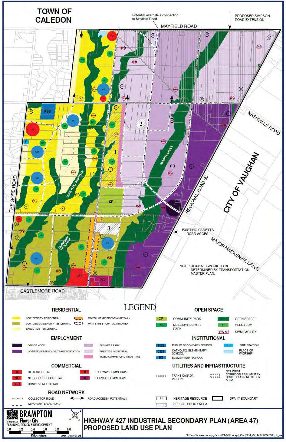
1 OFFICIAL PLAN DESIGNATIONS INDUSTRIAL generally east of Clarkway Dr RESIDENTIAL generally west of Clarkway Dr CORRIDOR PROTECTION AREA east of Clarkway Dr (for arterial network and high order transportation facilities) SPECIAL STUDY AREA designations for 5253 Countryside Dr and Clarkway Dr to determine if a Place of Worship can be developed on these sites in a manner that supports planning objectives of Area 47 2

2 LANDREALTORS PRESENTATION Appendix 2: Google Map Picture : GORE ROAD BRAMPTON ON Jaswinder S. Bhatti Gian S. Tung Sumanjit S. Panfer Broker Right At Home Realty Inc., Brokerage Sale Representative HomeLife Superstar R.E. Ltd., Brokerage Sale Representative Right At Home Realty Inc., Brokerage Mobile: Mobile: Mobile:

3 LANDREALTORS PRESENTATION Appendix 3: Geowerehouse Teranet Aerial Photo Jaswinder S. Bhatti Gian S. Tung Sumanjit S. Panfer Broker Right At Home Realty Inc., Brokerage Sale Representative HomeLife Superstar R.E. Ltd., Brokerage Sale Representative Right At Home Realty Inc., Brokerage Mobile: Mobile: Mobile:
4 3
5 Refines the Preliminary Concept presented at June 2011 Open House, based on study findings and public feedback. Yields about 22,300 people and 20,700 jobs (41 people and jobs per hectare, or 17 people and jobs per acre). Estimates will be refined once boundaries of the natural heritage system and GTA West Transportation Route Planning Study Area are finalized. RESIDENTIAL Executive Residential (max. 6 units per net acre) Low Density (max. 8 units per net acre) Low/Medium Density (max. 14 units per net acre) A band of Mixed-Use (3 to 4 storey built form with ground floor Retail and Residential above) is proposed fronting Clarkway Dr between Castlemore Rd and the TransCanada Pipeline. Estimated yield of 5,700 residential units, including a required minimum of 600 Executive Residential units. EMPLOYMENT Logistics/Warehouse/Transportation uses are proposed for lands between Hwy 50 and Coleraine Dr south of Countryside Dr, based on proximity to CP Intermodal and future GTA-West Corridor. Prestige Industrial uses, such as manufacturing within wholly enclosed buildings and corporate offices, are proposed for the lands fronting future GTA-West Transportation Corridor. Business Park uses, (e.g., industrial multiples and industrial uses with limited outside storage) are proposed for the centre of the 4 employment area.
6 COMMERCIAL Commercial uses proposed to serve Area 47 and vicinity: One District Retail centre Two Neighbourhood Retail centres Three Convenience Retail centres One Highway Commercial centre One Service Commercial centre SCHOOLS Based on estimated student yield, the following schools are proposed in the general locations shown in the Proposed Plan. Peel District School Board: one Public Secondary School and five Elementary Schools Dufferin-Peel Catholic District School Board: one Elementary School PLACES OF WORSHIP Special Policy Area 2 designation southwest of Countryside Dr and proposed Major Mackenzie Dr extension proposes to further evaluate the feasibility of a Place of Worship at this location considering need for land assembly. Special Policy Area 3 designation at Clarkway Dr. proposes to further evaluate the feasibility of a Place of Worship at this location considering the large size of this property (about 55 acres) and the scale and range of uses that may be proposed; Place of Worship designation at southwest quadrant of Mayfield Rd and Clarkway Dr - based on Jain OMB decision from December
7 HERITAGE RESOURCES The Cultural Heritage Study for Area 47, has identified 22 cultural heritage resources that require heritage impact assessment, based generally on their historical value, design value and contextual value. These resources include residential structures, agricultural related buildings, landscape features, building remnants, farm complexes and barns. Two additional heritage resources are being recommended for listing in the City s Register of Cultural Heritage Resources. COMMUNITY PARK Community Park of approximately 40 acres, proposed at the north-east quadrant of Clarkway Dr and the TransCanada Pipeline, is expected to provide a range of active outdoor recreational activities and provide a community focus. NEIGHBOURHOOD PARK Seventeen Neighbourhood Parks, each with a service area of about 400 metres, have been proposed based on preliminary analysis. STORMWATER MANAGEMENT PONDS Based on analysis to date as part of the Master Environmental Servicing Plan, 26 Stormwater Management Ponds are proposed in the general locations shown. 6

8 CLARKWAY DRIVE SPECIAL POLICY AREA (Special Policy Area 1): Proposes residential within a major portion of Special Policy Area 1. Large lots proposed fronting east side of Clarkway Dr that are compatible with existing estate residences. Densities gradually increasing away from Clarkway Dr. Policies for Special Policy Area 1 will address specific provisions regarding densities and lot widths, to protect the character of the existing estate residences on Clarkway Dr. A band of Mixed Commercial/ Industrial uses within a compatible built form are proposed at the eastern edge of Special Policy Area 1 with frontage onto a future northsouth Collector Road. 7
9 TRANSPORTATION Proposed arterial roads include an extension of Major Mackenzie Dr west to Mayfield Rd (Arterial A2) and an east-west arterial road, in proximity to the TransCanada Pipeline ROW, which connects The Gore Rd with a realigned Coleraine Dr. The alignment for new arterial and collector roads within Area 47 are subject to the Municipal Class Environmental Assessment process for roads and finalized through that process. The Future GTA West Corridor shown in the Preliminary Concept has been expanded in the Proposed Plan in order to match MTO s Preliminary Route Planning Study Area. The expansion of the Preliminary Route Planning Study Area within SP47 is necessary to allow for the identification and evaluation of alternative road alignments and interchange options as part of the next phase of the GTA West Transportation Corridor EA. The Study Area will be refined and modified as the EA progresses. Secondary Plan for Area 47 to include policies to enable the early release of lands within MTO s Preliminary Route Planning Study Area that are no longer required for their corridor, subject to the availability of sufficient information to more precisely identify the lands required for the road corridor and interchange connections. 8
10

 571-0000 Sale Representative Triple Net Realty Inc.")
11 Falco Group Presentation Trust Owner: GORELAND DEVELOPMENT INC. Address: Gore Road Total Area: 10 Acres Portfolio: Brampton Jaswinder S. Bhatti Gagandeep S. Sekhon Sumanjit S. Panfer Broker Triple Net Realty Inc., Brokerage Mobile: (416) Sale Representative Triple Net Realty Inc., Brokerage Mobile: (416) Broker of Record Triple Net Realty Inc., Brokerage Mobile: (416)
OFFICE CONSOLIDATION CHAPTER 47 HIGHWAY 427 INDUSTRIAL SECONDARY PLAN
 OFFICE CONSOLIDATION CHAPTER 47 HIGHWAY 427 INDUSTRIAL SECONDARY PLAN NOTE: This Secondary Plan is partially in effect. Highlighted sections are under appeal. August 2017 1 EXPLANATORY NOTE Office Consolidation
SCHEDULE A TO OFFICIAL PLAN AMENDMENT OP2006#
 AREA TO BE OUTLINED AS SOWN AND TE FOLLOWING TEXT BOX TO BE ADDED "PROPOSED OPEN SPACE DESIGNATION AS SOWN SUBJECT TO FURTER STUDY AS PART OF BLOCK PLANNING" EXISTING OPEN SPACE DESIGNATIONS WITIN AREA
Highway 427 Industrial Secondary Plan Area 47 Schedule C Class Environmental Assessment For Arterial Roadways
 Welcome to Pubic Information Centre #1 Highway 427 Industrial Secondary Plan Area 47 Schedule C Class Environmental Assessment For Arterial Roadways Welcome to Open House # 1 Tonight, we invite you to.
MEMORANDUM. Future Urban Area Conceptual Master Plan Cultural Heritage Resources
 MEMORANDUM TO: FROM: Heritage Markham Committee Regan Hutcheson, Manager-Heritage Planning DATE: June 14, 2017 SUBJECT: STUDI / PROJECTS Future Urban Area Conceptual Master Plan Cultural Heritage Resources
The West Vaughan Employment Area Secondary Plan Policies
 Part 2: The West Vaughan Employment Area Secondary Plan Policies 2.1 General Policies It is the policy of Council: 2.1.1. That the West Vaughan Employment Area (the WVEA), identified on Schedule 1, will
Brampton. Secondary Plan. Review. Bram West. A New Direction in Planning & Public Consultation
 Brampton Bram West Secondary Plan Review A New Direction in Planning & Public Consultation Introduction The Bram West Secondary Plan Review offers an important opportunity for the community to define a
CONSULTING SERVICES FOR THE WHITEBELT VISIONING EXERCISE ADDENDUM TO THE GTA WEST LAND USE STUDY WORK PROGRAM
 CONSULTING SERVICES FOR THE WHITEBELT VISIONING EXERCISE ADDENDUM TO THE GTA WEST LAND USE STUDY 1. Introduction WORK PROGRAM The Town of Caledon is a large, local municipality located in the Greater Toronto
MOUNT PLEASANT SECONDARY PLAN & VILLAGE BLOCK PLAN. Wednesday, March 5, 2008 Informal Public Open House
 MOUNT PLEASANT SECONDARY PLAN & VILLAGE BLOCK PLAN Wednesday, March 5, 2008 Informal Public Open House 1. Welcome & Introductions 2. Highlights of Provincial Growth Plan 3. Overview and Status Update -
11.4 Highway 400 North Employment Lands Secondary Plan APPROVED BY THE ONTARIO MUNICIPAL BOARD ON NOVEMBER 21, 2011
 11.4 Highway 400 North Employment Lands Secondary Plan APPROVED BY THE ONTARIO MUNICIPAL BOARD ON NOVEMBER 21, 2011 11.4.1 General 11.4.1.1. as approved by the Ontario Municipal Board on November 21, 2011,
MAYFIELD WEST SECONDARY PLAN PHASE 2
 MAYFIELD WEST SECONDARY PLAN PHASE 2 Public Open House #3 February 25, 2010 Draft Preferred Land Use Scenario TOWN OF CALEDON PLANNING & DEVELOPMENT DEPARTMENT Open House Agenda TOWN OF CALEDON 1. Welcome
9 CITY OF VAUGHAN OFFICIAL PLAN AMENDMENT NO BOCA EAST INVESTMENTS LIMITED
 9 CITY OF VAUGHAN OFFICIAL PLAN AMENDMENT NO. 631 - BOCA EAST INVESTMENTS LIMITED The Planning and Economic Development Committee recommends the adoption of the recommendations contained in the following
11.4 Highway 400 North Employment Lands Secondary Plan
 11.4 Highway 400 North Employment Lands Secondary Plan APPROVED BY THE ONTARIO MUNICIPAL BOARD ON NOVEMBER 21, 2011 11.4.1 General 11.4.1.1. The following policies and Schedules A - I form Official Plan
OFFICE CONSOLIDATION SECONDARY PLAN AREA 48. CHAPTER 48(b) COUNTRYSIDE VILLAGES SECONDARY PLAN
 COUNTRYSIDE VILLAGES SECONDARY PLAN") OFFICE CONSOLIDATION SECONDARY PLAN AREA 48 CHAPTER 48(b) COUNTRYSIDE VILLAGES SECONDARY PLAN October 2016 TABLE OF CONTENTS (Part II, Chapter 48(b)) Purpose. 1.0 Location 2.0 Effect of this Chapter and
OFFICE CONSOLIDATION SECONDARY PLAN AREA 48 CHAPTER 48(b) COUNTRYSIDE VILLAGES SECONDARY PLAN October 2016 TABLE OF CONTENTS (Part II, Chapter 48(b)) Purpose. 1.0 Location 2.0 Effect of this Chapter and
Ms. Kathryn Lockyer, Clerk Steeles Avenue West 10 Peel Centre Drive, Suite A, 5th floor
 Council February Piccin, Bottos Barristors and Solicitors Regional Municipality of Peel Attn: Paul R. Bottos Ms. Kathryn Lockyer, Clerk 201-4370 Steeles Avenue West 10 Peel Centre Drive, Suite A, 5th floor
HEMSON C o n s u l t i n g L t d.
 INVENTORY & ASSESSMENT OF INTENSIFICATION OPPORTUNITIES City of Brampton Discussion i Paper for Public Review C o n s u l t i n g L t d. November 2008 EXECUTIVE SUMMARY This report is one of the key background
MILTON HEIGHTS COMMUNITY January 2006 Revised February 2015 Revised November 2015
 REVISED DRAFT MILTON HEIGHTS COMMUNITY January 2006 Revised February 2015 Revised November 2015 Urban Design Guidelines Milton Heights Landowners Group This page has been intentionally left blank. Contents
OFFICE CONSOLIDATION SECONDARY PLAN AREA 49 VALES NORTH SECONDARY PLAN
 OFFICE CONSOLIDATION SECONDARY PLAN AREA 49 VALES NORTH SECONDARY PLAN July 2014 EXPLANATORY NOTES Chapter 49 General (pertaining to all secondary plan office consolidations) i. Secondary plan office consolidations
HURON COMMUNITY PLAN
 CITY OF KITCHENER DEPARTMENT OF DEVELOPMENT AND TECHNICAL SERVICES PD 94/7 HURON COMMUNITY PLAN Recommended by Planning and Economic Development Committee: October 31, 1994 Adopted by Kitchener City Council:
MAYFIELD WEST SECONDARY PLAN PHASE 2
 MAYFIELD WEST SECONDARY PLAN PHASE 2 Council Information Workshop February 16, 2010 Draft Preferred Land Use Plan TOWN OF CALEDON PLANNING & DEVELOPMENT DEPARTMENT Workshop Agenda TOWN OF CALEDON 1. Welcome
Bressa Developments Limited. Planning Justification Report. Revised Draft Plan of Subdivision and Zoning By-Law Amendment
 Bressa Developments Limited Revised Draft Plan of Subdivision and Zoning By-Law Amendment Planning Justification Report Part of Lots 7 & 8 Concession 1, North of Dundas Street Town of Oakville September,
Further input invited as Colchester Growth Strategy nears final phase
 IUE 3 / NOVEMBER 2015 Further input invited as Colchester Growth trategy nears final phase trathcona County is seeking public feedback as it enters the final phase of work on a Growth Management trategy
Draft ROPA 43 - HPBATS/GTA West Corridor Protection
 Draft ROPA 4 - HPBATS/GTA West Corridor Protection Overview Purpose The purpose of Regional Official Plan Amendment (ROPA) No. 4 is to: Implement a corridor protection area to protect for the planned corridor
«** p. Planning, Design and. brampton.ca NOWer lliy Development Committee
 U BRAMPTON FS-I Report «** p. Planning, Design and brampton.ca NOWer lliy Development Committee Committee of the Council of The Corporation of the City of Brampton Date: May 22, 2014 File: City File: P26RE-
Population, Housing, and Employment Analysis
 Population, Housing, and Employment Analysis Reviewed housing development patterns, trends, needs, affordability, and estimated employment and population capacity at full build out. Total 28,200 people
CITY OF VAUGHAN KIRBY GO TRANSIT HUB SUB-STUDY
 WELCOME! Thank you for attending, and welcome to the first of three Public Meetings for the Kirby GO Transit Hub Study. Your feedback is important to us, and will help inform the development of the draft
11.9 West Vaughan Employment Area Secondary Plan
 City of Vaughan Official Plan Volume 2 2017 Office Consolidation As Partially Approved by the Ontario Municipal Board 11.9 West Vaughan Employment Area Secondary Plan APPROVED BY THE ONTARIO MUNICIPAL
date February 2s, 2oiS
 bramptonco FlOWef City PH Report Planning, Design and Development Committee Committee of the Council of The Corporation of the City of Brampton Date: File: January 23, 2013 P26S 49 PLANNIN&DESIGN &DEVaOPMENT
SPECIAL COMMITTEE OF THE WHOLE DECEMBER 9, 2002 BLOCK 57/58 WEST BLOCK PLAN BLOCK PLAN FILE BL.57/58W.99 HUNTINGTON BUSINESS PARK LAND OWNERS
 SPECIAL COMMITTEE OF THE WHOLE DECEMBER 9, 2002 BLOCK 57/58 WEST BLOCK PLAN BLOCK PLAN FILE BL.57/58W.99 HUNTINGTON BUSINESS PARK LAND OWNERS Recommendation The Commissioner of Planning recommends: THAT
LAND USE AMENDMENT CORNERSTONE (WARD 3) 60 STREET NE AND COUNTRY HILLS BOULEVARD NE MAP 26NE BYLAW 22D2017
 60 STREET NE AND COUNTRY HILLS BOULEVARD NE MAP 26NE BYLAW 22D2017") Page 1 of 14 EXECUTIVE SUMMARY This Land Use Amendment application covers an area of 43.76 hectares ± (108.14 acres ±) located in northeast Calgary, bound by Country Hills Boulevard NE to the south and
Page 1 of 14 EXECUTIVE SUMMARY This Land Use Amendment application covers an area of 43.76 hectares ± (108.14 acres ±) located in northeast Calgary, bound by Country Hills Boulevard NE to the south and
PUBLIC OPEN HOUSE HURONTARIO-MAIN CORRIDOR SECONDARY PLAN
 PUBLIC OPEN HOUSE HURONTARIO-MAIN CORRIDOR SECONDARY PLAN Tuesday, February 28, 2012 6pm 9pm 1 st Floor Atrium, City Hall 2 Wellington Street West, Brampton 1 POLICY FRAMEWORK The 2006 Provincial Growth
Services Department B September 10, 2007
 Report To: Development Services Committee Item: Date of Report: DS-07-246 September 5, 2007 From: Commissioner, Development File: Date of Meeting: Services Department B7200-0001 September 10, 2007 Subject:
FORMER CANADIAN FORCES BASE (CFB) ROCKCLIFFE SECONDARY PLAN. Official Plan Amendment XX to the Official Plan for the City of Ottawa
 ROCKCLIFFE SECONDARY PLAN. Official Plan Amendment XX to the Official Plan for the City of Ottawa") FORMER CANADIAN FORCES BASE (CFB) ROCKCLIFFE SECONDARY PLAN Official Plan Amendment XX to the Official Plan for the City of Ottawa 1 INDEX THE STATEMENT OF COMPONENTS PART A THE PREAMBLE PAGE Purpose...
FORMER CANADIAN FORCES BASE (CFB) ROCKCLIFFE SECONDARY PLAN Official Plan Amendment XX to the Official Plan for the City of Ottawa 1 INDEX THE STATEMENT OF COMPONENTS PART A THE PREAMBLE PAGE Purpose...
WELCOME TO OPEN HOUSE TWO November 28, 2018
 Langstaff Road Weston Road to Highway 7 Class Environmental Assessment Study WELCOME TO OPEN HOUSE TWO November 28, 2018 Please sign in and join our mailing list Study Overview York Region is conducting
CONTENTS 8.0 LAND USE 8.1 GENERAL LAND USE 8.2 RESIDENTIAL 8.3 MIXED USE 8.4 COMMERCIAL 8.5 EMPLOYMENT LANDS
 8-2 Land Use 8.0 LAND USE CONTENTS 8.1 GENERAL LAND USE 8.1.1 Uses provided for in all Land Use Designations 8.1.2 Uses prohibited in Hazardous Lands, Hazardous Sites and Special Policy Areas 8.1.3 Uses
TOWN OF HALTON HILLS OFFICIAL PLAN AMENDMENT 10 PROPOSED MODIFICATIONS. Premier Gateway Employment Lands Re-Phasing. to implement
 TOWN OF HALTON HILLS OFFICIAL PLAN AMENDMENT 0 PROPOSED MODIFICATIONS Premier Gateway Employment Lands Re-Phasing to implement Halton Peel Boundary Area Transportation Study/ GTA West Corridor Protection
Urban Design Brief Proposed Residential Development 5219 Upper Middle Road City of Burlington
 Urban Design Brief Proposed Residential Development 5219 Upper Middle Road City of Burlington Prepared by Weston Consulting Prepared for BLOOMFIELD DEVELOPMENT INC. Date: March 2017 Table of Contents 1.
5.0 Community Design Plan
 5.0 Community Design Plan The Community Design Plan for the Mer Bleue area is a composite of three plans: Land Use Plan Transportation Plan Municipal Servicing Plan Read together, these Plans and associated
TOWN OF HALTON HILLS OFFICIAL PLAN AMENDMENT 10 PROPOSED MODIFICATIONS. Premier Gateway Employment Lands Re-Phasing. to implement
 TOWN OF HALTON HILLS OFFICIAL PLAN AMENDMENT 0 PROPOSED MODIFICATIONS Premier Gateway Employment Lands Re-Phasing to implement Halton Peel Boundary Area Transportation Study/ GTA West Corridor Protection
Neighbourhood Open House
 Neighbourhood Open House Choice Properties REIT Proposed Commercial Development 2025 Guelph Line March 23 rd, 2016 Neighbourhood Open House Agenda Introductions Site Context and Surrounding Area Policy
3 Development Process 3.1 Stage One page Stage Two page Stage Three page CENTRAL PICKERING DEVELOPMENT PLAN
 3 Development Process 3.1 Stage One page 24 3.2 Stage Two page 25 3.3 Stage Three page 28 22 CENTRAL PICKERING DEVELOPMENT PLAN The Central Pickering Development Plan establishes the key elements of new
OFFICE CONSOLIDATION
 OFFICE CONSOLIDATION SECONDARY PLAN AREA 40(a) CHAPTER 40(d) OF THE THE BRAM WEST SECONDARY PLAN January 2019 2 EXPLANATORY NOTES Area 40(a) CHAPTER 40(d) General (pertaining to all secondary plan office
Summary of Changes for the Comprehensive Draft Proposed Official Plan Amendment
 Summary of Changes for the Comprehensive Draft Proposed Official Plan Amendment Note: Due to the broad scope of the Official Plan Review, this list is not exhaustive of the extent of changes in the comprehensive
1.0 South Nepean Secondary Plan for Areas 9 & 10
 1.0 South Nepean Secondary Plan for Areas 9 & 10 1.1 Introduction The Secondary Plan for Areas 9 and 10 in the South Nepean Urban Area will provide policies and an approach to guide future development
Edward R. Sajecki Commissioner of Planning and Building. Land Use Review- Former Parkway Belt West Lands- Fieldgate Drive and Audubon Boulevard
 Corporate Report Clerk s Files Originator s Files CD.04.FOR DATE: November 15, 2011 TO: FROM: SUBJECT: Chair and Members of Planning and Development Committee Meeting Date: December 5, 2011 Edward R. Sajecki
Former Rockcliffe Airbase Community Design Plan Guiding Design Vision and Principles December 4, 2013
 APPENDIX 5 - Guiding Design Vision and Principles Former Rockcliffe Airbase Community Design Plan Guiding Design Vision and Principles December 4, 2013 Vision Statement The redevelopment of the former
ELMVALE ACRES SHOPPING CENTRE MASTER PLAN
 ELMVALE ACRES SHOPPING CENTRE MASTER PLAN Contents 1.0 INTRODUCTION... 2 2.0 LOCATION... 2 3.0 EXISTING CONTEXT... 2 4.0 VISION & GUIDING PRINCIPLES... 2 5.0 LAND USE AND BUILT FORM... 4 5.1 St. Laurent
^\s-v. DATE:Ji^v^IL-^1^
 UBRAMPTON ^\s-v Report Planning, Design and brampton.cd Flower City Development Committee Date: May 07, 2012 File: City File: P26S 049 Subject: Committee of the Council of The Corporation of the City of
Leonard s Beach Secondary Plan (Alcona North) Official Plan Amendment
 Official Plan Amendment") Leonard s Beach Secondary Plan (Alcona North) Official Plan Amendment Public Meeting Presentation August 14, 2013 Note: This document is for presentation purposes only. Please see Staff Report DSR-135-13
Leonard s Beach Secondary Plan (Alcona North) Official Plan Amendment Public Meeting Presentation August 14, 2013 Note: This document is for presentation purposes only. Please see Staff Report DSR-135-13
9-2 Area and Site Specific Policies
 9-2 Area and Site Specific Policies 9.0 AREA AND SITE SPECIFIC POLICIES CONTENTS 9.1. Angus Glen/York Downs 9.2 Armadale 9.3 Berczy Village/Wismer Commons/Greensborough/ Swan Lake 9.4 Buttonville 9.5 Cathedral
Planning for the Future Urban Area. in north Markham. Update. Development Services Committee. December 9, De Development Services Committee
 Planning for the in north Markham 1 Update De December 9, 2014 Overview - Growth Management Strategy and new Official Plan 2014 Status - Official Plan 2014 and ROPA3 Update - Planning for the Future Urban
AMENDMENT NUMBER ## TO THE VAUGHAN OFFICIAL PLAN 2010 FOR THE VAUGHAN PLANNING AREA
 AMENDMENT NUMBER ## TO THE VAUGHAN OFFICIAL PLAN 2010 FOR THE VAUGHAN PLANNING AREA The following text and schedules "1", 2, 3, 4 and 5 constitute Amendment Number ## to the Official Plan of the Vaughan
Welcome. Walk Around. Talk to Us. Write Down Your Comments
 Welcome This is an information meeting introducing the applications for proposed redevelopment of the Yorkdale Shopping Centre site at 3401 Dufferin Street and 1 Yorkdale Road over the next 20+ years,
COUNCIL ATTACHMENT 2 HIGHWAY 7 CORRIDOR AND VAUGHAN NORTH-SOUTH LINK
 COUNCIL ATTACHMENT 2 HIGHWAY 7 CORRIDOR AND VAUGHAN NORTH-SOUTH LINK Welcome! The purpose today is to: Present the Study Background; Describe Alignment Alternatives Analyzed; Present the Evaluation of
WELCOME Mayfield West Secondary Plan (Phase 2) Open House #2: June 25, 2009
 Open House #2: June 25, 2009") WELCOME Mayfield West Secondary Plan (Phase 2) Open House #2: June 25, 2009 Please sign in View the display boards Meet with the project team Presentation of the development scenarios at 7pm THE OPPORTUNITY
WELCOME Mayfield West Secondary Plan (Phase 2) Open House #2: June 25, 2009 Please sign in View the display boards Meet with the project team Presentation of the development scenarios at 7pm THE OPPORTUNITY
Development Approval & Planning Policy Department
 To: From: Mayor and Members of Council Development Approval & Planning Policy Department Meeting: 2015-11-10 Subject: Proposed Official Plan Amendment 222 - The Mayfield West Phase 2 Secondary Plan - Ward
DS- Application to Amend the Zoning By-Law (To permit a service commercial plaza) HUMPHRIES PLANNING GROUP INCORPORATED
 HUMPHRIES PLANNING GROUP INCORPORATED") J BRAMPTON DS- Report Planning, Design and bramptonca FlOWef City Development Committee Committee of the Council of Date: May 15, 2014 The Corporation of the City of Brampton File: C05W01.001 PLANNING,
J BRAMPTON DS- Report Planning, Design and bramptonca FlOWef City Development Committee Committee of the Council of Date: May 15, 2014 The Corporation of the City of Brampton File: C05W01.001 PLANNING,
A Guide to Open Space Design Development in Halifax Regional Municipality
 A uide to Open Space Design Development in Halifax Regional Municipality May 2007 1 Introduction Pursuant to Section 3.5 of the Regional Municipal Planning Strategy (RMPS), subdivision of land may proceed
TOWN OF INNISFIL SPECIAL COUNCIL AGENDA OUR JOBS INNISFIL HEIGHTS WORKSHOP WEDNESDAY JANUARY 20, :30 P.M.
 January 13, 2016 TOWN OF INNISFIL SPECIAL COUNCIL AGENDA INNISFIL HEIGHTS WORKSHOP WEDNESDAY JANUARY 20, 2016 5:30 P.M. PLEASE REMEMBER TO TURN OFF CELL PHONES 1. OPENING OF MEETING BY THE MAYOR Opening
Table 8-4: Road Classification Local Roads, second table, of Chapter 8 Create a Multi-Modal City, be amended by adding the following:
 1 Port Street East Official Plan Amendment APPENDIX 3 Amendments to Mississauga Official Plan Table 8-4: Road Classification Local Roads, second table, of Chapter 8 Create a Multi-Modal City, be amended
2.5 Roads. Loading and service areas adjacent to Highway 401 should be screened through architectural walls and/or landscape buffer planting.
 N HIGHWAY OFF RAMP 2.5 Roads A legible road network with a clear hierarchy will help create a connected community, both within and surrounding the Milton Heights. The following section outlines the proposed
Derry Green Corporate Business Park
 Town of Milton Derry Green Corporate Business Park Urban Design Guidelines BMI/Pace - June 2010 Draft 3 Prepared by: Brook McIlroy Planning + Urban Design / Pace Architects Suite 300-51 Camden Street Toronto,
POLICY AMENDMENT AND LAND USE AMENDMENT TUXEDO PARK (WARD 9) CENTRE STREET N AND 26 AVENUE NE BYLAWS 36P2017 AND 234D2017
 CENTRE STREET N AND 26 AVENUE NE BYLAWS 36P2017 AND 234D2017") Page 1 of 11 EXECUTIVE SUMMARY This application proposes to redesignate a single parcel of land in the Community of Tuxedo Park from Commercial Corridor 2 (C-COR2 f1h10) District to Mixed Use Active Frontage
Page 1 of 11 EXECUTIVE SUMMARY This application proposes to redesignate a single parcel of land in the Community of Tuxedo Park from Commercial Corridor 2 (C-COR2 f1h10) District to Mixed Use Active Frontage
Bylaw C-1186 Adopted November 5, Planning and Development Services
 Bylaw C-1186 Adopted November 5, 2007 Planning and Development Services CITY OF GRANDE PRAIRIE OFFICE CONSOLIDATION BYLAW C-1186 A Bylaw to adopt the Westgate Area Structure Plan (As Amended by Bylaw C-1186-1,
PREPARED FOR: PLATTEVIEW ROAD CORRIDOR STUDY EXECUTIVE SUMMARY
 PREPARED FOR: PLATTEVIEW ROAD CORRIDOR STUDY EXECUTIVE SUMMARY SEPTEMBER 2016 Introduction The Platteview Road Corridor Study was led by the Metropolitan Area Planning Agency (MAPA) with assistance from
2.0 A FRAMEWORK FOR SUSTAINABLE GROWTH CONTENTS
 2-2 A Framework for Sustainable Growth 2.0 A FRAMEWORK FOR SUSTAINABLE GROWTH CONTENTS 2.1 MANAGING SUSTAINABLE GROWTH THE VISION TO 2031 2.2 GOALS AND OBJECTIVES 2.2.1 Protecting the Natural Environment
Urban Design Brief. Watson Parkway North & Watson Road North Guelph, Ontario. Prepared by Coletara Development
 Urban Design Brief Watson Parkway North & Watson Road North Guelph, Ontario Prepared by Coletara Development December, 2013 Urban Design Brief, Coletara Development 1 Introduction This Urban Design Brief
1.0 South Nepean Secondary Plan for Areas 9 & 10
 1.0 South Nepean Secondary Plan for Areas 9 & 10 1.1 Introduction The Secondary Plan for Areas 9 and 10 in the South Nepean Urban Area will provide policies and an approach to guide future development
Background Summary Report
 Background Summary Report May 2014 Submitted by Macaulay Shiomi Howson Ltd. In association with AMEC MMM Group Brook McIlroy Inc. Hemson Consulting Ltd. Table of Contents 1. Introduction... 1 2. Why is
2. East Riverside Planning Area
 2. East Riverside Planning Area 2.0 Preamble The following Secondary Plan provides direction for the development of the East Riverside Planning Area, designated on Schedule A: Planning Districts & Policy
OFFICE CONSOLIDATION CHAPTER 45 CREDIT VALLEY SECONDARY PLAN
 OFFICE CONSOLIDATION CHAPTER 45 CREDIT VALLEY SECONDARY PLAN May 2013 EXPLANATORY NOTES Area 45 Chapter 45 General (pertaining to all secondary plan office consolidations) i. Secondary plan office consolidations
p^-l C03E and 21T-09010B DATE RECOMMENDATION REPORT Application to Amend the Official Plan, Zoning By-Law and Proposed
 BRAMPTON p^-l Report Planning, Design and brompton.cc Flower City Development Committee Committee of the Council of The Corporation of the City of Brampton Date: May 12, 2011 PLAN«,DEW&DEVEOTE«TCO»EE Files:
6 Growth Management Challenges and Opportunities
 6 Growth Management Challenges and Opportunities The Town has established a goal of attaining a 50% participation rate with respect to employment opportunities versus residential population. The Town s
M E M O R A N D U M July 27, 2018
 M E M O R A N D U M July 27, 2018 To: Southlake 2035 Corridor Planning Committee From: Kenneth Baker, Sr. Director of Planning and Development Services Subject: Item #6 First National Bank Purpose Review,
Getting and Giving the Most
 Getting and Giving the Most It s OUR meeting participate enthusiastically Focus on the future Terminology expertise is secondary There is such a thing as a bad idea! Respect (for each other and the process)
Trafalgar Road Corridor Planning Study Open House
 Trafalgar Road Corridor Planning Study Open House June 24, 2013 6:30-8:30 p.m. Oakville & Trafalgar Rooms Overview The Livable Oakville Plan identifies the lands along Trafalgar Road, between the QEW and
THE CORPORATION OF THE CITY OF BRAMPTON BY-LAW. To adopt Amendment Number 263. to the 1984 Official Plan of the City of Brampton Planning Area
 REPEALED BY BY.LAW~o6-12. THE CORPORATON OF THE CTY OF BRAMPTON BY-LAW 1Vu~ber 83-95 To adopt Amendment Number 263 -- to the 1984 Official Plan of the City of Brampton Planning Area, The Council of The
1.0 INTRODUCTION AND BACKGROUND
 1.0 INTRODUCTION AND BACKGROUND 1.1 INTRODUCTION / BACKGROUND The Regional Municipality of York (hereafter referred to as York Region ) has completed a Municipal Class Environmental Assessment (Class EA)
Sustainable Growth. Sustainable Growth
 2 Sustainable Growth Sustainable Growth SUSTAINABLE GROWTH 2.1 COMMUNITY VISION... 2-5 2.2 THE CITY SYSTEM... 2-7 2.2.1 AREAS... 2-7 2.2.2 CITY-WIDE SYSTEMS... 2-8 2.2.3 PROVINCIAL PLAN BOUNDARIES AND
12 AMENDMENT NO. 149, TOWN OF MARKHAM HIGHWAY 404 NORTH SECONDARY PLAN
 12 AMENDMENT NO. 149, TOWN OF MARKHAM HIGHWAY 404 NORTH SECONDARY PLAN The Planning and Economic Development Committee recommends the adoption of the recommendation contained in the following report August
Report Regarding Site Plan Control for 55 Wellspring Way (File No. SP-06-16)
") Report Regarding Site Plan Control for 55 Wellspring Way (File No. SP-06-16) Executive Summary: The purpose of this report is to provide Council with information regarding site plan control under Section
Report Regarding Site Plan Control for 55 Wellspring Way (File No. SP-06-16) Executive Summary: The purpose of this report is to provide Council with information regarding site plan control under Section
LAND USE AMENDMENT CORNERSTONE (WARD 3) COUNTRY HILLS BOULEVARD AND STONEY TRAIL NE BYLAW 9D2017
 COUNTRY HILLS BOULEVARD AND STONEY TRAIL NE BYLAW 9D2017") Page 1 of 12 EXECUTIVE SUMMARY This Land Use Amendment application covers an area of 54.92 hectares ± (135.71 acres ±) located in northeast Calgary, bound by Country Hills Boulevard NE to the north and
Page 1 of 12 EXECUTIVE SUMMARY This Land Use Amendment application covers an area of 54.92 hectares ± (135.71 acres ±) located in northeast Calgary, bound by Country Hills Boulevard NE to the north and
UTSC SECONDARY PLAN COMMUNITY OPEN HOUSE
 WELCOME TO THE UTSC SECONDARY PLAN COMMUNITY OPEN HOUSE 1 Welcome to the first Community Open House for the UTSC Secondary Plan. Hosted by the University of Toronto Scarborough (UTSC), the following panels
Report to: Development Services Committee Report Date: September 11, 2017
 ~RKHAM Report to: Development Services Committee Report Date: September 11, 2017 SUBJECT: PREPARED BY: Conceptual Master Plan for the Future Urban Area - Community Structure Plan and Key Policy Direction
URBAN DESIGN BRIEF 1435 Beaverbrook Road On behalf of Wonderland Commercial Centre Inc.
 URBAN DESIGN BRIEF 1435 Beaverbrook Road On behalf of Wonderland Commercial Centre Inc. Knutson Development Consultants Inc. Development Engineering (London) Ltd. K & L Construction and Arthur Lierman
2.0 A FRAMEWORK FOR SUSTAINABLE GROWTH CONTENTS
 2-2 A Framework for Sustainable Growth 2.0 A FRAMEWORK FOR SUSTAINABLE GROWTH CONTENTS 2.1 MANAGING SUSTAINABLE GROWTH THE VISION TO 2031 2.2 GOALS AND OBJECTIVES 2.2.1 Protecting the Natural Environment
PLANNING AND URBAN DESIGN RATIONALE REPORT. Hunters Pointe Golf Course Redevelopment 289 Daimler Parkway Prepared For: Ontario Ltd.
 PLANNING AND URBAN DESIGN RATIONALE REPORT Hunters Pointe Golf Course Redevelopment 289 Daimler Parkway Prepared For: 2599587 Ontario Ltd. February 2018 Redevelopment of Hunters Pointe Golf Course, Welland
Public Storage Self-storage Facility (Warehouse)
") Public Storage Self-storage Facility (Warehouse) 3545 St. Joseph Boulevard Planning Rationale PREPARED FOR: Maple Reinders Constructors Ltd. 2660 Argentia Road Mississauga, Ontario L5N 5V4 PREPARED BY:
Public Storage Self-storage Facility (Warehouse) 3545 St. Joseph Boulevard Planning Rationale PREPARED FOR: Maple Reinders Constructors Ltd. 2660 Argentia Road Mississauga, Ontario L5N 5V4 PREPARED BY:
HEMSON IV EMPLOYMENT LAND CONVERSION
 28 IV EMPLOYMENT LAND CONVERSION The appropriateness of permitting changes to the City s employment land supply is considered within the context of the adequacy of the supply to accommodate growth projected
TOWN OF CALEDON Land Use Study for GTA West Corridor and Adjacent Lands!
 TOWN OF CALEDON Land Use Study for GTA West Corridor and Adjacent Lands! Presentation to Council! March 10, 2015! Why are we here?! 1. The Province has now developed a short list of possible routes for
Phase 1 Concept Plan MAY 26, Version Circulation Draft
 Phase 1 Concept Plan MAY 26, 2014 Version 2.0 - Circulation Draft Project Team: Project Engineers WSP/Genivar Contact: Jeff Halliday 306.585.1990 Phase 1 Concept Plan May 2014 Prepared for: Westerra Development
THE CORPORATION OF THE TOWN OF OAKVILLE BY-LAW NUMBER
 THE CORPORATION OF THE TOWN OF OAKVILLE BY-LAW NUMBER 20012-08530 A by-law to adopt an amendment to the Official Plan of the Oakville Planning Area (Official Plan Amendment 198) Land North of Dundas Street.
POCKET COMMUNITY PLAN
 POCKET COMMUNITY PLAN Part Three : COMMUNITY PLAN AREAS AND SPECIAL STUDY AREAS CONTENTS Community Location... 3-P-3 Community Vision... 3-P-4 Community Profile... 3-P-4 Community Issues... 3-P-6 Land
and services The protection and conservation of environmentally significant and sensitive natural heritage features and functions.
 6. Land Use 6.0 Preamble A healthy and livable city is one in which people can enjoy a vibrant economy and a sustainable healthy environment in safe, caring and diverse neighbourhoods. In order to ensure
Complete Neighbourhood Guidelines Review Tool
 Complete Neighbourhood Guidelines Review Tool Prepared By: City of Regina Planning Department October 2014 Page 1 of 14 Community Development Review Checklist for Secondary Plans and Concept Plans The
GUIDELINES. Transit Oriented Development. Approved by Edmonton City Council on February 15, 2012 in tandem with City Policy C565
 Transit Oriented Development GUIDELINES Prepared by the City of Edmonton Sustainable Development and Transportation Services Departments Approved by Edmonton City Council on February 15, 2012 in tandem
Richmond Hill Official Plan PART II SECONDARY PLANS
 9 N O R T H L E S L I E Richmond Hill Official Plan PART II SECONDARY PLANS TABLE OF CONTENTS 9.0 THE NORTH LESLIE SECONDARY PLAN 9-3 Basis The Development Concept 9.1 Introduction 9-4 9.2 Purpose 9-4
Emery Village Road 2A Municipal Class Environmental Assessment Study
 PW12.11 STAFF REPORT ACTION REQUIRED Emery Village Road 2A Municipal Class Environmental Assessment Study Date: March 30, 2016 To: From: Wards: Reference Number: Public Works and Infrastructure Committee
Commercial Development Proposal Tenth Line Road. Planning Rationale Report. Minto Developments Inc.
 Commercial Development Proposal 2168 Tenth Line Road Report September 2015 Prepared for Minto Developments Inc. Paquette Planning Associates Ltd. 56 Hutchison Avenue Ottawa, Ontario K1Y 4A3 PH: 613-722-7217
CONTENTS 2.0 A FRAMEWORK FOR SUSTAINABLE GROWTH 2.1 MANAGING SUSTAINABLE GROWTH THE VISION TO GOALS AND OBJECTIVES 2.3 MARKHAM STRUCTURE
 2 A Framework for Sustainable Growth 2.0 A FRAMEWORK FOR SUSTAINABLE GROWTH CONTENTS 2.1 MANAGING SUSTAINABLE GROWTH THE VISION TO 2031 2.2 GOALS AND OBJECTIVES 2.2.1 Protecting the Natural Environment
Vaughan Metropolitan Centre (VMC) Black Creek Renewal CLASS ENVIRONMENTAL ASSESSMENT
 Black Creek Renewal CLASS ENVIRONMENTAL ASSESSMENT") PUBLIC INFORMATION CENTRE Vaughan Metropolitan Centre (VMC) Black Creek Renewal Wednesday, May 10, 2017 6:00 p.m. to 8:00 p.m. Add photo Project Management, Environmental Assessment, Stormwater Management
PUBLIC INFORMATION CENTRE Vaughan Metropolitan Centre (VMC) Black Creek Renewal Wednesday, May 10, 2017 6:00 p.m. to 8:00 p.m. Add photo Project Management, Environmental Assessment, Stormwater Management