Zoning and Development Plan Review
|
|
|
- Linette McDaniel
- 5 years ago
- Views:
Transcription


1 Zoning and Development Plan Review October 2016
2 Zoning and Development Plan Review Project Information Project: Prepared for: North Lewis County Industrial Access Lewis County Public Works 2025 NE Kresky Avenue Chehalis, WA Project Representative Prepared by: Contact: Project Reference: SCJ Alliance 8730 Tallon Lane NE Lacey, WA scjalliance.com Eric Johnston, PE, Principal SCJ # Phase 02 Baseline Analysis Path: N:\Projects\0635 Lewis County\ North Lewis County - Industrial Access\Phase 2 - Baseline Analysis\Task 03 Project Context
3 TABLE OF CONTENTS Introduction... 1 Chehalis Tribes... 2 Port of Centralia... 3 IPAT... 4 Chehalis River Basin Flood Authority... 5 Washington State Department of Transportation... 6 Lewis County... 7 City of Centralia... 8 Thurston County... 9 Town of Bucoda City of Tenino LIST OF TABLES Table 1 Lewis County Study Area Demographics... 8 LIST OF FIGURES Figure 1 Great Wolf Lodge in Grand Mound... 2 Figure 2 Port of Centralia... 3 Figure 3 Industrial Park at TransAlta... 4 Figure 4 I-5 improvements at Mellen Street and Harrison (Exit 81)... 6 Figure 5 I-5 Improvements near Future Centralia Station... 6 Figure 6 Downtown Centralia... 8 Figure 7 Grand Mound Community in Thurston County... 9 Figure 8 Bucoda Neighborhood Figure 9 Bucoda Community Center Figure 10 Commercial Area, Downtown Tenino Figure 11 Tenino Neighborhood Page i
4 Page ii
5 INTRODUCTION Lewis County, located in the southwest part of Washington State, touches eight other Washington counties. Grays Harbor, Thurston, and Pierce Counties to the north; Yakima County to the east; and Skamania, Cowlitz, and Wahkiakum Counties to the south; and Pacific County to the west. The boundaries are purely political creations except for that portion of the northern boundary that briefly parallels the Nisqually River, and all of the eastern boundary which tracks along the crest of the Cascade Mountains. The largest county in western Washington, Lewis County covers 2,452 square miles and measures about 90 miles (east to west) by 25 miles (north to south). The topography varies widely, from the broad, relatively flat and low-lying western section of the county to the Cascade Mountains to the east. Roughly three-fourths of the county is rugged, mountainous and forested. The remainder is characterized by low rolling hills interspersed with rivers and tributaries including the Cowlitz, Chehalis, and Newaukum systems. The major population centers of Chehalis and Centralia, are located on the flood plains of the Chehalis River and its tributaries, including the Skookumchuck and Newaukum rivers. Over threequarters of the land in Lewis County is committed to federal, state, and private resource land uses. This includes 38% in federal and state ownership, primarily for timber and recreational uses. Another 37% is privately owned resource lands, large tracts of property devoted to mineral, agricultural and forestry uses. Only 1% of the land lies within urban areas, with much of that devoted to right-ofways and public uses, or constrained by critical areas. Another 1% of the land is classified as a "Rural Area of More Intense Development" (LAMIRDS), which includes small towns in unincorporated areas, crossroads, and commercial and subdivision enclaves. Other urban designations, such as Master Planned Resorts, are found within rural areas, especially adjacent to the State and Federal highway network. Twenty three percent of the land is considered remote rural, much of which is characterized by steep slopes, wetlands and hydric soils. This results in over 98% of Lewis County being considered as open space or remote rural areas with less than 2% available for urban or more intense rural development (2007 Lewis County Comprehensive Plan). In northern Lewis County along to the I-5 corridor, urban uses are more prevelant, and include employment centers of industry, business and tourism that support the economic vitality of Lewis County and adjacent counties. Access and circulation are two important transportation factors that weaken the economic viability of industrial investments that support the region s vision and economic vitality. Supporting and improving access to this job center is critical to the economic growth of the area. Of 39 counties in the state in 2015, Lewis ranked 33 rd in growth, 34 th for per capita personal income, and 16 th for poverty. As the number of jobs in the timber and mineral extraction industries wanes, jobs in other sectors are needed that do not upset the rural character of the county and takes advantage of a skilled trades and industrial sector. The Industrial Park at TransAlta, the site of a former surface coal mine, is located approximately eight miles from I-5, three miles from Bucoda, and four miles from Centralia. From 1971 until 2006, the mined coal fueled TransAlta s thermal generating plant which has a net capacity of 1,340 megawatts and is still Washington State s largest baseload power source. The mining operations have transitioned into reclamation efforts, and over 2,600 acres of the 7,700 acres disturbed for mining have been completely reclaimed. The two coal fired power plants will be retired in 2020 and While the mining and power generating operations are coming to an end, 4,400 acres have been designated by the Page 1

6 Washington State Legislature (Revised Code of Washington 36.70A.368) as an industrial park. The other primary industrial center within the study area is the Port of Centralia industrial parks. With some facilities located less than two miles of Interstate 5 interchanges, this site also has a combined 1,500 acres between ready-to-develop and currently provides over 800 jobs to the area. With improved access to these two major industrial parks and other surrounding industrial uses, northern Lewis County would be able to boost its economy, attract business and residents, and sustain the industrial employment base that has diminished over the last decade. CHEHALIS TRIBES The Confederated Tribes of the Chehalis Reservation are located on 4,215 acres in southwest Washington about twenty-six miles southwest of Olympia and six miles northwest of Centralia. Approximately 20% of the reservation lies within Thurston County and 80% in Grays Harbor County. The reservation consists of agricultural areas, residential neighborhoods and forested areas. The Reservation is dominated by the current and historical paths of the Chehalis and Black rivers. In 2013, the Chehalis Reservation tribal member population was 894. The Tribe currently has a growth rate of approximately 17% with a projected population growth of 1,046 by The Chehalis Tribe has identified core and rural residential areas with high and low density neighborhoods. The rural low density neighborhoods have been developed at scattered sites throughout the Reservation. The Tribe has designated commercial areas along Anderson Road from SR 12 to the reservation boundaries and the property known as the Grand Mound Property on Highway 99 near exit 88 on Interstate 5. Figure 1 Great Wolf Lodge in Grand Mound The Tribe operates the Lucky Eagle Casino and Eagles Landing Hotel (located in Rochester) and own and operate The Great Wolf Lodge Resort, an indoor water park located in Grand Mound between Old Highway 99 and Interstate 5. The tribe has recently expanded capacity at each site, and have completed the Grand Mound Development Plan as a response to the rapid growth in the Grand Mound area. This Plan was developed in consultation with Thurston County, and it develops a vision for the future of Grand Mound and establishes a plan that envisions a retail village or town center, higher density residential areas and new commercial and industrial land uses. Page 2

7 With increased commercial development and investment in Grand Mound and along property adjacent to the interstate by the tribe, congestion along Harrison Avenue/Old Highway 99 and the I-5 interchanges could further constrain access to existing industrial properties in north Lewis County. PORT OF CENTRALIA The Port of Centralia is a municipal corporation governed by three elected commissioners. With over 1,500 acres of property in two industrial parks west of Interstate 5 and one mixed-use development, the Port s industrial parks contain 30 businesses providing 800 jobs to the local economy. The industrial parks, like others in the area, have access to rail service, fiber optics, pipelines, water, and electricity. In a 2016 trip generation analysis, the Port s two industrial parks are estimated to currently provide 2.4 million square feet of industrial/warehouse space with the ability to develop approximately 2.5 million additional square feet 1. Access to the I-5 Harrison Avenue interchange (exit 82) is about 1-3 miles from Port properties and 3-6 miles to the Grand Mound interchange at exit 88. The Port is currently completing property acquisition for Centralia Station, a regional commercial park intended to provide approximately 40 acres of office, retail, restaurant, and recreation space. The park is located south of the Mellen Street interchange (Exit 81) and considerable construction in the area will provide easy freeway access to the site. Figure 2 Port of Centralia 1 The May 2016 transportation study states that Park I has 250 acres of primarily undeveloped property, though a May 2016 article by a commissioner states that Park I started to reach capacity and thus developed Park II in Page 3

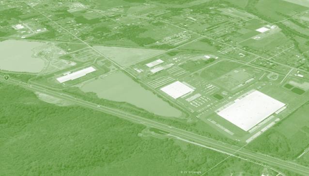
8 IPAT The Industrial Park at TransAlta, LLC (IPAT) is a non-profit organization established to market industrial uses on a portion of the TransAlta Centralia operations site. The mine and power generation site employed approximately 900 employees until 2006 when it discontinued mining operations. IPAT proposes to use former mining land to increase manufacturing employment and fulfill the demand for ready to develop industrial sites in excess of 100 acres. Figure 3 Industrial Park at TransAlta IPAT lists 1,000 acres of developable property eight miles from Interstate 5, equidistant between Seattle and Portland. The site features include access to rail, fiber optics, pipelines, large volume water, major electricity, and limited environmental and adjacent use concerns. Infrastructure capacities include: 60,000 gallons of potable water capacity is available Process Water Capacity: 2 million gallons per day Existing onsite sewer treatment facility to serve up to 1,000 employees Two natural gas pipeline providers, with 30 and 36 mains High-speed fiber optic lines North/south Finished Products Pipeline that provides a conduit for liquid fuels Page 4
9 BNSF heavy rail spur and full loop to serve three unit trains To capitalize on site strengths and maximize economic and employment benefits, facilities like warehouses and distribution centers are discouraged in favor of capital intensive manufacturing and heavy industrial uses. The area available for development is predicted to be able to accommodate over 2,000 jobs, which is a significant boost to the job market for the entire region. There are seven industrial pads currently proposed, and each has easy access to necessary utilities as well as a BNSF rail line. Additionally, access to the area, while currently available via road and railway, is also being examined for access development, creating shorter access routes to the highway. Full build out, depending on market conditions, is anticipated by at the earliest. When built out, businesses on the property are expected to contribute over 2,000 jobs to the regional economy, 1,400 more employees than when the coal mine was operational. In Lewis County, approximately 2,578 people of the civilian workforce remain currently unemployed. Freight traffic would vary based on the specific logistics of future developments. Without additional access routes, IPAT traffic would continue to use truck routes including Reynolds Avenue, Main Street, and SR 507 through Centralia s downtown leading to the Harrison Avenue interchange at I-5. Multiple intersections and segments along this truck route are noted in Centralia s 2007 Comprehensive plan as being congested and having a high number of accidents. IPAT is one of two designated Major Industrial Development areas in Lewis County that are not associated with the UGAs of the incorporated cities and towns. County development regulations provide an appropriate master planning process to address development criteria, preservation of large industrial sites, adequate public facilities (including sewer, water, and transportation), and adequate buffers and environmental protection. The Major Industrial Development areas require significant upfront planning to address an entire site. As an alternative, property owners may use the provisions of RCW 36.70A.365 to locate a new industrial development consistent with those standards within such proposed Major Industrial Development area. The major industrial facility siting may be more appropriate to the size, scale and pace of anticipated industrial development for those areas. In addition to industrial development pursuant to RCW 36.70A.365 and RCW 36.70A.367, Lewis County may designate a master planned location for major industrial activity subject to the provisions of RCW 36.70A.368. CHEHALIS RIVER BASIN FLOOD AUTHORITY The Chehalis River Basin Flood Authority was created through an interlocal agreement amongst local jurisdictions within the Chehalis River Basin in response to disastrous flooding occurring in The CRBFA is tasked with developing and participating in flood hazard mitigation measures throughout the basin, considering such things as retention dams, levees, creek restoration, street regrades, protecting the I-5, evacuation routes, and restoring aquatic species. Projects mitigate flooding of roads and highways and are not expected to affect transportation projects considered in this study. Page 5
 lanes between Mellen Street (Exit 81) and Harrison Avenue (Exit 82) interchanges to eliminate merging conditions between these interchanges and separate")
 This project also made safety improvements to the Mellen Street and Harrison Avenue interchanges, and widened and realigned the I-5")
10 WASHINGTON STATE DEPARTMENT OF TRANSPORTATION A multi-phase WSDOT project was completed in 2016 to increase highway capacity through the North Lewis and South Thurston counties. WSDOT constructed Collector Distributor (CD) lanes between Mellen Street (Exit 81) and Harrison Avenue (Exit 82) interchanges to eliminate merging conditions between these interchanges and separate local traffic from interstate traffic. Figure 4 I-5 improvements at Mellen Street and Harrison (Exit 81) This project also made safety improvements to the Mellen Street and Harrison Avenue interchanges, and widened and realigned the I-5 curve at Blakeslee Junction. It is expected to eventually provide access to the Port of Centralia s Centralia Station commercial park when those buildings are constructed. Figure 5 I-5 Improvements near Future Centralia Station Page 6
11 LEWIS COUNTY With over 75,000 residents spread across more than 1.5 million acres (31.2 per square mile), Lewis County remains a predominantly rural and resource-based county adjacent to the Thurston County, Olympia-Tumwater economic area to the north. The majority of development is within the I-5 corridor connecting Portland, Oregon with Tacoma and Seattle to the north, though dispersed communities are established along the eastbound US highway 12 stretching into the Cascade mountain range. At 16,000, the City of Centralia serves as the largest population and employment base. Lewis County was hit particularly hard by the Great Recession and has generally suffered from a lack of employment growth, high unemployment (8.2%), poverty (17%), and lower median household income ($42,917). Though employment has historically relied on resource extraction like forestry and wood products, the diversifying economy increasingly relies on industrial and commercial activities like manufacturing, transportation, logistics, warehousing, food production, and wholesale and retail. Of approximately 30,000 working residents, over 62% commute to work outside the county (one of the lowest rates of in-county workers). Of those working, annual wages in manufacturing average $46,864, in transportation $35,036, and agriculture, forestry, fishing and hunting averages $32,452. Lewis County s average total is $37,059. The per capita income average however is reported at $33,424. These numbers show the poor state of economy in the area, and the need for beneficial development. Population Labor Force Average Annual Wages Per Capita Income Major Local & State Taxes Source Lewis County 76,890 OFM (2016) Centralia 16,820 OFM (2016) Chehalis 7,460 OFM (2016) Napavine 1870 OFM (2016) Civilian Labor Force 31,452 ESD (2016) Employed 28,874 ESD (2016) Unemployed 2,578 ESD (2016) Unemployment Rate 8.2% ESD (2016) Lewis County Total $37,059 Lewis EDC (2014) Manufacturing $46,864 Lewis EDC (2014) Transportation & Warehousing $35,036 Lewis EDC (2014) Agriculture, Forestry, Fishing & Hunting $32,452 Lewis EDC (2014) Lewis County $33,424 ESD (2013) Lewis Retail Sales 7.8% DOR (2016) Retail Sales most areas 7.8% DOR (2016) Page 7
 Table 1 Lewis County Study Area Demographics All industrial developments focused on by this study are expected to take place in Lewis County.")
12 State B&O Tax.00484% DOR (2016) Average Property Tax Rates Unincorporated Lewis County $ ESD (2016) Centralia $10.26 ESD (2016) Table 1 Lewis County Study Area Demographics All industrial developments focused on by this study are expected to take place in Lewis County. Much of the property at the Port of Centralia is within the City of Centralia or the urban growth boundary, but other industrial properties, such as IPAT, are within unincorporated Lewis County. Based upon the area demographics found in Figure 1, Lewis County would greatly benefit from increased industrial activity as is proposed for development at IPAT. CITY OF CENTRALIA Centralia is the largest city in Lewis County with over 16,000 residents and, as a midway point between Seattle and Portland, sits along the major north-south highway and rail lines for the West Coast. Settled in 1852, the city s urban growth boundary has grown to almost 2000 acres with 63% used for residential, 10% used for commercial and medical uses, and about 17% devoted to industrial development. Centralia holds the great majority of Lewis County jobs and has stronger population growth than the rest of the county (2-3% ), but employment in the Centralia-Chehalis area dropped an estimated 7% to 14,534 between 2003 and Saddling the confluence of the Chehalis and Skookumchuck Rivers, Centralia encompasses significant floodplains that divide development and create transportation bottlenecks. Harrison Avenue, the primary interchange connecting the city to the I-5 is a highly congested corridor and frequently cited for frequent accidents and congested intersections. Residential traffic, downtown commercial traffic, industrial traffic, and school traffic are all commonly funneled into the Harrison corridor as a way to both cross to other parts of the city and to access the I-5. The Mullen Street interchange to the South is much less utilized. Figure 6 Downtown Centralia Modeling future development in the area, corridors like Harrison Avenue are expected to worsen and Centralia currently plans to widen, repave, resurface, and add bike lanes and sidewalks to Harrison and other unsatisfactory routes. As referenced above, WSDOT completed a project in 2016 that increases highway capacity through the North Lewis and South Thurston counties through the use of bypass collector distributor lanes through the Centralia area. Page 8

13 THURSTON COUNTY With a population of over 250,000, Thurston County anchors the southern end of the Puget Sound metropolitan area. The bulk of the urbanized population is centered in the cities of Olympia, Lacey, and Tumwater which also represent a significant source of employment. Olympia is notable for being Washington State s capitol and, along with the surrounding cities, has a large state and governmental employment draw. With one of the highest rates of commuters traveling to work in other counties (62%), Thurston County constitutes a significant source of imported income for Lewis County and the majority of the Lewis County commuters travel through the northern neighbor s jurisdiction. Though Grand Mound, Bucoda, and Tenino are all communities within Thurston County, they are closely connected to the Centralia and north Lewis County economy. Access and mobility projects for industrial uses located in Lewis County will likely impact and may be located within Thurston County. An impending Rural Mobility Study, a study of SR507, the widening of Highway 99 around Grand Mound, and other transportation and development visions have the potential to influence industrial access. Figure 7 Grand Mound Community in Thurston County The Grand Mound area is a rural community in Thurston County (located approximately 15 miles south of the Tumwater/Olympia/Lacey metro area) that is experiencing a surge in economic growth. With its close proximity to Interstate 5 (I-5) and rail services, being the location of The Great Wolf Lodge Resort and containing several undeveloped properties, Grand Mound has become an ideal location for new commercial/industrial uses and higher density housing. Several areas surrounding the I-5 corridor are Page 9
 projecting to add over 100,000 residents and 35,000 jobs.")

14 zoned for planned industrial parks, light industrial uses, arterial commercial and highway commercial uses and higher density housing (4-16 units per acre). Thurston County anticipates a continued trajectory of high growth over the next ten years (20%) projecting to add over 100,000 residents and 35,000 jobs. Even if Thurston County transportation projects do not directly impact industrial transportation practices in north Lewis County, it will continue to reciprocally influence and be influenced by the economic, demographic, and transportation practices of Lewis County and the study area. TOWN OF BUCODA With a population of approximately 600, the Town of Bucoda is the smallest community in Thurston County and is within close proximity to Centralia in Lewis County. Since 1968, flooding along the Skookumchuck River has occurred 10 times, occasionally restricting the SR507 primary ingress and egress (connecting to Centralia) and inundating the town with multiple feet of water. 45% of the town and 70% of the residential structures are within the floodplain. There are currently no planned developments that would impact industrial access in the study area. Figure 8 Bucoda Neighborhood In 1910 the Town of Bucoda became incorporated and by 1920 had a population of 442 people. Between 1920 and 1930, Bucoda experienced their largest population growth. After 1960 (until roughly 2000) Bucoda felt a decrease in population. Today the Town of Bucoda is a quiet residential community with a population of approximately 600 people with an annual average growth rate of 0.1% The Town of Bucoda lies in a valley of the Skookumchuck River, which meanders through the eastern and southern city limits. Approximately one quarter of the town s area is on a hillside, and three-fourths is on flat lands near the river that experiences occasional flooding. Residential neighborhoods surround the downtown area with single family homes predominantly low density (0-3.5 du/acre) to moderate density ( du/acre). Approximately 84% of the land area in Bucoda is zoned for residential uses. Currently, there are no multifamily developments in Bucoda. The Town of Bucoda consist of very few commercial and industrial uses (roughly 3% of the land area). Figure 9 Bucoda Community Center Page 10


15 CITY OF TENINO North of Bucoda on SR507 and east of Grand Mound on Old Highway 99, the City of Tenino is a historic, small community of about 1800 people. Tenino is considering plans to develop a Main Street program on the SR507 which could potentially increase safety, decrease vehicular speed, and enhance the character of downtown but the program is not expected to impact potential transportation and will take place east of the SR507 and Old Highway 99 intersection. The city may also continue restoration work along Scatter Creek that could affect new potential river crossings but is similarly not expected to impact future transportation projects. Figure 10 Commercial Area, Downtown Tenino Tenino, when incorporated in 1906, was a lively community powered by the railroad and sandstone quarries and by 1910 had a population of 1,083 residents. The population dropped in the 1950 s due to an impact on the job market and the opening of Interstate 5. Since 1990, Tenino s population growth rate has been 1%. Tenino currently makes up approximately 0.6% of the County s population. Downtown Tenino contains most of the area s historical buildings and is the focal point for the tight-knit community, providing retail and service oriented businesses. The buildings in downtown are characterized by the historical sandstone buildings from the early 1900 s. The City Park is located along the southern edge of the city limits and provides access for the Rails to Trails path that extends between Tenino and Yelm. Figure 11 Tenino Neighborhood Residential neighborhoods, predominantly single-family homes, surround the downtown core. Blended into the residential neighborhoods are some multifamily housing and mixed use developments. In Tenino, 52% of the net area is dedicated to single and multifamily residential uses. The western edge of Tenino, along the Burlington Northern Railroad corridor, is zoned for industrial uses, however currently there is very little industrial development within the City limits. The commercial and industrial uses make up 36% of the net area. Over half of the Tenino residents who are employed work outside of the City in either Olympia, Tumwater, Lacey, Centralia/Chehalis area or Tacoma. Page 11
Rural Land Use Designations Kittitas County December 6, 2007 Draft
 KITTITAS COUNTY COMMUNITY DEVELOPMENT SERVICES 411 N. Ruby St., Suite 2, Ellensburg, WA 98926 CDS@CO.KITTITAS.WA.US Office (509) 962-7506 Fax (509) 962-7682 Rural Land Use Designations Kittitas County
CHAPTER 7: Transportation, Mobility and Circulation
 AGLE AREA COMMUNITY Plan CHAPTER 7 CHAPTER 7: Transportation, Mobility and Circulation Transportation, Mobility and Circulation The purpose of the Transportation, Mobility and Circulation Chapter is to
SUSSEX COUNTY COMPREHENSIVE PLAN COUNTY PLANNING AND ZONING COMMISSION WORKSHOP
 SUSSEX COUNTY COMPREHENSIVE PLAN COUNTY PLANNING AND ZONING COMMISSION WORKSHOP August 21, 2017 TODAY S WORKSHOP Public Comment Utilities Update Economic Development Update Future Land Use Discussion Public
Exhibit A Comprehensive Plan Amendments
 Exhibit A Comprehensive Plan Amendments May 2010 Draft Chapter One - Introduction Chapter One INTRODUCTION NOTE: For brevity and ease in viewing the proposed changes, portions of chapter one that are not
LAND USE ELEMENT. Purpose. General Goals & Policies
 LAND USE ELEMENT Purpose This Land Use Element contains the goals and policies necessary to support the City s responsibility for managing land resources and guiding development through implementing regulations,
Definitions. Average Daily Traffic Demand (ADT): The actual number or projected number of cars that pass a point in a 24-hour period.
: The actual number or projected number of cars that pass a point in a 24-hour period.") Definitions Access Management: A combination of physical techniques and transportation policies used to control the flow of traffic between roads and the surrounding lands. Alternative City Form Scenarios:
Definitions Access Management: A combination of physical techniques and transportation policies used to control the flow of traffic between roads and the surrounding lands. Alternative City Form Scenarios:
The transportation system in a community is an
 7 TRANSPORTATION The transportation system in a community is an important factor contributing to the quality of life of the residents. Without a sound transportation system to bring both goods and patrons
LAND USE OVERVIEW WHAT YOU WILL FIND IN THIS CHAPTER
 LAND USE WHAT YOU WILL FIND IN THIS CHAPTER Information about the City s expected population and employment growth. Description and capacity of existing and future land use designations. Policies that
PUBLIC OPEN HOUSE SEPTEMBER 8 TH, 2010 CITY OF LETHBRIDGE DEVELOPMENT SERVICES
 PUBLIC OPEN HOUSE SEPTEMBER 8 TH, 2010 CITY OF LETHBRIDGE DEVELOPMENT SERVICES INTRODUCTION Why is the City creating the West Lethbridge Employment Centre Area Structure Plan? West Lethbridge Urbanization
2.0 AREA PLANS. Lakeside Business District. Lakeside Business District Land Use Categories:
 Lakeside Business District Lakeside Business District Land Use Categories: Campus Commercial Campus Commercial means a mixture of uses which includes corporate offices, office parks, hotels, commercial,
Access Management: An Overview
 Figures 1-5 Below Evolution of development along a highway. In the early stages, land along the road is used for farming with little traffic generated. As time passes, the highway corridor becomes a de
1.0 Circulation Element
 5/9/18 1.0 Circulation Element 1.1 Introduction As growth and development occur in Apache County, enhancements to its circulation system will be necessary. With time, more roads will be paved and air and
Transportation. Strategies for Action
 Transportation A major priority for the Overlake Neighborhood is to develop a multimodal transportation system. To achieve this system, a balance has to be found among travel, circulation and access needs;
Environmental: Urban land..51 acre wet (.30%); 1.01 acres/.59% within a 100 year floodplain; no other environmental indicators limit development.
; 1.01 acres/.59% within a 100 year floodplain; no other environmental indicators limit development.") A N DOV ER Downtown: Designated a State PDA Land Use: Downtown Andover (171.61 acres) is the Town s traditional central business district. It consists of offices, shops, restaurants, civic and institutional
A N DOV ER Downtown: Designated a State PDA Land Use: Downtown Andover (171.61 acres) is the Town s traditional central business district. It consists of offices, shops, restaurants, civic and institutional
RESOLUTION NO R
 e e RESOLUTION NO R04 0054 BE IT RESOLVED by the Mayor and City Council ofthe City ofpapillion that The Papillion Comprehensive Plan is hereby amended to incorporate the Option A Future Land Use Map Transportation
Policies and Code Intent Sections Related to Town Center
 Policies and Code Intent Sections Related to Town Center The Town Center Vision is scattered throughout the Comprehensive Plan, development code and the 1994 Town Center Plan. What follows are sections
Gold Line Bus Rapid Transit Transit Oriented Development (BRTOD) Helmo Station Area Plan
 Helmo Station Area Plan") Appendix F Gold Line Bus Rapid Transit Transit Oriented Development (BRTOD) Helmo Station Area Plan Introduction and Purpose of the Plan The Gold Line Bus Rapid Transit facility is an eleven-mile dedicated
Appendix F Gold Line Bus Rapid Transit Transit Oriented Development (BRTOD) Helmo Station Area Plan Introduction and Purpose of the Plan The Gold Line Bus Rapid Transit facility is an eleven-mile dedicated
SUNSET CORRIDOR LAND. The property is now available and ready for corporate utilization, development or investment.
 SUNSET CORRIDOR LAND The property is now available and ready for corporate utilization, development or investment. This 275-acre site is now available and ready to develop. Just off US 26, this west Sunset
Envision Skagit 2060 Citizen Committee Briefing Paper
 Envision Skagit 2060 Citizen Committee Briefing Paper Rural Villages & Fully Contained Communities (FCCs) By Mark Personius, AICP, Growth Management Consultant Rural Villages and Fully Contained Communities
CITY OF PUYALLUP. Background. Development Services
 CITY OF PUYALLUP Development Services 333 South Meridian Puyallup WA 98371 To: City Council From: Katie Baker, AICP, Planning Division Re: South Hill Neighborhood Plan Adoption Date: (Meeting date: February
Erik Rundell, Project Manager
 Erik Rundell, Project Manager M.U.R.P., Portland State University Certificate, Commercial Real Estate, University of Washington Graduate Certificate, GIS, University of Wisconsin-Madison B.A. Geography,
INTRODUCTION PLANNING HISTORY
 INTRODUCTION The Upper Rock Creek Master Plan Area lies in the east central part of Montgomery County. The Master Plan Area is adjacent to the City of Rockville to the south, the Olney Planning Area to
Planning Districts INTRODUCTION
 INTRODUCTION To facilitate detailed examination of development prospects for all areas of the community, Delano has been divided into 14 planning districts. The location of these planning districts is
3.10 LAND USE SETTING PROJECT SITE EXISTING LAND USE DESIGNATIONS AND ZONING. General Plan Land Use Designations.
 This section of the Draft EIR addresses the existing land uses on and adjacent to the project site and discusses the potential impacts of the proposed project on existing land uses. Key issues addressed
LAND USE DESIGNATIONS AND ZONING CLASSIFICATIONS
 LAND USE DESIGNATIONS AND ZONING CLASSIFICATIONS One of the most significant issues addressed within the community plan process is land use. How land is utilized within a community directly affects the
3.0 PROJECT DESCRIPTION
 3.0 PROJECT DESCRIPTION 3.1 BACKGROUND Under California law (Government Code Section 65300 et seq.), every city and county is required to have a general plan. The general plan is to be comprehensive and
4. ENVIRONMENTAL IMPACT ANALYSIS 7. LAND USE AND PLANNING
 4. ENVIRONMENTAL IMPACT ANALYSIS 7. LAND USE AND PLANNING 4.7.1 INTRODUCTION The following analysis discusses the consistency of the Proposed Project with the corresponding land use and zoning designations
LAND USE MEADOWS PLANNING AREA
 LAND USE MEADOWS PLANNING AREA I. Profile of Meadows Planning Area A. Location Meadows Planning Area is delineated by I-5 on the north, the Nisqually Bluffs representing the growth boundary on the east,
RESOLUTION NO. R Refining the route, profile and stations for the Downtown Redmond Link Extension
 RESOLUTION NO. R2018-32 Refining the route, profile and stations for the Downtown Redmond Link Extension MEETING: DATE: TYPE OF ACTION: STAFF CONTACT: Capital Committee Board PROPOSED ACTION 09/13/2018
PROTOTYPE DESIGN/INTRODUCTION
 PART III: PROTOTYPE DESIGN These concepts and guidelines described earlier were used to develop a prototype design for an emerging suburban area located west of the City of Milwaukee. This was done to
CITY OF TIGARD EXPECTED SERVICE AREA
 CITY OF TIGARD EXPECTED SERVICE AREA City overview / Background Incorporated in 1961, the has experienced rapid growth over the years. This growth can be attributed to many factors, primarily the close
EXISTING COMPREHENSIVE PLAN
 EXISTING COMPREHENSIVE PLAN Town Center Land Use Element: V. LAND USE POLICIES Town Center Mercer Island's business district vision as described in "Your Mercer Island Citizen-Designed Downtown" was an
Existing Transportation System 5-1
 5-1 The Jackson County transportation system is served by several modes of transportation including streets and highways, multi-modal, non-motorized, rail, and aviation. While the focus of the transportation
CITY OF COLWICH COMPREHENSIVE PLAN LAND USE LAND USE 1
 LAND USE LAND USE 1 WHAT YOU WILL FIND IN THIS CHAPTER: Discussion of today s conditions and tomorrow s projections Discussion of challenges and opportunities Discussion of the environmental quality goals,
EXECUTIVE SUMMARY DRAFT CHAPTER 1 INTRODUCTION EXECUTIVE SUMMARY
 CHAPTER 1 EXECUTIVE SUMMARY INTRODUCTION Through the joint efforts of the City of Tulsa planning staff and the Land Services division of Indian Nations Council of Governments (INCOG), the Berryhill Land
Joint Meeting City Council and the Plan Commission. September 1st, 2015
 Joint Meeting City Council and the Plan Commission September 1st, 2015 1 The City Plan Commission shall recommend a City Plan for the physical development of the City Article IX Section 2 of the City of
Urban Fringe Subarea Plan
 Urban Fringe Subarea Plan Updated February 27, 2018 Table of Contents Page I. Existing Goals and Policy Framework 2 A. Growth Management Act (GMA) B. County-wide Planning Policies C. Whatcom County Comprehensive
DEVELOPMENT FRAMEWORK POST 2030 LAND USE PLAN INTRODUCTION
 INTRODUCTION Oak Grove s Comprehensive Plan identifies a future Metropolitan Urban Service Area (MUSA). The Metropolitan Council does not anticipate extending utilities to this area prior to 2030. The
BROOKHILL NEIGHBORHOOD MODEL ZONING MAP AMENDMENT PREFACE TO APPLICATION
 BROOKHILL NEIGHBORHOOD MODEL ZONING MAP AMENDMENT PREFACE TO APPLICATION June 15, 2015 Revised: August 1, 2016 I. VISION Brookhill is a proposed community based upon the principles of Albemarle County
NEW CASTLE COUNTY S ZONING DISTRICTS
 NEW CASTLE COUNTY S ZONING DISTRICTS This is general information about New Castle County s zoning districts. The information included is by no means exhaustive or complete. Before designing plans to develop
IMPLEMENTATION STRATEGIES. In This Chapter. Goals & Strategies 182 Project List 183 Future Land Use 186 CHAPTER 11 IMPLEMENTATION STRATEGIES
 In This Chapter Goals & Strategies 182 Project List 183 Future Land Use 186 11 IMPLEMENTATION STRATEGIES NORTH AUGUSTA, SC 2017 COMPREHENSIVE PLAN 179 Individual commitment to a group effort that is what
PSRC REVIEW REPORT & CERTIFICATION RECOMMENDATION
 PSRC REVIEW REPORT & CERTIFICATION RECOMMENDATION KITSAP COUNTY COUNTYWIDE PLANNING POLICIES July 2, 2012 BACKGROUND A major emphasis of the Washington State Growth Management Act (GMA) is the need to
Secrest Short Cut and Monroe Expressway Small Area Plan AUGUST 29, 2018
 Secrest Short Cut and Monroe Expressway Small Area Plan AUGUST 29, 2018 Background and Process Monroe Expressway will be open by the end of 2018 Union County and Indian Trail identified a need to revisit
Issues Requiring Future Study
 Issues Requiring Future Study Transportation planning is an ongoing process that tends to identify new issues as it finds solutions for others. Some issues are so complex that a solution to one problem
Chapter IV: Development Pattern
 Chapter IV: Development Pattern Introduction The 2002 Prince George s County Approved General Plan designates three growth policy tiers Developed, Developing, and Rural as well as three center designations
Washington State s Growth Management Act
 Washington State s Growth Management Act A Framework for Smart Growth Anne Aurelia Fritzel, AICP Growth Management Services Department of Community, Trade and Economic Development The GMA A Framework for
TREASURE COAST REGIONAL PLANNING COUNCIL M E M O R A N D U M. To: Council Members AGENDA ITEM 5H
 TREASURE COAST REGIONAL PLANNING COUNCIL M E M O R A N D U M To: Council Members AGENDA ITEM 5H From: Date: Subject: Staff October 17, 2008 Council Meeting Local Government Comprehensive Plan Review Draft
4-Town Comprehensive Plan DRAFT 7/30/07
 4-Town Comprehensive Plan DRAFT 7/30/07 Acknowledgements ning Committee Town of Harrisburg Norman Roof Randy Nicol Town of Martinsburg Terry Thisse Paul Kelly Town of Montague Jan Bagdanowicz Wendy Perry
Urban Development Areas Frederick County
 18 Urban Development Areas Frederick County UDA Needs Profile: All UDAs Frederick County, Virginia's northernmost county has two UDA s, surrounded by the City of Winchester and located adjacent to the
EXHIBIT B PROJECT NARRATIVE POULSBO MEADOWS
 EXHIBIT B PROJECT NARRATIVE POULSBO MEADOWS Name of Project: Poulsbo Meadows; A Planned Residential Development (PRD)/Plat Applicants Name: PBH Group LLC/Byron Harris PO Box 1010 Silverdale, WA 98038 Description
Dwelling Units Max 12 dwelling units per acre/min 8 dwelling units per acre. Development Mix 80% non residential/20% residential
 13. OSTEEN LOCAL PLAN Background: The Osteen Local Plan area is located in southwest Volusia County along the SR 415 corridor between Lemon Bluff Road and Acorn Lake Road and includes 3,990 acres. The
Strategic Growth Area #1 Northampton Boulevard Corridor Area
 Strategic Growth Area #1 Northampton Boulevard Corridor Area Description Strategic Growth Area #1 has established itself as a major employment center in Southside Hampton Roads. Opportunities exist to
1.0 Introduction. Purpose and Basis for Updating the TMP. Introduction 1
 1.0 Introduction The Town of Castle Rock is situated between the metropolitan areas of Denver and Colorado Springs, amidst a unique terrain of rolling hills, mesas, ravines, and waterways. Like many Front
3. VISION AND GOALS. Vision Statement. Goals, Objectives and Policies
 Vision Statement Queen Creek s interconnected network of parks, trails, open spaces and recreation opportunities provide safe and diverse activities and programs that sustain its unique, small town, equestrian
City of Tacoma Planning and Development Services
 Agenda Item D-3 City of Tacoma Planning and Development Services To: Planning Commission From: Stephen Atkinson, Associate Planner, Planning Services Division Subject: Land Use Designations - Phase 2 Meeting
Making the Land Use, Transportation, Air Quality Connection
 Special Thanks To Our Generous Sponsor What Happened To Harbor Drive and the Mt. Hood Freeway? Andy Cotugno Metro Policy Advisor 180 days of air quality violations Gas Crisis Making The Pacific the Land
Elm Fork Land Use. Trinity River Corridor Project Committee May 13, 2013
 Elm Fork Land Use Trinity River Corridor Project Committee May 13, 2013 Purpose Discuss Trinity River planned Land Use and Appropriate Compatible Uses, particularly with respect to the Elm Fork Area 2
Further input invited as Colchester Growth Strategy nears final phase
 IUE 3 / NOVEMBER 2015 Further input invited as Colchester Growth trategy nears final phase trathcona County is seeking public feedback as it enters the final phase of work on a Growth Management trategy
Warren County/Bowling Green Focus 2030 Comprehensive Plan VOLUME 1 INDEX
 Appendix 5: Index VOLUME 1 INDEX A Aesthetics ES-6, FLU-15, FLU-17, FLU-24, NCR-7 Agricultural Base FLU-18, FLU-20 Agricultural Centers, Rural FLU-11 Agricultural District NCR-17-NCR-18 Agricultural Economy
APPENDIX C SPECIAL PLANNING AREAS
 SPECIAL PLANNING AREAS There are five Special Planning Areas (SPAs) on the Land Use Diagram (Figure LU-2). The SPAs are areas with significant new growth potential that require more detailed subsequent
City of Richland Comprehensive Plan: Integrated Non-project Final Environmental Impact Statement
 City of Richland Comprehensive Plan: Integrated Non-project Final Environmental Impact Statement September 12, 2017 Prepared for: City of Richland Prepared by: Oneza & Associates With assistance from:
Eastern Terminus TECHNICAL MEMORANDUM CENTRAL BROWARD EAST-WEST TRANSIT ANALYSIS BROWARD COUNTY, FLORIDA
 Eastern Terminus TECHNICAL MEMORANDUM CENTRAL BROWARD EAST-WEST TRANSIT ANALYSIS BROWARD COUNTY, FLORIDA FINANCIAL PROJECT ID NUMBER 411189-2-22-01 FLORIDA DEPARTMENT OF TRANSPORTATION DISTRICT 4 Prepared
Land Use Plan. Strategic Plan. CHAPTER SEVEN Proposed Land Use Plan. Fort Washington Area
 CHAPTER SEVEN Proposed Land Use Plan The Proposed Land Use Plan is a significant component of the Comprehensive Plan. It is Whitemarsh s land use policy statement. A policy guide for the township, it is
THE PLANNING AREA 2.1 PLANNING AREA LOCATION
 2. The Planning Area Brisbane Baylands Specific Plan 21 2 THE PLANNING AREA 2.1 PLANNING AREA LOCATION The Baylands is located approximately midway between San Francisco s central business district and
Asbury Chapel Subdivision Sketch Plan
 Asbury Chapel Subdivision Sketch Plan PART 1: PROJECT SUMMARY Applicant: NVR Inc. Project Size: +/- 76.13 acres Parcel Numbers: 02101112,02116101,02116112, 02116113 Current Zoning: Transitional Residential
S o u t h C e n t r a l O u t l i n e P l a n. Leduc Business Park. North Leduc Industrial Area Structure Plan C it y of Led u c.
 Leduc Business Park North Leduc Industrial Area Structure Plan C it y of Led u c Prepared for Farm Air Properties Inc. January, 2007 Table of Contents Page Number 1.0 Purpose of Plan and Definition of
Concord Community Reuse Project Goals and Guiding Principles. Overarching Goals (OG)
") Concord Community Reuse Project Goals and Guiding Principles Overarching Goals (OG) No priority is implied by the order of presentation of the goals and guiding principles. Overarching goals for the Concord
Concord Community Reuse Project Goals and Guiding Principles Overarching Goals (OG) No priority is implied by the order of presentation of the goals and guiding principles. Overarching goals for the Concord
6 PORT SYDNEY SETTLEMENT AREA
 Section 6 Port Sydney Page 61 6 PORT SYDNEY SETTLEMENT AREA 6.1 Basis and Principles Village of Port Sydney Waterfront Community Existing Services 6.1.1 Port Sydney is an historic settlement that has developed
LAND USE TANGLEWILDE/THOMPSON PLACE PLANNING AREA. C. Identified Neighborhood Groups and Homeowner s Associations
 LAND USE TANGLEWILDE/THOMPSON PLACE PLANNING AREA I. Profile of Tanglewilde/Thompson Place Planning Area (Revised 3/5/02) A. Location The Tanglewilde/Thompson Place Planning Area is located just east of
AWH REPORT OF THE PLANNING AND DEVELOPMENT DEPARTMENT FOR APPLICATION FOR REZONING ORDINANCE TO PLANNED UNIT DEVELOPMENT
 AWH REPORT OF THE PLANNING AND DEVELOPMENT DEPARTMENT FOR APPLICATION FOR REZONING ORDINANCE TO PLANNED UNIT DEVELOPMENT MAY 8, 2014 The Planning and Development Department hereby forwards to the Planning
CHAPTER 7: VISION AND ACTION STATEMENTS. Noble 2025 Vision Statement
 CHAPTER 7: VISION AND ACTION STATEMENTS This chapter presents the vision, policy and action statements that transform the comprehensive planning study, an analysis of Noble s past, future trends and community
Bypass #16 - Bend Parkway (new alignment for US 97) (MP )
 (MP )") Bypass #16 - Bend Parkway (new alignment for US 97) (MP 134.76-141.83) Description: The Parkway is on new alignment for US 97 through Bend. US 97 is a Statewide Highway on the National Highway System that
Bypass #16 - Bend Parkway (new alignment for US 97) (MP 134.76-141.83) Description: The Parkway is on new alignment for US 97 through Bend. US 97 is a Statewide Highway on the National Highway System that
Description of Preferred Alternative
 Chapter 2 Description of Preferred Alternative 2.1 Introduction This chapter of the programmatic Sammamish Town Center Sub-area Plan Final EIS provides a more detailed description of the Preferred Alternative
Growth Management Planning in the Central Puget Sound Region. Today s Presentation. Puget Sound Region. New Partners for Smart Growth
 Growth Management Planning in the Central Puget Sound Region New Partners for Smart Growth Denver, CO January 2006 Today s Presentation Regional growth management in central Puget Sound, WA Regional geographies
I. INTRODUCTION. Project Background and Study Area
 I. INTRODUCTION Project Background and Study Area Freedom Parkway is a key east-west corridor connecting I-25 on the west to the Town of Kersey on the east, running approximately one to two miles south
CHAPTER 2: FUTURE LAND USE CONCEPTS
 CHAPTER 2: FUTURE LAND USE CONCEPTS INTRODUCTION The future land use concepts presented in this chapter are an expression of community support for a viable and vital US 50 Corridor. Land use recommendations
General Location Annex, Rezone & Preliminary Plat Lansdowne Addition, Unit Three
 NEWFOUNDLAND I-5 Agricultural District Subject Site SUNDANCE ANDERSON Single Family Residential CHRISTY PUD Agricultural District Highway Business General Location Annex, Rezone & Preliminary Plat Lansdowne
Ten Mile Creek Planning Area
 PLANNING AREA POLICIES TEN MILE CREEK Ten Mile Creek Planning Area Location and Context The Ten Mile Creek Planning Area ( Ten Mile Creek area ) is located south of the current Boise AOCI, generally south
COUNTY-WIDE PLANNING POLICIES
 Thurston County COUNTY-WIDE PLANNING POLICIES November 10, 2015 These policies were adopted by the Board of County Commissioners on September 8, 1992. They were ratified earlier by each of the seven cities
Bourne Downtown Site Planning
 Prepared for: The Town of Bourne, MA In Cooperation with: Bourne Financial Development Corporation Prepared by:, Inc. June 24, 2009 Table of Contents Introduction and Summary... 1 Site Existing Conditions...
Drexel, Barrell & Co.
 Drexel, Barrell & Co. December 21, 2018 Engineers/Surveyors Boulder Colorado Springs Greeley 3 South 7 th Street Colorado Springs, Colorado 80905-1501 719 260-0887 719 260-8352 Fax El Paso County Planning
City of Chickasaw Land Use Comprehensive Plan 2030 Chapter5-Draft(2)Public review_
Public review_") Land Use Land Use refers to the activity or development characteristics of a given parcel of land. The Land Use Plan presented in the following pages, represents the City of Chickasaw s official position
Land Use Land Use refers to the activity or development characteristics of a given parcel of land. The Land Use Plan presented in the following pages, represents the City of Chickasaw s official position
8 Future Land Use Plan
 The Plan provides a land use framework for future development in the county through 2020. Future Land Use Plan The Future Land Use Plan provides a land use framework for future development in the county
New Partners for Smart Growth Conference February 5, 2010
 Dan Stroh, Planning Director City of Bellevue Planning and Community Development Bellevue, WA New Partners for Smart Growth Conference February 5, 2010 Summary of Project Long-range plan update for Bel-Red
PRELIMINARY REPORT. HIGHWAY 18 CORRIDOR NEIGHBORHOOD PLAN VILLAGE OF DOUSMAN November, 2014
 PRELIMINARY REPORT HIGHWAY 18 CORRIDOR NEIGHBORHOOD PLAN VILLAGE OF DOUSMAN November, 2014 This preliminary report presents the initial recommendations for land use within the Highway 18 corridor along
Silverdale Regional Center
 Silverdale Regional Center Vision for Silverdale Regional Center The Silverdale Regional Center Plan (Plan) will guide the evolution of the Silverdale Regional Center from a collection of strip malls and
SOUTH NATOMAS COMMUNITY PLAN
 SOUTH NATOMAS Community Plan Part Three : COMMUNITY PLAN AREAS AND SPECIAL STUDY AREAS SACRAMENTO 2030 GENERAL PLAN Contents Community Location... 3-SN-3 Community Vision... 3-SN-4 Community Profile...
Ch. 13 Urbanization. Global urbanizing trends 2/9/2016. Our urbanizing world. Central Case: Managing growth in Portland, Oregon
 Ch. 13 Urbanization Central Case: Managing growth in Portland, Oregon Oregon residents feared sprawling development would ruin their communities Urban Growth Boundaries (UGBs) allow development in urban
Chapter 5: Recreation
 Chapter 5: Recreation Introduction and Setting Recreational opportunities within Nevada County are varied, ranging from public parks with intensively used active recreational facilities, to vast tracts
Mississippi Skyway Preliminary Engineering Report
 EXECUTIVE SUMMARY Mississippi Skyway Preliminary Engineering Report CITY OF RAMSEY, MINNESOTA DECEMBER 2014 City of RAMSEY EXECUTIVE SUMMARY Project Need and Intent The Mississippi Skyway pedestrian bridge
OP Council Resolution June 16, Planning and Development Services
 OP-08-01 Council Resolution June 16, 2008 Planning and Development Services Kingsgate Landing Outline Plan Table of Contents 1.0 Introduction 1 1.1 Purpose of Plan 1 1.2 Plan Area Location 1 1.3 Ownership
COMMISSION ACTION FORM
 ITEM #: 6 DATE: 10-18-17 COMMISSION ACTION FORM REQUEST: Public Hearing on Proposed Amendments to the Ames Urban Fringe Future Land Map and Land Use Policy Plan for the North Growth Gap Area BACKGROUND
4.1 AESTHETICS AND VISUAL QUALITY
 SCOPE AND METHODOLOGY 4.1 AESTHETICS AND VISUAL QUALITY This section evaluates the potential impacts to aesthetics and visual quality. Aesthetics refers to visual resources and the quality of what can
POLICIES & REGULATIONS
 POLICIES & REGULATIONS Land use planning is now heavily regulated in certain counties of Washington State because of past rapid growth. The most significant change brought about by the Washington State
City of Yelm. Tahoma Terra Final Master Plan Development Guidelines. Table of Contents
 City of Yelm Tahoma Terra Final Master Plan Development Guidelines Table of Contents Table of Contents... 1 Purpose... 2 Low Density Residential (R4-6)... 3 Moderate Density Residential (R6-10)... 5 Neighborhood
Village Gateway at Law Park, with Memorial Plaque to Walter Law. Brick Wall along former Speyer Estate
 2.0 EXISTING CONDITIONS This chapter describes Briarcliff Manor s planning history and physical characteristics. This is necessary background for the land use recommendations in the Village Plan. 2.1 REGIONAL
South King County High Capacity Transit Corridor Report. Figure 1-1. Study Area
 Figure 1-1. Study Area 2 Figure 1-2. Sound Transit Long-Range Plan 3 1.2 Goals, Objectives, and the Need for HCT Sound Transit developed a set of HCT guiding principles, goals, and objectives for the Long-Range
A citizen s guide to the. Comprehensive Plan. City of Lakeville, Minnesota 1
 A citizen s guide to the Comprehensive Plan 2008 City of Lakeville, Minnesota 1 Introduction The City of Lakeville completed an update of its Comprehensive Plan in 2008. A comprehensive plan is a tool
Mitchell Ranch South MPUD Application for Master Planned Unit Development Approval Project Narrative. Introduction
 Mitchell Ranch South MPUD Application for Master Planned Unit Development Approval Project Narrative Introduction Mitchell Ranch South is a proposed single family (detached) residential development on
EXISTING PLANS Harriet Festing Center for Neighborhood Technology Midlothian Community Meeting March 12, 2015
 EXISTING PLANS Harriet Festing Center for Neighborhood Technology Midlothian Community Meeting March 12, 2015 BENEFITS Bring economic, community + environmental benefits Enhance property values Use