I. Introduction 3 minutes a. Introduce myself b. Discuss: what is an archives? - show PowerPoint pictures
|
|
|
- Hester Cannon
- 5 years ago
- Views:
Transcription
1 6 th Grade Osborn Program Activity Overview I. Introduction 3 minutes a. Introduce myself b. Discuss: what is an archives? - show PowerPoint pictures II. III. IV. PowerPoint (just includes photos) 3 minutes a. Discuss photos of 1913 Flood and construction of Huffman Dam Timeline Activity 10 minutes a. Discussion Questions PowerPoint (just includes photos) 5 minutes a. Pass out some of the photos and maps that are in the PowerPoint and discuss Pertains to the town of Osborn and the move V. Map Activity with maps and photos 30 minutes a. Divide into groups each group will get the same packet b. Map and worksheet c. Discuss Answers
2 Greene County Osborn Educational Program Designed to Fit the Following Ohio Social Studies Educational Standards: 4 th Grade: 1) The order of significant events in Ohio and the United States can be shown on a timeline. 2) Primary and Secondary sources can be used to create historical narratives. 12) People have modified the environment since prehistoric times. There are both positive and negative consequences for modifying the environment in Ohio and the United States. 5 th Grade: 4) Globes and other geographic tools can be used to gather, process, and report information about people, places and environments. Cartographers decide which information to include in maps. 7) Variation among physical environments within the Western Hemisphere influence human activities. Human activities also alter the physical environment. 9) Political, environmental, social and economic factors cause people, products and ideas to move from place to place in the Western Hemisphere today. 6 th Grade: 3) Globes and other geographic tools can be used to gather, process, and report information about people, places and environments. Cartographers decide which information to include and how it is displayed. 6) Variations among physical environments within the Eastern Hemisphere influence human activities. Human activities also alter the physical environment.


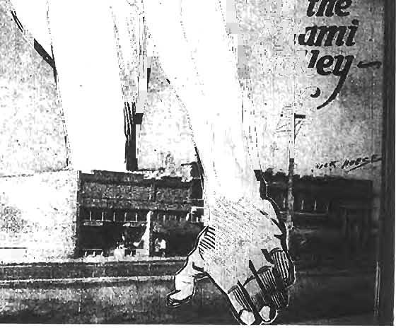
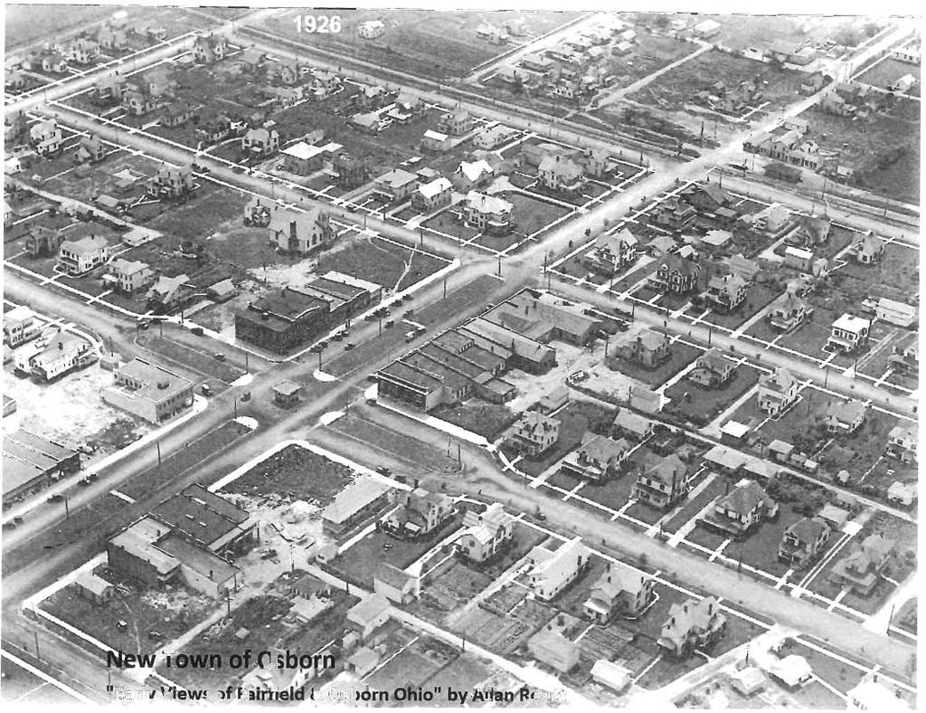
3 The "Old" Town of Osborn & the 1913 Flood 1851: The Town of Osborn is established Flood - March : Heavy rains throughout the Miami River Valley. March 26: Water crest reaches 20 feet in downtown Dayton : 5 dams are built to control the GreatMiami River. Old Osborn - "Early Views of Fairfield & Osborn Ohio" By Allan Routt Chronicling America - Library of Congress 1905: The town of Osborn had several shops, a hotel, a mill and four churches. March 24: Great Miami River rises to 11.6 feet and continues to rise. March 27-31: - More than 360 people died - 20,000 homes destroyed Map of Osborn - Greene County Archives 4th St. Looking Toward Main St. - Dayton Miami Conservancy District Photo Collection Constructing Huffman Dam Miami Conservancy District Photo Collection


4


5


6


7


8

9


10
11

12

13
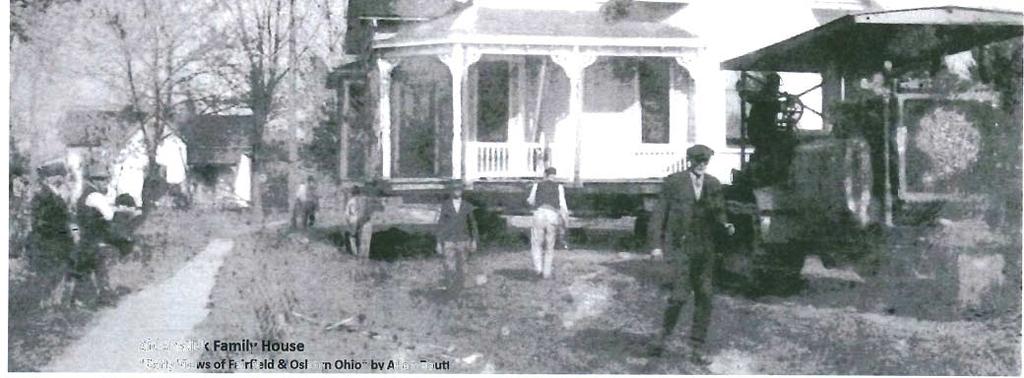
14 Name: 6 th Grade Osborn Map Activity 1. The Sidenstick Family house is colored in yellow (looks highlighted). On what street is it located and what building is located northwest of the house on the corner of Johnston Street and Pearl Street? 2. The Zeller family s house is at an intersection and is colored green. What two streets intersect there? 3. Only two streets in Osborn ran north and south. What are the names of the streets? 4. By studying the map, what businesses and industries were in Osborn? 5. Of the two families (Zeller and Sidenstick), only one house was in the original part of town? Which family was it? How can you tell? 6. Imagine that you were one of the citizens of Osborn, and you had to move your house. How would you prepare for the move? How would you feel?
15 Answer Key to Map Activity 1. The Sidenstick house is located on Harrison Avenue. The building that is located northwest of the house on the corner of Johnston and Pearl Street can either be a school or a church. 2. The Zeller family house is located at the intersection of Johnston Street and Julia Street. 3. The streets that run north to south are Mill Street and Pearl Street. 4. Businesses and industries that were in Osborn were mills, a railroad line, a warehouse and a Milling Company. 5. The Zeller family lived in the original part of town. By looking at the key in the top left corner, the original part (designated in pink) is an area where the Zeller family house is located. The Sidenstick house is located in the W. H. Cox Addition which is colored in yellow. 6. The student uses their imagination to answer this question.
16 List of Resources 1. Timeline created by Greene County Archives 2. Bath Township Map Greene County Archives 3. Photograph of Old Town of Osborn Greene County Historical Society Collection 4. Insert from The Dayton Journal, May 3, 1925 Dayton Metro Library Collection 5. Photograph of the Zeller Family Early Views of Fairfield & Osborn Ohio by Allan Routt 6. Photograph of the Sidenstick Family House Early Views of Fairfield & Osborn Ohio by Allan Routt Engineer Map Greene County Archives 8. Photograph of the New Town of Osborn Early Views of Fairfield & Osborn Ohio by Allan Routt Aerial Map of Fairfield and Osborn Greene County Historical Society Collection Map of Osborn Greene County Archives
Planning: Walkertown Area Historical Society Center and Museum December 26, Walkertown Area Historical Society
 Walkertown Area Historical Society Summary of Suggestions and Ideas for Development of the Walkertown Area Historical Society Center and Museum, 3058 Church Street, Walkertown, NC 27051 I. General Purpose
Advanced Site Inventory Activity
 9-12 ACTIVITY Advanced Site Inventory Activity 9-12 ACTIVITY Summary: Students investigate various elements of their Schoolyard Habitats site, including climate, land use, and human impact. Grade Level:
Urban Analysis. Downtown Zanesville like any city, has been physically modified through time as it
 Urban Analysis As a part of the consulting team s reconnaissance effort, an urban analysis was performed. Before the future of a place can be envisioned, one must understand the physical characteristics
Tíreolaíocht Ardleibhéal. Geography Higher Level. Scéimeanna Marcála Scrúduithe Ardteistiméireachta, 2007
 Scéimeanna Marcála Scrúduithe Ardteistiméireachta, 2007 Tíreolaíocht Ardleibhéal Marking Scheme Leaving Certificate Examination, 2007 Geography Higher Level Coimisiún na Scrúduithe Stáit State Examinations
NOMINATIONS TO THE NATIONAL REGISTER OF HISTORIC PLACES:
 NOMINATIONS TO THE NATIONAL REGISTER OF HISTORIC PLACES: THE NUTS & BOLTS OF DRAFTING A NOMINATION Presented by Jim Bertolini National and State Register Coordinator Nevada State Historic Preservation
National Building Museum
 National Building Museum Educator Resource Packet Grades 5 9 Fuller s Fantastic Geodesic dome This lesson was created as a supplement to the Fuller s Fantastic Geodesic Dome program at the National Building
Stormwater Management in Your Backyard
 Stormwater Management in Your Backyard An Extension Initiative for New Jersey, New York and Virginia This material is based upon work supported by the Cooperative State Research, Education, and Extension
Architectural Inventory Form (page 1 of 5)
") OAHP1403 Rev. 9/98 COLORADO CULTURAL RESOURCE SURVEY (page 1 of 5) Official eligibility determination (OAHP use only) Date Initials Determined Eligible- NR Determined Not Eligible- NR Determined Eligible-
OAHP1403 Rev. 9/98 COLORADO CULTURAL RESOURCE SURVEY (page 1 of 5) Official eligibility determination (OAHP use only) Date Initials Determined Eligible- NR Determined Not Eligible- NR Determined Eligible-
DRAFT ENVIRONMENTAL IMPACT REPORT NORTH HOLLYWOOD-VALLEY VILLAGE COMMUNITY PLAN AREA
 Environmental Review City Hall 200 N. Spring Street, Room 750 Los Angeles, CA 90012 DRAFT ENVIRONMENTAL IMPACT REPORT NORTH HOLLYWOOD-VALLEY VILLAGE COMMUNITY PLAN AREA The Plaza at The Glen Mixed Use
Architectural Inventory Form (page 1 of 5)
") OAHP1403 Rev. 9/98 COLORADO CULTURAL RESOURCE SURVEY (page 1 of 5) I. IDENTIFICATION 1. Resource number 5RT-2050 2. Temporary resource number: 145008005 3. County: Routt County 4. City: Steamboat Springs
OAHP1403 Rev. 9/98 COLORADO CULTURAL RESOURCE SURVEY (page 1 of 5) I. IDENTIFICATION 1. Resource number 5RT-2050 2. Temporary resource number: 145008005 3. County: Routt County 4. City: Steamboat Springs
Garden Lesson: Patterns in Plant Growth Season: Spring Grades: 4 th, 5 th & 6 th Grade
 Ohio Science Concept 4 th Grade: Earth s living history- Environmental change 5 th Grade: Interactions with Ecosystems 6 th Grade: Cellular to multicellular: Modern Cell Theory Garden Lesson: Patterns
What Makes a Community?
 What Makes a Community? Town Green Walking Tour Teacher Guide This packet contains materials that educators can utilize in class before and after your visit to the Fairfield Museum and History Center.
Images: 2010 Bill Sumner for Vizcaya Museum and Gardens.
 For Teacher: The field study visit to Vizcaya and this orientation are organized around inquirybased facilitated discussion. Vizcaya s school programs use facilitated discussion to encourage students to
Planning & Zoning Commission Meeting Date: June 18, 2012
 Meeting Date: June 18, 2012 Request Applicant Owner Zoning Location Attachments Proposed Master Plan for 11.5 acres of undeveloped property in the Tuscan Lakes PUD. The land is platted as one lot, and
Planning Districts INTRODUCTION
 INTRODUCTION To facilitate detailed examination of development prospects for all areas of the community, Delano has been divided into 14 planning districts. The location of these planning districts is
Call for Artists Deadline: April 27, 2018
 DOWNTOWN COMMONS NORTHWEST WALL and MAIN AVE. ELECTRICAL BOX WRAPS TWIN FALLS, IDAHO Call for Artists Deadline: April 27, 2018 INTRODUCTION The Magic Valley Arts Council on behalf of the City of Twin Falls
Blue Line LRT Extension
 v e Noble Pkwy Noble Pkwy Xerxes Ave N Shingle Creek Penn Ave N Penn Ave N Fremont Ave N Lyndale Ave N S Washington Ave University Ave NE Blue Line LRT Extension LIGHT RAIL PLATFORM AND STATION DESIGN
Redridge Dam Monument Collection
 This finding aid was produced using ArchivesSpace on 2018-06-29 Finding aid written in English Describing Archives: A Content Standard Michigan Technological University Archives and Copper Country Historical
Architectural Inventory Form
 COLORADO CULTURAL RESOURCE SURVEY Page 1 of 8 Official Eligibility Determination (OAHP use only) Rev. 9/98 OAHP1403 Date Initials Determined Eligible National Register Determined Not Eligible National
Annotated List of Additional Resources. Book / Print Sources
 Annotated List of Additional Resources Book / Print Sources For more information on Chippewa Falls history: The Chippewa County Chronicle. Friendship, WI: New Past Press, 1995. Found at the University
GVSU Sustainable Storm Water Initiative
 GVSU Sustainable Storm Water Initiative MWEA Watershed Seminar Bath, MI December 5, 2013 Dr. Peter J. Wampler Talk Road Map Brief Geomorphic History of the Grand River and Grand River Ravines Historic
My Street, My Town Lesson Plan
 P a g e 1 My Street, My Town Lesson Plan Grade Level: 4th Lesson Length: 2-4 class periods Learning Objectives Students will learn about street names and early Chandler families Students will do research
The transportation system in a community is an
 7 TRANSPORTATION The transportation system in a community is an important factor contributing to the quality of life of the residents. Without a sound transportation system to bring both goods and patrons
Community Meeting #2.1
 Community Meeting #2.1 Thursday, October 20, 2016, 7:00 p.m. to 9:00 p.m. Eliot Elementary School, 475 Old Gilroy Street, Gilroy, CA 95020 Meeting Summary The City of Gilroy held its third community meeting
Downtown Cleveland s Main Avenue Bridge
 Downtown Cleveland s Main Avenue Bridge Underpass Improvement Competition Project Summary Downtown Cleveland Alliance seeks a creative professional or team (architect, designer, artist, engineer, landscape
Inventory of the Hamlets
 THE HERITAGE CORRIDORS OF BATH Inventory of the Hamlets 28 AN OHIO SCENIC BYWA Y GHENT The historic Ghent area extends to the east on Yellow Creek Road where the creek passes beneath the road, to the west
9 North Downtown Master Plan & Saskatchewan Polytechnic
 9 North Downtown Master Plan & Saskatchewan Polytechnic Overview The area south of 33 rd Street (across from Kelsey-Woodlawn) will begin to see significant changes in the future. The North Downtown Master
School Programmes. Delivering the Curriculum for Excellence through creative, outdoor learning.
 Delivering the Curriculum for Excellence through creative, outdoor learning. Water of Leith Visitor Centre 24 Lanark Road Edinburgh EH14 1TQ Tel: 0131 455 7367 Email:admin@waterofleith.org.uk www.waterofleith.org.uk
Structural Project (stream daylighting) Property Protection (elevation) PREVENTION NATURAL RESOURCE PROTECTION STRUCTURAL PROJECTS PUBLIC EDUCATION
 Property Protection (elevation) PREVENTION NATURAL RESOURCE PROTECTION STRUCTURAL PROJECTS PUBLIC EDUCATION") NEW MITIGATION GOALS, STRATEGIES, ACTIONS PREVENTION STRUCTURAL PROJECTS NATURAL RESOURCE Structural Project (stream daylighting) PROPERTY PUBLIC EDUCATION EMERGENCY SERVICES Property Protection (elevation)
NEW MITIGATION GOALS, STRATEGIES, ACTIONS PREVENTION STRUCTURAL PROJECTS NATURAL RESOURCE Structural Project (stream daylighting) PROPERTY PUBLIC EDUCATION EMERGENCY SERVICES Property Protection (elevation)
Chapter 2: PROJECT METHODS
 Chapter 2: PROJECT METHODS The primary goal of the reconnaissance level survey is to identify areas of the City which are potentially eligible for preservation as either historic or conservation districts,
Olde Towne Vision Plan
 Olde Towne Vision Plan Introduction In 2016, the City of Bellevue will complete its move of City offices from Olde Towne Bellevue to its new municipal complex on Wall Street. The City intends to sell its
, C-MS I June 3, 2016 $1500 pd chk #216918
 , C-MS-8 LOTS 21 THROUGH 40, INCLUSIVE, BLOCK 299 CLEMENTS ADDITION TO THE CITY OF DENVER SOUTHEAST QUARTER OF SECTION 34, TOWNSHIP 3 SOUTH, RANGE 68 WEST, SIXTH PRINCIPAL MERIDIAN, CITY
MPO UPDATE. Metro Advisory Committee. August 8, 2017
 MPO UPDATE Metro Advisory Committee August 8, 2017 Iowa Data Bike 1 2 3 4 Greater Des Moines Water Trails and Greenways Master Plan MPO Strategic Plan QUESTIONS? Photo Credit: Maharry Photograpy, 2014
4 C OMMUNITY D ISTRICTS
 4 C OMMUNITY D ISTRICTS N ew development in the Area will include many different types of land uses, including a destination retail area that attracts people from all over the region; recreation opportunities
CONTEXT: the Highway, the River + the Railroads run through us.
 CONTEXT: the Highway, the River + the Railroads run through us. I-25 36 In the past they have divided us, now we have an opportunity to unite us. I-76 I-270 I-76 CSU I-25 LEGEND Cut + Cover River North
Comprehensive Development Guide
 INDUSTRIAL ELEMENT Comprehensive Development Guide 1 Industrial Element 7.1 Hardin County Industrial Overview BG PKWY Fort Knox Industrial Corridor Comprised of 11 parcels totaling 720 acres of land 68
CHAPTER 20 THE RAILROAD CHARACTER AREA. The Railroad Character Area contains the railroad tracks and those lands flanking them.
 CHAPTER 20 THE RAILROAD CHARACTER AREA The Railroad Character Area contains the railroad tracks and those lands flanking them. The Railroad Character Area contains the railroad tracks and those lands flanking
Historic Langhorne Association house histories
 01 Finding aid prepared by Celia Caust-Ellenbogen and Faith Charlton through the Historical Society of Pennsylvania's Hidden Collections Initiative for Pennsylvania Small Archival Repositories. Last updated
Lower Meramec Multi-Jurisdictional Floodplain Management Plan Public Involvement (Results of Early Public Engagement) 27 June 2018
 27 June 2018") Lower Meramec Multi-Jurisdictional Floodplain Management Plan Public Involvement (Results of Early Public Engagement) 27 June 2018 Public Involvement Summary: The planning process includes opportunities
Lower Meramec Multi-Jurisdictional Floodplain Management Plan Public Involvement (Results of Early Public Engagement) 27 June 2018 Public Involvement Summary: The planning process includes opportunities
Brampton. Secondary Plan. Review. Bram West. A New Direction in Planning & Public Consultation
 Brampton Bram West Secondary Plan Review A New Direction in Planning & Public Consultation Introduction The Bram West Secondary Plan Review offers an important opportunity for the community to define a
to the Jericho Reservoir Project Open House
 Welcome to the Jericho Reservoir Project Open House is responsible for supplying clean, safe drinking water to over 2.4 million residents in the region. Operating our vast drinking water system with a
2.1 Decision Making Matrix
 2.1 Decision Making Matrix The following decision-making matrix merges the elements of architectural and historical significance and current condition within the over-arching treatment recommendation of
QUESTIONS AND ANSWERS Windsor Woods, Princess Anne Plaza & The Lakes Combined Drainage Project
 QUESTIONS AND ANSWERS Windsor Woods, Princess Anne Plaza & The Lakes Combined Drainage Project PROJECT OVERVIEW Windsor Woods, Princess Anne Plaza and The Lakes are neighborhoods located in what was once
CLOSURE PLAN. CFR (b) Fly Ash Reservoir II. Cardinal Plant Brilliant, Ohio. August, 2016
 Fly Ash Reservoir II. Cardinal Plant Brilliant, Ohio. August, 2016") CLOSURE PLAN CFR 257.102(b) Fly Ash Reservoir II Cardinal Plant Brilliant, Ohio August, 2016 Prepared for: Cardinal Operating Company Cardinal Plant Brilliant, Ohio Prepared by: Geotechnical Engineering
CLOSURE PLAN CFR 257.102(b) Fly Ash Reservoir II Cardinal Plant Brilliant, Ohio August, 2016 Prepared for: Cardinal Operating Company Cardinal Plant Brilliant, Ohio Prepared by: Geotechnical Engineering
New York Avenue Streetscape and Trail Project Public Meeting #1 Summary
 New York Avenue Streetscape and Trail Project Public Meeting #1 Summary I. King Jordan Student Academic Center (SAC) Gallaudet University, Washington, DC February 23, 2017 Table of Contents 1.0 Introduction...
Land Use. Hardware Street Vendor Mixed-Use
 Land Use Definition Land Use is the way a piece of real estate is utilized. Existing, proposed, and adopted land uses all play a role in the planning process. Once a land use plan is adopted, the next
APPENDIX F. Mitigation Monitoring and Reporting Program
 APPENDIX F Mitigation Monitoring and Reporting Program APPENDIX F MITIGATION MONITORING AND REPORTING PROGRAM This Mitigation Monitoring and Reporting Program (MMRP) for the Creative Arts and Holloway
Planning & Zoning Board Meeting. DRAFT Comprehensive Transportation Plan Update, February 23, 2018 version
 Planning & Zoning Board Meeting DRAFT Comprehensive Transportation Plan Update, February 23, 2018 version May 10, 2018 Overview Overview of Agency Comments Overview of proposed modifications to the Draft
MONTGOMERY COUNTY PLANNING DEPARTMENT THE MARYLAND-NATIONAL CAPITAL PARK AND PLANNING COMMISSION
 MONTGOMERY COUNTY PLANNING DEPARTMENT THE MARYLAND-NATIONAL CAPITAL PARK AND PLANNING COMMISSION MCPB Item No. 6 Date: 7.22.13 Bethesda Purple Line Station Minor Master Plan Amendment, Scope of Work Elza
Cultural heritage and disaster management in Tucson, Arizona
 Kimmelman, Alex (1998 [2004]) Cultural heritage and disaster management in Tucson, Arizona, in Disaster Management Programs for Historic Sites, eds Dirk H. R. Spennemann & David W. Look. San Francisco
Adopting the Manual of Best Management Practices for Stormwater Quality. Facts for Communities
 Adopting the Manual of Best Management Practices for Stormwater Quality Facts for Communities Adopting the Manual of Best Management Practices for Stormwater Quality September 2006 prepared for the Mid-America
TABLE OF CONTENTS PAGE
 1989 BROWARD COUNTY LAND USE PLAN Original adoption March 1, 1989 Text amendments adopted as of March 10, 2015, are incorporated herein. BROWARD COUNTY BOARD OF COUNTY COMMISSIONERS BROWARD COUNTY PLANNING
Water: A Never-Ending Story
 Water: A Never-Ending Story A curriculum module intended for grades 3-5. Approximate time frame: 3 class periods I. Teacher Background Water on earth is used over and over. The water cycle, the continuous
Reducing the Storm Water Footprint of GVSU through BMP s
 Reducing the Storm Water Footprint of GVSU through BMP s Association of State Floodplain Managers Grand Rapids, MI June 22, 2016 Dr. Peter J. Wampler 1 Talk Road Map Brief Geomorphic History of the Grand
Swatara Township Stormwater Program. 1. There are no storm sewers on or near my property. Why should I pay a fee?
 1. There are no storm sewers on or near my property. Why should I pay a fee? All properties produce stormwater runoff that must be managed by the Township. Even if your property has never flooded and there
ARIZONA HISTORICAL SOCIETY 949 East Second Street Library and Archives Tucson, AZ (520)
") ARIZONA HISTORICAL SOCIETY 949 East Second Street Library and Archives Tucson, AZ 85719 (520) 617-1157 ahsref@azhs.gov DESCRIPTION MS 1173 Tucson Regional Plan, Inc. Papers, 1939-1980 Collection consists
ARIZONA HISTORICAL SOCIETY 949 East Second Street Library and Archives Tucson, AZ 85719 (520) 617-1157 ahsref@azhs.gov DESCRIPTION MS 1173 Tucson Regional Plan, Inc. Papers, 1939-1980 Collection consists
2.1 Location and Size
 2.0 Context 7 2.1 Location and Size The Saanich Penninsula The study area is centrally located within the Town boundaries on the east side of Highway 17, which runs through Sidney in a north-south direction.
L.G. Lee & Sons. L.G. Lee & Sons located on Mill Street in Almonte, Ontario, opened last month. Gardening Newsletter Vol. 10, Issue 7 - July 2015
 Over the span of 100 years, two world wars, a great depression and a catastrophic fire, there has been an almost unbroken thread of hardware-store history in a stretch of brick buildings in historic Almonte,
PREVIOUS PUBLIC PARTICIPATION BRIEF October 2014
 Comprehensive Planning During the development of the county comprehensive plan, Cultivating Community: A Plan for Union County s Future from 2007 through 2009, and three concurrent multi municipal plans
Citizen Advisory Committee Meeting #3.2
 Citizen Advisory Committee Meeting #3.2 August 10, 2016, 7:00 p.m. to 9:00 p.m. Police Department Conference Room, 7301 Hanna Street, Gilroy, CA 95020 Meeting Summary I. Call to Order Members present:
URBAN REGENERATION IN THE UK BY ANDREW TALLON DOWNLOAD EBOOK : URBAN REGENERATION IN THE UK BY ANDREW TALLON PDF
 Read Online and Download Ebook URBAN REGENERATION IN THE UK BY ANDREW TALLON DOWNLOAD EBOOK : URBAN REGENERATION IN THE UK BY ANDREW TALLON PDF Click link bellow and free register to download ebook: URBAN
RZC Public View Corridors and Gateways
 RZC 21.42 Public View Corridors and Gateways 21.42.010 Purpose 21.42.020 Scope and Authority 21.42.030 Administration 21.42.040 Gateways Design 21.42.050 Unidentified Public Views 21.42.060 Identification
Architectural Inventory Form
 COLORADO CULTURAL RESOURCE SURVEY Page 1 of 8 Official Eligibility Determination (OAHP use only) Rev. 9/98 OAHP1403 Date Initials Determined Eligible National Register Determined Not Eligible National
FIRST COCONUT GROVE SCHOOLHOUSE
 FIRST COCONUT GROVE SCHOOLHOUSE 3429 DEVON ROAD Designation Report City of Miami REPORT OF THE CITY OF MIAMI PLANNING DEPARTMENT TO THE HERITAGE CONSERVATION BOARD ON THE POTENTIAL DESIGNATION OF THE FIRST
City of Meriden Harbor Brook Flood Control Project Overview
 City of Meriden Harbor Brook Flood Control Project Overview Updated August 2013 OVERVIEW The center of Meriden, including the HUB site is the low point of the town which is ringed by basalt ridges. Running
American Map Greater Boston, Massachusetts
 American Map Greater Boston, Massachusetts If looking for the ebook American Map Greater Boston, Massachusetts in pdf format, then you have come on to the right website. We furnish complete version of
ABOUT GREEN CITY PROGRAM:
 ABOUT GREEN CITY PROGRAM: Green City Program Engaging, inspiring and empowering our youth for a sustainable future. Green City teaches K-12 students about environmentally sustainable design as it pertains
2018 SC 4-H Small Garden Project Group Record Book Cloverbuds Ages 5-8
 2018 SC 4-H Small Garden Project Group Record Book Cloverbuds Ages 5-8 Group Name: Group Contact: Physical Address of Garden: City: State: Zip: 4-H County: Phone: ( ) Email: Number of Participants in Group:
Brian Madigan, RLA, CPESC Director Land Planning & Design
 Brian Madigan, RLA, CPESC Director Land Planning & Design bmadigan@gymodpc.com Architecture, Engineering & Land Surveying, DPC 18969 US Route 11 Watertown, New York 13601 T: (315) 788-3900 F: (315) 788-0668
Mississippi Drive Corridor Revitalization. A DestinationTransportation Project...
 Mississippi Drive Corridor Revitalization A DestinationTransportation Project... Mississippi Drive Corridor Revitalization Welcome! Tonight s Agenda: Further define the Scope of the Project Discuss the
Camden SMART Initiative Stormwater Management and Resource Training
 Camden SMART Initiative Stormwater Management and Resource Training www.camdensmart.com Camden s Struggle with Stormwater 1 The City of Camden is served by a combined sewer system, which uses the same
PUBLIC OPEN HOUSE SEPTEMBER 8 TH, 2010 CITY OF LETHBRIDGE DEVELOPMENT SERVICES
 PUBLIC OPEN HOUSE SEPTEMBER 8 TH, 2010 CITY OF LETHBRIDGE DEVELOPMENT SERVICES INTRODUCTION Why is the City creating the West Lethbridge Employment Centre Area Structure Plan? West Lethbridge Urbanization
STUDY AREA. Tonight s Agenda. Project Tasks Completed. Next Steps. Town of Oyster Bay Eastern Waterfront Community Vision & Revitalization Plan
 Town of Oyster Bay Eastern Waterfront Community Vision & Revitalization Plan Public Meeting January 27, 2009 Opening Remarks Presentation Tonight s Agenda Introduction Study Area Overview Public Participation
CITY OF WESTERVILLE, PLANNING AND DEVELOPMENT. BASSEM BITAR / (614) /
 /") Staff Report Meeting Date: September 21, 2016 Case #: PC 2016-17 WESTERVILLE PLANNING COMMISSION Request: Applicant: Staff Liaison: RECOMMEND TO CITY COUNCIL FOR ITS FURTHER ACTION THE IMAGINE WESTERVILLE
Staff Report Meeting Date: September 21, 2016 Case #: PC 2016-17 WESTERVILLE PLANNING COMMISSION Request: Applicant: Staff Liaison: RECOMMEND TO CITY COUNCIL FOR ITS FURTHER ACTION THE IMAGINE WESTERVILLE
THE CORPORATION OF THE TOWN OF OAKVILLE BY-LAW NUMBER
 THE CORPORATION OF THE TOWN OF OAKVILLE BY-LAW NUMBER 2017-120 A by-law to adopt an amendment to the Livable Oakville Plan, Official Plan Amendment Number 20 (Downtown Oakville Growth Area) WHEREAS the
Fall www. aualum.org
 Fall 2007 www. aualum.org Photography by Jeff Etheridge Auburn Magazine For Alumni & Friends of Auburn University 33 34 Fall 2007 www. aualum.org Jean Williams recalls the day she was driving through her
Master Planning: Cuba, New York Phase II. Dr. John Anderson President Alfred State College. Alfred New York
 Master Planning: Cuba, New York Phase II Dr. John Anderson President Alfred State College Alfred, New York 14802 607-587-4211 February 1, 2011 June 30, 2012 March 5, 2012 Craig R Clark, PE Dean, School
Ashland BRT Environmental Assessment: logos of CTA, CDOT, Chicago Department of Housing and Economic Development
 Ashland BRT Environmental Assessment: logos of CTA, CDOT, Chicago Department of Housing and Economic Development Overview The Chicago Transit Authority (CTA), in partnership with the Chicago Department
Loved hearing what others shared and having a dialogue about the possibilities/opportunities
 MEMO To: Dave Efland, Director of Planning & Community Development November 7, 2018 From: Sarah Kelly and Emily Long, planning NEXT Re: Round 1 of Public Engagement, Delaware Together, Comprehensive Plan
Recommended Resources: The following resources may be useful in teaching this lesson:
 Unit E: Basic Principles of Soil Science Lesson 6: Understanding Soil Degradation Student Learning Objectives: Instruction in this lesson should result in students achieving the following objectives: 1.
Arturo Hernandez - Sangregorio Roy H. DeBoer Travel Prize in Landscape Architecture Proposal Summer 2014 March 23, 2014
 Arturo Hernandez - Sangregorio Roy H. DeBoer Travel Prize in Landscape Architecture Proposal Summer 2014 March 23, 2014 The Central Plaza: Urban Open Space in Two Colonial Cities Introduction Who we are,
Update. What is the Osborne Bridge Rehabilitation project all about and how is it being planned? Neighbourhood Advisory Committee (NAC)
") Update JANUARY 2010 Neighbourhood Advisory Committee (NAC) ARTS AND CULTURE Gas Station Theatre BUSINESS Osborne Village BIZ Downtown BIZ COMMERCIAL PROPERTY OWNER Great-West Life COMMUNITY ORGANIZATIONS
Update JANUARY 2010 Neighbourhood Advisory Committee (NAC) ARTS AND CULTURE Gas Station Theatre BUSINESS Osborne Village BIZ Downtown BIZ COMMERCIAL PROPERTY OWNER Great-West Life COMMUNITY ORGANIZATIONS
Historic Preservation Plan Update CITY OF HOLYOKE
 Historic Preservation Plan Update CITY OF HOLYOKE CITY OF HOLYOKE Historic Preservation Plan and Strategies for Center City This project is being funded in part by the City of Holyoke, Office of Community
Student Exploration: Seed Germination
 Name: Date: Student Exploration: Seed Germination Vocabulary: controlled experiment, germinate, hypothesis, mean, seed, trial, variable Prior Knowledge Question (Do this BEFORE using the Gizmo.) Plants
UNIVERSITY OF MICHIGAN:
 Chapter Eight UNIVERSITY OF MICHIGAN: North Campus I. Introduction The University of Michigan currently owns approximately 800 acres of land in the northeast section of Ann Arbor. North Campus refers to
Architectural Inventory Form
 COLORADO CULTURAL RESOURCE SURVEY Page 1 of 8 Official Eligibility Determination (OAHP use only) Rev. 9/98 OAHP1403 Date Initials Determined Eligible National Register Determined Not Eligible National
A: Downtown Diversion Pipe
 A: Downtown Diversion Pipe b c with modifications Map highlighting conservation easement. The diversion pipe would run along the railroad. Will divert 40-44% of total flow.; and Reduce the impact on Sand
Outflow to Saw Mill Run
 Dormont Stormwater Fee Frequently Asked Questions What is stormwater, and why is it a problem in Dormont? Stormwater is runoff from rain or snow that falls and flows to Little Saw Mill Run or McNeilly
PE PLE CROWDING CAN BE SEEDY
 UNIT 5 CROWDING CROWDING CAN BE SEEDY METHOD A simulation and gardening lab give students hands-on experience with the effects of increasing population density. MATERIALS Part 1: 20 ft of yarn/tape or
Guadalupe Espinoza Spencer Sibert George Clark Nathan Sorey. Rain Gardens Impacts on Our Water s Lifecycle
 Guadalupe Espinoza Spencer Sibert George Clark Nathan Sorey Rain Gardens Impacts on Our Water s Lifecycle 1 Community Produced Engaging Media to Motivate: Appreciation for our natural resources Conservation
Reconnecting New Haven: Downtown Crossing
 Reconnecting New Haven: Downtown Crossing Phase 2 Update Introduction to Phase 3 November 16, 2017 City of New Haven, Connecticut Toni N. Harp, Mayor Reconnecting New Haven Introduction Project Overview
Arkansas River Corridor
 Planning for Access Welcome to the Access Project. This project is a recreational planning effort in response to an interest by regional communities along the Arkansas River corridor. The project plan
1INTRODUCTION. Purpose of the Truckee Railyard Master Plan
 1INTRODUCTION Purpose of the Truckee Railyard Master Plan The purpose of the Truckee Railyard Master Plan is to capture and describe the Town s vision for the Railyard Area and to guide its future redevelopment.
NORTH COLLEGE PARK. Residential Neighborhood and Neighborhood Center OBJECTIVES EXISTING SITUATION AND ISSUES CONCEPT
 Greenbelt Metro Area Sector Plan - Subarea Design Policies and Guidelines - North College Park 119 NORTH COLLEGE PARK Residential Neighborhood and Neighborhood Center CONCEPT North College Park is envisioned
Chapter V-Transportation
 Town of Vernon 2026 Smart Growth Plan Chapter V-Transportation DEVELOPMENT OBJECTIVES Transportation System Objective - To provide an integrated transportation system which, through its location, capacity,
Recovery to Resilience Flood Tour
 Recovery to Resilience Flood Tour September 18, 2018 Tour Overview: Water Education Colorado is excited to offer a 5th anniversary, full-day tour of the 2013 flood-affected zone along the Front Range (to
FINAL MITIGATION PLAN to address
 CENTRAL CORRIDOR LRT STATE CAPITOL MALL HISTORIC FINAL MITIGATION PLAN February 2010 FINAL MITIGATION PLAN to address Adverse Effects of the Central Corridor LRT Project on the State Capitol Mall Historic
Guide to the Eau Claire Economic and Natural Resources Development Collection, , bulk
 Guide to the Eau Claire Economic and Natural Resources Development Collection, 1876-1983, bulk 1950-1983 Overview of the Collection Repository: Reference Code: Special Collections & Archives McIntyre Library
Natural Resources Comprehensive Plan Update NATURAL RESOURCES
 NATURAL RESOURCES 8. Natural Resources A. Introduction Natural resources play an important role in defining the City's physical structure and quality of life, with special emphasis on river and stream
Chapter 9. Historic Preservation Element
 Chapter 9. Historic Preservation Element Introduction This Historic Preservation Element of the Comprehensive Plan coordinates and directs the protection of sites, objects, and buildings central to the