Task Force Meeting December 11, 2007
|
|
|
- Emma Briggs
- 5 years ago
- Views:
Transcription

1 Martial Cottle Park Master Plan with State Park General Plan Elements Task Force Meeting December 11, 2007
2 Agenda 1. Welcome and Introductions 2. Accept Task Force Meeting #1 Summary 3. Community Workshop #1 Review of Outcomes 4. Review of Submitted Public Comments 5. Update on Draft Resource Inventory 6. Draft Opportunities & Constraints Analysis 7. Draft Goals & Objectives 8. Public Comments 9. Next Steps/Adjournment
3 Community Workshop #1 Review of Outcomes
4 Community Workshop #1 Summary Purpose of Workshop Introduce the community to the park planning process Familiarize the community with the park site and the Donor s Vision Solicit community input on issues and aspirations for the park Solicit community input on the prioritization of the program elements set forth in the Donor s Vision Inform the planning team s articulation of park goals, objectives, and programs
5 Community Workshop #1 Summary Community Discussion Groups Approximately 155 attendees Eight discussion groups Asked to address to questions: Their priorities for program elements set forth in the Donor s Vision, and Issues and concerns they had regarding the park.
6 Community Workshop #1 Summary Discussion Group Priorities Program Elements Identified in the Donor s Vision Historic Farm The majority of the groups identified the following as high priorities: Preserving historic farm elements and structures Farm animals and hay rides Interpretive programs and elements
7 Community Workshop #1 Summary Program Elements Identified in the Donor s Vision Farmers Market Discussion Group Priorities A limited number of groups identified the incorporation of a Farmers Market as a top priority.
8 Produce Stand Community Workshop #1 Summary Discussion Group Priorities Program Elements Identified in the Donor s Vision A limited number of groups identified the produce stand or a concession and refreshment stand as a top priority.
9 Specialty Crops/U-Pick Community Workshop #1 Summary Discussion Group Priorities Program Elements Identified in the Donor s Vision The majority of the groups identified the cultivation of specialty crops as a priority.
10 Equestrian Center Community Workshop #1 Summary Discussion Group Priorities Program Elements Identified in the Donor s Vision A majority of the groups identified the Equestrian Center as a priority. Most indicated a preference for a non-boarding type facility.
11 Community Hall Community Workshop #1 Summary Discussion Group Priorities Program Elements Identified in the Donor s Vision A limited number of groups identified the Community Hall as a priority. One comment raised the question of what the Community Hall would look like and who would use it, while another comment questioned the need for a Community Hall.
12 Grassy Park Community Workshop #1 Summary Discussion Group Priorities Program Elements Identified in the Donor s Vision A limited number of groups identified the incorporation of a grassy park as a priority.
13 Trails Community Workshop #1 Summary Discussion Group Priorities Program Elements Identified in the Donor s Vision A majority of the groups identified trails as a top priority with the following points emphasized: - access into and through the park - a perimeter trail - separate trails for different users
14 Lake Community Workshop #1 Summary Discussion Group Priorities Program Elements Identified in the Donor s Vision A majority of the groups identified a lake or pond as a favorable element. Most comments expressed a desire for maintaining a natural character and designing it for wildlife habitat or flood control.
15 Cultivated Fields Community Workshop #1 Summary Discussion Group Priorities Program Elements Identified in the Donor s Vision A majority of the groups identified active farming operations as a priority, including: Historical and sustainable farming Agricultural research and advanced practices Community subscription agriculture
16 Orchard Community Workshop #1 Summary Discussion Group Priorities Program Elements Identified in the Donor s Vision A majority of the groups identified orchards as a priority element within the park. Heirloom and demonstration orchards
17 Community Workshop #1 Summary Discussion Group Priorities Program Elements Not Listed on Donor s Vision Plan Community Gardens Composting Dog Park or place for off-leash dogs BBQ/Picnic Facilities Miscellaneous Park Elements, including: - Kitchen/added value - Facilities for school programs - Greenhouse/plant conservatory - Amphitheatre for ranger - Rose garden - Native tree nursery - Memorial to Mr. Lester
18 Habitat/Creek Restoration Community Workshop #1 Summary Discussion Group Priorities Other Priorities Not Listed on Donor s Vision Plan Several groups comments reflected a desire to preserve or create wildlife habitat Focus on the ecological restoration of Canoas Creek
19 Community Workshop #1 Summary Discussion Group Priorities Other Priorities Not Listed on Donor s Vision Plan Design Considerations View preservation Treatment of park edges Tree preservation and planting Sustainable design Site topography
20 Education Community Workshop #1 Summary Discussion Group Priorities Other Priorities Not Listed on Donor s Vision Plan Strong support for an educational component Opportunities to partner with schools, Master Gardener programs, 4-H, and other existing organizations Hands-on opportunities for children
21 Events Community Workshop #1 Summary Discussion Group Priorities Other Priorities Not Listed on Donor s Vision Plan A number of comments indicated support for a harvest festival or similar events.
22 Community Workshop #1 Summary Discussion Group Issues Fees Affordability Park funding Revenue-generating opportunities Concern about creating a for-profit park
23 Community Workshop #1 Summary Discussion Group Priorities Parking, Traffic and Roadways Parking emerged as a leading concern Traffic an area of concern, including: Potential for impacts on adjacent neighborhoods Traffic conditions on Branham Lane and Snell Avenue. A desire to not put roads through the park
24 Community Workshop #1 Summary Discussion Group Priorities Safety A desire for the park to be closed at night Security lighting Park security or emergency services
25 Community Workshop #1 Summary Discussion Group Priorities Noise, Odors, Maintenance Concern about potential impacts on neighbors, including: - noise from recreational activities near homes - odors from animals - maintenance and litter
26 Community Workshop #1 Summary Discussion Group Priorities Pesticides and Pests A desire to limit or avoid pesticide use, or require organic farming Some concern about rodents from the park infesting the neighborhood
27 Community Workshop #1 Summary Discussion Group Priorities Other Comments included: Non-historic agricultural uses and events would be allowed in the park Access into and within the park
28 Resource Inventory Update Final Draft Resource Inventory Revisions Most revisions corrected factual data about the site Executive Summary to be completed early next year State to conduct additional site survey for cultural resources and incorporate findings into Final Draft Resource Inventory early next year Final Draft Resource Inventory to be posted to the County s Web site for public review early in Martial Cottle Park Master Plan
29 Draft Opportunities & Constraints Analysis
30 Opportunities & Constraints Analysis The Donor s Vision The property shall be used exclusively as a public historical park that informs and educates the public about the agricultural heritage of the Santa Clara Valley as exemplified by the Martial Cottle family, dating from the 1850 s into the 20th century.
31 Opportunities & Constraints Analysis The Donor s Vision Grant Deed Conditions The property may be used for: Passive recreational activities (e.g., picnic facilities, trails) Interpretive, agricultural education and research uses related to the history of farming in SC Valley Commercial uses related to the primary historical purpose of the park, such as: - Agricultural leases - Produce stands - Community gardens - Farmer s markets
32 Opportunities & Constraints Analysis The Donor s Vision Grant Deed Conditions The property may not be used: For high intensity, organized recreational uses, such as: - athletic fields - playgrounds - tot lots - swimming pools - play courts - amusement rides As a repository for historic structures from other sites.
33 Red Foxes Constraint: non-native species is a threat to native species Hawks and Raptors Opportunity: enhance public experience Constraint: nesting raptors sensitive to disturbance Rodents Constraint: potential increase with more gardens Wildlife Opportunities & Constraints Analysis Natural Resources - Fauna Constraint: domestic and feral non-native species Opportunity: enhance public experience Constraint: features that attract Canada geese
34 Natural Habitat Opportunity: restore areas of native habitat Valley Oaks Opportunity: areas for programming & restoration Constraint: protect & replenish existing trees Riparian Habitat Opportunity: potential for creek restoration Seasonal Wetlands Opportunities & Constraints Analysis Natural Resources - Flora Opportunity: hydric soils suitable for restoration Constraint: areas may be subject to regulation Invasive Exotic Species: Constraint: conflict with agricultural use
35 Structures Opportunity: education and interpretation Opportunity: functional space for education, agriculture, administration, community use, etc. Constraint: significant rehabilitation & maintenance costs Farm Equipment & Personal Affects Opportunity: significant interpretive resource Archaeological Sites Opportunity: significant interpretive resource Constraint: sensitivity to subsurface excavation Historic Patterns of Use Opportunities & Constraints Analysis Cultural Resources Opportunity: significant interpretive potential
36 Adjoining Uses Opportunities & Constraints Analysis Visual & Aesthetic Character Opportunity: appropriate edge treatment with widening of Snell & Branham Constraint: balancing visual access to park from roads with preserving internal park character Constraint: privacy & aesthetic conflicts with residences along west side of park On Site Resources Opportunity: mature valley oaks are dramatic visual features Opportunity: historic buildings are distinctive visual features Opportunity: Canoas Creek channel has potential for enhancement as visual amenity
37 Valley Oaks Martial Cottle Park Master Plan
38 Historic Seasonal Wetlands Martial Cottle Park Master Plan
39 Canoas Creek Martial Cottle Park Master Plan
40 Historic Structures Martial Cottle Park Master Plan
41 Views Martial Cottle Park Master Plan


42
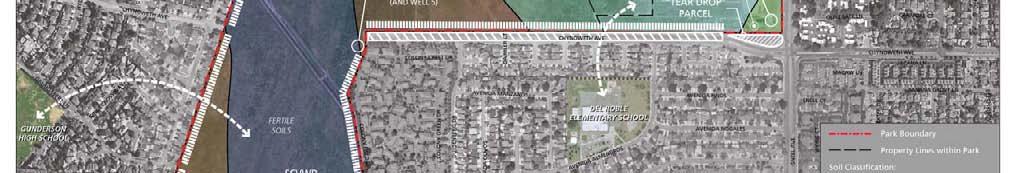
43 Adjacent Lands Opportunity: vacant 2.34-acre SCVWD S.E. corner of site Constraint: vacant 0.75-acre private parcel ( Tear drop Chynoweth and Snell Constraint: residences that back onto site Maintenance Facilities Constraint: potential visual & noise conflicts Parking Opportunities & Constraints Analysis Land Use Opportunity: wide public r.o.w. for Chynoweth Constraint: implications for traffic, noise, and visual Constraint: location/design of special event parking Constraint: space needs for larger vehicles (e.g., buses, horse trailers, etc.)
44 Soils Opportunities & Constraints Analysis Land Use Opportunity: fertile, well-drained soils good for agricultural crops Opportunity: areas of poorly-drained soils good for: Re-establishing native vegetation Incorporating recreational uses Developing above-grade community gardens
45 Opportunities & Constraints Analysis Land Use Soils Martial Cottle Park Master Plan
46 Opportunities & Constraints Analysis Land Use Potential Partnership or Programmatic Connections Martial Cottle Park Master Plan
47 Opportunities & Constraints Analysis Land Use Adjacent Land Use Issues Martial Cottle Park Master Plan

48 Opportunities & Constraints Analysis Land Use SCVWD Parcel Martial Cottle Park Master Plan
49 Opportunities & Constraints Analysis Land Use Tear Drop Parcel Martial Cottle Park Master Plan
50 Opportunities & Constraints Analysis Land Use Potential Streetscape Improvements and Parking Martial Cottle Park Master Plan
51 Opportunities & Constraints Analysis Land Use Infrastructure Martial Cottle Park Master Plan


52 Opportunities & Constraints Analysis Land Use Martial Cottle Park Master Plan
53 Site Access Opportunities & Constraints Analysis Circulation Opportunity: Hwy 85 underpass for trail connection Opportunity: dead-end streets on west side of site Opportunity: Canoas Creek maintenance roads for trail use Constraint: implications of site entry and parking locations on traffic and aesthetics Constraint: site size and limited access make pedestrian access inconvenient
54 Circulation Opportunities & Constraints Analysis Circulation Opportunity: Chynoweth alignment thru park as trail/service road connection Opportunity: Chynoweth west of site as potential bicycle corridor connection to Guadalupe River Park Opportunity: widening of Snell & Branham to enhance pedestrian safety and visual character Constraint: implications of primary access on Chynoweth to traffic and adjacent neighborhood Constraint: implications Snell & Branham traffic on site access and pedestrian/bicycle safety
55 Transit Opportunities & Constraints Analysis Circulation Opportunity: convenient regional access via Blossom Hill light rail station Opportunity: bus routes along Snell and Branham Opportunity: bike lanes along Snell and Branham Constraint: distance from Blossom Hill LRT station to core of park Constraint: absence of comfortable & attractive bus facilities
56 Opportunities & Constraints Analysis Circulation High Traffic Speeds and Volumes Martial Cottle Park Master Plan
57 Opportunities & Constraints Analysis Circulation Existing On-street Bike Lanes Martial Cottle Park Master Plan
58 Opportunities & Constraints Analysis Circulation Potential Vehicular Access Martial Cottle Park Master Plan
59 Opportunities & Constraints Analysis Circulation Potential Pedestrian Access Martial Cottle Park Master Plan
60 Opportunities & Constraints Analysis Circulation Potential Traffic Impacts Martial Cottle Park Master Plan
61 Opportunities & Constraints Analysis Circulation Potential Vehicular Conflict Point Martial Cottle Park Master Plan
62 Opportunities & Constraints Analysis Circulation Existing Bus Stops Martial Cottle Park Master Plan
63 Opportunities & Constraints Analysis Circulation Existing and Potential Multi-Use Trail Martial Cottle Park Master Plan


64 Opportunities & Constraints Analysis Circulation Martial Cottle Park Master Plan
65 Opportunities & Constraints Analysis Utilities and Infrastructure Water Opportunity: five existing wells provide source of water for park Constraint: implications of depending on ground water versus connecting to municipal water system Sewer Constraint: need to expand septic system and/or connect to municipal sewer system
66 Draft Goals & Objectives
67 Preliminary Goals & Objectives Recreation Goal: Provide for a range of passive recreation opportunities that complement the vision of a historic agricultural park and are consistent with the property s deed restrictions.
68 Preliminary Goals & Objectives Recreation Objectives: Integrate recreational programming and facilities with the park s agricultural function and historical resources. Locate and design recreational facilities that are compatible with adjacent uses outside the park property. Balance the mix and distribution of recreational elements including those identified in the Donor s Vision with elements that may be needed for efficient park operations (corporation yard, storage, hazmat shed).
69 Preliminary Goals & Objectives Recreation Objectives (Continued): Provide facilities that will activate and enhance the recreational use of the park (e.g., picnic facilities, multi-use trails, par course facilities, benches, etc.). Provide facilities and programming that addresses the needs and interests of a broad spectrum of the public. Provide facilities to serve large groups (e.g., group picnic area, central gathering space for events and festivals, etc.) as well as individual park visitors. Explore the potential for compatible dog use within the park.
70 Preliminary Goals & Objectives Agriculture Goal: Preserve and enhance the park as a functioning farm that supports sustainable and multifaceted agriculture that includes educational and community-serving components and commercial concessions consistent with the Donor s Vision.
71 Preliminary Goals & Objectives Agriculture Objectives: Preserve functioning components of the historic farm, including historic crops and farming methods, providing for interpretation and education about the historical farming practices of the Valley of the Heart s Delight. Employ sustainable agriculture practices for all farm operations, including organic farming practices. Employ state-of-the-art agricultural practices and technologies, including efficient irrigation systems. Establish viable partnerships with farming and research organizations to develop and operate the park s agricultural programs.
72 Objectives (Continued): Preliminary Goals & Objectives Agriculture Preserve Develop programs that will engage the public in active farming, including possible incubator programs for aspiring farmers and training in sustainable farming practices. Explore opportunities for developing and enhancing the marketing of produce grown at the park and creating value-added products. Develop community garden(s) in partnership with the City of San Jose. Develop interpretive programs for the agricultural operations of the park (see Education).
73 Preliminary Goals & Objectives Education & Interpretation Goal: Provide educational opportunities for a broad cross-section of the public that address the agricultural and historical themes of the park.
74 Objectives: Preliminary Goals & Objectives Education & Interpretation When available to the County, utilize the buildings, equipment and personal affects of the Cottle Ranch estate as the foundation of a program that interprets the history of agriculture in the Santa Clara Valley through the lens of the Cottle family s experience. Develop and implement a broad range of programs to provide hands-on training and education for people of all ages and backgrounds in agriculture, gardening, food production, and related topics as both vocation and avocation. Provide classroom facilities and/or multi-use space to accommodate educational programs. Martial Cottle Park Master Plan
75 Preliminary Goals & Objectives Education & Interpretation Objectives (Continued): Establish partnerships with appropriate organizations such as the Santa Clara County Board of Education, San Jose Unified School District, 4-H, Future Farmers of America, Master Gardeners and the University of California Cooperative Extension, and others to develop and implement educational programs at the park to further the park s mission. Develop programs to interpret the history of the site and region through its agricultural practices, cultural traditions, and natural resources.
76 Preliminary Goals & Objectives Education & Interpretation Objectives (Continued): Emphasize the development of interpretive and educational programs that are interactive and experiential in nature, in addition to more traditional exhibit-based approach, including use of internet technology to expand marketing and outreach for the park s educational programs. Develop agricultural business development programs in partnership with educational and research organizations.
77 Preliminary Goals & Objectives Natural Resources Goal: Preserve and enhance natural resources within the park consistent with the park s primary mission to provide for agriculture and passive recreation.
78 Preliminary Goals & Objectives Natural Resources Objectives: Preserve and restore native wildlife and vegetation populations within the park to the extent possible while allowing for the agricultural and recreational programs. Explore ecological restoration opportunities along Canoas Creek consistent with the channel s required hydrologic function. Create a lake, pond and/or wetlands in the area historically associated with poor drainage and seasonal ponding for the purpose of creating wildlife habitat and scenic value.
79 Objectives (Continued): Preliminary Goals & Objectives Natural Resources Preserve the existing valley oaks and provide for enhancement of oak savannah habitat with a program of new saplings. Incorporate the natural history of the park into the overall education and interpretive program. Make agronomic suitability of the various soils types a primary consideration in site design.
80 Preliminary Goals & Objectives Visual and Scenic Resources Goal: Protect and enhance the park s visual character while preserving high quality scenic vistas provided from within the park.
81 Objectives: Preliminary Goals & Objectives Visual and Scenic Resources Preserve the sense of openness felt from within the park and balance that sense with future park development as part of the Donor s Vision. Visually screen or buffer low-quality foreground views of adjoining development while preserving high quality views from within the park of the distant mountains to the east and south. Provide visual buffers along the adjoining street corridors that reduce the visual prominence of automobile traffic from within the park while maintaining some views into the park from surrounding streets and neighborhoods.
82 Preliminary Goals & Objectives Visual and Scenic Resources Objectives (Continued): Create visual buffers or screens along the western edge of the park that will reduce potential for privacy conflicts with adjacent landowners and views into private yards from the park. Preserve and enhance views of buildings or other structures with architectural and historical significance. Visually screen views of maintenance facilities, storage yards, and other facilities or structures that may detract from the park s visual quality.
83 Preliminary Goals & Objectives Land Use Goal: Develop and locate park uses to be responsive to the site s resources while being sensitive to the park s urban context and the potential for conflict with adjacent uses.
84 Preliminary Goals & Objectives Land Use Objectives: Site recreational, agricultural, interpretive and other park program elements to make the best use of the site s soils and cultural and historic resources. Distribute agricultural, recreational, and maintenance uses sensitively and provide appropriate buffers as necessary to avoid conflicts with adjacent residences. Provide limited site lighting only as necessary for public safety while being sensitive to impacts on park neighbors, night sky, and habitat values. Provide adequate parking to minimize potential for parking impacts on adjacent residential neighborhoods.
85 Objectives (Continued): Preliminary Goals & Objectives Land Use Distribute visitor parking to reduce potential for circulation, parking, and visual impacts on adjacent residential neighborhoods. Develop a coordinated land use and parking strategy for special events that optimizes the beneficial use of parkland during non-event periods, avoids visual impacts associated with large parking lots, and minimizes parking impacts on adjacent residential neighborhoods. Address security concerns of residents adjoining the west side of the park by permitting public access to the park during the park s hours of operations only.
86 Preliminary Goals & Objectives Circulation and Access Goal: Provide safe and convenient access to the park for a wide range of users.
87 Preliminary Goals & Objectives Circulation and Access Objectives: Develop strategies for facilitating travel to and from the park via alternative, non-automobile modes (e.g., bus, light rail, Caltrain, bicycle, walking) as a means of minimizing traffic and parking impacts and reducing harmful emissions. Provide safe and convenient pedestrian and bicycle connections from nearby transit nodes that includes bus stops, light rail and Caltrain stations to the park. Provide multiple points of walk-in entry for pedestrians and bicyclists to facilitate access to the park from surrounding neighborhoods and regional transit.
88 Objectives (Continued): Preliminary Goals & Objectives Circulation and Access Establish trail connections across the park to provide shorter and more convenient connections for pedestrians and bicyclists. Provide trails around the perimeter as well as through the site that are designed to accommodate safe and compatible use by multiple trail user groups, including pedestrians, rollerbladers, bicyclists, and equestrians. Provide accessible trails and access points for all people, regardless of physical abilities. Provide a system of internal service roads that facilitates access and circulation of park vehicles and farm machinery.
89 Objectives (Continued): Preliminary Goals & Objectives Circulation and Access Minimize potential traffic and parking impacts on surrounding neighborhoods by strategically locating parking facilities and vehicular entry points. Work with the City of San Jose on the future design of park edge and access treatments in conjunction with the widening of Snell Avenue and Branham Lane that will provide safe and attractive pedestrian and bicycle routes and allow for potential park access points (potentially both service and public). Work with the City of San Jose to provide safe and comfortable pedestrian and bicycle crossings at all intersections providing access to the park.
90 Objectives (Continued): Preliminary Goals & Objectives Circulation and Access Work with the VTA to develop safe, attractive, and context-sensitive designs for park area bus stops as means of promoting transit use as a preferred means of travel to the park. Work with the California State Department of Transportation (CALTRANS) to develop access beneath Highway 85 to surrounding neighborhoods near Blossom Hill Road. Evaluate the potential for collaborating with others on linking into other trail opportunities.
91 Public Comment Martial Cottle Park Master Plan
92 Planning Update Next Steps - Status Report Statement of Park Purpose, Vision and Goals and Objectives After Task Force Meeting #2, TAC and Project Team to provide input Program Development TAC Meeting #2 Late January Task Force Meeting #3 Late January Unit Classification Mid March Phase 4: Design Development Develop Alternatives February to Mid-April Task Force Meeting #4 April TAC Meeting #3 April Public Workshop #2: Alternatives Late April
93 Martial Cottle Park The Donor s Vision State Parks Concept Martial Cottle Park Master Plan
4.1 LAND USE, PLANS, AND POLICIES
 4.1 LAND USE, PLANS, AND POLICIES This chapter describes the existing land uses on the project site and the plans and policies applicable to the project, and evaluates the potential land use and planning
The following principles guide the development of goals and strategies to protect and promote these amenities:
 OPEN SPACE/PARKS/TRAILS/RECREATION GOALS/STRATEGIES Cherry Hills Village is a living environment that offers low density development, open areas, public scenic vistas, public trails and public parks. This
3. VISION AND GOALS. Vision Statement. Goals, Objectives and Policies
 Vision Statement Queen Creek s interconnected network of parks, trails, open spaces and recreation opportunities provide safe and diverse activities and programs that sustain its unique, small town, equestrian
Gold Line Bus Rapid Transit Transit Oriented Development (BRTOD) Helmo Station Area Plan
 Helmo Station Area Plan") Appendix F Gold Line Bus Rapid Transit Transit Oriented Development (BRTOD) Helmo Station Area Plan Introduction and Purpose of the Plan The Gold Line Bus Rapid Transit facility is an eleven-mile dedicated
Appendix F Gold Line Bus Rapid Transit Transit Oriented Development (BRTOD) Helmo Station Area Plan Introduction and Purpose of the Plan The Gold Line Bus Rapid Transit facility is an eleven-mile dedicated
Master Plan Objectives and Policies
 Master Plan Objectives and Policies Introduction This chapter identifies the Park issues and recommended policies established by this Master Plan. The issues were identified through meetings with staff,
Potential Green Infrastructure Strategies May 6, 2015 Workshop
 Potential Green Infrastructure Strategies May 6, 2015 Workshop Background The City of Cortland is developing the Tioughnioga Urban Headwaters Green Infrastructure Action Plan with funding from the National
Yadkin River Greenway Feasibility Study Fact Sheet Village of Clemmons, Town of Lewisville, Town of Bermuda Run
 Fact Sheet Village of Clemmons, Town of Lewisville, Town of Bermuda Run Project Background The Yadkin River Greenway Feasibility Study is a joint project with the Village of Clemmons, the Town of Bermuda
DRAFT MAP AMENDMENT FLU 04-4
 DRAFT MAP AMENDMENT FLU 04-4 SW 24 TH AVENUE ROADWAY CORRIDOR The University of Florida participates with the Metropolitan Transportation Planning Organization (MTPO) in its responsibilities for the continuing,
RECREATION AND OPEN SPACE ELEMENT GOALS, OBJECTIVES, AND POLICIES
 RECREATION AND OPEN SPACE ELEMENT GOALS, OBJECTIVES, AND POLICIES Goal 7 To provide park facilities, recreation programs, and open space resources that are safe, adequate, and accessible to all City residents,
2035 General Plan Update and Belmont Village Specific Plan. Joint Study Session with the City Council and Planning Commission April 12, 2016
 2035 General Plan Update and Belmont Village Specific Plan Joint Study with the City Council and Planning Commission April 12, 2016 Agenda 1. Welcome and Introductions 2. General Plan Update Status of
PLAN ELEMENTS WORKSHOP. April 5, 2016
 PLAN ELEMENTS WORKSHOP April 5, 2016 needs more housing. But there is no one-size fits-all solution. Every neighborhood has its own character. In some places, density is not only appropriate it is badly
This page intentionally blank.
 This page intentionally blank. Parks, Recreation, and Open Space Chapter Relationship to Vision Vision Parks, Recreation and Open Space Chapter Concepts County Government. County government that is accountable
Town of Portola Valley General Plan. Nathhorst Triangle Area Plan
 Town of Portola Valley General Plan Amended December 10, 1997 Table of Contents Introduction... 1 Planning Area... 1 Objectives... 2 Principles... 2 Standards... 4 Description... 4 Community Commercial...
Exhibit A. 8:9 Scuffletown Rural Conservation District
 Exhibit A 8:9 Scuffletown Rural Conservation District 8:9.1 Intent and Purpose The Scuffletown Rural Conservation (SRC) District is intended to provide for residential development that supports the development
Draft Stillwater 2030 Comprehensive Plan- Goals and Policies
 Draft Stillwater 2030 Comprehensive Plan- Goals and Policies Instructions- Review each goal and policy and discuss with group any changes, deletions for additions to the list using your groups pen. Keep
Mendota Heights 2040 Comprehensive Plan Draft Vers
 4 Parks and Trails The City of Mendota Heights boasts a variety of recreational and open space opportunities. Few cities can claim access to regional trails, riverside and lakeside parks, scenic bluffs
SCC PRD (2016) COUNTY PARK MASTER PLAN
 COUNTY PARK MASTER PLAN") SCC PRD (2016) COUNTY PARK MASTER PLAN MASTER PLAN UPDATE PARKS AND RECREATION COMMISSION NOVEMBER 7, 2018 PURPOSE OF THE MASTER PLAN The Sanborn County Park Master Plan will provide the Department with
SCC PRD (2016) COUNTY PARK MASTER PLAN MASTER PLAN UPDATE PARKS AND RECREATION COMMISSION NOVEMBER 7, 2018 PURPOSE OF THE MASTER PLAN The Sanborn County Park Master Plan will provide the Department with
SAN RAFAEL GENERAL PLAN 2040 INTRODUCTION AND OVERVIEW
 SAN RAFAEL GENERAL PLAN 2040 INTRODUCTION AND OVERVIEW Steering Committee Presentation February 14, 2018 Purpose of General Plan Guide land use and development decisions Coordinate transportation, infrastructure,
WARM SPRINGS PARK MASTER PLAN
 TABLE OF CONTENTS page 1.0 Introduction and Overview 1 2.0 Information Gathering 2 3.0 Conceptual Alternative Development 8 4.0 Master Plan Development 14 5.0 Construction Cost Estimates 19 LIST OF FIGURES
Chapter 5: Natural Resources and Environment
 NATURAL RESOURCES AND ENVIRONMENT 5-1 5 Chapter 5: Natural Resources and Environment BACKGROUND AND INTENT Urban expansion represents the greatest risk for the future degradation of existing natural areas,
Marshview Park. Concept Briefing and Feedback Session. Aquarium/Owls Creek Plan Steering Committee March 20, 2012
 Marshview Park Concept Briefing and Feedback Session Aquarium/Owls Creek Plan Steering Committee March 20, 2012 1 Outline of Today s Discussion Introductions Context for Marshview Park Site analysis -
Arlington, Virginia is a worldclass
 EXECUTIVE S U M M A RY Arlington maintains a rich variety of stable neighborhoods, quality schools and enlightened land use policies, and received the Environmental Protection Agency s highest award for
3.1 community vision. 3.3 required plan elements
 Chapter 3 Community Form 3.1 community vision 3.2 Parks & landscaping concepts 3.3 required plan elements D R A F T 20 Community Form Chapter 3 3.0 Community form 3.1 community vision The Specific Plan
Edgeley Pond + Park Public Meeting
 Edgeley Pond + Park Public Meeting February 21, 2017 Purpose of the meeting This Public Meeting is an opportunity for you to review the project background, process and provide input. City of Vaughan staff
Report to: Development Services Committee Report Date: April 24, 2017
 SUBJECT: Cornell Rouge National Urban Park Gateway - Report on Design Charrette and Next Steps PREPARED BY: Lilli Duoba, MES, MCIP, RPP, Manager, Natural Heritage (ext. 7925) REVIEWED BY: Marg Wouters,
AVONDALE ESTATES GREENSPACE AD-HOC COMMITTEE
 AVONDALE ESTATES GREENSPACE AD-HOC COMMITTEE INVENTORY AND RECOMMENDATIONS REPORT November 7, 2018 Our Mission Statement: To provide assistance and support, through professional expertise in matters of
RESPONSES TO PUBLIC CONCERNS AND QUESTIONS
 RESPONSES TO PUBLIC CONCERNS AND QUESTIONS Stations and Summary Questions for Public Meeting #2 June 23, 2015 General Questions / Concerns: 1. Is there any way this development can raise revenue for the
City of Nogales General Plan
 Open Space, Parks, Recreation and Trails City of Nogales General Plan Residents of Nogales place a high priority in the development of a comprehensive system of open space, parks, recreation and trails
WELCOME and introduction
 1 WELCOME and introduction Mobility Hub Locations within Burlington STUDY OVERVIEW STUDY OBJECTIVES The City of Burlington is developing four Area Specific Plans, one for each of Burlington s Mobility
City of Missoula and Missoula County Open Space Planning Open House
 City of Missoula and Missoula County Open Space Planning Open House FEBRUARY 6, 2018 The following slides contain the display board content from the open house. Please use boards to answer questions in
Charles P. Johnson and Associates. Annapolis Landscape Architects
 Charles P. Johnson and Associates Annapolis Landscape Architects AGENDA Introduction Project Limits and Scope Site Analysis Opportunities & Constraints Program Goals Image Boards Design Alternatives Pros
Building Great Neighbourhoods. Strathcona
 Building Great Neighbourhoods Strathcona March 21, 2018 Becky Redford Project Manager, Planning & Design Building Great Neighbourhoods Integrated Infrastructure Services Welcome and Purpose To provide
MAYFIELD WEST SECONDARY PLAN PHASE 2
 MAYFIELD WEST SECONDARY PLAN PHASE 2 Public Open House #3 February 25, 2010 Draft Preferred Land Use Scenario TOWN OF CALEDON PLANNING & DEVELOPMENT DEPARTMENT Open House Agenda TOWN OF CALEDON 1. Welcome
North Fair Oaks Community Plan Summary and Information
 North Fair Oaks Community Plan Summary and Information WHAT IS THE NORTH FAIR OAKS COMMUNITY PLAN? The North Fair Oaks Community Plan is part of the San Mateo County General Plan, and establishes policies
Chapter 4. Linking Land Use with Transportation. Chapter 4
 Chapter 4 Linking Land Use with Transportation Chapter 4 59 Chapter 4 Linking Land Use with Transportation Community Design and Transportation Program Introduction Since the 1950s, the predominant development
MEETING PURPOSE AND OVERVIEW
 MEETING PURPOSE AND OVERVIEW On February 23, 2012, the City of Elk Grove hosted the first of two community workshops related to the Southeast Policy Area. The workshop was held from 6:00 8:30 p.m. in the
Transportation. Strategies for Action
 Transportation A major priority for the Overlake Neighborhood is to develop a multimodal transportation system. To achieve this system, a balance has to be found among travel, circulation and access needs;
South East Sports Complex Phase I
 South East Sports Complex Phase I City of Spokane Design Review Board August 29, 2018 (Revised) Objectives 1. Early discussion and collaboration. 2. Provide framework / catalyst for future improvements
A BLUEPRINT FOR BROCKTON A CITY-WIDE COMPREHENSIVE PLAN
 A BLUEPRINT FOR BROCKTON A CITY-WIDE COMPREHENSIVE PLAN Public Meeting October 2016 1 Plan Summary and Discussion Public Meeting May 4 2017 City of Brockton Bill Carpenter, Mayor Department of Planning
John M. Fleming Managing Director, Planning and City Planner. Old East Village Dundas Street Corridor Secondary Plan Draft Terms of Reference
 Report to Planning and Environment Committee To: From: Subject: Chair and Members Planning & Environment Committee John M. Fleming Managing Director, Planning and City Planner Old East Village Dundas Street
Improve Neighborhood Design and Reduce Non Point Source Water Pollution
 HOW TO Planning Guide Improve Neighborhood Design and Reduce Non Point Source Water Pollution This document was funded by a grant from the New Hampshire Coastal Program with funding from the National Oceanic
Parks, Open Space and Trails
 Introduction Parks have often been referred as the lungs of our cities, cleansing the air of pollutants and particulate matter. Parks are also gathering places for families and community. They offer spaces
EXECUTIVE SUMMARY. Introduction
 EXECUTIVE SUMMARY Introduction State Route 68 is a designated scenic route that connects the world-renowned Monterey Peninsula to US Highway 101 and the Salinas Valley. SR 68 is a key route for bicycle,
CHAPTER 8 ISSUES, CONCERNS, CONSTRAINTS AND OPPORTUNITIES
 CHAPTER 8 ISSUES, CONCERNS, CONSTRAINTS AND OPPORTUNITIES Introduction This River Conservation Plan was developed during a time of tremendous activity and effort in planning the transformation of the Delaware
Introduction. Chapter 1. Purpose of the Comprehensive Plan Plan Organization Planning Process & Community Input 1-1
 Chapter 1 Introduction Lakewood 2025: Moving Forward Together Purpose of the Comprehensive Plan Plan Organization Planning Process & Community Input 1-1 Purpose of the Comprehensive Plan The Comprehensive
Clair-Maltby Community visioning
 Clair-Maltby Community visioning workshop #1 Summary April 27th, 2017 Table of Contents INTRODUCTIon 1 PURPOSE 1 CONSULTATION STRUCTURE 2 PARTICIPANT FEEDBACK 3 VISIONING EXERCISE 8 ONLINE SURVEY RESULTS
Brampton. Secondary Plan. Review. Bram West. A New Direction in Planning & Public Consultation
 Brampton Bram West Secondary Plan Review A New Direction in Planning & Public Consultation Introduction The Bram West Secondary Plan Review offers an important opportunity for the community to define a
BISCUIT RUN PARK MASTER PLAN
 BOARD OF SUPERVISORS November 14, 2018 BISCUIT RUN PARK MASTER PLAN COUNTY OF ALBEMARLE ANHOLD ASSOCIATES Contents Project Introduction Property Background County Park Planning Process Existing Site &
East Bench Master Plan Update
 Community & Economic Development Office of the Director East Bench Master Plan Update To: From: Planning Commission Wayne Mills, Senior Planner Date: November 18, 2015 CC: Re: Nora Shepard, City Planning
Authority of the General Plan
 Authority of the General Plan This La Habra Heights General Plan will serve as the blueprint for future planning and development in the City. This General Plan describes the City s vision for the future
CAL POLY MASTER PLAN UPDATE, March 2015
 Some Key Themes in the General Guiding Principles Academic Mission The plan must foremost advance the University s academic mission and student success. Foresight and Adaptability The plan should take
ADOPTED CAPITAL IMPROVEMENT PROGRAM BUDGET ARROYO PROJECTS
 ADOPTED CAPITAL IMPROVEMENT PROGRAM BUDGET ARROYO PROJECTS HAHAMONGNA FY 212-216 Capital Improvement Program Priority Description Total Estimated Costs Appropriated Through FY 211 Adopted FY 212 FY 213
The West Vaughan Employment Area Secondary Plan Policies
 Part 2: The West Vaughan Employment Area Secondary Plan Policies 2.1 General Policies It is the policy of Council: 2.1.1. That the West Vaughan Employment Area (the WVEA), identified on Schedule 1, will
Parks, Trails, and Open space Element
 Parks, Trails, and Open space Element Parks, Trails, and Open Space element Parks, Recreation, and Open Space are important components of the quality of life desired by the residents of Elk Grove. This
ATTACHMENT A AERIAL PHOTO OF McINTIRE PARK EAST
 ATTACHMENT A AERIAL PHOTO OF McINTIRE PARK EAST McIntire Botanical Garden Request for Proposals Attachments Page 1 of 33 ATTACHMENT B - MEMORANDUM OF AGREEMENT WITH THE CITY OF CHARLOTTESVILLE McIntire
CHAPTER 7: Transportation, Mobility and Circulation
 AGLE AREA COMMUNITY Plan CHAPTER 7 CHAPTER 7: Transportation, Mobility and Circulation Transportation, Mobility and Circulation The purpose of the Transportation, Mobility and Circulation Chapter is to
Concept Master Plan. for. Draft of. Wildlife Management Area. Prepared for. June, 2008
 Draft of Concept Master Plan for Vermillion Highlands: A Research, Recreation and Wildlife Management Area Prepared for Vermillion Highlands Steering Committee - Minnesota Department of Natural Resources
Portage Parkway Environmental Assessment Public Information Centre No. 1
 City of Vaughan Portage Parkway Environmental Assessment Public Information Centre No. 1 November 25, 2015 Welcome to the Public Information Centre This first Public Information Centre (PIC) introduces
Otay Regional Trail Alignment Study. Public Workshop March 14 th, 2017 from 5:30-8 p.m.
 Public Workshop March 14 th, 2017 from 5:30-8 p.m. Purpose of the Study A multi-agency planning effort to create a coordinated and sustainable trail system that enhances recreation and provides trail connections
TOWN OF BETHLEHEM MEETING SUMMARY LOCAL WATERFRONT REVITALIZATION PROGRAM UPDATE
 TOWN OF BETHLEHEM LOCAL WATERFRONT REVITALIZATION PROGRAM UPDATE MEETING SUMMARY Purpose: LWRP Update Public Workshop #3 Date and Time: October 24, 2017, 6:00 pm - 8:00 pm Location: Town Hall, 445 Delaware
Illustration of Eastlake Farmer s Cooperative Grain Elevator. Chapter 5: implementation 5-1
 Illustration of Eastlake Farmer s Cooperative Grain Elevator Chapter 5: implementation 5-1 chapter 5: implementation Introduction The Eastlake Subarea Plan includes a wide range of recommendations intended
Whitemarsh Comprehensive Plan Update: Housing & Land Use. Public Workshop #3: September 20, 2018
 Whitemarsh Comprehensive Plan Update: Housing & Land Use Public Workshop #3: September 20, 2018 Agenda Welcome Process Recap What We ve Heard The Plan Framework Review of Recommended Actions Land Use Housing
Corridor Vision. 1Pursue Minnehaha-Hiawatha Community Works Project. Mission of Hennepin County Community Works Program
 1Pursue Minnehaha-Hiawatha Community Works Project Minnehaha-Hiawatha Community Works is a project within the Hennepin Community Works (HCW) program. The mission of the HCW program is to enhance how the
The Illinois Department of Transportation and Lake County Division of Transportation. Route 173, including the Millburn Bypass
 The Illinois Department of Transportation and Lake County Division of Transportation welcome you to this Public Hearing for U.S. Route 45 from Illinois Route 132 to Illinois Route 173, including the Millburn
Master Site Development Plan (MSDP) Rocky View County Campus at Balzac East
 Rocky View County Campus at Balzac East") Master Site Development Plan (MSDP) Rocky View County Campus at Balzac East Balzac East, Alberta July 2009 CONTENTS 1.0 purpose 1 2.0 guiding principles 2 3.0 site description 3 4.0 site analysis and county
Master Site Development Plan (MSDP) Rocky View County Campus at Balzac East Balzac East, Alberta July 2009 CONTENTS 1.0 purpose 1 2.0 guiding principles 2 3.0 site description 3 4.0 site analysis and county
Policy & Procedure Effective Date: Parks Department Page of
 City of Arvada Policy & Procedure Effective Date: Parks Department Page of TITLE: City of Arvada Prairie Dog Habitat Plan APPROVAL: PURPOSE: To establish a plan for the preservation of black-tailed prairie
Isabel Neighborhood Plan: Alternatives
 Isabel Neighborhood Plan: Alternatives Presented by: Lori Parks, Associate Planner February 2, 2015 Agenda 1. Background on BART to Livermore 2. Isabel Neighborhood Plan 3. Alternative Scenarios 4. General
Town of Oakville Streetscape Strategy
 Town of Oakville Streetscape Strategy Endorsed by PDC on February 10, 2014 (PD-011-14) Town of Oakville Streetscape Strategy [endorsed by PDC February 10, 2014] 0 Town of Oakville Streetscape Strategy
RECREATION AND OPEN SPACE ELEMENT
 RECREATION AND OPEN SPACE ELEMENT Last amended August 19, 2008 Table of Contents Objective Page 5.1 Park system defined... 5-1 5.2 Access to parks and recreational facilities... 5-2 5.3 Recreation and
RECREATION, OPEN SPACE AND GREENWAYS ELEMENT GOALS, OBJECTIVES, AND POLICIES
 RECREATION, OPEN SPACE AND GREENWAYS ELEMENT GOALS, OBJECTIVES, AND POLICIES GOAL R-1: DEVELOP A RECREATION, OPEN SPACE AND GREENWAYS SYSTEM AS AN INTEGRAL COMPONENT OF AN OVERALL, COUNTY-WIDE ECONOMIC
URBAN DESIGN BRIEF URBAN DESIGN BRIEF 721 FRANKLIN BLVD, CAMBRIDGE August 2018
 URBAN DESIGN BRIEF URBAN DESIGN BRIEF 721 FRANKLIN BLVD, CAMBRIDGE August 2018 DESIGN BRIEF CONTENTS PART A 1.0 INTRODUCTION 2.0 DESCRIPTION & ANALYSIS OF SITE CONTEXT 3.0 DESIGN CONSTRAINTS AND OPPORTUNITIES
Rio/29 Small Area Plan. Design Plan & Implementation Framework Open House - January 25, 2018
 Rio/29 Small Area Plan Design Plan & Implementation Framework Open House - January 25, 2018 MEETING PURPOSE PRESENTATION 1. Orient to the updated design plans 2. Introduce implementing options 3. Explain
Windsor, Connecticut Plan of Conservation & Development DRAFT PLAN SUMMARY
 Windsor, Connecticut 2015 Plan of Conservation & Development DRAFT PLAN SUMMARY Plan Overview What is a Plan? Visionary Advisory Implementable Maintainable What it is not! Regulatory Binding Static Passive
CHAPTER 3 VISION, GOALS, & PLANNING PRINCIPLES. City of Greensburg Comprehensive Plan. Introduction. Vision Statement. Growth Management Goals.
 CHAPTER 3 VISION, GOALS, & PLANNING PRINCIPLES Introduction The Greensburg Comprehensive Plan is intended as a working community document. A combination of long and short-term goals, this document is intended
Lake O the Pines Master Plan Revision Public Information Meeting April 25 & 27, 2017
 Lake O the Pines Master Plan Revision Public Information Meeting April 25 & 27, 2017 Presented By Matthew Like, Lake Manager U.S. Army Corps of Engineers Fort Worth District US Army Corps of Engineers
Kenilworth Station Art and Landscape Committee (KSALC) June 25, 2015
 June 25, 2015") Kenilworth Station Art and Landscape Committee (KSALC) June 25, 2015 1 Today s Topics Welcome and Introductions Appoint Committee Co-Chairs Summary of Community Workshop #1 Kenilworth Channel Bridge Design
Kenilworth Station Art and Landscape Committee (KSALC) June 25, 2015 1 Today s Topics Welcome and Introductions Appoint Committee Co-Chairs Summary of Community Workshop #1 Kenilworth Channel Bridge Design
Town Center (part of the Comprehensive Plan)
") Town Center (part of the Comprehensive Plan) Mercer Island Town Center Looking North (2014) In 1994, a year-long process culminated in a set of design guidelines and code requirements for the Town Center
Town Center (part of the Comprehensive Plan) Mercer Island Town Center Looking North (2014) In 1994, a year-long process culminated in a set of design guidelines and code requirements for the Town Center
Open Space, Natural Areas, Parks, and Recreation
 Open Space, Natural Areas, Parks, and Recreation WHAT ARE THE CITY S CURRENT VALUES? This section addresses open spaces, natural areas, parks and recreation, and stormwater multi-use projects under separate
Corridor Enhancements
 Corridor Enhancements Safety is MoDOT s first priority in widening and rebuilding I-70 across the state of Missouri. MoDOT also understands that the interstate - and its interchanges and overpasses - are
Town of Peru Comprehensive Plan Executive Summary
 Town of Peru Comprehensive Plan Executive Communities that plan grow by choice, not by chance. A plan makes growth thoughtful, understandable, and predictable. A plan shows that a community is managing
Planned Development Review Revisions (Project No. PLNPCM )
") Planned Development Review Revisions (Project No. PLNPCM2014-00139) Standard residential development Planned Development Example: Smaller lot sizes than what is allowed to create open space amenity. What
Planned Development Review Revisions (Project No. PLNPCM2014-00139) Standard residential development Planned Development Example: Smaller lot sizes than what is allowed to create open space amenity. What
COMMUNITY DESIGN. GOAL: Create livable and attractive communities. Intent
 COMMUNITY DESIGN Intent An attractive, well-designed County will attract quality development, instill civic pride, improve the visual character of the community, and create a strong, positive image for
Status Update (2006 vs. Now) Citizen s Advisory Committee February Plan for Prosperity
 Citizen s Advisory Committee February Plan for Prosperity") Status Update (2006 vs. Now) Citizen s Advisory Committee February 2018 Plan for Prosperity 2000 2017 2000 2017 Gardnerville Population 6,000 5,760 5746 5,500 5,000 5,067 5,550 5,165 5,394 5,412 5,250
Status Update (2006 vs. Now) Citizen s Advisory Committee February 2018 Plan for Prosperity 2000 2017 2000 2017 Gardnerville Population 6,000 5,760 5746 5,500 5,000 5,067 5,550 5,165 5,394 5,412 5,250
Route 1 Corridor Study
 Route 1 Corridor Study Westbrook, Connecticut A Vision for the Connecticut Shoreline Public Informational Meeting July 28, 2015 Lower Connecticut River Valley Council of Governments Fitzgerald & Halliday,
CAMPUS MASTER PLAN DRAFT PLAN UPDATE JANUARY
 NEW MEXICO HIGHLANDS UNIVERSITY CAMPUS MASTER PLAN DRAFT PLAN UPDATE JANUARY 27 2010 MASTER PLANNING GOALS TO BALANCE THE STRATEGIC GOALS OF THE UNIVERSITY WITH THE PHYSICAL CAMPUS through the assessment
Standards (R-3) Figure B-11: R-3 Residential Standards Exhibit
 Figure B-11: R-3 Residential Standards Exhibit") Avila Ranch Avila Ranch Specific Plan Development Standards High Medium Density - High Residential Density Residential Lot and Building Lot and Standards Building (R-3) Standards (R-3) EXAMPLES These sketches
Avila Ranch Avila Ranch Specific Plan Development Standards High Medium Density - High Residential Density Residential Lot and Building Lot and Standards Building (R-3) Standards (R-3) EXAMPLES These sketches
Mississippi Skyway Preliminary Engineering Report
 EXECUTIVE SUMMARY Mississippi Skyway Preliminary Engineering Report CITY OF RAMSEY, MINNESOTA DECEMBER 2014 City of RAMSEY EXECUTIVE SUMMARY Project Need and Intent The Mississippi Skyway pedestrian bridge
Ivywild On The Creek PRELIMINARY CREEK DISTRICT MASTER PLAN
 Ivywild On The Creek PRELIMINARY CREEK DISTRICT MASTER PLAN Introduction: Rejuvenating an extraordinary Creekside neighborhood THE CREEKSIDE DISTRICT The Ivywild On The Creek Neighborhood District Master
Minto-Brown Island. November 18, City of Salem, Parks & Transportation Services
 Minto-Brown Island Park Master Plan Public Meeting #1 November 18, 2014 City of Salem, Parks & Transportation Services Division, i i Public Works Welcome... and thanks for participating in the master planning
1.0 VISION STATEMENT. December 6, PRINCIPLES
 Vision Statement Lincoln Regional Airport 1.0 VISION STATEMENT 1.1 City LOCATION of AND OVERVIEW The Easton Lincoln Place Land Use Master Plan identifies the principles, goals, policies, and standards
EL DORADO COUNTY GENERAL PLAN PARKS AND RECREATION ELEMENT PRINCIPLE INTRODUCTION STATE AUTHORIZATION
 EL DORADO COUNTY GENERAL PLAN PARKS AND RECREATION ELEMENT PRINCIPLE The General Plan must identify the types of governmental services, including parks and recreation facilities, which are necessary to
Parks, Trails, and Open Space Element
 P arks, Recreation, and Open Space are important components of the quality of life desired by the residents of Elk Grove. This Element of the General Plan addresses the City s goals, policies, and actions
OPEN HOUSE. Future. Neighborhood. Thursday April 27, :30 8:30 PM Refreshments provided Discovery Center, 4444 Hadley Avenue North
 OPEN HOUSE Thursday April 27, 2017 6:30 8:30 PM Refreshments provided Discovery Center, 4444 Hadley Avenue North The City Council has ini ated a planning process to guide future development on 206 acres
DRAFT Amsterdam/Churchill Community Plan (4/17/08) Adopted By the Gallatin County Commission
 Adopted By the Gallatin County Commission") DRAFT Amsterdam/Churchill Community Plan (4/17/08) Adopted By the Gallatin County Commission Table of Contents Acknowledgements Chapter 1: Introduction A Brief History What s Next Authority Organization
DRAFT Amsterdam/Churchill Community Plan (4/17/08) Adopted By the Gallatin County Commission Table of Contents Acknowledgements Chapter 1: Introduction A Brief History What s Next Authority Organization
A larger version of this map is located on the last page of this PDF.
 MAP Committee Input McLoughlin Area Draft Vision Map A larger version of this map is located on the last page of this PDF. 1. The map above is intended to portray a vision for the McLoughlin area. It highlights
Preliminary Recommendations Tk Takoma/Langley Crossroads Sector Plan
 Preliminary Recommendations Tk Takoma/Langley Crossroads Sector Plan Vision is to achieve a Transit Oriented, pedestrian friendly Community that Celebrates and builds upon the cultural Diversity of the
REGIONAL ACTIVITY CENTER
 DRAFT REGIONAL ACTIVITY CENTER 70 EAST BENCH MASTER PLAN DRAFT 06 Introduction The East Bench Regional Activity center is comprised of large educational, research, medical, and employment centers. These
Silverdale Regional Center
 Silverdale Regional Center Vision for Silverdale Regional Center The Silverdale Regional Center Plan (Plan) will guide the evolution of the Silverdale Regional Center from a collection of strip malls and
Tonight s Agenda. Summary Presentation Open House. Group Discussion Next Steps: online community wide survey
 Community Open House February 22, 2018 Tonight s Agenda Summary Presentation Open House Station 1: Project Overview and Community Input Station 2: Draft Vision and Guiding Principles Station 3: Western,
PARKS AND RECREATION
 PARKS AND RECREATION WHAT YOU WILL FIND IN THIS CHAPTER: Background information on the development of the Park, Recreation, and System Plan (PRSP). General overview of Ellensburg s parks and recreation