White Flint C 3. midtown on the pike. Draft Plan. Community Culture Commerce. Draft Plan
|
|
|
- Melvyn Mathews
- 5 years ago
- Views:
Transcription


1 Community Culture Commerce White Flint C 3 Draft Plan midtown on the pike Draft Plan montgomery county planning department The Maryland-National Capital Park and Planning Commission
2 Draft White Flint Sector Plan WHITE FLINT ABSTRACT This plan for the area of White Flint surrounding the Metro station contains the text and supporting maps of a comprehensive amendment to the approved and adopted 1992 North Bethesda/Garrett Park Master Plan. It also amends On Wedges and Corridors, the General Plan for the Maryland-Washington Regional District in Montgomery and Prince George s County, as amended. This Plan makes recommendations for land use, zoning, urban design, transportation, and community facilities. SOURCE OF COPIES The Maryland-National Capital Park and Planning Commission 8787 Georgia Avenue Silver Spring, MD THE MARYLAND-NATIONAL CAPITAL PARK AND PLANNING COMMISSION The Maryland-National Capital Park and Planning Commission is a bi-county agency created by the General Assembly of Maryland in The Commission s geographic authority extends to the great majority of Montgomery and Prince George s Counties; the Maryland-Washington Regional District (M- NCPPC planning jurisdiction) comprises 1,001 square miles, while the Metropolitan District (parks) comprises 919 square miles, in the two counties. The Commission is charged with preparing, adopting, and amending or extending On Wedges and Corridors, the general plan for the physical development of the Maryland-Washington Regional District. The Commission operates in each county through Planning Boards appointed by the county government. The Boards are responsible for all local plans, zoning amendments, subdivision regulations, and administration of parks. The Maryland-National Capital Park and Planning Commission encourages the involvement and participation of individuals with disabilities, and its facilities are accessible. For assistance with special needs (e.g., large print materials, listening devices, sign language interpretation, etc.), please contact the Community Outreach and Media Relations Division, or TDD
3 Draft of The White Flint Sector Plan Prepared by the Maryland-National Capital Park and Planning Commission 8787 Georgia Avenue Silver Spring, Maryland Approved by the Montgomery County Council Date Adopted by the Maryland-National Capital Park and Planning Commission Date 2
4 Elected and Appointed Officials County Council Michael Knapp, President Philip Andrews, Vice President Roger Berliner Mark Elrich Valerie Ervin Nancy Floreen George L. Leventhal Donald E. Praisner Duchy Trachtenberg County Executive Isiah Leggett The Maryland-National Capital Park and Planning Commission Royce Hanson, Chairman Samuel J. Parker, Jr., Vice Chairman Commissioners Montgomery County Planning Board Royce Hanson, Chairman John M. Robinson, Vice Chair Joe Alfandre Jean B. Cryor Amy Presley Prince George s County Planning Board Samuel J. Parker, Jr., Chairman Sylvester J. Vaughns, Vice Chair Sarah A. Cavitt Jesse Clark Colonel John H. Squire 3
5 The Plan Process A plan provides comprehensive recommendations for the use of publicly and privately owned land. Each plan reflects a vision of the future that responds to the unique character of the local community within the context of a countywide perspective. Together with relevant policies, plans should be referred to by public officials and private individuals when making land use decisions. The PUBLIC HEARING DRAFT PLAN is the formal proposal to amend an adopted master plan or sector plan. Its recommendations are not necessarily those of the Planning Board; it is prepared for the purpose of receiving public testimony. The Planning Board holds a public hearing and receives testimony, after which they hold public worksessions to review the testimony and revise the Public Hearing Draft Plan as appropriate. When the Planning Board s changes are made, the document becomes the Planning Board Draft Plan. The PLANNING BOARD DRAFT PLAN is the Board s recommended Plan and reflects their revisions to the Public Hearing Draft Plan. The Regional District Act requires the Planning Board to transmit a sector plan to the County Council with copies to the County Executive who must, within sixty days, prepare and transmit a fiscal impact analysis of the Planning Board Draft Plan to the County Council. The County Executive may also forward to the County Council other comments and recommendations. After receiving the Executive s fiscal impact analysis and comments, the County Council holds a public hearing to receive public testimony. After the hearing record is closed, the Council s Planning, Housing, and Economic Development (PHED) Committee holds public worksessions to review the testimony and makes recommendations to the County Council. The Council holds its own worksessions, then adopts a resolution approving the Planning Board Draft Plan, as revised. After Council approval the plan is forwarded to the Maryland-National Capital Park and Planning Commission for adoption. Once adopted by the Commission, the plan officially amends the master plans, functional plans, and sector plans cited in the Commission s adoption resolution. 4
6 Table of Contents Plan Vision... 7 MD 355/I-270 Framework... 7 Transportation Policy Report... 8 Background Existing Land Uses and Zoning Urban Form Center Circulation Buildings Figure Ground Sketch Public Use and Open Spaces Transitions Land Use and Zoning Area Wide Recommendations Recommendations by District Sustainability Recommendations Mobility Recommendations Public Facilities Public Parks Public Schools Fire, Rescue, and Emergency Medical Services Public Safety Libraries Farmers Market Historic Preservation Implementation Zoning Staging Plan Capital Improvement Projects (CIP) Administration Financing
7 List of Figures Figure 1: MD 355/I-270 Corridor Figure 2: MD 355: North Bethesda Figure 3: Plan Boundaries and Metro Station Policy Area Figure 4: 1992 Master Plan Rezoning Areas Figure 5: Major Infrastructure Elements Figure 6: Existing Land Use Figure 7: Existing Zoning Figure 8: Density/Open Space Sketch Figure 9: Proposed Rockville Pike Cross Section Figure 10: Promenades and Pedestrian Priority Streets Figure 11: Figure Ground Sketch Figure 12: Connections and Parks Sketch Figure 13: Green Space System Figure 14: Metro Proximity and Maximum FAR Figure 15: FAR and Massing Figure 16: Transfer of FAR Along Rockville Pike Figure 17: Existing Building Heights Figure 18: Proposed Building Heights Figure 20: Districts Figure 21: Metro West Figure 22: Metro East Figure 23: Maple Avenue Figure 24: Nebel Figure 25: NRC Figure 26: Mid-Pike Plaza Figure 27: White Flint Mall Figure 28: NoBe Figure 29: Proposed Zoning Figure 30: White Flint Stream Conditions Figure 31: Montgomery County Development Effects on Stream Quality Figure 32: White Flint Tree Canopy Figure 33: Existing and Proposed Street Classification Figure 34: Existing and Proposed Bikeways Figure 35: Existing Public Facilities Figure 36: Potential School Sites Figure 37: Proposed Public Facilities Figure 38: Historic Resources List of Tables: Table 1: Existing Zoning Table 2: FAR in Rings from Metro Table 3: Proposed Range of Building Heights Table 4: Proposed Development Table 5: Road Facility and Segment Table 6: Bikeway Facility and Segment Table 7: Capital Improvement Projects Organized by Category 6
8 Plan Vision There are few locations remaining in Montgomery County where excellent transit service and redevelopment potential coincide. Given the reality of future energy constraints and the effects of climate change, growth must take advantage of existing infrastructure, especially transit, to create compact new communities where reliance on the automobile is not necessary. Growth should be directed to those places where the reduction in the carbon footprint is possible, like White Flint, and where the infrastructure can support a sustainable, culturally interesting urban center outside of the well-established central business districts. As such, White Flint fits squarely into the County s General Plan and long range policies as the place to accommodate a substantial portion of the region s projected growth. White Flint was first proposed as an urban, mixed-use community at the center of North Bethesda more than 30 years ago. The envisioned transformation from a suburban, car-oriented series of strip shopping centers into an urban, transit-oriented mixed-use area has happened, but slowly and in scattered pockets. The automobile still dominates, especially along Rockville Pike and the pedestrian experience in most of White Flint is barely tolerable. Recent projects, such as the Conference Center, The Sterling and the North Bethesda Town Center have created urban block patterns, provided destination uses with buildings facing streets and have improved pedestrian access. More needs to be done to connect these urban pockets, to introduce civic functions and open space, and to reduce conflicts between vehicles and pedestrians. This Sector Plan explores how the urban center concept can be applied to new development to achieve a more coherent urban form. An urban place is dependent on people and activity. People walk from their homes to work, shops and transit; offices plazas are full of workers during the day. At night and on weekends people attend the theater, visit galleries, and eat out. In the summer, everyone is out enjoying the evening breezes. This is a place where different lifestyles converge to make urban living interesting, challenging and exciting. The proposed cultural and retail destinations in and around the civic core, the open space system, and walkable street grid combine to spark the energy that flows through White Flint. With this energy, White Flint will become a vibrant and sustainable urban center that can adapt and respond to future challenges. MD 355/I-270 Framework The MD 355/I-270 Corridor is a historic travel and trade route that links communities in Montgomery County from Washington, D.C. to Frederick County. Over the last 30 years the corridor has emerged as a world class center for advanced technology and biotechnology industries and a regional shopping and cultural destination. This Plan recommends adding more residential capacity near existing transit facilities to balance land uses in the MD 355/I-270 Corridor. A substantial housing resource at White Flint is well situated to support the planned expansion of federal facilities in White Flint (National Regulatory Commission) and Bethesda (National Institutes of Health/Base Realignment and Closure). 7

9 Transportation Policy Report The Planning Board s January 2002 Transportation Policy Report (TPR) contained a comprehensive analysis of land use and transportation strategies to improve the jobs- housing balance in the I-270 Corridor, thereby reducing potential vehicular trips. The County Council s April year Transportation Plan supported an alternative land use policy that would promote new opportunities for residents to live closer to work, especially near Metrorail stations. The 2030 Council of Governments (COG) Forecast Round 7.0 proposed 2.17 jobs- housing ratio while the Council s alternative land use policy proposed 1.18 jobs to housing for the White Flint Metro Station policy areas. This Plan, guided by that policy, proposes a land use housing balance of 2.87 to one as compared to the existing eight to one ratio. Figure 1 MD 355 / I-270 Corridor 8
10 Figure 2 MD 355: North Bethesda 9
11 Background A mixed-use center concept for White Flint was first conceived in 1978 in anticipation of the extension of the Metro system. At the time, approximately 63 percent of the land area within the 200-acre study area was zoned R-90, a low-density residential zone, and undeveloped. Mid-Pike Plaza was the E. J. Korvettes Shopping Center, and the Forum was the only highrise residential development. The Plan recommended a density of 2.0 FAR under the transit mixed use floating zones (TS-R and TS-M) within a half-mile radius of the Metro station and used the C-2, I-1, and OM zones for properties not recommended for mixed-uses. A 1992 reexamination of the same 200 acres added a street grid, expanded the use of the TS-R and TS-M zones to C-2 zoned properties, and rezoned I-1 properties to I-4 to limit the conversion of industrial uses to office uses. A few years later, in 1997, the County Council approved an amendment to advance the development of the Conference Center across the street from the Metro station as a centerpiece public/private partnership. These planning efforts established the skeletal framework for the urban center concept and placed an important public resource at the core. What has triggered this Sector Plan evaluation? The previous plans recommended floating zones to accomplish mixed-use development. There was little incentive to seek a change from the C-2 zone, although it has a 42-foot height limit, because it has few development standards and allows many uses. Market forces must remain strong for developers to risk a lengthy rezoning development process, which takes at least a few years. A recent text amendment allowing taller buildings for residential development in the C-2 zone exemplifies the desire to achieve mixed uses through other means. Once a zone, such as a C-2 zone, begins to evolve into a mixed-use zone, redevelopment may lead to desirable uses but undesirable development patterns because of the limited development standards in the zone. The Plan expands the study area to 430 acres bounded by the CSX tracks, Montrose Parkway, Old Georgetown Road and the White Flint Mall. Even though the study area has doubled, the entire area lies within a ¾-mile radius of the Metro station, which is a walkable distance. This Sector Plan reexamines whether more, if not all, of the Plan area should be zoned for mixed uses. There is ample space to establish edges and to ensure that new development transitions compatibly with adjoining residential communities. The Sector Plan area is split by Rockville Pike, which follows a ridgeline dividing the Cabin John (west) and Rock Creek (east) watersheds. The land east and west of the Pike descends about 25 feet away from the ridge line. Since there is more contiguous underdeveloped land area east of Rockville Pike than west, the east has greater potential for the creation of new neighborhoods. Development constraints include a large water main and an 80-foot wide safety zone underneath Nicholson Lane, which limits the location of buildings, and the 50-foot WMATA tunnel easement along Rockville Pike, which has posed problems for building placement along the east side of Rockville Pike. 10

12 Figure 3 11
13 Figure 4 12
14 Figure 5 13
15 Existing Land Uses and Zoning There are more than 150 properties in the area, ranging in size from 3,000 square feet to 42 acres. Much of the land is in non-residential use, about 5.9 million square feet of commercial and office buildings. About 4,000 residential units exist or have been approved. There is a local park, Wall Local Park, within the Sector Plan area. A second local park, White Flint Neighborhood Park, lies between the Plan area s southern boundary and Garrett Park Estates. South of the Plan area are two cultural and educational institutions, Georgetown Preparatory School and Strathmore Performing Arts Center. Table 1: Existing Zoning Zone Description Acreage C-2 General Commercial 138 C-0 Commercial Office 8 CT Commercial Transitional 7 RMX/3C Residential Mixed-Use Development 3 RH Multifamily, High Rise 5 I-1 Light Industrial 21 I-4 Low Intensity Light Industrial 49 TS-R Transit Station Residential 42 TS-M Transit Station Mixed 57 OM Office Building Moderate 9 PD9 Planning Development 11 R-90 Single-Family Residential 7 R-90/TDR Single-Family Residential/TDR 5 R-200 Single-Family Residential 5 14

16 Figure 6 15

17 Figure 7 16
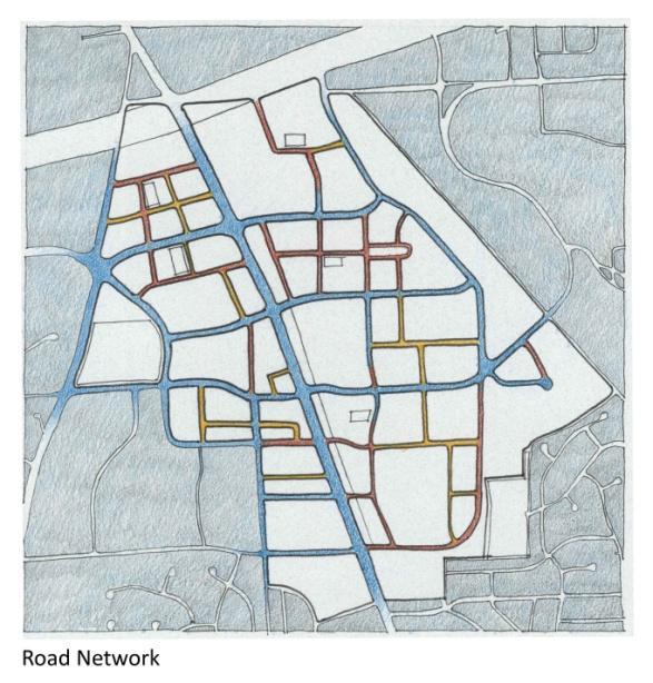
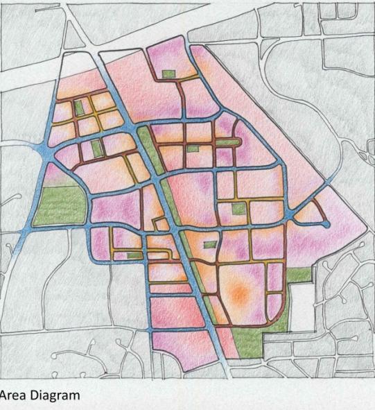
18 Urban Form While the previous Sector Plans had an urban design component, there was no proposed public open space system or civic space. Successful realization of the urban center concept depends on ensuring that the parts are unified. White Flint today is still in parts. The vision is a vibrant urban core centered along Rockville Pike, where public spaces are the primary focus of design and interaction. While land use defines the activity, success relies on the quality of urban spaces. The streets, buildings and open spaces flow block by block with a consistent approach to the street edge and public spaces, creating an environment where people interact in an active community. White Flint will be the sum of its parts. The goal is to achieve an urban core where the public spaces, primarily the sidewalks and streets, dominate design decisions. This environment can be achieved beginning with a connected street grid and open space system fronted with buildings. New development will be compact, sustainable, and easily accessible to transit. The proposed street grid will create walkable blocks; each block will have a residential component with local services within a short walking distance. All the components below increase the safety of the public and private spaces. Active sidewalks bring more people into public spaces Redevelopment may take 20 years and will occur property by property. The Plan will guide how the parts fit together as development occurs.. A companion piece, the White Flint Urban Design Guidelines, will provide additional detail to guide new development and implement the recommendations of the White Flint Sector Plan. Center Circulation Buildings Public Use and Open Spaces Transitions Sustainability In the core, community, culture and commerce converge to express White Flint s personality. The highest density and tallest buildings at the Metro station will form an identifiable center as a regional marketplace and a place for knowledge and information exchange. White Flint will have a walkable street system. Rockville Pike, transformed into a grand boulevard, will visually tie together the east and west sides of the Sector Plan area. Sidewalks, bikeways, trails, and paths will provide options for pedestrian circulation. White Flint will have buildings with podiums and slender towers that line the streets and articulate the skyline. Architectural details should incorporate features that add interest at the ground level as well as the floors above. Within a compact development pattern, White Flint will have a system of public and open spaces where people can gather. New development will include compatible transitions, especially with lower density surrounding neighborhoods. New development will incorporate environmentally sensitive design to conserve and generate energy and address stormwater management. Building and street design will respond to climate, seasons, sun and shade, topography, and make maximum use of renewable resources with minimum disruption of the natural environment. 17

19 Center The core of White Flint is located within a ¼-mile of the Metro station. Here density is high and buildings tall. Buildings along Rockville Pike should take advantage of long views out as well as visibility from the northern and southern edges of the Sector Plan area. The Conference Center, Wall Local Park, and a civic green define the center on the west side of Rockville Pike as do the Metro station and North Bethesda Town Center on the east side. Main Street will provide access into the interior of the Conference Center block through to Rockville Pike. Figure 8 Density / Open Space Sketch 18

20 19

21 Circulation Streets If the street network is the skeleton, the streets are the bones, each carrying a proportion of local and though traffic. Wider streets convey more traffic; as width decreases, streets support less traffic. There should be a clear division of function: loading and service functions should not hinder pedestrian movements. All streets must have ample space for pedestrians, bicyclists and street trees. Undergrounding utilities and locating wet utilities under the pavement and dry utilities under the sidewalk will allow the street tree canopy the space to grow. On-street metered parking should be permitted on all local streets and on most of the major streets during non-peak hour traffic to reduce speeds, encourage turnover, and generate revenue. Rockville Pike Boulevard Rockville Pike carries the majority of traffic through the Sector Plan area. The existing width between the City of Rockville and Nicholson Lane measures 134 feet and expands to 150 feet south of Nicholson Lane. The Pike has three north and south bound through-lanes and turning lanes. There are no street trees, landscaped median, or on-street parking. Rockville Pike is a State road under the authority of the Maryland State Highway Administration (SHA). This Plan recommends taming the beast by reconstructing the roadway as an urban boulevard, undergrounding utilities, adding a landscaped median and street tree panels and widening sidewalks to encourage walking and allow for safer crossings. A wider right-of-way makes bus priority lanes and onstreet parking possible. Figure 9 Proposed Rockville Pike Cross Section 20

22 Promenades Promenades are streets where special or distinctive plantings and paving materials provide a unique pedestrian experience. There are two promenades in the Sector Plan area: the Main Street Promenade located in the Conference Center block and the East Rockville Pike Promenade on top of the WMATA Tunnel. A portion of the proposed East Rockville Pike Promenade exists along the Nuclear Regulatory Commission frontage, where a series of paved walks and plantings sit on top of the Metro tunnel. Pedestrian Priority Streets These streets can be public or private and are intended to provide a distinctive streetscape internal to a development. The street cross sections emphasize pedestrian activity, but vehicles will have access at greatly reduced speeds. Figure 10 Promenades and Pedestrian Priority Streets 21

23 Bike Paths and Trails This Plan proposes an integrated network of bike paths and trails. Two bike paths in White Flint are part of the regional pedestrian and bicycle circulation system: the planned Montrose Parkway bike path and The Bethesda Trolley Trail. The Montrose Parkway bike path provides east-west links to trails in Cabin John Regional Park and Rock Creek Regional Park. The Bethesda Trolley Trail should be extended along Woodglen Avenue to connect to Wall Local Park, the Main Street Promenade, and the Montrose Parkway bike path. Recreation Loop The recreation loop is a signed recreational pathway that connects neighborhood greens, the central civic green, and Wall Local Park. The continuous loop passes through the districts and across Rockville Pike using sidewalks, trails, and public use easements. Buildings The buildings are the vertical extension of the street edge. Buildings provide substance in mass and bulk, and enliven the vertical plane with windows, doors, and variations in height. Buildings in urban settings combine horizontal elements the podiums and vertical elements the towers to provide variation and rhythm along the streetscape. Figure 11 Figure Ground Sketch 22

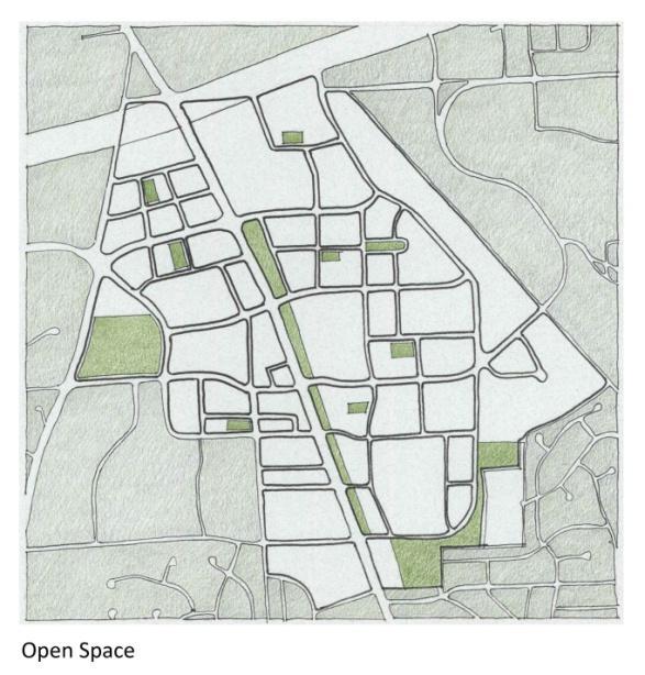
24 Public Use and Open Spaces Each element of the White Flint public use and open space system is designed to have a specific function. FOR THE CORRIDOR: an active urban park at the Aquatic Center and Wall Local Park sports, recreation, and fitness activities FOR ALL OF WHITE FLINT: a central civic green gathering, ceremonies, and celebrations FOR EACH NEIGHBORHOOD: a neighborhood green meeting place and a landmark FOR EACH BLOCK: an urban square at each cluster of offices, residences, and shops provide plazas, pocket parks, green streets FOR EACH BUILDING: recreation space public use space, community garden, green roof FOR EACH RESIDENCE: private outdoor space balcony, terrace, patio, rooftop, deck, yard Figure 12 Connections and Parks Sketch 23
25 Urban Plazas The urban plazas are centrally located spaces surrounded by active uses and generally paved. Trees and landscaping mark edges and provide shade. These plazas can be integrated into commercial development as part of a plaza, outdoor seating, or outdoor restaurant space. There are no minimum or maximum sizes or programmatic requirements for urban greens. Urban plazas along Rockville Pike should function as energy-capturing spaces like eddys or pocket parks to draw passersby off the Pike and into the interior of blocks. These plazas should be integrated into the streetscape and framed by the architecture. Neighborhood Greens The neighborhood green has grass and trees and functions as a neighborhood gathering place. About five percent of the Sector Plan area should be set aside for neighborhood greens. They can range in size from one quarter acre to one acre, depending on the type of development around the green: large enough to support outdoor activities but not so large as to require costly maintenance. These spaces provide environmental and recreational benefits, including stormwater infiltration and tree canopy for shade. Private Open Spaces Residential development should include private outdoor spaces for each unit as well common outdoor recreational facilities. Private spaces can be decks, balconies, rooftops, or terraces. Outdoor communal recreational spaces can include swimming pools, tennis courts, or other facilities. Transitions White Flint is surrounded by residential developments of differing densities and scales. New development at all the edges must be compatible with respect to building height, scale and density, and allow pedestrian and bicycle access from existing neighborhoods. Landscaped buffers, compatible uses, and buildings of appropriate bulk and height should be located adjacent to existing communities. 24
26 Figure 13 25
27 Land Use and Zoning Area Wide Recommendations The Plan recommends the Transit Mixed-Use Zone (TMX) for properties within the Sector Plan area because it permits the widest range of uses and will best achieve the urban center concept. The TMX zone requires a greater percentage of public use space in the optional method than the TS-M and TS-R zones: 20 percent rather than 10 percent. The public use space requirement enables the building of the public use and open space system. When used for nonresidential development, the TMX Zone has the added public benefit of retiring building lots in the Agricultural Reserve, thereby ensuring the continuation of this important County resource. The TMX Zone requires gradations in density and building heights. With distance from transit facilities building height and density decrease near singlefamily residential communities. Density Ten to twenty years ago, a 2.0 FAR was enough to spur redevelopment. Now, redevelopment to a higher FAR is necessary to convince owners to abandon profitable income-producing properties and redevelop, given the amount of infrastructure required on each property. Enhanced transit use Energy efficient New supply of residential units Environmentally responsible development Preservation of the Agricultural Reserve The proposed density pattern in White Flint places the highest density and tallest buildings within ¼- mile of the Metro station in accordance with the TMX Zone. Densities and heights transition away from Rockville Pike and the Metro station. The lowest FAR density and shorter buildings are located at the edges of the Sector Plan area where transitions are necessary to accommodate the lower density and modest scale of the adjacent residential communities. The gradations in density are based on proximity to three transit facilities: Metro and MARC provide rail transit; Rockville Pike provides the most extensive bus service. The density categories are based on a walking distance of 1/8 mile (660 feet). There are three different FAR areas: a series of 1/8 mile concentric rings emanating from the Metro Station, a 1/8 mile ring around the proposed MARC Station and a 1/8 mile band along each side Rockville Pike. The FAR for concentric rings around Metro is shown in Table 1. FARs of 4.0 and 3.0 are within the first two rings, a 2.5 FAR in the next two rings, and 2.0 FAR in the last two rings. The FAR around the MARC ring is 2.5 FAR. The density associated with the bands along Rockville Pike, shown in Table 2, involves transferring density from the edges of the Sector Plan area to the Pike where bus transit is available. 26
28 Figure 14 27

29 Table 2: FAR in Rings from Metro Distance Maximum FAR Area in Ring (in sf) Development Capacity (in sf) 1/8 mile FAR 4.0 1,050,000 4,200,000 2/8 mile FAR 3.0 4,850,000 14,550,000 3/8 mile FAR 2.5 4,800,000 12,000,000 4/8 mile FAR 2.5 1,900,000 4,750,000 5/8 mile FAR 2.0 2,350,000 4,700,000 6/8 mile FAR 2.0 or less 1,250,000 2,500,000 TOTAL 16,200,000 42,700,000 Density Transfer The TMX Zone allows density transfers if recommended in the plan. The Sector Plan recommends that every property, regardless of size, should be able to transfer density. Density transfers may be used to increase FAR up to.5, but only along Rockville Pike. Densities may be combined from more than one site and redistributed to properties along Rockville Pike to take advantage of proximity to transit. A property from which density is transferred must have a recorded easement or restriction in the land records stating the transfer had occurred. Calculating Density This Sector Plan recommends density by rings that ignore property lines, which is a departure from applying FAR on a property by property basis. If a property lies across two density rings, density should be calculated on each portion and added together to arrive at a total, which can then be distributed anywhere on the property as approved through the development process. Density bonuses for MPDUs or to accommodate workforce housing would be considered during the development process and may increase the final FAR total. How much FAR can be transferred is derived from the difference between the standard method and the recommended FAR for the sending property. Two calculations are done, one for the standard method and the second for the optional method. The difference between the two calculations is the amount that can be transferred. At least a.5 FAR should remain on the sending property. The transferrable FAR total is added to the FAR total for the receiving property and should not exceed the FAR recommended in the transfer band. Fulfilling the MPDU and workforce housing requirements may involve additional density. Figure 15 28
30 Figure 16 29

31 Figure 17 30

32 Building Heights The standard method of development in the TMX Zone sets a maximum height of 42 feet; there is no maximum height limit for the optional method. Heights for the optional method are established though the master or sector plans. The Plan recommends a building height range to ensure the projects have height variation and are compatible with adjoining properties, especially residential communities where building heights may be less than 40 feet. Setting a building height range reinforces the urban design principle of height differentiation for the structural parts of building: the street-framing portion, podiums, structured parking, and towers. Building heights along Rockville Pike should accentuate important intersections where distinctive architecture may be desirable. Figure 18 31
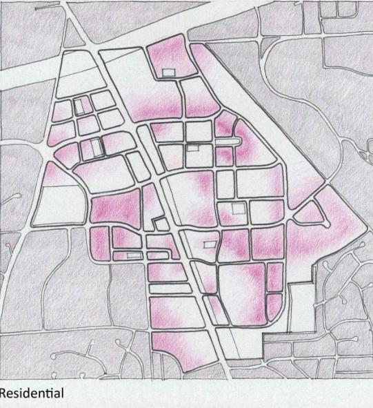
33 Table 3: Proposed Range of Building Heights Ring Existing Heights Proposed Height Proposed Height along Rockville Pike Ring 1: 1/8 mile Ring 2: 2/8 mile Ring 3: 3/8 mile Ring 4: 4/8 mile Ring 5: 5/8 mile Ring 6: 6/8 mile feet feet 300 feet feet feet less than 300 feet feet feet feet feet feet feet feet feet feet feet feet 100 feet Mixing the Uses Vertical and Horizontal Mixed Uses In compact development, vertical and horizontal mixed uses provide variety in the urban texture. This Plan recommends that proposed development should include vertical integration of uses, so that there are few single-use buildings. This is not to suggest, however, that there are no suitable places for singleuse buildings. Residential Residential units in an urban environment may take many forms, but because space is at a premium, they are typically one floor apartments. All new residential development should include a variety of unit types, including attached and multifamily units, and provide choices for all budgets. New residential development should yield 9,800 new units, of which at least 12.5 percent will be MPDUS and 10 percent workforce housing. The Plan recognizes that affordable housing, in addition to the MPDUs and workforce housing required for new development in a transit station policy area, is a suitable use for publicly owned land or land recommended for public use. Where new development is proposed adjacent to publicly owned land, consideration should be given to public/private ventures to provide more than the required affordable housing through land swaps or density transfers, whichever better accomplishes this objective at locations closest to transit. Housing for seniors and special populations is a permitted use in the TMX Zone. This Plan recommends that units for seniors and special populations be included in residential development, particularly in locations nearest local services and transit. 32
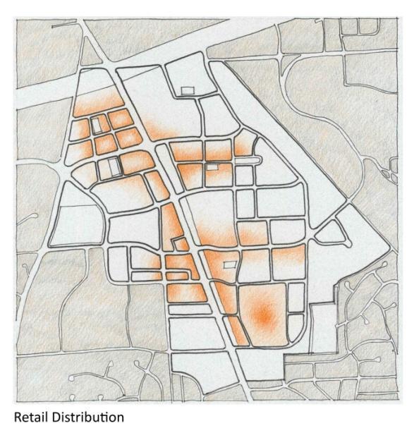
34 Child Daycare One difficulty faced by families is finding good quality child daycare near work or home. Child daycare is a permitted use in the TMX Zone. Child daycare should be incorporated in new office development and residential development near the transit facilities. Hotels Hotels should be located close to transit, especially within the first 1/8 mile of the Metro station. Hotels at this location will support the Conference Center facilities and could be integrated with residential uses and ground floor retail. Industrial While this Plan endorses mixed-use development, it may not be possible for all properties. There are properties with existing low-intensity industrial uses at the edges of the Sector Plan where redevelopment is questionable or not in the foreseeable future. This Plan does not discourage the continuation of these uses. Retail Grocery stores, local retail and commercial services, such as hair salons, pharmacies, dry cleaners make a neighborhood desirable. Local retail should be incorporated in the ground floor of buildings along the roads that cross the Pike such as Old Georgetown Road, Executive Boulevard, Marinelli Road, Nicholson Lane or interior north/south roads such as Woodglen Extended and Nebel Street. Regional retail is best located along Rockville Pike where there is high visibility. Table 4: Proposed Development Existing and Approved Proposed New MPDUs (12.5%) New Workforce Housing (10%) BLTs Residential Units 4,479 9, Nonresidential SF 7.29M 5.69M

35 Recommendations by District Each District: Has a neighborhood Includes a destination Has open space Has local retail for daily and weekly errands Has access to the recreation loop Is connected to the rest of White Flint Figure 20 Districts Seven districts composed of smaller blocks comprise the new mixed-use urban center in North Bethesda: Metro East and Metro West, Nebel Corridor, NRC, Mid-Pike Plaza, NoBe, and White Flint Mall. Some of these districts have new mixed-use development that resembles the sustainable urban form envisioned in the Plan. Most of the districts have the potential to unify existing and new developments into a more coherent urban fabric. Two districts, Mid-Pike Plaza and White Flint Mall, offer the most potential for mixed-use development because they are large and contain a few property owners. This Plan recommends that most development build to the 60 percent residential and 40 percent nonresidential split envisioned at the end state. This mixed-use split reduces overall trip generation, will allow the creation of neighborhoods, and generate the population growth needed to support an urban center. This Plan recognizes that not all properties are desirable for residential uses and in some instances, nonresidential development may be more appropriate. Garrett Park Estates, Crest of Wickford, Old Georgetown Village and Luxmanor are single-family and town house communities that surround the Plan area. Transitional areas to residential communities are within the southwestern and southeastern segments of the Plan area, including the Wall Local Park, White Flint Mall, White Flint Plaza, and the Nicholson Court block. 34
36 The following recommendations address use mix, open spaces, the transportation network, and urban form for the districts. A companion document, The White Flint Urban Design Guidelines, will address specific streetscape, building and massing, and other urban design principles for each district. Locate new development with buffers and pedestrian connections adjacent to existing communities to achieve a compatible transition between existing and new development. Contribute to improving Rockville Pike as an urban boulevard with landscape median and wide sidewalks. Build the planned urban street grid and reconstruct existing streets with wider sidewalks, street trees, and street furnishings. Provide on-street parking along new and existing streets. Consolidate service and loading entrances. Locate the tallest buildings at the Metro station and along Rockville Pike. Break up building mass along streets with different façade treatments and create distinctive entrances, windows, and facades. Develop a smaller walkable block pattern on larger properties. Orient buildings to the streets. Provide safe pedestrian crossings at all roadways. Incorporate sustainable design practices, such as solar orientation, native landscaping, and permeable pavement in redevelopment of properties. 35

37 METRO WEST The public event hub for the Sector Plan area: Conference Center Wall Local Park Civic Green Main Street Promenade Farmers Market Figure 21 Wall Local Park, the Montgomery Aquatic Center, Bethesda North Conference Center and Hotel, and the Grand and Wisconsin multifamily development are located in this 54-acre district bounded by Old Georgetown Road, Nicholson Lane, and Rockville Pike. There are four different zones: Transit Station, Residential (TS-R), Planned Development (PD), Single-Family Residential (R-200) and General Commercial (C-2). The area comprises three blocks, Conference Center, Wall Local Park, and Holladay and there is substantial public investment in the Aquatic Center, Wall Local Park, and the Conference Center. The realignment of Executive Boulevard and Old Georgetown Road will improve through traffic movements for the entire Sector Plan area. This district, especially the Conference Center block, will be the civic core of White Flint. The Plan recommends substantial residential development, additional public investment including the Civic Green, Main Street Promenade, and outdoor recreational facilities in Wall Local Park. Marinelli Road should be reconstructed to provide wider sidewalks and street trees to make walking between the Metro station and Wall Local Park a less daunting experience. Block 1: Conference Center The Bethesda North Conference Center and Hotel is the main feature in this block surrounded by automobile sales and other commercial uses. These properties are in the C-2 and Transit Station TS-R zones. 36
38 The new civic green, public use spaces and an east-west Main Street will create the backdrop for future private redevelopment. The intersection of Rockville Pike and Marinelli Road at the Metro station underpass should have a significant public use space. Rezone all properties to TMX zone. Secure dedication of the Civic Green through the development process, or if necessary, acquire at least one acre for that purpose. Develop a new walkable block network, including the interior Main Street (B-10) between Executive Boulevard and Rockville Pike. Provide a Class I Bikeway along Old Georgetown Road. Block 2: Wall Local Park This block contains the 11-acre Wall Local Park and Montgomery Aquatic Center. There are two other properties, the Gables (now used as a parking lot) and a bank. The land area remaining after the intersection realignment of Old Georgetown Road and Executive Boulevard will be reconfigured into rectangular blocks in sizes more conducive to redevelopment. Wall Local Park should be redesigned with more active outdoor facilities through developer contributions. This area should be primarily residential in character and use. Confirm the Planned Development (PD-9) Zone for Wall Local Park. Rezone the Gables and Reiver properties to the TMX Zone. Reconstruct the intersection of Old Georgetown Road, Executive Boulevard, and Old Old Georgetown Road. Ensure that building heights and massing along Old Georgetown Road should transition to the existing residential community. Block 3: Holladay This 15-acre block is bounded by Marinelli Road, Nicholson Lane, Executive Boulevard, and Rockville Pike. Properties are zoned TS-M, TS-R, and C-2. The Wisconsin and Grand multifamily developments reflect earlier success with highrise residential development, while the Metro Pike/Holladay development along Rockville Pike represents the type of mixed-use envisioned in this Plan. There is already substantial residential development in this block and redevelopment should focus on employment and retail uses. Reconfirm the Grand, Wisconsin, and Fallswood properties in the TS-R Zone. Rezone Metro Pike/Holladay and Anthropologie properties to the TMX Zone. Dedicate the Woodglen Drive extension between Nicholson Lane and Marinelli Road. Extend the Bethesda Trolley Trail to Marinelli Road. Develop a smaller walkable block pattern on larger properties. Orient buildings to the streets. Provide safe pedestrian crossings at all roadways Incorporate sustainable design practices, such as solar orientation, native landscaping, and permeable pavement in redevelopment of properties. 37
39 METRO EAST Retail and entertainment destination A Metro station A landmark bridge over the metro tracks Two public green spaces A grocery store Figure 22 Metro East contains properties located at the Metro station, including the 32-acre North Bethesda Town Center project on the Washington Metropolitan Area Transit Authority (WMATA) property. The Forum, the oldest residential highrise, and the recently built Sterling, Gallery and White Flint Station contain residential and mixed-use highrise development along Old Georgetown Road, between Rockville Pike and Nebel Street. There are two blocks, North Bethesda Town Center and Sterling. There is little redevelopment potential in this district. However, the TMX zone allows more density than has already been approved. Block 1: North Bethesda Town Center The 32-acre North Bethesda Town Center development is a planned mixed-use development with highrise multifamily residential, child daycare, and office and retail development on the WMATA site. The Town Center, because of its location at the Metro station, should take advantage of the higher FAR allowed in the TMX Zone and provide additional residential and office development. There are four other properties along Nebel Street that could redevelop into mixed uses. Rezone the North Bethesda Town Center to the TMX Zone. This allows air rights development over the Metro tunnel and more intense development on the undeveloped blocks. Rezone the I-1 property used for stormwater management to the TMX Zone; this property could redevelop or transfer its density. Rezone the 0.17-acre Montouri property at Old Georgetown Road and Nebel Street to the TMX Zone. This property may be suitable for transferring density. 38
40 Rezone the three properties at Nebel Street, Nebel Street, and 5301 Marinelli Road at the northwestern intersection of Nebel Street and Marinelli Road to the TMX Zone. Locate an express library in the North Bethesda Town Center development. Block 2: Sterling The Sterling block contains highrise and low-rise residential development. There is little redevelopment potential on this block. Confirm the TS-M Zone for the Sterling, Gallery, and White Flint Station developments. Confirm the Montrose Metro Office building in the Office Building Moderate (OM) Zone. Confirm the Forum multifamily residential development in the High Rise Multifamily (RH) Zone. Rezone the properties at and Nebel Street to the TMX Zone. Extend Citadel Avenue from Old Georgetown Road to Randolph Road. 39

41 MAPLE AVENUE DISTRICT Low-scale commercial industrial use area Figure 23 The 24-acre Maple Avenue District contains low scale industrial and commercial uses, including automobile repair, the historic Montrose School, the Montrose Shopping Center, and excess right-ofway for the Montrose Parkway. Existing zones in this district are Low-Intensity, Industrial (I-4), General Commercial (C-2), Office Building, Moderate (OM), and Single-Family Residential (R-90). Many of the properties are small and redevelopment is unlikely in the near term. The Montrose Parkway interchange affects the desirability for residential uses for properties along Rockville Pike and Randolph Road. The extension of Maple/Citadel Avenue to Old Georgetown Road will provide new access to the Metro station. It is anticipated that some light industrial and commercial properties may redevelop with mixed-uses. Provide a new public street connection between Maple Avenue extended and Randolph Road. Rezone the State of Maryland owned properties to the TMX Zone. Any property remaining from the Montrose Parkway should be considered for public uses, including affordable housing. Retain OM Zone on Rockville Pike since redevelopment is unlikely. Rezone Maple Avenue properties and the 6.76-acre Montrose Shopping Center at the northwestern intersection of Randolph Road and Nebel Street to the TMX Zone. The shopping center has the most potential for residential uses. 40
 and General Commercial (C- 2). A potential MARC station in this district will enhance transit options.")
42 NEBEL DISTRICT Public facilities and uses and low-scale industrial use area Figure 24 Washington Gas and the Montgomery County Pre-Release Center are two public uses within this 23-acre district adjacent to the CSX tracks zoned Low-Intensity, Light Industrial (I-4) and General Commercial (C- 2). A potential MARC station in this district will enhance transit options. Some properties in this district, including the Randolph Shopping Center, have potential to redevelop. Rezone the Montouri property, Nebel Center and Randolph Shopping Center, and commercial properties at northeastern intersection of Nebel Street and Nicholson Lane to the TMX zone. Confirm the I-4 Zone for the Washington Gas and Montgomery County Pre-Release Center properties. Extend Old Georgetown Road to the CSX rail line, if a MARC station is chosen for this location. Orient new buildings toward Nebel Street. 41
43 NRC DISTRICT Federal facility and WMATA bus facility Figure 25 The NRC District, approximately 38.5 acres, is bounded by Rockville Pike, Nicholson Lane, Nebel Street, and Marinelli Road. The headquarters of the Nuclear Regulatory Commission (NRC); Strathmore Court, a Housing Opportunities Commission (HOC) multifamily residential development; and a WMATA bus facility are located within the district. Properties are zoned Transit Station, Mixed (TS-M), Light Industrial (I-1), and General Commercial (C-2). The WMATA site has the greatest potential for future redevelopment and could add a substantial amount of residential uses should the bus facility no longer be needed. If the bus facility remains, the property may be appropriate to transfer density to properties along Rockville Pike. Confirm the NRC properties in the TS-M Zone. Confirm Strathmore Court in the TS-M Zone. Rezone the WMATA bus facility, properties along southern segment of Marinelli Road, properties at the northeastern intersection of Rockville Pike and Nicholson Lane, and properties along the western portion of Nebel Street between Nicholson Lane and Marinelli Road to the TMX Zone. Extend the Rockville Pike promenade from the NRC to Nicholson Lane. Extend Citadel Avenue to Nicholson Lane. If the WMATA bus facility redevelops, the street network should be extended across the property to provide inter-block connections north and south. 42
44 MID-PIKE PLAZA DISTRICT A major shopping and entertainment destination, the northern gateway of the regional marketplace Figure 26 Mid-Pike Plaza is a 20-acre C-2 zoned strip shopping center with surface parking and one-story buildings. The State of Maryland owns approximately X acres immediately north of the shopping center. Redevelopment of the property should retain its regional marketplace function and include residential and civic uses. Building heights should frame Rockville Pike and Old Georgetown Road. An urban square or neighborhood green and a civic or cultural attraction, such as a community playhouse or theater in conjunction with an express/electronic library, will provide reasons to gather and encourage evening activity. Rezone all properties to the TMX Zone. After the Montrose Parkway interchange is constructed, any remaining State-owned property north of the road should be considered for local public uses, including a relocated fire and emergency services and police sub-station. Land located south of the road may be suitable for affordable housing. A public/private partnership may achieve economies of scale for affordable housing and the civic uses. Provide a one-acre urban square or neighborhood green. Provide an express library with community meeting room space. 43
45 WHITE FLINT MALL DISTRICT A place for new residential neighborhoods Figure 27 The White Flint Mall, at 88 acres, is the Plan area s largest district. It contains office, commercial, and industrial uses, including the White Flint Mall and White Flint Plaza. The White Flint Neighborhood Park and the Garrett Park Estates community are on the southern boundary and the CSX tracks form the eastern boundary. Rockville Pike is the western boundary and Nicholson Lane, the northern boundary. Properties in this district are zoned Low Intensity, Light Industrial (I-4); Commercial Transition (CT); General Commercial (C-2); and Single-Family Residential (R-90). There are no residential units. The district is divided into the Nicholson Court, Eisinger and Fitzgerald, White Flint Plaza, and White Flint Mall blocks and can be further divided into walkable blocks by extending the existing road network and adding lateral connections. Redevelopment can provide a considerable number of new residential units organized into discrete neighborhoods. Some blocks may redevelop more than the targeted 60 percent residential use. Possible public uses in this district include the MARC station at Nicholson Court and a new elementary school located in the interior. There should be a substantial amount of public use space generated by new development. It is important for the public uses spaces to be well distributed and connected among the blocks. Locate an elementary school within this district, preferably in the interior. The White Flint Mall and White Flint Plaza are two adjacent properties that through assemblage may be able to dedicate the necessary acreage. Public use spaces in each neighborhood should be connected throughout the district. 44
46 Block 1: Eisinger/Fitzgerald This C-2 zoned block contains commercial properties located at the northwestern and northeastern corners of the intersection of Huff Court and Nicholson Lane. The Fitzgerald block has frontage along Rockville Pike while the Eisinger block is located at the northeastern intersection of Nicholson Lane and Huff Court. Uses include an automobile sales center, office buildings, and a commercial shopping center. New mixed-use development is anticipated for both blocks. The Eisinger block is anticipated to develop with more residential than nonresidential development. Rezone the entire block to the TMX Zone. Block 2: White Flint Plaza East of the Eisinger block is White Flint Plaza, a commercial shopping center zoned C-2. The shopping center has surface parking and several single story buildings. There are some long-term leases in this shopping center that will affect the timing of redevelopment. A new neighborhood green is anticipated when the shopping center is redeveloped. This block will contribute a portion of its property to an elementary school site, if a school is located within the Plan area. Rezone the entire block to the TMX Zone. Block 3: Nicholson Court Light industrial and commercial uses, including a Ride On bus parking facility and warehouses, are the primary uses in this block. Redevelopment in this district is likely to take place in the long-term. This block could redevelop as a residential enclave with local services. The block is a candidate for the MARC station and there may be some interest in a combination of Ride On bus storage and MARC parking facilities. Nebel Street, the northern boundary, crosses the CSX tracks and will provide excellent eastwest access to the MARC station. Any new development must provide transitions in height and density to the adjacent single-family residential community. Rezone to the entire block to the TMX Zone. New development to transition to the adjoining residential neighborhood. Block 4: White Flint Mall The White Flint Mall is the Plan area s largest property and has been home to premier department stores for 40 years. Two of the stores, Bloomingdale s and Lord and Taylor, own their respective buildings, which has implications for redevelopment. The property is zoned General Commercial (C-2) and Commercial Transition (CT). There are two medical office buildings zoned Commercial Office (C-O) along Rockville Pike and south of the mall. White Flint Neighborhood Park is to the immediate east and Garrett Park Estates is to the immediate south. New vertical residential and nonresidential uses will transform this property. New public amenities and facilities, public uses, neighborhood greens, and an expanded road network will create walkable blocks. Using the WMATA tunnel as a pedestrian promenade will enhance this block and improve pedestrian access. This property could accommodate an elementary school. Development along Rockville Pike may be denser and the buildings taller than the eastern segment of the property. Rezone to entire block to the TMX Zone. 45
47 Building heights should not exceed 50 feet at the rear to be compatible with the adjoining Garrett Park Estates. Any redevelopment of the medical office buildings should be compatible with the homes along Flanders Street. Landscape buffers may be necessary along the eastern and southern boundaries to transition to the existing single-family detached homes. The school location may also be considered for compatibility. Extend Executive Boulevard through White Flint Mall to White Flint Plaza with lateral extensions to Nicholson Lane. 46

48 NOBE DISTRICT New multifamily mixed uses Figure 28 The NoBe (NOrth BEthesda) District offers a blend of multifamily and townhouse residential development, offices along Edson and Security Lanes, commercial uses along Rockville Pike, a religious institution, and the North Bethesda Market development. The Bethesda Trolley Trail will draw pedestrians and bicyclists along Woodglen Drive and new residential uses will transition between the existing residential communities and the commercial uses along Rockville Pike. Land use recommendations for this district revolve around providing new mixed uses and urban open spaces, maintaining residential and office uses, and providing a buffer for existing residential communities. The Security Lane, North Bethesda Market, Water Tower, Edson Lane, and Hillery Way blocks are located in this district. Security and Edson Lanes are attractive streets and well landscaped with a full tree canopy along the sidewalk. Block 1: Water Tower The 10-acre Water Tower block is bordered by Executive Boulevard, Woodglen Drive, and Nicholson Lane and has little redevelopment potential. This block should be primarily residential. The 18-story Fallswood multifamily residential building and the WSSC water storage facility will remain. The Luttrell property has redevelopment potential and should provide a local street network between Executive Boulevard and Nicholson Lane. Rezone WSSC property to the TMX zone. If the WSSC water facility is no longer in use, this property should be acquired for parkland. Confirm the TSR Zone for the Fallswood residential development. Rezone the Luttrell property to the TMX Zone. Locate a ½-acre neighborhood green on the Luttrell property. Building heights along Executive Boulevard should be compatible with the residential community to the immediate south. 47
49 Block 2: North Bethesda Market This block, approximately 10 acres, contains a signature mixed-use building at the intersection of Executive Boulevard and Rockville Pike. Existing zones are Transit Station, Mixed (TS-M) and General Commercial (C-2). Particularly combined with adjacent properties, this site is a significant redevelopment opportunity and could include a hotel, retail, residential, and offices. Development in this block should activate adjacent roadways, including Rockville Pike, Nicholson Lane, Woodglen Drive, and Executive Boulevard. Rezone the North Bethesda Market property and properties at the northeastern corner of Woodglen Drive and Nicholson Lane to the TMX Zone. Properties north of Executive Boulevard extended may be more suitable for nonresidential, mixeduse development. Widen the west sidewalk to accommodate the extension of the Bethesda Trolley Trail. Block 3: Security Lane Two office buildings with associated parking garages are the primary uses along Security Lane between Rockville Pike and Woodglen Drive. Security Lane is a business street with on-street parking. Retain the Rockwall and Cascade office buildings in the C-O Zone. Block 4: Edson Lane Office buildings, residential townhouses, a religious institution, and commercial properties comprise the Edson Lane block. This block is surrounded by the Crest of Wickford and Old Georgetown Village residential communities south and east, respectively. Commercial properties are west of Rockville Pike. Edson Lane connects Woodglen Drive to Rockville Pike. The entrance to the Bethesda Trolley Trail is located at Edson Lane and Woodglen Drive. Rezone the office buildings at Rockville Pike, Rockville Pike, and Rockville Pike to the TMX Zone. Confirm the C-T Zone for properties between 5420 and 5510 Edson Lane. Confirm the R-90/TDR Zone for the Edson Park townhouses and Agen David Synagogue. New development should be sensitive to the scale of existing residential neighborhoods and located in structures of compatible density and height. Block 5: Hillery Way This block is under single ownership and transitions to residential communities to the immediate south and west. Hillery Way provides the only access to the residentially-zoned areas. The 1992 Master Plan recommended retaining the R-90 Zone. Townhouse development will make a transition to the existing community. Confirm the R-90 Zone for the properties under single-ownership. These properties are suitable for the Residential Townhouse (RT-12.5) as transitional development to existing residential community. Rezone the property at the northwestern intersection of Rockville Pike and Hillery Way to the TMX Zone. 48

50 Figure 29 49

51 Sustainability The White Flint Sector Plan area is located within the urban ring described in the 1993 General Plan Refinement of the Goals and Objectives for Montgomery County. It also falls within a Priority Funding Area designated by the state to encourage growth. The area is highly urbanized and all except a marginal amount of acreage has been developed, much of it before stormwater management was required. The Sector Plan area spans a cluster of five headwater stream subwatersheds in the Lower Rock Creek basin and the Cabin John watershed. Most of the development occurred at a time before stormwater management regulations were in place, so the subwatersheds are degraded. Most of the streams were in fair condition in As development occurred, the smaller headwater streams were placed in pipes underground and covered, and now all the streams, except those in a small portion of the southernmost tip of the Sector Plan area, are in poor condition. There are almost no natural resources remaining in the Sector Plan area and there are no environmentally sensitive areas (stream buffers, wetlands, floodplains or steep slopes) remaining to protect. Current tree canopy is approximately 10.5 percent and imperviousness is about 72 percent. Land areas that are not built or paved are either in grass, gravel or cleared earth. Figure 30 White Flint Stream Conditions 50
52 Figure 31 The recommendations in the Sector Plan are aimed at maintaining the same amount of pervious land cover, increasing tree canopy and incorporating stormwater management into all new and redeveloped properties. This will decrease the amount and increase the quality of runoff from the Sector Plan area, but it cannot completely offset the impacts of the existing and proposed development. Stream degradation will continue, but at a decreasing rate. In order to make positive progress and improve stream quality, corrective measures such as stream restoration, improved control of stormwater from existing development, and forest planting along streams will be needed. 51

53 Figure 32 52
54 Recommendations Urban development served by transit has the capacity to conserve energy and reduce greenhouse gas emissions because it is not dependent on the automobile. The first goal to achieve sustainability is minimizing gas emissions. The County s overall goal is to reduce the 2005 measured carbon emission levels by 80 percent by This can be done by avoiding and sequestering carbon emissions through reducing dependency on fossil fuel-based transportation systems, and efficient energy practices. Carbon dioxide, the gas most responsible for global warming, can be reduced in the most significant amounts by decreasing the number of automobile trips, designing green or high performance buildings, and increasing the use of renewable energy sources. Design new buildings to reduce carbon emissions through energy efficiency, on-site sources of renewable energy and recycling of waste materials from construction and demolition to the fullest extent possible as part of compliance with County law to achieve Leadership in Energy and Environmental Design (LEED) certification level or equivalent. Supply 20 percent of energy needs with on-site generation using renewable resources such as geothermal heating and cooling or wind powered electricity. Provide a safe, attractive and continuous network of sidewalks and bikeways throughout the White Flint Sector Plan area. Sequester carbon by increasing tree canopy coverage. The second goal is no net loss of pervious land surface, which is currently at 23 percent of the Sector Plan area. New development should provide space for stormwater infiltration of stormwater and trees. Much of the existing pervious land is in Wall Local Park, the North Bethesda Town Center property and developed residential and federally owned properties. Although future development will be compact, imperviousness should be reduced to the minimum necessary. This can be done by establishing a minimum pervious area in conjunction with other requirements: public use space, stormwater management treatment, or streetscapes. Require 20 percent pervious area for all newly developing properties. Create a system of pervious open spaces for environmentally sensitive stormwater infiltration. Increase overall tree canopy to 30 percent. Add pervious areas along Rockville Pike and along the new Main Street to reduce the impact of stormwater. Use environmentally sensitive design stormwater management techniques such as green roofs, bio-infiltration, innovative stormwater features, underground stormwater management, green streets, cisterns and pervious paving. The third goal is to establish community character with native vegetation. Vegetation is a highly visible factor in any urban or suburban landscape and can be a defining element in the cityscape. Native trees, shrubs, and perennials are effective expressions of the uniqueness of the ecosystem and can bring substantial visual quality of place. Create sustainable landscape guidelines for biodiversity, native plant materials, water conservation and appropriate soil regimes to establish a unique character for the Plan area. 53
55 Mobility The Plan recommends a transit-focused, multi-modal mobility system that supports the proposed urban center and local neighborhoods. Street enhancements are necessary to fully utilize the transit service. An improved street grid would allow better flow of traffic. Improved pedestrian and bicyclist access to transit would provide incentives to reduce automobile use. Two principles underpin the mobility recommendations: An enhanced grid street network can diffuse congestion. The Plan recommends a grid street network that includes business district streets and a finer grained system of local connections, including private streets, for more direct vehicular and pedestrian circulation. This robust network relieves pressure on Rockville Pike and Old Georgetown Road, the two major highways that have the most congestion in the Plan area, and alternatives within the Plan area. Walkable streets with access to transit reduce reliance on the automobile. The Plan incorporates the following regarding future trip generation: Development in Metro Station Policy Areas has a lower vehicle trip generation rate than development elsewhere in Montgomery County because of the availability of high-quality transit. Future commercial development in White Flint can be expected to have a lower vehicle trip generation rate because of the County s commitment to transportation demand management strategies including policies and programs designed to affect commuter behavior such as: parking management, connected sidewalk and bikeway facilities, improved access to Metro and MARC, and expanded circulator bus services and efficient parking management. Residential development can generally be expected to have a lower vehicle trip generation rate than commercial development. Based on these assumptions, Local Area Transportation Review (LATR) standards can likely be met with a proposed expansion of the Metro Station Policy Area boundary to encompass the full Plan area. The Policy Area Mobility Review (PAMR) analysis indicates that there will be higher levels of congestion than allowed in the current Growth Policy and, therefore, the Sector Plan should be designated a Metro Station Policy Area and able to support higher area-wide congestion levels. Recommendations Transit Construct a northern entrance to the Metro station in the southeast quadrant of Rockville Pike and Old Georgetown Road. Construct a MARC station. This MARC station replaces the Bou Avenue location recommended in the 1992 North Bethesda/Garrett Park Master Plan. The relocation is appropriate since White Flint will be the most intensely developed activity center along the Brunswick line. There are two possible locations: the Old Georgetown Road site because it maximizes the potential development within walking distance to the MARC station and the Nicholson Court site, because the road network will not need to be expanded to provide access. 54

56 Provide bus transit transfer facilities at the Metro and MARC stations. A total of eight bus bays should be provided at the Metro station and two bus bays at the MARC station. Support the development and maintenance of shuttle bus services serving both the Sector Plan area and immediately adjacent commercial properties. Develop circulator bus routes to provide local service, particularly on the east and west cross streets. Figure 33 Street Network Augment the master planned street network. Master planned streets should be built consistent with the design standards in the County Code. Implement non-master planned street and alley connections in conformance with the Montgomery County Zoning Ordinance and White Flint Design Guidelines. These streets may be public or private, and provide flexibility for operational functions including property access, loading, and parking. 55
57 Rockville Pike and Promenade Approving a comprehensive solution and design treatment for Rockville Pike will occur outside the sector plan process and requires coordination between SHA, Montgomery County Department of Transportation (MCDOT) and the utility companies. It is important that this project be initiated soon after the adoption of this Plan. Private development should not be stopped because of the lengthy time public sector projects take. Property owners with frontage along the west side who are interested in pursuing development will be required to set aside the 150-foot wide right-of-way as soon as they enter the development process, which may be well before the public agencies complete the Rockville Pike project design. Developers will be required to participate in the reconstruction at some point. Such participation would be better done after a cross section is chosen; otherwise there will be an unnecessary waste of private and public funds. Development must accommodate the width of the rightof-way and may be required to underground utilities before the final design is selected and the project fully funded. Increase the Rockville Pike right-of-way, north of Nicholson Lane, to 150 feet. Reconstruct Rockville Pike to provide a consistent design treatment including a wide landscaped median, three through travel lanes, and a separate curb lane that can provide multiple functions. During peak periods, the curb lane should serve as a through lane for transit vehicles only and a right turn lane for other vehicles. During off-peak periods the curb lane can accommodate parallel parking. The Planning Board, County Executive, and County Council should initiate a Capital Improvements Project (CIP) in conjunction with the State Consolidated Transportation Program once this Plan is adopted. The reconstruction project should be funded through a combined county/state/private joint venture. Extend the Promenade streetscape north and south of the NRC property to the edges of the Sector Plan area on top of the Metro tunnel easement. Main Street and Promenade The Planning Board, County Executive and County Council should initiate a CIP project as a public/private partnership with the property owners within in the Conference Center Block to select a road alignment and cross section for Main Street. When development occurs, each property can provide the needed right-of-way, locate driveways and loading areas, set back buildings correctly and provide their share of the streetscape. Main Street should include ample space for pedestrian and bicycle use and be wide enough to support a mature tree canopy. 56

58 Bikeway Network Provide links to existing and proposed public transit as well as to the outlying bicycle and trails network. Designate the Sector Plan area a Bicycle/Pedestrian Priority Area, an official State of Maryland designation that facilitates the allocation of funds for bicycle and pedestrian improvements on state roads. Figure 34 57
59 Travel Demand Management Establish a 39 percent non-auto driver mode share goal for employees in the entire Sector Plan area. The current non-auto driver mode share for the Plan area is 26 percent. The Plan goal is aggressive but achievable through the combination of land use (density, diversity, and design) and zoning requirements, transit improvements, supportive Travel Demand Management programs, and staging. Parking Districts Establish a Parking Lot District for the Sector Plan area to assist in the active management of parking demand and promote shared parking efficiencies, particularly relieving the requirement for smaller properties to self-park. Public/private parking agreements should be considered and encouraged as private properties redevelop. Growth Policy Amend the White Flint Metro Station Policy Area boundaries to be coterminous with the Sector Plan boundaries. The Sector Plan boundaries were developed in anticipation of amending the Policy Area boundaries. This would support transit-oriented development, including establishment of higher intersection congestion thresholds. Establish an alternative adequate public facilities (APF) review procedure with an exaction process based on the planned transportation infrastructure as proportioned to the traffic generated by each development. This will improve the efficiency of both the development review process (minimizing administrative costs) and infrastructure delivery (by avoiding lumpy infrastructure implementation). 58
60 Table 5: Road Facility and Segment From To Road # ROW (ft) Lanes Chapman Avenue (Citadel Avenue/Maple Avenue) Marinelli Road Old Georgetown Road B-12* 70 2 Old Georgetown Road Citadel Avenue** Montrose Parkway/Plan Area Boundary B-12* 70 2 Nicholson Lane Existing terminus B Existing terminus Marinelli Road B Marinelli Road Old Georgetown Road B Edson Lane Woodglen Drive Rockville Pike (MD 355) B Executive Boulevard Marinelli Road Nicholson Lane B Nicholson Lane Rockville Pike (MD 355) B Rockville Pike (MD 355) Huff Court B Huff Court Nebel Street (B-5) B Huff Court*** Nebel Street (B-5) Executive Boulevard B Executive Boulevard Nicholson Lane B Main Street Old Georgetown Road (MD 187) Rockville Pike (MD 355) B Rockville Pike (MD 355) B-13 B Marinelli Road Executive Boulevard Nebel Street B Montrose Parkway Plan Area Boundary Chapman Avenue A , divided Chapman Avenue CSX tracks/plan Area Boundary A , divided Nebel Street Rockville Pike (MD 355) Nicholson Lane B Nicholson Lane Plan Area Boundary B Nicholson Court (Realigned) 500 feet south from Nicholson Lane Nicholson Lane 500 feet south from Nicholson Lane B
61 From To Road # ROW (ft) Lanes Old Georgetown Road (MD 187) CSX tracks/plan Area Boundary A Old Georgetown Road (MD 187) Tilden Lane/Nicholson Lane Rockville Pike (MD 355) M , divided Rockville Pike (MD 355) Nebel Street B , divided Nebel Street CSX tracks/plan Area Boundary B , divided "Old" Old Georgetown Road Executive Boulevard/Old Georgetown Road Rockville Pike (MD 355) Montrose Parkway M-4a 120 4, divided Flanders Avenue Hubbard Drive M , divided Security Lane Woodglen Drive Rockville Pike (MD 355) B Rockville Pike (MD 355) Huff Court (B-4) B Station Street Marinelli Road Old Georgetown Road B Woodglen Drive Edson Lane Nicholson Lane B-3** 80 2 New Street Marinelli Road Nebel Street B Mid-Pike Spine Street Marinelli Road Old Georgetown Road B Old Georgetown Road New Street (B-16) B New Street "Old" Old Georgetown Road Rockville Pike (MD 355) B *This section of roadway is B-4 in the 1992 North Bethesda/Garrett Park Master Plan **B-4 is Huff Court south of Nicholson Lane ***B-4 is Citadel Avenue north of Nicholson Lane ****The roadway limits are Nicholson Lane to Marinelli Road in the 1992 North Bethesda/Garrett Park Master Plan 60
62 Table 6 : Bikeway Facility and Segment Rockville Pike Nebel Street Old Georgetown Road North Bethesda Trolley Trail Nicholson Lane Montrose Parkway Marinelli Road Randolph Road Old Georgetown Road Parklawn Drive Executive Blvd Marinelli Road to Nebel Street extended Randolph Road to Old Georgetown Road Plan Boundary to Rockville Pike Rockville Pike to Woodglen Drive Nicholson Lane to Rockville Pike Edson Lane to Nicholson Lane Nicholson Lane to Marinelli Road Marinelli Road to Montrose Road Old Georgetown to Nebel Street Old Georgetown Road to CSX Tracks Executive Blvd to Nebel Street Rockville Pike to CSX Tracks Executive Blvd to Nebel Street Nebel Street to CSX Tracks Nicholson Lane to Old Georgetown Road Route Number DB-13 Existing Type Proposed Type Comments Shared Use Path/ Signed Shared Roadway Shared Use Path Dual Bikeway: shared Use Path/ bicycle lane DB-13 Shared Use Path Shared Use Path/ bicycle lane Dual Bikeway: Shared Use Path/bike lane Shared Use Path SP-41 Shared Use Path Shared Use Path SP-41 SP-41 Shared Use Path Shared Use Path New Bikeway Reclassify bikeway segment dual proposed shared use path/proposed bike lane classification New Bikeway New Bikeway SR-37 On-Road Bikeway Shared Use Path Reclassify bikeway from On-Road classification to Shared Use Path SP- 50 Shared Use Path Functional Master Plan SP-45 Shared Use Path Dual: Shared Use Path/Bike Lane SP-25 Shared Use Path Shared Use Path Reclassify bikeway from shared use path to dual: shared use path/bike lane classification SP-46 Shared Use Path Extend SP-46 to Executive Blvd. Existing segment does not meet minimum requirement BL-27 Bike Lane Shared Use Path New Bikeway 61

63 Public Facilities Public facilities demonstrate public investment and interest in ensuring quality of life and safety. Parks, schools, libraries, fire, rescue and emergency services will be needed to support the planned population. Because space is at a premium in an urban area, public facilities will have to be located on smaller properties and efficiencies may be achieved in multi-use buildings. Figure 35 62
Sector Plan. Planning Board Draft. montgomery county planning department The Maryland-National Capital Park and Planning Commission
 Sector Plan Planning Board Draft montgomery county planning department The Maryland-National Capital Park and Planning Commission WHITE FLINT ABSTRACT This Plan contains the text and supporting maps for
S C O P E O F W O R K A P R I L
 white flint 2 sector plan S C O P E O F W O R K A P R I L 2 0 1 2 MONTGOMERY COUNTY PLANNING DEPARTMENT M-NCPPC MontgomeryPlanning.org 1 white flint 2 sector plan Scope of Work abstract This scope of work
THE 355/270 CORRIDOR:
 THE 355/270 CORRIDOR: Strategic Ideas for Sustaining a Livable Work Place Project Summary ACCESS LIFE DESIGN HEALTH WORK Montgomery County Planning Department The Maryland-National Capital Park and Planning
June White Flint. Urban Design Guidelines
 June 2010 White Flint Urban Design Guidelines Context Montgomery County s General Plan envisioned urban centers along the I-270 corridor as places where compact, transit serviceable growth and employment
MONTGOMERY COUNTY PLANNING DEPARTMENT THE MARYLAND-NATIONAL CAPITAL PARK AND PLANNING COMMISSION
 MONTGOMERY COUNTY PLANNING DEPARTMENT THE MARYLAND-NATIONAL CAPITAL PARK AND PLANNING COMMISSION MCPB Item No. Date10/25/12 Sketch Plan No. 32012004, White Flint Mall Redevelopment Nkosi Yearwood, Senior
Town Center. Block 5 Existing multifamily residential units are expected to remain.
 Area Guidelines Germantown s districts should be developed as distinct communities with unique features that are supported through the guidelines. The guidelines not only help distinguish these districts
Part 2 Common Elements
 WHITE FLINT SECTOR PLAN Round Table Discussion: Part 2 Common Elements October 8, 2007 The M-NCPPC 1 Role Regional Marketplace North Bethesda s Downtown with a Conference Center District The M-NCPPC 2
Seneca Meadows. Block 4 Locate office, technology, and medical development adjacent to I Screen views of garage structures from I-270.
 Seneca Meadows Seneca Meadows has an industrial park in its southern end and a mixed-use employment area planned for the north end. The district benefits from extensive I-270 visibility, stream valley
Prepared by the Maryland-National Capital Park and Planning Commission 8787 Georgia Avenue Silver Spring, Maryland
 Planning Board Draft Twinbrook Sector Plan An Amendment to the North Bethesda/Garrett Park Master Plan Prepared by the Maryland-National Capital Park and Planning Commission 8787 Georgia Avenue Silver
Policies and Code Intent Sections Related to Town Center
 Policies and Code Intent Sections Related to Town Center The Town Center Vision is scattered throughout the Comprehensive Plan, development code and the 1994 Town Center Plan. What follows are sections
DRAFT. October Wheaton. Design Guidelines
 October 2011 DRAFT Wheaton Design Guidelines 2 Draft - Design Guidelines - Wheaton Sector Plan Contents 04 Section 1: Introduction 06 Section 2: Context 08 Section 3: Design Guidelines 09 Goal 1: Create
EXISTING COMPREHENSIVE PLAN
 EXISTING COMPREHENSIVE PLAN Town Center Land Use Element: V. LAND USE POLICIES Town Center Mercer Island's business district vision as described in "Your Mercer Island Citizen-Designed Downtown" was an
master plan of highways bus rapid transit amendment
 Scope of Work master plan of highways bus rapid transit amendment September 2011 Montgomery County Planning Department M-NCPPC MontgomeryPlanning.org 1 Scope of Work master plan of highways bus rapid transit
WOODMONT TRIANGLE AMENDMENT TO THE SECTOR PLAN FOR THE BETHESDA CBD
 APPROVED AND ADOPTED M A R C H 2 0 0 6 WOODMONT TRIANGLE AMENDMENT TO THE SECTOR PLAN FOR THE BETHESDA CBD THE MARYLAND-NATIONAL CAPITAL PARK AND PLANNING COMMISSION 8787 Georgia Avenue, Silver Spring,
Status Report: MD 355 Project
 Status Report: MD 355 Project OCTOBER 2006 M-NCPPC MONTGOMERY COUNTY PLANNING DEPARTMENT Summary of Community Comments, and break to the Results of the MD 355 Participation Session Brookside Gardens -
Establish a network of streetscaped vehicle and pedestrian routes that connect within and outside the Plan area.
 This Plan s urban design goals are to create an urban scale, walkable community with connections to transit, parks, and services and with amenities and facilities for residents and employees. The 1992
The transportation system in a community is an
 7 TRANSPORTATION The transportation system in a community is an important factor contributing to the quality of life of the residents. Without a sound transportation system to bring both goods and patrons
white flint 2 sector plan
 white flint 2 sector plan Public Hearing Draft NOVEMBER 2016 MONTGOMERY COUNTY PLANNING DEPARTMENT M-NCPPC MontgomeryPlanning.org White Flint 2 Sector Plan Public Hearing Draft Abstract This Plan contains
MONTGOMERY COUNTY PLANNING DEPARTMENT THE MARYLAND-NATIONAL CAPITAL PARK AND PLANNING COMMISSION
 MONTGOMERY COUNTY PLANNING DEPARTMENT THE MARYLAND-NATIONAL CAPITAL PARK AND PLANNING COMMISSION Staff Report: Sketch Plan #320110010, Mid-Pike Plaza ITEM #: MCPB HEARING DATE: January 20, 2011 REPORT
Branch Avenue Corridor
 Approved Branch Avenue Corridor Sector Plan Prince George s County Planning Department The Maryland-National Capital Park and Planning Commission September 2008 Abstract TITLE: AUTHOR: SUBJECT: The Maryland-National
ARLINGTON COUNTY, VIRGINIA
 ARLINGTON COUNTY, VIRGINIA County Board Agenda Item Meeting October 15, 2005 DATE: September 28, 2005 SUBJECT: Request to Advertise the adoption of the 2005 Clarendon Sector Plan C. M. RECOMMENDATION:
ELMVALE ACRES SHOPPING CENTRE MASTER PLAN
 ELMVALE ACRES SHOPPING CENTRE MASTER PLAN Contents 1.0 INTRODUCTION... 2 2.0 LOCATION... 2 3.0 EXISTING CONTEXT... 2 4.0 VISION & GUIDING PRINCIPLES... 2 5.0 LAND USE AND BUILT FORM... 4 5.1 St. Laurent
White Flint Advisory Group Forum February 27, 2007 Summary M-NCPPC Auditorium 7:00-9:30 P.M.
 White Flint Advisory Group Forum February 27, 2007 Summary M-NCPPC Auditorium 7:00-9:30 P.M. Neighborhood 1 Bob Stoddard, Washington Real Estate Investment Trust Regarding: 12250 Nebel Street and 5520
Town Center (part of the Comprehensive Plan)
") Town Center (part of the Comprehensive Plan) Mercer Island Town Center Looking North (2014) In 1994, a year-long process culminated in a set of design guidelines and code requirements for the Town Center
Town Center (part of the Comprehensive Plan) Mercer Island Town Center Looking North (2014) In 1994, a year-long process culminated in a set of design guidelines and code requirements for the Town Center
Preliminary Recommendations Tk Takoma/Langley Crossroads Sector Plan
 Preliminary Recommendations Tk Takoma/Langley Crossroads Sector Plan Vision is to achieve a Transit Oriented, pedestrian friendly Community that Celebrates and builds upon the cultural Diversity of the
Sketch Plan. MNCPPC Plan No: A
 General Notes 1. The Sketch Plan drawings are conceptual only and represent proposed development in an illustrative manner. Final building locations, dimensions, heights, uses and development standards
MONTGOMERY COUNTY PLANNING DEPARTMENT
 MONTGOMERY COUNTY PLANNING DEPARTMENT THE MARYLAND-NATIONAL CAPITAL PARK AND PLANNING COMMISSION MCPB Item No.: Date: 5-03-18 Pike and Rose, Phase I: Site Plan Amendment No. 82012002D Rhoda Hersson-Ringskog,
Preliminary Port Towns Sector Plan and Proposed Sectional Map Amendment March 2009
 Preliminary Port Towns Sector Plan and Proposed Sectional Map Amendment March 2009 BLADENSBURG u COLMAR MANOR u COTTAGE CITY u EDMONSTON The Maryland-National Capital Park and Planning Commission Prince
Prepared by: The Maryland-National Capital Park and Planning Commission. Approved by: The Montgomery County Council January 17, 2006
 Prepared by: The Maryland-National Capital Park and Planning Commission Approved by: The Montgomery County Council January 17, 2006 Adopted by: The Maryland-National Capital Park and Planning Commission
PINE CURVE REZONING. Property does not meet criteria for open space preservation and is not a candidate for a park
 PINE CURVE REZONING BACKGROUND Purchased as two parcels in 2001 and 2002 Annexed and Zoned Greater Downtown District Historic Center September 25, 2002 and October 7, 2002 WHAT THE PROJECT IS AND IS NOT
PINE CURVE REZONING. BACKGROUND Purchased as two parcels in 2001 and 2002
 BACKGROUND Purchased as two parcels in 2001 and 2002 WHAT THE PROJECT IS AND IS NOT A Rezoning establishes the land use standards for Annexed and Zoned Greater Downtown District Historic Center September
Public Meeting: July 11, 2016
 Public Meeting: July 11, 2016 MONTGOMERY COUNTY PLANNING DEPARTMENT Maryland-National Capital Park and Planning Commission Tonight s Agenda Preliminary Recommendations Background and Context 2009 Twinbrook
Wheaton CBD & Vicinity Sector Plan D E S I G N G U I D E L I N E S
 Wheaton CBD & Vicinity Sector Plan D E S I G N G U I D E L I N E S 1 a b s t r a c t This document contains the design guidelines the property owners, community members, and planners should use to implement
MONTGOMERY COUNTY PLANNING DEPARTMENT THE MARYLAND-NATIONAL CAPITAL PARK AND PLANNING COMMISSION
 MONTGOMERY COUNTY PLANNING DEPARTMENT THE MARYLAND-NATIONAL CAPITAL PARK AND PLANNING COMMISSION MCPB Item No. 6 Date: 7.22.13 Bethesda Purple Line Station Minor Master Plan Amendment, Scope of Work Elza
Approved and Adopted JANUARY 2018
 Approved and Adopted JANUARY 2018 Abstract This Plan contains the text and supporting maps for a comprehensive amendment to the approved and adopted 1992 North Bethesda/Garrett Park Master Plan and the
Long Branch Sector Plan
 June 2012 Long Branch is one of Montgomery County s most affordable, older communities and has served as a gateway community, especially for newly arriving immigrants, since the 1960s. Many within this
Silver Line CPAM UPDATE. Transportation and Land Use Committee October 14, 2016
 Silver Line CPAM UPDATE Transportation and Land Use Committee October 14, 2016 Purpose Recap Project History and Map Changes Provide Overview of CPAM Components Discuss Transportation Impacts Discuss Fiscal
MEMORANDUM BACKGROUND. lcouncilmembers should bring their copy of the Plan to the meeting.i. AGENDA ITEM #l0a November 28, 2017.
 AGENDA ITEM #l0a November 28, 2017 Worksession MEMORANDUM November 22, 2017 TO: FROM: SUBJECT: County Council ~ Marlene Michaelson, Senior Legislative Analyst Grosvenor-Strathmore Metro Area Minor Master
Clairtrell Area Context Plan
 Clairtrell Area Context Plan March 2005 Urban Development Services City Planning Contents 1. Introduction... 4 2. Development Structure... 6 2.1 Streets... 7 2.1.1 Sheppard Avenue and Bayview Avenue...
Chapter IV: Development Pattern
 Chapter IV: Development Pattern Introduction The 2002 Prince George s County Approved General Plan designates three growth policy tiers Developed, Developing, and Rural as well as three center designations
Chapter 1.0 Introduction
 Chapter 1.0 Introduction 1.1 Background The North Metro commuter rail line is part of the RTD FasTracks regional transit system expansion program to build more than 100 miles of rail transit throughout
Living in Albemarle County s Urban Places
 Living in Albemarle County s Urban Places ALBEMARLE COUNTY, VIRGINIA A Closer Look at Albemarle s Approach to Managing Growth and Creating Quality Urban Environments www.albemarle.org Page 2 Living in
CONTENTS BACKGROUND AND CONTEXT... 3 Plan Area... 3 History... 3 Previous Planning Initiatives... 4 PLANNING FRAMEWORK... 5 Countywide Transit
 CONTENTS BACKGROUND AND CONTEXT... 3 Plan Area... 3 History... 3 Previous Planning Initiatives... 4 PLANNING FRAMEWORK... 5 Countywide Transit Corridors Functional Master Plan... 5 Veirs Mill Road Bus
Hockessin Community Redevelopment Plan
 Hockessin Community Redevelopment Plan 3.1 Introduction The Community Redevelopment Plan for the Village of Hockessin is the result of the people s vision for a distinct village center that serves as the
Rock Spring Master Plan Community Meeting #8: Preliminary Recommendations
 Rock Spring Master Plan Community Meeting #8: Preliminary Recommendations July 18, 2016 Ι Walter Johnson High School Andrea Gilles, andrea.gilles@montgomeryplanning.org Ι www.montgomeryplanning.org/community/rockspring/
Metro. Activity Center Design Guidelines. Recommendations For Developing Focused, Mixed-Use Commercial/Residential Centers
 Metro Activity Center Design Guidelines Recommendations For Developing Focused, Mixed-Use Commercial/Residential Centers Metro Activity Centers What is a MAC? Legacy, the adopted guide for the future growth
This Review Is Divided Into Two Phases:
 Semiahmoo Town Centre Review The purpose of this review: To review the Semiahmoo Town Centre Concept Plan, originally approved in 1993, to ensure that this centre will continue to serve the needs of South
CHAPTER 1. Ms. Guajardo s Class - Central Elementary CH 1 1
 INTRODUCTION CHAPTER 1 Ms. Guajardo s Class - Central Elementary CH 1 1 1.1 SETTING South Centre City is a linear corridor south of Downtown Escondido paralleling Centre City Parkway and South Escondido
Silverdale Regional Center
 Silverdale Regional Center Vision for Silverdale Regional Center The Silverdale Regional Center Plan (Plan) will guide the evolution of the Silverdale Regional Center from a collection of strip malls and
FUTURE LAND USE ELEMENT
 FUTURE LAND USE ELEMENT GOAL I: To create and sustain a great place to live, play, and prosper Objective 1: The City of Ocala shall incorporate the principles and strategies of the Ocala 2035 Vision into
MONTGOMERY COUNTY PLANNING DEPARTMENT THE MARYLAND-NATIONAL CAPITAL PARK AND PLANNING COMMISSION
 MONTGOMERY COUNTY PLANNING DEPARTMENT THE MARYLAND-NATIONAL CAPITAL PARK AND PLANNING COMMISSION MCPB Item No. Date: 05/12/2016 North Bethesda Conference Center Parking Structure, Mandatory Referral No.
City of Farmington. Downtown Plan. Amendment to the 1998 Master Plan Adopted October 11, 2004
 City of Farmington Amendment to the 1998 Master Plan Adopted October 11, 2004 Introduction Planning Background 1 Scope and Components of the Plan Amendment 2 Concept Introduction 3 Plan Concepts 3 Conceptual
Courthouse Square Planning & Urban Design Study. Courthouse Square Working Group #13 October 15, 2014
 Courthouse Square Planning & Urban Design Study Courthouse Square Working Group #13 October 15, 2014 1 Courthouse Square Process Working Group Community Courthouse Square Advisory Groups & Civic Associations
Review of Opportunity Area C Draft Comprehensive Plan and Draft BOS Follow-On Motions. Special Working Group Meeting March 4, 2015
 Review of Opportunity Area C Draft Comprehensive Plan and Draft BOS Follow-On Motions Special Working Group Meeting March 4, 2015 The slides that follow identify where the draft Comprehensive Plan has
Planning Board Briefing
 Planning Board Briefing Why Now? The Sector Plan Implementation Chapter States: Before Stage 1 begins, the following must occur: Approval of the Sectional Map Amendment. Approval of the Greater Lyttonsville
SPRINGHILL LAKE TRANSIT VILLAGE
 Greenbelt Metro Area Sector Plan - Subarea Design Policies and Guidelines - Springhill Lake Transit Village 113 SPRINGHILL LAKE TRANSIT VILLAGE Residential Neighborhood and Village Center CONCEPT Springhill
3.1 community vision. 3.3 required plan elements
 Chapter 3 Community Form 3.1 community vision 3.2 Parks & landscaping concepts 3.3 required plan elements D R A F T 20 Community Form Chapter 3 3.0 Community form 3.1 community vision The Specific Plan
WHEREAS, after consideration of the evidence presented at the public hearing on January 14, 2010, the Prince George's County Planning Board finds:
 R E S O L U T I O N WHEREAS, the Prince George s County Planning Board has reviewed DDS-600 requesting a departure for the location of two loading spaces without driveway access along Toledo Terrace in
EXHIBIT A. Tax Increment Reinvestment Zone No. 1 (Town Center) First Amended Project Plan 1
 First Amended Project Plan 1") EXHIBIT A Tax Increment Reinvestment Zone No. 1 (Town Center) First Amended Project Plan 1 1 As amended by Resolution No. 2008-02-001(TR1R) of the Tax Increment Reinvestment Zone No.1, and approved to
EXHIBIT A Tax Increment Reinvestment Zone No. 1 (Town Center) First Amended Project Plan 1 1 As amended by Resolution No. 2008-02-001(TR1R) of the Tax Increment Reinvestment Zone No.1, and approved to
Gold Line Bus Rapid Transit Transit Oriented Development (BRTOD) Helmo Station Area Plan
 Helmo Station Area Plan") Appendix F Gold Line Bus Rapid Transit Transit Oriented Development (BRTOD) Helmo Station Area Plan Introduction and Purpose of the Plan The Gold Line Bus Rapid Transit facility is an eleven-mile dedicated
Appendix F Gold Line Bus Rapid Transit Transit Oriented Development (BRTOD) Helmo Station Area Plan Introduction and Purpose of the Plan The Gold Line Bus Rapid Transit facility is an eleven-mile dedicated
THE NEIGHBORHOOD TODAY
 THE NEIGHBORHOOD TODAY CORE AREA VISION How are we Good Urbanism A Site s DNA thinking about Elements of great Unique elements urban communities embedded in a place the site and design? ELEMENTS LIKE:
SECTION TWO: Urban Design Concepts
 SECTION TWO: Urban Design Concepts The Gardnerville Plan for Prosperity shapes economic opportunities presented by regional growth. The Urban Design Concepts provide policies and concepts for land use,
HE VISION. Building a Better Connected Place
 HE VISION Building a Better Connected Place WALK INTO THE FUTURE. Life in Cranberry, 2030 Here s what our residents told us they wanted to see in their community by 2030: The Cranberry of 2030 is a place
Implementation Guide Comprehensive Plan City of Allen
 Implementation Guide 2030 Comprehensive Plan City of Allen DRAFT 2015 Implementation Guide Allen 2030 Comprehensive Plan INTRODUCTION The Comprehensive Plan serves as a guide for the growth and development
Sahuarita District & Phase 1 Master Plan. Town Council December 11, 2017
 Sahuarita District & Phase 1 Master Plan Town Council December 11, 2017 Visioning Study Visioning Process Advisory Group Meetings Community Questionnaire Town Center Case Studies Community Analysis The
Executive Summary. NY 7 / NY 2 Corridor
 Executive Summary NY 7 / NY 2 Corridor Transportation and Land Use Study December 2005 Prepared for: Town of Colonie Capital District Transportation Committee Prepared by: Introduction: Land use decisions
7Page 91 CLEMMONS COMMUNITY COMPASS 7 COMMUNITY CHARACTER
 7 Community Character The beauty of Clemmons won t necessarily be a reflection of our past, but our future. This quote from Comprehensive Plan Steering Committee member Wayne Dodson captures the essence
Urban Planning and Land Use
 Urban Planning and Land Use 701 North 7 th Street, Room 423 Phone: (913) 573-5750 Kansas City, Kansas 66101 Fax: (913) 573-5796 Email: planninginfo@wycokck.org www.wycokck.org/planning To: From: City Planning
MONTGOMERY COUNTY PLANNING DEPARTMENT THE MARYLAND-NATIONAL CAPITAL PARK AND PLANNING COMMISSION
 MONTGOMERY COUNTY PLANNING DEPARTMENT THE MARYLAND-NATIONAL CAPITAL PARK AND PLANNING COMMISSION MCPB Item No. Date: 09.03.15 White Flint 2 Sector Plan, Scope of Work Nkosi Yearwood, Senior Planner, Area
Welcome. Walk Around. Talk to Us. Write Down Your Comments
 Welcome This is an information meeting introducing the applications for proposed redevelopment of the Yorkdale Shopping Centre site at 3401 Dufferin Street and 1 Yorkdale Road over the next 20+ years,
Courthouse Square Planning & Urban Design Study Working Group Meeting #11 September 2, 2014
 Courthouse Square Planning & Urban Design Study Working Group Meeting #11 September 2, 2014 1 Study Area Courthouse Square DRAFT Design Concepts A B C 3 Public Feedback July 23 Workshop & Online Survey
BROOKHILL NEIGHBORHOOD MODEL ZONING MAP AMENDMENT PREFACE TO APPLICATION
 BROOKHILL NEIGHBORHOOD MODEL ZONING MAP AMENDMENT PREFACE TO APPLICATION June 15, 2015 Revised: August 1, 2016 I. VISION Brookhill is a proposed community based upon the principles of Albemarle County
Queensborough Eastern Neighbourhood Node. Community Open House
 Queensborough Eastern Community Open House The Vision The Queensborough Eastern will become the heart of eastern Queensborough. Through a sensitive mix of viable commercial and residential areas, the neighbourhood
Proposed Comprehensive Plan Strategies DRAFT for discussion June 28, 2017
 Proposed Comprehensive Plan Strategies DRAFT for discussion June 28, 2017 Land Use Rural Areas Refine the Farm and Forest area (FF) Update FF boundaries to account for existing lots less than five acres
C. Westerly Creek Village & The Montview Corridor
 C. Westerly Creek Village & The VISION Community Vision When the goals of the city are achieved Westerly Creek Village, a distinctive community defined by Montview Boulevard and Westerly Creek, is a strong
Sheridan Boulevard S TAT I O N A R E A P L A N S H E R I D A N B O U L E VA R D S TAT I O N A R E A P L A N
 Sheridan Boulevard S TAT I O N A R E A P L A N 1 City of Lakewood Adopted November, 2006 S H E R I D A N B O U L E VA R D S TAT I O N A R E A P L A N The Vision The City of Lakewood s overall vision is
Transportation. Strategies for Action
 Transportation A major priority for the Overlake Neighborhood is to develop a multimodal transportation system. To achieve this system, a balance has to be found among travel, circulation and access needs;
Urban Design Manual PLANNING AROUND RAPID TRANSIT STATIONS (PARTS) Introduction. Station Study Areas
 Introduction. Station Study Areas") 111111 PLANNING AROUND RAPID TRANSIT STATIONS (PARTS) Introduction The ION rapid transit system will link Waterloo, Kitchener and Cambridge through a central transit corridor (CTC). There are a number
111111 PLANNING AROUND RAPID TRANSIT STATIONS (PARTS) Introduction The ION rapid transit system will link Waterloo, Kitchener and Cambridge through a central transit corridor (CTC). There are a number
13 THORNHILL YONGE STREET STUDY IMPLEMENTATION CITY OF VAUGHAN OPA 669 AND TOWN OF MARKHAM OPA 154
 13 THORNHILL YONGE STREET STUDY IMPLEMENTATION CITY OF VAUGHAN OPA 669 AND TOWN OF MARKHAM OPA 154 The Planning and Economic Development Committee recommends the adoption of the recommendations contained
Strategic Growth Area #1 Northampton Boulevard Corridor Area
 Strategic Growth Area #1 Northampton Boulevard Corridor Area Description Strategic Growth Area #1 has established itself as a major employment center in Southside Hampton Roads. Opportunities exist to
The Village of Shirlington
 The Village of Shirlington Suburban Smart Growth Without Rail Transit July 2018 Agenda History (1940 to present) Attributes and Outcomes Lessons Learned Setting the Stage Arlington County Arlington is
The subject site plan amendment proposes the following revisions to the approved site plan:
 PROPOSED AMENDMENT The subject site plan amendment proposes the following revisions to the approved site plan: 1. The building footprint was modified to accommodate the revised architectural design. 2.
master plan of highways
 scope of work master plan of highways abstract This Scope of Work outlines the tasks and goals of updating the Master Plan of Highways, as well as the outreach that will be used in the planning process.
DRAFT Land Use Chapter
 Stevens Creek Urban Village DRAFT 1 18 17 Land Use Chapter INTRODUCTION This Land Use Chapter describes how the Stevens Creek Urban Village will accommodate the growth that is planned for it in the Envision
38 Queen s University Campus Master Plan Part 1
 38 Queen s University Campus Master Plan Part 1 46 The Campus at the City Scale Chapter 4 The Campus at the City Scale 39 Queen s is an urban University centrally located in Kingston. Decisions made by
Transit-Oriented Mixed Use Zoning in Montgomery County, Maryland
 Transit-Oriented Mixed Use Zoning in Montgomery County, Maryland Nkosi Yearwood Community-Based Planning Division Montgomery County Planning Department Rail Volution 2007 Miami, Florida The General Plan
New Partners for Smart Growth Conference February 5, 2010
 Dan Stroh, Planning Director City of Bellevue Planning and Community Development Bellevue, WA New Partners for Smart Growth Conference February 5, 2010 Summary of Project Long-range plan update for Bel-Red
MONTGOMERY COUNTY PLANNING DEPARTMENT THE MARYLAND-NATIONAL CAPITAL PARK AND PLANNING COMMISSION
 MONTGOMERY COUNTY PLANNING DEPARTMENT THE MARYLAND-NATIONAL CAPITAL PARK AND PLANNING COMMISSION MCPB Item No. Date: 1/26/12 Hanover Shady Grove, Sketch Plan 320120020 Joshua Sloan, Coordinator, Joshua.Sloan@MontgomeryPlanning.org,
Table of Contents. Elm Avenue Improvement Plan City of Waco, Texas. Introduction 1. Existing Context 1 Figure 1 2.
 Table of Contents Introduction 1 Existing Context 1 Figure 1 2 Plan Guidelines 3 Future Urban Form 4 The West-End 4 Main Street 6 The East-End 7 Figure 2 9 Public Improvement Recommendations 7 General
Welcome! to Keller Town Hall
 Welcome! to Keller Town Hall Keller Town Center Planning a New Downtown What is Keller Town Center? A new, growing downtown district planned as an urban village A combination of retail and office spaces,
Workshop 3. City of Burlington Waterfront Hotel Planning Study. September 14, The Planning Partnership
 Workshop 3 City of Burlington Waterfront Hotel Planning Study September 14, 2017 The Planning Partnership The Waterfront Hotel Planning Study 01 The Brant & Lakeshore Planning Study will establish a Strategic
Midtown Greenway Land Use and Development Plan Executive Summary
 Midtown Greenway Land Use and Development Plan Executive Summary Introduction The Midtown Greenway Land Use and Development Plan sets policy direction for land use and development in the Midtown Greenway
The Five Components of the McLoughlin Area Plan
 The Five Components of the McLoughlin Area Plan This documents contains the complete language of the five components of the McLoughlin Area Plan: The Vision Statement The Values The Guiding Principles
Subarea 4 Indian Creek. Vision The combination of park networks and transportation amenities make Subarea 4 the greenest hub in the Corridor.
 indian creek 180 extends south from 101st Street to I-435. The I-435 and Metcalf intersection is one of the primary intersections in the Kansas City Metro Area. The area includes several residential neighborhoods
4.1.3 LAND USE CATEGORIES
 4.1.3 LAND USE CATEGORIES a. City Center District The City Center District incorporates the existing character and mix of uses in downtown Belmont to encourage redevelopment and new development in keeping
A. Background Summary of Existing Challenges and Potential Possibilities. 1. Summary of Existing Assets and Potential Opportunities
 A. Background 1 A Main Street Master Plan Study was performed and completed in October of 2007. The study was initiated to review current land uses and development patterns along Main Street, from Parrish
WHITE FLINT SECTOR PLAN PHASE I PRESENTATION Montgomery County Planning Board April 13, Luxmanor Citizens Association
 WHITE FLINT SECTOR PLAN PHASE I PRESENTATION Montgomery County Planning Board April 13, 2009 Luxmanor Citizens Association An Inclusive Master Plan The Vision of a Better Community Pedestrian oriented
Regency Developments. Urban Design Brief. Holyrood DC2 Rezoning
 Regency Developments Urban Design Brief Holyrood DC2 Rezoning Stantec Consulting Ltd. 7-31-2017 1. Overview Regency Developments intends to rezone the lands located at 8510 and 8511 93 Avenue, within the
Secrest Short Cut and Monroe Expressway Small Area Plan AUGUST 29, 2018
 Secrest Short Cut and Monroe Expressway Small Area Plan AUGUST 29, 2018 Background and Process Monroe Expressway will be open by the end of 2018 Union County and Indian Trail identified a need to revisit
MONTGOMERY COUNTY PLANNING DEPARTMENT THE MARYLAND-NATIONAL CAPITAL PARK AND PLANNING COMMISSION
 MONTGOMERY COUNTY PLANNING DEPARTMENT THE MARYLAND-NATIONAL CAPITAL PARK AND PLANNING COMMISSION White Flint 2 Sector Plan: Briefing and Preliminary Staff Recommendations MCPB Item No. Date: 07/28/2016