MONTGOMERY COUNTY PLANNING DEPARTMENT THE MARYLAND-NATIONAL CAPITAL PARK AND PLANNING COMMISSION
|
|
|
- Lora Richard
- 6 years ago
- Views:
Transcription
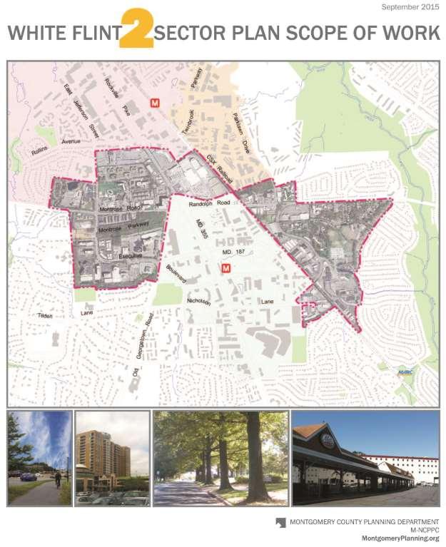
1 MONTGOMERY COUNTY PLANNING DEPARTMENT THE MARYLAND-NATIONAL CAPITAL PARK AND PLANNING COMMISSION MCPB Item No. Date: White Flint 2 Sector Plan, Scope of Work Nkosi Yearwood, Senior Planner, Area 2 Division, Nkosi.Yearwood@montgomeryplanning.org, Andrea Gilles, Senior Planner, Area 2 Division, Andrea.Gilles@montgomeryplanning.org, Nancy Sturgeon, Master Planner Supervisor, Master Plan Team, Area 2 Division, Nancy.Sturgeon@montgomeryplanning.org, Glenn Kreger, Chief, Area 2 Division, Glenn.Kreger@montgomeryplanning.org, Completed: Description White Flint 2 Sector Plan: Scope of Work Staff Recommendation Approval of the proposed Scope of Work Summary The White Flint 2 Sector Plan (WF2 Plan) is comprised of approximately 455 acres located to the west, north, and east of the 2010 White Flint Sector Plan. The City of Rockville and the 2009 Twinbrook Sector Plan are adjacent to the north. This Scope of Work includes the following: Proposed boundary for the WF2 Plan; Planning area context; Planning framework; Area development activity; Purpose and summary of plan issues; and Community Outreach and Plan Schedule.
2 2
3 CONTENTS Introduction Context Existing Land Uses Transportation Background Planning Framework Development Activity Purpose of the Plan Issues to be Addressed Transportation and Connectivity Community Facilities Environmental Sustainability Land Uses and Urban Design Community Outreach Plan Schedule Figures Figure 1: Plan Area Boundary Figure 2: Planning Context Figure 3: North Bethesda/Garrett Park Sector Plan Boundary (1992); Twinbrook Sector Plan (2009), White Flint Sector Plan (2010), White Flint 2 Sector Plan, Rock Spring Master Plan Figure 4: Rockville Pike Boulevard and Promenade Cross Section Figure 5: Alternative Rockville Pike BRT Cross Section Figure 6: City of Rockville Maximum Expansion Limits 1

4 INTRODUCTION The proposed White Flint 2 Sector Plan area is located in North Bethesda, adjacent to White Flint, Twinbrook, and the City of Rockville. This Scope of Work for the White Flint 2 Sector Plan describes the proposed boundaries and purpose, provides context and background, summarizes recent development activity and the issues to be addressed, and outlines the community engagement strategy and schedule. The 455-acre White Flint 2 Sector Plan (WF2 Plan) includes a short segment of Rockville Pike north of Montrose Parkway and south of Rollins Avenue, and encompasses areas to the west, north, and east of the 2010 White Flint Sector Plan. (See Figure 1.) Residential neighborhoods adjacent to the proposed Sector Plan area include Randolph Hills on the east and Luxmanor on the west. The WF2 Plan will examine land uses, transportation and connectivity, community facilities, and environmental sustainability. The Plan will seek to ensure efficient use of existing and proposed infrastructure, and will explore opportunities to enhance connectivity within WF2 as well as to White Flint and the surrounding communities. Figure 1: Plan Area Boundary 2
5 White Flint is transitioning from an auto-oriented, suburban development pattern into a more urban area where people walk and bike to work, shops, services, and transit. The WF2 area is served by two Metrorail stations: White Flint and Twinbrook, and a nearby MARC station in Garrett Park. The following long-range plans provide guidance for this area s future as well as a contextual framework that will inform the WF2 planning effort: the 2009 Twinbrook Sector Plan, the 2010 White Flint Sector Plan, the 2013 Countywide Transit Corridors Functional Master Plan and the City of Rockville s Pike Plan Planning Commission Draft for Public Review (released June 2014). The WF2 Plan will explore the common elements shared with the surrounding communities and proposed improvements, including: Transforming Rockville Pike from a series of suburban strip centers into an urban boulevard with new mixed-use centers. Examining the viability of aging office parks in a changing office market. Retaining or modifying light industrial zoned land. Improving connectivity and walkability throughout the area. Improving access to Metrorail stations. Planning for bus rapid transit along Rockville Pike. Planning a comprehensive bikeway network. Enhancing public open spaces. CONTEXT The WF2 Plan originally started after completion of the White Flint Sector Plan in April A WF2 Scope of Work was presented to the Planning Board on April 26, Subsequently, the County Council directed the Planning Department to delay the WF2 Plan in order to address other Master Plans. At the Department s spring 2015 semi-annual meeting with the County Council, the start date for the WF2 Plan was moved up from June 2015 to April Existing Land Uses There are a wide variety of land uses in the WF2 area (see Figure 2.) that are, to some extent, geographically concentrated to form the following clusters of activity: Offices are concentrated along Executive Boulevard in an area previously referred to as the Washington Science Center. Light industrial uses are located on Nicholson Court and along Parklawn Drive east of the CSX railroad. Retail shopping centers are clustered on Rockville Pike, including Montrose Crossing, Pike Center Shopping Center, Federal Plaza and Towne Plaza. In addition, two retail centers are located east of the CSX railroad, Loehmann s Plaza on Randolph Road and the Randolph Hills Shopping Center along Boiling Brook Parkway. Institutional uses located along Rocking Horse Road include the Rocking Horse Road Center, a Montgomery County Public School administrative facility and the upper school of the Charles E. Smith Jewish Day School. Institutional uses located along Montrose Road include the Jewish Community Center (JCC), the lower school of the Charles E. Smith Jewish Day School and six facilities of the 3
, townhouses, single-family and senior housing.")
6 Charles E. Smith Life Communities (senior living, assisted living, long-term care and rehabilitation services). Residential uses are interspersed throughout the Plan area and include multi-family (rental and condominium), townhouses, single-family and senior housing. Figure 2: Planning Context Transportation WF2 has a vast array of existing and proposed transportation infrastructure. The Metrorail Red Line runs parallel to Rockville Pike. Metrorail stations near WF2 include Twinbrook to the north and White Flint to the south. The Twinbrook Metrorail Station is located near Chapman Avenue and Halpine Road in the City of Rockville. The station is east of Rockville Pike and the platform is on the west side of the CSX railroad tracks, but there is access from the east side as well. This station is within walking distance of WF2, particularly from the Montrose Crossing and Pike Center shopping centers. The White Flint Metrorail Station is located at the northeast corner of Rockville Pike and Marinelli Drive. This station is also within walking distance of some areas within WF2. The 2013 Countywide Transit Corridors Functional Master Plan identified several Bus Rapid Transit (BRT) routes in the WF2 area. The MD 355 South Corridor is planned from the Rockville Metrorail Station to the Friendship Heights Metrorail Station. The Maryland State Highway Administration is currently studying the MD 355 South and MD 355 North BRT Corridors. (The MD 355 North Corridor is planned from the Rockville Metrorail Station to Middlebrook Road in 4
7 Germantown.) The Randolph Road BRT Corridor is planned from the White Flint Metrorail Station to the Glenmont Metrorail Station and east to US 29. The North Bethesda Transitway was originally recommended in the 1992 North Bethesda/Garrett Park Sector Plan. The 2013 Countywide Transit Corridors Functional Master Plan recommends that the North Bethesda Transitway run from the White Flint Metrorail Station, west on Old Georgetown Road to Rock Spring Drive and west to Montgomery Mall. The CSX rail line runs through the area and a new MARC station is proposed by the 2010 White Flint Sector Plan that could potentially link both sides of the tracks. The White Flint Sector Plan states (on page 52): Construct a MARC station at Nicholson Court. The location replaces the Bou Avenue location recommended in the 1992 North Bethesda/Garrett Park Master Plan. The location is appropriate since White Flint will be the most intensely developed activity center in North Bethesda along the Brunswick line. A major infrastructure project, the interchange at MD 355 and Montrose/Randolph Road, was completed in In 2012, the extension of Nebel Street from Randolph Road to the intersection of Bou Avenue and Chapman Avenue near Rockville Pike was completed, improving local circulation. Future construction to complete Montrose Parkway East is planned, as is the realignment of Old Georgetown Road and Executive Boulevard. WF2 has a relatively small stretch of Rockville Pike within its boundaries: the approximately 1,800-foot section from just north of the MD 355/Montrose/Randolph interchange (which is the northern boundary of the White Flint Sector Plan) to just south of Rollins Avenue/Twinbrook Parkway (which is the southern boundary of the City of Rockville). A critical issue for WF2 will be determining how much additional development can be supported by the existing and proposed transportation network. BACKGROUND Historically, Montgomery County s most densely developed areas have been the down-county centers nearest Washington, D.C. These areas include the County s downtowns or central business districts -- Bethesda, Friendship Heights, Silver Spring, and Wheaton which are wellestablished urban areas with Metrorail stations, high density, and a mix of uses. The 1993 General Plan Refinement identified these centers as the Urban Ring, where densities were planned to be higher than the rest of the County, including the Corridor Cities along I-270. Metrorail station areas located farther from the County s border with the District of Columbia, generally those north of I Glenmont, White Flint, Shady Grove -- developed less intensively and were more single-purpose in use. Most centers without Metrorail stations -- Kensington, Chevy Chase Lake, Long Branch, White Oak -- have traditionally been oriented toward local-serving uses and lower densities. The County has been reexamining its centers, particularly those outside the Urban Ring, and exploring locations that could accommodate future growth. In select areas, the County s suburban centers are evolving and redeveloping into more urban nodes with opportunities to live, work, and play within walkable communities. Over the past decade, the County completed a series of plans along the I-270/MD 355 Corridor, some with Metrorail stations -- the
8 Shady Grove Sector Plan, 2009 Twinbrook Sector Plan, and the 2010 White Flint Sector Plan -- and some without -- the 2009 Germantown Master Plan and the 2010 Great Seneca Science Corridor Master Plan. The 2006 Shady Grove Sector Plan recommended significant changes around the Shady Grove Metrorail Station (the northernmost of the County s western Red Line stations) to take advantage of transit accessibility and transform the area from light industrial to an urban village with an array of new residences, parks, open spaces, and a new street network. Pursuant to the County s Smart Growth Initiative, much of the zoning was changed from light industrial to transit-oriented mixed-use. One of the challenges of implementing this Plan is the relocation of uses within the County Service Park. Recent projects approved by the Planning Board include Shady Grove Station and the Townes at Shady Grove, which will add 2,366 new dwelling units to the area. The Twinbrook Sector Plan area is adjacent to WF2, north of Bou Avenue and east of the CSX tracks. The 2009 Twinbrook Sector Plan allows mixed-use development near the Twinbrook Metrorail Station in the Commercial Residential (CR) zone, while retaining some light industrial uses in the Twinbrook Overlay Zone for a portion of the Plan area. The 2010 White Flint Sector Plan is immediately adjacent to WF2 to the west, south, and east, and includes the White Flint Metrorail Station. The White Flint Sector Plan built upon the mixed-use floating zones that were recommended in the 1992 North Bethesda/Garrett Park Sector Plan, and recommended the rezoning of the majority of the area to mixed-use zones, with an emphasis on residential. The Plan also recommended a connected street grid and public use space system, further establishing the framework for transforming White Flint into an active urban center. One of the most notable changes in the White Flint area since the Plan was approved is the redevelopment of the former Mid-Pike Plaza shopping center into the award-winning Pike and Rose development. The Development Activity section on the following pages highlights the transformative redevelopment projects that have been proposed or constructed in the White Flint and Twinbrook areas. In support of the County s reexamination of its mix and location of land uses, the Planning Department has recently completed in-depth studies on office market conditions and industrial land use trends and their impacts on Montgomery County. In June 2015, the Department released an Office Market Assessment Report, prepared in partnership with Washington, DCbased Partners for Economic Solutions (PES). The report provides a detailed assessment of regional office market conditions and the implications for Montgomery County. The study examines an array of economic forces changing the Washington, DC region s office market and best practices for next-generation office development. In October 2013, the Industrial Land Use study, also prepared by PES, was distributed by the Department and provides information on regional and county trends. The report highlights the importance of industrial land uses in the County and provides policy recommendations for the County s industrially zoned areas. 6

9 Finally, the City of Rockville is updating its 1989 Rockville Pike Corridor Neighborhood Plan. This Plan covers approximately 2 miles of Rockville Pike, including properties from Bou Avenue to Richard Montgomery Drive. The Draft 2014 Rockville Plan recommends mixed-use development along the corridor, a new street network, new parks and open spaces, and a multi-way boulevard for Rockville Pike. Planning for WF2 will be coordinated with the City. PLANNING FRAMEWORK The 1992 North Bethesda/Garrett Park Sector Plan covered a large geography and focused on the areas around the Twinbrook, White Flint and Grosvenor-Strathmore Metrorail stations, as well as the office park at Rock Spring. Four areas that were previously part of the 1992 Sector Plan are now the subject of separate, smaller area plans, including the completed Twinbrook and White Flint Sector Plans, and the plans currently underway for White Flint 2 and Rock Spring. (See Figure 3.) Figure 3: North Bethesda/Garrett Park Sector Plan Boundary (1992) Twinbrook Sector Plan (2009), White Flint Sector Plan (2010), White Flint 2 Sector Plan, Rock Spring Master Plan Each of the four focus areas of the 1992 Sector Plan had distinct boundaries. While the proposed WF2 Plan area was part of the 1992 Sector Plan, it was not one of the four nodal areas that the 1992 Plan focused on. Therefore, it was not defined as a place with distinct 7
10 boundaries in the 1992 Plan. For areas outside of the four nodes the three Metrorail station areas and Rock Spring Park -- the 1992 Plan identified 23 key vacant or redevelopable properties with the greatest potential for change. The Plan states (on page 72) that These critical parcels and areas are undeveloped or underdeveloped for a variety of reasons, including environmental or market constraints, poor access or visibility, complex or unresolved ownership problems, decisions to hold land as an investment, zoning incompatible with an owner s aspirations, or inadequate public facilities. Of the 23 key properties identified for the broader area covered by the 1992 Plan, the following are located within the proposed WF2 Sector Plan area: Montrose Crossing, Wilgus, Tri-Rock, Loehmann s Plaza, and the light industrially zoned properties east of the railroad tracks along Parklawn Drive. The WF2 Sector Plan will address these sites as well as others within its boundaries. The WF2 Sector Plan will amend the 1992 North Bethesda/Garrett Park Sector Plan and the 2010 White Flint Sector Plan. As mentioned above, the White Flint Sector Plan recommends a new MARC station in the vicinity of Nicholson Court. The Nicholson Court area is being included in the WF2 Plan to facilitate planning for this potential transit improvement. The WF2 Plan will also amend, and be guided by relevant goals from, the 1993 General Plan Refinement including: Developing compact, mixed-use, transit-serviceable centers. Encouraging a sense of community identity. Providing connections and enhancing park and recreation linkages. DEVELOPMENT ACTIVITY In the 23 years since the 1992 North Bethesda/Garrett Park Sector Plan was approved, several properties in the proposed Plan area have been redeveloped. Townhouses have been constructed on a portion of the former Wilgus property, located on the south side of Montrose Road across from the Jewish Community Center. A 230-unit multifamily high-rise condominium building, Midtown Bethesda North, has been built on Bou Drive at the northeastern edge of the Montrose Crossing Shopping Center. A 147,990 square-foot Target store has been built along Bou Drive behind the Montrose Crossing Shopping Center. Bou Drive has been extended along the railroad tracks to align with Nebel Street at Randolph Road. In the Twinbrook area, Parklawn North, a 500,000-square foot headquarters for the National Institute of Allergy and Infectious Diseases (NIAID) has been completed. Two mixed-use developments are under construction, including the Galvan with 356 multi-family residential units and 100,000 square feet of retail, and the Terano with 214 multi-family residential units and 37,000 square feet of retail. Both the Galvan and Terano are included in Twinbrook Station, a 26-acre mixed-use development surrounding the Twinbrook Metrorail Station that was annexed by the City of Rockville in When completed, Twinbrook Station will have 1,500 residential units, 325,000 square feet of office and 220,000 square feet of retail. 8
11 Since the White Flint Sector Plan was adopted over five years ago, four sketch plans have been approved by the Planning Board, including Pike and Rose, North Bethesda Gateway, North Bethesda Market II, and White Flint Mall. Of these projects, only Pike and Rose has begun. Federal Realty has nearly completed Phase 1 of Pike and Rose, which is transforming the 20- acre former Mid-Pike Plaza strip shopping center into a mixed-use center. The project features a 493-unit high-rise residential building and 262,800 square feet of commercial development, including shops and restaurants, the ipic Theater, and the AMP performance venue run by Strathmore. Phase II is now underway and will include additional residential, a hotel, and an urban park. PURPOSE OF THE PLAN Rockville Pike is undergoing a transformation. Recent master/sector plans for this area provide a blueprint and a new vision for the area to evolve from suburban into a more urban, dynamic, mixed-use activity center. The market and development community have responded with several substantial projects that are evidence that the vision to transform the Pike can become a reality. WF2 includes areas that have not been covered by other recent plan updates, including a critical portion of Rockville Pike between the City of Rockville and the White Flint Sector Plan, as well at the industrial uses east of the CSX tracks. WF2 also includes Executive Boulevard, an office park that is experiencing high office vacancy rates like Rock Spring. These are issues that require Sector Plan consideration. This planning process will explore how WF2 is similar to, and unique from, the surrounding North Bethesda communities. WF2 does not have a Metrorail station within its boundaries and the areas closest to the White Flint and Twinbrook Metrorail stations should have higher development densities than areas farther away. Areas within WF2 are within walking distance of these two Metrorail stations and the Plan will examine connectivity and accessibility between the communities. An important goal for the WF2 Plan will be exploring ways to connect the North Bethesda centers -- WF2, White Flint, Twinbrook, and Rockville -- to one another seamlessly and cohesively. The WF2 planning process will also allow for a more detailed and nuanced assessment of the zoning conversions that became effective on October 30, 2014 as part of the Countywide District remapping. Baseline land use and traffic conditions will be evaluated to understand existing opportunities and constraints. Staff will evaluate different levels of residential and nonresidential development, and prepare scenarios to be tested by traffic modeling. Staff will explore the changing circumstances with the office market, whether industrial areas should be retained, and what locations are appropriate to encourage mixed-use development. Planners will also analyze the segment of Rockville Pike within the WF2 area and how it can be transformed into an urban boulevard, consistent with the goals of the White Flint Sector Plan and the City of Rockville s Pike Plan. Urban design guidelines will be prepared, which will likely have similar elements to the White Flint Sector Plan guidelines. The Plan will seek to improve vehicular transportation and bikeway networks from White Flint to Rockville, including BRT options; and potentially link both sides of the CSX tracks at the proposed location for a new MARC station near Nicholson Court. 9
12 ISSUES TO BE ADDRESSED Transportation and Connectivity Transportation congestion is a significant challenge in North Bethesda. The 2010 White Flint Sector Plan addressed this issue by recommending a new network of streets, an increased nonauto driver mode share for the Plan area, and a special tax district that aids in funding transportation infrastructure. WF2 will also address transportation and mobility issues by considering potential infrastructure improvements, modifications to existing transportation policies, or expansion of the White Flint special tax district. Montgomery County Department of Transportation (MCDOT), Maryland State Highway Administration (SHA), and the White Flint Partnership have conducted different traffic studies and analysis for White Flint and the surrounding area. These studies will inform the WF2 Plan s recommendations. As noted above, a critical issue for this Plan is determining how much additional development the transportation network can support. The White Flint Sector Plan states (on page 6): Rockville Pike will be transformed from a traffic barrier dividing the center into a unifying multi-modal boulevard. (See Figures 4 and 5 on following page.) The planned transformation of Rockville Pike will continue in WF2, between Montrose Parkway and the Rockville city limits, including recommendations to establish pedestrian and bicycle linkages to the City of Rockville and the surrounding trail network. This segment is important since it is adjacent to the City of Rockville and must be coordinated with Rockville s Pike Plan recommendations. The future construction of Montrose Parkway East and the BRT routes for Rockville Pike (MD 355 South), the North Bethesda Transitway, and Randolph Road are additional transportation infrastructure elements to be considered in the Plan area. Current design plans prepared by the State Highway Administration for Montrose Parkway East show that the Randolph Road crossing of the CSX railroad tracks will remain open. The Plan will explore how to improve walkability for residents in neighborhoods on the east side of the tracks. As noted above, the 2010 White Flint Sector Plan recommends a new MARC station at Nicholson Court, within the WF2 boundary. Redevelopment and infill options will be explored for that area to facilitate local access to and from the proposed MARC station as well as the White Flint Metrorail Station. 10
 Community Facilities Another issue to be considered in the WF2 Plan is school capacity in the Walter Johnson School Cluster in North Bethesda.")

13 Figure 4: Rockville Pike Boulevard and Promenade Cross Section Note: Image from the 2010 White Flint Sector Plan (page 17) Figure 5: Alternative Rockville Pike BRT Cross Section Note: Image from the 2010 White Flint Sector Plan (page 17) Community Facilities Another issue to be considered in the WF2 Plan is school capacity in the Walter Johnson School Cluster in North Bethesda. Proposed residential densities in the White Flint Sector Plan generate the need for a new elementary school within the Walter Johnson Cluster. The 2016 Subdivision Staging Policy indicates that the Walter Johnson Cluster is close to a residential moratorium for all school levels. Additional residential development will impact the cluster, as well as the adjacent down-county Consortium secondary schools. The need for additional park and open spaces will also be analyzed as a component of this Plan. The White Flint Sector Plan recommends a system of public use spaces as well as locations for new public facilities. The WF2 Plan will assess the impact of the proposed resources in White Flint and determine whether any additional facilities are needed. Environmental Sustainability Much of the development in the WF2 area occurred at a time before stormwater management regulations were in place. Redevelopment is an opportunity to improve environmental conditions and create a healthier community. The Plan will promote environmental sustainability, including environmental site design techniques and increased tree canopy 11

14 coverage. Additional opportunities for new parks and opens spaces will be considered. Opportunities to improve air quality, reduce emissions, and provide alternatives to singleoccupant vehicles will also be explored. Land Uses and Urban Design WF2 has a wide variety of land uses -- retail, office, industrial, institutional, and residential -- in typically segregated suburban clusters of low- to medium- density single-use developments. The Plan will evaluate the appropriateness of the single-use properties and explore land use patterns that promote mixed-use development at suitable locations. Two of the more predominant single-use land use types in WF2 are office and industrial. The Plan will explore whether the light-industrial-zoned land should be retained or modified, as well as the role of an office park in a changing office market. On a more micro-level, urban design guidelines will be established to recommend compatible building heights and scale between new and existing development. COMMUNITY OUTREACH Outreach efforts for this Plan will include an open house, a series of workshops, and small group meetings to engage residents, surrounding neighborhood associations, business owners, community organizations, the existing White Flint Sector Plan Implementation Advisory Committee, and the County Executive s coordinator for implementation of the White Flint Sector Plan. New social media, electronic newsletters, and other communication tools will be utilized. The City of Rockville will play an important role in the Plan s outreach efforts since the area north of Montrose Road and Randolph Road is within the City s maximum expansion limits. Figure 6: City of Rockville Maximum Expansion Limits 12


15 An open house kick-off meeting was held on June 25, 2015 to relaunch the WF2 planning effort and public engagement process. Approximately 100 people were in attendance, representing residents, developers, business owners, neighborhood associations, and community groups. Attendees engaged in a robust dialogue with staff and reconfirmed their priority issues, including overcrowded schools, connectivity, safety and access throughout the Pike area, particularly from the neighborhoods to the east that are bifurcated from White Flint by the CSX tracks. Attendees also expressed the desire for additional public parks and open space, and raised concerns regarding roadway capacity and how new infrastructure and public facilities will be financed. White Flint 2 Kick-Off Meeting, Luxmanor Elementary School, June 25, 2015 White Flint 2 Kick-Off Meeting, Luxmanor Elementary School, June 25, 2015 In fall 2015, staff will launch a series of workshops to solicit ideas from the community and begin developing preliminary plan concepts. Additional public meetings will address specific topics, such as transportation, land use, zoning and public facilities, including schools. Staff will meet with individual property owners, business owners, civic representatives, Rockville planning staff, public agencies, and other interested parties throughout the process. All public meetings, events, and staff reports will be posted on the project website. Translation services will be provided, as needed. 13
16 A Communications Plan has been established for the project to incorporate additional resources and tools for effectively communicating with the community about the issues in this Plan. A variety of opportunities for interactive engagement, in addition to public and small group meetings and workshops, are discussed below. Consistent, easy-to-understand messaging: Planning concepts related to transportation, zoning and infill opportunities will be explained simply and clearly across all media platforms. Overview PowerPoint: The Plan s main PowerPoint will be used to summarize the history and challenges of the area, including the WF2 Plan s relationship to the City of Rockville and the White Flint and Twinbrook Sector Plans. The PowerPoint will provide background to help planners communicate issues, including the context, planning history, and current topics, to interested stakeholders. Along with other relevant materials, the Plan s PowerPoint will be available online and will be updated throughout the process. This tool will be designed to help stakeholders learn about existing conditions -- past as well as the present -- as they engage with planners about the future of the area. A voice-over of planners narrating the PowerPoint (as in a live presentation) could also be placed on the Plan s webpage. And, the staff team will consider enabling viewers of the on-line PowerPoint to pose comments and questions about its content. Website: Efforts will be made to have well-coordinated messaging on the Plan from the project team and Planning Department staff. A project webpage has been established at montgomeryplanning.org/whiteflint2. E-newsletter and social media: Updates and clear messaging will be conveyed through regular postings on Facebook and Twitter (@montgomeryplans#whiteflint2) about various aspects of the Plan. Videos: Staff interviews and segments devoted to specific topics (transportation, zoning, public facilities, etc.) could be posted on the Planning Department website. PLAN SCHEDULE Planning Department staff began working on this Plan in May The Planning Board is scheduled to review the Working Draft Plan in spring 2016 and transmit the Planning Board Draft Plan to the County Executive and County Council by August The County Council review of the Plan is scheduled to begin in October Upon the completion of the Council s review and action, a Sectional Map Amendment (SMA) will be initiated to implement the Plan s zoning recommendations. It is anticipated that the SMA will be completed by summer Staff Plan Development: Outreach, Data Collection, Analysis April 2015 February 2016 Complete an inventory of existing conditions, including assembling land use data, zoning, demographics, transportation, environment, and community facilities, including parks and recreational amenities. Discuss and finalize the needed analysis and resources, establish a 14
17 methodology and approach. Prepare a Scope of Work that describes the Plan area and issues, including tasks, staff assignments, community outreach plan, and time line. September 3, Scope of Work Present Scope of Work to the Planning Board. June January 2016 Outreach, Develop Scenarios for Traffic Modeling The community open house will be followed by a series of workshops between September and December Staff will prepare development scenarios; analyze transportation and environmental impacts; conduct urban design studies and infrastructure needs assessment, possibly utilizing consultant services; develop concepts for the environment, parks, open spaces, and community facilities; identify potential zoning designations; and discuss alternatives with stakeholders. February 2016 Prepare Draft Preliminary Recommendations Develop preliminary recommendations, including identifying infrastructure needed to support the proposed development scenario. Prepare zoning and urban design recommendations that will implement the Plan recommendations. March Working Draft Plan Present the Working Draft Sector Plan to the Planning Board for review and approval to publish the Public Hearing Draft and set a public hearing date. Planning Board Review March - July 2016 Planning Public Hearing Draft Conduct the Planning Board s tour of the area and the public hearing to receive public testimony. Planning Board work sessions will be held to review testimony and discuss issues presented in the public hearing as well as those raised by Board members. The Planning Board Draft will be prepared for transmittal to the County Council and the County Executive. County Executive Review August - September 2016 The County Executive will review the Plan s recommendations, prepare a fiscal analysis and transmit comments to the County Council. County Council Review October April 2017 The County Council will tour the Plan area and conduct a public hearing on the Planning Board Draft Plan. Work sessions will be held by the Council s Planning, Housing, and Economic Development (PHED) Committee. The PHED Committee will make recommendations to the full Council on the Planning Board Draft and the Council will review and approve the White Flint 2 Sector Plan with a Council Resolution. 15
, will be initiated and completed.")
18 Sectional Map Amendment May - August 2017 The full Commission of the M-NCPPC will adopt the approved Plan. Once the Plan is approved and adopted, the process to implement the Plan s zoning recommendations, the Sectional Map Amendment (SMA), will be initiated and completed. STAY CONNECTED Staff Contacts Nkosi Yearwood Telephone: nkosi.yearwood@montgomeryplanning.org Andrea Gilles Telephone: andrea.gilles@montgomeryplanning.org Nancy Sturgeon Telephone: nancy.sturgeon@montgomeryplanning.org Project Webpage Twitter #WF2 Facebook 16
S C O P E O F W O R K A P R I L
 white flint 2 sector plan S C O P E O F W O R K A P R I L 2 0 1 2 MONTGOMERY COUNTY PLANNING DEPARTMENT M-NCPPC MontgomeryPlanning.org 1 white flint 2 sector plan Scope of Work abstract This scope of work
MONTGOMERY COUNTY PLANNING DEPARTMENT THE MARYLAND-NATIONAL CAPITAL PARK AND PLANNING COMMISSION
 MONTGOMERY COUNTY PLANNING DEPARTMENT THE MARYLAND-NATIONAL CAPITAL PARK AND PLANNING COMMISSION White Flint 2 Sector Plan: Briefing and Preliminary Staff Recommendations MCPB Item No. Date: 07/28/2016
CONTENTS BACKGROUND AND CONTEXT... 3 Plan Area... 3 History... 3 Previous Planning Initiatives... 4 PLANNING FRAMEWORK... 5 Countywide Transit
 CONTENTS BACKGROUND AND CONTEXT... 3 Plan Area... 3 History... 3 Previous Planning Initiatives... 4 PLANNING FRAMEWORK... 5 Countywide Transit Corridors Functional Master Plan... 5 Veirs Mill Road Bus
white flint 2 sector plan
 white flint 2 sector plan Public Hearing Draft NOVEMBER 2016 MONTGOMERY COUNTY PLANNING DEPARTMENT M-NCPPC MontgomeryPlanning.org White Flint 2 Sector Plan Public Hearing Draft Abstract This Plan contains
Approved and Adopted JANUARY 2018
 Approved and Adopted JANUARY 2018 Abstract This Plan contains the text and supporting maps for a comprehensive amendment to the approved and adopted 1992 North Bethesda/Garrett Park Master Plan and the
master plan of highways bus rapid transit amendment
 Scope of Work master plan of highways bus rapid transit amendment September 2011 Montgomery County Planning Department M-NCPPC MontgomeryPlanning.org 1 Scope of Work master plan of highways bus rapid transit
INTRODUCTION. Figure 1: Master Plan Area Boundary
 CONTENTS Introduction Planning Framework Background and Context Development Activity Purpose of the Plan Issues to be Addressed Land Uses and Urban Design Transportation and Connectivity Community Facilities
Status Report: MD 355 Project
 Status Report: MD 355 Project OCTOBER 2006 M-NCPPC MONTGOMERY COUNTY PLANNING DEPARTMENT Summary of Community Comments, and break to the Results of the MD 355 Participation Session Brookside Gardens -
Public Meeting: July 11, 2016
 Public Meeting: July 11, 2016 MONTGOMERY COUNTY PLANNING DEPARTMENT Maryland-National Capital Park and Planning Commission Tonight s Agenda Preliminary Recommendations Background and Context 2009 Twinbrook
Rock Spring Master Plan Community Meeting #6: Land Use + Transportation Forecasts
 Rock Spring Master Plan Community Meeting #6: Land Use + Transportation Forecasts May 23, 2016 Ι Walter Johnson High School Andrea Gilles, andrea.gilles@montgomeryplanning.org Ι www.montgomeryplanning.org/community/rockspring/
Preliminary Recommendations
 Preliminary Recommendations Plan Area 2 Plan Context White Flint 2 2010 White Flint Sector Plan 2009 Twinbrook Sector Plan 3 Plan Context 4 Plan Context White Flint Residential Non-Residential Sector Plan
THE 355/270 CORRIDOR:
 THE 355/270 CORRIDOR: Strategic Ideas for Sustaining a Livable Work Place Project Summary ACCESS LIFE DESIGN HEALTH WORK Montgomery County Planning Department The Maryland-National Capital Park and Planning
MONTGOMERY COUNTY PLANNING DEPARTMENT THE MARYLAND-NATIONAL CAPITAL PARK AND PLANNING COMMISSION
 MONTGOMERY COUNTY PLANNING DEPARTMENT THE MARYLAND-NATIONAL CAPITAL PARK AND PLANNING COMMISSION MCPB Item No. Date10/25/12 Sketch Plan No. 32012004, White Flint Mall Redevelopment Nkosi Yearwood, Senior
master plan of highways
 scope of work master plan of highways abstract This Scope of Work outlines the tasks and goals of updating the Master Plan of Highways, as well as the outreach that will be used in the planning process.
Silver Line CPAM UPDATE. Transportation and Land Use Committee October 14, 2016
 Silver Line CPAM UPDATE Transportation and Land Use Committee October 14, 2016 Purpose Recap Project History and Map Changes Provide Overview of CPAM Components Discuss Transportation Impacts Discuss Fiscal
Transit-Oriented Mixed Use Zoning in Montgomery County, Maryland
 Transit-Oriented Mixed Use Zoning in Montgomery County, Maryland Nkosi Yearwood Community-Based Planning Division Montgomery County Planning Department Rail Volution 2007 Miami, Florida The General Plan
1.0 Purpose of a Secondary Plan for the Masonville Transit Village
 Report to Planning and Environment Committee To: Chair and Members Planning & Environment Committee From: John M. Fleming Managing Director, Planning and City Planner Subject: Masonville Transit Village
THAT the attached Terms of Reference for the Thornhill Centre Street Study be approved.
 COMMITTEE OF THE WHOLE AUGUST 18, 2003 THORNHILL CENTRE STREET STUDY PLANNING FILE: 15.92 Recommendation The Commissioner of Planning recommends: THAT the attached Terms of Reference for the Thornhill
Town Center (part of the Comprehensive Plan)
") Town Center (part of the Comprehensive Plan) Mercer Island Town Center Looking North (2014) In 1994, a year-long process culminated in a set of design guidelines and code requirements for the Town Center
Town Center (part of the Comprehensive Plan) Mercer Island Town Center Looking North (2014) In 1994, a year-long process culminated in a set of design guidelines and code requirements for the Town Center
MONTGOMERY COUNTY METRO STATION AREA DESIGN CHARRETTE
 MONTGOMERY COUNTY METRO STATION AREA DESIGN CHARRETTE Shady Grove Metro Station Area Charrette Closing Presentation October 25-28, 2000 MONTGOMERY COUNTY, MD M-NCPPC Design Collective, Inc. Architects
Shady Grove Sector Plan
 Montgomery Planning Area 2 Division 11/15/2018 Shady Grove Sector Plan Minor Master Plan Amendment Scope of Work Edit presentation title MM/DD/YYYY 1 Purpose for the Plan Amendment 1. Reevaluate/status
Gold Line Bus Rapid Transit Transit Oriented Development (BRTOD) Helmo Station Area Plan
 Helmo Station Area Plan") Appendix F Gold Line Bus Rapid Transit Transit Oriented Development (BRTOD) Helmo Station Area Plan Introduction and Purpose of the Plan The Gold Line Bus Rapid Transit facility is an eleven-mile dedicated
Appendix F Gold Line Bus Rapid Transit Transit Oriented Development (BRTOD) Helmo Station Area Plan Introduction and Purpose of the Plan The Gold Line Bus Rapid Transit facility is an eleven-mile dedicated
Midtown Greenway Land Use and Development Plan Executive Summary
 Midtown Greenway Land Use and Development Plan Executive Summary Introduction The Midtown Greenway Land Use and Development Plan sets policy direction for land use and development in the Midtown Greenway
Chapter 1.0 Introduction
 Chapter 1.0 Introduction 1.1 Background The North Metro commuter rail line is part of the RTD FasTracks regional transit system expansion program to build more than 100 miles of rail transit throughout
MONTGOMERY COUNTY PLANNING DEPARTMENT THE MARYLAND-NATIONAL CAPITAL PARK AND PLANNING COMMISSION
 MONTGOMERY COUNTY PLANNING DEPARTMENT THE MARYLAND-NATIONAL CAPITAL PARK AND PLANNING COMMISSION MCPB Item No. 6 Date: 7.22.13 Bethesda Purple Line Station Minor Master Plan Amendment, Scope of Work Elza
MONTGOMERY COUNTY PLANNING DEPARTMENT
 MONTGOMERY COUNTY PLANNING DEPARTMENT THE MARYLAND-NATIONAL CAPITAL PARK AND PLANNING COMMISSION MCPB Item No.: Date: 5-03-18 Pike and Rose, Phase I: Site Plan Amendment No. 82012002D Rhoda Hersson-Ringskog,
Seneca Meadows. Block 4 Locate office, technology, and medical development adjacent to I Screen views of garage structures from I-270.
 Seneca Meadows Seneca Meadows has an industrial park in its southern end and a mixed-use employment area planned for the north end. The district benefits from extensive I-270 visibility, stream valley
Establish a network of streetscaped vehicle and pedestrian routes that connect within and outside the Plan area.
 This Plan s urban design goals are to create an urban scale, walkable community with connections to transit, parks, and services and with amenities and facilities for residents and employees. The 1992
DOMINION BOULEVARD CORRIDOR STUDY AND ECONOMIC DEVELOPMENT STRATEGIC PLAN A MODEL FOR CHESAPEAKE S FUTURE
 DOMINION BOULEVARD CORRIDOR STUDY AND ECONOMIC DEVELOPMENT STRATEGIC PLAN A MODEL FOR CHESAPEAKE S FUTURE Overview I. Draft Plan Process II. Draft Plan Overview a. Market Analysis b. Master Land Use Plan
SAN RAFAEL GENERAL PLAN 2040 INTRODUCTION AND OVERVIEW
 SAN RAFAEL GENERAL PLAN 2040 INTRODUCTION AND OVERVIEW Steering Committee Presentation February 14, 2018 Purpose of General Plan Guide land use and development decisions Coordinate transportation, infrastructure,
CITY OF CHARLOTTESVILLE, VIRGINIA CITY COUNCIL AGENDA
 CITY OF CHARLOTTESVILLE, VIRGINIA CITY COUNCIL AGENDA Agenda Date: December 16, 2013 Action Required: Adoption of Resolution Presenter: Staff Contacts: Title: James E. Tolbert, AICP, Director of NDS James
ASPEN HILL Minor Master Plan Amendment
 ASPEN HILL Minor Master Plan Amendment Project Briefing Planning Board Agenda Item #7 Andrea Gilles, Area 2 June 5, 2014 Briefing Purpose 1. Follow-up evaluation on Mixed-Use land use in the Minor Amendment
MONTGOMERY COUNTY PLANNING DEPARTMENT THE MARYLAND-NATIONAL CAPITAL PARK AND PLANNING COMMISSION
 MONTGOMERY COUNTY PLANNING DEPARTMENT THE MARYLAND-NATIONAL CAPITAL PARK AND PLANNING COMMISSION MCPB Item No. Date: 1/15/2015 Bethesda North Marriott Hotel and Conference Center: Limited Site Plan Amendment
AGENDA 7:00 p.m. Welcome 7:15 p.m. Staff Presentation 7:45 p.m. Questions and Responses 8:00 p.m. Open House
 AGENDA 7:00 p.m. Welcome 7:15 p.m. Staff Presentation 7:45 p.m. Questions and Responses 8:00 p.m. Open House 2 PLANNING CONTEXT - WHAT IS A MASTER PLAN? Master Plans are comprehensive amendments to the
County Council Presentation. White Oak Science Gateway Planning Board Draft Master Plan June 17, 2014
 County Council Presentation White Oak Science Gateway Planning Board Draft Master Plan June 17, 2014 http://montgomeryplanning.org/community/wosg/index.shtm Nancy Sturgeon, Lead Planner www.nancy.sturgeon@montgomeryplanning.org
Plan Overview. Manhattan Area 2035 Reflections and Progress. Chapter 1: Introduction. Background
 Plan Overview The Manhattan Urban Area Comprehensive Plan (the Comprehensive Plan) is a joint planning initiative of the City of Manhattan, Pottawatomie County, and Riley County. The 2014 Comprehensive
MONTGOMERY COUNTY PLANNING DEPARTMENT THE MARYLAND-NATIONAL CAPITAL PARK AND PLANNING COMMISSION
 MONTGOMERY COUNTY PLANNING DEPARTMENT THE MARYLAND-NATIONAL CAPITAL PARK AND PLANNING COMMISSION MCPB Item No. Date: 05/12/2016 North Bethesda Conference Center Parking Structure, Mandatory Referral No.
Implementation Guide Comprehensive Plan City of Allen
 Implementation Guide 2030 Comprehensive Plan City of Allen DRAFT 2015 Implementation Guide Allen 2030 Comprehensive Plan INTRODUCTION The Comprehensive Plan serves as a guide for the growth and development
Introduction. Chapter 1. Purpose of the Comprehensive Plan Plan Organization Planning Process & Community Input 1-1
 Chapter 1 Introduction Lakewood 2025: Moving Forward Together Purpose of the Comprehensive Plan Plan Organization Planning Process & Community Input 1-1 Purpose of the Comprehensive Plan The Comprehensive
DRAFT. October Wheaton. Design Guidelines
 October 2011 DRAFT Wheaton Design Guidelines 2 Draft - Design Guidelines - Wheaton Sector Plan Contents 04 Section 1: Introduction 06 Section 2: Context 08 Section 3: Design Guidelines 09 Goal 1: Create
Executive Summary. NY 7 / NY 2 Corridor
 Executive Summary NY 7 / NY 2 Corridor Transportation and Land Use Study December 2005 Prepared for: Town of Colonie Capital District Transportation Committee Prepared by: Introduction: Land use decisions
Natomas Vision Plan and PLNP
 Natomas Vision Plan 20030171 and PLNP2014-00172 Department of Community Development Planning and Environmental Review Leighann Moffitt Sub-Agenda 1. Staff Presentation Leighann Moffitt, County Planning
Joint Public Hearing. Preliminary Subregion 5 Master Plan and Proposed Sectional Map Amendment
 Preliminary Subregion 5 Master Plan and Proposed Sectional Map Amendment Joint Public Hearing April 11, 2013 Council Hearing Room Upper Marlboro 7:00 pm His Lordship s Kindness (Clinton) Presentation Overview
2.7 ac park. TOTAL 5,403 DU 1,297,900 sf 1,105,450 sf 3.87 ac 5,563 DU 1,121,200 sf 1,105,450 sf 3.87 ac
 PLAN AMENDMENT 2013-I-B1: SEVEN CORNERS SPECIAL STUDY Summary of Pre-staffing Comments Planner: Bernard Suchicital bsuchi@fairfaxcounty.gov (703) 324-1254 Background On October 29, 2013, the Board of Supervisors
JUSTIFICATION STATEMENT FOR SKETCH PLAN NO Sketch Plan Justification for Wilgus
 JUSTIFICATION STATEMENT FOR SKETCH PLAN NO. 320190070 Sketch Plan Justification for Wilgus I. INTRODUCTION Owner and Applicant, Wilgus-Montrose Associates LLC ( Applicant ), by its attorneys, Linowes and
MONTGOMERY COUNTY PLANNING DEPARTMENT THE MARYLAND-NATIONAL CAPITAL PARK AND PLANNING COMMISSION
 MONTGOMERY COUNTY PLANNING DEPARTMENT THE MARYLAND-NATIONAL CAPITAL PARK AND PLANNING COMMISSION Staff Report: Sketch Plan #320110010, Mid-Pike Plaza ITEM #: MCPB HEARING DATE: January 20, 2011 REPORT
John M. Fleming Managing Director, Planning and City Planner. Old East Village Dundas Street Corridor Secondary Plan Draft Terms of Reference
 Report to Planning and Environment Committee To: From: Subject: Chair and Members Planning & Environment Committee John M. Fleming Managing Director, Planning and City Planner Old East Village Dundas Street
Public Forum-Part II: June 20, 2016
 Public Forum-Part II: June 20, 2016 MONTGOMERY COUNTY PLANNING DEPARTMENT Maryland-National Capital Park and Planning Commission Tonight s Agenda I. Schedule and Next Steps II. Presentations i. Abbe Milstein
Preliminary Recommendations Tk Takoma/Langley Crossroads Sector Plan
 Preliminary Recommendations Tk Takoma/Langley Crossroads Sector Plan Vision is to achieve a Transit Oriented, pedestrian friendly Community that Celebrates and builds upon the cultural Diversity of the
The transportation system in a community is an
 7 TRANSPORTATION The transportation system in a community is an important factor contributing to the quality of life of the residents. Without a sound transportation system to bring both goods and patrons
RESOLUTION NO. R Refining the route, profile and stations for the Downtown Redmond Link Extension
 RESOLUTION NO. R2018-32 Refining the route, profile and stations for the Downtown Redmond Link Extension MEETING: DATE: TYPE OF ACTION: STAFF CONTACT: Capital Committee Board PROPOSED ACTION 09/13/2018
REVIEW AND EVALUATION OF REGIONAL LAND USE
 REVIEW AND EVALUATION OF REGIONAL LAND USE AND TRANSPORTATION SCENARIOS #220831 Environmental Justice Task Force October 7, 2014 VISION 2050 Process Development of Guiding Vision for Land Use and Transportation
PART 1. Background to the Study. Avenue Study. The Danforth
 The Danforth 1.1/ Study Purpose & Key Municipal Goals 1.2/ The Local Advisory Committee 1.3/ The Project Team 1.4/ Study Process/Summary of Method 1.5/ Summary of Consultation 1.1 Study Purpose and Key
A. WHAT IS A GENERAL PLAN?
 I. Introduction A. WHAT IS A GENERAL PLAN? A general plan is the planning guideline for the future of a city. It contains goals and policies which regulate urban development, the protection of the natural
White Flint Advisory Group Forum February 27, 2007 Summary M-NCPPC Auditorium 7:00-9:30 P.M.
 White Flint Advisory Group Forum February 27, 2007 Summary M-NCPPC Auditorium 7:00-9:30 P.M. Neighborhood 1 Bob Stoddard, Washington Real Estate Investment Trust Regarding: 12250 Nebel Street and 5520
Germantown Forward Status Report to the Planning Board M NCPPC
 Germantown Forward Status Report to the Planning Board Germantown Forward March 27, 2008 What s new? CCT alignment Capital Improvement Program Agency partners Water quality conditions Sustainability Design
CHAPTER 1. Ms. Guajardo s Class - Central Elementary CH 1 1
 INTRODUCTION CHAPTER 1 Ms. Guajardo s Class - Central Elementary CH 1 1 1.1 SETTING South Centre City is a linear corridor south of Downtown Escondido paralleling Centre City Parkway and South Escondido
STATEMENT OF JUSTIFICATION CLARKSBURG PREMIUM OUTLETS AT CABIN BRANCH NORTH DISTRICT, PHASE
 STATEMENT OF JUSTIFICATION CLARKSBURG PREMIUM OUTLETS AT CABIN BRANCH NORTH DISTRICT, PHASE 1 Southwest Corner of Clarksburg Road and Interstate-270 Clarksburg, Maryland Application for Site Plan #820140160
2040 LUP is a part of the Comprehensive Plan and carries the same legal authority. Economic Challenges
 1.1. Guiding Anchorage s Growth Where will new residents settle over the next two decades? Where will people work, shop, and play? Will there be enough room to grow? How will Anchorage look? Will growth
South Davis County COMMUNITY SPOTLIGHT
 South Davis County COMMUNITY SPOTLIGHT Davis/SLC Community Connector Bus Rapid Transit line connecting SLC & Davis County RTP Phase 1 Project Generate 3,100 average weekday riders Relieve congestion on
Sector Plan Briefing October 16, 2014
 Sector Plan Briefing October 16, 2014 M-NCPPC Greater Lyttonsville Team Robert Kronenberg, Chief Marc DeOcampo, Supervisor Erin Banks, Project Manager Melissa Williams, Outreach Matt Folden, Transportation
MONTGOMERY COUNTY PLANNING DEPARTMENT
 MONTGOMERY COUNTY PLANNING DEPARTMENT THE MARYLAND-NATIONAL CAPITAL PARK AND PLANNING COMMISSION Ashburton Elementary School Addition, Mandatory Referral, MR2018009 MCPB Item No. Date: 02-15-18 Troy Leftwich,
Scope of Services. River Oaks Boulevard (SH 183) Corridor Master Plan
 Corridor Master Plan") Scope of Services River Oaks Boulevard (SH 183) Corridor Master Plan PROJECT AREA The project area consists of the River Oaks Boulevard (SH 183) corridor bounded by SH 199 at the northern end and the Trinity
Scope of Services River Oaks Boulevard (SH 183) Corridor Master Plan PROJECT AREA The project area consists of the River Oaks Boulevard (SH 183) corridor bounded by SH 199 at the northern end and the Trinity
Hockessin Community Redevelopment Plan
 Hockessin Community Redevelopment Plan 3.1 Introduction The Community Redevelopment Plan for the Village of Hockessin is the result of the people s vision for a distinct village center that serves as the
Rock Spring Master Plan Community Meeting #8: Preliminary Recommendations
 Rock Spring Master Plan Community Meeting #8: Preliminary Recommendations July 18, 2016 Ι Walter Johnson High School Andrea Gilles, andrea.gilles@montgomeryplanning.org Ι www.montgomeryplanning.org/community/rockspring/
Town Center. Block 5 Existing multifamily residential units are expected to remain.
 Area Guidelines Germantown s districts should be developed as distinct communities with unique features that are supported through the guidelines. The guidelines not only help distinguish these districts
This chapter describes the purpose of the Plan, introduces how the Plan is organized and provides contextual background for the Plan.
 Chapter 1: INTRODUCTION Purpose of a Comprehensive Plan The 2040 Comprehensive Plan establishes Medina s vision as a community and sets goals and objectives which guide future decisions and policies. The
Prosperity Hucks Area Plan. Transportation and Planning Committee May 11, 2015
 Prosperity Hucks Area Plan Transportation and Planning Committee May 11, 2015 Presentation Outline 1. Background and Location 2. Community Dialog Process 3. Activity Center Recommendations 4. Wedge Recommendations
Secrest Short Cut and Monroe Expressway Small Area Plan AUGUST 29, 2018
 Secrest Short Cut and Monroe Expressway Small Area Plan AUGUST 29, 2018 Background and Process Monroe Expressway will be open by the end of 2018 Union County and Indian Trail identified a need to revisit
SUBJECT: GO Station Mobility Hubs Preferred Concepts: Aldershot GO, Burlington GO and Appleby GO. Planning and Development Committee - Public Meeting
 Page 1 of Report PB-76-17 SUBJECT: GO Station Mobility Hubs Preferred Concepts: Aldershot GO, Burlington GO and Appleby GO TO: FROM: Planning and Development Committee - Public Meeting Planning and Building
City of Tacoma Planning and Development Services
 Agenda Item E-1 City of Tacoma Planning and Development Services To: Planning Commission From: Elliott Barnett, Planning Services Division Subject: Tacoma Mall Regional Center Subarea Plan and EIS Meeting
Blueprint Denver Task Force Meeting #
 Blueprint Denver Task Force Meeting #1 6.23.16 1. Welcome and Introductions Your name and affiliation Name 1 thing you love about Denver Name 1 thing you d change about Denver All in 30 seconds! Ready,
Public input has been an important part of the plan development process.
 Lakewood s Comprehensive Plan recognizes that transportation helps shape the community, and that the way the community provides for the safe and efficient movement of people affects the character of the
RECOMMENDED GOALS, CONCEPTS, GUIDELINES PUBLIC PARTICIPATION PROGRAM
 2015 RECOMMENDED GOALS, CONCEPTS, GUIDELINES PUBLIC PARTICIPATION PROGRAM THE MARYLAND-NATIONAL CAPITAL PARK AND PLANNING COMMISSION PRINCE GEORGE S COUNTY PLANNING DEPARTMENT SEPTEMBER 24, 2015 INTRODUCTION
MEMORANDUM BACKGROUND. lcouncilmembers should bring their copy of the Plan to the meeting.i. AGENDA ITEM #l0a November 28, 2017.
 AGENDA ITEM #l0a November 28, 2017 Worksession MEMORANDUM November 22, 2017 TO: FROM: SUBJECT: County Council ~ Marlene Michaelson, Senior Legislative Analyst Grosvenor-Strathmore Metro Area Minor Master
White Flint C 3. midtown on the pike. Draft Plan. Community Culture Commerce. Draft Plan
 Community Culture Commerce White Flint C 3 Draft Plan midtown on the pike Draft Plan montgomery county planning department The Maryland-National Capital Park and Planning Commission Draft White Flint Sector
Sector Plan. Planning Board Draft. montgomery county planning department The Maryland-National Capital Park and Planning Commission
 Sector Plan Planning Board Draft montgomery county planning department The Maryland-National Capital Park and Planning Commission WHITE FLINT ABSTRACT This Plan contains the text and supporting maps for
SOUTH FLORIDA TOD GRANT UPDATE
 Palm Beach Transportation Planning Agency October 2018 SOUTH FLORIDA TOD GRANT UPDATE Presented by Treasure Coast Regional Planning Council in partnership with SFRTA & SFRPC What is Transit Oriented Development
CONSULTING SERVICES FOR THE WHITEBELT VISIONING EXERCISE ADDENDUM TO THE GTA WEST LAND USE STUDY WORK PROGRAM
 CONSULTING SERVICES FOR THE WHITEBELT VISIONING EXERCISE ADDENDUM TO THE GTA WEST LAND USE STUDY 1. Introduction WORK PROGRAM The Town of Caledon is a large, local municipality located in the Greater Toronto
Chair and Members of the Planning, Public Works and Transportation Committee. Tara Buonpensiero, Senior Planner Policy, MCIP, RPP
 REPORT TO: REPORT FROM: Chair and Members of the Planning, Public Works and Transportation Committee Tara Buonpensiero, Senior Planner Policy, MCIP, RPP DATE: April 9, 2018 REPORT NO.: RE: PLS-2018-0027
Wheaton CBD & Vicinity Sector Plan D E S I G N G U I D E L I N E S
 Wheaton CBD & Vicinity Sector Plan D E S I G N G U I D E L I N E S 1 a b s t r a c t This document contains the design guidelines the property owners, community members, and planners should use to implement
Staff Report and Recommendation
 Community Planning and Development Planning Services 201 W. Colfax Ave., Dept. 205 Denver, CO 80202 p: 720.865.2915 f: 720.865.3052 www.denvergov.org/cpd TO: City Council Neighborhoods and Planning Committee
burtonsville commercial crossroads neighborhood planning study
 Sector Plan burtonsville commercial crossroads neighborhood planning study Scope of Work Abstract This Scope of Work examines community issues in the Burtonsville Crossroads at US 29 and MD 198, outlines
MONTGOMERY COUNTY PLANNING DEPARTMENT THE MARYLAND-NATIONAL CAPITAL PARK AND PLANNING COMMISSION
 MONTGOMERY COUNTY PLANNING DEPARTMENT THE MARYLAND-NATIONAL CAPITAL PARK AND PLANNING COMMISSION Gables White Flint, Preliminary Plan No. 120150010 and Site Plan No. 820150010 MCPB Item No. Date: 4/30/2015
LAND USE AMENDMENT DOWNTOWN COMMERCIAL CORE (WARD 7) MACLEOD TRAIL SE AND 5 AVENUE SE BYLAW 254D2017
 MACLEOD TRAIL SE AND 5 AVENUE SE BYLAW 254D2017") Page 1 of 10 EXECUTIVE SUMMARY This Land Use Amendment application seeks to redesignate a full downtown block (currently the YWCA site) from a Direct Control based on the CM-2 District (Land Use Bylaw
Page 1 of 10 EXECUTIVE SUMMARY This Land Use Amendment application seeks to redesignate a full downtown block (currently the YWCA site) from a Direct Control based on the CM-2 District (Land Use Bylaw
ONTARIO MUNICIPAL BOARD
 PL 120483 ONTARIO MUNICIPAL BOARD Applicant/Appellant: 2124123 Ontario Limited Subject: OPA, Rezoning and Draft Plan of Subdivision Municipal Address: 3940 Highway 7 East Municipality: City of Markham
Chapter 2: Vision, Goals and Strategies
 Chapter 2: Vision, Goals and Lake Elmo Today & Tomorrow Comprehensive Plan 2040 2 VISION, GOALS & STRATEGIES - DRAFT 4-6-2018 INTRODUCTION Comprehensive Plan Purpose Perhapse the most important objective
MONTGOMERY COUNTY PLANNING DEPARTMENT
 MONTGOMERY COUNTY PLANNING DEPARTMENT THE MARYLAND-NATIONAL CAPITAL PARK AND PLANNING COMMISSION MCPB Item No. Date: 01/11/2018 Veirs Mill Corridor Master Plan: Briefing and Preliminary Staff Recommendations
Draft Plan Recommendations
 Draft Plan Recommendations Sponsored by Henry County and the Atlanta Regional Commission T S W TEAM Tunnell-Spangler-Walsh & Associates URS Corporation Marketek Study Area 1,300 acres Includes parts of
Local Growth Planning in North Central Green Line Communities
 2018 April 30 Page 1 of 6 EXECUTIVE SUMMARY This report outlines a high-level scope for local growth planning for north central Green Line communities. The catalyst for this review is the significant investments
City Council Special Meeting AGENDA ITEM NO. C.
 City Council Special Meeting AGENDA ITEM NO. C. DATE: 01/04/2019 TO: Honorable Mayor and City Council Members SUBJECT: Transit Villages Specific Plan project Study Session (Development Services Director
Review of Opportunity Area C Draft Comprehensive Plan and Draft BOS Follow-On Motions. Special Working Group Meeting March 4, 2015
 Review of Opportunity Area C Draft Comprehensive Plan and Draft BOS Follow-On Motions Special Working Group Meeting March 4, 2015 The slides that follow identify where the draft Comprehensive Plan has
Northwest Rail Corridor and US 36 BRT Development Oriented Transit Analysis 4.4 STATION AREA FINDINGS
 4.4 STATION AREA FINDINGS Each station is different, and each one requires a separate set of recommendations based on the vision for the site. This section outlines an initial TOD strategy and recommendations
ARLINGTON COUNTY, VIRGINIA
 ARLINGTON COUNTY, VIRGINIA County Board Agenda Item Meeting October 15, 2005 DATE: September 28, 2005 SUBJECT: Request to Advertise the adoption of the 2005 Clarendon Sector Plan C. M. RECOMMENDATION:
IMPLEMENTING SOMERSET COUNTY S INVESTMENT FRAMEWORK
 IMPLEMENTING SOMERSET COUNTY S INVESTMENT FRAMEWORK SMART CONSERVATION THROUGH SMART GROWTH NJ LAND CONSERVATION RALLY March 22, 2014 Laurette Kratina, PP, AICP, Supervising Planner Somerset County Planning
FOUR MILE RUN VALLEY WORKING GROUP AND CHARGE
 FOUR MILE RUN VALLEY WORKING GROUP AND CHARGE Adopted April 16, 2016 Amended July 19, 2016 Overview of Integrated Effort The overall goal of the Four Mile Run Valley (4MRV) initiative is to develop a comprehensive
Branch Avenue Corridor
 Approved Branch Avenue Corridor Sector Plan Prince George s County Planning Department The Maryland-National Capital Park and Planning Commission September 2008 Abstract TITLE: AUTHOR: SUBJECT: The Maryland-National
ELMVALE ACRES SHOPPING CENTRE MASTER PLAN
 ELMVALE ACRES SHOPPING CENTRE MASTER PLAN Contents 1.0 INTRODUCTION... 2 2.0 LOCATION... 2 3.0 EXISTING CONTEXT... 2 4.0 VISION & GUIDING PRINCIPLES... 2 5.0 LAND USE AND BUILT FORM... 4 5.1 St. Laurent
Municipal Development Plan Update Urban Service Area and Hamlets
 ENCLOSURE 1 Municipal Development Plan Update Urban Service Area and Hamlets Priorities Committee January 24, 2017 MUNICIPAL DEVELOPMENT PLAN UPDATE SHAPING OUR FUTURE MDP Update - Agenda MDP Update Public
Rio/29 Small Area Plan. Design Plan & Implementation Framework Open House - January 25, 2018
 Rio/29 Small Area Plan Design Plan & Implementation Framework Open House - January 25, 2018 MEETING PURPOSE PRESENTATION 1. Orient to the updated design plans 2. Introduce implementing options 3. Explain