Public Forum-Part II: June 20, 2016
|
|
|
- Clementine Parrish
- 5 years ago
- Views:
Transcription


1 Public Forum-Part II: June 20, 2016 MONTGOMERY COUNTY PLANNING DEPARTMENT Maryland-National Capital Park and Planning Commission
2 Tonight s Agenda I. Schedule and Next Steps II. Presentations i. Abbe Milstein (Luxmanor) ii. Matt Tifford (Randolph Hills) iii. Liz King (Walter Johnson cluster) iv. John Carter 2
3 Project Schedule and Next Steps June July June 6, 2016 June 20, 2016 June 30, 2016 July 11,2016 July 28, 2016 Public Meeting: Joint meeting with MCPS Public Meeting: Property owners and Civic/Homeowners-Part II Planning Board Briefing on the Adaptive Reuse Study (Bolan Smart) Public Meeting: Preliminary Recommendations Planning Board: Preliminary Recommendations September September 8, 2016 Staff/working draft to the Planning Board October Public Hearing 3
 Friends of White Flint Federal Realty Investment Trust: Montrose")
4 Public Forum-Part I (February, 2016) Property Owners Federal Realty JCC Randolph Hills Shopping Center Jordan Silverman Civics and others Garrett Park Citizens Association Cherington Townhouses Luxmanor Citizens Association Randolph Hills Civic Association Sierra Club (Montgomery County) Friends of White Flint Federal Realty Investment Trust: Montrose Crossing 4
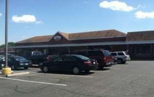
5 Meetings With Property Owners Federal Realty: Montrose Crossing and Federal Plaza 2. The Morgan Apartments 3. JCC Properties: Main Campus, 6101 Executive Boulevard, and 6101 Montrose Road 4. Wilgus and Willco properties 5. Kaiser Permanente: Mid-Atlantic Headquarters and lab and 6130 Executive Blvd Executive Blvd Executive Blvd Executive Blvd-Guardian Realty Nicholson Ct Nicholson Ct.-Barwood 12. Randolph Hills Shopping Center Parklawn Drive Parklawn Drive 15. Loehmann s Plaza Randolph Road 5
6 Property Owners with concept redevelopment plans Montrose Crossing 2. Wilgus and Willco Executive Blvd Executive Blvd 5. Loehmann s Plaza

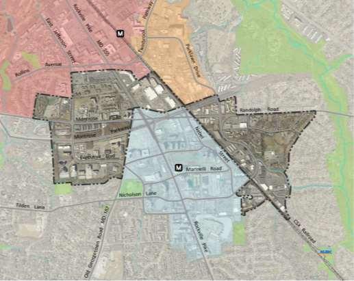
7 Randolph Civic Association and White Flint 2 June 20, 2016

8 RCA-Land (District 3)
9 On February 4, 2016 the RCA presented this vision, image and character for WF2: Vision, Image and Character Transition area from the high density in WF1 to quiet residential streets with multimodel access to nearby commercial businesses, and parks. WF2 presents an opportunity to help develop a more central sense of place within RCA-land.

10 Concept Plan Presented
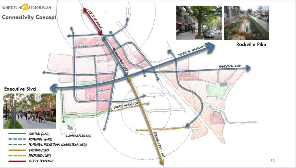
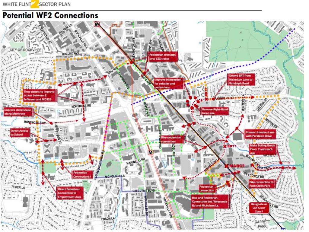
11 On February 4, 2016 the RCA presented this vision for transportation and connections for WF2: Transportation and Connections Walkable/bikeable connections to Pike District/White Flint Metro BRT stop servicing neighborhood to Pike District/WF Metro Road improvements at Parklawn and Randolph Road improvements at Boiling Brook and Rocking Horse
12
13

14 WF I RCA-Land
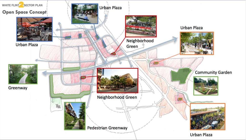
15 On February 4, 2016 the RCA presented this vision for parks and open space for WF2: Parks and Open Space/Public Facilities Pocket park at Putnam and Macon Park at MCPS Rocking Horse Center Polling place and activity building at Rocking Horse Center Town Center in Randolph Hills shopping Center.
16

17 Land Use/Density Commercial/residential zoning at Randolph Hills Shopping Center Montrose Church Townhomes Loehmann s Plaza redevelopment Montrose East Parkway

18 Thank You!
19 Liz King, on behalf of the Walter Johnson Cluster of PTAs
20 Cumulative Projected Impact of Developments Approved in Walter Johnson Cluster Elementary Middle High Total Present: WMAL/Rock Sp/Wh Fl 2 WMAL Expect Soon 195 SFHs, 135 TH units/dxs (MNCPPC) Rock Spring MP (scenario 3): Expect TH units, 2149 HR units White Flint 2 SP (scenario 3): Expect TH units, 4428 HR units SFH units (195).323,.132, TH/DX units (866).144,.064, MR/HR units (6577).048,.020, WMAL/Rock Sp/Wh Fl2 Subtotals Total with WMAL/Rock Sp/Wh Fl 2:
21 School Needs During Life of Plans Elementary Middle High Roundtable 30-Year Projections Rock Sp/Wh Fl 2 (scenario 3) Not included: Other 30-year development, turnover, students welcomed from other clusters Subtotal CIP Plan Capacity (guideline max) (guideline max) (until solution) Deficit Needed 2 schools 1 school HS solution Closed Schools Questionable* No Yes, but plans Other Schools WF South shrank WMAL considered mention for other clusters *sites are very small, at 3.08 and 3.53 acres. 2 sites are schools there s no net gain of land if they are moved. 1 site is both small, at 4.54 acres, and requires moving the HOC to separate space perhaps no net gain of resources if it is moved. The MCPS Chief Operating Officer estimates a cost of $28-35,000,000 to reopen a closed elementary school to meet Code requirements and MCPS standards. That would mean no savings over new construction. No feasibility studies have been done on any site.
22 Methodology: Dates in the first chart come from MNCPPC and Rockville planning records. Units are figures used by Bruce Crispell, MCPS Division of Long-Range Planning in developing the enrollment figures for the Capital Improvement Program (CIP), except as otherwise noted. Student generation rates are the rates provided by MCPS and MNCPPC. Rates used for are the student generation rates. I was unable to obtain the generation rates.


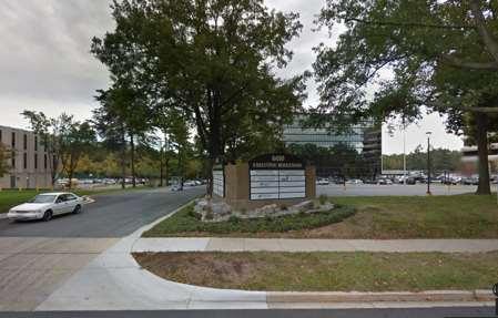
23 An Employment Center for the 21 st Century 6010 Executive Boulevard Placemaking, Connections, Energy and Environment

24 site area and location 6010 Executive Boulevard 6010 Executive Boulevard Site Area: 234,788 sf Building: 100,126 sf (0.43 FAR) Land Use: Office
25 existing conditions 6010 Executive Boulevard Existing Features: Streets Buildings White Flint Metro Station Streams M 6010


26 Existing Features: Existing Office Building (100,126 sf) Surface parking spaces Forest and stream area Adjacent office buildings Adjacent single family detached homes Buildings setbacks Executive Boulevard Adjacent parking structure existing conditions 6010 Executive Boulevard
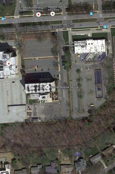
27 existing conditions 6010 Executive Boulevard


28 development activity 6010 Executive Boulevard Recent Leasing Activity: 1. Kaiser Permanente 2. Monument Realty Executive Blvd. (Peel property) 4. WBCMT Active Sites: Executive Blvd. 6. Wilco 7. Guardian Realty Under Construction: 7. Pike & Rose 1,500 feet to new to Metro Access Platform

29 Location 2101 East Jefferson 6116 Executive Boulevard 6120 Executive Boulevard 6006 Executive Boulevard Owner/Major Tenant Kaiser Permanente Site Area (square feet) Floor Area (square feet) 6010 Executive Boulevard FAR/Use 177, , FAR/ Medical Office WBCMT 210, , FAR/Office Monument Realty Peel Development 562, , FAR/ Office 225,769 48, FAR/ Office (NIH) Totals 965, ,350 recent lease activity 6010 Executive Boulevard 234,788 sf 100, FAR/ Office
30 6010 1,500 feet to new Metro Platform M connections 6010 Executive Boulevard Existing Features: Streets Buildings White Flint Metro Station Streams Proposed: New local streets Existing bus transit line, with potential new bikeway and enhanced sidewalks connecting to Pike & Rose and Metro Intersection improvement Trail system Transportation Demand Management Program
31 Building Design and Placemaking: Multi-tenant occupancy Higher ceilings More generous structural spans Ability for employees to customize space Mixing in non-traditional uses with office uses Integrating tech and office space Labs as an accepted part of the office workplace Fabrication on demand - graphic design, 3D printing Value of place Collaboration Part of a larger enhanced neighborhood workplace trends 6010 Executive Boulevard Connections: Walkable, dense and transit linked places Move people and goods efficiently Energy Efficiency: Focus on more sustainable larger areas and sites - green neighborhood planning and design Planning for energy efficiency - green buildings Environment: Interest in healthy, sustainable, and productive work settings Improved indoor air quality Design with nature and reducing environmental footprint Source: Gensler Design Forecast

32 Source: M-NCPPC concept framework 6010 Executive Boulevard

33 Source: Urban Land Institute ULl - concept 6010 Executive Boulevard


34 sustainable neighborhood planning and design 6010 Executive Boulevard Neighborhoods and Place Making Linkage/Pedestrian Orientation Compatibility and Energy Conservation Environmental Protection - Place for knowledge based workers - Mixed use - Public open space - Employment/retail - Housing variety - Buildings oriented to Executive Boulevard - Public Art - Bus transit link to Metro station - Bus shelters - Improved pedestrian access & streetscape - Bicycle network - Trail system - Underground parking - Reduced use of autos - Compatibility - Site orientation - Solar access - Solar panels - Recycle existing buildings - Green neighborhood design - Green Buildings - Forest conservation - On-site stormwater - Rain gardens - Tree panels - Increased tree canopy - Stream improvements - Grey water recycling - Coverage limit - Habitat Protection
 1 2 4 3 6 6")
 7 Forest enhancement 5 10")
35 opportunities 6010 Executive Boulevard 5 1 Existing Office 100,126 sf 2 New Office/Retail/ Other 252,126 sf 3 Housing 117,394 sf (100 Units) Placemaking: 4 Community Green/Open Space 5 Open Space/Play Area 6 Enhanced Executive Boulevard (wide sidewalk, bikeway, double row of street trees) 7 Forest enhancement Community green/open space

36 opportunities 6010 Executive Boulevard Connections: 1 Existing Office 100,126 sf 2 New Office/Retail/ Other 252,126 sf 3 Housing 117,394 sf (100 Units) 2 1 Connections: 4 Enhanced Executive Boulevard - wide sidewalk, bikeway, double row of street trees, new pedestrian oriented streetlights, benches 5 Bus transit along Executive Boulevard with bus shelters 6 Trail along stream to Executive Blvd. 7 Underground parking 893 spaces Trail along stream
37 opportunities 6010 Executive Boulevard Existing Office 100,126 sf 2 New Office/Retail 252,126 sf 3 New Housing/Retail 117,394 sf 2 1 (100 Units) Energy: Buildings oriented east and west for maximum daylighting of interiors Maximum solar access for public spaces Rain garden (park area and Exec. Blvd.) Solar panels for generating electricity Geothermal wells for heating and cooling LED Lighting Electric vehicle charging stations Environment: 50 percent tree canopy Reduced imperviousness Green roof new buildings Cool roof existing building

38 View along Executive Boulevard - Wide Sidewalks and Bikeway opportunities 6010 Executive Boulevard Placemaking: Street oriented buildings Canopy of trees Open space Connections: Bus transit along Executive Boulevard Wide sidewalk Bikeway Energy: East/west building orientation for maximum daylighting LED lighting Reduced auto dependence Environment: Tree save areas and increased tree canopy Stormwater and rain garden along sidewalk
39 Land Uses: uses Parking: recommendations 6010 Executive Boulevard Provide a mix of land uses: - 350,000 total square feet (100,126 existing) *retail, *research and development, **outdoor recreation facility, **artisan manufacturing and production, office, medical office, and light industrial and manufacturing - 120,000 square feet of *residential or 100 units Note: Existing use limitations - *limited and **not permitted in the EOF Zone 893 spaces (2 floors) needed with new development School Impact: 100 High-rise units (example): - Elementary (100 DUs X = 4.4 students) - Middle School (100 DUs X = 1.4 students) - High School (100 DUs X = 1.7 students) (Source: MCPS School Yield Calculations for the Walter Johnson Cluster) Opportunity for Transportation Improvements Opportunity for Sustainable Neighborhood Planning and Building Design - Placemaking, Connections, Energy and Environment
Public Meeting: July 11, 2016
 Public Meeting: July 11, 2016 MONTGOMERY COUNTY PLANNING DEPARTMENT Maryland-National Capital Park and Planning Commission Tonight s Agenda Preliminary Recommendations Background and Context 2009 Twinbrook
MONTGOMERY COUNTY PLANNING DEPARTMENT THE MARYLAND-NATIONAL CAPITAL PARK AND PLANNING COMMISSION
 MONTGOMERY COUNTY PLANNING DEPARTMENT THE MARYLAND-NATIONAL CAPITAL PARK AND PLANNING COMMISSION White Flint 2 Sector Plan: Briefing and Preliminary Staff Recommendations MCPB Item No. Date: 07/28/2016
Preliminary Recommendations
 Preliminary Recommendations Plan Area 2 Plan Context White Flint 2 2010 White Flint Sector Plan 2009 Twinbrook Sector Plan 3 Plan Context 4 Plan Context White Flint Residential Non-Residential Sector Plan
Rock Spring Master Plan Community Meeting #6: Land Use + Transportation Forecasts
 Rock Spring Master Plan Community Meeting #6: Land Use + Transportation Forecasts May 23, 2016 Ι Walter Johnson High School Andrea Gilles, andrea.gilles@montgomeryplanning.org Ι www.montgomeryplanning.org/community/rockspring/
S C O P E O F W O R K A P R I L
 white flint 2 sector plan S C O P E O F W O R K A P R I L 2 0 1 2 MONTGOMERY COUNTY PLANNING DEPARTMENT M-NCPPC MontgomeryPlanning.org 1 white flint 2 sector plan Scope of Work abstract This scope of work
white flint 2 sector plan
 white flint 2 sector plan Public Hearing Draft NOVEMBER 2016 MONTGOMERY COUNTY PLANNING DEPARTMENT M-NCPPC MontgomeryPlanning.org White Flint 2 Sector Plan Public Hearing Draft Abstract This Plan contains
Approved and Adopted JANUARY 2018
 Approved and Adopted JANUARY 2018 Abstract This Plan contains the text and supporting maps for a comprehensive amendment to the approved and adopted 1992 North Bethesda/Garrett Park Master Plan and the
Seneca Meadows. Block 4 Locate office, technology, and medical development adjacent to I Screen views of garage structures from I-270.
 Seneca Meadows Seneca Meadows has an industrial park in its southern end and a mixed-use employment area planned for the north end. The district benefits from extensive I-270 visibility, stream valley
Rock Spring Master Plan Community Meeting #8: Preliminary Recommendations
 Rock Spring Master Plan Community Meeting #8: Preliminary Recommendations July 18, 2016 Ι Walter Johnson High School Andrea Gilles, andrea.gilles@montgomeryplanning.org Ι www.montgomeryplanning.org/community/rockspring/
MONTGOMERY COUNTY PLANNING DEPARTMENT
 MONTGOMERY COUNTY PLANNING DEPARTMENT THE MARYLAND-NATIONAL CAPITAL PARK AND PLANNING COMMISSION MCPB Item No.: Date: 5-03-18 Pike and Rose, Phase I: Site Plan Amendment No. 82012002D Rhoda Hersson-Ringskog,
Presentation of the Staff Draft. July 17, 2014 SSRVP Team, Area 3
 Presentation of the Staff Draft July 17, 2014 SSRVP Team, Area 3 Presentation Overview Introduction Plan Framework Plan Recommendations Implementation Next Steps and Request for Public Hearing on September
Preliminary Recommendations Tk Takoma/Langley Crossroads Sector Plan
 Preliminary Recommendations Tk Takoma/Langley Crossroads Sector Plan Vision is to achieve a Transit Oriented, pedestrian friendly Community that Celebrates and builds upon the cultural Diversity of the
Establish a network of streetscaped vehicle and pedestrian routes that connect within and outside the Plan area.
 This Plan s urban design goals are to create an urban scale, walkable community with connections to transit, parks, and services and with amenities and facilities for residents and employees. The 1992
Silver Line CPAM UPDATE. Transportation and Land Use Committee October 14, 2016
 Silver Line CPAM UPDATE Transportation and Land Use Committee October 14, 2016 Purpose Recap Project History and Map Changes Provide Overview of CPAM Components Discuss Transportation Impacts Discuss Fiscal
THE 355/270 CORRIDOR:
 THE 355/270 CORRIDOR: Strategic Ideas for Sustaining a Livable Work Place Project Summary ACCESS LIFE DESIGN HEALTH WORK Montgomery County Planning Department The Maryland-National Capital Park and Planning
WHITE FLINT SECTOR PLAN PHASE I PRESENTATION Montgomery County Planning Board April 13, Luxmanor Citizens Association
 WHITE FLINT SECTOR PLAN PHASE I PRESENTATION Montgomery County Planning Board April 13, 2009 Luxmanor Citizens Association An Inclusive Master Plan The Vision of a Better Community Pedestrian oriented
White Flint Advisory Group Forum February 27, 2007 Summary M-NCPPC Auditorium 7:00-9:30 P.M.
 White Flint Advisory Group Forum February 27, 2007 Summary M-NCPPC Auditorium 7:00-9:30 P.M. Neighborhood 1 Bob Stoddard, Washington Real Estate Investment Trust Regarding: 12250 Nebel Street and 5520
Westbound: A One-day Exploration of Growth
 Westbound: A One-day Exploration of Growth Frog Pond Area 2018 UGB Expansion Proposal June 13, 2018 Growing Out: UGB Asks Four cities submitted proposals to expand greater Portland s urban footprint by
MONTGOMERY COUNTY PLANNING DEPARTMENT THE MARYLAND-NATIONAL CAPITAL PARK AND PLANNING COMMISSION
 MONTGOMERY COUNTY PLANNING DEPARTMENT THE MARYLAND-NATIONAL CAPITAL PARK AND PLANNING COMMISSION MCPB Item No. Date: 09.03.15 White Flint 2 Sector Plan, Scope of Work Nkosi Yearwood, Senior Planner, Area
Town Center. Block 5 Existing multifamily residential units are expected to remain.
 Area Guidelines Germantown s districts should be developed as distinct communities with unique features that are supported through the guidelines. The guidelines not only help distinguish these districts
MONTGOMERY COUNTY PLANNING DEPARTMENT THE MARYLAND-NATIONAL CAPITAL PARK AND PLANNING COMMISSION
 MONTGOMERY COUNTY PLANNING DEPARTMENT THE MARYLAND-NATIONAL CAPITAL PARK AND PLANNING COMMISSION Staff Report: Sketch Plan #320110010, Mid-Pike Plaza ITEM #: MCPB HEARING DATE: January 20, 2011 REPORT
MONTGOMERY COUNTY PLANNING DEPARTMENT THE MARYLAND-NATIONAL CAPITAL PARK AND PLANNING COMMISSION
 MONTGOMERY COUNTY PLANNING DEPARTMENT THE MARYLAND-NATIONAL CAPITAL PARK AND PLANNING COMMISSION MCPB Item No. Date10/25/12 Sketch Plan No. 32012004, White Flint Mall Redevelopment Nkosi Yearwood, Senior
ASPEN HILL Minor Master Plan Amendment
 ASPEN HILL Minor Master Plan Amendment Project Briefing Planning Board Agenda Item #7 Andrea Gilles, Area 2 June 5, 2014 Briefing Purpose 1. Follow-up evaluation on Mixed-Use land use in the Minor Amendment
Germantown Forward Status Report to the Planning Board M NCPPC
 Germantown Forward Status Report to the Planning Board Germantown Forward March 27, 2008 What s new? CCT alignment Capital Improvement Program Agency partners Water quality conditions Sustainability Design
MEMORANDUM BACKGROUND. lcouncilmembers should bring their copy of the Plan to the meeting.i. AGENDA ITEM #l0a November 28, 2017.
 AGENDA ITEM #l0a November 28, 2017 Worksession MEMORANDUM November 22, 2017 TO: FROM: SUBJECT: County Council ~ Marlene Michaelson, Senior Legislative Analyst Grosvenor-Strathmore Metro Area Minor Master
Shady Grove Sector Plan
 Montgomery Planning Area 2 Division 11/15/2018 Shady Grove Sector Plan Minor Master Plan Amendment Scope of Work Edit presentation title MM/DD/YYYY 1 Purpose for the Plan Amendment 1. Reevaluate/status
JUSTIFICATION STATEMENT FOR SKETCH PLAN NO Sketch Plan Justification for Wilgus
 JUSTIFICATION STATEMENT FOR SKETCH PLAN NO. 320190070 Sketch Plan Justification for Wilgus I. INTRODUCTION Owner and Applicant, Wilgus-Montrose Associates LLC ( Applicant ), by its attorneys, Linowes and
MONTGOMERY COUNTY METRO STATION AREA DESIGN CHARRETTE
 MONTGOMERY COUNTY METRO STATION AREA DESIGN CHARRETTE Shady Grove Metro Station Area Charrette Closing Presentation October 25-28, 2000 MONTGOMERY COUNTY, MD M-NCPPC Design Collective, Inc. Architects
Lower Merion Commercial Districts Issues and Characteristics Handbook November 2013
 Lower Merion Commercial Districts Issues and Characteristics Handbook November 2013 DRAFT TOWNSHIP-WIDE VISION: To maintain and enhance commercial areas to complement the surrounding high-quality residential
CONTENTS BACKGROUND AND CONTEXT... 3 Plan Area... 3 History... 3 Previous Planning Initiatives... 4 PLANNING FRAMEWORK... 5 Countywide Transit
 CONTENTS BACKGROUND AND CONTEXT... 3 Plan Area... 3 History... 3 Previous Planning Initiatives... 4 PLANNING FRAMEWORK... 5 Countywide Transit Corridors Functional Master Plan... 5 Veirs Mill Road Bus
Status Report: MD 355 Project
 Status Report: MD 355 Project OCTOBER 2006 M-NCPPC MONTGOMERY COUNTY PLANNING DEPARTMENT Summary of Community Comments, and break to the Results of the MD 355 Participation Session Brookside Gardens -
MONTGOMERY COUNTY PLANNING DEPARTMENT THE MARYLAND-NATIONAL CAPITAL PARK AND PLANNING COMMISSION
 MONTGOMERY COUNTY PLANNING DEPARTMENT THE MARYLAND-NATIONAL CAPITAL PARK AND PLANNING COMMISSION MCPB Item No. Date: 05/12/2016 North Bethesda Conference Center Parking Structure, Mandatory Referral No.
Bethesda Downtown Plan
 Bethesda Downtown Plan Planning Board Update Connecticut Avenue Location Economic Sustainability Social Environmental Scope Coming Soon! Team Listening, Twitter Outreach We Are Here Engagement Challenge
MONTGOMERY COUNTY PLANNING DEPARTMENT
 MONTGOMERY COUNTY PLANNING DEPARTMENT THE MARYLAND-NATIONAL CAPITAL PARK AND PLANNING COMMISSION Ashburton Elementary School Addition, Mandatory Referral, MR2018009 MCPB Item No. Date: 02-15-18 Troy Leftwich,
SECTION TWO: Urban Design Concepts
 SECTION TWO: Urban Design Concepts The Gardnerville Plan for Prosperity shapes economic opportunities presented by regional growth. The Urban Design Concepts provide policies and concepts for land use,
Sector Plan Briefing October 16, 2014
 Sector Plan Briefing October 16, 2014 M-NCPPC Greater Lyttonsville Team Robert Kronenberg, Chief Marc DeOcampo, Supervisor Erin Banks, Project Manager Melissa Williams, Outreach Matt Folden, Transportation
MONTGOMERY COUNTY PLANNING DEPARTMENT THE MARYLAND-NATIONAL CAPITAL PARK AND PLANNING COMMISSION
 MONTGOMERY COUNTY PLANNING DEPARTMENT THE MARYLAND-NATIONAL CAPITAL PARK AND PLANNING COMMISSION Rock Spring Master Plan: Briefing and Preliminary Staff Recommendations MCPB Item No. Date: 07/28/2016 Andrea
Planning Board Briefing
 Planning Board Briefing Why Now? The Sector Plan Implementation Chapter States: Before Stage 1 begins, the following must occur: Approval of the Sectional Map Amendment. Approval of the Greater Lyttonsville
University of the District of Columbia Van Ness Campus Master Plan Community Open House 3. December 8, 2010
 University of the District of Columbia Van Ness Campus Master Plan Open House 3 December 8, 2010 Introductions Sequence of Work: Campus Master Plan BEGIN: INTRODUCE AND START WORK Project Initiation Team
Prince George s County Economic Development Corporation David Iannucci President & CEO
 Prince George s County Economic Development Corporation David Iannucci President & CEO WBC REGIONAL ECONOMIC DEVELOPMENT FORUM THE FUTURE OF PRINCE GEORGE S COUNTY Wednesday, March 6, 2019 Why Prince George
Hill Center Greenwood. January 10, 2017
 Hill Center Greenwood January 10, 2017 Agenda I. Team Introduction II. Property and zoning overview III. Introduction of project IV. Moving forward H.G. Hill Realty Company 122 Year Old Company Local -
The Baileys Planning District portion of the Comprehensive Plan contains site design recommendations for both the Baileys Crossroads Community
 The Baileys Planning District portion of the Comprehensive Plan contains site design recommendations for both the Baileys Crossroads Community Business Center and the Seven Corners Community Business Center.
MONTGOMERY COUNTY PLANNING DEPARTMENT
 MONTGOMERY COUNTY PLANNING DEPARTMENT THE MARYLAND-NATIONAL CAPITAL PARK AND PLANNING COMMISSION 6000 Executive Boulevard, Sketch Plan No. 320180140 MCPB Item No. Date: 06/21/2018 Emily Tettelbaum, Senior
DOMINION BOULEVARD CORRIDOR STUDY AND ECONOMIC DEVELOPMENT STRATEGIC PLAN A MODEL FOR CHESAPEAKE S FUTURE
 DOMINION BOULEVARD CORRIDOR STUDY AND ECONOMIC DEVELOPMENT STRATEGIC PLAN A MODEL FOR CHESAPEAKE S FUTURE Overview I. Draft Plan Process II. Draft Plan Overview a. Market Analysis b. Master Land Use Plan
MONTGOMERY COUNTY PLANNING DEPARTMENT THE MARYLAND-NATIONAL CAPITAL PARK AND PLANNING COMMISSION
 MONTGOMERY COUNTY PLANNING DEPARTMENT THE MARYLAND-NATIONAL CAPITAL PARK AND PLANNING COMMISSION MCPB Item No. 8 Date: 12-15-16 Montgomery Village Center Sketch Plan No. 320170020 TL Troy Leftwich, Senior
City of Long Beach. creating vibrant and exciting places
 City of Long Beach creating vibrant and exciting places Land Use Element Urban Design Element Overview of the two draft General Plan elements Discuss areas of change Economic goals of the plans Case study
Ann Arbor Intermodal Station Environmental Review
 Ann Arbor Intermodal Station Environmental Review Park Advisory Commission September 19, 2017 AGENDA 1. Project Update 2. Draft Environmental Assessment 3. Draft Preferred Alternative 4. Next Steps 5.
2.7 ac park. TOTAL 5,403 DU 1,297,900 sf 1,105,450 sf 3.87 ac 5,563 DU 1,121,200 sf 1,105,450 sf 3.87 ac
 PLAN AMENDMENT 2013-I-B1: SEVEN CORNERS SPECIAL STUDY Summary of Pre-staffing Comments Planner: Bernard Suchicital bsuchi@fairfaxcounty.gov (703) 324-1254 Background On October 29, 2013, the Board of Supervisors
Review of Opportunity Area C Draft Comprehensive Plan and Draft BOS Follow-On Motions. Special Working Group Meeting March 4, 2015
 Review of Opportunity Area C Draft Comprehensive Plan and Draft BOS Follow-On Motions Special Working Group Meeting March 4, 2015 The slides that follow identify where the draft Comprehensive Plan has
DRAFT. 10% Common Open Space
 % OF CHARLOTTE IS CATEGORIZED AS A. LAND USES : Placeholder map displaying location of Place Type GOALS: Accommodate XX% of future growth. Provide a concentration of primarily commercial and civic activity
LEED-ND 101: Practical Strategies for Achieving Sustainability Goals. Travis Parker Lakewood Planning Director
 LEED-ND 101: Practical Strategies for Achieving Sustainability Goals Travis Parker Lakewood Planning Director Metro Vision Idea Exchange Oct 11, 2012 West Corridor Stations West Corridor Overview West
Gold Line Bus Rapid Transit Transit Oriented Development (BRTOD) Helmo Station Area Plan
 Helmo Station Area Plan") Appendix F Gold Line Bus Rapid Transit Transit Oriented Development (BRTOD) Helmo Station Area Plan Introduction and Purpose of the Plan The Gold Line Bus Rapid Transit facility is an eleven-mile dedicated
Appendix F Gold Line Bus Rapid Transit Transit Oriented Development (BRTOD) Helmo Station Area Plan Introduction and Purpose of the Plan The Gold Line Bus Rapid Transit facility is an eleven-mile dedicated
Part 2 Common Elements
 WHITE FLINT SECTOR PLAN Round Table Discussion: Part 2 Common Elements October 8, 2007 The M-NCPPC 1 Role Regional Marketplace North Bethesda s Downtown with a Conference Center District The M-NCPPC 2
Wadsworth Boulevard S TAT I O N A R E A P L A N
 Wadsworth Boulevard S TAT I O N A R E A P L A N City of Lakewood Adopted November, 2006 The Vision The City of Lakewood s overall vision is to transform the area around the light rail station into a mixed-use
JANUARY 19, 2011 CENTRAL AVENUE-METRO BLUE LINE TRANSIT-ORIENTED DEVELOPMENT IMPLEMENTATION PROJECT COMMUNITY FORUM
 CENTRAL AVENUE-METRO BLUE LINE TRANSIT-ORIENTED DEVELOPMENT IMPLEMENTATION PROJECT COMMUNITY FORUM JANUARY 19, 2011 THE MARYLAND-NATIONAL CAPITAL PARK AND PLANNING COMMISSION PRINCE GEORGE S COUNTY PLANNING
County Council Presentation. White Oak Science Gateway Planning Board Draft Master Plan June 17, 2014
 County Council Presentation White Oak Science Gateway Planning Board Draft Master Plan June 17, 2014 http://montgomeryplanning.org/community/wosg/index.shtm Nancy Sturgeon, Lead Planner www.nancy.sturgeon@montgomeryplanning.org
5 Land Use Element49
 5 Land Use Element 49 City of Forney - Comprehensive Plan Land Use Introduction Forney s Comprehensive Plan is a guide for physical and economic development in the City of Forney over the next 20-years.
Sheridan Boulevard S TAT I O N A R E A P L A N S H E R I D A N B O U L E VA R D S TAT I O N A R E A P L A N
 Sheridan Boulevard S TAT I O N A R E A P L A N 1 City of Lakewood Adopted November, 2006 S H E R I D A N B O U L E VA R D S TAT I O N A R E A P L A N The Vision The City of Lakewood s overall vision is
Clarksburg Master Plan Concept and the Clarksburg Town Center. Planning Regulating Building
 Master Plan Concept and the Town Center Planning Regulating Building Overview with CTC PHED T&E Dec 12, 2011 outline Location Master Plan Concept Staging Approved Preliminary Plans Infrastructure Town
SW Ecodistrict A VISION PLAN FOR A MORE SUSTAINABLE FUTURE June 25, 2013
 Urban Land Institute The Past, Present and Future of Sustainable Urbanism in Southwest DC SW Ecodistrict A VISION PLAN FOR A MORE SUSTAINABLE FUTURE June 25, 2013 Study Area The National Mall DOE FAA FAA
PINE CURVE REZONING. BACKGROUND Purchased as two parcels in 2001 and 2002
 BACKGROUND Purchased as two parcels in 2001 and 2002 WHAT THE PROJECT IS AND IS NOT A Rezoning establishes the land use standards for Annexed and Zoned Greater Downtown District Historic Center September
M-NCPPC Park System in
 Park Planning & Stewardship Division Park & Trail Planning Section East County Science Center Master Plan Parks, Recreation, Trails, and Open Space- Issues and Opportunities PARK PLANNING & STEWARDSHIP
Development Agreement Public Meeting. June 26, 2013
 Development Agreement Public Meeting June 26, 2013 Process 2007 2008 2009 2010 2011 2012 2013 Neighborhood Conservation District Petition Process Original Master Plan presented Community Forum Glen Lennox
Plano Tomorrow Vision and Policies
 Plano Tomorrow Vision and Policies PLANO TOMORROW PILLARS The Built Environment The Social Environment The Natural Environment The Economic Environment Land Use and Urban Design Transportation Housing
Urban Park Guidelines
 Park Planning & Stewardship Division Park & Trail Planning Section Urban Park Guidelines Objectives, Outreach Strategy Recommendations and Plan Schedule PARK PLANNING & STEWARDSHIP Brooke Farquhar, Rachel
Mini Technical Assistance Panel. Rock Spring Park
 Mini Technical Assistance Panel Rock Spring Park May 22, 2013 The Team Jason Bonnet, Forest City Washington Matthew Flis, Town of Vienna William Herbig, National Capital Planning Commission Sophie Lambert,
Community Design Guidelines. Port Wallace DRAFT
 Community Design Guidelines Port Wallace DRAFT Energy 1 2 3 Nature Movement Connections Built Form DRAFT Layout Energy 1 Nature Community Design Guidelines GREAT COMMUNITIES PROTECT, CELEBRATE, AND CONSERVE
PLAN ELEMENTS WORKSHOP. April 5, 2016
 PLAN ELEMENTS WORKSHOP April 5, 2016 needs more housing. But there is no one-size fits-all solution. Every neighborhood has its own character. In some places, density is not only appropriate it is badly
Neighborhood Districts
 NEIGHBORHOOD DISTRICTS SEVEN MAIN DISTRICTS Neighborhood Districts While the Development Plan provides a broad-scale overview of the neighborhood, this section focuses on uses and relationships at the
WELCOME and introduction
 1 WELCOME and introduction Mobility Hub Locations within Burlington STUDY OVERVIEW STUDY OBJECTIVES The City of Burlington is developing four Area Specific Plans, one for each of Burlington s Mobility
General Location Annex, Rezone & Preliminary Plat Lansdowne Addition, Unit Three
 NEWFOUNDLAND I-5 Agricultural District Subject Site SUNDANCE ANDERSON Single Family Residential CHRISTY PUD Agricultural District Highway Business General Location Annex, Rezone & Preliminary Plat Lansdowne
Rio/29 Small Area Plan. Design Plan & Implementation Framework Open House - January 25, 2018
 Rio/29 Small Area Plan Design Plan & Implementation Framework Open House - January 25, 2018 MEETING PURPOSE PRESENTATION 1. Orient to the updated design plans 2. Introduce implementing options 3. Explain
Montgomery Parks THEN AND NOW A TIMELINE OF PUBLIC PARK PLANNING
 Montgomery Parks THEN AND NOW A TIMELINE OF PUBLIC PARK PLANNING 1927 The Maryland-National Capital Park and Planning Commission is created The First M-NCPPC Meeting 1928 The General Development Plan for
Exhibit Planning and Design Workshop February 3-6, Commissioned by the Maryland-National Capital Park and Planning Commission (M-NCPPC)
") Exhibit Planning and Design Workshop February 3-6, 2014 Commissioned by the Maryland-National Capital Park and Planning Commission (M-NCPPC) Planning and Design Workshop The Montgomery County Planning
Exhibit Planning and Design Workshop February 3-6, 2014 Commissioned by the Maryland-National Capital Park and Planning Commission (M-NCPPC) Planning and Design Workshop The Montgomery County Planning
PINE CURVE REZONING. Property does not meet criteria for open space preservation and is not a candidate for a park
 PINE CURVE REZONING BACKGROUND Purchased as two parcels in 2001 and 2002 Annexed and Zoned Greater Downtown District Historic Center September 25, 2002 and October 7, 2002 WHAT THE PROJECT IS AND IS NOT
Grand Park Development (the "Applicant") requests approval of a Sketch Plan and Preliminary
 requests approval of a Sketch Plan and Preliminary") APPLICATION STATEMENT GRAND PARK DEVELOPMENT OLD GEORGETOWN ROAD, NORTH BETHESDA, MD Application for Sketch Plan No. 320190040 and Preliminary Plan No. 120190160 Grand Park Development (the "Applicant")
APPLICATION STATEMENT GRAND PARK DEVELOPMENT OLD GEORGETOWN ROAD, NORTH BETHESDA, MD Application for Sketch Plan No. 320190040 and Preliminary Plan No. 120190160 Grand Park Development (the "Applicant")
Obey Creek July 17, Vicinity Map. Concept Plan Submittal. No
 15/501 Fordham Blvd. 15/501 By-Pass To Downtown Chapel Hill Vicinity Map 0 1000 2000 FT Arlen Park DR. Bennett Road Mt. Carmel Church Rd. Southern Village Parkside Circle Market St. 15/501 Founder's Ridge
Developer s Program. The Station at East 54
 Developer s Program The Station at East 54 Existing Conditions The Station at East 54 is proposed for a 1.12 acre site at the northeast corner of Hamilton Road and Prestwick Road, tucked between the East
MONTGOMERY COUNTY PLANNING DEPARTMENT THE MARYLAND NATIONAL CAPITAL PARK AND PLANNING COMMISSION
 MONTGOMERY COUNTY PLANNING DEPARTMENT THE MARYLAND NATIONAL CAPITAL PARK AND PLANNING COMMISSION Bethesda Downtown Sector Plan, Work Session #1 MCPB Item No. Date: 7-20-15 Leslye Howerton, Planner Coordinator,
Sector Plan. Planning Board Draft. montgomery county planning department The Maryland-National Capital Park and Planning Commission
 Sector Plan Planning Board Draft montgomery county planning department The Maryland-National Capital Park and Planning Commission WHITE FLINT ABSTRACT This Plan contains the text and supporting maps for
Appendix 4 Park, Trail, and Recreation Facilities For more information, call the Park Planning and Stewardship Division at
 Appendix 4 Park, Trail, and Recreation Facilities For more information, call the Park Planning and Stewardship Division at 301-650-4380 montgomery county planning board maryland-national capital park and
RESIDENTIAL DISTRICTS
 RESIDENTIAL DISTRICTS The residential district standards have been revised to reflect on-the-ground conditions, while continuing to respect the use patterns established within the neighborhoods. This will
MONTGOMERY COUNTY PLANNING DEPARTMENT THE MARYLAND-NATIONAL CAPITAL PARK AND PLANNING COMMISSION
 MONTGOMERY COUNTY PLANNING DEPARTMENT THE MARYLAND-NATIONAL CAPITAL PARK AND PLANNING COMMISSION MCPB Item No. Date: 3.10.2016 Site Plan 820160040 Nora School Parker Smith, Planning Technician, Area 1,
Metro. Activity Center Design Guidelines. Recommendations For Developing Focused, Mixed-Use Commercial/Residential Centers
 Metro Activity Center Design Guidelines Recommendations For Developing Focused, Mixed-Use Commercial/Residential Centers Metro Activity Centers What is a MAC? Legacy, the adopted guide for the future growth
THE NEIGHBORHOOD TODAY
 THE NEIGHBORHOOD TODAY CORE AREA VISION How are we Good Urbanism A Site s DNA thinking about Elements of great Unique elements urban communities embedded in a place the site and design? ELEMENTS LIKE:
Clarksburg Square Road Extension
 Clarksburg Square Road Extension Preliminary Plan No. 120140060 Site Plan No. 820140050 Site Plan Amendment No. 82007022C (Clarksburg Town Center) Clarksburg SPA Water Quality Plan Mandatory Referral MR2015008
ULI PLACEMAKING OBJECTIVES
 ULI PLACEMAKING OBJECTIVES I) What is considered Great Placemaking and why? - Visual examples of New large scale projects with critical mass - Visual examples of Redevelopment smaller scale Main Street
Beaverton City Council: Work Session. SIDEDistrict. May 6, 2014
 BEAVERTON Beaverton City Council: CREEK Work Session SIDEDistrict May 6, 2014 Tonight s Agenda BEAVERTON CREEK SIDE Brief updates Creekside Vision Scenarios & discussion: Redevelopment & Parking Project
TOWN COUNCIL / PLANNING COMMISSION
 Workshop #3 TOWN COUNCIL / PLANNING COMMISSION January 20, 2011 Consultant Team In Attendance Tonight BMS Design Group Nevada City and San Francisco Michael Smiley, AICP, ASLA Partner-in-Charge Nancy L.
SAFETY AND CONNECTIVITY IN A PLANNED COMMUNITY
 DALE CITY TLC SAFETY AND CONNECTIVITY IN A PLANNED COMMUNITY PROJECT KICKOFF MEETING MARCH 7, 2016 AGENDA 1. Introductions 2. Project Overview 3. Discussion 4. Site Visit PROJECT KICKOFF MEETING MARCH
INDEPENDENCE BOULEVARD AREA PLAN
 INDEPENDENCE BOULEVARD AREA PLAN Public Meeting October 28, 2008 Tonight s Agenda Introduction 4:00 4:05 Tom Warshauer Presentation 4:05 5:00 Blake Drury Group Exercises 5:00 5:50 All Wrap Up & Next Steps
REVIEW AND EVALUATION OF REGIONAL LAND USE
 REVIEW AND EVALUATION OF REGIONAL LAND USE AND TRANSPORTATION SCENARIOS #220831 Environmental Justice Task Force October 7, 2014 VISION 2050 Process Development of Guiding Vision for Land Use and Transportation
Easton. Smart Growth Through Innovation. Easton
 Hazel Ave. Sunrise Blvd. Prairie City Rd. Smart Growth Through Innovation offers a unique opportunity to meet the region s future need for jobs and housing. It embodies smart growth principles advocated
Future Proposed Development
 Future Proposed Development on and around Link light rail s Capitol Hill Station Meeting September 24, 2012 Tonight s Agenda 6:00 pm Open House 6:30 pm Introductions Richard Conlin, City of Seattle Councilmember/Sound
The Floyds Fork Area Plan
 The Floyds Fork Area Plan Growth Framework and Design Principles Presented by: Wallace Roberts & Todd, LLC March 24, 2009 Ted Wathen / Quadrant Agenda Project overview and purpose Growth framework Design
URBAN DESIGN GUIDELINES For the Germantown Employment Area Sector Plan
 DRAFT February 2009 URBAN DESIGN GUIDELINES For the Germantown Employment Area Sector Plan Montgomery County Planning Department The Maryland-National Capital Park and Planning Commission Germantown 2
Sketch Plan. MNCPPC Plan No: A
 General Notes 1. The Sketch Plan drawings are conceptual only and represent proposed development in an illustrative manner. Final building locations, dimensions, heights, uses and development standards
FOUR MILE RUN VALLEY WORKING GROUP AND CHARGE
 FOUR MILE RUN VALLEY WORKING GROUP AND CHARGE Adopted April 16, 2016 Amended July 19, 2016 Overview of Integrated Effort The overall goal of the Four Mile Run Valley (4MRV) initiative is to develop a comprehensive
The Five Components of the McLoughlin Area Plan
 The Five Components of the McLoughlin Area Plan This documents contains the complete language of the five components of the McLoughlin Area Plan: The Vision Statement The Values The Guiding Principles
Subject: 30 Otis Street, Evaluation of Shadow on Proposed 11th and Natoma Park
 Date: September 5, 2018 To: Recreation and Park Commission Capital Committee Through: Philip A. Ginsburg, General Manager Toks Ajike, Director, Capital & Planning Division From: Brian Stokle, Planner,