INTRODUCTION. Figure 1: Master Plan Area Boundary
|
|
|
- Hannah Jefferson
- 5 years ago
- Views:
Transcription
1
2 CONTENTS Introduction Planning Framework Background and Context Development Activity Purpose of the Plan Issues to be Addressed Land Uses and Urban Design Transportation and Connectivity Community Facilities Environmental Sustainability Community Outreach Plan Schedule Figures Figure 1: Master Plan Area Boundary Figure 2: 1992 North Bethesda/Garrett Park Sector Plan; 2009 Twinbrook Sector Plan; 2010 White Flint Sector Plan; White Flint 2 Sector Plan; Rock Spring Master Plan Figure 3: Existing Zoning Figure 4: Aerial View of Rock Spring Master Plan 2

3 INTRODUCTION The Rock Spring Master Plan area is located in North Bethesda in the vicinity of the Interstate-270 spur. This Scope of Work for the Rock Spring Master Plan describes the proposed boundaries and purpose, provides context and background, summarizes recent development activity and the issues to be addressed, and outlines the community engagement strategy and schedule. The proposed boundaries for the Master Plan are the I-270 spur to the north, Old Georgetown Road to the east, Democracy Boulevard to the south, and Westlake Drive to the west. (See Figure 1.) Rock Spring has direct access to the I-270 spur via Rockledge Boulevard to Rockledge Drive. The area also has access from Democracy Boulevard and Old Georgetown Road. Roads through the Master Plan area include Rock Spring Drive, Fernwood Road, and Westlake Terrace. The 535-acre area is developed mostly as a suburban office park with single-use buildings that are widely dispersed, centered within their sites, with large setbacks, ample surface and garage parking, and substantial landscaping. The headquarters for Marriott International and Lockheed Martin have been located in Rock Spring for more than 25 years. Westfield Montgomery Mall, a large regional shopping mall, is located on the west side of the Plan area. Two smaller retail centers, Georgetown Square and Wildwood Shopping Center, are located on the east side of the Plan area along Old Georgetown Road. The area includes some multi-family residential units as well as a public high school. Figure 1: Master Plan Area Boundary 3

4 PLANNING FRAMEWORK The majority of the proposed Rock Spring Master Plan area was included in the 1992 North Bethesda/Garrett Park Sector Plan. The 1992 Sector Plan covered a large geography and focused on the areas around the Twinbrook, White Flint and Grosvenor-Strathmore Metrorail stations, as well as the office park at Rock Spring. Communities that were previously part of the 1992 Sector Plan are now the subject of separate, smaller area plans, including the 2009 Twinbrook Sector Plan, the 2010 White Flint Sector Plan, and the plans currently underway for Rock Spring and White Flint 2 (see Figure 2). The portion of the Rock Spring Master Plan area that includes Westfield Montgomery Mall was part of the 2002 Potomac Subregion Master Plan. The 1992 Sector Plan describes Rock Spring Park as one of the East Coast s premier office parks with a campus-style setting, green lawns, and lush landscaping that attracts tenants who wish to enhance their corporate image. At the same time, the Sector Plan notes that the office park consists of somewhat homogeneous, unrelated sets of buildings centered on sites with no particular relationship with each other and no unifying urban design features other Figure 2: 1992 North Bethesda/Garrett Park Sector Plan; 2009 Twinbrook Sector Plan; 2010 White Flint Sector Plan; White Flint 2 Sector Plan; Rock Spring Master Plan 4
5 than generous landscaping. Describing Rock Spring, the Sector Plan states: It provides a gateway to the I-270 technology corridor and proximity to Baltimore, Washington and suburban Virginia. It also has easy access to three high volume airports. The Park s visibility, unique access to major transportation networks, and proximity to other commercial/industrial centers, to the nation s capital and to stable residential neighborhoods make it the most convenient corporate office location in the County. Business demand for the type of space offered at Rock Spring Park is typically very high. Vacancies in the park average 8 to 12 percent, which is 30 to 50 percent less than elsewhere in the County. The asking price for space at Rock Spring Park is near the top of Montgomery County s office rents, surpassed only by Bethesda-Chevy Chase business districts. (Page 94) The 1992 Plan retained the office park s zoning, which was largely office-oriented. On the undeveloped Davis-Camalier site, in the northeast quadrant of the area, the 1992 Plan retained the high-rise housing zone, but recommended a mixed-use floating zone. The Plan includes extensive development guidelines for the 54-acre Davis property, which is envisioned as the urban village center for this area of North Bethesda, creating a more pedestrian friendly, transit serviceable environment with the housing and retail on the Davis parcel linked to the offices in the remainder of the Park. (Page 102) In 2011, the Planning Board approved a site plan application for the Davis parcel (see Development Activity section below). The 1992 Sector Plan recommended the North Bethesda Transitway to link the Metrorail Red Line with Montgomery Mall via Old Georgetown Road and Rock Spring Drive. The 1992 Plan defined Transitway as a path for transit, separated from other vehicles. It could be theoretically for heavy rail (unlikely here), light rail, buses, or even other technologies. An interim use might be for buses and ridesharing. (Page 185) The Transitway was originally conceived as a link between the Grosvenor Metrorail Station to the east, through Rock Spring, to a planned transit center at Montgomery Mall. It is included in the approved 2013 Countywide Transit Corridors Functional Master Plan (CTCFMP), which provides alternative routes to either the Grosvenor or White Flint Metrorail stations. Much of the right-of-way along Rock Spring Drive, Fernwood Road, and Tuckerman Lane is currently available through easements and dedications that have been provided through the development process. The CTCFMP lists four possible stations within Rock Spring for the Transitway: the Montgomery Mall Transit Center, Rock Spring Drive and Fernwood Road, Rockledge Drive and Rock Spring Drive, and Rock Spring Drive and Old Georgetown Road. Several objectives from the 1992 North Bethesda/Garrett Park Sector Plan continue to be relevant today, including: Add residential and retail uses. Preserve publicly accessible open space. Provide pedestrian and bicycle paths linking the open space with other areas in the office park, with public facilities and with adjacent residential neighborhoods. Integrate transitway stations and right-of-way into future development (page 94 of the Plan). 5

6 The 1993 General Plan Refinement included the Rock Spring area within the Urban Ring, the relatively intensively developed area of the County nearest Washington, D.C. The Rock Spring Plan will amend, and be guided by relevant goals from the General Plan Refinement, including: Accommodating selective additional development and redevelopment. Emphasizing development, including housing, in appropriate transit station areas. Expanding transportation options, while accommodating pedestrian needs. Enhancing park and recreation linkages (page 25 of the General Plan). BACKGROUND AND CONTEXT The central portion of the Rock Spring Master Plan is a conventional suburban, auto-oriented office park, which is bounded by I-270 on the west, the I-270 spur on the north, Rockledge Drive on the east, and Democracy Boulevard on the south. The majority of office buildings in Rock Spring were built in the 1980s and 1990s. The office park has a large percentage of Class A space (87 percent, compared to 50 percent Countywide) and much of it has been consistently renovated and upgraded. Office buildings in Rock Spring are substantially larger than other areas; on average, they are twice the size of office buildings elsewhere in the County. The Rock Spring office park contains 30 buildings with 5.3 million square feet of space. Major tenants include Marriott International, Lockheed Martin Corporation, IBM, Host Hotels and Resorts, and the National Institutes of Health. Several buildings contain mostly medical offices, such as the Camalier, Champlain, and Suburban Outpatient Medical Center. Other tenants in Office Buildings on Rockledge Drive overlooking a landscaped pond 6

7 the area s office buildings include insurance, real estate, and financial companies. Rock Spring Park is part of the North Bethesda/Potomac office submarket. It accounts for 48 percent of the office inventory in North Bethesda and 7 percent of office space Countywide. The current office vacancy rate in Rock Spring is 23.7 percent, much higher than the Countywide vacancy rate of 15 percent. Rock Spring s office vacancy rate has remained above 19 percent since Marriott International, which occupies about 800,000 square feet at their headquarters in Rock Spring, intends to relocate to a more urban location with good access to transit; the planned relocation would boost the office park s vacancy rate to 39 percent, if there are no other changes. The National Institute of Allergy and Infectious Diseases (NIAID) vacated approximately 160,000 square feet of leased office space in Rock Spring for a new headquarters in Twinbrook. IBM has reduced its Rock Spring footprint from 168,000 square feet to 59,000 square feet. The National Institutes of Health (NIH) currently leases over 700,000 square feet in several locations in Rock Spring. Lockheed Martin has 275,000 square feet of space in a secured and gated site on Rockledge Drive. Marriott International Headquarters on Fernwood Road Retail uses are located west and east of the office park. Westfield Montgomery Mall, a large regional shopping mall, is located west of I-270, north of Democracy Boulevard, east of Westlake Drive, and south of Westlake Terrace. A small shopping center is located adjacent to the regional mall on the southeast corner of Westlake Drive and Westlake Terrace. Across from Montgomery Mall, on the north side of Westlake Terrace, there is a Home Depot, as well as automobile sales and service uses, including Jim Coleman Toyota, Jim Coleman Infinity, Jim Coleman Cadillac, and Ourisman Ford Bethesda. This retail area is linked to Rock Spring s office park by Westlake Terrace, which bridges I

8 On the east side, the Master Plan area includes the Wildwood Shopping Center and Georgetown Square. Georgetown Square is located on the northwest corner of Old Georgetown Road and Democracy Boulevard and includes Giant, a DSW shoe store, a restaurant, and ancillary retailers. Wildwood Shopping Center is located east of Old Georgetown Road, north of Cheshire Drive, and west of Berkshire Drive. It includes a specialty grocer, Balducci s, a CVS, and a variety of small retailers in a strip-style center. Adjacent to the Wildwood Shopping Center to the north are a gas station, a bank, and a medical office building. The first residential units within the Rock Spring area were completed in The Berkshires at Rock Spring is a 386-unit multi-family development located adjacent to the I-270 spur between Rockledge Drive and Old Georgetown Road. Walter Johnson High School is also located in the Rock Spring Master Plan area, with primary access from Rock Spring Drive. The high school, which opened in 1956, is on nearly 31 acres and the building was revitalized in According to Montgomery County Public Schools (MCPS), current enrollment at Walter Johnson High School is 2,295 and the school s capacity is 2,335. MCPS is currently conducting a feasibility study to analyze the potential for adding classrooms to the high school. Walter Johnson High School With its location adjacent to I-270 and near I-495, Rock Spring is well served by roads, but not currently by transit; the closest Metrorail station is Grosvenor, 2 miles away. Two major infrastructure projects greatly improved vehicular access to and around Rock Spring: the interchange at the I-270 spur and Rockledge Boulevard and the Westlake Terrace bridge over I Multiple existing bus routes and shuttles run throughout the area. As mentioned above, the 2013 Countywide Transit Corridors Functional Master Plan included the North Bethesda 8

9 Transitway and four proposed stations within the Rock Spring Master Plan area. A critical issue for the Rock Spring Plan will be identifying additional mobility options to improve circulation in and around this area. DEVELOPMENT ACTIVITY Several properties in the proposed Rock Spring Master Plan area have been developed or have been approved for development since the 1992 North Bethesda/Garrett Park Master Plan. The Berkshires of Rock Spring, a 386-unit multi-family residential building (formally known as Avalon Bay) was completed in 2004 on the northern portion of the Davis-Camalier property along the I-270 spur. The Berkshires is part of a larger project for the entire Davis tract that was originally approved by the Planning Board in The proposed, multi-phase project for the Davis parcel, the only vacant site in the Plan area, has been amended several times and the approved development includes nearly 1 million square feet of offices, retail, a hotel, as well as high-rise and mid-rise residential buildings. In the heart of the Rock Spring office park, residential builder EYA is currently constructing a 168-unit townhouse development on the northwest corner of Fernwood Road and Rock Spring Drive, across from the Marriott s headquarters. A 340-unit multi-family high-rise residential building has been approved on a parcel on the north side of Westlake Terrace across from Westfield Montgomery Mall at the site currently occupied by Ourisman Ford. Westfield Montgomery Mall has undergone significant renovations, including a new food court, movie theatres, and the Cheesecake Factory (relocated from White Flint Mall). A new transit center at Montgomery Mall is funded and construction is underway. The transit center will be relocated from the mall s entrance on Westlake Terrace to a site just to the east before the bridge over I-270. This project is scheduled to be completed in approximately two years. Additional redevelopment may be contemplated by the mall s owners in the future. A Montgomery Mall Citizens Advisory Panel has been formed to keep the surrounding community informed about activities and issues at the regional shopping center. New movie theatre and mall entrance at Westfield Montgomery Mall 9
10 PURPOSE OF THE PLAN Across the County, region, and many areas of the country, the office market has been experiencing a significant downturn. Montgomery County s challenges are exemplified by a 15 percent office vacancy rate, which represents nearly 11 million square feet of vacant space. An Office Market Assessment Report, prepared for the Planning Department by Partners for Economic Solutions (PES) and released in June 2015, states (on page 1): The Washington, DC metro region is currently experiencing unprecedented challenges in its office market Montgomery County is suffering along with the rest of the region, performing better than other jurisdictions on some indicators and worse on others. The region and county have experienced recession-driven office market downturns for decades. What is different this time is a major realignment as tenants reduce their office space even as they expand their workforce. That trend will impact local and regional office markets for many years into the future. The trends impacting the County s office market include: Lasting impacts from the recession and slow recovery in those sectors of the economy that use office space. Federal budget cuts, sequestration, and overall uncertainty have reduced government contractors employment and ability to commit to long-term leases. The Federal government s freeze the footprint initiative, which mandates reducing the square footage of employee workstations as well as reducing the amount of space the government leases from the private sector. Competition in the region, particularly with the District of Columbia and Tysons in Fairfax County, which is served by the Silver Line, a new extension of the Metrorail system. Changes in preferences as prospective tenants seek transit-served locations near retail, restaurants, entertainment, and housing in buildings that offer open layouts, high ceilings, and natural light. Changes in office technology have reduced needs for filing and storage space. Once considered a premier office location, Rock Spring has been particularly hard hit by these current trends. Single-use business parks without access to transit, like Rock Spring, are struggling with the highest office vacancies. In the context of changing preferences among employers and their workforce for transit-served locations with a dynamic mix of uses, this planning effort will explore ways to reimagine Rock Spring. With the current construction of townhouses on a site previously planned for another office building, the market is already responding by introducing residential use into a heretofore single-use office park. Staff will assess the feasibility of adaptive reuse of vacant office buildings into residential uses and/or community uses, such as schools. As noted on page 66 of the PES report: Property owners and developers are beginning to rethink and redesign conventional office parks to accommodate a mix of uses. The Master Plan will examine opportunities for additional streets to improve the network; public use spaces and amenities; residential and non-residential uses; sustainable 10
11 environmental measures; infrastructure needs for the area; linkages to the proposed transitway; and opportunities to improve connectivity to the surrounding communities. Baseline land use and traffic conditions will be evaluated to understand existing opportunities and constraints. Redevelopment and infill opportunities for residential and nonresidential development will be explored and consideration will be given to allowing mixed-use development in areas where mixed-use development is currently limited by the existing zoning. The Rock Spring planning process will allow for a more detailed and nuanced assessment of the zoning conversions made effective through the Countywide comprehensive rezoning on October 30, 2014 (see Figure 3). Staff will evaluate different levels and types of development and prepare scenarios to be tested by traffic modeling. Staff will also work with Montgomery County Public Schools to estimate the potential number of new students that may result from any proposed increase in residential uses in the Master Plan area and identify potential ways to address school capacity issues. Urban design guidelines will be prepared and opportunities to improve mobility will be identified, as will the provision of public spaces and community facilities, including schools. ISSUES TO BE ADDRESSED Land Uses and Urban Design Many of the uses in the Plan area are low- to medium- density single-use developments. The Plan will evaluate the appropriateness of the single-use properties and explore land use patterns that promote mixed-use development at suitable locations. Two of the more predominant single-use land use types in Rock Spring are office and retail. The Plan will explore the role of an office park in a changing office market, as well as how the existing land use pattern could be modified and transformed. On a more micro-level, urban design guidelines will be prepared to address physical planning issues such as building heights, scale, the relationships between new and existing development, as well as ways to improve community identity. Transportation and Connectivity The Rock Spring Master Plan will address the need for transportation infrastructure to improve mobility within the Plan area and connectivity beyond it. The North Bethesda Transitway, the proposed BRT route through the Plan area, will connect the area to the Metrorail Red Line stations at Grosvenor and White Flint. Other ideas will be explored to enhance the multi-modal transportation options. 11

12 Figure 3: Existing Zoning Community Facilities Land use recommendations in the Rock Spring Master Plan must consider school capacity in the Walter Johnson School Cluster in North Bethesda. The Subdivision Staging Policy indicates that the Walter Johnson Cluster is close to a moratorium for all school levels. Additional residential development will impact the Walter Johnson cluster, as well as the adjacent Downcounty Consortium secondary schools. New or re-opened school facilities may be necessary. The need for additional park and open spaces will also be analyzed as a component of this Plan. The Rock Spring Master Plan will assess the impact of proposed development in the Rock Spring area and determine whether additional facilities are needed. 12

13 Figure 4: Aerial View of Rock Spring Master Plan Environmental Sustainability Much of the development in this area occurred at a time before stormwater management regulations were in place. Redevelopment provides an opportunity to improve environmental conditions and create a healthier community. The Plan will promote environmental sustainability, including environmental site design techniques and increased tree canopy coverage. The addition of new parks and open spaces will be considered. Opportunities to improve air quality by reducing reliance on single-occupant vehicles will also be explored. COMMUNITY OUTREACH A community kick-off meeting was held on September 1, 2015 at Walter Johnson High School to launch the planning and public engagement process. Approximately 150 people were in attendance, representing residents, developers, business owners, neighborhood associations and community groups. Attendees engaged in a robust dialogue with staff and identified their priority issues, including overcrowded schools; connectivity, safety and access throughout the area; the need for added amenities such as public parks and open space; and infrastructure needs. 13


14 September 1, 2015 Master Plan Kick-off Meeting at Walter Johnson High School Citizens participating at Rock Spring Master Plan Kick-off Meeting The dominant concern expressed by a majority of the attendees at the kick-off meeting was about school capacity at all school levels within the Walter Johnson cluster. As a result of this concern (which was also expressed at the June 25, 2015 kick-off meeting for the White Flint 2 Sector Plan), staff held a meeting on September 17 that focused exclusively on school issues. Over 100 people attend the September 17 meeting, where the Montgomery County Public Schools long range planner made a presentation regarding the methodology for forecasts as well as the approved plans to address capacity issues in the cluster. The Planning Department presented general information about the Rock Spring Master Plan and White Flint 2 Sector Plan. Planning staff also presented information on the annual school test and impact fees that are assessed as part of the adequate public facilities analysis, as required by the Subdivision Staging Policy. In addition to these meetings, staff met with the cluster coordinators for the Ashburton and Luxmanor elementary school PTAs. 14
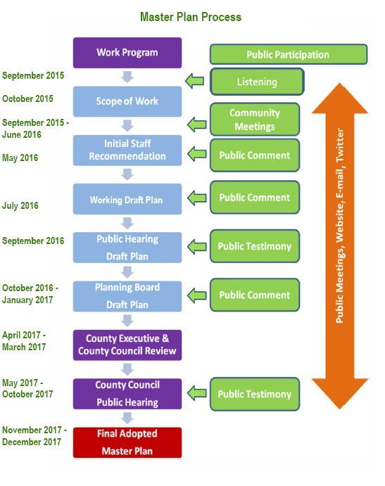
15 Over the summer, staff attended the Rock Spring office park s farmers market and food truck events and spoke with employees. In the fall and winter, staff will hold a series of community workshops to solicit ideas from and engage residents, surrounding neighborhood associations, business owners, and community organizations. Additional public meetings will address specific topics such as transportation, land use, zoning, and public facilities, including schools. Staff will meet with individual property owners, business owners, civic representatives, public agencies and other interested parties throughout the process. A Communications Plan has been prepared for the project that outlines resources and tools for effectively communicating with the community about the issues of this Plan. Social media, electronic newsletters, and other communication tools will be utilized. All public meetings, events and staff reports will be posted on the project website. A variety of opportunities for interactive engagement, in addition to public and small group meetings and workshops, are discussed below. Consistent, easy-to-understand messaging: Planning concepts related to transportation, zoning and infill opportunities will be explained simply and clearly across all media platforms. Overview PowerPoint: The Plan s main PowerPoint will be used to summarize the history and challenges of the area. The PowerPoint will provide background to help planners communicate issues to interested stakeholders, including the context, planning history and current topics to be addressed by the Plan. Along with other relevant materials, the Plan s PowerPoint will be available online and will be updated throughout the process. This tool will be designed to help stakeholders learn about existing conditions -- past as well as the present -- as they engage with planners about the future of the area. A voice-over of planners narrating the PowerPoint (as in a live presentation) will accompany it on the webpage for the Plan. And, if possible, the staff team will enable viewers of the on-line PowerPoint to pose comments and questions about its content. Websites: Efforts will be made to have well-coordinated messaging on the Plan from the Planning Department project team. A project webpage has been established at montgomeryplanning.org/community/rockspring. E-newsletter and social media: Updates and clear messaging will be conveyed through regular postings on Facebook and Twitter (@ReimagineRockSpring) about various aspects of the Plan. Videos: Staff interviews and segments devoted to specific topics (transportation, zoning, public facilities, etc.) could be posted on the Planning Department website. PLAN SCHEDULE The Rock Spring Master Plan was initiated on July 1, The Planning Board is scheduled to review the Working Draft Plan during summer 2016 and transmit the Planning Board Draft Plan to the County Executive and County Council by February The County Council review of the Plan is scheduled to begin in April Upon completion of the Council s review and 15
16 action, a Sectional Map Amendment (SMA) will be initiated to implement the Plan s zoning recommendations. It is anticipated that the SMA will be approved by February Project Scope of Work Background research July 2015 October 2015 Complete an inventory of existing conditions, including assembling data on land uses, zoning, demographics, transportation, environment, community facilities and parks and recreation facilities. September 1, 2015 Community Kick-off Meeting October 8, 2015 Approval of Scope of Work by the Planning Board Delineate the Plan area and issues to be addressed, including community outreach and timeline. Analysis and Community Meetings October 2015 April 2016 The community kick-off meeting will be followed by a series of workshops in fall Staff will prepare development scenarios; analyze transportation, school, and environmental impacts; conduct urban design studies and infrastructure needs assessment; develop concepts for the environment, parks and open spaces, and community facilities; identify potential zoning designations; and discuss alternatives with stakeholders. Draft Recommendations May June 2016 Develop preliminary recommendations for discussion with the Planning Board, including identifying infrastructure needs of the proposed development scenario, and land use and zoning options, and urban design recommendations that will implement the Plan recommendations. Working Draft Plan Summer 2016 Present a Working Draft Master Plan for Planning Board review and approval of a Public Hearing Draft. Set a public hearing date and publish the Public Hearing Draft of the Master Plan. Planning Board Review Public Hearing Draft Fall 2016 Conduct the Planning Board s tour of the area and the public hearing to receive public testimony. Planning Board Worksessions and Planning Board Draft October January
17 Planning Board worksessions will be held to review testimony and discuss issues presented in the public hearing. The Planning Board Draft will be prepared for transmittal to the County Council and the County Executive. County Executive Review February - March 2017 The County Executive will review the Plan s recommendations, prepare a fiscal analysis and transmit comments to the County Council. County Council Review April October 2017 County Council public hearing and PHED Committee Worksessions. The County Council will tour the Plan area and conduct a public hearing on the Planning Board Draft Plan. Worksessions will then be held by the Council s Planning, Housing, and Economic Development (PHED) Committee. The PHED Committee will make recommendations to the full Council on the Planning Board Draft. County Council Worksessions County Council worksessions will review the PHED Committee s recommendations and approve the Rock Spring Master Plan with a Council Resolution. Commission Adoption and Sectional Map Amendment November 2017 February 2018 The full Commission of the Maryland-National Capital Park and Planning Commission will adopt the approved Master Plan. The Planning Department will prepare and file the Sectional Map Amendment (SMA) to implement the Plan s zoning recommendations. 17
18 18
19 STAY CONNECTED Staff Contacts Don Zeigler Telephone: Mike Bello Telephone: Nancy Sturgeon Telephone: Project Webpage 19
S C O P E O F W O R K A P R I L
 white flint 2 sector plan S C O P E O F W O R K A P R I L 2 0 1 2 MONTGOMERY COUNTY PLANNING DEPARTMENT M-NCPPC MontgomeryPlanning.org 1 white flint 2 sector plan Scope of Work abstract This scope of work
MONTGOMERY COUNTY PLANNING DEPARTMENT THE MARYLAND-NATIONAL CAPITAL PARK AND PLANNING COMMISSION
 MONTGOMERY COUNTY PLANNING DEPARTMENT THE MARYLAND-NATIONAL CAPITAL PARK AND PLANNING COMMISSION MCPB Item No. Date: 09.03.15 White Flint 2 Sector Plan, Scope of Work Nkosi Yearwood, Senior Planner, Area
MONTGOMERY COUNTY PLANNING DEPARTMENT THE MARYLAND-NATIONAL CAPITAL PARK AND PLANNING COMMISSION
 MONTGOMERY COUNTY PLANNING DEPARTMENT THE MARYLAND-NATIONAL CAPITAL PARK AND PLANNING COMMISSION Rock Spring Master Plan: Briefing and Preliminary Staff Recommendations MCPB Item No. Date: 07/28/2016 Andrea
MONTGOMERY COUNTY PLANNING DEPARTMENT
 MONTGOMERY COUNTY PLANNING DEPARTMENT THE MARYLAND-NATIONAL CAPITAL PARK AND PLANNING COMMISSION Rock Spring Master Plan Public Hearing Draft: Worksession #7 MCPB Item No. Date: 3-30-17 Nancy Sturgeon,
CONTENTS BACKGROUND AND CONTEXT... 3 Plan Area... 3 History... 3 Previous Planning Initiatives... 4 PLANNING FRAMEWORK... 5 Countywide Transit
 CONTENTS BACKGROUND AND CONTEXT... 3 Plan Area... 3 History... 3 Previous Planning Initiatives... 4 PLANNING FRAMEWORK... 5 Countywide Transit Corridors Functional Master Plan... 5 Veirs Mill Road Bus
Rock Spring Master Plan Community Meeting #8: Preliminary Recommendations
 Rock Spring Master Plan Community Meeting #8: Preliminary Recommendations July 18, 2016 Ι Walter Johnson High School Andrea Gilles, andrea.gilles@montgomeryplanning.org Ι www.montgomeryplanning.org/community/rockspring/
master plan of highways bus rapid transit amendment
 Scope of Work master plan of highways bus rapid transit amendment September 2011 Montgomery County Planning Department M-NCPPC MontgomeryPlanning.org 1 Scope of Work master plan of highways bus rapid transit
Rock Spring Master Plan Community Meeting #6: Land Use + Transportation Forecasts
 Rock Spring Master Plan Community Meeting #6: Land Use + Transportation Forecasts May 23, 2016 Ι Walter Johnson High School Andrea Gilles, andrea.gilles@montgomeryplanning.org Ι www.montgomeryplanning.org/community/rockspring/
Silver Line CPAM UPDATE. Transportation and Land Use Committee October 14, 2016
 Silver Line CPAM UPDATE Transportation and Land Use Committee October 14, 2016 Purpose Recap Project History and Map Changes Provide Overview of CPAM Components Discuss Transportation Impacts Discuss Fiscal
Mini Technical Assistance Panel. Rock Spring Park
 Mini Technical Assistance Panel Rock Spring Park May 22, 2013 The Team Jason Bonnet, Forest City Washington Matthew Flis, Town of Vienna William Herbig, National Capital Planning Commission Sophie Lambert,
The subject site plan amendment proposes the following revisions to the approved site plan:
 PROPOSED AMENDMENT The subject site plan amendment proposes the following revisions to the approved site plan: 1. The building footprint was modified to accommodate the revised architectural design. 2.
THE 355/270 CORRIDOR:
 THE 355/270 CORRIDOR: Strategic Ideas for Sustaining a Livable Work Place Project Summary ACCESS LIFE DESIGN HEALTH WORK Montgomery County Planning Department The Maryland-National Capital Park and Planning
Executive Summary. NY 7 / NY 2 Corridor
 Executive Summary NY 7 / NY 2 Corridor Transportation and Land Use Study December 2005 Prepared for: Town of Colonie Capital District Transportation Committee Prepared by: Introduction: Land use decisions
Gold Line Bus Rapid Transit Transit Oriented Development (BRTOD) Helmo Station Area Plan
 Helmo Station Area Plan") Appendix F Gold Line Bus Rapid Transit Transit Oriented Development (BRTOD) Helmo Station Area Plan Introduction and Purpose of the Plan The Gold Line Bus Rapid Transit facility is an eleven-mile dedicated
Appendix F Gold Line Bus Rapid Transit Transit Oriented Development (BRTOD) Helmo Station Area Plan Introduction and Purpose of the Plan The Gold Line Bus Rapid Transit facility is an eleven-mile dedicated
MONTGOMERY COUNTY PLANNING DEPARTMENT THE MARYLAND-NATIONAL CAPITAL PARK AND PLANNING COMMISSION
 MONTGOMERY COUNTY PLANNING DEPARTMENT THE MARYLAND-NATIONAL CAPITAL PARK AND PLANNING COMMISSION White Flint 2 Sector Plan: Briefing and Preliminary Staff Recommendations MCPB Item No. Date: 07/28/2016
Chapter 1.0 Introduction
 Chapter 1.0 Introduction 1.1 Background The North Metro commuter rail line is part of the RTD FasTracks regional transit system expansion program to build more than 100 miles of rail transit throughout
MONTGOMERY COUNTY PLANNING DEPARTMENT
 MONTGOMERY COUNTY PLANNING DEPARTMENT THE MARYLAND-NATIONAL CAPITAL PARK AND PLANNING COMMISSION Ashburton Elementary School Addition, Mandatory Referral, MR2018009 MCPB Item No. Date: 02-15-18 Troy Leftwich,
Status Report: MD 355 Project
 Status Report: MD 355 Project OCTOBER 2006 M-NCPPC MONTGOMERY COUNTY PLANNING DEPARTMENT Summary of Community Comments, and break to the Results of the MD 355 Participation Session Brookside Gardens -
University of the District of Columbia Van Ness Campus Master Plan Community Open House 3. December 8, 2010
 University of the District of Columbia Van Ness Campus Master Plan Open House 3 December 8, 2010 Introductions Sequence of Work: Campus Master Plan BEGIN: INTRODUCE AND START WORK Project Initiation Team
2040 LUP is a part of the Comprehensive Plan and carries the same legal authority. Economic Challenges
 1.1. Guiding Anchorage s Growth Where will new residents settle over the next two decades? Where will people work, shop, and play? Will there be enough room to grow? How will Anchorage look? Will growth
1.0 Purpose of a Secondary Plan for the Masonville Transit Village
 Report to Planning and Environment Committee To: Chair and Members Planning & Environment Committee From: John M. Fleming Managing Director, Planning and City Planner Subject: Masonville Transit Village
white flint 2 sector plan
 white flint 2 sector plan Public Hearing Draft NOVEMBER 2016 MONTGOMERY COUNTY PLANNING DEPARTMENT M-NCPPC MontgomeryPlanning.org White Flint 2 Sector Plan Public Hearing Draft Abstract This Plan contains
THAT the attached Terms of Reference for the Thornhill Centre Street Study be approved.
 COMMITTEE OF THE WHOLE AUGUST 18, 2003 THORNHILL CENTRE STREET STUDY PLANNING FILE: 15.92 Recommendation The Commissioner of Planning recommends: THAT the attached Terms of Reference for the Thornhill
CITY OF CHARLOTTESVILLE, VIRGINIA CITY COUNCIL AGENDA
 CITY OF CHARLOTTESVILLE, VIRGINIA CITY COUNCIL AGENDA Agenda Date: December 16, 2013 Action Required: Adoption of Resolution Presenter: Staff Contacts: Title: James E. Tolbert, AICP, Director of NDS James
MONTGOMERY COUNTY PLANNING DEPARTMENT
 MONTGOMERY COUNTY PLANNING DEPARTMENT THE MARYLAND-NATIONAL CAPITAL PARK AND PLANNING COMMISSION Ourisman Ford at Montgomery Mall, Sketch Plan No. 320170100 MCPB Item No. Date: 11-30-17 LS Lori Shirley,
MEMORANDUM BACKGROUND. lcouncilmembers should bring their copy of the Plan to the meeting.i. AGENDA ITEM #l0a November 28, 2017.
 AGENDA ITEM #l0a November 28, 2017 Worksession MEMORANDUM November 22, 2017 TO: FROM: SUBJECT: County Council ~ Marlene Michaelson, Senior Legislative Analyst Grosvenor-Strathmore Metro Area Minor Master
MONTGOMERY COUNTY PLANNING DEPARTMENT THE MARYLAND-NATIONAL CAPITAL PARK AND PLANNING COMMISSION
 MONTGOMERY COUNTY PLANNING DEPARTMENT THE MARYLAND-NATIONAL CAPITAL PARK AND PLANNING COMMISSION MCPB Item No. 6 Date: 7.22.13 Bethesda Purple Line Station Minor Master Plan Amendment, Scope of Work Elza
PINE CURVE REZONING. Property does not meet criteria for open space preservation and is not a candidate for a park
 PINE CURVE REZONING BACKGROUND Purchased as two parcels in 2001 and 2002 Annexed and Zoned Greater Downtown District Historic Center September 25, 2002 and October 7, 2002 WHAT THE PROJECT IS AND IS NOT
MONTGOMERY COUNTY METRO STATION AREA DESIGN CHARRETTE
 MONTGOMERY COUNTY METRO STATION AREA DESIGN CHARRETTE Shady Grove Metro Station Area Charrette Closing Presentation October 25-28, 2000 MONTGOMERY COUNTY, MD M-NCPPC Design Collective, Inc. Architects
EXHIBIT A. Tax Increment Reinvestment Zone No. 1 (Town Center) First Amended Project Plan 1
 First Amended Project Plan 1") EXHIBIT A Tax Increment Reinvestment Zone No. 1 (Town Center) First Amended Project Plan 1 1 As amended by Resolution No. 2008-02-001(TR1R) of the Tax Increment Reinvestment Zone No.1, and approved to
EXHIBIT A Tax Increment Reinvestment Zone No. 1 (Town Center) First Amended Project Plan 1 1 As amended by Resolution No. 2008-02-001(TR1R) of the Tax Increment Reinvestment Zone No.1, and approved to
Town Center (part of the Comprehensive Plan)
") Town Center (part of the Comprehensive Plan) Mercer Island Town Center Looking North (2014) In 1994, a year-long process culminated in a set of design guidelines and code requirements for the Town Center
Town Center (part of the Comprehensive Plan) Mercer Island Town Center Looking North (2014) In 1994, a year-long process culminated in a set of design guidelines and code requirements for the Town Center
Plan Overview. Manhattan Area 2035 Reflections and Progress. Chapter 1: Introduction. Background
 Plan Overview The Manhattan Urban Area Comprehensive Plan (the Comprehensive Plan) is a joint planning initiative of the City of Manhattan, Pottawatomie County, and Riley County. The 2014 Comprehensive
SUBJECT: GO Station Mobility Hubs Preferred Concepts: Aldershot GO, Burlington GO and Appleby GO. Planning and Development Committee - Public Meeting
 Page 1 of Report PB-76-17 SUBJECT: GO Station Mobility Hubs Preferred Concepts: Aldershot GO, Burlington GO and Appleby GO TO: FROM: Planning and Development Committee - Public Meeting Planning and Building
RESOLUTION NO. R Refining the route, profile and stations for the Downtown Redmond Link Extension
 RESOLUTION NO. R2018-32 Refining the route, profile and stations for the Downtown Redmond Link Extension MEETING: DATE: TYPE OF ACTION: STAFF CONTACT: Capital Committee Board PROPOSED ACTION 09/13/2018
1 October Dear Citizens of Charlotte and Mecklenburg County,
 1 October 2011 Dear Citizens of Charlotte and Mecklenburg County, As co-chairs of the Center City 2020 Vision Plan Steering Committee, we are proud to present the Center City 2020 Vision Plan, which sets
CHARLES PUTMAN CHARLES PUTMAN AND ASSOCIATES, INC
 MEMORANDUM CHARLES PUTMAN & ASSOCIATES, INC. LAND DEVELOPMENT CONSULTANTS PLANNING ZONING PERMITTING 4722 NW Boca Raton Boulevard, Suite C-106 Boca Raton, Florida 33431 Phone: 561/994-6411 FAX: 561/994-0447
December 1, 2014 (revised) Preliminary Report -- Thomas Jefferson Site Evaluation
 Preliminary Report -- Thomas Jefferson Site Evaluation") December 1, 2014 (revised) TO: FROM: RE Arlington County Board Thomas Jefferson Site Evaluation Working Group by Carrie Johnson, Chair Preliminary Report -- Thomas Jefferson Site Evaluation The Thomas
December 1, 2014 (revised) TO: FROM: RE Arlington County Board Thomas Jefferson Site Evaluation Working Group by Carrie Johnson, Chair Preliminary Report -- Thomas Jefferson Site Evaluation The Thomas
The transportation system in a community is an
 7 TRANSPORTATION The transportation system in a community is an important factor contributing to the quality of life of the residents. Without a sound transportation system to bring both goods and patrons
County Council Presentation. White Oak Science Gateway Planning Board Draft Master Plan June 17, 2014
 County Council Presentation White Oak Science Gateway Planning Board Draft Master Plan June 17, 2014 http://montgomeryplanning.org/community/wosg/index.shtm Nancy Sturgeon, Lead Planner www.nancy.sturgeon@montgomeryplanning.org
Scope of Services. River Oaks Boulevard (SH 183) Corridor Master Plan
 Corridor Master Plan") Scope of Services River Oaks Boulevard (SH 183) Corridor Master Plan PROJECT AREA The project area consists of the River Oaks Boulevard (SH 183) corridor bounded by SH 199 at the northern end and the Trinity
Scope of Services River Oaks Boulevard (SH 183) Corridor Master Plan PROJECT AREA The project area consists of the River Oaks Boulevard (SH 183) corridor bounded by SH 199 at the northern end and the Trinity
JUSTIFICATION STATEMENT FOR SKETCH PLAN NO Sketch Plan Justification for Ourisman Ford
 I. INTRODUCTION JUSTIFICATION STATEMENT FOR SKETCH PLAN NO. 320170100 Sketch Plan Justification for Ourisman Ford Owner and Applicant, FP Whitro Westlake, LLC ( Applicant ), by its attorneys, Linowes and
REQUEST Current Zoning: O-15(CD) (office) Proposed Zoning: TOD-M(CD) (transit oriented development mixed-use, conditional)
 (office) Proposed Zoning: TOD-M(CD) (transit oriented development mixed-use, conditional)") Rezoning Petition 2016-117 Zoning Committee Recommendation January 4, 2017 REQUEST Current Zoning: O-15(CD) (office) Proposed Zoning: TOD-M(CD) (transit oriented development mixed-use, conditional) LOCATION
Rezoning Petition 2016-117 Zoning Committee Recommendation January 4, 2017 REQUEST Current Zoning: O-15(CD) (office) Proposed Zoning: TOD-M(CD) (transit oriented development mixed-use, conditional) LOCATION
SAN RAFAEL GENERAL PLAN 2040 INTRODUCTION AND OVERVIEW
 SAN RAFAEL GENERAL PLAN 2040 INTRODUCTION AND OVERVIEW Steering Committee Presentation February 14, 2018 Purpose of General Plan Guide land use and development decisions Coordinate transportation, infrastructure,
Implementation Guide Comprehensive Plan City of Allen
 Implementation Guide 2030 Comprehensive Plan City of Allen DRAFT 2015 Implementation Guide Allen 2030 Comprehensive Plan INTRODUCTION The Comprehensive Plan serves as a guide for the growth and development
FUTURE LAND USE ELEMENT
 FUTURE LAND USE ELEMENT GOAL I: To create and sustain a great place to live, play, and prosper Objective 1: The City of Ocala shall incorporate the principles and strategies of the Ocala 2035 Vision into
Planning Commission Report
 Planning Commission Report To: From: Subject: Planning Commission Meeting: January 6, 2016 Agenda Item: 8-B Planning Commission David Martin, Planning & Community Development Director Introduction to the
CITY OF PUYALLUP. Background. Development Services
 CITY OF PUYALLUP Development Services 333 South Meridian Puyallup WA 98371 To: City Council From: Katie Baker, AICP, Planning Division Re: South Hill Neighborhood Plan Adoption Date: (Meeting date: February
master plan of highways
 scope of work master plan of highways abstract This Scope of Work outlines the tasks and goals of updating the Master Plan of Highways, as well as the outreach that will be used in the planning process.
A. WHAT IS A GENERAL PLAN?
 I. Introduction A. WHAT IS A GENERAL PLAN? A general plan is the planning guideline for the future of a city. It contains goals and policies which regulate urban development, the protection of the natural
FOUR MILE RUN VALLEY WORKING GROUP AND CHARGE
 FOUR MILE RUN VALLEY WORKING GROUP AND CHARGE Adopted April 16, 2016 Amended July 19, 2016 Overview of Integrated Effort The overall goal of the Four Mile Run Valley (4MRV) initiative is to develop a comprehensive
EXISTING COMPREHENSIVE PLAN
 EXISTING COMPREHENSIVE PLAN Town Center Land Use Element: V. LAND USE POLICIES Town Center Mercer Island's business district vision as described in "Your Mercer Island Citizen-Designed Downtown" was an
MONTGOMERY COUNTY PLANNING DEPARTMENT THE MARYLAND-NATIONAL CAPITAL PARK AND PLANNING COMMISSION
 MONTGOMERY COUNTY PLANNING DEPARTMENT THE MARYLAND-NATIONAL CAPITAL PARK AND PLANNING COMMISSION MCPB Item No. Date: 05/12/2016 North Bethesda Conference Center Parking Structure, Mandatory Referral No.
Public Meeting: July 11, 2016
 Public Meeting: July 11, 2016 MONTGOMERY COUNTY PLANNING DEPARTMENT Maryland-National Capital Park and Planning Commission Tonight s Agenda Preliminary Recommendations Background and Context 2009 Twinbrook
2.7 ac park. TOTAL 5,403 DU 1,297,900 sf 1,105,450 sf 3.87 ac 5,563 DU 1,121,200 sf 1,105,450 sf 3.87 ac
 PLAN AMENDMENT 2013-I-B1: SEVEN CORNERS SPECIAL STUDY Summary of Pre-staffing Comments Planner: Bernard Suchicital bsuchi@fairfaxcounty.gov (703) 324-1254 Background On October 29, 2013, the Board of Supervisors
Secrest Short Cut and Monroe Expressway Small Area Plan AUGUST 29, 2018
 Secrest Short Cut and Monroe Expressway Small Area Plan AUGUST 29, 2018 Background and Process Monroe Expressway will be open by the end of 2018 Union County and Indian Trail identified a need to revisit
ATTACHMENT A 09/12/2011. Attachment A - 1. A. Preliminary Future Transit Station Sub-area
 ATTACHMENT A A. Preliminary Future Transit Station Sub-area The Centers, Corridors and Wedges Growth Framework describes Transit Station Areas, which are sub-areas within Growth Corridors, as areas surrounding
PUBLIC OPEN HOUSE HURONTARIO-MAIN CORRIDOR SECONDARY PLAN
 PUBLIC OPEN HOUSE HURONTARIO-MAIN CORRIDOR SECONDARY PLAN Tuesday, February 28, 2012 6pm 9pm 1 st Floor Atrium, City Hall 2 Wellington Street West, Brampton 1 POLICY FRAMEWORK The 2006 Provincial Growth
Review of Opportunity Area C Draft Comprehensive Plan and Draft BOS Follow-On Motions. Special Working Group Meeting March 4, 2015
 Review of Opportunity Area C Draft Comprehensive Plan and Draft BOS Follow-On Motions Special Working Group Meeting March 4, 2015 The slides that follow identify where the draft Comprehensive Plan has
DRAFT. October Wheaton. Design Guidelines
 October 2011 DRAFT Wheaton Design Guidelines 2 Draft - Design Guidelines - Wheaton Sector Plan Contents 04 Section 1: Introduction 06 Section 2: Context 08 Section 3: Design Guidelines 09 Goal 1: Create
Land Use Amendment in Southwood (Ward 11) at and Elbow Drive SW, LOC
 at and Elbow Drive SW, LOC") 2018 November 15 Page 1 of 10 EXECUTIVE SUMMARY This land use amendment application was submitted by Rick Balbi Architect on 2017 August 31 on behalf of Sable Developments Ltd, and with authorization from
2018 November 15 Page 1 of 10 EXECUTIVE SUMMARY This land use amendment application was submitted by Rick Balbi Architect on 2017 August 31 on behalf of Sable Developments Ltd, and with authorization from
ASPEN HILL Minor Master Plan Amendment
 ASPEN HILL Minor Master Plan Amendment Project Briefing Planning Board Agenda Item #7 Andrea Gilles, Area 2 June 5, 2014 Briefing Purpose 1. Follow-up evaluation on Mixed-Use land use in the Minor Amendment
INDEPENDENCE BOULEVARD AREA PLAN
 INDEPENDENCE BOULEVARD AREA PLAN Public Meeting October 28, 2008 Tonight s Agenda Introduction 4:00 4:05 Tom Warshauer Presentation 4:05 5:00 Blake Drury Group Exercises 5:00 5:50 All Wrap Up & Next Steps
Transit-Oriented Mixed Use Zoning in Montgomery County, Maryland
 Transit-Oriented Mixed Use Zoning in Montgomery County, Maryland Nkosi Yearwood Community-Based Planning Division Montgomery County Planning Department Rail Volution 2007 Miami, Florida The General Plan
IMPLEMENTING SOMERSET COUNTY S INVESTMENT FRAMEWORK
 IMPLEMENTING SOMERSET COUNTY S INVESTMENT FRAMEWORK SMART CONSERVATION THROUGH SMART GROWTH NJ LAND CONSERVATION RALLY March 22, 2014 Laurette Kratina, PP, AICP, Supervising Planner Somerset County Planning
Approved and Adopted JANUARY 2018
 Approved and Adopted JANUARY 2018 Abstract This Plan contains the text and supporting maps for a comprehensive amendment to the approved and adopted 1992 North Bethesda/Garrett Park Master Plan and the
PINE CURVE REZONING. BACKGROUND Purchased as two parcels in 2001 and 2002
 BACKGROUND Purchased as two parcels in 2001 and 2002 WHAT THE PROJECT IS AND IS NOT A Rezoning establishes the land use standards for Annexed and Zoned Greater Downtown District Historic Center September
SECTION ONE: INTRODUCTION. introduction
 introduction 1 INTRODUCTION Since it was first established in 1843 as a trading post for the Hudson s Bay Company, Victoria has evolved into a Provincial capital city that is recognized across Canada and
Courthouse Square Planning & Urban Design Study Working Group Meeting #11 September 2, 2014
 Courthouse Square Planning & Urban Design Study Working Group Meeting #11 September 2, 2014 1 Study Area Courthouse Square DRAFT Design Concepts A B C 3 Public Feedback July 23 Workshop & Online Survey
Introduction. Chapter 1. Purpose of the Comprehensive Plan Plan Organization Planning Process & Community Input 1-1
 Chapter 1 Introduction Lakewood 2025: Moving Forward Together Purpose of the Comprehensive Plan Plan Organization Planning Process & Community Input 1-1 Purpose of the Comprehensive Plan The Comprehensive
CHAPTER 7: Transportation, Mobility and Circulation
 AGLE AREA COMMUNITY Plan CHAPTER 7 CHAPTER 7: Transportation, Mobility and Circulation Transportation, Mobility and Circulation The purpose of the Transportation, Mobility and Circulation Chapter is to
QUINCE ORCHARD/FIRSTFIELD CORRIDOR CITY OF GAITHERSBURG MTAP 2017
 QUINCE ORCHARD/FIRSTFIELD CORRIDOR CITY OF GAITHERSBURG MTAP 2017 ULI LEADERSHIP INSTITUTE 2017 The Team Allison Davis, WMATA Daniel Park, Rodgers Consulting Debbie Albert, Arlington County Harry Ross,
DOMINION BOULEVARD CORRIDOR STUDY AND ECONOMIC DEVELOPMENT STRATEGIC PLAN A MODEL FOR CHESAPEAKE S FUTURE
 DOMINION BOULEVARD CORRIDOR STUDY AND ECONOMIC DEVELOPMENT STRATEGIC PLAN A MODEL FOR CHESAPEAKE S FUTURE Overview I. Draft Plan Process II. Draft Plan Overview a. Market Analysis b. Master Land Use Plan
Shady Grove Sector Plan
 Montgomery Planning Area 2 Division 11/15/2018 Shady Grove Sector Plan Minor Master Plan Amendment Scope of Work Edit presentation title MM/DD/YYYY 1 Purpose for the Plan Amendment 1. Reevaluate/status
C. Westerly Creek Village & The Montview Corridor
 C. Westerly Creek Village & The VISION Community Vision When the goals of the city are achieved Westerly Creek Village, a distinctive community defined by Montview Boulevard and Westerly Creek, is a strong
LAND USE OVERVIEW WHAT YOU WILL FIND IN THIS CHAPTER
 LAND USE WHAT YOU WILL FIND IN THIS CHAPTER Information about the City s expected population and employment growth. Description and capacity of existing and future land use designations. Policies that
PROJECT BACKGROUND. Preliminary Design Scope and Tasks
 PROJECT BACKGROUND Preliminary Design Scope and Tasks The purpose of this Study is the development of preliminary designs for intersection improvements for Trunk Highway (TH) 36 at the intersections of
AGENDA 7:00 p.m. Welcome 7:15 p.m. Staff Presentation 7:45 p.m. Questions and Responses 8:00 p.m. Open House
 AGENDA 7:00 p.m. Welcome 7:15 p.m. Staff Presentation 7:45 p.m. Questions and Responses 8:00 p.m. Open House 2 PLANNING CONTEXT - WHAT IS A MASTER PLAN? Master Plans are comprehensive amendments to the
Northwest Rail Corridor and US 36 BRT Development Oriented Transit Analysis 4.4 STATION AREA FINDINGS
 4.4 STATION AREA FINDINGS Each station is different, and each one requires a separate set of recommendations based on the vision for the site. This section outlines an initial TOD strategy and recommendations
Staff Report and Recommendation
 Community Planning and Development Planning Services 201 W. Colfax Ave., Dept. 205 Denver, CO 80202 p: 720.865.2915 f: 720.865.3052 www.denvergov.org/cpd TO: City Council Neighborhoods and Planning Committee
Ten Mile Creek Planning Area
 PLANNING AREA POLICIES TEN MILE CREEK Ten Mile Creek Planning Area Location and Context The Ten Mile Creek Planning Area ( Ten Mile Creek area ) is located south of the current Boise AOCI, generally south
ARLINGTON COUNTY, VIRGINIA
 ARLINGTON COUNTY, VIRGINIA County Board Agenda Item Meeting October 15, 2005 DATE: September 28, 2005 SUBJECT: Request to Advertise the adoption of the 2005 Clarendon Sector Plan C. M. RECOMMENDATION:
Economic Development & Housing Council Committee Comprehensive Plan Update September 20, 2005
 1 Economic Development & Housing Council Committee Comprehensive Plan Update September 20, 2005 Purpose To update the Committee on the ForwardDallas! Plan, including: Status Anticipated Products Public
PUBLIC OPEN HOUSE SEPTEMBER 8 TH, 2010 CITY OF LETHBRIDGE DEVELOPMENT SERVICES
 PUBLIC OPEN HOUSE SEPTEMBER 8 TH, 2010 CITY OF LETHBRIDGE DEVELOPMENT SERVICES INTRODUCTION Why is the City creating the West Lethbridge Employment Centre Area Structure Plan? West Lethbridge Urbanization
City of Farmington. Downtown Plan. Amendment to the 1998 Master Plan Adopted October 11, 2004
 City of Farmington Amendment to the 1998 Master Plan Adopted October 11, 2004 Introduction Planning Background 1 Scope and Components of the Plan Amendment 2 Concept Introduction 3 Plan Concepts 3 Conceptual
Mill Woods Town Centre Proposed Rezoning LDA
 Mill Woods Town Centre Proposed Rezoning LDA15 0649 The City of Edmonton has received an application for rezoning and an amendment to the Mill Woods Station Area Redevelopment Plan (ARP) for the Mill Woods
Table of Contents. Elm Avenue Improvement Plan City of Waco, Texas. Introduction 1. Existing Context 1 Figure 1 2.
 Table of Contents Introduction 1 Existing Context 1 Figure 1 2 Plan Guidelines 3 Future Urban Form 4 The West-End 4 Main Street 6 The East-End 7 Figure 2 9 Public Improvement Recommendations 7 General
b r a n c h av e n u e tr a n s it co r r i d o r r e vita lization pl a n a m o d el fo r s u b u r ban retro fit
 b r a n c h av e n u e tr a n s it co r r i d o r r e vita lization pl a n a m o d el fo r s u b u r ban retro fit P R I N C E G EO RG E S CO U NT Y, M D ADO PTED 0 p R O J E C T C AT E G O R Y : U R B
TOWN COUNCIL / PLANNING COMMISSION
 Workshop #3 TOWN COUNCIL / PLANNING COMMISSION January 20, 2011 Consultant Team In Attendance Tonight BMS Design Group Nevada City and San Francisco Michael Smiley, AICP, ASLA Partner-in-Charge Nancy L.
SOUTH FLORIDA TOD GRANT UPDATE
 Palm Beach Transportation Planning Agency October 2018 SOUTH FLORIDA TOD GRANT UPDATE Presented by Treasure Coast Regional Planning Council in partnership with SFRTA & SFRPC What is Transit Oriented Development
At first Work Session on October 22, At second Work Session on November 19, At third Work Session on December 3, 2015
 At first Work Session on October 22, 2015 Staff Reviewed Infrastructure: Transportation Capacity School Capacity Willett Branch Proposed Staging Language At second Work Session on November 19, 2015 Land
PART 1. Background to the Study. Avenue Study. The Danforth
 The Danforth 1.1/ Study Purpose & Key Municipal Goals 1.2/ The Local Advisory Committee 1.3/ The Project Team 1.4/ Study Process/Summary of Method 1.5/ Summary of Consultation 1.1 Study Purpose and Key
Sheridan Boulevard S TAT I O N A R E A P L A N S H E R I D A N B O U L E VA R D S TAT I O N A R E A P L A N
 Sheridan Boulevard S TAT I O N A R E A P L A N 1 City of Lakewood Adopted November, 2006 S H E R I D A N B O U L E VA R D S TAT I O N A R E A P L A N The Vision The City of Lakewood s overall vision is
The Glenn Dale-Seabrook-Lanham communities are served by a number of commercial
 10 Commercial and Employment Areas The Glenn Dale-Seabrook-Lanham communities are served by a number of commercial areas that were developed over the past several decades along arterial roads and at key
This chapter describes the purpose of the Plan, introduces how the Plan is organized and provides contextual background for the Plan.
 Chapter 1: INTRODUCTION Purpose of a Comprehensive Plan The 2040 Comprehensive Plan establishes Medina s vision as a community and sets goals and objectives which guide future decisions and policies. The
Wadsworth Boulevard S TAT I O N A R E A P L A N
 Wadsworth Boulevard S TAT I O N A R E A P L A N City of Lakewood Adopted November, 2006 The Vision The City of Lakewood s overall vision is to transform the area around the light rail station into a mixed-use
Northwest commuter rail station US 36 BRT. Westminster Station
 Northwest commuter rail station Westminster Station US 36 BRT Westminster Center US 36 & Church Ranch Broomfield Flatiron/96 th St. US 36 & McCaslin Table Mesa Boulder Junction 13-month effort that will
Seneca Meadows. Block 4 Locate office, technology, and medical development adjacent to I Screen views of garage structures from I-270.
 Seneca Meadows Seneca Meadows has an industrial park in its southern end and a mixed-use employment area planned for the north end. The district benefits from extensive I-270 visibility, stream valley
Developer s Program. The Station at East 54
 Developer s Program The Station at East 54 Existing Conditions The Station at East 54 is proposed for a 1.12 acre site at the northeast corner of Hamilton Road and Prestwick Road, tucked between the East
MONTGOMERY COUNTY PLANNING DEPARTMENT THE MARYLAND-NATIONAL CAPITAL PARK AND PLANNING COMMISSION
 MONTGOMERY COUNTY PLANNING DEPARTMENT THE MARYLAND-NATIONAL CAPITAL PARK AND PLANNING COMMISSION MCPB Item No. 8 Date: 12-15-16 Montgomery Village Center Sketch Plan No. 320170020 TL Troy Leftwich, Senior
MONTGOMERY COUNTY PLANNING DEPARTMENT THE MARYLAND-NATIONAL CAPITAL PARK AND PLANNING COMMISSION
 MONTGOMERY COUNTY PLANNING DEPARTMENT THE MARYLAND-NATIONAL CAPITAL PARK AND PLANNING COMMISSION MCPB Item No. Date: 1/26/12 Hanover Shady Grove, Sketch Plan 320120020 Joshua Sloan, Coordinator, Joshua.Sloan@MontgomeryPlanning.org,