THE NEW MANNVILLE PLAN
|
|
|
- Jack Freeman
- 5 years ago
- Views:
Transcription
1 THE NEW MANNVILLE PLAN VILLAGE OF MANNVILLE MUNICIPAL DEVELOPMENT PLAN BYLAW NO Prepared: June, 2006 Eventus Consulting Group Ltd Tools and Practices for Sustainable Communities Professional Planning Consultants
2 TABLE OF CONTENTS TABLE OF CONTENTS...2 PART 1 PURPOSE & CONTEXT...3 PART 2 VISION & KEY OBJECTIVES...7 PART 3 - GROWTH MANAGEMENT PLANNING AND ECONOMIC DEVELOPMENT STRATEGIES COMMUNITY SERVICES HOUSING STRATEGY PROTECTIVE SERVICES ENVIRONMENTAL SERVICES INFRASTRUCTURE SERVICES FISCAL STRATEGY VILLAGE FORM AND DEVELOPMENT STAGING PART 4 LAND USES RESIDENTIAL DEVELOPMENT COMMERCIAL AND INDUSTRIAL DEVELOPMENT (BUSINESS) PARKS, SCHOOLS AND OPEN SPACE AGRICULTURAL AREAS PART 5 IMPLEMENTATION HIERARCHY OF PLANS INTERMUNICIPAL PLANNING THE LAND USE BYLAW LIST OF FIGURES 1 Regional Context Page 6 2 Infrastructure Page 22 3 Land Use Concept Page 34 4 Park Design Concept Page 35 5 Future Growth Staging Page 38 6 Future Growth Pattern Page 39 2
3 PART 1 PURPOSE & CONTEXT PURPOSE The Municipal Development Plan (MDP) for the Village of Mannville (the Village) contains policies that are intended to influence a wide range of municipal issues and decisions. This plan is premised on the specific physical, economic and social circumstances that the Village is operating within. This plan is also premised on strategic visioning undertaken by the Community in March, This strategic visioning process set out the desired future of the Village and set a course that begins with establishing the policy framework around which the community will grow and change over time. This plan sets out specific policies for the operation of core services in the Village. These policies are focused on specific categories of land uses that include: residential, commercial and industrial business, parks and open space, community facilities, as well as the design and provision of municipal and other services. These policies represent the blueprint for implementing development in the Village as it moves towards its desired future. CONTEXT The Village of Mannville is located in the County of Minburn #27, on the Trans Canada/Yellowhead Highway 16. It is 24 km west of Vermilion, 80 km west of Lloydminster, and about 170 km east of Edmonton. The Village was named after J.D. Mann, a contractor for the Canadian Northern Railway. The site of the Village was originally located 2 miles west of the present site and was moved in The first settlers to arrive in the area in 1899 traveled from Edmonton by oxen. On December 29, 1906 Mannville was incorporated as a village. 3
4 The Village is now a well established community, with industry based primarily on agriculture and oilfield activity. However, recent statistics show that the population of the Village of Mannville has been declining. This is consistent with national trends associated with rural depopulation as larger urban economic areas grow in relevance across the country and North America. In the case of the Village the 2001 population was 722 which represent a 4.7% decline from its 1996 population of A decline in local population is also consistent with a 2% decline in the County of Minburn. Alternatively, the population of larger towns in the area, including Vegreville (population ), Vermilion (3948), Lloydminster (13,148) and Camrose (14,854), actually grew (0.7%, 5.4%, 16.2% and 8.2% respectively). While the Village s overall population has declined, there are a number of positive indices that can be garnered by a review of the population of the Village. This would include the fact that the Village is on average a relatively young community. With an average age of 42, and 44% of the population being aged 24 to 64 this suggests that the community presents an attractive quality of life influences to some families. Also, the percent of population that are less than 20 is 31%, including 6.9% that are less than four. There are also some 25% that are between the ages of 65 and over. This implies a degree of stability as older adults remain or return to the community. Some recent immigration from other places in Canada is another positive indication. In setting out a plan for the Village these demographic considerations are important in helping define the nature of a community, and its desirability as a location to work, live and play. 1 Community Profiles. Accessed: April 23,


5 2 Population TABLE 1 DEMOGRAPHIC CHARACTERISTICS Total Population Population 2004* 722 Population 2003* 722 Population 2002* 722 Population 2001** 720 Population 2000* 758 Population 1996** 758 Population 1991** 774 Population % change % Population % change % * Source: Official Population List, Alberta Municipal Affairs ** Source: Statistics Canada 1991, 1996, & 2001 Census Total Population Population by Age and Gender 1996 Male 1996 Female 1996 Total 2001 Male 2001 Female 2001 Total Age Age Age Age Age Age Age Age Age Age 75 and older Total All Persons Source: Statistics Canada 1996 & 2001 Census (numbers may not add up due to rounding) Mannville Population by Age Group (2001) 2 Alberta First Web Site. Accessed, June 2,
6 FIGURE #1 REGIONAL SETTING 6
7 PART 2 VISION & KEY OBJECTIVES MANNVILLE S VISION On March 27 th, 2006 a Strategic Visioning session was held in Mannville, Alberta. The purpose of the session was to engage the community in defining a future for the Village of Mannville defining a Vision. The session began by discussing with the Village the nature and purpose of Strategic Visioning. Through a process of Council and Community engagement the Village of Mannville has crafted the following Vision statement 3. Mannville will be known as a safe, caring & attractive community. A great place to live with outstanding services & lots of opportunity. CORE SERVICES AND OBJECTIVES The Village's core services are determined in part through the roles of municipal jurisdictions outlined in the Municipal Government Act (MGA). The degree to which different jurisdictions provide these services, and how, may differ based on size, location, setting, history and more. In the case of Mannville, Alberta the objectives expressed through the Visioning process with the current Village Council, its administration and the community include the provision of quality services that are customer focused and cost effective. Specific service areas and objectives are illustrated in Table 2 below. 3 See Village of Mannville, Strategic Plan (2006). Prepared by Eventus Consulting Group Ltd. 7
8 Core Service Areas TABLE 2 CORE SERVICES AND KEY OBJECTIVES Key Objectives Planning and Development Services Planning, Land Use & Growth Management (planning, zoning, development, and building) Economic Development (land and marketing for the Village) Housing & Land development To effectively manage growth towards a sustainable community. To participate in land development and housing construction to the extent that it serves as a catalyst to further development within the Village of Mannville. Community Services Parks, Recreation & Culture (parks, playgrounds, indoor/outdoor recreation and theater) To provide lifestyle amenities to the residents of Mannville. Protective Services Fire and Emergency Medical Respondents (EMR) Bylaw Services & Policing (municipal enforcement, pest control, animal control, RCMP) Infrastructure Services Sewer, Water, Transportation Services and Snow Clearing, Grading, Road Maintenance Environment (recycling and waste management services) Corporate Services Administration, Human Resources, Finance and Technology To provide efficient delivery of protective services to all residents of Mannville recognizing the vital role these play in preserving the quality of life for residents. To ensure that local infrastructure is maintained and enhanced. To encourage means of enhancing the Village of Mannville through initiatives and actions that are environmentally responsible. To ensure the provision of a high level of customer service, sound fiscal management, the introduction of new technology and human resource practices that contribute to the greater good of the community. 8
9 PART 3 - GROWTH MANAGEMENT The Village of Mannville is committed to a future that will see the Village grow as a thriving and caring community. The Village will be a well balanced community with varying housing forms, employment opportunities and a strong social and cultural fabric. As such the Village has determined to focus on the Triple Bottom Line business of Municipal Government. The Triple Bottom Line means that the Village is committed to creating a positive business friendly atmosphere that creates local employment opportunities and generates a positive influence on the community s tax base. It also means that the Village will encourage forms of housing that support the needs of varying age and income groups and that result in a more integrated community. Finally, this means the Village must also encourage the provision of amenities and services that serve the populace in a manner that preserves and enhances the environment. 1.0 Planning and Economic Development Strategies Perspective Town Planning and Economic Development are sometimes thought of as being on opposite sides of the development equation. Whereas town plans often serve to promote standards of development, economic development and marketing plans seek ways to bring business to the municipality with ease and in a way that makes the community an attractive place to operate. This sometimes requires that standards need to be flexible. The Village of Mannville has taken the progressive view that planning and economic development must work hand in hand. The extent to which business may choose to locate in the Village may be determined in part by the location of the municipality, the amount of local traffic that travels through the Village, and the cost of land. With planning and economic development working together as a business unit the standards are not presented as barriers to development. 9
10 Rather they are presented, though marketing initiatives and through action, as opportunities to create and innovate how businesses choose to locate in the Village. Policy 1.1 The Village will create a flexible regulatory environment that encourages new development without unnecessarily burdening the municipality or its rate payers. 1.2 The Village will work collaboratively with the local Chamber of Commerce to market the Village as an amazing place to locate a business or raise a family. 1.3 The Village will seek opportunities to work with its regional neighbours to promote the region. 1.4 The Village will redraft its business licensing and land use bylaw mechanisms to reflect the objectives of the Village. 2.0 Community Services Perspective The term "Community Services" is most often thought of as those services that affect the quality of life of its residents. They include recreation and parks, education, health, fire and police services. These services are sometimes referred to as being soft services. That is, they are soft because establishing the level of service (LOS) for recreation, parks, and libraries is generally more difficult to attribute then it is for hard services. Hard services typically include such services as roads and utilities. Hard services are generally quantifiable through measurements such as the number of vehicles that a road can accommodate. While there are hard components to soft services, such as buildings and equipment, the provision of these services may be the responsibility of the Village or they could be provided by private groups, other public agencies or even other levels of government (e.g. health). The role of the Village is to 10
11 determine which services are provided by other agencies, which services fall directly within municipal responsibility, and where gaps may exist. To the extent that gaps exist, the Village must ask the question - is this something the community needs and who is most appropriately equipped to provide this service? Policy 2.1 The Village shall seek cooperation with public and privately operated education, health, social and cultural agencies to ensure that a high standard of community services are available to the residents of the Village and that the services provided are responsive to changing needs and funding sources. 2.2 In partnership with provincially funded programs, the Village shall continue to support social initiatives, programs and partnerships, which address social needs. 3.0 Housing Strategy Perspective As a small urban centre within a primarily agricultural, or rural, setting the Village of Mannville is, like many small municipalities, seeing a stable to declining population basis. As rural de-population occurs the opportunity for the Village of Mannville is to cater to a retiring group of individuals that prefer the lifestyle of a smaller urban community. Providing a reasonable supply of housing options that includes senior accommodation, single family homes and various forms of multiple family housing are necessary to accommodate differing demographic groups. It is the Village's intent to provide an aesthetically pleasing, convenient and safe physical environment for both residents and visitors to the area. The needs of all residents must also be considered when reviewing new development and redevelopment proposals. Future residential developments shall be evaluated and reviewed with the goal of encouraging energy efficiency, resource conservation and sustainability. New developments shall be encouraged to 11
12 provide access to technology and telecommunication infrastructure necessary to serve home based businesses. Policy 3.1 Working with other governments, agencies, non-profit organizations and the private sector, the Village shall plan for a wide range of housing which meets the needs of various socio-economic groups, including seniors and young families. 3.2 The Village shall monitor housing development to evaluate whether housing needs are being met and should seek partnerships with housing developers to address specific needs as determined. 3.3 The Village encourages developers to establish innovative housing opportunities, which enhance interaction and communication, provide a sense of community and are pedestrian friendly. 4.0 Protective Services Perspective The provision of protective services in the Village is provided through a complex series of relationships with the County of Minburn and the Provincial and Federal Governments. The Village should consider future locations of new fire halls and the timing associated with the provision of other protective services. These should be reviewed in collaboration with the County of Minburn based on growth within the Village and the County. A continuation and expansion of joint emergency service arrangements, which includes a unified system of fire protection and support, should be explored with area municipalities. A fully operational Emergency Operations Centre (EOC) must also be established. These initiatives should be considered within the context of a Regional Emergency Services Management Plan. Police Protection is provided through contract with the Royal Canadian Mounted Police (RCMP). The RCMP is stationed in Vermilion, Alberta with police providing periodic visitations to the Village. The Village provides office space to the RCMP within the Village and the presence of RCMP within the Village should be 12
13 increased to ensure that residents feel the safety of local protection. The introduction of the PROS system in Police Cruisers may result in some improvements to local police presence. The Village may consider the potential to hire a Municipal Bylaw Enforcement Officer or to contract such services from another jurisdiction if available. Policy 4.3 Protective Services, including fire suppression, fire prevention, and emergency responder services, shall be provided by the Village to preserve and enhance the quality of life in the Village by providing an environment that is secure and safe for its residents. 4.4 Police Services shall continue to be provided by the RCMP and shall be encouraged to provide more regular visitations to the Village and operations out of the Village RCMP office. 4.5 Protective Services shall endeavour to address public concerns enhance public awareness, to educate residents with respect to the various roles and responsibilities in the provision of emergency services in the Village including community involvement. 4.6 The Village shall draft a Fire Control Bylaw to address fire safety, allowable controlled fires and fire bans in the community, and explore the feasibility of a Regional Protective Services Plan with its regional neighbours. 4.7 The Village shall strive to incorporate new fire prevention technologies into the community. 5.0 Environmental Services Perspective The settlement of communities creates significant impacts on the natural environment. In building a community consideration of the impacts of the building process must be taken into account. This includes an awareness of historical water courses that existed in the Village s history, and that pose challenges to modern development. 13
14 In the case of the Village of Mannville, the community has indicated a strong desire to encourage greater recycling initiatives 4. The Village has the opportunity to take up the leadership challenge of becoming an environmentally responsible community and setting itself up for substantial savings in the future. This will also position the Village to be a desirable place to live as more people recognize the benefits of living in a responsive community that accounts for the influence it has on the environment and does not simply ignore the fact. A proactive and aware community will lead to a greater community sense of responsibility and promote an attractive and healthy place in which to reside. Certain land areas that are within the Village boundaries, owned by the Village, or adjacent the Village proper must be recognized for their environmentally sensitive nature. These should be retained in their natural state or protected from incompatible development. Lands identified as having environmental significance or hazardous properties should be identified and addressed in the preliminary planning stages, protected or permitted to continue to perform their natural functions. The Village must also ensure resources of a cultural or historical nature are preserved for the benefit of its residents and future generations. Policy 5.1 General The Village shall strive to be a leader in the areas of environmental preservation, waste reduction, recycling, water conservation, and other environmental initiatives The Village will encourage the use of best management practices and available technologies in managing the environment The Village shall promote regional initiatives that encourage the use of practices that minimize disruption to the natural environment 4 In the most recent a recent poll (2005), 92% of Mannville voters expressed a desire to see enhanced recycling programs offered. 14
15 5.2 Natural Environment The Village shall endeavour to retain and improve the natural functions and habitats that exist within its Corporate Limits, and/or on lands owned by the Village, as well as improve the recreational and scenic qualities of natural areas No development other than parks shall be permitted to occur within the floodway of any water course Major drainage and water courses shall be protected from development, dedicated as environmental reserve and integrated into urban development in a manner which minimises disruption of natural drainage systems Parks development and operations shall be carried out in a manner which minimises the need for invasive action such as pesticide and herbicide spraying, utilizing natural forms of control wherever possible. 5.3 Waste Management and Recycling The Village shall prepare a Waste Management Plan to define and implement best management practices in recycling and waste disposal processes that meets the needs of the Village The Village shall continue to work with regional partners in surrounding municipalities and/or the private sector with respect to waste management The Village shall explore alternative waste management opportunities including local recycling, transfer sites, central recycling depots and shall evaluate options that result in a true cost accounting of the cost of waste management The Village shall support private and public sector initiatives in the development of environmentally friendly solid waste management projects or systems The Village shall promote waste reduction through public education, recycling and composting programs and by-law controls The Village shall encourage development proponents to demonstrate the environmental benefits of proposed developments and illustrate how the proposed development 15
16 contributes to community health, utilise environmentally sound practices and conserve resources. 5.4 New Development Areas Areas proposed for new development shall be accompanied by an Environmental Impact Assessment (EIA) Areas proposed for new development shall be accompanied by an Environmental Site Assessment (ESA-Phase 1) and any follow up measures (ESA-Phase 2 and 3) Areas proposed for new development shall be subject to provincial review for identification of historically or culturally significant sites All development shall respect and maintain the integrity of local streams and watercourses All new developments shall be required to regulate and control surface runoff during and following construction and shall include the incorporation of treatment for storm water run off designed to improve the quality of the runoff entering the receiving body Subdivision and development is encouraged to minimise the amount of road required to service a given area Energy efficient design and construction techniques are encouraged in all structures including the incorporation of water saving devices and fixtures Innovative housing design which reduces total energy demand, material and land requirements is encouraged Special setback requirements from high pressure pipelines or substations shall be respected and incorporated into subdivision design and new development is encouraged to incorporate existing facilities into the design rather than requiring relocation of the facility Developers are encouraged to orient development sites to take advantage of winter sun in order to reduce the cost of heating. 16
17 Landscaping should be undertaken in a manner that provides natural cooling during summer months and protects development from prevailing winds. 6.0 Infrastructure Services Perspective Infrastructure within the Village of Mannville can be described as fitting into three categories. These include, firstly, utilities provided by private companies that include power, cable and gas. These shallow utility companies pay a franchise fee to operate within the Village and are contracted by landowners and private developers to extend services as development proceeds. These private companies often work with each other in the sharing of line assignments and rights-of-way. Private utilities co-operate with the Village in reviewing subdivision and development plans in the early planning stages to ensure sufficient capacity exists in service lines to accommodate growth. The second type of infrastructure are those provided by the Village itself such as the water supply system, the sanitary sewerage system, storm and municipal waste. The urbanization and development of land results in changes to natural drainage systems, thereby increasing the amount of overland flow during rainstorms. Capacity considerations need to be monitored and programs put in place that allow for the expansion of Village facilities in concert with growth. Adequate mitigation measures must also be instituted to reduce the negative impacts on the natural and built environment. Finally, transportation systems consisting of a hierarchy of roads within the Village and connecting to the Provincial road network (Highways 881 and 16) are the third type of infrastructure. An efficient transportation system is crucial to the mobility of a community s residents and is critical in making a community a desirable place to live and work. The Village controls local roads and lanes which connect the secondary and primary highways. Control over roads outside its boundaries are limited and co-operation with other authorities is necessary to ensure that everyone benefits from the regional road system. In addition, increasing public awareness in the environment as well as increased emphasis 17
18 on leisure activity requires that pedestrian pathway systems be incorporated into transportation corridors where reserve and open space is not available for that purpose. Policy 6.1 Shallow Utilities All new development areas shall be required to be serviced by all utilities including municipal services and private utilities Generally, all new development shall incorporate underground services into the design Special setback requirements from high pressure pipelines or substations shall be respected and incorporated into subdivision design, and new development is encouraged to incorporate existing facilities into the subdivision design Utility companies are encouraged to maximise utilisation of rights of way and service trenches. Facilities shall be creatively designed and located to provide linear open space connections and be as inconspicuous as possible The location of shallow utilities is to be identified at the earliest possible time in the planning process and the Village shall strive to ensure that utility easements and rights of way are located in a manner which maximises use and enhances the opportunity for the rights of way to complement the open space system Developers shall be solely responsible for the installation of services to municipal standards necessary to service their development. Oversizing of utilities with cost recovery may be required to facilitate future development The Village should establish an off-site levies bylaw and schedule to ensure that contributions to trunk services are established for development agreements when required The sizing of sanitary sewer and water facilities shall be based on the ultimate patterns of development within the various catchment and pressure zone areas. Consideration for continuous development shall be designed for. 18
19 6.1.9 No new development shall be permitted until such time as utilities and transportation facilities can be provided in an adequate and cost effective manner or unless all costs associated with the provision of such services are borne by the landowner New development shall not be allowed on lands that are not contiguous to existing development Utility rights-of-way and public utility lots shall be provided at the time of subdivision. 6.2 Storm, Water, and Sanitary Services Direct runoff into existing water bodies from new developments shall not be permitted All developments shall be required to institute measures to restrict flow and siltation in a manner suitable to the Village and Alberta Environment New developments shall install storm water retention facilities as a means of preventing direct drainage to existing watercourses. Stormwater lakes shall be dedicated as public utility lots Stormwater retention sites shall be designed to enhance open space and its usage as well as to avoid water stagnation problems The location and need for snow storage facilities should be addressed through a storm water management plan and areas should be provided through the planning process The Village shall explore and, where deemed appropriate, encourage the use of naturalised wetland and wet pond areas as treatment for storm water in new development areas Commercial and Industrial developments shall treat all storm water originating on site to Village servicing standards. 6.3 Transportation and Roads The overall transportation network within the Village, identified on Figure 2, shall be maintained. 19
20 6.3.2 The Village shall ensure that the development of transportation facilities is co-ordinated with the development of new areas and address the location, type and intensity of the land uses and density or distribution of the population The planning, design and construction of all major roadways shall be undertaken in a manner to minimise the effects of noise, fumes and traffic hazards on existing and future residential development. Emphasis on community well being and aesthetics is encouraged in addition to standard engineering requirements The School Board is encouraged to consider the movements of school buses adjacent to residential areas and within individual school sites when making requests for new sites The Village shall maintain a standard of roadways appropriate to the intended use. Variation of Village standards may be approved in circumstances provided supporting documentation is submitted to justify the proposed changes and where the changes complement the development of a unique community Land requirements for major arterial roadways, highways and required interchanges, shall be protected The Village shall work cooperatively with the County of Minburn to protect road allowances for future expansion of the Village All new developments are expected to provide adequate offstreet parking Road rights-of-way should make provision for landscaping, tree planting and walkway or pathway systems. Pathways form part of the overall transportation system and therefore shall be dedicated as part of the road rights-of-way. Roads and pathways should be constructed simultaneously The Village shall develop and maintain a sign Bylaw which co-ordinates and controls the development of commercial advertising signs and structures on lands bordering provincial highways and arterial roads. Any advertising which is approved should be in keeping with a co-ordinated theme which enhances the Village s image The Highway 16 Corridor adjacent to the Village of Mannville should be evaluated with the goal of enhancing 20
21 the appearance of this corridor in conjunction with the Province and the County of Minburn The Village of Mannville shall review its traffic control bylaw to meet with the objectives of this plan and to enhance community safety within the community New residential developments should be concentrated away from existing and proposed major transportation route Where necessary, new developments shall incorporate berms, fencing, landscaping or a combination of all three in order to mitigate excessive noise levels Developers are encouraged to incorporate design features into neighbourhoods and individual buildings which reduce the impact and broadcast of excessive noise levels. 21
22 FIGURE #2 INFRASTRUCTURE 22
23 7.0 Fiscal Strategy Perspective The ability of the Village to provide services to its residents is directly linked to its revenues and its management of municipal finances. Day to day operations and funding for major capital projects must be generated from sources including the municipal tax base, government grants, development levies and user fees. It is the intent of the Village to maintain a balanced financial position so that its citizens and businesses are not unduly taxed in the present and future for the provision of required municipal services. New development should not result in long-term costs to the community and must support itself in terms of initial capital expenditures. The Village manages development to the extent that it is selfsustaining in terms of capital and operating expenditures and provides a balance between the residential and the non-residential tax base. Policy 7.1 The Village shall manage its debt servicing costs in accordance with the Municipal Government Act. 7.2 Proponents of new development shall prepare and submit fiscal information to demonstrate that the long term fiscal implications of proposed development on the Village are evaluated. 7.3 The Village shall facilitate the allocation of land uses and future growth in a fashion that leads to a fiscally balanced community and shall liase with other levels of government to fully capitalise on available funding programs and grants while seeking to achieve financial independence in terms of capital expenditures. 7.4 Local groups and organizations shall be encouraged to take an active role in raising funds and supporting the operation of community facilities. 7.5 The initial cost of roads, sidewalks, water, sewer, sanitary and shallow utility requirements in new development areas shall be borne by the proponent of such development and in accordance with Section 6 of this Plan. 23
24 7.6 The Village shall promote the growth of its industrial, commercial and public sectors of the Village's economy. 7.7 The rate and location of future growth shall maintain a balance between public demand for services and overall fiscal capacity of the Village. 8.0 Village Form and Development Staging Perspective The Village of Mannville intends to maintain a concentric form of growth, with the Downtown as the geographic centre, as the most efficient and logical means to promote a sustainable and whole community. The Village intends on ensuring that growth and expansion in all growth areas occurs in an efficient, orderly and economic fashion. Ideally, this would mean development would occur in a contiguous manner in close proximity to existing development and major services. Non-residential growth should occur generally south of the Village with residential growth occurring in the west, east and north. Policy 8.1 All lands proposed for development shall be required to follow the Hierarchy of Plans process outlined in Part 4 of this Plan before subdivision or development may occur. 8.2 Future development shall be permitted only in locations that can be accommodated by logical extensions of the municipal infrastructure, and that follow a logical sequencing of development. 8.3 Future development areas shall be subject to Area Structure Plans or Outline Plans, undertaken by the Village or its delegates, when deemed appropriate to ensure the continued supply of land in accordance with this Plan. 8.4 The Village shall maintain a supply of serviced land in each major land use category to accommodate short-term growth. 8.5 The Village shall ensure the provision of a long term land supply in each major land use category within its municipal boundaries. 24
25 8.6 The Village may consider development "out of sequence" provided the developer agrees to front end the full costs of extending services to a particular area. 25
26 PART 4 LAND USES 9.0 Residential Development Perspective Residential development has a direct bearing on the level of satisfaction of existing residents and the ability of the community to attract new residents. Residential development also has a major impact on a community s finances. The ability of the Village of Mannville to maintain a reasonable level of services in an efficient manner is critical to the long term future of the Village. Future residential development, therefore, should occur in accordance with financial, environmental and social policy goals established elsewhere in this Plan. Presently, the built form of the Village is relatively contiguous and built out at a density of about 4 units per acre with population limited to about 2 persons per unit, on average. As a sustainable community, that considers the changing nature of work, an ageing population and the trend towards urbanization, the Village recognizes that the density, style and type of residential development that are in demand are changing. The opportunity exists for the Village to provide housing options which provide identity for and enhance the desirability of it as a community. A wide range of housing opportunities shall ensure that the Village becomes a whole and balanced community, both socially and economically. Affordable housing opportunities shall serve to make the Village a more attractive choice for business and industry and families. The Land Use Concept (Figure 3) illustrates areas suitable for residential land uses. Policy 9.1 General In keeping with the Village s fiscal, environmental and land use goals, overall density for residential land uses shall range from 6 to 9 units per net developable acre. 26
27 9.1.2 In co-operation with developers, the Village shall endeavour to ensure that a supply of serviceable residential land is available A high standard of visual amenity shall be incorporated into all new development areas by capitalizing on varied visual impressions produced by such features as road configuration, integrated open space, sensitive use of building materials, or colours, landscaping and architectural styles Housing developments that provide a range of lifestyle, including seniors housing and young families, and work alternatives are encouraged The Village should prepare a set of guidelines regarding the planning and development process to ensure effective communication and clear expectations with the public and private companies. 9.2 Design Intent The Village shall seek to provide a flexible mixed housing stock which accommodates all ages (e.g. seniors) All developments are encouraged to incorporate high quality and durable materials in exterior finish which minimise long term maintenance Developments that incorporate lanes, laneless subdivisions, and alternate subdivisions forms are encouraged Suitable sound attenuation devices shall be required in areas where residential development is located adjacent to major arterial roadways or railway lines and creative solutions to sound attenuation which complement the aesthetics of an area are encouraged The range, style and type of single dwelling development shall be approved in Area Structure Plans or Outline Plans. 9.3 Density Area Structure Plans and Outline Plans shall demonstrate sensitivity to established residential areas with regard to style and density. 27
28 9.3.2 Low Density Housing on lots of varying sizes are encouraged within comprehensively designed development areas and shall take into account location, servicing capacity and the development of a socially cohesive community Higher Density Housing development is encouraged to develop as part of the comprehensively planned neighbourhoods and in a manner that blends with, and enhances surrounding land uses. 9.4 Affordable Housing Affordable housing developments are encouraged to take the form of multi-unit complexes, attached housing or suites so as to capitalise on energy efficiencies and reduce land consumption. Such housing shall be designed to blend into the overall streetscape The Village shall encourage multi unit high density development to locate in proximity to shopping facilities, institutions, parks or open space In collaboration with the Province, the Village should allow the development of basement suites in existing areas The Village shall continue to maintain the Mannville Housing Authority as a means of encouraging housing development within the Village Commercial and Industrial Development (Business) Perspective Within the Village of Mannville, commercial/industrial land uses have three primary subsets including the Central Business District (Downtown), the Regional Commercial Business District (Regional) and the Industrial Business Park. These groups have their own particular development characteristics and location criteria which differentiate the uses allowed in each of them. The Downtown area is intended to function as the primary commercial and business sector of the Village and represent the heart of the community. Main uses encouraged in this area are retail trades; offices; personal services; entertainment cultural, and restaurant facilities; public and government 28
29 operations; major business activities intended to serve the local resident trade area requirements; and residences as secondary uses to the primary commercial activities. The Highway area is intended to function as a service area for the Village, the Region and the travelling public. Main uses encouraged in this area are service stations; restaurants; and regional retail stores. Industrial Business uses, such as warehouses, light manufacturing, storage, and offices, shall be directed to the lands in or adjacent to the existing industrial park in the south and east of the Village. Together these three districts will be designed to function as a Regional Employment Centre. Policy 10.1 Central Business Development (Downtown) The Village should prepare a plan for the Downtown that includes detailed design guidelines, planned streetscape upgrades and other actions that will encourages creative development opportunities within the Downtown The Village shall ensure that an adequate traffic circulation pattern for vehicles and pedestrians is maintained within the Downtown Rear service lanes should be incorporated to provide access to parking, delivery and loading areas New developments in the downtown shall be encouraged to incorporate residential space as a secondary use on second and third floors Within the downtown area, the use of existing housing stock for suitable commercial uses, should be considered as an appropriate transitional use A destination park space located at the terminus of 50 th street should be planned as a central people destination place in the downtown (Figure 4) Regional Commercial Development (Regional) Regional Commercial land uses (directly related to or dependent upon the travelling public) shall be limited to those areas adjacent to Highway No. 16 as shown in Figure 3. 29
30 Access to all sites shall be via existing or approved service roads intended to service the Highway Commercial area.\ The architecture, landscaping, signage and lighting of Regional Commercial developments shall be strictly controlled to enhance the appearance of the community from the Highway Buffering shall be provided between Regional Commercial and residential land uses to prevent possible conflict due to noise, hours of operation, or detrimental visual impact Industrial Business Park Development (Industrial) At the Area Structure Plan or Outline stage, where different categories of Industrial uses are contemplated, these shall be clustered in distinct cells, rather than as homogeneous industrial tracts Industrial areas shall be provided with direct linkages to major transportation routes The Village shall ensure the adequate provision of pedestrian and vehicular links from residential areas to industrial development Industrial development should incorporate open space and amenity areas for the benefit of the employees, and sidewalks or pathways should be included to allow access to all sites from the community Industries which may be considered offensive by virtue of noxious emissions, noise, vibration or outside storage may be restricted and may be required to incorporate certain measures to ensure the integrity of surrounding areas are not jeopardized Industrial development adjacent to existing or future residential areas shall be subject to special controls, including screening, buffering, fencing, or other mitigating measures, to ensure compatibility Industrial buildings visible from major transportation routes shall incorporate high standards of landscaping, lighting, signage, exterior finish and architectural interest. 30
31 Existing industrial land uses located in areas other than designated industrial parks shall be discouraged from expanding and encouraged to relocate to more suitable locations Parks, Schools and Open Space Perspective Open Spaces shall be designed to ensure the provision of linkages to key destinations in the community including schools and centralized park and sport facilities. (Figure 3 and 4). Policies 11.1 The provision of pathways and local tot lots or playgrounds shall be provided in park concept plans within Area Structure Plans or Outline Plans Environmental Reserve (ER) shall be provided as required adjacent to and including major watercourses, drainage areas and sloped areas, and 11.3 Environmental Reserve (ER) land may be augmented with Municipal Reserve (MR) to ensure the open space is functional and continuous pathway systems can be constructed New development areas shall provide linear parkway systems, where possible linking school sites, recreation facilities and major open space areas to the rest of the community In accordance with the provisions of the Municipal Government Act (MGA) the Village of Mannville requires the full dedication of 10% of the Gross Developable Area (GDA) in Municipal Reserve (MR); cash-in-lieu of reserves will be accepted only in unusual circumstances Emphasis shall be placed on the provision of usable open space when dedicating credit Municipal Reserve (MR) and walkways which solely provide connections between streets and facilities, shall be provided as part of the road system or as Public Utility Lots All open space areas and facilities shall be designed to enhance the safety and security for the individual and the neighbourhood 31
32 using generally accepted principles of Crime Prevention Through Environmental Design (CPTED) Private open space and recreational facilities shall be encouraged to complement and augment the recreational facilities and open space areas provided by the Village 11.9 Where storm water retention facilities are provided, they shall be dedicated as public utility lots, designed to enhance open space and its usage, as well as to avoid water stagnation problems Portions of dry pond areas lying above the 1:20 year flood elevation may be eligible for Municipal Reserve (MR) credit provided the location, design and development coincide with the Village s open space needs All new developments or subdivisions shall consider the land requirements of the affected School Board in the development of their plans The Village and the School Board should work together to design school sites to maximize their benefit to all users, while providing for efficiencies in operation and maintenance Major entry points into the Village including Highway 16 and 881 should incorporate a higher level of landscaping and serve as attractive entries into the community The Village supports the preservation and enhancement of publicly and privately owned trees and their contribution to the community s health and appearance School sites may be revised from a Municipal Reserve (MR) designation to School Reserve (SR) or Municipal and School Reserve (MSR) upon demonstrated need for school sites. 32
33 12.0 Agricultural Areas Perspective The Agricultural nature of the economy of the Village and its historical links to the agricultural setting are important to the Village. Policies 12.1 The Village shall respect existing agricultural operations until such time that those lands are required for urban growth purposes Proposed urban development should address proximity issues to agricultural operations through appropriate setbacks and notifications. 33
34 FIGURE #3 LAND USE CONCEPT 34
35 FIGURE #4 PARKS DESIGN CONCEPT 35
36 PART 5 IMPLEMENTATION 13.0 Hierarchy of Plans Perspective The Municipal Government Act (MGA) sets out the Hierarchy of Plans When annexation of new lands occurs, the Village shall prepare a comprehensive plan for the annexed lands for incorporation into this Municipal Development Plan Area Structure Plans and/or Outline Plans shall be prepared by the Village, or by the developer/landowner, when authorized to do so by the Village, and shall be prepared in accordance with this plan Area Structure Plans and Outline Plans must promote the orderly and economic development of the Village Intermunicipal Planning Perspective It is clear that no municipality can exist or operate in isolation from its neighbours. Although cross-jurisdictional effects are often difficult to quantify, there can be no doubt that they are significant. It is believed that an attitude of cooperation amongst municipal neighbours and a broad perspective regarding economic and environmental health are of direct benefit to the Village itself. It is the purpose of this section to describe efforts that the Village of Mannville views as desirable to take with its regional neighbours to ensure effective and positive relationships. Policy 14.1 Coordination with the County of Minburn The Village shall maintain an open dialogue with the County of Minburn with regard to land use, transportation, infrastructure, recreation and environmental issues affecting both municipalities The Village should allow development to occur within the County in areas that have no negative impact towards the lifestyle and comfort of Village residents, future expansion of 36
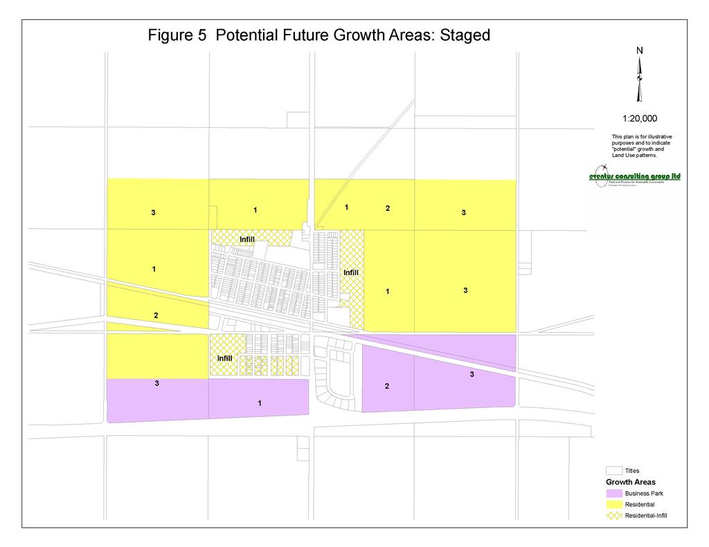
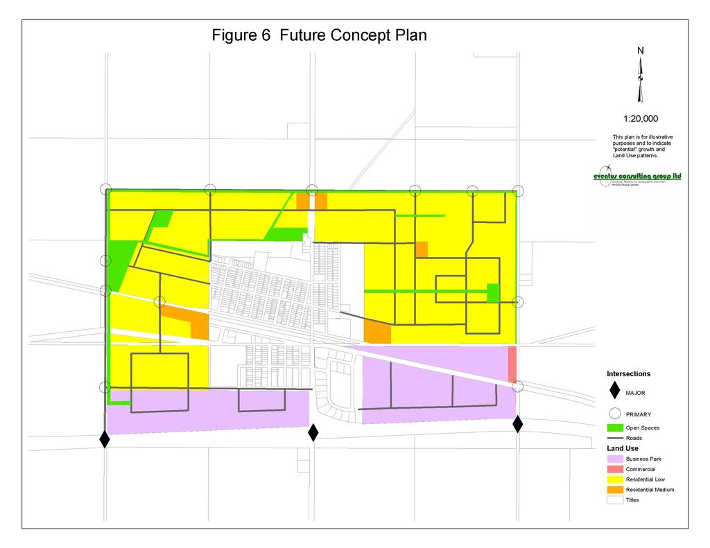
37 the municipal boundaries, continuity of uses or municipal facilities and infrastructure In consultation and co-operation with the County of Minburn the Village shall seek to incorporate lands within the Village boundaries which allow for a reasonable area for growth and development Future Land Use and Expansion Development of lands within the current municipal boundary, are recognized as immediate infill opportunities to assist in achieving the policies of this plan The Village shall explore growth options for the expansion of its municipal boundaries based on the objectives and policies of this plan and generally as shown on Figure 5 and 6 in Appendix A The Land Use Bylaw Perspective The Land Use Bylaw and the associated Land Use Map are important tools used in the implementation of the policies and standards of the Village Plan. Policy 15.1 Revisions to the Land Use Bylaw shall be undertaken to fully enact and enforce the policies adopted in this Plan In general, proposed resolutions considered by Council, applications for subdivision or development must be consistent with the land use policies set out in the Village MDP. 37
38 FIGURE #5 Future Growth Staging 38
39 FIGURE #6 Future Growth Pattern 39
")
 eventus")
40 Figure 1 Regional Context Mannville, Alberta (2006) Mannville, Alberta and Regional Context (2006) eventus consulting group ltd.
41

42

43
44
45

46
Municipal Development Plan. Summer Village of ROCHON SANDS. Bylaw #241-18
 Municipal Development Plan Summer Village of ROCHON SANDS Bylaw #241-18 TABLE OF CONTENTS PART ONE: BACKGROUND AND PURPOSE 3 SECTION 1: BACKGROUND 3 SECTION 2: GOALS AND POLICIES 3 PART TWO: PHYSICAL ENVIRONMENT
Red Fox Commercial Outline Plan
 Red Fox Commercial Outline Plan City of Cold Lake, Alberta Prepared by Durrance Projects Ltd and Ross W. Sharp & Associates Ltd October 2014 Rupert 1 Table of Contents 1. PURPOSE...3 1.1. Location...4
SECTION E. Realizing the Plan
 SECTION E Realizing the Plan 60 DESIGN REGINA - OFFICIAL COMMUNITY PLAN SECTION E Realizing the Plan Design Regina has been an ambitious plan-making exercise, with a high level of community, stakeholder,
Concord Community Reuse Project Goals and Guiding Principles. Overarching Goals (OG)
") Concord Community Reuse Project Goals and Guiding Principles Overarching Goals (OG) No priority is implied by the order of presentation of the goals and guiding principles. Overarching goals for the Concord
Concord Community Reuse Project Goals and Guiding Principles Overarching Goals (OG) No priority is implied by the order of presentation of the goals and guiding principles. Overarching goals for the Concord
Municipal Development Plan Update Urban Service Area and Hamlets
 ENCLOSURE 1 Municipal Development Plan Update Urban Service Area and Hamlets Priorities Committee January 24, 2017 MUNICIPAL DEVELOPMENT PLAN UPDATE SHAPING OUR FUTURE MDP Update - Agenda MDP Update Public
4.11 Town Centre Secondary Plan (Former City of Cumberland)
") 4.11 Town Centre Secondary Plan (Former City of Cumberland) 4.11.1 Town Centre Objectives 4.11.1.1 Introduction The reason for the preparation of this Secondary Plan for the Town Centre is as follows:
4.11 Town Centre Secondary Plan (Former City of Cumberland) 4.11.1 Town Centre Objectives 4.11.1.1 Introduction The reason for the preparation of this Secondary Plan for the Town Centre is as follows:
Westwind Developments Ltd. PIONEER LANDS AREA STRUCTURE PLAN - PROPOSED AMENDMENT
 FEBRUARY 2013 TABLE OF CONTENTS 1.0 BACKGROUND... 1 1.1 Amendment... 1 2.0 LOCATION & CONTEXT... 2 2.1 Land Ownership... 2 3.0 POLICY CONTEXT... 3 3.1 Municipal Development Plan... 3 3.2 Capital Region
4 Sustainability and Growth Management
 4 Sustainability and Growth Management Introduction Traditionally, has assumed growth and development with limited consideration for the long-term negative social, environmental or economic impacts on
TABLE OF CONTENTS 1.0 INTRODUCTION GENERAL OBJECTIVES LAND USE DESIGNATIONS, OBJECTIVES AND POLICIES 4
 Schedule I- Redstone Golf Course Resort Area Sector Plan 1 TABLE OF CONTENTS 1.0 INTRODUCTION 3 2.0 GENERAL OBJECTIVES 3 3.0 LAND USE DESIGNATIONS, OBJECTIVES AND POLICIES 4 4.0 TRANSPORTATION AND ROAD
EXISTING COMPREHENSIVE PLAN
 EXISTING COMPREHENSIVE PLAN Town Center Land Use Element: V. LAND USE POLICIES Town Center Mercer Island's business district vision as described in "Your Mercer Island Citizen-Designed Downtown" was an
RECREATION AND OPEN SPACE ELEMENT GOALS, OBJECTIVES, AND POLICIES
 RECREATION AND OPEN SPACE ELEMENT GOALS, OBJECTIVES, AND POLICIES Goal 7 To provide park facilities, recreation programs, and open space resources that are safe, adequate, and accessible to all City residents,
The West Vaughan Employment Area Secondary Plan Policies
 Part 2: The West Vaughan Employment Area Secondary Plan Policies 2.1 General Policies It is the policy of Council: 2.1.1. That the West Vaughan Employment Area (the WVEA), identified on Schedule 1, will
WEST HILL BUSINESS PARK AREA STRUCTURE PLAN
 MUNICIPAL DISTRICT OF PEACE NO. 135 WEST HILL BUSINESS PARK AREA STRUCTURE PLAN Prepared by: TABLE OF CONTENTS 1.0 Introduction... 1 1.1 Purpose of Plan........ 1 1.2 Plan Area..... 1 1.3 Existing Conditions...
Municipal Development Plan 2013
 UNIQUELY STONY PLAIN: Municipal Development Plan 2013 Quick Reference Guide What is a Municipal Development Plan (MDP)? The Town s highest-level planning document Sets the long-term vision and key themes
SECTION II SECTION II STATEMENT OF GOALS, OBJECTIVES, PRINCIPLES, ASSUMPTIONS, POLICIES AND STANDARDS
 STATEMENT OF GOALS, OBJECTIVES, PRINCIPLES, ASSUMPTIONS, POLICIES AND STANDARDS 1 2 STATEMENT OF GOALS, OBJECTIVES, PRINCIPLES, ASSUMPTIONS, POLICIES AND STANDARDS INTRODUCTION The New Jersey Municipal
3. VISION AND GOALS. Vision Statement. Goals, Objectives and Policies
 Vision Statement Queen Creek s interconnected network of parks, trails, open spaces and recreation opportunities provide safe and diverse activities and programs that sustain its unique, small town, equestrian
Town of Bowden Municipal Development Plan. Table of Contents
 Town of Bowden Municipal Development Plan Table of Contents 1.0 Introduction and Purpose 4 2.0 Community Context and Trends 5 3.0 Vision Statement 10 4.0 Land Use Concept and General Development 12 5.0
6 Growth Management Challenges and Opportunities
 6 Growth Management Challenges and Opportunities The Town has established a goal of attaining a 50% participation rate with respect to employment opportunities versus residential population. The Town s
178 Carruthers Properties Inc.
 178 Carruthers Properties Inc. Planning Rationale for 178 Carruthers Avenue Site Plan Control Application June 2014 Table of Contents 1.0 Introduction 2.0 Overview of Subject Property 3.0 Current Zoning
BYLAW C A Bylaw of Rocky View County to amend Land Use Bylaw C
 BYLAW C-7720-2017 A Bylaw of Rocky View County to amend Land Use Bylaw C-4841-97. The Council of Rocky View County enacts as follows: PART 1 TITLE This Bylaw shall be known as Bylaw C-7720-2017. PART 2
4.1.3 LAND USE CATEGORIES
 4.1.3 LAND USE CATEGORIES a. City Center District The City Center District incorporates the existing character and mix of uses in downtown Belmont to encourage redevelopment and new development in keeping
Port Lavaca Future Land Use
 Port Lavaca Future Land Use Introduction The City of Port Lavaca is beginning to see sustained growth, after many years of relative stable population. New single family homes, apartments, and businesses
CHAPTER 7: Transportation, Mobility and Circulation
 AGLE AREA COMMUNITY Plan CHAPTER 7 CHAPTER 7: Transportation, Mobility and Circulation Transportation, Mobility and Circulation The purpose of the Transportation, Mobility and Circulation Chapter is to
Land Use Amendment in Southwood (Ward 11) at and Elbow Drive SW, LOC
 at and Elbow Drive SW, LOC") 2018 November 15 Page 1 of 10 EXECUTIVE SUMMARY This land use amendment application was submitted by Rick Balbi Architect on 2017 August 31 on behalf of Sable Developments Ltd, and with authorization from
2018 November 15 Page 1 of 10 EXECUTIVE SUMMARY This land use amendment application was submitted by Rick Balbi Architect on 2017 August 31 on behalf of Sable Developments Ltd, and with authorization from
CHAPTER 12 IMPLEMENTATION
 CHAPTER 12 IMPLEMENTATION The 2010 Town of Denton Comprehensive Plan is intended to capture a vision of the future of Denton. As such, it provides a basis for a wide variety of public and private actions
COMMUNITY DESIGN. GOAL: Create livable and attractive communities. Intent
 COMMUNITY DESIGN Intent An attractive, well-designed County will attract quality development, instill civic pride, improve the visual character of the community, and create a strong, positive image for
Town of Peru Comprehensive Plan Executive Summary
 Town of Peru Comprehensive Plan Executive Communities that plan grow by choice, not by chance. A plan makes growth thoughtful, understandable, and predictable. A plan shows that a community is managing
North Oakville East Parks Facilities Distribution Plan. November, 2009
 North Oakville East November, 2009 POLICY CONTEXT 1) Purpose a) The purpose of this document is to be a guide for the location, configuration, design and development of the parks system for the North Oakville
Chapter 2: Vision, Goals and Strategies
 Chapter 2: Vision, Goals and Lake Elmo Today & Tomorrow Comprehensive Plan 2040 2 VISION, GOALS & STRATEGIES - DRAFT 4-6-2018 INTRODUCTION Comprehensive Plan Purpose Perhapse the most important objective
TOWN OF BRUDERHEIM Report to the capital region board
 TOWN OF BRUDERHEIM Report to the capital region board Introduction to the Town of Bruderheim Municipal Development Plan amendment and Relation to the CRB Evaluation Criteria 02 march 2017 1 Introduction
and services The protection and conservation of environmentally significant and sensitive natural heritage features and functions.
 6. Land Use 6.0 Preamble A healthy and livable city is one in which people can enjoy a vibrant economy and a sustainable healthy environment in safe, caring and diverse neighbourhoods. In order to ensure
Planning Districts INTRODUCTION
 INTRODUCTION To facilitate detailed examination of development prospects for all areas of the community, Delano has been divided into 14 planning districts. The location of these planning districts is
HAMLET OF KINGMAN AREA STRUCTURE PLAN
 HAMLET OF KINGMAN AREA STRUCTURE PLAN Prepared by: Austrom Consulting Ltd. Page 1 of 19 Table of Contents TABLE OF CONTENTS... 2 1. BACKGROUND... 3 1.1 PLAN AREA... 3 1.2 PLAN PURPOSE... 3 1.3 LEGISLATIVE
CITY OF LANGLEY OFFICIAL COMMUNITY PLAN BYLAW, 2005, NO APPENDIX II - REGIONAL CONTEXT MAP
 CITY OF LANGLEY OFFICIAL COMMUNITY PLAN BYLAW, 2005, NO. 2600 APPENDIX II - REGIONAL CONTEXT MAP ± Legend Agricultural Mixed Employment Industrial Conservation & Recreation Regional City Centre Urban Containment
The Five Components of the McLoughlin Area Plan
 The Five Components of the McLoughlin Area Plan This documents contains the complete language of the five components of the McLoughlin Area Plan: The Vision Statement The Values The Guiding Principles
Arlington, Virginia is a worldclass
 EXECUTIVE S U M M A RY Arlington maintains a rich variety of stable neighborhoods, quality schools and enlightened land use policies, and received the Environmental Protection Agency s highest award for
[PLANNING RATIONALE] For Site Plan Control and Lifting of Holding Zone By-Law 101 Champagne Avenue. May 23, 2014
![[PLANNING RATIONALE] For Site Plan Control and Lifting of Holding Zone By-Law 101 Champagne Avenue. May 23, 2014](/thumbs/75/71599615.jpg "[PLANNING RATIONALE] For Site Plan Control and Lifting of Holding Zone By-Law 101 Champagne Avenue. May 23, 2014") [PLANNING RATIONALE] For Site Plan Control and Lifting of Holding Zone By-Law 101 Champagne Avenue May 23, 2014 Contents 1.0 Introduction... 2 2.0 Site Context... 2 2.1 Adjacent Uses... 2 Figure 1: Site
[PLANNING RATIONALE] For Site Plan Control and Lifting of Holding Zone By-Law 101 Champagne Avenue May 23, 2014 Contents 1.0 Introduction... 2 2.0 Site Context... 2 2.1 Adjacent Uses... 2 Figure 1: Site
Table of Contents PART 1 FRAMEWORK... 1
 Table of Contents PART 1 FRAMEWORK... 1 1.0 PURPOSE... 1 1.1 MUNICIPAL GOVERNMENT ACT... 1 1.2 REGIONAL & MUNICIPAL POLICIES... 2 1.3 COMMUNITY CONTEXT... 6 PART 2 VISION... 8 2.1 SUSTAINABILITY... 8 2.2
PORT WHITBY COMMUNITY
 PORT WHITBY COMMUNITY SECONDARY PLAN UPDATE COMMUNITY IMPROVEMENT PLAN URBAN DESIGN GUIDELINES September 2015 DRAFT PROPOSED AMENDMENT NUMBER # to the Whitby Official Plan PURPOSE: The intent of this Amendment
4- PA - LD - LIVELY DOWNTOWN. LD - Background
 4- PA - LD - LIVELY DOWNTOWN LD - Background The downtown has been the service centre for the community since the city s inception and the area continues to supply people with their personal services,
The Vision. Photo provided by The Minervini Group. 46 Vision, Objectives & Strategies
 Vision, Objectives & Strategies The is the public framework and guide for future development of the Grand Traverse Commons. The establishes public polices for infrastructure, the preservation of natural
Chapter Master Planned Communities (MPC) District
 District") Sections 14.53.010 Purpose and Intent 14.53.020 Applicability 14.53.030 Procedure 14.53.040 MPC Standards 14.53.050 Required Findings 14.53.010 Purpose and Intent Chapter 14.53 Master Planned Communities
Sections 14.53.010 Purpose and Intent 14.53.020 Applicability 14.53.030 Procedure 14.53.040 MPC Standards 14.53.050 Required Findings 14.53.010 Purpose and Intent Chapter 14.53 Master Planned Communities
Transportation. Strategies for Action
 Transportation A major priority for the Overlake Neighborhood is to develop a multimodal transportation system. To achieve this system, a balance has to be found among travel, circulation and access needs;
The transportation system in a community is an
 7 TRANSPORTATION The transportation system in a community is an important factor contributing to the quality of life of the residents. Without a sound transportation system to bring both goods and patrons
Improve Neighborhood Design and Reduce Non Point Source Water Pollution
 HOW TO Planning Guide Improve Neighborhood Design and Reduce Non Point Source Water Pollution This document was funded by a grant from the New Hampshire Coastal Program with funding from the National Oceanic
Keyport. Vision for Keyport
 Keyport Vision for Keyport Keyport is a rural, historic waterfront village bounded and limited in size by its natural borders of water and the Naval Undersea Warfare Center. The community consists primarily
EXHIBIT A. Tax Increment Reinvestment Zone No. 1 (Town Center) First Amended Project Plan 1
 First Amended Project Plan 1") EXHIBIT A Tax Increment Reinvestment Zone No. 1 (Town Center) First Amended Project Plan 1 1 As amended by Resolution No. 2008-02-001(TR1R) of the Tax Increment Reinvestment Zone No.1, and approved to
EXHIBIT A Tax Increment Reinvestment Zone No. 1 (Town Center) First Amended Project Plan 1 1 As amended by Resolution No. 2008-02-001(TR1R) of the Tax Increment Reinvestment Zone No.1, and approved to
Further input invited as Colchester Growth Strategy nears final phase
 IUE 3 / NOVEMBER 2015 Further input invited as Colchester Growth trategy nears final phase trathcona County is seeking public feedback as it enters the final phase of work on a Growth Management trategy
6. REGIONAL AND COMMUNITY FACILITIES DESIGNATIONS 6.1. OBJECTIVES FOR REGIONAL AND COMMUNITY FACILITIES LAND USE DESIGNATIONS
 6. REGIONAL AND COMMUNITY FACILITIES DESIGNATIONS INTRODUCTION The Regional and land use designations provide the primary locations for uses which satisfy the health, education and other service needs
ARTICLE 6: Special and Planned Development Districts
 ARTICLE 6: Special and Planned Development Districts 6-10 Traditional Neighborhood Development (TND) District 6-10.10 Purpose and Intent The Traditional Neighborhood Development (TND) District provides
FORMER CANADIAN FORCES BASE (CFB) ROCKCLIFFE SECONDARY PLAN. Official Plan Amendment XX to the Official Plan for the City of Ottawa
 ROCKCLIFFE SECONDARY PLAN. Official Plan Amendment XX to the Official Plan for the City of Ottawa") FORMER CANADIAN FORCES BASE (CFB) ROCKCLIFFE SECONDARY PLAN Official Plan Amendment XX to the Official Plan for the City of Ottawa 1 INDEX THE STATEMENT OF COMPONENTS PART A THE PREAMBLE PAGE Purpose...
FORMER CANADIAN FORCES BASE (CFB) ROCKCLIFFE SECONDARY PLAN Official Plan Amendment XX to the Official Plan for the City of Ottawa 1 INDEX THE STATEMENT OF COMPONENTS PART A THE PREAMBLE PAGE Purpose...
Complete Neighbourhood Guidelines Review Tool
 Complete Neighbourhood Guidelines Review Tool Prepared By: City of Regina Planning Department October 2014 Page 1 of 14 Community Development Review Checklist for Secondary Plans and Concept Plans The
City of Royalton Comprehensive Land Use Plan 2005 to Revision February 8, 2011
 City of Royalton Comprehensive Land Use Plan 2005 to 2015 2011 Revision February 8, 2011 PART ONE: INTRODUCTION TO THE COMPREHENSIVE PLAN 1.0 Purpose and Introduction The Comprehensive Land Use Plan provides
Town Center (part of the Comprehensive Plan)
") Town Center (part of the Comprehensive Plan) Mercer Island Town Center Looking North (2014) In 1994, a year-long process culminated in a set of design guidelines and code requirements for the Town Center
Town Center (part of the Comprehensive Plan) Mercer Island Town Center Looking North (2014) In 1994, a year-long process culminated in a set of design guidelines and code requirements for the Town Center
City of Grande Prairie Development Services Department KENNEDY DEVELOPMENTS LTD. OUTLINE PLAN OP-09-01
 City of Grande Prairie Development Services Department KENNEDY DEVELOPMENTS LTD. OUTLINE PLAN OP-09-01 July 27, 2009 TABLE OF CONTENTS 1.0 Introduction... 1 1.1 Plan Area Location & Context... 1 1.2 Ownership
PSRC REVIEW REPORT & CERTIFICATION RECOMMENDATION
 PSRC REVIEW REPORT & CERTIFICATION RECOMMENDATION KITSAP COUNTY COUNTYWIDE PLANNING POLICIES July 2, 2012 BACKGROUND A major emphasis of the Washington State Growth Management Act (GMA) is the need to
Section 1 Introduction
 Section 1 Section 1,, describes the role of the Official Plan. The Official Plan is one of five growth management plans that was completed under the umbrella of Ottawa 20/20. 1.1 The Role of the Official
Dwelling Units Max 12 dwelling units per acre/min 8 dwelling units per acre. Development Mix 80% non residential/20% residential
 13. OSTEEN LOCAL PLAN Background: The Osteen Local Plan area is located in southwest Volusia County along the SR 415 corridor between Lemon Bluff Road and Acorn Lake Road and includes 3,990 acres. The
Chapter 6: Community Character
 Chapter 6: Community Character The term "community character" covers a broad spectrum of concerns. First and foremost, community character is a visual concept. In Long Grove, however, community character
Policies and Code Intent Sections Related to Town Center
 Policies and Code Intent Sections Related to Town Center The Town Center Vision is scattered throughout the Comprehensive Plan, development code and the 1994 Town Center Plan. What follows are sections
2018 Northampton Township Comprehensive Plan
 2018 BUCKS COUNTY, PENNSYLVANIA What is a? A comprehensive plan is a municipality s main policy document that details the collective vision for the future, the historic, environmental, and cultural facilities
Urban Design Manual PLANNING AROUND RAPID TRANSIT STATIONS (PARTS) Introduction. Station Study Areas
 Introduction. Station Study Areas") 111111 PLANNING AROUND RAPID TRANSIT STATIONS (PARTS) Introduction The ION rapid transit system will link Waterloo, Kitchener and Cambridge through a central transit corridor (CTC). There are a number
111111 PLANNING AROUND RAPID TRANSIT STATIONS (PARTS) Introduction The ION rapid transit system will link Waterloo, Kitchener and Cambridge through a central transit corridor (CTC). There are a number
CHAPTER 2: PLANNING PRINCIPLES
 CHAPTER 2: PLANNING PRINCIPLES 2 Comprehensive Principles The following overarching Principles provide the basis for the goals and policies included in the Mendocino County General Plan. These Principles
CONTENTS 8.0 LAND USE 8.1 GENERAL LAND USE 8.2 RESIDENTIAL 8.3 MIXED USE 8.4 COMMERCIAL 8.5 EMPLOYMENT LANDS
 8-2 Land Use 8.0 LAND USE CONTENTS 8.1 GENERAL LAND USE 8.1.1 Uses provided for in all Land Use Designations 8.1.2 Uses prohibited in Hazardous Lands, Hazardous Sites and Special Policy Areas 8.1.3 Uses
PUBLIC OPEN HOUSE SEPTEMBER 8 TH, 2010 CITY OF LETHBRIDGE DEVELOPMENT SERVICES
 PUBLIC OPEN HOUSE SEPTEMBER 8 TH, 2010 CITY OF LETHBRIDGE DEVELOPMENT SERVICES INTRODUCTION Why is the City creating the West Lethbridge Employment Centre Area Structure Plan? West Lethbridge Urbanization
This page intentionally blank.
 This page intentionally blank. Parks, Recreation, and Open Space Chapter Relationship to Vision Vision Parks, Recreation and Open Space Chapter Concepts County Government. County government that is accountable
SUBJECT: Waterfront Hotel Planning Study Update TO: Planning and Development Committee FROM: Department of City Building. Recommendation: Purpose:
 Page 1 of Report PB-23-18 SUBJECT: Waterfront Hotel Planning Study Update TO: Planning and Development Committee FROM: Department of City Building Report Number: PB-23-18 Wards Affected: 2 File Numbers:
TREASURE COAST REGIONAL PLANNING COUNCIL M E M O R A N D U M. To: Council Members AGENDA ITEM 5H
 TREASURE COAST REGIONAL PLANNING COUNCIL M E M O R A N D U M To: Council Members AGENDA ITEM 5H From: Date: Subject: Staff October 17, 2008 Council Meeting Local Government Comprehensive Plan Review Draft
The protection of the agricultural resources of the Province;
 PART II INTRODUCTION An Official Plan is a policy document, which is intended to serve as the basis for making land use decisions and managing change in any municipality in Ontario. According to the Planning
13 THORNHILL YONGE STREET STUDY IMPLEMENTATION CITY OF VAUGHAN OPA 669 AND TOWN OF MARKHAM OPA 154
 13 THORNHILL YONGE STREET STUDY IMPLEMENTATION CITY OF VAUGHAN OPA 669 AND TOWN OF MARKHAM OPA 154 The Planning and Economic Development Committee recommends the adoption of the recommendations contained
Implementation Guide Comprehensive Plan City of Allen
 Implementation Guide 2030 Comprehensive Plan City of Allen DRAFT 2015 Implementation Guide Allen 2030 Comprehensive Plan INTRODUCTION The Comprehensive Plan serves as a guide for the growth and development
MUNICIPAL DEVELOPMENT PLAN
 MUNICIPAL DEVELOPMENT PLAN Bylaw 2007-22 Prepared by: Office Consolidation - April 2017 Table of Contents 1.0 Introduction and Purpose... 1 2.0 Community Context and Trends... 2 3.0 Vision Statement...
OP Council Resolution June 16, Planning and Development Services
 OP-08-01 Council Resolution June 16, 2008 Planning and Development Services Kingsgate Landing Outline Plan Table of Contents 1.0 Introduction 1 1.1 Purpose of Plan 1 1.2 Plan Area Location 1 1.3 Ownership
GATEWAY AREA STRUCTURE PLAN
 CHESTERMERE GATEWAY AREA STRUCTURE PLAN COMMUNITY OPEN HOUSE SEPTEMBER 22 nd, 2015 PLAN AREA ± 512 hectares (± 1,265 acres) GATEWAY LOCATION UNDEVELOPED LANDS PRESENT AGRICULTURAL USE REGIONAL LAND USE
LAND USE AMENDMENT CORNERSTONE (WARD 3) COUNTRY HILLS BOULEVARD AND STONEY TRAIL NE BYLAW 9D2017
 COUNTRY HILLS BOULEVARD AND STONEY TRAIL NE BYLAW 9D2017") Page 1 of 12 EXECUTIVE SUMMARY This Land Use Amendment application covers an area of 54.92 hectares ± (135.71 acres ±) located in northeast Calgary, bound by Country Hills Boulevard NE to the north and
Page 1 of 12 EXECUTIVE SUMMARY This Land Use Amendment application covers an area of 54.92 hectares ± (135.71 acres ±) located in northeast Calgary, bound by Country Hills Boulevard NE to the north and
This page has been intentionally left blank.
 This page has been intentionally left blank. Chapter 3 3-2 3. Employment 3.A Niagara Economic Gateway 3.A.1 General The Niagara Economic Gateway comprises: a) The Gateway Economic Zone which includes all
THE CITY OF SPRUCE GROVE BYLAW C PIONEER LANDS AREA STRUCTURE PLAN AMENDMENT
 THE CITY OF SPRUCE GROVE BYLAW C-797-11 PIONEER LANDS AREA STRUCTURE PLAN AMENDMENT WHEREAS, pursuant to the Municipal Government Act, R.S.A., 2000, c.m-26, a municipality shall adopt Area Structure Plans
SCHEDULE A. Town of Ponoka Municipal Development Plan. (Bylaw No )
") SCHEDULE A Town of Ponoka 2013 Municipal Development Plan (Bylaw No. 323-13) TABLE OF CONTENTS 1 INTRODUCTION... 4 2 OVERALL LAND USE PATTERN AND DEVELOPMENT STRATEGY... 5 3 ECONOMIC DEVELOPMENT AND TOURISM...
SCHEDULE A Town of Ponoka 2013 Municipal Development Plan (Bylaw No. 323-13) TABLE OF CONTENTS 1 INTRODUCTION... 4 2 OVERALL LAND USE PATTERN AND DEVELOPMENT STRATEGY... 5 3 ECONOMIC DEVELOPMENT AND TOURISM...
implementation10 Village of Greendale Comprehensive Plan: Greendale, Wisconsin. Revisiting a Greenbelt Community
 implementation10 Village of Greendale Comprehensive Plan: 2010 - Village of Greendale Comprehensive Plan: 2010 - Implementation The recommendations of this Plan must be implemented by the Village of Greendale,
CHAPTER 3 VISION, GOALS, & PLANNING PRINCIPLES. City of Greensburg Comprehensive Plan. Introduction. Vision Statement. Growth Management Goals.
 CHAPTER 3 VISION, GOALS, & PLANNING PRINCIPLES Introduction The Greensburg Comprehensive Plan is intended as a working community document. A combination of long and short-term goals, this document is intended
THE GARDEN CITY PLAN. City of St. Catharines Official Plan. City of St. Catharines
 THE GARDEN CITY PLAN City of St. Catharines Official Plan City of St. Catharines August 2010 APPROVAL INFORMATION This Official Plan of the City of St. Catharines Planning Area, known as the Garden City
LAND USE AMENDMENT CORNERSTONE (WARD 3) 60 STREET NE AND COUNTRY HILLS BOULEVARD NE MAP 26NE BYLAW 22D2017
 60 STREET NE AND COUNTRY HILLS BOULEVARD NE MAP 26NE BYLAW 22D2017") Page 1 of 14 EXECUTIVE SUMMARY This Land Use Amendment application covers an area of 43.76 hectares ± (108.14 acres ±) located in northeast Calgary, bound by Country Hills Boulevard NE to the south and
Page 1 of 14 EXECUTIVE SUMMARY This Land Use Amendment application covers an area of 43.76 hectares ± (108.14 acres ±) located in northeast Calgary, bound by Country Hills Boulevard NE to the south and
S A C R A M E N T O C O U N T Y JACKSON HIGHWAY & GRANT LINE EAST VISIONING STUDY
 JACKSON HIGHWAY & GRANT LINE EAST S A C R A M E N T O C O U N T Y P L A N N I N G D E P A R T M E N T SUMMARY AND WORKBOOK November 19, 2008 History of the Visioning Study Sacramento County has two growth
Planned Residential Neighborhoods Land Use Goals
 Planned Residential Neighborhoods Land Use Goals Issue: Guidelines that provide for diverse high quality residential areas that include a variety of housing styles and layouts are needed. Goal 1: Create
Tāhuhu whakaruruhau ā-taone The sheltering ridge pole
 B2. Tāhuhu whakaruruhau ā-taone - Urban growth and form B2.1. Issues Tāhuhu whakaruruhau ā-taone The sheltering ridge pole Auckland s growing population increases demand for housing, employment, business,
DEVELOPMENT FRAMEWORK POST 2030 LAND USE PLAN INTRODUCTION
 INTRODUCTION Oak Grove s Comprehensive Plan identifies a future Metropolitan Urban Service Area (MUSA). The Metropolitan Council does not anticipate extending utilities to this area prior to 2030. The
CHAPTER 7: VISION AND ACTION STATEMENTS. Noble 2025 Vision Statement
 CHAPTER 7: VISION AND ACTION STATEMENTS This chapter presents the vision, policy and action statements that transform the comprehensive planning study, an analysis of Noble s past, future trends and community
Welcome to the Oakridge Centre Open House
 Welcome to the Oakridge Centre Open House Why is the City hosting this event? This open house is to inform you of a rezoning application submitted to the City of Vancouver to amend the existing CD-1 (Comprehensive
SECTION ONE: INTRODUCTION. introduction
 introduction 1 INTRODUCTION Since it was first established in 1843 as a trading post for the Hudson s Bay Company, Victoria has evolved into a Provincial capital city that is recognized across Canada and
Downtown Whitby Action Plan
 Downtown Whitby Action Plan Final Report October 2016 Table of Contents Introduction 1 Public Consultation 2 Walkability 3 Downtown Whitby Walkability Map 4 Vision 5 Goal & Objectives 6 Objective 1 7 Objective
A Growing Community Rural Settlement Areas
 Town of Huntsville Official Plan Review - POLICY BACKGROUND PAPER A Growing Community Rural Settlement Areas BACKGROUND: In addition to the fully municipally-serviced Urban Settlement Area and the Hidden
ADMINISTRATION RECOMMENDATION 2016 November 03. That Calgary Planning Commission recommends APPROVAL of the proposed Land Use Amendment.
 Page 1 of 12 EXECUTIVE SUMMARY This Land Use Amendment application covers an area of 75.76 hectares ± (187.20 acres ±) located in northeast Calgary, bound by Stoney Trail NE to the north, 128 Avenue NE
SUMMER VILLAGE OF SUNRISE BEACH
 SUMMER VILLAGE OF SUNRISE BEACH Municipal Development Plan Bylaw No. 132-13 ~ 2 ~ Summer Village of Sunrise Beach Municipal Development Plan 1 INTRODUCTION 1.1 SETTING The Summer Village of Sunrise Beach
Objectives and Strategies for the Integration of Recreation, Parks and Open Space in Regional Plans
 BULLETIN 2 Objectives and Strategies for the Integration of Recreation, Parks and Open Space in Regional Plans TABLE OF CONTENTS Introduction 3 Land-use Framework Outcomes 1 4-8 Land-use Framework Outcomes
THE CITY OF WINNIPEG BY-LAW NO. 4/2013. A By-law of THE CITY OF WINNIPEG to adopt a Secondary Plan for the Waverley West Southwest Neighbourhood.
 THE CITY OF WINNIPEG BY-LAW NO. 4/2013 A By-law of THE CITY OF WINNIPEG to adopt a Secondary Plan for the Waverley West Southwest Neighbourhood. THE CITY OF WINNIPEG, in Council assembled, enacts as follows:
HE VISION. Building a Better Connected Place
 HE VISION Building a Better Connected Place WALK INTO THE FUTURE. Life in Cranberry, 2030 Here s what our residents told us they wanted to see in their community by 2030: The Cranberry of 2030 is a place
MALL REVITALIZATION CASE STUDIES
 MALL REVITALIZATION CASE STUDIES DECEMBER 9, 2012 MALL REVITALIZATION OVERVIEW Introduction Sample Case Studies prepared for Lacey Woodland District Steering Committee as it considers strategies to revitalize
LAND USE AMENDMENT DOWNTOWN COMMERCIAL CORE (WARD 7) MACLEOD TRAIL SE AND 5 AVENUE SE BYLAW 254D2017
 MACLEOD TRAIL SE AND 5 AVENUE SE BYLAW 254D2017") Page 1 of 10 EXECUTIVE SUMMARY This Land Use Amendment application seeks to redesignate a full downtown block (currently the YWCA site) from a Direct Control based on the CM-2 District (Land Use Bylaw
Page 1 of 10 EXECUTIVE SUMMARY This Land Use Amendment application seeks to redesignate a full downtown block (currently the YWCA site) from a Direct Control based on the CM-2 District (Land Use Bylaw
General Manager, Planning and Development; General Manager, Parks, Recreation and Culture. Proposed Mini-Park and Plaza Designations
 Corporate NO: R106 Report COUNCIL DATE: June 16, 2008 REGULAR COUNCIL TO: Mayor & Council DATE: June 12, 2008 FROM: SUBJECT: General Manager, Planning and Development; General Manager, Parks, Recreation
Comprehensive Plan ADOPTED APRIL 2014
 Comprehensive Plan ADOPTED APRIL 2014 8 8. Outstanding Recreational & Cultural Opportunities We are proud of our community s parks and recreation system. Our community will ensure that the legacy of our