South Cambridgeshire Local Plan
|
|
|
- Suzanna Gardner
- 5 years ago
- Views:
Transcription


1 South Cambridgeshire Local Plan Adopted September 2018


2 Cambourne, South Cambridgeshire
3 South Cambridgeshire Local Plan Adopted Published by South Cambridgeshire District Council Published September 2018 SCDC/LP/
4 South Cambridgeshire District Council adopted this Local Plan at its meeting of Council on 27 September 2018.
5 Contents CONTENTS Chapter 1 Introduction 1 About South Cambridgeshire 3 What the Plan Does and How it was Prepared 3 What the Plan Looks Like 5 What Comprises the Development Plan for South Cambridgeshire 6 Strategic policies and neighbourhood planning 7 Chapter 2 Spatial Strategy 9 Key Facts 12 Evolving the Strategy and Overview 12 The Development Strategy 1999 to Objectively Assessed Needs for New Jobs and Homes 14 Duty to Cooperate 15 The Joint Spatial Approach for Cambridge and 16 South Cambridgeshire The Transport Strategy for Cambridge and South Cambridgeshire 20 Comparing the Development Strategy to 2031 with the 20 Structure Plan Vision and Objectives 22 Sustainable Development 23 Cambridge Green Belt 24 Provision of New Jobs and Homes 25 The Development Strategy to Development Frameworks 32 Strategy for the Rural Area 33 Rural Centres 33 Minor Rural Centres 34 Group Villages 35 Infill Villages 36 Phasing, Delivery and Monitoring 37 Phasing 38 Delivery 38 Monitoring 39 Chapter 3 Strategic Sites 43 Edge of Cambridge 46 Orchard Park 46 Land between Huntingdon Road and Histon Road 49 Cambridge East 55 Cambridge Northern Fringe East 57 New Settlements 64 Northstowe Extension 64 Waterbeach New Town 64 New Village at Bourn Airfield 72 Sustainable Villages 78 Cambourne West 78 i
6 Contents Chapter 4 Climate Change 85 Key Facts 88 Mitigation and Adaptation to Climate Change 88 Renewable and Low Carbon Energy Generation 90 Renewable and Low Carbon Energy in New Developments 91 Water Efficiency 92 Sustainable Show Homes 93 Construction Methods 94 Water Quality 95 Sustainable Drainage Systems 96 Managing Flood Risk 97 Chapter 5 Delivering High Quality Places 101 Key Facts 103 Securing High Quality Design 103 Public Art 106 Chapter 6 Protecting and Enhancing the Natural and Historic 109 Environment Key Facts 111 Conservation Area and Green Separation at Longstanton 112 Protecting and Enhancing Landscape Character 113 Protecting Agricultural Land 114 Biodiversity 115 Green Infrastructure 119 Ancient Woodlands and Veteran Trees 121 The Green Belt 122 Redevelopment in the Green Belt 122 Green Belt and Recreation Uses 123 Protecting Village Character 124 Heritage Assets 126 Heritage Assets and Adapting to Climate Change 129 Chapter 7 Delivering High Quality Homes 131 Key Facts 133 Allocations For Residential Development At Villages 134 Bayer CropScience Site, Hauxton 138 Fulbourn and Ida Darwin Hospitals 140 Papworth Everard West Central 142 Fen Drayton Former Land Settlement Association Estate 143 South of A1307, Linton 144 Residential Moorings 144 Housing Density 145 Housing Mix 145 Affordable Housing 148 Rural Exception Site Affordable Housing 150 Residential Space Standards 151 Extensions to Dwellings in the Countryside 153 Replacement Dwellings in the Countryside 154 Countryside Dwellings of Exceptional Quality 155 ii
7 Contents Development of Residential Gardens 156 Reuse of Buildings in the Countryside for Residential Use 157 Working at Home 157 Dwellings to Support a Rural-based Enterprise 158 Provision for Gypsies and Travellers and Travelling Showpeople 160 Gypsy and Traveller Provision at New Communities 162 Proposals for Gypsies, Travellers and Travelling Showpeople Sites 164 on Unallocated Land Outside Development Frameworks Design of Gypsy and Traveller Sites, and Travelling Showpeople 166 Sites Chapter 8 Building a Strong and Competitive Economy 169 Key Facts 172 New Employment Provision 172 New Settlements at Waterbeach and Bourn Airfield 173 New Employment Provision near Cambridge 173 New Employment Provision at Villages 177 Papworth Hospital 178 Imperial War Museum at Duxford 180 Mixed-use development in Histon & Impington Station Area 181 Promotion of Clusters 183 Shared Social Spaces as part of Employment Areas 184 Large Scale Warehousing and Distribution Centres 184 New Employment Development in Villages 185 New Employment Development on the Edges of Villages 185 Loss of Employment to Non-Employment Uses 186 Established Employment Areas 187 Expansion of Existing Businesses in the Countryside 188 Conversion or Replacement of Rural Buildings for Employment 189 Farm Diversification 190 Tourist Facilities and Visitor Attractions 191 Tourist Accommodation 192 Retail 192 Retail Hierarchy 192 Applications for New Retail Development 193 Retailing in the Countryside 195 Chapter 9 Promoting Successful Communities 197 Key Facts 199 Allocation for Open Space 200 Health Impact Assessment 201 Protection of Village Services and Facilities 201 Meeting Community Needs 202 Community Healthcare Facility Provision 206 Indoor Community Facilities 206 Outdoor Play Space, Informal Open Space and New 207 Developments Protecting Existing Leisure and Recreation Facilities within 211 Villages including Allotments and Community Orchards iii
8 Contents Artificial Lighting 212 Noise Pollution 213 Land Contamination 215 Air Quality 216 Hazardous Installations 218 Odour Pollution 219 Chapter 10 Promoting and Delivering Sustainable Transport 221 and Infrastructure Key Facts 225 Rail Station and Interchange 225 Planning for Sustainable Travel 226 Parking Provision 229 Rail Freight 234 Aviation-Related Development Proposals 235 Cambridge Airport 237 Air Safeguarding Zones 237 Lord s Bridge Radio Telescope 241 Provision of Infrastructure and Services 242 Waste Infrastructure 244 Education 244 Broadband 246 Appendices 247 Appendix A: Five-Year Housing Land Supply 249 Appendix B: Local Development Framework Policies referred to in 255 Area Action Plans superseded by Local Plan Policies, as referenced in Policy LP/1 Appendix C: List of Local Green Space Sites 259 (shown on the Policies Map) Appendix D: Glossary 261 Appendix E: Strategic policies in South Cambridgeshire 285 Appendix F: Monitoring Indicators 293 Appendix G: Superseded Documents and Policies 321 iv
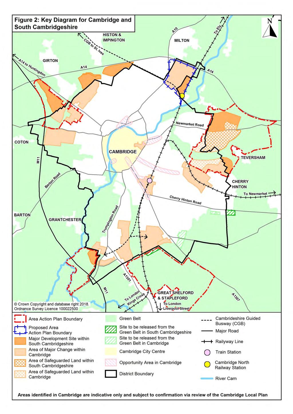
9 Contents LIST OF FIGURES Figure 1: Key Diagram for South Cambridgeshire 29 Figure 2: Key Diagram for Cambridge and South Cambridgeshire 30 Figure 3: Illustration of Major Development Areas at 60 West Cambridge, Darwin Green, North West Cambridge and Orchard Park Figure 4: Illustration of Major Development Sites at 61 Cambridge Biomedical Campus and Southern Fringe Figure 5: Illustration of Major Development Area and 62 Safeguarded Land at Cambridge East Figure 6: Illustration of Major Development Areas at Cambridge 63 Northern Fringe East and Cambridge North railway station Figure 7: Green Infrastructure Strategy Network 120 Figure 8: Minimum gross internal floor areas and storage (m 2 ) 152 Figure 9: Gypsy and Traveller need in South Cambridgeshire 161 Figure 10: Guide for On-site Provision of Open Space 210 Figure 11: Parking Provision 231 Figure 12: Cambridge Airport Air Safeguarding Zone 239 Figure 13: Imperial War Museum Duxford Air Safeguarding Zone 240 v
10 Contents INDEX OF POLICIES LP/1: Superseded Policies referred to in Adopted Area Action Plans 6 S/1: Vision 22 S/2: Objectives of the Local Plan 22 S/3: Presumption in Favour of Sustainable Development 23 S/4: Cambridge Green Belt 34 S/5: Provision of New Jobs and Homes 26 S/6: The Development Strategy to S/7: Development Frameworks 32 S/8: Rural Centres 33 S/9: Minor Rural Centres 34 S/10: Group Villages 35 S/11: Infill Villages 36 S/12: Phasing, Delivery and Monitoring 37 S/13: Review of the Local Plan 40 SS/1: Orchard Park 46 SS/2: Land between Huntingdon Road and Histon Road 49 SS/3: Cambridge East 55 SS/4: Cambridge Northern Fringe East and Cambridge North railway 57 station SS/5: Northstowe Extension 64 SS/6: Waterbeach New Town 64 SS/7: New Village at Bourn Airfield 72 SS/8: Cambourne West 78 CC/1: Mitigation and Adaptation to Climate Change 88 CC/2: Renewable and Low Carbon Energy Generation 90 CC/3: Renewable and Low Carbon Energy in New Developments 91 CC/4: Water Efficiency 92 CC/5: Sustainable Show Homes 93 CC/6: Construction Methods 94 CC/7: Water Quality 95 CC/8: Sustainable Drainage Systems 96 CC/9: Managing Flood Risk 97 HQ/1: Design Principles 103 HQ/2: Public Art and New Development 106 NH/1: Conservation Area and Green Separation at Longstanton 112 NH/2: Protecting and Enhancing Landscape Character 113 NH/3: Protecting Agricultural Land 114 NH/4: Biodiversity 115 NH/5: Sites of Biodiversity or Geological Importance 117 NH/6: Green Infrastructure 119 NH/7: Ancient Woodlands and Veteran Trees 121 NH/8: Mitigating the Impact of Development in and adjoining the Green 122 Belt NH/9: Redevelopment of Previously Developed Sites and Infilling in the 122 Green Belt vi
11 Contents NH/10: Facilities for Recreation in the Green Belt 123 NH/11: Protected Village Amenity Areas 124 NH/12: Local Green Space 124 NH/13: Important Countryside Frontage 125 NH/14: Heritage Assets 126 NH/15: Heritage Assets and Adapting to Climate Change 129 H/1: Allocations for Residential Development at Villages 134 H/2: Bayer CropScience Site, Hauxton 138 H/3: Fulbourn and Ida Darwin Hospitals 140 H/4: Papworth Everard West Central 142 H/5: Fen Drayton Former Land Settlement Association Estate 143 H/6: South of A1307, Linton 144 H/7: Residential Moorings 144 H/8: Housing Density 145 H/9: Housing Mix 145 H/10: Affordable Housing 148 H/11: Rural Exception Site Affordable Housing 150 H/12: Residential Space Standards 151 H/13: Extensions to Dwellings in the Countryside 153 H/14: Replacement Dwellings in the Countryside 154 H/15: Countryside Dwellings of Exceptional Quality 155 H/16: Development of Residential Gardens 156 H/17: Re-use of Buildings in the Countryside for Residential Use 157 H/18: Working at Home 157 H/19: Dwellings to Support a Rural-based Enterprise 158 H/20: Provision for Gypsies and Travellers and Travelling Showpeople 160 H/21: Gypsy and Traveller Provision at New Communities 162 H/22: Proposals for Gypsies, Travellers and Travelling Showpeople 164 Sites on Unallocated Land Outside Development Frameworks H/23: Design of Gypsy and Traveller Sites, and Travelling Showpeople 166 Sites E/1: New Employment Provision near Cambridge Cambridge Science 173 Park E/2: Cambridge Biomedical Campus Extension 174 E/3: Fulbourn Road East (Fulbourn) 6.9 hectares 177 E/4: Allocations for Class B1 Employment Uses 177 E/5: Allocations for Class B1, B2 and B8 Employment Uses 177 E/6: Papworth Hospital 178 E/7: Imperial War Museum at Duxford 180 E/8: Mixed-use development in Histon & Impington Station Area 181 E/9: Promotion of Clusters 183 E/10: Shared Social Spaces in Employment Areas 184 E/11: Large Scale Warehousing and Distribution Centres 184 E/12: New Employment Development in Villages 185 E/13: New Employment Development on the Edges of Villages 185 E/14: Loss of Employment Land to Non Employment Uses 196 E/15: Established Employment Areas 187 vii
12 Contents E/16: Expansion of Existing Businesses in the Countryside 188 E/17: Conversion or Replacement of Rural Buildings for Employment 189 E/18: Farm Diversification 190 E/19: Tourist Facilities and Visitor Attractions 191 E/20: Tourist Accommodation 192 E/21: Retail Hierarchy 192 E/22: Applications for New Retail Development 192 E/23: Retailing in the Countryside 193 SC/1: Allocation for Open Space 200 SC/2: Health Impact Assessment 201 SC/3: Protection of Village Services and Facilities 201 SC/4: Meeting Community Needs 202 SC/5: Community Healthcare Provision 206 SC/6: Indoor Community Facilities 206 SC/7: Outdoor Play Space, Informal Open Space and New 207 Developments SC/8: Protection of Existing Recreation Areas, Allotments and 211 Community Orchards SC/9: Lighting Proposals 212 SC/10: Noise Pollution 213 SC/11: Contaminated Land 215 SC/12: Air Quality 216 SC/13: Hazardous Installations 218 SC/14: Odour and Other Fugitive Emissions to Air 219 TI/1: Chesterton Rail Station and Interchange 225 TI/2: Planning for Sustainable Travel 226 TI/3: Parking Provision 229 TI/4: Rail Freight and Interchanges 234 TI/5: Aviation-Related Development Proposals 235 TI/6: Cambridge Airport Public Safety Zone 237 TI/7: Lord s Bridge Radio Telescope 241 TI/8: Infrastructure and New Developments 242 TI/9: Education facilities 244 TI/10: Broadband 246 Crown copyright and database right Ordnance Survey Licence number The Ordnance Survey mapping included within this document is provided by South Cambridgeshire District Council under licence from the Ordnance Survey in order to fulfil its public function to make available Council help public domain information. Persons viewing this mapping should contact Ordnance Survey copyright for advice where they wish to licence Ordnance Survey mapping/map data for their own use. The OS web site can be found at viii


13 Chapter 1 Introduction Histon, South Cambridgeshire
14
15 Chapter 1 Introduction Chapter 1 Introduction 1.1 This is the Local Plan for South Cambridgeshire. It updates and replaces the South Cambridgeshire Local Development Framework which was adopted between January 2007 and January 2010 and covered the period up to The Local Plan s policies and proposals cover the period 2011 to The Local Plan is founded on an extensive evidence base of studies and two rounds of public consultation on issues and options which were held between mid-july and end-september 2012 and mid-january to end-february Consultation on the Proposed Submission Local Plan was undertaken in summer 2013, before the plan was Submitted for Examination in March Further consultation was carried out on proposed modifications in 2015 and The Local Plan has been prepared in close cooperation with Cambridge City Council and Cambridgeshire County Council and its policies and proposals have been subject to sustainability appraisal through all stages of preparation. The Council has also worked with the local authorities in Cambridgeshire, Suffolk and Norfolk to produce a Strategic Housing Market Assessment (SHMA) to determine the amount of housing and jobs growth that will need to be accommodated by 2031 and agreed a memorandum of cooperation about how that need will be met. 1.2 The Local Plan affects all of us that live, work or study in South Cambridgeshire, or who come here to enjoy all that the area has to offer. About South Cambridgeshire 1.3 South Cambridgeshire is consistently recognised as one of the top places to live and work in the country due to our thriving economy and quality of life. Our successful local economy is important on a national stage and South Cambridgeshire is one of the fastest growing areas in the country. 1.4 South Cambridgeshire is located centrally in the East of England region at the junction of the M11 / A14 roads and with direct rail access to London and to Stansted Airport. It is a largely rural district which surrounds the city of Cambridge and comprises over 100 villages, none currently larger than 8,000 persons. It is surrounded by a ring of market towns just beyond its borders, which are generally miles from Cambridge. Together, Cambridge, South Cambridgeshire and the Market Towns form the Cambridge Sub-Region. South Cambridgeshire has long been a fast growing district and in 2011 had a population of 146,800 persons (bigger than Cambridge itself) and has become home to many of the clusters of high technology research and development in the Cambridge Sub-Region. What the Plan Does and How it was Prepared 1.5 The Plan aims to strike the right balance between growth and conservation, valuing what makes the area unique. It is about making sure jobs are created, and new homes provided, in the right areas, and that all transport needs are 3
16 Chapter 1 Introduction considered and people have a choice about where to live so they do not have to rely on cars for all of their journeys. 1.6 The Local Plan sets the levels of employment and housing development that should be provided over the plan period to best meet the needs of the area and establish a clear strategy for meeting development needs in the most sustainable way that protects the quality of life of existing and future residents. Its policies aim to ensure that development is of high quality and will meet the challenges we face with an ageing population and changing climate. It will ensure that new development comes with the necessary schools, health facilities, shops, leisure facilities and open spaces that residents need to provide a good quality of life. 1.7 The Local Plan sets a strong framework for new development to meet the needs of the area and provide a clear statement for local residents, businesses, service providers and the development industry of what they can expect to happen in terms of change in the built and natural environment over the next couple of decades. 1.8 The updated Local Plan responds to the National Planning Policy Framework (NPPF, ), the Localism Act 2011 and to proposed changes to the ways in which developers will contribute to funding supporting services and infrastructure through Section 106 contributions and the Community Infrastructure Levy (CIL). 1.9 Underpinning the whole of the Plan is the Government s commitment to sustainable development. Taking account of local circumstances, the new Local Plan s development and other proposals aim to meet the 3 overarching principles of sustainability: Economic contributing to building a strong, responsive and competitive economy by ensuring that sufficient land of the right type is available in the right places and at the right time to support growth and innovation; and by identifying and coordinating development requirements, including the provision of infrastructure; Social supporting strong, vibrant and healthy communities, by providing the supply of housing required to meet the needs of present and future generations; and by creating a high quality built environment, with accessible local services that reflect the community s needs and support its health, social and cultural wellbeing; and Environmental contributing to protecting and enhancing our natural, built and historic environment; and, as part of this, helping to improve biodiversity, prudent use of natural resources, minimising waste and pollution, and mitigating and adapting to climate change including moving to a low carbon economy. 1 The updated National Planning Policy Framework (NPPF) (published in July 2018) states that the policies in the previous framework (i.e. NPPF 2012) apply where the Local Plan was submitted to the Secretary of State for examination before 24 January 2019 (NPPF 2018, paragraph 214). The South Cambridgeshire Local Plan was submitted in March 2014 and references to the NPPF in this Local Plan refer to the NPPF 2012 and not the NPPF
17 Chapter 1 Introduction 1.10 The overarching objective in national policy to secure sustainable development strongly influenced the development of the Plan. The Council prepared a Sustainability Appraisal Scoping Report that has helped us identify the key issues and sustainability objectives for the new Local Plan. An Initial Sustainability Report was also prepared, which tested the sustainability merits of the issues and options which were considered and tested in producing the Plan. The draft Final Sustainability Report also includes an analysis of the issues identified, the options available to address them, the results of consultation on reasonable options, and how the proposed policies were arrived at. A Sustainability Appraisal Addendum was produced in 2015, to take account of new evidence prepared in response to the Inspectors Letter during the Local Plan Examination. Following the Examination Hearings proposed modifications were also subject to sustainability appraisal. What the Plan Looks Like 1.11 The Plan includes a vision, strategic objectives and specific chapters relating to the future spatial strategy and other matters which will affect how we live and work over the next two decades. Each chapter provides key facts about the topic. The chapters are as follows: Chapter 1: Introduction which describes the overall purpose of the document. Chapter 2: Spatial Strategy sets out the vision and objectives and development needs for South Cambridgeshire to 2031 together with the spatial strategy which focuses development on the edge of Cambridge, at new towns/new villages; and in selected villages. It also has policies for small scale development in villages. It includes a policy about phasing, delivering and monitoring of the Plan to ensure that it continues to meet its objectives. Chapter 3: Strategic Sites contains the strategic sites that will contribute most to the delivery of sustainable development in South Cambridgeshire. Chapter 4: Climate Change is concerned with sustainable development, climate change, water resources and flooding. Chapter 5: Delivering High Quality Places is concerned with design, landscape, and public realm. Chapter 6: Protecting and Enhancing the Natural and Historic Environment contains proposals to protect and enhance the historic built and the natural environment. Chapter 7: Delivering High Quality Homes is concerned with delivering high quality housing and includes village housing sites. Chapter 8: Building a Strong and Competitive Economy deals with building a strong and competitive economy, including sections on employment, retail and tourism and development sites. Chapter 9: Promoting Successful Communities is concerned with creating successful communities, including the provision of open space, leisure facilities and community facilities. 5
18 Chapter 1 Introduction Chapter 10: Promoting and Delivering Sustainable Transport and Infrastructure deals with promoting and delivering sustainable transport and other kinds of infrastructure Responding to the introduction of Neighbourhood Development Plans under the Localism Act 2011, the Local Plan includes Parish Council proposals where there is clear local support, as an alternative to the preparation of Neighbourhood Plans. What Comprises the Development Plan for South Cambridgeshire 1.13 In the past, strategic planning for South Cambridgeshire was undertaken at a higher plan making level, most recently through the Cambridgeshire and Peterborough Structure Plan 2003 and the Regional Spatial Strategy (the East of England Plan 2008). Both these documents have now been revoked and strategic planning is now undertaken at a local level, coordinated by a statutory duty to cooperate. This cooperation has in part been through the oversight provided by Cambridgeshire and Peterborough Joint Strategic Planning Unit which was set up to help coordinate the development of strategy with South Cambridgeshire District Council, Cambridgeshire County Council and other local planning authorities and stakeholders in the area On adoption of this Plan, the statutory development plan for South Cambridgeshire will comprise: South Cambridgeshire Local Plan; Northstowe Area Action Plan 2007 (excluding Policy NS/3(1g), which is replaced by Policy SS/5: Northstowe Extension); Cambridge Southern Fringe Area Action Plan 2008; Cambridge East Area Action Plan 2008 (excluding policies CE/3 and CE/35, which are replaced by Local Plan Policy SS/3: Cambridge East); North West Cambridge Area Action Plan 2009; and Cambridgeshire and Peterborough Minerals and Waste Local Development Framework Core Strategy and Proposals Map C 2011, Site Specific Proposals Plan and Proposals Map A and B Policy LP/1: Superseded Policies referred to in Adopted Area Action Plans Where policies of the Local Development Framework referred to in adopted Area Action Plans are superseded by policies of this Local Plan, the more up to date Local Plan polices will be applied, as set out in Appendix B The adopted Area Action Plans remain part of the development plan, and in places make reference to policies in other parts of the Local Development Framework, in particular the Core Strategy DPD and Development Control Policies DPD. For clarity on the policies to be applied in decision making 6
19 Chapter 1 Introduction involving the Area Action Plan sites, where reference is made in an Area Action Plan to a policy elsewhere in the Local Development Framework, the replacement policy in the Local Plan will apply. A schedule is included in Appendix B of the plan, identifying the relevant references in the adopted Area Action Plans that are superseded by the Local Plan and the Local Plan policies that will be applied Also on adoption of the Local Plan, the South Cambridgeshire Local Development Framework Core Strategy 2007, Development Control Policies DPD 2007, Site Specific Policies DPD 2010 and saved Policy CNF6 from the South Cambridgeshire Local Plan 2004 will be revoked in their entirety and will no longer form part of the development plan The Local Plan proposes the preparation of new Supplementary Planning Documents and an Area Action Plan to guide development in three areas of large scale development: Bourn Airfield new village Supplementary Planning Document; Waterbeach new town Supplementary Planning Document; and Cambridge Northern Fringe East Area Action Plan prepared jointly with Cambridge City Council These documents will be prepared after the Local Plan is adopted. Strategic policies and neighbourhood planning 1.19 There is a list of basic conditions in the Town and Country Planning Act 1990 that must be met by a Neighbourhood Plan before it can be successful at independent examination and ultimately adopted by a Local Planning Authority. One of these is that any draft Neighbourhood Plan must be in general conformity with the strategic policies contained in the development plan for the district. According to the National Planning Policy Framework (NPPF, 2012) a local planning authority should set out clearly the strategic policies for their area (paragraph 184) The Council has therefore used the guidance provided within the NPPF (2012) and in the National Planning Practice Guidance to define the strategic policies in the South Cambridgeshire Local Plan. Appendix E includes a list of the identified strategic policies to provide clarity for neighbourhood plan purposes. 7
20

21 Chapter 2 Spatial Strategy
22
23 Chapter 2 Spatial Strategy Chapter 2 Spatial Strategy 2.1 A number of factors contribute to quality of life and help make South Cambridgeshire such a good place to live, work and study. The successful economy, attractive villages, high quality new developments, and the quality of the local environment all come together to give the district its particular character. The relationship with Cambridge and the focus it provides for shopping, entertainment, culture and services for residents of South Cambridgeshire is also significant and a number of major new developments in the district lie on the edge of Cambridge. Parts of the area also look to surrounding market towns for services and employment. 2.2 For the success of the district to continue, it is important to make sure the Local Plan provides for the appropriate levels of growth with the right strategy that will deliver sustainable development. The Local Plan must provide for appropriate levels of employment so the Cambridge area can continue to develop as part of the home of one of the largest clusters of research and development activity in Europe, with housing in the right locations to support the local economy and provide for housing needs. It must do this whilst maintaining the quality of life for residents in existing and new communities, as well as the quality of the natural and built environment. It must also continue to provide an attractive rural hinterland and setting for the historic city of Cambridge, with those parts closer to Cambridge being protected by the Cambridge Green Belt. 2.3 This chapter sets out the vision and objectives for the Local Plan, including an overarching emphasis on delivering sustainable development. It establishes the number of jobs and homes to meet the objectively assessed needs of the district for the period to Key to the continued success of South Cambridgeshire is bringing together the three strands of economy, social and environment to ensure a sustainable future for the district over the period to 2031 and beyond. There will be considerable change, not least with significant developments already planned at the new town of Northstowe and on the Cambridge fringes as well as in surrounding areas such as at Alconbury Enterprise Zone, and this chapter plans for further major new developments to meet additional needs to The objective is that these new developments will become successful, vibrant, healthy new communities. As part of a sequential policy of encouraging a more sustainable pattern of living, only limited development to meet local needs will take place within villages in the district, with most of that limited development focussed into the larger, more sustainable villages. The emphasis will be on providing quality homes for all, including affordable housing to meet local needs, located where it has good access to services and facilities by sustainable modes of transport, to ensure the creation of sustainable and balanced communities. 11
24 Chapter 2 Spatial Strategy Key Facts: The Cambridge area has proved relatively resilient to the impacts of the downturn, with significant jobs growth forecast over the plan period, although significantly lower than had been anticipated by the East of England Plan There is a high level of housing required in the district; some to support natural growth but mainly to support the growing economy. Around 25% of the district around Cambridge is designated as Green Belt. Previous plans shifted the balance of development away from villages towards the edge of Cambridge (through review of the Green Belt), the new town of Northstowe and larger villages. Settlements have a varied and distinct local character, ranging from compact hamlets to larger villages. Access to services and jobs for many is inconvenient, due to limited public transport in villages away from main transport corridors. 56% of our population live in villages without a doctors surgery, primary school and food shop. The proportion of people that feel they can influence local decisions is higher in South Cambridgeshire than the national average. Evolving the Strategy and Overview 2.4 A range of issues have been considered in evolving the development strategy for the Local Plan for the period 2011 to 2031, including: the previous development strategy for 1999 to 2016 contained in the Local Development Framework (adopted between ), how it came about and progress in delivering the strategy; identifying objectively assessed needs for the area for the plan period , working jointly with other authorities in the housing market area; the Duty to Cooperate introduced by the Localism Act 2011; considering the appropriate strategy jointly with Cambridge City Council for the Councils respective Local Plans given the close relationship between the two areas, in particular: o whether the previous development sequence remained the most appropriate; o whether there was a case for a further review of the Green Belt; o undertaking a further Green Belt review; o considering any reasonable options for development on the edge of o Cambridge; considering allocation of further new settlements and strategic scale village development; the emerging Transport Strategy for Cambridge and South Cambridgeshire; a comparison between the evolving development strategy and the previous strategy. 12
25 Chapter 2 Spatial Strategy The Development Strategy 1999 to The strategy for the Cambridge area between 1999 and 2016 stemmed from work undertaken by Cambridge Futures (an influential group of local stakeholder organisations), which influenced the Regional Plan for East Anglia 2000 and the Cambridgeshire and Peterborough Structure Plan Prior to that, development in Cambridge had been constrained by the Green Belt. One of the effects of this constraint was that housing development that would otherwise have taken place in Cambridge was dispersed to towns and villages beyond the outer boundary of the Green Belt, with people commuting back to jobs in Cambridge contributing to congestion, greenhouse gas emissions, air quality problems and other quality of life issues. The change in strategy introduced in the Regional Plan and the Structure Plan recognised that a significant change in the approach to development in and close to the city was required in order to help redress an imbalance between homes and jobs in and close to Cambridge, whilst maintaining the special qualities of Cambridge and the surrounding area which are protected by a Green Belt. It also responded to the need to provide for the long-term growth of the University of Cambridge and Addenbrooke s Hospital, whilst minimising increases in congestion on radial routes into the city. 2.6 The Cambridge Local Plan (2006) and South Cambridgeshire Local Development Framework (adopted between 2007 and 2010) introduced a step change in levels of planned growth, unmatched since the interwar years, as the economy performed strongly in the early years of the new century. The Plans released significant land from the Cambridge Green Belt as identified in the Structure Plan, and allocated a number of urban extensions to the city in the south, north west, north east and east as well as the new town of Northstowe. Very little new development was proposed in the rural area, although a significant amount of housing already planned in villages under previous plans was still being built. 2.7 The main change that has taken place since the Local Development Framework was adopted is that the full development at Cambridge East, comprising 10,000-12,000 new homes, along with employment, shops and services in both Cambridge and South Cambridgeshire would not come forward in the plan period. It had been envisaged that around 7,500 new homes would be built in South Cambridgeshire. Marshall announced in April 2010 that it intends to remain at Cambridge Airport until at least Two areas of land in South Cambridgeshire are still intended to come forward in the plan period and the existing Area Action Plan provides a policy framework for those proposals, as confirmed by Policy SS/3 of the Local Plan. 2.8 Significant progress had already been made in delivering the strategy from the Local Development Framework at the time of preparing the Local Plan. The major existing sites in South Cambridgeshire that remain available and deliverable and which were found to be sound / sustainable locations for development by independent inspectors who examined the Local Development Framework are carried forward into the Local Plan. Whilst there was a slowdown in the delivery of these sites at the start of the recession, good progress is now being made. The major sites are: 13
26 Chapter 2 Spatial Strategy Edge of Cambridge: Trumpington Meadows 600 homes, with planning permission as part of a wider development of 1,200 which includes land in Cambridge City Council s area. North West Cambridge 1,155 homes in South Cambridgeshire with planning permission as part of a wider development of 3,000 homes which includes land in Cambridge City Council s area, to meet the needs of Cambridge University. Land between Huntingdon Road and Histon Road named Darwin Green, originally allocated for 1,100 homes but the capacity assumption has been revised to 900 dwellings in the light of pre-application discussions to allow a more appropriate density of development. Policy SS/2 identifies a larger site boundary than in the Site Specific Policies DPD, bringing capacity to approximately 1,000 dwellings. Land north of Newmarket Road Outline Planning permission granted in 2016 for development of approximately 1,300 homes. Land north of Cherry Hinton The Cambridge East AAP identified that it may be possible for this area to come forward ahead of relocation of the airport. Policy SS/3 identifies 420 homes in South Cambridgeshire as part of a wider development of 1,200 homes which includes land in Cambridge City Council s area. New settlement: Northstowe new town of 10,000 homes, first phase of which was granted planning permission in 2014 for 1,500 homes and a development framework plan for the whole new settlement agreed at the same time. Phase 2, 3,500 homes, was granted outline planning permission in Objectively Assessed Needs for New Jobs and Homes 2.9 A key role of the Local Plan is to provide for the development needs of the district over the plan period to Population growth and the continued success of the Cambridge and South Cambridgeshire economies are important drivers for further growth. There is a strong link between jobs and homes and it is important that the Local Plan provides an appropriate balance that will provide jobs for the whole community as well as supporting the nationally and internationally successful local economy with its focus on the high technology and research sectors, while at the same time delivering homes to meet the overall housing needs. This must be done while protecting the environment and what makes the area a successful and attractive place The National Planning Policy Framework (NPPF, 2012) requires that Local Plans should meet the objectively assessed housing, business and other development needs of an area in a positive and flexible way, unless any adverse impacts of doing so would significantly and demonstrably outweigh the benefits. This must involve using an evidence base to ensure that the Local Plan meets the full, objectively assessed needs for market and affordable housing in the local housing market area as far as is consistent with the policies set out in the NPPF (2012). Councils should work with neighbouring authorities where housing market areas cross administrative 14
27 Chapter 2 Spatial Strategy boundaries and the NPPF requires the preparation of a Strategic Housing Market Assessment (SHMA) to assess full housing needs The local authorities in the Cambridge Sub Region Housing Market Area have been working together for some time on a range of planning and housing issues and have prepared a joint SHMA, which was updated to inform the new Local Plans being prepared by Councils in the area. The Cambridge Sub Region SHMA 2012 identifies the objectively assessed need for housing in South Cambridgeshire and all other districts in the Cambridge Sub Region housing market area for the period (Chapter 12). The SHMA considers jobs forecasts as a key part of the analysis of the overall number of homes required to meet the development needs of the area for the period 2011 to It identifies the need for 22,000 additional jobs and 19,000 new homes in South Cambridgeshire. Additional independent technical evidence was prepared in 2015 to further consider need for new housing taking account of national guidance published after the plans were prepared. This identified the full Objectively Assessed Need for South Cambridgeshire as 19,337 homes. This has been rounded to 19,500 in the housing target for the plan period. Duty to Cooperate 2.12 The Localism Act 2011 establishes a Duty to Cooperate for local planning authorities in the preparation of their local plans. A key aspect of cooperation is around provision of jobs and homes to ensure that all the objectively assessed needs of the housing market area are met in full. The Cambridgeshire Authorities, together with Peterborough given the overlap between the two housing market areas, agreed a Memorandum of Cooperation (May 2013) that demonstrates that the full objectively assessed needs of the Cambridge Sub Region housing market area will be addressed. It confirms that South Cambridgeshire and Cambridge are both planning to meet their objectively assessed needs in full within their administrative areas in their new Local Plans A Memorandum of Understanding was also agreed between Cambridge City Council and South Cambridgeshire District Council in September 2014, which agrees that the housing trajectories for Cambridge and South Cambridgeshire, as updated each year in the Annual Monitoring Report, will be considered together for the purposes of phasing of housing delivery, including for calculating 5-year housing land supply in development management decisions that concern housing development The Duty to Cooperate also applies to county councils and a range of key public bodies with an interest in planning, including the Environment Agency, Historic England, Natural England, and the Highways England. The Council has engaged with relevant bodies throughout the issues and options stage and in the preparation of the Local Plan, in particular on assessment of site options for development. 15
28 Chapter 2 Spatial Strategy The Joint Spatial Approach for Cambridge and South Cambridgeshire 2.15 Interdependencies between the two administrative areas of Cambridge and South Cambridgeshire are well established through the location of key employment sites, patterns of travel to work and access to services and facilities. Both Councils have prepared new development plans that add to the development proposals from the Cambridge Local Plan 2006 and South Cambridgeshire Local Development Framework to meet the needs of the Cambridge area for the period to The Councils have a long history of joint working reflecting the strong interaction between the two administrative areas and the two authorities have worked closely together on the preparation of their Local Plans, including joint consultation on issues and options of shared interest For the review of their development plans, the Councils considered whether the strategy for 1999 to 2016 remained the most appropriate development strategy to 2031, or whether circumstances required an alternative approach. The interrelationship between Cambridge and South Cambridgeshire means that decisions cannot be taken in isolation and the approach in the Local Plans needed to remain joined up, as it has been in the past The Councils reviewed jointly how far the sustainable development strategy for 1999 to 2016 had progressed, what evidence there was that it was achieving its original objectives and what a new sustainable development strategy would look like in view of changes in economic and other circumstances. The objective to locate as many jobs and homes in and on the edge of Cambridge had to be considered within the context of a recently reviewed tightly drawn Green Belt, which aims to protect the unique character of Cambridge as a compact, dynamic city with a thriving historic centre, maintain and enhance the quality of the city s setting, and prevent the city merging with the ring of necklace villages A number of factors influenced the joint work on the evolution of the development strategy to 2031: As part of the review of the East of England Plan 2008 (the Regional Spatial Strategy for the East of England), which was subsequently abandoned, the Cambridgeshire authorities commissioned consultants to prepare the Cambridgeshire Development Study The study looked at how well the development strategy was working, forecasts for economic growth taking account of the beginning of the downturn, and how the strategy could be developed if further growth was needed. The study identified a range of challenges for growth. These included that significant additional expansion to Cambridge (where the economy is stronger) would impact on the integrity of the Green Belt and the concept of Cambridge as a compact city. The study also concluded that without deliverable solutions for transport and land supply, Cambridge-centered growth would be difficult to achieve, and would require a fundamental step change in traffic management and travel behaviour. The study recommended a spatial strategy for Cambridgeshire that was based on delivering the strategy in the Cambridge Local Plan 2006 and 16
29 Chapter 2 Spatial Strategy South Cambridgeshire Local Development Framework but with further balanced expansion through regeneration in selected market towns, and focused on making best use of existing infrastructure. However, it did indicate that some additional growth could be located on the edge of Cambridge incorporating a limited review of the Green Belt boundary, and potential for a further new settlement to attract employment opportunities and be supported by adequate transportation and social infrastructure, although highlighted the challenges associated with this. As part of the plan making process, the two Councils jointly commissioned a review of the development strategy by the Cambridgeshire and Peterborough Joint Strategic Planning Unit to help test whether the development sequence remained the most appropriate for the Councils respective new Local Plans. The Cambridge and South Cambridgeshire Sustainable Development Strategy 2012 provided a broad overview of the sustainability of different spatial options. Its findings were that the most sustainable focus for development was within and on the edge of Cambridge; development in market towns scored broadly the same as development of new settlements, with recognition that large free-standing developments present delivery challenges over long timescales. Development at the more sustainable villages was confirmed as the least sustainable location which, depending on the scale of development involved, could be mitigated by access to good quality public transport. However, within this broad assessment, the Strategy identified that there were considerable issues and complexities to resolve. The assessment did not take account of the committed development sites and locations in plans or the more detailed issues associated with the assessment and choice of new sites and locations. It recognised that detailed assessments needed to be undertaken in relation to development options and transport capacity at different locations, as well as critical policy issues such as the effect of development on the openness of the Green Belt and the purposes of including land within it. The Green Belt boundary on the edge of Cambridge was established in the Cambridge Local Plan 2006 and the South Cambridgeshire Local Development Framework with the expectation that its boundaries could endure beyond the end of the plan period of However, circumstances changed with the decision to keep the current businesses at Cambridge Airport, and whilst good progress had been made towards achieving the current development strategy as a whole, the Councils needed to consider as part of preparing their Local Plans whether there were exceptional circumstances for reviewing Green Belt boundaries again. The Councils took a joined up approach in the Issues and Options consultations in Summer 2012 and asked whether there should be more development on the edge of Cambridge, if there should be more land released from the Green Belt, and if so, where should this be. Ten Broad Locations around the edge of Cambridge were consulted on to explore whether any had potential to be released from the Green Belt for housing. 17
30 Chapter 2 Spatial Strategy This was followed up by a joint review of the Green Belt, to provide detailed and up to date evidence on the potential impact of further releases on the purposes of the Green Belt and the setting of the City. The update found that most of the inner Green Belt continues to be of high importance for Green Belt purposes and specifically important to protect the setting and special character of Cambridge as a compact historic city. The adjacent areas to the previous releases are also considered to have gained a greater value to the purposes of the Green Belt. Considering sites submitted through the Councils respective Strategic Housing Land Availability Assessments call for sites and identified through the joint Inner Green Belt Study Review 2012, a total of 41 sites were tested, using a joint pro-forma drawing on both Councils Sustainability Appraisals. Following the assessment, 6 sites in the Green Belt on the edge of Cambridge were identified as being sites with development potential, albeit with some constraints or adverse impacts. These sites were subject to public consultation in January 2013 and subsequently identified as appropriate to include in the Local Plans. In response to issues raised by the Inspectors during the Local Plan Examination, the Councils commissioned a new independent Inner Green Belt Review in This also concluded that beyond those locations already identified in the submission Local Plans it is unlikely that any development could be accommodated without substantial harm to Green Belt purposes (in most locations around the edge of the City). Additional work was carried to consider sites on the edge of Cambridge on an equal basis with other sites, through transport modelling and Sustainability Appraisal. Work was also undertaken on an updated Infrastructure Delivery Study and Viability Report with a Development Strategy document that drew together the findings of all the additional work. The Development Strategy Update and the Joint Sustainability Appraisal Addendum set out how the issue of Green Belt was considered through the plan making process, meeting the requirements of paragraphs 84 and 85 of the NPPF to consider the sustainability impacts of developing outside the Green Belt compared with removing land from the Green Belt for development. This work confirmed the approach to the development strategy. Further work was also undertaken to demonstrate that the transport measures necessary to support sustainable new settlements are capable of being delivered. The Greater Cambridge City Deal (now known as Greater Cambridge Partnership) provided a position statement in March 2016 that confirms the City Deal partners are wholly committed to delivery of the infrastructure programme for the benefit of existing and future residents and businesses through the provision of an enhanced transport network that provides good quality connectivity between homes and jobs, including supporting and securing new development provided for in the Local Plans through the delivery of key infrastructure schemes. The Councils undertook a joint Sustainability Appraisal of the overall strategy as part of the plan making process. A range of options around the impact of 18
31 Chapter 2 Spatial Strategy different levels of growth in the Green Belt on the edge of Cambridge, the approach to new settlements, major expansion of Cambourne and the best available sites at villages were identified and tested through Sustainability Appraisal, to consider the relative impact of different development packages. This included looking at different levels of growth at some of the site options to minimise adverse impacts and secure the most sustainable form of development. It identified the importance of balancing the accessibility aspects of sustainable development and the environmental and social aspects. This appraisal was updated in 2015, to take account of new evidence prepared in response to Inspectors during the Local Plan Examination. It concluded that the removal of additional large scale sites from the Cambridge Green Belt could result in irreversible adverse impacts on the special character of Cambridge as a compact historic city and risk the economic success of the Cambridge area, which is in part built on its attractiveness as a place to live and work. It confirmed that new settlements offer focused opportunities for infrastructure improvements, opportunities to co-locate housing and employment, and achieve high modal share by sustainable transport than more dispersed strategies. Strategy development and options testing was guided by the Joint Strategic Transport and Spatial Planning Group (JST&SPG), the member governance group set up to guide the collaborative preparation of development plans in Cambridge and South Cambridgeshire and the associated Transport Strategy. The broad strategy options considered by the JST&SPG demonstrated that: o Focusing development on Cambridge remains the most sustainable location for additional development. The Cambridge Local Plan for the period 2011 to 2031 identifies significant potential within the urban area of Cambridge. o The edge of Cambridge is the next most sustainable location for growth in the development sequence and significant development will take place in the plan period on land already removed from the Green Belt. The new Cambridge Local Plan proposes modest further revisions to the Green Belt which means that Cambridge is able to meet its full objectively assessed needs within its administrative area, although it makes little additional contribution to South Cambridgeshire s objectively assessed needs. o After development on the edge of Cambridge, new settlements are the next most sustainable location for growth. South Cambridgeshire District Council considered a number of new settlement sites submitted through its call for sites as part of the Strategic Housing Land Availability Assessment and Sustainability Appraisal processes. This identified two options for a new town north of Waterbeach of different sizes and a new village at Bourn Airfield as options for consultation in Issues and Options Subsequently, versions of both sites were identified as appropriate to include in the Local Plan. 19
32 Chapter 2 Spatial Strategy o o Development in villages should continue to be limited for sustainability reasons. South Cambridgeshire District Council considered a strategic scale of village development at Cambourne submitted through its call for sites as part of the Strategic Housing Land Availability Assessment and Sustainability Appraisal processes. This identified the site as an option for consultation in Issues and Options 2012 and subsequently a version of the site was identified as appropriate to include in the Local Plan. The Joint Strategic Transport and Spatial Planning Group (JST&SPG) considered the additional evidence prepared in 2015 and confirmed the approach. The Transport Strategy for Cambridge and South Cambridgeshire 2.19 The development strategy was predicated upon delivering efficient, sustainable patterns and choices of travel between home and work. Data from the Census 2011 shows that Cambridge has the highest proportion of people cycling to work in the United Kingdom with the lifestyle conditions that are also more likely to promote cycle based commuting choices than anywhere else in the United Kingdom The Transport Strategy for Cambridge and South Cambridgeshire 2014 focuses on the capacity for sustainable modes of transport and what further measures need to be provided in the sub region between key economic hubs in and around the city, where people live, and where they access services. The development strategy locates development in areas where there is already good public transport or where it can be provided and concentrates development in rural South Cambridgeshire in major new developments as far as possible to support the greatest public transport improvements, so that further improvements can be made to the sustainable transport in and around the city by making movement straightforward and convenient. The Transport Strategy for Cambridge and South Cambridgeshire 2014 was prepared in parallel with the two new local plans and includes the mitigation and infrastructure requirements necessary to promote sustainable travel as part of the development strategy of the two plans. Comparing the Development Strategy to 2031 with the Structure Plan 2.21 As part of the preparation of the Local Plan strategy in the new Local Plans to 2031, the Councils considered the proportions of planned development at the different stages in the development sequence and then tested whether it broadly continues the strategy set in train by the Structure Plan in 2003 as a benchmark of whether it provides an appropriate sustainable pattern of development for the Cambridge area into the future. 20
33 Chapter 2 Spatial Strategy 2.22 The distribution of housing across the development sequence in the Local Plans is shown below: Cambridge Urban Area Edge of Cambridge New Settlements and Cambourne West Rural Area (including windfalls) Existing Completions and Commitments (both areas) New Sites Cambridge New Sites South Cambs TOTAL % 5,358 1, , , , , ,610 8, , , TOTAL 27,457 2,360 5,956 35, Source: Housing Trajectory November This compares with the proportions at each stage in the sequence in the Structure Plan as shown below: Structure Plan 1999 to 2016 % New Local Plan Strategy 2011 to 2031 (both areas) Cambridge Urban Area 8, , Cambridge Fringe Sites 8, , New settlements 6, , Villages 9, , TOTAL 1999 to , , Source: Housing Trajectory November The development strategy identified in the Local Plans includes development at all stages in the sequence across both areas, taking account of the opportunities and constraints identified. It compares favourably with the Structure Plan with Cambridge remaining the focus of the development strategy comprising 54% of the housing requirement of both Councils 2011 to This is comparable with and slightly higher than the 52% in the Structure Plan strategy. The strategy has 35% of all new development planned on the edge of Cambridge, higher than the 25% in the Structure Plan, notwithstanding that Cambridge East is not now expected to come forward in the plan period at least. The main change is the swap in South % 21
34 Chapter 2 Spatial Strategy Cambridgeshire between the proportion of development at new settlements and that at villages which sees a much higher proportion at new settlements than the previous strategy: 23% compared with 18%. This leaves the lowest percentage at the least sustainable stage in the sequence with only 23% of planned development identified at villages. Vision and Objectives 2.25 The Local Plan contains policies and proposals which will shape the future direction of change in South Cambridgeshire over the years to The planning decisions that will be made in accordance with the Local Plan will affect the future well-being of people living and working in the district as well as others who visit and invest in South Cambridgeshire. This future direction is captured in the Council's vision, which has been drawn upon as the vision for the Local Plan. Policy S/1: Vision South Cambridgeshire will continue to be the best place to live, work and study in the country. Our district will demonstrate impressive and sustainable economic growth. Our residents will have a superb quality of life in an exceptionally beautiful, rural and green environment Reflecting the vision, are a set of more specific objectives for the Local Plan. In developing the objectives the Council has been guided by views gathered on what is important to local stakeholders. Policy S/2: Objectives of the Local Plan The vision for the Local Plan will be secured through the achievement of 6 key objectives: a. To support economic growth by supporting South Cambridgeshire's position as a world leader in research and technology based industries, research, and education; and supporting the rural economy. b. To protect the character of South Cambridgeshire, including its built and natural heritage, as well as protecting the Cambridge Green Belt. New development should enhance the area, and protect and enhance biodiversity. c. To provide land for housing in sustainable locations that meets local needs and aspirations, and gives choice about type, size, tenure and cost. d. To deliver new developments that are high quality and well-designed with distinctive character that reflects their location, and which responds robustly to the challenges of climate change. (continued) 22
35 Chapter 2 Spatial Strategy e. To ensure that all new development provides or has access to a range of services and facilities that support healthy lifestyles and well-being for everyone, including shops, schools, doctors, community buildings, cultural facilities, local open space, and green infrastructure. f. To maximise potential for journeys to be undertaken by sustainable modes of transport including walking, cycling, bus and train South Cambridgeshire is a prosperous area with high levels of economic activity and low levels of unemployment. Its 350 square miles of countryside provide a high quality setting for its 105 settlements. In recent decades the district has experienced significant growth, reflecting the success of the local economy and the need for new homes. These high levels of growth have managed to balance development with maintaining a high quality social, built and natural environment which is valued locally and has ensured that South Cambridgeshire regularly performs well in national quality of life surveys. Public consultation in updating the Local Plan showed strong support for supporting economic growth, but a degree of nervousness amongst the residents of the district believing that continuing high levels of growth would put the environment and living standards at risk. This then is a clear challenge for the way in which the vision and objectives are implemented through policies and proposals in the Local Plan and decisions on planning applications to provide an appropriate balance between supporting the economy, providing for housing needs and protecting the environment. Sustainable Development Policy S/3: Presumption in Favour of Sustainable Development 1. When considering development proposals the Council will take a positive approach that reflects the presumption in favour of sustainable development contained in the National Planning Policy Framework. It will always work proactively with applicants jointly to find solutions which mean that proposals that accord with the Local Plan and Neighbourhood Plans can be approved wherever possible, and to secure development that improves the economic, social and environmental conditions in the area unless material considerations indicate otherwise. 2. Where there are no policies relevant to the application or relevant policies are out of date at the time of making the decision then the Council will grant permission unless material considerations indicate otherwise taking into account whether: (continued) 23
36 Chapter 2 Spatial Strategy a. Any adverse impacts of granting permission would significantly and demonstrably outweigh the benefits, when assessed against the policies in the National Planning Policy Framework taken as a whole; or b. Specific policies in that Framework indicate that development should be restricted The National Planning Policy Framework (NPPF, 2012) states that the purpose of planning is to help achieve sustainable development, and the NPPF (2012) has at its heart a presumption in favour of sustainable development, which it says should be seen as a golden thread running through both plan making and decision taking. For South Cambridgeshire, sustainable development means supporting the economic success of the Cambridge area, maintaining the setting of Cambridge as a compact historic city, and providing for development needs in a way that maintains the high quality of life enjoyed by residents that makes it such an attractive place to live, work and study, and locates new homes close to services and employment or on high quality public transport routes. The Local Plan has a number of chapters covering the full range of planning policy issues, which together contribute to the achievement of the three dimensions of sustainability: an economic role, a social role and an environmental role. Cambridge Green Belt Policy S/4: Cambridge Green Belt A Green Belt will be maintained around Cambridge that will define the extent of the urban area. The detailed boundaries of the Green Belt in South Cambridgeshire are defined on the Policies Map, which includes some minor revisions to the inner boundary of the Green Belt around Cambridge and to the boundaries around some inset villages. New development in the Green Belt will only be approved in accordance with Green Belt policy in the National Planning Policy Framework The Government attaches great importance to Green Belts, and this is set out in the NPPF(2012). The fundamental aim of Green Belt policy is to prevent urban sprawl by keeping land permanently open and a specific function of some Green Belts, such as the one around Cambridge, is to preserve the setting and special character of historic towns. Cambridge has had a Green Belt since the 1965 Development Plan, which includes about 25% of South Cambridgeshire. A review of the Green Belt was undertaken in the 1980s resulting in the Cambridge Green Belt Local Plan A further and more strategically significant review was started in the Regional Planning Guidance for East Anglia (RPG6) with locations for Green Belt release identified in the Cambridgeshire and Peterborough Structure Plan 2003 and detailed boundary changes made in the Cambridge Local Plan 2006 and the South Cambridgeshire Local Development Framework
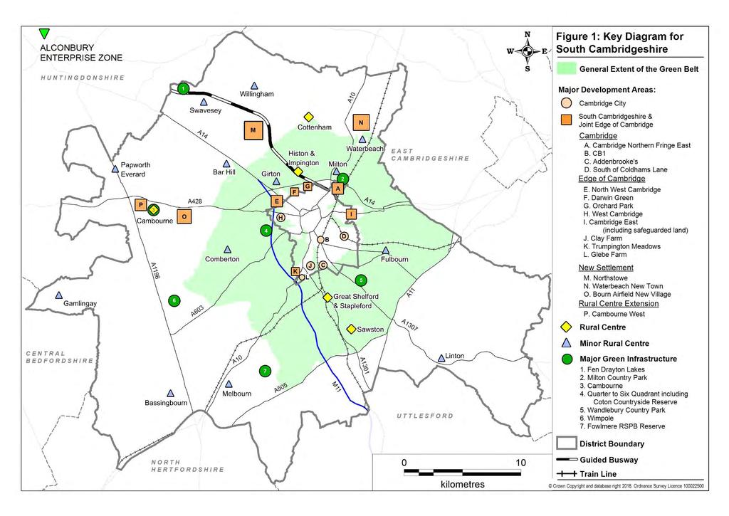
37 Chapter 2 Spatial Strategy 2.30 The Cambridge Green Belt surrounds Cambridge and is relatively small in extent, extending around 3 to 5 miles from the edge of the City and incorporates many of South Cambridgeshire s larger and most sustainable villages. The established purposes of the Cambridge Green Belt are to: Preserve the unique character of Cambridge as a compact, dynamic city with a thriving historic centre; Maintain and enhance the quality of its setting; and Prevent communities in the environs of Cambridge from merging into one another and with the city A number of factors define the special character of Cambridge and it's setting, which include: Key views of Cambridge from the surrounding countryside; A soft green edge to the city; A distinctive urban edge; Green corridors penetrating into the city; Designated sites and other features contributing positively to the character of the landscape setting; The distribution, physical separation, setting, scale and character of Green Belt villages; and A landscape that retains a strong rural character The NPPF (2012) is clear that where Green Belts are defined, they should only be altered in exceptional circumstances when preparing a Local Plan. When reviewing Green Belt boundaries, Councils are required to take account of the need to promote sustainable development and consider the consequences for sustainable development of channelling development towards urban areas within Green Belts, to villages inset within the Green Belt and to locations beyond the Green Belt The Inner Green Belt Review 2012, undertaken jointly with Cambridge City Council, examined the Green Belt in detail and found a number of small areas on the edge of Cambridge that are not considered of long term importance to Green Belt purposes. Given the level of need for homes and jobs, it is considered that exceptional circumstances exist to justify their release. These comprise a site between Huntingdon Road and Histon Road as an extension to the housing allocation carried forward from the Local Development Framework (Policy SS/2) and a site on Fulbourn Road as an extension to the Peterhouse Technology Park (Policy E/3). The independent Inner Green Belt Review 2015 for both Councils reached similar conclusions about the importance of land on the edge of Cambridge for Cambridge Green Belt purposes In addition, land is released from the Green Belt at Sawston, Impington and Comberton (Policy H/1) to meet the overall need for housing and to provide a flexible and responsive package of sites that will best meet identified needs. 25
38 Chapter 2 Spatial Strategy Provision of New Jobs and Homes Policy S/5: Provision of New Jobs and Homes Development will meet the objectively assessed needs in the district over the period for: a. 22,000 additional jobs to support the Cambridge Cluster and provide a diverse range of local jobs; b. 19,500 new homes, including affordable housing The Cambridge Sub-Region Strategic Housing Market Assessment 2012 (SHMA) took an integrated approach to the identification of the need for additional jobs and homes in South Cambridgeshire over the plan period. Additional assessment of Objectively Assessed Need was carried out in 2015 to take account of national planning guidance published after the submission of the Local Plan to consider issues around the latest national household projections, market signals and affordable housing For jobs, this takes account of the findings of two different local economic forecasting models alongside a range of national and local demographic forecasts, having regard to the proportion of economic growth expected to be created in South Cambridgeshire. The predicted level of jobs growth is provided for in full in the Local Plan as a key part of the continued support for the Council's vision to demonstrate impressive and sustainable economic growth. This will help maintain the role of the Cambridge area as a world leader in higher education, research and knowledge based industries and the important role of South Cambridgeshire, including a number of major research parks at Cambridge Science Park, Hinxton Hall and Granta Park The number of jobs is a forecast and not a target to be met at all costs. The Economy chapter (Chapter 8) provides a set of flexible policies that focus on delivering the types of employment appropriate to both support the Cambridge cluster and to provide a diverse range of local jobs to ensure a strong and vibrant local economy into the future. The Employment Land Review identifies that growth on this scale would generate a net demand for around 143,000m 2 of additional floorspace or 43 hectares of land in the B use classes. The Local Plan identifies a supply of land that is sufficient to provide the predicted 22,000 additional jobs and includes sufficient surplus that would also ensure that if the economy performs better than expected, the plan will not constrain economic potential. It also responds to demand in Cambridge identified in the Employment Land Review by identifying opportunities on the edge of Cambridge at the Science Park, around the new Cambridge North Railway Station, and next to the Peterhouse Technology Park It identifies a need for 19,000 new homes and 22,000 jobs in South Cambridgeshire by It provides a balance between jobs and homes across the HMA and confirms that there is no additional outstanding backlog arising from the Local Development Framework. 26
39 Chapter 2 Spatial Strategy 2.39 The Objectively Assessed Need: Further Evidence published in November 2015 takes account of national guidance published after the submission of the Local Plan, the CLG 2012 national household projections, market signals and affordable need. Compared with the SHMA methodology with its integrated approach to jobs and homes it is slightly higher. It identifies a need for 19,337 new homes in South Cambridgeshire by The higher of the two figures is taken to represent the full objectively assessed need for South Cambridgeshire and in the interests of positive planning has been rounded to 19,500 for the purposes of the plan requirement The SHMA includes consideration of need for affordable housing. Policy H/10 in Chapter 7: Delivering High Quality Homes requires the provision of affordable housing to respond to an identified high level of need. The Gypsy and Travellers Accommodation Assessment 2016 identifies no unmet objectively assessed need for pitches to meet the needs of Gypsies and Travellers for the period 2016 to It identifies a need for 11 plots for Travelling Showpeople. Policies in the High Quality Homes chapter provide more detail on how the needs of these groups will be met Over the plan period, the figure of 19,500 new homes implies an average delivery rate of 975 homes per year. While less than the Core Strategy 2007 annualised average of 1,176 homes, for comparison over the period 2001 to 2011 a total of 7,663 homes were built at an average of 766 homes per year and the Local Plan therefore represents a consistent step change in housing delivery over a lengthy period. The phasing of housing delivery is dealt with in Policy S/ Taking account of all forms of housing supply, comprising: completions in (the first four years of the plan period) of 2,735 homes; supply of housing on the existing allocations in adopted plans (including those with planning permission) expected by 2031 of 8,771 homes; unallocated sites with planning permission of 1,179 homes; and the Council s forecast windfall allowance of 2,450 homes, in 2015 the Council had a supply of 15,135 homes towards the 19,500 home requirement. This required sufficient new land to be identified to deliver a further 4,365 new homes in the district between 2011 and It will be important to monitor the need for jobs and homes regularly, as well as progress in delivery, and to review the Local Plan as necessary (see Policy S/12). 27
40 Chapter 2 Spatial Strategy The Development Strategy to 2031 Policy S/6: The Development Strategy to The need for jobs and homes will be met as far as possible in the following order of preference, having regard to the purposes of the Cambridge Green Belt: a. On the edge of Cambridge; b. At new settlements; c. In the rural area at Rural Centres and Minor Rural Centres. 2. Major site allocations from the South Cambridgeshire Local Development Framework together with the Area Action Plans for Northstowe (except as amended by SS/5), North West Cambridge, Cambridge Southern Fringe and Cambridge East (except as amended by Policy SS/3) are carried forward as part of the development plan to 2031 or until such time as the developments are complete. 3. The following 3 new strategic scale allocations are proposed for housing-led development with associated employment and supporting services and facilities to meet the majority of the additional development needs to 2031 and beyond: d. A new town north of Waterbeach for 8,000 to 9,000 homes; e. A new village based on Bourn Airfield for 3,500 homes; f. A major expansion of Cambourne for a fourth linked village of 1,200 homes, all of which by Development in the rural area will be limited, with allocations for jobs and housing focused on Rural Centres and Minor Rural Centres, and rural settlement policies providing for windfall development for different categories of village consistent with the level of local service provision and quality of public transport access to Cambridge or a market town. 28
41
42
43 Chapter 2 Spatial Strategy 2.44 The sustainable development sequence has been carried forward from the previous plan balancing the sustainability merits of land on the edge of Cambridge in terms of accessibility to services and facilities and reducing emissions with the sustainability merits of land in the Green Belt on the edge of Cambridge in terms of protecting the special characteristics of Cambridge as a compact historic city. Away from Cambridge, the most sustainable categories of village for development in the context of South Cambridgeshire are Rural Centres and Minor Rural Centres for the purposes of making allocations for new housing The development strategy for 2011 to 2031 is shown on the Key Diagrams (see Figures 1 and 2). A significant proportion of the overall housing requirement is made up of allocations carried forward from the previous plan and the policy clarifies that the adopted Area Action Plans for some of those developments remain part of the development plan alongside the Local Plan Cambridge City Council and South Cambridgeshire District Council jointly reached the view on the extent of change on the edge of Cambridge where only minor revisions to the inner Green Belt boundary are proposed in the Local Plans including a change to the boundary of the site between Huntingdon Road and Histon Road in South Cambridgeshire for housing that would not increase the overall number of homes currently planned but instead provide more room to ensure a high quality development (see Chapter 3 Strategic Sites, Policy SS/2), and employment allocations for the expansion of Cambridge Biomedical Campus, and south of Fulbourn Road as an extension to Peterhouse Technology Park (see Chapter 8 Promoting a Strong and Competitive Economy, Policies E/2 and E/3) Two new settlements a new town north of Waterbeach and a new village at Bourn Airfield - and a major village expansion at Cambourne will provide the majority of the additional housing required by The preference to allocate all three strategic sites was influenced by the long lead in times for new settlements which will therefore come forward later in the plan period and continue developing beyond Without including a major expansion of Cambourne, a significant amount of development would be required at villages and would result in the sort of dispersed development strategy confirmed as being unsustainable. In January 2017 the Council resolved to grant planning permission for a mixed use development including 2,350 homes at Cambourne West. The timing of development at Bourn Airfield new village has regard to the longer lead in times for the development of new settlements and so that the remainder of Cambourne is well progressed before any development starts at Bourn Airfield. This will also help provide additional flexibility and ensure a continuous supply of house building land The major sites will be supported by limited development at the more sustainable villages in the order of 900 homes to provide flexibility and help ensure a continuous supply of housing land over the plan period, including if there is any delay in progress on any of the major sites. These are addressed in Chapter 7: Delivering High Quality Homes. 31
44 Chapter 2 Spatial Strategy Development Frameworks Policy S/7: Development Frameworks 1. Development and redevelopment of unallocated land and buildings within development frameworks (as shown on the Policies Map) will be permitted provided that: a. Development is of a scale, density and character appropriate to the location, and is consistent with other policies in the Local Plan; and b. Retention of the site in its present state does not form an essential part of the local character, and development would protect and enhance local features of green space, landscape, ecological or historic importance; and c. There is the necessary infrastructure capacity to support the development; 2. Outside development frameworks, only allocations within Neighbourhood Plans that have come into force and development for agriculture, horticulture, forestry, outdoor recreation and other uses which need to be located in the countryside or where supported by other policies in this plan will be permitted Within settlements, policies in the plan generally support development and redevelopment of previously developed land subject to a range of policies which seek to ensure the development is sustainable The development frameworks define where policies for the built-up areas of settlements give way to policies for the countryside. This is necessary to ensure that the countryside is protected from gradual encroachment on the edges of villages and to help guard against incremental growth in unsustainable locations. In the countryside development is generally restricted to uses that need to be located there. The plan includes some flexibility for reusing existing buildings, and for development which supports the rural economy Frameworks have been defined to take into account the present extent of the builtup area, and planned development. Buildings associated with countryside uses (e.g. farm buildings, houses subject to agricultural occupancy conditions or affordable housing schemes permitted under the rural exceptions policy) are not normally included within the framework. Frameworks have not been defined around small clusters of houses or areas of scattered development where such buildings are isolated in open countryside or detached from the main concentration of buildings within Cambridge or a nearby village. Although it is recognised that such dwellings may be considered locally as 'part' of the nearest settlement in community terms, it is important in planning policy terms to limit the amount of new development that can take place in rural areas with few services and little or no public transport. 32
45 Chapter 2 Spatial Strategy 2.52 Property boundaries shown on the Ordnance Survey map have been taken into account in defining frameworks. However, since there are many large gardens on the edge of settlements, the framework boundaries sometimes cut across such gardens, especially (but not solely) if parts of those gardens relate more to the surrounding countryside than they do to the built-up areas. The 'cutting' of some gardens is regarded as a positive development control tool to limit the potential for further residential development in smaller villages with few facilities and little or no public transport. However, in such circumstances this policy will not be operated to establish a presumption against the grant of planning permission for ancillary domestic buildings in those parts of residential curtilages excluded from the framework. Where permission is required for such developments, applications will be considered on their individual merits. Strategy for the Rural Area 2.53 The Local Plan classifies villages into four groupings, to reflecting their relative sustainability. This is an important element of the sustainable development strategy, helping to direct housing to the most sustainable locations and control the level of windfall development that takes place in the least sustainable areas of the district whilst enabling the recycling of land and delivering new homes to meet local housing needs. Villages were classified following a review of the services and facilities, education, public transport and employment available at each settlement A local community preparing a neighbourhood plan may wish to make allocations for community led proposals in a neighbourhood plan that lie outside of the development framework of a village. As such are parish-led proposals the Council is supportive of such developments where they have received community support which means that the proposals are capable of being included in a neighbourhood plan. Rural Centres Policy S/8: Rural Centres 1. The following villages are identified as Rural Centres: a. Cambourne b. Cottenham c. Great Shelford and Stapleford d. Histon and Impington e. Sawston 2. Development and redevelopment without any limit on individual scheme size will be permitted within the development frameworks of Rural Centres, as defined on the Policies Map, provided that adequate services, facilities and infrastructure are available or can be made available as a result of the development. 33
46 Chapter 2 Spatial Strategy 2.55 Rural Centres are the largest, most sustainable villages of the district. They have good access to a secondary school (either within the village or accessible by good public transport), employment opportunities, a variety of services and facilities and have good public transport services to Cambridge or a market town Future development will comprise development and redevelopment within the village frameworks. Since the Rural Centres comprise the most sustainable villages in South Cambridgeshire there is no strategic constraint on the amount of development or redevelopment of land for housing that can come forward within the development frameworks, provided that the proposals are in accordance with the policies in the Plan Sites for new housing development have been identified as extensions to Cambourne, Histon & Impington and Sawston and the development frameworks have been drawn to include those sites For the purposes of village classification and related Local Plan policies, part of Pampisford parish west of London Road on the southern end of Sawston will be treated as if part of the Rural Centre of Sawston. It is therefore included within the Sawston development framework boundary and shown on the Sawston Inset of the Policies Map. It is shown as an area covered by another map on the Pampisford Inset of the Policies Map. It remains part of Pampisford parish. Minor Rural Centres Policy S/9: Minor Rural Centres 1. The following villages are selected as Minor Rural Centres: a. Bar Hill b. Bassingbourn c. Comberton d. Fulbourn e. Gamlingay f. Girton g. Linton h. Melbourn i. Milton j. Papworth Everard k. Swavesey l. Waterbeach m. Willingham 2. Residential development and redevelopment up to an indicative maximum scheme size of 30 dwellings will be permitted within the development frameworks of Minor Rural Centres, as defined on the Policies Map. 34
47 Chapter 2 Spatial Strategy 2.59 Minor Rural Centres have a lower level of services, facilities and employment than Rural Centres, but a greater level than most other villages in South Cambridgeshire, and often perform a role in terms of providing services and facilities for a small rural hinterland Within Minor Rural Centres there is scope in principle for larger scale windfall development within the village framework. This would allow larger villages with a reasonable level of services to provide services and facilities for surrounding smaller villages to achieve more development. However, the overall scale of development should be restricted in recognition of their more limited services compared to Rural Centres. A maximum scheme size of 30 dwellings is used as a guideline figure to indicate the upper limit of housing development likely to be suitable. Development will not be permitted on sites capable of accommodating scheme sizes significantly larger than 30 dwellings in Minor Rural Centres Sites for new housing development have been identified as extensions to Comberton, Melbourn and Willingham and within Gamlingay and the development frameworks have been drawn to include those sites. The indicative scheme size does not apply to allocations forming part of the overall development strategy of the Local Plan. Group Villages Policy S/10: Group Villages 1. The following villages are selected as Group Villages: Balsham Fen Drayton Little Abington Barrington Fowlmere Longstanton Barton Foxton Meldreth Bourn Great Abington Oakington Castle Camps Great Wilbraham Orwell Coton Guilden Morden Over Dry Drayton Hardwick Steeple Morden Duxford Harston Teversham Elsworth Haslingfield Thriplow Eltisley Hauxton Whittlesford Fen Ditton Highfields Caldecote 2. Residential development and redevelopment up to an indicative maximum scheme size of 8 dwellings will be permitted within the development frameworks of Group Villages, as defined on the Policies Map. 3. Development may exceptionally consist of up to about 15 dwellings where this would make the best use of a single brownfield site. 35
48 Chapter 2 Spatial Strategy 2.62 Group villages are generally less sustainable locations for new development than Rural Centres and Minor Rural Centres, having fewer services and facilities allowing only some of the basic day-to-day requirements of their residents to be met without the need to travel outside the village. All Group Villages have at least a primary school and limited development will help maintain remaining services and facilities and provide for affordable housing to meet local needs. Development will not be permitted on sites capable of accommodating scheme sizes significantly larger than 8 or exceptionally 15 dwellings in Group villages. Infill Villages Policy S/11: Infill Villages 1. The following villages are selected as Infill Villages: Abington Pigotts Heydon Newton Arrington Hildersham Pampisford Babraham Hinxton Papworth St Agnes Bartlow Horningsea Rampton Boxworth Horseheath Shepreth Carlton Ickleton Shingay-cum-Wendy Caxton Kingston Shudy Camps Childerley Knapwell Six Mile Bottom Conington Kneesworth Stow-cum-Quy Croxton Landbeach Streetly End Croydon Litlington Tadlow East Hatley Little Chishill Toft Grantchester Little Eversden Weston Colville Graveley Little Gransden Weston Green Great Chishill Little Shelford West Wickham Great Eversden Little Wilbraham West Wratting Harlton Lolworth Whaddon Hatley St George Longstowe Wimpole Heathfield Madingley 2. Residential development and redevelopment within the development frameworks of these villages, as defined on the Policies Map, will be restricted to scheme sizes of not more than 2 dwellings (indicative size) comprising: a. A gap in an otherwise built-up frontage to an existing road, provided that it is not sufficiently large to accommodate more than two dwellings on similar curtilages to those adjoining; or b. The redevelopment or sub-division of an existing residential curtilage; or c. The sub-division of an existing dwelling; d. The conversion or redevelopment of a non-residential building where this would not result in a loss of local employment. (continued) 36
49 Chapter 2 Spatial Strategy 3. In very exceptional circumstances a slightly larger development (not more than about 8 dwellings) may be permitted where this would lead to the sustainable recycling of a brownfield site bringing positive overall benefit to the village Infill Villages are generally amongst the smallest in South Cambridgeshire. These villages have a poor range of services and facilities and it is often necessary for local residents to travel outside the village for most of their daily needs. These villages generally lack any food shops, have no primary school and may not have a permanent post office or a village hall or meeting place. Development on any scale would be unsustainable in these villages, as it is will generate a disproportionate number of additional journeys outside the village. Development will not be permitted on sites capable of accommodating scheme sizes significantly larger than 2 or exceptionally 8 dwellings in Infill Villages. Phasing, Delivery and Monitoring Policy S/12: Phasing, Delivery and Monitoring 1. The Local Plan aims to achieve a continuous high level of housing production throughout the plan period to support predicted and actual jobs growth. The housing trajectories for Cambridge and South Cambridgeshire, as updated each year in the Annual Monitoring Report, will be considered together for the purposes of phasing of housing delivery, including for calculating 5-year housing land supply in development management decisions that concern housing development. Five-year housing land supply will be calculated using the Liverpool Method and a buffer of 20%. Housing sites are not deliberately phased. 2. Compliance with policies and allocations in the Local Plan will be continuously monitored throughout the plan period. If, through monitoring, it appears that policies and allocations are not being achieved or more up to date forecasts suggest that the objectively assessed needs of South Cambridgeshire require different levels of development, the following mechanisms will be triggered: a. Review of housing and employment land supply and allocations; b. Action to bring forward sites for development, wherever possible in partnership with landowners and developers; c. Action to bring forward development on previously developed land; d. Action to secure the timely provision of infrastructure; e. Review of all, or relevant parts of, the Local Plan. f. Review Development Management processes; g. Consider undertaking cooperation with other local authorities, including through duty to cooperate. 37
50 Chapter 2 Spatial Strategy Phasing 2.64 An important aspect of the Local Plan is to ensure that there will be a continuous supply of suitable, available and deliverable housing land to meet housing needs over the whole of the plan period. The allocations in the Plan have been made with the aim of ensuring a flexible and continuous supply of housing. To this end, the Council does not propose to phase the timing of housing development. Delivery 2.65 The South Cambridgeshire Housing Trajectory included and updated each year in the Annual Monitoring Report illustrates the expected rate and phasing of delivery of new homes. It demonstrates how the objectively assessed need for an additional 19,500 homes between 2011 and 2031 could be achieved. This represents an average of 975 homes a year but the delivery of homes will vary over the plan period responding to individual site circumstances and changes in the national economy. As outlined in paragraph 2.13, the Councils have agreed that the housing trajectories for both areas be considered together for the purposes of housing delivery, including calculation of 5-year housing land supply in development management decisions that concern housing development. This is consistent with the development sequence and spatial development strategy for Cambridge and South Cambridgeshire, and the phasing of housing delivery reflecting that strategy. As such, sites at the top of the development sequence in and on the edge of the urban area of Cambridge will deliver in the early and middle part of the plan period. Delivery in South Cambridgeshire will be greater in the middle and latter parts of the plan period, in particular as the fringe sites build out from the edge of Cambridge and move across the administrative boundary into South Cambridgeshire and as the new settlements come forward. There will also be some housing in larger villages early in the plan period. All dwelling figures in the trajectory are net additional dwellings (i.e. completed dwellings minus losses of dwellings). The trajectories rely on information about sites which have the potential to deliver dwellings over the next 15 years and beyond The NPPF (2012) requires the Council to maintain a 5-year land supply. This requires the sites that can actually be delivered within a rolling five year period to be identified. This is published each year in an updated housing trajectory in the Annual Monitoring Report. The NPPF (2012) also introduces a requirement to provide an additional buffer of 5% (moved forward from later in the plan period) to ensure choice and competition in the market for land. It goes on to say that where there has been a record of persistent under delivery of housing, local planning authorities should increase the buffer to 20% (moved forward from later in the plan period) to provide a realistic prospect of achieving the planned supply and to ensure choice and competition in the market for land (NPPF, 2012, paragraph 47) The Councils have a record of providing significant levels of housing and have a significant level of identified housing supply. The development strategy for Cambridge and South Cambridgeshire has been carried forward from previous plans, and includes two further new settlements. Under these circumstances the appropriate methodology for calculating five year housing land supply across the 38
51 Chapter 2 Spatial Strategy two authorities has been confirmed as being the Liverpool methodology. In response to historic levels of delivery, the appropriate buffer is 20% Appendix A sets out the methodology for establishing housing land supply using this approach. The appendix also includes details of the housing land supply position at November This shows that the Councils both individually and jointly demonstrate a five year housing land supply based on the housing requirement included in the local plans, and that this is anticipated to continue for the remainder of the plan period. The housing supply data will be updated annually and published in the Annual Monitoring Report The plan will provide sufficient flexibility in the range, size, type and location of housing allocations to enable a 5-year land supply to be maintained. Monitoring since 1999 shows that over a period of five years that South Cambridgeshire averages some 208 homes a year from windfall developments The Council has included a good degree of flexibility in the Local Plan capable of responding to rapid change, and also has significant supply through windfalls to help make up any shortfall if that were to occur at any point during the plan period. Monitoring 2.71 Monitoring provides information on the performance of policy, the delivery of development and impacts on the environment. Monitoring will help the local planning authority assess whether its plans remain sound or whether adjustments need to be made to continue to meet the Local Plan's objectives In order to assess the effectiveness of the policies in the delivery of development and protection of the environment, it is important that continuous monitoring and review of policies in the Local Plan is undertaken. Monitoring and review will take place on an annual basis through the Annual Monitoring Report (AMR). If, as a result of monitoring and review, it appears that development is not coming forward in a sustainable or timely manner, the Council will be proactive in using its powers to respond to changing circumstances, for example, through the use of Compulsory Purchase Orders to unlock sites, or through the review of land allocations or policies in the Local Plan A set of indicators has been developed specifically for monitoring the Local Plan; these are set out in Appendix F. For each indicator, the relevant policy or policies (if appropriate) that the indicator is monitoring are recorded, a target is set to allow progress to be measured, and triggers and actions are detailed to show what will be done if the target is not being met. Some indicators included in Appendix F are not directly related to the specific requirements of policies in the Local Plan; however annual collection of data is important against these policy issues to create an evidence base to inform a review of the Local Plan. These contextual indicators do not include triggers and actions, and instead specify that data will be collected for monitoring purposes only. 39
52 Chapter 2 Spatial Strategy 2.74 Additional indicators will be developed for Cambridge Northern Fringe East and land surrounding the proposed Cambridge North Station through the preparation of the Area Action Plan As part of the City Deal agreement, the partners committed to the delivery of an additional 1,000 new homes on rural exception sites in addition to the acceleration of delivery of 33,480 homes by The Cambridge and South Cambridgeshire Local Plans set a requirement of 33,500 homes for Greater Cambridge, only once delivery exceeds the level needed to meet the Local Plans requirements can any eligible homes be counted towards the 1,000 additional home City Deal commitment. On 1 September 2016 the Greater Cambridge City Deal Board agreed that eligible homes to be counted towards the commitment should be identified as all affordable homes (as defined by the National Planning Policy Framework) constructed on rural exception sites, and on sites not allocated for development in the local plans and outside of a defined settlement boundary. Eligible homes will be reported to Government as part of the City Deal process and monitored through the Council s Annual Monitoring Report. Policy S/13: Review of the Local Plan The Council will undertake an early review of the Local Plan to commence before the end of 2019 and with submission to the Secretary of State for examination anticipated by the end of Summer The new Local Plan will be prepared jointly by Cambridge and South Cambridgeshire Councils for their combined districts (Greater Cambridge). Specific matters to be addressed by the review include the following: a. An updated assessment of housing needs. b. The progress being made towards implementation of the spatial strategy for Greater Cambridge, in particular the new settlements at Waterbeach and Bourn Airfield. c. Working with the local housing authority, consideration of the implications of an assessment, required by the Housing Act 1985, as amended by the Housing and Planning Act 2016, of the needs of people residing in or resorting to their district with respect to the provision of sites on which caravans can be stationed Through the Greater Cambridge City Deal the Councils committed to an early review of their local plans beginning in This was in order to establish what impact the anticipated changed infrastructure landscape and economic growth in the area might have on housing need and other aspects of spatial and transport planning. In addition during the public examination hearings into the Local Plan a number of issues were highlighted for specific attention in the next review of the Local Plans. These relate to the assessment of housing needs, progress in delivering the development strategy and in particular the new settlements, and provision to meet the requirements of caravan dwellers. Policy S/13 accordingly requires that the next full review of the Local Plan should start in 2019 with 40
53 Chapter 2 Spatial Strategy submission for examination anticipated by the end of Summer Furthermore, a non-statutory spatial plan is being prepared for the Cambridgeshire and Peterborough Combined Authority. It is expected that, although non-statutory, the spatial plan will provide a strategy for the wider area that will inform the form and content of the joint local plan and should therefore precede its preparation. 41
54


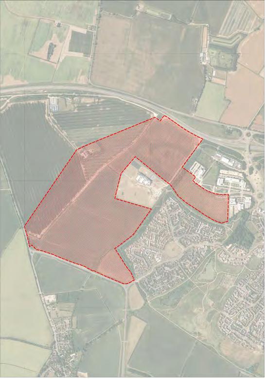
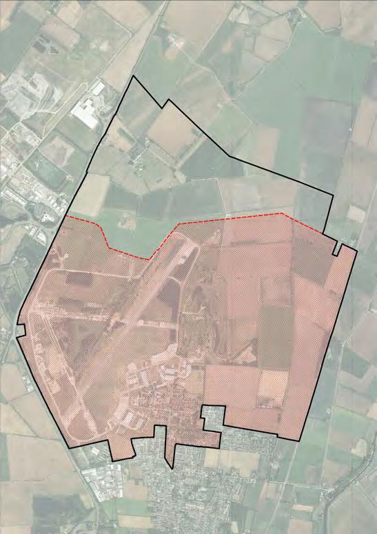
55 Chapter 3 Strategic Sites Northstowe Bourn Airfield New Village Waterbeach New Town Cambourne West
56
57 Chapter 3 Strategic Sites Chapter 3 Strategic Sites 3.1 The Spatial Strategy Chapter identifies the objectively assessed housing requirement for 19,500 new homes in the district over the period and the strategic sites that form a major part of the development strategy in the Local Plan. These are a combination of sites carried forward from the Local Development Framework ( ) and three new sites. Policy S/6 confirms that the Area Action Plans for the following sites remain part of the development plan for the plan period to 2031 or until such time as the developments are complete: Northstowe (except as amended by Policy SS/5 in this chapter); North West Cambridge; Cambridge Southern Fringe; and Cambridge East (except as amended by Policy SS/3 in this chapter). 3.2 This chapter includes policies for the following existing and new strategic allocations for housing, employment and mixed use developments: Edge of Cambridge: Orchard Park site carried forward from the Site Specific Policies Development Plan Document (DPD) 2010 with updated policy to provide for the completion of the development; Land between Huntingdon Road and Histon Road the site carried forward from the Site Specific Policies DPD 2010 but extended to the north following the Green Belt review informing the Local Plan. The notional capacity of the site as extended is 1,000 homes (compared with 1,100 homes in the 2010 DPD); Cambridge East safeguarding the Airport site for longer term development beyond 2031, and confirming allocation of land north of Newmarket Road and north of Cherry Hinton (the latter together with land in the City), and confirming that all other policies in the Cambridge East Area Action Plan are retained; Cambridge Northern Fringe East updated policy consistent with the Cambridge Local Plan for employment focused development around the new station to be guided by a new joint Area Action Plan. New Settlements: Waterbeach new town; Bourn Airfield new village; Extension to Northstowe allocation of the reserve land identified in the Northstowe Area Action Plan The Most Sustainable Villages: Cambourne West. 3.3 Figures 3-6 illustrate the major development sites on the edge of Cambridge within the boundaries of Cambridge City Council and South Cambridgeshire District Council. They are covered by policies in this Local Plan or Area Action Plans or the policies in the Cambridge Local Plan. 45
58 Chapter 3 Strategic Sites Edge of Cambridge Orchard Park Policy SS/1: Orchard Park 1. Land bounded by the A14, Histon Road, Kings Hedges Road and the former Cambridge-St Ives railway line, as defined on the Policies Map, is allocated for a sustainable housing-led mixed-use development providing a minimum of 900 dwellings, a public transport interchange on the Guided Busway along the former railway line, up to 18,000m 2 B1 Business development, a primary school, a local centre, public open space, and the preservation or enhancement of the Arbury Camp site of archaeological interest. 2. Development will provide for: a. The creation of strong internal cycle and footpath links between component parts of the development and the retention and strengthening of such links to neighbouring parts of the urban area and to the rural area to the north of the A14; b. Adequate attenuation measures in relation to noise and emissions generated by traffic on the A14, including the adoption of an appropriate layout and disposition of uses; c. The retention of an attractive urban edge to Cambridge through the use of high standards of design and landscaping and the creation of gateway features; d. The retention of appropriate existing features of ecological interest and the creation of new features which will enhance the interest of the site. 3. Additional residential development may be granted planning permission but only where this would be compatible with the objective for the development as a whole of providing a sustainable housing-led mixed-use development and where it would conform with the terms of this policy. The following specific assessments must be submitted as part of any planning application: e. A Noise Assessment to demonstrate that the proposed development takes account of, and mitigates as necessary and appropriate, any impacts of noise on achieving a satisfactory external and internal residential noise environment; (continued) 46
59 Chapter 3 Strategic Sites f. An Air Quality Assessment, including monitoring, to demonstrate that the proposed development takes account of, and mitigates as necessary and appropriate, any impacts of air quality on achieving a suitable residential environment and also any impacts of development upon the objectives of the designated Air Quality Management Area (AQMA). Account should also be taken of the anticipated effects of the A14 Improvements on the nature and extent of the A14 AQMA; g. A Transport Assessment to demonstrate that there is adequate highway capacity to serve all stages of development on the Orchard Park site as a whole, particularly in the A14 corridor between Girton and Milton, having regard to the traffic forecast to be generated by each phase of development. 3.4 The Orchard Park site was originally allocated for mixed-use development including 900 dwellings in the South Cambridgeshire Local Plan 2004 and the Site Specific Policies DPD (adopted January 2010) carried forward the allocation. Outline planning permission was granted in 2005 and has lapsed. The majority of the development has been completed. Parcel K1 is the last remaining housing parcel from the original Development Framework Plan. 3.5 There is potential for additional dwellings by using parcels originally envisaged for commercial development adjacent to the A14 and for mixed use development and a Heritage Resource & Conservation Centre (HRCC) in the south west corner of the site. The south west corner of the site fronts onto both Histon Road and Kings Hedges Road and will provide an important gateway building for those entering the historic City of Cambridge from the north. A high quality landmark building will therefore be required, which provides an appropriate frontage to Histon Road and reflects its edge of City location and the need to respect the separation with Histon and Impington village to the north of the A All the remaining land parcels have planning permission or are under construction. 3.7 The presence of the A14 has a heavy influence on the site and the original strategy envisaged that commercial uses on the northern edge of the site would act as noise attenuation for the A14. Any development proposal for residential development adjacent to the A14 would need to demonstrate that necessary mitigation measures have been included to ensure that traffic noise and vehicle emissions are reduced to acceptable levels. This includes creating a satisfactory internal and external residential noise environment through careful acoustic design and layout of any residential buildings (such as single aspect, limited height, sealed non opening windows on the façade facing A14, passive and or forced mechanical acoustically treated ventilation, no external private amenity spaces such as balconies / gardens on any façade with direct line of sight to road noise source). 47
60 Chapter 3 Strategic Sites 3.8 An Air Quality Assessment will be required to be submitted as part of any planning application. This must include monitoring of the actual location where residential development is proposed or an agreed equivalent, if appropriate monitoring data is not available from the Council. The assessment should be based on total emissions from the site and be in accordance with current national best practice guidance. The Air Quality Management Area (AQMA) must be taken into account in any development proposals to ensure that a satisfactory residential environment can be provided in order to protect the health of future residents by minimising exposure to poor air quality and appropriate mitigation measures must be included if necessary. Any proposals must also have regard to any impacts of development on the national air quality objectives, the designated AQMA along the A14 and the requirement to produce a site based Low Emission Strategy (see Policy SC/12). Account must also be taken of the anticipated effects of the A14 Improvements on the nature and extent of the AQMA. Development will not be permitted on any part of the site where this issue cannot be adequately addressed. 3.9 A Transport Assessment will be required to consider the implications of additional or alternative forms of development on highway capacity. This will include a detailed assessment of the net impact of replacing parcels assumed for commercial development in the Transport Assessment accompanying the original outline planning permission with residential development. The assessment must also consider the cumulative impact alongside other allocations in this part of Cambridge, on both the A14 Histon Interchange and surrounding local highways junctions and have regard to the effect of the A14 Improvements Arbury Camp (an Iron Age enclosure which was reoccupied during the Roman period, when the main Roman settlement was located to the north of Arbury Camp) lies within the site but below ground level. As in-situ preservation of the enclosure has proven to be essential, its site may be used to satisfy part of the open space requirements of the new development insofar as such use is compatible with preservation of the enclosure. Any additional residential development will need to make provision for its recreational needs in accordance with Policy SC/7, as well as any enhanced or additional community services and facilities to serve the additional homes. Consideration may be given to off-site provision of the active recreational needs of new residents in consultation with Orchard Park Community Council as the managing agency. 48
61 Chapter 3 Strategic Sites Land between Huntingdon Road and Histon Road Policy SS/2: Land between Huntingdon Road and Histon Road 1. Land at North West Cambridge between Huntingdon Road and Histon Road, as defined on the Policies Map, will be developed as part of a sustainable housing-led urban extension of Cambridge. The Cambridge Green Belt is revised to provide the northern boundary of this development. The Green Belt will continue to ensure separation from Girton and Histon & Impington villages. Spatial Masterplan: 2. A Spatial Masterplan will be submitted for approval by the local planning authorities as part of the first application for planning permission to demonstrate that the development of the whole site will integrate effectively with the development of the wider North-West Cambridge area, including development in Cambridge City: a. The Masterplan will set out the principles of good design and be supplemented by a Design and Access Statement; b. Design Codes for each phase of development will be required to be submitted and approved before the granting of the first reserved matters consent, to ensure a high quality development. Landscape Strategy: 3. A Landscape Strategy must be submitted and approved as part of, or before, the granting of the first planning permission, and must include appropriate edge treatments that respect the Green Belt setting of Cambridge and views of key features of the City. Any development shall retain hedges and woodland and provide a set back of the development from Cambridge Road and the A14 to provide effective visual separation between Cambridge and Impington. Provision of Housing, Services and Facilities: 4. Approximately 1,000 dwellings will be provided in South Cambridgeshire. The final number of homes may be higher or lower than the indicative capacity, and will be informed by a design-led assessment with a good mix of house types, sizes and tenures (including affordable housing) attractive to, and meeting the needs of, all ages and sectors of society including those with disabilities. (continued) 49
62 Chapter 3 Strategic Sites 5. The development will provide for an appropriate level and type of services, facilities and infrastructure to meet the day to day needs of the development either on site or elsewhere in North West Cambridge (within or outside the district), including a secondary school, primary school, local shopping and community facilities. Provision will be through innovative means, including opportunities for joint provision and co-location to provide services which best meet people s needs, are accessible to all and which are cost efficient to service and facility providers. Some provision has already been planned within the local centre of the adjoining development in Cambridge including a health centre and supermarket. Provision of other facilities to meet the needs of development in South Cambridgeshire will either need to be made on-site or via contributions for off-site provision. Provision for outdoor sports facilities, provision for teenagers and children, and informal open space, and allotments will be made in accordance with Policy SC/7. Transport, Access and Parking: 6. Development and transport systems will be planned in order to integrate with adjoining development in Cambridge City, to reduce the need to travel and to maximise the use of sustainable transport modes, so as to achieve a modal share of no more than 40% of trips by car (excluding passengers). This will include the provision of employee travel plans, residential travel planning, and other similar measures which could include car clubs. 7. Adequate highway capacity will be required to serve all stages of development. Planning permission will be subject to conditions requiring that sufficient highway capacity is available in the A14 corridor between Girton and Milton throughout the development for the traffic forecast to be generated by each phase of development. 8. Vehicular access shall be from Cambridge Road, through the development, and then via Darwin Green 1 (Cambridge City Council s area) to connect onto Huntingdon Road. There shall be no vehicular access direct to the A14 or to Girton. 9. Car parking and secure cycle parking will be provided in accordance with Policy TI/3. Car clubs will be encouraged in order to minimise the amount of land given over to car parking. This must be explored through the Transport Assessment and Travel Plan. (continued) 50
63 Chapter 3 Strategic Sites 10. The development will be highly accessible and permeable to all its residents on foot, by cycle and High Quality Public Transport (HQPT), to support non car modes of travel, recreation and health. HQPT will be provided to serve the development, including bus priority through the development, which will include segregation if required, linking effectively with the route through the adjoining development in Cambridge City and into the wider bus network. There will be a network of strong internal and external cycle and pedestrian links to neighbouring parts of the urban and rural areas. Countryside Enhancement Strategy: 11. A Countryside Enhancement Strategy for the land between Huntingdon Road, Cambridge Road / Histon Road and the A14 retained in the Green Belt will be prepared and implemented to protect existing and provide new landscape, biodiversity and public access enhancements, including hedgerow management and enhancement, measures to protect and enhance wildlife habitats, and new footpaths, cycleways and bridleways including access via the existing A14 overbridge to connect to the wider public rights of way. Developers will be required to retain appropriate existing features of ecological interest. Drainage: 12. Surface water drainage will be controlled by means of a sustainable drainage system which will only release surface water run-off into surrounding water courses at least at a rate no greater than if the site was undeveloped. Balancing ponds serving the site shall be located south of the A14. The development will not result in harm in the form of untreated sewage discharge or increased flood risk from treated waste water. Planning conditions (which may include Grampian style conditions¹) will link the start (and phased development of the site, if necessary) to the availability of waste water treatment capacity and the capacity of receiving watercourses. All flood mitigation measures should make allowance for the forecast effects of climate change. Noise and Air Quality: 13. Noise and air quality assessments will be required as part of any planning application. If necessary, development will be subject to measures, which may include planning conditions and / or planning (continued) 51
64 Chapter 3 Strategic Sites obligations, a landscaped buffer, and layout and design measures, to mitigate the effects of air pollution and noise caused by traffic using the A14 north of the site and Histon Road east of the site. Noise attenuation fencing will only be permitted exceptionally where it is demonstrated that landscape bunds are impractical or inappropriate. The length of such fencing will be minimised. Where noise attenuation fencing is permitted, any potential for reflected noise shall be minimised through the use of noise absorptive materials or other surface finishes to the fencing, to ensure no unacceptable adverse impact on nearby communities. The impacts of development on air quality objectives and the designated Air Quality Management Area (AQMA), and the anticipated effects of the A14 Improvements on the nature and extent of the AQMA should also be taken into account. A site based Low Emission Strategy will also be required (see Policy SC/12). Residential development must be outside AQMA. Land within the AQMA can be used to provide noise bunds, water management facilities and open space uses for the wider development. Management Strategies: 14. Management strategies for services, facilities, landscape and infrastructure will be submitted to the local planning authority for approval prior to the granting of outline planning permission to ensure high quality, robust and effective implementation, adoption and maintenance. 15. A comprehensive environmental management and construction strategy will be required for all phases of development and planning conditions will be imposed to minimise the adverse effects of construction activity on residential amenity and the environment. A scheme will be introduced to avoid construction vehicles travelling through existing residential areas of Cambridge and villages in the locality and to avoid unacceptable adverse impacts on traffic flows on the A14 and the surrounding road network. Conditions on timing of construction traffic movements on the network will be imposed if necessary, taking account also of the need to minimise adverse impacts on residential amenity. 1 Grampian Regional Council v. Aberdeen DC (1984) JPL 590 H.L: conditions restricting development unless and until an event had occurred which was not within the power of the applicant to bring about may be valid if reasonable and not otherwise ultra vires. 52
65 Chapter 3 Strategic Sites 3.11 Land between Huntingdon Road and Cambridge Road / Histon Road, known as Darwin Green 2 and formerly known as NIAB 2, was released from the Green Belt for a sustainable housing-led urban extension of Cambridge in the Site Specific Policies DPD. Plans for the adjoining built development within Cambridge City are to be found in the Cambridge Local Plan, which should be read alongside this policy to give a full understanding of all inter-related proposals in the area. The northern boundary of the site has been extended to provide a small additional area of residential development on land removed from the Green Belt and outside the Air Quality Management Area (AQMA) The site is identified for approximately 1,000 dwellings and associated development, which lies in the Parish of Impington (with the adjoining countryside to the west lying in the Parish of Girton). The site and adjoining land will provide the infrastructure needed to deliver and serve the urban extension as a whole. The notional capacity of 1,000 dwellings is a robust estimate of capacity for the purposes of plan making. The number of dwellings will be determined by a design led approach to deliver a high quality development on this edge of Cambridge. The additional part of the site added through this Local Plan is outside of the AQMA, and is subject to ensuring sufficient space between the development and the A14 for a noise bund, preserving important landscape features and all water management features necessary to serve all parts of the Darwin Green development The revised Green Belt boundary will maintain an open green foreground setting to Cambridge and ensure that the expanded City remains physically separate from surrounding villages especially the closest villages of Girton and Histon & Impington. In this way the character of Cambridge as a city surrounded by a necklace of villages can continue to be protected This rural area provides an opportunity for Green Belt enhancement and a Countryside Enhancement Strategy will be required to demonstrate how landscape and biodiversity enhancements will be achieved in the area as far north as the A14 trunk road to help enhance the quality of the setting of Cambridge and mitigate the impact of development. It will also set out improved countryside access to provide for informal recreation to serve both the development proposed in the City and existing development in this sector of Cambridge. There is a public footpath along the administrative boundary between Darwin Green 1 and Darwin Green 2. This route will be incorporated into the development. New routes for Non-Motorised Users will be delivered in the countryside between the site and the A14, as well as pedestrian / cycle use of the A14 overbridge It is important that any urban related open uses, such as playing fields, that are proposed in the Green Belt are carefully located and designed to ensure they do not reduce the effectiveness of the Green Belt separation between Cambridge and Girton in visual terms, particularly having regard to matters such as fencing and floodlighting (see Policy NH/8). 53
66 Chapter 3 Strategic Sites 3.16 The development will help meet the high level of housing need in the district. This requires balancing the need to make best use of land with creating a high quality urban extension to Cambridge. The final number of dwellings will be determined through a design-led approach and the required Masterplan and Design Codes, and the capacity of approximately 1,000 is a notional capacity to be finalised through the planning application process. A range of house types, sizes and mix will also be important in ensuring a balanced community The strategic developments are the key to addressing the affordable housing requirements of the area All necessary community services and facilities will be provided by the development, either onsite or through contributions to off-site provision secured through a planning obligation, for example through provision of new facilities or enhancement of existing facilities in the wider North West Cambridge Quadrant. Open space provision will also provide opportunities for enhanced nature conservation value, and will enable quiet enjoyment of the natural environment A secondary school is proposed on the site to serve the needs of all proposed new development in the north-west part of Cambridge both north and south of Huntingdon Road. The secondary school must be provided according to a trigger point relating to development in the whole quadrant, which may be ahead of development on the site in South Cambridgeshire. An appropriate mechanism will be included in the planning obligation for the site to ensure timely provision of this key community facility A fundamental requirement for this site is that it will be highly accessible and permeable to all its residents on foot, by cycle and High Quality Public Transport (HQPT), to support sustainable transport, recreation and health. Therefore all development will be within 400m easy walking distance of a HQPT bus stop via direct, safe and convenient routes. The route must be fully and effectively integrated with the route through the adjoining City development Vehicular access to the development will be provided through the City development and it is important that there is adequate capacity in the wider highway network at all times during the development. Any proposal will need to demonstrate that there is sufficient capacity in the A14 to accommodate the traffic generated by the development The impact of development on a number of natural resources will also be important. This includes surface water drainage and sewage discharge and the need to take account of the impact of the development on the wider catchment, particularly in view of known problems downstream, especially at Histon, Impington and Oakington, and other proposed large scale development that drains into that area. The impact on the wider catchment must therefore be addressed and the potential for a catchment wide assessment should be considered. Air quality is also an important 54
67 Chapter 3 Strategic Sites consideration in view of the AQMA on the A It is important that the services, facilities, landscape and infrastructure needed by this development are not only provided to a high quality, but that they are provided when they are needed, properly and effectively implemented, managed and maintained if they are to meet the needs of the community in the long term. There would be advantages in a single organisation taking responsibility for maintenance to avoid fragmentation and ensure continuity in approach. The policy is not specific about the number of management strategies. However, there should be a single agreed management strategy covering recreation, landscape and biodiversity. The inclusion of water and drainage features within open spaces would have significant advantages to ensuring a holistic approach to the management of open spaces where the respective needs of the various land uses and functions within those spaces can be addressed and should therefore be investigated. Cambridge East Policy SS/3: Cambridge East 1. Land at Cambridge East is allocated for development as shown on the Policies Map: a. Land north of Newmarket Road will deliver approximately 1,300 dwellings during the plan period. b. Land north of Cherry Hinton will deliver approximately 420 dwellings during the plan period (it adjoins land allocated in Policy 13 of the Cambridge Local Plan for 780 dwellings). 2. Proposals for residential development on sites (a), and (b) as shown on the Policies Map, will only be supported if: c. acceptable mitigation of environmental and health impacts (including noise) from the airport can be provided; and d. a masterplan is submitted for the development of site SS/3 (1b) and adjoining land in Cambridge (site R47) which safeguards the appropriate future development of the wider safeguarded land; and e. the continued authorised use of Cambridge Airport does not pose a safety risk. 3. Residential development on site SS/3 1b) as shown on the Policies Map, together with adjoining land in Cambridge (site R47), will make provision for a primary and secondary school, a local centre with community hub, open space and a spine road connecting Coldham s Lane with Cherry Hinton Road. Vehicular access to the site will only be permitted via the new spine road, unless needed for emergency access. (continued) 55
68 Chapter 3 Strategic Sites 4. The rest of the Cambridge East site is safeguarded for longer term development beyond Development on safeguarded land will only occur once the site becomes available and following a review of both this Plan and the Cambridge East Area Action Plan. 5. This policy replaces Policies CE/3 and CE/35 of the Cambridge East AAP. All other policies in the Cambridge East AAP are retained Land at Cambridge East was taken out of the Green Belt through the Cambridge Local Plan 2006 and Cambridge East Area Action Plan (AAP) 2008 for the development of a major new urban extension. This was dependant on the relocation of current activities at the airport. Marshall had been actively looking into relocation options for the airport activities since In 2010, they announced that they did not have a deliverable relocation option and that they intended to remain at Cambridge Airport for the foreseeable future In reviewing the future options for this large site, Cambridge City Council and South Cambridgeshire District Council have concluded that it is appropriate that the site allocated in the AAP remain out of the Green Belt. The corridor of Green Belt running from Coldham s Common to Teversham will remain as Green Belt There is an opportunity during the plan period to deliver residential development on parts of Cambridge East while the airport remains on the site. A number of specific sites are allocated in Policy SS/3 (1) and Policy 13 (1) of the Cambridge Local Plan (see Figure 5). These were identified in the AAP as capable of coming forward ahead of the Airport site, and potentially without it. Careful consideration of how the on-going airport activities will interact with any new residential use will be needed at the planning application stage, to ensure that the new homes have a high level of amenity, and that the continued authorised use of the airport would not be compromised. Any development that comes forward in advance of the wider site will have to be carefully planned and demonstrate that it is capable of working both with and without the wider development, so as not to prejudice the potential delivery of development on the safeguarded land at some point in the future if it becomes available. This policy makes it clear that these areas are not part of the wider safeguarded site and are allocated to come forward for development before A masterplan for site SS/3 (1b) and adjoining land in Cambridge will be required in order to ensure a comprehensive and coordinated approach to bringing these sites forward for development. The masterplan will take into account the context of the surrounding area, including development proposals on site R47 (Land north of Cherry Hinton, in the Cambridge Local Plan). While vehicular access to the site will be from the new spine road off Coldham s Lane and Cherry Hinton Road, access for emergency vehicles only from alternative points will need to be considered at an early stage. 56
69 Chapter 3 Strategic Sites 3.27 Cambridge City Council and South Cambridgeshire District Council accept that there is an existing need for a new secondary school to serve the eastern part of Cambridge, in response to demographic pressures. A significant shortfall in school capacity across the City is currently forecast from 2018, which coupled with proposed development north of Newmarket Road and north of Cherry Hinton will require the early provision of the secondary school. Residential development on land north of Cherry Hinton should not come forward before there is an agreed approach to the delivery of sufficient school capacity in the area, including land for the provision of a secondary school being made available. As an exception to Policy CE/6 of the Cambridge East AAP, the secondary school need not be included in the local centre. In common with practice elsewhere around Cambridge, and in line with national policy on Green Belt, it will be acceptable for school playing fields to be located in the retained Green Belt This policy safeguards the main airport site for longer-term development needs beyond Were circumstances to change, a review of this Plan and the Cambridge East AAP could examine the consequences of the change. Policies in the existing Cambridge East AAP will remain other than Policies CE/3 and CE/35. Cambridge Northern Fringe East Policy SS/4: Cambridge Northern Fringe East and Cambridge North railway station 1. The Cambridge Northern Fringe East and Cambridge North railway station will enable the creation of a revitalised, employment focussed area centred on a new transport interchange. 2. The area, shown on the Policies Map, and illustrated in Figure 6, is allocated for high quality mixed-use development, primarily for employment within Use Classes B1, B2 and B8 as well as a range of supporting uses, commercial, retail, leisure and residential uses (subject to acceptable environmental conditions). 3. The amount of development, site capacity, viability, time scales and phasing of development will be established through the preparation of an Area Action Plan (AAP) for the site. The AAP will be developed jointly between South Cambridgeshire District Council and Cambridge City Council, and will involve close collaborative working with Cambridgeshire County Council, Anglian Water and other stakeholders in the area. The final boundaries of land that the joint AAP will consider will be determined by the AAP. (continued) 57
70 Chapter 3 Strategic Sites 4. All proposals should: a. Take into account existing site conditions and environmental and safety constraints; b. Demonstrate that environmental and health impacts (including odour) from the Cambridge Water Recycling Centre can be acceptably mitigated for occupants; c. Ensure that appropriate access and linkages, including for pedestrians and cyclists, are planned for in a high quality and comprehensive manner; d. Recognise the existing local nature reserve at Bramblefields, the protected hedgerow on the east side of Cowley Road which is a City Wildlife Site, the First Public Drain, which is a wildlife corridor, and other ecological features, and where development is proposed provide for appropriate ecological mitigation, compensation, and enhancement measures either on- or off-site; and e. Ensure that the development would not compromise opportunities for the redevelopment of the wider area Cambridge Northern Fringe East (CNFE) is located within the Cambridge City Council and South Cambridgeshire District Council authority boundaries. The majority of the area is within Cambridge with Chesterton Sidings and part of the St John s innovation Park within South Cambridgeshire. An early review of the site through a jointly-prepared Area Action Plan (AAP) will ensure a coordinated approach is taken. This will enable the feasibility of development and its viability to be properly investigated and will ensure a comprehensive approach to redevelopment The railway station, on the sidings in South Cambridgeshire, will be served by the Cambridgeshire Guided Busway and will include cycle parking facilities and car parking. The station will significantly improve the accessibility of the site and surrounding area including access to and from the Cambridge Business Park, St John s Innovation Park and Cambridge Science Park making the area a highly attractive business destination Cambridge North railway station will provide a catalyst for regeneration of this area. Early development around Cambridge North station could help create a vibrant area around this key infrastructure to meet the needs of users of the station and bring forward further phased delivery elsewhere within the CNFE area. Planning applications submitted before the adoption of the AAP will be considered on their own merits and subject to ensuring that they would not prejudice the outcome of the AAP process and the achievement of the comprehensive vision for the area as a whole that will be established by the AAP The adopted Cambridgeshire and Peterborough Minerals and Waste Core Strategy (2011) and Site Specific Proposals Plan (2012) designates a safeguarding area for the existing Cambridge Water Recycling Centre and 58
71 Chapter 3 Strategic Sites another for an existing aggregates railhead; as well as a Waste Consultation Area for an existing waste management facility. In addition, it identifies an area of search for a household (waste) recycling centre to serve the north of Cambridge and an inert waste recycling facility. Any development proposals will need to be assessed against the above minerals and waste policies and specifically will need to prove they are compatible to ensure the existing safeguarded aggregates railhead and waste operations can continue without conflict The sidings, in South Cambridgeshire, currently have a number of businesses importing aggregate using the railway that is used for construction and road maintenance in the wider Cambridge area. This provides an important source of building materials for the wider area Exploration of the viability and feasibility of redevelopment of the Cambridge Water Recycling Centre within Cambridge City to provide a new treatment works facility either elsewhere or on the current site subject to its scale will be undertaken as part of the feasibility investigations in drawing up the AAP. If a reduced footprint were to be achieved on the current site this could release valuable land to enable a wider range of uses. Residential development could be an option subject to appropriate ground conditions, contamination issues, amenity and air quality The development of Cambridge Northern Fringe East will require partnership working between landowners and developers as well as the two local authorities and Cambridgeshire County Council. Highways England will also be engaged with in relation to strategic road network issues. 59
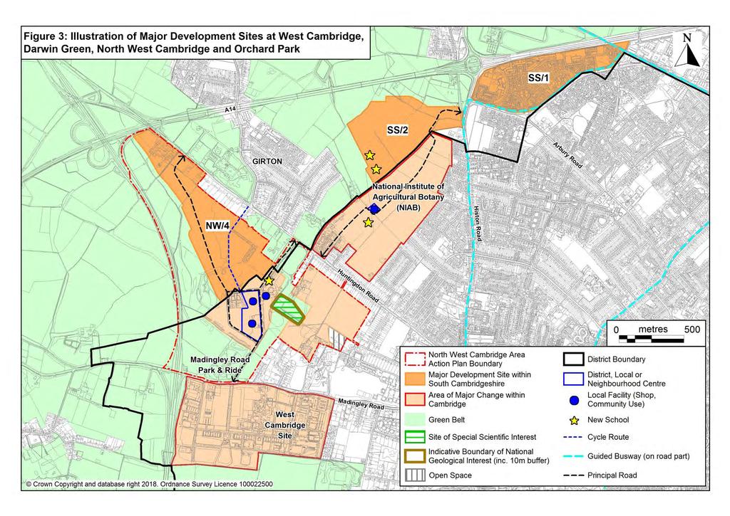
72
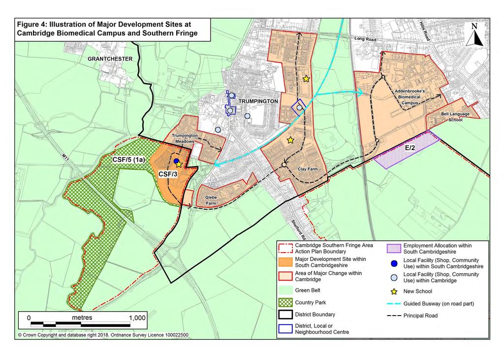
73
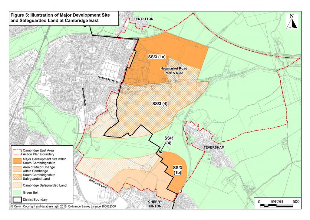
74
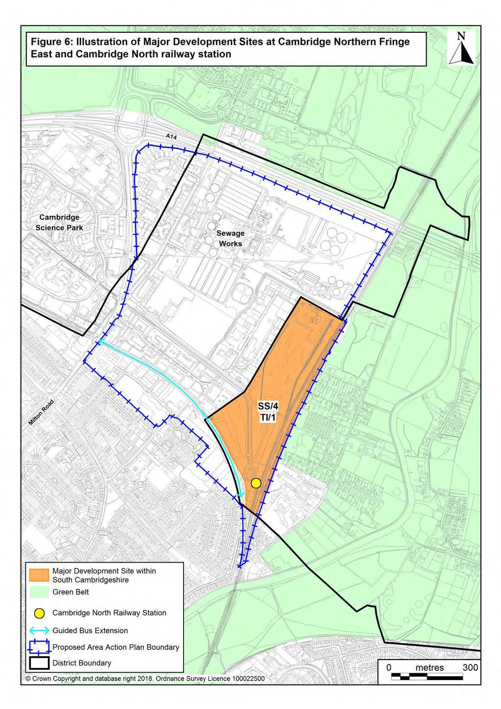
75
76 Chapter 3 Strategic Sites New Settlements Northstowe Extension Policy SS/5: Northstowe Extension The reserve land identified in the Northstowe Area Action Plan (AAP) is allocated as an extension to the site of the new town of Northstowe. It will help provide the 10,000 homes allocated in the AAP at an appropriate density and design and will not increase the overall number of homes The new town of Northstowe was originally planned in the Northstowe Area Action Plan (AAP) with an area of reserve land to the west of the town. The reserve land is allocated in the Local Plan to provide flexibility for the phasing and delivery of the town over the plan period and will not increase the total number of homes delivered by Policy SS/5 supersedes Policy NS/3 (1g) of the Northstowe AAP. Waterbeach New Town Policy SS/6: Waterbeach New Town 1. A new town of approximately 8,000 to 9,000 dwellings and associated uses is proposed on the former Waterbeach Barracks and land to the east and north as shown on the Policies Map. A Supplementary Planning Document (SPD) will be prepared for the new town as addressed at subsection 17 of this policy. The final number of dwellings will be determined through a design-led approach and spatial framework diagram included in the SPD having regard to: a. The quantum, location and distribution of development in the town; and b. Maintaining an appropriate setting for Denny Abbey listed building and scheduled monument. 2. The new town will be a sustainable and vibrant new community that is inclusive and diverse with its own distinctive local identity which is founded on best practice urban design principles, drawing on the traditions of fen-edge market towns, which encourages the high quality traditions and innovation that are characteristic of the Cambridge Sub-Region. (continued) 64
77 Chapter 3 Strategic Sites 3. It will be developed to maintain the identity of Waterbeach as a village close to the new town. Appropriate integration should be secured by the provision of suitable links to enable the residents of Waterbeach village to have convenient access to the services and facilities in the new town but with limited and controlled opportunities for direct road access from the wider new town to Waterbeach with emphasis on connections by public transport, cycle and on foot. 4. It will deliver an example of excellence in sustainable development and healthier living, which will make a significant contribution to the long term development needs of the Cambridge area. It will deliver high quality public transport links to Cambridge, including a relocated railway station, to enable a high modal share of travel by means other than the car. The Site: 5. The built area of the settlement will be contained within the Major Development Site, and the location of major land uses and design of the northern edge of the new town will ensure an appropriate relationship with Denny Abbey listed building and scheduled monument; 6. The new town will establish an appropriate relationship and interaction with Waterbeach village, and the Cambridge Research Park; 7. All built development will be provided within the Major Development Site shown on the Policies Map. Land outside the Major Development Site can provide other associated uses and mitigation including drainage, habitat compensation and informal open space. The Phasing and Delivery of a Mix of Land Uses: 8. The new town will provide a range of uses appropriate to a new town, including: a. Residential development of a mix of dwelling sizes and types, including affordable housing, to achieve a balanced and inclusive community; (continued) 65
78 Chapter 3 Strategic Sites b. Employment provision of a quantum, type and mix to meet the needs of the town and provide access to local jobs, and support the continued development of the economy of the Cambridge area to be established through an Economic Development Strategy prepared in partnership with the local authority and key stakeholders; c. Shops, services, leisure and other town centre uses¹ of an appropriate scale for a town whilst avoiding significant impacts on vitality and viability of surrounding centres, and not competing with Cambridge as the sub regional centre; d. A town centre supported by local centres, to ensure services and facilities are easily accessible to residents; e. Community services and facilities, including health and both primary and secondary school education; f. Open space, sports and leisure facilities; g. Appropriate provision for and design of waste / recycling management facilities. Measures to Address Landscape, Townscape and Setting of Heritage Assets in the Surrounding Area, and Deliver a High Quality New Development: 9. The new town will: a. Establish and follow design principles to deliver a high quality development responding to local character, but also with its own identity; b. Provide strategic landscaping within and beyond the Major Development Site to deliver high quality environs and: i. provide an appropriate screening of the town in views from Denny Abbey in order to protect the historic significance of the Abbey, and ii. maintain the village character of Waterbeach; (continued) 1 Main town centre uses as defined in the NPPF (2012): Retail development (including warehouse clubs and factory outlet centres); leisure, entertainment facilities the more intensive sport and recreation uses (including cinemas, restaurants, drive-through restaurants, bars and pubs, night clubs, casinos, health and fitness centres, indoor bowling centres, and bingo halls); offices; and arts, culture and tourism development (including theatres, museums, galleries and concert halls, hotels and conference facilities). 66
79 Chapter 3 Strategic Sites c. Conserve and enhance the significance of Denny Abbey Grade I listed building and scheduled monument, including the contribution made by its setting, the extent and nature of separation from the Major Development Site and formal open spaces, and protection of key views including to and from the Abbey; d. Include assessment, conservation and enhancement of other heritage assets as appropriate to their significance, including non-designated assets such as Car Dyke World War II structures, raised causeways, and the Soldiers Hill Earthworks. e. Incorporate necessary mitigation to sensitive receptor boundaries, with regard to noise and odour, including from the A10, proposed railway station, recreational activities and the Waterbeach Waste Management Park to ensure no significant adverse impact on quality of life / amenity and health using separation distances or acoustic earth bunding rather than physical barriers if appropriate and where practicable; f. Ensure there is no significant adverse impact on local air quality and or mitigate as necessary with a Low Emissions Scheme. Delivery of a Significant Network of Green Infrastructure: 10. The new town will: a. Provide a high degree of connectivity to existing corridors and networks; b. Include areas accessible to the public as well as areas with more restricted access with the aim of enhancing biodiversity; c. Provide and retain woods, hedges, and water features which would contribute to the character and amenity of the town and help preserve and enhance the setting of Denny Abbey, managed to enhance their ecological value; d. Consider the multifunctional value of spaces, e.g. amenity, landscape, biodiversity, recreation and drainage; e. Carry out a full programme of ecological survey and monitoring, to guide a Biodiversity management plan to provide appropriate mitigation and enhancement. Creation of a comprehensive movement network: 11. The new town will be founded on a comprehensive movement network for the whole town, that connects key locations including the town centre and relocated railway station to encourage the use of sustainable modes of travel, and includes: (continued) 67
80 Chapter 3 Strategic Sites a. Significant improvements in Public Transport, including: i. Provision of a relocated Waterbeach station with appropriate access arrangements by all modes to serve the village and the new town; ii. Provision of a Park and Ride site on the A10 to intercept traffic from the north of Waterbeach, served by a new segregated Bus link to Cambridge; b. Measures to Promote Cycling and Walking, from the start of the development including: i. Provision of a network of attractive, direct, safe and convenient walking and cycling routes linking homes to public transport and the main areas of activity such as the town centre, schools and employment areas; ii. iii. Provision of direct, segregated high quality pedestrian and cycle links to north Cambridge, surrounding villages and nearby existing facilities such as the Cambridge Research Park; A Smarter Choices package including residential, school and workplace travel planning. c. Highway Improvements, including: i. Primary road access from the A10; ii. iii. iv. Additional capacity to meet the forecast road traffic generation of the new town, particularly on the A10 and at the junction with the A14; Measures to mitigate the traffic impact of the new town on surrounding villages including Waterbeach, Landbeach, Horningsea, Fen Ditton and Milton; A review of the access arrangements to Denny Abbey and the Farmland Museum. Sustainable Design and construction: 12. The new town will incorporate and deliver opportunities to exceed sustainable design and construction standards established by the Local Plan. These measures could include combined heat and power provided from the adjacent Waterbeach Waste Management Park. (continued) 68
81 Chapter 3 Strategic Sites Infrastructure Requirements: 13. The new town will: a. Ensure the delivery of improvement to any existing infrastructure which will be relied upon by the new town as well as the provision, management and maintenance of new infrastructure, services and facilities to meet the needs of the town. b. Make appropriate arrangements for Foul Drainage and Sewage Disposal. c. Ensure the provision, management and on-going maintenance of sustainable surface water drainage measures to control the risk of flooding on site and which will reduce the risk of flooding to areas downstream or upstream of the development. Community Development: 14. Measures will be required to assist the development of a new community, such as through community development workers. Site Preparation: 15. Developers will be required to: a. Undertake site wide investigation and assessment of land contamination and other issues resulting from former land uses, including military use, to ensure the land is suitable for the proposed end use and is not presenting a risk to the environment; b. Ensure that all ordnance is removed from the site in ways that ensure the development can take place without unacceptable risk to workers and neighbours including major disruption to the wider public off site. Phasing and Delivery: 16. The delivery of the new town, including any individual phases, must: a. Be in accordance with the spatial framework diagram set out in the Supplementary Planning Document to ensure a comprehensive development of the site as a whole that will not prejudice the creation of a fully functioning and successful new town. b. Be informed by appropriate strategies, assessments and evidence reports. (continued) 69
82 Chapter 3 Strategic Sites c. Plan for essential services, facilities and infrastructure to be provided in a comprehensive manner, anticipating future needs, and establishing suitable mechanisms to deliver the infrastructure in a timely and efficient way to achieve the successful delivery of the new town, including the needs of individual phases, and the requirements on developers. d. Make satisfactory arrangements to ensure appropriate engagement and consultation with local people and stakeholders. Supplementary Planning Document: 17. The SPD to be prepared for the Strategic Site shown on the Policies Map will provide further guidance and detail on the implementation of Policy SS/6. The SPD will include: a. An overarching, high level vision for the new town. b. Consideration of relevant context including key constraints and opportunities. c. The broad location of the components of the new town which are essential to support comprehensive and seamless development. A spatial framework diagram will be included that ensures the creation of a sustainable, legible and distinctive new settlement. d. The location, nature and extent of any formal open space to be provided outside of the Major Development Site. e. Broadly how the development is to be phased, including the delivery of key infrastructure Land north of Waterbeach is allocated for the creation of a sustainable new town. It provides the opportunity to reuse an extensive area of previously developed land to meet the housing and employment needs of the Cambridge area. It will aim to be an exemplar in sustainability and high quality design, building on the knowledge gained from other new settlements being delivered in the district This is a long term development opportunity. Development will take place over the plan period, and beyond. The implementation of the new town development provided for by this policy will be informed by a SPD produced in accordance with policy paragraph 17, and the local community and stakeholders will be engaged in its preparation. The policy establishes requirements and objectives that will need to be addressed in the SPD, and subsequently by developers. A full range of detailed assessments will be required, initially at a level appropriate to inform the SPD, and ultimately as part of any planning application. 70
83 Chapter 3 Strategic Sites 3.39 The Policies Map also identifies the Major Development Site, which will accommodate the built development of the new town. This does not mean the whole of the area will be developed. Large parts of it will remain undeveloped and green after the settlement is complete to provide open spaces within the new town and a substantial green setting for the new town, Denny Abbey and Farmland Museum and Waterbeach village. Areas to the north of the town within the area to be covered by the SPD will ensure that it will remain physically separate from Denny Abbey. Assessment of the setting of Denny Abbey using Historic England s guidance on Setting of Heritage Assets will be required in view of the importance of conserving and where possible enhancing the remote rural and historic setting of Denny Abbey, a nationally important heritage asset, will be a key element of the plan, including having regard to key views and landscape character. There may be scope to provide some formal open space outside the Major Development Site whilst providing an appropriate setting for Denny Abbey, if demonstrated to be appropriate through the SPD Delivery of large areas of green infrastructure will also enable the enhancement of biodiversity within the town, whilst providing a network of open spaces for new and existing communities. Maintaining the identity of Waterbeach village as a village close to the new town is also necessary. The nature of the transition between Waterbeach village and the new town will be addressed through the SPD A new town will require a significant amount of new infrastructure, including schools, shops, services and facilities to meet the needs of the town. It is important that the services, facilities, landscape and infrastructure needed by this development are not only provided to a high quality, but that they are properly and effectively implemented, managed and maintained if they are to meet the needs of the community as they arise and in the long term A fundamental requirement for this site is that it will be highly accessible and permeable to all its residents on foot, by cycle and public transport, to support sustainable transport, recreation and health. The site offers particular opportunities to deliver public transport improvements, including the relocation of Waterbeach railway station to a location where it will also be convenient for people living in Waterbeach village making rail travel highly attractive. Segregated provision for buses both within the town and to link the new town to the public transport network in Cambridge will be required and similarly for cycle use. This will provide for quicker journeys, encourage maximum use by residents of the new town and improve safety. The existing A10 is at capacity and road improvements will be required, including measures to address capacity at the Milton junction with the A14. 71
84 Chapter 3 Strategic Sites New Village at Bourn Airfield Policy SS/7: New Village at Bourn Airfield 1. Land south of the A428 based on Bourn Airfield is allocated for the development of a new village of approximately 3,500 dwellings. A Supplementary Planning Document (SPD) will be prepared for the new village as addressed at subsection 15 of this policy. The final number of dwellings will be determined through a design-led approach and spatial framework diagram included in the SPD. It will be classified as a Rural Centre once built. 2. The new village will be developed to high standards of design and layout. A key consideration will be the relationship with other settlements in the A428 corridor, and maintaining rural character and separation of individual villages. 3. It will deliver an example of excellence in sustainable development and healthier living, which will make a significant contribution to the long term development needs of the Cambridge area. 4. The Major Development Site, which will accommodate the built development of the new village, is shown on the Policies Map. The area to be planned through the SPD is also shown on the Policies Map. This includes additional land to ensure that the development potential of the former airfield site is maximised and to ensure that the new village includes green infrastructure including formal and informal open space, strategic, landscaping and green separation, particularly from Caldecote / Highfields to help it fit into its rural setting. The Site: 5. The built area of the settlement will be contained within the Major Development Site, and the location of major land uses and the design of the edges of the new village will have particular regard to ensuring an appropriate relationship with Cambourne and Highfields Caldecote. (continued) 72
85 Chapter 3 Strategic Sites Measures to Address Landscape, Townscape and Historic Setting of the New Village, and Deliver a High Quality New Development: 6. The new village will: a. Establish and follow design principles to deliver a high quality development responding to local character, but also with its own identity; b. Provide strategic landscaping within and beyond the Major Development Site to deliver a high quality landscaped setting around the boundary of the settlement to avoid it appearing as part of a ribbon of urban development south of the A428, to maintain the rural nature of the Broadway and ensure separation from Cambourne, and to ensure countryside separation from Caldecote / Highfields and Bourn. The strategic landscaping along the eastern boundary of the Strategic Site south of the existing employment area will include a substantial and continuous woodland belt, including land within the Major Development Site; c. Protect and enhance the setting of listed buildings near to the site; d. Incorporate necessary mitigation to sensitive boundaries, with regard to noise, including the A428, using landscaped earth bunds. Delivery of a Significant Network of Green Infrastructure: 7. The new village will: a. Provide a high degree of connectivity to existing corridors and networks, including through an enhanced network of footpaths and bridleways; b. Include areas accessible to the public as well as areas with more restricted access with the aim of enhancing biodiversity; c. Retain existing woods, hedges, and water features which would contribute to the character and amenity of the village or separation from surrounding communities, managed to enhance their ecological value; d. Consider the multifunctional value of spaces, e.g. amenity, landscape, biodiversity, recreation and drainage; e. Take account of a full programme of ecological survey and monitoring, to guide a biodiversity management plan to provide appropriate mitigation and enhancement. (continued) 73
86 Chapter 3 Strategic Sites Creation of a comprehensive movement network: 8. The new village will be founded on a comprehensive movement network for the whole village, that connects key locations including the village centre and schools to encourage the use of sustainable modes of travel and includes: a. Significant Improvements in Public Transport, including: i. Provision of a segregated bus link from Cambourne to Bourn Airfield new village across the Broadway, and on through the development to the junction of the St Neots Road with Highfields Road; ii. Any measures necessary to ensure that a bus journey between Caldecote / Highfields and the junction of the A428 and the A1303 is direct and unaffected by any congestion (continued) iii. suffered by general traffic; Provision of high quality bus priority measures or busway on or parallel to the A1303 between its junction with the A428 and Queens Road, Cambridge; b. Measures to Promote Cycling and Walking, including: i. Provision of a network of attractive, direct, safe and convenient walking and cycling routes from the start of the development linking homes to public transport and the main areas of activity such as the village centre, schools and employment areas; ii. iii. Provision of a direct, segregated high quality pedestrian and cycle links to west Cambridge, Cambourne, Caldecote / Highfields, Hardwick and Bourn; A Smarter Choices package including residential, school and workplace travel planning. c. Highway Improvements including: i. Include measures to mitigate the traffic impact of the new village on surrounding villages and roads; ii. iii. Provide convenient vehicular access, with at least two separate access points to the north west and north east of the site; Ensure that there will be no direct vehicular access to the Broadway for southbound traffic from the new village (except buses and bicycles). 74
87 Chapter 3 Strategic Sites Sustainability: 9. The new village will incorporate and deliver opportunities to exceed sustainable design and construction standards established by the Local Plan. These measures could include combined heat and power. Infrastructure Requirements: 10. The new village will: a. Ensure the provision, management and maintenance of infrastructure, services and facilities to meet the needs of the village; b. Make appropriate arrangements for foul drainage and sewage disposal, to be explored and identified through a Foul Drainage Strategy; c. Ensure the provision, management and on-going maintenance of sustainable surface water drainage measures to control the risk of flooding on site and which will reduce the risk of flooding to areas downstream and upstream of the development. Community Development: 11. Measures will be required to assist the development of a new community, such as through community development workers. Site Preparation: 12. Developers will be required to: a. Undertake site wide investigation and assessment of land contamination and other issues resulting from former land uses, including military use, to ensure the land is suitable for the proposed end use and is not presenting a risk to the environment. b. Ensure that all ordnance is removed from the site in ways that ensure the development can take place without unacceptable risk to workers and neighbours including major disruption to the wider public off site. (continued) 75
88 Chapter 3 Strategic Sites Phasing and Delivery: 13. The delivery of the new village, including any individual phases, must: a. Be in accordance with the spatial framework diagram set out in the Supplementary Planning Document to ensure a comprehensive development of the site as a whole that will not prejudice the creation of a fully functioning and successful new village; b. Be informed by appropriate strategies, assessments and evidence reports; c. Plan for essential services, facilities and infrastructure to be provided in a comprehensive manner, anticipating future needs, and establishing suitable mechanisms to deliver the infrastructure in a timely and efficient way to achieve the delivery of the new village, including the needs of individual phases, and the requirements on developers; d. Make satisfactory arrangements to ensure appropriate engagement and consultation with local people and stakeholders. Supplementary Planning Document: 14. The SPD to be prepared for the Strategic Site shown on the Policies Map will provide further guidance and detail on the implementation of Policy SS/7. The SPD will include: a. An overarching, high level vision for the new village; b. Consideration of relevant context including key constraints and opportunities; c. The broad location of the components of the new village which are essential to support comprehensive and seamless development. A spatial framework diagram will be included that ensures the creation of a sustainable, legible and distinctive new settlement; d. Broadly how the development is to be phased, including the delivery of key infrastructure Land at Bourn Airfield is allocated for the creation of a sustainable new village of approximately 3,500 dwellings. It provides another opportunity for the reuse of previously developed land to meet the housing and employment needs of the Cambridge area This is a long term development opportunity. Development will take place over the plan period, and beyond. The implementation of the new village development provided for by this policy will be informed by a SPD produced in accordance with policy paragraph 15 and the local community and stakeholders will be engaged in 76
89 Chapter 3 Strategic Sites its preparation. The policy above establishes requirements and objectives that will need to be addressed in the SPD, and subsequently by developers The Policies Map identifies the Major Development Site which will accommodate the built development of the new village and infrastructure to support it. Not all the site will be developed within the Plan period and large parts of it will remain undeveloped and green after the settlement is complete to provide a substantial green setting for the settlement. A wider Strategic Site is identified to be addressed by the SPD. This will allow the consideration of measures to mitigate the wider impacts of the village, such as through strategic landscaping and green infrastructure, to ensure that it will remain physically separate from surrounding villages especially the closest villages of Caldecote / Highfields, Bourn and Cambourne The landscape strategy will avoid creating the appearance of a ribbon of development south of the A428, demonstrate how landscape and biodiversity enhancements will be achieved in the area, ensure substantial landscaped separation between settlements and maintain the rural character of the Broadway It is important that any urban related open uses, such as playing fields are carefully located and designed to ensure they do not reduce the rural character of the landscaped setting in visual terms, particularly having regard to matters such as fencing and floodlighting All necessary community services and facilities will be provided by the development, either on-site or through contributions to off-site provision secured through a planning obligation, for example in relation to off-site transport infrastructure A secondary school will be provided on site to serve the needs of the development. Local experience has shown that new settlements of this scale can support a secondary school which is also important for community cohesion. With further growth planned at Cambourne West it would be not be possible to expand that school to meet the needs generated by development at Bourn Airfield. The secondary school will be provided according to a trigger point in the planning obligation for the site to ensure timely provision of this key community facility. At least two primary schools and provision for early years childcare will be required A fundamental requirement for this site is that it will be a sustainable development which is highly accessible and permeable to all its residents on foot, by cycle and public transport, to support sustainable transport, recreation and health. Segregated provision for buses and cycle use provides for quicker journeys, greater use and improved safety. Together with development at West Cambourne extensive off-site transport infrastructure provision will be required to mitigate transport impacts, particularly between the new village and Cambridge. 77
90 Chapter 3 Strategic Sites 3.51 The impact of development on a number of natural resources will also be important. This includes surface water drainage and sewage discharge and the need to take account of the impact of the development on the wider catchment, particularly in view of known problems on the Bourn Brook. The impact on the wider catchment must therefore be addressed and the potential for a catchment wide assessment / improvements should be considered. Sustainable Villages Cambourne West Policy SS/8: Cambourne West 1. Land shown on the Policies Map south of the A428, north west of Lower Cambourne, including an area within the current Business Park is allocated for the development of a sustainable, fourth linked village to Cambourne of approximately 1,200 dwellings by 2031 with high levels of green infrastructure, subject to: Masterplanning 2. Development taking place in accordance with a Masterplan to be submitted for approval by the Local Planning Authority as part of the first application for planning permission. The Masterplan will set out the principles of good design and be supplemented by a Design and Access Statement. Design Guides / Design Codes for the development will be prepared as part of applications for the grant of approval for reserved matters. The Masterplan will demonstrate how the development will integrate with the rest of Cambourne, the Business Park and with Cambourne Village College. 3. A Landscape Strategy must be submitted for approval by the Local Planning Authority as part of the first application for planning permission, and include the provision of a high quality landscaped setting around the boundary of the settlement to avoid it appearing as part of a ribbon of development south of the A428, to protect the rural character of the A1198, to mitigate the impact on Caxton village and provide appropriate open space between the new village and Lower Cambourne. This setting will form part of the publicly accessible green infrastructure of the settlement, and be well connected to Cambourne s existing green network and the wider countryside, including through an enhanced network of footpaths and bridleways. (continued) 78
91 Chapter 3 Strategic Sites 4. Building heights and landscaping will minimise the visibility of the settlement and the secondary school from adjoining roads to the north, west and south. 5. Existing woods, hedges, unimproved grassland areas and water features will be retained which would contribute to the character and amenity of Cambourne West, managed to enhance their ecological value and linked together by areas of open space to provide a network of accessible green infrastructure. Provision of the Following Land Uses 6. Residential, primarily dwelling homes (Use Class C3), but could also include nursing and residential care homes. Housing densities to vary across the site with higher densities close to the village centre and bus routes and lower densities around the settlement boundary. The starting point for negotiations concerning the provision of affordable housing on this site will be Policy H/ Land south of the Business Park access road will be developed primarily for residential uses, and will include provision of a segregated cycle and pedestrian path linking to Cambourne Village College along the southern boundary, enhancing the existing footpaths and bridleways. It will only come forward once replacement employment land in criterion 7 is secured; 8. An equivalent quantity of employment land to that lost on the Business Park (8.1ha. in June 2013) will be delivered in the northern part of the Cambourne West site rather than its current location. In order to be compatible with residential development this will primarily be in Use Class B1, although other suitable employment uses will be included to provide a mix of employment opportunities, including smaller units. 9. Small scale shops and other town centre uses to serve the needs of the village and adjoining Business Park. Provide for convenience shopping needs with a store of up to 500 m2 (gross floorspace) within a 600 metre walk of the great majority of homes. A retail assessment will be submitted with the first planning application to demonstrate that the quantity of town centre uses proposed will support the needs of the development whilst not having a significant adverse impact on the vitality and viability of other centres including Cambourne village centre. (continued) 79
92 Chapter 3 Strategic Sites 10. If necessary to expand the capacity of the school, to provide land to enable the expansion of Cambourne Village College. 11. Community needs for other services and facilities being provided in accordance with policies and standards set out in Chapter 9 including Policy SC/4. Access 12. Development will provide for the additional travel demands generated. Coordination will be required with other developments on the A428 corridor to deliver the necessary improvements. The development will need to address, but is not limited to, the following (subject to detailed strategy development and to the transport assessment of development proposals): a. Any measures necessary to ensure that a bus journey between Cambourne West and the junction of the A428 and the A1303 is direct and unaffected by any congestion suffered by general traffic; b. High quality segregated bus priority measures on the A1303 between its junction with the A428 and Queens Road, Cambridge; c. Direct, segregated high quality pedestrian and cycle links to west Cambridge, Papworth Everard, Caxton and Bourn; d. The impact of the proposals on the junctions of the A428 with the A1303 and the A1198 will be assessed in detail and contributions towards or direct funding of improvements to the junctions may be required; e. Delivery or funding of any measures required to mitigate the traffic impact on Bourn, Caldecote, Toft, Comberton and Barton; f. A Smarter Choices package including residential, school and workplace travel planning; g. Vehicular access to be provided through an enhanced route through the Business Park, one or more access points from the Caxton Bypass, and via Sheepfold Lane; h. Bus prioritisation measures, including a bus link from one of the roundabouts on the Caxton bypass through the Cambourne West site, linking through to Great Cambourne by the Cambourne Business Park; i. Creation of high quality segregated cycle and pedestrian routes within the new settlement. (continued) 80
93 Chapter 3 Strategic Sites Other Requirements 13. Sustainable design and construction measures which will exceed the minimum standards set out in Policies CC/3 and CC/4 in recognition of the opportunities to exceed those standards afforded by strategic scale developments; 14. Satisfactory provision being made for the provision, management and on-going maintenance of sustainable surface water drainage facilities to control the risk of flooding on site and which will reduce the risk of flooding to areas downstream and upstream of the development; 15. Satisfactory arrangements being made for foul drainage and sewage disposal, to be explored and identified through a Foul Drainage Strategy; 16. Satisfactory arrangements to control traffic noise from the A428 and A1198 which do not involve the use of acoustic fences and walls such as gently contoured landscaped soil bunds; 17. Planning permission will only be granted where there are satisfactory legal agreements for the improvement, provision, management and maintenance of infrastructure, services and facilities, open spaces and other matters necessary to make the scheme acceptable in planning terms; 18. Satisfactory arrangements being made concerning site accesses, haul roads, construction traffic routes, storage compounds, use of plant and machinery, working days and hours, and retention of construction spoil on site Cambourne comprises three linked villages of Great, Upper and Lower Cambourne, separated by substantial landscaped areas. Land at Cambourne West is allocated for the creation of a new fourth sustainable linked village of approximately 1,200 dwellings. Large parts of the site will remain undeveloped and green after the fourth linked village is complete to provide a substantial green setting for the development and the rest of Cambourne and to retain separation from Lower Cambourne and further enhance the green infrastructure network of Cambourne. The development must also ensure that it will remain physically separate from Caxton village A key issue is the integration of the fourth linked village with the rest of Cambourne. The original Masterplan creates some challenges for integrating 81
94 Chapter 3 Strategic Sites additional development and a requirement of the proposed Cambourne West development is that it includes all mode car, bus, pedestrian and cycle access to the village via a remodelling of the Business Park access road, as well as from Sheepfold Lane and the Caxton Bypass. With the new village and the access through the Business Park, there is potential to relocate the remaining employment land on the Business Park onto the northern part of the new village and replace it with residential development that will help link and integrate the new village with the rest of Cambourne. The relocation of the employment land provides an opportunity for a more flexible range of employment uses to serve Cambourne as a whole, including small units The Landscape Strategy will avoid creating the appearance of a ribbon of urban development south of the A428 and extending down the A1198, demonstrate how landscape and biodiversity enhancements will be achieved in the area, ensure substantial landscaped separation between settlements and maintain the rural character of the A It is important that any urban related open uses, such as playing fields are carefully located and designed to ensure they do not reduce the rural character of the landscaped setting in visual terms, particularly having regard to matters such as fencing and floodlighting The development will help meet the high level of housing need in the district. To this end it must balance the need to make best use of land whilst providing a high quality development. The final number of dwellings will be determined through a design-led approach and the required Masterplan and Design Guides / Design Codes. A range of house types, sizes and mix will also be important in ensuring a balanced community Providing a substantial amount of affordable housing is fundamentally important to the growth strategy for the Cambridge Sub Region. It is necessary to sustain the growth of the local economy and to ensure that local people are not priced out of the housing market by economic success. Strategic developments like Cambourne West are the key to addressing the affordable housing requirements of the area Small scale shops and other uses of an appropriate scale to serve the needs of the village will be provided and there is potential to locate them so they are accessible from the adjoining Business Park to help take advantage of the potential additional custom and also to provide facilities more local to the business park, whilst not competing with the main Cambourne centre All necessary community services and facilities will be provided by the development, either onsite or through contributions to offsite provision secured through a planning obligation, for example in relation to off-site transport infrastructure or elsewhere in Cambourne. Open space provision will also provide opportunities for enhanced nature conservation value, and will enable quiet enjoyment of the natural environment as part of an enhancement of the extensive green network at Cambourne. 82
95 Chapter 3 Strategic Sites 3.60 If the development of Cambourne West requires the expansion of Cambourne Village College, land and funding should be provided to enable this expansion. At least one new primary school and provision for early years childcare will also be required A fundamental requirement for this site is that it will be highly accessible and permeable to all its residents on foot, by cycle and public transport, to support sustainable transport, recreation and health. High quality provision for buses and segregated cycle use provides for quicker journeys, greater use and improved safety. Together with development at Bourn Airfield, extensive off-site transport infrastructure provision will be required to mitigate transport impacts The impact of development on a number of natural resources will also be important. This includes surface water drainage and sewage discharge and the need to take account of the impact of the development on the wider catchment, particularly in view of known problems of Bourn Brook. The impact on the wider catchment must therefore be considered and addressed It is important that the services, facilities, landscape and infrastructure needed by this development are not only provided to a high quality, but that they are properly and effectively implemented, managed and maintained if they are to meet the needs of the community in the long term. There would be advantages in a single organisation taking responsibility for maintenance to avoid fragmentation and ensure continuity in approach. The policy is not specific about the number of management strategies. However, there should be a single agreed management strategy covering recreation, landscape and biodiversity. The inclusion of water and drainage features within open spaces would have significant advantages to ensuring a holistic approach to the management of open spaces where the respective needs of the various land uses and functions within those spaces can be addressed and should therefore be investigated Construction spoil should be retained on site. Construction traffic routes should avoid passing through local villages Following the submission of the Local Plan, the Council resolved to grant permission in January 2017 for a mixed use development including 2,350 homes, on a larger site which includes the land allocated in Policy SS/8. 83
96


97 Chapter 4 Climate Change Cambourne, South Cambridgeshire
98
99 Chapter 4 Climate Change Chapter 4 Climate Change 4.1 Our day-to-day activities and lifestyles such as heating and powering our homes and using our cars are releasing significant quantities of greenhouse gases into the atmosphere, affecting the climate in ways that could threaten how we live both today and tomorrow. Greenhouse gas emissions are the collective name for a range of gases that trap some of the sun s warmth within the earth s atmosphere, and the most prevalent greenhouse gas is carbon dioxide. The effects of climate change include shifts in our seasons, hotter drier summers, warmer wetter winters, rising sea levels and more extreme weather events such as droughts, flash floods, and strong winds. National policy is leading the response to climate change but there are measures that can be taken through the Local Plan to reduce our contributions to greenhouse gas emissions and adapt development to deal with the consequences of climate change. 4.2 Both reducing the impacts of, and being less vulnerable to, climate change is an essential part of delivering the environmental element of sustainable development. The National Planning Policy Framework (NPPF, 2012) states that planning can help to create places that secure radical reductions in greenhouse gas emissions, minimise vulnerability and provide resilience to the impacts of climate change, and deliver renewable and low carbon energy systems. 4.3 The UK has committed to targets for reducing greenhouse gas emissions, and increasing energy generation from renewable sources, these are: an 80% reduction in greenhouse gas emissions by 2050 (from 1990 levels); a 26% reduction in carbon dioxide emissions by 2020 (from 1990 levels); and sourcing 15% of its energy from renewable sources by 2020 (in % of UK energy came from renewable sources). Although meeting these targets will go some way to slowing down climate change, it is not going to immediately stop the changes happening, therefore developments will still need to be designed to be resilient to the predicted impacts. 4.4 A range of measures will contribute to reducing greenhouse gas emissions and protecting our residents and business from the consequences of climate change: buildings that will minimise heat loss in colder weather and also minimise overheating in hotter weather; locating new developments where they will minimise the need for travel by car and more sustainable alternatives are available; including energy and water efficiency in the design and construction of buildings; integrating renewable and low carbon energy technologies within a building(s) or delivering community renewable energy projects; incorporating green spaces and vegetation within developments to increase the absorption of carbon dioxide emissions and surface water run-off; and ensuring that buildings are designed to protect their occupiers from extreme weather events. 4.5 This chapter sets out the planning policies that will ensure that development delivered in South Cambridgeshire can better cope with the predicted impacts of 87
100 Chapter 4 Climate Change climate change as well as helping to ensure that it reduces greenhouse gas emissions. New development and refurbishment of existing buildings in the district provides an opportunity to deliver sustainable schemes and these opportunities will need to be integrated within the district s unique built and natural heritage. Key Facts: In March 2012 there were planning permissions for approximately 40MW of renewable energy from 15 wind turbines, two solar energy farms, two biomass boilers, and 22 arrays of photovoltaic panels. Planning permission for the first community wind turbine in the district, near Gamlingay, was approved in April 2012 and installed in Gas and electricity consumption in the district has fallen in the last few years however fuel poverty is affecting 13.5% of households. The Sustainable Parish Energy Partnership consists of 27 Parish Councils working with volunteers to help residents cut fuel bills and reduce carbon emissions. Environmentally friendly show homes for new developments have been opened at Cambourne (February 2013) and Trumpington Meadows (August 2012). The district is designated an area of Water Stress and with areas subject to flood risk. Mitigation and Adaptation to Climate Change Policy CC/1: Mitigation and Adaptation to Climate Change Planning permission will only be granted for proposals that demonstrate and embed the principles of climate change mitigation and adaptation into the development. Applicants must submit a Sustainability Statement to demonstrate how these principles have been embedded into the development proposal. The level of information provided in the Sustainability Statement should be proportionate to the scale and nature of the proposed development. 4.6 The National Planning Policy Framework (NPPF, 2012) requires that local planning authorities adopt proactive strategies to mitigate and adapt to climate change. 4.7 Climate change mitigation means taking action to reduce the causes of climate change, primarily through reductions in greenhouse gas emissions. Designing and constructing developments that are extremely energy efficient or make the best use of renewable energy technologies are both ways of helping to mitigate further climate change. 4.8 Climate change adaptation means ways that a development can be adapted to deal with the weather related consequences of climate change. Using water more 88
101 Chapter 4 Climate Change efficiently, reducing overheating and controlling high levels of rainwater run-off are all examples of adapting a development to respond to changes in our climate. 4.9 The principles of climate change adaptation and mitigation are embedded within the policies included in this chapter and other chapters in this plan, and therefore references are provided in the paragraphs below to the detailed policies. Further guidance on what should be included in a Sustainability Statement will be provided in the review of the District Design Guide SPD To mitigate climate change, proposals should demonstrate: high levels of energy efficiency (Building Regulations); use and generation of renewable and low carbon energy (Policy CC/3); promotion of sustainable forms of transport, such as using buses, cycling or walking, and reduction of car use (Policy HQ/1 & Transport Policies); recycling and waste reduction both during construction and occupation (Policy CC/6); and inclusion of high speed broadband to facilitate home working (Policy TI/10) To adapt to the effects of climate change, proposals should: manage and conserve water resources (Policy CC/4); demonstrate that flood risk from all sources has been avoided or managed (Policy CC/9); use Sustainable Drainage Systems (SuDS) (Policy CC/8); use layout, building orientation, design, and materials to ensure properties are not susceptible to overheating and include open space and vegetation for shading and cooling, and to detain surface water run-off (Policy HQ/1); and create a better linked habitat network by conserving, creating or enlarging existing habitats (Policy NH/4) The policy requires applicants to submit a Sustainability Statement to demonstrate how the principles of climate change mitigation and adaptation have been embedded within the development proposal. The Council would recommend that in the case of larger-scale developments (100 or more dwellings or exceeding 5,000m 2 of other floorspace) that a BREEAM Communities assessment is undertaken as part of demonstrating how they have integrated sustainable design into the masterplanning process To help local authorities, businesses and other organisations to consider the impacts of climate change and appropriate adaptation, the Environment Agency has published Climate Ready a set of tools and information to help live with the changing climate, guidance on adaptation, and maps showing detailed climate change information for each river basin district (using data from the UK Climate Change Projections 2009). 89
102 Chapter 4 Climate Change Renewable and Low Carbon Energy Generation Policy CC/2: Renewable and Low Carbon Energy Generation 1. Planning permission for proposals to generate energy from renewable and low carbon sources, with the exception of proposals for wind turbines, will be permitted provided that: a. The development, and any associated infrastructure, either individually or cumulatively with other developments, does not have unacceptable adverse impacts on heritage assets (including their settings), natural assets, high quality agricultural land, the landscape, or the amenity of nearby residents (visual impact, noise, shadow flicker, odour, fumes, traffic); b. The development can be connected efficiently to existing national energy infrastructure, or by direct connection to an associated development or community project, or the energy generated would be used for on-site needs only; c. Provision is made for decommissioning once the operation has ceased, including the removal of the facilities and the restoration of the site; and d. Developers have engaged effectively with the local community and local authority. 2. Planning permission for wind energy development involving one or more wind turbines will only be permitted provided that: e. The development site is in an area identified as suitable for wind energy development in a Neighbourhood Plan; and f. Following consultation, it can be demonstrated that the planning impacts identified by affected local communities have been fully addressed and therefore the proposal has their backing This policy sets out the criteria that must be considered when assessing proposals for developments to generate renewable or low carbon energy from freestanding installations, such as wind or solar farms Renewable and low carbon energy generation sources can either fully or partially displace the use of fossil fuels. These sources include technologies such as photovoltaic panels, wind turbines, solar thermal panels, air or ground source heat pumps, anaerobic digestion, combined heat and power plants, and biomass boilers where heat is generated. These technologies need to be located on-site or close to the energy users Using renewable and low carbon energy technologies to generate electricity and/or heat will help to reduce greenhouse gas emissions and should also progressively improve the security, availability and affordability of energy by increasing the diversity of sources we can access. 90
103 Chapter 4 Climate Change Renewable and Low Carbon Energy in New Developments Policy CC/3: Renewable and Low Carbon Energy in New Developments 1. Proposals for new dwellings and new non-residential buildings of 1,000m 2 or more will be required to reduce carbon emissions by a minimum of 10% (to be calculated by reference to a baseline for the anticipated carbon emissions for the property as defined by Building Regulations) through the use of on-site renewable energy and low carbon technologies. 2. This could be provided through the installation of an integrated system or site wide solutions involving the installation of a system that is not integrated within the new building. For a site wide solution, evidence must be submitted demonstrating that the installation is technically feasible and is capable of being installed. 3. For growth areas and new settlements, site wide renewable and low carbon energy solutions that maximise on-site generation from these sources will be sought, such as renewable and low carbon district heating systems New developments, such as housing, employment and community uses, can generate their own renewable energy by integrating smaller technologies such as solar panels into their design. This will also contribute to the achievement of national renewable energy targets. To meet the requirements of the policy, an applicant should design the development to achieve compliance with Part L of Building Regulations, and then use this as the baseline for calculating the amount of carbon emissions that should be met through the provision of renewable or low carbon energy technologies in accordance with the policy. The choice of which renewable or low carbon energy technology to use to deliver compliance with the policy rests with the applicant and should respond to the specific characteristics of the development proposed. Detailed guidance on the implementation of Policy CC/3 and the supporting documents that should be submitted to demonstrate compliance with the policy will be provided in a Supplementary Planning Document The Council, in partnership with three other local authorities in Cambridgeshire, commissioned a review of their existing policies that require reduction in carbon emissions from new developments through the installation of on-site renewable energy generation technologies. The Review of Merton Rule policies in four local planning authorities in Cambridgeshire considered the effectiveness of these policies and highlighted assessment, enforcement and monitoring concerns and inconsistency in delivery of the policy. The study found that either solar thermal or photovoltaic panels or a combination of both were the most tried and tested technologies that are also low maintenance and customer friendly. 91
104 Chapter 4 Climate Change Water Efficiency Policy CC/4: Water Efficiency 1. All new residential developments must achieve as a minimum water efficiency equivalent to 110 litres per person per day. 2. Proposals for non-residential development must be accompanied by a water conservation strategy, which demonstrates a minimum water efficiency standard equivalent to the BREEAM standard for 2 credits for water use levels unless demonstrated not practicable The NPPF (2012) states that planning should support the transition to a low carbon future in a changing climate, and to achieve this should seek ways to radically reduce greenhouse gas emissions, actively support energy efficiency improvements and use nationally described standards when setting any local requirements for a building s sustainability The Government has created a new approach for the setting of technical standards for new housing, including relating to water efficiency. The web based planning practice guidance (PPG) states that local planning authorities have the option to set additional technical requirements exceeding the minimum standards required by Building Regulations in respect of water efficiency where there is a clear local need The Cambridge Water Company is in an area of water stress as designated by the Environment Agency. The average person in the UK uses 150 litres of water per day. Water is a finite resource, and abstraction can have environmental costs. Cambridge Water Company s Resources Management Plan shows that beyond 2035, without additional resources or greater efficiency, the need for water to serve development will be greater than currently available supply. Cambridge Water Company are carrying out an enhanced programme of installing water meters to encourage reduced water use and are raising awareness of the need to save water Reflecting these local circumstances the policy requires higher water efficiency standards than the national Building Regulations. The efficiency measures required can be delivered at relatively low additional cost. 92
105 Chapter 4 Climate Change Sustainable Show Homes Policy CC/5: Sustainable Show Homes 1. On developments where a show home is being provided, a sustainable show home must be provided (either separately or instead of the show home) demonstrating environmentally sustainable alternatives beyond those provided to achieve the standard agreed for the development. 2. The sustainable alternatives can be purchased when a dwelling is bought off-plan and must be fully functional in the show home and positively marketed. Purchasers should be clear on where alternatives are available, why it is more sustainable, and the cost of including the alternative. 3. It must be as practical as possible for the purchaser to buy the sustainable alternatives as to purchase the standard options and the environmentally friendly options must be offered at a price (including cost of delivery and/or installation) that reflects the same profit margin to the developer as other standard buyer s options or extras Sustainable show homes can demonstrate environmentally sustainable alternatives for finishes, materials, fixtures and technologies as options that can be purchased when a dwelling is bought off-plan. Examples of options include: renewable technologies such as solar panels; rainwater harvesting and greywater recycling devices; windows and doors from sustainably sourced materials, with significantly improved u values; mechanical ventilation and heat recovery; smart energy metering and management systems; low energy internal and external light fittings; water efficient toilets and other sanitary ware fixtures or fittings; white goods with high energy efficiency ratings and low water consumption; raised growing beds, composting and enhanced recycling bins; sustainably sourced and low embodied energy flooring and wall finishes, kitchens and furniture The Council has secured the provision of sustainable show homes at Trumpington Meadows and Cambourne. 93
106 Chapter 4 Climate Change Construction Methods Policy CC/6: Construction Methods 1. Development which by its nature or extent is likely to have some adverse impact on the local environment and amenity during construction and/or generate construction waste must: a. Carefully manage materials already on-site (including soils), or brought to the site, to reduce the amount of waste produced and maximise the reuse or recycling of materials either onsite or locally. Any construction spoil reused within the development should take account of the landscape character and avoid the creation of features alien to the topography; b. Ensure that constructors are considerate to neighbouring occupiers by restricting the hours of noisy operations and by locating storage compounds and using plant or machinery to avoid noise, smells, dust, visual or other adverse impacts. 2. Where practicable, construction traffic will be required to be routed to avoid roads passing through villages. 3. Any temporary haul roads must: c. Be agreed with the Local Planning Authority; d. Be located, designed and landscaped in such a way as to avoid any adverse impacts on existing residents and businesses; e. Have an agreed methodology for where they cross public rights of way; and f. Include provision for the cleaning of vehicle tyres to avoid the deposition of mud / debris on the public highway and the generation of dust. 4. Applicants must submit supporting documents with any planning application to demonstrate how their development will comply with this policy; this should include a Construction Environmental Management Plan (CEMP) or similar document and may include registration with the Considerate Constructors Scheme. The level of information provided in the supporting documents, including CEMP or similar document, should be proportionate to the scale and nature of the proposed development The construction process for any new development utilises a significant amount of natural resources and generates construction waste and spoil. Construction of new developments can adversely affect the amenity of surrounding occupiers and the local environment through the generation of noise, smells and dust A Construction Environmental Management Plan or similar document should set out the management measures which the builders will adopt and implement for the 94
107 Chapter 4 Climate Change construction of the proposed development to avoid and manage any construction effects on: the environment and surrounding communities The Considerate Constructors Scheme is a national initiative set up by the construction industry. Any construction sites and companies that register with the scheme are monitored against a Code of Considerate Practice, which includes guidelines for respecting the community by considering the impact on their neighbours, and for protecting and enhancing the environment. Water Quality Policy CC/7: Water Quality 1. In order to protect and enhance water quality, all development proposals must demonstrate that: a. There are adequate water supply, sewerage and land drainage systems (including water sources, water and waste water infrastructure) to serve the whole development, or an agreement with the relevant service provider to ensure the provision of the necessary infrastructure prior to the occupation of the development. Where development is being phased, each phase must demonstrate sufficient water supply and waste water conveyance, treatment and discharge capacity; b. The quality of ground, surface or water bodies will not be harmed, and opportunities have been explored and taken for improvements to water quality, including renaturalisation of river morphology, and ecology; c. Appropriate consideration is given to sources of pollution, and appropriate Sustainable Drainage Systems (SuDS) measures incorporated to protect water quality from polluted surface water runoff. 2. Foul drainage to a public sewer should be provided wherever possible, but where it is demonstrated that it is not feasible, alternative facilities must not pose unacceptable risk to water quality or quantity The quality of water bodies is measured in terms of their overall ecological status which is made up of their chemical, biological and physical attributes. The Local Plan needs to ensure that development does not result in a deterioration of water quality, and that opportunities are taken for enhancement to support the achievement of the Water Framework Directive standards In South Cambridgeshire the majority of rivers are currently of moderate or poor ecological status. Most failures are due to phosphates and man-made alterations to river and bank form. In much of the south east of the district the underlying geology is chalk, providing a significant source of groundwater which is used for the public drinking water supply. It is particularly important that the quality of this water is 95
108 Chapter 4 Climate Change protected from pollution in these areas. Groundwater Protection maps are prepared by the Environment Agency, identifying zones of greatest risk Anglian Water and the Cambridge Water Company are the statutory undertakers responsible for water supply, sewerage and sewage disposal. The Environment Agency is responsible for water resource management, fluvial flooding, river management, pollution control and regulating the handling and disposal of waste water. Internal Drainage Boards (IDBs) manage all drainage within their areas excluding main rivers. Those applying for planning permission should consult statutory undertakers and IDBs as they may levy an infrastructure charge. Maps showing the area covered by individual Internal Drainage Boards can be found in the Council s Strategic Flood Risk Assessment, and in the Cambridgeshire Flood and Water Supplementary Planning Document South Cambridgeshire is a rural district, and not all developments will have access to a public sewer. It is essential that development provides appropriate plant that will treat effluent safely and protect the environment. A package treatment plant will be sought where practicable, and only where it is not practicable will a system incorporating septic tanks be acceptable. Sustainable Drainage Systems Policy CC/8: Sustainable Drainage Systems Development proposals must incorporate appropriate sustainable surface water drainage systems (SuDS) appropriate to the nature of the site. Development proposals will be required to demonstrate that: a. Surface water drainage schemes comply with the Sustainable Drainage Systems: Non-statutory technical standards for sustainable drainage systems and the Cambridgeshire Flood and Water Supplementary Planning Document or successor documents; b. Opportunities have been taken to integrate sustainable drainage with the development, create amenity, enhance biodiversity, and contribute to a network of green (and blue) open space; c. Surface water is managed close to its source and on the surface where it practicable to do so; d. Maximum use has been made of low land take drainage measures, such as rain water recycling, green roofs, permeable surfaces and water butts; e. Appropriate pollution control measures have been incorporated, including multiple component treatment trains; and f. Arrangements have been established for the whole life management and maintenance of surface water drainage systems Well planned and well designed surface water management infrastructure is necessary for the creation and ongoing maintenance of sustainable communities. It provides a flood risk management function alongside benefits for amenity and 96
109 Chapter 4 Climate Change biodiversity and can be linked to a network of green (and blue) open spaces. It can also conserve water resources and help improve the quality of water as it passes through the system. All these aspects make a significant contribution to climate change adaptation The Government is committed to protecting people and property from flood risk and expects that SuDS will be provided in new developments wherever this is appropriate. However, there is still a risk that SuDS are seen as later additions to development, and do not fully realise their potential multifunctional benefits. They should be considered from the beginning of the design and masterplanning process, taking account of all opportunities and constraints, including heritage and wildlife assets In some areas of the district infiltration SuDS will not be practicable due to ground conditions, but there are a wide range of measures that can be implemented to find suitable solutions for all sites. Detailed guidance on developing proposals that include the use of SuDS that effectively manage water, are aesthetically pleasing, conserve, accommodate and enhance biodiversity, and provide amenity for local residents is provided in the Cambridgeshire Flood and Water Supplementary Planning Document. Managing Flood Risk Policy CC/9: Managing Flood Risk 1. In order to minimise flood risk, development will only be permitted where: a. The sequential test and exception tests established by the National Planning Policy Framework demonstrate the development is acceptable (where required). b. Floor levels are 300mm above the 1 in 100 year flood level plus an allowance for climate change where appropriate and where appropriate and practicable also 300mm above adjacent highway levels. c. Suitable flood protection / mitigation measures are incorporated as appropriate to the level and nature of flood risk, which can be satisfactorily implemented to ensure safe occupation, access and egress. Management and maintenance plans will be required, including arrangements for adoption by any public authority or statutory undertaker and any other arrangements to secure the operation of the scheme throughout its lifetime; d. There would be no increase to flood risk elsewhere, and opportunities to reduce flood risk elsewhere have been explored and taken (where appropriate), including limiting discharge of surface water (post development volume and peak rate) to natural greenfield rates or lower, and (continued) 97
110 Chapter 4 Climate Change e. The destination of the discharge obeys the following priority order: i. Firstly, to the ground via infiltration; ii. Then, to a water body; iii. Then, to a surface water sewer; iv. Discharge to a foul water or combined sewer is unacceptable. 2. Site specific Flood Risk Assessments (FRAs) appropriate to the scale and nature of the development and the risks involved, and which takes account of future climate change, will be required for the following: f. Development proposals over 1ha in size; g. Any other development proposals in flood zones 2 and 3; h. Any other development proposals in flood zone 1 where evidence, in particular the Strategic Flood Risk Assessment or Surface Water Management Plans, indicates there are records of historic flooding or other sources of flooding, and/or a need for more detailed analysis. 3. FRAs will need to meet national standards and local guidance (including recommendations of the South Cambridgeshire and Cambridge City Strategic Flood Risk Assessment (2010) and the Phase 1 and 2 Water Cycle Strategy or successor documents) The NPPF (2012) requires a risk based sequential approach to flood risk, to avoid high risk areas and steer development to areas at lower risk. As well as minimising risk to the development itself, development should not increase flood risk elsewhere, and opportunities should be taken to reduce risk downstream, such as by reducing run off rates The Environment Agency publishes a Flood Map for Planning on their website, which identifies areas with an annual likelihood of flooding greater than 1% in any year for fluvial inland flooding (equivalent to 1 flood event in 100 years). They do not take account of existing flood defences, but show where these are present South Cambridgeshire District Council, in partnership with Cambridge City Council, commissioned a Strategic Flood Risk Assessment, which explores the nature and extent of flood risk across the area, taking account of the anticipated impacts of climate change. In addition, Cambridgeshire County Council, now the lead local flood management authority, has prepared a Surface Water Management Plan. These should be used to support the consideration of planning applications. A flooding and water management Supplementary Planning Document will be prepared in liaison with stakeholders to assist developers and key stakeholders with the effective delivery and implementation of the policy The appropriate responsible bodies including The Environment Agency, Anglian Water, Internal Drainage Boards and Cambridgeshire County Council should be 98
111 Chapter 4 Climate Change consulted, as appropriate, during the initial design process for any new development or redevelopment. 99
112


113 Chapter 5 Delivering High Quality Places Impington, South Cambridgeshire
114
115 Chapter 5 Delivering High Quality Places Chapter 5 Delivering High Quality Places 5.1 The National Planning Policy Framework (NPPF, 2012) establishes that Planning should always seek to secure high quality design and a good standard of amenity for all existing and future occupants of land and buildings. 5.2 South Cambridgeshire has been voted amongst the top 10 places in the country to live in a number of national surveys over recent years. The Local Plan seeks to shape development of all scales, be that small scale rural housing to major new communities, to create sustainable and successful places that protect the special qualities of the district s rural character, whilst using the opportunities presented by development to enhance the built and natural environment, and create vibrant communities. 5.3 The District Council has signed up to the Cambridgeshire Quality Charter for Growth, which is a clear policy statement of the aspiration to create new developments that offer communities a fulfilling, visually pleasing and environmentally sensitive way of life. Key Facts: The district has settlements of varied and distinct local character, ranging from compact hamlets through larger villages with linear street patterns to new settlements and extensions to the urban fabric of Cambridge. The Council has signed up to the Cambridgeshire Quality Charter for Growth, published in 2010, which sets out core principles for the level of quality expected in new developments. South Cambridgeshire has adopted a District Design Guide (2010) to provide additional guidance on how developments can ensure they are sustainable and achieve a high quality of design in a way that respects the local context. Securing High Quality Design Policy HQ/1: Design Principles 1. All new development must be of high quality design, with a clear vision as to the positive contribution the development will make to its local and wider context. As appropriate to the scale and nature of the development, proposals must: a. Preserve or enhance the character of the local urban and rural area and respond to its context in the wider landscape; b. Conserve or enhance important natural and historic assets and their setting; (continued) 103
116 Chapter 5 Delivering High Quality Places (continued) c. Include variety and interest within a coherent, place-responsive design, which is legible and creates a positive sense of place and identity whilst also responding to the local context and respecting local distinctiveness; d. Be compatible with its location and appropriate in terms of scale, density, mass, form, siting, design, proportion, materials, texture and colour in relation to the surrounding area; e. Deliver a strong visual relationship between buildings that comfortably define and enclose streets, squares and public places, creating interesting vistas, skylines, focal points and appropriately scaled landmarks along routes and around spaces; f. Achieve a permeable development with ease of movement and access for all users and abilities, with user friendly and conveniently accessible streets and other routes both within the development and linking with its surroundings and existing and proposed facilities and services, focusing on delivering attractive and safe opportunities for walking, cycling, public transport and, where appropriate, horse riding; g. Provide safe and convenient access for all users and abilities to public buildings and spaces, including those with limited mobility or those with other impairment such as of sight or hearing; h. Ensure that car parking is integrated into the development in a convenient, accessible manner and does not dominate the development and its surroundings or cause safety issues; i. Provide safe, secure, convenient and accessible provision for cycle parking and storage, facilities for waste management, recycling and collection in a manner that is appropriately integrated within the overall development; j. Provide a harmonious integrated mix of uses both within the site and with its surroundings that contributes to the creation of inclusive communities providing the facilities and services to meet the needs of the community; k. Ensure developments deliver flexibility that allows for future changes in needs and lifestyles, and adaptation to climate change; l. Mitigate and adapt to the impacts of climate change on development through location, form, orientation, materials and design of buildings and spaces; m. Include high quality landscaping and public spaces that integrate the development with its surroundings, having a clear definition between public and private space which provide opportunities for recreation, social interaction as well as support healthy lifestyles, biodiversity, sustainable drainage and climate change mitigation; 104
117 Chapter 5 Delivering High Quality Places n. Protect the health and amenity of occupiers and surrounding uses from development that is overlooking, overbearing or results in a loss of daylight or development which would create unacceptable impacts such as noise, vibration, odour, emissions and dust; o. Design-out crime and create an environment that is created for people that is and feels safe, and has a strong community focus. 2. Larger and more complex developments will be required to submit Masterplans and Design Codes to agree an overall vision and strategy for a development as a whole that demonstrates a comprehensive and inclusive approach. 5.4 The NPPF (2012) sets out a clear national policy framework for promoting good design as a key element to achieving sustainable development and emphasises the indivisible link between good design and good planning (paragraphs 56-68). 5.5 All new development will have an impact on its surroundings. Development needs to be of an appropriate scale, design and materials for its location and conform to the design principles set out in the policy above. The aim must be that any development from a major urban extension to Cambridge to an extension to an existing home respects, preserves and enhances the special character of South Cambridgeshire generally and the locality specifically. Any development must also take proper care to respond to its surroundings, and create sustainable, inclusive and healthy environments where people would wish to live, work, shop, study or spend their leisure time. Well designed buildings and places contribute to the quality of life, increase economic vitality, achieve high environmental standards, reduce emissions and deliver a high quality public realm. 5.6 A fully integrated and responsive design-led approach to development is needed rather than design being approached as a simple checklist or as an optional extra. Policy HQ/1 establishes a set of fundamental design principles that should be applied to all development to ensure it contributes to social, economic and environmental sustainability and makes a positive difference to people s lives to help provide homes, jobs and better opportunities for everyone, whilst protecting and enhancing the natural and historic environment, and conserving the countryside and open spaces that are important to everyone. Applicants will be required to demonstrate how their proposals meet the principles of sustainability, by submitting a Sustainability Statement, under Policy CC/1 in Chapter 4 Climate Change. 5.7 The Government requires Design and Access Statements to be submitted with most planning applications, intended to demonstrate how a proposal is functional, attractive and accessible to all. Comprehensive guidance on their format and content is provided in the Council s Design & Access Statements Briefing Note. 5.8 Developments should be planned comprehensively in an integrated manner, not piecemeal. Some larger scale developments or complex sites can take a number of 105
118 Chapter 5 Delivering High Quality Places years to complete and are often delivered and planned in stages. In order to ensure developments take place in a coherent and structured way, Masterplans and Design Codes should be produced to agree an overall vision and strategy for a development as a whole at the outset. Guidance on what should be covered in Masterplans and Design Codes is provided in the District Design Guide Supplementary Planning Document (SPD). 5.9 Further guidance to support Policy HQ/1 will be provided in the review of the District Design Guide SPD. Other detailed local context information can be found in Conservation Area Appraisals. Some parish councils have prepared Village Design Guides, or are considering neighbourhood plans, which also provide local context. Other useful guidance on design includes: By Design (DETR, 2000); Urban Design Compendium (Llewelyn-Davies for English Partnerships, The Housing Corporation and Urban Design Alliance); Car parking what works where (English Partnerships); RECAP Waste Management Design Guide SPD (Cambridgeshire County Council 2012). Public Art Policy HQ/2: Public Art and New Development 1. The Council will encourage the provision or commissioning of public art that is integrated into the design of development as a means of enhancing the quality of development proposals, in particular from: a. Residential developments comprising 10 or more dwellings; and b. Other developments where the floor area to be built is 1,000m 2 gross or more, including office, manufacturing, warehousing and retail developments. 2. Where development is unable to achieve an appropriate scheme on site the Council will encourage developers to make a financial contribution to support public art initiatives. Financial contributions may be pooled (up to a maximum of five), where appropriate. 3. The provision of public art must involve the local community and could be community-led and have regard to the local circumstances of the site and/or local aspirations. 4. Where public art is provided, contributions and commuted maintenance sums for up to 10 years will be required and include the cost of decommissioning where appropriate The provision of quality visual arts and crafts as part of new developments can bring social, cultural, environmental, educational and economic benefits, both to new development and the local community. Done well, public art that is designed to reflect and enhance its surroundings will help to raise the visual quality of 106
119 Chapter 5 Delivering High Quality Places developments, create a sense of place and through community involvement help with community development Public art can encompass a wide range of approaches. Integrated into the design to give a new development a sense of place and individuality. Public art could include designing a development so that functional elements such as lighting, seating, fencing, landscape, fountains and water features, and signage are bespoke or it could be a landmark work such as a sculpture. Alternatively, it could include provision of funding and/or space and facilities to enable performing arts which can help build new communities Public art will be sought though negotiation. An appropriate balance needs to be struck between all the competing demands on development and the benefits of public art. It is also important that public art is supported by the local community therefore proposals should be community-led to understand what is appropriate in their locality, having regard to the circumstances of the site Further guidance to support Policy HQ/2 will be provided in a District Design Guide SPD. 107
120

121 Chapter 6 Protecting and Enhancing the Natural and Historic Environment Wimpole Hall, South Cambridgeshire
122
123 Chapter 6 Protecting and Enhancing the Natural and Historic Environment Chapter 6 Protecting and Enhancing the Natural and Historic Environment 6.1 South Cambridgeshire has over one hundred villages with many featuring beautiful buildings set within a wide range of landscapes. Land use and the underlying geology have combined to produce a very diverse landscape including the distinctive Chalklands, rolling Clay Hills and the wide expanses of the Fens to the north. South Cambridgeshire has extensive areas of high quality agricultural land with medium to large-scale arable farmland dominating. Within the fields and hedgerows, hills and valleys, woodlands and fen a variety of habitats exist for plant and animal species. The Council wants to make sure these landscapes with their biodiversity are protected for the future. 6.2 Many of South Cambridgeshire s villages have a quiet, rural character which belies their proximity to Cambridge or towns outside the district. The Council regards the Cambridge Green Belt as vital to retaining the rural character of land and villages around Cambridge. Within villages are green spaces of particular importance to local communities or views into open countryside which all help to create what is special about the villages in South Cambridgeshire. These special features need to be protected. The Cambridgeshire Green Infrastructure Strategy highlights opportunities for improving landscapes, enhancing biodiversity, enjoying heritage and getting out into the countryside. 6.3 People have lived and worked in the area since Palaeolithic times and the evidence of their lives is all around us. It can be found in the historic villages and landscapes and as archaeological remains beneath our feet. Roman roads, remains of medieval field systems, Gothic churches, Georgian parkland, nineteenth century model farms and twentieth century schools are just some examples. A number of historic buildings are at risk from neglect or lack of use while modern agriculture can be harmful to archaeology. Other challenges are retaining the special character of historic buildings and places while accommodating modern changes and new and growing settlements. 6.4 South Cambridgeshire has many heritage assets, ranging from the nationally designated historic parks and gardens, scheduled monuments and listed buildings to historic landscapes, archaeology and historic buildings of local interest. Some parts of our heritage have particular meaning and value to local communities. Conservation areas are based on groups of historic buildings but also seek to conserve and enhance other aspects of a village which make it special. Key Facts: Five distinctive landscape characters in the district are identified by Natural England from the Fens in the north to the Chalklands and Claylands to the south. The waterways flowing through the district are important wildlife corridors but other uses for recreation may put pressure on these environments. The River Cam is identified as a County Wildlife Site. (continued) 111
124 Chapter 6 Protecting and Enhancing the Natural and Historic Environment South Cambridgeshire has a diverse range of wildlife sites many of which are officially recognised for protection. These include 39 nationally important Sites of Special Scientific Interest and over 100 County Wildlife Sites. Development pressures can threaten the future of some habitats. Only one internationally important wildlife site exists within the district; the Eversden and Wimpole Woods Special Area of Conservation which is home to a breeding colony of the rare Barbastelle bat. The ancient woodlands and veteran trees in the district are invaluable for their biodiversity importance. The Cambridgeshire Green Infrastructure Strategy (2011) provides an overarching strategy for Cambridgeshire which highlights existing natural green space and opportunities for creating, linking, and improving it. It shows two major ecological networks: the Gog Magogs Countryside Area and the West Cambridgeshire Hundreds project. The area of the Green Belt in South Cambridgeshire comprises 23,000 hectares covering 25% of the district. The district has a very rich heritage with 2,672 listed buildings, 86 conservation areas and 103 scheduled monuments. Within the wider historic landscape are individual features such as Roman roads and ancient Dykes. Historic landscapes are particularly important in South Cambridgeshire where they add interest and variety to an intensively farmed countryside. Important visitor attractions with historic links include Wimpole Hall, Denny Abbey and the Imperial War Museum, Duxford. Impington Village College is a pioneering modernist building. Conservation Area and Green Separation at Longstanton Policy NH/1: Conservation Area and Green Separation at Longstanton Areas of countryside within the conservation area at Longstanton will form part of the green separation between Longstanton and Northstowe. Public access to this area of countryside will be controlled to protect the conservation area. The area will contain only open land uses, such as playing fields, allotments and cemeteries, which will contribute towards effective separation between these communities. The open aspect of the fields affording views of All Saints Church will be maintained. Elsewhere the landscape character of a series of hedged paddocks, small copses and tree belts will be maintained and enhanced. 6.5 The green separation between Longstanton village and the new town of Northstowe is designed to ensure the maintenance of the village character of Longstanton. Most of the area of green separation is covered by the Northstowe Area Action Plan, but part of the area lies outside its boundary and is covered by 112
125 Chapter 6 Protecting and Enhancing the Natural and Historic Environment this policy. The land within the conservation area has a valuable character which should be preserved or enhanced. The predominant historic character of the open land comprises a series of paddocks with hedgerows and small copses, bounded by the tree-lined bridleway of Long Lane. Historically this is an important area and includes fields which still demonstrate remnants of the early ridge and furrow field system. Long Lane is a long established right of way and its Sylvan character is a key part of the setting of Longstanton. Protecting and Enhancing Landscape Character Policy NH/2: Protecting and Enhancing Landscape Character Development will only be permitted where it respects and retains, or enhances the local character and distinctiveness of the local landscape and of the individual National Character Area in which is it located. 6.6 The importance of the landscape is reflected in national planning guidance with the National Planning Policy Framework (NPPF, 2012) stating that the planning system should contribute to and enhance the natural and local environment by protecting and enhancing valued landscapes. 6.7 The South Cambridgeshire landscape has several distinctive and readily identified characters. These have been identified by Natural England as five distinct National Character Areas: The Fens South Suffolk and North Essex Claylands East Anglian Chalk Bedfordshire and Cambridgeshire Claylands Bedfordshire Greensand Ridge. 6.8 Within these national areas are a number of smaller and more detailed landscapes which add to and enhance the local landscape character of the district. The East of England Landscape Typology provides further detail on the landscape character within the National Character Areas, providing a finer grain of landscape assessment based on geology, landform, natural features, landscape patterns, vegetation, settlement patterns, and historic features and development. Each typology is also assessed in terms of Historic Features, Enclosure Patterns, Settlement Patterns and Historic Development. 6.9 The district s landscape is dominated by arable farmland with dispersed woodlands and often low, trimmed hedgerows. As a result it is a predominantly open landscape, allowing long views. A mosaic of hedgerow, fields, parkland and small woodlands create variety and combine to create an often treed skyline. A greater degree of enclosure and a more detailed landscape is often associated with settlements and the many small river valleys. Early enclosures of ancient countryside give a distinctive character to some villages which are surrounded by small fields with hedgerows. 113
126 Chapter 6 Protecting and Enhancing the Natural and Historic Environment 6.10 There are pressures on these landscapes as a result of changes in agricultural practice and the impact of new development for housing and employment. These distinctive landscapes help create a quality natural environment within the district which needs to be enhanced and protected for the future. There will be opportunities to enhance the landscape particularly in the growth areas around Cambridge and elsewhere in the district as these new settlements and urban fringe sites are developed in the coming years. The Cambridgeshire Green Infrastructure Strategy identifies further opportunities for landscape enhancement within the district To assist in retaining the distinctive nature of the South Cambridgeshire landscape the Council provides more detailed guidance about landscape character areas in the District Design Guide Supplementary Planning Document (SPD) and the Landscape in New Developments SPD to ensure that development respects both the distinctiveness of these National Character Areas and the more detailed local landscapes. Within the lifetime of the Local Plan these SPDs will be reviewed to include the more detailed East of England Landscape Typology published by Landscape East further refining the landscape character areas within the district. Protecting Agricultural Land Policy NH/3: Protecting Agricultural Land 1. Planning permission will not be granted for development which would lead to the irreversible loss of Grades 1, 2 or 3a agricultural land unless: a. Land is allocated for development in the Local Plan; b. Sustainability considerations and the need for the development are sufficient to override the need to protect the agricultural value of the land. 2. Uses not involving substantial built development but which take agricultural land will be regarded as permanent unless restricted specifically by condition. 3. When considering proposals for the change of use or diversification of farmland, particular consideration shall be given to the potential for impact upon Priority Species and Habitats 1. 1 Priority Species and Habitats are those that are identified within a Biodiversity Action Plan (BAP) and / or the Natural Environment and Rural Communities Act, 2006, Section The NPPF (2012) requires plans to take into account the economic and other benefits of the best and most versatile agricultural land. Where significant development of agricultural land is demonstrated to be necessary, local planning authorities should seek to use areas of poorer quality land in preference to that of a higher quality. 114
127 Chapter 6 Protecting and Enhancing the Natural and Historic Environment 6.13 South Cambridgeshire has a significant resource of good quality agricultural land. Much of the best agricultural land lies around Cambridge and the larger settlements, which may be the most sustainable locations for future development. The need to identify and maintain a large supply of land for development means there is pressure for development of agricultural land. In addition, the impact of development on soils and the protection of soil quality must be considered Farmland is also important for biodiversity whether it is arable or pastoral. South Cambridgeshire being still a largely rural district has a large proportion of open farmland which has a variety of habitats on both high and low grade agricultural land. This provides an extensive biodiversity resource for the district. Due to the pressures of increasing land use and the past needs of intensive cultivation, the farmland of the district in places is under severe stress and this resource needs to be protected. Biodiversity Policy NH/4: Biodiversity 1. Development proposals where the primary objective is to conserve or enhance biodiversity will be permitted. 2. New development must aim to maintain, enhance, restore or add to biodiversity. Opportunities should be taken to achieve positive gain through the form and design of development. Measures may include creating, enhancing and managing wildlife habitats and networks, and natural landscape. The built environment should be viewed as an opportunity to fully integrate biodiversity within new development through innovation. Priority for habitat creation should be given to sites which assist in the achievement of targets in the Biodiversity Action Plans (BAPs) and aid delivery of the Cambridgeshire Green Infrastructure Strategy. 3. If significant harm to the population or conservation status of a Protected Species, Priority Species 1 or Priority Habitat resulting from a development cannot be avoided (through locating on an alternative site with less harmful impacts), adequately mitigated, or, as a last resort, compensated for, then planning permission will be refused. 4. Where there are grounds to believe that a proposal may affect a Protected Species, Priority Species or Priority Habitat, applicants will be expected to provide an adequate level of survey information and site assessment to establish the extent of a potential impact. This survey information and site assessment shall be provided prior to the determination of an application. (continued) 115
128 Chapter 6 Protecting and Enhancing the Natural and Historic Environment 5. Previously developed land (brownfield sites) will not be considered to be devoid of biodiversity. The reuse of such sites must be undertaken carefully with regard to existing features of biodiversity interest. Development proposals on such sites will be expected to include measures that maintain and enhance important features and appropriately incorporate them within any development of the site. 6. Planning permission will be refused for development resulting in the loss, deterioration or fragmentation of irreplaceable habitats, such as ancient woodland, unless the need for, and benefits of, the development in that location clearly outweigh the loss. 7. Climate change poses a serious threat to biodiversity and initiatives to reduce its impact need to be considered. 1 Priority Species and Habitats are those that are identified within a Biodiversity Action Plan (BAP) and / or the Natural Environment and Rural Communities Act, 2006, Section National legislation and planning guidance place a duty on local authorities to consider biodiversity through their Local Plans. The Council is committed to the protection and enhancement of biodiversity and will work with partners to ensure a proactive approach to protection, enhancement and management of biodiversity identified in national and local strategies and plans such as Biodiversity Action Plans (BAPs) and the Cambridgeshire Green Infrastructure Strategy Whilst the need for development will be carefully considered against its impact on biodiversity, opportunities for biodiversity enhancement and the creation of new habitats can arise through sensitively located and carefully designed developments. For example, where habitats would be fragmented by new developments, it may be possible to create green corridors to reconnect habitats and assist species movement and dispersal into the wider landscape thereby contributing to wider ecological networks BAPs provide guidance on targets and actions for habitats and species conservation. Further guidance on sites, species and habitats are set out in the Council s Biodiversity SPD. This also contains guidance for developers of how biodiversity should be considered in the development process It is recognised that climate change poses a serious threat to biodiversity. As a means to make biodiversity more resilient to climate change applicants will be encouraged to reduce habitat fragmentation and to strengthen ecological networks to aid migration, natural dispersal and the exchange of genetic material within species. 116
129 Chapter 6 Protecting and Enhancing the Natural and Historic Environment Policy NH/5: Sites of Biodiversity or Geological Importance 1. Proposed development likely to have an adverse effect on land within or adjoining a Site of Biodiversity or Geological Importance, as shown on the Policies Map (either individually or in combination with other developments), will not normally be permitted. Exceptions will only be made where the benefits of the development clearly outweigh any adverse impact. 2. In determining any planning application affecting Sites of Biodiversity or Geological Importance the Council will ensure that the intrinsic natural features of particular interest are safeguarded or enhanced having regard to: a. The international, national or local status and designation of the site; b. The nature and quality of the site s features, including its rarity value; c. The extent of any adverse impacts on the notified features; d. The likely effectiveness of any proposed mitigation with respect to the protection of the features of interest; e. The need for compensatory measures in order to re-create on or off the site features or habitats that would be lost to development. 3. Where appropriate the Council will ensure the effective management of designated sites through the imposition of planning conditions or Section 106 agreements as appropriate The NPPF (2012) states that to minimise impacts on biodiversity and geodiversity local planning authorities must identify and map components of the local ecological networks, including the hierarchy of international, national and locally designated sites of importance for biodiversity, wildlife corridors and stepping stones that connect them, along with areas identified by local partnerships for habitat restoration or creation South Cambridgeshire has a range of important sites and habitats for biodiversity, recognised through designations, from international to local importance. Some of these are also of geological importance. Sites of Biodiversity or Geological Importance are identified on the Policies Map and these represent a tiered network for the conservation of biodiversity and geodiversity within South Cambridgeshire. These sites include the statutorily protected international Special Areas of Conservation (SACs) and Special Protection Areas (SPAs) and national Sites of Special Scientific Interest (SSSIs) and the non-statutorily protected Local Nature Reserves and County Wildlife Sites The Conservation of Habitats and Species Regulations 2010, require all European Sites to be given full protection. Ramsar and potential SPAs or SACs are afforded 117
130 Chapter 6 Protecting and Enhancing the Natural and Historic Environment similar protection as if they were legally designated. Natural England will be consulted on any planning application in or adjacent to a European Site, or any such candidate site. It is therefore a requirement that all proposals that might adversely affect the special interest of a European Site be given special scrutiny At present the only site of international importance within South Cambridgeshire is the Eversden and Wimpole Woods SAC. The site provides a habitat for a breeding colony of the Barbastelle bat, one of the rarest bats in Western Europe. The bats have been recorded at a small number of other sites up to eleven kilometres from the Woods. The SAC is shown on the Policies Map. The area of particular interest for the bats flight and feeding areas is shown within the Biodiversity SPD There are a number of other sites within the surrounding districts, which are considered as part of any Habitat Regulation Assessment carried out by the Council, because of their proximity to South Cambridgeshire and/or the nature of their conservation interest: Ouse Washes SAC and SPA Fenland SAC (Woodwalton Fen, Chippenham Fen, Wicken Fen) Portholme SAC Devil s Dyke SAC Breckland SAC and SPA 6.24 The Cambridgeshire Green Infrastructure Strategy has identified a strategic green infrastructure network across Cambridgeshire. Within the district it is important to retain and enhance the existing networks of natural habitats and the NPPF (2012) recognises the value of such networks. These networks may link sites of biodiversity importance and provide routes or stepping stones for the migration, dispersal and genetic exchange of species in the wider environment. In South Cambridgeshire such networks may include public rights of way, important roadside verges which need to be protected from road improvements or new access points, watercourses, ponds, moats, marshes and ditches that can be adversely affected by changes in local hydrology, woodlands, copses, pollarded willow and hedgerows, semi-natural grasslands and disused gravel, chalk or clunch pits. The management of such features is crucial to maintaining the existing biodiversity interest and to assisting further colonisation of habitats by various species. Further detail on these networks will be provided in the Biodiversity SPD Rivers, streams and drainage networks are particularly important features in South Cambridgeshire and make an important contribution to the biodiversity and landscape of the district. However these waterways are also a major recreation and tourism resource and careful management is required to preserve the special qualities that attract users. In view of the specialist characteristics of river valley habitats and their importance to the biodiversity of the district as a whole, detailed guidance on the way in which development proposals should respect these habitats, natural features and characteristic species shall be included in the Council s Biodiversity SPD. 118
131 Chapter 6 Protecting and Enhancing the Natural and Historic Environment 6.26 Public rights of way can often be green corridors in their own right, especially when in open arable countryside. Some rights of way can be up to 18 metres (60 feet) wide strips through the countryside, and should consequently be protected for the biodiversity opportunities that they provide. These corridors often co-exist with SSSIs, Local Nature Reserves, County Wildlife Sites, and Scheduled Ancient Monuments, and need to be very carefully managed to balance the complex rights and various statutory protections. Green Infrastructure Policy NH/6: Green Infrastructure 1. The Council will aim to conserve and enhance green infrastructure within the district. Proposals that cause loss or harm to this network will not be permitted unless the need for and benefits of the development demonstrably and substantially outweigh any adverse impacts on the district s green infrastructure network. 2. The Council will encourage proposals which: a. Reinforce, link, buffer and create new green infrastructure; and b. Promote, manage and interpret green infrastructure and enhance public enjoyment of it. 3. The Council will support proposals which deliver the strategic green infrastructure network and priorities set out in the Cambridgeshire Green Infrastructure Strategy, and which deliver local green infrastructure. 4. All new developments will be required to contribute towards the enhancement of the green infrastructure network within the district. These contributions will include the establishment, enhancement and the on-going management costs Green infrastructure is a strategic, multi-functional network of public green spaces and routes, landscapes, biodiversity and heritage. It includes a wide range of elements such as country parks, wildlife habitats, rights of way, bridleways, commons and greens, nature reserves, waterways and bodies of water, and historic landscapes and monuments. The network comprises rural and urban green infrastructure of different sizes and character, and the connections and links between them. It is part of (and contributes to) the wider environment. It includes both land that can be open to the public and areas that are not accessible In 2011 a partnership of local organisations, including the Council, produced the Cambridgeshire Green Infrastructure Strategy which provides an overarching green infrastructure strategy and network for Cambridgeshire. In the NPPF (2012) it states that in order to minimise impacts on biodiversity and 119

132 Chapter 6 Protecting and Enhancing the Natural and Historic Environment geodiversity, planning policies should plan for biodiversity at a landscape scale across local authority boundaries and this Strategy takes such an approach. The Strategy highlights shortfalls in green infrastructure which need to be addressed. The level of growth planned for South Cambridgeshire and Cambridge will put pressure on existing green infrastructure and will require investment to develop this network. Major developments create new demands and opportunities for green infrastructure. Delivery of green infrastructure can achieve many goals including linking different areas of green space, enhancing landscape character and creating more robust wildlife habitats, climate change adaptation, as well as delivering public access to countryside open space and supporting healthy lifestyles The Greater Cambridgeshire Local Nature Partnership has been set up to promote and deliver natural environment objectives and related benefits. A key role for the partnership is to be overseeing delivery of the Strategy The Cambridgeshire Green Infrastructure Strategy network is shown on Figure 7. The Strategy identifies a range of opportunities for enhancement in and around the district and has Cambridge and the surrounding area as one of its strategic areas. Each strategic area contains target areas and projects. Full details are included in the Cambridgeshire Green Infrastructure Strategy. Figure 7: Green Infrastructure Strategy Network 6.31 The target areas in and around South Cambridgeshire are Northstowe; Wicken Fen and Anglesey Abbey; Cambridge; Cambourne; Wimpole; West Cambridgeshire Woodlands and Fen Drayton. The projects include Fen 120
133 Chapter 6 Protecting and Enhancing the Natural and Historic Environment Drayton Lakes; RSPB habitat and visitor infrastructure management; Fens Waterways Link; Chalk Rivers project; Fowlmere Nature Reserve extension and development of facilities; linear monuments; woodland linkage project; enhanced rights of way links in Northstowe; Wicken Fen Vision; Wimpole cycle link; Cambridge fringe sites and Cambridge necklace projects. These take in projects in the Quarter to Six Quadrant part of the district which includes the parishes of Barton, Coton, Grantchester and Madingley. Other areas and projects outside the district will also be important to the residents of South Cambridgeshire. Green infrastructure projects will continue to come forward. An example of a Green Infrastructure project coming forward is a River Cam Corridor Strategy which is being prepared by local stakeholders, including the Council. Ancient Woodlands and Veteran Trees Policy NH/7: Ancient Woodlands and Veteran Trees 1. Planning permission will be refused for development resulting in the loss or deterioration of ancient woodland (as shown on the Policies Map) or veteran trees found outside ancient woodland, unless the need for, and benefits of, the development in that location clearly outweigh the loss. 2. Development proposals affecting ancient woodland or veteran trees will be expected to mitigate any adverse impacts, and to contribute to the woodland s or veteran tree s management and further enhancement via planning conditions or planning obligations The NPPF (2012) encourages local authorities to protect ancient woodlands and veteran or aged trees. Ancient woodland is defined as an area that has been wooded continuously since at least 1600 AD and such areas exist within South Cambridgeshire. Veteran trees are particularly valuable for biodiversity due to the large amount of deadwood that they may contain. These trees are defined by Natural England to be A tree which because of its great age, size or condition is of exceptional value culturally, in the landscape or for wildlife Ancient woodlands and veteran trees represent an important constituent of green corridors across the district since they have a high inherent biodiversity value. Where there are trees within the application site, or on land adjacent to it that could influence or be affected by the development, information will be required on which trees are to be lost / retained, including whether any are ancient or veteran. It is best practice to undertake a tree survey in accordance with BS 5837 Trees in relation to construction Recommendations to determine the significance and amenity value of trees on and near the site. 121
134 Chapter 6 Protecting and Enhancing the Natural and Historic Environment The Green Belt Policy NH/8: Mitigating the Impact of Development In and Adjoining the Green Belt 1. Any development proposals within the Green Belt must be located and designed so that they do not have an adverse effect on the rural character and openness of the Green Belt. 2. Where development is permitted, landscaping conditions, together with a requirement that any planting is adequately maintained, will be attached to any planning permission in order to ensure that the impact on the Green Belt is mitigated. 3. Development on the edges of settlements which are surrounded by the Green Belt must include careful landscaping and design measures of a high quality The NPPF (2012) gives strong protection to the Green Belt. The area of Green Belt in South Cambridgeshire comprises 23,000 hectares covering over 25% of the district. This means much of the district is affected by Green Belt policies particularly around those villages surrounding Cambridge. There are no villages within the Cambridge Green Belt, each is an island inset within the Green Belt with its own defined development framework boundary Green Belt is a key designation in the district, which protects the setting and special character of Cambridge. Inappropriate development is by definition harmful to the Green Belt and will not be approved except in very special circumstances and in accordance with the approach set out in the NPPF (2012). Redevelopment in the Green Belt Policy NH/9: Redevelopment of Previously Developed Sites and Infilling in the Green Belt 1. Redevelopment of Previously Developed Sites and Infilling in the Green Belt will be inappropriate development except for: (continued) a. The re-use of buildings provided that the buildings are of permanent and substantial construction, are consistent with Policies E/17 and H/17, provided they preserve the openness of the Green Belt and do not conflict with the purposes of including land in Green Belt; 122
135 Chapter 6 Protecting and Enhancing the Natural and Historic Environment b. The extension or alteration of a building provided that it does not result in disproportionate additions over and above the size of the original building; c. The replacement of a building, provided the new building is in the same use, and not materially larger than the one it replaces; d. Limited infilling, where infilling is defined as the filling of small gaps between existing built development (excluding temporary buildings). Such infilling should have no greater impact upon the openness of the Green Belt and the purpose of including land within it than the existing development. The cumulative impact of infilling proposals will be taken into account; e. The partial or complete redevelopment of previously developed sites (brownfield land), whether redundant or in continuing use (excluding temporary buildings), which would not have a greater impact on the openness of the Green Belt and the purpose of including land within it than the existing development There are existing developments within the Cambridge Green Belt, ranging from large institutions, to smaller groups of scattered development and individual buildings. NPPF (2012) paragraph 89 enables limited infilling or the partial or complete redevelopment of previously developed sites in the Green Belt in a number of specific circumstances. Green Belt and Recreation Uses Policy NH/10: Facilities for Recreation in the Green Belt Proposals for new buildings to provide appropriate facilities for outdoor sport and outdoor recreation will be permitted where they will not (either individually or cumulatively) harm the openness of the Green Belt and the purposes of including land within it The Cambridge Green Belt plays an important role in providing opportunities for access to the countryside for local people. This is recognised in the Cambridgeshire Green Infrastructure Strategy The NPPF (2012) guidance on Green Belt at paragraph 81 requires local planning authorities to plan positively to enhance beneficial use of the Green Belt including through providing opportunities for outdoor sport and outdoor recreation. At paragraph 89 the NPPF (2012) allows for the provision of new buildings to provide appropriate facilities for outdoor sport and outdoor recreation that preserve the openness of the Green Belt and do not conflict with Green Belt purposes. With the growth proposed in the extensions around 123
136 Chapter 6 Protecting and Enhancing the Natural and Historic Environment the City in the Cambridge Green Belt it is likely that land will become more intensively used, which could result in pressure for sport and recreational facilities being relocated to, or specifically developed on Green Belt land. It is important this is done in a way which protects the overall rural character of the Green Belt rather than creating a character more associated with the urban environment. Protecting Village Character 6.39 The character of villages is made up of a blend of buildings and open spaces. Given the pressure for development in the district, the remaining open land in and on the edge of villages is threatened. Some undeveloped land can be built on without harm to the character of the village and can contribute to the full and effective use of land in accordance with national policy, but others are important to maintain the village character and should not be developed. Some of these open spaces are particularly valued and cherished by the local community. Policy NH/11: Protected Village Amenity Areas Protected Village Amenity Areas are identified on the Policies Map where development will not be permitted within or adjacent to these areas if it would have an adverse impact on the character, amenity, tranquillity or function of the village Protected Village Amenity Areas (PVAAs) have been designated on sites within village frameworks in order to safeguard those areas of undeveloped land within villages which are important to retain. Some of the PVAAs may have important functions for the village such as allotments, recreation grounds and playing fields whilst others have an important amenity role in providing a setting for buildings or offer tranquil areas where there is minimum activity. Not all PVAAs have public access as some undeveloped areas which are important may be private gardens. They also vary from those which are very open to visual penetration to those which may be enclosed or semienclosed. Policy NH/12: Local Green Space Local Green Space identified on the Policies Map will be protected from development that would adversely impact on the character and particular local significance placed on such green areas which make them valued by their local community. Inappropriate development, as defined in the National Planning Policy Framework, would not be approved except in very special circumstances and in discussion with the local community. 124
137 Chapter 6 Protecting and Enhancing the Natural and Historic Environment 6.41 The NPPF (2012) has created a designation called Local Green Space (LGS), which is for green areas of particular importance to local communities which once designated can prevent new development other than in very special circumstances. Local communities and parish councils in the district have helped the Council to identify the sites that are demonstrably special to their local community. A LGS must hold a particular local significance, for example because of its beauty, historic significance, recreational value (including as a playing field), tranquillity or richness of its wildlife. The green area must be in reasonably close proximity to the community it serves. It must be local in character and not be an extensive tract of land. These sites can protect land outside of a development framework. A list of Local Green Space is provided in Appendix C. Policy NH/13: Important Countryside Frontage 1. Important Countryside Frontages are defined where land with a strong countryside character either: a. Penetrates or sweeps into the built-up area providing a significant connection between the street scene and the surrounding rural area; or b. Provides an important rural break between two nearby but detached parts of a development framework. 2. Planning permission for development will be refused if it would compromise these purposes In many places land with a strong countryside character penetrates or sweeps into South Cambridgeshire s villages or separates two parts of the built-up area. Such land enhances the setting, character and appearance of the village by retaining the sense of connection between the village and its rural origins and surroundings. The frontage where this interface particularly occurs is identified to indicate that the frontage and the open countryside beyond should be kept open and free from development. In most cases it is land which adjoins the village built-up area but in some cases it separates two parts of the village and the open intervening land therefore assumes an importance for the character of the village as a whole. 125
138 Chapter 6 Protecting and Enhancing the Natural and Historic Environment Heritage Assets Policy NH/14: Heritage Assets 1. Development proposals will be supported when: a. They sustain and enhance the special character and distinctiveness of the district s historic environment including its villages and countryside and its building traditions and details; b. They create new high quality environments with a strong sense of place by responding to local heritage character including in innovatory ways. 2. Development proposals will be supported when they sustain and enhance the significance of heritage assets, including their settings, as appropriate to their significance and in accordance with the National Planning Policy Framework, particularly: c. Designated heritage assets, i.e. listed buildings, conservation areas, scheduled monuments, registered parks and gardens; d. Non-designated heritage assets including those identified in conservation area appraisals, through the development process and through further supplementary planning documents; e. The wider historic landscape of South Cambridgeshire including landscape and settlement patterns; f. Designed and other landscapes including historic parks and gardens, churchyards, village greens and public parks; g. Historic places; h. Archaeological remains of all periods from the earliest human habitation to modern times A core planning principle of the NPPF (2012) is to conserve heritage assets in a manner appropriate to their significance, so that they can be enjoyed for their contribution to the quality of life of this and future generations Heritage assets are buildings, monuments, sites, places, areas or landscapes which are significant because of their historic interest. They are irreplaceable but can be vulnerable to neglect or unsympathetic change The district s character is largely shaped by its heritage, including that of its much loved historic villages and countryside. Villages stand out in the landscape, with a variety of forms which respond to their locations such as at the edge of Fens or on hilltops or valley sides. Agricultural and foodprocessing buildings are characteristic, and the varied geology is reflected in traditional materials such as brick, tile, clunch and clay batt Challenges facing the historic environment include preserving the district s special rural character and scale of building, the degree of change generated by prosperity, the impact of intensive agriculture on historic landscapes and 126
139 Chapter 6 Protecting and Enhancing the Natural and Historic Environment archaeology, the need to find new uses for traditional farm, food-processing and industrial buildings, and securing the future of unoccupied buildings such as historic garden pavilions. Understanding, conserving and enhancing the historic environment will be an essential part of master planning the growth planned within the district helping to create a sense of place The distinctive character and quality of life given by the historic environment of the area has been key to its economic success. Many important Hi-Tech and Bio-Tech organisations and businesses are based in large historic houses and their parkland settings. Strategic management plans are an important tool for achieving successful growth. Historic farm and industrial buildings can provide a range of size and type of premises for smaller businesses. Retaining historic pubs in use is important for village life as well as conservation Heritage is an essential component of plans from a village or neighbourhood level to that of the district. A full understanding of the historic environment, including traditional materials as used in vernacular buildings, is needed to inform plans, identify opportunities for conservation and enhancement, and to be able to reinforce local identity and create a sense of place The conservation of heritage assets does not prevent all change but requires it to be managed in a way which does not compromise heritage significance and exploits opportunities for enhancement. Section 12 of the NPPF (2012) provides guidance regarding the consideration of development proposals on heritage assets. In summary the more important the asset, the greater the weight should be applied to its conservation. Where development would lead to the substantial harm or total loss of significance of a designated asset, the local planning authority should refuse consent unless demonstrated it is necessary to achieve substantial public benefit that outweigh the harm or loss. Proposals leading to less than substantial harm to the significance should also be weighed against public benefits of the proposal. For proposals affecting non-designated assets a balanced judgement will be made, having regard to the scale of any harm or loss and the significance of the heritage asset Non-designated heritage assets of archaeological interest which are of equal significance to scheduled monuments will be considered in the same way as designated heritage assets Finding viable uses which sustain rather than compromise the significance of historic buildings is fundamental to conservation (though not possible for all buildings). The need to secure the future of buildings may require a flexible approach to other policies or enabling development, Section 106 agreements and other planning contributions. Buildings at risk will be monitored and action taken to secure their repair and encourage sustaining uses. The Council is committed to ensuring the future viable uses of assets within the district. 127
140 Chapter 6 Protecting and Enhancing the Natural and Historic Environment 6.52 Decisions on development proposals must be based on a good understanding of how the proposals will affect heritage. Applicants must describe the significance of any heritage assets, including any contribution from their setting. The level of detail must reflect the importance of the asset and clearly identify the potential impact of the proposal Where development is proposed for a site which includes or has the potential to include heritage assets with archaeological interest, developers must submit an appropriate desk-based assessment and, where necessary, a field evaluation Prospective developers should contact the County Council s Historic Environment Team for information to establish whether there is known or potential archaeological interest and the need for investigation and evaluation at an early stage Different levels of information are available on different types of heritage asset and parts of the district. For some development proposals, more research will be required. It will always be important to investigate sites and their context on the ground The Cambridgeshire Historic Environment Record, maintained by the County Council, provides information on heritage assets, including non-designated and designated heritage assets with archaeological interest. Other information on heritage assets and local heritage character is available on national websites, from the County Council s Historic Environment Team, and in District Council Conservation Area Appraisals and SPDs. The Council s web site and officers will give advice on sources of information Where development resulting in the loss of a heritage asset is permitted, the developer will be required to record and advance the understanding of the heritage asset to be lost. The results of assessments and investigations which are required and collected as part of development management are of public interest and will be made accessible, normally through the Cambridgeshire Historic Environment Record The Council encourages people to be involved with and enjoy local heritage and, where appropriate, developers will be required to support public understanding and engagement, and interpretation. 128
141 Chapter 6 Protecting and Enhancing the Natural and Historic Environment Heritage Assets and Adapting to Climate Change Policy NH/15: Heritage Assets and Adapting to Climate Change 1. The retention and re-use of historic buildings and other heritage assets will be encouraged and supported as a sustainable resource. 2. Proposals for energy efficient and renewable energy measures for historic buildings which adequately safeguard their heritage significance will be permitted Historic buildings and settlements often have sustainable forms of construction and design, and they can inform and inspire the best modern, sustainable development. Their survival reflects their success and adaptability. Conserving and re-using historic buildings retains their materials and embodied energy which is the energy used in materials and construction The energy efficiency of buildings is covered in Chapter 4: Climate Change. However, the implications of energy efficient and renewable energy measures for historic buildings need special consideration. Historic buildings are normally constructed and perform in a different way to modern buildings and the measures should be compatible with an individual building s characteristics as well as its heritage significance There are opportunities in most historic buildings to improve energy conservation without causing harm, through measures such as secondary glazing, improved loft insulation using natural materials, low energy lighting, and fuel efficient boilers. In some situations, renewable energy technologies can also be installed without causing harm When proposals will have a potentially negative impact on heritage assets, then alternative solutions which cause no or less harm should be identified. Where conflict between climate change objectives and the conservation of heritage assets is unavoidable, then the public benefit of mitigating the effects of climate change will be weighed against the harm to the significance of the heritage assets Historic England provides guidance on how heritage assets can be acceptably adapted to reduce their carbon footprint. The Council s Listed Buildings SPD provides guidance on general sustainability, improving energy efficiency and renewable energy related to listed buildings. The Council will produce supplementary guidance which will set out ways in which the environmental performance of heritage assets can be improved without compromising their significance, taking account of new approaches and innovations. 129
142


143 Chapter 7 Delivering High Quality Homes Impington, South Cambridgeshire
144
145 Chapter 7 Delivering High Quality Homes Chapter 7 Delivering High Quality Homes 7.1 Building new market and affordable homes to meet housing needs will support the creation of healthy communities and contribute to the success of the local economy. Building the right type of homes in the right places can also promote energy efficiency and help reduce fuel poverty. The Local Plan needs to do this whilst ensuring the protection and enhancement of our environment. 7.2 The Local Plan needs to consider the housing needs of the whole community including single person households, families, elderly people, people with disabilities, Gypsies and Travellers, and people wishing to build their own homes and be sufficiently flexible to cope with changes over the plan period. A proportion of the housing will need to be available at below market costs to help households who cannot afford open market prices or rents. 7.3 Housing needs and aspirations can often be met by extending existing homes or by replacing them. Where non-residential buildings lie vacant, turning them into homes can provide attractive places to live, provided that this is not at the cost of providing appropriate local places of employment. National planning policy requires that the Local Plan considers restricting inappropriate development in gardens and limiting new housing development in the countryside. Key Facts: South Cambridgeshire has high house prices in relation to earnings. In June 2012 average house prices were 6.9 times average household incomes with the ratio increasing to 10.3 times when comparing lower quartile prices and incomes. In June 2012 the average house price was 299,359 compared to an average price across England of 250,056. A housing register with over 3,378 households seeking affordable housing in March The Strategic Housing Market Assessment (2013) identifies that 11,838 affordable homes will be required to meet current and arising need in the period to ,416 new affordable homes built during 5 year period between 1 April 2007 and 31 March 2012 including 276 built on exception sites. Gypsy and Traveller community needs have been identified through the Gypsy and Traveller Accommodation Assessment An ageing population with growth forecast between 2001 to 2021 of 95% for the age group and 108% for those 75+. The 2011 census recorded that 41.5% of homes were detached houses or bungalows, 33.5% semi-detached houses or bungalows, 18% terraced houses or bungalows, 6% flats or maisonettes, and 1% were caravans and other dwellings. The Census 2011 recorded that 25% of households in the district were of one person (11.5% pensioners), 31% were households with dependent children, 9% were households with non-dependent children, 32% were households with no children (10% of which were pensioners), and 3% were other types of household. 133
146 Chapter 7 Delivering High Quality Homes Allocations for Residential Development at Villages POLICY H/1: Allocations for Residential Development at Villages 1. The following sites shown on the Policies Map are allocated for housing development and associated uses. They will be developed in accordance with relevant Local Plan policy requirements, and the development requirements identified in respect of each site in the table below. The number of homes granted planning permission on the site may be higher or lower than the indicative capacity and should be determined through a design-led approach. 2. All sites will need to make appropriate financial contribution to any necessary additional infrastructure requirements, including towards additional capacity in local schools. Site reference H/1:a Address Sawston, Dales Manor Business Park Area (ha.) and indicative dwelling capacity 10.7 ha. 200 dwellings Development requirements Contribution to any highway works required to mitigate the impact of development as a whole on the eastern flank of Sawston; Creation of a new vehicular access to Wakelin Avenue; Creation of a significant landscape buffer along the eastern boundary of the site where it adjoins farmland to provide a soft green village edge; Land bounded by East Way, Middle Way and Grove Road to be developed to provide light industrial and office employment (Use Class B1). Retention of the tree belt and hedges on the south-west part of the site except as required to provide for access. 134
147 Chapter 7 Delivering High Quality Homes Site reference H/1:b H/1:c Address Sawston, land north of Babraham Road (In Babraham Parish) Sawston, land south of Babraham Road (Part of the site is in Babraham Parish) Area (ha.) and indicative dwelling capacity 3.64 ha. 80 dwellings ha. 260 dwellings Development requirements Contribution to any highway works required to mitigate the impact of development as a whole on the eastern flank of Sawston; Creation of a significant landscape buffer along the eastern boundary of the site where it adjoins farmland to provide a soft green village edge. Contribution to any highway works required to mitigate the impact of development as a whole on the eastern flank of Sawston; A contribution to any necessary additional capacity in local schools and/or the provision of land to enable the expansion of Icknield Primary School. Creation of a significant landscape buffer along the eastern and southern boundary of the site where it adjoins farmland to provide a soft green village edge; Vehicular access from Babraham Road only, but to include additional cycle and pedestrian links into Sawston along the western boundary of the site including to The Green Road, Church Lane and Plantation Road; To come forward as a single proposal in a comprehensive scheme. 135
148 Chapter 7 Delivering High Quality Homes Site reference H/1:d H/1:e H/1:f H/1:g Address Histon & Impington, land north of Impington Lane Melbourn, land off New Road and rear of Victoria Way Gamlingay, Green End Industrial Estate Willingham, land east of Rockmill End Area (ha.) and indicative dwelling capacity 1.21 ha. 25 dwellings 3 ha. 65 dwellings 4.09 ha. 90 dwellings 2.12 ha. 50 dwellings Development requirements Creation of a significant landscape buffer along the boundary of the site where it adjoins or could be seen from open countryside to provide a soft green village edge; Design to mitigate impact on the conservation area and nearby listed buildings; No built development to take place in flood zones 2 or 3. Creation of a significant landscape buffer along the boundary of the site where it adjoins or could be seen from open countryside to provide a soft green village edge. To be developed as a mixed use site, incorporating employment uses utilising not less than 25% of the site, providing light industrial, office, and/or general industrial employment (Use Class B1 and B2) compatible with a residential area. Creation of a significant landscape buffer along the boundary of the site where it adjoins or could be seen from open countryside to provide a soft green village edge, and provide capacity for a sustainable drainage system. 136
149 Chapter 7 Delivering High Quality Homes Site reference H/1:h Address Land at Bennell Farm, Comberton (In Toft Parish) Area (ha.) and indicative dwelling capacity 6.27 ha. 90 dwellings Development requirements Residential development will be located to the east of the access road running through the site and be at a low density to take account of the character of this part of Comberton; Will be required to incorporate a full size football pitch and changing facilities for Toft village; Will be required to provide community car parking that is also available for overspill parking for Comberton Village College; The affordable housing provision to meet the affordable housing needs of the villages of Toft and Comberton, proportionate to the level of need in each village. 7.4 The Local Plan must allocate sites for new housing development to meet the long term needs of the district and support forecast new jobs. As detailed in the Spatial Strategy chapter, the majority of new housing will be delivered in the form of previously planned urban extensions to Cambridge, Northstowe and Cambourne, and additional new settlements at Waterbeach and Bourn Airfield and further expansion of Cambourne, which are addressed in Chapter 3: Strategic Sites. 7.5 The number of allocations in villages has been limited, and focused on opportunities at the more sustainable villages. They have been identified taking account of a range of factors and opportunities provided by individual sites, such as avoiding the best and most versatile agricultural land, brownfield sites, avoiding heritage and wildlife designations, landscape and townscape impacts, site access, school capacity, and site viability and deliverability. 7.6 At July 2017, the following allocations in villages have already been granted planning permission: Land off New Road and rear of Victoria Way, Melbourn: Full planning permission (S/2048/14/FL) was granted in February 2015 for erection of 64 dwellings on land south west of Victoria Way. Outline planning permission (S/0287/15/OL) was granted in March 2017 for erection of 18 dwellings and the retention of the existing dwelling on land at 36 New Road. Green End Industrial Estate, Gamlingay: Outline planning permission (S/2068/15/OL) for the demolition of 5 dwellings and industrial and office units and the erection of up to 90 dwellings was granted in December This planning permission covers approximately 75% of the allocation. 137
150 Chapter 7 Delivering High Quality Homes Land east of Rockmill End, Willingham: Outline planning permission (S/2833/15/OL) for erection of up to 72 dwellings, relocation of allotments and provision of public open space was granted in May This planning permission covers a larger site than the allocation. Land at Bennell Farm, Comberton (in Toft Parish): Outline planning permission (S/2204/15/OL) for erection of up to 90 dwellings, car park, football pitch and changing facilities was granted in October The most significant village development is planned at Sawston, one of the best served villages in the district in terms of access to services and facilities and will provide new homes close to the research parks located to the south of Cambridge. Allocations will provide an opportunity for a comprehensive and planned approach to the eastern side of the village, utilising opportunities for the reuse of previously developed land. 7.8 The identified development requirements for each of the housing sites are necessary to ensure that the likely impacts of the development will be adequately mitigated. Further site development requirements and contributions may be required by national planning policy and other policies in the Local Plan when a planning application is under consideration, where these are necessary to make a particular development acceptable in planning terms. 7.9 Associated uses in the context of this policy can include uses commonly found in and appropriate to residential areas such as affordable housing, schools and childcare facilities, open spaces for recreation and sport including allotments and play areas, healthcare facilities, and small local shops and services Supplementary Planning Documents (SPD) may be prepared during the plan period which add detail to Local Plan policies or provide further guidance on how sites should be developed. Account should be taken of such SPD as material planning considerations. Bayer CropScience Site, Hauxton POLICY H/2: Bayer CropScience Site, Hauxton 1. Land at Bayer CropScience Plc, Hauxton, is allocated for a sustainable high density, residential-led mixed-use development. Development of the 8.7 hectare site will comprise housing and B1 employment development as well as open space and community facilities. Development will be required to provide appropriate contributions to local services and facilities and the provision of a high quality bus service and cycle links to Cambridge (including long-term financial support if necessary). 138
151 Chapter 7 Delivering High Quality Homes 2. The development will include: a. The creation of riverside informal open space linking between the proposed Trumpington Meadows Country Park and Hauxton village, retaining appropriate existing features of ecological interest, and creation of new features that will enhance the site; b. Establishing pedestrian and cycle links to the Trumpington Meadows development, and to the Trumpington Park and Ride; c. Establishing pedestrian and cycle links to the village of Hauxton; d. Contributions to improved public transport provision along the A10 corridor; e. Improved community facilities; f. Finding uses for the listed buildings on the site at the Hauxton Mill complex; g. The remediation of all contamination caused by previous industrial uses of the site; h. Redevelopment that will secure a reduced visual impact of the site on the openness of the Cambridge Green Belt. 3. A Masterplan will be required for the site The Bayer CropScience site near Hauxton offers a specific opportunity where a brownfield site is available for redevelopment, located near to the edge of Cambridge. The site comprises a vacant previously intensively developed industrial site that included manufacturing and warehousing. Appropriate redevelopment will comprise a mix of uses to maximise sustainability and it will enable visual improvement of this prominent site, improving a major approach into Cambridge. It will need to be sensitively designed to take account of its position surrounded by the Green Belt. It is capable of being developed with good links to the Trumpington Meadows development, and Trumpington Park and Ride, as well as the village of Hauxton itself. The site also offers opportunities for improved access to the River Cam Part of the site lies within the medium risk flood zone, and appropriate mitigation measures will be required. The site was contaminated and remediation works have been undertaken and at time of writing site monitoring continues to be undertaken. Development should not commence on site until the Council has agreed that satisfactory remediation has been undertaken Proposals for the redevelopment of the recreation buildings and waste water treatment facility on the western side of the A10 will be considered in the context of proposals that do not comprise inappropriate development within the Green Belt. As a planning objective it would be highly desirable to secure the removal of the incongruous industrial structures on the western part of the site. Particular consideration should be given to proposals that remove these structures and improve the visual appearance of the Green Belt through proposals that are consistent with Policy NH/9 and the NPPF (2012) paragraph
152 Chapter 7 Delivering High Quality Homes Fulbourn and Ida Darwin Hospitals Policy H/3: Fulbourn and Ida Darwin Hospitals 1. The redevelopment of the existing built footprint of the Ida Darwin Hospital into a different configuration, comprising residential redevelopment on the eastern part of the Ida Darwin site and the transfer of part of the building footprint to the Fulbourn Hospital site for new mental health facilities will be permitted. 2. Redevelopment will create a green wedge on the western part of the Ida Darwin site to provide a compensatory enhancement to the openness of the Green Belt in this location. This green wedge will also provide enhanced public access to the countryside. 3. Developers will be required to undertake ecological surveys and monitoring prior to the commencement of construction, and propose a Biodiversity Strategy for the protection and enhancement of biodiversity that establishes which areas will be protected and enhanced, and appropriate mitigation measures. 4. An investigation into land contamination will be required prior to the granting of any planning permission. Should this indicate that remediation should be undertaken, this must be done to a standard agreed with the Council and conditions will be imposed on any planning permission to ensure that development takes place in accordance with a programme which takes account of remediation work. 5. Appropriate investigation of noise and vibration in relation to the adjoining railway line will be required, and attenuation measures may be secured by condition as necessary. 6. Development Briefs for this sensitive location in the Green Belt between Cambridge and Fulbourn are required to be submitted to and approved by the Local Planning Authority prior to granting of planning permission A policy allowing the redevelopment of the Ida Darwin Hospital and Fulbourn Hospital sites for residential development and new mental health facilities was originally included in the Site Specific Policies DPD. Fulbourn Hospital and Ida Darwin Hospital lie within the Cambridge Green Belt which in this locality separates Cambridge from Fulbourn village and forms part of the setting of the city. Cambridgeshire & Peterborough Mental Health Foundation Trust who own and operate both sites intend to rationalise health care provision on the sites, including relocating some existing uses from the Ida Darwin site to the Fulbourn Hospital site. They will no longer require the majority of buildings on the Ida Darwin site. 140
153 Chapter 7 Delivering High Quality Homes 7.15 The National Planning Policy Framework (NPPF, 2012) states that the construction of new buildings in the Green Belt should be regarded as inappropriate, except where the partial or complete redevelopment of previously developed sites would not have a greater impact on the openness of the Green Belt and the purpose of including land within it than the existing development The Ida Darwin Hospital site adjoins the western end of Fulbourn village. As a previously developed site which is developed at a relatively low density in landscaped grounds it has a physical relationship with the village but a significantly different character which justifies its location in the Green Belt. Redevelopment of the built footprint in a different configuration as a residential area would change the character of the site and its relationship with Fulbourn, but there is potential for this to have positive implications by the removal of all buildings from the western part of the site, and the creation of an area of open countryside character which could help increase the openness of the Green Belt The residential development potential would depend on how the existing Ida Darwin site built footprint were redistributed across the whole site. It is anticipated that the Ida Darwin site could deliver 250 to 275 dwellings, although the total would depend on any buildings that would remain on the Ida Darwin site, and the amount of additional healthcare development required on the Fulbourn Hospital site Fulbourn Hospital Conservation Area was designated in December 1992 to preserve and enhance the setting of the group of 19th Century former asylum buildings. The boundary of the conservation area includes the important parkland setting which was fundamental to the building s purpose as one of the first open asylums in the country. Any additional development will need to consider the historic pattern of development and parkland settlement A Biodiversity Strategy will be required to accompany development proposals, which should consider features worthy of retention. The redevelopment of the Ida Darwin site will provide significant opportunities for biodiversity enhancement, particularly on the western part of the site which is proposed to revert to open countryside A single line railway runs adjacent to the north of the Ida Darwin site. Although it is not a main line, railway noise will need assessment in accordance with the NPPF (2012) and associated guidance. Noise and vibration mitigation and/or attenuation on site and noise insulation measures to buildings may be required to provide external and internal noise levels that are acceptable for future residents There appears to have been a landfill area to the north west of the Ida Darwin site, and the site itself has historical use as a hospital. These are potential sources of land contamination. This is a material consideration that will require investigation and remediation as necessary so that land is suitable for use in accordance with the NPPF (2012) and associated British Standards / guidance The Ida Darwin site is located immediately to the south of a Roman settlement considered to be of national importance and subject to statutory designation 141
154 Chapter 7 Delivering High Quality Homes (Scheduled Monument 95). Further evidence of Iron Age and Roman settlement is known to the east of the scheduled monument and the settlement area is likely to extend into the Ida Darwin Hospital site. This will require appropriate investigation, although development of the hospital itself may have removed some or all remains The Ida Darwin site is within a groundwater protection zone and appropriate measures would therefore need to be provided so as to ensure the water environment is protected from contamination. The area is known to have a high water table, and this will need to be considered in a site-specific Flood Risk Assessment Residential development will be designed and landscaped to minimise impact on the character of the Green Belt. Strengthening the existing boundary tree planting, particularly the southern boundary will help mitigate the impact of a denser development on the character of the Green Belt. This will also allow two storey houses and three storey extra care accommodation to replace those parts of the Ida Darwin Hospital, which are large single storey without adversely affecting visual amenity A comprehensive Construction Environmental Management Plan will be required for all phases of development and the development should be carried out in accordance with Policy CC/6. Papworth Everard West Central Policy H/4: Papworth Everard West Central 1. Redevelopment of Papworth Everard West Central, as defined on the Policies Map, must be aimed at the continued invigoration of the village centre with the principle of providing a mix of uses including community uses, employment uses and housing development. 2. Any scheme for redevelopment must: a. Be well related to, and respect the character of, Papworth Everard village centre; and b. Integrate with surrounding development including the new residential development to the south. 3. Exceptionally, planning permission will be granted for housing development above the scale permitted in a Minor Rural Centre The Site Specific Policies DPD identified an area in Papworth Everard for redevelopment that would provide a mix of uses to enhance the village centre. Papworth West Central contains a number of buildings that have reached the end of their life or that are currently unused. The redevelopment or reuse of these buildings is an opportunity for continued invigoration of the village centre. Located at the heart of the expanded village any redevelopment will be based on the principle of 142
155 Chapter 7 Delivering High Quality Homes providing a mix of uses in the Papworth West Central area including community uses, employment uses and housing. Fen Drayton Former Land Settlement Association Estate Policy H/5: Fen Drayton Former Land Settlement Association Estate Within the former Land Settlement Association Estate at Fen Drayton, as defined on the Policies Map, planning permission for the redevelopment of existing buildings (excluding glasshouses) will be permitted provided that: a. Any new development delivers onsite experimental or groundbreaking forms of sustainable living and any non-residential buildings achieve Building Research Establishment Environmental Assessment Method (BREEAM) outstanding standard; b. It can be demonstrated that the buildings are no longer needed for agricultural purposes; and c. The development would not occupy a larger footprint than the existing buildings that are being replaced The Land Settlement Association (LSA) was created in the 1930s to carry out an experimental scheme for the provision of smallholdings for unemployed persons, with financial assistance from the Government. The scheme ended in the 1980s and only a very small number of smallholdings are still in commercial horticultural use, although some other commercial uses now operate within the area. The legacy of the experiment is a network of smallholdings with dwellings along the road frontages, a collection of glasshouses and outbuildings in varying states of repair, and large areas of unused land The Site Specific Policies DPD originally identified the former LSA estate at Fen Drayton as a location for experimental and ground-breaking forms of sustainable living. This replaced the previous policy included in the Local Plan 2004 which restricted development within the estate to that directly related to agriculture, horticulture, forestry or other uses appropriate to a rural area The Building Research Establishment Environmental Assessment Method (BREEAM) for non-residential buildings is a nationally recognised assessment for measuring the sustainability of non-residential buildings. Each building is assessed against a number of categories covering energy, water, materials, waste, pollution, health and wellbeing, management, land use and ecology, transport and innovation to produce an overall score for the sustainability of the building Detailed guidance on the implementation of Policy H/5 will be provided in a Supplementary Planning Document. 143
156 Chapter 7 Delivering High Quality Homes South of A1307, Linton Policy H/6: South of A1307, Linton South of the A1307 at Linton, within the area defined on the Policies Map, windfall residential development will not be permitted other than improvements to existing properties The A1307 is a major transport route that links Cambridge to Haverhill and is a high casualty route. The southern part of Linton is severed from the rest of the village by the A1307 and includes employment uses, residential uses and Linton Zoo. Although there is a pelican crossing and reduced speed limit, the A1307 makes it difficult for residents, workers or visitors to safely and easily access the services and facilities in the centre of the village. Windfall residential development in this location would not be sustainable with its poor access to the village facilities and services. Residential Moorings Policy H/7: Residential Moorings 1. A site of 0.95 hectares at Chesterton Fen Road, Milton is allocated for residential boat moorings. 2. The site must be designed so that it does not impede navigation and/or the use of the footpath alongside the river The site was proposed by the Conservators of the River Cam. The delivery of additional moorings will relieve pressure on areas within Cambridge, and provide further support for tourism. The Cambridge Local Plan allocates an adjoining area of land within their administrative boundary, which would be developed with this site The site lies in the Green Belt. Built development needed to support the moorings should be kept to the minimum needed to support the use of the moorings. Proposals will need to address impacts on the riverside footpath, to ensure continued convenient use for users. Appropriate provision of car and cycle parking will also be required. Proposals will need to be accompanied by full ecological and landscape assessments, to address the resulting changes to the nature of the site. There is also known archaeology in the area, which will require assessment prior to development. 144
157 Chapter 7 Delivering High Quality Homes Housing Density Policy H/8: Housing Density 1. Housing developments including rural exception sites, will achieve an average net density of: a. 30 dwellings per hectare (dph) in Rural Centres, Minor Rural Centre villages, and Group villages; and b. 40 dph in urban extensions to Cambridge and in new settlements. 2. The net density on a site may vary from the above where justified by the character of the locality, the scale of the development, or other local circumstances The density of residential development describes the number of houses or flats that are developed on an area of land. Achieving the right density of development for a location is important to the character of a place and local quality of life. The appropriate density for any particular location will be determined by the nature of the area and by its surroundings and by a need to use land efficiently as a finite resource. A net site density measure includes only those areas which will be developed for housing and directly associated uses such as access roads within the site, private garden space, car parking, incidental open space and landscaping, and children s play areas A density of 30 dwellings per hectare will achieve an efficient use of land. A higher density of 40 dph (net) will make the most of land in our most sustainable locations on the Cambridge fringe and in new settlements. 30 dph is identified for all but our smallest Infill villages. Local character, the scale of development, and other circumstances can justify development at lower and higher densities than 30 dph and 40 dph (net). Density guidelines are not needed for developments and rural affordable housing exception site developments in Infill villages where a design-led approach taking account of local circumstances including the character of the locality and the scale of the development should be followed. Housing Mix Policy H/9: Housing Mix 1. A wide choice, type and mix of housing will be provided to meet the needs of different groups in the community including families with children, older people, those seeking starter homes, people wishing to build their own homes, people seeking private rented sector housing, and people with disabilities. The market homes in developments of 10 or more homes will consist of: (continued) 145
158 Chapter 7 Delivering High Quality Homes a. At least 30% 1 or 2 bedroom homes; b. At least 30% 3 bedroom homes; c. At least 30% 4 or more bedroom homes; d. With a 10% flexibility allowance that can be added to any of the above categories taking account of local circumstances. 2. Section 1 is subject to: e. The housing mix of affordable homes (except starter homes) in all developments being determined by local housing needs evidence. f. On all sites of 20 or more dwellings, and in each phase of strategic sites, developers will supply dwelling plots for sale to self and custom builders. Where plots have been made available and appropriately marketed for at least 12 months and have not been sold, the plot(s) may either remain on the market or be built out by the developer. Exceptionally, no provision will be expected in developments or phases of developments which comprise high density multi-storey flats and apartments. 3. The mix of market homes to be provided on sites of 9 or fewer homes will take account of local circumstances. 4. 5% of homes in a development should be built to the accessible and adaptable dwellings M4(2) standard rounding down to the nearest whole property. This provision shall be split evenly between the affordable and market homes in a development rounding to the nearest whole number. 5. Developments including specialist accommodation for the elderly (with or without care) will not be subject to the housing mix set out in section 1 and will demonstrate appropriate design standards In order to deliver a wide choice of high quality homes, widen opportunities for home ownership and create sustainable, inclusive and mixed communities, it is important that we plan for a mix of housing based on the needs of different groups in the community. The high cost of housing locally also affects the size of home that many people can afford, even if their preference would be for a larger property, and it is important to provide for everyone s needs and help create mixed and balanced communities. The Council will encourage the creation of sites for starter homes within the district so that first time buyers are given more opportunities to live in the district. Also the Council will support those people wishing to build their own homes. The private rented sector plays an essential role in the housing market. The Census 2011 identifies a tenure change to private rented of 3.1% from the Census 2001 for South Cambridgeshire. Affordability within the private sector is a major concern for the District. The increase in size of deposit required for both market and shared ownership means there is likely to be a significant demand for private rented 146
159 Chapter 7 Delivering High Quality Homes accommodation from low to middle income households. We will support the private rented sector to grow through build to let, to meet the growing demand for rented homes as part of the market element of housing developments Our housing stock has traditionally been dominated by larger detached and semi-detached family houses. Whilst recent developments have helped to increase the stock of smaller properties available, the overall imbalance of larger properties remains. The Census 2011 for example identifies that 75% of the housing stock are detached and semi-detached houses and bungalows, with 18% terraced homes and 6% flats and maisonettes The population of the district is ageing and often older people need or prefer smaller properties that are easier to manage than their original home, with people often looking to downsize to a smaller property. We also know that as people age the incidence of disability and frailty also increase, and in the age band up to 7% of residents will be classified as frail 1. The Cambridgeshire Joint Strategic Needs Assessment for Older People (2010) recorded that 5% of older people received a disability living allowance and that by 2020 the prevalence of people with diabetes is expected to be 7.4%, 6% with cardiovascular disease and 2.7% with chronic obstructive pulmonary disease There are a range of models that can play a part in providing specialist accommodation for older people. These include sheltered and enhanced sheltered housing, Extra Care housing, retirement villages, continuing care retirement communities and registered care homes both with and without nursing care. Where appropriate, specialist accommodation for the elderly should be provided on a mixed-tenure basis, and such accommodation should be located on sites in new settlements or within larger villages. Where any scheme providing specialist accommodation for the elderly (with or without care) includes an affordable housing component, this can count towards the overall 40% affordable housing requirement if part of a wider development Custom and self build housing is housing built or commissioned by individuals (or groups of individuals) for their own occupation. As the Local Plan allocates mainly larger housing sites, without this policy, it is likely that custom and self builders would struggle to compete for sites. In October 2015 there were 229 people registered on the South Cambridgeshire Right to Build register which had been open since January New applications now average around 10 per month. This policy helps local residents develop their own lower cost market housing, supports the local economy by providing work for local builders and tradesmen, increases the diversity of housing supply, and will facilitate innovative designs and the development of more sustainable houses Local evidence shows that in Council housing up to 41% of households include someone with a disability 2. This figure falls to 14.3% of private sector households of which just less than half have mobility problems. A breakdown of household 1 Strategic Housing Market Assessment Chapter 34, Table 9. 2 South Cambridgeshire Housing Strategy , page
160 Chapter 7 Delivering High Quality Homes composition in the district in 2011 can be read in the key facts box at the start of this chapter The provision of housing which is constructed to Wheelchair Housing Design standards will only be expected as part of the affordable housing element of developments and then only in response to identified need. Affordable Housing Policy H/10: Affordable Housing 1. All developments of 11 dwellings or more, or on development sites of less than 11 units if the total floorspace of the proposed units exceeds 1,000m 2, will provide affordable housing as follows: a. To provide that 40% of the homes on site will be affordable; b. To address evidence of housing need. An agreed mix of affordable house tenures will be determined by local circumstances at the time of granting planning permission; c. In small groups or clusters distributed through the site. 2. Except where: d. It can be demonstrated that the level of affordable housing sought would make a development unviable in light of changing market conditions, individual site circumstances and development costs. In which case a revised mix of affordable house types and tenures and then a lower level of affordable housing provision may be negotiated; e. The off-site provision of affordable dwellings can be demonstrated to have benefits such as the provision of additional affordable dwellings, or the improvement or a better use of existing housing stock and would contribute to the creation of mixed and balanced communities; f. It can be demonstrated that it is not possible or appropriate to build affordable homes on-site or off-site, in which case the development will provide a financial contribution towards the future provision of affordable housing. The contribution to be of broadly equivalent value to that which would have been provided on-site Affordable housing is housing that is subsidised and provided to eligible households in the district whose needs are not met by the market. It includes rented housing and housing where occupiers purchase part of the property. A full definition is provided in the glossary. Detailed guidance on how this policy will be implemented will be provided in a Supplementary Planning Document The provision of affordable housing to meet housing need is a key issue for the Council. The Housing Strategy aims to deliver a range of homes that are 148
161 Chapter 7 Delivering High Quality Homes affordable to all and where people want to live that will support economic growth and economic activity. The key driver affecting the need for affordable housing is the high cost of buying or renting on the open market in comparison to local household incomes. There is a high level of housing need in the district with 3,378 households on the Council housing register as of March The Strategic Housing Market Assessment records that identifies that 11,838 affordable homes will be required to meet current and arising need in the period to 2031, a considerable proportion of all the homes to be built to 2031, however the delivery of such housing will be constrained by development viability, the availability of land, and the need to create sustainable, inclusive and mixed communities Viability evidence and past delivery has identified that 40% affordable housing is viable for most developments in most locations across the district. The number, type, and tenure of affordable housing will be negotiated on a site by site basis informed by the current housing strategy, local housing need and relevant site constraints. Local experience has shown that major complex developments such as new settlements have significant infrastructure requirements, but all are different both in terms of location, phasing and the package of required infrastructure. If there is an issue about whether such a development will stand the affordable housing target that is a matter that can most effectively be addressed through the planning application process where all the policy calls on a development, together with other development related requirements, can be looked at comprehensively and relative priorities determined There is no guarantee that any form of public subsidy will be available to support development projects. Factors such as market and site conditions, and site-specific development costs will be taken into account and an 'open-book' approach will be taken to negotiation where necessary. Developers seeking to justify a lower proportion of affordable housing are required to demonstrate why it is not viable to provide 40% affordable housing on-site. The financial viability assessment should be prepared by the applicant. Where agreement is not reached, external consultants will be appointed to undertake a further independent viability assessment. The applicant will meet the costs of the independent assessment In line with national policy, the priority is for new affordable housing to be provided on-site so that it contributes towards creating a mix of housing. However, for some developments, the provision of affordable housing on-site may not always be possible, and in these cases the Council will exceptionally accept a financial contribution towards future affordable housing provision rather than requiring on-site provision. Only where it can be robustly justified, will provision on a separate site or through a financial contribution (of broadly equivalent value) be potentially considered as acceptable The Council has previously operated a threshold of 2 properties, but this threshold has been raised in line with the Written Ministerial Statement of 28 November 2014, to encourage development on smaller brownfield sites and to help diversify the house building sector by providing a boost to small and medium sized developers. Affordable homes should be integrated with market homes in small groups or clusters to create sustainable, inclusive and mixed communities. Note that a vacant 149
162 Chapter 7 Delivering High Quality Homes building credit may apply to developments bringing vacant buildings on site back into lawful use or where such buildings are demolished as part of a development. If a vacant building credit is allowed the effect would be to reduce the expected affordable housing contribution from a site. Rural Exception Site Affordable Housing Policy H/11: Rural Exception Site Affordable Housing 1. Affordable housing developments to meet identified local housing needs on small sites adjoining a development framework boundary will be permitted subject to: a. The number, size, design, mix and tenure of affordable homes are confined to, and appropriate to, meeting identified local needs; b. The development is of a scale and location appropriate to the size, facilities and character of the settlement; c. For sites at settlements within or adjoining the Green Belt, that no alternative sites exist that would have less impact on Green Belt purposes; d. That the affordable homes are secured for occupation by those in housing need in perpetuity. Mortgagee in Possession clauses will be allowed where demonstrated to be necessary to enable development to proceed. 2. In order to facilitate the delivery of significant additional affordable housing the Council will consider allowing some market housing on rural exception sites on viability or deliverability grounds Many of our rural villages face particular difficulties in securing an adequate supply of land for affordable housing to address local needs. Most villages do not have housing site allocations, house prices are often high and existing social rented housing is usually under long term occupancy and rarely available to re-let. An exception site is a site that provides affordable housing located within (for villages without a development framework boundary), or adjoining but outside a development framework boundary, as an exception to normal planning policy The Council has a very good record of delivering exception sites and much progress has been made to deliver new local affordable housing in this way. We work with Parish Councils to understand local needs and explore options for meeting those needs. However more could be done if landowners were prepared to make additional land available and the National Planning Policy Framework (NPPF, 2012) asks that the Local Plan consider allowing some market housing on such sites to enable the provision of significant additional affordable housing to meet local needs. 150
163 Chapter 7 Delivering High Quality Homes 7.51 Exception sites should provide 100% affordable housing but this may not always be possible. The developer must demonstrate that the inclusion of market housing is required to enable the site to be developed primarily for affordable housing To ensure priority for the affordable housing is given to people in local housing need, the Council will require the affordable housing provider to enter into a legal agreement with cascade provisions, under which applicants with a connection to the village (through residence, employment or close family) are given first priority for newly created housing, followed by those with a connection to neighbouring villages, and then those in the rest of the district. Residential Space Standards Policy H/12: Residential Space Standards New residential units will be permitted where their gross internal floor areas meet or exceed the Government s Technical Housing Standards Nationally Described Space Standard (2015) or successor document. The standard requires that: a. The dwelling provides at least the gross internal floor area and built-in storage area set out in Figure 8; b. A dwelling with two or more bedspaces has at least one double (or twin) bedroom; c. In order to provide one bedspace, a single bedroom has a floor area of at least 7.5m² and is at least 2.15m wide; d. In order to provide two bedspaces, a double (or twin bedroom) has a floor area of at least 11.5m²; e. One double (or twin bedroom) is at least 2.75m wide and every other double (or twin) bedroom is at least 2.55m wide; f. Any area with a headroom of less than 1.5m is not counted within the gross internal area unless used solely for storage (if the area under the stairs is to be used for storage, assume a general floor area of 1m² within the gross internal area); g. Any other area that is used solely for storage and has a head room of 900-1,500mm (such as under eaves) is counted at 50% of its floor area, and any area lower than 900mm is not counted at all; h. A built-in wardrobe counts towards the gross internal area and bedroom floor area requirements, but should not reduce the effective width of the room below the minimum widths set out above. The built-in area in excess of 0.72m² in a double bedroom and 0.36m² in a single bedroom counts towards the built-in storage requirement; i. The minimum floor to ceiling height is 2.3m for at least 75% of the gross internal area The provision of sufficient space within new homes is an important element of good residential design and will ensure a reasonable level of residential amenity and 151
164 Chapter 7 Delivering High Quality Homes quality of life, and that there is sufficient space, privacy and storage facilities to ensure the long term sustainability and usability of new homes. From time to time the Government may make changes to the nationally described space standards, development proposals should therefore meet or exceed the standards in place at the time of the planning application if these are different from those in Policy H/ Applicants should state the number of bedspaces / occupiers a home is designed to accommodate rather than simply the number of bedrooms. Figure 8: Minimum gross internal floor areas and storage (m²) Number of bedrooms (b) Number of bed spaces (persons) 1 storey dwellings 2 storey dwellings 3 storey dwellings Built in storage 1b 1p 39 (37) 1.0 2p b 3p p b 4p p p b 5p p p p b 6p p p b 7p p Notes: 1. Built-in storage areas are included within the overall gross internal areas and include an allowance of 0.5m 2 for fixed services or equipment such as a hot water cylinder, boiler or heat exchanger. 2. Gross internal areas for one storey dwellings include enough space for one bathroom and one additional WC (or shower room) in dwellings with 5 or more bedspaces. Gross internal areas for two and three storey dwellings include enough space for one bathroom and one additional WC (or shower room). Additional sanitary facilities may be included without increasing the gross internal area provided that all aspects of the space standard have been met. 3. Where a 1 bedroom 1 person flat has a shower room instead of a bathroom, the floor area may be reduced from 39m 2 to 37m 2, as shown bracketed. 4. Furnished layouts are not required to demonstrate compliance. 5. Further details on how to apply the standard can be found in the Government s Technical Housing Standards Nationally Described Space Standard (2015) or successor document. 152
165 Chapter 7 Delivering High Quality Homes Extensions to Dwellings in the Countryside Policy H/13: Extensions to Dwellings in the Countryside Extensions to dwellings outside the village framework boundaries shown on the Policies Map will be permitted where: a. The development would not create a separate dwelling or be capable of separation from the existing dwelling; b. The extension is in scale and character with the existing dwelling and would not materially change its impact on its surroundings; c. The existing home is of permanent design and construction; d. If in the Green Belt that the extension would not result in a disproportionate addition to the original dwelling; e. If the original dwelling is subject to an occupancy condition, it must be demonstrated that the resultant dwelling can be supported by the viability of the site/holding or rural enterprise and that the cost of its occupation would not be unaffordable to workers employed in agriculture, forestry or another business where a rural location is essential There are a wide range of properties in the countryside outside villages, from large farmhouses and substantial residences to small dwellings built at a time when families had few possessions and were used to living in cramped, crowded conditions, and who would have worked locally on the land. These dwellings although small, often sit on large plots of land. Today these properties can be ill-suited for modern family life but remain expensive to purchase or rent because of the land that comes with the dwelling. Such properties are found across the district but with a notable concentration at the Land Settlement Association Estate at Great Abington. This policy applies to all the free standing buildings on a curtilage which together form a dwelling In determining what constitutes a disproportionate addition, account will be taken of the extent to which the dwelling has been previously extended, or could be extended under Permitted Development rights and the character of the area. For the purposes of this policy 'original' is defined as the size of the dwelling as it was built or as it existed as of the 1st July 1948, whichever is the oldest date. 153
166 Chapter 7 Delivering High Quality Homes Replacement Dwellings in the Countryside Policy H/14: Replacement Dwellings in the Countryside 1. The one-for-one replacement of dwellings within a curtilage, outside the village framework boundaries shown on the Policies Map, will be permitted where: a. It can be demonstrated that the use as a dwelling has not been abandoned; b. If the replacement dwelling is not on the footprint of the original dwelling, that the original is demolished within a month of the replacement dwellings first occupation; c. In considering countryside impact and effect on local character only the removal of existing buildings currently lawfully used for purposes ancillary to the residential use of the original dwelling can be taken into account and they must still be standing at the time of the application; d. If in the Green Belt that the replacement dwelling is not materially larger than the one it replaces. 2. Caravans and mobile homes are distinct from permanent dwellings since they can be removed. Given the restrictions on development in the countryside the replacement of caravans and mobile homes with permanent dwellings will not be permitted outside village framework boundaries Where it can be demonstrated that the use of a dwelling has not been abandoned, replacement on a one-for-one basis can be permitted which should encourage more self-build housing projects. There is a growing trend for people to build their own homes which is limited by the availability of land. Assessment of the design quality, scale, countryside impact, and effect on local character of the proposed development will be considered against the other policies of the plan The Council may control the further expansion of replacement dwellings by the use of planning conditions to remove the rights under the General Permitted Development Order, to dwellings both within and outside the Green Belt. 154
167 Chapter 7 Delivering High Quality Homes Countryside Dwellings of Exceptional Quality Policy H/15: Countryside Dwellings of Exceptional Quality Outside the Green Belt, single new bespoke dwellings of exceptional quality will be permitted in the countryside providing all of the following criteria are met: a. The dwelling would reflect the highest standards in architecture, being recognised as truly outstanding or innovative; b. The dwelling would significantly enhance its immediate setting; c. The nature and size of the site, and the design of the dwelling, its landscaping and location on site are sensitive to the defining characteristics of the local area and to wider views; d. That there are no existing dwellings on the site capable of being replaced under Policy H/ Our countryside benefits from and is enhanced by existing high quality countryside homes built before planning controls were introduced and when the population and business density of the area were both much lower than they are today. The NPPF (2012) says we should avoid the construction of isolated country homes unless there are special circumstances such as the exceptional quality and innovative nature of the design, that the house would enhance its immediate setting and that it is sensitive to the defining characteristics of the local area. Sites with an existing dwelling which could be replaced under policy H/13 should be avoided in order to protect the supply of sites suitable for self-build and other more affordable homes The Council s Economic Development Strategy shows an unfulfilled demand for large high quality homes in the 1 million plus category suitable for business executives. The desirability of the district as a place to live and work is key to attracting and retaining businesses in the area. So too is the availability of homes that meet the needs of top executives. A limited number of such bespoke homes could help to satisfy this demand and provide a significant enhancement to the countryside. 155
168 Chapter 7 Delivering High Quality Homes Development of Residential Gardens Policy H/16: Development of Residential Gardens The development of land used or last used as residential gardens for new dwellings will only be permitted where: a. The development is for a one-to one replacement of a dwelling in the countryside under Policy H/14 and/or: b. There would be no significant harm to the local area taking account of: i. The character of the local area; ii. Any direct and on-going impacts on the residential amenity of nearby properties; iii. The proposed siting, design, scale, and materials of construction of the buildings; iv. The existence of or ability to create a safe vehicular access; v. The provision of adequate on-site parking or the existence of safe, convenient and adequate existing on-street parking; vi. Any adverse impacts on the setting of a listed building, or the character of a conservation area, or other heritage asset; vii. Any impacts on biodiversity and important trees; viii. Ensuring that the form of development would not prevent the development of adjoining sites Over the years there has been a trend for development to take place in residential gardens as one of the only means available to provide new housing in villages and as a means whereby property owners can gain value from their land. Such developments include where an existing house or houses are demolished for redevelopment, and where an existing house is retained and new dwellings are erected in the garden. It is recognized that there are limited opportunities for new development in many villages and that there can be some situations where there can be development in residential gardens without harm to the local area The development of residential gardens has in the past led to concerns about impacts on residential amenity, local character, heritage, and from increased traffic. Gardens represent an important part of the character and amenity value of many villages which can be harmed by inappropriate development. The NPPF (2012) asks us to consider the case for including policies in our Local Plan to resist the inappropriate development of residential gardens. 156
169 Chapter 7 Delivering High Quality Homes Reuse of Buildings in the Countryside for Residential Use Policy H/17: Reuse of Buildings in the Countryside for Residential Use The change of use and adaptation of redundant or disused buildings in rural areas to residential use will only be permitted where: a. The buildings are unsuitable for employment use, or it being demonstrated through marketing the development opportunity for at least 12 months at a realistic price, that there is no demand for their development for employment use; b. The buildings are structurally sound, not makeshift in nature and are of permanent, substantial construction; c. There will be an enhancement to the immediate setting of the buildings; d. The form, bulk, design, landscaping and materials used in the change of use and adaptation and any associated extensions are sensitive to the character and appearance of the building and locality; e. There is a safe vehicular site access South Cambridgeshire has a rich heritage of agricultural buildings, some which are no longer needed for agricultural purposes. Where there is no prospect of their being used to provide local employment, the Council is supportive of allowing rural buildings to be adapted to make a contribution to meeting local housing needs. The reuse of existing rural buildings that are no longer needed for their original purpose provides an opportunity for development without the impact that new buildings have on the landscape. Reuse may therefore be allowed in situations where new buildings would not. It is important, however, to consider the potential impact in terms of the character of the building and the locality. Not all buildings in the countryside are suitable for conversion or adaptation to new uses, as they may be of insubstantial construction, of poor design, or not in keeping with their surroundings. Working at Home Policy H/18: Working at Home The partial conversion, extension or change of use of residential dwellings to enable the residents to work at or from part of the dwelling will be permitted subject to: a. The rest of the property remaining in residential use; b. There being no significant harm to the residential amenity of neighbours or to the character of the locality arising from the appearance of the property, noise, hours and days of operation, fumes, vibration, dust, odours, car and pedestrian traffic generation, car parking impacts, safe vehicular access and advertising. 157
170 Chapter 7 Delivering High Quality Homes 7.64 A growing number of people are working at or from home either full time or part time and in self-employment or as an alternative to going into the office. Many successful businesses have been set up and operated from residential properties before moving on to purpose built business accommodation. Home working can help to maintain economic prosperity and employment and relieve commuting pressure on our roads, and can be expected to grow further as rural broadband speeds increase Some small-scale manufacturing and service industries are operated by people working in their own homes, for example the manufacture of craft items and foodstuffs or the carrying out of clothing alterations or repairs. Planning permission is not normally required so long as such activities do not affect the overall domestic character of the building. However, if the non-residential use ceases to be ancillary, because the business has expanded, planning permission will be required. Indicators that a material change of use has occurred include: a significant alteration to the appearance of the dwelling; a significant increase in the volume of visitors or traffic; a significant increase in noise, fumes or odour coming from the dwelling; the installation of special machinery or equipment not normally found in a dwelling; and the laying out of rooms in such a way that they could not easily revert to residential use at the end of the working day. Dwellings to Support a Rural-based Enterprise Policy H/19: Dwellings to Support a Rural-based Enterprise 1. Proposals for permanent dwellings in the countryside for full-time workers in agriculture or forestry or in another business where a rural location is essential, will be permitted if special circumstances can be demonstrated by it meeting all of the following criteria: a. There is a clear existing functional need for one or more workers to be readily available at most times; b. The enterprise has been established for at least three years and is, and should remain financially viable; c. There is no other accommodation within the site / holding or nearby which is currently suitable and available, or could be made available and suitable through conversion and change of use; d. A dwelling or building suitable for conversion to a dwelling within the site/holding has not been sold on the open housing market without an agricultural or other occupancy condition in the last year; e. The proposed dwelling is no larger than that required to meet the reasonable needs of the enterprise. (continued) 158
171 Chapter 7 Delivering High Quality Homes 2. Where criterion (b) cannot be met or it is a new enterprise on a well established site / holding, the development of a temporary dwelling may be permitted for up to three years where all the other criteria above are met, and there is clear evidence demonstrating: f. A firm intention and ability to develop the enterprise; g. That the enterprise has been planned on a sound financial basis; h. That the functional need cannot be fulfilled by another existing building on the site/holding or any existing accommodation. 3. Where a new dwelling is permitted, this will be the subject of a condition ensuring the occupation will be limited to a person solely or mainly working, or last working in the locality in agriculture, forestry or in another business where a rural location is essential, or a surviving partner of such a person, and to any resident dependents. 4. The relaxation of an occupancy condition will only be permitted where it can be demonstrated that: i. There is no longer a continued need for the dwelling on the site / holding or for the enterprise, or to house surviving partners and any resident dependents; j. There is no long term need for a dwelling with restricted occupancy to serve need in the locality; k. The property has been marketed locally for a reasonable period (minimum 12 months) at a price which reflects the existence of the occupancy condition In many instances it will be possible for workers in agricultural and land-based occupations to live in a town or village near to their business location. However, occasionally the nature of agricultural and other rural enterprises make it essential for someone to live on, or in close proximity to the enterprise. Applications for planning permission in such circumstances will need to demonstrate that the enterprise or intention to engage in one is genuine and will be sustained for a reasonable period of time that is sufficient to warrant a dwelling in the countryside where it would not otherwise be permitted. It will be necessary to establish that the enterprise needs one or more workers to be readily available at most times, for example to provide essential care to animals or processes at short notice and to deal quickly with emergencies that could cause serious loss of crops or produce. Such dwellings may be exceptionally permitted in open countryside only because of the needs of the enterprise. National planning policy guidance allows for this as a special circumstance which can justify the national policy against new isolated homes in the countryside. As this is a departure from policy, the planning permission will be subject to a condition restricting occupation In general, preference will be given to the re-use or replacement of existing buildings over those which propose the erection of a new dwelling in order to avoid further development in the countryside. The erection of a new dwelling could not be justified where an existing dwelling serving the site / holding / enterprise or closely 159
172 Chapter 7 Delivering High Quality Homes associated with it has either recently been sold off or in some other way effectively separated from it. The assessment of the design quality, scale, countryside impact, and effect on local character of the proposed development will be considered against the other policies of the plan The Council will seek advice on the viability of proposed enterprises and where future viability is uncertain will resist new permanent dwellings in the countryside. In these circumstances a temporary planning permission for a caravan may be granted to enable the enterprise an opportunity to demonstrate viability The size and nature of such dwellings should be commensurate with the reasonable needs of the enterprise. Unusually large dwellings in relation to the staff needs of the enterprise, or expensive construction in relation to the income it can sustain, should not be permitted Regarding equestrian based rural enterprises, it should be noted that the security of horses is not considered to be sufficient in itself to justify the provision of a dwelling as site security can be achieved by other methods When marketing a dwelling subject to an occupancy condition, if other buildings are associated with the dwelling, the marketing must include the dwelling being offered for sale independently of the other buildings. Provision for Gypsy and Traveller and Travelling Showpeople Policy H/20: Provision for Gypsies and Travellers and Travelling Showpeople 1. Provision will be made for at least 11 plots for Travelling Showpeople between 2011 and 2031, as indicated in the Cambridgeshire, King s Lynn & West Norfolk, Peterborough and West Suffolk Gypsy and Traveller Accommodation Assessment Sites that have unrestricted planning permission for Gypsy and Traveller or Travelling Showpeople site use are safeguarded for this use. Planning permission for alternative development or changes of use will not be permitted The Government s Planning Policy for Traveller Sites requires that local planning authorities set targets for the provision of Gypsies and Traveller pitches and Travelling Showpeople plots which address the likely site accommodation needs of travellers in their area, working collaboratively with neighbouring local planning authorities. This planning guidance was revised in 2015, in particular revising the definition of Gypsies and Travellers for the purposes of planning. 160
173 Chapter 7 Delivering High Quality Homes 7.73 Responding to the new guidance and the need for up to date evidence on the level of need, the Council joined forces with other local authorities in Cambridgeshire, as well as parts of Norfolk and Suffolk, to commission a new Gypsy and Traveller Accommodation Assessment (GTAA), which was completed in Government policy requires Councils to maintain a five year land supply of Travellers sites, in a similar way to housing, and identify deliverable sites to meet the needs to meet identified for the first five years. The GTAA identified no need for Gypsy and Traveller pitches during the plan period, taking account of existing available supply. The Local Plan does not propose any further allocations The GTAA identified a need for additional Travelling Showpeople Plots, particularly arising from overcrowding on existing plots The assessment acknowledges that it was not possible to determine the travelling status of a number of households, and a proportion of these may meet the definition provided in the PPTS. Any proposals for sites in the district will be considered according to Policies H/22 and H/23. The GTAA will be reviewed regularly. There will be a need to monitor the plan and review it as necessary to take account of more up to date evidence. Figure 9: Gypsy and Traveller need in South Cambridgeshire Period Need for Gypsy and Traveller Pitches Need for Travelling Showpeople Plots TOTAL 2016 to Source: Cambridgeshire, King s Lynn & West Norfolk, Peterborough and West Suffolk Gypsy and Traveller Accommodation Assessment To ensure that the levels of Gypsy and Traveller and Travelling Showpeople accommodation are maintained, sites are safeguarded to meet the continuing housing needs of these communities. Safeguarding will ensure that sites are not lost to competing uses. This could be a particular issue in Chesterton Fen Road where major developments are taking place close by. Unrestricted means not subject to conditions restricting the time of occupancy such as a temporary or personal planning permission. The policy will apply to any new permission granted as well existing sites. It excludes former publicly owned sites at Meadow Lane, Willingham and Mettle Hill, Meldreth, where the use has been discontinued. 161
174 Chapter 7 Delivering High Quality Homes 7.78 The Council was planning to produce a separate Gypsy and Traveller Development Plan Document, and consulted on principles in 2006, and site options and policies in Following significant changes to government policy, including the removal of regional plans, it was determined that Gypsy and Traveller issues should be addressed as part of a single Local plan, rather than continuing to prepare a separate document Needs Assessments are reviewed periodically. There will be a need to monitor the plan and review it as necessary to take account of more up to date evidence The Government s Planning Policy for Travellers Sites requires plans to identify specific sites, or where not possible broad locations, where future need will be met. The Council considers that major developments provide an opportunity to deliver provision to meet longer term needs should they arise In respect of those Gypsies and Travellers or Travelling Showpeople who do not lead a nomadic lifestyle according to the planning definition, South Cambridgeshire will continue to assess and plan to meet their needs, as part of its wider responsibilities to plan to meet the accommodation needs of its settled community. The Housing Act 1985 (as amended by the Housing and Planning Act 2016) includes a requirement to consider the needs of people residing in or resorting to the District with respect to the provision of sites on which caravans can be stationed, or places on inland waterways where houseboats can be moored. Policy S/13 includes a commitment to consider the implications of an assessment, including whether any site allocations should be made to meet any need identified, working with the local housing authority, through an early review of the Local Plan. Gypsy and Traveller Provision at New Communities Policy H/21: Gypsy and Traveller Provision at New Communities 1. If need is identified opportunities to deliver Gypsy and Traveller sites will be sought as part of large scale new communities and significant major development sites. The need and opportunities should be kept under review through the planning of future phases of such developments as they come forward during life of the Local Plan. 2. The location of site provision will be identified through the masterplanning and design process. Sites provided will meet the following criteria: a. Sites will be located within but on the edge of the major development, or outside but in close proximity to the major development. Sites in the Green Belt would not be appropriate, unless exceptional circumstances can be demonstrated at the masterplanning and planning application stage. The site will not be located in identified green separation; (continued) 162
175 Chapter 7 Delivering High Quality Homes b. The sites will be well related to the major development, enabling good access to the services and facilities of the development, providing safe access to the major development on foot, cycle and public transport. Access should not rely on minor residential roads If need is identified, major developments provide an opportunity to deliver pitches as part of mainstream development, ensuring they meet the needs of all sectors of the community, in sustainable locations close to services and facilities, where sites can be planned into the developments from the outset. As stated in The Road Ahead: Final Report of the Independent Task Group on Site Provision and Enforcement for Gypsies and Travellers published by the Department of Communities and Local Government in December 2007, the approach of integrating the provision of Gypsy and Traveller accommodation as part of new development helps to erode misconceptions and distrust. Development that accommodates both Gypsies and Travellers and the settled community from its conception can remove the potential for friction, and can also be physically planned in a coordinated and integrated manner The Local Plan has not identified specific sites for Gypsy and Traveller pitch provision at each of the major developments it includes. Instead a criteria-based policy is included which will guide the identification of a site through the masterplanning of the developments. This would allow design issues and the relationship between land uses to be considered fully at the design stage. There would then be further consultation through the planning application process. The policy provides flexibility with regard to the location of provision, in order that the best location(s) can be identified through the masterplanning and design process. Phasing plans would also need to consider the availability of services and facilities when sites were to be occupied Many Gypsies and Travellers express a preference for a rural location, which is on the edge of or closely located to a large town or city consistent with traditional lifestyles and means of employment Generally individual sites delivered through this policy should be between 5 and 10 pitches in scale. If sites are delivered as affordable sites, they will count towards the affordable housing requirement of the development. However, provision could also be private, and sold or leased to Gypsies and Travellers, and tenure issues will be determined through site-specific negotiations, and evidence of local need at the time of delivery When applications for planning permission or reserved matters approval come forward for large scale new communities or significant major development sites consideration will be made of whether there is a current need for Gypsy and Traveller site provision, and the opportunity to deliver appropriately a site or sites within that phase of the development will be reviewed. 163
176 Chapter 7 Delivering High Quality Homes Proposals for Gypsies, Travellers and Travelling Showpeople Sites on Unallocated Land Outside Development Frameworks Policy H/22: Proposals for Gypsies, Travellers and Travelling Showpeople Sites on Unallocated Land Outside Development Frameworks Planning permission for Gypsy and Traveller caravan sites and sites for Travelling Showpeople (as defined in the Government s Planning Policy for Travellers) on unallocated land outside development frameworks, and outside the Cambridge Green Belt, will only be granted where: a. The Council is satisfied that the applicant has adequately demonstrated a clear need for a site in the district, and the number, type and tenure of pitches proposed, which cannot be met by a lawful existing or available allocated site; b. The site is located in a sustainable location, well related to a settlement with a range of services and facilities, including a primary school, a food shop and healthcare facilities, and is, or can be made, safely accessible on foot, by cycle or public transport; c. The needs of residents of the site can be met appropriately by local facilities and services without placing undue pressure on them; d. The number and nature of pitches provided on the site is appropriate to the site size and location, will address the identified need; e. The site would not present unacceptable adverse or detrimental impact on the health, safety and living conditions of the residents of the site by virtue of its location; f. The site, or the cumulative impact of the site, in combination with existing or planned sites, would respect the scale of, and not dominate, the nearest settled community; g. The site, or the cumulative impact of the site in combination with existing or planned sites, would not have an unacceptable adverse impact on the amenity of surrounding land uses, the countryside and landscape character, village character, on heritage or biodiversity interests, or from traffic generated; h. The site location would not have an unacceptable adverse impact on the effectiveness and amenity of existing or proposed public rights of way; i. Sites for Travelling Showpeople must also be suitable for the storage, maintenance and testing of items of mobile equipment. Gypsy and Traveller sites are inappropriate development in the Green Belt. Any proposals in the Green Belt would have to demonstrate they comply with National and Local Policy regarding development in the Green Belt. If, through the application of such Policy, provision of a Gypsy and Traveller site in the Green Belt is considered acceptable in principle, the proposed development is required to comply with the criteria set out within this policy. 164
177 Chapter 7 Delivering High Quality Homes 7.87 This policy will be used to assess planning applications for Gypsy and Traveller pitches and Travelling Showpeople plots which come forward on sites which have not been allocated through the Local Plan, often referred to as windfall proposals. The GTAA 2016 identified that there could be additional need from existing households where need could not be appropriately assessed. Proposals for additional sites will be assessed using this policy. Applicants will need to demonstrate that they meet the definitions provided by the Government s Planning Policy for Travellers Sites Proposals for Gypsy and Traveller caravan sites are predominantly residential uses and will be acceptable within development frameworks where policies in the Local Plan are met; in particular in terms of the scale and design of development being appropriate to the settlement. Development outside development frameworks is tightly controlled, and applicants seeking planning permission for sites will need to demonstrate the need for a site in the district The Government s Planning Policy for Travellers Sites establishes that the existing level of provision and need for sites, the availability of alternative accommodation, and the personal circumstances of the applicant are material considerations when considering planning applications Note: The GTAA identifies a need for 9 additional Travelling Showpeople plots in the next 5 years plus an additional 2 by the end of the plan period. This is beyond current levels of supply. The new need for Travelling Showpeople plots has arisen well into the plan making process and there was no need identified in the previous study. It is considered that the criteria based policy approach in Policy H/22 is a reasonable, pragmatic and proportionate response to the current situation for the Local Plan and the stage it has reached. It can provide an appropriate response to any proposals received to address the modest level of identified need. In parallel with the Local Plan process, the Council is continuing to move forward via discussions the Showmen s Guild and with neighbouring authorities to identify a site close to the strategic highway network that is sufficient to meet this modest need The policy excludes land in the Green Belt. National planning policy establishes a general presumption against inappropriate development in the Green Belt. The definition of inappropriate development includes Gypsy and Traveller sites and Travelling Showpeople sites. Subject to the best interests of the child, personal circumstances and unmet need are unlikely to clearly outweigh harm to the Green Belt and any other harm so as to establish very special circumstances. If future need arises for affordable sites, which cannot be met outside the Green Belt, consideration of Gypsy and Traveller caravan site provision in the Green Belt will be treated in accordance with the approach to affordable housing exceptions sites Issues of sustainability apply to Gypsy and Traveller and Travelling Showpeople sites, emphasised by government policy. National planning guidance also requires that local planning authorities very strictly limit new traveller site development in open countryside that is away from existing settlements. 165
178 Chapter 7 Delivering High Quality Homes 7.93 Sites must be sited in locations that provide a safe environment for the occupants including in terms of their general health well-being, and should avoid locations in the vicinity of dangerous roads, railway lines, water bodies, or power lines unless impacts can be satisfactorily mitigated. The use of unstable or contaminated land, or hazardous areas will not be permitted unless appropriate mitigation can be achieved. Sites must also appropriately address flood risk. Caravans and mobile homes intended for permanent use will not be permitted in areas of a high probability of flood risk or on the functional floodplain or where sites would increase risk of flooding elsewhere Proposals will need to be served by a vehicular access point which adheres to the highway authority s guidance and standards. There will also need to be sufficient capacity in the local highway network to accommodate the site Travelling Showpeople sites differ in that they need to provide secure, permanent bases for the storage of equipment when not in use. Most Showpeople need to live alongside their equipment, so sites must be suitable for both residential and business use, and be capable of accommodating equipment which is sometimes large. Care needs to be taken that such activities are appropriately designed and located in order to avoid nuisance to neighbouring uses. Design of Gypsy and Traveller Sites, and Travelling Showpeople Sites Policy H/23: Design of Gypsy and Traveller Sites, and Travelling Showpeople Sites Proposals for Gypsies and Traveller sites and Travelling Showpeople sites will only be granted planning permission where they are of a good design layout, have regard to government good practice guidance, and where: a. The proposal clearly demarcates the site and pitch boundaries using appropriate boundary treatment and landscaping sympathetic to, and in keeping with, the surrounding area. There should also be clear delineation of public communal areas and private space, and between residential areas and any non-residential areas; b. Site design takes account of the needs of residents, and provides an appropriate pitch layout that ensures security and safety of residents, and allows ease of movement, whether walking, cycling or driving; c. There is safe access for pedestrians, cyclists and vehicles, including for turning and parking, vehicles towing caravans, emergency vehicles and servicing requirements, including waste collection; d. All necessary utilities can be provided on the site including mains water, electricity supply, drainage, sanitation and provision for the screened storage and collection of refuse, including recyclable materials; e. The site is not located on contaminated land, unless the land is capable of adequate amelioration prior to occupation; (continued) 166
179 Chapter 7 Delivering High Quality Homes f. The proposal would avoid any unacceptable adverse or detrimental impact on the health and living conditions of the residents of the site or on neighbouring uses, including as a result of excessive noise, dust, fumes, lighting, traffic generation or activity; g. Built development in the countryside is kept to the minimum required, in order to minimise harm to the surrounding area. Any amenity buildings proposed are of an appropriate scale and reasonably related to the size of the pitch, and are of an appropriate design for the location; h. Pitches should be an appropriate scale for the size and number of caravans to be accommodated, without over-crowding or unnecessary sprawl at an appropriate density; i. Provision of space for play should be made on larger sites (10 or more pitches) This policy addresses specific design principles that should be met by all new Gypsy and Traveller sites or Travelling Showpeople sites. Guidance will be included in the District Design Guide SPD Gypsy and Traveller caravan sites are predominantly residential uses as is reflected in South Cambridgeshire. Any employment uses would require planning permission, and could therefore be considered on their merits in the particular location. However, Travelling Showpeople may require space for the storage and maintenance of large pieces of equipment. The site design and layout should ensure the amenity and safety of residents is protected by locating non-residential uses away from the residential and communal areas The site design and layout should ensure the safety and security of residents. If external lighting will help achieve this, it should be designed into the proposal at the outset to ensure it is the minimum required and appropriate for the location. Safe access to, and movement within, the site for pedestrians, cyclists and vehicles is essential, as well as ensuring access is retained at all times for emergency vehicles and servicing requirements, including refuse collection Sites must be capable of being serviced by all necessary utilities in order to provide an appropriate residential environment. Foul drainage to a public sewer should be provided wherever possible. Where foul drainage to a public sewer is not feasible sites will only be permitted if proposed alternative facilities are considered adequate and would not pose an unacceptable risk to the quality or quantity of ground or surface water, pollution of local ditches, watercourses or sites of biodiversity importance. Sites must incorporate appropriate measures for surface water drainage, utilising sustainable drainage systems where practicable Each pitch should be designed to provide appropriate accommodation for a household, and should normally allow for the siting of at least one trailer / mobile home and a touring caravan and space for car parking. Transit site pitches, 167
180 Chapter 7 Delivering High Quality Homes providing short term accommodation, are likely to be smaller, as national design guidance states, each pitch should be capable of accommodating touring caravans, rather than space for a static caravan Proposals for family sites, such as to accommodate an extended family with a number of caravans, will be required to establish the number of pitches the site is capable of providing if it were occupied by separate family units, in order that the impacts of a site are fully considered The number of parking spaces will be considered against car parking standards contained in the development plan, based on the anticipated number of residents. If appropriate planning conditions will be applied to any planning permission, restricting the parking of larger vehicles or the number of commercial vehicles Built development in the countryside will be kept to the minimum required in order to minimise harm to the surrounding area. Amenity blocks, which typically include kitchen and bathroom facilities, will be considered on their merits and must be compatible with the scale of development and the pitch on which it is to be accommodated. Energy and water efficiency of built development should be considered, reflecting policies contained elsewhere in the development plan. All private and communal buildings will need to comply with mobility standards as required by building regulations Proposals for stables will be considered on their merits. Sites will need to include sufficient space to exercise horses or be readily accessible to local bridleways and other permitted rights of way Improvement or provision of infrastructure may be necessary to make the development acceptable in planning terms. It is important to ensure that children have safe access to space for play. In order to meet the needs of residents, larger sites should include distinct areas for children to play. Separate contributions to play space will not normally be sought. 168


181 Chapter 8 Building a Strong and Competitive Economy Cambourne Business Park, Cambourne, South Cambridgeshire Genome Campus, Hinxton, South Cambridgeshire Cambridge Research Park, Landbeach, South Cambridgeshire
182
183 Chapter 8 Building a Strong and Competitive Economy Chapter 8 Building a Strong and Competitive Economy 8.1 This chapter sets out how the Council will assist the achievement of strong and sustainable local economic growth, where entrepreneurship, innovation and inward investment are actively encouraged. 8.2 During the last 30 years, the Cambridge Sub-Region has developed into one of the premier locations for high technology research and development in Europe. Planning policies favouring research and development and discouraging large scale office and warehouse development have helped foster one of the highest rates of job growth outside any of the UK s major cities. 8.3 The Council has an adopted Economic Development Strategy that seeks to maintain a progressive, modern, innovative, balanced and resilient economy and be open for new business. The Strategy was supported by an economic assessment, and developed through consultation with partners, stakeholders, businesses and residents. The findings and priorities of the Strategy have guided the Local Plan which aims to anticipate growth sectors and capture opportunities provided by planned growth areas including Northstowe, and the urban extensions to Cambridge. 8.4 Recent evidence suggests that the local high-tech cluster is maturing and that growth in the research and development sector will be slower than in the past, and other sectors will account for a higher proportion of growth. New sectors are likely to include renewable technologies, the creative ICT sectors, digital, health/bioscience, high-technology manufacturing, professional business services, tourism and leisure. 8.5 The Local Plan provides more flexibility than recent past policies as part of delivering the objective to support economic growth by maintaining South Cambridgeshire's position as a world leader in research and technology based industries, research, and education by continuing to support proposals that build on the successful employment clusters; whilst alongside this providing opportunities for a wider range of other employment that supports sustainable economic growth through a suite of policies and the development of existing and new employment sites. 8.6 The Local Plan aims to ensure there is sufficient employment land available, in the right places to support the economy, and provide the right balance between supporting growth, whilst protecting the quality of the built and natural environment. The Council may prepare Local Development Orders to facilitate the effective implementation of new employment proposals. 8.7 The Local Plan also addresses issues which underpin economic development including delivering strategic infrastructure such as affordable homes and services, and considers transport issues by providing jobs close to people s homes, and where jobs can be accessed by means other than the car. 171
184 Chapter 8 Building a Strong and Competitive Economy Key Facts: The district has a diverse high value economy with 81,200 jobs in 2011 (Source: Cambridge Econometrics). Sectors anticipated to grow in future include professional services, computing and business services, construction, and health. Unemployment at 1.4% is lower than national level of 4%, and median pay levels are higher. The area has proved resilient to the impacts of the downturn with a range of successful business and research parks including Cambridge Science Park, Granta Park, and the Babraham Institute. Despite policies protecting employment in villages there is a gradual loss of premises. There is a significant agricultural sector with many farms diversifying into other sectors, particularly tourism. There are a significantly higher proportion of micro businesses than regionally or nationally with 86% of businesses employing fewer than 10 people. Homeworking is growing, making access to broadband more important. Important local tourist attractions include Duxford Imperial War Museum, Wimpole Hall, the American Military Cemetery, Chilford Hall, Linton Zoo and RSPB Reserves at Fen Drayton and Fowlmere. Primary retail and service centres are outside the district (Cambridge and market towns), but some larger villages provide services to smaller villages, and village shops are a vital service. New High Street facilities are planned for Cambourne and Northstowe. New Employment Provision 8.8 Policy S/5 establishes a target of 22,000 new jobs to be provided in the district by South Cambridgeshire has a good supply and range of existing employment sites. Additionally existing commitments with planning permission provide a wide variety and types of employment development, including significant opportunities at research parks for high technology and Research & Development (R&D), including at: Granta Park, Babraham Institute, Wellcome Trust Genome Campus and Cambridge Research Park The Council will consider the case for removing restrictive planning conditions and planning obligations imposed under previous development plans which have served their purpose of supporting the embryonic high tech R&D sector and are not consistent with our current approach to local economic development. 172
185 Chapter 8 Building a Strong and Competitive Economy 8.11 At March 2012 planning permission had been granted for 238,298m 2 (80.3 hectares) of employment uses. In addition, there are opportunities for significant further provision at: Northstowe (20 hectares of employment land), and Cambridge University s North West Cambridge development (for 100,000m 2 of research facilities, including up to 40,000m 2 for research institutes and private research facilities linked to the University). New Settlements at Waterbeach and Bourn Airfield 8.12 New settlements are allocated in the Local Plan for a new town at Waterbeach and a new village at Bourn Airfield. Policies SS/6 and SS/7 require a range of uses appropriate to the new settlements including employment provision of a quantum, type and mix to meet the needs of the settlements, to be established through an Economic Development Strategy prepared in partnership with the local authority and key stakeholders. New Employment Provision near Cambridge Policy E/1: New Employment Provision near Cambridge Cambridge Science Park Appropriate proposals for employment development and redevelopment on Cambridge Science Park (as defined on the Policies Map) will be supported, where they enable the continued development of the Cambridge Cluster of high technology research and development companies South Cambridgeshire has a good supply and range of existing employment sites. Additionally existing commitments with planning permission provide a wide variety and types of employment development, including significant opportunities at research parks for high technology and R&D, including at Granta Park, Babraham Institute, Wellcome Trust Genome Campus and Cambridge Research Park. At March 2012 planning permission had been granted for 238,298m 2 (80.3 hectares) of employment. In addition, there are opportunities for significant further provision at Northstowe, and Cambridge University s North West Cambridge development The Employment Land Review (2012) identified a particular need for office space in or on the edge of Cambridge. Opportunities have been identified on the northern fringe of Cambridge for additional employment development, taking advantage of the increased accessibility of the area as a result of by the Guided Busway and the planned Cambridge Science Park railway station. Cambridge Science Park has played a crucial role in establishing and supporting the research and development and high tech sectors since the 1970 s. Some of the early phases were built at low densities and are forty years old, and there is scope for intensification or even redevelopment. Proposals will need to demonstrate they are compliant with other policies in the Local Plan, particularly in relation to design and transport. 173
186 Chapter 8 Building a Strong and Competitive Economy 8.15 The area around the Cambridge North Station itself has been identified for a high density mixed employment led development, providing a new gateway to the northern part of Cambridge (Policy SS/4). Policy E/2: Cambridge Biomedical Campus Extension 1. An extension to the Cambridge Biomedical Campus will be supported on land shown on the Policies Map for biomedical and biotechnology research and development within class B1(b) and related higher education and sui-generis medical research institutes. 2. Proposals for development should: a. Create substantial and attractive landscaped edges to the western, eastern and southern boundaries retaining and reinforcing existing planting on the southern and western boundaries. b. Provide an appropriate landscaped setting for the Nine Wells Local Nature Reserve and set back built development away from the south-western corner of the site. c. Demonstrate and incorporate suitable measures to ensure that there will be no material adverse impact on the volume, pattern of flow or water quality of the chalk springs at Nine Wells and Hobson s Brook and Conduit. d. Demonstrate and incorporate suitable measures to ensure that surface water flood risks can be appropriately managed and mitigated to avoid flood risks to the site and to not increase flood risks elsewhere; and to make appropriate arrangements for foul drainage and sewage disposal through the preparation of a Foul Drainage Strategy. e. Not include any pedestrian access from the site to the western, southern and eastern boundaries in order to minimise visitor pressures on the Nine Wells LNR. f. Provide suitable measures to mitigate any adverse ecological impacts, in particular any potential for increased visitor pressures on Nine Wells LNR that may arise from the development not withstanding sub-section e, and demonstrate regard for the conservation of farmland biodiversity and deliver an overall net gain in biodiversity. g. Have building heights which are no higher than those on the adjoining part of the Cambridge Biomedical Campus and which provide a suitable transition in reflection of the site s edge of settlement location. (continued) 174
187 Chapter 8 Building a Strong and Competitive Economy h. Provide high quality new public realm and open space, retaining and enhancing existing watercourses. i. Include measures to enhance access to and within the Cambridge Biomedical Campus including provision for cyclists, pedestrians, wheelchair users and people with other disabilities, and mitigate impacts on the wider road network and parking in the surrounding area. j. Connect any new clinical buildings for the Cambridge University Hospitals NHS Foundation Trust to the Addenbrooke s Hospital energy network, where feasible and viable The Cambridge Biomedical Campus (CBC) is an international centre of excellence for patient care, biomedical research and healthcare education. It plays a local, regional and national role in providing medical facilities and medical research. The local plan will support its continuing development as such, and as a high quality, legible and sustainable campus. It also reinforces the existing biomedical and biotechnology cluster in the Cambridge area Policy S/6 The Development Strategy to 2031 sets out a spatial strategy for the location of new employment development, the preferred location being on the edge of Cambridge, subject to the purposes of the Cambridge Green Belt The Employment Land Review 2012 has identified a particular need for office space in or on the edge of Cambridge. Opportunities have been identified on the northern fringe of Cambridge at Cambridge Northern Fringe East and through densification of the Cambridge Science Park. On the southern fringe, the delivery of development of the CBC has been brought forward by the planned relocation of Astra Zeneca to the site The Cambridge Inner Green Belt Boundary Study (November 2015), has looked at the whole inner Green Belt including land south of the CBC. It has concluded that development south of CBC could be undertaken without significant harm to Green Belt purposes provided that it avoid rising ground near White Hill, provide a setting for Nine Wells Local Nature Reserve, provide a soft green edge to the city and that new development be no more prominent in views from elevated land to the south east than the existing buildings at Addenbrooke s. The Council considers that the need for jobs can comprise exceptional circumstances justifying a review of the Green Belt so far as this would not cause significant harm to Green Belt purposes. Whilst there is no overall shortage of employment land within South Cambridgeshire for high-tech and research and development companies and organisations, the findings of the new study provide an opportunity to allocate land for an extension to the CBC to provide high quality biomedical development on the edge of Cambridge with its locational benefits, without causing significant harm to the purposes of the Cambridge Green Belt. 175
188 Chapter 8 Building a Strong and Competitive Economy 8.20 Addenbrooke s Hospital is to develop a new clinical waste facility (energy from waste) to replace an existing facility which will supply energy to clinical buildings for Cambridge University Hospitals NHS Foundation Trust. Appropriate developments within the site should, therefore, seek to connect to this energy network, subject to feasibility and viability Cambridge University Hospitals NHS Foundation Trust (the Trust) has a strategic masterplan for the extended campus area which includes the following: key routes and street hierarchy; public realm strategy and open space; building massing; potential uses; development phasing; and sustainability This site should be included in future updates to the strategic masterplan and the site developed having regard to its provisions The Transport Strategy for Cambridge and South Cambridgeshire (2014) identifies a need to investigate the case for a new railway station in this area to serve the CBC and southern Cambridge. Should a need be demonstrated for a new station and if the preferred location is nearby, the layout of the site should allow for such provision. The development of this site should also take account of any proposals which may emerge from the City Deal A1307 corridor project Nine Wells is a historically important site containing several chalk springs, which form the source of the Hobson Conduit. The reserve is a mix of woodland, scrub and water. Previously a SSSI (Site of Special Scientific Interest) Nine Wells once contained some rare freshwater invertebrates, however following the drought of 1976 these were lost. Today the chalk watercourses are being managed with the aim of re-creating the conditions favourable for a possible re-introduction of these rare species. It is important that the chalk springs not be compromised in terms of their volume, pattern of flow or water quality Parts of the site have been identified as subject to surface water flood risks. Evidence indicates that surface water flood risks can be appropriately managed and mitigated through the creation of a new boundary ditch around the eastern, southern and western site boundaries. The policy requires that any application will need to demonstrate that there will be no material adverse impact on the volume, pattern of flow or water quality of the chalk springs at Nine Wells and Hobson s Brook and Conduit. Measures will also need to be taken to minimise visitor pressures on the LNR from people working on the site. This can partly be achieved by ensuring there are no convenient pedestrian access links between the sites and also by providing high quality new public realm and open space on the development site itself. 176
189 Chapter 8 Building a Strong and Competitive Economy 8.26 There is some uncertainty regarding the availability of access to the site. This is a matter which will be considered further through the early review of the Plan. Policy E/3: Fulbourn Road East (Fulbourn) 6.9 hectares 1. Land adjoining Peterhouse Technology Park is allocated for employment use. 2. Development proposals will need to demonstrate how the site can be designed and landscaped to effectively mitigate impact on the wider Cambridge Green Belt. This will include excavation to achieve appropriate profile and setting against the Cambridge Green Belt and agricultural land, and the creation of landscaped buffers on the southern and eastern boundaries The Employment Land Review identified demand for employment land on the edge of Cambridge. The Inner Green Belt Study Review (2012) highlighted an opportunity to provide additional employment land next to the Peterhouse Technology Park whilst avoiding significant impacts on the Green Belt. There are also two areas allocated in the Cambridge Local Plan to the west of the existing development The Technology Park is cut into rising ground, and cannot be seen from higher ground to the south. Similar treatment will be required for this site. It is bound by an existing hedgerow, which should be retained and enhanced, together with a new landscaped boundary to the south and east. New Employment Provision at Villages Policy E/4: Allocations for Class B1 Employment Uses The following sites are allocated for employment development for uses within Use Class B1: Offices; Research and Development; and Light Industry: 1. Longstanton: N of Hattons Road up to the bypass (6.7 ha.) 2. Pampisford: West of Eastern Counties Leather, London Road (residue) (1.9 ha.) Policy E/5: Allocations for Class B1, B2 and B8 Employment Uses The following sites are allocated for employment development for uses within Classes B1: Offices; Research and Development, B2: Light Industry and B8: General Industry and Storage uses: 1. Over: Norman Way (residue) (1.7 ha.) 2. Papworth Everard: Ermine Street South (residue) (2.5 ha.) 177
190 Chapter 8 Building a Strong and Competitive Economy 8.29 These two policies carry forward employment allocations in villages from previous plans. Most form the residue of the original allocation where sites have been partially developed. The site at Longstanton forms part of the Home Farm development. They are included in the Local Plan to enable their completion. Papworth Hospital Policy E/6: Papworth Hospital 1. The reuse or redevelopment of the Papworth Hospital site, as defined on the Policies Map, will be permitted based on a sequential approach to finding replacement uses beginning with healthcare. 2. Only if a suitable healthcare use or uses cannot be found after the site has been marketed for healthcare for a period of no less than 2 years would other employment uses within the B1 Business Use Class compatible with this location in the centre of Papworth Everard be permitted. 3. Any scheme must: a. Maintain the vitality and viability of Papworth Everard village; b. Maintain the housing and employment balance of the village; c. Maintain or enhance the setting of Papworth Hall; and d. Preserve or enhance buildings on the site identified in the Papworth Everard Conservation Area Appraisal that contribute to the setting of the village and history of the site. 4. New housing development and/or redevelopment for housing will not be permitted. Conversion of existing buildings of character for residential use may exceptionally be permitted where it would be the most appropriate use of the buildings and recreate the character of the original Papworth Hospital buildings fronting the historic landscaped parkland setting of Papworth Hall A policy for the reuse or redevelopment of the Papworth Hospital site was originally included in the Site Specific Policies Development Plan Document (DPD) (adopted January 2010). Papworth Hospital is the UK s largest specialist cardiothoracic hospital and the country s main heart and lung transplant centre. In 2005, Papworth Hospital decided to move to the Biomedical Campus at Addenbrooke s in Cambridge. This will provide new facilities for the hospital with the benefit of immediate access to a range of services, facilities and research that takes place there The Papworth Hospital site is within the Papworth Everard Conservation Area. The Papworth Everard Conservation Area Appraisal (June 2011) identifies specific buildings within the hospital site as buildings of local architectural or historic interest, 178
191 Chapter 8 Building a Strong and Competitive Economy and as making a positive contribution to the conservation area. The buildings identified include the Bernhard Baron Hospital Building and Princess Hospital Building (both are examples of hospital buildings designed specifically for tuberculosis patients with design features to ensure access to sunlight and fresh air) and the Sims Woodhead Memorial Laboratory (Lakeside Lodge). Other buildings within the hospital site are identified as having a negative or neutral contribution to the conservation area either because views of the building are screened by modern development or due to their current unattractive appearance. The Appraisal sets out guidelines for any new development within or affecting the conservation area. For Papworth Hospital, any development proposals should seek to enhance the site, for example through enhancing the parkland, removing poor quality extensions or modern buildings, and by ensuring that new buildings are of a high quality that respond to the context Papworth Everard is synonymous with healthcare provision and medical facilities in the village have ranged from the treatment and convalescence of tuberculosis sufferers to the current provision of residential rehabilitation facilities for the disabled by the independent Papworth Trust, and the treatment of people with life threatening cardio-vascular problems by the Papworth Hospital NHS Trust. Healthcare provides a breadth of employment opportunities and the hospital employs a large number of local residents from the unskilled to highly specialised doctors and therefore the decision to relocate Papworth Hospital to Cambridge is a major threat to the future viability of the village and the maintenance of a sustainable community Healthcare is therefore the preferred use for the site following the relocation of Papworth Hospital. This could include a continued role within the NHS or could include private healthcare facilities trading on the world renowned Papworth Hospital name. A long-term approach will need to be taken to securing a healthcare future. If it is necessary to consider other forms of employment use for the Papworth Hospital site, then a mix of uses within the B1 Business Use Classes would be the most appropriate in this historic parkland setting Residential development would not be acceptable other than exceptionally for the conversion of any existing buildings of character where it is the most appropriate use of the buildings and would make the most appropriate contribution to enhancing the historic setting of Papworth Hall. Residential redevelopment as an alternative to healthcare / employment uses is not compatible with the long term strategy to make Papworth Everard a sustainable village and would make the village a dormitory settlement unrelated to the main focus of jobs growth in and on the edge of Cambridge. 179
192 Chapter 8 Building a Strong and Competitive Economy Imperial War Museum at Duxford Policy E/7: Imperial War Museum at Duxford 1. The Imperial War Museum site at Duxford Airfield will be treated as a special case as a museum which is a major tourist / visitor attraction, educational and commercial facility. 2. Proposals will be considered with regard to the particular needs and opportunities of the site and any proposals involving the use of the estate and its facilities for museum uses or non-museum uses must be complementary to the character, vitality and sustainability of the site as a branch of the Imperial War Museum. 3. Details of projected increases in noise will be required with all proposals which would lead to an increase in commercial or flying activity and details concerning the scale, form and design will be required to accompany any outline planning application The Imperial War Museum Duxford (IWM Duxford) is an integral element of the multi branch Imperial War Museums and is a major tourist / visitor attraction, educational and commercial facility based on a long established airfield. It is established as the European centre of aviation history together with restoration, conservation, storage and research functions. There is a working airfield and the visitor offer is unique in combining static and dynamic aircraft exhibits through its own activities and those of its onsite partners. IWM Duxford receives some 440,000 visitors per annum and has a key remit to provide a substantial educational programme for both formal and informal learners. The site also includes a memorial to honour soldiers from the Royal Anglian Regiment who have lost their lives since Duxford is regarded as the finest and best-preserved example of a fighter base representative of the period up to 1945 in Britain, with an exceptionally complete group of First World War technical buildings in addition to technical and domestic buildings typical of both inter-war Expansion Periods of the RAF. It also has important associations with the Battle of Britain and the American fighter support for the Eighth Air Force. Development proposals will need to consider the impact on this nationally important heritage asset, in accordance with the National Planning Policy Framework (NPPF, 2012) and Policy NH/14. IWM Duxford sees its long term future as a vibrant, sustainable and effective visitor attraction, education provider and commercial venue with jobs and investment beyond the direct effects of the museum and its partners Given its national significance, the District Council will give IWM Duxford special consideration within the context of protecting the quality of the surrounding landscape in this sensitive site on the edge of the Cambridge Green Belt. 180
193 Chapter 8 Building a Strong and Competitive Economy Mixed-Use Development in Histon & Impington Station Area Policy E/8: Mixed-Use Development in Histon & Impington Station Area 1. To create an attractive and vibrant gateway to the settlements from the Guided Busway stop, redevelopment of land around Station Road in Histon and Impington, as shown on the Policies Map, will deliver mixeduse development, including: a. Commercial uses workshops, retail, café / restaurant (in Use Classes B1, A1 and A3); b. Community uses; c. Residential development including work / live units. 2. Development proposals for the sites known as former Bishops Hardware Store site, Old Railway Goods Yard, and Kendall Court should include commercial and/or community uses in addition to any residential development. 3. The former station building and the Railway Vue public house are of local importance and should be retained and reused as appropriate for commercial or a community use. 4. All schemes must integrate with surrounding uses, respect the character and maintain the vitality and viability of Histon and Impington village centre, and retain the significant wooded area known as The Copse. 5. Planning permission will only be granted for development proposals where the applicant can demonstrate that their proposals will contribute to achieving the objectives for the area outlined above. The preferred approach would be through masterplanning the whole policy area, in consultation with landowners and stakeholders. 6. A Supplementary Planning Document may be produced to support the application of the policy Histon and Impington Parish Council has aspirations to rejuvenate the area around the former railway station in Histon and Impington to create a vibrant gateway into this community. The southern section of the settlement lacks a focus, with no key points and few shops to generate the footfall for success. The Guided Busway provides an opportunity to create a second local focus for the village, not simply a gateway but a destination in its own right The aspiration is to make better use of vacant and underused land to provide a wider mix of uses to attract more use of the area at different times of the day, including outside of the peak hours. These uses could include small (artisan) 181
194 Chapter 8 Building a Strong and Competitive Economy workshops, small scale retail and destination shops (e.g. for craft made items, specialist foods) as well as food outlets including café / restaurants. The new uses should complement facilities offered elsewhere in the village and should not detract from or undermine them There are several development opportunity sites including; the warehouse site, Kendall Court and the old railway goods yard to the north west of the former station building. These should be redeveloped for mixed-use development, including commercial and retail uses, to try to rebalance the ratio of employment uses to residential in the village as this ratio has halved in six years. Small and Medium Enterprises are the villages' (and the nation's) growth engines for new jobs and there are currently few start up premises or work and live opportunities in the village The opportunity for new residential development will be limited but attractive due to the proximity to the Guided Busway and convenience of other local facilities. The opening of the Cambridge North station with Busway access will increase its attractiveness and provide an opportunity for sustainable living with minimal reliance upon the private car The two Victorian buildings; the former station building and Railway Vue public house are landmark buildings which are important to the local community. Located in key positions they should be retained in commercial use or as a community asset The Copse is an attractive wooded area which provides an important informal amenity and recreation area for local residents, and has been designated a Local Green Space. Many of the trees are protected by Tree Preservation Orders An exemplar of 21st Century design, redevelopment will be based on the highest standards of sustainability and latest architectural styles in a way that will co-exist in harmony with its surroundings whilst creating an area that is visually striking. It will maximise opportunities for local access on foot and by cycle, as well as by public transport, reducing reliance upon the car. 182
195 Chapter 8 Building a Strong and Competitive Economy Promotion of Clusters Policy E/9: Promotion of Clusters 1. Development proposals in suitable locations will be permitted which support the development of employment clusters, drawing on the specialisms of the Cambridge area in the following sectors: Biotechnology and biomedical; Computer services; Electronic engineering; High-technology manufacturing; Information technology / telecommunications; Healthcare, teaching and research; Research and development; Clean Technology; Other locally driven clusters as they emerge. 2. Employment land allocations especially suited for cluster development are Northstowe, North-west Cambridge, and the new employment provision on the edge of Cambridge (Policies E/1 and SS/4). These areas will be expected to include provision of a range of suitable units, including for start-ups, SMEs, and incubator units The NPPF (2012) (paragraph 21 4th bullet point) requires local planning authorities to plan positively for the location, promotion and expansion of clusters or networks of knowledge driven, creative or high technology industries. The Council s Economic Development Strategy identified a particular need for premises to support start-ups and enterprise, and low cost lab/office space Previous development plans for the district have included policies which selectively managed employment development, restricting the occupancy of new employment buildings to firms that can demonstrate a need to be located in the Cambridge area. The purpose has been to recognise the Cambridge areas role as a world leader in research, manage development pressure by reserving land for uses needing a Cambridge location, and encourage uses that do not need to be close to Cambridge to locate elsewhere Recent evidence in the Employment Land Review, building on the Cambridge Cluster at 50 Study, suggests that the high tech cluster is maturing. Greater flexibility is needed to support its diversification enabling associated high tech manufacturing and headquarters functions. A significant element of future growth in the district is expected to come from other office sectors, which could be restricted by previous policies Many local businesses take risks to innovate and a high number of business startups and failures is one of the characteristics of the Cambridge high tech sector and there is a risk that a more flexible policy could affect the future of the sector, by increasing competition for land and buildings, and increasing rents. However, there 183
196 Chapter 8 Building a Strong and Competitive Economy is now a larger amount of employment land that is available than in the past, and Policy E/9 seeks to ensure major sites continue to deliver land and buildings suitable for the future development of the high tech clusters On balance the evidence suggests the benefits of removing the policy currently outweigh the costs. It will however be important that the impact on the district economy, and in particular the high technology research & development clusters, is closely monitored, and a policy reinstated through plan review if evidence indicates harmful impacts. Shared Social Spaces as part of Employment Areas Policy E/10: Shared Social Spaces in Employment Areas Appropriately scaled leisure, eating and social hub facilities will be permitted in business parks and employment areas where: a. The use is ancillary or complementary to existing or proposed B-Use Classes, and supports the functionality of the employment area; b. The use will not have unacceptably adverse effects on existing businesses or future business use of the site; c. The facility is intended primarily to meet the needs of workers in the business park, and does not attract significant levels of visitor traffic into the area The Cambridge Cluster at 50 identified that some business parks were considered isolated, and the lack of a social aspect could be making them less attractive places to locate to. It highlighted the importance of social spaces for doing business The policy supports the development of complimentary facilities in order to help develop the social milieu of free standing business parks which are not close to existing comparable village facilities. The need for such complementary facilities will vary according to the location of individual business parks. In smaller employment areas facilities are likely to be available nearby, such as in village centres. Large Scale Warehousing and Distribution Centres Policy E/11: Large Scale Warehousing and Distribution Centres Large scale warehousing and distribution centres will not be permitted in the district This element of the Selective Management of Employment policies for the Cambridge area warrants retention. These uses require a large land area, but generate relatively low numbers of jobs. They could quickly reduce the available land supply, and increase pressure on transport networks, which could harm the continued prosperity of the high technology clusters. Whilst proposals for 184
197 Chapter 8 Building a Strong and Competitive Economy warehousing supporting other employment uses or meeting local needs will be supported subject to other policy requirements, large scale proposals serving a wider regional or national function will not be supported. New Employment Development in Villages Policy E/12: New Employment Development in Villages Within development frameworks in villages, planning permission will be granted for new employment development (B1, B2 and B8 uses) or expansion of existing premises provided that the scale of development would be in keeping with the category and scale of the village, and be in character and scale with the location Sensitive small-scale employment development can help sustain the rural economy, and achieve a wider range of local employment opportunities. It can enhance the vitality of Rural Centres, and reduce the need to travel. There is also potential for cluster related firms to develop on an appropriate scale. Proposals must be in scale with the location. This means that larger proposals are more likely to be considered favourably in Rural Centres, whilst only very small scale proposals are likely to be acceptable at Group or Infill villages. New Employment Development on the Edges of Villages Policy E/13: New Employment Development on the Edges of Villages Subject to Green Belt policy, new development for employment development (B1, B2 and B8 Use Classes) will be permitted on sites adjoining or very close to the development frameworks of villages where: a. It is demonstrated that there are no suitable buildings or sites within the settlement or nearby, or suitable buildings to reuse or replace in the countryside nearby. b. The site comprises previously developed land. If greenfield sites are proposed they will need to demonstrate no suitable previously developed sites are available. c. The proposal is justified by a business case, demonstrating that the business is viable. d. There is a named user for the development, who shall be the first occupant. A planning condition will be attached to any permission to this effect. e. The proposal is logically related to the built form of the settlement, the scale and form of the development would be in keeping with the category and scale of the village. (continued) 185
198 Chapter 8 Building a Strong and Competitive Economy f. The proposal would not have an unacceptable adverse impact on the character and appearance of the area and in particular the village edge, and is in scale with the location. g. The site can be easily accessed on foot or cycle Sensitive small scale employment development can help sustain the rural economy, and achieve a wider range of local employment opportunities. Where it can be demonstrated there are no suitable buildings in the area, the Council will support development on the edges of villages in appropriate circumstances. Loss of Employment to Non-Employment Uses Policy E/14: Loss of Employment Land to Non Employment Uses 1. The conversion, change of use or redevelopment of existing employment sites to non-employment uses within or on the edge of development frameworks will be resisted unless one of the following criteria is met: a. It is demonstrated that the site is inappropriate for any employment use to continue having regard to market demand. Applications will need to be accompanied by documentary evidence that the site is not suitable or capable of being made suitable for continued employment use. Evidence would be required that the property has been adequately marketed for a period of not less than twelve months on terms that reflect the lawful use and condition of the premises. b. The overall benefit to the community of the proposal outweighs any adverse effect on employment opportunities and the range of available employment land and premises. c. The existing use is generating environmental problems such as noise, pollution, or unacceptable levels of traffic and any alternative employment use would continue to generate similar environmental problems. 2. Redevelopment proposals which propose the loss of all employment uses will need to be accompanied by clear viability or other evidence as to why it is not possible to deliver an element of employment development as part of the scheme Employment sites at villages are a scarce resource, which should be retained. Making best use of existing employment sites reduces the pressure for development of new sites, including new sites in the countryside. It also provides a greater range of employment opportunities and reduces the need to travel. Sites should be retained to provide local employment, unless specific factors indicate otherwise. 186
199 Chapter 8 Building a Strong and Competitive Economy 8.55 The Council will require robust evidence that a site or building is no longer appropriate for employment use. Any marketing exercise should include extensive advertising. Both freehold and leasehold options should be made available without restrictive covenants preventing reuse as an employment use. All details of offers should be provided to the Council during the marketing period together with full reasons as to why any offer has not been accepted. The facility should only be marketed at an appropriate value agreed by the Council and an independent assessor for its existing use. Established Employment Areas Policy E/15: Established Employment Areas 1. In defined Established Employment Areas, redevelopment of existing buildings and appropriate development for employment use will be permitted. 2. The following Established Employment Areas are defined on the Policies Map: a. Cambourne Business Park, Cambourne; b. Brookfields Business Estate / Park, Twentypence Road, Cottenham; c. Land at Hinxton Road, South of Duxford; d. Granta Park, Great Abington; e. Wellcome Trust Genome Campus, Hinxton; f. Cambridge Research Park, Landbeach; g. Site to North of Cambridge Research Park, Landbeach; h. Daleshead Foods Ltd, Cambridge Road, Linton; i. Eternit site, Meldreth; j. Norman Way Industrial Estate, Over; k. Former Spicers site, Sawston; l. Buckingway Business Park, Swavesey; m. Convent Drive / Pembroke Avenue site, Waterbeach. 3. Permission will be refused where there would be a negative impact on surrounding countryside, or landscape character South Cambridgeshire contains a number of Established Employment Areas, which are identified on the Policies Map. The policy provides a context for considering planning applications on these sites, to support their role and function as employment sites Within these areas, appropriate development and redevelopment will be permitted, subject to consideration of land supply across the district, and other policy concerns. This will enable more efficient use of the sites, and allow them to be adapted for the needs of existing and future users. 187
200 Chapter 8 Building a Strong and Competitive Economy 8.58 The sites identified are outside development frameworks, and not in the Green Belt. Employment sites created from the conversion of agricultural buildings have not been included, as these were permitted through specific policies, and are not intended for extension. Expansion of Existing Businesses in the Countryside Policy E/16: Expansion of Existing Businesses in the Countryside Subject to Green Belt policy, and outside the areas listed in Policy E/15, the expansion of established existing firms which are outside development frameworks will be permitted where: a. The proposal is justified by a business case, demonstrating that the business is viable, and has been operating successfully for a minimum of 2 years. b. There is a named user for the development, who shall be the first occupant. A planning condition will be attached to any permission to this effect. c. The proposal is of a scale appropriate in this location, adjacent to existing premises and appropriate to the existing development. d. There is no unacceptable adverse impact on the countryside with regard to scale, character and appearance of new buildings and/or changes of use of land. e. Existing buildings are reused where possible. f. The proposed development would not (by itself or cumulatively) have a significant adverse impact in terms of the amount or nature of traffic generated There are many existing businesses located in the countryside, which play a valuable part in the economy of the district. Whilst the Local Plan generally restricts new development in the countryside, the expansion of these firms will be supported if certain conditions are met. A business case will be required, to demonstrate the proposal will secure jobs or create new jobs The scale of growth must not conflict with other policies in the Plan, and must not result in an unsustainable level of development in a particular location. 188
201 Chapter 8 Building a Strong and Competitive Economy Conversion or Replacement of Rural Buildings for Employment Policy E/17: Conversion or Replacement of Rural Buildings for Employment 1. The change of use or adaptation of buildings in the countryside for employment use will be permitted provided the following apply: a. The buildings are structurally sound, not makeshift in nature and are of permanent, substantial construction; b. The buildings are capable of re-use without materially changing their existing character or impact upon the surrounding countryside; c. The form, bulk and general design of the buildings are in keeping with their surroundings. 2. The replacement of suitably located, existing buildings of permanent design and construction in the countryside for economic development purposes with well-designed new buildings will be permitted where it would bring about environmental improvement, and result in a more sustainable development. 3. Any increase in floor area must enhance the design, and ensure the building remains in scale and character with its rural surroundings. 4. Incidental uses such as car parking and storage should be accommodated within the group of buildings, or on well related land where landscaping can reduce the visual impact of the new site. 5. Employment generated must be in scale with the rural location. Developments resulting in significant numbers of employees or visitors must only be located near to larger settlements or accessible by public transport, cycling, or walking. Proposals which would have a significant adverse impact in terms of the amount or nature of traffic generated will be refused The NPPF (2012) requires that Local Plans support the sustainable growth and expansion of all types of business and enterprise in rural areas, both through conversion of existing buildings and well designed new buildings. 189
202 Chapter 8 Building a Strong and Competitive Economy Farm Diversification Policy E/18: Farm Diversification 1. Well-conceived diversification schemes to support agricultural and other land-based rural businesses, will be permitted if: a. They are consistent in scale with their rural location; b. Existing buildings are reused where possible, and if not replaced, in accordance with Policy E/17; c. Any new development is part of an existing group of buildings. 2. Applications must include a Business Plan, to demonstrate how the proposal will support the continued operation of the agricultural and other land based rural businesses Agriculture still makes an important contribution to the South Cambridgeshire economy, but increasingly farms are diversifying into non-agricultural activities, for the business to remain viable. This could include planting of woodland, farm shops, farm-based food processing and packaging, craft workshops, sporting facilities, fishing lakes, equestrian businesses, nature trails, holiday accommodation or renewable energy infrastructure. In order to protect the quality and distinctiveness of the local landscape, the Council wishes to prevent uncoordinated development in rural areas and the piecemeal stripping of assets from farms without regard for the viability of the holding It is important that diversification proposals are well founded in terms of effectively contributing to the agricultural business and the rural economy and integrating new activities into the environment and the rural scene. Farmers are required to submit a Business Plan with any planning application for diversification. This should include details of existing farm activities, the need for diversification, details of the proposal and implications of the proposal on, for example, the rural economy and the environment. 190
203 Chapter 8 Building a Strong and Competitive Economy Tourist Facilities and Visitor Attractions Policy E/19: Tourist Facilities and Visitor Attractions Proposals for new or extended tourist facilities and visitor attractions (excluding accommodation) in the countryside will be supported where it can be demonstrated that: a. The development utilises and enhances the areas existing tourism assets; b. There is an identified need for a rural location, and all opportunities for reuse / replacement of existing rural buildings have been explored appropriate to the proposal; c. There would be no significant adverse impact on the character and appearance of the area; d. The scheme is in scale with its location and the nature of the facility it supports; e. The proposal maximises sustainable travel opportunities, including walking, cycling, and public transport. Proposals which would have a significant adverse impact in terms of the amount or nature of traffic generated will be refused; f. The proposal does not require on site accommodation (e.g. for security) Within the district, there are a number of assets which have become major tourist visitor attractions, such as the World War II airfield at Duxford which is now home to the Imperial War Museum, and Wimpole Hall which is owned by the National Trust. Facilities such as these can only be developed where the assets exist The NPPF (2012) requires support for sustainable rural tourism and leisure developments that benefit businesses in rural areas, communities and visitors, and which respect the character of the countryside. Tourist facilities and attractions could include visitor and information centres, toilets, tea rooms, or picnic sites. The policy is intended to support the districts existing attractions and assets. It is not the intention of the policy to encourage new major tourist attractions. 191
204 Chapter 8 Building a Strong and Competitive Economy Tourist Accommodation Policy E/20: Tourist Accommodation 1. Development which will provide tourist accommodation within development frameworks will be supported where the scale and type of development is directly related to the role and function of the centre. 2. Outside development frameworks, development to provide overnight visitor accommodation, holiday accommodation and public houses will be permitted by the change of use / conversion / replacement of suitable buildings and by small scale new developments appropriate to local circumstances. 3. Development of holiday accommodation will be limited to short term holiday lets through conditions or legal agreement. Permitted development rights may be removed in the interests of amenity The Cambridge area draws large numbers of visitors every year generating significant demand for visitor accommodation. The primary attraction is the City of Cambridge. Cambridge City Council has undertaken a study of the need for hotel accommodation for Cambridge, and the Local Plan addresses the need for City Centre accommodation. Taking account of existing and planned facilities in and on the edge of the city, additional need is limited. The South Cambridgeshire Local Plan therefore does not allocate any specific sites for new hotel accommodation. Holiday accommodation will be limited to no longer than 4 week lets to ensure it is retained as tourist accommodation and not used as long term or permanent residential accommodation. Retail Retail Hierarchy Policy E/21: Retail Hierarchy A retail hierarchy of preferred centres will be taken into account in considering proposals for retail development. Any proposals for new retail provision in these centres should be in scale with their position in the hierarchy. The hierarchy of centres in South Cambridgeshire is as follows: a. Northstowe and Waterbeach (new towns) town centres; b. Rural Centres village centres; c. Other village centres (Minor Rural Centres, Group Villages and Infill Villages). 192
205 Chapter 8 Building a Strong and Competitive Economy 8.67 The NPPF (2012) requires Local Planning Authorities to recognise town centres as the heart of their communities and pursue policies to support their viability and vitality. To assist this they should define a network and hierarchy of centres that is resilient to anticipated future economic changes Cambridge is the relevant city centre in the local hierarchy while the ring of market towns just outside the district represent town centres The centres at the new towns of Northstowe and Waterbeach will also be considered as town centres in the hierarchy. For both new towns, there will be a need for convenience and comparison floor area provision of a scale necessary to ensure that the settlements are sustainable. However, the Council does not intend that either new town should perform a sub regional shopping role that has a significant impact on the role of Cambridge The village centres in Rural Centre Villages can fulfil the role of local centres but are not appropriate locations for shopping development to serve larger/dispersed catchment areas. Rural Centres are the appropriate location for shopping development to serve their local catchment area only. The same principle applies to Minor Rural Centres, Group Villages and Infill Villages, which serve even smaller catchment areas than Rural Centres and cater for very localised shopping needs. It is not practicable to define the extent of local centres on the Policies Map due to the dispersed distribution of most town centre uses in our villages. Applications for New Retail Development Policy E/22: Applications for New Retail Development 1. Proposals for new shops, redevelopment or extension of existing shops, or the change of use of buildings to shops within a development framework will only be permitted where the size and attraction of the shopping development is of a scale appropriate to the function and size of village. Wherever possible retail uses will be located in close proximity to each other in the centre of villages, unless serving very local catchments e.g. corner shops. 2. Proposals involving additional retail floorspace resulting in a retail unit in excess of the following thresholds should be accompanied by a Retail Impact Assessment: a. Rural Centre village centres 500m 2 (gross) b. Outside such centres 250m 2 (gross) 3. Proposals for retail developments up to and including the above floorspace thresholds will generally be regarded as being of a scale that would not result in significant adverse impacts. (continued) 193
206 Chapter 8 Building a Strong and Competitive Economy 4. Where impact assessments indicate significant adverse impacts on an existing town or village centre, development will be refused Village shops play a vital role in achieving sustainability in villages, reducing the need for residents to travel to meet everyday needs. In smaller villages they also play an important community function, supporting those who have difficulty travelling further afield, and forming a hub to village life. The Council will, wherever possible, support provision of new shops and facilities of an appropriate scale to the village. Wherever possible retail uses will be encouraged to locate in close proximity to each other in order to allow for easier access and provide for greater convenience, thereby strengthening existing provision The NPPF (2012) sets a default threshold of 2,500m 2 gross retail floorspace above which impact assessments would be required. Only the very largest superstores in the district would reach this threshold. Given the rural nature of the district it is likely that a much smaller development could impact on the viability of other village centres. A higher threshold is included in the village centres of Rural Centres, reflecting that these often include small scale supermarkets. However, the location of such a facility on the edge of the village, or in or on the edge of smaller village, could impact on the viability of village centres, and therefore a lower threshold has been included for proposals outside these areas In order to explore future needs for retail development, Cambridge City Council and South Cambridgeshire District Council commissioned the Cambridge Sub-Regional Retail Study This showed that retail in Cambridge was performing well and provided an assessment of the need for new floorspace for both comparison goods (items not generally purchased on a frequent basis e.g. clothing, shoes, electrical goods, furniture, books.) and convenience goods (everyday and essential items e.g. food and drink) to It identified that additional needs were generally related to serving the planned major developments such as Northstowe New major developments will require retail development of an appropriate scale to meet the needs generated. Northstowe will require convenience and comparison floor area provision of a scale, which ensures that the settlement is sustainable. However, the Council does not intend that Northstowe should perform a sub regional shopping role that has a significant impact on the role of Cambridge. Further guidance on proposals for convenience and comparison retail in Northstowe is contained in the Northstowe Area Action Plan. 194
207 Chapter 8 Building a Strong and Competitive Economy Retailing in the Countryside Policy E/23: Retailing in the Countryside 1. Planning permission for the sale of goods in the countryside will not be granted except for: a. Sales from farms and nurseries of produce and/or craft goods, where the majority of goods are produced on the farm or in the locality; or b. Exceptionally, the sale of convenience goods, ancillary to other uses, where proposals, either individually or cumulatively, do not have a significant adverse impact on the viability of surrounding village shops, or the vitality of Rural Centres or other village centres. 2. Where permission is granted, conditions may be imposed on the types of goods that may be sold Sporadic development for retail uses in the countryside could result in unsustainable patterns of development, and could harm the vitality and viability of village centres. 195
208


209 Chapter 9 Promoting Successful Communities Park Life Event, Milton Country Park, South Cambridgeshire
210
211 Chapter 9 Promoting Successful Communities Chapter 9 Promoting Successful Communities 9.1 Communities are about places and people. As well as being well designed our new developments need to promote good health, include necessary services and facilities when they are needed, provide open space, and allow safe movement by walking and cycling. The people that move into these new places will form successful new communities and the Local Plan will ensure they are given the right support to do this. 9.2 A number of new communities are already planned in South Cambridgeshire, at the new town of Northstowe and in a number of urban extensions to Cambridge. These follow on from Cambourne, which in over a decade has grown into a rural centre with a range of facilities and a thriving community. The development strategy is set out in Chapter 2 and identifies further new communities to be created during the plan period and beyond. 9.3 The Local Plan will also affect existing communities. South Cambridgeshire is a mostly rural authority of 105 villages providing a variety of services and facilities for their local communities. Larger villages usually provide a greater choice since they serve larger populations and a larger catchment area. Many smaller villages have very few facilities, but those facilities can be important in ensuring that a basic level of services is available locally. The Council aims to play its part in protecting and improving rural services, in order to support existing communities. The Localism Act requires the Council to keep a List of Assets of Community Value which will help to identify what facilities and services local communities consider to be valuable within their villages. Key Facts: The health of people living in the district is generally better than the average for England. Good health leads to an aging population with the highest growth expected to occur in the 65+ age group. In national indices of multiple deprivation (2010), out of 326 English local authorities where a rank of 1 is the most deprived authority in England, and a rank of 326 the least deprived authority, our score was 322 (meaning we are one of the most successful areas in England). The indices take account of income, employment, health and disability, education skills and training, barriers to housing and other services, crime, and the environment. Age structure is a key factor for planners and service providers as it affects requirements for services such as education, health, leisure, arts and sports facilities. It influences household composition and therefore the overall size of a new development s population. People who move into new developments can have very different population characteristics to the surrounding area. (continued) 199
212 Chapter 9 Promoting Successful Communities Initial populations tend to have a young age structure, with many young couples and young children, and very few older people. Population age structures change markedly over time as developments mature, with children and adults ageing and the age structure gradually becoming older and more similar to the surrounding population. This process may take as long as 30 years. Rural shops and services are vital for maintaining communities and supporting access for the less mobile members of society. Sport and play space is important for supporting healthy lifestyles and improving both the physical and mental wellbeing of communities. There are high levels of demand for new allotments, which provide opportunities to support healthy lifestyles. Areas around the A14 north of Cambridge, and the centre of Cambridge, are designated as Air Quality Management Areas. National Noise Action Plans First Priority Locations have been identified within the district in areas close to the M11, A14 and A10, and other busy roads. Allocation for Open Space Policy SC/1: Allocation for Open Space The following sites are allocated to meet local need for open space: 1. Extensions to existing recreation grounds: a. Land east of Bar Lane, Stapleford and west of the access road to Green Hedge Farm ha. b. Land north of Hatton s Road, Longstanton ha. c. Land north of former EDF site, Ely Road, Milton - 3.1ha. 2. New Sites: d. Land known as Bypass Farm, west of Cottenham Road, Histon - 3.5ha. e. Land south of Granhams Road, Great Shelford - 4.8ha. 9.4 The Council has published an updated Recreation and Open Space Study This has provided information on the provision of open space within the district and how this is meeting local need. As a result of this review sites for open space and recreation uses have been carried forward from the previous Plan and others have been identified in conjunction with the relevant local parish council in areas where there is an identified shortage of existing provision. Where other shortages may exist or arise during the plan period, Parish Councils have the option of preparing Neighbourhood Plans. These provide a further means of achieving open space allocations in parishes to meet local needs, particularly given the circumstances of site delivery and maintenance arrangements that are typical in South Cambridgeshire Parishes. 200
213 Chapter 9 Promoting Successful Communities 9.5 The site south of Granhams Road, Great Shelford is only suitable for informal recreation uses due to its character and parkland setting. Road access is also very limited. Sites at Great Shelford, Stapleford, Histon and Milton remain in the Green Belt. Health Impact Assessment Policy SC/2: Health Impact Assessment New development will have a positive impact on the health and wellbeing of new and existing residents. Planning applications for developments of 20 or more dwellings or 1,000m 2 or more floorspace will be accompanied by a Health Impact Assessment to demonstrate this. a. For developments of 100 or more dwellings or 5,000m 2 or more floorspace a full Health Impact Assessment will be required; b. For developments between 20 to 100 dwellings or 1,000 to 5,000m 2 or more floorspace the Health Impact Assessment will take the form of an extended screening or rapid Health Impact Assessment. 9.6 A key role for the Local Plan is to provide for development in a way that supports and encourages active and healthy lifestyles. 9.7 Health Impact Assessment (HIA) is a method of considering the positive and negative impacts of development on the health of different groups in the population, in order to enhance the benefits and minimise any risks to health. To ensure that new developments have a positive impact on the health and wellbeing of new and existing residents the Council will require an HIA of development proposals to a level of detail appropriate to its scale and nature. It is recognised that HIAs are most effective for large scale developments and therefore for developments of less than 100 dwellings or 5,000m 2 the Council will accept less detailed assessments. 9.8 Detailed guidance on how this policy will be implemented will be provided in a Supplementary Planning Document. Protection of Existing Village Services and Facilities Policy SC/3: Protection of Village Services and Facilities 1. Planning permission will be refused for proposals which would result in the loss of a village service, including village pubs, shops, post offices, banks and building societies, community buildings and meeting places, sports venues, cultural buildings, places of worship or health facilities, where such loss would cause an unacceptable reduction in the level of community or service provision in the locality. (continued) 201
214 Chapter 9 Promoting Successful Communities 2. The following matters will be considered in determining the significance of the loss: a. The established use of the premises and its existing and potential contribution to the social amenity of the local population; b. The presence of other village services and facilities which provide an alternative, with convenient access by good local public transport services, or by cycling or walking; and how these remaining uses will cope with displaced users; and any unacceptable impact of those alternative services or facilities; c. The future economic viability of the use including the results of marketing of the premises for a minimum of 12 months at a realistic price and in appropriate cases financial information. 9.9 Village services and facilities in South Cambridgeshire perform a vital function in rural communities, particularly for the less mobile. The National Planning Policy Framework (NPPF, 2012) advises that plans should guard against the unnecessary loss of valued facilities and services, particularly where this would reduce the community s ability to meet its day-to-day needs. The local community can highlight the facilities it values within its parish by applying for them to be included on the register of Community Assets held by the Council. Meeting Community Needs Policy SC/4: Meeting Community Needs 1. All housing developments will include or contribute to the provision of the services and facilities necessary to meet the needs of the development. The scale and range of this provision or contribution will be appropriate to the level of need generated by the development and will address the specific needs of different age groups, of people with disabilities, and faith groups and will be adaptable to population growth and demographic changes. The full range of services and facilities are likely to be required in new settlements and similar developments. 2. The community needs of large scale major developments (individual sites with 200 or more dwellings, or groups of smaller sites which cumulatively exceed this figure), will be established through detailed assessments and strategies prepared in consultation with service providers, and approved by the local authority in partnership with the landowners and stakeholders. 3. In making assessments of need and the timing of delivery of the service or facility, account will be taken of capacity at existing facilities in the locality, their accessibility and of other local circumstances. (continued) 202
215 Chapter 9 Promoting Successful Communities Range of Services and Facilities to be Provided 4. The community facilities and services to be provided include: a. Primary and secondary schools; b. Meeting places; c. Health facilities; d. Libraries; e. Sports facilities; f. Commercial facilities important to community life including childcare nurseries, local shops restaurants and cafes, and public houses; g. Provision for faith groups; h. Provision for burials; i. Provision for waste and recycling; 5. New retail provision should not undermine the vitality and viability of nearby town centres as defined in the National Planning Policy Framework having regard to the hierarchy of centres. 6. Provision can include buildings, land (serviced if to be built on), and financial contributions. Location of Services and Facilities 7. Services and facilities should be provided in accessible locations. Opportunities for joint provision and co-location of compatible services and facilities should be examined and such provision made where this is practical and cost efficient to service and facility providers. In new settlements provision will be focused in town, district or local centres where appropriate to the service and facility being provided. Community Involvement and Development 8. A community development strategy will be prepared for large scale major developments (Waterbeach New Town, Bourn Airfield New Village and Cambourne West) to demonstrate how the new communities will be effectively supported throughout the build phase of the developments, including at the outset of development. (continued) 203
216 Chapter 9 Promoting Successful Communities Implementation 9. The timely delivery of services and facilities when they are needed will be required, including the provision of key services and facilities for early phases of the development. Phasing will be established through planning obligations or conditions. Phasing may require the provision and use of interim facilities from first occupation until permanent facilities are delivered, to help build a sense of community and minimise car dependency. 10. As appropriate to the nature of facilities provided, the developer will prepare management and maintenance strategies, to be approved by the Local Planning Authority, to ensure robust and effective implementation, adoption and maintenance in the long term The sites allocated in the Local Plan identify where new communities will be developed over the plan period. Experience from developing Cambourne, and the ongoing work to deliver Northstowe and the urban extensions to Cambridge, have informed the content of this policy. New large scale major developments will need to include a wide range of services and facilities to become successful communities. Smaller village developments will not usually need to include new services and facilities on-site but may need to contribute to the expansion of existing facilities and sometimes provide land for that expansion. The provision of facilities and services will be secured via a planning obligation when mitigating a site specific impact or more generally through a Community Infrastructure Levy contribution (CIL) (see Chapter 10 for a more detailed reference to CIL) Reflecting Planning Practice Guidance, the Council will not seek tariff style Section 106 contributions for general off site infrastructure improvements from sites under 10 dwellings (and which have a combined gross floor space of no more than 1,000m 2 ). If, through consultation, a service or facility provider identifies a particular requirement arising directly from a development and which is necessary to mitigate the impact of that development, it would be legitimate to secure a financial contribution towards its provision or (where an existing infrastructure item) its improvement / upkeep The work of different agencies needs to be coordinated to deliver public, commercial and voluntary services, of the right nature and size, and when they are needed. Depending on the scale and nature of development, assessments and strategies for service provision will be required, prepared in partnership with the landowner and stakeholders, which will also address future management and governance issues New developments take time to develop into new communities especially if they are of a large scale. Support is needed to help people to settle and start the groups, clubs and activities found in more established neighbourhoods. Community 204
217 Chapter 9 Promoting Successful Communities Development Strategies provide a way to help plan community development rather than leaving it to chance. This could include support to help establish good communication and information for new residents, establish new community groups, organise community activities, and support the growth of new sports clubs and community groups. The development of a Public Art Strategy within a new community can play a role in linking existing and new residents in a community and help bring existing and new residents together (see Chapter 5 for Policy HQ/2 Public Art and New Development) The timely delivery of key services and facilities in the early phases of the development is vital and the provision of places where the community can meet should be prioritised. If a new dwelling in a first phase is put forward to be used by the community this can provide a starting point for community development With regard to provision for sports facilities, the Council has worked with Cambridge City Council and Sport England to develop two sports strategies: a Playing Pitch Strategy for grass and all weather pitches covering both areas; and an Indoor Sports Facility Strategy to guide future provision of indoor sports halls, swimming pools and outdoor cycling facilities to serve existing and new communities in Cambridge and South Cambridgeshire. In line with the Framework, the strategies assess existing facilities, the future need for sport and active recreation facilities, and opportunities for new provision. The Playing Pitch Strategy and Indoor Sports Facility Strategy take into account planned growth to Where large windfall sites come forward, which have not been accounted for in the strategies, applicants should provide a sports strategy (also known as a facilities development plan) setting out the details of specific facilities to be developed, the rationale and need for these. The process will involve consultation with Sport England and the relevant National Governing Bodies for sport Smaller extensions to existing villages will not be required to provide as wide a range of services and facilities as large scale major developments, however consideration will need to be given to the impact of developments on the edge of existing villages so that the extra demands for services and facilities from new residents are provided for in ways that minimise impacts on the existing community Some public services can successfully share facilities such as libraries, health facilities and meeting rooms. The dual use of sports facilities and community spaces by the local community and the school population in village colleges is a successful part of the way of life in South Cambridgeshire that should be continued in new schools. Such sharing of facilities can assist in the ensuring that a wider range of services is available to a community A number of facilities some of sub regional significance have been identified in studies prepared by Cambridgeshire Horizons, an organisation which was charged to help implement earlier development proposals in the Cambridge area but which was wound up in Recognising the desirability of such facilities, Cambridge City Council and South Cambridgeshire District Council explored whether there was a need and possible site 205
218 Chapter 9 Promoting Successful Communities options for accommodating a community stadium, ice rink and concert hall in updating their Local Plans. Public consultation revealed that sites explored through the Local Plan outside the Green Belt were unlikely to be made available by their owners for such facilities. On the evidence available and the results of public consultation, the two Councils were not convinced that a compelling case exists amounting to the exceptional circumstances necessary in national planning policy for allocating a community stadium or other facilities in the Green Belt In the absence of policies in the Plan, should any proposals subsequently come forward they would be considered on an exceptional basis on the evidence at the time. If proposed in the Green Belt it would have to comply with the national policy and local plan policy regarding Green Belt. It would also have to comply with the National Planning Policy Framework 1, and in particular the sequential approach to town centre uses, and other policies in the Local Plan. Community Healthcare Facility Provision Policy SC/5: Community Healthcare Facility Provision Proposals for Community healthcare facilities will be supported within development frameworks Community healthcare facilities provide a range of care services designed to support patients in the community and who might previously have been treated as inpatients or day patients in hospital. The Council would be supportive of appropriately located and scaled proposals which will be assessed using relevant Local Plan policies. Proposals within the Green Belt would have to demonstrate very special circumstances, in particular why they were unable to locate outside the Green Belt. Indoor Community Facilities Policy SC/6: Indoor Community Facilities 1. All housing developments will contribute towards the provision of indoor community facilities to meet the need generated by the development. 2. Developments of sufficient scale to generate the need for new on-site facilities will be required to do so, unless it can be demonstrated that there would be advantages in delivery off-site such as a more accessible location or the delivery of a larger and better facility. 3. Other developments will contribute to off-site provision, through planning obligations or through the Community Infrastructure Levy as appropriate. Contributions will be based on a standard of 111m 2 of such floorspace per 1,000 additional population. 1 National Planning Policy Framework (2012) 206
219 Chapter 9 Promoting Successful Communities 9.22 Indoor community facilities, including village halls, community halls, church halls and other publicly accessible buildings, play a crucial role in maintaining a sense of local identity, as well as providing a base for a variety of different groups and activities, from pre-school groups, to indoor carpet and short mat bowls, yoga, meetings or coffee mornings. The Council is keen to ensure that all residents have access to facilities which are appropriate and suitable for their needs The Council commissioned a community facilities assessment in 2009 to understand the size and condition of village halls, community halls, church halls and other publicly accessible facilities. It identified a standard approach for indoor community space per capita that can be used when considering the needs generated by new development, which has been used to guide negotiations on planning obligations since January Only very large developments could justify provision of new facilities within the development, therefore contributions for off-site provision will be sought, whether via a planning obligation or through a Community Infrastructure Levy The standard within the policy is for the main hall only and does not include ancillary rooms such as kitchen, store, lobby, toilets and offices which will also form part of the building at a scale proportionate to the development. At recent developments the main hall has equated to in the region of 25% of the total floor area. Outdoor Play Space, Informal Open Space and New Developments Policy SC/7: Outdoor Play Space, Informal Open Space and New Developments 1. All housing developments will contribute towards Outdoor Playing Space (including children s play space and formal outdoor sports facilities), and Informal Open Space to meet the need generated by the development in accordance with the following minimum standards: a. Outdoor play space, informal open space and allotments and community allotments: 3.2 hectares per 1,000 people comprising: i. Outdoor Sport 1.6ha. per 1,000 people ii. Open Space 1.2ha. per 1,000 people iii. Allotments and community orchards 0.4ha. per 1,000 people b. Subject to the needs of the development the open space requirement will consist of: iv. Formal Children s Play Space 0.4ha. per 1,000 people v. Informal Children s Play Space 0.4ha. per 1,000 people vi. Informal Open Space 0.4ha. per 1,000 people 2. Only family dwellings of two or more bedrooms will be required to contribute to the provision of Children s Play Space. (continued) 207
220 Chapter 9 Promoting Successful Communities 3. Housing provision consisting of Sheltered housing, Extra Care housing, and residential and nursing homes will not be required to provide Outdoor Play Space except Informal Open Space. 4. Where appropriate, provision will be on-site so that provision is integrated into the development and benefits to the health and wellbeing of new residents are maximised, guided by Figure 10. However, an appropriate contribution will be required for off-site provision of the types of space not provided on-site. This may be for new facilities and/or improvements to existing facilities. On individual sites negotiation may take place on the types of space provided on site, taking account of the needs of the area, existing provision and any identified deficiencies in provision. 5. In developments of less than 10 homes, it is expected that only the Informal Open Space element will be provided on-site. Where an individual phase comprises 10 or fewer dwellings, but will form part of a larger scheme exceeding that total, a proportional contribution to future on-site provision will be required. 6. Depending on the nature of provision, contributions may also be required to meet maintenance and/or operating costs either as pump priming or in perpetuity. 7. Where on-site provision is required, the Council may seek the option of a commuted capital sum to construct the facility. In these circumstances, a serviced site (as appropriate for the facility concerned) will be transferred to the Council free of charge by the developer The NPPF (2012) paragraph 73 addresses the importance that access to open space has to the health and wellbeing of a community. It states that local authorities should set locally derived standards for the provision of open space, sports and recreational facilities after they have assessed the quantity and quality of what is available within their area The Council carried out an assessment of open space, sports and recreation facilities across the district (Recreation and Open Space Study, 2013). This includes an audit of the quality, quantity and accessibility of existing facilities and an assessment of future needs, with input from stakeholders including parish councils, sports clubs, and sports governing bodies. In 2016 South Cambridgeshire District Council and Cambridge City Council in partnership with Sport England, completed two sports strategies: a Playing Pitch Strategy for grass and all weather pitches covering both areas; and an Indoor Sports Facility Strategy to guide future provision and management of indoor sports halls, swimming pools and outdoor cycling facilities to serve existing and new communities in Cambridge and South Cambridgeshire. In line with the NPPF (2012), the strategies set out to 208
221 Chapter 9 Promoting Successful Communities assess existing facilities, the future need for sport and active recreation facilities, and opportunities for new provision. These strategies will need to be taken into account when considering future provision The standards within this policy are expressed as minimum standards. Whether open space provision is required in excess of the minimum standards will be determined having regard to the particular considerations to which a development proposal gives rise, including the needs of the area, existing provision and any identified deficiencies Policies in adopted Area Action Plans provide specific guidance for the areas that they cover, which are defined on the Policies Map. Policy LP/1 identifies where policies of the Local Development Framework referred to in adopted Area Action Plans are superseded by policies of this Local Plan. Paragraph D10.2 of the Northstowe Area Action Plan refers to district wide standards set out in policy SF/11 of the Development Control Policies DPD. This policy is superseded by this Local Plan Policy The villages of South Cambridgeshire and the parts of the district on the edge of Cambridge have a range of sports pitches and pavilions, children s play spaces, and informal open spaces suitable for play and for activities such as dog walking. These are primarily owned and operated by parish councils, although the use of management companies is becoming more common within new developments. Access to good quality open space and children s play facilities has significant benefits for community health and wellbeing. It is important that new developments provide new open spaces or contribute to the improvement of existing facilities to address the new needs generated. Depending on the scale of the development there is a hierarchy of open space provision. Larger schemes will be expected to provide for more types of open space Allotments and community orchards are important and valued forms of green space and should be included in new housing developments. Allotments provide fresh local fruit and vegetables as well as invaluable exercise and encourage a healthier life style. Orchards provide a range of benefits, including biodiversity, landscape enhancement, fruit for local communities and are a catalyst for the community to come together. The Council is supporting local people to establish or restore community orchards. It is important to ensure more of these areas are developed or conserved in a similar way as allotments have developed over time. New areas of allotments and community orchards form important community assets and are well used. The standard stated in the policy is equivalent to 32 allotments per 1,000 households The Council secures the provision of, or funding for, open space for all residential development to meet the needs generated. On-site provision is preferable, where practicable, to provide accessible spaces integral to the development close to where people live. Generally smaller developments can only deliver informal open space or play areas, whilst larger sites are capable of delivering a wider range of spaces, including sports pitches. Contributions for off-site provision will be sought, whether via a planning obligation or through a Community Infrastructure Levy. The 209
222 Chapter 9 Promoting Successful Communities approach to tariff style contributions outlined in paragraph 9.11 will also apply to this policy On individual sites negotiation may take place on the types of space provided on-site, taking account of the needs of the area, existing provision and any identified deficiencies in provision Figure 10 below provides a guide for when on-site provision will be sought. This means direct provision of a space or facility within the agreed development site boundary. On individual sites negotiation may take place on the types of space provided on-site, taking account of the needs of the area, existing provision and any identified deficiencies. Regard should also be made to the Playing Pitch Strategy and Indoor Sports Facilities Strategy. Figure 10: Guide for On-site Provision of Open Space Informal Open Space Type of space Informal open space Allotments and community orchards On-site provision sought on developments above: All scales of development 200 dwellings Minimum activity zone (minimum buffer zone) Open Space for Formal Sport Children s Play Space Sports Pitches Other Outdoor Sport Local Area for Play (LAP) Local Equipped Area for Play (LEAP) Neighbourhood Equipped Area for Play (NEAP) 200 dwellings 200 dwellings 10 dwellings 50 dwellings 200 dwellings 100m 2 (5m) 500m 2 (20m) 1,200m 2 (30m for equipped play areas and m for skate parks and informal MUGAs It is important that there is provision made for open space that meets all the different needs of a community across the age ranges from play areas for toddlers to tranquil informal spaces with seating for older people to enjoy. Such open space will be designed carefully within a development so that the green spaces are fit for purpose and areas with potentially noisy uses such as playing fields for team sports will not cause disturbance and that children s play areas are within sight of housing so that they are a safe environment in which children can play. 210
223 Chapter 9 Promoting Successful Communities 9.35 Further guidance on the quantity, quality, and accessibility of open space will be provided in an Open Space Supplementary Planning Document (SPD) Other forms of larger open space are also important resources for local people, such as country parks; and access to the countryside for leisure is also valuable to health and wellbeing. The provision of green infrastructure is dealt with in Chapter 6: Protecting and Enhancing the Natural and Historic Environment Policy NH/6: Green Infrastructure. Protecting Existing Leisure and Recreation Facilities within Villages including Allotments and Community Orchards Policy SC/8: Protection of Existing Recreation Areas, Playing fields Allotments and Community Orchards Planning Permission will not be granted for proposals resulting in the loss of land or buildings providing for recreational use, playing fields or for the loss of allotments or community orchards except where: a. They would be replaced by an area of equivalent or better quantity and quality and in a suitable location; or b. The proposed development includes provision of open space, or sports and recreation facilities of sufficient benefit to outweigh the loss; or c. An excess of provision in quantitative and qualitative terms is clearly demonstrated in all the functions played by the land or buildings to be lost, taking into account potential future demand and in consultation with local people and users d. Where replacement open space is to be provided in an alternative location, the replacement site / facility must be fully available for use before the area of open space to be lost can be redeveloped The NPPF (2012) states that existing open space, sports and recreational buildings and land, including playing fields, should be protected from development Most villages in the district have playing fields, recreation grounds, pavilions, or buildings providing sport and play facilities for local communities. These form an important part of village life, and are a valuable resource worthy of protection Allotments and community orchards are important resources to have within a village and are valued by the local community this is reflected in how many such sites are now designated as Local Green Space (see Chapter 6 - Policy NH/12 Local Green Space). The Council will resist development that adversely impacts on these green features There is demand for more allotments within the district and the Council would not want communities to lose existing allotments unless suitable replacement land can be provided that is acceptable to the local community. 211
224 Chapter 9 Promoting Successful Communities Artificial Lighting Policy SC/9: Lighting Proposals 1. Development proposals which include new external lighting will only be permitted where it can be demonstrated that: a. The proposed lighting scheme and levels are the minimum required for reasons of public safety, crime prevention / security, and living, working and recreational purposes; b. Light spillage and glare are minimised; c. There is no unacceptable adverse impact on the local amenity of neighbouring or nearby properties, or on the surrounding countryside; d. There is no dazzling or distraction to road users including cyclists, equestrians and pedestrians; e. Road and footway lighting meets the County Council s adopted standards. 2. Proposed development that is adversely affected by existing artificial lighting outside the development site will not be permitted unless any significant impact can be mitigated to an acceptable level The NPPF (2012) states that by encouraging good design, planning policies and decisions should limit the impact of light pollution from artificial light on local amenity, intrinsically dark landscapes and nature conservation (paragraph 125 of the NPPF, 2012) Artificial lighting is essential for reasons of safety or security and for living, working and recreational purposes. In some cases it can also add to the amenity of the built environment by highlighting buildings and open spaces of character. However, insensitive lighting can cause light pollution (or obtrusive light), with various negative effects which can take the form of sky glow, glare and light trespass / spillage. Light spillage to residential premises can cause annoyance, disturb sleep and can have adverse health impacts South Cambridgeshire, as a predominantly rural area, is sensitive to light pollution through sky glow which can affect the tranquillity of the countryside. Light pollution can have a negative impact upon biodiversity by affecting the normal diurnal (daily) patterns of plants, animals and insects and can be a waste of energy and resources (including carbon) External lighting is needed for living, industrial, commercial business and transport including parking purposes and for some community and sports facilities such as floodlit sports pitches. Whilst the lighting has to be adequate for the purpose, it is important that there is no significant adverse impact on the amenity of surrounding properties. 212
225 Chapter 9 Promoting Successful Communities 9.45 Existing or proposed external lighting which may have an adverse impact will need to be accompanied by an assessment of impact on sensitive premises both on and off site and/or will require a light mitigation scheme or strategy as appropriate designed by a suitably qualified lighting engineer in accordance with the latest industry and or government / national best practice guidance and relevant British Standards publications. This may require the use of planning conditions and Section 106 agreements including limiting the times when lighting is used to mitigate and minimise any unacceptable adverse impact Although artificial light is needed for safety and amenity, it can have negative effects if is it not properly selected and designed or appropriately located. The Local Plan needs to ensure development proposals avoid adverse impact on nearby uses or the surrounding countryside and deliver positive benefits to society and local communities in terms of the reduction in energy use / carbon emissions and light pollution. Noise Pollution Policy SC/10: Noise Pollution 1. Planning permission will not be granted for development which: a. Has an unacceptable adverse impact on the indoor and outdoor acoustic environment of existing or planned development; b. Has an unacceptable adverse impact on countryside areas of tranquillity which are important for wildlife and countryside recreation; c. Would be subject to unacceptable noise levels from existing noise sources, both ambient levels and having regard to noise characteristics such as impulses whether irregular or tonal. 2. Conditions may be attached to any planning permission to ensure adequate attenuation of noise emissions or to control the noise at source. Consideration will be given to the increase in road traffic that may arise due to development and conditions or Section 106 agreements may be used to minimise such noise. 3. Where a planning application for residential development is near an existing noise source, the applicant will be required to demonstrate that the proposal would not be subject to an unacceptable noise levels both internally and externally. 4. The Council will seek to ensure that noise from proposed commercial, industrial, recreational or transport use does not cause any significant increase in the background noise level at nearby existing noise sensitive premises which includes dwellings, hospitals, residential institutions, nursing homes, hotels, guesthouses, and schools and other educational establishments. 213
226 Chapter 9 Promoting Successful Communities 9.47 The NPPF (2012) advises that planning policies should aim to avoid noise giving rise to significant adverse impacts on health and quality of life as a result of new development. Adverse impacts on health and quality of life should be mitigated and reduced to a minimum including through the use of conditions, while recognising that many developments will create some noise (paragraph 123 of the NPPF, 2012) Noise including vibration can have a significant adverse impact upon environmental quality, health and quality of life including amenity. Annoyance is probably the most widespread adverse effect of noise, including speech interference and it can have an adverse impact on sleep during the sensitive night time period. Noise has also been shown to effect educational performance and achievement Typical sources of environmental noise within the district include transport: road, rail and air traffic; industrial; commercial and business premises; landfill operations; construction; and also sport and recreation / entertainment venues The NPPF (2012) affirms that the National Noise Policy Statement for England 2010 forms part of the overall framework of national planning policy, and should be a material consideration in decisions on planning applications. The Noise Policy Statement sets out the long term vision of government noise policy which is to promote good health and a good quality of life through the effective management and control of all forms of noise within the context of government policy on sustainable development In addition the Environmental Noise (England) Regulations 2006 and accompanying National Noise Action Plans have the aim of avoiding, preventing or reducing the harmful effects of environmental noise from roads, rail, aviation and industry There are certain parts of the district close to the M11, A14, A10 and other busy roads that experience significant levels of traffic noise which have been identified as major road priority locations for traffic noise action Local authorities have no specific obligations under the Noise Action Plans but are encouraged to review planning policy and practice for the management of noise from industrial / commercial sources. The plans acknowledge that the current complimentary land use planning system and pollution control regimes provide a vital contribution to the proactive management and control of the adverse effects of such noise sources that may arise as a result of development. This will ensure that measures are incorporated into development proposals which mitigate against increased population exposure to noise levels by the development Where necessary, the Council will require a noise impact assessment undertaken in accordance with the latest industry and or government / national best practice guidance and relevant British Standards publications, which will be expected to: identify all significant sources of noise either existing or proposed; assess the likely short and long term impacts of noise generated or exposure to noise; 214
227 Chapter 9 Promoting Successful Communities assess the suitability of the site for development proposed, having regard to noise impact on quality of life and health both internally and externally; and propose noise protection measures to achieve acceptable internal and external noise levels, including consideration of adequate distance separation from noise sources, site and building layout / orientation, provision and retention of acoustic barriers, acoustic insulation of buildings / noise sources, noise limits at site boundaries, restrictions on types of activity, limitations on hours of operation. Where acceptable internal noise levels cannot be met with open windows, alternative means of ventilation may be required. Noise should be mitigated at source in the hierarchy of mitigation measures Further guidance is included in the current District Design Guide SPD and will be included in an Environmental SPD to support the Local Plan The overarching objective is to ensure development is appropriate and compatible for its location. It is important that noise sensitive developments are located away from existing sources of significant noise, and that potentially noisy developments are located in areas where noise will not have an unacceptable impact on surrounding land uses or the environment, unless its impact can be mitigated by planning conditions or obligations to provide an adequate protection against noise both internally and externally. Aviation-related development proposals must also comply with Policy TI/5 in Chapter 10. Land Contamination Policy SC/11: Contaminated Land Where development is proposed on contaminated land or land suspected of being impacted by contaminants the Council will require developers to include an assessment of the extent of contamination and any possible risks. Proposals will only be permitted where land is, or can be made, suitable for the proposed use The adoption of a contaminated land policy at a local level is supported by the NPPF (2012), which states that policies and decisions should ensure that land is suitable for its new use taking account of ground conditions and land instability. After remediation, as a minimum, land should not be capable of being determined as contaminated land under Part IIA of the Environmental Protection Act 1990 (paragraph 120 of the NPPF 2012) Land contamination has the potential to affect adversely public health and safety, and unless dealt with appropriately, can inhibit the reuse of otherwise suitable brownfield sites. It is important that potential contamination is identified at the earliest stage in the development process to ensure that appropriate remediation measures are identified and addressed early in the preparation of proposals for a site. Remediation should remove unacceptable risk and make a site suitable for its new use. 215
228 Chapter 9 Promoting Successful Communities 9.59 Further guidance is included in the current District Design Guide SPD and will be included in an Environmental SPD to support the Local Plan. Air Quality Policy SC/12: Air Quality 1. Where development proposals would be subject to unacceptable air quality standards or would have an unacceptable impact on air quality standards they will be refused. 2. Where emissions from the proposed development are prescribed by EU limit values or national objectives, the applicant will need to assess the impact on local air quality by undertaking an appropriate air quality assessment and detailed modelling exercise having regard to guidance current at the time of the application to show that the national objectives will still be achieved. 3. Development will not be permitted where it would adversely affect air quality in an Air Quality Management Area (AQMA); or lead to the declaration of a new AQMA through causing a significant deterioration in local air quality by increasing pollutant levels either directly or indirectly; or if it would expose future occupiers to unacceptable pollutant levels. 4. Larger development proposals that require a Transport Assessment and a Travel Plan as set out in Policy TI/2 will be required to produce a site based Low Emission Strategy. This will be a condition of any planning permission given for any proposed development which may result in the deterioration of local air quality and will be required to ensure the implementation of suitable mitigation measures. 5. Development will be permitted where: a. It can be demonstrated that it does not lead to significant adverse effects on health, the environment or amenity from emissions to air; or b. Where a development is a sensitive end use, that there will not be any significant adverse effects on health, the environment or amenity arising from existing poor air quality. (continued) 216
229 Chapter 9 Promoting Successful Communities 6. Specifically applicants must demonstrate that: c. There is no adverse effect on air quality in an Air Quality Management Area (AQMA) from the development; d. Pollution levels within the AQMA will not have a significant adverse effect on the proposed use / users; e. The development will not lead to the declaration of a new AQMA; f. The development will not interfere with the implementation of and should be consistent with the current Air Quality Action Plan; g. The development will not lead to an increase in emissions, degradation of air quality or increase in exposure to pollutants at or above the health based air quality objective; h. Any impacts on the proposed use from existing poor air quality, are appropriately mitigated; i. The development promotes sustainable transport measures and use of low emission vehicles in order to reduce the air quality impacts of vehicles. 7. Applicants shall, where appropriate, prepare and submit with their application, a relevant assessment, taking into account guidance current at the time of the application Air pollution and poor air quality can have detrimental impacts on health and the environment. Emissions arising from any development including indirect emissions such as those attributable to associated traffic generation must therefore be considered in determining planning applications. Where emissions from industrial processes are subject to pollution control legislation the regulatory authority will be consulted with respect to control of these emissions. NPPF (2012) paragraph 124 requires that planning policies should sustain compliance with and contribute towards EU limit values or national objectives for pollutants, taking into account the presence of Air Quality Management Areas and the cumulative impacts on air quality from individual sites in local areas. Planning decisions should ensure that any new development in Air Quality Management Areas is consistent with the local Air Quality Action Plan The Local Air Quality Management regime places a duty on the Council to protect its local area from air pollution Air quality issues within South Cambridgeshire have been linked directly to the volume of traffic that runs through the district, specifically along the A14. The A14 is congested on a regular basis between Bar Hill (to the west of Cambridge) and Milton (to the north north-east of Cambridge). This has resulted in the declaration of an Air Quality Management Area (AQMA) for nitrogen dioxide (NO2) and PM10 along a stretch of the A14 between Bar Hill and Milton. There is also an AQMA in Cambridge city centre. An AQMA is designated when reviews of air quality identify that levels of certain pollutants are high and or are not forecast to meet health based target levels required by the UK Air Quality Strategy. 217
230 Chapter 9 Promoting Successful Communities 9.63 The Joint Air Quality Action Plan for Huntingdonshire, Cambridge City and South Cambridgeshire incorporates priority actions for tackling air quality issues through the land use planning process. Improvements can be achieved by reducing the need to travel by co-locating uses, and promoting smarter and cleaner transport choices. Site-based Low Emission Strategies can help minimise emissions from developments, by integrating design and low emissions transport related measures. Examples of measures include travel to work plans, residential travel plans, priority parking for low emission vehicles and provision of infrastructure for recharging electric vehicles Low Emission Strategies provide a package of measures to help specifically mitigate the transport emissions impacts of development. They complement other design and mitigation options, such as travel planning and the provision of public transport infrastructure. Strategies are often secured through a combination of planning conditions and planning obligations. They may incorporate policy measures and/or require financial investments in and contributions to the delivery of low emission transport projects and plans, including strategic air quality monitoring and assessment activities Further guidance is included in the current District Design Guide SPD and will be included in an Environmental SPD to support the Local Plan. Hazardous Installations Policy SC/13: Hazardous Installations In considering proposals for hazardous substances consent or development in the vicinity of hazardous installations, account will be taken of the amount, type and location of hazardous substances present, and the need for special precautions to protect future users of the site and any other affected land Hazardous installations, notifiable pipelines and licensed explosive sites are installations handling or storing hazardous materials. The siting of installations handling hazardous substances are subject to planning controls aimed at keeping them separate from housing and other land uses with which such installations might be incompatible from the safety viewpoint. The operators of such installations are required to notify the Health and Safety Executive (HSE) on certain types of development. The Council is required to consult the HSE on proposals for certain types of development within specified distances of notifiable installations. The Council will therefore seek the advice of the HSE and other regulatory authorities about off-site risks to the public arising from any proposed development which would introduce one or more hazardous substances Within South Cambridgeshire there are 9 installations handling hazardous substances and 11 high pressure natural gas transmission pipelines. Whilst they are subject to stringent controls under existing health and safety legislation, it is necessary to control the kinds of development permitted in the vicinity of these 218
231 Chapter 9 Promoting Successful Communities installations. In determining a planning application on land within the specified consultation zone of one of these installations, the Council will take account of advice from the HSE and other regulatory authorities Under the present system of controls over hazardous development and over development within the vicinity of hazardous installations, the activities and substances (and quantities) to which the above statements apply are set out in the web based planning practice guidance (PPG) in a specific section on hazardous substances which is updated as new regulations are implemented. Odour Pollution Policy SC/14: Odour and Other Fugitive Emissions to Air 1. Development likely to generate malodours and emissions to air such as dust, fumes, smoke, heat, radiation, gases, steam or other forms of pollution will only be permitted where it can be demonstrated that it will not have significant adverse effects on: a. Health; b. The amenity of existing or proposed sensitive end users; c. The wider environment. 2. In appropriate circumstances an odour or other emissions to air impact assessment may be required to be submitted Potential sources of odour and other fugitive emissions to air include food, industrial, commercial or business premises and agricultural / farm buildings and activities. Odour is noted as a form of pollution by the NPPF (2012) The planning system has an important role in preventing or minimising odour impacts from new or changed developments by regulating the location and, to a certain extent, the specification of some design and control parameters of these activities by the use of planning conditions and Section 106 agreements Some industrial trades and agricultural / farming activities are inherently odorous by virtue of the materials they process, generate, use or store and even with the use of best industrial practice; from time to time such facilities may give rise to offensive odour. In some circumstances the ability to adequately disperse or abate the release of offensive odour may be limited and planning permission should not be granted for facilities in inappropriate locations Particular issues in relation to odour from sewage treatment works are addressed in the Cambridgeshire and Peterborough Minerals and Waste LDF, which identifies areas around sewage treatment works with a capacity exceeding 2,000 population where odour assessment is required for development proposals within safeguarding areas. 219
232


233 Chapter 10 Promoting and Delivering Sustainable Transport and Infrastructure Guided Bus Stop, Histon, South Cambridgeshire
234
235 Chapter 10 Promoting and Delivering Sustainable Transport and Infrastructure Chapter 10 Promoting and Delivering Sustainable Transport and Infrastructure 10.1 The transport choices we make are a key factor in achieving sustainable development and can have a direct impact, through congestion and vehicle emissions, on quality of life and the environment. The transport system needs to be balanced in favour of sustainable modes; walking, cycling and public transport, in order to provide people with a real choice about how they travel. Cambridgeshire County Council, as the local transport authority, is responsible for producing the Cambridgeshire Local Transport Plan (LTP) which seeks to address existing transport challenges as well the needs generated by new development, and plan for the delivery of new transport infrastructure, such as road improvements Cambridgeshire County Council prepared a new Transport Strategy for Cambridge and South Cambridgeshire in parallel with the Local Plan. Cambridge and South Cambridgeshire are popular places to live and work, and have experienced high levels of jobs, housing and population growth. This is helping to drive a strong local economy but also means that there is pressure on local transport infrastructure. Growth is set to continue into the future to meet local needs. The Transport Strategy will ensure that current and future transport needs are met, that people can access work and services, and that the character of the area can be preserved, helping to ensure that people in the area continue to enjoy a high quality of life. The Local Plan will assist with the delivery of requirements and aspirations within current and emerging transport plans and strategies South Cambridgeshire is located at the crossroads of the M11 / A14 roads and has direct rail access to London and Stansted Airport. The A14 is a major east / west route linking the east coast ports with the Midlands and the north, and carries considerable international freight traffic. The A14 is also a key route for local and regional commuter, business and freight traffic and, like some other major routes, has high traffic flows and congestion, particularly around Cambridge, and high levels of accidents. In July 2012 the Government announced a package of proposals for major investment along the A14 corridor in Cambridgeshire to address congestion and long term capacity issues. The Secretary of State approved (in May 2016) the A14 Cambridge to Huntingdon Improvement Scheme Development Consent Order application and building work began in November It is anticipated the new road will be opened in late Air quality issues within South Cambridgeshire have been linked directly to the volume of traffic that runs through the district, specifically along the A14. Regular congestion between Bar Hill and Milton has resulted in the declaration of an Air Quality Management Area (AQMA) in this area. An Air Quality Action Plan has been formulated outlining how the Council intends to bring about improvements in air quality. This incorporates priority actions for tackling air quality issues through the land use planning process and is an integral part of the LTP. 223
236 Chapter 10 Promoting and Delivering Sustainable Transport and Infrastructure 10.5 A few rural parts of the district are well served by rail, for example the A10 corridor both north and south of Cambridge, while others rely on the market towns and Cambridge for access to the railway network. Improved access to stations and interchanges, for example improved cycle access via cycle path networks or quiet routes, can help encourage more people to cycle and more people to travel by train rather than car. In Cambridge, the new Cambridge North Station and Interchange will contribute to the growth of rail use and will be essential to provide interchange facilities There are a number of major road corridors between the market towns and Cambridge, and villages located along these routes tend to be well served by public transport and cycling infrastructure. Away from these corridors, rural parts of the district are more isolated. In these areas Community Transport is particularly important, and the Council has adopted a Community Transport Strategy to help coordinate and develop services. A significant improvement to public transport is the Guided Busway between Cambridge and St. Ives. It provides services to a number of villages as well as the planned new town at Northstowe. This also links to the new Cambridge North railway station at Chesterton on the edge of Cambridge South Cambridgeshire is a predominantly rural district with several relatively isolated villages lacking essential facilities and services to meet day to day needs, meaning the car will remain an essential mode of travel for some. However, considerable benefits can be delivered by enabling travel by other means than the car. These include improved health through increased walking and cycling, reductions in carbon emissions, enabling social inclusion and reducing the impact of congestion, and are particularly important in light of highway capacity issues and projected future growth. Other smart measures, including home working (with significant increases in broadband speed), encouraging the use of low emission vehicles, and demand responsive public and/or community transport. Car share schemes should be considered as appropriate to individual developments Nearly all of South Cambridgeshire is within 10km of Cambridge or a market town, which is a reasonable cycling distance for many people and particularly where good quality routes exist. New and improved cycle infrastructure (cycle paths and parking) is continually being provided through new developments and through national funding of schemes. In addition, many businesses install showers as part of their Travel Plans, to encourage cycling to work. The costs of motoring are rising and the increasingly publicised health benefits of cycling are causing people to switch to cycling, and evidence shows that cycling is on the increase in the district Development places additional pressures on infrastructure, services and facilities. It is important that the needs generated by development are appropriately planned and that infrastructure is available when it is needed. Development must ensure the needs of communities are met, including transport, telecommunications, waste management, water supply, wastewater, flood risk, the provision of minerals and energy (including heat), health, security, community and cultural infrastructure and other local facilities. This will help to ensure that people in the area continue to enjoy a high quality of life. 224
237 Chapter 10 Promoting and Delivering Sustainable Transport and Infrastructure Key Facts: There are high levels of congestion on radial routes into Cambridge at peak times. Average commuting distances have increased (10.2 miles by all modes in 2010 compared to 8.1 miles in 2009), and 64% of those journeys are by car or van (2011). High levels of traffic on the A14 and radial routes into Cambridge at peak times. Areas around the A14 north of Cambridge are designated as Air Quality Management Areas. National Noise Action Plans First Priority Locations have been identified within the district at areas close to the M11, A14 and A10 and other busy roads. A few rural parts of the district, for example the A10 corridor both north and south of Cambridge, are well served by rail, while others rely on the market towns and Cambridge for access to the railway network. Good public transport services to larger villages, but limited services to many smaller villages away from transport corridors. Cycling levels are higher than the national average, and rising. Rail Station and Interchange Policy TI/1: Chesterton Rail Station and Interchange Land at Chesterton Sidings is safeguarded for the development of a railway station and interchange facility Cambridgeshire & Peterborough Structure Plan saved Policy P8/10 and the Local Transport Plan proposed the development of a rail station and interchange facility at Chesterton Sidings to provide a high quality interchange between all modes, including with the Guided Busway. The new Cambridge North station opened in May Not all the land at Chesterton Sidings will be required for the railway station and public transport interchange. Some of the remaining land will be used by Network Rail for train stabling and at least until the completion of the planned upgrade to the A14 trunk road for the delivery of aggregates and the manufacture of coated roadstone. Even with these uses present at the sidings there will be land to the rear of the Cambridge Business Park available for redevelopment in the short term Chesterton Sidings forms part of a larger area of land with development potential which includes land within Cambridge City. The Council is working jointly with Cambridge City Council and Cambridgeshire County Council on a coordinated approach to the development of this area (see Policy SS/4). Central to the development of this area will be a multimodal transport interchange. 225
238 Chapter 10 Promoting and Delivering Sustainable Transport and Infrastructure Chesterton Sidings includes an area of Jersey Cudweed. This is a protected species under Schedule 8 of the Wildlife and Countryside Act. Development will need to incorporate measures for protecting this species. Planning for Sustainable Travel Policy TI/2: Planning for Sustainable Travel 1. Development must be located and designed to reduce the need to travel, particularly by car, and promote sustainable travel appropriate to its location. 2. Planning permission will only be granted for development likely to give rise to increased travel demands, where the site has (or will attain) sufficient integration and accessibility by walking, cycling or public and community transport, including: a. Provision of safe, direct routes within permeable layouts that facilitate and encourage short distance trips by walking and cycling between home and nearby centres of attraction, and to bus stops or railway stations, to provide real travel choice for some or all of the journey, in accordance with Policy HQ/1; b. Provision of new cycle and walking routes that connect to existing networks, including the wider Rights of Way network, to strengthen connections between villages, Northstowe, Cambridge, market towns, and the wider countryside; c. Protection and improvement of existing cycle and walking routes, including the Rights of Way network, to ensure the effectiveness and amenity of these routes is maintained, including through maintenance, crossings, signposting and waymarking, and, where appropriate, widening and lighting; d. Provision of secure, accessible and convenient cycle parking in accordance with Policy TI/3; e. Securing appropriate improvements to public and community transport (including infrastructure requirements) in accordance with the aims of the Cambridgeshire Local Transport Plan and South Cambridgeshire Community Transport Strategy. 3. Developers will be required to demonstrate they will make adequate provision to mitigate the likely impacts (including cumulative impacts) of their proposal including environmental impacts (such as noise and pollution) and impact on amenity and health. This will be achieved through direct improvements and Section 106 contributions and/or the Community Infrastructure Levy (CIL), to address transport infrastructure in the wider area including across the district boundary. (continued) 226
239 Chapter 10 Promoting and Delivering Sustainable Transport and Infrastructure 4. Developers of larger developments 1 or where a proposal is likely to have significant transport implications 2 will be required to demonstrate they have maximised opportunities for sustainable travel and will make adequate provision to mitigate the likely impacts through provision of a Transport Assessment and Travel Plan. All other developments will be required to submit a Transport Statement. Where a Transport Assessment / Statement or Travel Plan is required, a Low Emissions Strategy Statement should be integrated. 5. Travel Plans must have measurable outputs, be related to the aims and objectives in the Local Transport Plan and provide monitoring and enforcement arrangements. Planning obligations may be an appropriate means of securing the provision of some or all of a Travel Plan, including the requirement for an annual monitoring and progress report. Submission of area-wide Travel Plans will be considered in appropriate situations. Outline planning applications are required to submit a framework for the preparation of a Travel Plan. 1 Larger development includes proposals of over 20 dwellings or 0.5 hectares for residential development and over 1,000m 2 or 1 hectares for other development. 2 Developments with significant transport implications are those: In particularly congested locations and/or generating larger numbers of trips; Where there are particular local travel problems; That will have an adverse impact on an existing, or will result in the declaration of new, Air Quality Management Area or an unacceptable adverse impact on local air quality The National Planning Policy Framework (NPPF, 2012) requires that plans and decisions ensure developments that generate significant movement are located where the need to travel will be minimised and the use of sustainable transport modes can be maximised, and that development should only be prevented or refused on transport grounds where the residual cumulative impacts of development are severe. The development strategy in Chapter 2 addresses the development needs of the district and where that development should be focused, ensuring that distances and links between homes and employment, education, health, shopping, leisure and other services and facilities, are practical. Achieving sustainable transport has been a key consideration influencing the strategy. Transport impacts of individual developments will still need to be considered at the planning application stage In assessing whether the development proposal is likely to give rise to a material increase in travel demand, the Council will consider the existing use of the building(s) / site, existing transport conditions in the immediate and wider area, and likely transport generation from the development proposals. 227
240 Chapter 10 Promoting and Delivering Sustainable Transport and Infrastructure All development should strive to offer real travel choice for all people by non-car modes appropriate in scale and kind to the development. Development must be designed to promote road safety, and to create places where walking and cycling have priority over motorised traffic, so that people feel safe. Development should ensure good accessibility by walking and cycling to local facilities, services and to bus stops or railway stations. For the average person cycling has the potential to substitute for short car trips, particularly under 5 kilometres, and walking under 1km The measures applicable to each development proposal will vary on a case-bycase basis, according to the type and scale of development proposed, its location, and the level of existing transport infrastructure and services in the immediate area. This could also include a financial contribution for the implementation of schemes beyond the scope of an individual development to deliver Development must also mitigate its traffic impacts, including its environmental impacts and impacts on amenity and health. Measures designed to encourage people to make sustainable travel choices, such as car clubs, car sharing, infrastructure / facilities for electric charging plug-in points and other ultra-low emissions vehicles, provision of cycle lanes and parking, and encouraging the accelerated uptake of cleaner fuels and technologies resulting in carbon and vehicle emission reductions can assist with reducing these impacts. Well designed developments may actively help to enhance air quality, manage exposure and reduce overall emissions, therefore reducing possible health impacts. Further information on addressing air quality, including Air Quality Management Areas, noise and health impacts is contained in Chapter 9 Promoting Successful Communities Planning applications need to address the transport implications of the proposed development. Many schemes will require the submission of a Transport Assessment and Travel Plan to explore the transport impacts of their proposals, how they will be addressed, and how sustainable travel will be delivered in the long term. These should be agreed with the highway authority. For smaller developments with lower impacts, a simpler Transport Statement is required, which should demonstrate how it will encourage travel planning activities. A Low Emissions Strategy Statement should be integrated within this work Information on producing Travel Plans is available on the Department for Transport website: Smarter Choices. Detailed guidance on workplace Travel Plans is available from Travel for Cambridgeshire. Area-wide Travel Plans will be acceptable where appropriate, such as on business parks, which would enable businesses to coordinate their efforts and pool resources for the benefit of everyone using the business park. 228
241 Chapter 10 Promoting and Delivering Sustainable Transport and Infrastructure Parking Provision Policy TI/3: Parking Provision 1. Car parking provision should be provided through a design-led approach in accordance with the indicative standards set out in Figure 11. Cycle parking should be provided to at least the minimum standards set out in Figure Car parking provision will take into consideration the site location, type and mix of uses, car ownership levels, availability of local services, facilities and public transport, and highway and user safety issues, as well as ensuring appropriate parking for people with impaired mobility The Council will encourage innovative solutions to car parking, including shared spaces where the location and patterns of use permit, and incorporation of measures such as car clubs and electric charging points. 4. Residential garages will only be counted towards car and cycle parking provision where they meet a minimum size requirement All parking provision must be provided in a manner that accords with Policy HQ/1 and the developer must provide clear justification for the level and type of parking proposed in the Design and Access Statement and/or Travel Plan. 1 Minimum levels of car parking for people with impaired mobility will be required in accordance with national guidance. Detailed advice on the provision and design of parking for disabled car users can be found in Traffic Advisory Leaflet 5/95 (Department for Transport (DfT)), Inclusive Mobility: A Guide to Best Practice on Access to Pedestrians and Transport Infrastructure, (DfT, 2005) and BS 8300: Design of buildings and their approaches to meet the needs of disabled people Code of practice (British Standards Institute, 2009). 2 Minimum size of residential garage (or car port) should be 3.3m x 6m for a car, with an additional 1m at the end and/or mm at the side of a garage to park cycles South Cambridgeshire is a mainly rural district and many remoter areas are quite isolated with limited public transport, therefore the car has a role in improving access to local services and facilities. At the same time, nearly all of South Cambridgeshire is within reasonable cycling distance of a market town or Cambridge. Car and cycle parking can be used as part of a comprehensive approach to encouraging use of more sustainable modes of travel, whilst recognising that car ownership levels are expected to continue rising until
242 Chapter 10 Promoting and Delivering Sustainable Transport and Infrastructure Provision of car parking has a significant influence on the design of development and the amenity of its eventual occupiers. Under provision of car parking may lead to inappropriate on-street car parking, creating potential highway safety problems and unsightly street environments, whilst over provision may equally result in unsightly, and sometimes unsafe, car dominated developments. A balance needs to be struck to ensure sufficient parking is provided in the right locations whilst not creating excessive provision which will undermine sustainability objectives to reduce travel by car The Government s Residential Car Parking Research shows that allocating car parking spaces to individual properties reduces the efficiency of car parking provision across the whole development, as not all households own a car. A combination of allocated and unallocated spaces provides greatest flexibility in providing appropriate levels of parking. As a guide, at least one space should be allocated within the curtilage of the residential property, which would provide householders with access to their property to charge electric vehicles The car parking standards in Figure 11 are indicative, providing a guide to developers as part of a design-led approach whereby car parking provision is tailored to reflect the specific development in terms of its location (whether there are local services available which may reduce the need to travel long distances by car), the density of development, the mix of uses proposed, together with consideration of any smart measures being incorporated into the development, (such as car clubs), which may reduce the level of need for private car parking. The Council will encourage innovative solutions such as shared parking areas, for example where there are a mix of day and night uses, car clubs and provision of electric charging points. The developer must provide clear justification for the level and type of parking proposed in the Design and Access Statement and/or Travel Plan, and will need to demonstrate they have addressed highway safety issues Provision of cycle parking to at least the minimum standards in Figure 11 will assist in encouraging more people to cycle for some journeys in that they will be assured of a safe and secure place to park their bicycle at each end of their journey. For residential purposes cycle parking should be within a covered, lockable enclosure; for houses this could be in the form of a shed or garage, for flats either individual lockers or cycle stands within a lockable, covered enclosure are required. For all other developments cycle parking should be covered and in a convenient, secure location, with visitor parking located as near as possible to the main entrance of buildings. All cycle parking should be designed and located to minimise conflict between cycles, pedestrians and vehicles. Some flexibility will be applied to applications where it can be demonstrated that strict adherence to the standards for a multi-purpose site is likely to result in a duplication of provision. Guidance on the design and dimensions of cycle racks or stands will be provided in a District Design Guide Supplementary Planning Document (SPD) Recent experience in South Cambridgeshire shows that residential garages provided in new developments are often too small to accommodate modern, larger, cars and householders frequently use garages for storage, due to inadequate storage provided within homes. Garages will only be considered as part of the car 230
243 Chapter 10 Promoting and Delivering Sustainable Transport and Infrastructure parking provision where they are of a minimum size, particularly if they are also being counted as providing secure parking for cycles. Where a single garage provides the only parking space within the curtilage of the property, a planning condition may be applied to prevent its loss, for example, through conversion into a habitable room. Figure 11: Parking Provision Use Class / nature of activity Indicative Car Parking Provision (gross floor area) Minimum Cycle Parking Provision (gross floor area) Notes RETAIL AND FINANCIAL SERVICES A1: Retail (food) 1 space per 14m 2 1 space per 25m 2 Most single shops need A1: Retail (nonfood) 1 space per 20m 2 1 space per 25m 2 short stay parking in A1: Retail warehouses 1 space per 25m 2 1 space per 25m 2 front of shop. Rear parking for longer stay / staff parking. Where on-site parking is not possible 1 space per 28m 2 sales area is a good average for increase in on-street parking demand in peak times. A2: Financial and professional services FOOD AND DRINK A3: Restaurants, snack bars, cafes and roadside restaurants* A3: Transport cafes A4: Pubs and bars A5: Take-aways (hot food) A: Sui Generis (including retail warehouse clubs, launderettes, amusement centres) 1 space per 25m 2 1 space per 30m 2 1 space per 5m 2 1 space per 10m 2 * Roadside restaurants on trunk roads or other main roads, often attached to petrol stations. 2 lorry spaces per 3 seats 1 space per 10m 2 1 space per 20m 2 On merit 7 spaces per 10 employees On merit On merit Essential all commercial vehicles can enter and leave the site in forward gear. 231
244 Chapter 10 Promoting and Delivering Sustainable Transport and Infrastructure Use Class / nature of activity A: Sui Generis (including shops selling / displaying motor vehicles, taxi / car hire business, petrol filling stations) Indicative Car Parking Provision (gross floor area) 1 space per 45m 2 display area, 1 per staff, 1 per 35m 2 for motor service centre and 1 per 20m 2 retail floor area at petrol filling stations plus space for requirements of servicing. BUSINESS B1: Business 1 space per 25m 2 (under 2,500m 2 ) 1 space per 30m 2 (over 2,500m 2 ) B2: General Industrial B8: Storage and Distribution 1 space per 50m 2 1 space per 100m 2 COMMUNAL ACCOMMODATION C1: Hotels 13 spaces per (including hotels, 10 guest boarding and bedrooms guest houses) C2: Residential Institutions (hospitals) C2: Residential Institutions (nursing / convalescent homes) 1 space per 4 staff plus 1 per 3 daily visitors. 1 space per residential staff plus 1 per 3 bed spaces Minimum Cycle Parking Provision (gross floor area) On merit 1 space per 30m 2 1 space per 40m 2 On merit 1 space per 2 members of staff working at the same time To be determined according to the needs of each proposal 1 space per 2 staff working at the same time Notes Provision should take account of duration of storage. Includes staff parking and allowance has been made for use of bars, restaurants and function rooms by general public. 232
245 Chapter 10 Promoting and Delivering Sustainable Transport and Infrastructure Use Class / nature of activity C2: Residential Institutions (residential schools and colleges) C3: Residential Dwellings COMMUNITY FACILITIES D1: Nonresidential institutions (pre-schools, crèches and nurseries) D1: Nonresidential institutions (primary & secondary schools) D1: Nonresidential institutions (nonresidential colleges) D1: Nonresidential institutions (health centres and clinics) D1: Nonresidential institutions (churches) Indicative Car Parking Provision (gross floor area) On merit 2 spaces per dwelling 1 space to be allocated within the curtilage 1.5 spaces per 2 staff 1 space per 2 staff plus waiting facilities / 1.5 spaces per classroom 1 space per 2 staff plus 1 space per 15 students 1 space per 2 staff plus 2 per consulting room 1 space per 4 seats or 1 per 8m 2 Minimum Cycle Parking Provision (gross floor area) On merit 1 space per bedroom 1 space per 2 staff working at the same time A rate of 30% for pupils over 5 and 60% for pupils over 12 years University development 100% for the number of pupils using the building at any one time 2 spaces per consulting room 1 space per 15m 2 Notes Additional provision may be needed for visitors, service vehicles, salesmen. If site includes church hall, use D2 public assembly standard) 233
246 Chapter 10 Promoting and Delivering Sustainable Transport and Infrastructure Use Class / nature of activity D2: Assembly and leisure (places of public assembly including village halls and community centres) D2: Assembly and leisure (cinemas / conferences) D2: Assembly and leisure (leisure) Indicative Car Parking Provision (gross floor area) 1 space per 4 seats or 1 per 8m 2 1 space per 5 seats 1 space per 22m 2 (over 1,000m 2 ) Minimum Cycle Parking Provision (gross floor area) 1 space per 3 seats 1 space per 3 seats 1 space per 25m 2 (net floor area) and for every 15 seats for spectators Notes Facilities which serve a wider hinterland rather than a primarily local function should be assessed on merit. Rail Freight Policy TI/4: Rail Freight and Interchanges 1. In order to promote the use of rail for freight movements, freight interchange facilities will be permitted where they accord with other relevant proposals of this plan. 2. Existing rail freight facilities and sidings at Duxford, Foxton, Fulbourn and Whittlesford will be safeguarded Cambridgeshire s roads already have higher than the national average heavy commercial vehicle traffic and freight traffic is predicted to quadruple by The use of inappropriate routes can have considerable impacts on villages. Given the importance of supporting the economic prosperity of the Cambridge area and existing levels of congestion, it is important that existing freight interchange sites are protected Rail has an important role in the movement of freight. There is a general acceptance that the transfer of freight from road to rail will provide significant environmental improvement and will help to develop sustainable distribution. Whilst only some of the rail freight sites in the district are in operation, the remaining are maintained. New and upgraded existing facilities can help make the railway more 234
247 Chapter 10 Promoting and Delivering Sustainable Transport and Infrastructure attractive to potential users. It is therefore important to retain and safeguard existing rail freight facilities within the district A Transport Safeguarding Area has been designated in the Cambridgeshire and Peterborough Minerals and Waste Local Development Framework for the Foxton Sidings and the branch railway line to Barrington to enable the import of materials by rail for the partial fill and restoration of the quarry. Aviation-Related Development Proposals Policy TI/5: Aviation-Related Development Proposals 1. In assessing any planning applications for new airfields or flying sites, or for the expansion or intensification of use of any existing airfields or flying sites, the Council will take account of the following factors: a. The economic, employment or emergency services advantages likely to accrue to the area; b. The likely noise impact of the proposal on local residents and the users / occupiers of any other noise-sensitive buildings in the area, including (where relevant) any cumulative impacts of flying in the area; c. The accessibility of the site in relation to the transport infrastructure; d. The effect of the proposal on nature conservation interests; e. The impact of the proposal on the landscape, including the effects of any lighting that would form a necessary part of the scheme; f. Any resulting increase in the range of recreation provision; g. Any safety issues arising from the proposal, including the safety of users of public rights of way close to, or crossing, the site; h. The effect of the proposal on sites with potential for renewable energy generation. 2. Aircraft noise impacts, including engine testing, will usually need to be assessed in terms of aircraft noise exposure contours values for daytime and night-time using the noise exposure index (LAeq, 16hr to 2300hrs / LAeq, 8hr to 2300hrs) supplemented as appropriate by other considerations such as a single event levels (SEL) of individual events. 3. In assessing the impact of noise, consideration will be given, where relevant, to the types of flying activities that are proposed at the site (or are likely to be associated with it), e.g. aerobatics, aero-towing, ballooning, flying training (including ab-initio flights), helicopters, historic aircraft, parachuting, and special event days. Applicants will be required to state what types of flying activities are proposed, and on what scale. (continued) 235
248 Chapter 10 Promoting and Delivering Sustainable Transport and Infrastructure 4. Other factors relevant to a judgement as to whether or not a development would give rise to an unacceptable amount of noise could be: i. The type and weight of aircraft to be operated from the airfield; j. The total number of proposed movements in and out of the airfield; k. The type of aircraft activities proposed including any touch-and-go movements or circuit training; l. The proposed total number of daily movements; m. The proposed hours of operation. 5. Where necessary or appropriate, conditions may be imposed to cover these and any other essential matters. In certain cases such conditions may allow for a limited number of exceptions above the imposed restriction. 6. In all cases the Council will require applicants to state whether their proposals are intended to provide for these kinds of activities and, if so, to describe their intended scale. In appropriate cases the significance of any potential adverse impact on quality of life / amenity arising from proposed flying activities may be assessed: n. By the use of on-site demonstrations; o. By the imposition of a temporary permission to give a reasonable trial run during which a careful programme of monitoring will be undertaken. 7. In the case of small airfields / airstrips in tranquil rural areas a special case would have to be demonstrated to justify the granting of planning permission for development that would generate activities of a type (or on a scale) that would be materially at odds with a primarily recreational function and low level of activity. 8. Where planning permission is granted conditions may be imposed in appropriate circumstances to restrict matters such as: p. The total number of take-offs and / or touch-and-go movements (normally on a daily maximum basis); q. The types or weights of aircraft to be operated; and r. The hours of operation of the site South Cambridgeshire has a long association with flying and, in addition to Cambridge Airport there are a number of established aerodromes and smaller airfields in the district, including IWM Duxford with its large collection of flying historic aircraft and internationally renowned air shows. Aviation contributes to national, regional and local economies and there are a number of industries established on local airfields. However, airfields can also raise environmental issues which need careful consideration to balance the different interests that can be in 236
249 Chapter 10 Promoting and Delivering Sustainable Transport and Infrastructure conflict. In particular, noise resulting from flying activities has been a source of complaints in the past and is still a very sensitive issue in some areas of the district Policy TI/5 is intended to provide a flexible framework within which any individual proposal can be considered in the light of all the particular local circumstances. Aircraft noise will usually be assessed in terms of the daytime noise exposure index supplemented as appropriate by other considerations such as the maximum noise level of individual events. It may also be necessary to adopt acceptability criteria for the noise exposure level appropriate to local circumstances, for example to account for public perception of increased annoyance where local background noise conditions are unusually low or where flying activities are already experienced from the use of other local airfields Certain types of flying activity may result in a different level or type of potential impact from that caused by conventional modern aeroplanes taking part in normal flights. Such disturbance may often (but not always) be more severe It will be helpful in the determination of planning applications if the promoters of any proposal are able to demonstrate the existence (or proposed existence) of a local liaison committee comprising representatives of a suitable range of interested local bodies. The completion of a Section 106 planning obligation may be an appropriate way of demonstrating this commitment. Cambridge Airport Policy TI/6: Cambridge Airport Public Safety Zone Within the Cambridge Airport Public Safety Zone, identified on the Policies Map, there is a general presumption against new development or changes of use except for a change of use which could not reasonably be expected to increase the numbers of people living, working or congregating on the land The Annex to Department for Transport Circular 1/2010, Control of Development in Airport Public Safety Zones requires such zones be safeguarded and identified in development plans. Public safety zones have been established around Cambridge Airport. Within this area development is restricted whilst the airport is operational in order to minimise the number of people at risk of death or injury in the event of an aircraft crash on take-off or landing. Air Safeguarding Zones Applications for development within Cambridge Airport s Air Safeguarding Zones (shown in Figure 12) will be the subject of consultation with the operator of the airport and the Ministry of Defence. Restrictions in height, or changes to the detailed design of development may be necessary to mitigate the risk of aircraft accident and maintain the operational integrity of the airport. 237
250 Chapter 10 Promoting and Delivering Sustainable Transport and Infrastructure The purpose of airport safeguarding is to take the measures necessary to ensure the safety of aircraft, their passengers and crew while taking off or landing or while flying in the vicinity of Cambridge Airport. This is achieved by assessing proposed development so as to: protect the air through which aircraft fly; protect the integrity of radar and other electronic aids to air navigation; protect visual aids, such as approach and runway lighting, by preventing them from being obscured, or preventing the installation of other lights; and avoid any increase in the risk to aircraft of a birdstrike A similar Aerodrome Safeguarding Zone applies to the Imperial War Museum Duxford (shown in Figure 13). Applications for development within Duxford s Air Safeguarding Zones will be the subject of consultation with the aerodrome operator. 238

251
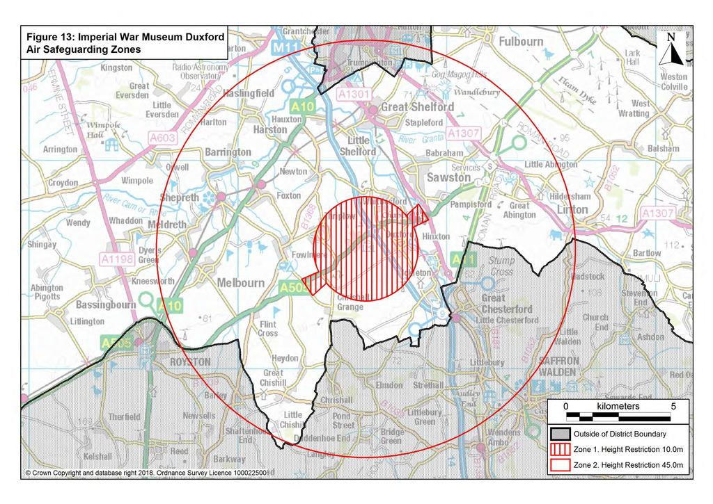
252
253 Chapter 10 Promoting and Delivering Sustainable Transport and Infrastructure Lord s Bridge Radio Telescope Policy TI/7: Lord s Bridge Radio Telescope 1. Within the Lord s Bridge Restricted Area (defined on the Policies Map), planning permission will only be granted for development that would not result in any risk of interference to the Mullard Radio Astronomy Observatory at Lord s Bridge. 2. Within the Lords Bridge Consultation Area 1 (defined on the Policies Map), development proposals that could adversely affect the operation of the Mullard Radio Astronomy Observatory at Lord s Bridge will be subject to consultation with the University of Cambridge, and account will be taken of the risk of interference to the equipment being used at the Observatory. Planning permission will be refused where interference would be caused that could not be overcome by conditions or by the use of planning obligations. 3. Within the Lords Bridge Consultation Area 2 (defined on the Policies Map), development proposals for telecommunications and microwave operations that could adversely affect the operation of the Mullard Radio Astronomy Observatory at Lord s Bridge will be subject to consultation with the University of Cambridge, and account will be taken of the risk of interference to the equipment being used at the Observatory. Planning permission will be refused where interference would be caused that could not be overcome by conditions or by the use of planning obligations The international importance of the Mullard Radio Astronomy Observatory at Lord s Bridge must be safeguarded. The Observatory contains unique radio and optical telescopes operated by the Universities of Cambridge and Manchester / Jodrell Bank. The telescopes measure signals that are very weak, and hence highly susceptible to many forms of interference, specifically electrical interference, light pollution and mechanical vibration from domestic, industrial plant and other sources such as vehicles and aircraft. Arrangements are made to consult the University of Cambridge about the technical consequences for the Observatory of proposed development. Harm caused to the Observatory will be overcome with the use of conditions or planning obligations to regulate the installation and use of equipment likely to interfere with the operation of the Observatory. 241
254 Chapter 10 Promoting and Delivering Sustainable Transport and Infrastructure Provision of Infrastructure and Services Policy TI/8: Infrastructure and New Developments 1. Planning permission will only be granted for proposals that have made suitable arrangements for the improvement or provision of infrastructure necessary to make the scheme acceptable in planning terms. The nature, scale and phasing of any planning obligations and/or Community Infrastructure Levy (CIL) contributions sought will be related to the form of the development and its potential impact upon the surrounding area. 2. Contributions may also be required towards the future maintenance and upkeep of facilities either in the form of initial support or in perpetuity in accordance with Government guidance The NPPF (2012) requires Local Plans to consider a wide variety of infrastructure needs, including transport, telecommunications, waste management, water supply, wastewater, flood risk and coastal change management, and the provision of minerals and energy (including heat), health, security, community and cultural infrastructure and other local facilities The Council s Infrastructure Delivery Study (IDS) (updated in 2015), produced in partnership with Cambridge City Council, explores infrastructure needs and costs, when and where infrastructure will need to be provided, the scale of funding needed to achieve this, and potential sources of funding. The IDS identifies infrastructure critical to the delivery of the Local Plan Infrastructure provision will be funded through a number of sources. Mainstream funding, such as the County Council s capital programmes, service providers investment programmes, and Government grant will contribute to infrastructure spending. However, developer funding, such as planning obligations and CIL, are an important additional resource for locally determined priorities CIL is the Government s preferred mechanism for securing developer contributions towards local and strategic infrastructure improvements and, where possible, the Council intends using CIL to fund offsite provision of facilities and services The provisions contained with the CIL Regulations mean that agreements under Section 106 of the Town and County Planning Act 1990 will revert back to their original intention and mitigate site specific impacts only. In certain circumstances it may be appropriate for the Council to secure planning obligations in addition to CIL where, in accordance with CIL Regulation 122, the obligation is: Necessary to make the development acceptable in planning terms; Directly related to the development; and Fairly and reasonably related in scale and kind to the development. 242
255 Chapter 10 Promoting and Delivering Sustainable Transport and Infrastructure The Council will consult on and publish an infrastructure list under CIL Regulation 123 which will clearly set out those items the Council intends spending CIL receipts on. Under the CIL Regulations the Council will be unable to secure planning obligations for items of infrastructure on the Regulation 123 list thereby providing clarity to developers and land owners that no double counting will occur (i.e. the Council will not secure a financial contribution through a section 106 agreement towards a piece of infrastructure that it could fund through CIL receipts) Should the Council revise the Regulation 123 list, it is to ensure that these changes are clearly explained and subject to appropriate local consultation. Should the Council not introduce a CIL Charging schedule, a CIL charging schedule is later withdrawn or the CIL Regulations are later repealed the Council will produce a Planning Obligations SPD to detail the specific infrastructure requirements from new development Contributions may be necessary for some or all of the following: Affordable housing, including for Key Workers; Education (including nursery and pre-school care); Health care; Public open space, sport and recreation facilities (including Strategic Open Space); Improvements (including infrastructure) for pedestrians, cyclists, equestrians, highways and public and community transport; Other community facilities (e.g. community centres, youth facilities, library services social care, and the provision of emergency services); Landscaping and biodiversity; Drainage / flood prevention; Waste management (pursuant to the Cambridgeshire & Peterborough Minerals and Waste Development Plan); Arts and cultural provision; Community development workers and youth workers; Other utilities and telecommunications; Preservation or enhancement of the historic landscape or townscape There are some forms of development where contributions will not be sought as set out in planning practice guidance. These include custom and self-build housing schemes as well as starter homes Depending on the nature of the services and facilities, contributions may also be required to meet maintenance and/or operating costs either as pump priming or in perpetuity, provided through an obligation Development can create additional demands for physical infrastructure and social facilities, as well as having impacts on the environment. In such cases planning obligations will be required, in accordance with government guidance, to make the necessary improvements, provide new facilities, or secure compensatory provision for any loss or damage created. Such obligations will take account of the wider needs of the Cambridge Sub-Region, in order to achieve wider planning objectives, with contributions pooled where appropriate to meet strategic requirements. In such 243
256 Chapter 10 Promoting and Delivering Sustainable Transport and Infrastructure cases, the nature and scale of contributions sought will be related to the size of the scheme and the extent to which it places additional demands upon the area. Waste Infrastructure Cambridgeshire County Council is responsible for minerals and waste planning in Cambridgeshire. The Cambridgeshire and Peterborough Minerals and Waste Plan was adopted, the Core Strategy in July 2011 and Site Specific Proposals Plan in February There is also an adopted Policies Map, which shows allocated sites and areas of search for future minerals and waste facilities, and safeguarding areas for existing and future facilities The Site Specific Proposals Plan includes areas of search for waste recycling and recovery facilities at Cambridge Northern Fringe East, Cambridge East (the airport site and North of Newmarket Road), and Northstowe. Education Policy TI/9: Education Facilities 1. Local circumstances, including increasing pressure on provision of places, must be taken into account when assessing proposals for education facilities in order to achieve the most sustainable development. In addition, new or enhanced education facilities should: a. Improve the scale, range, quality and accessibility of education provision; b. Be appropriately located to the community they serve; c. Mitigate the impact of any associated residential development; and d. Comply with the strategic objectives of Cambridgeshire County Council, the local Children s Services Authority, and/or the ambition of the community they serve. 2. The Council will work with the County Council to provide high quality and convenient local education services in all parts of the district, but particularly in areas of population growth. 3. Developers should engage with the Children s Services Authority at the earliest opportunity and work co-operatively to ensure the phasing of residential development and appropriate mitigation is identified in a timely manner to ensure appropriate education provision can be secured. 4. Planning permission will be granted for new education facilities in locations accessible by walking, cycling and public transport, where this will meet an existing deficiency or support regeneration or new development. 244
257 Chapter 10 Promoting and Delivering Sustainable Transport and Infrastructure Cambridgeshire County Council is the local Children s Services Authority. It has the statutory duty, established through the Education Act 1996, to secure sufficient places in state funded schools for all children and young people of statutory school age (5-16 years of age) who want one. The Childcare Act 2005 and Education Act 2011 introduced the duty on local authorities to commission sufficient early years and post-16 provision respectively. In addition, the Education Act 2011 cemented a shift in the County Council s role as that of commissioner rather than as a direct provider of school places. Within this commissioning role there is enhanced emphasis on the County Council working in partnership with a wide variety of education providers. Both the County Council and the schools in Cambridgeshire recognise the importance of maintaining their long-established working relationships and working practices in order to ensure that the needs of Cambridgeshire s residents, both current and those who will live in new communities, are addressed Easy access to good quality educational provision is important for supporting economic growth, developing strong sustainable communities and promoting economic prosperity. It is therefore appropriate for new residential development to contribute towards the cost of education provision, either towards the expansion of existing facilities, or in some cases towards the funding of a new school, in line with Policy TI/8. Developers of residential sites should engage with the Children s Services Authority at the earliest opportunity to ensure appropriate education provision is delivered in a timely manner Education facilities comprises those providing early-years and childcare, primary, secondary and further education places for all children and young people aged 0-19 and up to 25 for those with Special Educational Needs and/or disabilities. Higher education and other types of education such as private language schools are not included in this definition of education To ensure consistency and equity in school place planning across Cambridgeshire, the County Council has adopted principles to underpin its duty in respect of the commissioning school places. Although recent legislative and policy changes have resulted in a different approach to education planning, the principles set out below remain appropriate: New schools and expansions of existing schools should provide high quality education provision; and There should be minimal disruption to existing communities as a result of changes in provision; and Schools should play a central role in the communities they serve; and Schools should be located, where possible within the statutory walking distance of the communities they serve: o 2 miles for primary aged pupils (4-10 years old); and o 3 miles for secondary aged pupils (11-15 years old) The education infrastructure required to mitigate the impact of the residential allocations originally identified in the Local Development Framework have been identified. However, the new schools identified will only mitigate the impact of developments they serve. The sites that have been secured will not allow for the schools to expand in response to demand arising from additional residential 245
258 Chapter 10 Promoting and Delivering Sustainable Transport and Infrastructure allocations in the Local Plan. Therefore, appropriate sites, and/or alternative solutions, will need to be secured to be agreed with the Children s Services Authority in order for the education impact of further new housing developments to be appropriately mitigated The Council will work with the County Council (and neighbouring County Councils, as appropriate), as the local education authority, to ensure that school places are made available to all new residents in appropriate locations and in a timely manner, including regular partnership reviews of where school places will be needed in the future. Educational facilities will be expected, where appropriate and/or possible, reflecting on the County Council s commissioning role, to include provision for community use, for example through making multi-use facilities accessible to the wider community As part of this on-going process, a current shortfall (to 2021) of at least 1,050 (7FE) secondary school places has been identified. This need will be met by a new secondary school to serve the eastern part of Cambridge, and the three Councils will continue to work together to find the most appropriate location New education facilities should be located in highly accessible locations with good quality footpaths and cycleways to encourage sustainable travel to and from the school by teachers, parents and pupils. Broadband Policy TI/10: Broadband New development (residential, employment and commercial) will be expected to contribute towards the provision of infrastructure suitable to enable the delivery of high speed broadband services across the district. As a minimum, suitable ducting to industry standards should be provided to the public highway that can accept fibre optic cabling or other emerging technology. Other forms of infrastructure, such as facilities supporting mobile broadband and Wi-Fi, should be included where possible and viable Broadband is a key infrastructure element for the district. Increasing broadband coverage in rural areas will encourage local enterprise, give more people the flexibility to work from home, save transport costs and reduce congestion. Wider access to broadband will also bring opportunities to provide health, education and public services in better ways. This includes supporting elderly and vulnerable people so they can live independently, and helping young people and adult learners to develop the skills they need to succeed. It will support implementation of the South Cambridgeshire Economic Development Strategy and the Cambridgeshire and Peterborough Broadband Plan, prepared by the Connecting Cambridgeshire partnership. 246
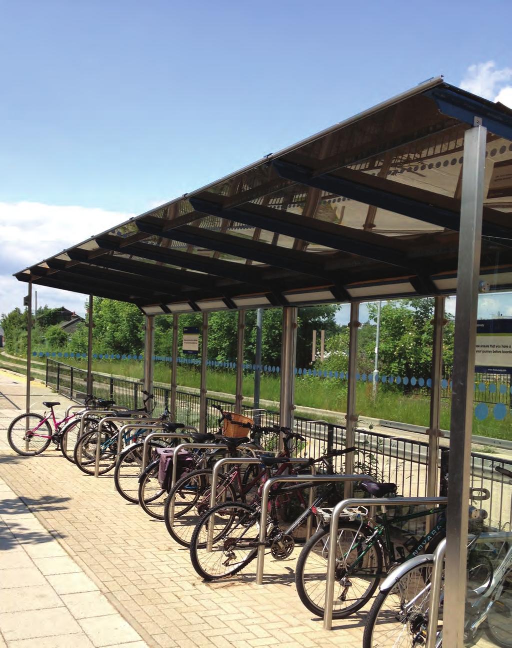

259 Appendices Histon, South Cambridgeshire
260
261 Appendix A Appendix A: Five-Year Housing Land Supply Five-year housing land supply will be calculated using the Liverpool methodology, which has been determined as appropriate for Cambridge and South Cambridgeshire and which spreads any shortfall in supply at the point of calculation over the remainder of the plan period. A 20% buffer is also included in response to historic levels of delivery. The methodology for calculating five-year housing land supply is set out in figure A1 below: Figure A1: Methodology for Calculating Five-Year Supply (a) Housing requirement in the plan period (b) Completions so far in the plan period (c ) Number of dwellings left to deliver in the plan period (= a - b) (d) Number of years of plan period left (e) Annualised average requirement for the remainder of the plan period (= c d) (f) Five year supply requirement (= e x 5) (g) 20% buffer to be added to the five year supply requirement (= f x 0.2) (h) Five year supply requirement with 20% buffer (= f + g) (i) Number of dwellings predicted to be completed in the five year period (j) Five year supply (= i h x 5) Net number of new homes required in the plan period (2011 to 2031) as set out in Policy S/5 of the South Cambridgeshire Local Plan and Policy 3 of the Cambridge Local Plan. Net number of new homes completed so far in the plan period, as set out in the Annual Monitoring Report. Calculated by subtracting the net number of homes completed so far in the plan period from the housing requirement. Number of years of the plan period left in which to deliver the housing requirement. Calculated by dividing the number of dwellings left to deliver by the number of years of the plan period left. The requirement to meet in the next five year period. Calculated by multiplying the annualised average requirement by five. A 20% buffer in addition to the five year supply requirement should be added in response to historic levels of delivery Five year supply requirement plus 20% buffer, against which predicted housing supply is assessed. Net number of new homes predicted to be completed in the five year period, as set out in the housing trajectory published in the Annual Monitoring Report. Calculated by dividing the number of dwellings predicted to be completed in the five year period by the five year supply requirement with the 20% buffer, and then multiplying by five. Figures A2 and A3 below summarise the housing land supply position for South Cambridgeshire and Cambridge individually and jointly as at November 2017 for the five-year periods and , as contained in the Annual Monitoring Reports The Councils both individually and jointly demonstrate a five year housing land supply using the methodology above. The Council s five year supply will be published each year in their Annual Monitoring Reports. These should be consulted for the most up to date position on housing supply. 249
262 Appendix A Figure A2: Five-Year Housing Land Supply Position at November 2017 for (a) Housing requirement 2011 to 2031 (b) Completions up to 31 March 2017 (c ) Number of dwellings left to deliver in the plan period (= a - b) (d) Number of years of plan period left (e) Annualised average requirement for the remainder of the plan period (= c d) (f) Five year supply requirement (= e x 5) (g) 20% buffer to be added to the five year supply requirement (= f x 0.2) (h) Five year supply requirement with 20% buffer (= f + g) (i) Number of dwellings predicted to be completed in the five year period (1 April 2017 to 31 March 2022) (j) Five year supply (= i h x 5) Cambridge South Cambridge-shire Cambridge & South Cambridgeshire 14,000 19,500 33,500 4,932 3,970 8,902 9,068 15,530 24, ,109 1,757 3,239 5,546 8, ,109 1,757 3,886 6,656 10,542 4,201 7,235 11, NOTE: the five year supply figure (row j) and each of the other figures in rows e-h have been calculated using formulae in a spreadsheet, and therefore have been calculated using accurate unrounded numbers. The numbers shown in rows e, f, g and h of this table are the rounded numbers, and therefore the numbers in this table may not sum due to rounding. Source: Cambridge Annual Monitoring Report 2017 and South Cambridgeshire Annual Monitoring Report
263 Appendix A Figure A3: Five-Year Housing Land Supply Position at November 2017 for (a) Housing requirement 2011 to 2031 (b) Completions up to 31 March 2018 (c ) Number of dwellings left to deliver in the plan period (= a - b) (d) Number of years of plan period left (e) Annualised average requirement for the remainder of the plan period (= c d) (f) Five year supply requirement (= e x 5) (g) 20% buffer to be added to the five year supply requirement (= f x 0.2) (h) Five year supply requirement with 20% buffer (= f + g) (i) Number of dwellings predicted to be completed in the five year period (1 April 2018 to 31 March 2023) (j) Five year supply (= i h x 5) Cambridge South Cambridge-shire Cambridge & South Cambridgeshire 14,000 19,500 33,500 6,267 4,629 10,896 7,733 14,871 22, ,144 1,739 2,974 5,720 8, ,144 1,739 3,569 6,864 10,433 3,874 8,197 12, NOTE: the five year supply figure (row j) and each of the other figures in rows e-h have been calculated using formulae in a spreadsheet, and therefore have been calculated using accurate unrounded numbers. The numbers shown in rows e, f, g and h of this table are the rounded numbers, and therefore the numbers in this table may not sum due to rounding. Source: Cambridge Annual Monitoring Report 2017 and South Cambridgeshire Annual Monitoring Report 2017 Figure A4 below shows that it is anticipated that based on the housing trajectory as at November 2017 it is anticipated that there will be a rolling five-year housing land supply continuing for the remainder of the plan period. The housing supply data will be updated annually and published in the Annual Monitoring Report. 251

264 Appendix A Figure A4: Rolling Five Year Supply Cambridge South Cambridgeshire Cambridge & South Cambridgeshire Source: Cambridge Annual Monitoring Report 2017 and South Cambridgeshire Annual Monitoring Report 2017 Figure A5 below shows past and projected completions for Cambridge and South Cambridgeshire over the plan period (2011/12 to 2030/31). In total, the plans must make provision for a minimum of 33,500 homes over this period, which is represented in the graph by the black plan line (the combined annual housing requirement of 1,675 net homes). It also includes a manage line, which shows the outstanding balance of completions relative to cumulative delivery. Figure A5: Past and Projected completions 2011/12 to 2030/31 252
Great Easton Neighbourhood Plan Statement of Basic Conditions
 Great Easton Neighbourhood Plan 2017-2031 Statement of Basic Conditions OCTOBER 2016 GREAT EASTON PARISH COUNCIL Contents 1.0 Introduction....Page 2 2.0 Summary of Submission Documents and Supporting Evidence..
Sustainability Statement. Whitby Business Park Area Action Plan
 Sustainability Statement Whitby Business Park Area Action Plan November 2014 Contents Page 1. Introduction 1 2. Scoping 3 3. Sustainability Appraisal of Options 6 4. Assessment of Draft Area Action Plan
Site Assessment Technical Document Appendix A: Glossary
 Central Bedfordshire Council www.centralbedfordshire.gov.uk Site Assessment Technical Document Appendix A: Glossary July 2017 1.1.11-1 - ii Appendix A: Glossary Term Agricultural Land Classification AONB
Parish of Repton NEIGHBOURHOOD DEVELOPMENT PLAN
 Parish of Repton NEIGHBOURHOOD DEVELOPMENT PLAN BASIC CONDITIONS STATEMENT December 2018 CEF 4 Legal Requirements This statement has been produced by the NDP Working Group on behalf of Repton Parish Council
To secure a Green Belt around Cambridge whose boundaries are clearly defined and which will endure for the plan period and beyond.
 4. GREEN BELT OBJECTIVES GB/a GB/b GB/c GB/d To secure a Green Belt around Cambridge whose boundaries are clearly defined and which will endure for the plan period and beyond. To maintain the purposes
Local Development Scheme
 Local Development Scheme 2012 2016 The Local Development Scheme (LDS) is a project plan that outlines how and when the Authority will update its planning policies and other associated documents. It ensures
BEDFORD BOROUGH COUNCIL PLAN IMPLEMENTATION MONITORING REPORT
 BEDFORD BOROUGH COUNCIL PLAN IMPLEMENTATION MONITORING REPORT 2017-18 Summary 1 Progress on local development documents 1 Local development documents adopted in the monitoring period 1st April 2017 31st
Newcourt Masterplan. November Exeter Local Development Framework
 Newcourt Masterplan November 2010 Exeter Local Development Framework Background The Exeter Core Strategy Proposed Submission sets out the vision, objectives and strategy for the development of Exeter up
ROCHFORD LOCAL DEVELOPMENT FRAMEWORK: Sustainability Appraisal/ Strategic Environmental Assessment. Rochford Core Strategy Preferred Options Document
 ROCHFORD LOCAL DEVELOPMENT FRAMEWORK: Sustainability Appraisal/ Strategic Environmental Assessment Non Technical Summary Rochford Core Strategy Preferred Options Document October 2008 SUSTAINABILITY APPRAISAL
Briefing Document of CNP. June 2017
 Cholsey Parish Council Cholsey Neighbourhood Plan Briefing Document of CNP June 2017 Cholsey Neighbourhood Plan Page! 1 of! 8 Cholsey Plan Briefing v1.4 Page Left Intentionally Blank Cholsey Neighbourhood
DUNSFOLD NEIGHBOURHOOD PLAN Site Selection Policies
 DUNSFOLD NEIGHBOURHOOD PLAN Site Selection Policies The criteria for assessing sites for future housing and business development in Dunsfold are set out below. (Development criteria, covering what it is
BETTER PUBLIC TRANSPORT PROJECT WATERBEACH TO SCIENCE PARK AND EAST CAMBRIDGE CORRIDORS
 Report To: Greater Cambridge Partnership Joint Assembly 20 th September 2018 Lead Officer: Peter Blake GCP Director of Transport BETTER PUBLIC TRANSPORT PROJECT WATERBEACH TO SCIENCE PARK AND EAST CAMBRIDGE
Examination of South Cambridgeshire Local Plan
 Matter SC6A - Policy SS/5 Waterbeach New Town Historic England( formerly English Heritage) 874 Rep Nos 59748, 60250, 60253 Examination of South Cambridgeshire Local Plan Historic England, Hearing Statement
WINCHESTER TOWN 3.1 LOCATION, CHARACTERISTICS & SETTING
 WINCHESTER TOWN 3.1 LOCATION, CHARACTERISTICS & SETTING 3.1.1 The area referred to by the City Council, as Winchester Town, consists of the Winchester Wards plus the adjoining built up areas of Badger
SOUTH CAMBRIDGESHIRE DISTRICT COUNCIL. REPORT TO: Planning Committee 1 April 2015 Planning and New Communities Director
 SOUTH CAMBRIDGESHIRE DISTRICT COUNCIL REPORT TO: Planning Committee 1 April 2015 AUTHOR/S: Planning and New Communities Director Application Number: Parish(es): Proposal: Site address: Applicant(s): Recommendation:
Schedule of Planning Applications Committee Date: 23 May Reference: 06/17/0726/F Parish: Hemsby Officer: Mr J Beck Expiry Date:
 Schedule of Planning Applications Committee Date: 23 May 2018 Reference: 06/17/0726/F Parish: Hemsby Officer: Mr J Beck Expiry Date: 22-05-2018 Applicant: Proposal: Site: Mr Gillett Change of use to the
2. Spatial Portrait, Vision and Objectives
 VISION & OBJECTIVES 2. Spatial Portrait, Vision and Objectives Introduction 2.1 This section sets out the spatial portrait of Uttlesford, the vision we have for the future of the area and the objectives
Ongar. Residential Sites. Vision for Ongar
 5.58 Located in the east of the district, is a District Centre of medieval origin that boasts a retail and service offer benefiting the local community and those in other settlements further afield. 5.59
The Fairfield Partnership Vision for North-East Elsenham
 The Fairfield Partnership Vision for North-East Elsenham August 2009 Frequently Asked Questions Who is The Fairfield Partnership? The Fairfield Partnership is a joint venture between Marchfield Developments
Oxford Green Belt Study. Summary of Final Report Prepared by LUC October 2015
 Oxford Green Belt Study Summary of Final Report Prepared by LUC October 2015 Project Title: Oxford Green Belt Study Client: Oxfordshire County Council Version Date Version Details Prepared by Checked by
WELCOME GYPSY LANE. Wider Site Location plan. Proposals for the development of LAND OFF FOXLYDIATE LANE WEBHEATH. Proposals for the development of
 WELCOME The developers are preparing an outline planning application for a residential led development and need the community s views in order to develop the proposals further WHAT IS PROPOSED? A high
STATEMENT OF OBJECTION TO THE PROPOSED DEVELOPMENT OF LAND AT CHURCH CLIFF DRIVE FILEY
 STATEMENT OF OBJECTION TO THE PROPOSED DEVELOPMENT OF LAND AT CHURCH CLIFF DRIVE FILEY You will be aware that Scarborough borough council have adopted a new local plan that includes land at Church Cliff
Settlement Boundaries Methodology North Northumberland Coast Neighbourhood Plan (August 2016)
") Introduction This background paper sets out a methodology for the definition of settlement boundaries in the North Northumberland Coast Neighbourhood Plan. The neighbourhood plan is planning positively
Introduction This background paper sets out a methodology for the definition of settlement boundaries in the North Northumberland Coast Neighbourhood Plan. The neighbourhood plan is planning positively
Neighbourhood Planning Local Green Spaces
 Neighbourhood Planning Local Green Spaces Introduction... 2 1. Why green space is important... 4 2. Neighbourhood plans and green space... 6 3. Evidence... 8 Statutory designations... 9 Green space audit...
Suffolk Coastal Local Plan Review Issues and Options, August 2017, Public Consultation
 Suffolk Coastal Local Plan Review Issues and Options, August 2017, Public Consultation Having reviewed the issues and options documents, the Society has made the following response: Part 1 - Strategic
Cranfield University Masterplan
 Central Bedfordshire Council EXECUTIVE Tuesday, 5 December 2017 Cranfield University Masterplan Report of: Cllr Nigel Young, Executive Member for Regeneration, (nigel.young@centralbedfordshire.gov.uk )
Brighton Marina Neighbourhood Forum AGM. City Plan Part Two - Draft Plan
 Brighton Marina Neighbourhood Forum AGM City Plan Part Two - Draft Plan 16 May 2018 Sandra Rogers Planning Manager Carly Dockerill & Robert Davidson Principal Planning Officers Presentation outline: Context
Appendix A: Retail Planning Assessment
 Rotherham Town Centre Masterplan Appendix A: Retail Planning Assessment 139 Appendix A Rotherham Town Centre Masterplan Retail Planning Background and Policy Context 1. Introduction 1.1 The Masterplan
INTRODUCTION NORTH HEYBRIDGE GARDEN SUBURB
 INTRODUCTION This event is being hosted by the promoters of the proposed North Heybridge Garden Suburb who are working with Maldon District Council and other key stakeholders on the preparation of a comprehensive
3. Neighbourhood Plans and Strategic Environmental Assessment
 1. Introduction This report sets out a draft Screening Determination for the Preston Parish Council s Neighbourhood Plan and has been prepared by rth Hertfordshire District Council. The purpose of the
ALLERTHORPE NEIGHBOURHOOD PLAN
 Allerthorpe s Neighbourhood Plan sets out a vision for the Parish for the next 15 years (2018 2033) that builds on and reflects the opinions and views of parish residents. VISION In 2033 Allerthorpe will
OKEFORD FITZPAINE NEIGHBOURHOOD PLAN
 OKEFORD FITZPAINE NEIGHBOURHOOD PLAN Dear Parishioner, The Neighbourhood Plan Project Team have prepared this leaflet to summarise the full Neighbourhood Plan document. It provides a summary of the Vision,
Making the case for Sustainable Transport Project Potential
 Making the case for Sustainable Transport Project Potential The Structural Investment Fund (SIF) Strategy for Greater Lincolnshire identifies the barriers to growth identified by having poor transport
2.0 Strategic Context 4
 2.0 Strategic Context 4 2.1 The Area Action Plan is a non-statutory plan, which forms a corporate policy document, expressing particular issues and areas of concern while also providing a vision for the
The Gwennap Parish Vision Statement
 QUICK GUIDE What is a Neighbourhood Development Plan? Ultimately it is a document used by developers or anyone wishing to submit a planning application that describes the vision, strategy, plans, regeneration,
Revised draft District Plan for Council
 Revised draft District Plan for Council June 2012 1 Chapter 1: Background to the revised draft District Plan 1.1 This revised draft District Plan has been written in the context of the Localism Act and
Cottenham Civil Parish. Neighbourhood Development Plan to 2031
 Cottenham Civil Parish Neighbourhood Development Plan 2017 to 2031 Cottenham Parish Council Basic Conditions Statement December 2018 In 2031 Cottenham will still be an attractive safe rural village, proud
19 th October FAO Paul Lewis Planning Policy Branch Planning Division Welsh Assembly Government Cathays Park Cardiff CF10 3 NQ
 19 th October 2009 FAO Paul Lewis Planning Policy Branch Planning Division Welsh Assembly Government Cathays Park Cardiff CF10 3 NQ Dear Sir / Madam Technical Advice Note 6 Planning for Sustainable Rural
Our City Centre is a vibrant, creative and welcoming destination, with a modern business, cultural, shopping, leisure and residential offer
 3. Sheffield in 2034 Our City sits at the heart of a strong, distinctive and internationally successful City Region economy which supports innovation and enterprise Our City Centre is a vibrant, creative
Plumpton Neighbourhood Development Plan Revised Pre Submission Document - Regulation 14 Consultation
 REPRESENTATIONS... Plumpton Parish Council Plumpton Neighbourhood Development Plan Revised Pre Submission Document - Regulation 14 Consultation Representations submitted on behalf of: Cala Homes (South
Rochford District Council. Adopted 16 December Local Development Framework. Development Management Plan LDF.
 Rochford District Council Adopted 16 December 2014 Local Development Framework Development Management LDF www.rochford.gov.uk Contents Page 1 Introduction... 3 The Role of the Development Management...
A428 Cambourne to Cambridge Better Bus Journeys Landscape and Planning Appraisal Cambridgeshire County Council. January 2017
 A428 Cambourne to Cambridge Better Bus Journeys Landscape and Planning Appraisal Cambridgeshire County Council January 2017 Notice This document and its contents have been prepared and are intended solely
Annex B: SWDP Objectives mapped against Worcestershire SCS Objectives. Annex B: SWDP Objectives mapped against Worcestershire SCS Objectives
 Annex B: SWDP mapped against SCS Annex B: SWDP mapped against SCS in SCS Economic Success That Is Shared By All 1. A skilled prosperous economy 1. Development that focuses on improving A. Enhanced prosperity
Cookham Parish Council s Response to The Draft Local Borough Plan
 Cookham Parish Council s Response to The Draft Local Borough Plan As Agreed at the Planning Committee Meeting on 10 th January 2017. Designation of Poundfield as a Local Green Space The Parish Council
About 10% of the Borough's population lives in the seven rural parishes. Population figures from the 1991 census are given below:-
 8. THE DISTRICT VILLAGES 8.1 Population About 10% of the Borough's population lives in the seven rural parishes. Population figures from the 1991 census are given below:- Village No. of Persons Cottingham
Cambridge to Cambourne Busway (A428) Planning Appraisal. Prepared by Strutt & Parker LLP & Atkins on behalf of Greater Cambridge Partnership
 Planning Appraisal. Prepared by Strutt & Parker LLP & Atkins on behalf of Greater Cambridge Partnership") Cambridge to Cambourne Busway (A428) Planning Appraisal Prepared by Strutt & Parker LLP & Atkins on behalf of Greater Cambridge Partnership August 2017 1 CONTENTS 1. Executive Summary 3 2. Introduction...5
Cambridge to Cambourne Busway (A428) Planning Appraisal Prepared by Strutt & Parker LLP & Atkins on behalf of Greater Cambridge Partnership August 2017 1 CONTENTS 1. Executive Summary 3 2. Introduction...5
Planning and Regulatory Committee 20 May Applicant Local Councillor Purpose of Report
 Planning and Regulatory Committee 20 May 2014 7. APPLICATION FOR PLANNING PERMISSION FOR THE CARRYING-OUT OF DEVELOPMENT PURSUANT TO PLANNING PERMISSION REFERENCE NUMBER 603451 DATED 28 FEBRUARY 2007 WITHOUT
Planning and Sustainability Statement
 Land adjacent to Manor Farm, Catterick Village Pallett Hill Sand and Gravel Co Ltd Proposed 10 new dwellings, (6 No market dwellings and 4 No affordable dwellings) with access, associated car parking and
Local Development Plan for Glasgow
 Local Development Plan for Glasgow Forbes Barron Head of Planning & Building Control Services Context and Process for LDP NPF 3 Principles An 80% reduction in emissions by 2050. Achieving the aims of the
Neighbourhood Planning Guidance Local Green Spaces
 Neighbourhood Planning Guidance Local Green Spaces Introduction This guidance note has been produced for communities preparing neighbourhood plans in North Dorset to help them to identify, assess and designate
Cotswolds AONB Landscape Strategy and Guidelines. June 2016
 Cotswolds AONB Landscape Strategy and Guidelines June 2016 Cotswolds AONB Landscape Strategy and Guidelines Introduction The evolution of the landscape of the Cotswolds AONB is a result of the interaction
Effingham Neighbourhood Plan 1. Basic Conditions Statement
 Effingham Neighbourhood Plan 1 Basic Conditions Statement Effingham Neighbourhood Plan 2016: Basic Conditions Statement 2 Contents This statement has been prepared by Effingham Parish Council to accompany
Stantonbury Neighbourhood Plan
 Stantonbury Neighbourhood Plan 2018-2031 Basic Conditions Statement October 2018 Intentionally blank 1.0 Basic Conditions Statement Introduction 1.1 This statement has been prepared by Stantonbury Parish
Application Guide. Should you have any questions on the Outline Application please contact:
 Application Guide Application Guide This guide describes the structure of the Outline Application, explains the different documents that have been submitted with it and identifies what will happen next.
Copyright Nigel Deeley and licensed for reuse under this Creative Commons Licence
 1 Copyright Nigel Deeley and licensed for reuse under this Creative Commons Licence Prepared by the Neighbourhood Plan Steering Group on behalf of Garway Parish Council with assistance from 2 Table of
LONGDEN VILLAGE DEVELOPMENT STATEMENT
 LONGDEN VILLAGE DEVELOPMENT STATEMENT 2017-2027 1 Longden Development Statement 2017-2027 15/01/18 1. Background 1.1 Longden Village Longden village is a very rural and traditional community first mentioned
WHITELEY TOWN COUNCIL NORTH WHITELEY DEVELOPMENT SEPTEMBER 2014
 WHITELEY TOWN COUNCIL NORTH WHITELEY DEVELOPMENT SEPTEMBER 2014 Dear Resident This Special Edition of the Whiteley Voice which has been prepared in conjunction with the North Whiteley Consortium is to
Neighbourhood Plan Representation
 Date: 10 th November 2017 Neighbourhood Plan Representation Land to the east of Callow Hill Road, Alvechurch Introduction This representation has been prepared by RPS Planning and Development on behalf
1.3 The following table presents a Statement of Compliance demonstrating how the Standish Neighbourhood Plan meets those requirements.
 1. Introduction 1.1 This Basic Condition Statement was prepared to accompany the draft Standish Neighbourhood Plan (2018). 1.2 Paragraph 8 of Schedule 4B of the Town and Country Planning Act 1990 requires
Response to the London Bridge Area Vision and Site Allocations within the New Southwark Plan
 1 Melior Place London SE1 3SZ 020 7407 4701 teamlondonbridge.co.uk info@teamlondonbridge.co.uk 28 April 2017 Response to the London Bridge Area Vision and Site Allocations within the New Southwark Plan
Wildlife and Planning Guidance: Neighbourhood Plans
 Wildlife and Planning Guidance: Neighbourhood Plans This Leaflet is one of a series of 4 Wildlife and Planning Guidance Leaflets and is intended to provide useful information to assist you to campaign
South Worcestershire Development Plan. South Worcestershire Design Guide Supplementary Planning Document
 South Worcestershire Development Plan South Worcestershire Design Guide Supplementary Planning Document Statement of Consultation: Early Engagement Scoping Paper February 2017 1. Introduction 1.1 This
Welcome. Site/11/04. Site/11/03. Proposed Site. 11,400 new homes needed in east Cambs
 Welcome Welcome to our consultation on our proposals for new homes on land north east of Soham Road, Fordham. Members of the project team are available to answer any questions you have and listen to feedback.
Northern Territory Compact Urban Growth Policy
 Northern Territory Compact Urban Growth Policy A Reference Policy Document to clause 2.7 (Reference to Policy) of the NT Planning Scheme May 2015 Table of Contents 1 Policy Setting... 3 1.1 Context for
Basic Conditions Statement Exmouth Neighbourhood Plan
 Exmouth Neighbourhood Plan 2018-2031. On behalf Exmouth Neighbourhood Plan Steering Group July 2018 Table of Contents 1. Introduction... 4 2. Legal Requirements... 5 3. Why there is a need for a Neighbourhood
National Planning Policy Framework
 National Planning Policy Framework Draft text for consultation March 2018 Ministry of Housing, Communities and Local Government Crown copyright, 2018 Copyright in the typographical arrangement rests with
EXTRACT FROM THE CUDDINGTON NEIGHBOURHOOD PLAN The Policies
 EXTRACT FROM THE CUDDINGTON NEIGHBOURHOOD PLAN The Policies Environment and Landscape Policy 1 - Landscape Setting Development should respect and wherever possible enhance the landscape setting of Cuddington
9 Pershore. Introduction. Pershore Abbey
 118 Introduction 9.1 The historic town of Pershore lies on the River Avon and has a population of 7,000 (2009 Mid-Term Population Estimates). The main areas of the town are centred on the Abbey, the bustling
DRAFT STRATEGIC ENVIRONMENTAL ASSESSMENT REPORT
 DRAFT STRATEGIC ENVIRONMENTAL ASSESSMENT REPORT Published by Limpsfield Parish Council in accordance with EU Directive 2001/42 on Strategic Environmental Assessment and with the Environmental Assessment
Droitwich Spa 6. Reasoned Justification
 87 Droitwich Spa 6 Reasoned Justification 6.1 Droitwich Spa is identified in the settlement hierarchy (Policy SWDP1) as a main town being the largest settlement in Wychavon District with an estimated population
Kibworth Harcourt. Introduction. Introduction
 Introduction Introduction Welcome to this public exhibition on the proposals for the delivery of new homes on land at The Kibworths. The purpose of today s exhibition is to give you the opportunity to
Gypsy and Traveller Development Plan Document
 Local Development Framework Gypsy and Traveller Development Plan Document Responding to the Issues and Options 2 Consultation Appendix 2-14 December 2010 Contents Page Executive Summary i Chapter 1 -
Vigo Neighbourhood Plan Basic Conditions Statement
 Vigo Neighbourhood Plan Basic Conditions Statement Plan Period: 2016 to 2028 Status: Submission Version Qualifying Body: Vigo Parish Council Glossary of Some Terms & Abbreviations Used in this Document
Strategic Environmental Assessment Screening Report. Dublin Port Masterplan Review 2017
 Strategic Environmental Assessment Screening Report Dublin Port Masterplan Review 2017 Table of Contents 1 Introduction... 1 2 Purpose of the Masterplan... 2 3 Task 1.1 Pre-Screening Check... 5 4 Task
Scottish Natural Heritage. Better places for people and nature
 Scottish Natural Heritage Better places for people and nature Contents Summary... 3 SNH approach... 5 Place-making in policy and practice... 6 Developing the contribution of the natural heritage to place-making...
Perth and Kinross Council Development Management Committee 8 June Pre-Application Report by Development Quality Manager
 Perth and Kinross Council Development Management Committee 8 June 2016 5(3)(i) 16/259 Pre-Application Report by Development Quality Manager Residential development at St Martins Road, Land 120 metres West
Response to. South Cambridgeshire Local Plan
 Response to South Cambridgeshire Local Plan Dr Tumi Hawkins Disclaimer The content of this document is solely my personal opinion based on the evidence that South Cambridgeshire District Council has placed
BLEWBURY NEIGHBOURHOOD DEVELOPMENT PLAN STATEMENT OF BASIC CONDITIONS
 BLEWBURY NEIGHBOURHOOD DEVELOPMENT PLAN STATEMENT OF BASIC CONDITIONS Introduction 1.1 This statement has been prepared to accompany the submission of the Blewbury Neighbourhood Development Plan ( the
Introduction. Grounds of Objection
 Planning application ref. number 18/04496/APP Planning application to Aylesbury Vale District Council for the erection of 17 dwellings and associated works to the South of Hogshaw Road Granborough. Granborough
Former North Works, Lickey Road, Longbridge, Birmingham
 Committee Date: 14/11/2013 Application Number: 2013/06431/PA Accepted: 27/08/2013 Application Type: Full Planning Target Date: 26/11/2013 Ward: Longbridge Former North Works, Lickey Road, Longbridge, Birmingham
The targets do not adhere to the government projections or methodology, being aspirational rather than achievable.
 Question 1: Preferred Growth Option (see pages 7-9 of the consultation document) Do you agree with the preferred growth option for the Joint Local Plan? The targets do not adhere to the government projections
Reporter: Section 3 Place, Drymen, pp reference: Body or person(s) submitting a representation raising the issue (including reference number):
 submitting a representation raising the issue (including reference number):") Issue 10 Drymen Development plan Reporter: Section 3 Place, Drymen, pp.66-69 reference: Body or person(s) submitting a representation raising the issue (including reference number): Nadja Ray (85) Stuart
Issue 10 Drymen Development plan Reporter: Section 3 Place, Drymen, pp.66-69 reference: Body or person(s) submitting a representation raising the issue (including reference number): Nadja Ray (85) Stuart
GUILDFORD BOROUGH GREEN BELT AND COUNTRYSIDE STUDY
 GUILDFORD BOROUGH GREEN BELT AND COUNTRYSIDE STUDY Volume II - Addendum On behalf of Guildford Borough Council PPG Ref : BNL.0287 April 2014 COPYRIGHT The conents of this document must not be copied or
Rural Planning and National Parks. John Scott Director of Conservation and Planning Peak District National Park Authority 2 November 2018
 Rural Planning and National Parks John Scott Director of Conservation and Planning Peak District National Park Authority 2 November 2018 UK national parks So how green is this land? Are we concreting
2015/1020 Mr Edward Cockburn Caravan storage on hardcore base (Retrospective) Ranah Stones, Whams Road, Hazlehead, Sheffield, S36 4HT
 Ranah Stones, Whams Road, Hazlehead, Sheffield, S36 4HT") 2015/1020 Mr Edward Cockburn Caravan storage on hardcore base (Retrospective) Ranah Stones, Whams Road, Hazlehead, Sheffield, S36 4HT Dunford Parish Council have not commented Councillor Andrew Millner
2015/1020 Mr Edward Cockburn Caravan storage on hardcore base (Retrospective) Ranah Stones, Whams Road, Hazlehead, Sheffield, S36 4HT Dunford Parish Council have not commented Councillor Andrew Millner
A428 Cambourne to Cambridge Segregated Bus Route
 A428 Cambourne to Cambridge Segregated Bus Route Consideration of Green Belt Issues August 2017 A 17 Minster Precincts Peterborough PE1 1XX United Kingdom T +44 (0) 1733 310 471 F +44 (0) 1733 553 661
Response by The Dartington Hall Trust
 Consultation Response by The Dartington Hall Trust Site Reference: SH_39_02_08/13 Contents Introduction 1 Site Description 2 Development Proposal and Context 3 Site Technical Assessment 4 Planning Policy
Draft Island Development Plan
 Draft Island Development Plan February 2015 Written Statement Contents Part One 1 About the Island Development Plan What is the Island Development Plan? What is the Island Development Plan used for? Structure
Appendix 1 Structure plan guidelines
 Appendix 1 Structure plan guidelines This appendix forms part of the regional policy statement [rps]. 1.1. Introduction Structure plans are an important method for establishing the pattern of land use
Response by The Dartington Hall Trust
 Consultation Response by The Dartington Hall Trust Site Reference: (T6 in DPD) 14_56/2246/13/f Contents Introduction 1 Site Description 2 Development Proposal and Context 3 Site Technical Assessment 4
Western City District What we heard
 What we heard Vision to 2056 and Priorities Governance and implementation Infrastructure and funding The protection of the natural landscape including biodiversity and the Metropolitan Rural Area for food
Change Paper / Date CAIRNGORMS NATIONAL PARK AUTHORITY
 Change Paper / Date CAIRNGORMS NATIONAL PARK AUTHORITY Title: Prepared by: REPORT ON CALLED-IN PLANNING APPLICATION FIONA MURPHY (PLANNING OFFICER DEVELOPMENT MANAGEMENT) DEVELOPMENT PROPOSED: REFERENCE:
Chapter 3 Core Strategy
 Chapter 3 Core Strategy 3.0 Introduction The core strategy sets out how the development objectives in the Development Plan are consistent with the National Spatial Strategy and the Regional Planning Guidelines.
PLANNING DECISION NOTICE
 PLANNING DECISION NOTICE TOWN AND COUNTRY PLANNING ACT, 1990 Applicant WILLITON VILLAGE HALL STEERING COMM. C/O ALISON CALLOWWAY 54 NORTHCROFT WILLITON TAUNTON TA4 4RT Date Registered 11/08/2006 Application
Rochford District Council Allocations Development Plan Document: Discussion and Consultation Document Sustainability Appraisal
 Option SWH1 Balanced Communities Option SWH1 1 To ensure the delivery of high quality sustainable communities where people want to live and work Will it ensure the phasing of infrastructure, including
National Planning Policy Framework
 National Planning Policy Framework February 2019 Ministry of Housing, Communities and Local Government ( ( (!"#$%&"'()'"&&$&*()%'$+,( -."/01%.2( ( ( @$"0"/1"9(12(@&$
Committee Report. Case Officer: Gemma Walker. Ward: Bacton & Old Newton. Ward Member/s: Cllr Jill Wilshaw.
 Committee Report Item No: 1 Ward: Bacton & Old Newton. Ward Member/s: Cllr Jill Wilshaw. Reference: DC/17/05423 Case Officer: Gemma Walker Description of Development Outline planning application (all matters
Reserved Matters application for a site that straddles the boundary between CBC and BBC
 BBC APPLICATION 15/02682/MAR NUMBER CBC APPLICATION CB/15/04294/RM NUMBER LOCATION Wixams Land at former storage depot, Bedford Road, Wilstead Bedfordshire PROPOSAL Reserved Matters Application for Strategic
Policy and Resources Committee 10 th October Green Infrastructure Supplementary Planning Document (SPD) Summary. Title
 Summary. Title") Policy and Resources Committee 10 th October 2017 Title Report of Wards Status Urgent Key Enclosures Officer Contact Details Green Infrastructure Supplementary Planning Document (SPD) Deputy Chief Executive
Policy and Resources Committee 10 th October 2017 Title Report of Wards Status Urgent Key Enclosures Officer Contact Details Green Infrastructure Supplementary Planning Document (SPD) Deputy Chief Executive
DEVELOPMENT MANAGEMENT REPORT
 ITEM A07-1 DEVELOPMENT MANAGEMENT REPORT TO: BY: Development Management Committee (South) Development Manager DATE: 21 June 2016 DEVELOPMENT: SITE: WARD: APPLICATION: APPLICANT: Outline application for