Land at Whiteditch Lane, Newport, Essex
|
|
|
- Hannah Johnson
- 5 years ago
- Views:
Transcription

1 Land at Whiteditch Lane, Newport, Essex Ecology Report Produced for Sworders Agricultural By March 2013
2 Document Control: Version Date Version Details Prepared by Checked by Approved by Draft RJH Final RJH DP DP Prepared for: Title: Project number: Document version: Document status: Document date: Sworders Agricultural Whiteditchh Lane, Newport, Essex Ecology Report AEL Final 4 March 2013 Signed on behalf of : Director APPLIED ECOLOGY LTD St. John's Innovation Centre Cowley Road Cambridge CB4 0WS Tel: Fax: Mobile: info@appliedecology.co. uk
3 Contents 1 Introduction 1 Background 1 Legislation 1 Summary 2 2 Survey Approach 3 3 Survey Findings 4 Habitats and Plants 4 Protected Animal Species 4 4 Conclusions and Recommendations 7 Conclusions 7 Recommendations 7 Appendix 1 9 Site Location Plan 9 Figures Figure 3.1: Habitat map 6 04 March 2013
4 04 March 2013
5 1 Introduction Background 1.1 (AEL) were appointed by Sworders Agricultural (on behalf of the landowners) in January 2013 to undertake an ecology walkover survey of an area of arable land (9.1ha in extent) off Whiteditch Lane in Newport, Essex (central grid reference TL ). A figure showing the location of the site is provided in Appendix A walkover survey of the site was completed by AEL on the 6 February 2013 in order to record and evaluate the habitats present, and to assess its potential to support protected animal species that could be of material planning concern for future development of the site. Legislation 1.3 The Wildlife and Countryside Act 1981 (as amended) provides the main legal framework for nature conservation and species protection in the UK. The Site of Special Scientific Interest (SSSI) is the main statutory nature conservation designation in the UK. Such sites are notable for their plants, or animals, or habitats, their geology or landforms, or a combination of these. Natural England is the key statutory agency in England for advising Government, and for acting as the Government s agent in the delivery of statutory nature conservation designations. 1.4 Designation of a SSSI is a legal process, by which sites are notified under the Wildlife and Countryside Act The 1981 Act makes provision for the protection of sites from the effects of changes in land management, and owners and occupiers receive formal notification specifying why the land is of special scientific interest, and listing any operations likely to damage the special interest. 1.5 The Countryside and Rights of Way Act 2000, and The Natural Environment and Rural Communities (NERC) Act 2006, provide supplementary protected species legislation. Specific protection for badgers is provided by the Protection of Badgers Act National Planning Policy Framework (2012) 1.6 The National Planning Policy Framework (NPPF) was published in March 2012 and replaces previous planning policy guidance (PPS 9) on biodiversity. NPPF states in Chapter 9 paragraph 118 the following in relation to biodiversity and planning: When determining planning applications, local planning authorities should aim to conserve and enhance biodiversity by applying the following principles: If significant harm resulting from a development cannot be avoided (through locating on an alternative site with less harmful impacts), adequately mitigated, or, as a last resort, compensated for, then planning permission should be refused; Proposed development on land within or outside a Site of Special Scientific Interest likely to have an adverse effect on a Site of Special Scientific Interest (either individually or in 1 04 March 2013
6 combination with other developments) should not normally be permitted. Where an adverse effect on the site s notified special interest features is likely, an exception should only be made where the benefits of the development, at this site, clearly outweigh both the impacts that it is likely to have on the features of the site that make it of special scientific interest and any broader impacts on the national network of Sites of Special Scientific Interest; Development proposals where the primary objective is to conserve or enhance biodiversity should be permitted; Opportunities to incorporate biodiversity in and around developments should be encouraged; Planning permission should be refused for development resulting in the loss or deterioration of irreplaceable habitats, including ancient woodland and the loss of aged or veteran trees found outside ancient woodland, unless the need for, and benefits of, the development in that location clearly outweigh the loss; and the following wildlife sites should be given the same protection as European sites: - Potential Special Protection Areas and possible Special Areas of Conservation; listed or proposed Ramsar sites; and - Sites identified, or required, as compensatory measures for adverse effects on European sites, potential Special Protection Areas, possible Special Areas of Conservation, and listed or proposed Ramsar sites. The presumption in favour of sustainable development does not apply where development requiring appropriate assessment under the Birds or Habitats Directives is being considered, planned or determined. Summary 1.7 In order to assess the nature conservation and biodiversity value of the proposed development site in accordance with current wildlife legislation and planning policy, a desk assessment and ecological field survey has been completed and is described in this report. 1.8 Chapter 2 and 3 describes the assessment approach and findings, and Chapter 4 provides conclusions and recommendations March 2013
7 2 Survey Approach 2.1 A walkover field survey of the entire site was completed an experienced AEL ecologist ( ) on 6 February 2013, during fine, dry and snow free weather conditions. All field boundaries were walked and associated habitat and botanical information was recorded for dominant and notable habitats and features. 2.2 Evidence of the presence of protected animal species or features of significant potential value in this respect were searched for and recorded during the walkover survey. In the absence of such evidence, a professional judgment assessment of habitat suitability for these species/groups was completed based on habitat extent, condition and connectivity with other habitats March 2013
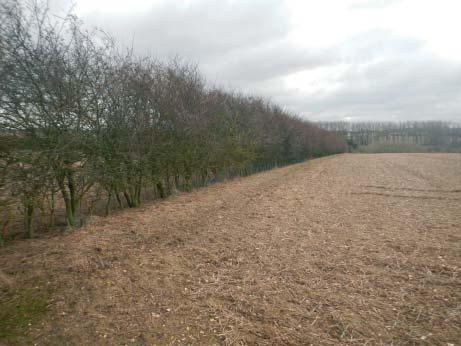
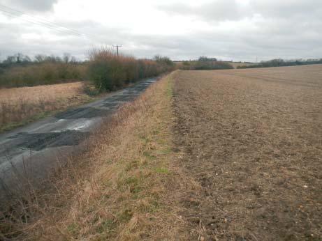
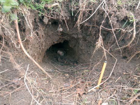
8 3 Survey Findings Habitats and Plants 3.1 A habitat map is shown by Figure 3.1, with representative photographs provided in Figure The site consists of two separate arable fields, both of which supported cereal stubble during the walkover survey (Photos 1 and 2). The fields supported sparse arable weeds of only a few common species that are evident during the winter, including cleavers Galium aparine, annual meadow grass Poa annua and field forget me not Myosotis arvensis. 3.3 The internal boundary between the two arable fields and the majority of the site s perimeter boundary support hedgerows. In general these hedgerows are relatively speciespoor and lack mature standard trees. For descriptive purposes, the hedgerows have been divided into nine separate sections on the basis of their woody shrub species composition and structure. The locations of the nine sections are shown by Figure 3.1 and the character of each is summarised below. Hedgerow sections H1, H5, H6 and H7 are mixed hawthorn Crataegus monogyna hedges with field maple Acer campestre, elder Sambucus nigra, blackthorn Prunus spinosa and dog rose Rosa canina (e.g. Photo 3). H3, H4 and H9 (a recently planted section) are species poor examples dominated entirely by hawthorn (e.g. Photo 4). H2 is located along a steep sloping embankment and is dominated by dead and dying elm Ulmus species, with a few mature ash Fraxinus excelsior standards. H8 is a mixed blackthorn hedge, with some patches of bramble Rubus agg., elm and dog rose. 3.4 A narrow and sloping rough grassland and tall ruderal verge, dominated by common couch Elytrigia repens, false oat grass Arrhenatherum elatius, nettle Urtica dioica and bramble Rubus agg., was present along southern boundary of the site, along the north side of Bury Water Lane (Photo 5). Protected Animal Species Overview 3.5 The site is dominated by in arable land and is of low value in protected species terms. No evidence of protected animal species was recorded during the walkover. 3.6 On the basis of the habitats present the key potential protected species issues identified during the walkover survey can be summarised as: A single mammal dug hole was found along the embankment at hedge section H1 of a size consistent with badger size and shape (Photo 6). No evidence of badger use was found in association with this hole however and the hole was located in an area 4 04 March 2013
9 extensively dug by rabbits. On balance the hole is likely to be the result of tunnel collapse and enlargement of a rabbit dug hole. The presence of a narrow sloping rough grass embankment along the site s southern boundary (northern side of Bury Water Lane) that has some potential to support reptiles. The likely presence of common species of nesting bird within boundary hedgerow habitats, and potentially ground nesting species such as skylark in the arable fields, during the bird breeding period (March July, inclusive). The presence of two off site ponds within 250m of the site (neither was inspected during the walkover), which could theoretically support breeding great crested newts, one in an abandoned area of garden nursery just off site to the south east, and the other a larger water body located around 140m to the southwest of the site. The site itself is of negligible value to terrestrial GCN, but specific GCN survey in April May of these two ponds may be required going forward depending on future development proposals in order to determine the presence/absence of GCN and therefore the potential risk of killing/injuring GCN during any development construction. 3.7 Although further survey for reptiles and off site ponds for GCN may be required, the majority of the site is unsuitable for these species / groups and it is likely that any negative effects of development could be designed out and / or mitigated relatively easily. In summary, no over riding ecological constraints to future development of the site have been identified by the initial walkover survey March 2013
 Land off Whiteditch Lane, Newport, Essex Figure 1: Habitat")
10 H5 H4 Arable land H9 H6 H3 H7 H2 Arable land H1 H8 100 m Key Site boundary Hedgerow secɵon (with secɵon reference number) Land off Whiteditch Lane, Newport, Essex Figure 1: Habitat map


11 Photo 1 Photo 2 Photo 3 Photo 4 Photo 5 Photo 6 Land at Whiteditch Lane, Newport, Essex Photo-sheet
12 4 Conclusions and Recommendations Conclusions 4.1 In general terms the site is dominated by arable land, with mostly species poor hedgerow boundaries that lack significant mature standard trees or other notable habitat features. 4.2 The site is of limited value to protected animal species with a small linear bank along Bury Water Lane offering habitat conditions potentially suitable for reptiles, and hedgerows that could support nesting birds during the bird breeding period. Two ponds are located within 250m of the site and could theoretically support GCN. Although the site itself supports very little in the way of GCN friendly terrestrial habitat, which is restricted to boundary habitats, specific GCN surveys of these ponds may be required to assess the risk of development construction resulting in negative effects on this species. Recommendations 4.3 The need for further ecology survey will be partly dependent on future development proposals for the site, but recommendations going forward include: Reptile survey If the rough grassland bank along Bury Water Lane is to be lost or damaged, a reptile survey would be required to determine the presence/absence of reptiles from this specific area and the need for associated mitigation. The reptile survey would need to be completed between the months of April September. Great crested newt survey A survey of the two off site ponds to determine their suitability, and if suitable, the presence / absence of GCN should be undertaken; assuming access for survey can be arranged. This survey would need to be completed between April May. If more than a year passes between the current walkover survey and development of the site, a further walkover should be completed in order to check for the presence of badger setts within the site. A specific breeding bird survey is not considered necessary given the lack of habitat diversity and the poor quality of the habitat present within the site. However, site clearance must be completed outside of the bird breeding period (i.e. between the months of August and February) March 2013
13
14 Appendix 1 Site Location Plan 9 04 March 2013
15
16
17 11 04 March 2013
18 , 2013
Planning Application 13/00952/FULLS at Ampfield Hill, Romsey, Test Valley: Great Crested Newt Survey Following on From Ecological Assessment
 10 June 2014 Mr Allan Clark esq Ampfield Parish Council Blue Haze Ampfield Hill Ampfield Romsey SO51 9BD By email only Our Ref: P13/46 Dear Mr Clark Planning Application 13/00952/FULLS at Ampfield Hill,
Basic Habitat Survey Tabernacle Gardens, Pembroke
 Basic Habitat Survey Tabernacle Gardens, Pembroke Produced by The Wildlife Trust of South and West Wales Contact Ecologist: Position: Nathan Walton Wildlife Trust Officer Registered Office: Wildlife Trust
Wingerworth, Chesterfield. February Surveyor: James Porter
 Report Wingerworth, Chesterfield February 2014 Surveyor: James Porter (Natural England Licence Number: CLS00241 Contents Contents Notice to readers 1.0 Introduction Background Information Site Description
Dormouse Method Statement
 , Northamptonshire A Report on behalf of April 2013 CONTENTS 1.0 Introduction 1.1 Purpose of this Method Statement 1.2 Site Background 1.3 Dormouse Ecology & Legal Protection 2.0 Methodology 2.1 Tool Box
Preliminary Ecological Appraisal
 Preliminary Ecological Appraisal Seminar Outline What is Preliminary Ecological Appraisal (PEA)? What are the main objectives of PEA? Methods of PEA Wildlife legislation and planning policy Examples of
Proposed Residential Development at Church Stile Farm in Cradley, Herefordshire. Hazel Dormouse Surveys
 Proposed Residential Development at Church Stile Farm in Cradley, Herefordshire A report to: Terra Strategic BSL Strategic Ltd. 2 The Courtyard 707 Warwick Road Solihull B91 3DA By: Udall-Martin Associates
Statutory and Non-Statutory Designated Sites and Ecology
 Statutory and Non-Statutory Designated Sites and Ecology The National Planning Policy Framework considers the conservation and enhancement of the natural environment in chapter 11 paragraphs 109-119, where
ECOLOGICAL ADVICE SERVICE
 ECOLOGICAL ADVICE SERVICE TO: FROM: Guy Wilson Marie Thibault DATE: 11 th August 2016 SUBJECT: CA/16/01502/FUL / Land adjoining Goose Farm, Canterbury Thank you for requesting advice on this application
Tandridge Local Plan Assessing the Ecological Suitability of 183 sites considered for development Tandridge District Council, Surrey
 Tandridge Local Plan Assessing the Ecological Suitability of 183 sites considered for development Tandridge District Council, Surrey PLANNING I DESIGN I ENVIRONMENT 1.0 INTRODUCTION TEP conducted Site
CLACKMANNANSHIRE COUNCIL STIRLING - ALLOA - KINCARDINE RAILWAY (ROUTE RE- OPENING) AND LINKED IMPROVEMENTS (SCOTLAND) BILL
 AND LINKED IMPROVEMENTS (SCOTLAND) BILL") CLACKMANNANSHIRE COUNCIL STIRLING - ALLOA - KINCARDINE RAILWAY (ROUTE RE- OPENING) AND LINKED IMPROVEMENTS (SCOTLAND) BILL GREAT CRESTED NEWT SURVEY REPORT JUNE 2003 Scott Wilson (Scotland) Ltd Contact:
CLACKMANNANSHIRE COUNCIL STIRLING - ALLOA - KINCARDINE RAILWAY (ROUTE RE- OPENING) AND LINKED IMPROVEMENTS (SCOTLAND) BILL GREAT CRESTED NEWT SURVEY REPORT JUNE 2003 Scott Wilson (Scotland) Ltd Contact:
EXTENDED PHASE ONE HABITAT SURVEY. Mid Wales Golf Centre Caersws Powys. Grid reference: SO
 Arbor Vitae Environment 1 EXTENDED PHASE ONE HABITAT SURVEY Mid Wales Golf Centre Caersws Powys Grid reference: SO04139044 Arbor Vitae Environment 2 CONTENTS Executive summary 3 1 Introduction 1.1 Background
WALTON ROAD QUARRY, HARTLEBURY, WORCESTERSHIRE
 WALTON ROAD QUARRY, HARTLEBURY, WORCESTERSHIRE Biodiversity Enhancement Report to Wienerberger Ltd Project Ref: 2017/130 v1 Worcestershire Wildlife Consultancy Lower Smite Farm Smite Hill Hindlip Worcester
Land at Porch Farm, Kingsclere Ecology Briefing Paper, April 2016 C_EDP3343_01a
 C_EDP3343_01a Introduction 1.1 This Ecology Briefing Paper has been prepared by The Environmental Dimension Partnership Ltd (EDP) on behalf of Linden Homes. This briefing paper considers the ecological
Settlement Boundaries Methodology North Northumberland Coast Neighbourhood Plan (August 2016)
") Introduction This background paper sets out a methodology for the definition of settlement boundaries in the North Northumberland Coast Neighbourhood Plan. The neighbourhood plan is planning positively
Introduction This background paper sets out a methodology for the definition of settlement boundaries in the North Northumberland Coast Neighbourhood Plan. The neighbourhood plan is planning positively
OVERVIEW OF PLANNING POLICY AND PROCEDURE RELATING TO BIODIVERSITY IN ENGLAND
 OVERVIEW OF PLANNING POLICY AND PROCEDURE RELATING TO BIODIVERSITY IN ENGLAND Disclaimer: This document is a guide to legislation and procedure relating to biodiversity in England. It is offered to readers
Ecological Impact Assessment
 Ecological Impact Assessment P/2016/01107 Received 09/08/2016 Ecological Impact Assessment Standby Diesel Scheme New Farm, Tutbury, Staffordshire Principal Author: James Towers Date: July 2016 Address:
Appendix C.1 Legislation and Policy Guidance
 Appendix C.1 Legislation and Policy Guidance Conservation of Habitats and Species Regulations 2010 The Conservation of Habitats and Species Regulations 2010 (SI No. 2010/490) update and supersede The Conservation
Plumpton Neighbourhood Development Plan Revised Pre Submission Document - Regulation 14 Consultation
 REPRESENTATIONS... Plumpton Parish Council Plumpton Neighbourhood Development Plan Revised Pre Submission Document - Regulation 14 Consultation Representations submitted on behalf of: Cala Homes (South
DEACON LANDSCAPES, WOOTON, KENT ECOLOGY DORMOUSE SURVEY ISSUE 1 NOVEMBER 2015
 DEACON LANDSCAPES, WOOTON, KENT ECOLOGY DORMOUSE SURVEY ISSUE 1 NOVEMBER 2015 Landscape Architects Ecology & Environment Masterplanning Arboriculture Historic Landscapes ISSUE NO. AUTHOR CHECKED BY DATE
Devon hedges: Devon Hedges: There are numerous rules and pieces of. the law and other protection. The Law and Other Protection
 Devon hedges: the law and other protection There are numerous rules and pieces of legislation that affect hedges, with the overall aim of protecting this habitat and its wildlife. This section summarises
Watford Local Plan Part 2 Publication Stage Environmental Report. Appendix 3: Consultation Comments
 Watford Local Plan Part 2 Publication Stage Environmental Report Appendix 3: Consultation Comments August 2016 Appendix 3 - Responses to Consultation of the Local Plan Part 2 As required by the SEA Directive,
Policy DM19: Development and Nature Conservation
 Avonmouth Wetland Habitat Project October 2010 and December 2011 (the Cresswell study). Policy Links Bristol Local Plan Core Strategy Lead Policy BCS4: Avonmouth and Bristol Port BCS9: Green Infrastructure
Hedgerows Grow West. Surveying a hedgerow Workbook to help explore a hedgerow
 Hedgerows Grow West Surveying a hedgerow Workbook to help explore a hedgerow Hedgerows Grow West is a partnership project across eleven councils in Northern Ireland that aims to restore and enhance hedgerows
Survey of proposed new access track, construction traffic and ALV passing places for Reeves Hill wind farm, Knighton, Powys
 Survey of proposed new access track, construction traffic and ALV passing places for Reeves Hill wind farm, Knighton, Powys Phase I walkover with Great Crested Newt habitat assessment and mitigation details
Neighbourhood Planning Guidance Local Green Spaces
 Neighbourhood Planning Guidance Local Green Spaces Introduction This guidance note has been produced for communities preparing neighbourhood plans in North Dorset to help them to identify, assess and designate
Parish of Repton NEIGHBOURHOOD DEVELOPMENT PLAN
 Parish of Repton NEIGHBOURHOOD DEVELOPMENT PLAN BASIC CONDITIONS STATEMENT December 2018 CEF 4 Legal Requirements This statement has been produced by the NDP Working Group on behalf of Repton Parish Council
Proof of evidence on Dormice
 ELECTRICITY ACT 1989 (Sections 36, 37, 62(3) & Schedule 8) TOWN AND COUNTRY PLANNING ACT 1990 (Section 90) and THE ELECTRICITY GENERATING STATIONS AND OVERHEAD LINES (INQUIRIES PROCEDURE (ENGLAND AND WALES))
To secure a Green Belt around Cambridge whose boundaries are clearly defined and which will endure for the plan period and beyond.
 4. GREEN BELT OBJECTIVES GB/a GB/b GB/c GB/d To secure a Green Belt around Cambridge whose boundaries are clearly defined and which will endure for the plan period and beyond. To maintain the purposes
UTT/17/2075/FUL - (BERDEN) (Referred to Committee by Councillor Janice Loughlin. Reason: In the Public Interest)
 (Referred to Committee by Councillor Janice Loughlin. Reason: In the Public Interest)") UTT/17/2075/FUL - (BERDEN) (Referred to Committee by Councillor Janice Loughlin. Reason: In the Public Interest) PROPOSAL: LOCATION: APPLICANT: Amendments to the design of a scheme for a 49.99MW battery
UTT/17/2075/FUL - (BERDEN) (Referred to Committee by Councillor Janice Loughlin. Reason: In the Public Interest) PROPOSAL: LOCATION: APPLICANT: Amendments to the design of a scheme for a 49.99MW battery
Ward: Fishbourne. Bethwines Farm Blackboy Lane Fishbourne Chichester West Sussex PO18 8B
 Parish: Fishbourne Ward: Fishbourne FB/16/00961/FUL Proposal New pitched roof to the bunker building. Site Bethwines Farm Blackboy Lane Fishbourne Chichester West Sussex PO18 8B Map Ref (E) 483188 (N)
Padgbury Lane North, Congleton. Great Crested Newt Mitigation Strategy
 Padgbury Lane North, Congleton Great Crested Newt Mitigation Strategy February 2014 FPCR Environment and Design Ltd Registered Office: Lockington Hall, Lockington, Derby DE74 2RH Company No. 07128076.
A16 Ecology: Application 2 - LBHF
 A16 Ecology: Application 2 - LBHF Addendum to the Environmental Statement Volume I January 2012 Introduction A16.1 This Chapter of the Addendum to the June 2011 Environmental Statement (ES) (hereafter
AN ECOLOGICAL ASSESSMENT OF SELECTED SITES AT HAZELBURY BRYAN
 AN ECOLOGICAL ASSESSMENT OF SELECTED SITES AT AZELBURY BRYAN Bryan Edwards, Dorset Environmental Records Centre 18 th January 2018 BACKGROUND An ecological survey was undertaken of eight areas that have
Preliminary Ecological Appraisal Land off Dishforth Road, Sharow
 Preliminary Ecological Appraisal Land off Dishforth Road, Sharow Report reference: R-3017-01 Report Title: Preliminary Ecological Appraisal Land off Dishforth Road, Sharow Report Reference: R-3017-01 Written
3. Neighbourhood Plans and Strategic Environmental Assessment
 1. Introduction This report sets out a draft Screening Determination for the Preston Parish Council s Neighbourhood Plan and has been prepared by rth Hertfordshire District Council. The purpose of the
PROPOSED CITY DEVELOPMENT PLAN 2016 Natural Environment SUPPLEMENTARY GUIDANCE SG7. Consultation Draft, June 2016
 PROPOSED CITY DEVELOPMENT PLAN 06 Natural Environment SUPPLEMENTARY GUIDANCE SG7 Consultation Draft, June 06 PROPOSED CITY DEVELOPMENT PLAN POLICIES CDP The Placemaking Principle CDP Sustainable Spatial
E16: MAINTENANCE OF LANDSCAPED AREAS
 HIGH SPEED TWO INFORMATION PAPER E16: MAINTENANCE OF LANDSCAPED AREAS This paper outlines the proposed approach to the maintenance of landscaped areas created for HS2 Phase One. It will be of particular
ECOLOGY DUE DILIGENCE REPORT
 ECOLOGY DUE DILIGENCE REPORT Saunderton Data Centre GP Limited, Haw Lane, Saunderton November 2010 Our Ref: JSL1776-R-003 RPS Lakesbury House Hiltingbury Road Chandlers Ford Hampshire SO53 5SS Tel: 0238
Preliminary Ecological Appraisal Land off Hodgesons Lane, Sherburn in Elmet
 Preliminary Ecological Appraisal Land off Hodgesons Lane, Sherburn in Elmet Report reference: R-2320-01.2 Report Title: Preliminary Ecological Appraisal Land off Hodgesons Lane, Sherburn in Elmet Report
2014/0590 Reg Date 26/06/2014 Chobham
 2014/0590 Reg Date 26/06/2014 Chobham LOCATION: PROPOSAL: TYPE: APPLICANT: OFFICER: ASCOT PARK POLO CLUB, WESTCROFT PARK FARM, WINDLESHAM ROAD, CHOBHAM, WOKING, GU24 8SN Erection of a two storey detached
Balcombe Neighbourhood Plan. Habitats Regulations Assessment Screening Report
 Balcombe Neighbourhood Plan Habitats Regulations Assessment Screening Report Produced for Regulation 14 of the Neighbourhood Planning (General) Regulations 2012 17 th July 2015 1.0 Introduction 1.1 This
an Inspector appointed by the Secretary of State for Communities and Local Government
 Appeal Decision Site visit made on 14 July 2015 by I Radcliffe BSc(Hons) MCIEH DMS an Inspector appointed by the Secretary of State for Communities and Local Government Decision date: 18 August 2015 Appeal
Hartest river corridor survey
 Hartest river corridor survey Project no. Report Date 56/15 Final 21st September 2015 Prepared by Penny Hemphill BSc. Hons Checked by Simone Bullion BSc. Hons, PhD., MCIEEM SWT Trading Ltd Suffolk Wildlife
Land at Hall Road Rochford. Landscape and Biodiversity Management Strategy. Prepared on behalf Bellway Homes
 Land at Hall Road Rochford Landscape and Biodiversity Management Strategy Prepared on behalf Bellway Homes April 2010 Land at Hall Road Rochford Landscape and Biodiversity Management Strategy Prepared
University Park, Worcester Non Technical Summary December 2011
 University Park, Worcester Non Technical Summary December 2011 Introduction UW Wrenbridge LLP, a Joint Venture Company of the University of Worcester and Wrenbridge Land Ltd (the Applicants ) intend to
Section 6.0: Glencullen Design Guide
 Section 6.0: Glencullen Design Guide The Planning Authority requires that the adherence to each of the above principles will be demonstrated at the Planning Application stage using appropriate visualisation
Neighbourhood Planning Site Assessment Pro-forma and Guide Version 2
 Neighbourhood Planning Site Assessment Pro-forma and Guide Version 2 September 2014 Site HNP 006 Land East of Stanbridge Road and North of Lower Road 1. Background information Site location and use Site
GLOUCESTERSHIRE CONSERVATION ROAD VERGES SITE REGISTER
 GLOUCESTERSHIRE CONSERVATION ROAD VERGES SITE REGISTER Gloucestershire County Council in partnership with Gloucestershire Wildlife Trust and Gloucestershire Centre for Environmental Records Conservation
Habitat Regulations Assessment (HRA) Screening Determination. May 2017
 Screening Determination. May 2017") Cholsey Parish Council Cholsey Neighbourhood Plan Habitat Regulations Assessment (HRA) Screening Determination May 2017 Cholsey Neighbourhood Plan Page! 1 of! 10 SASR - HRA v1.1 Page Left Intentionally
Cholsey Parish Council Cholsey Neighbourhood Plan Habitat Regulations Assessment (HRA) Screening Determination May 2017 Cholsey Neighbourhood Plan Page! 1 of! 10 SASR - HRA v1.1 Page Left Intentionally
Wild about Bolnore. Welcome to Bolnore Village, situated in the beautiful West Sussex countryside. ResIDENTS INFORMATION GUIDE
 Wild about Bolnore Welcome to Bolnore Village, situated in the beautiful West Sussex countryside. Sustainability has been a key factor in the development of the village and considerable effort has been
PART 2 SOUTH DOWNS NATIONAL PARK AUTHORITY SECTION 1 SCHEDULE OF APPLICATION RECOMMENDATIONS
 42 PART 2 SOUTH DOWNS NATIONAL PARK AUTHORITY PLANNING COMMITTEE REPORT OF THE SERVICE MANAGER PLANNING DEVELOPMENT Applications to be determined by the council on behalf of the South Downs National Park
Neighbourhood Planning Local Green Spaces
 Neighbourhood Planning Local Green Spaces Introduction... 2 1. Why green space is important... 4 2. Neighbourhood plans and green space... 6 3. Evidence... 8 Statutory designations... 9 Green space audit...
HEDGEROW REGULATIONS ASSESSMENT
 Wasperton Mineral Allocation Site, Warwickshire Report 13 th June 2018 Client: Cadogan & Co. Report authors: Anna Dudley and Catherine Coton Report reference: C1944-1 Swift Ecology Ltd Fartown Barn Pensax
Bishopgarth Complex, Westfield
 West Yorkshire Police Estates Bishopgarth Complex, Westfield JULY 2014 RSK GENERAL NOTES Project No.: 660469 Title: Bishopgarth Complex, Wakefield Client: West Yorkshire Police Estates Date: July 2014
Replacement Golf Course Facilities and Residential Development, Churston. Environmental Statement Non-Technical Summary
 Replacement Golf Course Facilities and Residential Development, Churston Environmental Statement Non-Technical Summary July 2011 Reproduced from the Ordnance Survey s map with the permission of the Controller
Oxford Green Belt Study. Summary of Final Report Prepared by LUC October 2015
 Oxford Green Belt Study Summary of Final Report Prepared by LUC October 2015 Project Title: Oxford Green Belt Study Client: Oxfordshire County Council Version Date Version Details Prepared by Checked by
Applicant: Mr C Fletcher Agent: Ms B Stala Case Officer: Sally Smith (HBC) Jill Lee (WCC) Ward: Stakes Parish Southwick and Widley
 Jill Lee (WCC) Ward: Stakes Parish Southwick and Widley") Site Address: Berewood Phase 2 Development Site, London Road, Purbrook, Waterlooville Proposal: Reserved Matters Application for landscaping of Phase A of the Town Park (under Condition 6(i)d)), together
Site Address: Berewood Phase 2 Development Site, London Road, Purbrook, Waterlooville Proposal: Reserved Matters Application for landscaping of Phase A of the Town Park (under Condition 6(i)d)), together
Ward: Southbourne. Outline application with all matters reserved. Erection of 5 no. dwellings and associated works.
 Parish: Southbourne Ward: Southbourne SB/16/00205/OUT Proposal Site Outline application with all matters reserved. Erection of 5 no. dwellings and associated works. Dunkirk South Lane Southbourne Emsworth
49 Broughton Avenue London N3 3EN
 Location 49 Broughton Avenue London N3 3EN Reference: 17/3448/RCU Received: 30th May 2017 Accepted: 1st June 2017 Ward: Finchley Church End Expiry 27th July 2017 Applicant: Mr P Atwal Proposal: Erection
Proposal: Proposed new access road. The application site is Council owned land and the decision level is at Planning and Licensing Committee.
 Reference: 16/01492/FUL Ward: Warley Site: Lion Lodge South The Avenue Warley Essex CM13 3RZ Proposal: Proposed new access road Plan Number(s): 1:1250 LOCATION PLAN; MB.DJA 1 OF 1; Applicant: Mr M Bryan
Wyvern Park Skipton Environmental Statement. Non-technical Summary - April 2015
 Wyvern Park Skipton Environmental Statement Non-technical Summary - April 2015 BWB Consulting Ltd Whitehall Waterfront 2 Riverside Way Leeds LS1 4EH Telephone: +44(0)113 233 8000 Copyright This Report
NON-TECHNICAL SUMMARY
 NON-TECHNICAL SUMMARY THE HIDE, BISHOP AUCKLAND PROPOSED ECO CHALET DEVELOPMENT NON-TECHNICAL SUMMARY 1 Introduction 1.1.1 This non-technical summary for the (ES) prepared in relation to the proposed eco-chalet
ABBEY MANOR GROUP/SAINSBURY S SUPERMARKETS LTD
 ABBEY MANOR GROUP/SAINSBURY S SUPERMARKETS LTD Mixed Use Development including Business Park and Foodstore Land at Bunford Park, Bunford Lane, Yeovil Environmental Statement: Non-Technical Report June
Oxford Brookes University Biodiversity Action Plan (BAP) V2
 V2") Oxford Brookes University Biodiversity Action Plan (BAP) V2 Background Oxford Brookes University is based at three sites in Oxford: Headington, Wheatley and Harcourt Hill, and has a presence across numerous
Oxford Brookes University Biodiversity Action Plan (BAP) V2 Background Oxford Brookes University is based at three sites in Oxford: Headington, Wheatley and Harcourt Hill, and has a presence across numerous
Potential sources of guidance for EIA opinions and consents for Glastir Woodland Creation schemes
 EIA guidance Potential sources of guidance for EIA s and consents for Glastir Woodland Creation schemes Every Glastir Woodland Creation plan requires an Environment Impact Assessment (EIA) to assess whether
If I can be of further assistance, please done hesitate to contact me.
 A Chara, We have read with interest your Review of Section 40 of the Wildlife Act - Burning/Cutting Controls. From a road safety perspective, we would support the introduction of any measures that would
Neighbourhood Plan Representation
 Date: 10 th November 2017 Neighbourhood Plan Representation Land to the east of Callow Hill Road, Alvechurch Introduction This representation has been prepared by RPS Planning and Development on behalf
Wildlife and Planning Guidance: Neighbourhood Plans
 Wildlife and Planning Guidance: Neighbourhood Plans This Leaflet is one of a series of 4 Wildlife and Planning Guidance Leaflets and is intended to provide useful information to assist you to campaign
LILAC Housing: Site Management Plan
 LILAC Housing: Site Management Plan Prepared by: Joe Atkinson. Date: 30/10/2011 Version 1.0 Relevant Legislation & Policy Conservation Regulations 1994, 2007, 2009, 2010 Wildlife & Countryside Act 1981;
Plumpton Parish Neighbourhood Plan. Local Green Spaces and Green Infrastructure
 Plumpton Parish Neighbourhood Plan Local Green Spaces and Green Infrastructure 1. Background The Parish of Plumpton lies within and adjacent to the South Downs National Park. The Plumpton Parish Neighbourhood
Padgbury Lane South, Congleton. Great Crested Newt Mitigation Strategy
 Padgbury Lane South, Congleton Great Crested Newt Mitigation Strategy February 2014 FPCR Environment and Design Ltd Registered Office: Lockington Hall, Lockington, Derby DE74 2RH Company No. 07128076.
. bank / ditch cross-section. hedge woundwort wood false-brome
 HERCOLOGICAL RECORD SITE NAME & length (m) Biddlesgate & Bratch Copse (1002 m) grid ref. of ends (A) SU 07901.14502 Parish(es) Cranborne / Damerham, Hants (Wilts until 1895) Alderholt / Damerham, Hants
Response by The Dartington Hall Trust
 Consultation Response by The Dartington Hall Trust Site Reference: SH_39_02_08/13 Contents Introduction 1 Site Description 2 Development Proposal and Context 3 Site Technical Assessment 4 Planning Policy
AVIATION UPDATE/ SERVICES
 AVIATION UPDATE/ SERVICES SUMMER 2018 SPECIALISTS IN ENVIRONMENTAL ASSESSMENT & MANAGEMENT FOR THE AVIATION INDUSTRY Over 20 years experience partnering with airports across the UK to assess and safeguard
2015/1020 Mr Edward Cockburn Caravan storage on hardcore base (Retrospective) Ranah Stones, Whams Road, Hazlehead, Sheffield, S36 4HT
 Ranah Stones, Whams Road, Hazlehead, Sheffield, S36 4HT") 2015/1020 Mr Edward Cockburn Caravan storage on hardcore base (Retrospective) Ranah Stones, Whams Road, Hazlehead, Sheffield, S36 4HT Dunford Parish Council have not commented Councillor Andrew Millner
2015/1020 Mr Edward Cockburn Caravan storage on hardcore base (Retrospective) Ranah Stones, Whams Road, Hazlehead, Sheffield, S36 4HT Dunford Parish Council have not commented Councillor Andrew Millner
STATEMENT OF COMMON GROUND (CD/H01) LAND ADJ A385 TOTNES ROAD COLLATON ST MARY APPEAL REFERENCE: APP/X1165/A/14/
 LAND ADJ A385 TOTNES ROAD COLLATON ST MARY APPEAL REFERENCE: APP/X1165/A/14/") STATEMENT OF COMMON GROUND (CD/H01) LAND ADJ A385 TOTNES ROAD COLLATON ST MARY APPEAL REFERENCE: APP/X1165/A/14/2214154 APPEAL BY TAYLOR WIMPEY (EXETER) LIMITED LOCAL PLANNING AUTHORITY TORBAY COUNCIL
STATEMENT OF COMMON GROUND (CD/H01) LAND ADJ A385 TOTNES ROAD COLLATON ST MARY APPEAL REFERENCE: APP/X1165/A/14/2214154 APPEAL BY TAYLOR WIMPEY (EXETER) LIMITED LOCAL PLANNING AUTHORITY TORBAY COUNCIL
SOUTH CAMBRIDGESHIRE DISTRICT COUNCIL. REPORT TO: Planning Committee 1 April 2015 Planning and New Communities Director
 SOUTH CAMBRIDGESHIRE DISTRICT COUNCIL REPORT TO: Planning Committee 1 April 2015 AUTHOR/S: Planning and New Communities Director Application Number: Parish(es): Proposal: Site address: Applicant(s): Recommendation:
APPENDIX 1: SCOPED ENVIRONMENTAL IMPACT STATEMENT (EIS) FORM
 FORM") APPENDIX 1: SCOPED ENVIRONMENTAL IMPACT STATEMENT (EIS) FORM This form is intended for use by applicants (primarily private landowners) who need to conduct a Scoped EIS in support of minor development
APPENDIX 1: SCOPED ENVIRONMENTAL IMPACT STATEMENT (EIS) FORM This form is intended for use by applicants (primarily private landowners) who need to conduct a Scoped EIS in support of minor development
Welcome to our Public Consultation
 About our development This exhibition gives you the chance to view and comment on our emerging plans for a proposed residential development located on land to the West of Alwyn Road, Rugby. Welcome to
Garages To Rear Of The Willows 1025 High Road London N20 0QE
 Location Garages To Rear Of The Willows 1025 High Road London N20 0QE Reference: 15/03944/FUL Received: 25th June 2015 Accepted: 2nd July 2015 Ward: Totteridge Expiry 27th August 2015 Applicant: Mr Alex
NORTH WEST Biodiversity Strategy Condition 34 December 2012
 NORTH WEST Condition 34 December 2012 North West Cambridge Report ref: C030/R1/v4 Date: 10 th December 2012 This report has been prepared on behalf of: University of Cambridge By: Mike Dean MD Ecology
BREEDON NORTHERN LIMITED
 Non Technical Summary CONTENTS 1 INTRODUCTION... 1 2 SITE DESCRIPTION... 1 3 DESCRIPTION OF THE DEVELOPMENT... 6 4 NEED FOR THE DEVELOPMENT... 8 5 KEY ISSUES CONSIDERED IN THE ENVIRONMENTAL IMPACT ASSESSMENT...
Guidance for Developers on the Management of Biodiversity issues in the Planning Process
 Biodiversity and the Planning Process Guidance for Developers on the Management of Biodiversity issues in the Planning Process 1.0 March 2017 Table of Contents: Page What is biodiversity and why is it
ROCHFORD LOCAL DEVELOPMENT FRAMEWORK: Sustainability Appraisal/ Strategic Environmental Assessment. Rochford Core Strategy Preferred Options Document
 ROCHFORD LOCAL DEVELOPMENT FRAMEWORK: Sustainability Appraisal/ Strategic Environmental Assessment Non Technical Summary Rochford Core Strategy Preferred Options Document October 2008 SUSTAINABILITY APPRAISAL
Land at BROOK STREET PROPERTIES TENCREEK FARM, LISKEARD. Environmental Statement: Non-Technical Summary
 BROOK STREET PROPERTIES TENCREEK FARM, LISKEARD Land at Environmental Statement: Non-Technical Summary Introduction Brook Street Properties is applying to Cornwall Council for outline planning permission
an Inspector appointed by the Secretary of State for Communities and Local Government
 Appeal Decision Site visit made on 6 November 2017 by Rachel Walmsley BSc MSc MA MRTPI an Inspector appointed by the Secretary of State for Communities and Local Government Decision date: 19 th January
LONGDEN VILLAGE DEVELOPMENT STATEMENT
 LONGDEN VILLAGE DEVELOPMENT STATEMENT 2017-2027 1 Longden Development Statement 2017-2027 15/01/18 1. Background 1.1 Longden Village Longden village is a very rural and traditional community first mentioned
SOUTH CAMBRIDGESHIRE DISTRICT COUNCIL. Planning and New Communities Director
 SOUTH CAMBRIDGESHIRE DISTRICT COUNCIL REPORT TO: Planning Committee 7 November 2012 AUTHOR/S: Planning and New Communities Director S/1611/12/FL - BOURN Construction of Solar Energy Farm to include installation
Application No: Location: Coopers Beach Caravan Park, Church Lane, East Mersea, CO5 8TN. Scale (approx): 1:5000
: 1:5000") Application No: 146075 Location: Coopers Beach Caravan Park, Church Lane, East Mersea, CO5 8TN Scale (approx): 1:5000 The Ordnance Survey map data included within this publication is provided by Colchester
Application No: 146075 Location: Coopers Beach Caravan Park, Church Lane, East Mersea, CO5 8TN Scale (approx): 1:5000 The Ordnance Survey map data included within this publication is provided by Colchester
East Harptree Landscape & Character Assessment
 East Harptree Landscape & Character Assessment Produced by East Harptree Parish Council in consultation with local residents September 2014 Contents The Parish of East Harptree: Objective Introduction
Statement of Community Involvement LAND OFF SOUTHDOWN ROAD HORNDEAN, HAMPSHIRE
 LAND OFF SOUTHDOWN ROAD HORNDEAN, HAMPSHIRE CONTENTS Page 1. Introduction 3 2. Pre-application Discussions 4 3. The Consultation Process 5 4. Consultation Feedback 7 5. Responses to Consultation Feedback
NON TECHNICAL SUMMARY
 CONTENTS Introduction...1 Site Setting and Description...3 Proposed Development...3 Proposed Time Extension...4 Proposed Lateral Extension...4 Improvement of the main access road (Downs Lane)...4 Restoration
Grass Verge Management
 Grass Verge Management Ecology Technical Information Note No. 02 October 2011 About Sustrans Sustrans makes smarter travel choices possible, desirable and inevitable. We re a leading UK charity enabling
Non-technical summary
 Non-technical summary Introduction NTS.1 is applying for outline planning permission for a residential development of up to 80 dwellings on land at Hambrook, on the northern fringe of Bristol. NTS.2 An
Planning and Regulatory Committee 20 May Applicant Local Councillor Purpose of Report
 Planning and Regulatory Committee 20 May 2014 7. APPLICATION FOR PLANNING PERMISSION FOR THE CARRYING-OUT OF DEVELOPMENT PURSUANT TO PLANNING PERMISSION REFERENCE NUMBER 603451 DATED 28 FEBRUARY 2007 WITHOUT
Galloper Wind Farm Limited
 Galloper Wind Farm Eastern Super Grid Transformer Project Environmental Statement Chapter 2 Site Description and Land Use Document Reference GWF/2/2/214 Galloper Wind Farm Limited CONTENTS Page 2 SITE
CA//17/02777/FUL. Scale 1:1,250. Planning Services Canterbury City Council Military Road Canterbury Kent CT1 1YW
 O CA//17/02777/FUL Scale 1:1,250 Map Dated: 15/03/2018 Planning Services Canterbury City Council Military Road Canterbury Kent CT1 1YW AGENDA ITEM NO 16 PLANNING COMMITTEE APPLICATION NUMBER: SITE LOCATION:
Environmental Impact Assessment for Waterway Restoration Projects. Chris John, Technical Director Ecus Ltd.
 Environmental Impact Assessment for Waterway Restoration Projects Chris John, Technical Director Ecus Ltd. Environmental Impact Assessment for Waterway Restoration Projects What is Environmental Impact
Experiences of dealing with Lesser Horseshoe Bats (Rhinolophus
 Experiences of dealing with Lesser Horseshoe Bats (Rhinolophus hipposideros) in Wales, UK Len Wyatt Environmental Science Advisor, Transport, Housing and Strategic Regeneration, Welsh Assembly Government,
Designations protecting the historic designed landscape
 Historic Landscape Project Designations protecting the historic designed landscape A. Key national designations affecting the historic environment: 1. Listed buildings 2. Scheduled Monuments (generally