AT Land North And West of Wavendon Business Park, Ortensia Drive, Wavendon Gate
|
|
|
- Diana Reynolds
- 5 years ago
- Views:
Transcription
1 APP 02 Application Number: 15/02337/OUT Major Outline application for up to 134 residential units, sqm of A1 (retail use) for the provision of a local convenience store with access from Ortensia Drive and the land north of the site, with associated landscaping, infrastructure and ancillary works AT Land North And West of Wavendon Business Park, Ortensia Drive, Wavendon Gate FOR Hewlett Packard Enterprise Services UK Limited Target: 22nd December 2015 Ward: Danesborough And Walton Parish: Wavendon Parish Council Report Author/Case Officer: Sarah Hine Contact Details: sarah.hine@milton-keynes.gov.uk Team Leader: Sarah Evans Strategic Business Unit Team Leader Contact Details: sarah.evans@milton-keynes.gov.uk 1.0 INTRODUCTION (A brief explanation of what the application is about) 1.1 The main section of the report set out below draws together the core issues in relation to the application including policy and other key material considerations. This is supplemented by an appendix which brings together planning history, additional matters and summaries of consultees responses and public representations. Full details of the application including plans, supplementary documents, consultee responses and public representations are available on the Council s Public Access System All matters have been taken into account in writing this report and recommendation. 1.2 The Site The application site, measures 5.53 hectares, and is situated to the east of Wavendon Gate to the south of H9 Groveway. The eastern part of the site is located within the Strategic Land Allocation (SLA) which is identified in the Council s Core Strategy to deliver up to 2,900 dwellings with supporting infrastructure including a local centre, a secondary school, two primary schools, playing fields and strategic open space. The area of the application site included within the SLA has mainly been identified for a green buffer and a small area of housing development. 1.3 The remainder of the site is allocated within the Milton Keynes Local Plan Proposals map for an employment use. This employment allocation of this
2 site is divided between the existing Wavendon Gate Business Park (which links to the site to the south) and the Towergate site allocated for a future employment use (located on the western boundary of the site). The site benefits from an extant consent for 6 employment buildings (B1) and a data centre. 1.4 The site is currently occupied by an area of hardstanding which is used as overflow car parking for the Wavendon Tower Business Park, pasture land and some low grade woodland. 1.5 To the north the site is bounded by agricultural land. Land on the north eastern boundary of the site is allocated within the SLA for residential development and is currently the subject to an outline planning application for the development of up to 240 dwellings. 1.6 The Stables music and education venue lies directly to the east of the application site. The eastern boundary is defined by a hedgerow with parking for The Stables beyond. The eastern element of the application site is also subject to a separate outline application by The Stables which seeks this area of land to be used for additional grasscrete car parking and associated landscaping. 1.7 To the south of the application site is the Wavendon Gate Business Park which is occupied by 5 office buildings with associated car parking. The western boundary of the site is formed of Ortensia Drive which provides a link from H9 (Groveway) into the business park. 1.8 Details of the location of the site and its relationship to surrounding properties can be seen in the plans attached to this report. 1.9 The Proposal This planning application seeks outline planning permission for the development of up to 134 dwellings and square metres of A1retail spaces for a convenience shop to serve the development. The application proposes a strategic access into the site from Ortensia Drive. All other matters including layout, landscaping, appearance, scale and internal access arrangements would be considered as part of any future reserved matters applications 1.10 The application is accompanied by a Planning Statement, Design and Access Statement, Transport Assessment, Marketing report, Flood Risk Assessment, Acoustic report, Archaeology Report, Tree Survey, Landscape and Visual Assessment and Ecology Assessment The proposed strategic access to the application site is located off Ortensia Drive, which provides the existing access from H9 Groveway into the Wavendon Tower Business Park and into the Wavendon Gate residential development. The application proposes a T-junction into the site The application includes a conceptual layout which proposes a link into the
3 site to the north which is also subject to a planning application for outline consent for residential development on the site The application site has a total site area of 5.53 ha and proposes the development of 134 dwellings which equates to an overall site density of approximately 24 dwellings per hectare (dph) if the redline boundary is taken and a net residential density (i.e. excluding all open space areas) of approximately 42dph. The applicant is proposing to provide 30% affordable housing A Conceptual Layout has been submitted with this application to this report. However, it should be noted that the Conceptual Layout has been submitted for illustrative purposes only and does not form part of the proposals under consideration as part of this outline planning application Details of the proposal as described above can be seen in the plans appended to this report. 2.0 RELEVANT POLICIES (The most important policy considerations relating to this application) 2.1 National Policy National Planning Policy Framework (March 2012) paragraph: 12 Accordance with Development Plan 14 Presumption in Favour of Sustainable Development 22 Building a strong, competitive economy Ensuring the vitality of town centres 32 Transport Statements 36, 37 and 38 Promoting sustainable transport 39 Parking 42 Communications Infrastructure Five Year Housing Land Supply 50 Mix of Housing Design 109 Biodiversity Enhancements 69 Crime 70 Delivery of Social, Recreational and Cultural Facilities Access to Open Space 98 Sustainability 103 Flood Risk 109 Conserving and Enhancing the Natural Environment Biodiversity 121 Ground Conditions 123 Noise 125 Light 141 The Historic Environment Determining Applications
4 2.2 Local Policy Core Strategy (Adopted July 2013) CSA Presumption in Favour of Sustainable Development CS1 Milton Keynes Development Strategy CS2 Housing Land Supply CS3 Employment Land Supply CS5 Strategic Land Allocation CS8 Other Areas of Change CS10 Housing CS11 A Well Connected Milton Keynes CS12 Delivering Successful Neighbourhoods CS13 Ensuring High Quality Well Designed Places CS14 Community Energy Networks CS15 Delivering Economic Prosperity CS17 Improving Access to Local Services and Facilities CS18 Healthier and Safer Communities CS19 The Historic and Natural Environment CS21 Delivering Infrastructure 2.3 Milton Keynes Local Plan (Adopted December 2005) D1 Impact of Development Proposals on Locality D2 Design of Buildings D2A Urban Design Aspects of New Developments D4 Sustainable Construction HE1 Protection of Archaeological Sites NE1 Nature Conservation Areas NE2 Protected Species NE3 Biodiversity and Geological Enhancement NE4 Conserving and Enhancing Landscape Character T2 Access for Those With Impaired Mobility T3,T4 Pedestrians and Cyclists T5 Public Transport T10 Traffic T15 Parking Provision T17 Traffic Calming H1 Land Allocated for Housing H2-H5 Affordable Housing H7 Housing on unidentified sites H8 Housing Density H9 Housing Mix E1 Protection of Existing Employment Land VS1 New Village Shops C4 Education C5 Health and Community Care Facilities L3 Open Space Standards of Provision PO4 Planning Obligations Percent for Art
5 2.4 Supplementary Planning Guidance Strategic Land Allocation Development Framework SPD (2013) (SLADF) Affordable Housing SPD (2013) New Residential Development Design Guide SPD (2012) Sustainable Construction SPD (2007) Milton Keynes Parking Standards SPD (2016) Planning Obligations for Leisure, Recreation and Sports Facilities SPG (2005) Social Infrastructure Planning Obligation SPG (2005) Planning Obligations for Education Facilities SPG (2004) Milton Keynes Drainage Strategy - Development and Flood Risk SPG (2004) 2.5 Wavendon Neighbourhood Plan Wavendon Parish Council is preparing a Neighbourhood Plan for its parish area; the plan is still at an early stage and has not yet been subject to presubmission public consultation and therefore carries very limited weight at this time. 3.0 MAIN ISSUES (The issues which have the greatest bearing on the decision) 3.1 Principle of development (loss of employment land/ five year housing land supply/ Strategic Land Allocation) The application site can be divided into two designations the western element of the site which is allocated for an employment/ future employment use and the eastern part of the site which falls within the Strategic Land Allocation. The principle of the development of this site considered both of these designations. Loss of employment Land The Council s Employment Land Study identifies that the release of the application site for residential development would not impact on the Council s ability to cater for its needs in terms of sites for the provision of employment land for office uses. Furthermore paragraph 22 of the NPPF sets out that proposals for alternative uses for sites which have a long term protection of employment where there is no reasonable prospect of a site being used for the allocated employment use should be considered on their merits. On the basis that the application site has been allocated for an employment use for in excess of 20 years with only a part of the site having been developed it is considered that the release of this site for residential development should be considered on its merits. Five year housing land supply It has been accepted by the Council that a 5 year housing land supply cannot currently be demonstrated and for this reason the Council must rely upon the provisions of Paragraph 14 of the NPPF to consider the submitted application. The proposed development would make a significant contribution towards meeting the identified housing shortfall and on balance is considered to be sustainable in terms of economic, social and environmental roles as set out within the NPPF.
6 Strategic Land Allocation The principle of residential development in the western element of the site which is located within the Strategic Land Allocation is in accordance with Policies CS1, CS2 and CS5 of the Core Strategy and the adopted Strategic Land Allocation Development Framework SPD and would facilitate the expansion of the Borough. The principle of residential development is therefore considered to be acceptable. That said, future layout applications will need to consider the green buffer allocation. 3.2 Retail provision within the site The provision of sq.m of retail within the site is considered acceptable on the basis this will meet day to day needs of residents, whilst not adversely impacting on the viability of the established surrounding retail facilities. 3.3 Loss of overflow car parking within Wavendon Gate Business Park The application site includes an area of degraded hardstanding that the applicant has indicated provided 63 additional car parking space to facilitate a previous lease of Turing House. The applicant has submitted information to demonstrate that these were overflow and not associated with the original provision for this building. Whilst the loss of car parking would not ordinarily be supported this car parking area was additional to the required provision on the site and is currently in a degraded state so is not considered to adversely impact on the provision of car parking originally considered to be required in association for Turing House. 3.4 Access onto Ortensia Drive The proposed access is a simple all movement priority T junction with 6m radii forming a bell mouth. This junction is considered to be an acceptable highways solution in the context of the existing highways network and is capable of serving the proposed development. 3.5 Impact on Local Highway Network The applicant has submitted data to demonstrate that there is sufficient capacity within the junction between Ortensia Drive and Groveway (H9) to accommodate the traffic associated to this development without adversely impacting on the performance of the junction. On this basis this proposal is not considered to adversely impact on the local highway network. 3.6 Planning Obligations The application includes on- and off-site infrastructure contributions through a section 106 agreement and land at nil value for areas of public open space. These contributions, together with the provision of 30% affordable housing are considered acceptable. On the basis of the completion of this section 106 agreement it is considered to mitigate the impact of this development. 3.7 Ecological matters There is a known record of Badgers and Great Crested Newts within the site. The submitted Ecological Appraisal sets out a number of recommendations in terms of safeguarding and enhancing areas of habitat, site fauna and in respect of protected species. The Council s Countryside Officer has
7 commented that the mitigation recommendations are broadly acceptable subject to further information being secured by condition. On this basis the proposed development of the site is considered to be in accordance with Policy NE3 of the adopted Local Plan and paragraphs 109,117 and 118 of the NPPF. 3.8 Design and Layout The scale, design and layout of the development and the internal roads and footpaths are not matters for consideration as part of this application. A Conceptual Layout has been submitted for illustrative purposes only to demonstrate that the proposed development is capable of being accommodated within the application site and forming an appropriate extension to the existing urban edge without detriment to the surrounding areas. An obligation is proposed for the section 106 agreement which would be imposed requiring the submission of a site wide Design Code prior to the submission of any reserved matters application 3.9 Density Policy H8 of the Local Plan sets out densities on a zonal basis, the application site is within zone 4 which sets average net density of 30dws/ha, the policy sets out that development below this net density will not be permitted. The application site has a total site area of 5.53 ha which equates to a 24dph however this calculation does not consider the area of the site which will not be brought forward for residential development such as areas of open space. Once the areas of open space within the site have been accounted for it is considered that within the developable area development will be in excess of the minimum 30dws/ha. 4.0 RECOMMENDATION (The decision that officers recommend to the Committee) 4.1 It is recommended that planning permission be granted subject to the completion of a S106 Legal Agreement including the provision of 30% affordable housing consisting of a tenure mix of 25% Affordable Rent (including 5% at broadly equivalent to Social Rent) and 5% Shared Ownership and provision of sustainable construction in accordance with saved Local Plan Policy D4, nil value land for any incidental open space areas, provision for long term management of the open space and Sustainable Urban Drainage System and commuted sums towards maintenance and the allocation of funding towards infrastructure, the submission and approval of a design code and community facilities to mitigate the impact of the development on Wavendon village. And subject to the conditions set out in Section 6 of this report. 5.0 CONSIDERATIONS (An explanation of the main issues that have lead to the officer Recommendation) 5.1 Principle of development The application site can be divided into two designations the western element of the site which is allocated for an employment/ future employment use and secondly the eastern part of the site which falls within the Strategic Land Allocation. On this basis the principle of the development of the site is considered in response to these two designations. The western element of
8 the site is considered first in terms of loss of employment land and then the eastern element of the site in terms of the site allocation within the SLA. 5.2 Employment land designation The western element of the application site is allocated for an employment use, Policy E1 of the Local Plan deals with the protection of existing employment land. This policy seeks that change of use of employment land should be refused, unless there would be no conflict with existing or potential neighbouring uses and: (i) The proposal would result in a significant reduction in the detrimental environmental impact of an existing use: or (ii) The proposed use is one that cannot be satisfactorily accommodated other than in an employment area; or (iii) The proposed use will not significantly reduce the provision of local employment opportunities. When the basic principle of the above test is applied the proposed residential development of this area of this part of the site is not considered to conflict with the existing neighbouring employment use on the basis that a separate access from Ortensia Drive will be provided into the site and no physical link will be provided between the application site and the existing business park. Furthermore the nature of the site as a business park means that its close proximity to the proposed residential use is unlikely to cause significant disruption in itself. Highways and parking matters similarly are not considered to have a serious impact on residential amenity given that the site benefits from a separate access and onsite parking.. The land to the north of the application site is allocated for a potential employment use, again the application does not propose any link into this site and there is an established landscape boundary between the two sites, the retention of which could be sought when considering the reserved matter of layout for the application site. The broad principle of residential development bounding the land to the north of the application site has been established within the SLADF and therefore residential development to the south of this site is considered broadly acceptable. Given the nature of the proposed change of use parts (i) and (ii) of Policy E1 are not considered to be applicable in this instance. Part (iii) of Policy E1 is discussed below in conjunction with the Employment Land Study. 5.3 Paragraph 22 of the NPPF sets out that Local Planning Authorities should avoid the long term protection of sites allocated for employment use where there is no reasonable prospect of a site being used for that purpose. The NPPF goes on to require a regular review of employment land and Where there is no reasonable prospect of a site being used for the allocated employment use, applications for alternative uses of land or buildings should be treated on their merits having regard to market signals and the relative need for different land uses to support sustainable local communities. The Council s Employment Land Study (ELS) (2015) has identified the Wavendon Gate Business Park as a high value employment site ranking 17 th out of 118 sites within the Borough, this includes the area of the application site which is currently given over to hard standing for over flow car parking.
9 The remainder of the site which has been allocated for an employment use within the Towergate allocation was ranked at number 75 out of 118. The Council s Development Plans Officer has commented that the development of the Towergate site for a residential use would mean that there is no readily available large site in Milton Keynes capable of accommodating larger office operators requiring large sites outside of Central Milton Keynes. Whilst the study identifies the Wavendon Gate Business Park as a high value site there are other material considerations in this instance which need to be weighed in the assessment of the continued protection of this site for an employment use. Firstly the ELS also identified that the Council has sufficient employment land to cater for its needs in terms of office proposals until The Council s Development Plans Officer has advised that on the basis of the ELS there would be no shortage of land in permitting the development of the application site for residential development and that any land lost would not have to be made up by allocating sites elsewhere. In terms of the area of the application site located within the Towergate allocation this has been allocated for an employment use since the adoption of the Local Plan in 1995 the site has remained undeveloped, apart from the Thurlow Nunn garage in the north of the allocation. That said the Development Plans Officer has identified that the release of this site could mean that the Council is at risk of diminishing its supply of employment land allocated for large scale office development outside of Central Milton Keynes. 5.4 The application documents acknowledge that the applicant has not completed any formal marketing of the element of the application site within the Towergate application but has focused on the letting of the vacant premises within the existing Wavendon Gate Business Park. Whilst the lack of marketing makes it difficult to determine if there is any specific demand for the Towergate site, the fact that the site has been allocated for in excess of 20 years and has, in the most part, not been brought forward for development combined with the vacancies at the existing Wavendon Gate Business Park, suggests that this site may no longer have a reasonable prospect of being brought forward for an employment use. On this basis and as a result of the ELS concluding that release of this site for residential development would not impact the Council s ability to cater for its needs in terms of sites for the provision of employment land for office use it is considered that in line with paragraph 22 of the NPPF the proposal to release the western element of this site for a residential use should be considered on its merits. 5.5 Five Year Housing Land Supply A further material planning consideration that one must weigh in the balance when considering the release of the application site from its employment land allocation is the requirement of paragraph 49 of the NPPF for a Local Planning Authority to demonstrate a five year housing land supply. Relevant policies for the supply of housing should not be considered up-todate if the local planning authority cannot demonstrate a five-year supply of deliverable housing sites. In this regard, it has been accepted by the Council that it cannot currently demonstrate a 5 year land supply, and for this reason the Council must rely
10 upon the provisions of Paragraph 14 of the Framework to consider the submitted application. This states that: at the heart of the National Planning Policy Framework is a presumption in favour of sustainable development. Where the development plan is absent, silent or relevant policies are out-of-date the Council must consider favourably applications for housing development and should grant permission unless: any adverse impacts of doing so would significantly and demonstrably outweigh the benefits, when assessed against the policies in this Framework taken as a whole; or specific policies in this Framework indicate development should be restricted. On this basis the starting point for the determination of this application is the fact that the Authority cannot demonstrate a 5 year housing land supply, and the proposed development would make a significant contribution towards meeting the identified shortfall. An assessment must be made on whether the proposal can be considered to be sustainable development in terms of the economic, social and environmental considerations as set out in the NPPF. The application is considered to comply with the NPPF test for social sustainability on the basis that the application site will provide housing to meet future need and is accessible to the local services provided within the wider SLA development including education and healthcare facilities. The site is also considered to pass the environmental sustainability test on the basis that that the application site adjoins an expansion area and is already allocated for development. Finally the economic test requires the provision of the right land types, in the right place at the right times. As discussed elsewhere within this report this site is considered to adhere to paragraph 22 of the NPPF in respect of being a site which should be considered for release from its allocation as employment land, following 20 years of allocation with a development proposal only being brought forward for a small part of the site. In conclusion this site is considered to be sustainable on the basis of the tests set out within the NPPF. Furthermore as part of the site is located within the SLA and is, in part, allocated for housing delivery, the principle of this use in a small part of this site is considered to be established. Whilst the development of housing on this site would require the release of the vast majority of the remainder of this site from its employment land allocation this is not considered to prejudice the Local Plan process as, the findings of the ELS are that the authority has sufficient employment land to meet its identified needs until In summary, the development proposals are located within the Development Boundary of Milton Keynes as defined on the Policies Map. Given the current context that Milton Keynes Council cannot demonstrate a 5 year housing supply and that the proposal complies with the sustainable development principles outlined in the NPPF, it is recommended that this site is released for residential development on the basis of the 5 year housing land supply
11 matter. It is nevertheless necessary to have regard to all the provisions of the NPPF and other material considerations before reaching a conclusion on the principle of development. A balance must be struck in this regard. 5.6 Conclusion on the principle of residential development and loss of employment land within the western element of the application site Planning law requires that applications for planning permission must be determined in accordance with the development plan, unless material considerations indicate otherwise. The National Planning Policy framework must also be taken into account in the preparation of local and neighbourhood plans, and is a material consideration in planning decisions. (NPPF paragraph 2) In conclusion although the development of the part of the site allocated for an employment use is contrary to the Local Plan Policy E1, which seeks the protection of land allocated for employment uses, it is considered there are a number of site specific factors which must be considered in this instance. In particular weight must be given to the need for the Council to achieve a 5 year land supply versus the loss of an existing and part of a proposed employment site in the context of the findings of the Employment Land Study. On balance it is considered that the benefits of the proposal for housing delivery within the areas of the site allocated for an employment use would outweigh the harm and that this element of the proposal should be granted as an exception to policy. 5.7 Strategic Land Allocation for the eastern element of the application site The Core Strategy allocates a part of the application site as within the Strategic Land Allocation. Policy CS1 (Milton Keynes Development Strategy) focuses the majority of development on, and adjacent to, the existing urban area of Milton Keynes as amended. It identifies a Strategic Land Allocation to the south east of the city. Policy CS2 relates to housing and Policy CS5 Strategic Land Allocation sets out the key principles which should be met by development in the Strategic Land Allocation. 5.8 The SLADF identifies the majority of the eastern element of the application site as located within the SLA landscape buffer (as demonstrated in Figure 3.4 of the SLADF, which has been appended to this report) the purpose of this was to provide separation between Wavendon village and development within the SLA and to protect the green setting of the village. The Core Strategy Examiner s report (at para 51) refers to the openness of the area immediately to the north of Wavendon s settlement boundary.[as providing]..an attractive green setting for the village. All land immediately to the north of the settlement boundary is considered to fall within the area that the Inspector describes and the Council is of the view that this land should remain open in character to continue to contribute to the attractive green setting of the village. At para 66 of the Core Strategy Examiner s report, the Examiner warns that without masterplanning of the SLA there could be a danger of a piecemeal approach to the fringes of the village that could erode the openness of the area between the village and the new development. The
12 Development Framework therefore seeks to avoid the development of land on the fringe of the settlement boundary of Wavendon in order to protect the setting of the village. The SLADF also allocates the provision of allotments within this buffer. A number of public representations have been received expressing the importance of the preservation of this area of green buffer in ensuring no coalescence between the SLA and existing village settlement. This application seeks to establish the principal of the site for the development of up to 134 dwellings with the matter of layout reserved. On this basis the green buffer is not considered to be a reason for the refusal of this application however when the matter or layout is brought forward as a reserved matters application for the proposals to be considered acceptable no development should be located within the green buffer. 5.9 Loss of overflow car parking within Wavendon Gate Business Park The application would result in the development of an area of car parking associated with the existing Wavendon Gate Business Park which is currently laid to hard standing. The applicant has indicated that this car parking is an additional overflow provision including 63 spaces on a degraded parking area on surplus land created to facilitate the lease of vacant Turing House premises within the site a detailed parking plan showing the allocation of spaces for each unit has been submitted as a part of this application and is appended to this report (Drawing Number WAV-001Rev C) Retail Facilities The application proposes the provision of a square metre retail facility to meet the needs of the residents of the application site and surrounding sites. Paragraphs 38 of the NPPF seeks: For larger scale residential developments in particular, planning policies should promote a mix of uses in order to provide opportunities to undertake day-to-day activities including work on site. Where practical, particularly within large-scale developments, key facilities such as primary schools and local shops should be located within walking distance of most properties. The application proposes a retail facility to serve the day to day needs of residents of the site and surrounding proposed residential development. It is considered that the scale of the proposed retail is such that it would serve the day to day needs of residents of the proposed development without competing with established or planned retail facilities which may result in adverse impact on the vitality and viability of such sites A small scale retail provision within this site is considered appropriate on the basis that the site is close to larger retail facilities at the Kingston district centre. In addition, new retail facilities are proposed within the Strategic Land Allocation in a new Local Centre approved under planning application 13/02381/OUTEIS Eagle Farm South and a new mixed-use Neighbourhood Centre approved under planning application 13/02382/OUTEIS Glebe Farm. It is considered that the provision of any greater quantum of retail space may undermine the viability of other local centres and retail facilities. Subsequent applications within the vicinity of this site may also be required to make some
13 form of retail provision dependent on the scale of the development proposes, that said the Council would not wish to see retail development within this area which would undermine existing retail facilities. These new retail facilities are anticipated to meet the day to day needs of new and existing residents, including the residents of the application site, in accordance with the requirements of Policy CS5(9) of the Core Strategy Access onto Ortensia Drive The application proposes a new access to serve the development on Ortensia Drive; access is the only matter which is not reserved within this application. The proposed access is a simple all movement priority T junction with 6m radii forming a bell mouth. The Highways Officer has confirmed that there is no objection to the principal of the development of this access within this location The details submitted in respect of the proposed access shows a pedestrian refuge to provide a crossing facility from the redway on the western side of Ortensia Drive, to a planned footway on the east side of the road. Policy T3 (iv) sets out that development proposals should improve and extend the existing redway and footway network. Whilst the pedestrian access is supported the crossing of Ortensia Drive should be capable of accommodating cyclists. A redway should be taken into the proposed development and merged into the trafficked access road in a suitable arrangement. It is considered that this matter can be dealt with at reserved matters stage. On this basis the proposal of the pedestrian refuge is considered broadly acceptable. The Highways Officer has raised no objection to this on the condition that an adequate running lane width and an acceptable width for the refuge can be achieved. In the event the required width cannot be achieved dropped curbs on either side of Ortensia Drive maybe required The application shows a footway to be constructed on the east side of Ortensia Drive to lead back into the Wavendon Gate Business Park. This is considered acceptable in the context of policy T3 on the basis that it will extend the existing pedestrian footway network In the event that the application site to the north, which is also seeking outline planning permission for residential development is approved (15/02768/OUT) it would be expected that a link between these two sites would be established this matter would be dealt with at reserved matters stage Impact on Local Highway Network Saved Local Plan Policy D1 states that planning permission will be refused for development that would lead to additional traffic generation that would overload the existing network or cause undue disturbance, noises or fumes A Transport Assessment accompanies the application to determine the impact of the proposed development on the local highway network this assessment also takes account of all other committed development within the Strategic Land Allocation. The assessment considers the capacity of this
14 junction until 2020 with the proposed development in place. Junction capacity is assessed on the basis of Ratio of Flow to Capacity (RFC). The assessment shows the maximum RFC as occurring in the morning peak hour with the evening peak hour showing a reduction to Industry standards set the safe operation of a junction at a maximum RFC of On this basis the Highways Officer has confirmed that the junction is able to operate well within its capacity with the proposed development in place and no junction improvements. On this basis it is therefore considered that whilst the proposed development will result in additional traffic generation this will not overload the existing network and is therefore considered acceptable Design and Layout The detailed scale, design and layout of the development and the internal roads and footpaths within the site are not matters for consideration as part of this application. Notwithstanding, the applicant has submitted a Conceptual Layout for illustrative purposes only to demonstrate how a development of up to 134 dwellings could respond to the key principles of Policy CS5 of the Core Strategy and the more detailed design guidance contained in the Strategic Land Allocation Development Framework SPD. The submitted Conceptual layout is not considered to be acceptable on the basis that development is currently proposed on an area allocated as the SLA green buffer. Reserved matters applications for the proposed layout of this site which propose development on the green buffer are unlikely to be considered acceptable The applicant states that the proposed development would incorporate a range of house sizes and types to reflect local housing need and to promote a balanced residential community. The exact nature of the housing mix to be provided would be confirmed through any future reserved matters application. The proposed building heights and massing principles should respond to the conditions, context and character of the site. The scale of the development would be expected to accord with the surrounding residential sites The section 106 agreement for this site will require the submission and approval of a Design Code prior to the submission of any application for the approval of reserved matters. The Design Code would establish the detailed design parameters for the whole site including character areas, the density and general massing of development, highways, landscaping and architecture. The submission of a Design Code would ensure that the site is brought forward in a manner that is in keeping with the wider SLA development Overall, Officers are satisfied that the proposed development is capable of being accommodated within the application site and forming an appropriate extension to the existing urban edge without detriment to the surrounding areas. The application is therefore in accordance with Policy CS13 of the Core Strategy which promotes the delivery of high quality and well-designed places.
15 5.22 Density Policy H8 of the Local Plan sets net densities for new housing developments on a zonal basis. The application site is within zone 4 which sets out an average net density of 30dws/ha, the policy sets out that development below this net density will not be permitted. The application site has a total site area of 5.53 ha which equates to a 24dph however this calculation does not consider the area of the site which will not be brought forward for residential development such as areas of open space. Once the areas of open space within the site have been accounted for it is considered that within the developable area development will be in excess of the minimum 30dws/ha as set out within policy H8 of the Local Plan. On this basis the principle of up to 134 dwellings on this site is considered broadly acceptable however, at the time of preparing a reserved matters layout the density achieved on this site will be dependent upon the other site constraints. It is anticipated that once a detailed layout is developed for the site taking into account the Council s standards for allocated and unallocated parking, road and footpath widths, rear garden depths and setback distances as well as the green buffer, the number of dwellings that are able to be achieved could be less than the 134 maximum level Impact on Neighbouring sites The application site is to the west of the existing Stables site which is used as a music and education venue with performance in the evening and at weekends. The Stables have submitted a representation expressing concerns regarding the ongoing vitality and management issues of the venue if residential properties are developed in close proximity. The applicant has submitted a Noise Report which carried out monitoring of noise levels on an evening when The Stables was in use. The Council s Environmental Health Officer has reviewed this report and raises no objection to the principle of residential development within the application site subject to a layout to be submitted as a part of a reserved matters application showing due consideration of the neighbouring use of The Stables as an entertainment venue. On this basis it is considered that the principle of residential development on this site is broadly acceptable in terms of future residential amenity subject to this matter being given due consideration and a green buffer being retained between the two sites when a reserved matters application for layout is brought forward Surface water drainage A Flood Risk Assessment has been submitted as a part of this application; the site is located within Flood Zone 1 and is therefore identified as at a low risk of flooding. The Environment Agency and Local Lead Flood Authority has confirmed no objection to the principle of residential development on this site subject to the condition proposed within section 6 of this report Further details in relation to the disposal of surface water drainage has been conditioned and will be dealt with during a reserved matters application; proposals will need to accord with the adopted Milton Keynes Drainage Strategy - Development and Flood Risk SPG.
16 5.26 Planning Obligations The creation of new dwellings places increased demands on services and facilities in the area. It is important that new development is accompanied either by the provision of new services and facilities or contributions to existing services and facilities to meet those increased demands The relevant service providers have been contacted as a part of the section 106 consultations process. It has been identified that additional service demand can be suitably addressed by the below financial contribution and that the scale of this development does not trigger the requirement for the provision of additional facilities The below contributions are considered to be in accordance with the CIL 123 regulations in terms of pooling and are not considered to exceed any pooling restrictions. Education 701,726 Higher Education 166,395 Transport 960,396 Health Facilities 261,169 Leisure and Community Facilities 167,783 Open Space and Play Areas 487,471 Libraries & Lifelong Learning 41,307 Crematorium/burial grounds 11,992 Heritage 39,975 Waste Management 44,639 Public Art 10,993 Social Care 60,851 Other (including drainage, voluntary sector, inward investment, carbon offset and emergency services) 126,710 Total Contributions 3,081,409 The total contribution considered required in order to make this development acceptable in planning terms is therefore: 3,081, Ecology Saved Local Plan Policies NE2 and NE3 and Policy CS19 of the Core Strategy seek to safeguard biodiversity interests including protected species and supporting habitats such as ponds, hedgerows and trees. The National Planning Policy Framework similarly seeks to minimise impacts on biodiversity and puts a responsibility on local planning authorities to conserve and enhance the natural environment and to encourage biodiversity in and around developments An Ecological Assessment was prepared by the applicant to obtain baseline ecological information about the site and its surroundings. Specific surveys were carried out to assess the main habitats present and identify the
17 presence of badgers, bats, reptiles, Great Crested newts and breeding birds. The assessment found the following: Badgers An active Badger sett has been identified; the application proposes a nondevelopment buffer to protect the sett. Great Crested Newts Several on site ponds have been confirmed to support Great Crested Newts. The indicative layout proposes the retention of ponds along with a suitable area of terrestrial habitat and corridors. Nesting Birds The survey has not identified any evidence of rare species, it is identified that safeguards will be required to prevent damage or disturbance to nests. The woodland/scrub at the northern boundary of the site should be retained to maintain this habitat. Bats The assessment has identified that the small area of ash woodland in the north west and large mature poplar trees should be retained. The report makes a number of recommendations regarding safeguarding and enhancing areas of habitat and site fauna, including for protected species, where appropriate licencing from Natural England regarding Badges and Great Crested Newt will be required. The Council s Countryside Officer has confirmed that these recommendations are accepted, but certain aspects, including numbers of bird boxes and bat tubes that will need to be incorporated into buildings; detailed planting schedules locations, species of trees, including fruit trees in back gardens, shrubs and wildflowers along with an appropriate management plans to ensure the long term sustainability of the wildlife corridor and other wildlife orientated areas such SuD s features will be secured by condition. Future reserved matters applications on this site will need to be considerate of these ecological requirements. It is considered that that there are no overriding ecological constraints to the development of the site whilst opportunities are also available for the retention and enhancement of biodiversity. It is therefore considered that the proposals accord with the National Planning Policy Framework and with saved Local Plan Policies NE2 and NE3 and Policy CS19 of the Core Strategy The area of the site which benefits from an extant consent for business development is currently occupied by an area of hardstanding and recolonising ground scrub/developing woodland. Policy NE3 of the adopted Local Plan and the NPPF set out that development proposal should include mitigation methods to compensate for the impacts of the development on ecological terms within the immediate area. The application identifies the record of a badger set within the application site and a known record of Great Crested Newts within the site. Natural England have been consulted but provided no comment on these proposals. The Council s Countryside Officer has commented that where appropriate licencing from Natural England
18 regarding Badges and Great Crested Newt will be required. On the basis that the technical data submitted with the application documents and that the proposed mitigation and offsetting are considered acceptable by the Countryside Officer it is considered that Natural England are likely to grant a licence for the proposed works. The submitted Ecological Appraisal sets out a number of recommendations in terms of safeguarding and enhancing areas of habitat, site fauna and in respect of protected species. The Council s Countryside Officer has commented that in principle the recommendations set out within the submitted within the application are acceptable, but that additional details in respect of bird boxes, bat tubes, planting schedules, tree species, shrubs, wildflower planting and appropriate management can be secured by condition. On this basis the proposed development of the site is considered to be in accordance with Policy NE3 of the adopted Local Plan and paragraphs 109,117 and 118 of the NPPF Other matters Whilst the majority of the application site is not located within the Strategic Land Allocation, it is considered that given the site proximity and relationship to the SLA the principles established within the framework document should also be applied to this site Affordable Housing In accordance with Policy CS10 of the Core Strategy and saved Local Plan Policy H4 the applicant has confirmed that the proposed development would provide 30% affordable housing. Under the Affordable Housing SPD a tenure mix consisting of 25% Affordable Rent (including 5% at broadly equivalent Social Rent level) and 5% Shared Ownership is required. Based on a development of 134 dwellings this would equate to a total of 40 affordable housing units. The Tenure Mix should be 25% Affordable Rent (at a range of rental levels up to 80% including 5% at a level broadly equivalent to Social Rent) and 5% Shared Ownership. This breaks down to 34 Affordable Rent and 6 Shared Ownership On the basis of the above provision, the Council s Housing Development Officer has confirmed no objections to the proposed development, but has stated that the breakdown of proposed Affordable Housing size mix, and location of individual plots will be required within Reserved Matters applications Surface Water Drainage Policy CS5(11) of the Core Strategy requires new development in the Strategic Land Allocation to take a strategic and integrated approach to flood management and water resource management, including the provision of a Sustainable Urban Drainage System (SUDS) and appropriate flood risk mitigation. The adopted drainage strategy SPG sets out that drainage infrastructure should be provided above ground The application is accompanied by a Flood Risk Assessment which confirms that the site is located within Flood Zone 1 low probability, which is considered to have a less than 1 in 1,000 annual probability of river or sea
19 flooding The drainage strategy proposes utilising the existing topography of the sure and a series of Sustainable Urban Drainage features, which accord with the Milton Keynes Drainage Strategy. The detailed design of surface water drainage arrangements will be subject to reserved matters applications and conditions In light of the above it can be concluded that the proposed development would provide adequate drainage and would not contribute to an increased flood risk. The Environment Agency, Lead Local Flood Authority and Internal Drainage Board have no objection, subject to conditions requiring the planning permission to be carried out in accordance with the submitted Flood Risk Assessment, the submission of further drainage details, a scheme for surface water disposal to be submitted and the requirement for a remediation strategy if contamination is identified during construction The applicant would elect who would be responsible for the long term management and maintenance of the SUDS subject to agreeing the commuted sums for the future maintenance. The applicant could elect to delegate the management of the SUDS to the Parks Trust, the Council, the Internal Drainage Board or a private management company. No decision has been made by the applicant as to which body would be elected to be responsible for the long term management of the SUDS, as a commuted sum cannot be agreed until the design of the SUDS is finalised. These provisions would be included in the S106 Agreement Foul Water Drainage Anglian Water has confirmed that there is sufficient capacity to treat the foul water flows arising from this development without any detrimental impact on the existing foul water drainage network, subject to the conditions set out within section 6 of this report Landscaping The landscaping of the site is not a matter for consideration as part of this outline application. Notwithstanding, the applicant has submitted a illustrative layout including landscaping, this layout shows residential development on an area of the site allocated as a green buffer within the Strategic Land Allocation Development Framework. As discussed within the considerations of this report when the matter of layout is brought forward development on this buffer will not be considered acceptable. At reserved matters stage the applicant is expected to bring forward a scheme which shows how landscaping can be integrated with residential development of the site whilst respecting the green buffer allocation The applicant has also undertaken an arboriculture assessment of the site in order to ascertain the quality and extent of existing landscaping features. The assessment identifies a number of category A and B trees in the north west fo the site which will be retained where possible. Trees in the eastern element of the site are located within the boundaries and will be retained where possible.
20 5.43 The application identifies that the sites northern hedgerow and trees have ecological value and potential for bat habitats. It is proposed that these features will be retained where possible in accordance with Policy CS19 of the Core Strategy ensures that existing wildlife habitats are protected The Design and Access Statement also indicates that a landscape screen will be established around the boundary of the Wavendon Gate Business Park to protect the amenity and privacy of future dwellings. Strengthening of the landscaping at the boundary with The Stables is proposed. Whilst the principal of strengthening the landscaping at the boundary maybe supported the green buffer allocation within this location would still be required within layout and landscaping proposals Public Open Space and Play Provision The proposed development is expected to include on-site public open space areas to meet the general recreational needs of residents and a clear and structured green network to promote pedestrian and cycle links between the application site and adjacent areas As previously discussed part of the eastern section of this site is within The Strategic Land Allocation, the SLADF allocates the provision of allotments within this element of the site. The indicative landscape details submitted with this application proposes the provision of allotments and an area of open space situated within the application site. The applicant has agreed to provide financial contributions, based on the Council s adopted standards towards off-site facilities, in lieu of on-site provision which would be paid for through the s.106 agreement The details of these open space areas and play facilities would be considered at the reserved matters stage. It should be noted that as previously discussed the conceptual layout submitted in support of this application is not considered acceptable Ecology Saved Local Plan Policies NE2 and NE3 and Policy CS19 of the Core Strategy seek to safeguard biodiversity interests including protected species and supporting habitats such as ponds, hedgerows and trees. The National Planning Policy Framework similarly seeks to minimise impacts on biodiversity and puts a responsibility on local planning authorities to conserve and enhance the natural environment and to encourage biodiversity in and around developments An Ecological Assessment was prepared by the applicant to obtain baseline ecological information about the site and its surroundings. Specific surveys were carried out to assess the main habitats present and identify the presence of badgers, bats, reptiles, Great Crested newts and breeding birds. The assessment found the following:
21 Badgers An active Badger sett has been identified; the application proposes a nondevelopment buffer to protect the sett. Great Crested Newts Several on site ponds have been confirmed to support Great Crested Newts. The indicative layout proposes the retention of ponds along with a suitable area of terrestrial habitat and corridors. Nesting Birds The survey has not identified any evidence of rare species, it is identified that safeguards will be required to prevent damage or disturbance to nests. The woodland/scrub at the northern boundary of the site should be retained to maintain this habitat. Bats The assessment has identified that the small area of ash woodland in the north west and large mature poplar trees should be retained. The report makes a number of recommendations regarding safeguarding and enhancing areas of habitat and site fauna, including for protected species, where appropriate licencing from Natural England regarding Badges and Great Crested Newt will be required. The Council s Countryside Officer has confirmed that these recommendations are accepted, but certain aspects, including numbers of bird boxes and bat tubes that will need to be incorporated into buildings; detailed planting schedules locations, species of trees, including fruit trees in back gardens, shrubs and wildflowers along with an appropriate management plans to ensure the long term sustainability of the wildlife corridor and other wildlife orientated areas such SuD s features will be secured by condition. Future reserved matters applications on this site will need to be considerate of these ecological requirements. It is considered that that there are no overriding ecological constraints to the development of the site whilst opportunities are also available for the retention and enhancement of biodiversity. It is therefore considered that the proposals accord with the National Planning Policy Framework and with saved Local Plan Policies NE2 and NE3 and Policy CS19 of the Core Strategy Sustainable Construction As the submitted application is an outline planning application there is no need to address saved Local Plan Policy D4 at this stage. The requirements for meeting Policy D4 and a requirement to make a financial contribution towards the carbon offset fund would be set out in the S106 Agreement. In addition, a condition is recommended to require the submission of a sustainability statement at reserved matters stage Community Energy Networks Policy CS5(7) and Policy CS14 of the Core Strategy requires developers to consider the use of Community Energy Networks. The relative low density and residential nature of this application would mean that demand from this development would be very low and this would reduce the efficiency of such
22 an approach. As a result a Community Energy Network is not considered to be required in this instance Telecommunications and ICT Network The Strategic Land Allocation Development Framework SPD states that new developments should ensure that appropriate infrastructure is provided to support broadband and telecommunications services in accordance with Policy CS5(8) of the Core Strategy. Given that a part of this site is within the Strategic Land Allocation it is considered the whole of the site should achieve this standard. It is therefore recommended that a condition is added requiring details of how superfast broadband would be delivered to every household to be submitted at the reserved matters stage Pedestrian and Cycle Provision Within the application site, the Conceptual Layout suggests that the proposed development could be designed to promote walking and cycling opportunities along desire lines through the development creating the potential for new connections with the extensive surrounding network of existing footpaths and cycleways. No formal redway routes are proposed within the site but connections will be made into the local network These matters would be considered as part of any future reserved matters application, but at this stage it is considered that the applicant has satisfactorily demonstrated that the proposed development would preserve existing footpath and cycleways and create new links to promote a legible network of attractive and safe pedestrian and cycle routes and greater access to local amenities in accordance with saved Local Plan Policy T Public Transport The application does not propose any specific public transport routes within the site, a new bus route is planned to run to the site to the north of the application site which would serve this development. A development of 134 dwellings alone is unlikely to trigger the requirement of a new bus service. Contributions towards public transport improvements would be funded through the section 106 agreement Car and Cycle Parking The proposed development would need to comply with the Council s parking standards applicable for Zone 3 (urban area) that are in force at the time any reserved matters application is submitted. Any development would also need to comply with guidance contained in the Council s New Residential Development Design Guide SPD or any further guidance on parking that may be adopted at the time any reserved matters application is submitted. A condition has been recommended to cover this. Further details of proposed parking solutions should be included within the subsequent Design Code The applicant has raised concerns about the potential casual parking of vehicles on the residential streets of this development by patrons of The Stables music venue. The Highways Officer has commented that this issue can potentially be covered through residents parking zone or a CPZ.
23 However, these are best dealt with at an early stage in the life of the development and this requires noting for future reference Conclusion When determining this application one must consider if the benefits of residential development particularly in the context of the Council s lack of a five year housing land supply outweighs the potential harm of the release of the site from an employment use. Consideration also needs to be given to the fact that a part of the site, albeit a small area is allocated for housing development within the Strategic Land Allocation Development Framework SPD. Furthermore the Employment Land Study identifies this site as suitable for release from employment use without adversely impacting on the ability of the Council to meet demand within this employment type. On balance it is considered that the benefits of the proposal for housing delivery within the areas of the site allocated for an employment use would outweigh the harm and that this element of the proposal should be granted as an exception to policy The detailed scale, design, layout, landscaping and internal access arrangements are not matters for consideration as part of this outline application The proposed access is a matter for consideration as part of this outline planning application. The proposed access is considered to be acceptable on the basis of the information submitted by the applicant which demonstrates that there is sufficient capacity within the existing highway network in particular at the junction of the H9 (Groveway) and Ortensia Drive to accommodate the traffic associated to this development without adversely impacting on the performance of the existing network The applicant has confirmed a commitment to provide proportionate financial contributions towards items of strategic and local infrastructure, including a contribution towards the provision of education and health facilities, to ensure that the proposed development has the necessary supporting infrastructure and does not adversely impact on existing services and local residents Overall, the proposed application is considered to accord with the policy requirements of the Development Plan and the National Planning Policy Framework as a whole and there are no material considerations of such significance which weigh against the scheme. In accordance with the presumption in favour of sustainable development it is therefore recommended that outline planning permission is granted in accordance with the recommendation in Section 4 and subject to the conditions set out in Section 6 of this report.
24 6.0 CONDITIONS (The conditions that need to be imposed on any planning permission for this development to ensure that the development is satisfactory. To meet legal requirements all conditions must be Necessary, Relevant, Enforceable, Precise and Reasonable ) 1. No development shall commence on any phase or part of the development until details of the layout, scale, appearance, internal access and landscaping for that phase or part (hereinafter called 'the reserved matters') have been submitted to and approved in writing by the Local Planning Authority. Reason: Outline planning permission including strategic access only is granted in accordance with the application submitted. 2. Application(s) for approval of all the reserved matters in respect of all phases or parts of the development shall be made to the Local Planning Authority before the expiration of five years from the date of this permission. Reason: To comply with Section 51 of the Planning and Compulsory Purchase Act The development within any phase or part of the development hereby permitted shall be begun on or before the expiration of two years from the date of the approval of the last of the reserved matters of that phase or part. Reason: To comply with Section 51 of the Planning and Compulsory Purchase Act The development hereby permitted shall not exceed 134 dwellings (Use Class C3) and 100 square metres of retail (Use Class A1). The use classes are those set out in the Town and Country Planning (Use Classes) Order 2010 or in any provision equivalent to that Class in any statutory instrument revoking or re-enacting that order with or without modification. Reason: To ensure development conforms to the outline planning permission 5. Prior to the commencement of development of any phase or part of the development, a phasing plan for the whole site shall be submitted to and approved in writing by the Local Planning Authority. For the avoidance of doubt the phasing plan shall include the timing and delivery of all roads, footways, redway and bridleway links. The development shall take place in accordance with the approved phasing plan. Reason: In order to clarify the terms of this planning permission and ensure that the development proceeds in a planned and phased manner. 6. Prior to the commencement of each phase/parcel of the development a programme of archaeological field evaluation shall be completed. The programme of archaeological evaluation shall be detailed in a Written Scheme of Investigation submitted to and approved by the local planning authority in writing. On completion of the agreed archaeological field evaluation for each phase/parcel a further Written Scheme of Investigation for
25 a programme of archaeological mitigation in respect of any identified areas of significant buried archaeological remains shall be submitted to and approved by the local planning authority in writing. The scheme for archaeological mitigation shall include an assessment of significance and research questions; and: 1. The programme and methodology of site investigation and recording 2. The programme for post investigation assessment 3. Provision to be made for analysis of the site investigation and recording 4. Provision to be made for publication and dissemination of the analysis and records of the site investigation 5. Provision to be made for archive deposition of the analysis and records of the site investigation 6. Nomination of a competent person or persons/organisation to undertake the works set out within the Written Scheme of Investigation. No development in any phase/parcel shall take place other than in accordance with the Written Scheme of Investigation so approved. The development hereby permitted shall not be occupied until the site investigation and post investigation assessment has been completed in accordance with the programme set out in the approved Written Scheme of Investigation and the provision made for analysis, publication and dissemination of results and archive deposition has been secured. Reason: To ensure that a proper record is produced of any archaeological remains affected by the development pursuant to paragraph 141 of the National Planning Policy Framework 7. Reserved matters applications for each phase or part of the development shall include details of the proposed finished floor levels of all buildings and the finished ground levels in relation to existing surrounding ground levels for that phase or part. Development for that phase of part shall be undertaken in accordance with the approved levels. Reason: To ensure that development is carried out at suitable levels. 8. The development hereby permitted shall be carried out in accordance with the submitted Flood Risk Assessment (FRA) by EASTransport Planning Ltd job Number. 668 dated August 2015 and the following mitigation measures detailed within the FRA: 1. Limiting the surface water run-off generated by the 1-in-100 critical storm so that it will not exceed the run-off from the undeveloped site and not increase the risk of flooding off-site. 2. Inclusion of source control measures within the development parcels. The mitigation measures shall be provided in full implemented prior to occupation and subsequently in accordance with the timing/phasing arrangements embodied within the scheme or within any other period as may subsequently be agreed in writing by the Local Planning Authority.
26 Reason: To prevent flooding by ensuring the satisfactory storage of/disposal of surface water from the site. 9. Prior to the commencement of each phase or part of the development, a scheme for surface water disposal shall be submitted to and approved in writing by the Local Planning Authority. Infiltration systems shall only be used where it can be demonstrated that they will not pose a risk to groundwater quality. The development shall be carried out in accordance with the approved details. Reason: To protect and prevent the pollution of controlled waters from potential pollutants associated with current and previous land uses in line with the National Planning Policy Framework paragraphs 109, 120 and 121 and Environment Agency Ground Protection: Principles and Practice. 10. If, during development, contamination not previously identified is found to be present at the site then no further development (unless otherwise agreed in writing with the Local Planning Authority) shall be carried out until the developer has submitted a remediation strategy detailing how this unsuspected contamination shall be dealt with and obtained approval in writing from the Local Planning Authority. The approved remediation strategy shall be carried out in full in accordance with the timing sets out within the strategy. Reason: To protect and prevent the pollution of controlled waters from potential pollutants associated with current and previous land uses in line with the National Planning Policy Framework paragraphs 109, 120 and 121 and Environment Agency Ground Protection: Principles and Practice. 11. Prior to the commencement of each phase or part of the development, details of the storm water drainage design shall be submitted to and approved in writing by the Local Planning Authority. No associated dwellings shall be occupied in that phase or part of the development until the works have been carried out in accordance with the approved storm water drainage scheme. Reason: To prevent environmental and amenity problems arising from flooding. 12. Prior to the commencement of development of each phase or part of the development, a foul water strategy shall be submitted to and approved in writing by the Local Planning Authority. No dwellings in that phase or part shall be occupied until the works have been carried out in accordance with the approved foul water strategy for that phase or part. Reason: To prevent environmental and problems arising from flooding. 13. Reserved matters applications for each phase or part of the development shall include a scheme to provide car parking and cycle parking and manoeuvring of vehicles within the development in accordance with the
27 Milton Keynes Council Parking Standards SPG (2016) and any subsequent parking standards adopted at the time any reserved matters application is submitted and in accordance with the Council's New Residential Development Design Guide (2012) or any further guidance on parking that may be adopted at the time any reserved matters application is submitted. The approved scheme shall be implemented and made available for use for each dwelling prior to the occupation of that dwelling and shall not thereafter be used for any other purpose. Reason: To enable vehicles to draw off, park, load/unload and turn clear of the highway to minimise danger, obstruction and inconvenience to users of the adjoining highway. 14. Prior to the commencement of construction of the access hereby approved, full details of the access road, cycleway and footpath shall be submitted to and approved in writing by the Local Planning Authority. The details shall include method of disposal of surface water from the highway, surfacing materials, traffic calming features, full direction and traffic signing, lining, lane markings and lighting details and pedestrian crossing facilities. The access shall be provided in full in accordance with the approved scheme prior to the occupation of any part of the development. Reason: To provide satisfactory adoptable highway connections to the local highway network. 15. Prior to the commencement of construction of the strategic access hereby approved, a Construction and Delivery Plan shall be submitted to and approved in writing by the Local Planning Authority. The Construction and Delivery Plan shall outline the phasing of the proposed strategic access works including links to the existing highway, footpaths and cycleways and landscaping works. The development shall take place in accordance with the approved Construction and Delivery Plan. Reason: In the interests of highway safety and to ensure adequate mitigation measures are in place. 16. There shall be no direct vehicular access to or from the site via The Stables, except for the purposes of emergency access only. Reason: For the avoidance of doubt and in the interests of highway safety. 17. The development shall not be occupied until an approved interim Travel Plan has been submitted to the Local Planning Authority. A site Travel plan co-ordinator shall be nominated to manage the Travel Plan and conduct resident travel surveys. Residents surveys will be carried out within 3 months of first occupation, with the development of an approved full Travel Plan within 6 months. The full Travel Plan shall include actions and measures to reduce single occupancy car use and within timescales agreed by the Local Authority. Targets for modal shift to achieve a reduction in single occupancy vehicle usage must be agreed with Milton Keynes Council. The approved full
28 Travel Plan shall be implemented in accordance with the timetable and targets contained within and shall continue to be implemented as long as any part of the development is occupied with a minimum of annual reporting for the first five years following first occupation of the final stage of development, biennially thereafter. Reason: To reduce single occupancy vehicle trips to the site and promote sustainable travel. 18. Prior the commencement of development of each phase or part of the development, an open space specification which includes the details and specification for all areas of open space shall be submitted to and approved in writing by the Local Planning Authority. The open space specification shall also include the timing for laying out of all areas of open space and the Neighbourhood Play Area and the long term management and maintenance arrangements for the open space and the Neighbourhood Play Area. The development shall be implemented in accordance with the approved details. Reason: To ensure that adequate provision of open space/play areas is made within the development in accordance with saved Policy L3 of the Milton Keynes Local Plan Reserved matters applications for each phase or part of the development shall include a landscaping scheme with detailed drawings showing which trees and hedgerows are to be retained and which trees and hedgerows are proposed to be felled or lopped. The landscaping scheme shall also show the numbers, types and sizes of trees and shrubs to be planted including their locations in relation to associated infrastructure and a species list to include native species and species beneficial to wildlife. Any trees or shrubs removed, dying, severely damaged or diseased within two years of planting shall be replaced in the next planting season with trees or shrubs of such size and species as may be agreed by the Local Planning Authority. Reason: To protect significant trees, safeguarding the character of the area and preserving habitat and to minimise the effect of development on the area. 20. Prior to commencement of any works on site all existing trees and hedgerows to be retained in each phase or part of the development are to be protected according to the provisions of BS 5837:2012 'Trees in relation to design, demolition and construction-recommendations' Reason: To ensure that there is adequate tree protection measures. 21. Any protected species survey report in excess of three years old at the time of the commencement of development of each phase or part of the development shall be updated and submitted to and approved in writing by the Local Planning Authority prior to the commencement of development of that phase or part of the development.
29 Reason: To safeguard protected species and biodiversity in accordance with saved Policy NE2 of the Milton Keynes Local Plan Prior to the commencement of development of each phase or part of the development, a scheme to incorporate additional biodiversity features such as swallow cups, bird and bat boxes, bricks or cavities into appropriate buildings shall be submitted to and approved in writing by the Local Planning Authority to ensure that opportunities for biodiversity are maximised on the site in addition to the creation of new habitats as recommended in the document entitled Land at Wavendon Business Park: Ecological Appraisal, July 2015 (ECO3788. ECOApp.vf). The development shall be carried out in accordance with the approved scheme all features and access to them and the requirements of approved scheme shall be maintained for the lifetime of the development. Reason: To ensure the development incorporates adequate biodiversity enhancements in accordance with saved Policy NE4 of the Milton Keynes Local Plan Reserved matters applications for each phase or part of the development, shall include details of the proposed boundary treatments for that phase or part. The approved boundary treatments shall be carried out in accordance with the approved details for that phase or part and be completed prior to the first occupation of each dwelling or first use of such phase or part of the development. Reason: To ensure a satisfactory appearance for the development in the interests of visual amenity and privacy. 24. Reserved matters applications for each phase or part of the development shall include a lighting scheme for all public and private streets, footpaths and parking areas. The lighting scheme shall include details of what lights are being proposed, a lux plan showing maximum, minimum, average and uniformity levels, details of means of electricity supply to each light and how the lights will be managed and maintained in the future. If any lighting is required within the vicinity of current or built-in bat features, it shall be low level with baffles to direct the light away from the boxes and units, thus preventing severance of bat commuting and foraging routes. The approved scheme shall be implemented prior to the occupation of each associated dwelling within that phase or part of the development. Reason: In the interests of safety and amenity and in order to comply with saved policy NE2 of the Milton Keynes Local Plan Reserved matters applications for each phase or part of the development shall incorporate measures to minimise the risk of crime in accordance with Secured by Design principles. All dwellings shall achieve Secured by Design accreditation as awarded by Thames Valley Police. The development shall be carried out in accordance with the approved measures prior to the occupation of that dwelling.
30 Reason: To design out crime and promote well-being in the area. 26. Reserved matters applications for each phase or part of the development shall be accompanied by a Sustainability Statement for that phase or part including as a minimum details required by saved policy D4 of the Milton Keynes Local Plan and accompanying Supplementary Planning Document Sustainable Construction Guide. The approved details shall be implemented for each dwelling prior to the occupation of that dwelling. Reason: To ensure the development complies with saved Policy D4 of the Milton Keynes Local Plan Reserved matters applications for each phase or part of the development shall be accompanied by details of how superfast broadband infrastructures will be delivered to every household within that phase or part, subject to network capacity being available. The agreed superfast broadband infrastructures shall be installed prior to the first occupation of each associated dwelling within that phase or part of the development. Reason: To ensure that residents have access to high quality telecommunications and ICT networks in accordance with Policy CS5 (8) of the Core Strategy. 28. Prior to the commencement of development of any phase or part of the development, a Construction Environmental Management Plan (CEMP) shall be submitted to and approved in writing by the Local Planning Authority. The CEMP shall include Noise Action Levels (based on a noise survey) and site procedures to be adopted during the course of construction including working hours, intended routes for construction traffic, details of vehicle wheel washing facilities, location of site compound, lighting and security and how dust and other emissions will be controlled. The development shall be carried out in accordance with the approved CEMP. Reason: To ensure that there are adequate mitigation measures in place and in the interests of amenities of existing and future residents. 29. The hours of working on any phase or part of the development during the construction period shall be restricted to 09:00 hours to 18:00 hours Mondays to Fridays, 09:00 hours to 13:00 hours on Saturdays and no working shall take place on Sundays and Public Holidays. For the purpose of clarification of this condition, the term 'working' means the use of plant or machinery (mechanical or other), the carrying out of any maintenance/cleaning work on any plant or machinery, deliveries to the site and the movement of vehicles within the curtilage of the site. Reason: To minimise disturbance to occupiers of completed and nearby dwellings.
31 30. No part of the development shall be occupied until the new means of access and the associated visibility splays, hereby approved has been sited and laid out and constructed in accordance with Milton Keynes Highway Specification. Reason: In order to minimise danger, obstruction and inconvenience to users of the highway and of the development.
32 Appendix to 15/02337/OUT A1.0 RELEVANT PLANNING HISTORY (A brief outline of previous planning decisions affecting the site this may not include every planning application relating to this site, only those that have a bearing on this particular case) A1.1 15/00983/EIASCR Screening opinion request for proposed residential development on land to provide upto 134 Units together with access from Ortensia Drive EIA NOT REQUIRED MK/41/96 Erection of B1 office buildings with ancillary parking PERMITTED A2.0 ADDITIONAL MATTERS (Matters which were also considered in producing the Recommendation) A2.1 Equalisation Whilst the majority of the application site is not located within Strategic Land Allocation the application site would benefit from facilities provided within the developments of land at Glebe Farm and Eagle Farm South including the provision of playing fields, community buildings, open space and allotments. The lead developer of Glebe Farm and Eagle Farm South should therefore be fairly recompensed for the civic contributions they are making on behalf of all landowners in the Strategic Land Allocation, including the developer of this site, through a process of equalisation. A2.2 The principle of equalisation has previously been agreed on other sites within the Strategic Land Allocation. Representations have been received in respect of this application requesting that it is ensured that all applicants within the Strategic Land Allocation are required to equalise. There are no valid reasons in relation to equalisation, to delay the determination of this application. The Development Control Committee is not the relevant place to hold what are essentially commercial negotiations and a resolution to grant outline planning permission would not prejudice the position of any other interest in the Strategic Land Allocation.
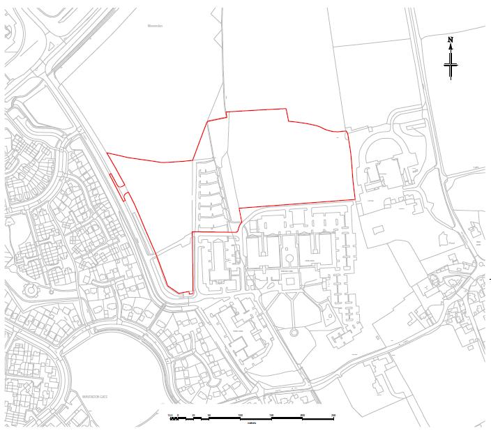
33
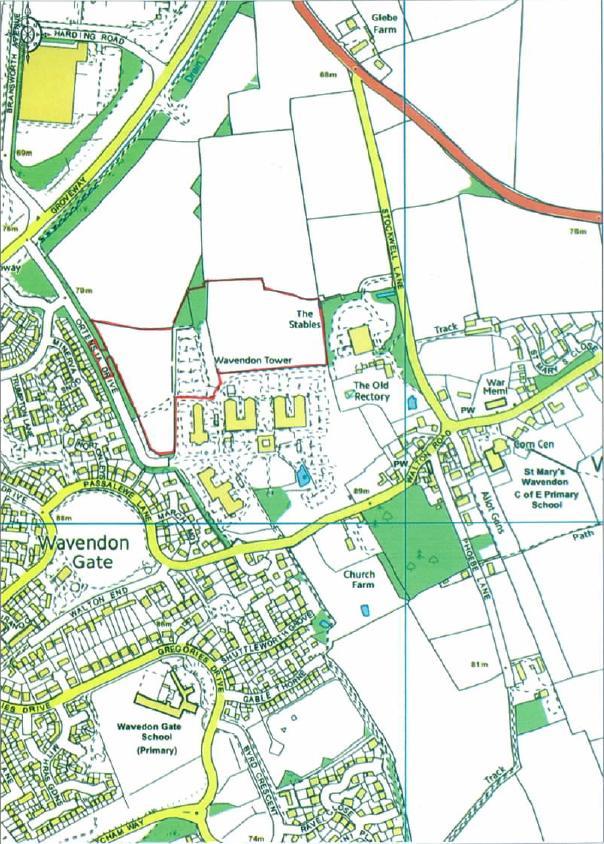
34
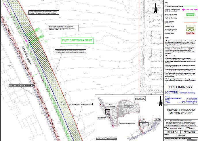
35
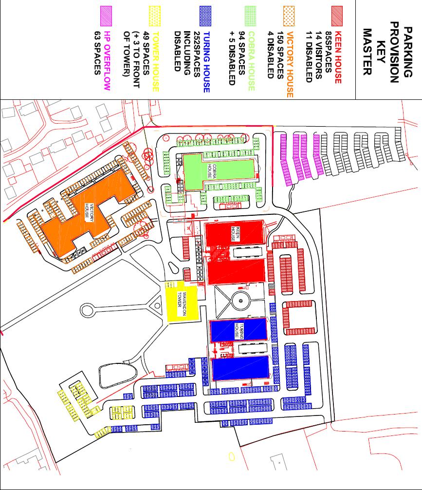
36

37 Extract from the Strategic Land Allocation Development Framework SPD showing the extent of the landscape buffer
Report Author/Case Officer: Debbie Kirk Contact Details:
 APP 01 Application Number: 14/00350/OUTEIS MAJOR A residential development for up to 400 dwellings, together with formal and informal open space, amenity space, retained vegetation, structural landscaping,
Plumpton Neighbourhood Development Plan Revised Pre Submission Document - Regulation 14 Consultation
 REPRESENTATIONS... Plumpton Parish Council Plumpton Neighbourhood Development Plan Revised Pre Submission Document - Regulation 14 Consultation Representations submitted on behalf of: Cala Homes (South
Schedule of Planning Applications Committee Date: 23 May Reference: 06/17/0726/F Parish: Hemsby Officer: Mr J Beck Expiry Date:
 Schedule of Planning Applications Committee Date: 23 May 2018 Reference: 06/17/0726/F Parish: Hemsby Officer: Mr J Beck Expiry Date: 22-05-2018 Applicant: Proposal: Site: Mr Gillett Change of use to the
Description Details submitted pursuant to discharge of condition 5 (Design Code) attached to planning permission 13/01729/OUT.
 attached to planning permission 13/01729/OUT.") ITEM 9 Application Number: 18/00266/DISCON Description Details submitted pursuant to discharge of condition 5 (Design Code) attached to planning permission 13/01729/OUT. AT The Point, 602 Midsummer Boulevard,
ITEM 9 Application Number: 18/00266/DISCON Description Details submitted pursuant to discharge of condition 5 (Design Code) attached to planning permission 13/01729/OUT. AT The Point, 602 Midsummer Boulevard,
Outline planning permission including means of access (all other matters reserved) for the erection of 14 new dwellings
 for the erection of 14 new dwellings") APP 02 Application Number: 16/01630/OUT Major Outline planning permission including means of access (all other matters reserved) for the erection of 14 new dwellings AT Land East of Castle Road And North
APP 02 Application Number: 16/01630/OUT Major Outline planning permission including means of access (all other matters reserved) for the erection of 14 new dwellings AT Land East of Castle Road And North
Welcome to our exhibition
 Welcome to our exhibition The Homes & Communities Agency (HCA) welcomes you to this public exhibition explaining our proposals for the redevelopment of the former Lea Castle Hospital site. About the Homes
Report Author/Case Officer: Paul Keen Senior Planning Officer (Dev Control) Contact Details:
 Contact Details:") APP 03 Application Number: 17/02060/FUL Description A full planning application for the demolition of an existing bungalow (C3 use class) and associated out buildings and the erection of two, two storey
APP 03 Application Number: 17/02060/FUL Description A full planning application for the demolition of an existing bungalow (C3 use class) and associated out buildings and the erection of two, two storey
Great Easton Neighbourhood Plan Statement of Basic Conditions
 Great Easton Neighbourhood Plan 2017-2031 Statement of Basic Conditions OCTOBER 2016 GREAT EASTON PARISH COUNCIL Contents 1.0 Introduction....Page 2 2.0 Summary of Submission Documents and Supporting Evidence..
Case Officer: Sarah Kay File No: CHE/14/00515/REM Tel. No: (01246) Plot No: 2/6132 Ctte Date: 15 th September 2014 ITEM 1
 Plot No: 2/6132 Ctte Date: 15 th September 2014 ITEM 1") Case Officer: Sarah Kay File No: CHE/14/00515/REM Tel. No: (01246) 345786 Plot No: 2/6132 Ctte Date: 15 th September 2014 ITEM 1 APPROVAL OF RESERVED MATTERS FROM APPLICATION CHE/12/00234/OUT (1) LAYOUT,
Case Officer: Sarah Kay File No: CHE/14/00515/REM Tel. No: (01246) 345786 Plot No: 2/6132 Ctte Date: 15 th September 2014 ITEM 1 APPROVAL OF RESERVED MATTERS FROM APPLICATION CHE/12/00234/OUT (1) LAYOUT,
an Inspector appointed by the Secretary of State for Communities and Local Government
 Appeal Decision Site visit made on 14 July 2015 by I Radcliffe BSc(Hons) MCIEH DMS an Inspector appointed by the Secretary of State for Communities and Local Government Decision date: 18 August 2015 Appeal
Newcourt Masterplan. November Exeter Local Development Framework
 Newcourt Masterplan November 2010 Exeter Local Development Framework Background The Exeter Core Strategy Proposed Submission sets out the vision, objectives and strategy for the development of Exeter up
Report Author/Case Officer: Joanne Horner Contact Details:
 APP 04 Application Number: 16/00140/FUL Other Two storey side extension to existing dwelling and formation of hard standing to provide parking for number 54 (Resubmission of withdrawn application 15/02852/FUL)
Demolition of The Suffolk Punch Public House and clearing of the site including the car park and associated works. Parish: Bradwell Parish Council
 APP 01 Application Number: 15/01914/FUL Demolition of The Suffolk Punch Public House and clearing of the site including the car park and associated works. AT The Suffolk Punch, 1 Langcliffe Drive, Heelands
Parish: Bradwell Parish Council
 APP 02 Application Number: 16/01475/FUL Demolition of existing public house and erection of 27 dwellings, two storey D1 use building for a nursery and associated car parking to east of St Augustines Church
Parish of Repton NEIGHBOURHOOD DEVELOPMENT PLAN
 Parish of Repton NEIGHBOURHOOD DEVELOPMENT PLAN BASIC CONDITIONS STATEMENT December 2018 CEF 4 Legal Requirements This statement has been produced by the NDP Working Group on behalf of Repton Parish Council
DUNSFOLD NEIGHBOURHOOD PLAN Site Selection Policies
 DUNSFOLD NEIGHBOURHOOD PLAN Site Selection Policies The criteria for assessing sites for future housing and business development in Dunsfold are set out below. (Development criteria, covering what it is
Garages To Rear Of The Willows 1025 High Road London N20 0QE
 Location Garages To Rear Of The Willows 1025 High Road London N20 0QE Reference: 15/03944/FUL Received: 25th June 2015 Accepted: 2nd July 2015 Ward: Totteridge Expiry 27th August 2015 Applicant: Mr Alex
SOUTH CAMBRIDGESHIRE DISTRICT COUNCIL. REPORT TO: Planning Committee 1 April 2015 Planning and New Communities Director
 SOUTH CAMBRIDGESHIRE DISTRICT COUNCIL REPORT TO: Planning Committee 1 April 2015 AUTHOR/S: Planning and New Communities Director Application Number: Parish(es): Proposal: Site address: Applicant(s): Recommendation:
Derry City and Strabane District Council Planning Committee Report
 Derry City and Strabane District Council Planning Committee Report COMMITTEE DATE: 23 rd March 2016 APPLICATION No: APPLICATION TYPE: PROPOSAL: LOCATION: APPLICANT: LA11/2015/0395/F Residential Development
Committee Report. Case Officer: Gemma Walker. Ward: Bacton & Old Newton. Ward Member/s: Cllr Jill Wilshaw.
 Committee Report Item No: 1 Ward: Bacton & Old Newton. Ward Member/s: Cllr Jill Wilshaw. Reference: DC/17/05423 Case Officer: Gemma Walker Description of Development Outline planning application (all matters
DEVELOPMENT MANAGEMENT REPORT
 ITEM A07-1 DEVELOPMENT MANAGEMENT REPORT TO: BY: Development Management Committee (South) Development Manager DATE: 21 June 2016 DEVELOPMENT: SITE: WARD: APPLICATION: APPLICANT: Outline application for
CONSULTATION RESPONSE. Application for approval of reserved matters for Phase 2 Landscaping pursuant to outline planning application 05/00291/MKPCO
 CONSULTATION RESPONSE ITEM 7 Application Number: 12/00677/MKPCR Application for approval of reserved matters for Phase 2 Landscaping pursuant to outline planning application 05/00291/MKPCO AT Area 10,
Kibworth Harcourt. Introduction. Introduction
 Introduction Introduction Welcome to this public exhibition on the proposals for the delivery of new homes on land at The Kibworths. The purpose of today s exhibition is to give you the opportunity to
WELCOME. Land North of STEVENAGE. We would like to thank you for attending our public exhibition today.
 WELCOME We would like to thank you for attending our public exhibition today. The purpose of this event is to share our proposals and hear your thoughts on our ideas. Members of the project team are on
Statement of Community Involvement LAND OFF SOUTHDOWN ROAD HORNDEAN, HAMPSHIRE
 LAND OFF SOUTHDOWN ROAD HORNDEAN, HAMPSHIRE CONTENTS Page 1. Introduction 3 2. Pre-application Discussions 4 3. The Consultation Process 5 4. Consultation Feedback 7 5. Responses to Consultation Feedback
Derry City and Strabane District Council Planning Committee Report. Amended layout from approval A/2004/0462/F with reduction from 166 units
 Derry City and Strabane District Council Planning Committee Report COMMITTEE DATE: 1 st February 2017 APPLICATION No: APPLICATION TYPE: PROPOSAL: LOCATION: APPLICANT: AGENT: Full Planning application Amended
Stantonbury Neighbourhood Plan
 Stantonbury Neighbourhood Plan 2018-2031 Basic Conditions Statement October 2018 Intentionally blank 1.0 Basic Conditions Statement Introduction 1.1 This statement has been prepared by Stantonbury Parish
Land at Rampton Road. Cottenham
 Land at Rampton Road Cottenham Introduction TEP is preparing an outline planning application for 54 dwellings on 6.9 hectares of land adjacent to Rampton Road, Cottenham on behalf of the owners Cambridgeshire
WELCOME GYPSY LANE. Wider Site Location plan. Proposals for the development of LAND OFF FOXLYDIATE LANE WEBHEATH. Proposals for the development of
 WELCOME The developers are preparing an outline planning application for a residential led development and need the community s views in order to develop the proposals further WHAT IS PROPOSED? A high
Reserved Matters application for a site that straddles the boundary between CBC and BBC
 BBC APPLICATION 15/02682/MAR NUMBER CBC APPLICATION CB/15/04294/RM NUMBER LOCATION Wixams Land at former storage depot, Bedford Road, Wilstead Bedfordshire PROPOSAL Reserved Matters Application for Strategic
CA//17/02777/FUL. Scale 1:1,250. Planning Services Canterbury City Council Military Road Canterbury Kent CT1 1YW
 O CA//17/02777/FUL Scale 1:1,250 Map Dated: 15/03/2018 Planning Services Canterbury City Council Military Road Canterbury Kent CT1 1YW AGENDA ITEM NO 16 PLANNING COMMITTEE APPLICATION NUMBER: SITE LOCATION:
Site Assessment Technical Document Appendix A: Glossary
 Central Bedfordshire Council www.centralbedfordshire.gov.uk Site Assessment Technical Document Appendix A: Glossary July 2017 1.1.11-1 - ii Appendix A: Glossary Term Agricultural Land Classification AONB
Development of land adjacent to Braggs Farm Lane and Rumbush Lane, Dickens Heath. Welcome. Today s exhibition. The proposal site
 Welcome Welcome to this event to discuss the development of land adjacent to Braggs Farm Lane. is currently in the preliminary stages of designing proposals to sensitively develop this site with high-quality
Introduction. Grounds of Objection
 Planning application ref. number 18/04496/APP Planning application to Aylesbury Vale District Council for the erection of 17 dwellings and associated works to the South of Hogshaw Road Granborough. Granborough
Sustainability Statement. Whitby Business Park Area Action Plan
 Sustainability Statement Whitby Business Park Area Action Plan November 2014 Contents Page 1. Introduction 1 2. Scoping 3 3. Sustainability Appraisal of Options 6 4. Assessment of Draft Area Action Plan
Target: 27th October 2016 (Extension of Time Agreed Until )
") APP 01 Application Number: 16/02106/OUT Outline application (all matters reserved except access) for residential development of up to 150 dwellings, estate road, open space and associated works. AT Land
APP 01 Application Number: 16/02106/OUT Outline application (all matters reserved except access) for residential development of up to 150 dwellings, estate road, open space and associated works. AT Land
Ward: West Wittering. Proposal Change of use from public highway pavement to residential garden use.
 Parish: West Wittering Ward: West Wittering WW/17/03295/FUL Proposal Change of use from public highway pavement to residential garden use. Site Izora 1 Watersedge Gardens West Wittering PO20 8RA Map Ref
Contents. Milton Keynes Council Site Allocations Plan, Adoption Version
 ANNEX C Site Allocations Plan, Adoption Version Contents 1 2 3 4 5 6 Introduction Vision and Objectives Policy Allocations Monitoring Appendix A Schedule of Superseded Existing Development Plan Policies
SOUTH EAST LINCOLNSHIRE LOCAL PLAN: HOUSING PAPER DONINGTON (JUNE 2016)
") SOUTH EAST LINCOLNSHIRE LOCAL PLAN: HOUSING PAPER DONINGTON (JUNE 2016) 1 DONINGTON S PLACE IN THE SPATIAL STRATEGY 1.1 Policy 2 of the South East Lincolnshire Local Plan 2011-2036 Draft for Public Consultation
SOUTH EAST LINCOLNSHIRE LOCAL PLAN: HOUSING PAPER DONINGTON (JUNE 2016) 1 DONINGTON S PLACE IN THE SPATIAL STRATEGY 1.1 Policy 2 of the South East Lincolnshire Local Plan 2011-2036 Draft for Public Consultation
PLANNING COMMITTEE DATE: 07/09/2015 REPORT OF THE SENIOR MANAGER PLANNING AND ENVIRONMENT SERVICE CAERNARFON. Number: 4
 Number: 4 Application Number: C15/0034/37/LL Date Registered: 21/05/2015 Application Type: Full - Planning Community: Llanaelhaearn Ward: Llanaelhaearn Proposal: Location: Summary of the Recommendation:
REFERENCE: B/03745/12 Received: 02 October 2012 Accepted: 05 October 2012 WARD(S): Totteridge Expiry: 30 November 2012.
: Totteridge Expiry: 30 November 2012.") LOCATION: 15A Pyecombe Corner, London, N12 7AJ REFERENCE: B/03745/12 Received: 02 October 2012 Accepted: 05 October 2012 WARD(S): Totteridge Expiry: 30 November 2012 Final Revisions: APPLICANT: PROPOSAL:
LOCATION: 15A Pyecombe Corner, London, N12 7AJ REFERENCE: B/03745/12 Received: 02 October 2012 Accepted: 05 October 2012 WARD(S): Totteridge Expiry: 30 November 2012 Final Revisions: APPLICANT: PROPOSAL:
Vigo Neighbourhood Plan Basic Conditions Statement
 Vigo Neighbourhood Plan Basic Conditions Statement Plan Period: 2016 to 2028 Status: Submission Version Qualifying Body: Vigo Parish Council Glossary of Some Terms & Abbreviations Used in this Document
ROCHFORD LOCAL DEVELOPMENT FRAMEWORK: Sustainability Appraisal/ Strategic Environmental Assessment. Rochford Core Strategy Preferred Options Document
 ROCHFORD LOCAL DEVELOPMENT FRAMEWORK: Sustainability Appraisal/ Strategic Environmental Assessment Non Technical Summary Rochford Core Strategy Preferred Options Document October 2008 SUSTAINABILITY APPRAISAL
Briefing Document of CNP. June 2017
 Cholsey Parish Council Cholsey Neighbourhood Plan Briefing Document of CNP June 2017 Cholsey Neighbourhood Plan Page! 1 of! 8 Cholsey Plan Briefing v1.4 Page Left Intentionally Blank Cholsey Neighbourhood
DONCASTER METROPOLITAN BOROUGH COUNCIL. PLANNING COMMITTEE - 15th October Expiry Date:
 DONCASTER METROPOLITAN BOROUGH COUNCIL PLANNING COMMITTEE - 15th October 2013 Application 3 Application Number: 13/01158/FUL Application Expiry Date: 31st July 2013 Application Type: Full Application Proposal
It is recommended that the Committee resolve to APPROVE the application and grant planning permission subject to the following conditions:
 LOCATION: Phase 2A Millbrook Park (Site of Former Inglis Barracks), Mill Hill East, London, NW7 1PZ REFERENCE: H/04606/12 Received: 04 December 2012 Accepted: 17 December 2012 WARD: Mill Hill Expiry: 18
Ward: Southbourne. Outline application with all matters reserved. Erection of 5 no. dwellings and associated works.
 Parish: Southbourne Ward: Southbourne SB/16/00205/OUT Proposal Site Outline application with all matters reserved. Erection of 5 no. dwellings and associated works. Dunkirk South Lane Southbourne Emsworth
Site north of Hattersley Road West (east of Fields Farm Road), Hattersley
, Hattersley") Application Number 17/00982/REM Proposal Site Applicant Recommendation Reason for report Application for the approval of reserved matters (means of access, landscaping, layout, scale and appearance) relating
Application Number 17/00982/REM Proposal Site Applicant Recommendation Reason for report Application for the approval of reserved matters (means of access, landscaping, layout, scale and appearance) relating
Rochford District Council Allocations Development Plan Document: Discussion and Consultation Document Sustainability Appraisal
 Option SWH1 Balanced Communities Option SWH1 1 To ensure the delivery of high quality sustainable communities where people want to live and work Will it ensure the phasing of infrastructure, including
Site: Essex Police & La Plata House London Road Brentwood Essex CM14 4QJ
 Reference: 16/01805/OUT Ward: Brentwood West Site: Essex Police & La Plata House London Road Brentwood Essex CM14 4QJ Proposal: Outline application for demolition of existing police station buildings,
2015/1020 Mr Edward Cockburn Caravan storage on hardcore base (Retrospective) Ranah Stones, Whams Road, Hazlehead, Sheffield, S36 4HT
 Ranah Stones, Whams Road, Hazlehead, Sheffield, S36 4HT") 2015/1020 Mr Edward Cockburn Caravan storage on hardcore base (Retrospective) Ranah Stones, Whams Road, Hazlehead, Sheffield, S36 4HT Dunford Parish Council have not commented Councillor Andrew Millner
2015/1020 Mr Edward Cockburn Caravan storage on hardcore base (Retrospective) Ranah Stones, Whams Road, Hazlehead, Sheffield, S36 4HT Dunford Parish Council have not commented Councillor Andrew Millner
Perth and Kinross Council Development Management Committee 20 February 2013 Report of Handling by Development Quality Manager
 Perth and Kinross Council Development Management Committee 20 February 2013 Report of Handling by Development Quality Manager 4(4)(iii) 13/81 Erection of sports hall, associated changing facilities, offices
WHITELEY TOWN COUNCIL NORTH WHITELEY DEVELOPMENT SEPTEMBER 2014
 WHITELEY TOWN COUNCIL NORTH WHITELEY DEVELOPMENT SEPTEMBER 2014 Dear Resident This Special Edition of the Whiteley Voice which has been prepared in conjunction with the North Whiteley Consortium is to
Reference: 15/06961/RCU Received: 13th November 2015 Accepted: 17th November 2015 Ward: Coppetts Expiry 12th January 2016
 Location 91 Manor Drive London N20 0XD Reference: 15/06961/RCU Received: 13th November 2015 Accepted: 17th November 2015 Ward: Coppetts Expiry 12th January 2016 Applicant: Mr Christos Papadopoulos Proposal:
26 September 2014 CONSULTATION EXPIRY : APPLICATION EXPIRY : 22 July 2014 SUMMARY RECOMMENDATION: PERMISSION
 Item No.: 5 The information, recommendations and advice contained in this report are correct as at the date of preparation, which is more than one week in advance of the Committee meeting. Because of the
Neighbourhood Planning Local Green Spaces
 Neighbourhood Planning Local Green Spaces Introduction... 2 1. Why green space is important... 4 2. Neighbourhood plans and green space... 6 3. Evidence... 8 Statutory designations... 9 Green space audit...
3. Neighbourhood Plans and Strategic Environmental Assessment
 1. Introduction This report sets out a draft Screening Determination for the Preston Parish Council s Neighbourhood Plan and has been prepared by rth Hertfordshire District Council. The purpose of the
SOUTH CAMBRIDGESHIRE DISTRICT COUNCIL. Executive Director (Operational Services) Corporate Manager (Planning and New Communities)
 Corporate Manager (Planning and New Communities)") SOUTH CAMBRIDGESHIRE DISTRICT COUNCIL REPORT TO: Planning Committee 12 January 2011 AUTHOR/S: Executive Director (Operational Services) Corporate Manager (Planning and New Communities) Notes: S/1848/10
SOUTH CAMBRIDGESHIRE DISTRICT COUNCIL REPORT TO: Planning Committee 12 January 2011 AUTHOR/S: Executive Director (Operational Services) Corporate Manager (Planning and New Communities) Notes: S/1848/10
Planning Area Committee 25 June 2018 Addendum to Officers Report RESTRICTION OF PERMITTED DEVELOPMENT RIGHTS - EXTENSIONS
 Planning Area Committee 25 June 2018 Addendum to Officers Report 17/8150/RMA West Hendon Regeneration Area (Phase 6) Pages 11 54 The conditions section shall be changed as follows: RESTRICTION OF PERMITTED
an Inspector appointed by the Secretary of State for Communities and Local Government
 Appeal Decision Site visit made on 23 January 2017 by Gareth Wildgoose BSc (Hons) MSc MRTPI an Inspector appointed by the Secretary of State for Communities and Local Government Decision date: 6 February
EXTRACT FROM THE CUDDINGTON NEIGHBOURHOOD PLAN The Policies
 EXTRACT FROM THE CUDDINGTON NEIGHBOURHOOD PLAN The Policies Environment and Landscape Policy 1 - Landscape Setting Development should respect and wherever possible enhance the landscape setting of Cuddington
About 10% of the Borough's population lives in the seven rural parishes. Population figures from the 1991 census are given below:-
 8. THE DISTRICT VILLAGES 8.1 Population About 10% of the Borough's population lives in the seven rural parishes. Population figures from the 1991 census are given below:- Village No. of Persons Cottingham
OKEFORD FITZPAINE NEIGHBOURHOOD PLAN
 OKEFORD FITZPAINE NEIGHBOURHOOD PLAN Dear Parishioner, The Neighbourhood Plan Project Team have prepared this leaflet to summarise the full Neighbourhood Plan document. It provides a summary of the Vision,
Suffolk Coastal Local Plan Review Issues and Options, August 2017, Public Consultation
 Suffolk Coastal Local Plan Review Issues and Options, August 2017, Public Consultation Having reviewed the issues and options documents, the Society has made the following response: Part 1 - Strategic
University Park, Worcester Non Technical Summary December 2011
 University Park, Worcester Non Technical Summary December 2011 Introduction UW Wrenbridge LLP, a Joint Venture Company of the University of Worcester and Wrenbridge Land Ltd (the Applicants ) intend to
SPG 1. * the northern and western sections which are open fields used for pasture and grazing;
 SPG 1 1.0 INTRODUCTION This development brief is based on the allocation of the Priors Hall site for employment and countryside recreational purposes in the Corby Borough Local Plan. The brief is intended
Planning and Regulatory Committee 20 May Applicant Local Councillor Purpose of Report
 Planning and Regulatory Committee 20 May 2014 7. APPLICATION FOR PLANNING PERMISSION FOR THE CARRYING-OUT OF DEVELOPMENT PURSUANT TO PLANNING PERMISSION REFERENCE NUMBER 603451 DATED 28 FEBRUARY 2007 WITHOUT
07/00934/MKPCO OUTLINE PERMISSION FOR RESIDENTIAL DEVELOPMENT OF UP TO 1600 DWELLINGS (35.55 HECTARES), UP TO 3
, UP TO 3") 07/00934/MKPCO AND 07/00936/MKPCO OUTLINE PERMISSION FOR RESIDENTIAL DEVELOPMENT OF UP TO 1600 DWELLINGS (35.55 HECTARES), UP TO 3.14 HECTARES OF MIXED USES (CLASS A1, A2, A3, A4, A5, C3 AND D1 USES INCLUDING
07/00934/MKPCO AND 07/00936/MKPCO OUTLINE PERMISSION FOR RESIDENTIAL DEVELOPMENT OF UP TO 1600 DWELLINGS (35.55 HECTARES), UP TO 3.14 HECTARES OF MIXED USES (CLASS A1, A2, A3, A4, A5, C3 AND D1 USES INCLUDING
DELEGATED DECISION on 1st September 2015
 Application N o : 14/04810/OUT LONDON BOROUGH OF BROMLEY TOWN PLANNING RENEWAL AND RECREATION DEPARTMENT DELEGATED DECISION on 1st September 2015 14/04810/OUT Claire Harris 4 Oaklands Road Bromley BR1
Persimmon Homes Thames Valley Date received: 2 nd April week date(major): 2 nd July 2014 Ward: Nascot
: 2 nd July 2014 Ward: Nascot") PART A Report of: DEVELOPMENT MANAGEMENT SECTION HEAD Date of Committee: 26 th June 2014 Site address: Rounton, 28, Nascot Wood Road Reference Number: 14/00497/REM Description of Development: Reserved
PART A Report of: DEVELOPMENT MANAGEMENT SECTION HEAD Date of Committee: 26 th June 2014 Site address: Rounton, 28, Nascot Wood Road Reference Number: 14/00497/REM Description of Development: Reserved
Copyright Nigel Deeley and licensed for reuse under this Creative Commons Licence
 1 Copyright Nigel Deeley and licensed for reuse under this Creative Commons Licence Prepared by the Neighbourhood Plan Steering Group on behalf of Garway Parish Council with assistance from 2 Table of
Welcome to our public exhibition
 About Our Scheme Welcome to our public exhibition This exhibition gives you the chance to view and comment upon our emerging proposals for a new residential development of 68 new homes on the site of the
PROPOSED RESIDENTIAL DEVELOPMENT LAND AT GREEN LANE, YARM
 PROPOSED RESIDENTIAL DEVELOPMENT LAND AT GREEN LANE, YARM PUBLIC CONSULTATION YOUR VIEW MATTERS TO US LOCATION PLAN Thank you for taking the time to read this information leaflet regarding a proposed residential
Committee Report. Committee Date: 23 February Item No: 3 Reference: 4242/16 Case Officer: DYJO
 Committee Report Committee Date: 23 February 2017 Item No: 3 Reference: 4242/16 Case Officer: DYJO Description of Development: Application for Outline Planning Permission (include access only) for the
Test Valley Borough Council Southern Area Planning Committee 8 January 2019
 ITEM 11 APPLICATION NO. 18/02218/FULLS APPLICATION TYPE FULL APPLICATION - SOUTH REGISTERED 23.08.2018 APPLICANT Rugby Football Union SITE The Trojans Club, Stoneham Lane, Eastleigh, SO50 9HT, CHILWORTH
DEVELOPMENT MANAGEMENT REPORT
 ITEM A08-1 DEVELOPMENT MANAGEMENT REPORT TO: BY: DATE: DEVELOPMENT: SITE: WARD: APPLICATION: APPLICANT: Development Management Committee Development Manager Proposed live/work unit in connection with existing
INTRODUCTION NORTH HEYBRIDGE GARDEN SUBURB
 INTRODUCTION This event is being hosted by the promoters of the proposed North Heybridge Garden Suburb who are working with Maldon District Council and other key stakeholders on the preparation of a comprehensive
PLANNING STATEMENT. Market House Market Place Kingston upon Thames KT1 1JS
 PLANNING STATEMENT To support planning and listed building consent applications for change of use from Class A1 shop and Class A3 cafe to Class A3 restaurant at: Market House Market Place Kingston upon
8.0 Design and Form of Development 43/
 42/ 8.0 Design and Form of Development 43/ Rothwells Farm, Golborne/ Development Statement Figure 7. Site Constraints Key 44/ Site Boundary 360 Bus Route/Stops Existing Trees Underground Water Pipe Sensitive
Reference: 16/1447/FUL Received: 7th March 2016 Accepted: 7th March 2016 Ward: East Finchley Expiry 2nd May 2016
 Location 374B Long Lane London N2 8JX Reference: 16/1447/FUL Received: 7th March 2016 Accepted: 7th March 2016 Ward: East Finchley Expiry 2nd May 2016 Applicant: Ms Katrin Hirsig Proposal: Single storey
Neighbourhood Planning Site Assessment Pro-forma and Guide Version 2
 Neighbourhood Planning Site Assessment Pro-forma and Guide Version 2 September 2014 Site HNP 006 Land East of Stanbridge Road and North of Lower Road 1. Background information Site location and use Site
Site ref: AS06 Site Name or Address: Murreys Court, Agates Lane
 Site ref: AS06 Site Name or Address: Murreys Court, Agates Lane Proposed Land Use: Total Site Area (Ha): Housing 1.85 Ha Description: It is understood that the owner has no plans to dispose of the site
Public Consultation 23 January Peel Hall, Warrington Board 1. A message from Satnam... Site history...
 Board 1 A message from Satnam... Thank you for attending today s public consultation about proposals to develop a new residential neighbourhood at. The display boards show why the development is needed
Planning and Sustainability Statement
 Land adjacent to Manor Farm, Catterick Village Pallett Hill Sand and Gravel Co Ltd Proposed 10 new dwellings, (6 No market dwellings and 4 No affordable dwellings) with access, associated car parking and
Called-in by Cllr Richard Stay for the following reasons: DETERMINE. Application recommended for refusal
 Item No. 13 APPLICATION NUMBER CB/15/00275/OUT LOCATION Prebendal Farm, Grove Road, Slip End, Luton, LU1 4BZ PROPOSAL Outline Development: Redevelopment of land previously used as a farm yard to residential
Application Guide. Should you have any questions on the Outline Application please contact:
 Application Guide Application Guide This guide describes the structure of the Outline Application, explains the different documents that have been submitted with it and identifies what will happen next.
APPLICATION REFERENCE: PL/2016/02759/PPFL
 APPLICATION REFERENCE: PL/2016/02759/PPFL Site Address: Land Adjacent To Mount Farm Tanworth Lane, Chewisck Green. Proposal: Erection of 54 dwellings following the granting of outline permission 2014/1163/S
Babergh and Mid Suffolk Joint Draft Local Plan Consultation, August 2017, Public Consultation
 Babergh and Mid Suffolk Joint Draft Local Plan Consultation, August 2017, Public Consultation Having reviewed the documents, the Society has made the following response: Housing Delivery Q 7. Do you agree
Mid Suffolk District Council Planning Control Department 131 High Street Needham Market IP6 8DL
 Mid Suffolk District Council Planning Control Department 131 High Street Needham Market IP6 8DL OUTLINE PLANNING PERMISSION Town and Country Planning Act 1990 THE TOWN AND COUNTRY PLANNING (DEVELOPMENT
Droitwich Spa 6. Reasoned Justification
 87 Droitwich Spa 6 Reasoned Justification 6.1 Droitwich Spa is identified in the settlement hierarchy (Policy SWDP1) as a main town being the largest settlement in Wychavon District with an estimated population
Public Consultation. Land at Monks Farm, North Grove. Welcome
 Welcome Welcome to our public exhibition for development on Land at Monks Farm, orth Grove. Gallagher Estates and Gleeson Strategic Land are preparing an outline planning application for new homes, open
2014/0943 Reg Date 06/11/2014 Lightwater
 2014/0943 Reg Date 06/11/2014 Lightwater LOCATION: PROPOSAL: TYPE: APPLICANT: OFFICER: LAND REAR OF 4, 6 & 8 MACDONALD ROAD, LIGHTWATER, GU18 5TN Erection of 2 linked-detached two storey dwellings with
Item No: 2 Reference: 0443/17 Case Officer: Elizabeth Thomas Ward: Rickinghall & Walsham. Ward Member/s: Cllr Jessica Fleming. Cllr Derek Osborne.
 Committee Report Item No: 2 Reference: 0443/17 Case Officer: Elizabeth Thomas Ward: Rickinghall & Walsham. Ward Member/s: Cllr Jessica Fleming. Cllr Derek Osborne. Description of Development Renewal of
Site Location Plan. Land on the North West of Epsom Road Waddon Croydon. 1 : A4 September The. Waddon. Waddon.
 138 140 44.3m MP 11.5 El Sub Sta EPSOM ROAD 13 Bank 1 to 5 154 Trough 19to21 1 to 5 156 The Waddon (PH) 23 FB Waddon Station 45.0m Posts 29to31 1 to 9 Stafford Court 39 37 Meridian Court 10 43 to 45 1
South Worcestershire Development Plan. South Worcestershire Design Guide Supplementary Planning Document
 South Worcestershire Development Plan South Worcestershire Design Guide Supplementary Planning Document Statement of Consultation: Early Engagement Scoping Paper February 2017 1. Introduction 1.1 This
Report Author/Case Officer: Samantha Taylor Planning Officer Contact Details:
 APP 01 Application Number: 16/03023/FUL Major Demolition of existing B8 storage and distribution warehouse, and erection of a new B8 storage and distribution warehouse with ancillary B1 floorspace and
Welcome to our exhibition
 Welcome to our exhibition housing development A46 Wildmoor Alcester Road Canal Quarter A422 Town Centre housing development Warwickshire-based IM Properties, one of the UK s largest privately owned property
1 The development hereby permitted shall be carried out in accordance with the following approved plans:
 Location The Avenue Tennis Club The Avenue London N3 2LE Reference: 16/6509/FUL Received: 10th October 2016 Accepted: 10th October 2016 Ward: Finchley Church End Expiry 5th December 2016 Applicant: Mrs
3 Abbey View Mill Hill London NW7 4PB
 Location 3 Abbey View Mill Hill London NW7 4PB Reference: 15/03203/HSE Received: 26th May 2015 Accepted: 16th June 2015 Ward: Mill Hill Expiry 11th August 2015 Applicant: Proposal: Mr Richard Benson Alterations
Departure from the Development Plan. Town Council objection to a major application. DETERMINE
 Item No. 9 APPLICATION NUMBER CB/17/01642/OUT LOCATION Land rear of 43 to 91 Silver Birch Avenue South of Alder Green and Aspen Gardens, Aspen Gardens, Stotfold PROPOSAL Outline application for up to 95