CHAPTERsix. Attractive, Safe & Healthy Places
|
|
|
- Homer Dean
- 5 years ago
- Views:
Transcription


1 CHAPTERsix Attractive, Safe & Healthy Places
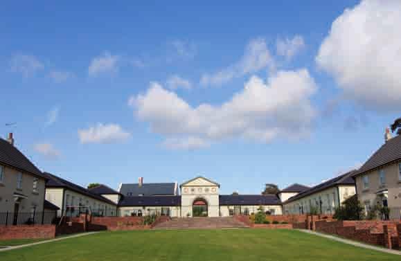
2 CHAPTER 6: ATTRACTIVE, SAFE AND HEALTHY PLACES 6.1 The policies in this chapter set out how the Core Strategy will ensure that all of Doncaster s towns, villages and neighbourhoods are attractive, safe and healthy places. This is essential to improving Doncaster s economy, as it will make Doncaster somewhere which people want to invest, work and live in. Specific policies deal with design, valuing our natural and built heritage, and ensuring the green infrastructure network (paths, parks, nature reserves etc.) are looked after. Policy CS14: Design and Sustainable Construction All proposals in Doncaster must be of high quality design that contributes to local distinctiveness, reinforces the character of local landscapes and building traditions, responds positively to existing site features and integrates well with its immediate and surrounding local area. Imaginative design solutions, including innovative and contemporary architecture, are welcome where they meet these objectives. New development should also have no unacceptable negative effects upon the amenity of neighbouring land uses or the environment. This will be achieved through the design principles and quality standards set out below. A) The components of development, including use mix, layout (movement patterns, townscape, landscape, open space and public realm), density (intensity of development) and form (scale, height, massing; and architectural details of buildings), will be assessed to ensure that the development proposed is robustly designed, works functionally, is attractive, and will make a positive contribution to achieving the following qualities of a successful place: 1. character an attractive, welcoming place with its own identity appropriate to the area; 2. continuity and enclosure of streets and spaces by buildings; 3. quality, stability, safety and security of private property, public areas and the highway; 4. permeability ease of pedestrian movement with good access to local facilities and public transport services; 5. legibility a development that is easy to navigate; 6. adaptability flexible buildings capable of changing over time; 7. inclusive accessible development that meets the needs of as much of the population as possible; 8. vitality creating vibrant, busy places with a mix of uses where appropriate; and; 9. sustainability proposals are environmentally responsible and well managed. B) New housing developments will be expected to meet relevant Building for Life criteria (14/20 criteria for developments of more than ten dwellings). An agreed proportion of new homes should be designed to Lifetime Homes standards, subject to design and viability considerations. C) The design and layout of development must also be designed to adapt to a changing climate, whilst helping reduce the causes of climate change, by using energy, water and materials in the most efficient way as possible. In order to help achieve this, proposals will be supported which meet or exceed the following minimum standards: 70 Doncaster Council Core Strategy,
3 1. all new housing must meet all criteria to achieve Code for Sustainable Homes of at least Level 3 and new non-domestic buildings must meet the BREEAM rating of at least Very Good. This should be supported by preliminary assessments at planning application stage; and; 2. all new developments must secure at least 10% of their total regulated energy from decentralised and renewable or low carbon sources. Explanation 6.2 National policy highlights the importance of good design in creating attractive and sustainable buildings and places for people that stand the test of time. There are now well established principles of good design which are reflected within national guidance. Whilst the quality of Doncaster s built environment has improved over recent years and continues to be regenerated, the design quality of new buildings, public spaces and neighbourhoods must continually evolve to address the needs of the community and the wider environment as is recognised in the Borough Strategy. A recent housing design audit undertaken by the council and Transform South Yorkshire suggested that whilst there are some notable exceptions, the general quality of new development built in the borough over the past 10 years has not been as good as it could be. Similarly, there is an urgent need to improve the overall sustainability of all types of development to help combat climate change and its effects. 6.3 The council will ensure design requirements are delivered by providing support and guidance for developers where appropriate. This may include new and updated Supplementary Planning Documents and/or area based masterplans and design guidance. Applicants must demonstrate how they have met the design requirements through their submitted Design and Access Statements. The analysis of Doncaster s historic built environment character undertaken by the South Yorkshire Archaeology Service provides a useful starting point that can be considered as part of the design process. 6.4 New proposals should seek to use land efficiently, but to be acceptable, higher density developments must also be well designed. Building for Life (BFL) is the national standard for residential design quality that encompasses good design objectives. Residential proposals for more than ten homes will be expected to achieve Building for Life good (meet at least 14 criteria or equivalent if the criteria change in the future). Smaller schemes will be expected to meet the criteria that are relevant. By following the design principles set out in this policy and others in the Core Strategy, most major housing developments should be able to achieve this standard. Similarly new developments will be required to meet the sustainable construction standards set out in the policy which address a wide range of environmental issues. 6.5 Building new Lifetime Homes will ensure a more adaptable and sustainable housing stock that caters for a wider range of needs, particularly those of an ageing population. We will encourage new homes to be built to Lifetime Homes standards on council and public owned land. This may include smaller two bed properties to discourage under-occupation of the wider housing stock and support a more sustainable turnover of family properties through down-sizing. Due to the current economic conditions, prior to 2014 the council will seek to develop an agreed proportion of new homes to meet Lifetime Homes, particularly on key sites which support the Lifetime Neighbourhood concept, or where there is an identified need. From 2014 the council will seek to negotiate up to 20% of all new homes on a site to be Lifetime Homes having regard to design and viability considerations. From 2016 it is anticipated that the standard will become mandatory on all homes through changes to the Building Regulations / Code for Sustainable Homes. 6.6 The council may also require Secured by Design accreditation depending upon the location, scale of development proposed and level of crime in the local area. National Policy recognises that safety and security are essential in creating successful development. Developers must have regard to the attributes in the Safer Places - The Planning System and Crime Prevention document, which provides information on designing out crime. Doncaster Council Core Strategy,
4 6.7 Using these nationally recognised standards as design benchmarks provides a flexible way for proposals to reduce their environmental impact and provides certainty to investors and developers. Often good design principles can be met simply by using a good designer, and there are many overlaps between the standards and other planning requirements e.g. surface water management, so they should not represent additional burdens for developers. Studies undertaken for the council and elsewhere demonstrate that if considered early enough, meeting the standards will not impinge upon investment in the borough, and will bring about many longer term community benefits (e.g. encourage investment, less crime, better health, and lower energy or maintenance bills) as well as adding economic value to proposals. 6.8 Renewable energy will form an important component of Doncaster s future energy needs, however it is recognised that viability and cost effectiveness is directly influenced by the site location and the specific energy demand of the development in question. New development will be expected to incorporate on site renewable energy technology to meet a proportion of its future energy demands such as, solar panels, ground source heat pumps, solar water heating, as well as biomass space heating. Where renewables are required, a feasibility analysis should be undertaken and information provided to the council as part of the sustainability / energy statement. Where the use of renewable energy is not practicable or viable, applicants must present robust evidence to demonstrate this is the case, and show how they have attempted to secure or exceed an equal equivalent reduction in carbon dioxide emissions (over the current Building Regulations Target Emission Rates) through other measures such as passive architectural design techniques or efficiency improvements to the building fabric. Where national standards and changes to the Building Regulations exceed the carbon dioxide reduction requirements and Code for Sustainable Homes/BREEAM levels set out above within the plan period, those standards will take precedence. 6.9 For significant greenfield sites, urban extensions, and other major proposals, (which are important by virtue of their proposed use, scale or location) the council may seek higher sustainability levels, using BREEAM (Building Research Establishment Environmental Assessment Method) and the Code for Sustainable Homes levels as flexible benchmarks to be met. For these proposals, the council may request applicants submit a Sustainability Statement at pre-application stage to help ascertain the highest standards of sustainable design and construction whilst not compromising the viability of the development. This request could include a feasibility analysis of various low-carbon or renewable energy technologies e.g. solar panels or Combined Heat and Power Better quality design (including consideration of adverts) will contribute to a safe, attractive and healthy borough comprised of interesting and environmentally friendly buildings which are sympathetic to Doncaster s character and which improve the quality of local neighbourhoods for the benefit of the community and environment. 72 Doncaster Council Core Strategy,
5 Policy CS15: Valuing Our Historic Environment Doncaster s historic environment will be preserved, protected or enhanced in accordance with the principles set out below. A) Proposals and initiatives will be supported which preserve and, where appropriate, enhance the heritage significance and setting of the borough s heritage assets, especially those elements which contribute to the distinct identity of the borough. These include: 1. the nationally-important waterlogged archaeological remains at Sutton Common, Thorne Moor, and Hatfield Moor; 2. the Roman camps and settlements, motte and bailey castles, historic houses, historic parks and gardens and villages, with special regard to those along the Southern Magnesian Limestone Ridge; 3. the Georgian townscape and the railway and racing heritage of Doncaster, its historic grain, including its street layouts and plot sizes; 4. the borough s historic market towns such as Thorne, Hatfield, Bawtry, and Tickhill; and; 5. early twentieth century suburban developments, including planned colliery villages. B) Proposals will be supported which protect or enhance the heritage significance and setting of locally identified heritage assets such as buildings of local architectural or historic interest, locally important archaeological sites and parks and gardens of local interest. C) Proposals will be supported which respect and enhance key views and vistas, especially of the spires and towers of Doncaster s historic churches, particularly St George s Minster and Christ Church in Doncaster town centre. Explanation 6.11 The historic environment is important for its own sake. It is also central to the character and identity of the borough. It is a source of immense local pride, as well as being a valuable educational and economic resource. The historic environment should also act as a stimulus and inspiration to place making in all parts of the borough so that it can reinforce local identity and play a part in increasing the appeal of the area as a place to live, work, visit and invest in National planning policy on the historic environment provides guidance on the identification, significance, and protection of heritage assets. These assets include listed buildings, conservation areas, historic parks and gardens and archaeological remains. National policy expects that the contribution of such heritage assets to local character and sense of place is recognised and valued and the policy will reinforce this Doncaster s distinctive heritage assets are richly diverse, including evidence of early settlements, castles, country houses and estates, nationally significant parks and gardens, historic market towns and villages, ecclesiastical, agricultural, civic and industrial buildings, railway and canal structures, twentiethcentury suburbs and planned colliery settlements. The geology of the district gives rise to an interesting variety of vernacular building materials including sandstone to the west, through limestone, to brick and timber-framing to the east. Stone slate, Welsh slate, clay pantile and clay plaintile roofs are distinctive characteristics of parts of the borough. National policy requires local authorities to ensure that they have evidence about the historic environment and heritage assets in their area and that this is publicly documented. Doncaster Council Core Strategy,
6 6.14 The borough has around 800 listed buildings, designated nationally. In addition, we have 4 nationally registered parks and gardens of special historic interest and 51 nationally designated scheduled ancient monuments. These are detailed in national lists and registers, copies of which are made publicly available by the council. Listed buildings and scheduled monuments are afforded protection through national planning legislation and policy. The heritage significance of registered parks and gardens of special historic interest is a material consideration in the determination of planning applications English Heritage in consultation with the council produces an annual Heritage at Risk Register which provides details of all the designated assets at risk within the borough (with the exception of Grade II Listed Buildings). The council has also prepared a list of Grade II Listed Buildings At Risk. Strategies and initiatives to reduce the number of buildings and areas at risk are being supported and developed. As part of this, should a historic building (designated or undesignated) become vacant, under-used, or derelict, the council will, where appropriate, encourage its owner to promote its re-use, or its more efficient existing use where this preserves or enhances its heritage significance. The borough s 46 conservation areas also have some protection through national planning legislation and policy but are designated locally. The key characteristics of each of the borough s conservation areas are described in conservation area character summaries on the council s website. Conservation area appraisals and management proposals will be used to identify and assess local character and promote enhancement There are also 13 locally designated parks and gardens of local interest as well as significant numbers of undesignated historic buildings which we may in the future consider for designation as buildings of local architectural and historic interest. These heritage assets contribute to the distinctive local character of the borough but are not afforded the same legislative protection. National policy on the historic environment recognises that some of these local heritage assets have lesser significance but expects that decisions are based on the nature, extent, and level of that significance, which is a material consideration in the determination of planning applications. We will review the existing parks and gardens of local historic interest and consider the designation of buildings of local architectural and historic interest. The policy will ensure that what contributes to making them special can be assessed and is given due consideration in planning decisions. Archaeological sites of national and local importance are identified in South Yorkshire s Sites and Monuments Record This policy seeks to ensure that heritage assets are safeguarded or enhanced for the future, both for their own heritage merits and for the wider benefits they bring. The benefits should include improvement in the quality of the historic built and landscaped environment, stimulation of high architectural quality in new buildings, creation of a stronger local identity and sense of place, increased sustainability, encouragement of local building craft skills, greater opportunities for use of the historic environment in education and increased levels of investment and tourism. 74 Doncaster Council Core Strategy,
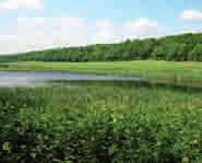
7 Policy CS16: Valuing our Natural Environment Doncaster s natural environment will be protected and enhanced, in accordance with the principles set out below. A) Proposals will be supported which enhance the borough s Ecological Networks by: 1. including measures that are of an appropriate size, scale and type and have regard to both the nature of the development and its impact on existing or potential networks; 2. maintaining, strengthening and bridging gaps in existing habitat networks; and; 3. using native species and delivering local and national Biodiversity Action Plan targets, especially in the following regionally important biodiversity opportunity areas: the Humberhead Levels, the South Yorkshire Magnesian Limestone Ridge, the River Don Corridor and the Dearne Valley. B) Nationally and internationally important habitats, sites and species will be given the highest level of protection in accordance with the relevant legislation and policy. Proposals which may impact on Local Sites and Non Designated Sites will only be supported where: 1. they protect, restore, enhance and provide appropriate buffers around wildlife and geological features; 2. harm is avoided where possible, and any unavoidable harm is appropriately mitigated and compensated; 3. they produce and deliver appropriate long term management plans for local wildlife and geological sites; and; 4. they can demonstrate that the need for a proposal outweighs the value of any features to be lost. C) Proposals located within 3km of Thorne and Hatfield Moors Special Protection Area will be supported where they deliver a net gain in nightjar foraging habitat. D) Proposals will be supported which enhance the borough s landscape and trees by: 1. being appropriate to the landscape s character, sensitivity and capacity; 2. including measures to mitigate any negative impacts on the landscape; 3. ensuring designs are of high quality, include appropriate hard and soft landscaping, a long term maintenance plan and enhance landscape character while protecting its local distinctiveness; and; 4. retaining and protecting appropriate trees and hedgerows, and incorporating new tree, woodland and hedgerow planting. Doncaster Council Core Strategy,
8 Explanation 6.18 Doncaster has an extensive network of locally important wildlife and geological sites and a range of valuable landscapes that this policy seeks to protect. National policies and legislation protects international sites, such as Thorne and Hatfield Moors Special Area of Conservation and Special Protection Area, as well as Doncaster s 15 Sites of Special Scientific Interest. National policies also expect the natural environment should function as an integrated network of habitats and so the Core Strategy incorporates policies to achieve this goal. The United Kingdom recognises the need to protect, manage and plan all landscapes, both outstanding and ordinary, that determine the quality of peoples living environment. In accordance with national policy the council has recently undertaken landscape character and capacity studies and conservation area appraisals. National policy seeks to protect and enhance the quality, character and amenity value of the countryside and urban area as a whole, recognises the limits of the environment to accept further development without irreversible damage, and encourages sustainable development. The planning authority also has a duty to ensure the planting and protection of trees in development and is developing a tree strategy for the borough The Local Biodiversity Action Plan and Geodiversity Action Plan describe Doncaster s biodiversity and geodiversity resource and set targets to focus their conservation. The Proposals Map will show the national and international wildlife sites present in Doncaster. The Local Sites Supplementary Planning Document defines how, and why, areas will be designated as a local wildlife or geological site and contains a list and maps of all the areas meeting the criteria, based on information present in the local records centre database. Together these resources tell us where many of Doncaster s important habitats and species are located. At the regional level maps and targets have been produced that set out a conservation program to identify and protect priority habitats and ecological networks. They also represent areas where conservation efforts should be focused as they are expected to deliver the greatest benefit. The Landscape Character and Capacity studies in Doncaster describe variations in the landscape, which make one area distinctive from another, and assess landscape sensitivity and the capacity of the landscape to accommodate various types of development without adverse effects. These will be used as key pieces of evidence when determining development plan allocations and planning applications The policy will help protect, enhance and restore our environmental assets by designing existing biodiversity and ecological networks into proposals and seeking appropriate opportunities to incorporate new features. Enhancement measures will be guided by current conservation targets, with the greatest emphasis on delivery being in priority areas (as shown on Map 7). This will involve the creation and expansion of habitats such as woodlands, wetlands, heathlands and grasslands and will help species adapt to possible future changes in climate by allowing them to move over larger areas. Specifically within 3km of Thorne and Hatfield Moors there will be a net gain in nightjar habitat. Developments that do not result in a loss of, or damage to, nightjar foraging habitat would not trigger part C of the policy and therefore would not be required to create new nightjar foraging habitat. However, by avoiding losses of existing habitat and creating new habitat where appropriate this policy will help to conserve this internationally important species. Further detail to support this policy will be included within subsequent Development Plan Documents and the Proposals Map, including the identification of local Biodiversity Opportunity Areas, within the context of the regional priority areas Doncaster is a large borough with approximately 350 local wildlife and geological sites, many of which are in private ownership. Ensuring these sites are managed appropriately for the features for which they are designated is a significant challenge if we are to protect our natural environment for future generations. Proposals often affect land surrounding, or neighbouring, local sites. Where necessary we will seek planning obligations to help to bring a greater number of Doncaster s local sites into good management and secure their long term sustainability. 76 Doncaster Council Core Strategy,
 Doncaster Council Core Strategy,")
9 77 Map 7: Priority Landscape-Scale Project Areas (Extract from Priority Landscape-Scale Project Areas - Yorkshire and Humber Regional Biodiversity Delivery Plan ) Doncaster Council Core Strategy,
10 6.22 The term landscape is often used to mean countryside, however landscape is everywhere and may comprise historic landscapes, rural landscapes, urban landscapes or townscapes and the urban fringe. The policy will help protect and enhance the borough s landscapes by ensuring proposals are designed to be appropriate for a given setting. Designs will be inclusive, of high quality and incorporate comprehensive landscape proposals that take account of the character and the quality of the surrounding landscape. Together these actions will help to ensure that proposals respect the different landscapes and trees across the borough Our natural environment provides many valuable services to the people of Doncaster. This policy will help to achieve several of the goals within the Borough Strategy, creating a high quality environment in which people can enjoy living and working. It will also help to guide the restoration of mineral sites and promote natural flood defences along Doncaster s rivers. Ecosystem services such as tourism, air quality and people s health and mental wellbeing will all benefit from protection and investment in our natural environment, making Doncaster a great place to be, as illustrated by Figure Doncaster Council Core Strategy,
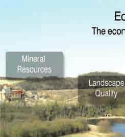

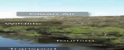
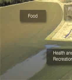
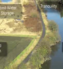
11 Figure 2: Ecosystems Services Doncaster Council Core Strategy,
12 Policy CS17: Providing Green Infrastructure Doncaster s green infrastructure network (including key green wedges) will be protected, maintained, enhanced and, where possible, extended, based on the principles set out below. A) Proposals will be supported which make an overall contribution to the green infrastructure network by: 1. including measures, either on or off site, that are of an appropriate size, shape, scale and type and that have regard to the nature of the proposal and its potential impact; 2. contributing to the delivery of identified opportunities and priorities; 3. providing for appropriate long term maintenance and management; and: 4. avoiding damage to or loss of green infrastructure assets or, where loss is unavoidable and the benefits of the development outweigh the loss, including appropriate compensation measures. B) Proposals will be supported which reduce, and help people and wildlife adapt to, the impacts of climate change; for example by promoting more naturalised forms of flood storage along the regionally important rivers Don and Dearne and locally important watercourses; or incorporating tree planting within developments. C) Proposals will be supported which contribute to an attractive and connected environment by: 1. creating and/or enhancing green corridors (potentially including footpaths) that link urban areas to the wider countryside and the public footpath and bridleway network; 2. creating and/or enhancing links from areas of growth (as identified under the Growth and Regeneration Strategy - Policy CS2) to greenspaces and assets within existing urban areas; 3. incorporating assets that define and soften the edges of settlements to provide a high quality transition between urban and rural areas particularly at urban greenfield extensions; and; 4. preventing fragmentation of habitats, creating linkages and enabling wildlife to move around the ecological network. D) Proposals will be supported which have regard to local standards and opportunities, and help to address deficiencies, by making an appropriate contribution to sport, recreation and related community uses, including: 1. providing well designed and accessible, sport, recreation and open space facilities (including children s play space and parks) that meet the needs of the proposal and the wider community; and; 2. providing suitable and appropriate, on-site open space (or an equivalent contribution towards off-site provision). 80 Doncaster Council Core Strategy,
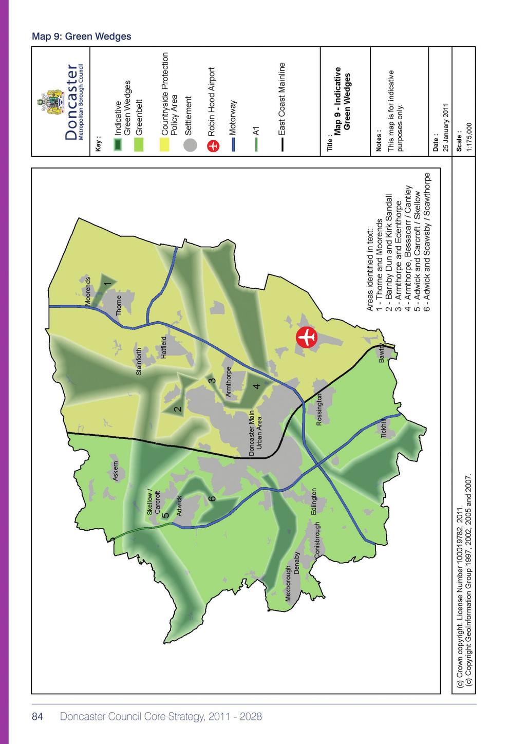
13 Explanation 6.24 Green infrastructure is a network of multi-purpose spaces that provide the opportunity for the coordination and delivery of environmental improvements, to support investment and improve quality of life. A successful network helps to create a safe and accessible environment, mitigate climate change (by reducing surface water run-off and providing urban cooling), reduce traffic noise and exhaust pollution, provide opportunities for sport and recreation and protects and enhances our historic and natural environment. The various assets which make up the network can be in public or private ownership, and in urban and rural areas. They include: elements of the built environment, such as road verges and street trees, private gardens and amenity space, and parts of buildings (e.g. green/brown roofs, bird/bat boxes); individual sites, such as heritage and biodiversity sites, and managed and natural green spaces (e.g. parks, formal and informal open space, allotments and publicly accessible nature conservation sites); linear features, such as footpaths, greenways, bridleways and cycle paths, cycle lanes within the road network, disused railway lines, towing paths and waterways; and; aspects of the wider landscape and countryside, such as agricultural land, wildlife habitat and flood plain National policies require an approach that ensures new development protects, restores, maintains, creates, enhances and extends green infrastructure and improves the connectivity within the network. Within this broad approach, the policy will help implement and deliver the standards and targets set out in various strategies, including our Greenspace Strategy, Rights of Way Improvement Plan and Biodiversity and Geodiversity Action Plans. The policy should also be read in conjunction with other relevant Local Development Framework policies, in particular those relating to valuing our historic and natural environment (Core Strategy Policies CS15 and CS16) and the countryside (Core Strategy Policy CS3), as these other policies will provide a higher level of protection to particular green infrastructure assets It is therefore important that green infrastructure provision is considered at the outset, and designed as an integral part of new development. Proposals will need to take account of both their impact on the existing network, and future opportunities, having regard to local issues and strategic priorities. As part of this, proposed maintenance arrangements should be set out. For public areas this will usually be in the form of a management company or a third party agreement between the developer and the council to secure the long term costs of green infrastructure As a first step, a hierarchy of green infrastructure corridors has been identified within the borough (see Map 8). The policy seeks to increase the quality, number and connectivity of assets within these corridors and the wider green infrastructure network. To complement these green infrastructure corridors, and to reinforce the protection of the countryside (see Policy CS3), green wedges will be identified where development allocations need to be sensitive to strategic rural gaps between settlements. It is envisaged that these will include the following (as shown indicatively on Map 9): land to the East of the borough (between Thorne and Moorends, Barnby Dun and Kirk Sandall, Armthorpe and Edenthorpe and Armthorpe and Bessacarr/Cantley); and; land to the West of the borough (between Adwick and Carcroft/Skellow and Adwick and Scawsby/ Scawthorpe). Doncaster Council Core Strategy,
14 6.28 Green wedges will overlay Countryside Protection Policy Area /Green Belt designation and areas identified for development. Thus the identification of an area as being within a green wedge would not in itself exempt it from development (although Green Belt/Countryside Protection Policy Area designation would). However, where the green wedge overlays development allocations there will be an expectation that the development must deliver an extensive buffer and an exceptionally high standard of landscaping (to prevent the complete merging of settlements and enhance the amenity and visual appearance of settlement edges), as well as improving access to the countryside etc. They will thus function as a type of green infrastructure corridor with a focus on landscape and amenity The Proposals Map will provide further detail of the green infrastructure network, including identifying the location of key green wedges and reflecting other designations made through separate processes (such as Conservation Areas and Local Wildlife and Geological Sites). To facilitate the implementation of this policy, the council will develop a green infrastructure strategy (and/or Supplementary Planning Document) to highlight green infrastructure opportunities across the borough, provide further detail on local standards (including the quality, quantity and type of public open space) and inform sub-regional projects and strategies. Other relevant strategies will also be kept under review and updated as required. Together these will establish linkages and coordinate the delivery of green infrastructure at various spatial scales across the wider region from neighbourhood and site specific level through to cross boundary programmes Not all green infrastructure assets will be publicly accessible. For example, there are a large number of privately owned local wildlife sites which contribute toward green infrastructure, but are not open to the public. The council welcomes and encourages access to publicly owned (and some privately owned) open spaces and countryside sites, but environmental sensitivity is a consideration and some sites may be managed primarily for the benefit of local wildlife (especially protected species) or alleviate the effects of climate change. 82 Doncaster Council Core Strategy,

15 Map 8: Green Infrastructure Corridors Doncaster Council Core Strategy,
16
DUNSFOLD NEIGHBOURHOOD PLAN Site Selection Policies
 DUNSFOLD NEIGHBOURHOOD PLAN Site Selection Policies The criteria for assessing sites for future housing and business development in Dunsfold are set out below. (Development criteria, covering what it is
Great Easton Neighbourhood Plan Statement of Basic Conditions
 Great Easton Neighbourhood Plan 2017-2031 Statement of Basic Conditions OCTOBER 2016 GREAT EASTON PARISH COUNCIL Contents 1.0 Introduction....Page 2 2.0 Summary of Submission Documents and Supporting Evidence..
Rochford District Council Allocations Development Plan Document: Discussion and Consultation Document Sustainability Appraisal
 Option SWH1 Balanced Communities Option SWH1 1 To ensure the delivery of high quality sustainable communities where people want to live and work Will it ensure the phasing of infrastructure, including
Neighbourhood Planning Local Green Spaces
 Neighbourhood Planning Local Green Spaces Introduction... 2 1. Why green space is important... 4 2. Neighbourhood plans and green space... 6 3. Evidence... 8 Statutory designations... 9 Green space audit...
Tāhuhu whakaruruhau ā-taone The sheltering ridge pole
 B2. Tāhuhu whakaruruhau ā-taone - Urban growth and form B2.1. Issues Tāhuhu whakaruruhau ā-taone The sheltering ridge pole Auckland s growing population increases demand for housing, employment, business,
Plan Modification to Chapter B2 of the Auckland Unitary Plan(AUP) Operative in part (15 November 2016)
 Operative in part (15 November 2016)") UNITARY PLAN UPDATE REQUEST MEMORANDUM TO FROM Phill Reid Linley Wilkinson DATE 25 September 2018 SUBJECT Plan Modification to Chapter B2 of the Auckland Unitary Plan(AUP) Operative in part (15 November
UNITARY PLAN UPDATE REQUEST MEMORANDUM TO FROM Phill Reid Linley Wilkinson DATE 25 September 2018 SUBJECT Plan Modification to Chapter B2 of the Auckland Unitary Plan(AUP) Operative in part (15 November
The Gwennap Parish Vision Statement
 QUICK GUIDE What is a Neighbourhood Development Plan? Ultimately it is a document used by developers or anyone wishing to submit a planning application that describes the vision, strategy, plans, regeneration,
8.0 Design and Form of Development 43/
 42/ 8.0 Design and Form of Development 43/ Rothwells Farm, Golborne/ Development Statement Figure 7. Site Constraints Key 44/ Site Boundary 360 Bus Route/Stops Existing Trees Underground Water Pipe Sensitive
STATEMENT OF OBJECTION TO THE PROPOSED DEVELOPMENT OF LAND AT CHURCH CLIFF DRIVE FILEY
 STATEMENT OF OBJECTION TO THE PROPOSED DEVELOPMENT OF LAND AT CHURCH CLIFF DRIVE FILEY You will be aware that Scarborough borough council have adopted a new local plan that includes land at Church Cliff
Site Assessment Technical Document Appendix A: Glossary
 Central Bedfordshire Council www.centralbedfordshire.gov.uk Site Assessment Technical Document Appendix A: Glossary July 2017 1.1.11-1 - ii Appendix A: Glossary Term Agricultural Land Classification AONB
Appendix 1 Structure plan guidelines
 Appendix 1 Structure plan guidelines This appendix forms part of the regional policy statement [rps]. 1.1. Introduction Structure plans are an important method for establishing the pattern of land use
Chapter 2: OUTLINE PLANNING APPLICATION PROPOSALS. A New Garden Neighbourhood Matford Barton 17
 Chapter 2: OUTLINE PLANNING APPLICATION PROPOSALS A New Garden Neighbourhood Matford Barton 17 2.1. SUMMARY AND STATUS OF THE PROPOSALS 2.1.1. The parameter plans and associated wording in this chapter
Schedule of Planning Applications Committee Date: 23 May Reference: 06/17/0726/F Parish: Hemsby Officer: Mr J Beck Expiry Date:
 Schedule of Planning Applications Committee Date: 23 May 2018 Reference: 06/17/0726/F Parish: Hemsby Officer: Mr J Beck Expiry Date: 22-05-2018 Applicant: Proposal: Site: Mr Gillett Change of use to the
2.0 Strategic Context 4
 2.0 Strategic Context 4 2.1 The Area Action Plan is a non-statutory plan, which forms a corporate policy document, expressing particular issues and areas of concern while also providing a vision for the
Copyright Nigel Deeley and licensed for reuse under this Creative Commons Licence
 1 Copyright Nigel Deeley and licensed for reuse under this Creative Commons Licence Prepared by the Neighbourhood Plan Steering Group on behalf of Garway Parish Council with assistance from 2 Table of
10.0 Open Space and Public Realm
 10.0 Open Space and Public Realm 10.0 Open Space and Public Realm The Public Open Space System is comprised of: outdoor spaces available for public use that are either publicly owned (e.g., parks and
Newcourt Masterplan. November Exeter Local Development Framework
 Newcourt Masterplan November 2010 Exeter Local Development Framework Background The Exeter Core Strategy Proposed Submission sets out the vision, objectives and strategy for the development of Exeter up
3. Neighbourhood Plans and Strategic Environmental Assessment
 1. Introduction This report sets out a draft Screening Determination for the Preston Parish Council s Neighbourhood Plan and has been prepared by rth Hertfordshire District Council. The purpose of the
Cotswolds AONB Landscape Strategy and Guidelines. June 2016
 Cotswolds AONB Landscape Strategy and Guidelines June 2016 Cotswolds AONB Landscape Strategy and Guidelines Introduction The evolution of the landscape of the Cotswolds AONB is a result of the interaction
Neighbourhood Planning Guidance Local Green Spaces
 Neighbourhood Planning Guidance Local Green Spaces Introduction This guidance note has been produced for communities preparing neighbourhood plans in North Dorset to help them to identify, assess and designate
Planning and Sustainability Statement
 Land adjacent to Manor Farm, Catterick Village Pallett Hill Sand and Gravel Co Ltd Proposed 10 new dwellings, (6 No market dwellings and 4 No affordable dwellings) with access, associated car parking and
Sustainability Statement. Whitby Business Park Area Action Plan
 Sustainability Statement Whitby Business Park Area Action Plan November 2014 Contents Page 1. Introduction 1 2. Scoping 3 3. Sustainability Appraisal of Options 6 4. Assessment of Draft Area Action Plan
Kibworth Harcourt. Introduction. Introduction
 Introduction Introduction Welcome to this public exhibition on the proposals for the delivery of new homes on land at The Kibworths. The purpose of today s exhibition is to give you the opportunity to
Public Consultation. Land at Monks Farm, North Grove. Welcome
 Welcome Welcome to our public exhibition for development on Land at Monks Farm, orth Grove. Gallagher Estates and Gleeson Strategic Land are preparing an outline planning application for new homes, open
Droitwich Spa 6. Reasoned Justification
 87 Droitwich Spa 6 Reasoned Justification 6.1 Droitwich Spa is identified in the settlement hierarchy (Policy SWDP1) as a main town being the largest settlement in Wychavon District with an estimated population
BRE Strategic Ecological Framework LI Technical Information Note 03/2016
 BRE Strategic Ecological Framework Technical Information Note 03/2016 September 2016 Contents 1. Introduction 2. Aims of BRE s Strategic Ecological Framework 3. How SEF is different from previous approaches
Stantonbury Neighbourhood Plan
 Stantonbury Neighbourhood Plan 2018-2031 Basic Conditions Statement October 2018 Intentionally blank 1.0 Basic Conditions Statement Introduction 1.1 This statement has been prepared by Stantonbury Parish
PLACE WORKSHOP REPORT. A+DS SNH sustainable placemaking programme
 PLACE briefing WORKSHOP REPORT A+DS SNH sustainable placemaking programme INTRODUCTION This report summarises the outcome of a Scottish Natural Heritage workshop on placemaking which was held on Wednesday
South Worcestershire Development Plan. South Worcestershire Design Guide Supplementary Planning Document
 South Worcestershire Development Plan South Worcestershire Design Guide Supplementary Planning Document Statement of Consultation: Early Engagement Scoping Paper February 2017 1. Introduction 1.1 This
Ipswich Issues and Options for the Ipswich Local Plan Review, August 2017, Public Consultation
 Ipswich Issues and Options for the Ipswich Local Plan Review, August 2017, Public Consultation Having reviewed the issues and options documents, the Society has made the following response: Part 1 Strategic
Chapter 5 Urban Design and Public Realm
 5.1 Introduction Public realm is all areas of the urban fabric to which the public have access. It is where physical interaction takes place between people. It therefore, includes buildings and their design,
Suffolk Coastal Local Plan Review Issues and Options, August 2017, Public Consultation
 Suffolk Coastal Local Plan Review Issues and Options, August 2017, Public Consultation Having reviewed the issues and options documents, the Society has made the following response: Part 1 - Strategic
EXTRACT FROM THE CUDDINGTON NEIGHBOURHOOD PLAN The Policies
 EXTRACT FROM THE CUDDINGTON NEIGHBOURHOOD PLAN The Policies Environment and Landscape Policy 1 - Landscape Setting Development should respect and wherever possible enhance the landscape setting of Cuddington
DESIGN & ACCESS STATEMENT
 DESIGN & ACCESS STATEMENT January 2016 Contents Introduction section 1 Section 1 - Introduction Section 2 - Assessment Section 3 - Involvement Section 4 - Evaluation Section 5 - Design Section 6 - Layout
Welcome to our exhibition
 Welcome to our exhibition housing development A46 Wildmoor Alcester Road Canal Quarter A422 Town Centre housing development Warwickshire-based IM Properties, one of the UK s largest privately owned property
OKEFORD FITZPAINE NEIGHBOURHOOD PLAN
 OKEFORD FITZPAINE NEIGHBOURHOOD PLAN Dear Parishioner, The Neighbourhood Plan Project Team have prepared this leaflet to summarise the full Neighbourhood Plan document. It provides a summary of the Vision,
1.3 The following table presents a Statement of Compliance demonstrating how the Standish Neighbourhood Plan meets those requirements.
 1. Introduction 1.1 This Basic Condition Statement was prepared to accompany the draft Standish Neighbourhood Plan (2018). 1.2 Paragraph 8 of Schedule 4B of the Town and Country Planning Act 1990 requires
Parish of Repton NEIGHBOURHOOD DEVELOPMENT PLAN
 Parish of Repton NEIGHBOURHOOD DEVELOPMENT PLAN BASIC CONDITIONS STATEMENT December 2018 CEF 4 Legal Requirements This statement has been produced by the NDP Working Group on behalf of Repton Parish Council
RURAL ZONE - POLICY. Rural Zone Policy. Issue: Rural Environment. Ruapehu District Plan Page 1 of 8
 Rural Zone Policy RU2 RURAL ZONE - POLICY RU2.1 Introduction The natural resources of the rural environment in the Ruapehu District provide the basis for the existing and potential character, intensity
WELCOME. Land North of STEVENAGE. We would like to thank you for attending our public exhibition today.
 WELCOME We would like to thank you for attending our public exhibition today. The purpose of this event is to share our proposals and hear your thoughts on our ideas. Members of the project team are on
Oxford Green Belt Study. Summary of Final Report Prepared by LUC October 2015
 Oxford Green Belt Study Summary of Final Report Prepared by LUC October 2015 Project Title: Oxford Green Belt Study Client: Oxfordshire County Council Version Date Version Details Prepared by Checked by
Scottish Natural Heritage. Better places for people and nature
 Scottish Natural Heritage Better places for people and nature Contents Summary... 3 SNH approach... 5 Place-making in policy and practice... 6 Developing the contribution of the natural heritage to place-making...
About 10% of the Borough's population lives in the seven rural parishes. Population figures from the 1991 census are given below:-
 8. THE DISTRICT VILLAGES 8.1 Population About 10% of the Borough's population lives in the seven rural parishes. Population figures from the 1991 census are given below:- Village No. of Persons Cottingham
Elderberry Walk. Developer HAB Housing
 Case studies Elderberry Walk Developer HAB Housing Development of 161 new homes on the former Dunmail Primary School site, focused around a central green street, with retained trees, new multifunctional
The Proposed Auckland Unitary Plan (notified 30 September 2013)
") 3 Business zones Introduction There are 10 business zones in the Unitary Plan: City Centre Metropolitan Centre Town Centre Local Centre Neighbourhood Centre Mixed Use General Business Business Park Light
3 Business zones Introduction There are 10 business zones in the Unitary Plan: City Centre Metropolitan Centre Town Centre Local Centre Neighbourhood Centre Mixed Use General Business Business Park Light
ROCHFORD LOCAL DEVELOPMENT FRAMEWORK: Sustainability Appraisal/ Strategic Environmental Assessment. Rochford Core Strategy Preferred Options Document
 ROCHFORD LOCAL DEVELOPMENT FRAMEWORK: Sustainability Appraisal/ Strategic Environmental Assessment Non Technical Summary Rochford Core Strategy Preferred Options Document October 2008 SUSTAINABILITY APPRAISAL
March General enquiries: Web site:
 REDEVELOPMENT OF WILSON HOSPITAL FOR MITCHAM LOCAL CARE CENTRE Community Planning & Design Brief for Merton Clinical Commissioning Group and London Borough of Merton March 2016 1. Mitcham Cricket Green
Overview Report. Proposed Development
 Overview Report Proposed Development the construction of a 1km cycle/pedestrian trail including a new footbridge, new car park and entrance road at Drumshanbo Lock and a new pedestrian/cycle road crossing,
Valuing Historic Places
 Valuing Historic Places Introduction Historic buildings and places have played an increasingly central role in the delivery of a range of public benefits, including education, economic development, sustainable
WELCOME GYPSY LANE. Wider Site Location plan. Proposals for the development of LAND OFF FOXLYDIATE LANE WEBHEATH. Proposals for the development of
 WELCOME The developers are preparing an outline planning application for a residential led development and need the community s views in order to develop the proposals further WHAT IS PROPOSED? A high
MATURE SUBURBS RESIDENTIAL DEVELOPMENT GUIDELINES
 MATURE SUBURBS RESIDENTIAL DEVELOPMENT GUIDELINES DRAFT FEBRUARY 2005 BIRMINGHAM CITY COUNCIL 1 Introduction Mature Suburbs Residential Development Guidelines - Interim Supplementary Planning Advice -
Response to the London Bridge Area Vision and Site Allocations within the New Southwark Plan
 1 Melior Place London SE1 3SZ 020 7407 4701 teamlondonbridge.co.uk info@teamlondonbridge.co.uk 28 April 2017 Response to the London Bridge Area Vision and Site Allocations within the New Southwark Plan
Our City Centre is a vibrant, creative and welcoming destination, with a modern business, cultural, shopping, leisure and residential offer
 3. Sheffield in 2034 Our City sits at the heart of a strong, distinctive and internationally successful City Region economy which supports innovation and enterprise Our City Centre is a vibrant, creative
Welcome to our Public Consultation
 About our development This exhibition gives you the chance to view and comment on our emerging plans for a proposed residential development located on land to the West of Alwyn Road, Rugby. Welcome to
SPG 1. * the northern and western sections which are open fields used for pasture and grazing;
 SPG 1 1.0 INTRODUCTION This development brief is based on the allocation of the Priors Hall site for employment and countryside recreational purposes in the Corby Borough Local Plan. The brief is intended
Linden Homes Proposals for land off Ringwood Road, Verwood
 Welcome Welcome to Linden Homes first public exhibition displaying proposals for new homes on land off Ringwood Road in Verwood. Award-winning house builder Linden Homes, part of the Galliford Try Group,
Guide. Guide to Regional Planning Policies. Background
 Guide Guide to Regional Planning Policies January 2017 Background The Strategic Planning Policy Statement for NI - Planning for Sustainable Development - sets out the Department s regional planning policies
CLOUGHJORDAN SETTLEMENT PLAN
 CLOUGHJORDAN SETTLEMENT PLAN 1.0 General Introduction and Development Context Location The market town of Cloughjordan lies close to the border with Offaly at the junction of the R490 and R491 Regional
WINCHESTER TOWN 3.1 LOCATION, CHARACTERISTICS & SETTING
 WINCHESTER TOWN 3.1 LOCATION, CHARACTERISTICS & SETTING 3.1.1 The area referred to by the City Council, as Winchester Town, consists of the Winchester Wards plus the adjoining built up areas of Badger
Western City District What we heard
 What we heard Vision to 2056 and Priorities Governance and implementation Infrastructure and funding The protection of the natural landscape including biodiversity and the Metropolitan Rural Area for food
ALLERTHORPE NEIGHBOURHOOD PLAN
 Allerthorpe s Neighbourhood Plan sets out a vision for the Parish for the next 15 years (2018 2033) that builds on and reflects the opinions and views of parish residents. VISION In 2033 Allerthorpe will
Local Development Scheme
 Local Development Scheme 2012 2016 The Local Development Scheme (LDS) is a project plan that outlines how and when the Authority will update its planning policies and other associated documents. It ensures
BLETCHLEY PARK AREA - DEVELOPMENT FRAMEWORK
 ANNEX A To Item 9 REVISED TEXT: additions shown bold and underlined, deletions in (brackets and in italics). BLETCHLEY PARK AREA - DEVELOPMENT FRAMEWORK This framework sets out the key objectives and requirements
9 Pershore. Introduction. Pershore Abbey
 118 Introduction 9.1 The historic town of Pershore lies on the River Avon and has a population of 7,000 (2009 Mid-Term Population Estimates). The main areas of the town are centred on the Abbey, the bustling
WELCOME. North East Haverhill. The Planning Process
 WELCOME North East The site to the North East of, known as Great Wilsey Park, is identified by St Edmundsbury Borough Council in its Core Strategy as capable of delivering a Sustainable Urban Extension.
Chapter 3 Core Strategy
 Chapter 3 Core Strategy 3.0 Introduction The core strategy sets out how the development objectives in the Development Plan are consistent with the National Spatial Strategy and the Regional Planning Guidelines.
Wallingford Neighbourhood Plan
 Wallingford Neighbourhood Plan Introduction What is neighbourhood planning? Neighbourhood planning was introduced by the Localism Act 2011 to give local people more influence over how development comes
Evesham 7. Reasoned Justification
 95 Reasoned Justification 7.1 Evesham is situated within the Vale of Evesham and has an estimated population of 22,800 (2009 Mid-Term Population Estimates). As a main town it provides a wide range of services
ENIVRONMENTAL CHARACTER & GREEN INFRASTRUCTURE SUITE POLICY AND CONTEXT
 ENIVRONMENTAL CHARACTER & GREEN INFRASTRUCTURE SUITE POLICY AND CONTEXT INTRODUCTION TO ENVIRONMENTAL CHARACTER STRATEGY AND GREEN INFRASTRUCTURE STRATEGY - POLICY CONTEXT As part of the government s Sustainable
Welford-on-Avon Neighbourhood Plan Consultation Event Sunday, 6 April Your name Your address
 Welford-on-Avon Neighbourhood Plan Consultation Event Sunday, 6 April 2014 Your name Your email address Please either: - complete this feedback form and put it in the box before leaving the Memorial Hall
LANDSCAPE CHARACTER ASSESSMENT
 THE COUNTY DURHAM LANDSCAPE CHARACTER ASSESSMENT FOREWORD The landscape of County Durham is one of great contrast and diversity. From the North Pennines in the west to the Durham Coast in the east it contains
Basic Conditions Statement Exmouth Neighbourhood Plan
 Exmouth Neighbourhood Plan 2018-2031. On behalf Exmouth Neighbourhood Plan Steering Group July 2018 Table of Contents 1. Introduction... 4 2. Legal Requirements... 5 3. Why there is a need for a Neighbourhood
SOUTH YORKSHIRE RESIDENTIAL DESIGN GUIDE
 SOUTH YORKSHIRE RESIDENTIAL DESIGN GUIDE 2011 INTEGRATED VITAL, ACTIVE AND WELL MANAGED EQUITABLE, COHESIVE, INCLUSIVE AND SAFE LOCAL, DISTINCTIVE AND ATTRACTIVE EFFICIENT, FLEXIBLE AND ADAPTABLE Metropolitan
Settlement Boundaries Methodology North Northumberland Coast Neighbourhood Plan (August 2016)
") Introduction This background paper sets out a methodology for the definition of settlement boundaries in the North Northumberland Coast Neighbourhood Plan. The neighbourhood plan is planning positively
Introduction This background paper sets out a methodology for the definition of settlement boundaries in the North Northumberland Coast Neighbourhood Plan. The neighbourhood plan is planning positively
Briefing Document of CNP. June 2017
 Cholsey Parish Council Cholsey Neighbourhood Plan Briefing Document of CNP June 2017 Cholsey Neighbourhood Plan Page! 1 of! 8 Cholsey Plan Briefing v1.4 Page Left Intentionally Blank Cholsey Neighbourhood
Statutory and Non-Statutory Designated Sites and Ecology
 Statutory and Non-Statutory Designated Sites and Ecology The National Planning Policy Framework considers the conservation and enhancement of the natural environment in chapter 11 paragraphs 109-119, where
Northern Territory Compact Urban Growth Policy
 Northern Territory Compact Urban Growth Policy A Reference Policy Document to clause 2.7 (Reference to Policy) of the NT Planning Scheme May 2015 Table of Contents 1 Policy Setting... 3 1.1 Context for
PLANNING COMMITTEE DATE: 07/09/2015 REPORT OF THE SENIOR MANAGER PLANNING AND ENVIRONMENT SERVICE CAERNARFON. Number: 4
 Number: 4 Application Number: C15/0034/37/LL Date Registered: 21/05/2015 Application Type: Full - Planning Community: Llanaelhaearn Ward: Llanaelhaearn Proposal: Location: Summary of the Recommendation:
Weaver Valley Green Infrastructure data
 Weaver Valley Green Infrastructure data Introduction Introduction Green infrastructure is a 150m 1 asset that we propose can be better used to provide competitive advantage and underpin sustainable growth
DEVELOPMENT MANAGEMENT REPORT
 ITEM A08-1 DEVELOPMENT MANAGEMENT REPORT TO: BY: DATE: DEVELOPMENT: SITE: WARD: APPLICATION: APPLICANT: Development Management Committee Development Manager Proposed live/work unit in connection with existing
Wildlife and Planning Guidance: Local Plans
 Wildlife and Planning Guidance: Local Plans This Leaflet is one of a series of 4 Wildlife and Planning Guidance Leaflets and is intended to provide useful information to assist you to campaign effectively
Joint Core Strategy Rushden Sustainable Urban Extension
 Date Page 1 of 18 Report Originator Title Planning Manager Joint Core Strategy Rushden Sustainable Urban Extension 1. PURPOSE OF REPORT 1.1 To consider representations received on the emerging Joint Core
A Growing Community Rural Settlement Areas
 Town of Huntsville Official Plan Review - POLICY BACKGROUND PAPER A Growing Community Rural Settlement Areas BACKGROUND: In addition to the fully municipally-serviced Urban Settlement Area and the Hidden
Annex B: SWDP Objectives mapped against Worcestershire SCS Objectives. Annex B: SWDP Objectives mapped against Worcestershire SCS Objectives
 Annex B: SWDP mapped against SCS Annex B: SWDP mapped against SCS in SCS Economic Success That Is Shared By All 1. A skilled prosperous economy 1. Development that focuses on improving A. Enhanced prosperity
INTRODUCTION NORTH HEYBRIDGE GARDEN SUBURB
 INTRODUCTION This event is being hosted by the promoters of the proposed North Heybridge Garden Suburb who are working with Maldon District Council and other key stakeholders on the preparation of a comprehensive
LONGDEN VILLAGE DEVELOPMENT STATEMENT
 LONGDEN VILLAGE DEVELOPMENT STATEMENT 2017-2027 1 Longden Development Statement 2017-2027 15/01/18 1. Background 1.1 Longden Village Longden village is a very rural and traditional community first mentioned
GREENBANK DEVELOPMENT MASTERPLAN
 DEVELOPMENT MASTERPLAN POTENTIAL TRAIN STATION COMMUNITY CENTRE Greenbank will be a connected masterplanned community providing easy access to local and surrounding amenity. Affordable quality homes, green
Plumpton Neighbourhood Development Plan Revised Pre Submission Document - Regulation 14 Consultation
 REPRESENTATIONS... Plumpton Parish Council Plumpton Neighbourhood Development Plan Revised Pre Submission Document - Regulation 14 Consultation Representations submitted on behalf of: Cala Homes (South
Grantham Southern Quadrant Link Road Environmental Statement
 Grantham Southern Quadrant Link Road Environmental Statement Non Technical Summary Introduction Lincolnshire County Council (LCC) is submitting a planning application for the proposed implementation of
PDP DESIGN & ACCESS STATEMENT
 PDP The Planning & Design Partnership Planning.. Architecture.. Interiors.. Landscape The Chicory Barn Studio, The Old Brickyards, Moor Lane, Stamford Bridge York, The East Riding Of Yorkshire, YO41 1HU.
WOKING DESIGN SUPPLEMENTARY PLANNING DOCUMENT (SPD)
") Agenda Item No. 5 EECUTIVE - 15 JANUARY 2015 Executive Summary WOKING DESIGN SUPPLEMENTARY PLANNING DOCUMENT (SPD) The report outlines the various responses to the consultation on the Design Supplementary
Agenda Item No. 5 EECUTIVE - 15 JANUARY 2015 Executive Summary WOKING DESIGN SUPPLEMENTARY PLANNING DOCUMENT (SPD) The report outlines the various responses to the consultation on the Design Supplementary
DUBLIN DOCKLANDS MASTER PLAN AND RELATIONSHIP WITH OTHER PLANS
 .1 National Policy and Programmes.1.1 Sustainable Development A Strategy for Ireland, 1997.1.2 National Climate Change Strategy, 2007-2012.1. National Development Plan 2007-201.1.4 National Spatial Strategy,
SECOND DRAFT ARMTHORPE NEIGHBOURHOOD DEVELOPMENT PLAN AUGUST 2014
 SECOND DRAFT ARMTHORPE NEIGHBOURHOOD DEVELOPMENT PLAN AUGUST 2014 ARMTHORPE NEIGHBOURHOOD DEVELOPMENT PLAN August 2014 Contents Copyright Armthorpe Parish Council 2014 Introduction... 4 Vision and Aims...
Town of Cobourg Heritage Master Plan. Statutory Public Meeting
 Town of Cobourg Heritage Master Plan Statutory Public Meeting April 25 th 2016 Presentation Overview 1. Introduction 2. Project background and schedule overview 3. Review of strategic direction content
University Park, Worcester Non Technical Summary December 2011
 University Park, Worcester Non Technical Summary December 2011 Introduction UW Wrenbridge LLP, a Joint Venture Company of the University of Worcester and Wrenbridge Land Ltd (the Applicants ) intend to
LEEDS SITE ALLOCATIONS PLAN MATTER 3 GREEN BELT KCS DEVELOPMENT AUGUST 2017
 LEEDS SITE ALLOCATIONS PLAN MATTER 3 GREEN BELT KCS DEVELOPMENT AUGUST 2017 Smith Limited Suite 9C Joseph s Well Hanover Walk Leeds LS3 1AB T: 0113 2431919 F: 0113 2422198 E: planning@peacockandsmith.co.uk
Design Guidance. Introduction, Approach and Design Principles. Mauritius. November Ministry of Housing and Lands. .. a
 sig evelo r D Mauritius s. Utilities.. Individu a s. er itects.to ls chpers.po e Public. T. h rban D Sc U e me Promot e h ners. A Design Guidance o.h Planne rs n w iticians r l useholde National Development
SUSTAINABLE MANAGEMENT
 . Sustainable Management.1 The Concept of Sustainable Management The concept of sustainable management recognises there are limits to the use of natural and physical resources and there is a need to balance
Linby Neighbourhood Plan Masterplan Safeguarded Land Top Wighay Farm March Linby Neighbourhood Development Plan Masterplan 1
 Linby Neighbourhood Plan Masterplan Safeguarded Land Top Wighay Farm March 2017 Linby Neighbourhood Development Plan Masterplan 1 Linby Neighbourhood Development Plan Masterplan 2 Contents: Section 1:
B4. Te tiaki taonga tuku iho - Natural heritage
 B4. Te tiaki taonga tuku iho - Natural heritage Tuia I runga, tuia i raro, tuia ki te waonui a Tiriwa Bind the life forces of heaven and earth to the great realm of Tiriwa B4.1. Issues Auckland s distinctive