Samrand Development (Pty) Ltd C2562 KOSMOSDAL EXTENSION 104 ROADS AND STORMWATER REPORT PART 1 AND 2. March 2019
|
|
|
- Ross McDaniel
- 5 years ago
- Views:
Transcription

1 Samrand Development (Pty) Ltd C2562 KOSMOSDAL EXTENSION 104 ROADS AND STORMWATER REPORT PART 1 AND 2 March 2019
2 KOSMOSDAL FILING STATION KOSMOSDAL EXTENSION 104 ROADS AND STORMWATER SERVICE REPORT PART 1 - SERVICES IMPACT ASSESSMENT PAGE 1 TABLE OF CONTENTS PART 1 I Costing Sheet GENERAL INFORMATION Application Number Location of the Area Concerned Property Owner / Developer Information Consulting Engineers Development Information IMPACT ASSESSMENT Existing Roads Network Existing Stormwater Network Recommendations from the Traffic Impact Study Roads Trip Generation Stormwater Runoff PROPOSED ROAD UPGRADES PROPOSED STORMWATER UPGRADES AND CAPACITY CALCULATIONS External Upgrades Link Infrastructure CONCLUSION GENERAL INFORMATION Design Standards ROAD INFORMATION Details of Site Investigation on Access and Boundary Roads Details on Recommendations from the TIA STORMWATER Description of Existing Stormwater Details of Proposed New and Upgrades to Stormwater Infrastructure Floodline Information Summarised Scope of Works COST ESTIMATES Cost Schedules Summary of Cost GENERAL Total Project Construction Value Construction Period and Intended Construction Start Date Relevant Environmental Authorisations and WULA Requirements Wayleaves to be obtained from City of Tshwane, Gautrans and SANRAL... 9
3 KOSMOSDAL FILING STATION KOSMOSDAL EXTENSION 104 ROADS AND STORMWATER SERVICE REPORT PART 1 - SERVICES IMPACT ASSESSMENT PAGE 2 ANNEXURES A Locality Plan B Title Deed and Agreement of Sale C Letter of appointment D Draft Annexure T and Proposed Township Layout E Existing Stormwater Network Layout Plan F Executive Summary of the TIS G Proposed Stormwater Network Layout Plan H Road Master Plan I Costing Sheet
4 KOSMOSDAL FILING STATION KOSMOSDAL EXTENSION 104 ROADS AND STORMWATER SERVICE REPORT PART 1 - SERVICES IMPACT ASSESSMENT PAGE 3 1 GENERAL INFORMATION 1.1 Application Number The township application for the proposed Kosmosdal Extension 104 is situated on a Part of the Remainder of Portion 2 of the Farm Olievenhoutbosch 389-JR. 1.2 Location of the Area Concerned The proposed township Kosmosdal Extension 104 is situated on Portion 254 and a Portion of the Remainder of Portion 2 of the Farm Olievenhoutbosch 389-JR. The township is bordered as follows: Northern side: Kosmosdal Extension 81. South-western side: Samrand Avenue. Eastern side: Rooihuiskraal Road. Refer to Annexure A for locality plan. 1.3 Property Owner / Developer Information Samrand Development (Pty) Ltd Physical Address: Reg No: 1994/000475/07 1 Samrand Avenue PO Box Samrand Business Park Cleveland Centurion Tel: Mail: cavgroup@cavaleros.co.za Responsible person: Mr. Barry Hertzog Refer to Annexure B for title deed and agreement of sale and Annexure C for the letter of appointment. 1.4 Consulting Engineers Civil Concepts (Pty) Ltd Physical Address: Reg. No : 95/12428/07 50, 15 th Street P O Box Menlo Park Menlo Park Tel: Fax: Mail: leendert@civilconcepts.co.za The responsible person is: Mr. Leendert Zietsman (Reg No ). 1.5 Development Information The township application for the proposed Kosmosdal Extension 104 on Portion 254 and a Portion of the Remainder of Portion 2 of the Farm Olievenhoutbosch 389-JR was submitted by Urban Smart Townplanning The proposed Kosmosdal Extension 104 will have rights as summarised in the table below. Also refer to the Conditions of Establishment and Township Layout attached as Annexure D.
5 KOSMOSDAL FILING STATION KOSMOSDAL EXTENSION 104 ROADS AND STORMWATER SERVICE REPORT PART 1 - SERVICES IMPACT ASSESSMENT PAGE 4 Township Land Use Area (ha) FAR Kosmosdal Ext 104 Special with the following restrictions: Convenience store maximum 360 m 2 Place of refreshment maximum 480 m 2 Car wash maximum 20 m 2 Motor workshop maximum 760 m 2 2 IMPACT ASSESSMENT 2.1 Existing Roads Network Existing Road Network - According to the City of Tshwane s 2015 Road Masterplan prepared by Tolplan (February 2015): N1 freeway is a class 1 road that lies to the east of the proposed development site. It runs in a north-south direction and serves an important mobility function to Centurion and Midrand. Samrand Avenue is a class 3 road that runs in an east-west direction to the north of the proposed development site. This road intersects with Rooihuiskraal Road and Rietspruit Road, in the form of signalised junctions, and with the N1 freeway ramp terminals to the east. This road will provide a marginal access to the proposed development. Rietspruit Road is a class 4a road that lies to the east of the proposed development site. It intersects with Rooihuiskraal Road to the south and Samrand Avenue to the north. Rooihuiskraal Road (M37) is a class 3 road that lies to the west of the proposed development site and runs in a north-south direction. A full access to the proposed development will be provided off Rooihuiskraal Road. Waterberg Road is a class 3 road that links up with Rooihuiskraal Road (M37) to form a signalized T-junction. This road is located to the north of the proposed development site. Watercress is a class 4b road which intersects with Samrand Avenue and Coqui Francolin to form a 4-leggd priority controlled junction. This road serves as an access to Kosmosdal Extension 81 residential development. Coqui Francolin is class 4a road which intersects with Samrand Avenue and Watercress to form a 4-legged priority controlled junction. 2.2 Existing Stormwater Network Stormwater Elements The site drains to the east at an average slope of 4.67%. The existing stormwater network in the vicinity of the site includes the following: 450mm diameter stromwater pipe along Samrand Road near the proposed access position. 750mm stormwater pipe along the eastern boundary of the property along Rooihuiskraal Road. Refer to Annexure E for the existing stormwater network layout Floodlines The proposed development is not affected by a floodline. 2.3 Recommendations from the Traffic Impact Study Below is an extract of recommended upgrades required for Kosmosdal Extension 104 on Portion 254 and a Portion of the Remainder of Portion 2. Please refer to the submitted Traffic Impact Study (TIS) for a full description of the latent rights and associated road upgrades for the proposed township. Proposed upgrades to the road network for Kosmosdal Extension 104 (background plus development traffic):
6 KOSMOSDAL FILING STATION KOSMOSDAL EXTENSION 104 ROADS AND STORMWATER SERVICE REPORT PART 1 - SERVICES IMPACT ASSESSMENT PAGE 5 Rooihuiskraal Road/ Samrand Avenue Receiving lane on the northern approach in Rooihuiskraal road has to be extended to 100m. The traffic signal timings and phasings have to be adjusted Proposed access to the township A proposed full access to the development site will be provided off Rooihuiskraal Road (M37). A topographical survey was conducted on Rooihuiskraal Road (M37) to confirm the sight distance, in order to warrant a full access to the proposed development site. Survey results concluded that the minimum requirements for sight distance are met, as prescribed in the UTG 1 Guidelines for the Geometric Design of Urban Arterial Roads (1986). There are no fixed obstructions that will hamper the sight distance from the development access. The design of the access and internal roads of the site are geometrically sound (refer to TIA for Line of Sight Plan). The executive summary of the approved TIS, and TIS approval letter is included in Annexure F. 2.4 Roads Trip Generation It is anticipated that the proposed development will generate 221 and 300 trips during the weekday morning and afternoon peak hours, respectively. 2.5 Stormwater Runoff The pre-development flow runoff for Kosmosdal Extension 104 Portion 254 and a Portion of the Remainder of Portion 2 of the Farm Olievenhoutbosch 389-JR is shown below: Catchment Area Slope Length A1 1.7 ha m/m 228 m Pre-Development The site is currently undeveloped. The following parameters were used in the calculation of the runoff values: Area: 1.7 ha Length: 228 m Slope: Run-off coefficient: 0.45 MAP: 668 mm The pre-development flow runoff for Kosmosdal Extension 104 is shown below: Post-Development Area: 1.7 ha Length: 228 m Slope: Run-off coefficient: 1 MAP: 668 mm Catchment (As Per SMP) Q 2 (m 3 /s) Q 20 (m 3 /s) A The Post-Development Runoff for the development was determined using the Rational Method.
7 KOSMOSDAL FILING STATION KOSMOSDAL EXTENSION 104 ROADS AND STORMWATER SERVICE REPORT PART 1 - SERVICES IMPACT ASSESSMENT PAGE 6 The following runoff values can be reported for the catchment: Catchment (As Per SMP) Q 2 (m 3 /s) Q 20 (m 3 /s) A Proposed stormwater infrastructure The following upgrades to the existing stormwater network will be required: Two new kerb inlets with two new junction boxes to be installed on Rooihuiskraal road on the existing 750mm diameter stormwater pipe running along Roohuishkraal road gravitating south ward. Including the connections for the new instalments. The proposed development can obtain a stormwater connection to the existing 450 mm diameter stormwater pipe along the south-eastern boundary of the development near the proposed access position off Samrand Road 3 PROPOSED ROAD UPGRADES This was already dealt with in Sub-Clause 2.3, and further details thereof will be given in Part 2 of the report. 4 PROPOSED STORMWATER UPGRADES AND CAPACITY CALCULATIONS 4.1 External Upgrades The existing external stormwater network have sufficient capacity available to accommodate the stormwater runoff generated by the development. 4.2 Link Infrastructure No new link infrastructure will be required. Refer to Annexure G for the proposed stormwater network layout. 5 CONCLUSION A part 2 report is required for construction of road and stormwater services. L Zietsman Pr. Tech Eng. Civil Concepts (Pty) Ltd March 2019
8 KOSMOSDAL FILING STATION KOSMOSDAL EXTENSION 104 ROADS AND STORMWATER SERVICE REPORT PART 2 - SERVICES PROVISION DETAILS PAGE 1 TABLE OF CONTENTS PART 1 I Costing Sheet GENERAL INFORMATION Application Number Location of the Area Concerned Property Owner / Developer Information Consulting Engineers Development Information IMPACT ASSESSMENT Existing Roads Network Existing Stormwater Network Recommendations from the Traffic Impact Study Roads Trip Generation Stormwater Runoff PROPOSED ROAD UPGRADES PROPOSED STORMWATER UPGRADES AND CAPACITY CALCULATIONS External Upgrades Link Infrastructure CONCLUSION GENERAL INFORMATION Design Standards ROAD INFORMATION Details of Site Investigation on Access and Boundary Roads Details on Recommendations from the TIA STORMWATER Description of Existing Stormwater Details of Proposed New and Upgrades to Stormwater Infrastructure Floodline Information Summarised Scope of Works COST ESTIMATES Cost Schedules Summary of Cost GENERAL Total Project Construction Value Construction Period and Intended Construction Start Date Relevant Environmental Authorisations and WULA Requirements Wayleaves to be obtained from City of Tshwane, Gautrans and SANRAL... 9
9 KOSMOSDAL FILING STATION KOSMOSDAL EXTENSION 104 ROADS AND STORMWATER SERVICE REPORT PART 2 - SERVICES PROVISION DETAILS PAGE 2 ANNEXURES A Locality Plan B Title Deed and Agreement of Sale C Letter of appointment D Draft Annexure T and Proposed Township Layout E Existing Stormwater Network Layout Plan F Executive Summary of the TIS G Proposed Stormwater Network Layout Plan H Road Master Plan I Costing Sheet
10 KOSMOSDAL FILING STATION KOSMOSDAL EXTENSION 104 ROADS AND STORMWATER SERVICE REPORT ANNEXURES 1 GENERAL INFORMATION 1.1 Design Standards Road Design Standards The following sub-clauses summarise the applied design standards on all classes of road. The unit rates are based on these standards. Radii at Intersections The Radii at intersections are as follows: Class 3 15 m Class 4a - 12 m Class 4b - 10 m Other - 10 m Kerbing At Class 2, 3, 4 and 5 intersections, Fig 7 kerbing with 150 mm in situ concrete channel will be used. Mountable kerbs will be 500 mm wide on the Class 4b road where applicable, and 300 mm wide on the Class 5 road where applicable. Pavement Design The pavement design will be based on the following road categories and traffic classes as per the TRH4 guideline. Road Classification Class Reserve Category Traffic Class Rooihuiskraal road, Samrand Avenue 3 32 m B ES Stormwater Design Standards For internal networks, the following design principles of the City of Tshwane were incorporated to determine the element sizes: All major and minor systems within road reserves must be a closed system in the form of pipe or box culverts; The major systems are a combination of street capacity and underground systems; A maximum flow depth of 100 mm may be used for calculating street capacity; All townships must have an underground pipe connection to a municipal stormwater network; The design flow is determined with the difference between the 1: 20 year runoff and the road capacity; A minimum 1: 2 year runoff connection must be provided for any township development; If no road capacity is available, i.e. midblock or Class 3 roads, a 1: 20 year runoff connection must be provided; The minimum pipe diameter in road reserves is 450 mm ø; and All stormwater pipeline joints to be spigot and socket type joints.
11 KOSMOSDAL FILING STATION KOSMOSDAL EXTENSION 104 ROADS AND STORMWATER SERVICE REPORT ANNEXURES The design of the network is based on the following steps: Major Networks - 20 Year Runoff Selection of appropriate design standards; Determination of the major catchment for the area; Determination of an anticipated stormwater drainage network and physical properties i.e. length and slope; and Determination of the required types and sizes of the drainage network elements through hydrological modelling using HydroCube Software. Major networks are required to accommodate the 1:20 year runoff. The pipe or box culvert size was determined according to the total flow less the flow in the road. Minor Networks - 2 Year Runoff Determine minor sub-catchments drainage to the minor networks; Determine physical characteristics of minor catchments and networks; and Determination of the required types and sizes with HydroCube software of the drainage network elements through hydrological modelling General Standards All work to be handed over to City of Tshwane will be constructed to the minimum standard of SANS1200, with amendments to the specification in order to comply with Standard Specification for Municipal Civil Engineering Works (CoT, 2005), as well as in accordance with the Standard construction details and design standards for roads and stormwater drainage infrastructure (latest edition). 2 ROAD INFORMATION 2.1 Details of Site Investigation on Access and Boundary Roads Status of Existing Boundary Roads Existing Road Network- According to the City of Tshwane s 2015 Road Masterplan prepared by Tolplan (February 2015): N1 freeway is a class 1 road that lies to the east of the proposed development site. It runs in a north-south direction and serves an important mobility function to Centurion and Midrand. Samrand Avenue is a class 3 road that runs in an east-west direction to the north of the proposed development site. This road intersects with Rooihuiskraal Road, Rietspruit Road in the form of signalised junctions and the N1 freeway ramp terminals. This road will serve a marginal access to the proposed development. Rietspruit Road is a class 4a road that lies to east of the proposed development site. It intersects with Rooihuiskraal Road to the south and Samrand Avenue to the north. Access to the development will be off Rietspruit Road. Rooihuiskraal Road (M37) is a class 3 road that lies to the west of the proposed development site and runs in a north-south direction. A partial access to the proposed development will be off Rooihuiskraal Road. Waterberg Road is a class 3 road that links up with Rooihuiskraal Road (M37) to form a signalized T-junction. This road is located to the north of the proposed development site. Watercress is a class 4b road which intersects with Samrand Avenue and Coqui Francolin to form a 4-leggd priority controlled junction. This road serves as an access to Kosmosdal Extension 81 residential development. Coqui Francolin is class 4a road which intersects with Samrand Avenue and Watercress to form a 4-legged priority controlled junction. All roads are currently constructed in accordance with the relevant authority s standards. This report does not address the condition on the roads.
. KOSMOSDAL EXTENSION 10")
12 KOSMOSDAL FILING STATION KOSMOSDAL EXTENSION 104 ROADS AND STORMWATER SERVICE REPORT ANNEXURES Road Masterplan Below find an extract from the current approved road master plan of the area. Refer to Annexure H for complete Road Master Plan (J3). KOSMOSDAL EXTENSION 104 DIE HOEWES X Geometric Design Standards Design Speed All geometric standards are based on 60 km/h design speed for Class 3 to Class 5 roads. Horizontal & Vertical Alignment, Intersections Geometric designs of the road upgrades will be in accordance with the applicable standards of the City of Tshwane and the Gauteng Department of Roads and Transport. Public Transport Facilities There are existing pedestrian walkways along the site frontage and no additional pedestrian walkways are proposed. No additional public transport facilities are proposed. Access to Erf A proposed full access to the development site will be provided off Rooihuiskraal Road (M37) and a marginal access off Samrand Avenue. A topographical survey was conducted on Rooihuiskraal Road (M37) to check the sight distance, in order to warrant a full access to the proposed development site. Survey results concluded that the minimum requirements for sight distance are met, as prescribed in the UTG 1 Guidelines for the Geometric Design of Urban Arterial Roads (1986). There are no fixed obstructions that will hamper the sight distance from the development access. The design of the access and internal roads of the site are geometrically sound (refer to TIA for Line of Sight Plan). The executive summary of the submitted TIS, and TIS approval letter is included in Annexure F.

13 KOSMOSDAL FILING STATION KOSMOSDAL EXTENSION 104 ROADS AND STORMWATER SERVICE REPORT ANNEXURES Pavement Design In Situ Conditions All in situ conditions will be confirmed by means of a geotechnical investigation and laboratory testing before commencement of detail design of the pavement structure. Pavement Design The proposed pavement design will comply with GPDRT standards and is as follows: - 30mm continuously graded medium asphalt - 150mm crushed stone base to 88% apparent density - 150mm stabilized subbase to 97% of MDD, min UCS = 100% of MDD - 150mm upper selected layer to 95% of MDD - 150mm lower selected layer to 93% of MDD - 150mm in-situ road bed to 90% of MDD 2.2 Details on Recommendations from the TIA Below is an extract of recommended upgrades required for Kosmosdal Extension 104. Please refer to the approved Traffic Impact Study (TIS) for a full description of the latent rights and associated road upgrades for the proposed township. Proposed upgrades to the road network for Kosmosdal Extension 104 (background plus development traffic): Rooihuiskraal Road/Samrand Avenue Receiving lane on the northern approach in Rooihuiskraal road has to be extended to 100m. The traffic signal timings and phasings have to be adjusted.
14 KOSMOSDAL FILING STATION KOSMOSDAL EXTENSION 104 ROADS AND STORMWATER SERVICE REPORT ANNEXURES 3 STORMWATER 3.1 Description of Existing Stormwater The site drains to the east at an average slope of 4.67%. The existing stormwater network in the vicinity of the site includes the following: 450mm diameter stromwater pipe along Samrand Road near the proposed access position. 750mm stormwater pipe along the eastern boundary of the property. Refer to Annexure E for the existing stormwater network layout. 3.2 Details of Proposed New and Upgrades to Stormwater Infrastructure Existing Infrastructure Data and Runoff Calculation This has already been dealt with in Sub-clause 3.1. The post development runoff generated by the development is estimated to be: Catchment A1 Q m 3 /s Q m 3 /s New Infrastructure The following upgrades will be required on the existing stormwater network: Two new kerb inlets accompanied with two new junction boxes to be installed on Rooihuiskraal Road on the existing 750mm diameter stormwater pipe running along Rooihuishkraal Road gravitating south ward. Including the connections for the development. The proposed development can obtain a stormwater connection to the existing 450 mm diameter stormwater pipe along the south-eastern boundary of the development near the proposed access position off Samrand Road Link Infrastructure An existing stormwater connection is available for the development, and therefore no link infrastructure is required for this development. Refer to Annexure G for the proposed stormwater network layout. 3.3 Floodline Information The proposed development is not affected by a floodline. 3.4 Summarised Scope of Works The existing external stormwater network have sufficient capacity available to accommodate the stormwater runoff generated by the development.
15 KOSMOSDAL FILING STATION KOSMOSDAL EXTENSION 104 ROADS AND STORMWATER SERVICE REPORT ANNEXURES 4 COST ESTIMATES 4.1 Cost Schedules All rates include for P & G s, professional fees and 15% VAT Link Services The following link infrastructure is required to provide access to the existing municipal infrastructure. Cost Item Area/Width/Length/No Rate Cost ROADS Access to filling station Samrand Avenue 325 m 2 R / m 2 R 617, STORMWATER New 450mm dia connetction 20m R / m R 24, TOTAL LINK SERVICES R 641, External Services Cost Item Area/Width/Length/No Rate Cost ROADS Rooihuiskraal Road/ Samrand Avenue Receiving lane on the northern approach in Rooihuiskraal road has to be extended to 100m. The traffic signal timings and phasings have to be adjusted m 2 R / m 2 R2,055, TOTAL EXTERNAL ROAD SERVICES (Including Professional Fees and VAT) R 2,055, STORMWATER New 450 mm dia connection 10 m R 1,200 / m R 12, New kerb inlets 2 R 13,000 / Unit R 26, New junction boxes 2 R 9,000 / Unit R 18, TOTAL EXTERNAL STORMWATER SERVICES (Including Professional Fees and VAT) R 56, Summary of Cost The summary of the costs are shown in the table below. Please also refer to Annexure I for the costing sheet. Item Contribution by CoT Contribution by Applicant Estimated Development Charges Roads [Total Trips 300 x R 2,775.70p/trip] R 832, Stormwater Main stormwater network & local stormwater network 15,960m² x 0.5[ C] x (R R0.02+R4.07+R0.76) R 208, Total Estimated Development Charges R 1 041, Cost of Link Services Roads Link Infrastructure R 617, Stormwater Link Infrastructure R 24, Total Estimated Cost of Link Services R 641, Cost of External Roads Upgrades Rooihuiskraal Road/ Samrand Avenue R 2,055, Total Estimated Cost of External Roads Upgrades R 2,055, Cost of External Stormwater Upgrades New 450 mm dia connection R 12, New kerb inlets R 26, New junction boxes R 18, Total Estimated Cost of External Stormwater Upgrades R 56, Nett Cost of Link Services and Upgrades By APPLICANT R 2,753,300.00
16 KOSMOSDAL FILING STATION KOSMOSDAL EXTENSION 104 ROADS AND STORMWATER SERVICE REPORT ANNEXURES No boundary contribution is payable in terms of roads and stormwater. We propose that the development charges of R 1 041, to be allocated towards the road upgrades. 5 GENERAL 5.1 Total Project Construction Value Link R 641, External R 2,111, TOTAL (INCL. VAT) R 2,753, Construction Period and Intended Construction Start Date The municipal works should commence soon after the service agreement has been signed. The estimated construction period is 3 months. 5.3 Relevant Environmental Authorisations and WULA Requirements No WUL will be required. 5.4 Wayleaves to be obtained from City of Tshwane, Gautrans and SANRAL A full Wayleave application to City of Tshwane will be applicable. No new road reserves are required to be registered for the development. A full approval process will be followed in order to satisfy all municipal departments requirements, and the full design approved for construction. L Zietsman Pr. Tech Eng. Civil Concepts (Pty) Ltd March 2019
17 KOSMOSDAL FILING STATION KOSMOSDAL EXTENSION 104 ROADS AND STORMWATER SERVICE REPORT ANNEXURES LIST OF ANNEXURES A B C D E F G H LOCALITY PLAN TITLE DEED AND AGREEMENT OF SALE LETTER OF APPOINTMENT DRAFT CONDITIONS OF ESTABLISHMENT AND PROPOSED TOWNSHIP LAYOUT EXISTING STORMWATER NETWORK LAYOUT PLAN EXECUTIVE SUMMARY OF TRAFFIC IMPACT STUDY AND TIS APPROVAL PROPOSED STORMWATER NETWORK LAYOUT PLAN ROADS MASTERPLAN
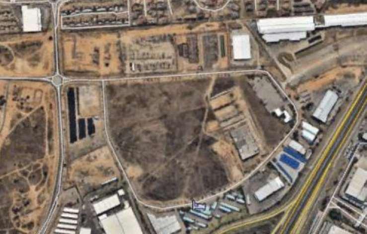
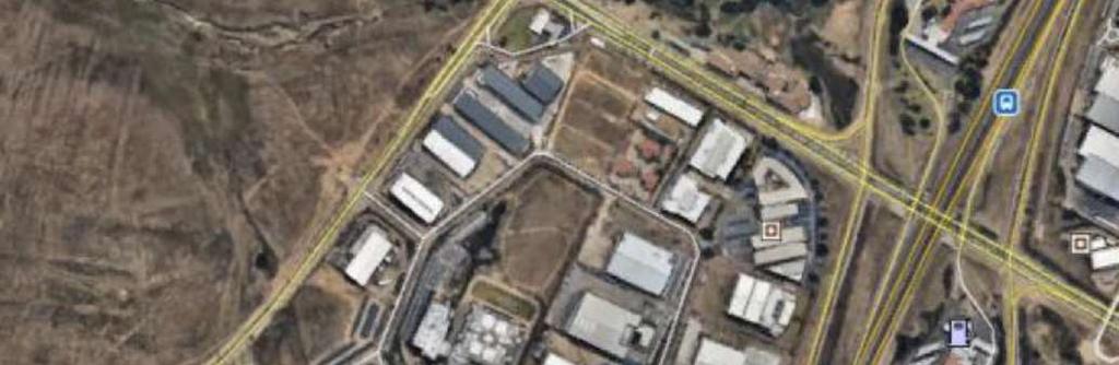
18 KOSMOSDAL FILING STATION KOSMOSDAL EXTENSION 104 ROADS AND STORMWATER SERVICE REPORT ANNEXURES ANNEXURE A LOCALITY PLAN


19 KOSMOSDAL X104 LOCALITY PLAN DATE: 05/03/2019
20 KOSMOSDAL FILING STATION KOSMOSDAL EXTENSION 104 ROADS AND STORMWATER SERVICE REPORT ANNEXURES ANNEXURE B PROOF OF OWNERSHIP OF PROPERTY
21
22
23
24
25
26
27
28
29
30
31
32
33
34
35
36
37 KOSMOSDAL FILING STATION KOSMOSDAL EXTENSION 104 ROADS AND STORMWATER SERVICE REPORT ANNEXURES ANNEXURE C LETTER OF APPOINTMENT
38
39
40
41
42 KOSMOSDAL FILING STATION KOSMOSDAL EXTENSION 104 ROADS AND STORMWATER SERVICE REPORT ANNEXURES ANNEXURE D CONDITIONS OF ESTABLISHMENT
43 STATEMENT OF THE CONDITIONS UNDER WHICH THE APPLICATION MADE BY SAMRAND DEVELOPMENT (PROPRIETARY) LIMITED (HEREINAFTER REFERRED TO AS THE TOWNSHIP OWNER) IN TERMS OF SECTION 16(4)(f)(i) OF THE CITY OF TSHWANE LAND USE MANAGEMENT BY-LAW, 2016 FOR THE ESTABLISHMENT OF A TOWNSHIP ON A PART OF THE REMAINDER OF PORTION 2 OF THE FARM OLIEVENHOUTBOSCH 389-JR, GAUTENG PROVINCE, HAS BEEN APPROVED 1. CONDITIONS TO BE COMPLIED WITH BY THE TOWNSHIP OWNER PRIOR TO THE OPENING OF THE TOWNSHIP REGISTER IN TERMS OF SECTION 16(7) AND (8), AND DECLARING THE TOWNSHIP A PROCLAIMED TOWNSHIP IN TERMS OF SECTION 16(9) OF THE CITY OF TSHWANE LAND USE MANAGEMENT BY-LAW 2016 (HEREINAFTER REFERRED TO AS THE BY-LAW ) Proof of compliance of conditions in terms of this paragraph shall be to the satisfaction of the Municipality in terms of section 16(7)(a) of the By-law. 1.1 CANCELLATION OF EXISTING CONDITIONS OF TITLE The township owner shall at its own costs, cause the following restrictive conditions and/or servitudes to be cancelled or the township area to be freed therefrom: (a) Conditions 4 on page 4, Deed of Transfer T71984/1994: 1.2 GENERAL i. By virtue of Notarial Deed K4580/87s, dated 1st December 1987 and registered on 30th December 1987, the within mentioned property is subject to a servitude of right of way which servitude in extent hectares is depicted by the letters ABCDEFGHA on diagram SG No. A3290/85 in favour of (1) Portion 108 (a Portion of Portion 2) of the farm Olievenhoutbosch 389-JR and (2) Portion 109 (a Portion of Portion 2) of the farm Olievenhoutbosch 389-JR as will more fully appear from the said Notarial Deed. The township owner shall comply with the provisions of section 16(7) of the By-law and satisfy the City of Tshwane Metropolitan Municipality that Amendment Scheme The relevant amendment scheme in terms of section 16(4)(d) of the By-law read with section 16(4)(g)(v) is in order and shall be published in terms of section 16(9)(a) and (b) in accordance with COT: F/ Name of Township, street names and numbering The name of the township as well as the street names and numbers have been approved by the Municipality and is indicated on the General Plan in accordance with Schedule 5 and section 42 of the By-law Geotechnical conditions in terms of section 28(12) to (14) A geotechnical report has been submitted in order to determine the soil suitability of the land and indicating the various classes of soil according to the NHBRC classification on which the township is to be established and the said report shall be favourable. If it is determined that the property falls within a dolomitic area the applicant shall provide proof that a dolomitic stability and foundation investigation has been carried out and a report compiled from the results, indicating areas suitable for development and specifying conditions under which development may take place, has been submitted and accepted by the Municipality and the Council for Geoscience; Kosmosdal Extension 104 Page 1 of 9 19-Feb-19
44 The Engineer Geologist has certified that he/she compared the final layout plan of the township with the geological report in conjunction with the consulting town planner and he/she is satisfied that buildings can be erected on every erf. If any special arrangements have to be made for any erf the township owner shall provide proof that these arrangement have been made to the satisfaction of the Municipality. If required by the Municipality to do so, the township owners shall have the layout plan for the township vetted by the Council for Geoscience Engineering Services (i) (ii) (iii) (iv) (v) Access is available to the township and that access to a public street system is available to all erven in the township whether by means of a private or public street in terms of section 28(5) of the By-law. The portions of the road reserves adjoining the proposed township, and which are required for the proper installation and maintenance of municipal services, shall be acquired by the township owner; Engineering Services read with Chapter 7 of the By-law: The township owner shall, at its (or his or her) costs provide such engineering services, social infrastructure and open spaces as the Municipality may deem necessary for the proper development of the land development area and/or land development application; provided that the Municipality may, for that purpose, enter into an engineering services agreement with the owner of the land development area, in terms of the By-law, other law and as may be required in accordance with section 49 of the Act ; The township owner shall for the purpose of providing such engineering services reach agreement to the satisfaction of, and with the City of Tshwane on the availability and provision of engineering services for the township, which agreement shall indicate the standard of services to be provided and obligations of the Township Owner and the City of Tshwane with regard to the provision of internal and external engineering services and the payment of engineering services contribution toward the provision of such services in terms of section 21(3) of the by-law and section 49 of Spatial Planning and Land Use Management Act, (Act 16 of 2013). The stormwater plan for this township must be integrated with the greater stormwater master plan for the total relevant catchment area, including adjoining areas. The low points in roads and the accumulation of stormwater in crescents, cul-de-sac s and lower lying erven must be drained to the satisfaction of the Municipality Department Mineral Resources The comments of the Department: Mineral Resources was obtained Electricity where limited capacity is available The township lies within the priority area for the supply of electricity in bulk can be supplied, provided that the total expected load of kva is not exceeded. Capacity in this regard will expire 12 months after the approval of the application. This date may be amended with the written approval of the Energy and Electricity Department in terms of Chapter 7 of the By-law read with section 42 of SPATIAL PLANNING AND LAND USE MANAGEMENT ACT, (ACT 16 OF 2013) General Plan (a) (b) General Plan in terms of section 16(6) of the By-law plus extensions of time in terms of section 16(6)(a) and section 16(8)(a) of the By-law read with Schedule 10 The township owner shall comply with the provisions of section 16(6) and 29 (where applicable) of the By-law. 2. CONDITIONS OF ESTABLISHMENT RELATING TO THE TOWNSHIP WHICH SHALL REMAIN APPLICABLE TO THE TOWNSHIP AND ERVEN IN THE TOWNSHIP IN TERMS OF Kosmosdal Extension 104 Page 2 of 9 19-Feb-19
45 2.1 NAME SECTION 16(4)(f) AND (g)(ii) The name of the township is Kosmosdal Extension DESIGN The township consists of erven as indicated on layout plan KMDX104/ PROVISION AND INSTALLATION OF ENGINEERING SERVICES The Township Owner shall at his cost provide the township with such engineering services, social infrastructure and open spaces as the Municipality may deem necessary for the proper development of the township and comply with the engineering services agreement entered into between the township owner and the Municipality as required in terms of Section 21(3) of the Bylaw and in accordance with section 49 of the Spatial Planning and Land Use Management Act, 16 of PRECAUTIONARY MEASURES The township owner shall at its own expense, make arrangements with the Municipality, in order to ensure that- (i) (ii) (iii) water will not dam up, that the entire surface of the township area is drained properly and that streets are sealed effectively with tar, cement or bitumen to the satisfaction of the Municipality; and trenches and excavations for foundations, pipes, cables or for any other purposes, are properly refilled with damp soil in layers not thicker than 150mm, and compacted until the same grade of compaction as that of the surrounding material is obtained, to the satisfaction of the Municipality. the township owner and its successors in title including the owner of any erven within the township shall comply with the conditions imposed by the Council for Geoscience and shall comply with the geotechnical or dolomite stability or similar report aimed at managing the development in so far as it is located on dolomite. 2.5 ACCEPTANCE AND DISPOSAL OF STORMWATER The township owner shall arrange for the drainage of the township to fit in with that of the adjacent roads and all stormwater running off or being diverted from the roads and higher lying areas shall be received and disposed of, to the satisfaction of the Municipality. 2.6 CONDITIONS IMPOSED BY NATIONAL AND REGIONAL ROADS AUTHORITIES The township owner shall, at its own cost, comply with and strictly adhere to all the conditions and/or requirements imposed by the South African National Roads Agency Limited, the Department of Roads and Transport (Gauteng Provincial Government), Department of Water and Environmental Affairs and where applicable as imposed by the Municipality. 2.7 ACCESS CONDITIONS (a) (b) Access to or egress from the township shall be provided to the satisfaction of the Municipality. No access to or egress from the township shall be permitted along the lines of no access as indicated on the approved layout plan of the township No.KMDX104/1. 3. CONDITIONS TO BE COMPLIED WITH BEFORE THE ERVEN IN THE TOWNSHIP BECOME REGISTRABLE WHICH SHALL BE READ WITH THE CONDITIONS OF ESTABLISHMENT INDICATED IN 2 ABOVE IN TERMS OF SECTION 16(10) OF THE BY-LAW AND SECTION Kosmosdal Extension 104 Page 3 of 9 19-Feb-19
46 53 OF THE SPATIAL PLANNING AND LAND USE MANAGEMENT ACT, 16 OF REFUSE REMOVAL (a) (b) The township owner shall at his own expense have all litter within the township area removed to the satisfaction of the City of Tshwane Metropolitan Municipality, when required to do so by the City of Tshwane Metropolitan Municipality. The township owner shall provide sufficient refuse collection points in the township and shall make arrangements to the satisfaction of the Municipality for the removal of all refuse. 3.2 REMOVAL OR REPLACEMENT OF EXISTING SERVICES If, by reason of the establishment of the township, it should be necessary to remove or replace any existing municipal, TELKOM and/or ESKOM services, the cost of such removal or replacement shall be borne by the township owner. For purposes of removal or replacement the township owner shall, at its own costs, protect the services by means of the registration of servitudes in favour of the City of Tshwane, TELKOM and/or ESKOM should it be deemed necessary. 3.3 DEMOLITION OF BUILDINGS AND STRUCTURES The township owner shall at its own costs cause all existing buildings/structures situated within the building line reserves, side spaces, or over common boundaries to be demolished to the satisfaction of the Municipality, when requested thereto by the Municipality or where buildings/structures are dilapidated. 3.4 CONSOLIDATION OF ERVEN The township owner shall, at its own costs, after proclamation of the township but prior to the development of any erf/unit in the township, consolidate Erven 1and 2 to the satisfaction of the Municipality. The Municipality hereby grants approval for the consolidation of Erven 1 and 2 in terms of section 16(12)(d) of By-law read with section 15(6) of the By-law, which consolidation approval shall only come into operation on proclamation of the township and subject to the section 16(10) certification in term of the By-law by the City of Tshwane. The Township Owner shall simultaneously with an application for a section 16(10) certification for the registration of erven in the township apply for a section 16(10) certification for purposes of the consolidation and shall comply with the conditions of the consolidation and the township for issuing of both certifications. 3.5 RESTRICTION ON REGISTRATION AND TRANSFER OF ERVEN FROM THE TOWNSHIP In terms of section 16(10) of the By-law read with section 53 of Spatial Planning and Land Use Management Act, (Act 16 of 2013) no property(ies) or land and/or erf/erven and/or sections and/or units, sectional title schemes/registers or other registration transaction/s, in a land development area, which registration transactions results from a land development application(s), may be submitted by the applicant and/or owner, to the Registrar of Deed for registration, including transfer and the registration of a Certificate of Consolidated Title and/or Certificate of Registered in the name of the owner; prior to the Municipality certifying to the Registrar of Deeds that: (i) all engineering services have been designed and constructed to the satisfaction of the Municipality, including the provision of guarantees, and maintenance guarantees, for services having been provided to the satisfaction of the Municipality as may be required; (ii) all engineering services contributions and open spaces and parks contributions and/or development charges and/or other monies have been paid; Kosmosdal Extension 104 Page 4 of 9 19-Feb-19
47 (iii) (iv) (v) (vi) all engineering services have been or will be protected to the satisfaction of the Municipality by means of servitudes; all conditions of the approval of the land development application have been complied with or that arrangements for compliance to the satisfaction of the Municipality have been made, which arrangements shall form part of an agreement read with Chapter 7 of the By-law, to the satisfaction of the Municipality; it is in a position to consider a final building plan; and all the properties have either been transferred in terms of subsection 16(11) hereof or shall be transferred simultaneously with the first transfer or registration of a newly created property or sectional title scheme. 4. DISPOSAL OF EXISTING CONDITIONS OF TITLE IN TERMS OF SECTION 16(4)(g) All erven shall be made subject to existing conditions and servitudes, if any, but excluding - (a) the following servitudes or conditions which do not affect the township area due to location: (i) Condition 3 on page 3 By virtue of Notarial Deed of Servitude K1385/84S, dated 17 February 1984 and registered 18th April 1984, the within mentioned property is subject to a perpetual right to convey water by way of pipelines on a portion measuring 1,5726 hectares as indicated by the figure ABCDEFGHJKLMNPQRSA on diagram SG No. A1673/81 as will more fully appear from the said Notarial Deed with diagrams annexed thereto; (ii) Condition 5 on page 4 By virtue of Notarial Deed K272/91s dated 26th November 1990 and registered on 23rd January 1991 the within mentioned property is subject to perpetual right in favour of Rand Water Board to take and to convey water over the property by way of pipelines 825 square metres as indicated by the figure ABCD on diagram SG No. A5114/88 as will more fully appear from the said Notarial Deed; (iii) Endorsement on page 9 Kragtens Notariële akte van Serwituut K2673/98S gedateer 19de Februarie 1998, verleen aan die eienaar van die binnegemelde eiendom aan die Stadsraad van Centurion n ewigdurende serwituut van reg van weg, groot 14,5714ha, soos aangedui deur die letters ABCDEFGHJKLMNPQRSTUVWYZA1B1C1D1E1F1G1H1J1K1L1 M1N1P1Q1R1S1T1U1W1X1Y1Z1A2B2C2D2E2F2G2H2J2K2L2 M2N2P2Q2R2S2T2U2V2W2X2A, soos meer volledig sal blyk uit diagram L.G. nr. 3406/97 en genoemde akte van serwituut. (iv) (v) Endorsement Kragtens Noatriele akte van kansellasie van Serwituut K5758/03S gedateer 3 Aug 2003 word n gedeelte van bg Serwituut, groot 2877m² gekanselleer. Die figuur word voorgestel deur ABCDEFA op kaart LG. No. 5306/2003 gehad aan genoemde notariele akte. Endorsement By virtue of Notarial deed of Partial Cancellation K3398/2015S dated 3 June 2015, the parties agree that the servitude created by notarial deed of servitude K4580/1987S and the partial cancellation thereof as indicated by the figures ABCDEFA on diagram SG No. 5306/2003, be and is hereby cancelled, as will more fully appear from the said notarial deed. Kosmosdal Extension 104 Page 5 of 9 19-Feb-19
48 (vi) (vii) (viii) Endorsement on page 13 of Deed of Title The line ABCDEFGHJKLMNPQRSTUV on diagram SG. No. 2618/1999 represents the Centre Line of a Servitude 3 metres wide sewer servitude over the Remainder of Portion 2 of the farm Olievenhoutbosch No. 389-JR. The line ABCDEFG on SG Diagram 5733/2002, Notarial deed of servitude K1486/2004S represents the Centre Line of a Servitude 4 metres wide sewer servitude over the Remainder of Portion 2 of the farm Olievenhoutbosch 389-JR. Endorsement on page 10 of Deed of Title By virtue of Notarial deed of Servitude K2944/99S dated 18/6/99 the within mentioned property is subject to a servitude for municipal purposes along the line ABCDEFGHJKLMNPQRST on diagram SG. No A9743/93, which represents the centre line servitude 2 metres wide and the figure UVWX, represents the servitude area over the property, in favour of the Town Council of Centurion, with ancillary rights as will more fully appear from the said deed. (ix) Condition 1 on page 3 of Deed of Title By virtue of Notarial Deed K155/74S, registered on 28 th January 1974, the right has been granted to ESKOM to convey electricity over the property hereby conveyed together with the ancillary rights and subject to conditions, as will more fully appear from the said Notarial Deed and by virtue of Notarial Deed of Amendment of Servitude K2445/1979S the route is established, as will more fully appear from the said Notarial Deed of Amendment of Servitude; (x) Endorsement on page 11 of Deed of Title By virtue of Notarial deed of Servitude K2945/99S dated 18/6/99 the within mentioned property is subject to a) a servitude for municipal purposes along the line ABCDEFGHJKLMNPQR which represents the centre line of a Sewer Pipe line Servitude 5 metres wide, 1,50 metres to the west side and 3,50 metres to the east side. b) a servitude for municipal purposes along the line RS which represents the centre line of a sewer pipe line servitude 3,50 metres wide, 1,50 metres to the north side and 2,00 metres to the south side. c) a servitude for municipal purposes along the line PT on diagram SG. No A 4648/86, which represents the centre line of a sewer pipe line servitude 3,00 metres wide, 1,50 metres to the north and 1,50 metres to the south side in favour of the Town Council of Centurion, as will more fully appear from the said deed. (b) The following servitude which only affects Erf 1 in the township Endorsement on page 7 of Deed of Title Kragtens Notariële Akte No. K8139/96S gedateer is die hierinvermelde eiendom onderhewig aan n serwituut met gebied vir munisipale doeleindes, groot 7,1266ha voorgestel deur die figuur ABCDEFG op Kosmosdal Extension 104 Page 6 of 9 19-Feb-19
49 5. CONDITIONS OF TITLE. serwituutkaart LG No /1995 met bykomende regte ten gunste van die Stadsraad van Centurion. 5.1 Conditions of Title imposed in favour of the Municipality in terms of the section 16(4)(g) of the By-law ALL ERVEN (a) (b) (c) Each erf is subject to a servitude, 2m wide, in favour of the Municipality, for sewerage and other municipal purposes, along any boundary other than a street boundary and in the case of a panhandle erf, an additional servitude for municipal purposes 2m wide across the access portion of the erf, if and when required by the Municipality: Provided that the Municipality may dispense with any such servitude. No building or other structure or any part of its foundation shall be erected within the aforesaid servitude area and no large rooted trees shall be planted within the area of such servitude or within 2m thereof. The Municipality shall be entitled to deposit temporarily on the land adjoining the aforesaid servitude such material as may be excavated by it during the process of the construction, maintenance or removal of such sewerage mains and other works as it, in its discretion may deem necessary and shall further be entitled to reasonable access to the said land for the aforesaid purpose subject to any damage done during the process of the construction, maintenance or removal of such sewerage mains and other works being made good by the Municipality ERVEN 1AND ALL ERVEN (a) The erf shall be subject to a servitude (2m wide) for stormwater in favour of the City of Tshwane Metropolitan Municipality as indicated on the General Plan. (b) No buildings or other structures may be erected within the aforesaid servitude area and no trees with large roots may be planted within the area of such servitude or within a distance of 2m thereof. (c) The City of Tshwane Metropolitan Municipality shall be entitled to temporarily deposit on the land adjoining the aforesaid servitude, any material it excavates during the laying, maintenance or removal of such services and other works which in its discretion it regards necessary, and furthermore the City of Tshwane Metropolitan Municipality shall be entitled to reasonable access to the said property for the aforesaid purpose, subject to the provision that the City of Tshwane Metropolitan Municipality shall make good any damage caused during the laying, maintenance or removal of such services and other works. (a) As this erf (stand, land, etc) forms part of an area which may be subject to dust pollution and noise as a result of open-cast mining activities past, present or future in the vicinity thereof, the owner thereof accepts that inconvenience with regard to dust pollution and noise as a result thereof, may be experienced. 6. CONDITIONS CONTAINED IN THE AMENDMENT SCHMEME IN TERMS OF SECTION 16(4)(G)(v) INCORPORATED THE TOWN PLANNING SCHEME TSHWANE TOWN PLANNING SCHEME, 2008 (REVISED 2014) 6.1 ERVEN 1 AND 2 Kosmosdal Extension 104 Page 7 of 9 19-Feb-19
50 PROPERTY DESCRIPTION :ERVEN 1 AND 2 KOSMOSDAL EXTENSION Use Zone 28: Special 2 Uses permitted Filling station with an ancillary shop larger than 250m², car wash, place of refreshment and motor workshop 3 Uses with consent Table B, Column (4). 4 Uses not permitted Table B, Column (5). 5 Definitions Clause 5; Provided that the following definition shall apply for Place of refreshment: (1) Place of refreshment: means land and buildings used for the preparation, sale and consumption of refreshments on the property such as a restaurant, café, coffee shop, tea room, tea garden, sport bar, pub, bar and may included a take-away facility and a drive-thru facility for the collecting of take-away orders from a vehicle and a maximum of two table games, two dartboards, two electronic games, television screens and soft background music for the customers but excludes a place of amusement. The kitchen layout shall comply with the municipality s health requirements. 6 Density n/a 7 Coverage 40% 8 Height 2 storeys (10m) 9 Floor area ratio 0.15 Provided that the following restrictions shall apply: (1) The ancillary shop to the filling station shall not exceed a gross floor area of 360m²; (2) Place of refreshment shall not exceed 480m²; (3) Car wash shall not exceed 20m²; (4) Motor workshop shall not exceed 760m² 10 Site Development Plan and Landscape Development Plan Clause Street Building Lines 3.6m street building line 12 Building Restriction Areas Clause 12, Table A 13 Parking requirements Demarcated parking spaces (minimum 2.5m x 5.0m with a permanent dust-free surface, together with the necessary maneuvering space, shall be provided and maintained on the Erf to the satisfaction of the Municipality as follows: (1) 6 parking spaces per 100sqm gross floor area for Place of Refreshment ; (2) 6 parking spaces per 100sqm gross floor area for convenience store; (3) 4 parking spaces per 100sqm gross floor area for offices; Kosmosdal Extension 104 Page 8 of 9 19-Feb-19
51 (4) 3 parking spaces per 100sqm gross floor area for ATM (5) 7 parking bays per carwash booth (6) 3 parking spaces per 100sqm gross floor area for motor workshop. (7) Other: Clause 28 Table G 14 Paving of traffic areas All parts of the erven upon which motor vehicles are allowed to move or park, shall be provided with a permanent dustfree surface, which surface shall be paved, drained and maintained to the satisfaction of the Municipality. 15 Access to the erf Entrances to and exits from the Erf shall be sited, constructed and maintained to the satisfaction of the Municipality. 16 Loading and off-loading facilities The loading and off-loading of goods shall only take place within the boundaries of the erf. 17 Turning facilities Not required. 18 Physical barriers Clause 18(8) 19 Health measures 1) Any requirements for air-pollution, noise abatement or health measures set by the Municipality shall be complied with to the satisfaction of the Municipality without any costs to the Municipality. 2) No air-conditioning units or compressors may be mounted to the exterior walls of building(s) without the prior consent of the Municipality. 3) Flood-lights or spot-lights used to illuminate the buildings or signs, shall be positioned as such that none of the light spills onto adjacent properties or shines into the eyes of motorists or pedestrians. Lights may not shine higher than 0,5m beneath the top of the building to prevent light pollution. 20 Outdoor advertising Advertisements and/or signboards shall not be erected or displayed on the erf without the written consent of the Municipality first being obtained in terms of municipal bylaws for outdoor advertising. 21 Detrimental soil conditions Clause Open Space Not applicable 23 General: (1) An engineer must be appointed before building plans are submitted, who must submit, together with the building plans, a certificate which states that he has studied the relevant geological report and that he has established the necessary measures with regard to building work, drainage of the buildings and the site and the installation of wet services so that the whole development is safe as far as possible from a geological point of view. On completion he must certify that all his specifications have been met. (2) In addition to the above conditions the erf and buildings thereon are further subject to the general provisions of the Tshwane Town-planning Scheme, 2008 (Revised 2014). Kosmosdal Extension 104 Page 9 of 9 19-Feb-19


52 SERVITUDE NOTES: 1. Erf 1 is affected by a Servitude SG A3290/1995 (K4580/1987s) (to be cancelled). 2. Erf 1 in the Township is affected by an Electrical Powerline Servitude Vide SG No / A 2,0m Stormwater Servitude is proposed on Erf Acc ess t o Erv en 1 an d 2 wi ll be o btai ned f rom a righ t of way servitude to be registered over Erf 4949 Kosmosdal Extension 81 OR as arranged to the satisfaction of the Municipality (The township owner shall not be permitted until access can be provided to the satisfaction of the Municipality and/or the land use right s appl icabl e to th ese erv en amen ded to a u se th at is acceptable to the Municipality ). C/C1 ( T h e w h o l e s i t e ) GEOT ECHNICAL SO IL ZONES T r a n s p o r t e d H i l l w a s h / p e b b l e m a r k e r / l o c a l i s e d n o d u l a r / h a r d p a n f e r ri c re t e / r e w o r k e d / r e s i d u a l g r a n i t e / l o c a l i s e d g r a n i t e b e d ro c k. Z o n i n g a m e n d e d f o r E r f 3 0 a s p r o p o s e d b y T P D e p t. 0 m 3 0 m 6 0 m 9 0 m m ON ORI GIN AL A3 W N S C A L E : 1 : PROPOSED TOWNSHIP KOSMOSDAL EXTENSION 104 SITUATED ON PART OF THE REMAINDER OF PORTION 2 OF THE FARM OLIEVENHOUTBOSCH JR LOCAL AUTHORITY: TSHWANE MUNICIPALITY ER F ER F E RF KOSMOSDAL EXT 83 T H E S I T E KOSMOSDAL EXT 81 KOSMOSDAL EXT Y ER F X KO SM OSDAL E XT 83 Servitude Vide SG Diagram A3290/1985 to be cancelled SA M R A N D A V E N U E Servitude Area for Municipal purposes Vide SG Diagram 13240/1995 WE HEREBY CERTIFY THAT IN TERMS OF THE PROVISIONS OF SECTION 144 OF THE NATIONAL WATER ACT (ACT 36 OF 1998) NO FLOODLINES WITH EXPECTED FREQUENCIES OF 1 : 50 OR 1 : 100 YEAR OCCUR IN THIS TOWNSHIP ERF 4775 M A R G I N A L A C C E S S ( P e r p e n d i c u la r t o S a m r a n d A v e n u e ) DATE A KOSM OSDAL E XT ,11m ERF Proposed 2,0m Stormwater Servitude Proposed 2,0m Stormwater Servitude SA M R AN D AV EN U E 40,0m ERF E 4 0, 0m ERF , 27m ERF 1 C/C1 C/C1 K OSMOS DAL EXT 88 URBANSMART; urbansmart-townplanners.com; urbansmart.co.za and the URBANSMART logo are trademarks of UrbanSmart Planning Studio (Pty) Ltd URBANSMART Planning Studio (Pty) Ltd. D A T E A M E N D M E N T S PROPOSED KOSMOSDAL EXT 98 E R F R. O. W. S e r v i t u d e AREA : 1,1197Ha 28, 91m 1 9, 34 m OL IB ANU M ST 74,78m Servitude ERF 4772 ARNI CA CL OSE 100, 3 6 m ERF 2 AREA: 0, 4836Ha SERVITUDE AREA VIDE SG DIAGRAM 3406/ 1997 ERF 4771 D ER F Servitude 2 5,0m 7 4,34m C E RF E R F , 4 6m Servitude B R O O I H U ISKRA A L R O A D 4 0, 0 m 40,0m Servitude Vide SG Diagram A3290/1985 to be cancelled ERF 5437 KO SM OSDAL E XT 66 PTN 254 OLIEVENHOUTBOSCH 389-JR ERF 3251 Proposed 2,0m Stormwater Servitude Servitude Area for Municipal purposes Vide SG Diagram 13240/1995 LOCALITY PLAN LAND USE "SPECIAL" FOR : Filling station with ancillary shop larger than 250m² car wash, place of refreshment, motor workshop. TOTAL NO TE S: PROPOSED KOSMOSDAL EXT 92 THE FIGURE A-B-C-D-E-A REPRESENTS THE BOUNDARY OF THE TOWNSHIP KOSMOSDAL EXTENSION 104 MEASURING APPROXIMATELY 1,5962Ha IN EXTENT. MINIMUM GRADIENT OF STREETS MAXIMUM GRADIENT OF STREETS TOTAL STREET LENGTH KOSMOSDAL EXT 91 KOSMOSDAL EXT 90 ERF No ERF 1 & ERF 2 KOSMOSDAL EXT 88 NU MBE R : N /A : N /A : N /A SCALE: 1 : ALL MEASUREMENTS AND AREAS ARE APPROXIMATE AND SUBJECT TO FINAL SURVEY. 2. GEODETICT SYSTEM : WG CONTOURS : Bigen Africa. 4. SURVEY DONE BY : A.C. Calogero Professional Land Surveyors. 5. CONTOUR INTERVAL : 0,5m 6. O WN E R : Caveleros Group 7. DEED OF TRANSFER : T71 984/ LOCAL AUTHORITY : TSHWANE MUNICIPALITY 9. PLAN DESIGNED BY : U RBA NS MAR T 10. ERVEN 1 AND 2 WILL BE CONSOLIDATED ON PROCLAMATION OF THE TOWNSHIP. NO TE S: 2 AR EA 1,5 962H a % 100% 2 1,5 962H a 100% DENOTES THE TOWNSHIP BOUNDARY. PLAN NUMBER: REF: T501 KMDX 104/1 APPLICANT: LIST OF COoRDINATES WG , 0m SA M R A N D A V E N U E Y X 2. DEN O TE S A L IN E O F N O ACCESS. 3. DENOTES THE PROPOSED SERVITUDES. F E B S u b m i s s i o n o f n e w T o w n s h i p. Y TOWNSHIP A B C D E X 40, 0 m ERF 5456 KOSMO SDAL E XT 88 Reg. Nr : / /20 07 UR B A NS M A RT PLANNING STUDIO P.O. Box Woodhill Pret or ia Tel: (082 ) Fax: (086 )
53 KOSMOSDAL FILING STATION KOSMOSDAL EXTENSION 104 ROADS AND STORMWATER SERVICE REPORT ANNEXURES ANNEXURE E EXISTING STORMWATER NETWORK

54
55 KOSMOSDAL FILING STATION KOSMOSDAL EXTENSION 104 ROADS AND STORMWATER SERVICE REPORT ANNEXURES ANNEXURE F EXECUTIVE SUMMARY OF TRAFFIC IMPACT STUDY

56 SAMRAND DEVELOPMENT (PTY) LTD C2562/01TIA PROPOSED MIXED-USE DEVELOPMENT TO BE LOCATED ON ERVEN 1 AND 2, KOSMOSDAL EXTENSION 104 CENTURION, PRETORIA TRAFFIC IMPACT ASSESSMENT FEBRUARY 2019
57 EXECUTIVE SUMMARY Civil Concepts (Pty) Ltd was appointed by Samrand Development (Pty) Ltd to prepare a Traffic Impact Assessment (TIA) for a proposed mixed use development to be located in the north-western quadrant of the Samrand Avenue / Rooihuiskraal Road (M37) junction, on Erven 1 & 2 Kosmosdal Extension 102, Centurion, Pretoria. The proposed development will consist of a filling station, 490 m 2 GLA fast food and either a car wash facility (10 stalls) or 820 m 2 GLA vehicle fitment centre development. The proposed development consisting of a fast food and car wash facility was analysed, since it will generate the most trips. The fast food and a car wash facility / vehicle fitment centre will be built as ancillary components to the proposed filling station. This Traffic Impact Assessment (TIA) was prepared for the proposed development to determine the impact of the development trips on the surrounding road network and road upgrades required. This study was done in accordance with the Committee of Transport Officials (COTO) TMH 17 Trip Data Manual, (COTO) TRH26 South African Road Classification and Access Management Manual, (COTO) THM16 Volume 2 Traffic Impact and Site Traffic Assessment Standards and Requirements Manual and the Highway Capacity Manual (2010), The Department of Transport s Manual for Traffic Impact Studies (Document RR 93/635) and the trip rates prescribed in the Institute if Transportation Engineers common trip generation rates for a Car Wash. It is anticipated that the development will generate 221 trips during the weekday morning and 300 trips during the afternoon peak hours, respectively. The base year (2019) and five year horizon (2024) are analysed as part of this study. The proposed mixed-use development will be serviced by two (2) accesses: A proposed marginal access (left-in, left-out only) off Samrand Avenue; and A proposed full access off Rooihuiskraal Road (M37). A topographical survey was conducted on Rooihuiskraal Road (M37) to check the sight distance, in order to warrant a full access to the proposed development site. Survey results concluded that the minimum requirements for sight distance are met, as prescribed in the UTG 1 Guidelines for the Geometric Design of Urban Arterial Roads (1986). There are no fixed obstructions that will hamper the sight distance from the development access. The design of the access and internal roads of the site are geometrically sound.
58 The peak hour development trips from the following Traffic Impact Study was considered as latent rights and the upgrades proposed were taken into account in this study: Proposed development on Part of the Remainder of Portion 2 of the Farm Olievenhoutbosch 389-JR, Kosmosdal Extensions 90 and 91 (previously Kosmosdal Extension 15) Addendum to the Traffic Impact Study (TIS2) done by Civil Concepts (Pty) Ltd, dated June 2015 (report no. C2039/01TIS2). The peak hour development trips from Proposed mixed use development on the Remainder of Portion 2 of the Farm Olievenhoutbosch 389-JR, Samrand Phase 3 (Kosmosdal Extensions 92) Addendum to the Traffic Impact Study (TIS2) done by Civil Concepts (Pty) Ltd, dated May 2016 (report no. C2033/02TIS2), were not considered as latent rights in this study as it may take 7-10 years for this development to be completed. A 3% annual growth rate was used to escalate the traffic counts to account for any unknown latent rights within the vicinity of the proposed development and accommodate an increase in vehicle ownership. No trip reductions were applied in this study. Five (5) junctions including accesses were analysed in this study. The capacity analyses show that some of the junctions will require upgrades to operate satisfactorily. Incremental road upgrades have been proposed at the problematic junctions to mitigate the effect of the proposed development. The capacity analysis results for the 2019 and 2024 background and development traffic volumes show that the analysed junctions will operate the same or better when compared to the 2019 and 2024 background traffic volumes. Parking will be provided within the site in accordance with the current Tshwane Town Planning Scheme 2008 (Revised November 2014). This Traffic Impact Assessment will be submitted to the City of Tshwane (CoT) for evaluation and approval.
59 KOSMOSDAL FILING STATION KOSMOSDAL EXTENSION 104 ROADS AND STORMWATER SERVICE REPORT ANNEXURES ANNEXURE G PROPOSED STORMWATER NETWORK LAYOUT PLAN


60
61 KOSMOSDAL FILING STATION KOSMOSDAL EXTENSION 104 ROADS AND STORMWATER SERVICE REPORT ANNEXURES ANNEXURE H ROAD MASTER PLAN


62 ROAD MASTERPLAN DATE 2019/03/06
STORMWATER MANAGEMENT PLAN: ERAND GARDENS X70
 STORMWATER MANAGEMENT PLAN: ERAND GARDENS X70 Client: Central Developments 09 April 2018 _ Rev00 Report no: SWMP/410/00 SWMP FOR ERAND GARDENS X70 TABLE OF CONTENTS 1 INTRODUCTION... 1 2 GENERAL INFORMATION...
OPEN SPACE MANAGEMENT WORKSHOP. Johannesburg Botanical Gardens 22 May 2009 TOWN PLANNING SCHEME REQUIREMENTS
 1 OPEN SPACE MANAGEMENT WORKSHOP Johannesburg Botanical Gardens 22 May 2009 TOWN PLANNING SCHEME REQUIREMENTS INTRODUCTION What is the purpose and function of a Town Planning Scheme? 3 To manage the use
HOLDING 88 OF THE LYTTELTON AGRICULTURAL HOLDINGS
 PROJECTS OF DUBRUTO URBAN PLANNING ALSO FOR SALE Unique Property for development for a mixed land use with a floor area ratio of 5 and Gautrain Urban Node parking standards for flats. Site is 550m from
ENVIRONMENTAL IMPACT ASSESSMENT
 ENVIRONMENTAL IMPACT ASSESSMENT NOTICE OF APPLICATION FOR AMENDMENT OF AN ENVIRONMENTAL AUTHORISATION FOR THE HAASENDAL DEVELOPMENT ON PORTIONS 1, 11, 26, 30, 34, 58, AND 87 OF FARM HAASENDAL NO. 222,
Visual Specialist Opinion on Preferred Layout Alternative 4 September 2014 (Megan Anderson of MALA)
") Visual Specialist Opinion on Preferred Layout Alternative 4 September 2014 (Megan Anderson of MALA) Sillito Environmental Consulting Suite 105, Block B2 Tokai Village Centre Vans Road Tokai 7966 29 September
Visual Specialist Opinion on Preferred Layout Alternative 4 September 2014 (Megan Anderson of MALA) Sillito Environmental Consulting Suite 105, Block B2 Tokai Village Centre Vans Road Tokai 7966 29 September
City of Richmond. Engineering Design Specifications
 City of Richmond Design Specifications June 2008 CITY OF RICHMOND ENGINEERING DESIGN SPECIFICATIONS JUNE 2008 THIS DOCUMENT DETAILS THE MINIMUM STANDARDS TO BE USED FOR THE DESIGN OF ENGINEERING PROJECTS
Leduc Industrial Outline Plan SE W4
 Leduc Industrial Outline Plan SE 1-50-25-W4 Within the North Leduc Industrial ASP Prepared for: Leduc Energy Park Ltd. Prepared by: Stantec Consulting Ltd. File No. 1161 104655 V5 Table of Contents 1.0
Rezoning. Rezone from A-1 to RH to create 9 suburban single family residential lots. Approval to Proceed
 City of Surrey PLANNING & DEVELOPMENT REPORT Rezoning Proposal: Rezone from A-1 to RH to create 9 suburban single family residential lots. Recommendation: Approval to Proceed Location: 18712 and Portion
I615. Westgate Precinct
 I615. Westgate Precinct I615.1. Precinct Description The Westgate Precinct is located approximately 18km west of the Auckland city centre. There are seven Sub-precincts in the Westgate Precinct: Sub-precinct
OFFICE CONSOLIDATION SECONDARY PLAN AREA 22 THE BRAMALEA SOUTH INDUSTRIAL SECONDARY PLAN
 OFFICE CONSOLIDATION SECONDARY PLAN AREA 22 THE BRAMALEA SOUTH INDUSTRIAL SECONDARY PLAN November 2010 EXPLANATORY NOTES (Secondary Plan Area 22) General (pertaining to all secondary plan office consolidations)
City of Grande Prairie Development Services Department
 City of Grande Prairie Development Services Department ROYAL OAKS NORTH OUTLINE PLAN OP-07-03 NW 35-71-6 W6M May 7, 2007 Royal Oaks North Outline Plan TABLE OF CONTENTS 1.0 INTRODUCTION........ 3 1.1 Purpose
City of Grande Prairie Development Services Department KENNEDY DEVELOPMENTS LTD. OUTLINE PLAN OP-09-01
 City of Grande Prairie Development Services Department KENNEDY DEVELOPMENTS LTD. OUTLINE PLAN OP-09-01 July 27, 2009 TABLE OF CONTENTS 1.0 Introduction... 1 1.1 Plan Area Location & Context... 1 1.2 Ownership
ARTICLE 6: Special and Planned Development Districts
 ARTICLE 6: Special and Planned Development Districts 6-10 Traditional Neighborhood Development (TND) District 6-10.10 Purpose and Intent The Traditional Neighborhood Development (TND) District provides
AMENDMENTS. Date Effective. Amendment No. Council. DCP 14 Davidson St, Greenacre Page 2
 AMENDMENTS Amendment No. Description Adopted by Council Date Effective DCP 14 Davidson St, Greenacre Page 2 TABLE OF CONTENTS 1.0 INTRODUCTION... 4 1.1 NAME OF THIS PLAN... 4 1.2 COMMENCEMENT OF DEVELOPMENT
M E M O R A N D U M. Chair and Members of North West Planning Advisory Committee
 Item 9.1.1 PO Box 1749 Halifax, Nova Scotia B3J 3A5 Canada M E M O R A N D U M TO: FROM: Chair and Members of North West Planning Advisory Committee Stephanie Salloum, Planner II DATE: June 26, 2017 SUBJECT:
14.5 HOPEFIELD: (REFER PLAN 39 AND PLAN 40)
") URBAN DYNAMICS WESTERN CAPE INC. 248 14.5 HOPEFIELD: (REFER PLAN 39 AND PLAN 40) FIGURE 83: LOCALITY - HOPEFIELD Within the context of the Saldanha Bay Municipal area, Hopefield, an historical agricultural
URBAN DYNAMICS WESTERN CAPE INC. 248 14.5 HOPEFIELD: (REFER PLAN 39 AND PLAN 40) FIGURE 83: LOCALITY - HOPEFIELD Within the context of the Saldanha Bay Municipal area, Hopefield, an historical agricultural
S o u t h C e n t r a l O u t l i n e P l a n. Leduc Business Park. North Leduc Industrial Area Structure Plan C it y of Led u c.
 Leduc Business Park North Leduc Industrial Area Structure Plan C it y of Led u c Prepared for Farm Air Properties Inc. January, 2007 Table of Contents Page Number 1.0 Purpose of Plan and Definition of
CHECKLIST FOR PHASE II DRAINAGE REPORT
 I. COVER SHEET CHECKLIST FOR PHASE II DRAINAGE REPORT A. Name of Project B. Address C. Owner D. Developer E. Engineer F. Submittal date and revision dates as applicable II. GENERAL LOCATION AND DESCRIPTION
DEMERGER OF A PORTION OF THE ASSETS of FIBRE OTTICHE SUD F.O.S. S.R.L. to PRYSMIAN S.p.A. (hereinafter, the Transaction )
") ADMINISTRATIVE BODY S REPORT IN CASE OF DEMERGER, PREPARED PURSUANT TO ART. 70, PARAGRAPH 2 OF THE CONSOB REGULATION ADOPTED THROUGH RESOLUTION NO. 97/99, AS SUBSEQUENTLY AMENDED AND INTEGRATED, ACCORDING
ADMINISTRATIVE BODY S REPORT IN CASE OF DEMERGER, PREPARED PURSUANT TO ART. 70, PARAGRAPH 2 OF THE CONSOB REGULATION ADOPTED THROUGH RESOLUTION NO. 97/99, AS SUBSEQUENTLY AMENDED AND INTEGRATED, ACCORDING
THE CITY OF VAUGHAN BY-LAW BY-LAW NUMBER
 THE CITY OF VAUGHAN BY-LAW BY-LAW NUMBER 123-2013 A By-law to designate the whole of the City of Vaughan as a Site Plan Control Area, and to adopt site development guidelines and rules of procedure for
BASIC ASSESSMENT PROCESS
 BASIC ASSESSMENT PROCESS NOTICE OF A BASIC ASSESSMENT PROCESS FOR THE PROPOSED MIXED USE DEVELOPMENT ON THE REMAINDER OF PORTION 2, REMAINDER OF PORTION 7, PORTION 7, REMAINDER OF PORTION 9, REMAINDER
that the Town Board of the Town of East Greenbush will hold a public hearing on April 11,
 TOWN OF EAST GREENBUSH NOTICE OF PUBLIC HEARING PLEASE TAKE NOTICE that the Town Board of the Town of East Greenbush will hold a public hearing on April 11, 2018, at 5:45 p.m. at the East Greenbush Town
APPENDIX A SIMPLIFIED APPROACH TO STORMWATER MANAGEMENT FOR SMALL PROJECTS. In West Sadsbury Township, Chester County, Pennsylvania
 APPENDIX A SIMPLIFIED APPROACH TO STORMWATER MANAGEMENT FOR SMALL PROJECTS In West Sadsbury Township, Chester County, Pennsylvania TABLE OF CONTENTS I. Introduction 3 II. Importance of Stormwater Management
PHASE III: Reserved Matters Submission
 Statement of Compliance with the outline approval for the proposed residential development of land at: BURGES LANE, WIVELISCOMBE PHASE III: Reserved Matters Submission Foreword Contents: This Statement
Authority. any changes required as a result of the approved CHMP.
 PLANNING PERMIT Permit No. Planning Scheme Responsible Authority../2013 Greater Geelong Planning Scheme Greater Geelong City Council ADDRESS OF THE LAND 5, 15, 21, 23, 1/23, 25, 33, 40 and 50 Caddys Road;
Mr & Mrs Connolly per Pump House Designs Pump House Yard The Green SEDLESCOMBE, East Sussex. TN33 0QA
 AGENDA ITEM NO: 5 (c) Report to: PLANNING COMMITTEE Date: 03 June 2015 Report from: Head of Housing and Planning Services Application Address: Proposal: Application No: Recommendation: Ward: File No: Applicant:
STAFF REPORT. December 20, North York Community Council. Director, Community Planning, North York District
 STAFF REPORT December 20, 2005 To: From: Subject: North York Community Council Director, Community Planning, North York District Preliminary Report Application to Amend the Official Plan and Zoning By-law
ENVIRONMENTAL IMPACT ASSESSMENT
 ENVIRONMENTAL IMPACT ASSESSMENT NOTICE OF ENVIRONMENTAL IMPACT ASSESSMENT PROCESS FOR THE PROPOSED HAASENDAL DEVELOPMENT AND KUILS RIVER GOLF COURSE RE-DEVELOPMENT ON ERF 23580, ERF 23579, ERF 23582, ERF
Development Permit Application Form. Property Owner Information as Registered on Legal Title Property Owner Name: Phone:
 Development Application Requirements 1 1926 Tsawwassen Drive Tel: 604-943-2112 Tsawwassen, BC V4M 4G2 www.tsawwassenfirstnation.com Canada Development Permit Application Form Name of Applicant: Address:
North York Community Council. Director, Community Planning, North York District. Ward No. 26, Don Valley West
 STAFF REPORT ACTION REQUIRED 85 Laird Drive Zoning Application - Final Report Date: December 18, 2007 To: From: Wards: Reference Number: North York Community Council Director, Community Planning, North
OP Council Resolution June 16, Planning and Development Services
 OP-08-01 Council Resolution June 16, 2008 Planning and Development Services Kingsgate Landing Outline Plan Table of Contents 1.0 Introduction 1 1.1 Purpose of Plan 1 1.2 Plan Area Location 1 1.3 Ownership
The Corporation of the TOWN OF MILTON
 Report to: From: Chair & Members of the Administration & Planning Standing Committee W.F. Mann, Director of Planning and Development Date: April 16, 2012 PD 022-12 (Z19/11) Subject: Technical Report Proposed
CITY OF PORTSMOUTH PLANNING DEPARTMENT. MEMORANDUM To: From:
 CITY OF PORTSMOUTH PLANNING DEPARTMENT MEMORANDUM To: From: Subject: Date: Planning Board Juliet T.H. Walker, Planning Director Jillian Harris, Planner 1 Staff Recommendations for the August 23, 2018 Planning
SCHEDULE 10 TO THE URBAN GROWTH ZONE. Shown on the planning scheme map as UGZ10. Truganina Precinct Structure Plan. 1.0 The Plan
 SCHEDULE 10 TO THE URBAN GROWTH ZONE Shown on the planning scheme map as UGZ10 Truganina Precinct Structure Plan 1.0 The Plan Map 1 shows the future urban structure proposed in the Truganina Precinct Structure
HEALTH SCIENCES BUILDING
 HEALTH SCIENCES BUILDING DESIGN BRIEF AND PLANNING RATIONALE June 30, 2015 Montgomery Sisam / NXL / Bryden Martel Architects 1066 Somerset Street West, Ottawa, Ontario K1Y 4T3 Voice: 613-724-9914 Electronic:
Harrow Lane, St Leonards-on-Sea, East Sussex, TN37 7JZ ERECTION OF 113 DWELLINGS TOGETHER WITH ESTATE ROADS (DETAILED SUBMISSION)
") AGENDA ITEM NO: Report to: PLANNING BOARD Date: 10 September, 2003 Report from: Borough Planning Officer Application Address: Proposal: Application No: Recommendation: Ward: File No: Applicant: Interest:
AGENDA ITEM NO: Report to: PLANNING BOARD Date: 10 September, 2003 Report from: Borough Planning Officer Application Address: Proposal: Application No: Recommendation: Ward: File No: Applicant: Interest:
CITY OF VAUGHAN EXTRACT FROM COUNCIL MEETING MINUTES OF SEPTEMBER 26, 2017
 Item 6, Report No. 31, of the Committee of the Whole, which was adopted without amendment by the Council of the City of Vaughan on September 26, 2017. 6 SITE DEVELOPMENT FILE DA.17.027 2523360 ONTARIO
Kaufland supermarket and complementary uses, part 1550 Pascoe Vale Road, Coolaroo Incorporated Document (Insert date) 2019
 2019") Kaufland supermarket and complementary uses, part 1550 Pascoe Vale Road, Coolaroo Incorporated Document (Insert date) 2019 Page 1 of 7 Incorporated document pursuant to section 6(2)(j) of the Planning
Kaufland supermarket and complementary uses, part 1550 Pascoe Vale Road, Coolaroo Incorporated Document (Insert date) 2019 Page 1 of 7 Incorporated document pursuant to section 6(2)(j) of the Planning
Central and East Neighbourhoods - Hermitage Outline Plan
 Central and East Neighbourhoods - Hermitage Outline Plan Office Consolidation September 2013 Prepared by: Planning and Policy Services Branch Planning and Development Department City of Edmonton The Central
CITY CLERK. Consolidated Clause in North York Community Council Report 8, which was considered by City Council on October 26, 27 and 28, 2004.
 CITY CLERK Consolidated Clause in Report 8, which was considered by City Council on October 26, 27 and 28, 2004. 28 Request for Direction Report - Site Plan Approval Application 03 200020 NNY 24 SA - Marek
Proposed Bunnings Warehouse. 90 Benalla Road Shepparton
 90 Benalla Road Shepparton April 2015 CONTENTS 1. Introduction 1 2. Proposed Development 1 3. Existing Conditions 3 3.1 Location and Land Use 3 3.2 Road Network 5 3.3 Turning Movement Counts 8 4. Car Parking
SOUTH CAMBRIDGESHIRE DISTRICT COUNCIL. Executive Director (Operational Services) Corporate Manager (Planning and New Communities)
 Corporate Manager (Planning and New Communities)") SOUTH CAMBRIDGESHIRE DISTRICT COUNCIL REPORT TO: Planning Committee 12 January 2011 AUTHOR/S: Executive Director (Operational Services) Corporate Manager (Planning and New Communities) Notes: S/1848/10
SOUTH CAMBRIDGESHIRE DISTRICT COUNCIL REPORT TO: Planning Committee 12 January 2011 AUTHOR/S: Executive Director (Operational Services) Corporate Manager (Planning and New Communities) Notes: S/1848/10
Development of land adjacent to Braggs Farm Lane and Rumbush Lane, Dickens Heath. Welcome. Today s exhibition. The proposal site
 Welcome Welcome to this event to discuss the development of land adjacent to Braggs Farm Lane. is currently in the preliminary stages of designing proposals to sensitively develop this site with high-quality
TRANSPORT AND WORKS ACT 1992 TRANSPORT AND WORKS (APPLICATIONS AND OBJECTIONS PROCEDURE)(ENGLAND AND WALES) RULES 2006
(ENGLAND AND WALES) RULES 2006") TRANSPORT AND WORKS ACT 1992 TRANSPORT AND WORKS (APPLICATIONS AND OBJECTIONS PROCEDURE)(ENGLAND AND WALES) RULES 2006 THE MIDLAND METRO (BIRMINGHAM CITY CENTRE EXTENSION LAND ACQUISITION AND VARIATION)
TRANSPORT AND WORKS ACT 1992 TRANSPORT AND WORKS (APPLICATIONS AND OBJECTIONS PROCEDURE)(ENGLAND AND WALES) RULES 2006 THE MIDLAND METRO (BIRMINGHAM CITY CENTRE EXTENSION LAND ACQUISITION AND VARIATION)
1-17 Anndale Drive, Bales Avenue and Glendora Avenue Zoning Amendment Application Preliminary Report
 STAFF REPORT ACTION REQUIRED 1-17 Anndale Drive, 31-35 Bales Avenue and 22-70 Glendora Avenue Zoning Amendment Application Preliminary Report Date: August 20, 2007 To: From: Wards: Reference Number: North
Land Use Amendment in Southwood (Ward 11) at and Elbow Drive SW, LOC
 at and Elbow Drive SW, LOC") 2018 November 15 Page 1 of 10 EXECUTIVE SUMMARY This land use amendment application was submitted by Rick Balbi Architect on 2017 August 31 on behalf of Sable Developments Ltd, and with authorization from
2018 November 15 Page 1 of 10 EXECUTIVE SUMMARY This land use amendment application was submitted by Rick Balbi Architect on 2017 August 31 on behalf of Sable Developments Ltd, and with authorization from
DEPARTMENT OF PUBLIC WORKS & UTILITIES
 CITY OF PORT ANGELES DEPARTMENT OF PUBLIC WORKS & UTILITIES URBAN SERVICES STANDARDS AND GUIDELINES January 2017 Craig Fulton, P.E., Director TABLE OF CONTENTS "URBAN SERVICES STANDARDS AND GUIDELINES"
TABLE OF CONTENTS 1.0 INTRODUCTION... 3
 TABLE OF CONTENTS 1.0 INTRODUCTION... 3 1.1. BACKGROUND... 3 1.2. THE PROPOSAL... 5 2.0 EXISTING POLICY FRAMEWORK... 5 2.1. PROVINCIAL POLICY STATEMENT (PPS)... 5 2.2. CITY OF LONDON OFFICIAL PLAN (OP)...
TOWNSHIP OF LOGAN SOIL & FILL IMPORTATION AND PLACEMENT APPLICATION SUBMITTAL CHECKLIST
 TOWNSHIP OF LOGAN SOIL & FILL IMPORTATION AND PLACEMENT APPLICATION SUBMITTAL CHECKLIST Applications: 5 copies of application - Applicant will reproduce the copies at his/her costs. The Township Clerk
OFFICE CONSOLIDATION By-law Number 30-92
 OFFICE CONSOLIDATION By-law Number 30-92 A by-law to protect and conserve topsoil within the City of Brampton WHEREAS the Topsoil Preservation Act, R.S.O. l99o, chapter T.12, provides that Councils of
4 Residential and Urban Living Zones
 4 Residential and Urban Living Zones Refer to Chapters 11 to 20 for additional rules that may apply to these zones. 4.1 OBJECTIVES AND POLICIES Objective Res1 Policy 1 Policy 2 Policy 3 Policy 4 Policy
64 Mineral Extraction Area Rules
 64 Mineral Extraction Area Rules 64.1 Introduction For the purposes of this Chapter: Active Area, in relation to a Mineral Extraction Area (MEA), is that part of the Mineral Extraction Area which is owned
WEST HILL BUSINESS PARK AREA STRUCTURE PLAN
 MUNICIPAL DISTRICT OF PEACE NO. 135 WEST HILL BUSINESS PARK AREA STRUCTURE PLAN Prepared by: TABLE OF CONTENTS 1.0 Introduction... 1 1.1 Purpose of Plan........ 1 1.2 Plan Area..... 1 1.3 Existing Conditions...
Palisades Outline Plan
 NE ¼ 25 36 28 W4 Town of Penhold Approved August 13, 2012 Contents Figures & Tables... 2 Introduction... 1 Overview... 1 Purpose... 1 Development Area... 3 Ownership... 3 Topography... 3 Existing & Surrounding
C ity of Grande Prairie Development Services Department
 C ity of Grande Prairie Development Services Department FAIRWAY DEVELOPMENT OUTLINE PLAN OP 08 09 Approved April 6, 2009 Prepared by: Focus Corporation Table of Contents 1.0. Introduction 2 3 1.1. Plan
UTT/16/1466/DFO GREAT DUNMOW MAJOR
 UTT/16/1466/DFO GREAT DUNMOW MAJOR PROPOSAL: LOCATION: APPLICANT: AGENT: Reserved matters approval for the accesses to the site and principal roads within the site including spine road following outline
SOUTH CAMBRIDGESHIRE DISTRICT COUNCIL. REPORT TO: Planning Committee 1 April 2015 Planning and New Communities Director
 SOUTH CAMBRIDGESHIRE DISTRICT COUNCIL REPORT TO: Planning Committee 1 April 2015 AUTHOR/S: Planning and New Communities Director Application Number: Parish(es): Proposal: Site address: Applicant(s): Recommendation:
Newcourt Masterplan. November Exeter Local Development Framework
 Newcourt Masterplan November 2010 Exeter Local Development Framework Background The Exeter Core Strategy Proposed Submission sets out the vision, objectives and strategy for the development of Exeter up
TRANSPORT STAMENT LA PETITE FERME DEVELOPMENT ON FARM 30/1108 FRANSCHOEK
 Western Cape Government Department of Transport and Public Works 9 Dorp Street, Cape Town, 8001 email: malcolm.watters@westerncape.gov.za Date: 21 February 2018 Our Ref: ITS 3934 Le Petite Ferme Attention:
The Town Board of the Town of Vienna, County of Dane, State of Wisconsin, does ordain and adopt as follows.
 ORDINANCE DRIVEWAYS AND CULVERTS NO. 6-5-06 ORDINANCE CONCERNING DRIVEWAY AND CULVERT REQUIREMENTS 1-1-1 Driveway Permits; Culvert Requirements 1-1-2 Driveway and Culvert Location, Design and Construction
VALLEY COUNTY MINIMUM STANDARDS FOR PRIVATE ROAD DESIGN AND CONSTRUCTION
 MINIMUM STANDARDS FOR PRIVATE ROAD DESIGN AND CONSTRUCTION Adopted November 28, 2005 TABLE OF CONTENTS DEFINITION OF TERMS...II I. DESIGN CRITERIA... 1 A. GENERAL DESIGN CRITERIA... 1 B. ROADWAY CLASSIFICATION...
A BILL FOR AN ORDINANCE TO AMEND CHAPTER 9, KAUAI COUNTY CODE 1987, RELATING TO STREET REQUIRE:MENTS FOR SUBDIVISIONS
 ORDINANCE NO. BILL NO. { vy"yj1j A BILL FOR AN ORDINANCE TO AMEND CHAPTER 9, KAUAI COUNTY CODE 1987, RELATING TO STREET REQUIRE:MENTS FOR SUBDIVISIONS BE IT ORDAINED BY THE COUNCIL OF THE COUNTY OF KAUA'I,
ONTARIO MUNICIPAL BOARD
 PL 120483 ONTARIO MUNICIPAL BOARD Applicant/Appellant: 2124123 Ontario Limited Subject: OPA, Rezoning and Draft Plan of Subdivision Municipal Address: 3940 Highway 7 East Municipality: City of Markham
PLANNING COMMITTEE REPORT
 PLANNING COMMITTEE REPORT TO: BY: Planning Committee South Head of Development DATE: 19 December 2017 DEVELOPMENT: SITE: WARD: APPLICATION: APPLICANT: Conversion of existing water storage reservoir to
FORMER CANADIAN FORCES BASE (CFB) ROCKCLIFFE SECONDARY PLAN. Official Plan Amendment XX to the Official Plan for the City of Ottawa
 ROCKCLIFFE SECONDARY PLAN. Official Plan Amendment XX to the Official Plan for the City of Ottawa") FORMER CANADIAN FORCES BASE (CFB) ROCKCLIFFE SECONDARY PLAN Official Plan Amendment XX to the Official Plan for the City of Ottawa 1 INDEX THE STATEMENT OF COMPONENTS PART A THE PREAMBLE PAGE Purpose...
FORMER CANADIAN FORCES BASE (CFB) ROCKCLIFFE SECONDARY PLAN Official Plan Amendment XX to the Official Plan for the City of Ottawa 1 INDEX THE STATEMENT OF COMPONENTS PART A THE PREAMBLE PAGE Purpose...
12 January 12, 2011 Public Hearing APPLICANT: TAILWIND DEVELOPMENT GROUP,LLC PROPERTY OWNER: CITY OF VIRGINIA BEACH
 12 January 12, 2011 Public Hearing APPLICANT: TAILWIND DEVELOPMENT GROUP,LLC PROPERTY OWNER: CITY OF VIRGINIA BEACH STAFF PLANNER: Faith Christie REQUEST: Conditional Change of Zoning (from PD-H1 Planned
STORMWATER MANAGEMENT DESIGN ASSISTANCE MANUAL. For Minor Land Development Activities in Paradise Township, York County, Pennsylvania
 STORMWATER MANAGEMENT DESIGN ASSISTANCE MANUAL For Minor Land Development Activities in Paradise Township, York County, Pennsylvania Simplified Approach TABLE OF CONTENTS Introduction.......C-2 Importance
Rezoning. Rezone from C-4 and RA to RF-9C and RF-12C to allow subdivision into approximately 47 small single family lots in East Clayton.
 City of Surrey PLANNING & DEVELOPMENT REPORT File: 7903-0275-00 Rezoning Proposal: Rezone from C-4 and RA to RF-9C and RF-12C to allow subdivision into approximately 47 small single family lots in East
Example Stormwater Control Plan For a Residential Subdivision Project. Whispering Pines Lane Anytown, USA
 Example Stormwater Control Plan For a Residential Subdivision Project Whispering Pines Lane Anytown, USA December 2, 2015 XYZ Corporation Jane Jones, 707-555-1212 This example prepared by Dan Cloak Environmental
Fabriek Street 45 Paarl. P.O. Box 2632 Paarl Tel: Cell:
 8 March 2018 Department: Department of Environmental Affairs and Development Planning Attention: Ms Bernadette Osborne NOTICE OF FIRST PUBLIC PARTICIPATION PERIOD: 8 March 2018 18 April 2018 GNEC Code:
Application Recommended for Approval Hapton with Park Ward
 Application Recommended for Approval Hapton with Park Ward APP/2017/0036 Outline Planning Application Outline application for the construction of a new 3 bedroom dwelling (with all matters reserved for
March 21, 2018 ALCA Meeting. March 21, 2018
 March 21, 2018 ALCA Meeting March 21, 2018 Agenda 1. Process and Timeline 2. Original Submission 3. Revised Submission 4. Next Steps The City of Calgary Role: The City is responsible for capturing and
LAND USE ASSESSMENT REPORT (LUAR) PROPOSED AFFORDABLE HOUSING COMPLEX MAIN ROAD PDE FILE NUMBER: REZ
 PROPOSED AFFORDABLE HOUSING COMPLEX MAIN ROAD PDE FILE NUMBER: REZ") LAND USE ASSESSMENT REPORT (LUAR) PROPOSED AFFORDABLE HOUSING COMPLEX 560-564 MAIN ROAD PDE FILE NUMBER: REZ13-00008 PREPARED FOR P.O. BOX 908 ST. JOHN'S, NL CANADA A1B 4C4 PROPONENT BROOKSIDE DEVELOPMENTS
LAND USE ASSESSMENT REPORT (LUAR) PROPOSED AFFORDABLE HOUSING COMPLEX 560-564 MAIN ROAD PDE FILE NUMBER: REZ13-00008 PREPARED FOR P.O. BOX 908 ST. JOHN'S, NL CANADA A1B 4C4 PROPONENT BROOKSIDE DEVELOPMENTS
SOCIALIST REPUBLIC OF VIET NAM CONSTRUCTION. Independence - Freedom - Happiness
 THE MINISTRY OF SOCIALIST REPUBLIC OF VIET NAM CONSTRUCTION Independence - Freedom - Happiness -------- ---------- No. 07/2008/TT-BXD Hanoi, April 7, 2008 CIRCULAR GUIDING THE ELABORATION, EVALUATION,
ENVIRONMENTAL SCOPING REPORT FOR THE PROPOSED MONAVONI X 51
 ENVIRONMENTAL SCOPING REPORT FOR THE PROPOSED MONAVONI X 51 Part of the Remainder of Portion 5 of the farm Mooiplaats 355 JR and part of Portion 2 of the farm Zwartkop 383 JR GAUT: 002/13-14/E0032 OCTOBER
PRELIMINARY STAFF PLANNING REPORT TO THE WALWORTH COUNTY ZONING AGENCY X CONDITIONAL USE
 This report was prepared prior to the public hearing. This report may be supplemented or amended to reflect the review of additional information presented at the public hearing and written material submitted
BACKGROUND INFORMATION DOCUMENT
 BACKGROUND INFORMATION DOCUMENT PROPOSED UPGRADING OF THE N2 NATIONAL ROAD FROM KRAAIBOSCH TO DIE VLEIE BASIC ENVIRONMENTAL IMPACT ASSESSMENT The South African National Roads Agency Society Limited (SANRAL)
DRIVEWAY REGULATIONS
 TOWN OF NEW LONDON PLANNING BOARD DRIVEWAY REGULATIONS INSTRUCTIONS TO APPLICANTS FOR THE CONSTRUCTION OR ALTERATION OF DRIVEWAYS IMPORTANT: READ CAREFULLY BEFORE FILLING OUT ATTACHED APPLICATION Revised
ROAD CLOSURE AND LAND USE AMENDMENT SILVER SPRINGS (WARD 1) NORTHEAST OF NOSEHILL DRIVE NW AND SILVER SPRINGS ROAD NW BYLAWS 2C2018 AND 29D2018
 NORTHEAST OF NOSEHILL DRIVE NW AND SILVER SPRINGS ROAD NW BYLAWS 2C2018 AND 29D2018") Page 1 of 19 EXECUTIVE SUMMARY This application proposes redesignating two parcels in the community of Silver Springs from Special Purpose Future Urban Development (S-FUD) District and undesignated road
Page 1 of 19 EXECUTIVE SUMMARY This application proposes redesignating two parcels in the community of Silver Springs from Special Purpose Future Urban Development (S-FUD) District and undesignated road
9 CITY OF VAUGHAN OFFICIAL PLAN AMENDMENT NO BOCA EAST INVESTMENTS LIMITED
 9 CITY OF VAUGHAN OFFICIAL PLAN AMENDMENT NO. 631 - BOCA EAST INVESTMENTS LIMITED The Planning and Economic Development Committee recommends the adoption of the recommendations contained in the following
280 Manse Road - Official Plan Amendment, Zoning Amendment, Draft Plan of Subdivision Applications - Preliminary Report
 STAFF REPORT ACTION REQUIRED 280 Manse Road - Official Plan Amendment, Zoning Amendment, Draft Plan of Subdivision Applications - Preliminary Report Date: March 11, 2014 To: From: Wards: Reference Number:
Humber Bay Shores Precinct Plan Final Report
 STAFF REPORT ACTION REQUIRED Humber Bay Shores Precinct Plan Final Report Date: May 21, 2010 To: From: Wards: Reference Number: Etobicoke York Community Council Director, Community Planning, Etobicoke
Post - Construction Hydromodification Development Requirements
 Condensed Version - Interim Low Impact Development / Hydromodification Guidelines, City of Lompoc 1 Post - Construction Hydromodification Development Requirements I. PURPOSE A. The purpose of these requirements
Huntington Stormwater Utility
 Huntington Stormwater Utility Stormwater Management & Sediment and Erosion Control Requirements for Construction Sites Authorized by Huntington City Code Articles: 971, 970, 930, 935, 955, Revised April
I611. Swanson North Precinct
 I611. Swanson North Precinct I611.1. Precinct Description Swanson North is located in the north eastern foothills of the Waitakere Ranges. It is outside the Waitakere Ranges Heritage Area Act and the Waitakere
PRESENTED: April 15, 2008 FILE: DP No. 273/ Development Permit No Government Road Townhomes
 DISTRICT OF SQUAMISH REPORT TO: Council FOR: Regular PRESENTED: April 15, 2008 FILE: DP No. 273/2007-26 FROM: SUBJECT: Planning Department Development Permit No. 273 40126 Government Road Townhomes Recommendation
Example Stormwater Control Plan For a Residential Subdivision Project. Whispering Pines Lane Anytown, USA. February 21, 2018
 Example Stormwater Control Plan For a Residential Subdivision Project Whispering Pines Lane Anytown, USA February 21, 2018 XYZ Corporation Jane Jones, 925-555-1212 This example prepared by Dan Cloak Environmental
City of Surrey PLANNING & DEVELOPMENT REPORT File:
 City of Surrey PLANNING & DEVELOPMENT REPORT File: 7916-0362-00 Planning Report Date: July 10, 2017 PROPOSAL: Development Permit Development Variance Permit to allow a truck/trailer staging area and to
CITY OF VAUGHAN EXTRACT FROM COUNCIL MEETING MINUTES OF MAY 27, 2014
 CITY OF VAUGHAN EXTRACT FROM COUNCIL MEETING MINUTES OF MAY 27, 2014 Item 6, Report No. 21, of the Committee of the Whole, which was adopted without amendment by the Council of the City of Vaughan on May
R E S O L U T I O N. Designation: Section 2, Block 17, Lot 20.G-1 ( ) R-2A (1-Family, 2-acre Minimum Lot Size) 46 North Greenwich Road
 R-2A (1-Family, 2-acre Minimum Lot Size) 46 North Greenwich Road") PLANNING BOARD Arthur Adelman, Chair TOWN OF NORTH CASTLE WESTCHESTER COUNTY 17 Bedford Road Armonk, New York 10504-1898 R E S O L U T I O N Telephone: (914) 273-3542 Fax: (914) 273-3554 www.northcastleny.com
PLANNING BOARD Arthur Adelman, Chair TOWN OF NORTH CASTLE WESTCHESTER COUNTY 17 Bedford Road Armonk, New York 10504-1898 R E S O L U T I O N Telephone: (914) 273-3542 Fax: (914) 273-3554 www.northcastleny.com
APPENDIX G: TOWN ORDINANCE REVIEW
 APPENDIX G: TOWN ORDINANCE REVIEW TYLin (225740) Woodard & Curran SWMP January 2013 Stormwater LID strategies, ranked for Zoning Bylaw and Site Plan Review Standards Dimensional Requirements Permit the
BRIDGE OF DON MASTERPLAN & PLANNING SUMMARY
 BRIDGE OF DON MASTERPLAN & PLANNING SUMMARY SITE LOCATION The site of the existing AECC lies in an area of predominately residential and business use in Bridge of Don and extends approximately 50 acres.
5959 Yonge Street Rezoning Application - Preliminary Report
 STAFF REPORT ACTION REQUIRED 5959 Yonge Street Rezoning Application - Preliminary Report Date: February 23, 2011 To: From: Wards: Reference Number: North York Community Council Director, Community Planning,
Royston Garbage Collection Regulations and Rates Bylaw
 Royston Garbage Collection Regulations and Rates Bylaw The following is a consolidated copy of the Royston garbage collection regulation and rates bylaw and includes the following bylaws: Bylaw No. Bylaw
~!VAUGHAN NOV Z November 21, Mr. Denis Kelly, Regional Clerk The Regional Municipality of York Yonge Street Newmarket, ON L3Y 6Z1
 ~!VAUGHAN NOV Z 5 2016 November 21, 2016 Mr. Denis Kelly, Regional Clerk The Regional Municipality of York 17250 Yonge Street Newmarket, ON L3Y 6Z1 Dear Mr. Kelly: RE: NEW KIRBY GO STATION IN BLOCK 27
City of Hume Planning Scheme Amendment C207. Statement of Expert Evidence Provided to Planning Panels Victoria
 14 August 2017 Revision: 1 Reference: 1702 City of Hume Planning Scheme Amendment C207 Statement of Expert Evidence Provided to Planning Panels Victoria Stormwater Management Evidence for 35 Buckland Way
Bylaw A Bylaw to amend Bylaw 12800, as amended, The Edmonton Zoning Bylaw Amendment No. 2239
 Bylaw 17672 A Bylaw to amend Bylaw 12800, as amended, The Edmonton Zoning Bylaw Amendment No. 2239 WHEREAS City Council at its meeting of February 22, 2001, gave third reading to Bylaw 12800, as amended;
Persimmon Homes Thames Valley Date received: 2 nd April week date(major): 2 nd July 2014 Ward: Nascot
: 2 nd July 2014 Ward: Nascot") PART A Report of: DEVELOPMENT MANAGEMENT SECTION HEAD Date of Committee: 26 th June 2014 Site address: Rounton, 28, Nascot Wood Road Reference Number: 14/00497/REM Description of Development: Reserved
PART A Report of: DEVELOPMENT MANAGEMENT SECTION HEAD Date of Committee: 26 th June 2014 Site address: Rounton, 28, Nascot Wood Road Reference Number: 14/00497/REM Description of Development: Reserved
Request for Statement of Interest in Implementation of the Roosevelt Road Redevelopment Plan
 425 Hillside Avenue Request for Statement of Interest in Implementation of the Roosevelt Road Redevelopment Plan I. INTRODUCTION The is seeking the services of a qualified consulting firm to prepare plans
SOIL EROSION AND SEDIMENT CONTROL
 SOIL EROSION AND SEDIMENT CONTROL SECTION 1: AUTHORITY, TITLE AND PURPOSE 11. STATUTORY AUTHORIZATION This ordinance is adopted pursuant to the provisions of the Federal Water Pollution Control Act 86