Regional Overview, Existing Jurisdictions, and Governing Land Use Plans
|
|
|
- Darcy Green
- 5 years ago
- Views:
Transcription
1 4.6 LAND USE Introduction This section of the EIR describes existing land uses on the North and West Campuses and analyzes the potential for implementation of the proposed project to conflict with any applicable land use plan, policy, or regulation of an agency with jurisdiction over the project (including, but not limited to, the general plan and the local coastal program) adopted for the purpose of avoiding or mitigating an environmental effect. Information in this section is based upon the 1990 LRDP, the California Coastal Act and its policies, the Goleta Community Plan, the Airport Plan, and project maps of the area. Full bibliographic entries for all reference materials appear in.6 (References) of this section. Seven comment letters and eight verbal comments related to land use/planning were received in response to the NOP circulated for the proposed project. The NOP, comments on the NOP and a summary of issues raised during scoping are included in Appendices A and B. Comments on the NOP included suggestions that the EIR address: 1) coastal land use laws and policies; 2) preserving open space through project design and open space management; 3) maintaining the South Parcel as open space and rezoning the Ellwood Marine Terminal as open space; 4) reducing density on the North Parcel near Cannon Green; 5) density issues of the North Campus Faculty Housing compared to the surrounding neighborhood; and 6) the relation between the amendment in the 1990 LRDP for 50 faculty-designated housing units and the 1991 Mitigation Implementation Agreement to move 50 faculty housing units from West Campus Bluffs to the West Campus interior Existing Conditions This section provides an overview of existing and proposed land uses in the project area, as well as specific information regarding the University s proposed residential and open space plan components, within the jurisdiction of the University in the Joint Proposal area. Existing and proposed land use designations in the Joint Proposal area, including those lands under University jurisdiction, are shown on Figures and 4.6-2, respectively Regional Overview, Existing Jurisdictions, and Governing Plans The project area is located south of the City of Goleta, on the south coast of the County of Santa Barbara, along the south-central coast of California. The proposed project consists of the residential development, habitat enhancement and restoration, and preservation of lands owned by the University of California. The Joint Proposal area consists of lands within three different land use jurisdictions: the University, the City of Goleta, and the County of Santa Barbara. Each jurisdiction has its own governing land use plans and policies. UCSB is part of the University of 4.6-1
2 California, a constitutionally created entity of the State of California. As a constitutional entity, the University of California is not subject to municipal regulations, such as County and City General and Community Plans. Goleta and other surrounding communities are part of the County of Santa Barbara, and this jurisdictional separation provides no formal mechanism for joint planning. Nevertheless, this EIR provides a discussion of the consistency of the proposed project with the Goleta Community Plan (GCP), which included the West Devereux property. The West Devereux property was purchased by the University in 1994 and designated as the UCSB North Campus. Upon purchase of the property in 1994, jurisdictional authority for the area transferred from the County to the University. As the discussion below indicates, the GCP identified the West Devereux property (now the North Campus) as residential and open space land uses, and the proposed project is generally consistent with this local plan. All campus land use and open space management decisions are governed by its 1990 LRDP, as amended. The Office of Campus Planning and Design is responsible for preparing and updating the LRDP. However, any amendments to the LRDP are reviewed by numerous campus and University committees, approved by the campus Chancellor, and submitted to The Regents final University approval. LRDP Amendments are subsequently submitted to the CCC for approval. Under California state law, the 1990 LRDP is equivalent to a local agency, general and coastal plan, and is the policy document that guides the physical development of the campus. The 1990 LRDP identifies the physical development needed to achieve the campus s academic goals, provides a land use plan to guide the location of future facilities (UCSB, 1990), and addresses development locations and type, open space, sensitive habitat protection, and recreation. Proposed campus development projects must be consistent with the policies and requirements of the 1990 LRDP. In addition, because the entire campus lies within the Coastal Zone, its LRDP also serves as the Local Coastal Plan (LCP) for the campus and is subject, under the California Coastal Act, to final consistency approval by the California Coastal Commission (CCC). As part of this consistency review, the California Coastal Act requires an analysis of the LRDP s consistency with all other affected agencies and LCPs. A discussion of the consistency of the proposed project with the policies of Chapter 3 of the California Coastal Act is provided below Joint Proposal for the Ellwood-Devereux Coast The project area is part of the planning area described in the Joint Proposal for the Ellwood-Devereux Coast, dated March The Joint Proposal area is bounded by Hollister Avenue and the Ellwood and University Village neighborhoods to the north; the Pacific Ocean to the south; Storke Road, Storke Ranch subdivision, and the community of Isla Vista to the east; and the Ellwood Mesa to the west. Figure 2-1 shows the Joint Proposal area, including the proposed residential and open space plan developments within each jurisdiction

3

4
5 The proposed residential developments in the Joint Proposal area that are currently under review include: 1) the proposed Ocean Meadows Residences (on the existing Ocean Meadows Golf Course) and the proposed Open Space Plan components within the Camino Corto Reserve, Del Sol Reserve, and the Devereux School site within the County of Santa Barbara s jurisdiction; 2) the proposed Comstock Homes Development, the proposed Ellwood Mesa Open Space area and Open Space Plan components, the Coronado Preserve, and the Goleta Union School District Site areas within the jurisdiction of the City of Goleta; and 3) the proposed LRDP Amendment of the North and West Campus, including development within the University s jurisdiction, including residential development on the North Campus (North Parcel and Storke- Whittier) and West Campus areas and Open Space Plan components on the North and West Campuses. These areas of development within the University s jurisdiction are identified on Figure 2-1. The Joint Proposal is the result of an unprecedented public-private cooperative effort to guide development of the last remaining open coastal lands in western Goleta. The purpose of the Joint Proposal is to provide an open space, habitat, and development plan that avoids and mitigates the potential impacts of development within the area, and that is, on balance, most protective overall of sensitive natural and coastal resources. The Open Space Plan encompasses 10 properties, which are currently under multiple and private owners and jurisdictions. It provides the opportunity to plan the preservation, management, and development of the Ellwood-Devereux area in a comprehensive rather than piecemeal fashion. Comprehensive planning would allow improved public coastal access and the preservation and enhancement of 652 consolidated acres of recreational and natural land as well as marine environment resources. Potential development would be reduced from 760 to 570 units, and future University and private residential development would be clustered adjacent to existing development and infrastructure as well as employment centers. The Ellwood-Devereux area is part of the lower Devereux Creek watershed, also known as the greater Devereux Slough regional ecosystem. Development is presently allowed in various locations throughout the area. Under existing plan and regulations, development may occur close to sensitive habitat areas and the most valued recreational lands, while less valuable lands are designated as open space. If development moves proceed under existing plans, policies and approvals islands of development would fragment open space, disrupt coastal access, recreational use, and the overall ecosystem in the area, even taking careful planning and mitigation into account. The Joint Proposal proposes to protect the resources in the area by relocating development potential away from coastal areas to the northern perimeter of the area where it would be clustered contiguous to existing development, roads, and services. Through the transfer of development rights from the Ellwood Mesa and the South Parcel of the University s North Campus, to the areas on the north side of Santa Barbara Shores Park and Ocean Meadows Golf Course, a 652-acres area could be permanently preserved as open space. Without the relocation coordinated by the three participating jurisdictions and the cooperation of private property owners, the benefits of preserving contiguous open areas could not be achieved
6 The proposed project s development of 236 units of faculty and 151 units of family student housing on the North and West Campuses, as well as the improvement of coastal access, restoration of degraded habitat (including restoration and preservation of the South Parcel of the North Campus), and management of coastal resources within Open Space areas under University jurisdiction are consistent with the Joint Proposal Airport Plan. Portions of the project site are within the Airpoirt Plan (ALUP) prepared by the Santa Barbara County Airport Commission (ALUC). The Public Utilities Code (State of California, Public Utilities Code, Article 3.5, Section 21674) gives the ALUP the ability to assist local agencies in ensuring compatible land uses in the vicinity of existing airports to the extent that the land in the vicinity of such airports is not already devoted to incompatible land uses. Land use issues associated with airports include concerns related to the height of structures for navigational reasons and the structure occupants (i.e., the specific land use) related to safety concerns. In general, residential uses are generally considered poor adjacent to airport areas, and particularly under approach zones because of both noise and hazard (Caltrans, 1976). To ensure land use compatibility between a County airport and the surrounding area, the Santa Barbara County Airport Plan (ALUP, 1993) imposes land use restrictions on defined areas adjacent to the airports. The ALUC review process is applicable to projects under the jurisdiction of the ALUC; however, under California law, the University is not subject to ALUC policies. The ALUC has identified planning boundaries around each airport. The area within these planning boundaries is referred to as the Airport Influence Area (AIA). The AIA is divided into three zones: Zone 1, where policies on height restrictions apply; Zone II, where policies on height restrictions and safety apply; and Zone III, where policies on height restrictions, safety, and noise apply. The Santa Barbara Airport is in the process of completing the Runway Safety Area and Runway Relocation project, which would expand the AIA. This project is anticipated to be completed within three years. Figure identifies the existing AIA with respect to the University s proposed development. The faculty housing site is located within the existing and future Zone II. Zone II is further subdivided into three safety areas based on degrees of hazard, with land use restrictions greater in areas closer to the airport. The faculty housing site is located in part of Safety Area 2, also referred to as the Approach Zone. Within Safety Area 2 (Approach Zone), the ALUC has identified incompatible uses as: All residential construction within one mile of the runway end except new single-family construction on existing recorded parcels and rebuilding and alteration which will not increase density 4.6-8
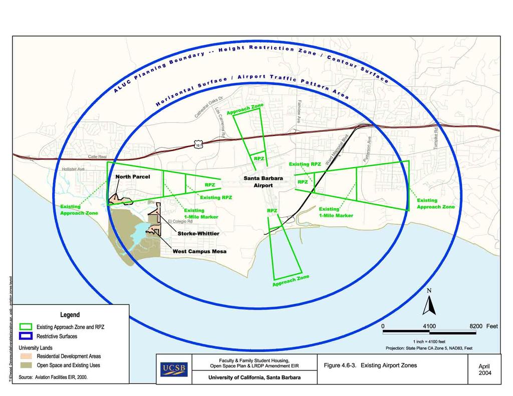
7
8 Non-residential uses within one mile of the runway end which would result in large concentrations of people such as, but not limited to, shopping centers, schools, hospitals, or stadiums Hazardous installations such as oil or gas storage All project proposals in Safety Area 2 within one mile of the runway end, and proposals which would result in large concentrations of people in Safety Area 2 more than one mile from the runway end shall be reviewed on a case-by-case basis by the ALUC Height limitations vary based on the proximity of the site to the runway, and are based on the Federal Aviation Regulations (FAR) Part 77 The Sierra Madre Family Student Housing site and the Open Space Plan area would be located outside of the existing and future Approach Zone North Campus The North Campus consists of the following three sub-areas: North Parcel, South Parcel, and the Storke-Whittier Parcel. Because the North Campus property was acquired by the University in 1994, the 1990 LRDP did not address land use in this area. However, in 1998, the University adopted an amendment to the 1990 LRDP to extend existing campus policies (including coastal policies) to these newly acquired campus areas. Prior to acquisition by the campus, this area was included in the County of Santa Barbara s GCP, which was adopted by the Coastal Commission into the County s LCP in However, the GCP does not provide zoning for the North Campus, as described above, because the North Campus is within the University s planning jurisdiction, and the University, as a state entity, is not subject to local zoning regulations. However, the University s proposed development is intended to be generally consistent with the GCP North Campus North Parcel. The North Parcel consists of approximately 30 acres of undeveloped land that is located south of the western terminus of Phelps Road, and south and west of the western terminus of Marymount Road. It is bounded by Phelps Road, medium to high-density residential development to the north, including the Canon Green Condominiums, Ocean Meadows Golf Course to the south, the University Village neighborhood to the east, and townhomes and Ellwood Mesa to the west. It is currently undeveloped. A number of informal trails cross the parcel that link to locations along the Ellwood Mesa and University property. The GCP identifies the North Parcel as part of a larger area that is designated for Planned Development (PD) up to 351 residential units. The 1990 LRDP, as amended in 1998, designates the North Parcel for the development of up to 147 units of faculty housing. The project proposes an LRDP Amendment to enable the development of 236 units of faculty housing on the North Parcel, as well as trail connections from the faculty housing complex to the Open Space Areas. Refer to Section 2.0 for a detailed description of this development
9 North Campus South Parcel. The South Parcel consists of approximately 71.5 acres of undeveloped land, with the Venoco Access Road and power transmission lines situated along its southern border. The Ellwood Marine Terminal facility, located to the south of this parcel, currently contains oil storage and transportation structures. Like the North Parcel, a number of trails cross the parcel that linking to the Ellwood Mesa and other University property. The GCP identifies the South Parcel as part of that same larger Planned Development area as the North Parcel. The 1990 LRDP, as amended, designates the South Parcel for up to 122 units of faculty housing. The proposed LRDP Amendment includes development of Open Space Plan amenities on the South Parcel, and designation of the South Parcel as permanent open space. Refer to Section 3.0 for a detailed description of this development North Campus Storke-Whittier Parcel. The Storke-Whittier Parcel consists of approximately 14.8 acres of undeveloped land and is located west of Storke Road, north of the existing University Family Student Housing, south of Whittier Drive, and surrounding the easterly portion of Ocean Meadows Golf Course. The Ocean Meadows driving range is situated on a portion of the site. The portion of the site on the corner of Storke Road and Whittier Drive is designated for multiple unit residential development of 1,450 square feet or more under the GCP. The balance of the parcel that is adjacent to Storke Road is identified as part of a larger area that is designated for PD. The 1990 LRDP, as amended, designates this site for up to 144 units of family student housing. The proposed LRDP Amendment includes development of 151 units of family student housing, as well as trail connections from the housing to the Open Space Plan area on the Storke-Whittier site. Refer to Section 3.0 for a detailed description of this proposed development West Campus Mesa The West Campus Mesa is a partially developed area of approximately 48 acres located southwest of the intersection of Storke and El Colegio Roads and adjacent to the Devereux Slough to the west. Current development includes student gardens, the Orfalea Children s Center, and faculty housing. The 1990 LRDP provides for the development of 167 units of faculty and student housing (117 faculty and 50 student units) on West Campus Mesa. The 1990 LRDP also allows for expansion of the Orfalea Children s Center (up to 10,000 additional square feet). The proposed project does not include development of the 50 units on the West Campus Mesa at the present time, but would not alter the existing LRDP designation of 50 residential units of housing and Open Space Plan-related amenities on the West Campus Mesa. Refer to Section 3.0 for a detailed description of this development
10 West Campus Bluffs The West Campus Bluffs area is vacant, undeveloped land encompassing approximately 36 acres of scenic coastal mesa. Devereux School and West Campus Point Faculty Housing are located to the north, West Campus Beach lies to the south, Isla Vista is situated to the east, and COPR and Devereux Slough are to the west. The 1990 LRDP proposed construction of 100 faculty units on approximately 27 acres of the site along with a 9-acre Coal Oil Point Park. As discussed earlier, the 1990 LRDP proposed construction of faculty housing adjacent to the West Campus Bluffs. Following input from the community, the University reached an agreement with the County of Santa Barbara, the City of Santa Barbara and a number of concerned community groups to withdraw the proposal for 50 faculty housing units adjacent to the Bluffs, relocate 50 proposed units to the West Campus Mesa, and pursue alternative sites for the construction of additional faculty housing. The Joint Proposal proposes to locate the additional faculty housing on the North Parcel of the North Campus and amending the LRDP to remove the residential designation for the West Campus Bluffs. However, the Joint Proposal recognizes that if faculty housing goals cannot be realized on the North Campus, the University can revisit the feasibility of constructing faculty housing on the West Campus Bluffs. The proposed LRDP would also include improving the Open Space Plan amenities on the West Campus Bluffs site. Refer to Section 3.0 for a detailed description of this development Coal Oil Point and COPR The Coal Oil Point area is a 6-acre headland bounded on the west by Coal Oil Point, to the north and east by the West Campus Bluffs, and to the south by the beach. Existing uses include the 1,500-square-foot Cliff House seminar facility and conference center, with a 50-space unpaved parking lot, a temporary restroom, and a number of old structures along with the COPR Manager s residence and administrative office. Access to Coal Oil Point is via Devereux Road. The 1990 LRDP provides for the replacement or remodel of the existing Cliff House conference facility (equivalent in size to the existing structure plus consolidation of old outlying structures and building pads). The additional development of public facilities provided for in the 1990 LRDP include a parking lot to serve remodeled Cliff House and the COPR, a permanent or temporary restroom, and a stairway to the West Campus Beach. The proposed project does not include replacing the Cliff House at the present time, but would not alter the existing LRDP long term plans for the area. Refer to Section 3.0 for a detailed description of this development. The 165-acre COPR is largely surrounded by undeveloped and environmentally sensitive land. The 17.5-acre Ellwood Marine Terminal area, the North Campus South Parcel, and the Ocean Meadows Golf Course are located north of this area; Sands Beach and the Pacific Ocean are located to the south; Devereux School and the remainder of West Campus is located to the east;
11 and the Ellwood Mesa is to the west. This area includes the historic 125-acre COPR created in 1979 and the 40-acre expansion area added by The Regents in This area supports a variety of habitats, many considered environmentally sensitive under the Coastal Act. The COPR, including Devereux Slough, is part of the University s Natural Reserve System, and is managed to protect its ecological and academic values. Historic public use of the COPR and nearby beaches extends back decades prior to the University land purchase. The COPR is crossed by a number of trails, and has a long history of public use. Sands Beach is one of the most heavily visited beaches in the County. All lands within the COPR are designated by the LRDP as environmentally sensitive habitat areas. The Draft COPR Management Plan (COPR Plan) was released in July of The COPR Plan serves as a guide to manage sensitive resources and enhance the value of the COPR as a research and education area. The COPR Plan describes several programs divided into the following categories: users, habitat conservation, stewardship, and administration. The COPR Plan integrates the policies of the Coastal Act, as stipulated in the 1990 LRDP. A Snowy Plover Management Plan has already been approved by the Coastal Commission, and will be incorporated in the final COPR Plan Regulatory Framework This Regulatory Framework section addresses those applicable plans, policies, and regulations of agencies with jurisdiction over the proposed project. As indicated previously, a discussion of the Goleta Community Plan, though not applicable to the Project by virtue of the University s ownership of the property, is provided Federal There are no federal regulations, authorities, or administering agencies that regulate the proposed project pertaining to land use State California Coastal Act (California Public Resources Code et seq.). The California Coastal Act was enacted by the State Legislature in 1976 to provide longterm protection of California s 1,100- mile coastline for the benefit of current and future generations. Chapter 3 of the Coastal Act contains the Coastal Resource Planning and Management Policies of the Coastal Act, which provide a framework of planning and environmental policies to guide the protection of resources as well as development in the coastal zone. Section states that: The Legislature further finds and recognizes that conflicts may occur between one or more policies of [the Coastal Act]. The Legislature therefore declares that in carrying out the provisions of [the Coastal Act] such conflict be resolved in a manner, which on balance is the most protective of significant coastal resources
12 In this context, the Legislature declares that broader policies, which, for example, serve to concentrate development in close proximity to urban and employment centers may be more protective, overall, than specific wildlife habitat and other similar resource policies. Section 30200(b) of the Coastal Act also provides that: Where the commission or any local government in implementing the provision of this division identifies a conflict between the policies of this chapter, Section shall be utilized to resolve the conflict and the resolution of such conflicts shall be supported by appropriate findings setting forth the basis for the resolution of identified policy conflicts. The analysis below discusses the consistency of the Project with the policies of Chapter 3, and identifies potential conflicts that may require balancing in order to provide a project that on balance is the most protective of significant coastal resources. Relevant Coastal Act policies are discussed under Impact below Local The GCP is part of the Comprehensive Plan for the County of Santa Barbara. The GCP provides development policies (including the general type and location of land uses) specifically tailored for the unincorporated Goleta area, and identifies measures to implement those policies. All development within the jurisdiction of the County of Santa Barbara must comply with the policies set forth in the GCP. In addition, those portions of the GCP located within the coastal zone have also been incorporated into the County of Santa Barbara s LCP. While lands under the University s jurisdiction are not subject to the GCP, the University has generally based the currently the proposed project on the County of Santa Barbara s existing and approved plans and standards. Relevant GCP policies and development standards are discussed under Impact below Project Impacts and Mitigation Methodology For the purposes of this analysis, it is assumed that the project would incorporate relevant LRDP policies (identified below) into project design, siting, construction, or operation as appropriate. The compatibility of the proposed project s residential development with adjacent development is analyzed by comparing proposed uses to adjacent development based on use and intensity of development. Project conformance with adopted plans and policies were analyzed by comparing the features of proposed development to those features (e.g., habitat restoration, access, etc.) called for in the relevant policies
13 LRDP Policies The Coastal Act Element of the LRDP included a range of policies and standards (herein termed LRDP policies) which ensure consistency of the LRDP, and projects implemented under the LRDP, with the statutory requirements of Chapter 3 of the Coastal Act (commencing with Section 30200). The Project will be developed in conformance with the following LRDP policies relevant to and Planning (a).1. As much as feasible, the student housing on the North Campus will be physically integrated with existing West Campus Student Housing both to enhance facilities at the older existing development and to establish a sense of shared community (a).2. Site planning and architectural design for the residential development adjacent to the Ocean Meadows Golf Course will consider the potential flight of errant golf balls, and avoid siting particularly sensitive uses (e.g., child care, tot lots, etc.) in areas exposed to the flight of golf balls New structures on the campus shall be in general conformance with the scale and character of surrounding development. Clustered developments and innovative designs are encouraged Buildings on Main and Storke Campus shall not exceed the height limits established in Figure 15 measured to the ridgeline, except for mechanical and electrical equipment (b). Buildings on North and West Campus shall not exceed 35 feet, except for student housing on North Campus, which shall not exceed 45 feet. Height restrictions are measures to the ridge line and exclude mechanical and electrical equipment No development shall be permitted on the bluff face, except for staircases or access ways to provide public beach access and pipelines for instructional or research-oriented use Public access to campus beaches from adjoining beaches and all stairway or pathway access routes mapped in Figure 26 in the 1990 LRDP and Figure 3.0 in the North and West Campus Housing LRDP Amendment will remain open to protect the permanent right of the public for pedestrian access and appropriate recreational uses of the beach at all times, except as provided for in policy number To provide parking for a potential seminar facility at Coal Oil Point, while protecting the area from overuse, parking for no more than 50 cars shall be provided at Coal Oil Point, subject to special permit Public access policies under this section shall be subject to restriction, as determined by the campus, only when public access is inconsistent with the following: a) public health or safety; b) natural disaster, civil disorders which pose a threat to property, or other such seriously disruptive events; c) extraordinary measures, which are required to immediately avert, alleviate,
14 or repair damage to campus property, or to maintain the orderly operation of the campus; military security needs; d) protection of fragile coastal resources; and e) adequate nearby access The campus shall cooperate with the County of Santa Barbara and the California Department of Parks and Recreation in the proposed expansion of the California Coastal Trail System so long as it is consistent with the environmental constraints of the Coastal Act Pedestrian access to the sandy beaches upcoast shall be provided by a) the campus from Camino Majorca at the end of Del Playa Drive in Isla Vista; and, b) from the proposed coastal access parking lot at the west terminus of Phelps Road via a trail along the western boundary of North Campus to the beach. Bicycle parking racks shall be provided within Coal Oil Point Park adjacent to Del Playa concurrent with any development of the faculty housing Project. Trail access upcoast along the bluff top should be marked with appropriate directional information and cautions against intrusion into the fenced Reserve New student and faculty housing projects including those adjacent to coastal bluff top parks will contain recreational facilities and open space so as not to overburden oceanfront recreational areas Outdoor recreational facilities, including recreation field, and basketball and tennis courts, may be used by the public at no cost, when not occupied by University classes or programs Development in Coal Oil Point Natural Reserve will be kept to a minimum. Only structures that would be used in conjunction with research in the reserve, or that would enhance the area s usefulness as a natural study area will be allowed, such as weather stations, observation blinds, and small storage structures The University shall coordinate with and encourage action by the County of Santa Barbara, City of Santa Barbara, and RWQCB to see that adjacent land uses are established and carried out in a manner which will sustain the biological productivity of campus marine resources No permanent aboveground structures shall be permitted on the dry sand beach except facilities necessary for public health and safety, temporary recreational structures such as volleyball poles and nets Thresholds of Significance The following thresholds of significance are based on Appendix G of the CEQA Guidelines. For purposes of this EIR, implementation of the proposed project may have a significant adverse impact on land use if it would result in any of the following: Physically divide an established community
15 Conflict with any applicable habitat conservation plan or natural community conservation plan Conflict with any applicable land use plan, policy, or regulation of an agency with jurisdiction over the project (including, but not limited to the LRDP, general plan, specific plan, local coastal plan, or zoning ordinance) adopted for the purpose of avoiding or mitigating an environmental effect Effects Not Found to Be Significant Threshold. Would the proposed project physically divide an established community? The proposed project would develop faculty and family student housing on the University North Campus. As such, the Initial Study (included in Appendix A of this EIR) determined that the proposed project would not divide or isolate any uses that have been established on or near the project site, and no additional analysis is required in this EIR. The proposed project would implement the concepts articulated in the Joint Proposal for the Ellwood-Devereux Coast. The Joint Proposal provides the opportunity to plan the preservation, management, and development of 652 consolidated acres of recreational, natural land, and marine environment resources. The Joint Proposal recognizes that although the 10 parcels that comprise the plan area (owned by 24 individuals and agencies and regulated by three separate jurisdictions) are not a developed community, they are all part of the lower Devereux Creek watershed, also known as the greater Devereux Slough regional ecosystem, which is recognized as a natural community. This natural community has significant natural resources, yet development is allowed on or near some of the most sensitive habitat areas and most valued recreational lands, while less valuable lands are presently designated for open space. If all current plans were developed, islands of development would be set within open spaces dividing the natural community and impairing its long-term sustainability. Even with careful planning and mitigation, development would occur on the coastal mesa and among the sensitive habitats including vernal pools and native grasslands. For 20 years development efforts have been fraught with contention over resource protection. Several lawsuits have failed to resolve issues to the owners and the community s satisfaction. Money may be found to purchase one or two individual properties, but it is unlikely that the overall ecosystem can be protected in this manner. The proposed project would implement the Joint Proposal s plan to reduce potential development from 760 to 570 units, and cluster University and private residential development would be clustered adjacent to existing development and infrastructure, and employment centers. Accordingly, the proposed project is considered to result in a beneficial impact in that it would preserve and restore an established natural community. Threshold. Would the proposed project conflict with any applicable habitat conservation plan or natural community conservation plan?
16 OPEN SPACE PLAN, & LRDP AMENDMENT EIR The proposed project would develop faculty and family student housing on the University North Campus, and improve coastal access and manage coastal resources on the North and West Campuses. As such, the Initial Study determined that the project site is not covered by any applicable habitat conservation plan or natural community conservation plan, and no additional analysis is required in this EIR. As noted above, the project area is all part of the lower Devereux Creek watershed, also known as the greater Devereux Slough regional ecosystem, which is recognized as a natural community that has significant natural resources and sensitive habitat areas. Implementation of the proposed project, including concentrating residential development adjacent to existing development and restoration of the Open Space Plan area would preserve and restore the natural community. Accordingly, the proposed project is considered to result in a beneficial impact in that it would preserve and restore an established natural community Impacts and Mitigation Measures Impact The proposed project would not conflict with applicable land use plans, policies, and regulations. This impact would be less than significant. Amendment of the LRDP to permit residential development on the North Campus, improve coastal access, and manage coastal resources in open space areas, including restoration of degraded habitat, would not conflict with the GCP, Santa Barbara County Association of Governments, Regional Growth Forecast 2000, Santa Barbara County Air Pollution Control District (SBAPCD), Revised 2001 Clean Air Plan, and Water Quality Control Plan (Central Coast Basin Plan). The development of multi-family housing on the North Parcel would not be consistent with the Santa Barbara Municipal Airport Plan; however, the University is not subject to regulation by the ALUP could be deemed compatible with the Santa Barbara ALUP. However, the University is not subject to regulation under the ALUP. Nevertheless, the project is consistent with all the applicable policies in the ALUP regarding noise, safety, and height. Elements of the proposed project may conflict with individual policies of Chapter 3 of the California Coastal Act. However, as recognized in the Joint Proposal and as discussed in the Alternatives analysis of this EIR, conflicts with other individual policies of Chapter 3 would result from implementation of alternatives that allow development to occur as permitted by existing approved plans, regulations, and ownerships. The Joint Proposal reflects a conclusion that: (1) implementation of the proposed project (and the Joint Proposal) resolves the identified Coastal Act policy conflicts in a manner which on balance is the most protective of significant coastal resources, and (2) that the concentration of development through the proposed project (and the Joint Proposal) in close proximity to urban and employment centers may be more protective, overall, than specific wildlife habitat and other similar resource policies in Chapter 3 of the Coastal Act
17 OPEN SPACE PLAN, & LRDP AMENDMENT EIR The proposed project would result in development of 236 units of faculty housing on the North Parcel, development of 151 units of family student housing on the Storke-Whittier Parcel, the designateion of the South Parcel as open space, and the designateion of the COPR Expansion Area as natural reserve. The designations for development of 117 units of housing on the West Campus Mesa would be reduced to 50 units of faculty housing. The designations for a 10,000 gross square feet (gsf) expansion of the Orafalea Children s Center and replacement of the Cliff House (with a structure equivalent to all existing and former structures at Coal Oil Point) would remain. The amended LRDP would, once adopted by the CCC, serve as the LCP for this portion of the campus. The following discussion provides an evaluation of the proposed residential development and open space plan with respect to the existing governing policy framework for the North and West Campus areas. California Coastal Act. The potential environmental effects of the proposed new development, as well as measures proposed to mitigate the associated adverse effects, are evaluated in the appropriate issue area sections of this EIR. To the extent that the proposed amendment to the LRDP would result in physical environmental impacts, these changes are subsumed within each specific issue area analysis. The following analysis summarizes these effects, where necessary, for an evaluation of consistency. Table addresses the policies of Chapter 3 of the Coastal Act, by article. The proposed project is consistent with all of the policies of Chapter 3, with the exception of the policies contained in 30233, and 30255, which express a policy in favor of limiting diking, filling, and dredging of wetlands to specific industrial, commercial, boating, and public service uses and only where no feasible less environmentally damaging alternative exists, and where feasible mitigation measures are provided to minimize adverse environmental effects. Residential use is not a use identified in Section As discussed earlier, the Coastal Act recognizes that conflicts may occur between one or more policies of the Coastal Act, and where such conflicts occur, calls for resolution in a manner which on balance is the most protective of significant coastal resources. Section In addition Section expressly recognizes that broader policies which, for example, serve to concentrate development in close proximity to urban and employment centers may be more protective, overall, than specific wildlife habitat and other similar resource policies. Section 30200(b) further recognizes that [w]here the commission or any local government in implementing the provision of this division identifies a conflict between the policies of this chapter, Section shall be utilized to resolve the conflict and the resolution of such conflicts shall be supported by appropriate findings setting forth the basis for the resolution of identified policy conflicts
18 OPEN SPACE PLAN, & LRDP AMENDMENT EIR BALANCING ANALYSIS Because policy conflicts are associated with both with the proposed project, existing use of the project area and the reasonable alternatives to the proposed project (under existing approved plans, policies, and regulations) the following balancing analysis is provided. Residential development on the North Parcel would result in the loss of approximately 1.54 acres of Coastal Act wetlands and 1.29 acres of ACOE wetlands on the North Parcel due to A
19 direct removal or hydrological interruption. The Project also includes realignment, reengineering and restoration of Phelps Ditch Phelps Ditch is a riparian area and is designated as an ESHA. However, it is a manmade flood control channel. Presently, notwithstanding its ESHA designation, Phelps Ditch is considered to have intermediate functionality as a habitat area (WRA, 2004) In addition, impacts to Phelps Ditch will be temporary, and as part of the Project, it will be restored and enhanced. Of those wetlands that would be lost, most have low to medium functionality (WRA, 2004). Implementation of the Project (including the Open Space Plan) would result opportunities for preservation, enhancement, and/or restoration of numerous acres of wetlands, including vernal pools, freshwater marsh, saltwater marsh and riparian forest within the project area. With mitigation of the impacts associated with residential development, the proposed project would result in an increase of wetlands. The proposed project would also preserve 146 acres of open space and natural reserve on the South Parcel (68.7 acres), COPR Expansion Area (40 acres), and West Campus Bluffs (37.3 acres). As recognized in the Joint Proposal and as discussed in the analysis of Alternatives, the proposed project will implement the concepts articulated in the Joint Proposal for the Ellwood- Devereux Coast, which is the result of an unprecedented public-private cooperative effort to guide development of the last remaining open coastal lands in western Goleta. The resulting Open Space Plan provides the opportunity to plan the preservation, management, and development of the Ellwood-Devereux area in a comprehensive rather than piecemeal fashion. Comprehensive planning would allow improved public coastal access, and the preservation and enhancement of 652 consolidated acres of recreational, natural land, and marine environment resources. The Ellwood-Devereux area is part of the lower Devereux Creek watershed, also known as the greater Devereux Slough regional ecosystem. Development is presently allowed in various locations throughout the area. Under existing plans and regulations, development may occur close to sensitive habitat areas and the most valued recreational lands, while less valuable lands are designated as open space. If development moves proceeds under existing plans, policies, and approvals islands of development would fragment open space, disrupt coastal access, recreational use, and the overall ecosystem in the area, even taking careful planning and mitigation into account. Conservation of the Ellwood Mesa and Devereux Slough as an effectively functioning consolidated and restored ecosystem is more protective of coastal resources than protection of each specific habitat area which, following permissible development, would be isolated and fragmented by development, and would thereby have their sustainability and their value to the overall ecosystem compromised over the long term. While resulting in the removal of certain isolated and degraded wetland areas of low to intermediate functional value (WRA, 2003), the Project (including the Open Space Plan) would improve public access, maintain and enhance recreational resources in the area, protect, restore and enhance the marine environment, protect and enhance area land resources, and locate new residential development contiguous with existing developed areas able to accommodate it, without other significant adverse
20 environmental effects. Articles 2 through 5 of Chapter 3 of the Coastal Act are further discussed below. Article 2 of Chapter 3 of the Coastal Act encourages maximum coastal access for all people. Article 2 expresses policies against new development interfering with public coastal access, and in favor of enhancing public access where possible. Coastal public facilities are to be distributed to mitigate the impacts of overcrowding and overuse. But access must be provided in a reasonable manner that takes into account individual circumstances and that balances private property rights. Were the proposed project (including the Open Space Plan) not to be implemented, existing uses of the project area that conflict with Coastal Act policies would continue, and development would occur under existing approved plans, policies would continue in a piecemeal fashion, as noted above. Public access through the Plan Area would be discontinuous and interrupted by roads and development, which conflicts with the policies of Article 2 of Chapter 3 of the Coastal Act. The opportunity to further the policies of Article 2 of Chapter 3 of the Coastal Act though an unbroken, integrated, access system through 652 acres of consolidated permanently-preserved and restored open space and natural reserve would be lost. Implementation of the proposed project (including the portion of the Open Space Plan within the University s jurisdiction) will contribute to the creation of an unbroken, integrated, access system through 652 acres of consolidated permanently-preserved and restored open space and natural reserve which will further public access to coastal resources. It also plans for necessary and improved access infrastructure, including the installation and maintenance of stairs, the reparation of access ramps, and the creation of new low profile improvements such as boardwalks to protect dune and wetland areas. Many trails would be re-graded, ramp and trail surfaces would be improved, and scrub would be trimmed to widen trails. Existing chain link fences would be replaced with more attractive barriers or wood rail fencing, and where multiple informal trails exist, those trails would be closed, and the public would be directed toward designated coastal access points. The installation of a permanent restroom facilities and bike racks, and the creation of interpretive centers for education of the public, all distributed in such a way as to minimize the impact of overcrowding. It also contemplates the construction and enhancement of informal seating and overlook areas at key points where desirable views exist. Finally, under the Open Space Plan more than 150 public parking spaces would be added along the perimeters of the open space area (including 84 spaces on University property), and highly visible coastal access signs would be installed. Article 3 of Chapter 3 stresses the importance of preserving and expanding visitor-serving and recreational opportunities. It seeks to protect coastal areas suited for water oriented recreational activities and encourages the protection of oceanfront land suitable for recreational use. Were the project (including the Open Space Plan) not implemented, existing uses of the project area that conflict with Coastal Act policies would continue, development would occur under existing approved plans, policies and regulations would occur, and the most significant
21 recreational opportunity presented by the Open Space Plan the opportunity to preserve the unique and irreplaceable recreational opportunity of an unbroken natural open-space area consisting of 652 acres adjacent to the coast would be lost to residents and visitors alike. The recreational experience of the area would be and diminished and interrupted by the proximity of residential development and daily-activity. The proposed project (and the Open Space Plan) would further the policy objectives of Article 3 of Chapter 3 by seizing this irreplaceable opportunity while also providing for resource protection. It would plan integrated, permanent recreational opportunities, including an extensive trails network, coastal access, and passive recreation and open space. The amount of permanently preserved open space would increase. The coastal access trails would replace an informal unplanned system and would better protect wildlife habitat areas, with educational opportunities for area visitors. Beaches, already the site of a majority of area recreational activities, would also provide wildlife viewing opportunities, as well as opportunities for surfing, swimming, and other recreational activities. Natural resources would be protected by channeling public use away from the most sensitive areas and by educating the public through interpretive centers and signs. Article 4 encourages the maintenance, enhancement, and where feasible restoration of the marine environment, including coastal waters, streams, estuaries and lakes. In addition, the biological productivity and quality of coastal waters is to be maintained. As discussed earlier, Section expresses a policy in favor of limiting diking, filling, and dredging of wetlands to specific industrial, commercial, boating, and public service uses and only where no feasible less environmentally damaging alternative exists, and where feasible mitigation measures are provided to minimize adverse environmental effects. Temporary impacts to resources for incidental public serve purposes are permissible in accordance with Section 30233(a)(5). The Open Space Plan Area includes approximately 30 acres of seasonal pond wetland areas. These range from high quality vernal pools on Ellwood Mesa, with a high diversity and cover of native vernal pool plants and natural gently sloping topography, to highly disturbed seasonal ponds on lands subject to past grading and ongoing disturbance. Approximately 24 acres would be preserved in the context of 652 acres of consolidated natural and restored open space, thereby promoting and enhancing their productivity and long-term survivability by minimizing the perimeter to area ratio. Implementation of the broader policy of Chapter 3 (concentrating development in close proximity to urban and employment centers) would require that approximately 1.54 acres of seasonal ponds or wetlands be filled as part of the proposed project with areas used for residential use, which raises a conflict with the policy expressed by Section These degraded ponds are of low to intermediate biological function and are found primarily on lands that have been graded (WRA, 2003). Although regarded as wetlands and therefore having some habitat value, degraded ponds tend to have lower cover and diversity of native wetland plants than higher quality pools, and many may have residual salt marsh vegetation due to their location on land historically part of the Devereux Slough. Furthermore, subsequent to mitigation, the
SECTION 3.0 PROJECT DESCRIPTION
 3.1 INTRODUCTION SECTION 3.0 PROJECT DESCRIPTION The University of California, Santa Barbara (University) proposes to implement an LRDP Amendment for the University North and West Campuses, develop 236
4.9 VISUAL RESOURCES Introduction
 4.9 VISUAL RESOURCES 4.9.1 Introduction This section describes the visual setting of the North and West Campuses, and evaluates the potential for changes of residential development and undeveloped area
4.10 RECREATION Introduction
 OPEN SPACE PLAN, & LRDP AMENDMENT EIR 4.10 RECREATION 4.10.1 Introduction This section describes existing recreational resources on the University s North and West Campuses, and analyzes whether the project
3.10 LAND USE SETTING PROJECT SITE EXISTING LAND USE DESIGNATIONS AND ZONING. General Plan Land Use Designations.
 This section of the Draft EIR addresses the existing land uses on and adjacent to the project site and discusses the potential impacts of the proposed project on existing land uses. Key issues addressed
Venice Pumping Plant Dual Force Main Project Draft EIR
 City of Los Angeles 5.9 LAND USE PLANS 5.9.1 Environmental Setting Venice Pumping Plant Dual Force Main Project Draft EIR The Project lies within the bounds of Los Angeles County and the City of Los Angeles.
4.8 LAND USE AND PLANNING
 4.8 LAND USE AND PLANNING 4.8.1 INTRODUCTION This section describes existing and planned land uses at the Hayward campus and analyzes the impact of implementation of the proposed Master Plan on land uses
LOS ANGELES AIRPORT/EL SEGUNDO DUNES Specific Plan
 LOS ANGELES AIRPORT/EL SEGUNDO DUNES Specific Plan Ordinance No. 167,940 Effective June 28, 1992 TABLE OF CONTENTS MAP Section 1. Section 2. Section 3. Section 4. Section 5. Section 6. Specific Plan Area
Coal Oil Point Reserve Management Plan LRDP Policy Consistency Analysis August Consistent. All applicable LRDP policies apply to the COPRMP.
 APPENDIX G LRDP CONSISTENCY TABLE Coal Oil Point Reserve Management Plan LRDP Policy Analysis August 2015 INTRODUCTORY POLICIES Policy INTRO-1 - The policies of the Coastal Act (PRC Sections 30210 through
Gold Line Bus Rapid Transit Transit Oriented Development (BRTOD) Helmo Station Area Plan
 Helmo Station Area Plan") Appendix F Gold Line Bus Rapid Transit Transit Oriented Development (BRTOD) Helmo Station Area Plan Introduction and Purpose of the Plan The Gold Line Bus Rapid Transit facility is an eleven-mile dedicated
Appendix F Gold Line Bus Rapid Transit Transit Oriented Development (BRTOD) Helmo Station Area Plan Introduction and Purpose of the Plan The Gold Line Bus Rapid Transit facility is an eleven-mile dedicated
U C S B OFFICE OF CAMPUS PLANNING & DESIGN. Notice of Impending Development. September Trailer 309, 320, and 327 Demolition Project
 U C S B OFFICE OF CAMPUS PLANNING & DESIGN E H T LET A U N IV E R SIT T H Y E R E 186 O F University of California Santa Barbara September 2013 Notice of Impending Development Trailer 309, 320, and 327
3. VISION AND GOALS. Vision Statement. Goals, Objectives and Policies
 Vision Statement Queen Creek s interconnected network of parks, trails, open spaces and recreation opportunities provide safe and diverse activities and programs that sustain its unique, small town, equestrian
Shoreline Master Program Town of La Conner, Washington
 Shoreline Master Program Town of La Conner, Washington Department of Ecology approval effective Adopted September 24, 2013 by Town of La Conner Ordinance No.1106 Amended May 13, 2014 by Town of La Conner
3.11 PARKS, OPEN SPACE AND RECREATION
 3.11 PARKS, OPEN SPACE AND RECREATION This section identifies existing park, open space, and recreation resources, assesses potential impacts associated with the proposed project, and recommends mitigation
Goal 1: To Encourage the Orderly, Harmonious and Judicious Use of University Resources in the Development of University Land.
 2.0 Future Land Use Goal 1: To Encourage the Orderly, Harmonious and Judicious Use of University Resources in the Development of University Land. Objective 1.1: Make available future building sites that
TABLE OF CONTENTS. Tables Table UC Davis Park and Open Space Resources
 TABLE OF CONTENTS 4.13 Recreation... 4.13-1 4.13.1 Environmental Setting... 4.13-1 4.13.2 Impacts and Mitigation Measures... 4.13-4 4.13.3 References... 4.13-8 Tables Table 4.13-1 UC Davis Park and Open
INTRODUCTION. 1.1 What is a General Plan? 1.2 Requirements for a General Plan. 1.3 Introduction to Monterey County
 1.1 What is a General Plan? INTRODUCTION California state law requires each city and county to adopt a comprehensive, long-term general plan for the physical development of the county or city, and any
Glenborough at Easton Land Use Master Plan
 Implementation 114 9.0 IMPLEMENTATION 9.1 OVERVIEW This chapter summarizes the administrative procedures necessary to implement the proposed land use plan, infrastructure improvements, development standards,
I. INTRODUCTION... 1 II. PROJECT DESCRIPTION... 1 III. PROCEDURE... 2 IV. CONSISTENCY WITH THE 1990 LONG RANGE DEVELOPMENT PLAN...
 NOTICE OF IMPENDING DEVELOPMENT UNIVERSITY OF CALIFORNIA, SANTA BARBARA East Gate Vegetation Removal Project Table of Contents I. INTRODUCTION... 1 II. PROJECT DESCRIPTION... 1 III. PROCEDURE... 2 IV.
Nob Hill Pipeline Improvements Project EIR
 Section 3.1 Aesthetics This section addresses the visual aspects that may affect the views experienced by the public, including the potential to impact the existing character of each area that comprises
No comments related to land use and planning issues were received in response to the Notice of Preparation.
 4.8 LAND USE AND PLANNING This section analyzes the impacts relative to land use and planning that would occur as a result of implementation of the proposed Facilities Master Plan (proposed project). This
Tāhuhu whakaruruhau ā-taone The sheltering ridge pole
 B2. Tāhuhu whakaruruhau ā-taone - Urban growth and form B2.1. Issues Tāhuhu whakaruruhau ā-taone The sheltering ridge pole Auckland s growing population increases demand for housing, employment, business,
GENERAL PLAN UPDATE ISSUES MEETING. January 21, 2010 City Hall Mitchell Room 6:00 pm 9:00 pm
 GENERAL PLAN UPDATE ISSUES MEETING January 21, 2010 City Hall Mitchell Room 6:00 pm 9:00 pm WELCOME! Introductory Comments Continued Review of Quality of Life Standards, Growth Management, Proposition
U C S B OFFICE OF CAMPUS PLANNING & DESIGN. Notice of Impending Development. January Segovia Road Access Project
 U C S B OFFICE OF CAMPUS PLANNING & DESIGN E H A UNIVERSIT T Y LET T H E RE 186 OF BE 8 LIGH T CALIFORNIA University of California Santa Barbara January 2013 Notice of Impending Development Segovia Road
Appendix E Section 4(f) Evaluation
 Evaluation") Appendix E Section 4(f) Evaluation Appendix E Draft Section 4(f) Evaluation E.1 Introduction This appendix addresses a federal regulation known as Section 4(f), which protects parks, recreation areas,
Appendix E Section 4(f) Evaluation Appendix E Draft Section 4(f) Evaluation E.1 Introduction This appendix addresses a federal regulation known as Section 4(f), which protects parks, recreation areas,
Chapter 10 IMPLEMENTATION RECOMMENDATIONS
 Chapter 10 IMPLEMENTATION RECOMMENDATIONS The recommended land use plan presented in the previous chapter provides a design for the attainment of the urban and rural development and open space preservation
Policy & Procedure Effective Date: Parks Department Page of
 City of Arvada Policy & Procedure Effective Date: Parks Department Page of TITLE: City of Arvada Prairie Dog Habitat Plan APPROVAL: PURPOSE: To establish a plan for the preservation of black-tailed prairie
Chapter 5: Recreation
 Chapter 5: Recreation Introduction and Setting Recreational opportunities within Nevada County are varied, ranging from public parks with intensively used active recreational facilities, to vast tracts
3.10 Land Use and Planning
 3.10 This section describes the regulatory and environmental setting for land use and planning in the program and individual project areas. It also describes impacts on land use and planning that could
Department of Community Development. Planning and Environmental Review Division Revised Notice of Preparation
 Department of Community Development Michael J. Penrose, Acting Director Divisions Building Permits & Inspection Code Enforcement County Engineering Economic Development & Marketing Planning & Environmental
CHAPTER 10-D GREATER MONTEREY PENINSULA AREA PLAN
 CHAPTER 10-D GREATER MONTEREY PENINSULA AREA PLAN GREATER MONTEREY PENINSULA AREA PLAN SUPPLEMENTAL POLICIES 1.0 - Land Use GMP-1.1 GMP-1.2 GMP-1.3 GMP-1.4 GMP-1.5 GMP-1.6 GMP-1.7 The County shall overlay
Arana Gulch Park Master Plan
 809 Center Street, Santa Cruz, CA 95060 Arana Gulch Park Master Plan Executive Summary The Arana Gulch Master Plan completes the last master planning work for the parks and open spaces within the City
Mendota Heights 2040 Comprehensive Plan Draft Vers
 4 Parks and Trails The City of Mendota Heights boasts a variety of recreational and open space opportunities. Few cities can claim access to regional trails, riverside and lakeside parks, scenic bluffs
Plan Modification to Chapter B2 of the Auckland Unitary Plan(AUP) Operative in part (15 November 2016)
 Operative in part (15 November 2016)") UNITARY PLAN UPDATE REQUEST MEMORANDUM TO FROM Phill Reid Linley Wilkinson DATE 25 September 2018 SUBJECT Plan Modification to Chapter B2 of the Auckland Unitary Plan(AUP) Operative in part (15 November
UNITARY PLAN UPDATE REQUEST MEMORANDUM TO FROM Phill Reid Linley Wilkinson DATE 25 September 2018 SUBJECT Plan Modification to Chapter B2 of the Auckland Unitary Plan(AUP) Operative in part (15 November
4.8 Land Use and Planning Environmental Setting Impacts and Mitigation Measures References...4.
 TABLE OF CONTENTS 4.8 Land Use and Planning...4.8-1 4.8.1 Environmental Setting...4.8-1 4.8.2 Impacts and Mitigation Measures...4.8-5 4.8.3 References...4.8-11 FIGURES Figure 4.8-1 Figure 4.8-2 Figure
TO MEMBERS OF THE COMMITTEE ON GROUNDS AND BUILDINGS:
 Office of the President June 22, 2004 102 TO MEMBERS OF THE COMMITTEE ON : For Meeting of ITEM FOR ACTION Click here for EXECUTIVE SUMMARY CERTIFICATION OF ENVIRONMENTAL IMPACT REPORT AND APPROVAL OF DESIGN,
Chapter 5: Natural Resources and Environment
 NATURAL RESOURCES AND ENVIRONMENT 5-1 5 Chapter 5: Natural Resources and Environment BACKGROUND AND INTENT Urban expansion represents the greatest risk for the future degradation of existing natural areas,
OP Council Resolution June 16, Planning and Development Services
 OP-08-01 Council Resolution June 16, 2008 Planning and Development Services Kingsgate Landing Outline Plan Table of Contents 1.0 Introduction 1 1.1 Purpose of Plan 1 1.2 Plan Area Location 1 1.3 Ownership
III. PROJECT DESCRIPTION
 III. PROJECT DESCRIPTION A. PROJECT LOCATION Regional Setting The project site is located in the southeast quadrant of the City of Chico in Butte County, California and is comprised of four parcels totaling
OFFICE CONSOLIDATION SECONDARY PLAN AREA 22 THE BRAMALEA SOUTH INDUSTRIAL SECONDARY PLAN
 OFFICE CONSOLIDATION SECONDARY PLAN AREA 22 THE BRAMALEA SOUTH INDUSTRIAL SECONDARY PLAN November 2010 EXPLANATORY NOTES (Secondary Plan Area 22) General (pertaining to all secondary plan office consolidations)
5.13 RECREATION / OPEN SPACE
 5.13 RECREATION / OPEN SPACE The project includes the development of two 5+ acre public parks, four pocket parks and various trails. This complies with the Board of Supervisors established minimum standard
4. ENVIRONMENTAL IMPACT ANALYSIS 7. LAND USE AND PLANNING
 4. ENVIRONMENTAL IMPACT ANALYSIS 7. LAND USE AND PLANNING 4.7.1 INTRODUCTION The following analysis discusses the consistency of the Proposed Project with the corresponding land use and zoning designations
Venice Pumping Plant Dual Force Main Project Draft EIR 5.11 PUBLIC FACILITIES AND SERVICES
 5.11 PUBLIC FACILITIES AND SERVICES RECREATIONAL FACILITIES AND PUBLIC RESOURCES This section of the EIR includes a description of the existing recreational facilities and public resources in the proposed
CHAPTER 10-D GREATER MONTEREY PENINSULA AREA PLAN
 CHAPTER 10-D GREATER MONTEREY PENINSULA AREA PLAN GREATER MONTEREY PENINSULA AREA PLAN SUPPLEMENTAL POLICIES 1.0 - Land Use GMP-1.1 GMP-1.2 GMP-1.3 GMP-1.4 GMP-1.5 GMP-1.6 GMP-1.7 GMP-18.6 The County shall
G. RECREATION AND OPEN SPACE ELEMENT. The following summarizes the Recreation and Open Space Element:
 G. RECREATION AND OPEN SPACE ELEMENT The purpose of the Element is to provide the framework and direction for a comprehensive system of public and private sites for recreation, including, but not limited
East Panorama Ridge Concept Plan Amendment
 Page 1 of 7 L003 : East Panorama Ridge Concept Plan Amendment Corporate NO: L003 Report COUNCIL DATE: March 4, 2002 REGULAR COUNCIL LAND USE TO: Mayor & Council DATE: February 27, 2002 FROM: General Manager,
Master Plan for Preservation and Scenic Conservation (1995)
") 3.2 Master Plan for Preservation and Scenic Conservation (1995) The Master Plan for Preservation and Scenic Conservation was developed under the direction of the Guilford Preservation Alliance in the 1980s
3.2 Master Plan for Preservation and Scenic Conservation (1995) The Master Plan for Preservation and Scenic Conservation was developed under the direction of the Guilford Preservation Alliance in the 1980s
AWH REPORT OF THE PLANNING AND DEVELOPMENT DEPARTMENT FOR APPLICATION FOR REZONING ORDINANCE TO PLANNED UNIT DEVELOPMENT
 AWH REPORT OF THE PLANNING AND DEVELOPMENT DEPARTMENT FOR APPLICATION FOR REZONING ORDINANCE TO PLANNED UNIT DEVELOPMENT MAY 8, 2014 The Planning and Development Department hereby forwards to the Planning
Staff Report and Recommendation
 Community Planning and Development Planning Services 201 W. Colfax Ave., Dept. 205 Denver, CO 80202 p: 720.865.2915 f: 720.865.3052 www.denvergov.org/cpd TO: City Council Neighborhoods and Planning Committee
Regional Context Statement
 Regional Context Statement REGIONAL CONTEXT STATEMENT 3. REGIONAL CONTEXT STATEMENT In 1995, the Provincial Government passed into law the Growth Strategies Act. The purpose of this provincial initiative
5.1 AESTHETICS AND VISUAL RESOURCES Physical Setting
 5.1 AESTHETICS AND VISUAL RESOURCES 5.1.1 Physical Setting Aesthetic values are an important aspect in establishing the identity, sense of place, and quality of life in a community. Natural features in
UNIVERSITY OF MICHIGAN:
 Chapter Eight UNIVERSITY OF MICHIGAN: North Campus I. Introduction The University of Michigan currently owns approximately 800 acres of land in the northeast section of Ann Arbor. North Campus refers to
Planned Development Review Revisions (Project No. PLNPCM )
") Planned Development Review Revisions (Project No. PLNPCM2014-00139) Standard residential development Planned Development Example: Smaller lot sizes than what is allowed to create open space amenity. What
Planned Development Review Revisions (Project No. PLNPCM2014-00139) Standard residential development Planned Development Example: Smaller lot sizes than what is allowed to create open space amenity. What
Chapter 14. Shorelines
 Chapter 14 Shorelines Contents City of Spokane Comprehensive Plan 14.1 INTRODUCTION... 7 14.2 SPOKANE S SHORELINE MASTER PROGRAM...11 14.3 ENVIRONMENTS AND MANAGEMENT POLICIES...15 14.5 GOALS AND POLICIES...22
RECREATION AND OPEN SPACE ELEMENT GOALS, OBJECTIVES, AND POLICIES
 RECREATION AND OPEN SPACE ELEMENT GOALS, OBJECTIVES, AND POLICIES Goal 7 To provide park facilities, recreation programs, and open space resources that are safe, adequate, and accessible to all City residents,
SECTION II SECTION II STATEMENT OF GOALS, OBJECTIVES, PRINCIPLES, ASSUMPTIONS, POLICIES AND STANDARDS
 STATEMENT OF GOALS, OBJECTIVES, PRINCIPLES, ASSUMPTIONS, POLICIES AND STANDARDS 1 2 STATEMENT OF GOALS, OBJECTIVES, PRINCIPLES, ASSUMPTIONS, POLICIES AND STANDARDS INTRODUCTION The New Jersey Municipal
A. WHAT IS A GENERAL PLAN?
 I. Introduction A. WHAT IS A GENERAL PLAN? A general plan is the planning guideline for the future of a city. It contains goals and policies which regulate urban development, the protection of the natural
Provide and maintain sufficient public parks, recreation facilities, and open space to meet the recreational needs of County residents and visitors.
 (ROS) Goal Provide and maintain sufficient public parks, recreation facilities, and open space to meet the recreational needs of County residents and visitors. OBJECTIVE ROS.01 The County shall acquire,
PSRC REVIEW REPORT & CERTIFICATION RECOMMENDATION
 PSRC REVIEW REPORT & CERTIFICATION RECOMMENDATION KITSAP COUNTY COUNTYWIDE PLANNING POLICIES July 2, 2012 BACKGROUND A major emphasis of the Washington State Growth Management Act (GMA) is the need to
5.0 MITIGATION MEASURES ADOPTED PURSUANT TO THE 2004 FEIR FOR THE 2004 LRDP...5-1
 Faculty and Family Student Housing, Open Space Plan, and LRDP Amendment EIR Addendum TABLE OF CONTENTS 1.0 INTRODUCTION...1-1 1.1 PROJECT INFORMATION...1-2 1.2 SUMMARY OF NEW INFORMATION AND REVISIONS
OPEN SPACE CHAPTER 7: OVERVIEW. Preserve open space to protect natural resources, enhance character and provide passive recreation opportunities
 CHAPTER 7: OPEN SPACE OVERVIEW Ridgefield has made tremendous progress permanently preserving areas of town as open space. Open space preservation can serve many important purposes, including: protect
Draft Stillwater 2030 Comprehensive Plan- Goals and Policies
 Draft Stillwater 2030 Comprehensive Plan- Goals and Policies Instructions- Review each goal and policy and discuss with group any changes, deletions for additions to the list using your groups pen. Keep
CHAPTER 1. Ms. Guajardo s Class - Central Elementary CH 1 1
 INTRODUCTION CHAPTER 1 Ms. Guajardo s Class - Central Elementary CH 1 1 1.1 SETTING South Centre City is a linear corridor south of Downtown Escondido paralleling Centre City Parkway and South Escondido
CHAPTER 10 AESTHETICS
 CHAPTER 10 AESTHETICS CHAPTER 10 AESTHETICS This section identifies and evaluates key visual resources in the project area to determine the degree of visual impact that would be attributable to the project.
RECREATION, OPEN SPACE AND GREENWAYS ELEMENT GOALS, OBJECTIVES, AND POLICIES
 RECREATION, OPEN SPACE AND GREENWAYS ELEMENT GOALS, OBJECTIVES, AND POLICIES GOAL R-1: DEVELOP A RECREATION, OPEN SPACE AND GREENWAYS SYSTEM AS AN INTEGRAL COMPONENT OF AN OVERALL, COUNTY-WIDE ECONOMIC
CHARLES PUTMAN CHARLES PUTMAN AND ASSOCIATES, INC
 MEMORANDUM CHARLES PUTMAN & ASSOCIATES, INC. LAND DEVELOPMENT CONSULTANTS PLANNING ZONING PERMITTING 4722 NW Boca Raton Boulevard, Suite C-106 Boca Raton, Florida 33431 Phone: 561/994-6411 FAX: 561/994-0447
This page intentionally blank.
 This page intentionally blank. Parks, Recreation, and Open Space Chapter Relationship to Vision Vision Parks, Recreation and Open Space Chapter Concepts County Government. County government that is accountable
When planning stormwater management facilities, the following principles shall be applied where possible.
 2.0 Principles When planning stormwater management facilities, the following principles shall be applied where possible. 2.0.1 Drainage is a regional phenomenon that does not respect the boundaries between
12.0 LAND USE AND PLANNING
 This section describes the existing and proposed land uses and land use designations on each of the project sites and surrounding properties, and analyzes the potential for the project to conflict with
Municipal Development Plan. Summer Village of ROCHON SANDS. Bylaw #241-18
 Municipal Development Plan Summer Village of ROCHON SANDS Bylaw #241-18 TABLE OF CONTENTS PART ONE: BACKGROUND AND PURPOSE 3 SECTION 1: BACKGROUND 3 SECTION 2: GOALS AND POLICIES 3 PART TWO: PHYSICAL ENVIRONMENT
1.0 Circulation Element
 5/9/18 1.0 Circulation Element 1.1 Introduction As growth and development occur in Apache County, enhancements to its circulation system will be necessary. With time, more roads will be paved and air and
SANTA BARBARA COUNTY ZONING ADMINISTRATOR STAFF REPORT February 5, 2016
 SANTA BARBARA COUNTY ZONING ADMINISTRATOR STAFF REPORT February 5, 2016 PROJECT NAME: Public Works Isla Vista Sidewalk Improvements & Tree Replacement HEARING DATE: February 22, 2016 STAFF / PHONE: J.
TO: Mayor & Council DATE: April 12, The Planning and Development Department and the Engineering Department recommend that Council:
 CORPORATE REPORT NO: R080 COUNCIL DATE: April 12, 2010 REGULAR COUNCIL TO: Mayor & Council DATE: April 12, 2010 FROM: SUBJECT: General Manager, Planning and Development General Manager, Engineering Neighbourhood
STREAM BUFFERS
 88-415 STREAM BUFFERS 88-415-01 PURPOSE In the Kansas City region and throughout the nation, vegetated stream buffers have been clearly shown to protect stream stability and related infrastructure, improve
Support the implementation of Cape Coral's Comprehensive Plan. Protect and utilize the unique natural resources in the City.
 7.0 OVERVIEW - RECOMMENDATIONS Chapter 7 The preparation of the Cape Coral Parks and Recreation Master Plan spanned a period of approximately 12 months. Plan preparation included the input of a wide range
DRAFT MAP AMENDMENT FLU 04-4
 DRAFT MAP AMENDMENT FLU 04-4 SW 24 TH AVENUE ROADWAY CORRIDOR The University of Florida participates with the Metropolitan Transportation Planning Organization (MTPO) in its responsibilities for the continuing,
COASTAL CONSERVANCY. Staff Recommendation March 25, 2004 LOS ANGELES GREEN VISION PLAN. File No.: Project Manager: Marc Beyeler
 COASTAL CONSERVANCY Staff Recommendation March 25, 2004 File No.: 04-014 Project Manager: Marc Beyeler RECOMMENDED ACTION: Authorization to disburse up to $50,000 to the University of Southern California
SPECIFIC PLAN Requirements
 CITY OF LANCASTER PLANNING DEPARTMENT 44933 Fern Avenue, Lancaster, California 93534 (661) 723-6100 SPECIFIC PLAN Requirements Purpose The purpose of a specific plan is to provide for the logical development
Prepared by: Casey Kempenaar, Senior Planner
 CITY OF CITRUS HEIGHTS PLANNING DIVISION STAFF REPORT PLANNING COMMISSION MEETING September 13, 2017 Prepared by: Casey Kempenaar, Senior Planner REQUEST The applicant requests a Design Review Permit Modification
Lewisville Lake Master Plan Revision Public Information Meeting May 2 & 4, 2017
 Lewisville Lake Master Plan Revision Public Information Meeting May 2 & 4, 2017 Presented By Rob Jordan Lake Manager U.S. Army Corps of Engineers Fort Worth District US Army Corps of Engineers Purpose
CONSERVATION ELEMENT GOALS, OBJECTIVES, AND POLICIES
 CONSERVATION ELEMENT GOALS, OBJECTIVES, AND POLICIES Goal 4 To conserve, manage, appropriately use and protect the natural resources of the City ensuring continued resource availability and environmental
STEWARDSHIP OF LONG ISLAND SOUND S ECOLOGICAL AND RECREATIONAL RESOURCES
 STEWARDSHIP OF LONG ISLAND SOUND S ECOLOGICAL AND RECREATIONAL RESOURCES Robin Kriesberg, Save the Sound, Inc. Thomas Halavik, US Fish and Wildlife Service Coastal Program An Initiative to Identify, Protect
PG&E WINTERS GAS OPERATIONS AND TECHNICAL TRAINING CENTER
 PG&E WINTERS GAS OPERATIONS AND TECHNICAL TRAINING CENTER CEQA scoping Meeting March 19 th, 2014 Winters City Council Chambers - 6:30 pm AGENDA FOR THE MEETING 6:30 Welcome (John Donlevy) 6:40 Overview
-MENDOCINO COUNTY PLANNING AND BUILDING SERVICES- DIVISION II OF TITLE 20--COASTAL ZONING CODE
 CHAPTER 20.504 VISUAL RESOURCE AND SPECIAL TREATMENT AREAS Sec. 20.504.005 Applicability. Sec. 20.504.010 Purpose. Sec. 20.504.015 Highly Scenic Areas. Sec. 20.504.020 Special Communities and Neighborhoods.
IV.B. VISUAL RESOURCES
 IV.B. VISUAL RESOURCES ENVIRONMENTAL SETTING Existing Visual Character Project Site The project site is located at 17331-17333 Tramonto Drive in the Pacific Palisades community of the City of Los Angeles
6Natural. Environment Development Permit Guidelines
 6Natural Bylaw 2600-2016, being "Official Community Plan Bylaw, 2016" Schedule "A" CITY OF ABBOTSFORD OFFICIAL COMMUNITY PLAN Environment Development Permit Guidelines Part V - 6-1 Area Subdivision or
CHAPTER 5.0 ENVIRONMENTAL IMPACT ANALYSIS
 CHAPTER 5.0 ENVIRONMENTAL IMPACT ANALYSIS Chapter 5 contains an analysis of the potential environmental impacts that may occur through implementation of the proposed project, including anticipated future
City of Surrey PLANNING & DEVELOPMENT REPORT File:
 City of Surrey PLANNING & DEVELOPMENT REPORT File: 7916-0362-00 Planning Report Date: July 10, 2017 PROPOSAL: Development Permit Development Variance Permit to allow a truck/trailer staging area and to
City of Grande Prairie Development Services Department KENNEDY DEVELOPMENTS LTD. OUTLINE PLAN OP-09-01
 City of Grande Prairie Development Services Department KENNEDY DEVELOPMENTS LTD. OUTLINE PLAN OP-09-01 July 27, 2009 TABLE OF CONTENTS 1.0 Introduction... 1 1.1 Plan Area Location & Context... 1 1.2 Ownership
DRAFT SCOPE FOR THE DRAFT ENVIRONMENTAL IMPACT STATEMENT FOR HUDSON HIGHLANDS RESERVE TOWN OF PHILIPSTOWN, NEW YORK June 5, 2018
 DRAFT SCOPE FOR THE DRAFT ENVIRONMENTAL IMPACT STATEMENT FOR HUDSON HIGHLANDS RESERVE TOWN OF PHILIPSTOWN, NEW YORK June 5, 2018 Project Name: Project Location SEQRA Classification of Project: Lead Agency:
SECTION 2.0 INTRODUCTION
 SECTION 2.0 INTRODUCTION 2.1 PURPOSE AND SCOPE OF THE EIR Environmental Impact Reports (EIR) are informational documents which wil inform public agency decision-makers and the public generally of the significant
Chapter Master Planned Communities (MPC) District
 District") Sections 14.53.010 Purpose and Intent 14.53.020 Applicability 14.53.030 Procedure 14.53.040 MPC Standards 14.53.050 Required Findings 14.53.010 Purpose and Intent Chapter 14.53 Master Planned Communities
Sections 14.53.010 Purpose and Intent 14.53.020 Applicability 14.53.030 Procedure 14.53.040 MPC Standards 14.53.050 Required Findings 14.53.010 Purpose and Intent Chapter 14.53 Master Planned Communities
4.1 LAND USE AND HOUSING
 4.1 This section provides a project-level analysis of potential impacts to land use, Shorelines of the State (shorelines), and housing. The study area for the land use and housing analysis in the Final
San Diego River Coalition 2012 Work Plan
 San Diego River Coalition 2012 Work Plan Adopted November 18, 2011 The mission of the San Diego River Coalition is preserve and enhance the San Diego River, its watershed, and its natural, cultural and
4.1 AESTHETICS EXISTING ENVIRONMENTAL SETTING ALAMITOS BAY MARINA REHABILITATION PROJECT CITY OF LONG BEACH
 4.1 AESTHETICS This section provides a discussion of the existing visual and aesthetic resources on site and in the surrounding area as well as an analysis of potential impacts from implementation of the
NOTICE OF IMPENDING DEVELOPMENT UNIVERSITY OF CALIFORNIA RUDY HOUSE DEMOLITION PROJECT
 NOTICE OF IMPENDING DEVELOPMENT UNIVERSITY OF CALIFORNIA RUDY HOUSE DEMOLITION PROJECT This Notice of Impending Development is for the demolition of a 3,086 gross square foot, one story, structure on the
Authority of the General Plan
 Authority of the General Plan This La Habra Heights General Plan will serve as the blueprint for future planning and development in the City. This General Plan describes the City s vision for the future
City of Marina Local Coastal Program Volume I Land Use Plan
 Local Coastal Program Volume I Land Use Plan Certified by California Coastal Commission April 20, 1982 Approved, Adopted, and Certified by City Council Resolution No. 82-61 October 27, 1982 Reformatted
Schedule of Planning Applications Committee Date: 23 May Reference: 06/17/0726/F Parish: Hemsby Officer: Mr J Beck Expiry Date:
 Schedule of Planning Applications Committee Date: 23 May 2018 Reference: 06/17/0726/F Parish: Hemsby Officer: Mr J Beck Expiry Date: 22-05-2018 Applicant: Proposal: Site: Mr Gillett Change of use to the
4.1 AESTHETICS AND VISUAL QUALITY
 SCOPE AND METHODOLOGY 4.1 AESTHETICS AND VISUAL QUALITY This section evaluates the potential impacts to aesthetics and visual quality. Aesthetics refers to visual resources and the quality of what can
Project Description. 2.1 Project Location
 2 Project Description 2.1 Project Location The 7,743-acre Northern Sphere Area, which includes the IVG Packing House, is located in the central portion of Orange County, immediately north and east of the