Northland Regional Landscape Assessment Worksheet
|
|
|
- Lucas Baker
- 5 years ago
- Views:
Transcription
1 Northland Regional Landscape Assessment Worksheet DESCRIPTION AND CHARACTERISATION Component Comment Land Types (refer to list overleaf) Coastal cliffs / escarpment Bays and headlands Dune complex Beach Reefs and islands Wetland Unit name PARENGARENGA MOUTH TO HOOPER POINT Contains a wide range of types, with all being in a predominantly natural state and very clearly represented. Geology (including geopreservation sites) Parengarenga Group sandstone, mudstone and bluff-forming igneous conglomerate, Mangakahia Complex sandstone, mudstone and limestone, with Pleistocene consolidated sand forming a veneer on Taumataroa Flat and adjacent ridge-tops, and Pleistocene intertidal and estuarine sands forming low terraces bordering Parengarenga Harbour. Wetland areas are ponded by Holocene foredunes, which are overlying eroded Pleistocene consolidated and eroded dune sand. Coastal hill country is of Tangihua Complex igneous rocks forming an anticlinal core below unconformably overlying Parengarenga Group stratigraphic sequence of mudstone bluff-forming igneous conglomerate and minor deeply weathered and podzolised sandstone. NZ Geopres. Inventory: Te Huka Beach and Kurahaupo Rocks Lower Miocene sediments Deep water fine-grained sediments overlain by volcaniclastic conglomerates. Considered the best exposed sequence through most of the Parengarenga Group. Soil Types Ecology (including protected vegetation / features, PNAP Level 1 and 2 sites) Te Kopuru sand; Ohia sand; Ruakaka peaty sandy loam; Hurewai fine sandy loam; Te Hapua fine sandy loam; Kapuwairua clay and silty clay; Rangiuru reddish brown clay; Mangonui clay; Apongo clay; eroded remains of Te Koporu sand; and Huia steepland soils and stony clay and stony silt loam. The Unuwhao Bush and Shrubland is a forest and shrubland complex that comprises 6 ecological units. It plays a vital linking role between the wetlands and various bush remnants in Te Paki Ecological District, acting as a corridor for the recruitment and dispersal of the less mobile native species. The site contains landsnails that are threatened endemics in Te Paki Ecological District, supports one of only three sites for the threatened Te Paki endemic ground beetle Mecodema sp. Te Paki, and contains many threatened plant species. It is a representative site for all vegetation types that have been defined. Whareana Bay is a habitat of Spinifex grassland on dunes. It includes a managed population of the acutely threatened endemic herb Atriplex hollowayi. Along with a number of other endangered, declining and vulnerable plant species, this part of the unit has particular value for shorebirds and several landsnail species, four of which are at various levels of threat. It is deemed to be a representative, unmodified, nationally threatened habitat type which supports threatened and regionally significant species. 1
2 In the swamp of Waihakari Wetland, raupo associations prevail, whilst oioi rushland occurs in adjacent areas of wet sand. It is deemed to be a nationally uncommon habitat type in a remote spot with minimal modification. The area is a representative site for oioi rushland. Approximately 0.7 ha of this site is within a Chronically Threatened land environment. Ngakengo Beach supports 4 ecological units: Spinifex grassland on foredune; dunefield; oioi-coastal toetoe tussock-sedgeland on dunes; and sand sedge sedgeland on damp sand flats. A number of seabird species that are threatened or of regional significance use this area as habitat or for roosting. It has been assessed as being an unmodified dune system representative of a rare habitat type and outstanding habitat for threatened shorebirds; and for threatened and regionally significant flora that have also been recorded. It is a representative site for all the vegetation types that are present. Archaeological sites A number of pa are identified in this unit, including at Otu Hill, Mokaikai pa, Tomakainga pa, and a further 10 within or just inland of the ONL. Still more are located on gentle peaks in close proximity. The entire Te Paki / North Cape area has a substantial number of recorded archaeological sites, and this part of it is consistent with that broader pattern, with many dozen identified. The area of coast between Tom Bowling Bay and Hooper Point has the largest intensity of sites, but areas inland and outside of this ONL demonstrate an even greater level of past use and habitation. Heritage Landscapes Past history of burning and agriculture over most of Te Paki. Extensive archaeological evidence of pre European use of the area. Landscape characterisation (including the identification of any specific characteristics) A diverse and powerful coastal landscape that extends from the northern mouth of the Parengarenga Harbour to Hooper Point, immediately east of Spirits Bay (but excludes the North Cape landmass and its connecting tobolo). It includes a wide range of coastal landscape components in a cohesive whole, including exposed ocean beaches, extensive dunefields, backdune wetlands, wooded coastal flanks, rugged rocky shores, cliffs and bluffs, intertidal reefs along its northern extent. Vegetation relationships are similarly varied, comprising areas of foredune dominated by Spinifex associations, backdune rush and sedge prevalent areas, wetland vegetation, manuka shrubland, scattered pohutukawa and pockets of broadleaf/hardwood forest. The subtle interrelationships between the land forms and its vegetation cover lead to a diverse but cohesive landscape pattern that is evocative of this particular part of the coast. The outer extents of Te Paki are exposed to extremes of weather, being often battered by large seas and high winds. The morphology of the coast and vegetative responses to those conditions are very evident; indeed the landscape is an explicit representation of its shaping forces. Water clarity is a feature of these northern-most areas, with the colour and clearness of the sea contributing to the landscape character of this ONL. The cultural dimension of this land is communicated by a number of pa sites and extensive archaeological evidence. 2
3 EVALUATION Criteria Rank Comment Natural Science Factors Representativeness Natural landscapes are clearly characteristic of the area, district or region. The key components of the landscape will be present in a way that defines the character of the place and distills its character and essence. Endemic associations. Rarity Natural features are unique or rare in the region or nationally, and few comparable examples exist. 5 Entirely characteristic of the coast of the apex of the country. The assemblages outlined above are almost entirely indigenous and bring a landscape character that is representative of the context of this unit. 5 Components that are largely uncommon in their own right are composed in sequences that are rare and unusual. Provides habitat for a number of rare and threatened organisms. Aesthetic Values Coherence The patterns of land cover and land use are largely in harmony with the underlying natural pattern of the landform of the area and there are no significant discordant elements of land cover or land use. Diversity & Complexity The elements contributing to overall landscape character are diverse and complex (particularly in ecological terms) without creating disharmony. Vividness Natural features and landscape are widely recognized across the community and beyond the local area and remain clearly in the memory; striking landscapes are symbolic of an area due to their recognisable and memorable qualities. Naturalness How affected by human activity is the landscape? Does human activity intrude on the landscape? Eg. Presence of buildings and associated built development. Presence of infrastructure services. Extent of indigenous forest cover. Homogeneity of exotic vegetation. Presence / extent of modified agricultural land use. Strength of natural processes / ecological patterns. Unmodified and legible physical relief and landform. Presence of water. Intactness Natural systems are intact and aesthetically coherent and do not display significant visual signs of human modification, intervention or manipulation, visually intact and highly aesthetic natural landscapes. 5 Very unified and cohesive. Essentially almost no unnatural, disparate elements present. A small area of pasture at the eastern end of Tom Bowling Bay is the only extent of land cover that is not apparently natural. 5 Highly diverse, yet correspondingly unified in its composition and appearance. A direct response to natural conditions. 5 Extremely vivid and graphic. Inaccessibility severely limits the number of people that can experience this landscape, but it remains highly memorable regardless. 5 There are no evident buildings, infrastructure or exotic production vegetation in this ONL, with the exception of kikuyu pasture on the flanks at the western end of Tom Bowling Bay. Some past grazing by cattle, pigs and horses has been recorded and it is unclear whether this still continues. Natural forces prevail and are graphically represented in the character of the landscape that results. Landform remains entirely intact in terms of human intervention. The area has a history of burning and failed agriculture, but is recovering from that past impact to a point where it is no longer evident. 5 Extremely intact and natural. Experiential Values Expressiveness The legibility of the landscape. Natural features clearly demonstrate the natural processes that formed them. Sensory qualities 5 Graphically expressive. Natural processes of wind transport, wave attack and natural erosion are dynamic and almost daily in this exposed area. Strong interaction with the landscape, both visually and 3
4 (These are landscape phenomena as directly perceived and experienced by humans, such as the view of a scenic landscape, or the distinctive smell and sound of the foreshore). Transient Values The consistent and repeated occurrence of transient features that contributes to the character, qualities and values of the landscape; landscapes are widely recognised for their transient features and the contribution that these make to the landscape. Remoteness / Wildness Does the landscape display a wilderness character, remote from and untouched by human presence? Eg. Sense of remoteness Accessibility Distance from built development Shared and recognised values Natural features and landscape are widely known and valued by the immediate and wider community for their contribution to a sense of place leading to a strong community association with, or high public esteem for the place. Spiritual, cultural and historical associations Natural features and landscapes can be clearly and widely known and influenced by their connection to the spiritual, cultural and historical valued in the place and includes associative meanings and associative activities valued by the community. These can include both activities and meanings associative meanings are spiritual, cultural or social associations with particular landscape elements, features, or areas, whilst associative activities are patterns of social activity that occur in particular parts of a landscape, for example, popular walking routes or fishing spots. 5 through other senses. However the challenges of access means this area is only very lightly visited. 4 Highly responsive to sea conditions and light angles / intensity, particularly in those areas that feature dunes. Limited seasonal shift. 5 One of the most remote parts of Northland. Difficult to land by boat and roading is private and locked. Almost nobody lives here. 3 *** Likely to be familiar to those living on the Parengarenga and wider area, and possibly amongst people with family connections to this land. Otherwise it is probable that few people that lack a strong local knowledge would be aware of this area. Likely to be a strong cultural relationship with this land and coast. Consultation was initiated during the mapping process, but has not led to any feedback within the required period Rank scale between 1 (low) and 5 (high) Land Types Coastal cliffs / escarpment Low escarpment Bays and headlands Beach Dune complex Reefs and islands Estuarine / inlet Open harbour Coastal plain Rolling hills Steep hills; moderate to high relief Ranges; high relief Strongly rolling land Low rolling land Valley floors and flats Plains Volcanic cones River mouth Wetland Watercourses Lakes and water bodies 4

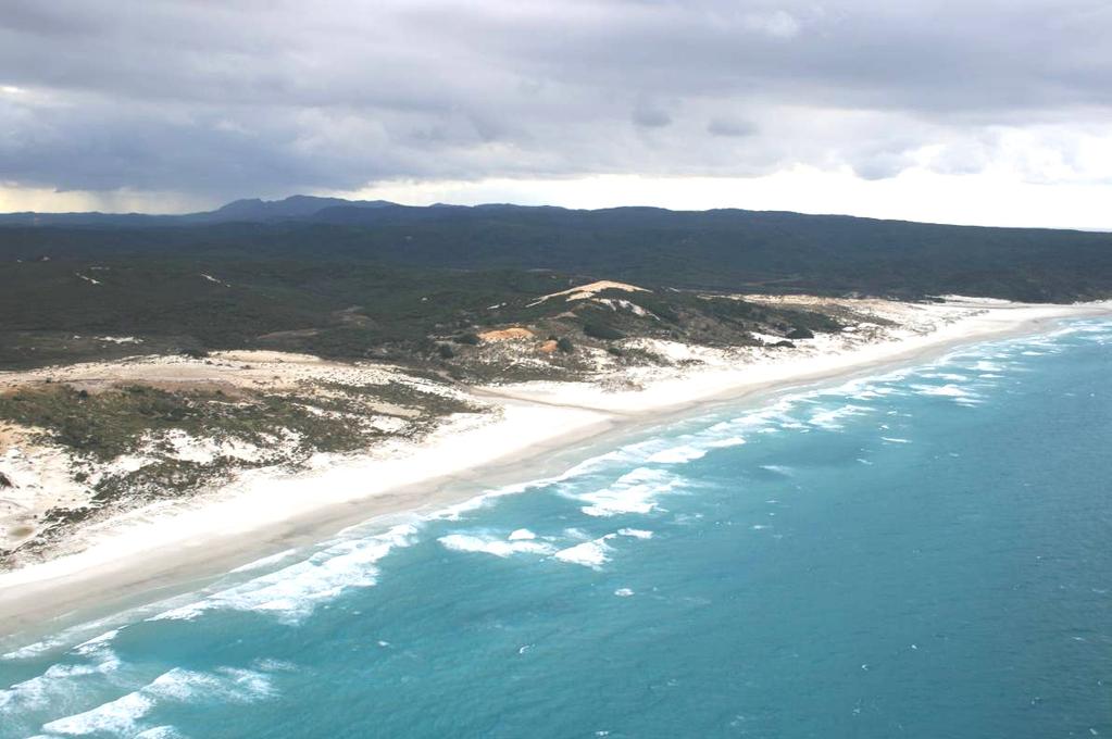
5 Photographs of unit 5

6 6

7 7
Northland Regional Landscape Assessment Worksheet
 Northland Regional Landscape Assessment Worksheet Unit name TE POUAHI HEADLAND DESCRIPTION AND CHARACTERISATION Component Land Types (refer to list overleaf) Dune complex Coastal cliffs / escarpment Reefs
Northland Regional Landscape Assessment Worksheet
 Northland Regional Landscape Assessment Worksheet DESCRIPTION AND CHARACTERISATION Component Land Types (refer to list overleaf) Coastal cliffs / escarpment Bays and headlands Dune complex Beach Reefs
Northland Regional Landscape Assessment Worksheet
 Northland Regional Landscape Assessment Worksheet DESCRIPTION AND CHARACTERISATION Component Land Types (refer to list overleaf) Volcanic cones Geology (including geopreservation sites) Soil Types Unit
Northland Regional Landscape Assessment Worksheet
 Northland Regional Landscape Assessment Worksheet DESCRIPTION AND CHARACTERISATION Component Land Types Northern and eastern dissected hills; moderate to high relief land type Unit name NORTH EAST BUSH
Northland Regional Landscape Assessment Worksheet
 Northland Regional Landscape Assessment Worksheet Unit name KAURI MOUNTAIN BUSH DESCRIPTION AND CHARACTERISATION Component Land Types Volcanic cones land type Northern and eastern dissected hills; moderate
Northland Regional Landscape Assessment Worksheet
 Northland Regional Landscape Assessment Worksheet Unit name BALD ROCK DESCRIPTION AND CHARACTERISATION Component Land Types (refer to list overleaf) Volcanic cone (remains). Comment The site is an eye-catching
Northland Regional Landscape Assessment Worksheet
 Northland Regional Landscape Assessment Worksheet Unit name MARERETU RANGE DESCRIPTION AND CHARACTERISATION Component Land Types Northern and eastern dissected ranges; high relief land type Geology (including
Section 6A 6A Purpose of the Natural Features and Landscapes Provisions
 Section 6A 6A Purpose of the Natural Features and Landscapes Provisions This Chapter addresses the protection and management of natural features and landscapes within the City. The City has a number of
LANDSCAPE UNIT 10 Te Kawau, Turipeka & Otautu Point
 Location Map LANDSCAPE VALUES Landscape Unit No. 10 Description: Te Kawau, Turipeka, & Otautu Point KEY LANDSCAPE FACTORS / VARIABLES LANDSCAPE UNIT 10 Te Kawau, Turipeka & Otautu Point LEGEND Outstanding
Northland Regional Landscape Assessment Worksheet
 Northland Regional Landscape Assessment Worksheet DESCRIPTION AND CHARACTERISATION Component Land Types Volcanic cones land type Geology (including geopreservation sites) Unit name PARAKIORE VOLCANIC CONE
LANDSCAPE GUIDELINES. Countryside & Coastal Countryside Environments. Landscape, Natural Character & Amenity Values Guide
 Landscape, Natural Character & Amenity Values Guide Copyright WDC 2009 Version A2 18May09 Environmental Services Group Publication Countryside & Coastal Countryside Environments START HERE Quality Land
B4. Te tiaki taonga tuku iho - Natural heritage
 B4. Te tiaki taonga tuku iho - Natural heritage Tuia I runga, tuia i raro, tuia ki te waonui a Tiriwa Bind the life forces of heaven and earth to the great realm of Tiriwa B4.1. Issues Auckland s distinctive
Northland Regional Landscape Assessment Worksheet
 Northland Regional Landscape Assessment Worksheet Unit name MAUNGATAPERE DESCRIPTION AND CHARACTERISATION Component Land Types Volcanic cones land type Comment One of a sequence of volcanic cones, which
3. Highway Landscaping Assessment
 Guidelines for Highway Landscaping 3-1 3. Highway Landscaping Assessment 3.1 Introduction This section outlines the steps necessary to assess the highway landscaping component of a state highway construction
Part 3 : : Outstanding Natural Features and Landscapes
 Part 3 : : Outstanding Natural Features and Landscapes Review and Evaluation of Outstanding Natural Features and Landscapes tauranga city : : landscape study 157 Introduction Introduction Tauranga City
1 INTRODUCTION TO NATURAL ENVIRONMENT
 Kāpiti Coast District Plan Review Section 32 Analysis Summary Report 1 INTRODUCTION TO NATURAL ENVIRONMENT Diverse landscapes, plants and animals make up the natural environment of the District. Much has
Appendix One. Landscape. Areas of Outstanding Landscape Value: Criteria for Selection. Landscape Character
 Areas of Outstanding Value: Criteria for Selection The dimensions of landscape are landscape character and landscape quality. The analysis of landscape character and quality draws heavily on the visual
Assessment of Landscape, Visual and Natural Character Effects
 Assessment of Landscape, Visual and Natural Character Effects Consent Footprint Amendments Mangamaunu Half Moon Bay Okiwi Bay South Report prepared for: New Zealand Transport Agency and KiwiRail Holdings
Raewyn Peart. Policy Director Environmental Defence Society
 1 Raewyn Peart Policy Director Environmental Defence Society www.eds.org.nz Coastal Environment Where the sea impacts on the land and the land impacts on the sea 2 www.eds.org.nz Section 6 RMA matters
ENVIRONMENT BAY OF PLENTY. Outstanding Natural Features and Landscapes Review in Inland Bay of Plenty
 ENVIRONENT BAY OF PLENTY Outstanding Natural Features and Landscapes Review in Inland Bay of Plenty February 2009 Outstanding Natural Features and Landscapes Review in Inland Bay of Plenty CONTENTS 1.0
Evidence-based Assessment of Natural Character
 Evidence-based Assessment of Natural Character RMLA Waikato Branch 07 Sept 2016 Michael Steven Landscape Architect/Landscape Planner Pohara, Golden Bay 1 The key issue. The adequacy of landscape & natural
Chapter 3: Natural Environment. Proposed Waikato District Plan Stage 1. (Notified version)
") Chapter 3: Natural Environment Proposed Waikato District Plan Stage 1 Page 2 of 7 Contents Chapter 3: Natural Environment... 3 3.1 Indigenous Vegetation and Habitats... 3 3.1.1 Objective Biodiversity and
Chapter 3: Natural Environment Proposed Waikato District Plan Stage 1 Page 2 of 7 Contents Chapter 3: Natural Environment... 3 3.1 Indigenous Vegetation and Habitats... 3 3.1.1 Objective Biodiversity and
Apply scoring methodology
 1 Assessment of Alternatives The purpose of this assessment is to evaluate runway options against a range of environmental criteria. The first step is to formulate evaluation criteria necessary to understand
Landscape Guidelines. Landscape type: Valley Pasture Character areas: Frome Valley Pasture Stour Valley Pasture. Landscape change
 Landscape type: Valley Pasture Character areas: Frome Valley Pasture Stour Valley Pasture The valley pasture landscape type is found along the lower reaches of the Stour and Frome, formed from alluvial
COROMANDEL PENINSULA LANDSCAPE ASSESSMENT. PREPARED FOR Thames Coromandel District Council DATE September STATUS Draft
 PREPARED FOR Thames Coromandel District Council DATE September 2011. STATUS Draft STATUS DRAFT. SCALE as shown @ A3. DATE September 2011. PAGE 2 INTRODUCTION OUTSTANDING & AMENITY LANDSCAPES Coromandel
CA.1 Coastal Area. Index. CA.1.1 Description and Expectations
 Index.1.2.3.4 CA.2 CA.2.1 CA.2.2 CA.2.3 CA.3 CA.3.1 CA.3.2 CA.3.1 CA.4 CA.4.1 CA.4.2 CA.4.3 CA.4.4 CA.5 CA.5.1 CA.5.2 Description and Expectations Objectives Policies Guidance Note Landuse Eligibility
Verde Valley Landscape Character Type
 Existing Condition Landscape Character The existing landscape character describes the existing set of valued aesthetic attributes for the current landscape. The landscape character descriptions include
Appendix 17A Scenic Quality Rating Forms
 1 2 Appendix 17A Scenic Quality Rating Forms UNITED STATES DEPARTMENT OF THE INTERIOR BUREAU OF LAND MANAGEMENT SCENIC QUALITY RATING SUMMARY Date: March 7, 2018 Landscape Character Unit: N/A Key Observation
D10. Outstanding Natural Features Overlay and Outstanding Natural Landscapes Overlay
 D10. Outstanding Natural Features Overlay and Outstanding Natural Landscapes Overlay D10.1. Background These provisions give effect to Policy 15(a) of the New Zealand Coastal Policy Statement 2010, and
H7 Open Space zones. (a) provide for the needs of the wider community as well as the needs of the community in which they are located;
 provide for the needs of the wider community as well as the needs of the community in which they are located;") H7. Open Space zones H7.1. Background The majority of land zoned as open space is vested in the Council or is owned by the Crown. However some areas zoned open space are privately owned. While the open
H7. Open Space zones H7.1. Background The majority of land zoned as open space is vested in the Council or is owned by the Crown. However some areas zoned open space are privately owned. While the open
D10. Outstanding Natural Features Overlay and Outstanding Natural Landscapes Overlay
 D10. Outstanding Natural Features Overlay and Outstanding Natural Landscapes Overlay D10.1. Background These provisions give effect to Policy 15(a) of the New Zealand Coastal Policy Statement 2010, and
7. Landscape. Introduction
 Introduction Our landscapes provide us with a Marlborough identity and are an integral part of the Marlborough environment. Landscapes are distinct spatial areas influenced by location-specific processes
3. STATEMENTS OF DESIRED CHARACTER FOR PLANNING AREAS AND PRECINCTS
 3.30 Planning Area No. 30 Mary River Valley 3.30.1 Location and Role This Planning Area encompasses rural lands in the western part of the Shire. These lands are located within the catchment area of the
Landscape considerations in Forests & Woodlands. Jill Bullen, Senior Landscape Specialist
 Landscape considerations in Forests & Woodlands Jill Bullen, Senior Landscape Specialist UK Forestry Standard (UKFS) Sustainable forest management Landscape sub-section (S6.4, page 96) Standards and requirements
PART 5 - NATURAL AND PHYSICAL ENVIRONMENT
 CONTENTS...PAGE 5.1 INTRODUCTION...3 5.2 NATURAL RESOURCES...4 5.3 PHYSICAL RESOURCES...4 5.4 COASTAL ENVIRONMENT...4 5.5 HERITAGE FEATURES...4 5.6 HAZARDS...4 5.7 SUMMARY...4 ISTHMUS SECTION - OPERATIVE
Section 3b: Objectives and Policies Rural Environment Updated 19 November 2010
 Page 1 of Section 3b 3b RURAL ENVIRONMENT 3b.1 Introduction The Rural Environment comprises all the land outside of the Residential, Town Centre and Industrial Environments. Most land within the District
Digital Terrestrial Television Infrastructure Rollout. Environmental Impact Assessment - Corridor -
 Digital Terrestrial Television Infrastructure Rollout Environmental Impact Assessment - Corridor - 1 1 ENVIRONMENTAL IMPACT ASSESSMENT (EIA): CORRIDOR 1.1 INTRODUCTION Corridor is a small farming community
Part 7 Heritage. Diagrams and tables
 Part 7 Heritage Contents Page 7.1 Introduction... 3 7.2 Resource management issues... 3 7.3 Objective... 5 7.4 Resource management strategy... 5 7.5 Roles and responsibilities... 6 7.6 Notification requirements
Waipohutukawa Bay, Bay of Islands Visual, Natural Character and Landscape Effects
 Photograph 20: View of Waipohutukawa Bay from the water (Thornton property to the left of view, Collie property to the right of view) Photograph 21: Closer range view from the water (Thornton property
Digital Terrestrial Television Infrastructure Rollout
 Digital Terrestrial Television Infrastructure Rollout Environmental Impact Assessment - Ruacana - ENVIRONMENTAL IMPACT ASSESSMENT: RUACANA 1 INTRODUCTION Ruacana is a town in the Omusati Region, in northern
Rural Subdivision and Development
 Rural Subdivision and Development Design Guidelines MAY 2012 1 Rural Subdivision and Development Design Guidelines 2The open spaciousness of the rural environment in the foreground of Mount Taranaki from
I541. Te Arai North Precinct
 I541. Te Arai North Precinct I541.1. Precinct Description The Te Arai North Precinct contains approximately 616ha of coastal land north of Te Arai Point, generally known as Mangawhai North Forest. The
CENTENNIAL PARKLANDS CONSERVATION MANAGEMENT PLAN: VOLUME
 EXECUTIVE SUMMARY Location Centennial Parklands is located at the heart of Sydney s Eastern Suburbs, just a couple of kilometres from the city centre. It forms a green swathe of parkland, ponds and sporting
Appendices. Contents. Appendices - Sep 1997 CP-1 AP-1
 Appendices Contents 1. Goals for Protected Areas in British Columbia... AP-3 2. Guiding Principles for Protected Areas... AP-4 3. Resource and Recreation Use Guidelines for Protected Areas... AP-5 4. Aboriginal
Section 12C Subdivision in the Rural Residential Zone
 Section 12C 12C Subdivision in the Rural Residential Zone The Rural Residential Zone provides part of the range of residential opportunities within the City. Land zoned rural residential is considered
Swan Coastal Plain - Reading
 Swan Coastal Plain Almost all the soils of the Swan Coastal Plain are formed by material deposited by rivers and wind. The Yilgarn Block, east and south of the scarp bordering the Swan Coastal Plain, rose
City of Rockingham. Local Management Practices, Costs and Strategic Coastal Planning
 City of Rockingham Local Management Practices, Costs and Strategic Coastal Planning Decision Making Process Considerations Climate Change Response Action Plan Ongoing observations/major Storm events Ongoing
Cotswolds AONB Landscape Strategy and Guidelines. June 2016
 Cotswolds AONB Landscape Strategy and Guidelines June 2016 Cotswolds AONB Landscape Strategy and Guidelines Introduction The evolution of the landscape of the Cotswolds AONB is a result of the interaction
Tables of Criteria and Matrices for Landscape Assessment (LSCA & LVIA)
") Carly Tinkler CMLI Environmental, Landscape and Colour Consultancy 46 Jamaica Road, Malvern, Worcestershire WR14 1TU Tel +44 (0)7711 538854 carlytinkler@hotmail.co.uk Tables of Criteria and Matrices for
Carly Tinkler CMLI Environmental, Landscape and Colour Consultancy 46 Jamaica Road, Malvern, Worcestershire WR14 1TU Tel +44 (0)7711 538854 carlytinkler@hotmail.co.uk Tables of Criteria and Matrices for
The European Landscape Convention And National Landscape Strategy. Tony Williams Irish Landscape Institute
 The European Landscape Convention And National Landscape Strategy As a reflection of European identity and diversity, the landscape is our living natural and cultural heritage, be it ordinary or outstanding,
Colin D Meurk, Simon Swaffield, Robert Watts, Shaun Awatere, Robyn Simcock, Jude Wilson. Landcare Research, Lincoln University, GreenVisionNZ
 Colin D Meurk, Simon Swaffield, Robert Watts, Shaun Awatere, Robyn Simcock, Jude Wilson Landcare Research, Lincoln University, GreenVisionNZ NZREAAA Roadshow 14 th -20 th August, 2013 Our thanks to NZTA
4.3 Dudley Area Plan. Introduction. History and Existing Character. Desired Future Character for Dudley
 4.3 Dudley Area Plan Introduction The suburb of Dudley has developed as a result of various circumstances including its topography, history and mineral resources. Dudley development has been identified
3.0 PART THREE: STRATEGIES FOR RESERVES
 3.0 PART THREE: STRATEGIES FOR RESERVES 3.1 RESERVE ACT OBJECTIVES The purposes of the Reserves Act 1977 are: providing for the preservation and management of areas for the benefit and enjoyment of the
Mollers Lane, Leopold, Victoria Significant Landscape Overlay Re-assessment
 XURBAN Mollers Lane, Leopold, Victoria Significant Landscape Overlay Re-assessment For: TGM Group November 2016 Final Mollers Lane, Leopold, Victoria Significant Landscape Overlay Re-assessment Client
Landscape Conservation Design April, 2014
 Designing Sustainable Landscapes in the Northeast A project of the North Atlantic Landscape Conservation Cooperative & Northeast Climate Science Center Landscape Conservation Design April, 2014 Conceptual
RULES FOR URBAN TREE GROUPS AND REMOVAL OF INDIGENOUS VEGETATION REMOVAL
 27A RULES FOR URBAN TREE GROUPS AND REMOVAL OF INDIGENOUS VEGETATION REMOVAL Activities Table Policies 4.4.10, 12.4.7, 12.4.10, 12.4.11, 12.4.12, 12.4.13, 12.4.14, 12.4.15, and 12.4.16 27A.1 Activities
LANDSCAPE CHARACTER ASSESSMENT
 THE COUNTY DURHAM LANDSCAPE CHARACTER ASSESSMENT FOREWORD The landscape of County Durham is one of great contrast and diversity. From the North Pennines in the west to the Durham Coast in the east it contains
CB1 Moderately undulating landscape with slight gilgai (few inches) formation: broad ridge tops and upper slopes of moderately shallow grey cracking
 formation: broad ridge tops and upper slopes of moderately shallow grey cracking") CB1 Moderately undulating landscape with slight gilgai (few inches) formation: broad ridge tops and upper slopes of moderately shallow grey cracking clays (Ug5.22 and Ug5.23). Associated are: (i) some
CB1 Moderately undulating landscape with slight gilgai (few inches) formation: broad ridge tops and upper slopes of moderately shallow grey cracking clays (Ug5.22 and Ug5.23). Associated are: (i) some
E15. Vegetation management and biodiversity
 E15. management and biodiversity E15.1. Background contributes to a range of ecosystem services such as erosion and sediment control, reducing stormwater flows, protecting or enhancing water quality, amenity
July 22, 2013 REQUEST FOR PROPOSALS TO PROVIDE ENGINEERING DESIGN SERVICES FOR A PROJECT ALONG THE WESTERN SHORE OF MOBILE BAY
 Mobile Bay National Estuary Program 4172 Commanders Drive Mobile, AL 36615 Phone: 251-431-6409 Fax: 251-431-6450 Contact: Tom Herder, Watershed Protection Coordinator Email: therder@mobilebaynep.com July
Reading the Driftless Landscape
 Reading the Driftless Landscape Author, Cindy Ramseyer Editors and Contributors: Katie Abbott, Chuck Bauer, Darcy Kind, Heidi Nelson, Carroll Schaal A Publication of the Blue Mounds Area Project with generous
Ōpōtiki Landscape Review Outstanding Natural Landscape Evaluation and Mapping Prepared for Ōpōtiki District Council 8 th July 2016
 Ōpōtiki Landscape Review Outstanding Natural Landscape Evaluation and Mapping Prepared for Ōpōtiki District Council 8 th July 2016 3 Table of Contents Contents 1.0 Introduction... 4 1.1 Background...
Proposed Southland District Plan 2012 Appeal Version October 2016
 S e c t i o n 3. 5 - F i o r d l a n d / R a k i u r a Z o n e The Fiordland/Rakiura Zone encompasses the Fiordland and Rakiura National Parks and part of Mt Aspiring National Park. It also includes areas
Lower Sensitivity. VS Classification Level 2: Exposed Upland/Plateau
 S04 Moel Hebog Reproduced from the Ordnance Survey map with the permission of Ordnance Survey on behalf of the Controller of Her Majesty s Stationery Office, Crown copyright Licence No. 100023387 Location
3-2 Environmental Systems
 3-2 Environmental Systems 3.0 ENVIRONMENTAL SYSTEMS CONTENTS 3.1 GREENWAY SYSTEM 3.1.1 General Policies 3.1.2 Natural Heritage Network 3.1.3 Natural Heritage Network Enhancement Lands 3.1.4 Rouge Watershed
STEWARDSHIP OF LONG ISLAND SOUND S ECOLOGICAL AND RECREATIONAL RESOURCES
 STEWARDSHIP OF LONG ISLAND SOUND S ECOLOGICAL AND RECREATIONAL RESOURCES Robin Kriesberg, Save the Sound, Inc. Thomas Halavik, US Fish and Wildlife Service Coastal Program An Initiative to Identify, Protect
Coast Protection, Development and Coastal Biodiversity. Brian Caton Member CEMAC, AMLR NRM Former Chair & Member, Coast Protection Board
 Coast Protection, Development and Coastal Biodiversity Brian Caton Member CEMAC, AMLR NRM Former Chair & Member, Coast Protection Board Saltmarsh: an extensive problem for Biodiversity and Planning Law
SH1 - Causeway, Auckland, 2014 (Source: NZ Transport Agency)
") SH1 - Causeway, Auckland, 2014 (Source: NZ Transport Agency) Coastal effects assessment guide Environmental and social responsibility policy State highway environmental plan Transport Agency statement
SH1 - Causeway, Auckland, 2014 (Source: NZ Transport Agency) Coastal effects assessment guide Environmental and social responsibility policy State highway environmental plan Transport Agency statement
LANDMAP Methodology Overview
 LANDMAP Methodology Overview June 2017 Jill Bullen, Senior Landscape Specialist jill.bullen@cyfoethnaturiolcymru.gov.uk 0300 065 4706 (Please note this is an information document and not a training presentation)
4.2 Ecological Principles
 4.2 Ecological Principles Introduction The overall character of the campus is one of open woodland in which locally and regionally indigenous tree species predominate. The colours, textures and quality
Exceptional ecological landscapes support wildlife across New Hampshire
 Natural Com Exceptional ecological landscapes support wildlife across New Hampshire T he natural landscape of New Hampshire offers a fascinating study of great contrasts and rich biological wonders. To
UNIT 3. LANDSCAPES CHANGE. PRIMARY 3/ Social Science Pedro Antonio López Hernández
 UNIT 3. LANDSCAPES CHANGE PRIMARY 3/ Social Science Pedro Antonio López Hernández LANDSCAPES They are all the elements you can see in a specific area of land. There are two types of landscapes 1. Natural
Digital Terrestrial Television Infrastructure Rollout. Environmental Impact Assessment - Kongola -
 Digital Terrestrial Television Infrastructure Rollout Environmental Impact Assessment - Kongola - 1 1 ENVIRONMENTAL IMPACT ASSESSMENT: KONGOLA 1.1 RATIONALE FOR THE SITE Kongola is situated in the Caprivi
BREEDON NORTHERN LIMITED
 Non Technical Summary CONTENTS 1 INTRODUCTION... 1 2 SITE DESCRIPTION... 1 3 DESCRIPTION OF THE DEVELOPMENT... 6 4 NEED FOR THE DEVELOPMENT... 8 5 KEY ISSUES CONSIDERED IN THE ENVIRONMENTAL IMPACT ASSESSMENT...
BACKGROUND INFORMATION DOCUMENT
 BACKGROUND INFORMATION DOCUMENT PROPOSED UPGRADING OF THE N2 NATIONAL ROAD FROM KRAAIBOSCH TO DIE VLEIE BASIC ENVIRONMENTAL IMPACT ASSESSMENT The South African National Roads Agency Society Limited (SANRAL)
Baylands Segment J. Bay between the Golden Gate and Segment J. Coyote Point. of For managed ponds. included habitat enhancement.
 Baylands Segment J Crissy Field Alameda Naval Air Station Heron's Head Park COLMA CREEK SFO Millbrae San Mateo BAYLANDS 2009 SAN FRANCISCO AREA san francisco area Western side of central San Francisco
coastal plain coastal plain
 NORFOLK O R F O L K COAST C O A SAONB T A O NIntegrated B I n t elandscape g r a t e d L Guidance a n d s c a p e G u i d a n c e 1 Integrated landscape character MAP 23a - Coastal Plain Key Plan This
Views About Management
 Views About Management A statement of English Nature s views about the management of Site of Special Scientific Interest (SSSI). This statement represents English Nature s views about the management of
National Park Service U.S. Department of the Interior. Climate Change Response and Cultural Landscape Preservation
 Climate Change Response and Cultural Landscape Preservation National Park Service Climate Change Response Strategy (Sept. 2010) Preserving the Nation s Heritage The preservation and protection of cultural
Coastal hazard assessments in Victoria
 Coastal hazard assessments in Victoria Viktor Brenners viktor.brenners@delwp.vic.gov.au Future Coasts program 4 year program established in 2007. Outputs included: Coastal Digital Elevation Models Victorian
Statutory and Non-Statutory Designated Sites and Ecology
 Statutory and Non-Statutory Designated Sites and Ecology The National Planning Policy Framework considers the conservation and enhancement of the natural environment in chapter 11 paragraphs 109-119, where
Introducing Green Infrastructure for Coastal Resilience
 Introducing Green Infrastructure for Coastal Resilience National Oceanic and Atmospheric Administration (NOAA) Office for Coastal Management Gloucester, MA Office of Travel Courtesy, Tim Grafft What Is
Re: planning application no Galetech Energy Developments Ltd, Butter Mountain, Manor Kilbride, Co. Wicklow
 Planning Department, Wicklow County Council, County Buildings, Station Rd, Wicklow Town, Co. Wicklow 12 th December 2013 Re: planning application no. 138844 Galetech Energy Developments Ltd, Butter Mountain,
Kelowna Heritage Register Evaluation Criteria
 Kelowna Heritage Register valuation Criteria The Kelowna Heritage Register valuation Criteria is based on 4 main principles: A. Architectural History: style or type of building, structure or landscape;
Severn Estuary Shoreline Management Plan What does it mean for planning in North Somerset?
 Severn Estuary Shoreline Management Plan What does it mean for planning in North Somerset? Coastal planning The National Planning Policy Framework sets out the Government s planning policies for England.
APPENDIX 4. 5 ST AGNES LOCAL LANDSCAPE CHARACTER ASSESSMENT TABLE ST AGNES BEACON
 APPENDIX 4. 5 ST AGNES LOCAL LANDSCAPE CHARACTER ASSESSMENT TABLE ST AGNES BEACON CHARACTER AREA: ST AGNES BEACON DATE OF ASSESSMENT May 2016 Character Attribute Landscape reference guide ST AGNES BEACON
Lower Sensitivity. VS Classification Level 2: Exposed Upland/Plateau
 S05 Y Moelwynion Reproduced from the Ordnance Survey map with the permission of Ordnance Survey on behalf of the Controller of Her Majesty s Stationery Office, Crown copyright Licence No. 100023387 Location
6 HIGHLY VALUED NATURAL RESOURCES
 6 HIGHLY VALUED NATURAL RESOURCES Contents 6.1 Introduction 6.1.1 Highly Valued Natural Resources 6.1.2 Significant Natural Areas 6.1.3 Highly Valued Landscapes 6.1.4 Geologically Significant Sites 6.2
Coastal Environment of Otago
 Coastal Environment of Otago Natural Character and Outstanding Natural Features and Landscapes Assessment Waitaki District Section Report 26 June 2015 Prepared by MIKE MOORE BSc, Dip LA, MRRP, ANZILA LANDSCAPE
Site Option 3: Te Matai
 Site Option 3: Te Matai Location Napier Drain looking south east Description The Te Matai growth option is located between the existing residential boundary (Ruamahanga Crescent) Napier Road (State Highway
- - - Key Characteristics
 S23 Dyffryn Dysynni Reproduced from the Ordnance Survey map with the permission of Ordnance Survey on behalf of the Controller of Her Majesty s Stationery Office, Crown copyright Licence No. 100023387
2A District-wide Policies
 2A Introduction This Chapter contains policies which are relevant to subdivision, use and development activities occurring across all zones and areas of the District. The policies in this Chapter implement
PART 05 VISUAL SETTING
 PART 05 VISUAL SETTING 5.1 How to use the Visual Settings 5.2 Views from the Headland 5.3 Creek Foreshore Park Looking North 5.4 Bridge looking North 5.5 Bridge looking West 5.6 Bridge looking South 5.7
Digital Terrestrial Television Infrastructure Rollout. Site-specific Environmental Management Plan - Omega -
 Digital Terrestrial Television Infrastructure Rollout Site-specific Environmental Management Plan - Omega - 2 1 ENVIRONMENTAL IMPACT ASSESSMENT: OMEGA 1.1 RATIONALE FOR THE SITE Omega is situated in the
Building and Public Space Design Guidelines
 AMERICA'S CUP WYNYARD HOBSON Building and Public Space Design Guidelines INTRODUCTION 10 April 2018 The 36 th America s Cup in Auckland requires the construction of new wharf and breakwater structures.
I542. Te Arai South Precinct
 I542. Te Arai South Precinct I542.1. Precinct Description The Te Arai South Precinct contains approximately 750ha of coastal land south of Te Arai Point, known as Mangawhai South Forest. The land within
 108 40' 29'' W Soil Map Mesa County Area, Colorado 108 36' 55'' W 39 10' 11'' N 39 6' 31'' N 4331700 4332500 4333300 4334100 4334900 4335700 4336500 4337300 4338100 701100 701900 702700 703500 704300 705100
Draft Gaviota Coast Plan Chapter 7: Visual Resources
 Draft Gaviota Coast Plan Chapter 7: Visual Resources 11/28/2012 Long Range Planning Division Planning and Development Department County of Santa Barbara Page Intentionally Blank Cover Photo: Gaviota Morning
SCIENCE AND RESEARCH INTERNAL REPORT NO.75 DATABASES AND THEIR APPLICATION TO MANAGEMENT PLANNING. W. Mary McEwen
 SCIENCE AND RESEARCH INTERNAL REPORT NO.75 DATABASES AND THEIR APPLICATION TO MANAGEMENT PLANNING by W. Mary McEwen This is an internal Department of Conservation report and must be cited as Science and
Lower Sensitivity. VS Classification Level 2: Exposed Upland/Plateau
 S02 Y Carneddau Reproduced from the Ordnance Survey map with the permission of Ordnance Survey on behalf of the Controller of Her Majesty s Stationery Office, Crown copyright Licence No. 100023387 Location