SCOTTISH BORDERS COUNCIL PLANNING AND BUILDING STANDARDS COMMITTEE 10 DECEMBER 2018 APPLICATION FOR PLANNING PERMISSION
|
|
|
- May Gordon
- 5 years ago
- Views:
Transcription
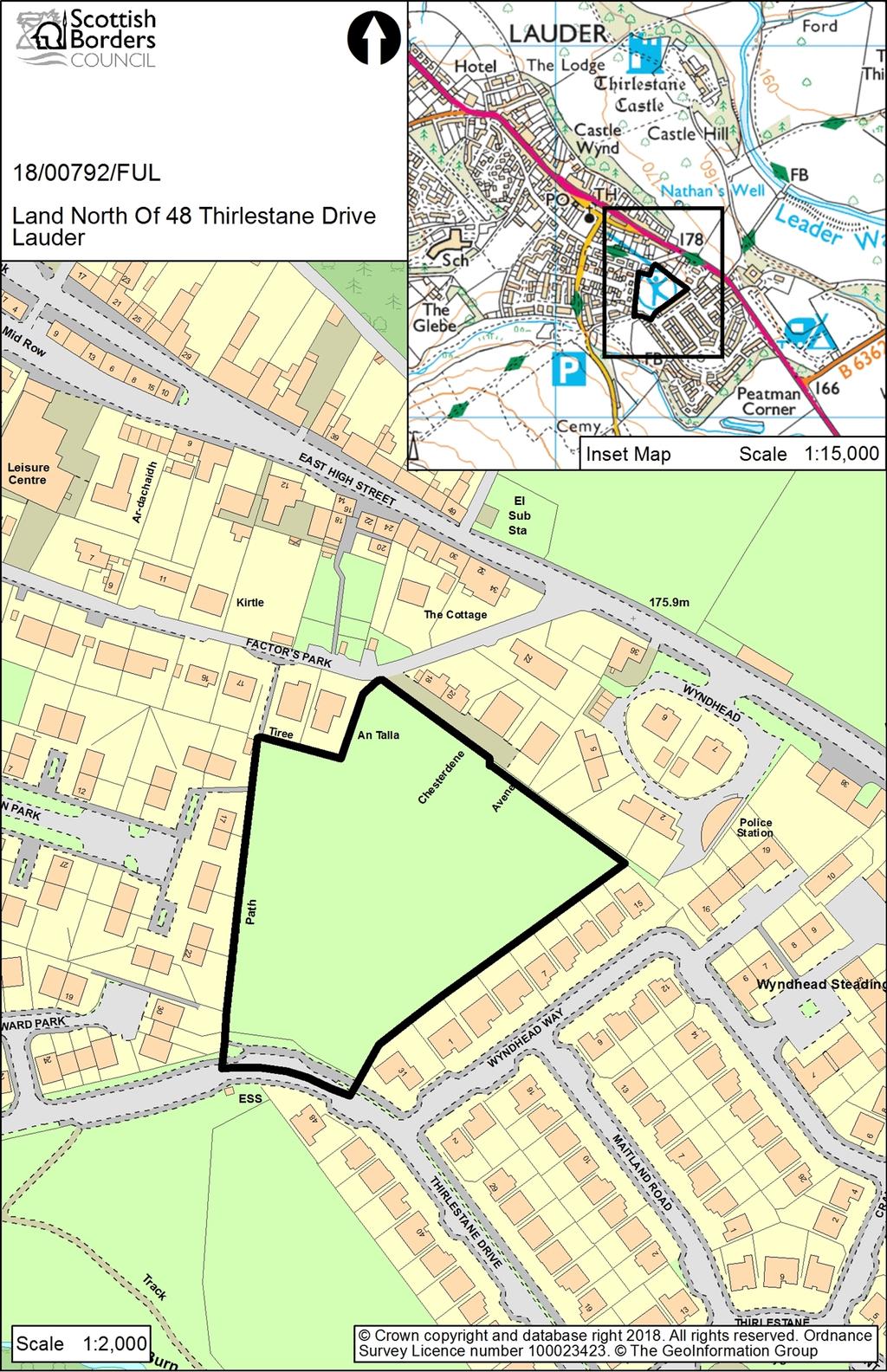
1 SCOTTISH BORDERS COUNCIL PLANNING AND BUILDING STANDARDS COMMITTEE 10 DECEMBER 2018 APPLICATION FOR PLANNING PERMISSION ITEM: OFFICER: WARD: PROPOSAL: SITE: APPLICANT: REFERENCE NUMBER: 18/00792/FUL Julie Hayward Leaderdale And Melrose Erection of 38 dwellinghouses, formation of access, landscaping and associated infrastructure Land North of 48 Thirlestane Drive Lauder Persimmon Homes East Scotland SITE DESCRIPTION The site is an overgrown paddock/field located between two areas of housing within the development boundary of Lauder. The site slopes gently down to the road to the south. There is an area of open space through which the Lauder Burn flows, to the south west. Factors Park is to the north, Wyndhead Way is to the south east, Millburn Park is to the west and Thirlestane Drive is to the south. A footpath runs along the western boundary between Thirlestane Drive and Factors Park that also links into Millburn Park. PROPOSED DEVELOPMENT The proposal is to erect 38 dwellinghouses within the site. Access would be from Thirlestane Drive. The application as submitted was for a cul-de-sac with a mix of detached, terraced and semi-detached houses all two storey and with 9 different house types. The layout and design of the houses raised a number of concerns and following negotiations, amended drawings have now been received. The number of houses remains 38 but the layout has been redesigned to provide a degree of connectivity with a looped access road. Ten amended house types are proposed, all two storeys, terraced, semi-detached and detached. Of the units, 29 would be for private sale and 9 would be affordable units. The houses would have slate grey tiled roofs, rendered walls and UPVC windows. Access would be from Thirlestane Drive to the south and parking would be a mix of in-curtilage, communal courtyard and off-street visitor parking. An area of open space is proposed for the southern section of the site adjacent to the road and in the centre of the site. Landscape buffers are proposed for the north east and south east boundaries and a detailed landscape plan has been submitted. There would be a footpath link from the site to the existing footpath on the western boundary through to Factor s Park. PLANNING HISTORY None
2 REPRESENTATION SUMMARY Four representations from separate households were received in response to the application as submitted, which can be viewed in full on Public Access. The key concerns raised are: The footpath accesses Factors Park on a bend between two private driveways, one serving 4 properties and also the parking area and drives opposite. There is also no footpath and the road is narrow and poorly lit at night. Exiting from the driveway serving 4 properties is already difficult because of restricted visibility without having to take into account pedestrian access from the left hand side. There is no need for an extra footpath from the proposed site as there is already an existing pedestrian link less than 20 metres further along Factors Park, away from the corner and drives/parking areas; Density; Inadequate access; Increased traffic impacting on road safety; Insufficient parking; Noise nuisance; Overprovision as the proposal would increase the number of houses, inhabitants and vehicles impacting on health and safety due to overcrowding, increased congestion, parking and noise pollution; The housing development and landscaping buffer could cause overshadowing/loss of daylight entering living room and bedrooms; Screening between existing properties and the boundary fence of the proposed development should be the maximum possible to lessen the visual and noise impact. The Greenbelt Company would be employed to maintain this screening but no details of land ownership have been provided should issues arise in future; Drainage from the site into Wyndhead Way is a problem due to the height differential between the field and houses and the retaining wall, despite Persimmon installing drains. The drainage issues must be fully investigated to resolve this issue. Amended drawings were received on 5 th October 2018 and neighbours were renotified. Seven representations were received raising the following issues: The proposal would increase the footfall of pedestrians by adding another path to the existing one and will greatly endanger lives using this route via Factors Park. The footpath to Factors Park leads straight on to a service lay-by in which six vehicles reverse on and traverse the lay-by on a daily basis. The path then exits straight on to the road which is narrow with no pavement for pedestrians and no street light on the road (within 45m one way and 37m the other way) making the road very dark at night with poor visibility. If the only footpath from the new development exited between plots 11 and 12, onto the existing footpath, this may encourage pedestrians to use Millburn Park, which has pavements and is not a through road; The shelter buffering which was assured by the Persimmon designer has been removed from the rear of An-talla and Tiree. This has been sacrificed for the new proposed path which is unacceptable; Density is too high resulting in problems associated with overcrowding and little scope to create an attractive site with more imaginative designs. The design is not sympathetic to the Conservation Area, which the site borders at the Factors Park end. The north eastern part of the site is elevated and
3 the impact of the development could be reduced with single storey or onean-a-half storey houses; Screening needs to be more substantial; Will future residents have to pay the annual fee to the Greenbelt Group for maintenance of planting and the play area and will the development carry similar burdens, such as not being allowed to carry out businesses from the houses and who will ensure these are adhered to? The land was to be held for community use after Allanbank was selected as the school site. Community groups and charity organisations attempted to make use of the site for community projects but each application or idea was turned down. This was a deliberate act by the Council to ensure that this hideous housing scheme goes ahead. This is intentional manipulation and the community has been denied a number of useful, beneficial projects that could enhance life in the community for financial gain and political motives; Services in the area cannot cope with the additional burden of 38 properties. Issues surrounding the development of Lauderdale Drive were overlooked and not properly disclosed as part of the community engagement relating to the potential impact on Lauder Burn as well as the impact on sanitation services; Problems on Thirlestane Drive with excessive speeds. The estate should be a 20 mph zone and a no HGV zone. Logging trucks, lorries and huge tractors come through the estate as well as commercial vehicles that are too large to properly see let alone safely stop. It is destructive to the road surfaces, the nominal "speed curbing" speed bumps do nothing to slow down traffic; it is an accident waiting to happen. Adding 38 more houses in an area not remotely large enough to cope with them will do nothing but make the situation worse with increase traffic of residents and guests; The Lauder surgery of Stow and Lauder Health Clinic is already at capacity and this development would be an additional burden on the service; The school is at capacity and this development will add to existing problems of class sizes, access to facilities and pupil-teacher ratios; There is sufficient social housing in Lauder, with associated problems. APPLICANTS SUPPORTING INFORMATION Design Statement Extended Phase 1 Habitat Survey May 2018 SUDS and Drainage Statement Transport Statement CONSULTATION RESPONSES: Scottish Borders Council Consultees Roads Planning Service: No objection in principle to housing on this site as the site is centrally located with good vehicular and access. Raises concerns with the proposed layout submitted. The layout is simply one long cul-de-sac with no internal connectivity. Furthermore, no effort has been made to create any form of street on the section of road running generally north to south, with the majority of properties turned away from this section of road. The current layout therefore does not accord with the principle of Designing Streets and the Council s Placemaking and Design guidance. Fully I am fully supportive of the suggestions and sketch layout for a loop road as suggested by the Council s Landscape Architect.
4 In its current form, RPS objects to the proposed development. Re-consultation: The submitted layout is a significant improvement on that previously submitted. RPS is disappointed to see the loss of the direct pedestrian link through to Factors Park, however the link provided does offer pedestrians the option of going via Millburn Park or Factors Park. No objections to this proposal provided the conditions set out in their reconsultation response are included in any consent issued. Director of Education and Lifelong Learning: The proposed development is within the catchment area for Lauder Primary School and Earlston High School. A contribution of 294,652 is sought for the Primary School and 135,356 is sought for the High School, making a total contribution of 430,008. Housing Section: Eildon Housing Association advises that they have met Persimmon Homes to explore working together to deliver 25% on-site affordable units. Whilst this site is not in current SHIP 2018/23, it is anticipated that it is likely to be identified as a prioritised affordable housing site in the new SHIP 2019/24 which is being developed with a view towards submission to Scottish Ministers in autumn Archaeology Officer: The site has archaeological potential. While there is nothing known from the site itself, the surrounding area is rich in archaeological remains and discovery. There have been a large number of artefacts, mostly prehistoric and medieval in date, found in the vicinity of Lauder over the last two centuries. Very few of the discoveries have accurate find spot locations, although several curiously came from the Crookburn near the Crook Well, though no names like these exist on maps. It could be that this was an 18 th /19 th century local name for the Lauder Burn which can be called crooked and the OS 1 st Edition shows an un-named well to the north of the burn and west of the development area. Regardless, there is a moderate potential on the edge of a medieval village for discovering objects, features or deposits pertaining to this phase of settlement. One possible feature that may exist in the northern part of the site is the remains of Lauder s town wall. The wall was said to have followed the course of Castle Wynd in the north-east and Factor s Park/Crofts Road in the south and west of the High Street. It is unknown if the wall was to the inside or outside of these roads, or indeed if the roads follow the former course. There is also a high possibility for encountering remnants of medieval rig and furrow cultivation. The Local Development Plan is in accordance with the analysis above in suggesting the need for archaeological investigation. It is recommended that an archaeological evaluation is required in advance of development as a first phase in what may be a multi-phase approach to mitigation depending on the results. It is noted from aerial photography that there are likely to be services in the site, and so evaluation should focus on 10% of the total red line boundary area outside the proscribed service corridors. A condition is recommended. Forward Planning: The site is allocated within the Scottish Borders Local Development Plan (LDP) 2016 for housing with an indicative capacity of 30 units. The Forward Planning Team has no comments to make in respect of the proposals but would highlight the site requirements stated within the LDP which are as follows:
5 Main vehicular access to be achieved via Thirlestane Drive with a potential vehicular and pedestrian minor access link onto Factors Park. The extension of the footway would need to be carried out with pedestrian linkages through to Millburn Park; Provision of amenity access within the development for pedestrians and cyclists will be required. Links to the Core Paths to be created and amenity maintained and enhanced; Landscape enhancement particularly along the western, north-eastern and south-eastern boundaries will be required and their long term maintenance to be addressed; Mitigation measures are required to prevent any impact on the River Tweed Special Areas of Conservation (Lauder Burn); Further assessment on nature conservation interest along with archaeology will also be required and mitigation put in place. Ecology Officer: The Extended Phase 1 Habitat Survey (Acorna Ecology, May 2018) is noted. The site is located immediately adjacent to several other housing estates, on improved grassland and bordered by several roads. There are no trees on site; habitat other than improved grassland includes ephemeral weed species, tall ruderal species such as thistles, amenity grassland, and some shrubs and young Sitka spruce trees, as well as public footpaths. The Leader Water flows approximately 330m to the north of the site and the Lauder Burn 130m to the south. Both are tributaries of the River Tweed, designated as a Special Area of Conservation (SAC). In relation to the SAC, care must be taken to follow SEPA s standing advice and good practice guidance for drainage (e.g. SUDS) in order to avoid pollution incidents. Given that the site is surrounded by other housing, as well as public roads (which separate the site from the SAC sites), and that it is not in an area prone to surface water flooding, combined with SEPA s contentment with the proposal as not requiring their further attention, The Ecology Officer is content that no further assessment is required in relation to potential impacts on the SAC. An assessment of the site for protected species was undertaken. No evidence that any protected species were present on site was observed. There were no other habitats on site with significance for biodiversity and no connectivity to adjacent habitats with biodiversity significance. Landscape Architect: The site is a paddock/field located between two areas of housing. It was previously zoned as a site for a new primary school but when an alternative site was developed it was zoned for housing. The site slopes gently down to the south (and the road). The site does appear as a logical addition to the pattern of development in the area however it is considered the current layout does not work that well in terms of both placemaking and designing streets principles; the terraced housing (both Housing Association and Private Developer) has a less than satisfactory relationship with the other detached/ semi-detached units and the open space at the entrance to the development is a wasted opportunity. A layout that develops a looped road layout should be achievable with only a small reduction in the number of units. The looped road layout has the benefit of all the housing facing inwards to a more attractive and
6 useable open space, not dissimilar to the open space in the original Wyndhead development to the south east. There are quite a number of small areas within the common areas that have been proposed entirely as grass. Low ground cover planting (or partially ground cover, with ground cover along the base of fences, walls or buildings) would be more effective and require less maintenance than small areas of grass. Groundcover shrubs with grass to the edge of roadways and paths would work better and would help to avoid awkward grass cutting at bases of hedges/walls/buildings, as well as screening and softening plot boundary fences and walls. The Officer has some concern about the hardiness of some of shrubs proposed and would be less concerned if a long term maintenance and plant replacement strategy is a condition of any approval. The commitment to maintain the common areas and open space shall initially be the responsibility of the developer and a factoring agreement with a residents association should be a condition of consent to ensure that the future maintenance does not rest with the Planning Authority, who does not have the resources to take on the maintenance of additional open space and areas of planting. Landscape Architect Re-consultation: No response. Access Officer: There are no claimed Rights of Way/Core Paths on this area of land; however a customary/permissive path runs along the western edge of the site. The following conditions should be applied in order to maintain and improve public access: The connection path to Factors Park should be made up and surfaced to an adoptable standard 2m wide along its entire length through the site; Both during and after construction, the customary/permissive path along the western boundary should remain open and unobstructed. Statutory Consultees Transport Scotland: No comments or objections. Lauderdale Community Council: Object: Number, density and layout of housing units: The Developer's proposal has too many houses. The Local Development Plan put the site capacity at 30; a 27% increase on this is clearly unacceptable. The scheme as proposed looks too dense and cluttered. The alternative layout suggested by SBC's Landscape Architect has slightly fewer houses and a less cluttered appearance. If the development were to be consented it should have a layout based on this but with fewer units. Parking: While the Developer claims that guidelines on parking provision have been met, we believe that an unreasonably small number of spaces are available for visitors. In a rural area it is likely that most visitors will arrive in cars. Lack of spaces will result in visitors parking on approach roads with implications for safety and possible contention with other residents. This problem would be somewhat alleviated by a reduction in the number of houses. We have noticed that in some recent developments garages are too small to accommodate typical vehicles. As a result the garage is used for storage and vehicles parked elsewhere. The garages should be adequately sized so as not to reduce effective parking capacity.
7 Pedestrian safety: The proposed pedestrian access to the north would join Factor's Park where there is no footpath. This would not be safe. Pedestrian access should be to the west where there is an existing footpath. Drainage: We understand that there are continuing drainage issues from a previous development and are concerned that SEPA have made no assessment but merely provided a link to their general guidance. Plantings, hedges and paths: Firm and continuing arrangements should be put in place to ensure proper maintenance of these so that the responsibility does not end up with SBC, the Community Council or volunteers. Lauderdale Community Council Re-consultation: Lauderdale Community Council had two main points of objection to the original proposal, namely lack of safe pedestrian access and number of houses: The revised scheme provides better, although not ideal, pedestrian access and so we no longer object on that issue. Although the developer has modified the layout along the lines suggested by SBC's Landscape Architect, they have not reduced the number of houses even to the 36 units proposed by that consultee, let alone to the 30 suggested, admittedly as an indicative number, in the Local Development Plan; 30 houses on the 1.2ha site, a density of 25/ha, would be in the middle of the medium density range set out in SBC's Supplementary Guidance on Housing; 38, 32/ha would bring the site into the high density range. Recent developments nearby and elsewhere around the town would be in the low or medium density categories. A high density development would be inappropriate in this semi-rural setting on the outskirts of the town and out of keeping with existing housing. Lauderdale Community Council therefore still objects to the proposal with this number of houses, although we have no objection in principle to housing on the site. Scottish Water: No response. SEPA: No comments. DEVELOPMENT PLAN POLICIES: SES Plan Strategic Development Plan 2013 Policy 1B: The Spatial Strategy: Development Principles Policy 5: Housing Land Scottish Borders Local Development Plan 2016 PMD1: Sustainability PMD2: Quality Standards PMD3: Land Use Allocations HD1: Affordable Housing and Special Needs Housing HD3: Protection of Residential Amenity EP1: International Nature Conservation Sites and Protected Species
8 EP2: National Nature Conservation Sites and Protected Species EP3: Local Biodiversity EP8: Archaeology IS2: Developer Contributions IS3: Developer Contributions Related to the Borders Railway IS5: Protection of Access Routes IS6: Road Adoption Standards IS7: Parking Provisions and Standards IS9: Waste Water Treatment Standards and Sustainable Urban Drainage OTHER PLANNING CONSIDERATIONS: Supplementary Planning Guidance: Placemaking and Design 2010 Householder Development (Privacy and Sunlight) 2006 Biodiversity 2005 Affordable Housing 2015 Development Contributions 2011 (updated January 2018) KEY PLANNING ISSUES: Whether the layout of the site, the design of the houses and landscaping are acceptable; Whether the proposed development impacts on residential amenity; Whether adequate access and parking can be achieved. ASSESSMENT OF APPLICATION: Planning Policy The application site is allocated in the Local Development Plan for housing (ELA12B: Wyndhead II) with an indicative capacity of 30 units. Policy PMD3 states that development will be approved in principle for the land uses allocated on the Land use Proposals tables and maps. The proposed residential development on this site would therefore comply with basic principles of this policy. Layout and Design Policy PMD2 requires all development to be of high quality in accordance with sustainability principles, designed to fit in with Borders townscapes and to integrate with its landscape surroundings. The policy contains a number of standards that would apply to all development. The site is situated within an area characterised by both modern and older houses and the density varies depending on the age of the development. The indicative site capacity contained within the local development plan is 30 units and so the development of 38 houses (as proposed) is slightly higher than this figure. However, this is would not be a significant issue provided an acceptable scheme in terms of layout and design can be achieved. The layout as originally submitted was for a cul-de-sac which lacked internal connectivity and did not take on board the guidance contained within national policy
9 Designing Streets or the Council s Supplementary Planning Guidance on Placemaking and Design, which seek internal connectivity and the formation of attractive streets. In addition, the car parking was a dominant element of the proposal and the proposed houses did not front onto the road, contributing to a layout lacking in any street frontage. The amended layout is a significant improvement. The road now forms a loop within the site and the proposed houses now front onto the road creating more of a street. The area of open space at the front of the site remains, as this is required for the drainage basin, but an additional area of open space has been included in the centre of the site. There is a good mix of terraced, semi-detached and detached houses with varying building lines to lessen the uniformity. A house now faces the open space at the front of the site to improve views of the development from Thirlestane Drive. There are however, still large areas of communal car parking. It is accepted that this is a difficult site to develop due to its shape and location within existing housing developments and the revised scheme is considered to be acceptable. The original proposal was for two storey houses all of a similar design and materials. More variety in the house designs and materials and a range of one-and-a-half and two storey houses were requested. It is disappointing that the revised house types are all two storey with rendered walls and tiled roofs. The windows now have a vertical emphasis and a condition would control the external materials. On balance, it is considered that the house designs are now considered acceptable. The site requirements within the Local Development Plan require landscape enhancement along the western, north eastern and south eastern boundaries of the site and long term maintenance for the planting. There would be low single rail fencing between rear gardens and 1.8m high vertical timber fences to the rear boundaries of the gardens. Re-constituted stone walls (1.8m high) would be erected on prominent boundaries. A detailed planting scheme has been submitted together with a maintenance programme. This shows tree planting at the entrance and between car parking areas, which would help to reduce the dominant impact of the parking. The landscaping buffers along the north east and south east boundaries would include tree and shrub planting and hedgerows are proposed within the site. The Council s Landscape Architect has been consulted on the revised drawings, though no response has been received at the time of writing the report. A condition would secure the implementation of the scheme, once approved. The visual impact of the development locally is restricted to a short section of Thirlestane Drive, with wider views from outwith the settlement restricted by existing housing and trees. The proposed landscaping, once established, will help soften the impact of the development. It is considered that the proposal would not have a significant adverse impact on the visual amenities of the area. Impact on Residential Amenity Policy HD3 states that development that is judged to have an adverse impact on the amenity of residential areas will not be permitted.
10 The Council s Supplementary Planning Guidance: Guidance on Householder Developments contains guidance on privacy, overlooking and access to light that can be applied when considering planning applications for new developments to ensure that proposals do not adversely affect the residential amenities of occupants of existing and proposed dwellings. The site is situated within a residential area and is bounded on three sides by existing properties. Landscape buffers, as required by the Local Development Plan, are proposed along the north east and south east boundaries. These will provide a degree of screening, as does the existing fences and hedges to the rear of the existing houses. The layout complies with the guidance within the Supplementary Planning Guidance in terms of light and privacy. Ecology Policies EP1, EP2 and EP3 seek to protect international and national nature conservation sites, protected species and habitat from development proposals that will have unacceptable adverse impacts on designated sites and/or protected species. The Local Development Plan also requires mitigation measures to prevent any impact on the River Tweed Special Area of Conservation. Further assessment on nature interest is also required to ensure compliance with Policy. The Leader Water flows approximately 330m to the north of the site and the Lauder Burn 130m to the south. Both are tributaries of the River Tweed, designated as a Special Area of Conservation (SAC). An Extended Phase 1 Habitat Survey was submitted with the application. In relation to the SAC, care must be taken to follow SEPA s standing advice and good practice guidance for drainage (e.g. SUDS) in order to avoid pollution incidents. The Council s Ecology Officer advises that given that the site is surrounded by other housing, as well as public roads (which separate the site from the SAC sites), and that it is not in an area prone to surface water flooding, no further assessment is required in relation to potential impacts on the SAC. An assessment for protected species was undertaken however no evidence was found that any protected species were present on the site. The habitat survey did not identify any trees on site with bat roosting potential and noted that potential for nesting habitat for breeding birds is limited to adjacent residential gardens outside the application site boundary. There were no other habitats on-site with significance for biodiversity and no connectivity to adjacent habitats with biodiversity significance. It is considered therefore that the proposed development will not have an unacceptable adverse impact on designated sites or protected species and would meet the terms of Policies EP1, EP2 and EP3 of the local development plan. Archaeology Policy EP8 states that development proposals which will adversely affect local archaeological assets will only be permitted if it can be demonstrated that the benefits of the proposal outweigh the heritage value of the asset. All proposals that adversely affect such an asset must include an acceptable mitigation strategy. The Council s Archaeology Officer advises that the site has archaeological potential and has set out the reasoning behind this view in his response. An archaeological evaluation is required in advance of development as a first phase in what may be a
11 multi-phase approach to mitigation depending on the results. An appropriately worded planning condition would secure an appropriate evaluation and would ensure compliance with LDP policy. Access and Parking Policy IS7 requires that car parking should be provided in accordance with the Council s adopted standards. The Roads Planning Service advises that the revised layout is a significant improvement on that previously submitted. Although disappointed that the direct pedestrian link through to Factors Park has been omitted, the link as proposed does offer pedestrians the option of going via Millburn Park or Factors Park. Planning conditions are required in respect of road and footway surfacing and development phasing. Water and Drainage Policy IS9 states that the preferred method of dealing with waste water associated with new development would be a direct connection to the public sewerage system. A SUDS and Drainage Statement and a detailed drainage plan have been submitted with the application. Foul and surface water drainage would be to the public system with the surface water drainage being treated and attenuation to greenfield levels prior to connection into the surface water sewers. The report states that Scottish Water has confirmed that capacity exists within the foul sewer network to accept the proposed development but have not responded to their planning consultation. Connection to the public system would be in accordance with Policy IS9 of the LDP. Precise details of the proposed drainage arrangements will be agreed at Building Warrant stage. The planning application form indicates that the proposed development would connect to the public water supply network. As stated above, Scottish Water has not responded to the consultation and has not confirmed that a connection to the public supply is available. However, given that the site is allocated in the plan, it is assumed there is sufficient capacity to absorb this development. For the avoidance of doubt an appropriately worded condition (to require confirmation from Scottish Water that a connection to the public water supply is available to serve this site) is recommended. Development Contributions Development contributions, in compliance with policies IS2 and IS3, are required in respect of education (Lauder Primary School and Earlston High School), play provision and the Border railway. In addition, on-site affordable housing provision is required. Should Members be minded to support this application, these matters will be secured by a legal agreement. CONCLUSION Subject to a legal agreement and compliance with the schedule of conditions, the development is considered acceptable, having principally had regard to the relevant provisions of the Local Development Plan 2016 but also having had regard to overriding material considerations in this case which are as set out in this report.
12 RECOMMENDATION BY CHIEF PLANNING OFFICER: I recommend the application is approved subject to a legal agreement addressing contributions towards education, the Borders Railway and play areas and the provision of on-site affordable housing and the following conditions: 1. The development hereby permitted shall not be carried out otherwise than in complete accordance with the plans and specifications approved by the Planning Authority. Reason: To ensure that the development is carried out in accordance with the approved details. 2. No development shall take place within the development site as outlined in red on the approved plan until the developer has secured a Written Scheme of Investigation (WSI) detailing a programme of archaeological works. The WSI shall be formulated and implemented by a contracted archaeological organisation working to the standards of the Chartered Institute for Archaeologists (CIfA). The WSI shall be submitted by the developer no later than 1 month prior to the start of development works and approved by the Planning Authority before the commencement of any development. Thereafter the developer shall ensure that the programme of archaeological works is fully implemented and that all recording, recovery of archaeological resources within the development site, post-excavation assessment, reporting and dissemination of results are undertaken per the WSI. Reason: The site is within an area where development may damage or destroy archaeological remains, and it is therefore desirable to afford a reasonable opportunity to record the history of the site. 3. The development hereby approved shall only be carried out in strict accordance with a programme of phasing which has first been submitted to and approved in writing by the Planning Authority. The phasing programme to include the timing for the provision of the pedestrian link. Reason: To ensure that the development proceeds in an orderly manner. 4. Notwithstanding the description of the materials in the application, no development shall commence until a sample of all materials to be used on all exterior surfaces of the development hereby approved have been submitted to and approved in writing by the Planning Authority and thereafter no development shall take place except in strict accordance with the approved details. Reason: The materials require further consideration to ensure a satisfactory form of development, which contributes appropriately to its setting. 5. No development shall commence until a Construction Method Statement has been submitted to and approved in writing by the Planning Authority. As a minimum this should outline how the site will comply with the British Standard 5228:2009 Code of Practice for noise and vibration control on construction and open sites and should include the hours of construction, how noise complaints will be managed and methods for dust suppression on the site. The development then to be carried out in accordance with the approved Construction Method Statement. Reason: To safeguard residential amenities. 6. No development shall commence until precise details of the surfacing materials for the proposed roads, footpaths and parking spaces has been submitted to and
13 approved in writing by the Planning Authority. Thereafter no development shall take place except in strict accordance with the approved details. Reason: To ensure that the proposed development is laid out in a proper manner with adequate provision for traffic and in a manner that enhances the character and visual appearance of the development. 7. The proposed roads, footpaths and parking spaces/areas indicated on the drawings hereby approved shall be constructed to ensure that each dwellinghouse, before it is occupied, is served by a properly consolidated and surfaced carriageway, parking area and footpath/shared surface. Reason: To ensure that the proposed development is laid out in a proper manner with adequate provision for traffic and pedestrians. 8. The planting, seeding and turfing shown on landscape drawings d, d and d hereby approved, shall be carried out in the first planting and seeding seasons following the occupation of the dwellings or the completion of the development, whichever is the sooner, and shall be maintained thereafter and replaced as necessary for a period of two years from the date of completion of the planting, seeding and turfing. Reason: To ensure that the proposed landscaping is carried out as approved. 9. No water supply other than the public mains shall be used to supply the development without the written agreement of the Planning Authority. Reason: To ensure that the development is adequately serviced with a sufficient supply of wholesome water and there are no unacceptable impacts upon the amenity of any neighbouring properties. 10. No drainage system other than the public mains sewer shall be used to service the development without the written consent of the Planning Authority. Prior to occupation of the first dwellinghouse written evidence is to be submitted to and approved in writing by the Planning Authority that the development has been connected to the public water drainage network. Reason: To ensure that the development does not have a detrimental effect on public health. Informatives 1. In respect of condition 6, Roads Construction Consent is required for the roads and footways within the site and must be obtained prior to work commencing on site. It should be borne in mind that only contractors first approved by the Council may work within the public road boundary. The connection path to Factors Park should be made up and surfaced to an adoptable standard 2m wide along its entire length through the site. 2. Both during and after construction, the customary/permissive path along the western boundary should remain open and unobstructed. 3. In relation to the Special Area of Conservation, care should be taken to avoid contamination of the water environment by following SEPA good practice guidelines, e.g. GPP 5. SEPA standing advice relating to construction should be followed.
14 DRAWING NUMBERS TD Location Plan F18 REV C Fence Elevation W21 Wall Elevations F4 Boundary Fence Elevation E11432/1001 REV H Engineering Layout E11432/2001 REV F Drainage Layout TD REV A Site Sections TD REV A Site Sections TD REV N Site Layout Braemar Fortrose Leith Newmore Newton Portree Thornwood Threave Thurso Torridon d Landscaping d Landscaping d Landscaping Approved by Name Designation Signature Ian Aikman Chief Planning Officer The original version of this report has been signed by the Service Director (Regulatory Services) and the signed copy has been retained by the Council. Author(s) Name Julie Hayward Designation Team Leader Development Management
15
SCOTTISH BORDERS COUNCIL PLANNING AND BUILDING STANDARDS COMMITTEE 25 APRIL 2016 APPLICATION FOR PLANNING PERMISSION IN PRINCIPLE
 SCOTTISH BORDERS COUNCIL PLANNING AND BUILDING STANDARDS COMMITTEE 25 APRIL 2016 APPLICATION FOR PLANNING PERMISSION IN PRINCIPLE ITEM: OFFICER: WARD: PROPOSAL: SITE: APPLICANT: AGENT: REFERENCE NUMBER:
Derry City and Strabane District Council Planning Committee Report
 Derry City and Strabane District Council Planning Committee Report COMMITTEE DATE: 23 rd March 2016 APPLICATION No: APPLICATION TYPE: PROPOSAL: LOCATION: APPLICANT: LA11/2015/0395/F Residential Development
Site north of Hattersley Road West (east of Fields Farm Road), Hattersley
, Hattersley") Application Number 17/00982/REM Proposal Site Applicant Recommendation Reason for report Application for the approval of reserved matters (means of access, landscaping, layout, scale and appearance) relating
Application Number 17/00982/REM Proposal Site Applicant Recommendation Reason for report Application for the approval of reserved matters (means of access, landscaping, layout, scale and appearance) relating
Perth and Kinross Council Development Management Committee 8 June Pre-Application Report by Development Quality Manager
 Perth and Kinross Council Development Management Committee 8 June 2016 5(3)(i) 16/259 Pre-Application Report by Development Quality Manager Residential development at St Martins Road, Land 120 metres West
Statement of Community Involvement LAND OFF SOUTHDOWN ROAD HORNDEAN, HAMPSHIRE
 LAND OFF SOUTHDOWN ROAD HORNDEAN, HAMPSHIRE CONTENTS Page 1. Introduction 3 2. Pre-application Discussions 4 3. The Consultation Process 5 4. Consultation Feedback 7 5. Responses to Consultation Feedback
Perth and Kinross Council Development Management Committee 20 February 2013 Report of Handling by Development Quality Manager
 Perth and Kinross Council Development Management Committee 20 February 2013 Report of Handling by Development Quality Manager 4(4)(iii) 13/81 Erection of sports hall, associated changing facilities, offices
SOUTH CAMBRIDGESHIRE DISTRICT COUNCIL. Executive Director (Operational Services) Corporate Manager (Planning and New Communities)
 Corporate Manager (Planning and New Communities)") SOUTH CAMBRIDGESHIRE DISTRICT COUNCIL REPORT TO: Planning Committee 12 January 2011 AUTHOR/S: Executive Director (Operational Services) Corporate Manager (Planning and New Communities) Notes: S/1848/10
SOUTH CAMBRIDGESHIRE DISTRICT COUNCIL REPORT TO: Planning Committee 12 January 2011 AUTHOR/S: Executive Director (Operational Services) Corporate Manager (Planning and New Communities) Notes: S/1848/10
Derry City and Strabane District Council Planning Committee Report. Amended layout from approval A/2004/0462/F with reduction from 166 units
 Derry City and Strabane District Council Planning Committee Report COMMITTEE DATE: 1 st February 2017 APPLICATION No: APPLICATION TYPE: PROPOSAL: LOCATION: APPLICANT: AGENT: Full Planning application Amended
SOUTH CAMBRIDGESHIRE DISTRICT COUNCIL. Planning and New Communities Director
 SOUTH CAMBRIDGESHIRE DISTRICT COUNCIL REPORT TO: Planning Committee 5 June 2013 AUTHOR/S: Planning and New Communities Director S/0747/13/FL HISTON Construction of Car Park at Histon Baptist Church, Station
SCOTTISH BORDERS COUNCIL PLANNING AND BUILDING STANDARDS COMMITTEE 29 FEBRUARY 2016 APPLICATION FOR PLANNING PERMISSION
 SCOTTISH BORDERS COUNCIL PLANNING AND BUILDING STANDARDS COMMITTEE 29 FEBRUARY 2016 APPLICATION FOR PLANNING PERMISSION ITEM: REFERENCE NUMBER: 1. 15/01155/FUL 2. 15/01156/FUL OFFICER: Julie Hayward WARD:
Departure from the Development Plan. Town Council objection to a major application. DETERMINE
 Item No. 9 APPLICATION NUMBER CB/17/01642/OUT LOCATION Land rear of 43 to 91 Silver Birch Avenue South of Alder Green and Aspen Gardens, Aspen Gardens, Stotfold PROPOSAL Outline application for up to 95
PARISH / WARD: Peacehaven / Peacehaven East PROPOSAL:
 APPLICATION ITEM LW/16/0802 NUMBER: NUMBER: 7 APPLICANTS NAME(S): Mr J Robison & Ms S Teng PARISH / WARD: Peacehaven / Peacehaven East PROPOSAL: Planning Application for Conversion of existing garage to
STATEMENT OF OBJECTION TO THE PROPOSED DEVELOPMENT OF LAND AT CHURCH CLIFF DRIVE FILEY
 STATEMENT OF OBJECTION TO THE PROPOSED DEVELOPMENT OF LAND AT CHURCH CLIFF DRIVE FILEY You will be aware that Scarborough borough council have adopted a new local plan that includes land at Church Cliff
SOUTH CAMBRIDGESHIRE DISTRICT COUNCIL. Director of Development Services
 SOUTH CAMBRIDGESHIRE DISTRICT COUNCIL REPORT TO: Development and Conservation Control Committee 5 th April 2006 AUTHOR/S: Director of Development Services S/2290/05/F Haslingfield House (Revised Design)
REFERENCE: 15/01661/FUL Registered: 16 March 2015 Expiry date: 25 October 2016
 LOCATION: Land North Of Charcot Road, Colindale REFERENCE: 15/01661/FUL Registered: 16 March 2015 Expiry date: 25 October 2016 WARD: Colindale APPLICANT: PROPOSAL: Fairview New Homes (Colindale) Ltd Erection
Application Recommended for Approval Hapton with Park Ward
 Application Recommended for Approval Hapton with Park Ward APP/2017/0036 Outline Planning Application Outline application for the construction of a new 3 bedroom dwelling (with all matters reserved for
CA//16/00504/FUL. Canterbury City Council Military Road Canterbury Kent CT1 1YW. Crown copyright and database rights 2016 Ordnance Survey
 O Scale 1:1,250 Map Dated: 09/05/2016 CA//16/00504/FUL Crown copyright and database rights 2016 Ordnance Survey 100019614 Canterbury City Council Military Road Canterbury Kent CT1 1YW AGENDA ITEM NO 13
Welcome to our public exhibition
 About our development Welcome to our public exhibition This exhibition gives you the chance to view and comment on our proposals for a new residential development of 165 high-quality homes, along with
Derry City and Strabane District Council Planning Committee Report
 Derry City and Strabane District Council Planning Committee Report COMMITTEE DATE: 23rd March 2016 APPLICATION No: APPLICATION TYPE: PROPOSAL: LOCATION: APPLICANT: AGENT: LA11/2015/0263/O Outline Planning
Plumpton Neighbourhood Development Plan Revised Pre Submission Document - Regulation 14 Consultation
 REPRESENTATIONS... Plumpton Parish Council Plumpton Neighbourhood Development Plan Revised Pre Submission Document - Regulation 14 Consultation Representations submitted on behalf of: Cala Homes (South
Derry City and Strabane District Council Planning Committee Report
 Derry City and Strabane District Council Planning Committee Report COMMITTEE DATE: 20.12.2017 APPLICATION No: APPLICATION TYPE: PROPOSAL: LOCATION: APPLICANT: AGENT: A/2014/0495/F Full Construction of
SOUTH CAMBRIDGESHIRE DISTRICT COUNCIL. Planning and New Communities Director. Linton. Yes
 SOUTH CAMBRIDGESHIRE DISTRICT COUNCIL REPORT TO: Planning Committee 2 July 2014 AUTHOR/S: Planning and New Communities Director Application Number: Parish(es): Proposal: Site address: Applicant(s): Recommendation:
an Inspector appointed by the Secretary of State for Communities and Local Government
 Appeal Decision Site visit made on 14 July 2015 by I Radcliffe BSc(Hons) MCIEH DMS an Inspector appointed by the Secretary of State for Communities and Local Government Decision date: 18 August 2015 Appeal
SOUTH CAMBRIDGESHIRE DISTRICT COUNCIL. REPORT TO: Planning Committee 1 April 2015 Planning and New Communities Director
 SOUTH CAMBRIDGESHIRE DISTRICT COUNCIL REPORT TO: Planning Committee 1 April 2015 AUTHOR/S: Planning and New Communities Director Application Number: Parish(es): Proposal: Site address: Applicant(s): Recommendation:
Mr & Mrs Connolly per Pump House Designs Pump House Yard The Green SEDLESCOMBE, East Sussex. TN33 0QA
 AGENDA ITEM NO: 5 (c) Report to: PLANNING COMMITTEE Date: 03 June 2015 Report from: Head of Housing and Planning Services Application Address: Proposal: Application No: Recommendation: Ward: File No: Applicant:
PLANNING COMMITTEE REPORT
 PLANNING COMMITTEE REPORT TO: BY: Planning Committee South Head of Development DATE: 19 December 2017 DEVELOPMENT: SITE: WARD: APPLICATION: APPLICANT: Conversion of existing water storage reservoir to
1 The development hereby permitted shall be carried out in accordance with the following approved plans:
 Location 59 Greenway Close London N20 8ES Reference: 16/00011/HSE Received: 30th December 2015 Accepted: 7th January 2016 Ward: Totteridge Expiry 3rd March 2016 Applicant: Mr Ankit Shah Proposal: Part
PLANNING COMMITTEE DATE: 07/09/2015 REPORT OF THE SENIOR MANAGER PLANNING AND ENVIRONMENT SERVICE CAERNARFON. Number: 4
 Number: 4 Application Number: C15/0034/37/LL Date Registered: 21/05/2015 Application Type: Full - Planning Community: Llanaelhaearn Ward: Llanaelhaearn Proposal: Location: Summary of the Recommendation:
Cllr Jamieson called the application to committee on grounds of style of houses. DETERMINE RECOMMENDED Full Application - Granted
 Item No. 10 SCHEDULE B APPLICATION NUMBER CB/11/04549/FULL LOCATION The Bell, High Street, Westoning, Bedford, MK45 5JH PROPOSAL Alterations and extensions to existing building and erection of three dwellings.
26 September 2014 CONSULTATION EXPIRY : APPLICATION EXPIRY : 22 July 2014 SUMMARY RECOMMENDATION: PERMISSION
 Item No.: 5 The information, recommendations and advice contained in this report are correct as at the date of preparation, which is more than one week in advance of the Committee meeting. Because of the
Welcome to our public exhibition
 About Our Scheme Welcome to our public exhibition This exhibition gives you the chance to view and comment upon our emerging proposals for a new residential development of 68 new homes on the site of the
Mid Suffolk District Council Planning Control Department 131 High Street Needham Market IP6 8DL
 Mid Suffolk District Council Planning Control Department 131 High Street Needham Market IP6 8DL OUTLINE PLANNING PERMISSION Town and Country Planning Act 1990 THE TOWN AND COUNTRY PLANNING (DEVELOPMENT
Welcome. Site/11/04. Site/11/03. Proposed Site. 11,400 new homes needed in east Cambs
 Welcome Welcome to our consultation on our proposals for new homes on land north east of Soham Road, Fordham. Members of the project team are available to answer any questions you have and listen to feedback.
Persimmon Homes Thames Valley Date received: 2 nd April week date(major): 2 nd July 2014 Ward: Nascot
: 2 nd July 2014 Ward: Nascot") PART A Report of: DEVELOPMENT MANAGEMENT SECTION HEAD Date of Committee: 26 th June 2014 Site address: Rounton, 28, Nascot Wood Road Reference Number: 14/00497/REM Description of Development: Reserved
PART A Report of: DEVELOPMENT MANAGEMENT SECTION HEAD Date of Committee: 26 th June 2014 Site address: Rounton, 28, Nascot Wood Road Reference Number: 14/00497/REM Description of Development: Reserved
Report Author/Case Officer: Paul Keen Senior Planning Officer (Dev Control) Contact Details:
 Contact Details:") APP 03 Application Number: 17/02060/FUL Description A full planning application for the demolition of an existing bungalow (C3 use class) and associated out buildings and the erection of two, two storey
APP 03 Application Number: 17/02060/FUL Description A full planning application for the demolition of an existing bungalow (C3 use class) and associated out buildings and the erection of two, two storey
Report Author/Case Officer: Joanne Horner Contact Details:
 APP 04 Application Number: 16/00140/FUL Other Two storey side extension to existing dwelling and formation of hard standing to provide parking for number 54 (Resubmission of withdrawn application 15/02852/FUL)
Construction of 9 dwellings and associated infrastructure.
 Application Number 16/00653/FUL Proposal Site Applicant Recommendation Construction of 9 dwellings and associated infrastructure. Land at Grange Road South, Hyde McDermott Developments Ltd Approve REPORT
Case Officer: Sarah Kay File No: CHE/14/00515/REM Tel. No: (01246) Plot No: 2/6132 Ctte Date: 15 th September 2014 ITEM 1
 Plot No: 2/6132 Ctte Date: 15 th September 2014 ITEM 1") Case Officer: Sarah Kay File No: CHE/14/00515/REM Tel. No: (01246) 345786 Plot No: 2/6132 Ctte Date: 15 th September 2014 ITEM 1 APPROVAL OF RESERVED MATTERS FROM APPLICATION CHE/12/00234/OUT (1) LAYOUT,
Case Officer: Sarah Kay File No: CHE/14/00515/REM Tel. No: (01246) 345786 Plot No: 2/6132 Ctte Date: 15 th September 2014 ITEM 1 APPROVAL OF RESERVED MATTERS FROM APPLICATION CHE/12/00234/OUT (1) LAYOUT,
University Park, Worcester Non Technical Summary December 2011
 University Park, Worcester Non Technical Summary December 2011 Introduction UW Wrenbridge LLP, a Joint Venture Company of the University of Worcester and Wrenbridge Land Ltd (the Applicants ) intend to
Site off Hattersley Road West (bound by Hattersley Road West to the north west and Sandy Bank Avenue to the south and west), Hattersley
, Hattersley") Application Number 17/00984/REM Proposal Site Applicant Recommendation Reason for report Application for the approval of reserved matters (means of access, landscaping, layout, scale and appearance) relating
Application Number 17/00984/REM Proposal Site Applicant Recommendation Reason for report Application for the approval of reserved matters (means of access, landscaping, layout, scale and appearance) relating
Replacement Golf Course Facilities and Residential Development, Churston. Environmental Statement Non-Technical Summary
 Replacement Golf Course Facilities and Residential Development, Churston Environmental Statement Non-Technical Summary July 2011 Reproduced from the Ordnance Survey s map with the permission of the Controller
SOUTH CAMBRIDGESHIRE DISTRICT COUNCIL. Planning and New Communities Director
 SOUTH CAMBRIDGESHIRE DISTRICT COUNCIL REPORT TO: Planning Committee 9 January 2013 AUTHOR/S: Planning and New Communities Director S/2064/12/FL WATERBEACH Demolition of existing 35 no. shared amenity apartments
Planning, Taxi Licensing and Rights of Way Committee Report. Application No: P/2018/0725 Grid Ref:
 Planning, Taxi Licensing and Rights of Way Committee Report Application No: P/2018/0725 Grid Ref: 310683.45 291656.14 Community Council: Newtown and Llanllwchaiarn Valid Date: 18/07/2018 Officer: Gemma
Derry City and Strabane District Council Planning Committee Report
 Derry City and Strabane District Council Planning Committee Report COMMITTEE DATE: 20th March 2018 APPLICATION No: APPLICATION TYPE: PROPOSAL: LOCATION: APPLICANT: AGENT: ADVERTISEMENT: LA11/2017/1064/F
REPORT OF THE HEAD OF COMMUNITY WELLBEING AND DEVELOPMENT - 1 September 2014 LOCATION: LAND AT WREXHAM ROAD HOLT WREXHAM LL13 9TS
 APPLICATION NO: P/2013 /0823 COMMUNITY: Holt WARD: Holt LOCATION: LAND AT WREXHAM ROAD HOLT WREXHAM LL13 9TS DESCRIPTION: OUTLINE APPLICATION FOR RESIDENTIAL DEVELOPMENT INCLUDING FORMATION OF MULTI- USER
Perth and Kinross Council Development Management Committee 24 May 2017 Report of Handling by Interim Head of Planning
 Perth and Kinross Council Development Management Committee 24 May 2017 Report of Handling by Interim Head of Planning 5(3)(i) 17/188 Erection of a dwellinghouse and relocation of public footpath, site
Planning Area Committee 25 June 2018 Addendum to Officers Report RESTRICTION OF PERMITTED DEVELOPMENT RIGHTS - EXTENSIONS
 Planning Area Committee 25 June 2018 Addendum to Officers Report 17/8150/RMA West Hendon Regeneration Area (Phase 6) Pages 11 54 The conditions section shall be changed as follows: RESTRICTION OF PERMITTED
Ground Floor Flat 15 Redbourne Avenue London N3 2BP
 Location Ground Floor Flat 15 Redbourne Avenue London N3 2BP Reference: 17/4160/FUL Received: 28th June 2017 Accepted: 29th June 2017 Ward: West Finchley Expiry 24th August 2017 Applicant: Proposal: Mr
3 Abbey View Mill Hill London NW7 4PB
 Location 3 Abbey View Mill Hill London NW7 4PB Reference: 15/03203/HSE Received: 26th May 2015 Accepted: 16th June 2015 Ward: Mill Hill Expiry 11th August 2015 Applicant: Proposal: Mr Richard Benson Alterations
Perth and Kinross Council Development Management Committee 24 April 2013 Report of Handling by Development Quality Manager
 Perth and Kinross Council Development Management Committee 24 April 2013 Report of Handling by Development Quality Manager Alterations,Carpenter House, Carpenter Street, Perth, PH1 5GB Ref. No: 13/00303/FLL
REPORT OF THE HEAD OF COMMUNITY WELLBEING AND DEVELOPMENT - 1 September 2014 LOCATION: PLAS DRAIN PLAS DRAIN ROAD PENYCAE WREXHAM LL14 1UH
 APPLICATION NO: P/2013 /0740 COMMUNITY: Rhos WARD: Ponciau LOCATION: PLAS DRAIN PLAS DRAIN ROAD PENYCAE WREXHAM LL14 1UH DESCRIPTION: CONVERSION OF OUTBUILDINGS TO SINGLE DWELLING APPLICANT(S) NAME: MR
1. Local Plan Context
 1. Local Plan Context WHY ARE YOU HERE? ABOUT US PLANNING APPLICATION CONSULTATION Stewart Milne Homes are in the process of preparing a detailed planning application for a development of approximately
Change Paper / Date CAIRNGORMS NATIONAL PARK AUTHORITY
 Change Paper / Date CAIRNGORMS NATIONAL PARK AUTHORITY Title: Prepared by: REPORT ON CALLED-IN PLANNING APPLICATION FIONA MURPHY (PLANNING OFFICER DEVELOPMENT MANAGEMENT) DEVELOPMENT PROPOSED: REFERENCE:
Ward: West Wittering. Proposal Change of use from public highway pavement to residential garden use.
 Parish: West Wittering Ward: West Wittering WW/17/03295/FUL Proposal Change of use from public highway pavement to residential garden use. Site Izora 1 Watersedge Gardens West Wittering PO20 8RA Map Ref
PLANNING AND BUILDING STANDARDS COMMITTEE
 PLANNING APPEALS & REVIEWS Briefing Note by Chief Planning Officer PLANNING AND BUILDING STANDARDS COMMITTEE 4 th September 2017 1 PURPOSE 1.1 The purpose of this briefing note is to give details of Appeals
Reference: 16/1447/FUL Received: 7th March 2016 Accepted: 7th March 2016 Ward: East Finchley Expiry 2nd May 2016
 Location 374B Long Lane London N2 8JX Reference: 16/1447/FUL Received: 7th March 2016 Accepted: 7th March 2016 Ward: East Finchley Expiry 2nd May 2016 Applicant: Ms Katrin Hirsig Proposal: Single storey
Derry City and Strabane District Council Planning Committee Report
 Derry City and Strabane District Council Planning Committee Report COMMITTEE DATE: 1 st July 2015 APPLICATION No: APPLICATION TYPE: PROPOSAL: LOCATION: APPLICANT: AGENT: A/2014/0266/F Residential Development
APPLICATION ITEM LW/17/0325 NUMBER: NUMBER: 8 APPLICANTS. PARISH / Peacehaven / P L Projects NAME(S):
:") APPLICATION ITEM LW/17/0325 NUMBER: NUMBER: 8 APPLICANTS PARISH / Peacehaven / P L Projects NAME(S): WARD: Peacehaven North Planning Application for Demolition of the existing bungalow and PROPOSAL: erection
APPLICATION ITEM LW/17/0325 NUMBER: NUMBER: 8 APPLICANTS PARISH / Peacehaven / P L Projects NAME(S): WARD: Peacehaven North Planning Application for Demolition of the existing bungalow and PROPOSAL: erection
CA//17/02777/FUL. Scale 1:1,250. Planning Services Canterbury City Council Military Road Canterbury Kent CT1 1YW
 O CA//17/02777/FUL Scale 1:1,250 Map Dated: 15/03/2018 Planning Services Canterbury City Council Military Road Canterbury Kent CT1 1YW AGENDA ITEM NO 16 PLANNING COMMITTEE APPLICATION NUMBER: SITE LOCATION:
Site Location Plan. Land on the North West of Epsom Road Waddon Croydon. 1 : A4 September The. Waddon. Waddon.
 138 140 44.3m MP 11.5 El Sub Sta EPSOM ROAD 13 Bank 1 to 5 154 Trough 19to21 1 to 5 156 The Waddon (PH) 23 FB Waddon Station 45.0m Posts 29to31 1 to 9 Stafford Court 39 37 Meridian Court 10 43 to 45 1
2014/0943 Reg Date 06/11/2014 Lightwater
 2014/0943 Reg Date 06/11/2014 Lightwater LOCATION: PROPOSAL: TYPE: APPLICANT: OFFICER: LAND REAR OF 4, 6 & 8 MACDONALD ROAD, LIGHTWATER, GU18 5TN Erection of 2 linked-detached two storey dwellings with
Derry City and Strabane District Council Planning Committee Report
 Derry City and Strabane District Council Planning Committee Report COMMITTEE DATE: 29 th November 2017 APPLICATION No: APPLICATION TYPE: PROPOSAL: LOCATION: APPLICANT: AGENT: LA11/2016/0854/O Outline Shared
80 residential units with associated garages, roads and sewers. Land off South Meadow Road, Northampton,
 PLANNING COMMITTEE: 30 September 2010 DIRECTORATE: Planning and Regeneration HEAD OF PLANNING: Susan Bridge N/2010/0301: WARD: APPLICANT: AGENT: REFERRED BY: REASON: DEPARTURE: 80 residential units with
Newcourt Masterplan. November Exeter Local Development Framework
 Newcourt Masterplan November 2010 Exeter Local Development Framework Background The Exeter Core Strategy Proposed Submission sets out the vision, objectives and strategy for the development of Exeter up
3(iv)(b) TCP/11/16(29)
(b) TCP/11/16(29)") 3(iv)(b) TCP/11/16(29) TCP/11/16(29) Planning Application 09/02229/AML Erection of a dwellinghouse, garage with upper floor accommodation and stables (Approval of Matters Specified by Conditions) at land
3(iv)(b) TCP/11/16(29) TCP/11/16(29) Planning Application 09/02229/AML Erection of a dwellinghouse, garage with upper floor accommodation and stables (Approval of Matters Specified by Conditions) at land
DEVELOPMENT MANAGEMENT REPORT
 ITEM A08-1 DEVELOPMENT MANAGEMENT REPORT TO: BY: DATE: DEVELOPMENT: SITE: WARD: APPLICATION: APPLICANT: Development Management Committee Development Manager Proposed live/work unit in connection with existing
2014/0590 Reg Date 26/06/2014 Chobham
 2014/0590 Reg Date 26/06/2014 Chobham LOCATION: PROPOSAL: TYPE: APPLICANT: OFFICER: ASCOT PARK POLO CLUB, WESTCROFT PARK FARM, WINDLESHAM ROAD, CHOBHAM, WOKING, GU24 8SN Erection of a two storey detached
Welcome to our exhibition
 Welcome to our exhibition The Homes & Communities Agency (HCA) welcomes you to this public exhibition explaining our proposals for the redevelopment of the former Lea Castle Hospital site. About the Homes
Land at Fiddington Hill Nursery, Market Lavington
 Land at Fiddington Hill Nursery, Market Lavington Briefing Report for Market Lavington Parish Council Persimmon Homes (Wessex) April 2016 Background This brief report has been prepared following the Market
LONDON BOROUGH OF WALTHAM FOREST
 LONDON BOROUGH OF WALTHAM FOREST Committee/Date: Planning 5th December 2006 Application reference: Applicant: Location: Proposed development: Wards affected: Appendices: 2006/1330/OUT Mr Z Ahmed Nita Villa
5 Gratton Terrace London NW2 6QE. Reference: 17/5094/HSE Received: 4th August 2017 Accepted: 7th August 2017 Ward: Childs Hill Expiry 2nd October 2017
 Location 5 Gratton Terrace London NW2 6QE Reference: 17/5094/HSE Received: 4th August 2017 Accepted: 7th August 2017 Ward: Childs Hill Expiry 2nd October 2017 Applicant: WSD (Gratton) Ltd Proposal: The
SOUTH EAST LINCOLNSHIRE LOCAL PLAN: HOUSING PAPER DONINGTON (JUNE 2016)
") SOUTH EAST LINCOLNSHIRE LOCAL PLAN: HOUSING PAPER DONINGTON (JUNE 2016) 1 DONINGTON S PLACE IN THE SPATIAL STRATEGY 1.1 Policy 2 of the South East Lincolnshire Local Plan 2011-2036 Draft for Public Consultation
SOUTH EAST LINCOLNSHIRE LOCAL PLAN: HOUSING PAPER DONINGTON (JUNE 2016) 1 DONINGTON S PLACE IN THE SPATIAL STRATEGY 1.1 Policy 2 of the South East Lincolnshire Local Plan 2011-2036 Draft for Public Consultation
CAERNARFON DEPENDENCY CATCHMENT AREA
 CAERNARFON DEPENDENCY CATCHMENT AREA GWYNEDD UNITARY DEVELOPMENT PLAN - HOUSING Map not to scale Dependency Catchment Area Location 2 Caernarfon Topic Housing To the rear of Bro Eglwys, Bethel. Grid Ref.
Special Landscape Area (Great Orme and Creuddyn Peninsular). Agricultural land (grade 3a). TPO A14 (1982) - group of trees (G4) on east boundary.
. Agricultural land (grade 3a). TPO A14 (1982) - group of trees (G4) on east boundary.") TAN 24 and TAN 5: Technical Advice Note (TAN) 24: The Historic Environment (2017) Guidance on how the planning system considers the historic environment during development plan preparation and decision
TAN 24 and TAN 5: Technical Advice Note (TAN) 24: The Historic Environment (2017) Guidance on how the planning system considers the historic environment during development plan preparation and decision
Schedule of Planning Applications Committee Date: 23 May Reference: 06/17/0726/F Parish: Hemsby Officer: Mr J Beck Expiry Date:
 Schedule of Planning Applications Committee Date: 23 May 2018 Reference: 06/17/0726/F Parish: Hemsby Officer: Mr J Beck Expiry Date: 22-05-2018 Applicant: Proposal: Site: Mr Gillett Change of use to the
Outh SOUTH CAMBRIDGESHIRE DISTRICT COUNCIL. Joint Director for Planning and Economic Development S/0179/18/OL. Histon. Approval.
 Outh SOUTH CAMBRIDGESHIRE DISTRICT COUNCIL REPORT TO: Planning Committee 4 April 2018 AUTHOR/S: Joint Director for Planning and Economic Development Application Number: Parish(es): Proposal: Site address:
Derry City and Strabane District Council Planning Committee Report. Environmental Improvement Scheme. Derry City & Strabane District Council
 Derry City and Strabane District Council Planning Committee Report COMMITTEE DATE: 7 th September 2016 APPLICATION No: APPLICATION TYPE: PROPOSAL: LA11/2015/0776/F Environmental Improvement Scheme Provision
RESIDENTIAL ACTIVITY PERFORMANCE STANDARDS
 Preferred Options Consultation Q&A Sheet RESIDENTIAL ACTIVITY PERFORMANCE STANDARDS What are the key goals for managing the design of residential buildings in the Second Generation Plan (2GP)? The key
LONGDEN VILLAGE DEVELOPMENT STATEMENT
 LONGDEN VILLAGE DEVELOPMENT STATEMENT 2017-2027 1 Longden Development Statement 2017-2027 15/01/18 1. Background 1.1 Longden Village Longden village is a very rural and traditional community first mentioned
Land Adj. 63 Sunny Bank Road, Sutton Coldfield, Birmingham, B73 5RJ
 Committee Date: 11/07/2013 Application Number: 2013/03520/PA Accepted: 20/05/2013 Application Type: Full Planning Target Date: 15/07/2013 Ward: Sutton Vesey Land Adj. 63 Sunny Bank Road, Sutton Coldfield,
Planning and Regulatory Committee 20 May Applicant Local Councillor Purpose of Report
 Planning and Regulatory Committee 20 May 2014 7. APPLICATION FOR PLANNING PERMISSION FOR THE CARRYING-OUT OF DEVELOPMENT PURSUANT TO PLANNING PERMISSION REFERENCE NUMBER 603451 DATED 28 FEBRUARY 2007 WITHOUT
CALA Homes is preparing a planning application for a development of up to 36 new homes, including a mix of properties to meet local demand.
 WELCOME Welcome to this public consultation event for our proposed development on land to the south of Twelve Leys in Wingrave. Thank you for taking the time to come along today. Homes is preparing a planning
UTT/17/2075/FUL - (BERDEN) (Referred to Committee by Councillor Janice Loughlin. Reason: In the Public Interest)
 (Referred to Committee by Councillor Janice Loughlin. Reason: In the Public Interest)") UTT/17/2075/FUL - (BERDEN) (Referred to Committee by Councillor Janice Loughlin. Reason: In the Public Interest) PROPOSAL: LOCATION: APPLICANT: Amendments to the design of a scheme for a 49.99MW battery
UTT/17/2075/FUL - (BERDEN) (Referred to Committee by Councillor Janice Loughlin. Reason: In the Public Interest) PROPOSAL: LOCATION: APPLICANT: Amendments to the design of a scheme for a 49.99MW battery
Reporter: Section 3 Place, Drymen, pp reference: Body or person(s) submitting a representation raising the issue (including reference number):
 submitting a representation raising the issue (including reference number):") Issue 10 Drymen Development plan Reporter: Section 3 Place, Drymen, pp.66-69 reference: Body or person(s) submitting a representation raising the issue (including reference number): Nadja Ray (85) Stuart
Issue 10 Drymen Development plan Reporter: Section 3 Place, Drymen, pp.66-69 reference: Body or person(s) submitting a representation raising the issue (including reference number): Nadja Ray (85) Stuart
Welcome to our Public Consultation
 About our development This exhibition gives you the chance to view and comment on our emerging plans for a proposed residential development located on land to the West of Alwyn Road, Rugby. Welcome to
REFERENCE: B/03745/12 Received: 02 October 2012 Accepted: 05 October 2012 WARD(S): Totteridge Expiry: 30 November 2012.
: Totteridge Expiry: 30 November 2012.") LOCATION: 15A Pyecombe Corner, London, N12 7AJ REFERENCE: B/03745/12 Received: 02 October 2012 Accepted: 05 October 2012 WARD(S): Totteridge Expiry: 30 November 2012 Final Revisions: APPLICANT: PROPOSAL:
LOCATION: 15A Pyecombe Corner, London, N12 7AJ REFERENCE: B/03745/12 Received: 02 October 2012 Accepted: 05 October 2012 WARD(S): Totteridge Expiry: 30 November 2012 Final Revisions: APPLICANT: PROPOSAL:
DESIGN & ACCESS STATEMENT
 DESIGN & ACCESS STATEMENT January 2016 Contents Introduction section 1 Section 1 - Introduction Section 2 - Assessment Section 3 - Involvement Section 4 - Evaluation Section 5 - Design Section 6 - Layout
WELCOME. Welcome and thank you for visiting today.
 WELCOME Welcome and thank you for visiting today. Bellway Homes Ltd (Yorkshire) are preparing a reserved matters planning application for a residential development of 293 homes at land North of Yew Tree
3 Tretawn Gardens London NW7 4NP
 Location 3 Tretawn Gardens London NW7 4NP Reference: 16/7886/HSE Received: 12th December 2016 Accepted: 19th December 2016 Ward: Mill Hill Expiry 13th February 2017 Applicant: Proposal: Mr Murray Two storey
St Michaels C of E Junior & Infant School, Nantmel Grove, Bartley Green, Birmingham, B32 3JS
 Committee Date: 06/03/2014 Application Number: 2013/08595/PA Accepted: 19/11/2013 Application Type: Full Planning Target Date: 14/01/2014 Ward: Bartley Green St Michaels C of E Junior & Infant School,
CALA HO ME S WELCOME
 WELCOME Welcome to this public consultation event for our proposed residential development of 56 high quality homes on land to the north east of Station Road in Earls Colne. Thank you for taking the time
SOUTH CAMBRIDGESHIRE DISTRICT COUNCIL. Planning and New Communities Director
 SOUTH CAMBRIDGESHIRE DISTRICT COUNCIL REPORT TO: Planning Committee 9 January 2013 AUTHOR/S: Planning and New Communities Director S/2270/12/FL FEN DRAYTON 850m long flood defence embankment ranging in
DESIGN & ACCESS STATEMENT
 DESIGN & ACCESS STATEMENT Land to the South East of the A495, Bronington Erection of 31 Dwellings (27 dwellings and 4 bungalows including 4 Affordable Dwellings), Realignment and Improvements to A495 (including
18 Birkbeck Road London NW7 4AA. Reference: 15/02994/HSE Received: 14th May 2015 Accepted: 26th May 2015 Ward: Mill Hill Expiry 21st July 2015
 Location 18 Birkbeck Road London NW7 4AA Reference: 15/02994/HSE Received: 14th May 2015 Accepted: 26th May 2015 Ward: Mill Hill Expiry 21st July 2015 Applicant: Proposal: Mrs Tania Kallis Single storey
Welcome to our public exhibition
 About our scheme Welcome to our public exhibition Taylor Wimpey East Anglia intends to submit a detailed planning application for a new residential development of 39 high-quality homes at the B&M Concrete
1 The development hereby permitted shall be carried out in accordance with the following approved plans:
 Location The Avenue Tennis Club The Avenue London N3 2LE Reference: 16/6509/FUL Received: 10th October 2016 Accepted: 10th October 2016 Ward: Finchley Church End Expiry 5th December 2016 Applicant: Mrs
SOUTH CAMBRIDGESHIRE DISTRICT COUNCIL. Planning and New Communities Director
 SOUTH CAMBRIDGESHIRE DISTRICT COUNCIL REPORT TO: Planning Committee 3 October 2012 AUTHOR/S: Planning and New Communities Director S/1723/12/OL CAXTON AND ELSWORTH OUTLINE APPLICATION FOR ERECTION OF RESTAURANT/TAKEAWAY
an Inspector appointed by the Secretary of State for Communities and Local Government Decision date: 13 February 2018
 Appeal Decision Site visit made on 23 January 2018 by Stephen Hawkins MA MRTPI an Inspector appointed by the Secretary of State for Communities and Local Government Decision date: 13 February 2018 Appeal
Welcome. Land adjacent Sandy Lane WALTHAM CHASE THE PROPOSED SITE
 Land adjacent Sandy Lane WALTHAM CHASE Existing Linden Homes developments Welcome Welcome to Linden Homes Southern s ( Linden ) public exhibition about its proposals for a range of high-quality homes for
INTRODUCTION CURRENT APPLICATION
 05/01805/FUL & 05/01807/LBC ERECTION OF A SINGLE DWELLING HOUSE WITH ANCILLARY ACCOMMODATION AT Flamingo Zoological Gardens, Olney Road, Weston Underwood FOR Mr A J Crowther (as amended by letter dated