Mandurah Junction Outline Development Plan. ODP Text and Design Criteria
|
|
|
- Melvin Berry
- 5 years ago
- Views:
Transcription

1 Mandurah Junction Outline Development Plan ODP Text and Design Criteria Modification 1: Final March 2011
2 Record of Adoption to the Revision No & Date Description Endorsed by Council Endorsed by WAPC 0 (Feb 2010) draft for advertising 23 February 2010 N/A 1 (July 2010) Final (draft: subject to WAPC approval) 24 August (October 2010) Final (DoP Assessment for WAPC Approval) N/A 3 (November 2010) Final (WAPC Approval) N/A 11 November 2010 Record of the Mandurah Junction Outline Development t Plan (Outline Development Plan and Figure Versions) (Plan No 09/4509/002) Revision No & Date Description Incorporated in Precinct Text 0 (2 February 2010) Draft for Advertising Rev0 A (6 July 2010) Final (draft: subject to WAPC approval) Rev1 B (12 October 2010 ) Final (DoP Assessment for WAPC Approval) Rev2 C (19 November 2010) Final (WAPC Approval) Rev3 D (20 February 2011) Modification No 1: Final Approval Rev4 Record of Modifications to the approved Modification No Description Endorsed by Council Endorsed by WAPC 1 (Rev 4) (Mar 2011) Increase ODP Area by adding lots in Rafferty Road to Service Commercial Remove minimum scale for identified R100 lots 1m setback to fencing and landscaping to rear laneways Document Status Printed 9 June 2011 Last Saved 27 April 2011 Author Document Version Rev 4 Ben Dreckow 27 April June 2011 ii
3 Table of Contents 1. Introduction Application Relationship to Town Planning Scheme No Outline Development Plan Overview ODP Vision ODP Objectives ODP Design Principles ODP Key Elements Design Criteria Preamble Desired Urban Form Land Use Precincts Site Layout Street Actvitation Building Height and Scale Overshadowing Land Uses Vehicle Parking and Access Building Design Architectural Character Building Articualtion Roof design Openings Materials and Colours Services Crime Prevention Through Environmental Design (CPTED) Landscape Design Resource Conservation Boundary treatments Signage Noise Attenuation Precinct Specific Criteria Mixed Use Commercial Mixed Use Residential High Density Residential (R160) Medium / High Density Residential (R100) Medium Density Residential (R60) Administration Implementation Adoption of the Outline Development Plan Modifications to the Outline Development Plan Applications for Planning Approval Submission of Plans Advertising of Proposals iii
4 List of Figures Figure 1 Outline Development Plan Area... 3 Figure 2 Outline Development Plan... 9 Figure 3 Precincts Figure 4 Building Heights and Scale Figure 5 Vehicle Access Provisions List of Tables Table 1 Land Use Table Table 2 Mixed Use Commercial Development Standards Table 3 Mixed Use Residential Development Standards Table 4 High Density Residential Development Standards Table 5 Medium / High Density Residential Development Standards Table 6 Medium Density Residential Development Standards iv
5 Mandurah Junction Outline Development Plan 1. Introduction 1
6 1.1 Application This ODP Text and Design Criteria ( ODP Text ) form part of the approved Outline Development Plan ( ODP ) for the Mandurah Junction ODP, providing design guidelines and development standards for the ODP. 1.2 Relationship to Town Planning Scheme No 3 The approval of Mandurah Junction ODP is addressed through Clause 4.9 of Town Planning Scheme No 3 ( Scheme 3 ), which states permissibility of land uses and relevant development and subdivision standards are specified in the applicable Outline Development Plan. The defined ODP Area is shown in Figure 1. The approval process for the ODP is addressed by Clause 7.11 of Scheme 3, whereby upon endorsement by Council and the Western Australian Planning Commission, this ODP Text forms part of the City of Mandurah s development approval process for proposals within the ODP. Therefore a provision, standard or requirement of the ODP (including this ODP Text) shall be given the same force and effect as if it were a provision, standard or requirement of the Scheme. The City of Mandurah may refuse an application for planning approval that is determined as not being consistent with the intent or content of these Design Criteria. If the provisions of this ODP are at variance with a requirement of a Local Planning Policy, the ODP provisions shall prevail. Should there be no reference contained within this ODP to a specific criteria related to a particular development, then in accordance with Scheme 3, reference should be made to a corresponding zone or zones included within Scheme 3, where applicable. The standards and guidelines provided in the ODP shall apply throughout the ODP Area unless they are not applicable for that particular development (e.g. a commercial requirement for a residential development). For any development within the ODP Area, the priority shall be given to achieving quality built form outcomes as opposed to compliance with development standards. 2
7 Figure 1 Outline Development Plan Area 3
8 1.3 Outline Development Plan Overview The Mandurah Junction ODP is presented as Figure ODP Vision Outline Development Plans provide for a flexible, yet comprehensive approach to the preparation of plans and policies that guide the development of new development within Mandurah. The vision for the Mandurah Junction site, which has been prepared by LandCorp following consultation with the key stakeholder and community consultation groups, is: Mandurah Junction is an important transit linked and integrated urban centre which aims to achieve high sustainability standards and create a vibrant community that includes a choice of lifestyle and affordable living. As part of the planning and design process a Sustainability Framework was also developed to assess the relative sustainability values of various development scenarios for the site ODP Objectives Industry Leadership The development will: Set high sustainability and development standards; Become the catalyst for the regeneration of the surrounding area; and Become a key transit oriented development in the Peel Region. Environmental Leadership The development will: Utilise integrated and innovative design solutions for energy, water, and waste systems and management; and Utilise sustainable building materials and construction waste management. Economic Leadership The development will: Compliment uses in the local economy. Community Well-being The development will: Establish a pedestrian priority public domain with a variety of opportunities and activities for residents, workers and visitors. Provide access to affordable living with a range of innovative housing options, services, and recreational facilities. Urban design The development will have a layout that responds to: Climate and context with emphasis on the relationship of buildings and spaces; The integration of diverse housing typologies; and Incorporate climate responsive technologies. Achievement of State Goals The development will achieve Directions 2031 and Beyond requirements by: Providing a mixture of medium and high density housing; Providing a mixture of land uses and a range of amenities that will support local population, workers and commuters; Reducing private motor vehicle dependency for new residents in the project area; and Increasing the number of people walking, cycling and using public transport in the area. Business Performance The development will: Achieve a positive financial return that is balanced against environmental and social objectives set for the project. 4
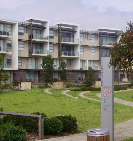
9 Private Sector Linkages Under the pillar Private Sector Linkages, the project will have the following objectives: Positive relationship developed with the City of Mandurah, adjoining landowners and other stakeholders throughout the planning and development of the project; and Private sector companies involved as partners in the development of the site, including built form partnering opportunities ODP Design Principles The intent for Mandurah Junction is to create a high quality contemporary built environment based on sound design principles that will provide opportunities for affordable living, diversity and choice in a walkable, pedestrian oriented development. The main design principles, which have been established for the subject site and incorporated within the ODP, are to: Provide a legible and permeable street network that disperses traffic volumes and encourages walking as an alternative to car use; Provide sufficient parkland to establish a high level of residential attraction; Locate commercial uses in places that have exposure to the movement network, both in respect to vehicle and pedestrian movement; Increase residential densities in relative proximity to public transit access the closer to the station, the higher the density of development; Establish a reasonable transition between areas of lower and higher residential densities and the subsequent scale of built form, bearing in mind the capacity of the surrounding area to be recoded and redeveloped over time; Incorporate longer-term parking within developments, out of view of the public domain (e.g. behind or under buildings), and to encourage shorter-term parking on street; Establish a maximum street-wall height subject to density and overshadowing; Maximise views onto parkland to provide residential amenity and passive surveillance; Minimise the visual impact of the railway infrastructure, such as the stowage depot, on local residents; and Provide a robust design that has the ability to connect with a variety of design options for the abutting Lots 5002 and 5003 Allnutt Street ODP Key Elements Based on the vision and objectives for the development of the site, a number of elements have been identified and reflected within the ODP as follows: An overall design for Lot 5001 Allnutt Street which is flexible enough to reflect the potential long term redevelopment of Lots 5002 and 5003 Allnutt Street; Three different possible design options for Lots 5002 and 5003, which show that the ODP for Lot 5001 can be implemented successfully regardless of which design option for the abutting lots is adopted in the future. The provision of a north-south neighbourhood connector linking Rafferty Road in the north with Allnutt Street in the south, ultimately providing a new connection to the train station, designed to cater for public transport; Extension of Morfitt Street, Wyeree Road, Palmer Way and Barker Road into the site from the west providing a more connected and legible street network; The provision of additional areas of public open space to allow for the retention of native vegetation (where possible), provide for the extension of the existing Palmer Way open space, create linear north-south and east-west corridors, accommodate overland drainage paths and provide relief to the proposed built form; 5
10 Creation of key east-west and north-south open space corridors providing opportunities for pedestrian and cyclist access across the site, best practice urban water management techniques and providing a context within which the built form product can respond; Provision of a variety of housing product and built form through the development including mid rise apartments; terraced housing fronting abutting parkland and affordable housing; The provision of an interconnected pedestrian and cyclist network which will link into potential improved east-west pedestrian and cyclist linkages between the train station and the beach / City Centre; and The provision of sufficient retail and commercial floorspace within close proximity to the train station in the south and the existing service commercial precinct in the north. Residential Development The ODP has been designed to incorporate a mix of medium and high density residential development, primarily based on the proximity of the train station, and the subsequent walkable catchment. Across the site, various R-Code densities are proposed, from R60 adjacent to existing residents to R160 adjacent to the key north south road. There is the potential for approximately 950 dwellings across the site. This total is made up of 113 townhouse lots and 837 apartments. Allocation of dwellings across the site will be controlled through maximum heights and allocated setbacks for each superlot, thereby creating an envelope for development. This will ensure that superlots approved at lower, more responsive heights are allocated closer to existing houses. Within the ODP there are two key focal points: The central parkland; and The north-south spine road. Apartment buildings to a maximum height of six storeys are proposed around the central parkland, providing surveillance while also benefitting from the aesthetics of the park and the ocean in the distance. Similar height apartment buildings are also proposed along the length of the north-south spine road with mixed use dwellings proposed on the ground floor. The allocation of these Mixed Use areas will allow some of the City s local employment objectives contained within the Mandurah Southern City Strategy to be realised. On the western side of the subject site, abutting the existing houses, building heights of between two and three storeys are proposed. Where any boundary is shared with existing residential dwellings, overshadowing and privacy considerations will be regulated in accordance with the Residential Design Codes. Within the north western portion of the ODP area, two to three storey townhouses are proposed to offer an alternative housing product overlooking the abutting POS areas and separated from stowage and service yards by five storey apartment buildings. Studio accommodation above garages will also be encouraged for some of these townhouse lots. Access to the majority of dwellings within the ODP will be from rear laneways or from below ground or ground level parking areas. By ensuring vehicular access is from the rear, elevations to the primary streets will become activated, substantially improving the passive surveillance and safety of these streets. It is proposed to control the built form on the proposed lots through the ODP text. Affordable Housing In November 2009 LandCorp prepared an Affordable Community Strategy for Mandurah Junction. This strategy recognised LandCorp s approach as a government wide effort to create affordable communities using an affordable housing target using a range of strategies and actions such as: public housing, affordable sales through demonstration projects, affordability agreements with developers, package deals with partner builders, product diversity, density bonus, National Rental Affordability Scheme and Housing Affordability Fund. Subsequently LandCorp received Housing Affordability Funding which has allowed the delivery of lots to be brought forward to 2013 and will provide direct cost saving the purchases or up to 6
11 55 lots within Mandurah Junction. This fund is a significant step towards LandCorp realising their aim of achieveing a 15 per cent affordable housing tartget and deliver affordable living through lower household coast as a result of energy, water and transport cost savings. Movement Network The proposed ODP structure is based on traditional perimeter street blocks. The street network is direct, interconnected and highly legible to allow pedestrians and vehicle users access to key destinations within the site. A key design element in the ODP is the provision of a north-south neighbourhood connector (Galgoyl Road) linking Rafferty Road in the north with Allnutt Street in the south, ultimately providing a new connection to the train station from the north. This road has scope to extend to Rouse Road in the future. By constructing the north-south spine road on the eastern alignment, future earthworks are reduced and the construction and design of future car parking access points from the rear is made more convenient and more cost effective. As the proposed alignment of the north-south spine road abuts the train line, stowage areas, bus wash down areas and further to the east, Mandurah Road, any development fronting this road is therefore required to meet the requirements of the City s Noise Attenuation Policy and WAPC State Planning Policy 5.4 Road and Rail Transportation Noise and Freight Consideration in Land Use Planning. A Noise Attenuation Report, prepared as part of the ODP, indicates that notifications on titles will be required to state that noise mitigation measures are to be implemented with a view to achieving the target levels in at least one outdoor living area and acceptable indoor noise levels. Public Open Space Areas of public open space have been located throughout the subject site, with a balance of active, passive and conservation open space areas. A total of ha of open space is proposed, representing a total of 16.5 per cent of the site, noting there is an existing reserve; Reserve is also located within the area of the ODP. An indicative public open space strategy has been prepared to: Maintain, wherever possible, the existing mature and habitat vegetation; Ensure passive surveillance over open space areas through lot configuration; and Utilise bio-retention swales along the street verges, and drainage basins within the (nominated) open space, as open, unfenced and vegetated public open spaces that can be utilised for passive recreation. Suitable local native shrub species are to be planted within the bio-retention zones. A key component is the central open space that adjoins Reserve to retain existing vegetation and provide linkages to a greenway network to the other smaller parcels of open space throughout the site. Commercial and Employment An economic analysis for the subject site has been prepared which not only considers the allocation of commercial floorspace within Lot 5001, but also assumes likely residential and commercial development for Lots 5002 and 5003 should they be developed in the future. The data used in this analysis has been drawn from the recently released Directions 2031 with Mandurah s labour force predicted to grow 95 per cent to 43,548 with employment increasing to 31,433 (growth of 112 per cent). This assumes an increase in employment self sufficiency from the current 67 per cent to 72 per cent. Demand for retail services, and therefore floorspace within Mandurah Junction is based on an analysis of the likely user groups (i.e. residents, workers and visitors) that will engage with the centre once operational and predicated on extrapolations of the current distribution of population and employment types within Mandurah along with their consumption profiles. The predicted demand for retail floorspace within the area by 2031 is estimated at between 4500 and 6500 square metres within the ODP area. By 2016, retail floorspace requirement is estimated at between approximately 1800 and 2800 square metres. Within the ODP area (i.e. Lot 5001), 1100 square metres of retail floorspace is proposed, based on the sites proximity to the train station and its location within the city centre boundaries. 7
12 An additional 8500 square metres of commercial floorspace is proposed (i.e. non-retail) making a total of 9600 square metres. The ODP is an important development node within Mandurah and as such should be a focus of development activity. A focused economic development strategy for Mandurah that recognises the importance of Mandurah Junction may also promote the positioning of the precinct as a location for specific types of uses over and above general commercial / office space. These uses may include the Health, Welfare and Community Services and Entertainment / Recreational and Cultural uses. In response the ODP will provide these uses as being permitted for the mixed use precincts. Environment A significant amount of environmental analysis has been undertaken over the site, including vegetation and flora studies, fauna, acid sulphate soils, contamination and heritage. As a result, a high number of habitat trees have been identified and are proposed for retention in public open space areas where possible. The Landscape Strategy aims to integrate the retention of vegetation (significant trees) and ecological restoration for the protection of potential Black Cockatoo habitat. The evidence of limited foraging of the Carnaby s Black Cockatoo on the site requires the development to be subject to assessment by the Department of Environment, Water, Heritage and the Arts (DEWHA) under the federal Environment Protection and Biodiversity Conservation Act Surface Water Quality To address stormwater management, the principles of the minor/major drainage will be employed. The minor/major drainage system is defined as a system of underground pipes, swales and kerbs etc which are designed to carry runoff generated by low frequency minor ARI storms (5 year ARI) and a system of roads, drainage reserves, basins and open space designed to convey major events (greater than 5 year ARI). The quality of stormwater infiltration and runoff will be maximised through: Adopting a treatment train approach to runoff through the use of water sensitive urban design best management practices such as permeable pavements, buffer strips, bioretention swales, rain gardens, bio-filtration pockets, median swales and infiltration basins. The treatment train will be largely incorporated with the public open space. Xeri-scaping to avoid the use of fertilisers; Recommending a maintenance and monitoring program (after GHD 2009). Public Art Mandurah Junction will be a creative and vibrant place, which provides public art, which is accessible and creates a destination for all community members to enjoy. The public art that is provided at Mandurah Junction will: Contribute to the cultural identity of the place; Respond to the indigenous connection to Mandurah Junction; Be of high artistic and technical integrity; Be maintained easily and supported by the City of Mandurah; and Support local artists and community groups when possible. LandCorp will provide Public / Community Art elements in public open space and negotiate with developers to incorporate art into building design (Refer Clause 2.3.2). Community Well-being Mandurah Junction will be developed into a vibrant community that includes a choice of lifestyle and cultural pursuits. To achieve this, the developer is not only required to develop a built environment, but also create a strong and connected community. LandCorp will prepare a Community Plan, which engages the community on possible community activities, facilities and services. The community plan will facilitate the implementation of community development strategies at Mandurah Junction as well as, resources required and delivery partners 8
13
14
15 Mandurah Junction Outline Development Plan 2. Design Criteria 11
16 2.1 Preamble The Mandurah Junction development will be a model for sustainable infill development that improves the amenity of the area for existing and future residents and visitors. Innovative solutions that improve the quality of the built form and public realm are encouraged. Outcomes prescribed within this ODP Text relate to the maximum potential of each lot, however actual outcomes may differ due to the configuration, size and shape of individual landholdings. Where required, development criteria are specified by element, with criteria provided by Precinct. The following standards and guidelines shall apply throughout the ODP Area unless they are not applicable for that particular development (e.g. a commercial requirement for a residential development). For any development within the ODP Area, there will be a priority given to achieving high quality urban design outcomes to compliment the development standards outlined below. 12

 Careful consideration should be given to the interface between each precinct and to the relationship between new developments and adjoining areas.")
17 2.2 Desired Urban Form Land Use Precincts (a) The ODP has been divided into five distinct land use precincts or zones, as provided in Figure 3 as follows: Mixed Use Commercial Mixed Use Residential High Density Residential Medium/High Density Residential Medium Density Residential. Service Commercial (b) New developments should respond to the context and climate and should contribute positively to the desired character of each precinct as well as reinforcing a strong overall sense of place. (c) Careful consideration should be given to the interface between each precinct and to the relationship between new developments and adjoining areas. Specific criteria for each land use precinct is provided in Section 2.4. (Note: For all development within the Service Commercial precinct, refer to the Service Commercial zone of Town Planning Scheme 3. The following design criteria are not applicable to the Service Commercial precinct) Site Layout (a) The maximum extent of building mass is defined by the maximum plot ratio described in the Development Standards table for the relevant precinct. (b) Building mass should generally be located towards the street front(s) of each site to provide spatial definition to adjacent streets, and to enable private and service areas to be located away from the public domain. (c) The minimum building setbacks are described in the Development Standards table for the relevant precinct. (d) The layout of buildings on sites should seek an optimum balance between being orientated towards adjacent streets and being orientated to capture winter sun for passive solar heating of internal spaces. (e) Buildings should be orientated, with appropriately located openings, to maximise the potential for natural summer ventilation. (f) The location and design of private open spaces (such as courtyards or balconies) should minimise the possibility of overlooking into neighbouring properties, and maximise privacy for the occupants of the open space. Private open space and communal open space should be designed and provided in accordance with the R-Codes. The massing of building should generally be placed towards the street. Buildings should be orientated to optimise north-facing glazing. 13
18 Figure 3 Precincts (Replace with PDF) 14

 the design of car parking areas shall be consistent with the overall vision for the project and include well")
 crossovers shall be limited to one crossover per development site; (d) Service areas shall be discrete with rubbish bins, clothes drying")
 building entrances at ground floor levels shall address the primary street frontage")
 a canopy or awning shall be provided to all ground floor tenancies adjacent to a street, to a minimum height of 3m, and a minimum depth")

 All development should present a clearly identifiable front door to an adjacent street, with a well-defined pedestrian pathway to the")
19 2.2.3 Street Actvitation All development in the Mixed Use Commercial and Mixed Use Residential precincts shall seek to maximise activation of adjacent streets. To fulfil this requirement, the following shall be required as a minimum: (a) on-site car parking and service areas shall be located away from the street edge; (b) the design of car parking areas shall be consistent with the overall vision for the project and include well designed landscaping; Car-parking adjacent to streets should be avoided. (c) crossovers shall be limited to one crossover per development site; (d) Service areas shall be discrete with rubbish bins, clothes drying areas, plant and equipment screened from public view; (e) ground floor tenancies shall incorporate full height glazing to street elevations with shading devices for solar control as required; (f) building entrances at ground floor levels shall address the primary street frontage and be clearly identified; Vehicle crossovers should be minimised. (g) a canopy or awning shall be provided to all ground floor tenancies adjacent to a street, to a minimum height of 3m, and a minimum depth of 2.5m (h) areas of blank wall at ground floor level to adjacent streets shall be minimised; and (i) the principal entry to ground floor tenancies will exit to the adjacent street. (j) In all cases, development should address adjacent streets and satisfy the CPTED requirements in Section (k) All development should present a clearly identifiable front door to an adjacent street, with a well-defined pedestrian pathway to the entrance from the nearest public footpath. (l) Where public access is anticipated, the pedestrian access shall be designed for universal access. Street interface should be glazed with high levels of pedestrian amenity. Service areas adjacent to streets should be avoided. A canopy/awning is required where there is street front commercial activity. Blank walls to streets should be avoided 15
 50 per cent maximum max shadow coverage (as measured at 12pm of 21 June) of")
 Figure 4 identifies a series of locations that warrant a building of a landmark quality.")

 To offset the additional cost of responding to a landmark location, developments in these locations are eligible for: A 25 per cent development bonus plot ratio; and the street wall being")
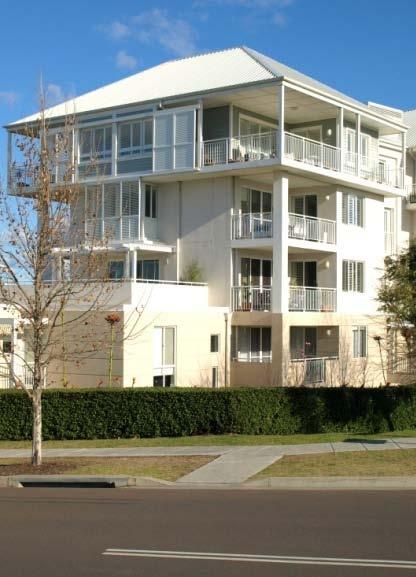
20 2.2.4 Building Height and Scale Building Heights Figure 4 outlines the building height and scale for development within the ODP area, as referenced in the development standards tables for the Precincts Overshadowing Notwithstanding the contents of Figure 4, the development shall ensure the following: (a) 50 per cent maximum max shadow coverage (as measured at 12pm of 21 June) of designated public squares or parkland; and (b) the maintenance of at least 3 hours of sunshine to major openings of habitable rooms to any dwelling on an adjacent lot on 21 June Landmark Building Criteria (a) Figure 4 identifies a series of locations that warrant a building of a landmark quality. These locations either stand at the gateway to the overall Mandurah Junction precinct or terminate vistas. 16 Buildings in landmark locations are expected to display a higher than average standard of building design and incorporate distinctive architectural features to all street-fronts which will contribute to the overall character and quality of the public realm. (b) To offset the additional cost of responding to a landmark location, developments in these locations are eligible for: A 25 per cent development bonus plot ratio; and the street wall being increased by an additional storey within 20 metres of the identified street corners. (Note: Refer to Clause with regard to potential for additional residential units within the defined building envelope). Examples of buildings with a landmark quality or feature.
21 Figure 4 Building Heights and Scale (Replace with PDF) 17
22 2.2.6 Land Uses Land Use Table Land uses within the ODP are specified in Table 1 based on the specified Precinct Areas as shown in Figure 3. Table 1 Land Use Table Use Class Category / Land Use Precinct / Level where applicable (Ground Level) Mixed Use Commercial (Other than Ground Level) (Ground Level) Mixed Use Residential (Other than Ground Level) High Density Residential (R160) Medium / High Density Residential (R100) and Medium Density Residential (R60) Category 1: Retail Shop Market Liquor Store Restaurant / Café P P P P P Category 2: Commercial Category 3: Residential Category 4: Tourist Category 5: Community NOTES: P AA X Office Consulting Rooms Medical Centre Private Car Park Showroom Grouped Dwelling Multiple Dwelling Short Stay Accommodation Serviced Apartments Hostel / Lodging House Bed and Breakfast Community / Health Services Education Establishment Library Public Car Park P P P P AA X P AA P P AA P AA P P P P P P AA means the use is permitted by the Scheme providing the use complies with the relevant development standards and the requirements of the Scheme; means the use is not permitted unless the Council has exercised its discretion by granting planning approval; means the use is not permitted by the Scheme; As per Residential Zone of Scheme 3 18
23 Unlisted Uses Where a use is not listed in Table 1, there may be examples where a land use is: (a) Listed in another zone within Scheme 3; or (b) Is not listed in Table 1 or Scheme 3; In these circumstances, Council may, not-withstanding any other provision of Scheme 3: (a) (b) (c) Determine that the use is consistent with the objectives and purposes of the particular zone and is therefore permitted; or Determine that the proposed use may be consistent with the objectives and purpose of the zone and thereafter follow the 'SA' procedures of Clause 7.3 of Scheme 3 in considering an application for planning approval; or Determine that the use is not consistent with the objectives and purposes of the particular zone and is therefore not permitted Application of the Residential Design Codes Residential Development The development of Dwellings (Single, Grouped Multiple) shall be in accordance with the provisions of the Residential Design Codes. However, where alternative provisions are specified in the ODP, the ODP prevails over the R-Codes. The minimum and average site area per dwelling and plot ratio requirements (Columns 3 and 5 of Table 1 of the R-Codes) may be varied from those shown on the ODP, to the effect that a proposed development complies with the ODP Text and Design Criteria, including, but in no particular order: Building Height and Scale; Setbacks; Streetscape provisions; and Achieving strategic economic and sustainability objectives. Any proposed variation to the site area of the R-Codes shall be publicly advertised, as per Clause3.2.2 of the ODP. Studio Apartments Over Garages / Laneways Where a development incorporates a studio apartment over a garage accessed from laneways (which is strongly encouraged), these developments are permitted to vary the minimum and average site area per dwelling and plot ratio requirements (Columns 3 and 5 of Table 1 of the R-Codes). Tourism Development All units in any development designed primarily for tourist occupation shall not be subject to compliance with the R-Codes in regard to minimum site area required per dwelling. (i.e. the relevant R-Code shown on the ODP shall be for permanent residential units only). This clause is subject to such units being occupied by any person is limited to a maximum of three months in any 12-month period. Such restriction shall be placed on any planning approval issued and subsequent management statement of a strata scheme. Mixed Use Development The provisions of Clause 4.2 of R-Codes shall generally apply to Mixed Use development, to the extent that the provisions are consistent with the Vision and Intent of the ODP. 19

24 2.2.7 Vehicle Parking and Access Minimum Parking Provisions (a) The minimum car-parking provision shall be at the ratio as described below: Land Use Category Retail / Commercial Residential / Tourist Minimum Standard 1 bay per 80m 2 GLA floorspace 1 per unit (b) (c) (d) Secure bike parking should be provided at the rate of 1 space per 100 square metres of commercial floorspace. End of trip facilities (ie: showers, changing facilities and equipment storage) are required for all commercial buildings with net lettable space greater than 100 square metres. Showers should be provided at the rate of 1 per 500 square metres Design Provisions (a) Resident and employee car parking should be provided on-site and fully screened from public view as either: as surface parking concealed behind buildings; or fully concealed in a basement; or in a semi-basement. Where parking is in a basement or in a semibasement, pedestrian access from the car park should be provided directly into the building. (b) The ground floor level of any building above a semi-basement car park shall be no more than 1.2m above the adjacent ground level at the street boundary. High quality screening should be used to avoid a direct line of sight to parked cars and to provide security to the car park. (c) Parking for visitors shall be in clearly identifiable and publicly accessible bays. (d) For mixed-use development, reciprocal car parking arrangements are encouraged between compatible land uses to maximise use of car bays throughout the 24-hour period, and to improve site efficiency Vehicle Access and Crossovers (a) Where provided, all vehicular crossovers shall be from a rear laneway, with crossovers to the front of the property not permitted; or. (b) Vehicle crossovers are generally limited to one crossover per street for any development, except where otherwise indicated on Figure 5. (c) All development shall be setback 1.0m from any rear laneway. Examples of parking integrated into development through the use of semi-basement car-park. 20
25 Figure 5 Vehicle Access Provisions (Replace with PDF) 21


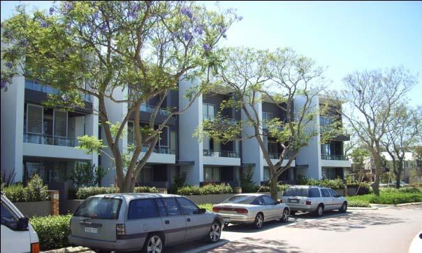
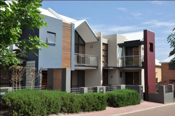
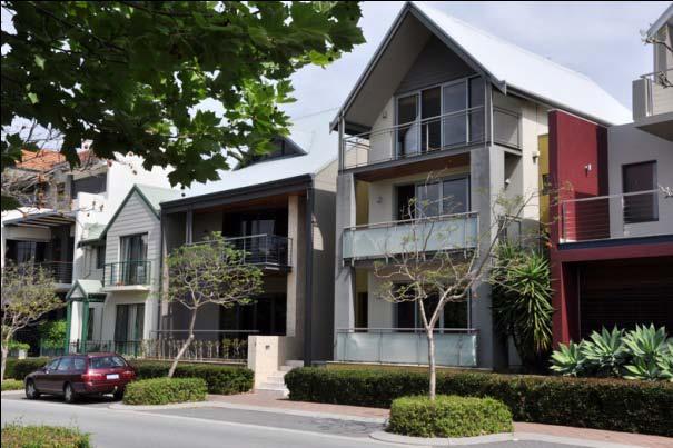
26 2.3 Building Design To ensure the built form outcome at Mandurah Junction fulfils the vision identified in the ODP high quality architectural design is encouraged that is innovative, sustainable, and environmentally responsive, and which contributes to high quality streetscapes and other public places. Note: There are elements contained within this part which will guide a designer to meet the vision intended of the ODP, some which will form part of the assessment of a development application by the City of Mandurah and others that will be placed as a condition of development approval by the City of Mandurah Architectural Character The architectural character should be of a contemporary nature with a consistent language of simple forms, high-quality materials and appropriate design and detailing. Examples of buildings with a diverse but contemporary character. 22
. At street level this should be at intervals of around 6-8m.")
.")

 Where walls without articulation are unavoidable, other details using colour, texture or other variation should be applied.")

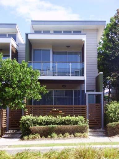
27 2.3.2 Building Articualtion (a) Buildings are to be articulated (transition visually into different elements to establish a rhythm or pattern, particularly at pedestrian level). At street level this should be at intervals of around 6-8m. (b) Corner buildings are to address both frontages and should articulate the corner by incorporating a distinctive design feature (such as a tower element or entrance feature). (c) The public faces of buildings should be detailed using a variety of materials, surface modelling, projections such as balconies and verandas, the spacing of windows and doors. Example of distinctive corner articulation. (d) Public art, where incorporated, shall be integrated into the design of buildings as an architectural feature. (e) Where walls without articulation are unavoidable, other details using colour, texture or other variation should be applied. (f) Structural elements, glazing details, architectural details and cladding patterns should be used to create a rhythm to building elevations and avoid a monolithic, blank appearance. (g) Recesses and projections in the architectural detailing should be pronounced to take advantage of the sharp contrast resulting from the strong sunlight evident in Mandurah. Incorporation of public art into the design of a building. Use of colour and materials to add interest to a building. Use of projecting elements to cast shadow and add visual interest. Example of how visual interest can be achieved where a blank wall is unavoidable. Example of a strong structural rhythm. 23
 to encourage architectural expression.")

.")

28 2.3.3 Roof design (a) A variety of roof forms is permitted (pitched, skillion, flat with parapet, or vaulted) to encourage architectural expression. (b) Where a conventional dual pitch roof is employed, the roof pitch shall be a minimum of 25 degrees. (c) Roof materials for pitched or vaulted are limited to metal sheeting in a light colour (max 0.55 solar absorbency). (d) In the case of flat roofs for commercial development, it is encouraged that the roof in landscaped to maintain an attractive appearance when viewed from upper levels of other nearby buildings. Example of pitched roof. Example of vaulted roof. Example of skillion roof. Example of landscaped roof. 24


29 2.3.4 Openings (a) (b) (c) (d) (e) Openings should be placed to capture winter sun, enable natural ventilation and provide for passive surveillance of public areas. The use of clear glazing is required wherever there is significant occupation of the building to engender a strong visual relationship between the building occupants and people within the adjacent public domain. The use of reflective, dark tinted or obscure glass (including signage) is not permitted on ground floor windows adjoining pedestrian areas. Rooms requiring privacy should not be situated immediately adjacent to pedestrian areas. Where no other placement of such rooms is possible, a raised level difference between the rooms and the pedestrian areas of between 0.6 metres and 1.2m metres should be achieved as a privacy feature. Exterior shade structures should be used where it is necessary to protect windows from summer sun. Example of screen being Projecting building Ground floor residential used to provide shade, structure provides units raised above privacy and visual interest. shade to openings street level to provide greater privacy Materials and Colours Mandurah is a coastal town in a climate with hot summer days, therefore the choice of external materials should be taken into consideration. Building products should be durable, structurally robust, UV stable, and noiseless in the event of storm conditions; they should retain their integrity at a mature stage of development. A schedule of proposed exterior colours and materials is to accompany applications for planning approval Services (a) (b) (c) The placement of air-conditioning units should be integrated into the design of buildings and shall not be located on elevations facing the public domain, nor located where they may cause a noise nuisance to adjacent neighbours. All services located on the roof (e.g. air-conditioners, satellite dishes, etc) shall be designed to be integrated into the roof design and shall not be visible from the surrounds, noting that adjoining buildings may be developed with a number of levels. Building entrances, car-parking areas, and the ground floor elevation of any retail/commercial or mixed-use building facing the street shall be well lit for safe use for after dark. (d) Lighting should be designed and located to avoid excessive glare to adjacent neighbours. Mechanical plant and other services should be hidden from view from the street. 25


 Stormwater is to be retained on site wherever possible, using water sensitive design principles, or through the use of rainwater tanks.")
 Lawn areas should be minimised, or alternative low water-use ground cover planting should be used.")
30 2.3.7 Crime Prevention Through Environmental Design (CPTED) (a) (b) (c) (d) Building and landscape design is to avoid the formation of blind spaces, corners or alleys that cannot be seen from within the mostused rooms of a building or from approach paths. Deterrents to ram raiding, such as raised sills should be considered in the design of ground floor windows in vulnerable buildings such as shops and showrooms. Where provided, security screens and grills are to be designed to be integral to the architecture of the development to ensure a high quality streetscape is maintained. A CPTED assessment shall be undertaken for all development. Note: Reference shall be made to the Performance Criteria under Chapter 5 of the WAPC s Designing Out Crime Guidelines, 2006 in undertaking such assessments. Blind spots that can only be monitored by camera should be avoided Landscape Design Development should provide eyes on the street. (a) Stormwater is to be retained on site wherever possible, using water sensitive design principles, or through the use of rainwater tanks. The selection of plant species should include consideration of the mature size of the plant, which should not result in the obstruction of any lighting or essential vehicle or pedestrian sight lines. Native plant species are preferred. (b) Lawn areas should be minimised, or alternative low water-use ground cover planting should be used. (c) (d) (e) Low water-use irrigation systems (such as drippers) should be used in preference to conventional airborne sprays. The use of soil amendment materials and mulch is encouraged to reduce the need for excessive watering of landscaped areas. Paving materials adjacent to the public domain shall coordinate with the public paving to ensure a harmonious interface. Ground materials shall be selected to assist with water absorption and to reduce run-off (for example permeable or segmental paving). Use of groundcovers as an alternative to grass. Co-ordinated public paving with segmented pavers to assist with stormwater infiltration Example of integrated landscape and stormwater management with native species. 26


31 2.3.9 Resource Conservation (a) (b) (c) (d) (e) (f) (g) (h) (i) (j) (k) All development shall seek to minimise energy consumption by achieving a minimum sixstar thermal energy efficiency rating. To encourage the capture of cooling breezes and to minimise use of air conditioning, at least 75 per cent of accommodation units within multiple dwelling developments should be capable of natural cross ventilation (i.e. with openings on more than one side). To encourage the use of natural heating in winter through solar gain it is encouraged that no more than 20 per cent of residential units in any development should have a south-only orientation. Access of summer sun into openings and private open space shall be controllable and mandatory on the western and eastern elevations through the use of high quality design elements (e.g. full height and moveable balcony screens with adjustable louvres). Draught seals/weather stripping shall be installed on openings. In developments of six units or more, a central waste collection space shall be included to accommodate bins for recyclable waste and other materials, or as required by the City of Mandurah, for the separation of waste at the source. Motion sensors shall be used for lighting in basement car parks, and other locations as appropriate. Where supplied, high star rated energy efficient appliances should be installed (e.g. fridge/freezer, clothes washer, dishwasher, hob, oven etc.) A highly energy efficient hot water system should be installed (e.g. gas or solar boosted gas centralised hot water system. The use of photovoltaic cells and other means of on-site power generation are encouraged. A Building/Dwelling Management Manual, or similar user-friendly document, shall be produced to assist occupants to understand the intended performance of the building and specific operational requirements. (l) Water saving devices shall be installed including flow regulators, AAAA WELS rated showerheads, AAAA WELS (4.5/3L) dual flush toilets. (m) Other water-saving strategies such as third pipe grey water reuse; reuse of rainwater; waterless urinals; urine separators, etc. are encouraged. (n) (o) The use of recycled, recyclable materials, and materials with a low embodied-energy content (such as timber) is encouraged, Any timber used should be sourced from renewable plantations. Example of a photovoltaic Use of balconies and Moveable shade array incorporated into the other projections to structure to manage roof design. shade openings. solar penetration all year round 27


 (f) Boundary fences require a 1 metre setback from the rear laneway. This is encouraged to be treated with landscaping.")
 Entry communication and mail delivery boxes should be integrated into the building design.")
32 Boundary treatments (a) Boundary fences to primary street frontages may be installed to a maximum height of 1.2 metres when measured from the adjacent footpath level, and shall be at least 50 per cent visually permeable from a height of 0.6 metres. (b) Boundary fences to secondary street frontages and rear laneways may be installed to a maximum height of 1.8 metres when measured from the adjacent footpath level, and shall be at least 50 per cent visually permeable from a height of 0.6 metres. Low permeable fencing to suit front boundaries. (c) Fences shall coordinate with the building and landscape design. (d) Common fencing between adjacent developments should be constructed to a minimum height of 1.8 metres. (e) (f) Boundary fences require a 1 metre setback from the rear laneway. This is encouraged to be treated with landscaping. Pedestrian access points are encouraged to be provided within rear boundary fences on to laneways to assist in the activation of laneways. Integration of side fencing/screening into the overall building design Signage (a) Entry communication and mail delivery boxes should be integrated into the building design. Multiple residential developments should utilise a shared entry communication system. (b) (c) (d) (e) Street numbering is to be provided on the building s front façade. No freestanding pylon signage is permitted. All signage must be attached to a building. Signage should be integrated with the architectural design and where multipleoccupancy is likely to occur, signage should be shared. Corporate colours, logos and decorations will be regarded as signage and will be required to be considered through a signage concept plan for each development. Signage should not detract from the intended amenity and character of the Precinct and can only be considered when attached or form part of the building façade. (f) Signs shall not exceed a size of 3 square metres within 5 metres of ground level. (g) Signage is not permitted above the roofline of the building. (h) Clearance to signs above pedestrian areas shall be a minimum of 2.4 metres Car-orientated pylon signage should be avoided. Signage (where required) should be integrated into the building design. 28
33 Noise Attenuation Noise attenuation measures shall be implemented at the development stage in accordance with Detailed Area Plans (DAP s) approved by the City of Mandurah. The DAP s will be prepared for the Mixed Use precincts identified on Figure 2 as a condition of subdivision approval. The approved DAP s will be incorporated into Appendix 1 of the ODP Text. 29

34 2.4 Precinct Specific Criteria Mixed Use Commercial Objective and Urban Form The objective of the Mixed Use Commercial precinct is to establish an urban experience that frames the eventual redevelopment of the railway station car park. With the longer-term station development, the Precinct forms a distinct focal point of activity. Development in the Mixed Use Commercial precinct is intended to accommodate a wide range of commercial activities that have a high worker density (such as offices or fine-grained retail outlets) as well as residential accommodation. This development should deliver a high density of workers and residents to support the transit system and provide a local population catchment to help sustain local businesses and services. Section indicating typical mixed use commercial development The urban form of the Mixed Use Commercial precinct will consist of a traditional urban pattern of building, where the buildings street wall of between three and four storey will generally follow the street boundary. Upper levels of buildings may be set back from the street wall at the designer s discretion to achieve an articulated skyline Mixed Use Criteria (Ground Level) 30 In addition to any criteria outlined in Section 2.2, it is mandatory for the ground level to be commercial land use. Table 2 Mixed Use Commercial Development Standards Development Standard Maximum Minimum Street setbacks Other setbacks Rear Laneway Setback (where applicable) Street wall height 3m (to allow for alfresco areas and building entry zones) N/A N/A 21 metres (5 storeys) (Refer Clause 2.2.4) Overall building height Refer Figure 4 Podium Setback (Street wall to Overall height) Lot size Plot ratio Residential density N/A 3:1 (Refer Clause 0) R160 (Refer Clause ) 0m mandatory (except for dedicated alfresco areas and building entry zones) As per R-Codes (as amended) 1.0m (including fencing) (Refer Clause ) 12 metres (3 storeys) 12 metres (3 storeys) 3 metres (as residential/landscape terrace) 2000 square metres (to ensure super lot development) 1:1 R60


35 Examples of mixed use buildings with commercial uses at ground level. 31

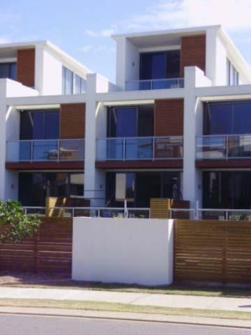
36 2.4.2 Mixed Use Residential Objective and Urban Form The objective of the Mixed Use Residential precinct is to enable the ultimate establishment of a quality commercial strip that can be augmented by upper-level residential accommodation. As with the Mixed Use Commercial precinct, development in the Mixed Use Residential precinct is intended to accommodate a variety of commercial activities as well as residential accommodation. However, it is recognised that the demand for commercial uses may be limited in the short-to-medium term, and, as a result, buildings in the Mixed Use Residential precinct may need to be designed to accommodate residential uses until the demand for commercial use is evident. Section indicating typical mixed use residential development The urban form of the Mixed Use Residential precinct will consist of a traditional urban pattern of building, where the building s street wall of between three and four storeys will generally follow the street boundary. Upper levels of buildings may be set back from the street wall at the designer s discretion to achieve an articulated skyline Mixed Use Criteria (Ground Level) In addition to any criteria outlined in Section 2.2 the following criteria shall apply to the development based on the potential for the site to be used for mixed use: (a) (b) (c) The ground level land use can be residential, but the building shall be designed for change in use over time; Ground level to have minimum floor to ceiling level of 4.2m; Ground level to be designed to achieve fire rating and disabled access requirements for commercial development (gradients, door widths, circulation etc); 32 Table 3 Mixed Use Residential Development Standards Development Standard Maximum Minimum Street setbacks 6.0m Other setbacks Rear Laneway Setback (where applicable) Street wall height N/A N/A 16 metres (4 storeys) (Refer Clause 2.2.4) 0m where there are groundfloor commercial activities, otherwise 3.0m. As per R-Codes (as amended) 1.0m (including fencing) (Refer Clause ) 6 metres (2 storeys) Overall building height Refer Figure 4 12 metres (3 storeys) Podium Setback (Street wall to Overall height) Lot size Plot ratio Residential density N/A 3:1 (Refer Clause 2.2.4)) R160 (Refer Clause ) 3 metres (as residential/landscape terrace) 2000 square metres (to ensure super lot development) 1:1 R60


37 Examples of residential-scaled buildings converting to commercial on the ground floor. 33
 2.4.3.")
38 2.4.3 High Density Residential (R160) Objective and Urban Form The objective of the High Density Residential precinct is to establish high-quality residential apartment complexes that capitalise on the outlook over the adjacent parkland and increase density abutting the station. The parkland setting is intended to create an attractive setting for apartments so that the density of development that is anticipated closer to the station can be sustained in a more marginal location. The development controls for the High Density Residential precinct are more flexible than the mixed-use precincts to allow designers to propose less urban solutions that have the potential for greater modulation of the built form, and, thus, more appropriate to the parkland and residential setting. Section indicating typical high-density development Mixed Use Criteria (Ground Level) It is recognised that there may be demand for additional mixed use / commercial within the precinct. Therefore, developments within the High Density Residential precinct may be designed for ground level commercial. Table 4 High Density Residential Development Standards Development Standard Maximum Minimum Street setbacks N/A 3.0m Other setbacks Rear Laneway Setback (where applicable) N/A N/A As per R Codes (as amended) and BCA 1.0m (including fencing) (Refer Clause ) Street wall height N/A N/A Overall building height Refer Figure 4 Podium Setback (Street wall to Overall height) Lot size Plot ratio Residential density N/A 3:1 (Refer Clause 2.2.4) R160 (Refer Clause ) 12 metres (3 storeys) 3 metres (as residential/landscape terrace) 2000 square metres (to ensure super lot development)) 1:1 R80 34

39 Examples of high-density apartments. 35


40 2.4.4 Medium / High Density Residential (R100) Objective and Urban Form The objective of the Medium/High Density Residential precinct is to establish a small neighbourhood of high-quality residential townhouses and small apartment buildings with its own sense of place. The intent of the precinct is to establish a series of streets that are well defined by the adjacent built form. The anticipated built form will be of a domestic scale that is clearly residential in character, and will consist of terraces of attached buildings with relative narrow frontages. The incorporation of studio apartments over garages accessed from laneways is strongly encouraged to provide a diversity of housing choice and enable passive surveillance of laneways. Section indicating typical medium-high density residential development Example of garage-top studios/townhouses to a rear lane. 36 Table 5 Medium / High Density Residential Development Standards Development Standard Maximum Minimum Street setbacks 3.0m 2.0m Other setbacks Rear Laneway Setback (where applicable) 0m mandatory for the first 12m behind the front building line (from the primary street). As per R-Codes (as amended) beyond. N/A Overall building height Refer Figure 4 Podium Setback (Street wall to Overall height) Lot size Plot ratio Residential density N/A 2:1 (Refer Clause 2.2.4) R100 (Refer Clause ) 1.0m (including fencing) (Refer Clause ) 9 metres (2 storeys) (unless shown on Figure 4) 3 metres (as residential/landscape terrace) As per R-Codes (as amended) 0.75:1 R40


41 Examples of medium to high-density apartment buildings. 37
 2.4.5.")

42 2.4.5 Medium Density Residential (R60) Objective and Urban Form The objective of the Medium Density Residential precinct is to establish an appropriate interface with the existing residential area, which graduates the scale of building from the urban scale of the mixed use precincts to the suburban scale of the existing residential surround. The Medium Density Residential precinct will be characterised by a combination of townhouses and small domestic-scaled apartment buildings in a fragmented urban form that avoids presenting a regimented address to the street and is more reminiscent of the fragmented form of the adjacent suburban pattern. It is anticipated that in time, the building stock in the adjacent suburban area will be renewed with a scale of development that is similar to the Medium Density Residential precinct. Section indicating typical medium density development. The incorporation of studio apartments over garaging to laneways is strongly encouraged to provide a diversity of housing choice and enable passive surveillance of laneways. Example of studio over a rear lane garage. Table 6 Medium Density Residential Development Standards Development Standard Maximum Minimum Street setbacks 6.0m 3.0m Other setbacks Rear Laneway Setback (where applicable) N/A N/A As per R-Codes (as amended) 1.0m (including fencing) (Refer Clause ) Overall building height Refer Figure 4 9 metres (2 storeys) Podium Setback (Street wall to Overall height) Lot size N/A 3 metres (as residential/landscape terrace) As per R-Codes (as amended) Plot ratio 1.5:1 0.5:1 Residential density R60 (Refer Clause ) R40 38


43 Example of medium density townhouses. 39
SCHEDULE 12 TO THE DESIGN AND DEVELOPMENT OVERLAY GLEN WAVERLEY ACTIVITY CENTRE STRUCTURE PLAN
 DD/MM/YY Proposed C120 SCHEDULE 12 TO THE DESIGN AND DEVELOPMENT OVERLAY Shown on the planning scheme map as DDO12. GLEN WAVERLEY ACTIVITY CENTRE STRUCTURE PLAN 1.0 Design objectives DD/MM/YY Proposed
I615. Westgate Precinct
 I615. Westgate Precinct I615.1. Precinct Description The Westgate Precinct is located approximately 18km west of the Auckland city centre. There are seven Sub-precincts in the Westgate Precinct: Sub-precinct
DRAFT Northeast Quadrant of Kipling Avenue and Highway 7 DRAFT AUGUST 29, Goals Land Use. The goals of this Plan are to:
 AUGUST 29, 2017 12.15 Northeast Quadrant of Kipling Avenue and Highway 7 12.15.1 Goals 12.15.2 Land Use The goals of this Plan are to: 12.15.2.1 General Provisions: a) Ensure the development of a compact
(DC1) Direct Development Control Provision DC1 Area 4
 Direct Development Control Provision DC1 Area 4") . General Purpose (DC) Direct Development Control Provision DC Area 4 The purpose of this Provision is to provide for an area of commercial office employment and residential development in support of the
. General Purpose (DC) Direct Development Control Provision DC Area 4 The purpose of this Provision is to provide for an area of commercial office employment and residential development in support of the
Keystone Business Park Precinct Structure Plan North East Industrial Precinct. Part 2 Design Principles
 Keystone Business Park Precinct Structure Plan North East Industrial Precinct Part 2 Design Principles Context Issues Services Landform Issues Geotech and contamination Ecology Traffic and access Issues
Ensure that development within the Arrowtown Urban Growth Boundary provides:
 URBAN DEVELOPMENT 4 4.2.5.2 Ensure that development within the Arrowtown Urban Growth Boundary provides: an urban form that is sympathetic to the character of Arrowtown, including its scale, density, layout
FORMER CANADIAN FORCES BASE (CFB) ROCKCLIFFE SECONDARY PLAN. Official Plan Amendment XX to the Official Plan for the City of Ottawa
 ROCKCLIFFE SECONDARY PLAN. Official Plan Amendment XX to the Official Plan for the City of Ottawa") FORMER CANADIAN FORCES BASE (CFB) ROCKCLIFFE SECONDARY PLAN Official Plan Amendment XX to the Official Plan for the City of Ottawa 1 INDEX THE STATEMENT OF COMPONENTS PART A THE PREAMBLE PAGE Purpose...
FORMER CANADIAN FORCES BASE (CFB) ROCKCLIFFE SECONDARY PLAN Official Plan Amendment XX to the Official Plan for the City of Ottawa 1 INDEX THE STATEMENT OF COMPONENTS PART A THE PREAMBLE PAGE Purpose...
CONTENTS 8.0 LAND USE 8.1 GENERAL LAND USE 8.2 RESIDENTIAL 8.3 MIXED USE 8.4 COMMERCIAL 8.5 EMPLOYMENT LANDS
 8-2 Land Use 8.0 LAND USE CONTENTS 8.1 GENERAL LAND USE 8.1.1 Uses provided for in all Land Use Designations 8.1.2 Uses prohibited in Hazardous Lands, Hazardous Sites and Special Policy Areas 8.1.3 Uses
Highland Village Green Design Guidelines
 Highland Village Green Design Guidelines Publishing Information Title Highland Village Green Design Guidelins Author The City of Calgary Status DRAFT - Proposed document subject to changes Additional Copies
East Bayshore Road Neighbourhood
 East Bayshore Road Neighbourhood Northridge Property Management Urban Design Brief 3195 East Bayshore Road City of Owen Sound January 2016 East Bayshore Road Neighbourhood Northridge Property Management
Cape Cabarita (Formerly known as the Wellcome Site) Development Control Plan. Date of Adoption: 4 September 2007 Effective Date: 7 March 2008
 Development Control Plan. Date of Adoption: 4 September 2007 Effective Date: 7 March 2008") Cape Cabarita (Formerly known as the Wellcome Site) Development Control Plan Date of Adoption: 4 September 2007 Effective Date: 7 March 2008 Development Control Plan Index 1 INTRODUCTION...3 1.1 LAND TO
Cape Cabarita (Formerly known as the Wellcome Site) Development Control Plan Date of Adoption: 4 September 2007 Effective Date: 7 March 2008 Development Control Plan Index 1 INTRODUCTION...3 1.1 LAND TO
4 Residential and Urban Living Zones
 4 Residential and Urban Living Zones Refer to Chapters 11 to 20 for additional rules that may apply to these zones. 4.1 OBJECTIVES AND POLICIES Objective Res1 Policy 1 Policy 2 Policy 3 Policy 4 Policy
I539. Smales 2 Precinct
 I539. Smales 2 Precinct I539.1. Precinct Description The Smales 2 Precinct applies to a 4.8 hectare block of land located on the southern side of Northcote Road and fronting Lake Pupuke, Takapuna. The
Development Control Plan
 Development Control Plan Liberty Grove Development Control Plan Date of Adoption: 4 September 2007 Effective Date: 7 March 2008 Index 1 INTRODUCTION... 3 1.1 NAME OF PLAN... 3 1.2 AREA TO WHICH THIS PLAN
URBAN DESIGN BRIEF URBAN DESIGN BRIEF 721 FRANKLIN BLVD, CAMBRIDGE August 2018
 URBAN DESIGN BRIEF URBAN DESIGN BRIEF 721 FRANKLIN BLVD, CAMBRIDGE August 2018 DESIGN BRIEF CONTENTS PART A 1.0 INTRODUCTION 2.0 DESCRIPTION & ANALYSIS OF SITE CONTEXT 3.0 DESIGN CONSTRAINTS AND OPPORTUNITIES
The West Vaughan Employment Area Secondary Plan Policies
 Part 2: The West Vaughan Employment Area Secondary Plan Policies 2.1 General Policies It is the policy of Council: 2.1.1. That the West Vaughan Employment Area (the WVEA), identified on Schedule 1, will
Regency Developments. Urban Design Brief. Holyrood DC2 Rezoning
 Regency Developments Urban Design Brief Holyrood DC2 Rezoning Stantec Consulting Ltd. 7-31-2017 1. Overview Regency Developments intends to rezone the lands located at 8510 and 8511 93 Avenue, within the
22.15 OUTDOOR ADVERTISING SIGNAGE POLICY
 22.15 OUTDOOR ADVERTISING SIGNAGE POLICY This policy applies to all land where a planning permit is required to construct or display a sign under the provisions of the Kingston Planning Scheme. 22.15-1
medium desnity housing
 This section updated September 2013 This part of the Plan sets out the assessment criteria for medium density housing. The criteria are designed to give designers and builders flexibility and to provide
City of Vaughan Urban Design Guidelines for Infill Development in Established Low-Rise Residential Neighbourhoods
 City of Vaughan Urban Design Guidelines for Infill Development in Established Low-Rise Residential Neighbourhoods DRAFT - September 2016 Contents 1. Introduction 1 2. Policy Context 3 3. Characteristics
URBAN DESIGN BRIEF. 2136&2148 Trafalgar Road. Town of Oakville
 URBAN DESIGN BRIEF 2136&2148 Trafalgar Road Town of Oakville Prepared By: METROPOLITAN CONSULTING INC For 2500674 Ontario Inc November 2016 TABLE OF CONTENTS Page No. 1.0 Introduction/Description of Subject
Next Steps / Development Process. Structure Plan. June submitted to City of Fremantle. Structure Plan. July supported for advertising
 overview What is today about? In July 0, the City of Fremantle resolved that the be advertised for public comment. Today is about: Understanding the history and context of the site Having your say on the
Proposed for Vic West Neighbourhood Plan. Design Guidelines for Intensive Residential Development - Townhouse and Attached Dwelling
 Proposed for Vic West Neighbourhood Plan Design Guidelines for Intensive Residential Development - Townhouse and Attached Dwelling Design Guidelines for Intensive Residential Development - Townhouse and
RESIDENTIAL ACTIVITY PERFORMANCE STANDARDS
 Preferred Options Consultation Q&A Sheet RESIDENTIAL ACTIVITY PERFORMANCE STANDARDS What are the key goals for managing the design of residential buildings in the Second Generation Plan (2GP)? The key
Design Guidelines - 1 -
 Design Guidelines REAR YARDS Rear yard decks and porches, attached to a garden or garage suite, should be permitted provided minimum rear yard setbacks, separation distances, and necessary site access
[PLANNING RATIONALE] For Site Plan Control and Lifting of Holding Zone By-Law 101 Champagne Avenue. May 23, 2014
![[PLANNING RATIONALE] For Site Plan Control and Lifting of Holding Zone By-Law 101 Champagne Avenue. May 23, 2014](/thumbs/75/71599615.jpg "[PLANNING RATIONALE] For Site Plan Control and Lifting of Holding Zone By-Law 101 Champagne Avenue. May 23, 2014") [PLANNING RATIONALE] For Site Plan Control and Lifting of Holding Zone By-Law 101 Champagne Avenue May 23, 2014 Contents 1.0 Introduction... 2 2.0 Site Context... 2 2.1 Adjacent Uses... 2 Figure 1: Site
[PLANNING RATIONALE] For Site Plan Control and Lifting of Holding Zone By-Law 101 Champagne Avenue May 23, 2014 Contents 1.0 Introduction... 2 2.0 Site Context... 2 2.1 Adjacent Uses... 2 Figure 1: Site
H9. Business Metropolitan Centre Zone
 H9. Business Metropolitan Centre Zone H9.1. Zone description The Business Metropolitan Centre Zone applies to centres located in different subregional catchments of Auckland. These centres are second only
Section Three, Appendix 17C Multiple Unit Housing Design Assessment Criteria
 APPENDIX 17C MULTIPLE UNIT HOUSING DESIGN ASSESSMENT CRITERIA Purpose of Appendix 17C In the Residential 9 Zone the construction and use of multiple household units located within the Multiple Household
Mixed Use Centres Development Permit Guidelines
 1 Mixed Use Centres Development Permit Guidelines Area Commercial or Mixed Use development occurring in City Centre, Urban Centre, Neighbourhood Centre, or Institutional Complex land use designations is
Newcourt Masterplan. November Exeter Local Development Framework
 Newcourt Masterplan November 2010 Exeter Local Development Framework Background The Exeter Core Strategy Proposed Submission sets out the vision, objectives and strategy for the development of Exeter up
Section Three, Appendix 16C Medium Density Housing, Design Assessment Criteria (Residential 8A zone)
") APPENDIX 16C MEDIUM DENSITY HOUSING, DESIGN ASSESSMENT CRITERIA (RESIDENTIAL 8A ZONE) PURPOSE OF APPENDIX 16C (RESIDENTIAL 8A ZONE) In the Residential 8A Zone the following are defined as restricted discretionary
APPENDIX 16C MEDIUM DENSITY HOUSING, DESIGN ASSESSMENT CRITERIA (RESIDENTIAL 8A ZONE) PURPOSE OF APPENDIX 16C (RESIDENTIAL 8A ZONE) In the Residential 8A Zone the following are defined as restricted discretionary
The Proposed Auckland Unitary Plan (notified 30 September 2013)
") 3 Business zones Introduction There are 10 business zones in the Unitary Plan: City Centre Metropolitan Centre Town Centre Local Centre Neighbourhood Centre Mixed Use General Business Business Park Light
3 Business zones Introduction There are 10 business zones in the Unitary Plan: City Centre Metropolitan Centre Town Centre Local Centre Neighbourhood Centre Mixed Use General Business Business Park Light
Part 9 Specific Land Uses - Housing on Small and Narrow Lots
 19 HOUSING ON SMALL AND NARROW LOTS This section of the DCP applies where development for the purpose of a dwelling house, attached dwellings, or semi-detached dwellings is or are proposed in the R2 Low
Chapter 5 Urban Design and Public Realm
 5.1 Introduction Public realm is all areas of the urban fabric to which the public have access. It is where physical interaction takes place between people. It therefore, includes buildings and their design,
MASTER PLAN NO. 60 (SITE DEVELOPMENT PLAN EASTBANK/REGATTA NORTH PRECINCTS 2 4) 2008
 2008") Page 2 TABLE OF CONTENTS PAGE 1 PRELIMINARY... 5 1.1 CITATION... 5 1.2 TYPE OF MASTER PLAN... 5 1.3 LEGAL REQUIREMENT FOR MASTER PLAN... 5 1.4 LEGAL EFFECT OF THE MASTER PLAN... 5 2 DESCRIPTION OF LAND...
Page 2 TABLE OF CONTENTS PAGE 1 PRELIMINARY... 5 1.1 CITATION... 5 1.2 TYPE OF MASTER PLAN... 5 1.3 LEGAL REQUIREMENT FOR MASTER PLAN... 5 1.4 LEGAL EFFECT OF THE MASTER PLAN... 5 2 DESCRIPTION OF LAND...
Clairtrell Area Context Plan
 Clairtrell Area Context Plan March 2005 Urban Development Services City Planning Contents 1. Introduction... 4 2. Development Structure... 6 2.1 Streets... 7 2.1.1 Sheppard Avenue and Bayview Avenue...
WINDSOR GLEN DESIGN GUIDELINES
 WINDSOR GLEN DESIGN GUIDELINES Adopted by Council, 2006 WINDSOR GLEN REDEVELOPMENT DESIGN GUIDELINES August 2006 1.0 Master Plan Organization For this area of the Coquitlam Town Centre, a mix of high,
Subdivision Design Criteria. Penihana North GUIDELINES TO THE RULES
 Created September 2013 Penihana North Subdivision Design Criteria GUIDELINES TO THE RULES This part of the Plan sets out the design criteria for subdivision in Penihana North. The criteria will be considered
Revitalization Guidelines for Corridors, Villages and Town Centres
 Revitalization Guidelines for Corridors, Villages and Town Centres July 2017 Updated May, 2018 Publishing Information Title: Prepared by: Revitalization Guidelines for Corridors, Villages and Town Centres
LOW DENSITY RESIDENTIAL
 LOW DENSITY RESIDENTIAL Corner lots with coach houses to increase diversity, provide unity to the streetscape and increase eyes on the street. Garages and ancillary units accessed via rear lanes. Parking
PART AOTEA PRECINCT
 CONTENTS... PAGE AOTEA PRECINCT...4 14.5.1 INTRODUCTION...4 14.5.2 RESOURCE MANAGEMENT ISSUES...4 14.5.3 RESOURCE MANAGEMENT OBJECTIVES AND POLICIES... 4 14.5.4 RESOURCE MANAGEMENT STRATEGY...5 14.5.5
Official Plan Review: Draft Built Form Policies
 PG.30.1 REPORT FOR ACTION Official Plan Review: Draft Built Form Policies Date: May 15, 2018 To: Planning and Growth Management Committee From: Chief Planner and Executive Director, City Planning Division
Duplex Design Guidelines
 Duplex Design Guidelines Adopted by Council May 29, 2006 Prepared By: Table of Contents 1.0 Application and Intent 1 2.0 Areas of Application 2 3.0 Design Principles 3 4.0 Design Guidelines 4 4.1 Site
FRUITVALE TRANSIT VILLAGE (Phase 2) Residential Project
 Residential Project") FRUITVALE TRANSIT VILLAGE (Phase 2) Residential Project DEVELOPER: SIGNATURE PROPERTIES ARCHITECT: HKIT ARCHITECTS April 23, 2010 TABLE OF CONTENTS 3 Vision 4 Description of Site 5 Guiding Concepts 6
FRUITVALE TRANSIT VILLAGE (Phase 2) Residential Project DEVELOPER: SIGNATURE PROPERTIES ARCHITECT: HKIT ARCHITECTS April 23, 2010 TABLE OF CONTENTS 3 Vision 4 Description of Site 5 Guiding Concepts 6
CHAPTER 13 DESIGN GUIDELINES
 CHAPTER 13 DESIGN GUIDELINES Section 1300.00 Section 1300.01 Design Guidelines Purpose The purposes of this section are to: A. The purpose of this Section is to establish procedures and standards to serve
H10. Business Town Centre Zone
 H10. Business Town Centre Zone H10.1. Zone description The Business Town Centre Zone applies to suburban centres throughout Auckland, the satellite centres of Warkworth and Pukekohe, and the rural towns
GREENVALE CENTRAL PRECINCT STRUCTURE PLAN
 76 Conservation area boundary. Low Fence to exclude vehicles but allow pedestrian access Front boundary of allotment 5.0m MINIMUM SETBACK Path providing public access to dwellings fronting Conservation
New-Cast Mixed-use Development Proposal King Street West, Newcastle, Ontario
 URBAN DESIGN BRIEF New-Cast Mixed-use Development Proposal King Street West, Newcastle, Ontario TABLE OF CONTENTS: 1.0 Executive Summary 2.0 Creating Vibrant and Sustainable Urban Places: Excerpts from
Wide asphalt driveway abutting school property. garage built with incompatible materials, too close to park. incompatible fencing materials
 Wide asphalt driveway abutting school property incompatible fencing materials garage built with incompatible materials, too close to park Lack of plantings as a buffer between private property and open
Chapter 13 Residential Areas: Appendices APPENDIX 1 Residential Areas
 Chapter 13 Residential Areas: Appendices Page 1 Chapter 13 Residential Areas: Appendices APPENDIX 1 Residential Areas Design Code for Intensive Housing INTRODUCTION DESIGN ELEMENTS A NEIGHBOURHOOD DESIGN
MVRC ARCHITECTURAL DESIGN STATEMENT
 11251 MOONEE VALLEY RACING CLUB MAY 201 CONTENTS 0 Contents Introduction 1 Site Analysis a. Site Features b. Built form Interfaces c. Existing Streetscape d. Site Opportunities and Constraints 2 Masterplan
Urban Design Manual PLANNING AROUND RAPID TRANSIT STATIONS (PARTS) Introduction. Station Study Areas
 Introduction. Station Study Areas") 111111 PLANNING AROUND RAPID TRANSIT STATIONS (PARTS) Introduction The ION rapid transit system will link Waterloo, Kitchener and Cambridge through a central transit corridor (CTC). There are a number
111111 PLANNING AROUND RAPID TRANSIT STATIONS (PARTS) Introduction The ION rapid transit system will link Waterloo, Kitchener and Cambridge through a central transit corridor (CTC). There are a number
APPENDIX MATAKANA COMMERCIAL URBAN DESIGN GUIDELINES
 APPENDIX MATAKANA COMMERCIAL URBAN DESIGN GUIDELINES 1.0 INTRODUCTION The following urban design guidelines are to be utilised by landowners, planners and other persons involved in development at early
therry, elizabeth, franklin and queen: BLOCK plan
 therry, elizabeth, franklin and queen: BLOCK plan INTRODUCTION Therry, Elizabeth, Franklin and Queen Street block Purpose & background The City of Melbourne has prepared this document for developers and
Urban Design Guidelines Townhouse and Apartment Built Form
 Urban Design Guidelines Townhouse and Apartment Built Form Town of Wasaga Beach Table of Contents 1. Introduction 1.1. Purpose 1.2. Urban Design Principles 1.3. Application of Guidelines 2. Site Design,
VEHICULAR AND PEDESTRIAN CIRCULATION
 This perspective sketch communicates the intended character and quality of a proposed streetscape design. Locate benches near a major intersection where people tend to gather. Seating and lighting provide
Chapter 2: OUTLINE PLANNING APPLICATION PROPOSALS. A New Garden Neighbourhood Matford Barton 17
 Chapter 2: OUTLINE PLANNING APPLICATION PROPOSALS A New Garden Neighbourhood Matford Barton 17 2.1. SUMMARY AND STATUS OF THE PROPOSALS 2.1.1. The parameter plans and associated wording in this chapter
WEST LOOP DESIGN GUIDELINES CHECKLIST
 WEST LOOP DESIGN GUIDELINES CHECKLIST Section 1.0 General Strategies 1.1 DESIGN EXCELLENCE: ENCOURAGE HIGH QUALITY AND INNOVATIVE DESIGN OF NEW BUILDINGS WITHIN THE WEST LOOP WITHOUT BEING PRESCRIPTIVE
Nelson Residential Street Frontage Guideline
 DRAFT 22-06-2012 Nelson Residential Street Frontage Guideline June 2012 1317273 Contents and purpose Residential s are important Residential s are much more than corridors which move traffic. Streets allow
4 RESIDENTIAL ZONE. 4.1 Background
 4 RESIDENTIAL ZONE 4.1 Background The residential areas within the City are characterised by mainly lowrise dwellings sited on individual allotments. Past architectural styles, settlement patterns and
B L A C K D I A M O N D D E S I G N G U I D E L I N E S for Multi-family Development
 B L A C K D I A M O N D D E S I G N G U I D E L I N E S for Multi-family Development Adopted June 18, 2009 This section of the Design and focuses on site planning and design guidance for new multi-family
Complete Neighbourhood Guidelines Review Tool
 Complete Neighbourhood Guidelines Review Tool Prepared By: City of Regina Planning Department October 2014 Page 1 of 14 Community Development Review Checklist for Secondary Plans and Concept Plans The
Westwind Developments Ltd. PIONEER LANDS AREA STRUCTURE PLAN - PROPOSED AMENDMENT
 FEBRUARY 2013 TABLE OF CONTENTS 1.0 BACKGROUND... 1 1.1 Amendment... 1 2.0 LOCATION & CONTEXT... 2 2.1 Land Ownership... 2 3.0 POLICY CONTEXT... 3 3.1 Municipal Development Plan... 3 3.2 Capital Region
Appendix D: Rockbank Major Town Centre key design principles
 Appendix D: Rockbank Major Town Centre key design principles ATTRACTING INVESTMENT & SUPPORTING THE COMMUNITY Principle 1 Create a focal point for a diverse range of uses within the town centre that are
PUBLIC RIGHT-OF-WAY IN THIS CHAPTER PUBLIC REALM
 PUBLIC RIGHT-OF-WAY This section provides design guidelines for improvements in the public right-of-way. The public right-of-way refers to streets, sidewalks, non-vehicular thoroughfares, parks and greenways
4.0 URBAN DESIGN FRAMEWORK. The vision for the future development of the plan area is to:
 4.0 The vision for the future development of the plan area is to: Create a new neighbourhood that focuses on the highly valued natural and aesthetic features of the lands and provides good quality homes,
RIVERSIDE DESIGN CD-1 GUIDELINES. Adopted by City Council August 9, 1983
 $1 City of Vancouver Land Use and Development Policies and Guidelines Community Services, 453 W. 12th Ave Vancouver, BC V5Y 1V4 F 604.873.7344 fax 873.7060 planning@city.vancouver.bc.ca RIVERSIDE DESIGN
Urban Design Brief to 1557 Gordon Street & 34 Lowes Road West
 Urban Design Brief 1533 to 1557 Gordon Street & 34 Lowes Road West Reid s Heritage Homes Ltd. & 883928 Ontario Ltd. and RHH Property Management Ltd. City of Guelph Zoning By-law Amendment November 2017
DAREBIN PLANNING SCHEME AMENDMENT C137
 Who is the planning authority? Planning and Environment Act 1987 DAREBIN PLANNING SCHEME AMENDMENT C137 EXPLANATORY REPORT This amendment has been prepared by the Darebin City Council, who is the planning
URBAN DESIGN BRIEF 305, 309, & 315 SOUTHDALE ROAD WEST LONDON ONTARIO
 URBAN DESIGN BRIEF 305, 309, & 315 SOUTHDALE ROAD WEST LONDON ONTARIO CARVEST PROPERTIES LTD. December 2013 Section 1 - Land Use Planning Context 1.1 Subject Lands The subject lands are located immediately
Housing and Coach House Guidelines - Ladner
 Housing and Coach House Guidelines - Ladner Policy D.8: Encourage Compatible Housing Design Encourage housing design that is sensitive to existing single family housing neighbourhoods by requiring a design
10 Proposed Redevelopment, Tewkesbury Road, Cheltenham SCHEME EVOLUTION STARBUCKS
 SCHEME EVOLUTION STARBUCKS The proposed Starbucks Drive Thru alongside the proposed food store provides an appropriate mix of uses, suitable for this location. The proposed store is bespoke, designed specifically
5.1 Site Plan Guidelines
 5. Community Core Guidelines Development of the Community Core will take place by plan of subdivision and site plan approval. It will occur in a phased manner that will reflect the timing of residential
TALL BUILDING GUIDELINES
 TALL BUILDING GUIDELINES Urban Design Guidance for the Site Planning and Design of Tall Buildings in Milton May, 2018 A Place of Possibility Contents 1.0 INTRODUCTION 1 1.1 What is a Tall Building? 2
VILLAGE OF SKOKIE Design Guidelines for Mixed-Use Districts NX Neighborhood Mixed-Use TX Transit Mixed-Use CX Core Mixed-Use
 VILLAGE OF SKOKIE Design Guidelines for Mixed-Use Districts NX Neighborhood Mixed-Use TX Transit Mixed-Use CX Core Mixed-Use TABLE OF CONTENTS CHAPTER 1 SITE DESIGN Purpose 1 CHAPTER 2 SITE DESIGN Streetscape
H13. Business Mixed Use Zone
 H13. Business Mixed Use Zone H13.1. Zone description The Business Mixed Use Zone is typically located around centres and along corridors served by public transport. It acts as a transition area, in terms
CONTENTS 6.1 URBAN DESIGN
 6-2 Urban Design and Sustainable Development 6.0 URBAN DESIGN AND SUSTAINABLE DEVELOPMENT CONTENTS 6.1 URBAN DESIGN 6.1.1 General Policies 6.1.2 The Public Realm 6.1.3 Streets and Blocks 6.1.4 Streetscapes
ELMVALE ACRES SHOPPING CENTRE MASTER PLAN
 ELMVALE ACRES SHOPPING CENTRE MASTER PLAN Contents 1.0 INTRODUCTION... 2 2.0 LOCATION... 2 3.0 EXISTING CONTEXT... 2 4.0 VISION & GUIDING PRINCIPLES... 2 5.0 LAND USE AND BUILT FORM... 4 5.1 St. Laurent
Policies and Code Intent Sections Related to Town Center
 Policies and Code Intent Sections Related to Town Center The Town Center Vision is scattered throughout the Comprehensive Plan, development code and the 1994 Town Center Plan. What follows are sections
SCHEDULE THREE TO THE DEVELOPMENT PLAN OVERLAY EASTERN GOLF COURSE KEY REDEVELOPMENT SITE
 DD/MM/YY SCHEDULE THREE TO THE DEVELOPMENT PLAN OVERLAY Shown on the planning scheme map as DPO3 EASTERN GOLF COURSE KEY REDEVELOPMENT SITE 1.0 A permit may be granted before a development plan has been
H14. Business General Business Zone
 H14. Business General Business Zone H14.1. Zone description The Business General Business Zone provides for business activities from light industrial to limited office, large format retail and trade suppliers.
SECTION ONE North East Industrial Zone Design Guide Palmerston North City Council June 2004
 SECTION ONE North East Industrial Zone Design Guide Palmerston North City Council June 2004 young heart easy living 1 Preface Industrial areas are a very important component of the economic well-being
3.1 community vision. 3.3 required plan elements
 Chapter 3 Community Form 3.1 community vision 3.2 Parks & landscaping concepts 3.3 required plan elements D R A F T 20 Community Form Chapter 3 3.0 Community form 3.1 community vision The Specific Plan
Woodbrook - Shanganagh
 Section 4: Key Sites Framework Strategy Woodbrook - Shanganagh Local Area Plan 2017-2023 4. Site Framework Strategies The Master Plans shall have regard to the thematic objectives under the LAP Development
Contents of Part 6. Part 6 Zones
 Contents of Part 6 Part 6 Zones... 6-1 6.1 Preliminary... 6-1 6.2 Zone codes... 6-3 6.2.1 Low density residential zone code... 6-3 6.2.1.1 Application... 6-3 6.2.1.2 Purpose and overall outcomes... 6-3
lot flankage Y street 16m 6m landscape strip for large site 3m landscape strip for small medium site
 Commercial General Commercial Objectives Create developments compatible with adjacent land uses in scale, function and character Define a consistent and attractive street edge with quality landscaping,
Chapter PEDESTRIAN COMMERCIAL (PC) ZONING DISTRICT
 ZONING DISTRICT") Chapter 11-17 PEDESTRIAN COMMERCIAL (PC) ZONING DISTRICT Sections: 11-17-01 GENERAL PURPOSE 11-17-02 PERMITTED BUILDING TYPES 11-17-03 USES PERMITTED WITH DESIGN REVIEW 11-17-04 USES PERMITTED BY CONDITIONAL
Chapter 11-17 PEDESTRIAN COMMERCIAL (PC) ZONING DISTRICT Sections: 11-17-01 GENERAL PURPOSE 11-17-02 PERMITTED BUILDING TYPES 11-17-03 USES PERMITTED WITH DESIGN REVIEW 11-17-04 USES PERMITTED BY CONDITIONAL
KEY MAP DEVELOPMENT PERMIT AREA MAP. Sunnymede North Sub-Area Plan
 Richmond Official Community Plan BROADMOOR AREA SUNNYMEDE NORTH SUB-AREA PLAN Bylaw 7100 Schedule 2.6C SUNNYMEDE NORTH SUB-AREA PLAN SUNNYMEDE NORTH SUB-AREA PLAN SUNNYMEDE NORTH SUB-AREA PLAN KEY MAP
6 Site Framework Strategies
 6 Site Framework Strategies 6.1 Introduction Section 6 identifies a number of specific areas which are considered to be key sites within the Plan area and which may have potential for development / redevelopment.
II. SINGLE FAMILY RESIDENTIAL
 II. SINGLE FAMILY RESIDENTIAL Castle Rock is made up of numerous individually built houses and subdivision tracts that have been developed during the past century. Some of the tracts are diverse in architectural
2A District-wide Policies
 2A Introduction This Chapter contains policies which are relevant to subdivision, use and development activities occurring across all zones and areas of the District. The policies in this Chapter implement
Commercial Development Permit Area
 City of Kamloops KAMPLAN Commercial Development Permit Area PURPOSE The purpose of this Development Permit Area (DPA) is to establish objectives and provide guidelines for the form and character of commercial
Smart Growth Development Checklist
 2004 Smart Growth Development Checklist Smart Growth Development Checklist Corporation of the City of New Westminster Guide and manage growth in a manner which is consistent with the principles of sustainable
Uptown Rideau Street Secondary Plan [Amendment #166, January 12, 2016]
![Uptown Rideau Street Secondary Plan [Amendment #166, January 12, 2016]](/thumbs/76/73760497.jpg "Uptown Rideau Street Secondary Plan [Amendment #166, January 12, 2016]") [Amendment #166, January 12, 2016] The policies of this Secondary Plan are in effect, save and except for the property at 560 Rideau Street, for which there remains a site specific appeal to this Secondary
[Amendment #166, January 12, 2016] The policies of this Secondary Plan are in effect, save and except for the property at 560 Rideau Street, for which there remains a site specific appeal to this Secondary
Development Control Plan
 Development Control Plan Abbotsford Cove (Also known as the Former Nestle Site) Development Control Plan Date of Adoption: 4 September 2007 Effective Date: 7 March 2008 Index 1 INTRODUCTION... 3 1.1 ENVIRONMENTAL
Section 5 (S5) - Sneydes Parade
 - Sneydes Parade") EAST WERRIBEE EMPLOYMENT PRECINCT PRECINCT STRUCTURE PLAN 15m High Large Canopy Tree encouraged 41.4 6.0 4.2 2.0 0.3 300mm Kerb 3 Lane incl. dedicated bus lane 6m median (Trees at 25m spacing) 3 Lane incl.
EAST WERRIBEE EMPLOYMENT PRECINCT PRECINCT STRUCTURE PLAN 15m High Large Canopy Tree encouraged 41.4 6.0 4.2 2.0 0.3 300mm Kerb 3 Lane incl. dedicated bus lane 6m median (Trees at 25m spacing) 3 Lane incl.
Little Mountain UDP Presentation
 Summary of UDP Evaluation of Dec 2015 Plan Dec 2015 Site Plan Transitional edges work well Central spine and permeability are strong Tree retention is good Establish Big Idea Sameness of built form contributes
DESIGN GUIDELINES FOR: INTENSIVE RESIDENTIAL DEVELOPMENT TOWNHOUSE AND ROWHOUSE
 DESIGN GUIDELINES FOR: INTENSIVE RESIDENTIAL DEVELOPMENT TOWNHOUSE AND ROWHOUSE 1. Introduction Townhouse and Rowhouse Building Typologies Within these guidelines, the term rowhouse means a single row
WELLINGTON HOSPITAL DESIGN GUIDE TABLE OF CONTENTS
 WELLINGTON HOSPITAL DESIGN GUIDE TABLE OF CONTENTS 1.0 Introduction Page 2 The Place of Wellington Hospital 2 The Future of the Hospital 2 2.0 The Intention of the Design Guide 3 3.0 Analysis 4 General
MASTER PLAN NO. 62 (SITE DEVELOPMENT PLAN BIRTINYA VILLAGE CENTRE) 2009
 2009") Development Agreement, Development Control Plan 1 - Kawana Waters and Section 6.1.45A (Development Control Plans under Repealed Act) of the Integrated Planning Act 1997 MASTER PLAN NO. 62 (SITE DEVELOPMENT
Development Agreement, Development Control Plan 1 - Kawana Waters and Section 6.1.45A (Development Control Plans under Repealed Act) of the Integrated Planning Act 1997 MASTER PLAN NO. 62 (SITE DEVELOPMENT