MONTGOMERY COUNTY PLANNING DEPARTMENT THE MARYLAND-NATIONAL CAPITAL PARK AND PLANNING COMMISSION
|
|
|
- Joseph Floyd
- 5 years ago
- Views:
Transcription

1 MONTGOMERY COUNTY PLANNING DEPARTMENT THE MARYLAND-NATIONAL CAPITAL PARK AND PLANNING COMMISSION MCPB Item No. 6 Date: Site Plan No , West Chevy Chase Heights Erin Grayson, Senior Planner, Area 1, erin.grayson@montgomeryplanning.org, Robert Kronenberg, Acting Chief, Area 1, robert.kronenberg@montgomeryplanning.org, Description Located at 4705 West Virginia Avenue, 194 feet east of the intersection with Wisconsin Avenue Lot 26, R-60 zone, 1994 Bethesda CBD Sector Plan Requesting Site Plan Approval for an existing 4,062 sf building for commercial uses including office and showroom (miscellaneous) space Applicant: 4311 Montgomery Avenue, LLC Filing date: January 22, 2013 Completed: 4/26/13 Summary Staff recommends approval of the Site Plan with conditions. Staff has received no citizen correspondence on this application as of the date of this report. The Planning Board reviewed LMA G-913 on November 1, 2012 and recommended that the Hearing Examiner approve the DPA with binding elements to address concerns regarding compatibility.
2 SITE PLAN RECOMMENDATION AND CONDITIONS Staff recommends approval of Site Plan No for West Chevy Chase Heights for a 4,062-square foot building for commercial use. All site development elements as shown on the site, landscape, and lighting plans stamped by the M-NCPPC on April 8, 2013 are required except as modified by the following conditions: 1. Development Ceiling Approval is limited to an existing building containing a maximum of 4,062 square feet of commercial uses. 2. Fire and Rescue Prior to certified site plan, the applicant must obtain traffic orders prohibiting on-street parking along the West Virginia Avenue property frontage and submit all required documents for MCFRS approval. 3. Transportation The Applicant must provide the following pedestrian and bicycle improvements: a. A five-foot wide concrete sidewalk with a variable-width grass buffer along the West Virginia Avenue property frontage. b. Handicapped accessible pedestrian ramp from the handicap parking space to the front door of the building, as shown on the Site Plan. c. One inverted-u bicycle rack near the front entrances to accommodate short term bicycle parking. The bicycle rack must be mounted on a concrete slab or other fixed-inplace hard surface. d. The Applicant must enter into a transportation mitigation agreement with MCDOT. 4. Development Plan Conformance The development must comply with the binding elements for Development Plan G-913 approved by the Montgomery County Council on January 22, 2013 per Resolution No Validity The Adequate Public Facilities (APF) review for the Site Plan will remain valid for eighty-five (85) months from the date of mailing of the Planning Board Resolution. 6. Landscaping a. The Applicant must provide all landscape structures, including walls, fences, railings, paving, etc. per the Landscaping and Lighting Plan received by the MNCPPC dated April 8, b. The Applicant must provide all trees, shrubs and groundcovers in accordance with the Landscaping and Lighting Plan received by the MNCPPC dated April 8, c. The Applicant must construct the streetscape improvements, including the undergrounding of utilities, consistent with the 1994 Bethesda CBD Sector Plan Section 6.3H Transition Areas identified on page 200 of the Plan
3 7. Lighting a. The Applicant must provide the lighting distribution and photometric plan with summary report and tabulations that conform to the Illuminating Engineering Society of North America standards for residential/commercial development. The Applicant must provide all on-site down light fixtures as full cut-off fixtures. b. Deflectors shall be installed on all fixtures causing potential glare or excess illumination, specifically on the perimeter fixtures abutting the adjacent residential properties. 8. Maintenance Maintenance of all on-site amenities is the responsibility of the Applicant and subsequent owner(s). This includes maintenance of paving, plantings, lighting, fencing, and bicycle racks. 9. Development Program The Applicant must construct the proposed development in accordance with a development program that will be reviewed and approved prior to the approval of the Certified Site Plan. The development program must include the following items in its phasing schedule: a. Street lamps and sidewalks must be installed prior to release of any use-and-occupancy permit for the commercial building. Street tree planting may wait until the next growing season. b. On-site amenities including, but not limited to bicycle racks, sidewalks, and fencing must be installed prior to release of any use-and-occupancy permit. c. The development program must provide phasing for installation of on-site landscaping and lighting. 10. Certified Site Plan Prior to approval of the Certified Site Plan the following revisions must be made and/or information provided subject to Staff review and approval: a. Include the FCP exemption letter, stormwater management concept exemption, development program, inspection schedule, and Site Plan resolution on the approval or cover sheet. b. Ensure consistency of all details and layout between site plan and landscape plan
4 TABLE OF CONTENTS SECTION 1: CONTEXT AND PROPOSAL 5 SITE DESCRIPTION 5 PROJECT DESCRIPTION 6 COMMUNITY OUTREACH 13 SECTION 2: SITE PLAN REVIEW 14 DEVELOPMENT STANDARDS 14 FINDINGS 15 ATTACHMENTS

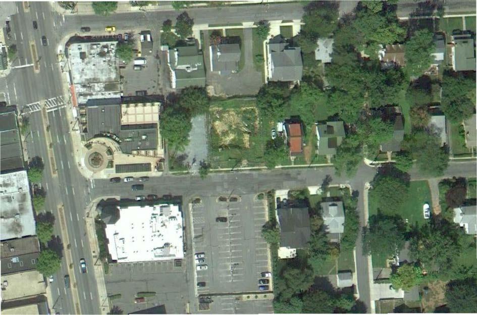
5 SECTION 1: CONTEXT AND PROPOSAL SITE DESCRIPTION Site Vicinity The C-T zoned property ( Site or Subject Property ) is located at 4705 West Virginia Avenue in Bethesda. The adjacent property to the west of the Subject Property is used as a parking lot for nearby commercial uses in the CBD-1 zone. Further west are commercial properties also zoned CBD-1. Immediately north of the application Site is a building that is residential in character but used as office space in the C-T zone. The adjacent property to the east is zoned R-60 and contains a single family detached residential dwelling unit. South of the Subject Property across West Virginia Avenue is a parking lot, Lot 44, which is owned and operated by Montgomery County. The Bethesda metro station is approximately a half mile south of the Site. Vicinity Map - 5 -
6 Site Analysis The Subject Property is a recorded lot and, therefore, a preliminary plan is not required. The Site, Lot 26, is 8,550 square feet in size and rectangular in shape, measuring approximately 90 feet wide and 94 feet deep, with about 90 feet of street frontage along West Virginia Avenue. The Site is relatively flat, and contains no forest, streams, wetlands, or environmental buffers. Site Aerial View PROJECT DESCRIPTION Previous Approvals The Montgomery County Planning Board conducted a public hearing for Local Map Amendment G-913 on November 1, 2012 pursuant to 59-H-1.1 of the Montgomery County Zoning Ordinance, to reclassify - 6 -
7 the 8,550 square foot lot from the R-60 Zone to the C-T Zone. The Planning Board recommended approval to the Hearing Examiner and submitted comments in a transmittal letter dated November 7, The Office of Zoning and Administrative Hearings held a public hearing for this application on November 16, 2012, in the Stella B. Werner Council Office Building at 100 Maryland Avenue, Rockville, Maryland. On January 22, 2013, by Resolution No , the County Council approved Local Map Amendment G- 913 and the associated Schematic Development Plan (SDP), in which existing Lot 26 was reclassified from the R-60 Zone to the C-T Zone. The re-zoning approval is subject to approval of a Site Plan and five binding elements: 1. Development and use shall be limited to 4,275 square feet floor area of development, with associated signage, parking, landscaping, lighting and infrastructure improvements. 2. The following height limitation shall apply to the development: up to 24 feet for the building. 3. The following minimum building setbacks shall apply: a) From West Virginia Avenue: 10 feet b) From all other lot lines: 15 feet 4. The following green area shall apply: minimum 10% 5. The property, including open space, will be subject to site plan review. General building, open space, parking locations, landscaping/lighting, and number of parking spaces to be determined at site plan. The parking layout is for illustrative purposes only and will be revised at site plan to improve residential scale, buffering, and compatibility. Proposal Building The 4,062 square foot building and associated commercial uses including office and showroom space have not changed from the approved SDP that was reviewed by the Planning Board in November The applicant is not proposing any construction or substantial changes to the current building at this time. Reclassification of the Subject Property to the C-T zone, with the associated binding elements, allows the applicant to use the two story structure as general office space rather than for residential purposes. The existing house footprint is centrally located on the lot and complies with the development standards of the C-T zone. It is set back 17.7 feet from the eastern property line, 15.2 feet from the western property line, 25.3 feet from the rear property line, and 25.1 feet from the West Virginia Avenue rightof-way. There are two existing asphalt parking areas located off of the street, one near the eastern property boundary and the other near the western property boundary, which the applicant proposes to retain to provide four on-site parking spaces. The Site is within the Bethesda Parking Lot District (PLD) and will make up for the difference in required spaces by paying the PLD tax
8 G-913 Schematic Development Plan - 8 -
.")
9 Front view of existing building from West Virginia Avenue Rear view of existing building Circulation Vehicular access to the Site is from West Virginia Avenue, where two parking areas are provided to accommodate four parking spaces (a west parking pad containing two standard spaces and an east parking pad containing one standard space and one handicap space). The handicap parking space is located so that direct access is available to the handicap ramp at the southeast corner of the building. All visitors will have access to the front door of the building and employees will utilize the front door and rear door of the building. The sidewalk and streetscape will be updated in accordance with the 1994 Bethesda CBD Sector Plan as modified for properties adjacent to residential communities. This requires - 9 -
10 widening the three foot wide concrete walk to be five feet in width, planting three street trees, and adding one streetlight. The sidewalk will be flush with the driveway entrances. These improvements will enhance the pedestrian connectivity of the Site to the Bethesda CBD and alert pedestrians to the transition from residential development to commercial development. Site Plan Landscape and Lighting Landscaping is concentrated primarily along the eastern property line to provide a visual buffer between the building and residential development to the east. Screening will be provided by planting a row of 12 evergreen trees that will be 6 to 7 feet in height. At the southeast building corner, the landscape plan shows a crepe myrtle tree at a minimum 10 foot height will be planted with ornamental landscaping at the base. At the southwest corner of the Site, a boxwood hedge with an ultimate height of 4 to 5 feet will be planted in a semicircular pattern. Along the front of the building a hedgerow of boxwoods is proposed along either side of the covered front porch. Three street trees in accordance with the Bethesda Streetscape standards will be planted within the right-of-way for West Virginia Avenue along the Subject Property s street frontage
11 Lighting fixtures include a hanging lantern at the front door in the covered porch area, a floodlight at the rear entry point and three hanging light fixtures along the rear façade of the building. One street light will be installed in accordance with the Bethesda Streetscape standards. The light pole will be 15 feet tall. Landscape Plan ADEQUATE PUBLIC FACILITIES On-Site and Off-Site Circulation Internal Site circulation is adequate. Staff anticipates that off-site circulation to and from the Subject Property will occur almost entirely from Wisconsin Avenue with minimal local traffic traveling through
12 the residential neighborhoods to the east and south via West Virginia Avenue and Maryland Avenue, respectively. Transportation Demand Management A traffic mitigation agreement is required because the subject Site is located in the Bethesda CBD Policy Area. Public Transit Service The Bethesda Metrorail Station is located within approximately ½ mile from the Site. In addition, bus service is available along Wisconsin Avenue via Metrobus routes J2, J3, and J7. Sector-Planned Roadway and Bikeway In accordance with the 1994 Bethesda CBD Sector Plan, West Virginia Avenue exists as a residential street with 60-foot wide right-of-way. No master planned bikeways are identified on West Virginia Avenue in either the Bethesda CBD Sector Plan or 2005 Countywide Bikeways Functional Master Plan. Pedestrian and Bicycle Facilities The existing pedestrian sidewalk is three feet-wide. The applicant proposes to upgrade the existing sidewalk, driveway aprons, and install bike one rack near the main entrance. Local Area Transportation Review (LATR) Since the proposed use will generate fewer than 30 peak-hour trips within the weekday morning and evening peak periods, the applicant submitted a traffic statement in lieu of a traffic impact study. The table below shows the number of peak-hour trips generated by the proposed general office use during the weekday morning peak period (6:30 to 9:30 a.m.) and the evening peak period (4:00 to 7:00 p.m.). Based on this analysis, the subject application satisfies the LATR requirements of the APF test. Square Peak-Hour Trips Land Use Footage or Morning Evening No. of Units Total New Total New Proposed General Office Space 3,625 SF Proposed Showroom (Misc. Service) 2,350 SF Displaced Density SFDU (Credit) 1 DU Net Increase in Site-Generated Trips Transportation Policy Area Review (TPAR) Since the proposed development is within the Bethesda CBD Policy Area, the project is exempt from both the roadway and transit tests set forth in the Subdivision Staging Policy. As a result, the proposed development is not required to pay transportation impact tax to satisfy the TPAR requirement. Other Public Facilities and Services Other public facilities and services are available and will be adequate to serve the proposed commercial uses. The Site is served by public water and sewer. Gas, electric, and telecommunications services are also available to serve the property. Police stations, firehouses, and health services are currently operating within the standards set by the effective Growth Policy Resolution. The application has been
13 reviewed by the Montgomery County Fire and Rescue Service, which has determined that the Subject Property will have adequate access for emergency vehicles upon the applicant s receipt of traffic orders prohibiting on-street parking in front of the Site on West Virginia Avenue. COMMUNITY OUTREACH The Applicant has met all proper signage, noticing, and submission meeting requirements. Staff has not received correspondence on this application as of the date of this report
14 SECTION 3: SITE PLAN REVIEW DEVELOPMENT STANDARDS The Subject Property was rezoned to the C-T Zone, Commercial Transitional, by Local Map Amendment G-913 and is subject to the Schematic Development Plan. The intent of the C-T zone is to provide sites for low-intensity commercial buildings which, singly or in groups, will provide an appropriate transition between one-family residential areas and high-intensity commercial development. (Sec. 59-C-4.301) The following table shows the application s conformance to the development standards of the zone and the approved Schematic Development Plan. Development Standard Permitted/Required Proposed Maximum Lot Coverage 30 percent Applicable Zoning Provision 31.9 percent 1 59-C-4.303(a) Maximum Building Height 24 ft 23 ft 59-C-4.303(a) Maximum Floor Area 0.5 FAR FAR 59-C Building Setback from Street Right-of-Way 10 ft 25.1 ft 59-C-4.305(a) Building Setback for Building w/ Windows (west side) Building Setback from Adjoining Residential Zone (east side) 15 ft 15 ft 15.2 ft 17.7 ft 59-C-4.305(b)(1) 59-C-4.305(b)(2) Minimum Green Area 10 percent percent 59-C Parking 11 spaces 2 4 spaces 59-C-4.307(b) and 59-E The building was legally constructed under the R-60 zoning standards which allow up to 35% lot coverage, therefore, the building is allowed to remain in this condition pursuant to Section 59-C-4.308(a). 2 Because this project is within a Parking Lot District, parking spaces are calculated to determine the total yield, but are not technically required to be provided on the site. The application is proposing to provide up to 4 spaces with the remainder to be satisfied through the PLD tax
15 FINDINGS 1. The site plan conforms to all non-illustrative elements of a development plan or diagrammatic plan, and all binding elements of a schematic development plan, certified by the Hearing Examiner under Section 59-D-1.64, or is consistent with an approved project plan for the optional method of development, if required, unless the Planning Board expressly modifies any element of the project plan. The Site Plan is subject to the binding elements of Development Plan Amendment LMA G-913: 1. Development and use shall be limited to 4,275 square feet floor area of development, with associated signage, parking, landscaping, lighting and infrastructure improvements. 2. The following height limitation shall apply to the development: up to 24 feet for the building. 3. The following minimum building setbacks shall apply: a) From West Virginia Avenue: 10 feet b) From all other lot lines: 15 feet 4. The following green area shall apply: minimum 10% 5. The property, including open space, will be subject to site plan review. General building, open space, parking locations, landscaping/lighting, and number of parking spaces to be determined at site plan. The parking layout is for illustrative purposes only and will be revised at site plan to improve residential scale, buffering, and compatibility. The site plan conforms to each of these binding elements. All of the development standards required by the binding elements have satisfied through the site plan application. The use and building style conform to the approved Schematic Development Plan (SDP) and, although the size of the parking areas has not been revised from that shown on the development plan, the proposed landscaping along the eastern property line and parking areas has been designed to achieve appropriate buffering and satisfactory compatibility. 2. The Site Plan meets all of the requirements of the zone in which it is located, and where applicable conforms to an urban renewal plan approved under Chapter 56. The proposed site plan includes a low-intensity commercial use that meets the purpose of the C- T zone. The development meets or exceeds all development standards as shown on the data table above. Regarding density, height, green area, and parking, the proposed development exceeds minimum requirements and is less than any allowed maximum restrictions. Regarding setbacks, the proposed structure and parking areas meet or exceed the minimum setbacks of the C-T Zone. 3. The locations of buildings and structures, open spaces, landscaping, recreation facilities, and pedestrian and vehicular circulation systems are adequate, safe, and efficient. a. Locations of buildings and structures Because of the specific requirements of the approved SDP, the buildings and structures have been reviewed to ensure conformance to the previous approval. The building continues to be adequately situated on Lot 26 with direct pedestrian access to the building from West Virginia
16 Avenue and the parking areas, similar in layout to a detached house with driveways to the side, ensuring safe and efficient use by employees and patrons. b. Open Spaces Open spaces are appropriately located on the subject Site. Green area generally serves as a front yard, creating a layout similar to a detached house, and as buffer areas along the side of the building. This arrangement of yard area and planting buffers is an adequate, safe, and efficient use of the space around the building and parking footprints. c. Landscaping and Lighting Landscaping and lighting are used in several ways. Landscaping is provided along the street to provide comfort for pedestrians; along the eastern edge of the property to provide a buffer between the C-T zone and R-60 zone; and along the front of the building and parking areas to achieve a more residential appearance. Lighting is used to illuminate building entrances and pedestrian areas. The landscape and lighting plan is an adequate, safe, and efficient use of plant material and lighting fixtures to respond to the context. d. Recreation Facilities No recreation facilities are required for this commercial development. e. Pedestrian and Vehicular Circulation Systems Vehicular circulation is limited to two access points for two parking pads. While this is not ideal, Staff recognizes the building was constructed in accordance with the R-60 zoning standards and the two parking areas were permitted at the time. Due to the now commercial nature of the Site, four on-site parking spaces for an approximate 4,000 square foot structure are not unreasonable. Pedestrian circulation simply allows comfortable and safe access from each edge of the Site, along the West Virginia Avenue frontage. One bicycle rack is adjacent to the western parking pad area near the front entrance in a safe, well-lit area for employees and patrons. The pedestrian and vehicular circulation systems are adequate, safe, and efficient and the direct connections to the larger network are obvious and direct. 4. Each structure and use is compatible with other uses and other site plans and with existing and proposed adjacent development. The area to the east of the Subject Property is residential in character, made up of a mix of older one-family homes as well as more recently redeveloped lots containing single-family homes zoned R-60. A commercial property zoned C-T is directly north of the Subject Property. The parking lots on the west and south of the Site are zoned CBD-1, and further west across Wisconsin Avenue is the Bethesda Central Business District. The proposal is compatible with adjacent development in the surrounding area with regards to the use and building location. The low-intensity commercial use is compatible and appropriate as a transition between the confronting and adjacent commercial uses and the residential neighborhood to the east. The height and density of the structure was constructed under R-60 zoning requirements and is the building is, therefore, residential in scale. Additional screening
17 and landscaping added at the edge of the parking pad area adjacent to the existing residential use facilitates greater compatibility. 5. The Site Plan meets all applicable requirements of Chapter 22A regarding forest conservation, Chapter 19 regarding water resource protection, and any other applicable law. a. Forest Conservation This property is subject to Chapter 22A, Montgomery County Forest Conservation Law, but is exempt from the requirement to submit a Forest Conservation Plan because the tract area is less than 40,000 square feet in size. There is neither existing forest nor tree save concerns associated with this request. b. Stormwater Management The Department of Permitting Services issued comments to the applicant on Februrary 21, 2013, and concluded that a stormwater management concept is not required since redevelopment of the site is not proposed. ATTACHMENTS: A. Resolution No for G-913 B. G-913 Technical Staff Report C. Planning Board November 7, 2012 Transmittal letter D. Agency Review
18
19
20
21
22
23
24
25
26
27
28
29 MONTGOMERY COUNTY PLANNING DEPARTMENT THE MARYLAND-NATIONAL CAPITAL PARK AND PLANNING COMMISSION MCPB Item No. 7 Date: Montgomery Avenue, Local Map Amendment, G-913 Erin Grayson, Senior Planner, Area 1, erin.grayson@montgomeryplanning.org, Robert Kronenberg, Acting Chief, Area 1, Robert.kronenberg@montgomeryplanning.org, Description Located at 4705 West Virginia Avenue, east of the intersection with Wisconsin Avenue R-60, 1994 Bethesda CBD Sector Plan, 8,550 square feet Requesting a Local Map Amendment with a Schematic Development Plan to rezone the property to C-T Applicant: 4311 Montgomery Avenue, LLC Submitted date: July 9, 2012 (ZHE) Hearing Examiner date: November 16, 2012 Completed: 10/19/12 Summary Staff Recommendation: Approval of the C-T Zone with the accompanying Schematic Development Plan The subject application consists of one lot, totaling 8,550 square feet, located at 4705 West Virginia Avenue in Bethesda. The applicant is requesting a rezoning of this area from the R-60 Zone to the C-T Zone. The lot is improved with a one-family detached residential dwelling unit. The zoning request for the C-T Zone proposes to retain the existing dwelling unit, and utilize C-T zone development standards that will allow for modest expansion in the future. The proposed use is general office. The application complies with the purpose clause of the C-T Zone, the proposed development is compatible with existing uses in the area, and the applicant s proposal is generally consistent with the 1994 Bethesda CBD Sector Plan recommendations for the site. Staff recommends that, if the application is approved, parking, landscaping, and screening undergo detailed review at the site plan stage.
30 RECOMMENDATION: Staff recommends approval of Local Map Amendment G-913 for the following reasons: 1) The proposed Local Map Amendment is consistent with the purpose clause of the C- T zone. 2) The proposed Local Map Amendment conforms to the Bethesda Central Business District ( CBD ) Sector Plan. 3) The requested Commercial-Transitional (C-T) zone is compatible with the surrounding uses. DATA SUMMARY Current Zone and Use: Purposed Zone and Use: Sector Plan Consistency: The site is zoned R-60 and developed with a one-family detached dwelling unit. The C-T zone is proposed for this site. The schematic development plan proposes general office use within the existing one-family dwelling unit on the site. The project complies with the recommendations contained in the Approved and Adopted Bethesda CBD Sector Plan. Maximum FAR: Required: 0.50; Existing Building Maximum Lot Coverage: Required: 30%; Existing Building 29.85% Minimum Green Area: Required: 10%; Existing Building 45.55% Building Height: Required: 24 ft.; Existing Building 23 ft. BACKGROUND The Applicant, 4311 Montgomery Avenue, LLC, for G-912 seeks a local map amendment (rezoning), pursuant to 59-H-1.1 of the Montgomery County Zoning Ordinance, to reclassify a 8,550 square foot lot from the R-60 Zone to the C-T Zone. The application was filed under the optional method of application process, which allows the applicant to restrict development standards or use of the property to less than the maximum permitted in the requested zone. Such binding limitations are shown on a schematic development plan that is submitted with the application, and these limitations, if approved, must also be reiterated in covenants filed in the land records of Montgomery County. The Office of Zoning and Administrative Hearings has scheduled a public hearing date for this application on November 16, 2012, in the Stella B. Werner Council Office Building at 100

31 Maryland Avenue, Rockville, Maryland. Before the Hearing Examiner s proceedings, the Montgomery County Planning Board will conduct a public hearing of the application on November 1, 2012, at 8787 Georgia Avenue, Silver Spring, Maryland. DESCRIPTION OF PROPERTY The subject site is located at 4705 West Virginia Avenue in Bethesda. The site, Lot 26, is 8,550 square feet in size and rectangular in shape, measuring approximately 90 feet wide and 94 feet deep, with about 90 feet of street frontage along West Virginia Avenue. The property is relatively flat. The adjacent property to the west of the subject site is used as a parking lot for nearby commercial uses in the CBD-1 zone. Further west are commercial properties also zoned CBD-1. Immediately north of the subject site is a building that is residential in character but 2

32 used as office space in the C-T zone. The adjacent property to the east is zoned R-60 and contains a one-family detached residential dwelling unit. South of the subject site across West Virginia Avenue is a parking lot, Lot 44, which is owned and operated by Montgomery County. The Bethesda metro station is approximately 1600 feet away. Front view of Lot 26 from West Virginia Avenue Rear view of Lot 26 3
33 SURROUNDING AREA A surrounding area must be identified in a floating zone application so compatibility can be properly evaluated. For the subject site, the surrounding area is generally formed by Wisconsin Avenue to the west, Highland Avenue to the north, Maryland Avenue to the east, and Chase Avenue on the south. This area is appropriate for determining whether the proposed zone will be compatible with surrounding uses because it uses Wisconsin Avenue, which is a major arterial roadway, as a clear demarcation between more dense development to the west of the roadway and less dense development on the east. The boundary also captures surrounding properties that may be affected by the rezoning. An aerial image of the selected neighborhood is depicted on the following page. The area to the east of the defined neighborhood is residential in character, made up of a mix of older one-family homes as well as more recently redeveloped lots containing single-family homes zoned R-60. A commercial property zoned C-T is directly north of the subject property. The parking lots on the west and south of the subject property are zoned CBD-1, and further west across Wisconsin Avenue is the Bethesda Central Business District. 4

34 Selected Neighborhood PROPOSAL The applicant is not proposing any construction or changes to the current building on the property at this time, however, the applicant has introduced binding elements that will allow for expansion of the 4,062 square foot building in the future to a building of up to 4,275 square feet in size. The C-T zone, with the proposed binding elements, would allow the applicant to use the two story structure as general office space rather than for residential purposes. The existing house footprint is centrally located on the lot and complies with the development standards of the R-60 zone. It is set back 17.7 feet from the eastern property line, 15.2 feet from the western property line, 25.3 feet from the rear property line, and 25.1 feet from the 5
35 West Virginia Avenue right-of-way. There are two existing asphalt parking areas located off of the street, one near the eastern property boundary and the other near the western property boundary, which the applicant proposes to retain to provide five on-site parking spaces. The site is within the parking lot district and therefore no parking is required on-site. The applicant s schematic development plan differentiates between elements of the proposal that are legally binding and elements that are merely illustrative. 1 The applicant has proposed binding elements to the schematic development plan that will allow for minimal expansion in the future. The proposed binding elements for the subject application are listed below, followed by the illustrative portion of the plan. 1. Development and use shall be limited to 4,275 square feet floor area of development, with associated signage, parking, landscaping, lighting and infrastructure improvements. 2. The project shall be developed in one phase. 3. The following height limitation shall apply to the development: up to 24 feet for the building. 4. The following minimum building setbacks shall apply: a) From West Virginia Avenue: 10 feet b) From all other lot lines: 15 feet 5. The following green area shall apply: minimum 10% 6. The property, including open space, will be subject to site plan review. General building, open space, parking locations, landscaping/lighting, and number of parking spaces to be determined at site plan H-2.5 6
36 Illustrative Portion of Schematic Development Plan Staff supports these binding elements, with the exception of binding element #2. Binding element #2 is unnecessary since the existing building is proposed to remain on the site and the other binding elements allow for potential expansion in the future. Additional square footage can be constructed in the future, per provision 59-C-4.302(a) and (c) of the Zoning Ordinance, which relates to new construction, re-use of existing building, remodeling, and reconstruction in the C-T zone. The provision states: (a) For new construction, a building permit can be issued only on a lot with a minimum front lot line of 100 feet on a public street. For this purpose, new construction does not include either remodeling an existing structure or reconstruction as the result of fire or other catastrophe, as regulated in paragraphs (c) and (d) below. 7
37 Paragraph (c) is applicable in this case, which states: (c) For remodeling of a building existing at the time the C-T zone is granted, the board may, at the time of site plan approval, approve an expansion of the gross floor area of the building, provided the increase: (1) Is compatible with neighboring residential and commercial uses; and (2) Does not exceed 40 percent. The project has 90 feet of street frontage, but this is permissible since the existing building will remain and new construction is not proposed. Any future building addition will be capped at 213 square feet per the binding elements and thus fall under the definition of remodeling for the C-T zone. If the rezoning is approved and the project proceeds to site plan and the site plan includes only the existing building footprint, any future addition to the building will trigger further site plan review, which could help ensure the building retains its residential character. C-T ZONE PURPOSE CLAUSE 59-C Purpose. The purpose of the C-T zone is to provide sites for low-intensity commercial buildings which, singularly or in groups, will provide an appropriate transition between one-family residential areas and high-intensity commercial development. The C-T zone is intended to constitute a margin of limited width at the border between a commercial area and a one-family residential area. For that reason, the C-T zone can only be applied: (a) In areas designated for the C-T zone on adopted and approved master or sector plans; or (b) On property so located that it is between and adjoining or separated only by a street, highway, or utility right-of-way from both of the following uses: (1) Existing or proposed one-family residential uses; and (2) Existing high-intensity commercial uses. As used herein, the term "high-intensity commercial use" refers to any commercial or central business district development with an existing height that is greater than 40 feet. The term "high-intensity commercial use" does not include development in the C-1 zone. In other words, to satisfy the purpose clause of the C-T zone, one of two possible locational requirements must be met: The proposed rezoning must (1) be designated for the C-T Zone in the relevant master or sector plan, or (2) be proposed on a property that acts as a buffer between single-family residential homes and high intensity commercial areas with buildings taller than 40 feet. Staff does conclude that the subject property is recommended for the C-T Zone in the Bethesda CBD Sector Plan, for the reasons discussed in the Master Plan compliance section of this report. 8

38 The second requirement is not applicable because the adjacent parking lot on Lot 17 does not qualify as a high intensity commercial use. The adjacent parking lot is shown in the following picture. Parking lot on Adjacent Lot 17 DEVELOPMENT STANDARDS The application and associated schematic development plan satisfy the development standards of the C-T zone, as described in the chart on the following page. 9
39 Development Standard Permitted/Required Proposed Maximum Lot Coverage 30 percent Applicable Zoning Provision percent 59-C-4.303(a) Maximum Building Height 24 ft 23 ft 59-C-4.303(a) Maximum Floor Area 0.5 FAR FAR 59-C Building Setback from Street Right-of-Way 10 ft 25.1 ft 59-C-4.305(a) Building Setback for Building w/ Windows (west side) Building Setback from Adjoining Residential Zone (east side) 15 ft 15 ft 15.2 ft 17.7 ft 59-C-4.305(b)(1) 59-C-4.305(b)(2) Minimum Green Area 10 percent percent 59-C Parking None required 5 spaces 59-C-4.307(b) and 59-E-3.7 The building on the property has been constructed to the dimensions included in the chart above, however the applicant requests that binding elements that restrict the applicant only to the dimensions required by the zone be included. Greater flexibility will allow the applicant to make minor additions or alterations to the building in the future, if necessary. SECTOR PLAN CONFORMANCE 1994 Bethesda CBD Sector Plan The 1994 Approved and Adopted Bethesda CBD Sector Plan ( Plan ) recommends the subject site be zoned C-T with either retail and service employment (Figure 4.25, page 104) or lowdensity office employment (Figure 4.27, page 110). The applicant s request adheres to these recommendations. Furthermore, the Plan gives more specific recommendations for the subject property as well as other nearby properties in what is defined as the East Bethesda Transition Area on page 107 of the Plan. The Plan states that this area forms a transition between the single family houses of 10
40 East Bethesda and the Central Business District, and is characterized by low-density, primarily residential development, green open spaces, and paved parking lots screened with landscaping. On page 108 of the Plan, the plan goes into greater detail about the section of single-family houses between Chestnut Street and West Virginia Avenues. Long-term stability of the area is a raised as an issue because it is unknown whether these houses will be well maintained in a safe and relatively quiet neighborhood. Three objectives were identified: 1. Ensure the stability of land uses in the transition area to preserve East Bethesda as a single family neighborhood. 2. Provide parking to serve the needs of the adjacent commercial establishments. Keep overflow parking and cut-through traffic from having an undesirable impact on the East Bethesda neighborhood. 3. Provide low-density housing. This proposal to rezone the subject site from the R-60 to the C-T zone will contribute to the stability of land uses by confirming future office use on the site. The applicant improved the property when they replaced an underutilized parking area with the existing residential structure. The 4,062 square foot structure provides a strong street presence and an opportunity to meet the needs of a small business and continue as a stable use in the transition area. The applicant is providing five parking spaces on-site. There are also two on-street parking spaces along the site s West Virginia Avenue frontage and a public parking lot is located across the street for easy visitor access. Across West Virginia Avenue, there is a public parking lot where visitors to the building will also have the option to park. This public parking lot and the private parking lot next to the site supplement parking for the more dense development along Wisconsin Avenue. The applicant is not providing housing but the proposed use as an office in a one family house serves as an adequate transition to low-density housing. Transitions like this building will add to the aesthetic appeal of West Virginia Avenue as one drives eastward to reach one family homes in the neighborhood. 11
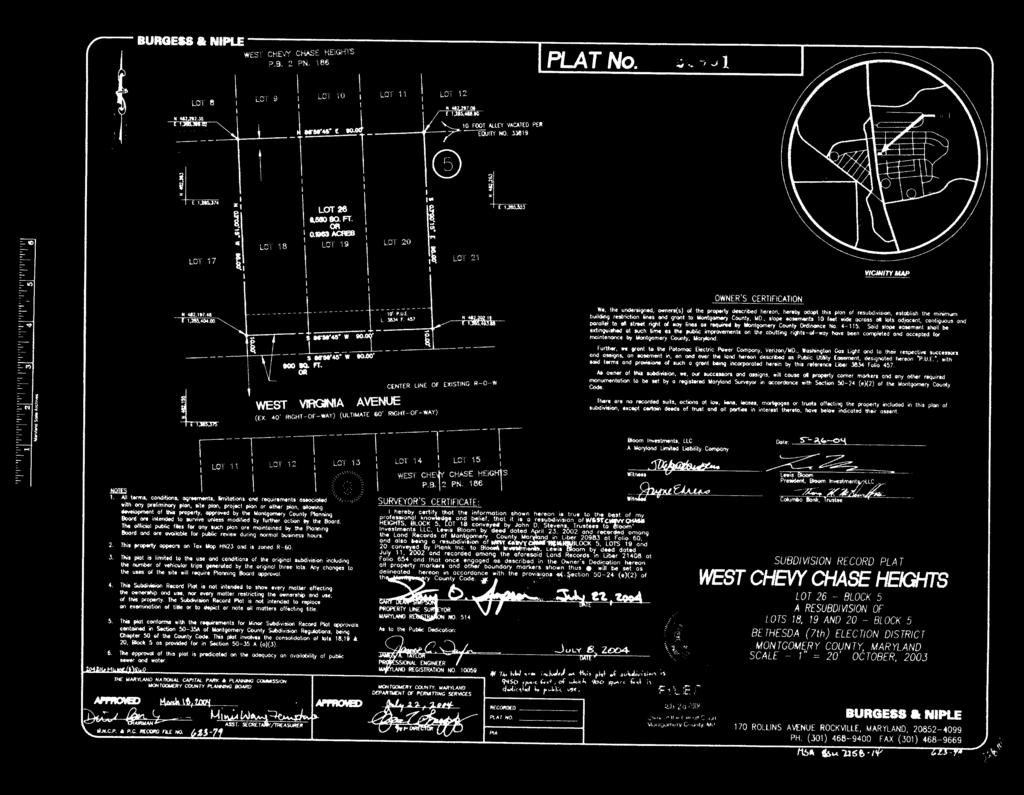
41 The Plan provides additional detail with regards to the application site. More specifically, the following excerpt refers to the subject property on page 109 of the Plan: The Plan also retains the 1976 Plan recommendation for R-60 (C-T) zoning for Lots 18, 19, and 20 (block 5) on the north side of West Virginia Avenue. Applications for C-T zoning on these lots will be considered to be in accordance with the Sector Plan for individual parcels. Where an existing structure is on more than one lot or where a structure previously existed on two lots as on Lots 19 and 20 (block 5), these lots should be considered a single lot. Otherwise, if assembly should take place, C-T zoning would not be considered favorably. Any additions or expansions of existing structures or any new construction should be residential in scale and character to achieve compatibility with the adjacent single-family houses. The property was recorded by plat on May 26, 2004 that combined lots 18, 19 and 20 to create Lot 26 in the West Chevy Chase Heights subdivision (Attachment A). Originally, one house crossed the boundary of lots 19 and 20 and another house was located on lot 18. Prior to recordation, the house on lots 19 and 20 was demolished and the property was used as a parking area. The house on what was previously lot 18 remained until the applicant purchased lot 26 in October of 2011 and demolished the one and a half story one-family dwelling unit that was built in Following demolition of that house in 2011, a new one-family detached residential dwelling unit was constructed on lot 26. The existing house is two stories and 4,062 square feet in size. 12

42 A different individual combined Lots 18, 19, and 20, block 5, and recorded the plat for Lot 26 on May 26, Lot 26 was recorded as R-60 zoned property as a single lot at that time. The applicant purchased Lot 26 in 2011, and now seeks zoning approval from R-60 to C-T for a single lot. Because the site was one lot zoned R-60 at the time of application submittal, staff must review the subject property as a single lot rather the than three previous individual parcels. The construction that took place on the lot in 2012 to build the existing structure occurred under the R-60 zoning classification. The concern for consolidation in the plan was to prevent consolidation and then redevelopment under the C-T standards to a commercial scale. But the applicant purchased a previously consolidated lot and redeveloped the property under the R-60 standards. The dwelling unit is residential in scale and has the appearance of a house on every facade. The applicant has proposed a binding element to cap the square footage of the building at 4,275 square feet, and any addition to the building in the future will trigger site plan review. On page 106 of the Bethesda CBD Sector Plan, Urban Design Guidelines designate West Virginia Avenue from Wisconsin Avenue to Tilbury Street as a local pedestrian path. The applicant has constructed a 5 foot wide sidewalk along the site frontage but has not planted any street trees. The placement of street trees along the site s West Virginia Avenue street frontage would satisfy the intent of the Urban Design Guidelines of the Sector Plan. Staff suggests that if the rezoning is approved, the applicant be required to plant street trees as part of site plan review. 13
43 In conclusion, the subject property can be rezoned to the C-T zone in accordance with the Master Plan recommendations. COMPATIBILITY The proposal is compatible with adjacent development in the surrounding area with regards to the use and building location. The parking, however, is not residential in scale. Two curb cuts that are double wide are present on the property, but other lots in the defined residential neighborhood do not contain curb cuts of this width and number. Staff suggests the parking areas be further reviewed as site plan, if the application is approved. Additional screening and landscaping should be a consideration in the future to achieve greater compatibility. The applicant has submitted an exhibit to demonstrate the existing building is residential in scale and character and compatible with the adjacent single-family houses in the R-60 zone. The applicant emphasizes in the exhibit that the existing dwelling unit is appropriate for the Commercial Transitional zone as a transitional use between more intense CBD-1 uses and R-60 one-family homes. The applicant s exhibit is included in attachment C. PUBLIC INTEREST The C-T Zone requires that the proposed rezoning bear sufficient relationship to the public interest to justify its approval. When evaluating the public interest it is customary to consider master plan conformance and other public interest factors such as adverse impacts on public facilities or the environment. The proposed rezoning of the application site bears sufficient relationship to the public interest. Construction of the primary structure has been completed and there will be no additional demands on public utilities or further adverse environmental impacts. The proposal substantially conforms to the applicable recommendations in the Bethesda CBD Sector Plan. COMMUNITY CORRESPONDENCE The Applicant has met all proper signage, noticing, and submission meeting requirements. Staff has not received correspondence on either application as of the date of this report. ADDITIONAL CONSIDERATIONS Adequate Public Facilities Water and Sewer. Public water and sewer connections were established when the applicant constructed the building earlier this year. Since no further building modifications or additions are proposed at this time, the Washington Suburban Sanitary Commission (WSSC) did not comment on the application. 14
44 Transportation and Roadways. A full APF test for the site will be required at site plan. The proposed development is expected to generate a maximum of eight weekday peak hour trips during the morning and evening weekday periods. Schools. Staff has not received comments from Montgomery County Public Schools (MCPS) regarding the proposal s potential impact on the school system. However, due to the commercial nature of the application, no impact should result on the school system. Environment There are no environmental features of concern on this proposal, as outlined in the Environmental Planning Interoffice Memorandum included in Attachment D. CONCLUSION Staff recommends that Local Map Amendment G-913 be approved with the revised binding elements proposed by Staff, listed below. 1. Development and use shall be limited to 4,275 square feet floor area of development, with associated signage, parking, landscaping, lighting and infrastructure improvements. 2. The following height limitation shall apply to the development: up to 24 feet for the building. 3. The following minimum building setbacks shall apply: a) From West Virginia Avenue: 10 feet b) From all other lot lines: 15 feet 4. The following green area shall apply: minimum 10% 5. The property, including open space, will be subject to site plan review. General building, open space, parking locations, landscaping/lighting, and number of parking spaces to be determined at site plan. ATTACHMENTS A. Record Plat B. Schematic Development Plan C. Applicant s Compatibility Exhibit D. Transportation Planning Interoffice Memorandum E. Environmental Planning Interoffice Memorandum 15
45
46
47
48 IMMEDIATE NEIGHBORHOOD BUILDING SITES Address Lot Description Block Subdivision Zoning Enclosed Area (sq. ft.) 1 Site 4705 West Virginia Avenue Lot 26 5 West Chevy Chase Heights C T 2 3, Wisconsin Avenue Pt. of Lot 3 5 West Chevy Chase Heights CBD 1 1, Wisconsin Avenue Pt. of Lot 3 5 West Chevy Chase Heights CBD Wisconsin Avenue Pt. of Lot 2 / Pt. of Lot 3 5 West Chevy Chase Heights CBD 1 1, Wisconsin Avenue Pt. of Lot 1 / Pt. of Lot 2 5 West Chevy Chase Heights CBD 1 1, Wisconsin Avenue Pt. of Lot 1 5 West Chevy Chase Heights CBD 1 1, Highland Avenue Lot 7 / Lot 8 / Pt. of Abandoned Alley 5 West Chevy Chase Heights CBD 1 2, Highland Avenue Lots 9 11 / Pt. of Abandoned Alley 5 West Chevy Chase Heights C T 2, Highland Avenue Lot 28 5 West Chevy Chase Heights R 60 3, Highland Avenue Lot 14 / Lot 15 / Abandoned Alley 5 West Chevy Chase Heights R 60 1, Wisconsin Avenue Lot 25 5 West Chevy Chase Heights CBD 1 12, West Virginia Avenue Lot 27 5 West Chevy Chase Heights CBD 1 N/A West Virginia Avenue Lot 21 / Lot 22 / Pt. of Abandoned Alley 5 West Chevy Chase Heights R 60 1, West Virginia Avenue Lot 23 / Lot 24 / Abandoned Alley 5 West Chevy Chase Heights R 60 1, Wisconsin Avenue Pt. of Lots West Chevy Chase Heights CBD 1 9, Parking for 7901 Wisconsin Avenue Pt. of Lot 4 / Pt. of Lot 5 9 West Chevy Chase Heights CBD 1 N/A 12 Public Parking on West Virginia Ave. Lot 11 / Lot 12 9 West Chevy Chase Heights CBD 1 N/A 13 Public Parking on West Virginia Ave. Lot 13 / Lot 14 9 West Chevy Chase Heights CBD 1 N/A West Virginia Avenue Lot 29 9 West Chevy Chase Heights R 60 4, West Virginia Avenue Lot 28 9 West Chevy Chase Heights R 60 1,624 1 Enclosed area based on available Tax Record Data as of 10/02/ Proposed zoning
 Enclosed Area (Sq. Ft.")
49 SITE 4705 West Virginia Avenue Lot 26, Block 5 West Chevy Chase Heights Zoning: R 60 (Proposed CT) Enclosed Area (Sq. Ft.): 3,780

50 Wisconsin Avenue Pt. of Lot 3, Block 5 West Chevy Chase Heights Zoning: CBD 1 Enclosed Area (Sq. Ft.): 1,560

51 Wisconsin Avenue Pt. of Lot 3, Block 5 West Chevy Chase Heights Zoning: CBD 1 Enclosed Area (Sq. Ft.): 936

52 Wisconsin Avenue Pt. of Lot 2 / Pt. of Lot 3, Block 5 West Chevy Chase Heights Zoning: CBD 1 Enclosed Area (Sq. Ft.): 1,404

53 Wisconsin Avenue Pt. of Lot 1 / Pt. of Lot 2, Block 5 West Chevy Chase Heights Zoning: CBD 1 Enclosed Area (Sq. Ft.): 1,560

54 Wisconsin Avenue Pt. of Lot 1, Block 5 West Chevy Chase Heights Zoning: CBD 1 Enclosed Area (Sq. Ft.): 1,560

55 Highland Avenue Lot 7 / Lot 8 / Pt. of Abandoned Alley, Block 5 West Chevy Chase Heights Zoning: CBD 1 Enclosed Area (Sq. Ft.): 2,770

56 Highland Avenue Lots 9 11 / Pt. of Abandoned Alley, Block 5 West Chevy Chase Heights Zoning: C T Enclosed Area (Sq. Ft.): 2,022

57 Highland Avenue Lot 28, Block 5 West Chevy Chase Heights Zoning: R 60 Enclosed Area (Sq. Ft.): 3,769

58 Highland Avenue Lot 14 / Lot 15 / Abandoned Alley, Block 5 West Chevy Chase Heights Zoning: R 60 Enclosed Area (Sq. Ft.): 1,380 * *May not reflect building permit issued in 1993

59 Wisconsin Avenue Lot 25, Block 5 West Chevy Chase Heights Zoning: CBD 1 Enclosed Area (Sq. Ft.): 12,263

60 West Virginia Avenue Lot 27, Block 5 West Chevy Chase Heights Zoning: CBD 1 Enclosed Area (Sq. Ft.): N/A

61 West Virginia Avenue Lot 21 / Lot 22 / Pt. of Abandoned Alley, Block 5 West Chevy Chase Heights Zoning: R 60 Enclosed Area (Sq. Ft.): 1,312 * *May not reflect building permits issued in 2009 and/or 2011

62 West Virginia Avenue Lot 23 / Lot 24 / Abandoned Alley, Block 5 West Chevy Chase Heights Zoning: R 60 Enclosed Area (Sq. Ft.): 1,664

63 Wisconsin Avenue Pt. of Lots 1 3, Block 9 West Chevy Chase Heights Zoning: CBD 1 Enclosed Area (Sq. Ft.): 9,291

64 11 Parking for 7901 Wisconsin Avenue Pt. of Lot 4 / Pt. of Lot 5, Block 9 West Chevy Chase Heights Zoning: CBD 1 Enclosed Area (Sq. Ft.): N/A

65 12 Public Parking on West Virginia Ave. Lot 11 / Lot 12, Block 9 West Chevy Chase Heights Zoning: CBD 1 Enclosed Area (Sq. Ft.): N/A

66 13 Public Parking on West Virginia Ave. Lot 13 / Lot 14, Block 9 West Chevy Chase Heights Zoning: CBD 1 Enclosed Area (Sq. Ft.): N/A

67 West Virginia Avenue Lot 29, Block 9 West Chevy Chase Heights Zoning: R 60 Enclosed Area (Sq. Ft.): 4,048

68 West Virginia Avenue Lot 28, Block 9 West Chevy Chase Heights Zoning: R 60 Enclosed Area (Sq. Ft.): 1,624
69
70
71
72
73

74
75
76
77
78
79
MONTGOMERY COUNTY PLANNING DEPARTMENT THE MARYLAND-NATIONAL CAPITAL PARK AND PLANNING COMMISSION
 MONTGOMERY COUNTY PLANNING DEPARTMENT THE MARYLAND-NATIONAL CAPITAL PARK AND PLANNING COMMISSION MCPB Item No. Date: 3.10.2016 Site Plan 820160040 Nora School Parker Smith, Planning Technician, Area 1,
MONTGOMERY COUNTY PLANNING DEPARTMENT THE MARYLAND-NATIONAL CAPITAL PARK AND PLANNING COMMISSION
 MONTGOMERY COUNTY PLANNING DEPARTMENT THE MARYLAND-NATIONAL CAPITAL PARK AND PLANNING COMMISSION MCPB Item No. Date: 12-10-15 Leisure World Clubhouse II Addition Fitness Center, Limited Site Plan Amendment
MONTGOMERY COUNTY PLANNING DEPARTMENT THE MARYLAND-NATIONAL CAPITAL PARK AND PLANNING COMMISSION
 MONTGOMERY COUNTY PLANNING DEPARTMENT THE MARYLAND-NATIONAL CAPITAL PARK AND PLANNING COMMISSION MCPB Item No. Date: 06-12-14 King of the Nations Christian Fellowship Church: Limited Site Plan Amendment
MONTGOMERY COUNTY PLANNING DEPARTMENT THE MARYLAND-NATIONAL CAPITAL PARK AND PLANNING COMMISSION
 MONTGOMERY COUNTY PLANNING DEPARTMENT THE MARYLAND-NATIONAL CAPITAL PARK AND PLANNING COMMISSION The Goddard School in North Bethesda Preliminary Plan Amendment 11996015B and Site Plan Amendment 82006005A
MONTGOMERY COUNTY PLANNING DEPARTMENT THE MARYLAND-NATIONAL CAPITAL PARK AND PLANNING COMMISSION
 MONTGOMERY COUNTY PLANNING DEPARTMENT THE MARYLAND-NATIONAL CAPITAL PARK AND PLANNING COMMISSION MCPB Item No.: 2 Date: 12-19-13 Site Plan 820140020, 8001 Newell Street Neil Braunstein, AICP, Area 1, neil.braunstein@montgomeryplanning.org,
MONTGOMERY COUNTY PLANNING DEPARTMENT THE MARYLAND-NATIONAL CAPITAL PARK AND PLANNING COMMISSION
 MONTGOMERY COUNTY PLANNING DEPARTMENT THE MARYLAND-NATIONAL CAPITAL PARK AND PLANNING COMMISSION MCPB Item No. Date: 05-22-14 Consent Item - Park Potomac: Site Plan Amendment No. 82004015K MCS. Molline
MONTGOMERY COUNTY PLANNING DEPARTMENT
 MONTGOMERY COUNTY PLANNING DEPARTMENT THE MARYLAND-NATIONAL CAPITAL PARK AND PLANNING COMMISSION MCPB Item No.: Date: 5-03-18 Pike and Rose, Phase I: Site Plan Amendment No. 82012002D Rhoda Hersson-Ringskog,
MONTGOMERY COUNTY PLANNING DEPARTMENT THE MARYLAND-NATIONAL CAPITAL PARK AND PLANNING COMMISSION
 MONTGOMERY COUNTY PLANNING DEPARTMENT THE MARYLAND-NATIONAL CAPITAL PARK AND PLANNING COMMISSION MCPB Item No. 4 7/18/13 4990 Fairmont Avenue, Project Plan 920130070 & Preliminary Plan 120130230 Erin Grayson,
12 January 12, 2011 Public Hearing APPLICANT: TAILWIND DEVELOPMENT GROUP,LLC PROPERTY OWNER: CITY OF VIRGINIA BEACH
 12 January 12, 2011 Public Hearing APPLICANT: TAILWIND DEVELOPMENT GROUP,LLC PROPERTY OWNER: CITY OF VIRGINIA BEACH STAFF PLANNER: Faith Christie REQUEST: Conditional Change of Zoning (from PD-H1 Planned
Clarksburg Square Road Extension
 Clarksburg Square Road Extension Preliminary Plan No. 120140060 Site Plan No. 820140050 Site Plan Amendment No. 82007022C (Clarksburg Town Center) Clarksburg SPA Water Quality Plan Mandatory Referral MR2015008
MONTGOMERY COUNTY PLANNING DEPARTMENT THE MARYLAND-NATIONAL CAPITAL PARK AND PLANNING COMMISSION
 MONTGOMERY COUNTY PLANNING DEPARTMENT THE MARYLAND-NATIONAL CAPITAL PARK AND PLANNING COMMISSION MCPB Item No. 3 4/3/14 4990 Fairmont Avenue, Site Plan 820140060 Erin Banks, AICP, Senior Planner, Area
R E S O L U T I O N. Single-Family Residence/ Church. 2,488 sq. ft. 2,488 sq. ft. Area Parking Required: Church
 R E S O L U T I O N WHEREAS, the Prince George s County Planning Board is charged with the approval of Detailed Site Plans pursuant to Part 3, Division 9 of the Zoning Ordinance of the Prince George s
MONTGOMERY COUNTY PLANNING DEPARTMENT THE MARYLAND NATIONAL CAPITAL PARK AND PLANNING COMMISSION
 MONTGOMERY COUNTY PLANNING DEPARTMENT THE MARYLAND NATIONAL CAPITAL PARK AND PLANNING COMMISSION MCPB Item No. 8 Date: 3.30.2017 Project Name: Lot 31/31A Bethesda, Site Plan Amendment, No. 82007018C Elza
MONTGOMERY COUNTY PLANNING DEPARTMENT
 MONTGOMERY COUNTY PLANNING DEPARTMENT THE MARYLAND-NATIONAL CAPITAL PARK AND PLANNING COMMISSION MCPB Item No. Date: 04/05/2018 850 Sligo Avenue Sketch Plan No. 320180090 Neil Sullivan, Planner Coordinator,
I. Introduction. Prior Approvals
 Statement of Justification First National Bank 19790 Crystal Rock Drive, Germantown, Maryland Application for Site Plan and Limited Preliminary Plan Amendment I. Introduction DPH Architecture, for First
The subject site plan amendment proposes the following revisions to the approved site plan:
 PROPOSED AMENDMENT The subject site plan amendment proposes the following revisions to the approved site plan: 1. The building footprint was modified to accommodate the revised architectural design. 2.
Request Change in Nonconformity. Staff Recommendation Approval. Staff Planner Jonathan Sanders
 Applicant & Owner Public Hearing April 11, 2018 City Council Election District Beach Agenda Item 5 Request Change in Nonconformity Staff Recommendation Approval Staff Planner Jonathan Sanders Location
MONTGOMERY COUNTY PLANNING DEPARTMENT Newell Street. Site Plan Item #2. Maryland-National Capital Park and Planning Commission
 8001 Newell Street Site Plan 820140020 Item #2 December 19, 2013 Redlined Conditions 1. The Applicant must comply with the conditions of approval for Project Plan 920130020 in MCPB Resolution No. 13-74.
MONTGOMERY COUNTY PLANNING DEPARTMENT THE MARYLAND-NATIONAL CAPITAL PARK AND PLANNING COMMISSION
 MONTGOMERY COUNTY PLANNING DEPARTMENT THE MARYLAND-NATIONAL CAPITAL PARK AND PLANNING COMMISSION MCPB Item No. Date: 05/12/2016 North Bethesda Conference Center Parking Structure, Mandatory Referral No.
MONTGOMERY COUNTY PLANNING DEPARTMENT THE MARYLAND-NATIONAL CAPITAL PARK AND PLANNING COMMISSION
 MONTGOMERY COUNTY PLANNING DEPARTMENT THE MARYLAND-NATIONAL CAPITAL PARK AND PLANNING COMMISSION MCPB Item No. Date: 1/15/2015 Bethesda North Marriott Hotel and Conference Center: Limited Site Plan Amendment
Description. Summary. MCPB Item No. Date: 01/17/13. Bethesda Crescent, Limited Site Plan Amendment, A, A
 THE MARYLAND-NATIONAL CAPITAL PARK AND PLANNING COMMISSION MCPB Item No. Date: 01/17/13 Bethesda Crescent, Limited Site Plan Amendment, 81984005A, 81984003A Parag Agrawal, Senior Planner, parag.agrawal@montgomeryplanning.org,
MONTGOMERY COUNTY PLANNING DEPARTMENT THE MARYLAND-NATIONAL CAPITAL PARK AND PLANNING COMMISSION
 MONTGOMERY COUNTY PLANNING DEPARTMENT THE MARYLAND-NATIONAL CAPITAL PARK AND PLANNING COMMISSION MCPB Item No. Date: 9-4-13 Limited Site Plan Amendment No. 81994026B, Darcars at Montgomery Industrial Park,
Planning Commission Staff Report June 5, 2008
 Owner/Applicant Taylor Village Sacramento Investments Partners, LP c/o Kim Whitney 1792 Tribute Road #270 Sacramento, CA 95815 Staff Recommendation Planning Commission Staff Report Project: File: Request:
MONTGOMERY COUNTY PLANNING DEPARTMENT THE MARYLAND NATIONAL CAPITAL PARK AND PLANNING COMMISSION
 MONTGOMERY COUNTY PLANNING DEPARTMENT THE MARYLAND NATIONAL CAPITAL PARK AND PLANNING COMMISSION MCPB Item No. Date: 5.3.18 8000 Wisconsin Avenue Sketch Plan No. 320180120 Matthew Folden, Planner Coordinator,
STATEMENT OF JUSTIFICATION CLARKSBURG PREMIUM OUTLETS AT CABIN BRANCH NORTH DISTRICT, PHASE
 STATEMENT OF JUSTIFICATION CLARKSBURG PREMIUM OUTLETS AT CABIN BRANCH NORTH DISTRICT, PHASE 1 Southwest Corner of Clarksburg Road and Interstate-270 Clarksburg, Maryland Application for Site Plan #820140160
MONTGOMERY COUNTY PLANNING DEPARTMENT THE MARYLAND-NATIONAL CAPITAL PARK AND PLANNING COMMISSION
 MONTGOMERY COUNTY PLANNING DEPARTMENT THE MARYLAND-NATIONAL CAPITAL PARK AND PLANNING COMMISSION 8015 Old Georgetown Road, Preliminary Plan 120160220, Site Plan 820160090 MCPB Item No.: 8 Date: 11-03-16
PLANNED UNIT DEVELOPMENT Date: April 5, 2018
 PLANNED UNIT DEVELOPMENT Date: April 5, 2018 DEVELOPMENT NAME SUBDIVISION NAME LOCATION Robert Myers Robert Myers 2955 and 2989 Dauphin Street (Southeast corner of Dauphin Street and Sage Avenue) CITY
Project Name: MELWOOD HOTEL. Date Accepted: 1/12/04. Waived. Planning Board Action Limit: Plan Acreage: 1.7 Zone: Dwelling Units:
 The Maryland-National Capital Park and Planning Commission Prince George's County Planning Department Development Review Division 301-952-3530 Note: Staff reports can be accessed at www.mncppc.org/pgco/planning/plan.htm.
Request Alternative Compliance to the prescribed criteria of the Oceanfront Resort District Form-Based Code. Staff Planner Kristine Gay
 Applicant/Owner Ocean Rental Properties, LLC Public Hearing April 13, 2016 City Council Election District Beach Agenda Item 1 Request Alternative Compliance to the prescribed criteria of the Oceanfront
AWH REPORT OF THE PLANNING AND DEVELOPMENT DEPARTMENT FOR APPLICATION FOR REZONING ORDINANCE TO PLANNED UNIT DEVELOPMENT
 AWH REPORT OF THE PLANNING AND DEVELOPMENT DEPARTMENT FOR APPLICATION FOR REZONING ORDINANCE TO PLANNED UNIT DEVELOPMENT MAY 8, 2014 The Planning and Development Department hereby forwards to the Planning
MONTGOMERY COUNTY PLANNING DEPARTMENT THE MARYLAND-NATIONAL CAPITAL PARK AND PLANNING COMMISSION
 MONTGOMERY COUNTY PLANNING DEPARTMENT THE MARYLAND-NATIONAL CAPITAL PARK AND PLANNING COMMISSION Montgomery Auto Sales Park: Preliminary Plan No. 11985027A, Site Plan No. 820140130 and Site Plan No. 820140140
PLANNED UNIT DEVELOPMENT STAFF REPORT Date: June 2, 2016
 # 9 ZON2016-01032 PLANNED UNIT DEVELOPMENT STAFF REPORT Date: June 2, 2016 DEVELOPMENT NAME JJT Properties LLC LOCATION 1147 & 1151 East I-65 Service Road South and 1180 Sledge Drive (Southeast corner
CHAPTER ADDITIONAL REQUIREMENTS IN THE NC, NEIGHBORHOOD COMMERCIAL ZONE
 CITY OF MOSES LAKE MUNICIPAL CODE CHAPTER 18.31 ADDITIONAL REQUIREMENTS IN THE NC, NEIGHBORHOOD COMMERCIAL ZONE Sections: 18.31.010 Purpose 18.31.020 Minimum Lot Area 18.31.030 Setbacks 18.31.040 Maximum
MONTGOMERY COUNTY PLANNING DEPARTMENT THE MARYLAND-NATIONAL CAPITAL PARK AND PLANNING COMMISSION
 MONTGOMERY COUNTY PLANNING DEPARTMENT THE MARYLAND-NATIONAL CAPITAL PARK AND PLANNING COMMISSION MCPB Item No. Date: 1/26/12 Hanover Shady Grove, Sketch Plan 320120020 Joshua Sloan, Coordinator, Joshua.Sloan@MontgomeryPlanning.org,
The Maryland-National Capital Park and Planning Commission Prince George's County Planning Department Development Review Division
 The Maryland-National Capital Park and Planning Commission Prince George's County Planning Department Development Review Division 301-952-3530 Note: Staff reports can be accessed at www.mncppc.org/pgco/planning/plan.htm.
REQUEST Current Zoning: O-15(CD) (office) Proposed Zoning: TOD-M(CD) (transit oriented development mixed-use, conditional)
 (office) Proposed Zoning: TOD-M(CD) (transit oriented development mixed-use, conditional)") Rezoning Petition 2016-117 Zoning Committee Recommendation January 4, 2017 REQUEST Current Zoning: O-15(CD) (office) Proposed Zoning: TOD-M(CD) (transit oriented development mixed-use, conditional) LOCATION
Rezoning Petition 2016-117 Zoning Committee Recommendation January 4, 2017 REQUEST Current Zoning: O-15(CD) (office) Proposed Zoning: TOD-M(CD) (transit oriented development mixed-use, conditional) LOCATION
D1 September 11, 2013 Public Hearing APPLICANT:
 D1 September 11, 2013 Public Hearing APPLICANT: BEACH MUNICIPAL FEDERAL CREDIT UNION PROPERTY OWNER: SISTERS II, LLC STAFF PLANNER: Karen Prochilo REQUEST: Conditional Change of Zoning (AG-2 Agriculture
ARTICLE 6: Special and Planned Development Districts
 ARTICLE 6: Special and Planned Development Districts 6-10 Traditional Neighborhood Development (TND) District 6-10.10 Purpose and Intent The Traditional Neighborhood Development (TND) District provides
McDonald s Restaurant - Purcellville Town of Purcellville Special Use Permit Statement of Justification July 24, 2014
 Introduction / Written Statement McDonald s Restaurant - Purcellville McDonald s Corporation is proposing to redevelop the existing McDonald s eating establishment with a drive-through located at 121 N
MONTGOMERY COUNTY PLANNING DEPARTMENT THE MARYLAND-NATIONAL CAPITAL PARK AND PLANNING COMMISSION
 MONTGOMERY COUNTY PLANNING DEPARTMENT THE MARYLAND-NATIONAL CAPITAL PARK AND PLANNING COMMISSION MCPB Item No. Date: 10.25.18 Artery Plaza: Site Plan Amendment 81984002E SD Stephanie Dickel, Planner Coordinator,
MONTGOMERY COUNTY PLANNING DEPARTMENT
 MONTGOMERY COUNTY PLANNING DEPARTMENT THE MARYLAND-NATIONAL CAPITAL PARK AND PLANNING COMMISSION Ashburton Elementary School Addition, Mandatory Referral, MR2018009 MCPB Item No. Date: 02-15-18 Troy Leftwich,
The Development Review Process. Presentation to the GSSC IAC
 The Development Review Process Presentation to the GSSC IAC July 19, 2011 Regulatory Processes in the Planning Department Natural Resource Inventory/Forest Stand Delineation Zoning (Development Plan) Special
Note: Staff reports can be accessed at Zone: I-3. Tier:
 The Maryland-National Capital Park and Planning Commission Prince George s County Planning Department Development Review Division 301-952-3530 Note: Staff reports can be accessed at www.mncppc.org/pgco/planning/plan.htm.
D3 January 14, 2015 Public Hearing
 D3 January 14, 2015 Public Hearing APPLICANT: DONALD J. BOUCHER, JR. PROPERTY OWNER: D.J.B. SERVICE CENTER, LLC STAFF PLANNER: Kristine Gay REQUEST: A. Conditional Change of Zoning (I-1 to B-2) B. Conditional
JUSTIFICATION STATEMENT FOR SITE PLAN NO Site Plan Justification for Chevy Chase Lake Townhouses
 I. INTRODUCTION JUSTIFICATION STATEMENT FOR SITE PLAN NO. 820150050 Site Plan Justification for Chevy Chase Lake Townhouses Applicant, CC Associates LLC (the Applicant ), by its attorneys, Linowes and
VILLAGE OF CLEMMONS PLANNING BOARD DRAFT STAFF REPORT
 VILLAGE OF CLEMMONS PLANNING BOARD DRAFT STAFF REPORT PETITION INFORMATION Docket # C-226 Staff Megan Ledbetter Petitioner(s) JBJH Properties, LLC Owner(s) JBJH Properties, LLC Subject Property 5892-49-1766
COMMUNITY DESIGN. GOAL: Create livable and attractive communities. Intent
 COMMUNITY DESIGN Intent An attractive, well-designed County will attract quality development, instill civic pride, improve the visual character of the community, and create a strong, positive image for
MONTGOMERY COUNTY PLANNING DEPARTMENT THE MARYLAND-NATIONAL CAPITAL PARK AND PLANNING COMMISSION
 MONTGOMERY COUNTY PLANNING DEPARTMENT THE MARYLAND-NATIONAL CAPITAL PARK AND PLANNING COMMISSION MCPB Item Date: 09/08/16 The Collection (Formerly Chevy Chase Center): Site Plan Amendment No. 82001013C,
14 October 10, 2012 Public Hearing APPLICANT: MPB, INC
 14 October 10, 2012 Public Hearing APPLICANT: MPB, INC PROPERTY OWNER: MUNDEN & ASSOCIATES, LP STAFF PLANNER: Karen Prochilo REQUEST: Conditional Change of Zoning (AG-1 & AG-2 to Conditional O-2) ADDRESS
Location and Field Inspection: History: Master Plan Recommendation:
 R E S O L U T I O N WHEREAS, the Prince George s County Planning Board has reviewed Special Permit Application No. SP-130008, Sudsville Laundry, requesting a special permit to construct an addition and
MONTGOMERY COUNTY PLANNING DEPARTMENT THE MARYLAND-NATIONAL CAPITAL PARK AND PLANNING COMMISSION
 MONTGOMERY COUNTY PLANNING DEPARTMENT THE MARYLAND-NATIONAL CAPITAL PARK AND PLANNING COMMISSION Preliminary Plan 120120220 & Site Plan 820120140, 7001 Arlington Road MCPB Item No. 8 Date: 11-1-12 Erin
11 March 9, 2011 Public Hearing APPLICANT: BUDDHIST EDUCATION CENTER OF AMERICA DONG HUNG TEMPLE, INC. PROPERTY OWNER: MOY FAMILY, LLC
 11 March 9, 2011 Public Hearing APPLICANT: BUDDHIST EDUCATION CENTER OF AMERICA DONG HUNG TEMPLE, INC. PROPERTY OWNER: MOY FAMILY, LLC REQUEST: Conditional Use Permit for Religious use STAFF PLANNER: Karen
Rezoning Petition Zoning Committee Recommendation August 1, 2017
 Rezoning Petition 2017-090 Zoning Committee Recommendation August 1, 2017 REQUEST LOCATION SUMMARY OF PETITION PROPERTY OWNER PETITIONER AGENT/REPRESENTATIVE COMMUNITY MEETING STATEMENT OF CONSISTENCY
Request Modification of Conditions of a Conditional Use Permit approved October 14, Staff Recommendation Approval. Staff Planner Stephen White
 Applicant Property Owner Public Hearing September 13, 2017 City Council Election District Lynnhaven Agenda Item 3 Request Modification of Conditions of a Conditional Use Permit approved October 14, 2003.
PLANNING AND ZONING COMMISSION AGENDA MEMORANDUM
 PLANNING AND ZONING COMMISSION AGENDA MEMORANDUM City and County of Broomfield, Colorado To: Planning and Zoning Commission From: John Hilgers, Planning Director Anna Bertanzetti, Principal Planner Meeting
Note: Staff reports can be accessed at Special Permit Application No.
 The Maryland-National Capital Park and Planning Commission Prince George's County Planning Department Development Review Division 301-952-3530 Note: Staff reports can be accessed at www.mncppc.org/pgco/planning/plan.htm.
Bloor St. W. Rezoning - Preliminary Report
 STAFF REPORT ACTION REQUIRED 1638-1644 Bloor St. W. Rezoning - Preliminary Report Date: April 1, 2008 To: From: Wards: Reference Number: Toronto and East York Community Council Acting Director, Community
SUBMITTAL REQUIREMENTS
 WHEN PROCESS TYPE III IS USED References to Process Type III applications are found in several places in the Milton Municipal Code (MMC), indicating that the development, activity, or use, is permitted
MONTGOMERY COUNTY PLANNING DEPARTMENT
 MONTGOMERY COUNTY PLANNING DEPARTMENT THE MARYLAND-NATIONAL CAPITAL PARK AND PLANNING COMMISSION MCPB Item No. 4 Date: 12-15-16 CVS Derwood: Site Plan No. 820160150 Calvin Nelson, Jr., Planner Coordinator,
MIDTOWN MIXED-USE VILLAGE. TECHNICAL DATA SHEET COMPONENT C-1 FOR PUBLIC HEARING - PETITION NUMBER Project No RZ1.1. Issued.
 N MIDTOWN MIXED-USE VILLAGE TECHNICAL DATA SHEET COMPONENT C- FOR PUBLIC HEARING - PETITION NUMBER 04-00 Project No. 496 Issued Revised SCALE: " = 0' N 0 0 0 40 RZ. c GENERAL PROVISIONS: a. SITE LOCATION.
6 May 14, 2014 Public Hearing
 6 May 14, 2014 Public Hearing APPLICANT: MICHAEL D. SIFEN, INC. PROPERTY OWNER: GEORGE STREET CORP. STAFF PLANNER: Stephen J. White REQUEST: Conditional Use Permit (Mini-Warehouse / Self Storage) ADDRESS
SPECIFIC PLAN Requirements
 CITY OF LANCASTER PLANNING DEPARTMENT 44933 Fern Avenue, Lancaster, California 93534 (661) 723-6100 SPECIFIC PLAN Requirements Purpose The purpose of a specific plan is to provide for the logical development
MONTGOMERY COUNTY PLANNING DEPARTMENT THE MARYLAND-NATIONAL CAPITAL PARK AND PLANNING COMMISSION
 MONTGOMERY COUNTY PLANNING DEPARTMENT THE MARYLAND-NATIONAL CAPITAL PARK AND PLANNING COMMISSION MCPB Item No. 3 Date: 02-28-13 8415 Fenton Street, Preliminary Plan 120120130, Site Plan 820130050 John
MONTGOMERY COUNTY PLANNING DEPARTMENT THE MARYLAND-NATIONAL CAPITAL PARK AND PLANNING COMMISSION
 MONTGOMERY COUNTY PLANNING DEPARTMENT THE MARYLAND-NATIONAL CAPITAL PARK AND PLANNING COMMISSION MCPB Item No. Date10/25/12 Sketch Plan No. 32012004, White Flint Mall Redevelopment Nkosi Yearwood, Senior
PLANNING JUSTIFICATION REPORT
 PLANNING JUSTIFICATION REPORT 55 DELHI STREET CITY OF GUELPH PREPARED FOR: VESTERRA PROPERTY MANAGEMENT PREPARED BY: LABRECHE PATTERSON & ASSOCIATES INC. SCOTT PATTERSON, BA, CPT, MCIP, RPP PRINCIPAL,
Rezoning Transportation Analysis Petition Number: General Location Identifier:
 From: Kelsie Anderson, PE Kelsie.Anderson@charlottenc.gov 704-432-5492 Staff Reviewer: Kory Hedrick, PE, PMP Khedrick@charlottenc.gov 704-432-6511 CDOT s review of this rezoning petition is intended to
Request Alternative Compliance (Commercial Parking Lot in Restricted Area) Staff Recommendation Approval. Staff Planner Ashby Moss
 Staff Recommendation Approval. Staff Planner Ashby Moss") Applicant Property Owners Pacific Avenue West, LLC Public Hearing April 11, 2018 City Council Election District Beach Agenda Item 2 Request Alternative Compliance (Commercial Parking Lot in Restricted
Applicant Property Owners Pacific Avenue West, LLC Public Hearing April 11, 2018 City Council Election District Beach Agenda Item 2 Request Alternative Compliance (Commercial Parking Lot in Restricted
EXHIBIT B PROJECT NARRATIVE POULSBO MEADOWS
 EXHIBIT B PROJECT NARRATIVE POULSBO MEADOWS Name of Project: Poulsbo Meadows; A Planned Residential Development (PRD)/Plat Applicants Name: PBH Group LLC/Byron Harris PO Box 1010 Silverdale, WA 98038 Description
Request Conditional Use Permit (Car Wash Facility) Staff Recommendation Approval. Staff Planner Jonathan Sanders
 Staff Recommendation Approval. Staff Planner Jonathan Sanders") Applicant Property Owner SunTrust Bank Public Hearing October 10, 2018 City Council Election District Princess Anne Agenda Item 2 Request Conditional Use Permit (Car Wash Facility) Staff Recommendation
Applicant Property Owner SunTrust Bank Public Hearing October 10, 2018 City Council Election District Princess Anne Agenda Item 2 Request Conditional Use Permit (Car Wash Facility) Staff Recommendation
4 January 11, 2012 Public Hearing APPLICANT:
 . 4 January 11, 2012 Public Hearing APPLICANT: MID-ATLANTIC AUTO PROPERTY OWNER: DZR, LLC STAFF PLANNER: Leslie Bonilla REQUEST: Conditional Use Permit (truck rental, automobile service, and automotive/bulk
MONTGOMERY COUNTY PLANNING DEPARTMENT THE MARYLAND-NATIONAL CAPITAL PARK AND PLANNING COMMISSION
 MONTGOMERY COUNTY PLANNING DEPARTMENT THE MARYLAND-NATIONAL CAPITAL PARK AND PLANNING COMMISSION MCPB Item No. Date: 12/11/2014 Ripley East Sketch Plan No. 320150010 SD Stephanie Dickel, Planner Coordinator,
Staff Report and Recommendation
 Community Planning and Development Planning Services 201 W. Colfax Ave., Dept. 205 Denver, CO 80202 p: 720.865.2915 f: 720.865.3052 www.denvergov.org/cpd TO: City Council Neighborhoods and Planning Committee
CHESAPEAKE LANDSCAPE ORDINANCE
 CHESAPEAKE LANDSCAPE ORDINANCE CONSERVATION PRESERVATION CZO 19-600 Effective October 16, 2008 BUFFER YARD C PARKING LOT REFORESTATION YEAR 1 REFORESTATION YEAR 4 BUFFER YARD F CBPA REFORESTATION Page
MONTGOMERY COUNTY PLANNING DEPARTMENT THE MARYLAND-NATIONAL CAPITAL PARK AND PLANNING COMMISSION
 MONTGOMERY COUNTY PLANNING DEPARTMENT THE MARYLAND-NATIONAL CAPITAL PARK AND PLANNING COMMISSION MCPB Item No. Date: 7/30/2015 Pooks Hill Sketch Plan No. 320150060 Kathleen A. Reilly, AICP Planner Coordinator,
PLANNING COMMISSION. Agenda Item # 3.
 PLANNING COMMISSION Agenda Item # 3. CASE SUMMARY Conditional District Rezoning Planning Commission February 4, 2015 CD-9-215 Jeff Walton, 341-3260, jeff.walton@wilmingtonnc.gov Staff recommendation CONDITIONAL
CHAPTER SPECIAL PURPOSE AND OVERLAY ZONING DISTRICTS
 Special Purpose and Overlay Zoning Districts 106.28.010 CHAPTER 106.28 - SPECIAL PURPOSE AND OVERLAY ZONING DISTRICTS SPECIAL PURPOSE AND OVERLAY ZONING DISTRICTS Sections: 106.28.010 - Purpose 106.28.020
6 March 9, 2011 Public Hearing APPLICANT: OLD DOMINION SOCCER CLUB
 REQUEST: Conditional Use Permit (outdoor recreational facility soccer fields) 6 March 9, 2011 Public Hearing APPLICANT: OLD DOMINION SOCCER CLUB PROPERTY OWNER: CALVARY ASSEMBLY OF GOD STAFF PLANNER: Leslie
MONTGOMERY COUNTY PLANNING DEPARTMENT
 MONTGOMERY COUNTY PLANNING DEPARTMENT THE MARYLAND-NATIONAL CAPITAL PARK AND PLANNING COMMISSION MCPB Consent Date: 4-26-18 Cabin John Auto Park (N. Bethesda Home Depot), Site Plan Amendment No. 81980017A
MONTGOMERY COUNTY PLANNING DEPARTMENT THE MARYLAND-NATIONAL CAPITAL PARK AND PLANNING COMMISSION
 MONTGOMERY COUNTY PLANNING DEPARTMENT THE MARYLAND-NATIONAL CAPITAL PARK AND PLANNING COMMISSION MCPB Item No.: Date: 9-24-15 Plaza Del Mercado Limited Site Plan Amendment 82006004A Crystal Myers, Senior
ARTICLE 9: LANDSCAPING AND FENCING REQUIREMENTS
 ARTICLE 9: LANDSCAPING AND FENCING REQUIREMENTS Section 9.01 Intent The intent of the landscaping requirements are to improve the appearance of lot areas and soften paved areas and buildings; to provide
BACKGROUND / DETAILS OF PROPOSAL
 8 APPLICANT AND OWNER: MISSION ENTERPRISES, L.L.C STAFF PLANNER: Kristine Gay REQUEST: Conditional Use Permit ( Eating and Drinking Establishment within 100 of Protected District ) ADDRESS / DESCRIPTION:
Request Conditional Use Permit (Automobile Service Station) Staff Recommendation Approval. Staff Planner Bill Landfair
 Staff Recommendation Approval. Staff Planner Bill Landfair") Applicant Property Owner RTR Real Estate Associates, Tidewater Investments, LLC, Bruce Ranomski Public Hearing December 12, 2018 City Council Election District Centerville Agenda Item 7 Request Conditional
Applicant Property Owner RTR Real Estate Associates, Tidewater Investments, LLC, Bruce Ranomski Public Hearing December 12, 2018 City Council Election District Centerville Agenda Item 7 Request Conditional
COUNTY COUNCIL OF PRINCE GEORGE'S COUNTY, MARYLAND, SITTING AS THE DISTRICT COUNCIL ORDER AFFIRMING PLANNING BOARD DECISION, WITH AMENDED CONDITIONS
 Case No. Applicant: Dawn Limited Partnership COUNTY COUNCIL OF PRINCE GEORGE'S COUNTY, MARYLAND, SITTING AS THE DISTRICT COUNCIL ORDER AFFIRMING PLANNING BOARD DECISION, WITH AMENDED CONDITIONS IT IS HEREBY
4 September 14, 2011 Public Hearing APPLICANT:
 4 September 14, 2011 Public Hearing APPLICANT: MID-ATLANTIC AUTO PROPERTY OWNER: KHJ, LLC STAFF PLANNER: Leslie Bonilla REQUEST: Conditional Use Permit (motor vehicle rental, automotive service, and automotive/bulk
ARLINGTON COUNTY, VIRGINIA
 ARLINGTON COUNTY, VIRGINIA County Board Agenda Item Meeting of September 19, 2015 DATE: September 11, 2015 SUBJECTS: Outdoor Café at Citizen Burger Bar A. SP# 418 Site Plan Amendment to modify an approved
6 July 9, 2014 Public Hearing
 6 July 9, 2014 Public Hearing APPLICANT: CAMERON JUSTIN MUNDEN PROPERTY OWNER: GRANTED WISH, L.L.C. STAFF PLANNER: Kevin Kemp REQUEST: Conditional Use Permit (Bulk Storage Yard) ADDRESS / DESCRIPTION:
Establish a network of streetscaped vehicle and pedestrian routes that connect within and outside the Plan area.
 This Plan s urban design goals are to create an urban scale, walkable community with connections to transit, parks, and services and with amenities and facilities for residents and employees. The 1992
DEPARTMENT OF PLANNING JEFFERSON PARISH, LOUISIANA
 DEPARTMENT OF PLANNING JEFFERSON PARISH, LOUISIANA DESIGN REVIEW REPORT : CPZ-3-1 : (S) Cynthia Lee-Sheng AT LARGE: A Chris Roberts B Elton M. Lagasse ADVERTISING DATES: 06/03/1 06/10/1 06/17/1 PAB PUBLIC
PLANNED UNIT DEVELOPMENT & SUBDIVISION STAFF REPORT Date: May 18, 2017
 & PUD-0000102-2017 PLANNED UNIT DEVELOPMENT & SUBDIVISION STAFF REPORT Date: May 18, 2017 NAME SUBDIVISION NAME Dauphin Creek Estates Subdivision Dauphin Creek Estates Subdivision LOCATION CITY COUNCIL
The Maryland-National Capital Park and Planning Commission Prince George s County Planning Department Development Review Division
 The Maryland-National Capital Park and Planning Commission Prince George s County Planning Department Development Review Division 301-952-3530 Note: Staff reports can be accessed at www.mncppc.org/pgco/planning/plan.htm.
Request Conditional Rezoning (R-15 Residential to Conditional A-24 Apartment) Staff Recommendation Approval. Staff Planner Jimmy McNamara
 Staff Recommendation Approval. Staff Planner Jimmy McNamara") Applicant Franklin Johnston Group Management & Development, LLC Property Owner Virginia Wesleyan College Public Hearing July 12, 2017 City Council Election District Bayside Agenda Item 3 Request Conditional
Applicant Franklin Johnston Group Management & Development, LLC Property Owner Virginia Wesleyan College Public Hearing July 12, 2017 City Council Election District Bayside Agenda Item 3 Request Conditional
Highway Oriented Commercial Development Criteria
 7.6 HOC-1 Highway Oriented Commercial District A. Statement of Purpose The Highway Oriented Commercial District (HOC-1) is intended to provide for the development of high density retail and service businesses
Request Conditional Use Permit (Automobile Repair Garage) Staff Planner Kevin Kemp
 Staff Planner Kevin Kemp") Request Conditional Use Permit (Automobile Repair Garage) Staff Planner Kevin Kemp Location 845 Lynnhaven Parkway GPIN 14963473030000 Election District Rose Hall Site Size 0.40 acre portion of a 6.35 acre
Request Conditional Use Permit (Automobile Repair Garage) Staff Planner Kevin Kemp Location 845 Lynnhaven Parkway GPIN 14963473030000 Election District Rose Hall Site Size 0.40 acre portion of a 6.35 acre
MONTGOMERY COUNTY PLANNING DEPARTMENT THE MARYLAND-NATIONAL CAPITAL PARK AND PLANNING COMMISSION
 MONTGOMERY COUNTY PLANNING DEPARTMENT THE MARYLAND-NATIONAL CAPITAL PARK AND PLANNING COMMISSION MCPB Item No.: 8 Date: 9-19-13 Bethesda Commerce, Limited Preliminary & Site Plan, 120130240 & 820130240
Neo-Traditional Overlay Application
 MAYOR AND CITY COUNCIL OF LAUREL DEPARTMENT OF ECONOMIC AND COMMUNITY DEVELOPMENT 8103 Sandy Spring Road Laurel, Maryland 20707 (301) 725-5300 Internet Address http://www.cityoflaurel.org E-mail: ecd@laurel.md.us
Asbury Chapel Subdivision Sketch Plan
 Asbury Chapel Subdivision Sketch Plan PART 1: PROJECT SUMMARY Applicant: NVR Inc. Project Size: +/- 76.13 acres Parcel Numbers: 02101112,02116101,02116112, 02116113 Current Zoning: Transitional Residential
MONTGOMERY COUNTY PLANNING DEPARTMENT THE MARYLAND NATIONAL CAPITAL PARK AND PLANNING COMMISSION
 MONTGOMERY COUNTY PLANNING DEPARTMENT THE MARYLAND NATIONAL CAPITAL PARK AND PLANNING COMMISSION MCPB Item No. 3 Date: 1.5.17 7272 Wisconsin Avenue: Sketch Plan Amendment No. 32016004A, Preliminary Plan
3 November 10, 2010 Public Hearing APPLICANT AND PROPERTY OWNER :
 3 November 10, 2010 Public Hearing APPLICANT AND PROPERTY OWNER : TRUSTEES OF ST. ANDREWS UNITED METHODIST CHURCH STAFF PLANNER: Faith Christie REQUEST: Modification of a Conditional Use Permit for a church
Baumgarten MPUD. Exhibit 3 Evaluation Criteria
 Pursuant to LDC subsections 10.02.13 B, 10.02.08 F and Chapter 3 G. of the Administrative Code, staff s analysis and recommendation to the Planning Commission, and the Planning Commission s recommendation
PART 1: PROJECT SUMMARY. The application is Attachment A. The site plan is Attachment B.
 Belleterre Subdivision Sketch Plan Town Board 8.7.17 Belleterre Subdivision Sketch Plan PART 1: PROJECT SUMMARY Applicant: Bowman Development Project Size: +/- 20.85 acres Parcel Number: 01115104 and 01115121