Table of Contents. City of Bellingham, WA CITY CENTER IMPLEMENTATION STRATEGY
|
|
|
- Damian Young
- 5 years ago
- Views:
Transcription
1
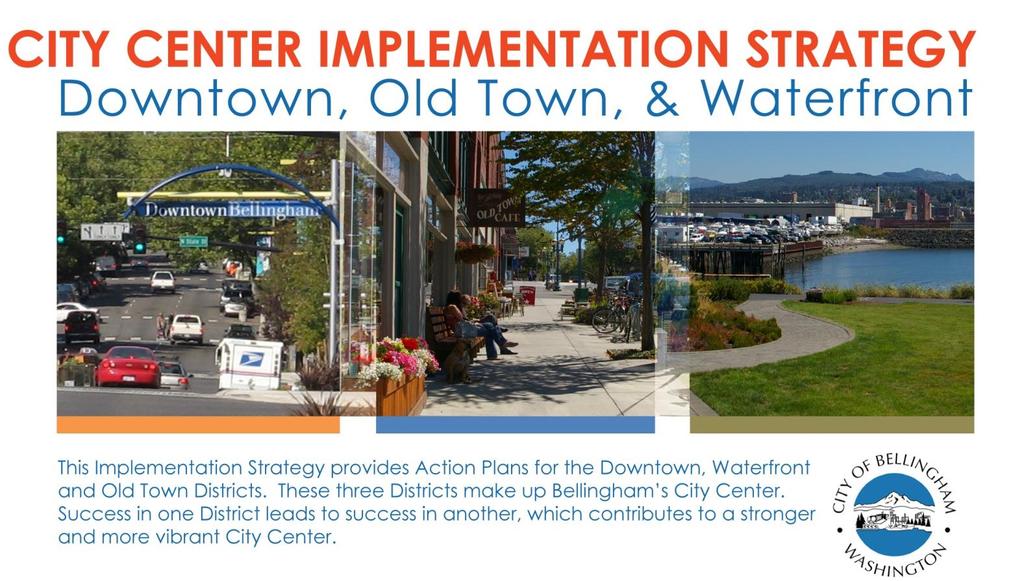
2 1 Table of Contents 1. Introduction Criteria Evaluation and Recognition Figure 1: Downtown, Old Town and Waterfront Districts Downtown Action Plan... 5 a. Redevelopment and Activities... 5 b. Historic Resources... 7 c. Tourism and Hospitality... 7 d. Parks and Placemaking... 9 e. Streets and Streets as Places f. Parking Old Town Action Plan a. Development, Streets and Connections b. Maritime Heritage Park and Whatcom Creek Waterfront Action Plan a. Cleanup b. Infrastructure / Streets and Parks Downtown Project Matrix Old Town Project Matrix Waterfront Project Matrix... 21
3 2 1. INTRODUCTION. This document contains actions necessary to realize the community s vision for the City Center as described in the 1) Downtown Bellingham Plan, 2) Waterfront District Sub-area Plan, and 3) the Old Town Sub-area Plan. The recommended actions are designed to achieve the goals of these adopted plans. They are also intended to support the City s Legacies and Strategic Commitments, and other adopted programs and agreements. Each Action Plan includes a list of actions, a timeline, and responsible City Departments. The Action Plans are dynamic and should be changed to respond to plans and projects proposed by other agencies or the private sector to combine efforts and maximize benefits. The three Districts are at various stages of redevelopment; therefore, they have very different needs requiring different supporting solutions. The following objectives for the Action Plans support the implementation of the City Center Neighborhood planning area: Initiate many projects in all Districts for the purpose of generating a lot of activity at one time, engage multiple investors to share project risk together, blending public and private commitments in support of one another and creating exciting places. Involve many players at once the city, developers, investors, merchants, citizen leaders, other government entities and Downtown residents. Welcome grassroots efforts to implement the community s vision. Inspire strong advocates from the public and private sectors that are dedicated to overall implementation. All participants are necessary, but individuals committed to project completion are critical. Commit public capital and resources in a timely and strategic manner, sending a strong signal to the investment and development community of the City's serious commitment to the redevelopment of the City Center. Recognize and communicate successes to celebrate and promote the City Center, as well as provide accountability. This will reaffirm the City's commitment and involve a growing audience and stakeholder group. Allow for change because conditions change, the plans and this Implementation Strategy will benefit from the establishment of an ongoing review process. The plans must be allowed to evolve over time.
4 3 2. CRITERIA. In general, the City should set the highest priority on actions that support private development consistent with the vision of the Downtown, Old Town and Waterfront Plans. However, there will be times when the City must further prioritize these actions due to funding constraints. When this occurs, the City should consider the following criteria: Fix-it-First Criteria Does the project focus investments on maintaining or improving what we have first? Would the investment allow the facility to be used better? Private Investment Criteria Does the project leverage or catalyze the investment of private funds? Does the project remove barriers to investing in the City Center? Timing Criteria Does the project under consideration have to be completed prior to other projects being initiated? Linkage Criteria Would project or staff costs be reduced if the project were to proceed in conjunction with another project? Double-Duty Criteria Does the project capitalize on leveraging multiple opportunities or solving multiple problems? Financing Criteria Does the project share development and/or operational costs with other entities (i.e. grants, private investor or governmental agencies)? Additional Criteria - For the Downtown placemaking action items, programming is essential to the success of the space. Capital investments should only be made when public or private partners are able to adequately program the space (i.e. sidewalk cafes, food-carts, concerts, etc.). Does the project involve many players? 3. EVALUATION and RECOGNITION. A multitude of actions over many years will be required to realize the vision of a vibrant City Center. The City should evaluate its progress as well as celebrate the individuals, groups and initiatives which help accomplish the goals in the Downtown, Waterfront and Old Town plans.

5 4 4. Figure 1: Downtown, Old Town and Waterfront Districts.
6 5 5. DOWNTOWN ACTION PLAN. For more detail regarding the goals and policies that support the actions contained herein, see the Downtown Bellingham Plan. The following actions are organized by topic area. Details regarding timing and Departmental responsibility for short-term actions are listed in the Project Matrix, Section 8. = 1-6 years, Mid-term = 7-13 years and Long-term = years a. Redevelopment and Activities D.1 Develop a City Center Recognition Program. D.2 Create a Downtown Retail Development Strategy. D.3 Complete renovations to the Federal Building. D.4 Market the City s Crime Prevention through Environmental Design resources. Host an event to honor and celebrate actions which help accomplish the goals of the City Center plans. For example, an award may be presented to a property owner undertaking a historic building rehabilitation, a business launching an expansion project, a group sponsoring a community event or a resident for sweeping the sidewalk and weeding the planters. Develop a strategy to identify the appropriate scale, unique opportunities, and best locations for concentrated retail uses, including identification of complementary, synergistic uses that can combine to create a distinct retail core. Utilize this City-owned nearly-vacant facility by renovating the building to serve as government offices. The City has dedicated police staff available to assist property and business owners in identifying physical measures to address unwanted activities (e.g. loitering). The program needs to be actively marketed to Downtown business and property owners to increase participation. D.5 Improve the permitting process. Through the use of LEAN tools and techniques, review the City Center design review, pre-application, public facilities permit and commercial building permit processes and make adjustments to streamline and provide clear and predictable processes.
7 6 D.6 Comprehensive Update to City Center Design Standards Short-Term A comprehensive analysis is needed to identify the best approach for City Center Design Review, including the process and the design guidelines and standards. This may result in additional substantial changes to improve the process and regulations. Include consideration of standards and practices for reducing unwanted sound transmission from new buildings, which may affect nearby users. D.7 Launch a capital campaign for the Whatcom Museum. D.8 Develop a strategy to address large vacant spaces. D.9 Update regulations and procedures for doing business in rights-of-way. The Whatcom Museum Foundation will mount a fundraising campaign for the Syre Education Building and 1892 Old City Hall. The Syre Education Building first floor is proposed to become a Native American Studies education center and the bird collection currently located there would be re-interpreted on the third floor of the 1892 Old City Hall. New, permanent exhibits would be designed and installed in several of the galleries located on the first floor of the Old City Hall building. As a part of a campaign, the installation of a fire suppression system is planned for both historic buildings. Bellis Fair Mall opened over 25 years ago, leaving many empty retail storefronts Downtown. Some still sit vacant. After exploring a variety of possible ideas and actions, the City will develop a strategy to address these large vacant spaces. Update or adopt regulations for street vending, food trucks, sidewalk cafés and other business activity occurring in the public realm permitting street vending and food trucks. D.10 Develop a building program for the Central Library. A building program statement was developed in ("Bellingham Public Library Community Analysis, Library Needs Assessment, Central Library Building Program Statement and Cost Analysis"), which now needs updating to meet current and future vision and requirements for the Central Library. D.11 Select a site for a new Central Library. In 2007, the current Central Library location was chosen as the site where the replacement library would be constructed. Since that
8 7 time, the building has been identified as a potential location for other City/community uses. A new site for the Central Library needs to be selected and secured. D.12 Replace the Central Library. Mid-term LLIBRARY/EXEC b. Historic Resources The 63 year old Central Library was last renovated 31 years ago for a 20-year anticipated life span and is in need of replacement. The City s population has more than doubled and new technologies have been introduced since its original construction. In 2013, the Library Board of Trustees adopted a five-year strategic plan that includes a goal to replace the current facility. D.13 Improve regulations for historic building rehabilitation. D.14 Create Residential Transition zone educational materials on design. D.15 Complete the nomination process for a Downtown historic district. Review existing City programs and regulations to ensure that they are adequate to encourage the rehabilitation and use of historic buildings. Create educational materials that property owners in the Residential Transition zones may use to create buildings that are compatible with surrounding historic features. Submit a nomination to the National Parks Service for a historic district. This honorary designation (non-regulatory) could increase property values and provide grant funding or tax incentives. D.16 Develop historic materials and tours. Develop and sponsor educational materials and tours showcasing the historic buildings and landmarks of Downtown. c. Tourism and Hospitality D.17 Focus on improving Magnolia Street between Cornwall Ave and WTA. Work with businesses and others to implement CPTED and Placemaking techniques to improve the comfort and image of this part of Downtown. Improvements could include removal of blank walls to discourage panhandling. D.18 Create an Alcohol Impact Area. Establish an Alcohol Impact Area to mitigate problems with chronic public inebriation and illegal activities linked to the sale or
9 8 consumption of alcohol within all or a portion of Downtown. For example, an initial voluntary Alcohol Impact Area could ask stores selling high-alcohol content low-cost beers and wines to remove these products from their shelves. D.19 Develop a marketing program. Support the Downtown Bellingham Partnership in developing a marketing program to attract more customers. Work with Bellingham Whatcom Tourism to attract more out of County visitors to Downtown. D.20 Sponsor Downtown sculpture shows. On-going Continue to sponsor and promote Downtown sculpture shows to provide opportunities for new and established artists. D.21 Develop tour materials for Downtown s public outdoor art collection. D.22 Dedicate new police personnel to Downtown. D.23 Change regulations to better enforce common infractions. D.24 Provide police training for mental health and alcohol issues. Develop a self-guided tour to highlight the City's art collection. In addition to the existing bicycle and vehicular patrol, hire two new positions dedicated to the City Center. Over time, work with the property and business owners to share in the cost of expanding these services through a Business Improvement District, Mainstreet Program or similar program. Adjust municipal codes as necessary to allow the Bellingham Police Department (BPD) to enforce the most common infractions. Initiate changes to the Bellingham Municipal Code, including stricter penalties for breaking open container laws and extended hours for restrictions on sitting and lying on the sidewalk, to assist officers with enforcement. All sworn and BPD direct customer service providers will receive the initial State Certified 8-hour core CIT training course within 2014, with the eventual goal of all BPD sworn and civilian personnel receiving the remaining 32 hours of CIT training by end of D.25 Initiate a Downtown Ambassador Program. An ambassador, or similar program, would provide a consistent
10 9 visible presence on the street. Ambassadors could supply social service and/or tourism resources, as well as act as a liaison to BPD officers. D.26 Develop resources to assist stakeholders in responding to behavioral and safety issues. The City will partner with community organizations, such as the Downtown Bellingham Partnership, to develop a safety response resource that outlines best practices, community resources, and contact information for use by downtown employees, residents, etc. An ambassador program could be a resource to assist in coordinating this effort. D.27 Brand the Museum campus. Identify and implement ways to strengthen the visual and conceptual ties between the three building Whatcom Museum "campus". D.28 Open a Visitor s Center (5). Work with Bellingham Whatcom Tourism to open a high-quality storefront for visitor s in downtown. D.29 Develop a heritage tourism program. Mid-term Work with the Tourism Commission, Bellingham Whatcom Tourism Bureau and others to promote the stories of Downtown through a greater heritage tourism program for the City Center. d. Parks and Placemaking Improving and programming Maritime Heritage Park is the City of Bellingham s highest priority for Parks and Placemaking within the City Center. See the Old Town Action Plan. Depot Market Square is the City s second priority with regard to programming. There are many other public spaces Downtown (e.g. Unity Circle, Commercial Plaza, Library Lawn, and streets and alleys) for which the City does not have the resources to prioritize as short-term programming items; however the City welcomes and encourages partnerships to implement changes in these areas. D.30 Advertise Depot Market Square as an event venue. Housed at Depot Market Square, the Bellingham Farmers Market is one of Downtown s main attractions and fills this facility most Saturday s. Depot Market hosts a number of other community events, but could be utilized much more frequently.
11 10 D.31 Provide safe and convenient public restrooms. Review existing hours of operation, condition, comfort and safety of the public restrooms and make recommendations for improvement. This review should include an assessment of the need and feasibility for alternative options, such as the Portland Loo. D.32 Develop a centrally located town square. Mid-term The identification of a new town square location, similar to Fairhaven Village Green, should take into account the elements necessary to ensure its success as a thriving public space: - Size. A minimum of 16,000 square feet. - Location. Generally, south of Flora Street and northwest of State Street and abutting a public street with active uses nearby and ample sunlight (or potential for). - Design and Programming. Incorporates elements such as moveable seating, kinetic play equipment, games and activities for all ages, art and functional sculptural elements, water feature(s), grassy areas and abundant landscaping, performance space, accommodations for retail and dining, programmed events, pedestrian-scale lighting, weather coverage and shading devices such as canopies, trellises and umbrellas, and a sense of enclosure created by surrounding buildings. Programming should be budgeted and planned along with capital expenses. D.33 Improve the functionality of the Commercial Street Plaza. Mid-term 1. Clean and enhance the space (e.g. replace/repaint paneling and waste receptacles and maintain or add new artwork) (short-term action). 2. Depending on the tenants, encourage adjacent businesses to expand into the area by providing café seating, weather coverage and Wi-Fi access. Food carts or other private uses could locate here to activate the space. 3. Highlight access to the public restroom.
12 11 D.34 Enliven Unity Circle. Long-term Initiate a Placemaking workshop at Unity Circle to improve and expand the space for use by nearby residents. Invite surrounding businesses, property owners and other community stakeholders to develop ideas to activate and encourage use of the site. e. Streets and Streets as Places D.35 Formalize Downtown Streetscape Design Standards. Formalize streetscape design elements, including sidewalk scoring pattern, light standards, bulb-out dimensions, landscaping/street trees, and street furniture parameters into a manual for use by various City Departments, as well as the public. This will ensure a consistent aesthetic as new projects are implemented. A distinction between the Arts District and the rest of Downtown should be apparent through design. Allow some flexibility to achieve context-sensitive solutions, recognizing that some streets have different opportunities and uses. D.36 Develop a State Street corridor plan. Develop a corridor plan for North State Street that identifies and evaluates the use of the right-of-way, including opportunities for Placemaking, multi-modal transportation options and possibly increased on-street parking. This action is anticipated to result in one or more capital projects. D.37 Construct pedestrian improvements at the State Street and Laurel Street intersection. D.38 Activate the Lightcatcher Building street frontage. This project, similar to the recently improved State and Maple intersection, will greatly improve the connection between Downtown, WWU and the Sehome neighborhood by providing a safe pedestrian crossing. The Museum, working with Planning & Community Development and other stakeholders, will identify opportunities to invigorate this important street frontage and extend the activities and inspiration happening behind the wall to the exterior by employing the Placemaking approach. D.39 Install raingardens. The Downtown Improvement Garden (DIG) project will improve
13 12 Whatcom Creek water quality by installing 36 raingardens in strategic locations Downtown. The raingardens will help treat stormwater from over 90 urban acres that currently flows untreated into Whatcom Creek. The City will partner with adjacent business owners to help with maintenance. D.40 Conduct a street tree condition inventory. Conduct an inventory that identifies information such as the health of existing trees, anticipated life-span, pruning / planting /removal recommendations and other information regarding the condition of downtown street trees. D.41 Establish a Streetscape Replacement Program. D.42 Continue Downtown Maintenance Program. D.43 Install Bike Racks and Bike Lockers as needed. On-going On-going On-going A replacement program is needed for the continued upgrade, expansion, and replacement of streetscape amenities, such as garbage receptacles, street trees, benches, bollards, tree wells, and paving. The streetscape improvements installed in the 1980s are showing signs of age and are not in keeping with current ADA guidelines. This program should include expansion of the Arts District streetscape (e.g. pavers, tree wells, lighting), Downtown banners and wayfinding system. Work with the Downtown Bellingham Partnership and other stakeholders to keep Downtown clean and maintain a distinct landscape design consistent with the Downtown image and atmosphere. Identify locations for the installation of additional secure bicycle storage facilities and racks as these amenities become increasingly used and an analysis of area-wide bike parking needs is completed. D.44 Expand the Wayfinding System. On-going/Shortterm 1. () Install signage for bicycles and pedestrians on Railroad Avenue connecting South Bay trail to Whatcom Creek Trail. In addition, where South Bay trail ends at Laurel Street, add signs to direct bicyclists and pedestrians to the safest crossing routes along Laurel and Railroad Avenue or the enhanced crosswalks on State Street.
14 13 2. () Install wayfinding signs on Prospect Street to direct visitors to the area behind Old City Hall leading into Maritime Heritage Park. 3. (Ongoing) As funding allows, improve and enhance gateways into Downtown. For example, evaluate the feasibility to create a strong gateway on the northern end of State Street. 4. () Employ pedestrian level signage beyond the kiosks to promote the quick walking routes between destinations. Note: The City is in the process of completing a Bicycle Master Plan. This Action Plan may be amended to include Bicycle Master Plan priority projects expected to be adopted prior to Council consideration on this document. f. Parking D.45 Improve Commercial Street Parking Garage. D.46 Consider policy and code changes to parking fees and fines. D.47 Public/private partnership structured parking opportunities. Short term On-going, as opportunities arise and funding available. Investments in signage, the façade, the elevator, safety and aesthetics are desired make the most of this important asset. Reinvestment in this parking infrastructure is important to preserve and enhance this asset. Funding may require additional revenue or possible debt service payments. Policy changes and Council-approved code changes related to prices for parking and fines will facilitate more efficient use of the available parking. Consideration of higher prices in high demand areas and lower prices in low demand areas will distribute onstreet parking and encourage use of off-street areas. Increased fines for repeat offenders (i.e. parking scofflaws) will discourage abuse and increase system revenue. Parking inventory studies indicate there is no need for additional parking capacity within the 20 year planning horizon. However, the City welcomes the opportunity to participate in providing public parking as part of a larger redevelopment project. Examples of opportunities include a new public library or a new private office tower. In 2014, the City will research partnership options to determine what structures are possible.
15 14 D.48 Invest in new parking technology. On-going For greater efficiency and to improve customer service, explore options for new technologies. License plate recognition tools for enforcement, mobile device enabled parking availability applications, payment options using debit/credit card/online payments and smart parking meter technologies may provide greater efficiencies and higher service levels. Additional revenue may be needed to fund these improvements. 6. OLD TOWN ACTION PLAN. For more detail regarding the goals and policies that support the actions contained herein, see the Old Town Sub-area Plan. The following actions are organized by topic area. Details regarding timing and Departmental responsibility for short-term actions are listed in the Project Matrix, Section 9. = 1-6 years, Mid-term = 7-13 years and Long-term = years. OLD TOWN a. Development, Streets and Connections O.1 Redevelop the 600 W. Holly Street site. Through an open public process, seek development proposals from qualified parties or take a preliminary step by issuing a Request for Expression of Interest to determine if the timing is right. O.2 Reopen C Street Railroad Crossing. C Street was closed at Chestnut Street due to safety concerns with the non-signalized intersection. The City will work with BNSF to design and configure a safe crossing so this crossing can be reopened to vehicular traffic. O.3 Redevelop the Army Street site. In 2014, provide funding to the Bellingham Public Development Authority to determine whether redeveloping the Army Street site into a mixed-use development is feasible. O.4 Establish a Streetscape Replacement Program. Include Old Town in Action D.37
16 15 OLD TOWN O.5 Formalize Old Town Streetscape Design. Formalize streetscape design elements into a manual for use by City Departments as well as the public. Coordinate with Action D.34 O.6 Create an Alcohol Impact Area. Coordinate with Action D.17 O.7 Improve the Whatcom Museum overlook and the alley between Whatcom Museum and Syre Education building. Mid-term In order to provide a better connection between the Arts District of Downtown and Old Town, this alley could be improved with unique lighting and artwork. An improved overlook incorporating a draw would bring more people to Old Town from Downtown. Note: If NW Recycling relocates in the future, additional actions may be added to this Action Plan to implement the vision of the Old Town Sub-area Plan. b. Maritime Heritage Park (MHP) & Whatcom Creek O.8 Lease Environmental Learning Center (ELC). Short term Constant utilization of the ELC building during the week, as well as evenings and weekends is key to increasing activity in the park. If there is a lack of interest in leasing, identify other potential uses. O.9 Increase the range of recreational and play opportunities. Short term A variety of facilities can increase use in the park, including courts for bocce ball, pickle ball, basketball and a dog off-leash area. O.10 Increase programming. Short term Increase staffing levels to oversee programming and collaborations and support facilitation of events at MHP. Provide funding for supplies and services. O.11 Build a playground. The MHP Master Plan calls for a new playground, which had been previously removed from the north side of the Creek. A playground would help bring a greater diversity of users to the park.
17 16 OLD TOWN O.12 Develop and implement a pilot busker Ongoing activity has shown to be the most successful in activation program. of problematic parks in other cities. O.13 Reduce desirability for loitering. Use techniques defined in the Crime Prevention Through Environmental Design Handbook and other sources to make physical changes to the park that reduce the desirability to loiter. For example, redesign the planter box adjacent to the fountain at the Holly Street entrance to discourage sitting. O.14 Improve visibility throughout the park. Enhance lighting by increasing existing candle power and adding new lights. Thin and/or remove vegetation that creates hidden areas and blind corners. O.15 Install emergency call boxes. Install one emergency call box near the ELC building. Evaluate need for additional call boxes. O.16 Install security cameras. Install security cameras near the ELC building. Identify other key areas for future installment. O.17 Install a safe 24 hour sanitary public restroom. Because of the hidden nature of traditional restrooms, the existing facility often feels unsafe due to loitering. The "Portland Loo" is one design that reduces the hidden nature of restrooms while still providing a facility. O.18 Communicate expectations for park users. Install signage to communicate the Park s rules and regulations. O.19 Reestablish a cadet program. To decrease crime and infractions, promote education and safety and provide a point of contact for park users. O.20 Enhance habitat between Roeder Avenue and Holly Street. Although the total area of this site is relatively small, it represents a vital connection, as it is lacking an upper intertidal beach and healthy riparian vegetation. This project includes: removing standing creosote piles and timber debris, removing toppled armor rock and concrete rubble, adding beach nourishment sediment, removing non-native vegetation and planting native nearshore riparian species.
18 17 7. WATERFRONT DISTRICT ACTION PLAN. For more detail regarding the goals and policies that support the actions contained herein, please see the Waterfront District Sub-area Plan and the Interlocal Agreement for Facilities between the Port and City (Facilities Agreement). Timing for most activities outlined for the Waterfront District are subject to the Facilities Agreement, which defines phases by success of development rather than by year. This Strategy will be revised as conditions change, which may affect the timing of completing the actions. See Section 10. for the Project Matrix which outlines the action, timing and City teams. = Phase 1, Mid-term= Phase 2 and Long-term = Phases 3, phases are defined in the Facilities Agreement. a. Cleanup W.1 Design and conduct RG Haley site cleanup. (mid-term in Facilities Agreement) This City-owned site, located in the Cornwall Beach Area of the Waterfront District, is designated by the Department of Ecology as a MTCA (Model Toxic Control Act) site. Work includes development of a Remedial Investigation and Feasibility Study (RIFS), a Cleanup Action Plan (CAP) and a Consent Decree with Department of Ecology, and construction. W.2 Support the Port of Bellingham (Port), as appropriate, with site clean-up activities. W.3 Support the Port of Bellingham (Port), as appropriate, in site clean-up activities. b. Infrastructure / Streets and Parks W.4 Develop a conceptual park master plan and grading plan for the Cornwall Beach Park. Mid-term Per the Facilities Agreement, the Port is designated as the lead agency responsible for undertaking remediation for Whatcom Waterway, Cornwall Landfill, and Georgia Pacific West sites. The City s role may vary per separate agreements between the Port and City. Per the Facilities Agreement, the Port is designated as the lead agency responsible for undertaking remediation for Central Waterfront. The City s role will vary per separate agreements between the Port and City. Conceptual park master planning is required early on to gain a better understanding of park use, which will be used to
19 18 complete a grading plan. The grading plan will be incorporated into the Cornwall Landfill and RG Haley site construction documents. Implementation of the master plan (park build-out) is not included in this project activity. It is anticipated that the City will finalize the name of the park. W.5 Design and construct the first phase of Whatcom Waterway Park. W.6 Design and construct Granary/Bloedel to Cornwall Avenue. W.7 Design and construct the first segment of Commercial Street and Commercial Green. A conceptual plan will be completed for Whatcom Waterway Park from Roeder Avenue to Commercial Green. However, actual build-out is anticipated to be completed in phases. As currently scoped, this project is contingent upon completion of Whatcom Waterway cleanup. Design of this project will be coordinated with Granary/Bloedel to Cornwall Avenue project. In addition to serving as a primary entry to the Waterfront District, design of Granary and Bloedel Streets will establish site grades and streetscape aesthetics for the Downtown Waterfront Area. It is anticipated that the City will finalize the names of the streets (i.e. Granary and Bloedel street names are subject to change). Conceptual planning for this street and plaza space will include evaluation of historic icons (e.g. the tile tanks) and whether the City wants to own them, as well as re-evaluation of the cross section to determine if there are other options. W.8 Develop a Utility Master Plan. Beyond the City s standard utility planning (i.e. water, sewer and stormwater systems), the City will evaluate the feasibility of district-level systems, including district-heat, small-scale hydropower, and non-potable water. The overall planning effort is focused on the District south of Whatcom Waterway, and the district-level systems are focused in the densest planned Downtown Waterfront Area. W.9 Aeration Stabilization Basin (ASB) Trail, including a trail connecting to Bellwether Way. Identified as an early action in the land swap between the Port and City in 2012, this activity will utilize minimum resources to provide public access to the Waterfront as early as possible.
20 19 W.10 Conduct Marine Nearshore Habitat Connectivity Assessment. Compile existing information on nearshore species and habitats within the Waterfront District. Once assembled, this information will be used to inform a connectivity study of existing habitats within Bellingham's marine nearshore. W.11 Develop Cornwall Beach Park. Mid-term In the early years, the City plans to prepare the site (as simple as a grass field) to be further developed. This project is likely to include more detailed master and conceptual site planning prior to construction. W.12 Commercial Street Bridge and extension of Commercial Street. Long-term Another primary ingress/egress will be needed when development reaches a certain threshold (estimated at roughly 1.6 million square feet south of Whatcom Waterway). W.13 Adjust Laurel Street. Long-term If Western Washington University redevelops as planned, the City will adjust the interim Laurel Street to accommodate WWU s development. W.14 Complete Cornwall Beach Park. Long-term Given the scale of this undertaking, the City expects completion of the park, with all amenities planned, will be phased over time. W.15 Complete Whatcom Waterway Park. Long-term Continue implementation of Whatcom Waterway Park. Additional land near the Log Pond area will be provided to extend the park in this phase.
21 20 8. DOWNTOWN PROJECT MATRIX Placeholder. 9. OLD TOWN PROJECT MATRIX Placeholder. (NOTE TO READER: As of July 7, 2014, the Project Matrices for Downtown and Old Town are in process. Staff intends to provide this additional detail for the short-term actions along with the 2015/2016 draft budget. See the Waterfront Project Matrix, next page, as an example.)
22 WATERFRONT DISTRICT PROJECT MATRIX SHORT TERM ACTIONS 2014 Budget Executive PW Parks Planning Fire Legal Police Finance a. Cleanup W.1 Design and conduct RG Haley site cleanup. X X X P P L P W.2 Support the Port of Bellingham (Port), as appropriate, with site clean-up activities. X X X X P P L P b. Infrastructure / Streets and Parks W.4 Develop a conceptual park master plan and grading plan for the Cornwall Beach Park. W.5 Design and construct the first phase of Whatcom Waterway Park. X P P L P P P P X X X P P L P P P P W.6 Design and construct Granary/Bloedel to Cornwall Avenue. X X X P L P P P P P W.7 Design and construct the first segment of Commercial Street and Commercial Green. X X X P L L P P P W.8 Develop a Utility Master Plan. X P L P P P P W.9 Aeration Stabilization Basin (ASB) Trail, including a trail connecting to Bellwether Way. X X P L P P W.10 Conduct Marine Nearshore Habitat Connectivity Assessment. X L P P P P L = Lead responsible for managing project. P = Participant responsible carrying out tasks for the team.
8implementation. strategies
 PROGRAM STRATEGIES 8implementation strategies T he implementation actions of this chapter are designed to support and carry out the land use, economic development, transportation, urban design, and program
Town Center (part of the Comprehensive Plan)
") Town Center (part of the Comprehensive Plan) Mercer Island Town Center Looking North (2014) In 1994, a year-long process culminated in a set of design guidelines and code requirements for the Town Center
Town Center (part of the Comprehensive Plan) Mercer Island Town Center Looking North (2014) In 1994, a year-long process culminated in a set of design guidelines and code requirements for the Town Center
Pedestrian and Bike Bridge LOGO
 6.2.2 Pedestrian and Bike Bridge The proposed pedestrian and bike crossing re-envisions the existing bridge at Pismo Creek on Cypress Street. The bridge is currently underutilized by vehicular through
Planning Commission March 14, Presented by: City of Bellingham Port of Bellingham
 Planning Commission March 14, 2013 Presented by: City of Bellingham Port of Bellingham 1 Agenda Waterfront District Background Waterfront District Proposal Overview Sub-area Plan Development Regulations
Downtown Whitby Action Plan
 Downtown Whitby Action Plan Final Report October 2016 Table of Contents Introduction 1 Public Consultation 2 Walkability 3 Downtown Whitby Walkability Map 4 Vision 5 Goal & Objectives 6 Objective 1 7 Objective
CHAPTER ONE INTRODUCTION
 1.0 Introduction Bellingham s central waterfront is in a state of transition from its long history as an active industrial site to a new mixed-use neighborhood. Over the past several years, the Port of
Urban Design Manual PLANNING AROUND RAPID TRANSIT STATIONS (PARTS) Introduction. Station Study Areas
 Introduction. Station Study Areas") 111111 PLANNING AROUND RAPID TRANSIT STATIONS (PARTS) Introduction The ION rapid transit system will link Waterloo, Kitchener and Cambridge through a central transit corridor (CTC). There are a number
111111 PLANNING AROUND RAPID TRANSIT STATIONS (PARTS) Introduction The ION rapid transit system will link Waterloo, Kitchener and Cambridge through a central transit corridor (CTC). There are a number
City Center Neighborhood Plan
 [1] City Center Neighborhood Plan As adopted by Ordinance No. 2014-09-049 and amended by Ordinance Nos. Formerly CBD Neighborhood as adopted by Ordinance No. 8868 and amended by Ordinance Nos. 8946, 9693,
6 Strategic Vision and Vision Matrix
 PUBLIC HANDOUT: FEBRUARY 11, 2013 TOWN COUNCIL MEETING STRATEGIC VISION PLAN: VISIONING INTO ACTION 6 Strategic Vision and Vision Matrix 6.1 Strategic Vision The Strategic Vision builds on the vision of
CHAPTER 7: VISION AND ACTION STATEMENTS. Noble 2025 Vision Statement
 CHAPTER 7: VISION AND ACTION STATEMENTS This chapter presents the vision, policy and action statements that transform the comprehensive planning study, an analysis of Noble s past, future trends and community
Silverdale Regional Center
 Silverdale Regional Center Vision for Silverdale Regional Center The Silverdale Regional Center Plan (Plan) will guide the evolution of the Silverdale Regional Center from a collection of strip malls and
Town of Cobourg Heritage Master Plan. Statutory Public Meeting
 Town of Cobourg Heritage Master Plan Statutory Public Meeting April 25 th 2016 Presentation Overview 1. Introduction 2. Project background and schedule overview 3. Review of strategic direction content
38 Queen s University Campus Master Plan Part 1
 38 Queen s University Campus Master Plan Part 1 46 The Campus at the City Scale Chapter 4 The Campus at the City Scale 39 Queen s is an urban University centrally located in Kingston. Decisions made by
THEMES, VISION, + PRINCIPLES
 CHAPTER 2: THEMES, VISION, + PRINCIPLES This page intentionally left blank. 20 VISION DRAFT AUGUST 2018 2 2 THEMES, VISION, + GUIDING PRINCIPLES The Key Themes, Vision, and Guiding Principles presented
The Vision. Photo provided by The Minervini Group. 46 Vision, Objectives & Strategies
 Vision, Objectives & Strategies The is the public framework and guide for future development of the Grand Traverse Commons. The establishes public polices for infrastructure, the preservation of natural
Hockessin Community Redevelopment Plan
 Hockessin Community Redevelopment Plan 3.1 Introduction The Community Redevelopment Plan for the Village of Hockessin is the result of the people s vision for a distinct village center that serves as the
PLAN ELEMENTS WORKSHOP. April 5, 2016
 PLAN ELEMENTS WORKSHOP April 5, 2016 needs more housing. But there is no one-size fits-all solution. Every neighborhood has its own character. In some places, density is not only appropriate it is badly
DOWNTOWN NORFOLK COUNCIL ACTION PLAN. Strategic Initiatives Focus Area Objectives. Departmental Focus Area Key Objectives
 DOWNTOWN NORFOLK COUNCIL ACTION PLAN FY18 Strategic Initiatives Focus Area Objectives Departmental Focus Area Key Objectives STRATEGIC INITIATIVES FOCUS AREA OBJECTIVE #1: NURTURE A VIBRANT URBAN ENVIRONMENT
Parks Master Plan Implementation: Phase I Waterfront Use and Design REPORT #: September 7, 2016 File #
 0 'O DI Lan-171-14 1 - THE CORPORATION OF THE TOWN OF COBOURG..,. STAFF REPORT TO: FROM: Mayor and Members of Council Dean A. Hustwick, Director of Recreation and Culture DATE OF MEETING: Committee of
TEMPLE MEDICAL & EDUCATION DISTRICT
 City of Temple, Texas TEMPLE MEDICAL & EDUCATION DISTRICT 1 Description. The City of Temple joined in partnership with key public and private entities to jointly promote education and medical activities
A larger version of this map is located on the last page of this PDF.
 MAP Committee Input McLoughlin Area Draft Vision Map A larger version of this map is located on the last page of this PDF. 1. The map above is intended to portray a vision for the McLoughlin area. It highlights
Policies and Code Intent Sections Related to Town Center
 Policies and Code Intent Sections Related to Town Center The Town Center Vision is scattered throughout the Comprehensive Plan, development code and the 1994 Town Center Plan. What follows are sections
Port Lavaca Future Land Use
 Port Lavaca Future Land Use Introduction The City of Port Lavaca is beginning to see sustained growth, after many years of relative stable population. New single family homes, apartments, and businesses
Dyersville Downtown Plan. Open House October 24, 2017
 Dyersville Downtown Plan Open House October 24, 2017 What is a Comprehensive Plan? - Vision - Guidance for decisions - Basis for regulations What is a Downtown Plan? - Understand priorities - Identify
Table of Contents. Elm Avenue Improvement Plan City of Waco, Texas. Introduction 1. Existing Context 1 Figure 1 2.
 Table of Contents Introduction 1 Existing Context 1 Figure 1 2 Plan Guidelines 3 Future Urban Form 4 The West-End 4 Main Street 6 The East-End 7 Figure 2 9 Public Improvement Recommendations 7 General
The Five Components of the McLoughlin Area Plan
 The Five Components of the McLoughlin Area Plan This documents contains the complete language of the five components of the McLoughlin Area Plan: The Vision Statement The Values The Guiding Principles
The Auburn Plan Designing the Future of Auburn February 28, 2005
 The Auburn Plan Designing the Future of Auburn February 28, 2005 Block-by-Block Bicycle Tour Aerial survey Focus Group Meetings September 7 and 8 Design Workshops October 11, 14, and 21 Revitalization
Study Area. Capitol Way. Greening America s Capitals 11/13/2014. A Greening America s Capitals Project
 Olympia, WA: Greening Capitol Way Supporting Communities move towards sustainability is a priority for the federal government. A Greening America s Capitals Project Office of Sustainable Communities U.S.
The transportation system in a community is an
 7 TRANSPORTATION The transportation system in a community is an important factor contributing to the quality of life of the residents. Without a sound transportation system to bring both goods and patrons
{Best Practices. Summary of Tools, Strategies and Best Practices from 11 Michigan Case Study Communities
 Case Studies Michigan Coastal Community Working Waterfronts { Summary of Tools, Strategies and from 11 Michigan Case Study Communities Table of Contents Zoning...2 Community and Stakeholder Collaboration
WEST LOOP DESIGN GUIDELINES CHECKLIST
 WEST LOOP DESIGN GUIDELINES CHECKLIST Section 1.0 General Strategies 1.1 DESIGN EXCELLENCE: ENCOURAGE HIGH QUALITY AND INNOVATIVE DESIGN OF NEW BUILDINGS WITHIN THE WEST LOOP WITHOUT BEING PRESCRIPTIVE
Illustration of Eastlake Farmer s Cooperative Grain Elevator. Chapter 5: implementation 5-1
 Illustration of Eastlake Farmer s Cooperative Grain Elevator Chapter 5: implementation 5-1 chapter 5: implementation Introduction The Eastlake Subarea Plan includes a wide range of recommendations intended
Strategies/Actions Priority List
 Strengthening the Creative Sector: Build stronger relationships with, and between, cultural organizations and businesses and increase opportunities for working together to build capacity within organizations.
EXISTING COMPREHENSIVE PLAN
 EXISTING COMPREHENSIVE PLAN Town Center Land Use Element: V. LAND USE POLICIES Town Center Mercer Island's business district vision as described in "Your Mercer Island Citizen-Designed Downtown" was an
CHAPTER 8 ISSUES, CONCERNS, CONSTRAINTS AND OPPORTUNITIES
 CHAPTER 8 ISSUES, CONCERNS, CONSTRAINTS AND OPPORTUNITIES Introduction This River Conservation Plan was developed during a time of tremendous activity and effort in planning the transformation of the Delaware
Comprehensive Plan ADOPTED APRIL 2014
 Comprehensive Plan ADOPTED APRIL 2014 8 8. Outstanding Recreational & Cultural Opportunities We are proud of our community s parks and recreation system. Our community will ensure that the legacy of our
1. Parks & Recreation Neighborhood Parks Community Parks Special Use Sites 2. Open Space 3. Trails
 Appendix A: Park Classifications The intent of parks and recreation classifications is to aid in making acquisition and design decisions for park sites, facilities and the organization of recreation space
CITY OF BELLINGHAM PLANNING DEPARTMENT STAFF REPORT
 1 1 1 1 1 1 1 1 0 1 0 1 0 1 0 CITY OF BELLINGHAM PLANNING DEPARTMENT STAFF REPORT Agenda Topic: For: Staff Contact: I. Project Summary Review of the Waterfront District subarea plan and associated documents,
PUBLIC RIGHT-OF-WAY IN THIS CHAPTER PUBLIC REALM
 PUBLIC RIGHT-OF-WAY This section provides design guidelines for improvements in the public right-of-way. The public right-of-way refers to streets, sidewalks, non-vehicular thoroughfares, parks and greenways
CHAPTER VIII Implementation
 CHAPTER VIII Implementation VIII. Implementation The vision for the Marlboro Pike Corridor will require that a variety of participants work together to make it a reality. The following action steps outline
3.1 community vision. 3.3 required plan elements
 Chapter 3 Community Form 3.1 community vision 3.2 Parks & landscaping concepts 3.3 required plan elements D R A F T 20 Community Form Chapter 3 3.0 Community form 3.1 community vision The Specific Plan
SECTION ONE: INTRODUCTION. introduction
 introduction 1 INTRODUCTION Since it was first established in 1843 as a trading post for the Hudson s Bay Company, Victoria has evolved into a Provincial capital city that is recognized across Canada and
Downtown Dubuque...it s a great time.
 Downtown Dubuque...it s a great time. Your timing could not be better to invest in Downtown. With hundreds of millions in public and private investment occurring on the City s downtown waterfront, millions
Ivywild On The Creek PRELIMINARY CREEK DISTRICT MASTER PLAN
 Ivywild On The Creek PRELIMINARY CREEK DISTRICT MASTER PLAN Introduction: Rejuvenating an extraordinary Creekside neighborhood THE CREEKSIDE DISTRICT The Ivywild On The Creek Neighborhood District Master
implementation r expression in landscape
 6 ubc okanagan implementation campus plan r expression in landscape 68 6 implementation campus plan sections The Campus Plan supports the academic mission, values and commitments of the University by providing
City of Plattsburgh DRI: Downtown Streetscapes & Riverfront Access. Downtown Streetscape and Riverfront Access Design
 City of Plattsburgh DRI: Downtown Streetscapes & Riverfront Access Welcome Thank you for coming this evening. Agenda PART I - Project Context The Downtown Revitalization Program Our DRI Projects Other
Table L-1 Summary Action Strategy. Action Item Timing Status Responsible Agency
 CHAPTER 4: CIRCULATION ELEMENT ISSUE #1: MAJOR THOROUFARES AND TRANSPORTATION ROUTES A balanced transportation system for Fontana is provided that meets the mobility needs of current and future residents
Implementation Status Jan 2013
 Implementation Status Jan 2013 Key Red Strikethrough: Green Text: Black Text: Completed Project has been initiated or is underway No action Circulation & Linkages Goal A: To establish safe and efficient
6. DOWNTOWN. The Downtown Element focuses on supporting and expanding the vitality and enhancement of Downtown Chico as the City s central core.
 VISION In 2030, Downtown Chico is the heart of the community and the center of cultural activity. Engaging and active at the street level, it is a multi-story, mixed-use hub, with specialty retail, restaurants,
Philip A. Ginsburg, General Manager Toks Ajike, Acting Planning and Capital Program Director
 Date: March 7, 2018 To: Through: From: Subject: Recreation and Park Commission Capital Committee Philip A. Ginsburg, General Manager Toks Ajike, Acting Planning and Capital Program Director Dan Mauer,
Implementation Guide Comprehensive Plan City of Allen
 Implementation Guide 2030 Comprehensive Plan City of Allen DRAFT 2015 Implementation Guide Allen 2030 Comprehensive Plan INTRODUCTION The Comprehensive Plan serves as a guide for the growth and development
Roanoke Rapids Streetscape Master Plan. City Council Presentation
 SCHEDULE: Stakeholder Meeting/Kick off November,2016 Master Planning Phase (November March 2017) Public Meeting #1 December 13, 2016 Review Meeting with Key Stakeholders Refine Concepts Based on Input
About Momentum Midland
 About Momentum Midland Achieving a community s full potential in terms of economic development and quality of life is critically important to its long term sustainability. Core to achieving this is a vibrant
10.0 Open Space and Public Realm
 10.0 Open Space and Public Realm 10.0 Open Space and Public Realm The Public Open Space System is comprised of: outdoor spaces available for public use that are either publicly owned (e.g., parks and
3. VISION AND GOALS. Vision Statement. Goals, Objectives and Policies
 Vision Statement Queen Creek s interconnected network of parks, trails, open spaces and recreation opportunities provide safe and diverse activities and programs that sustain its unique, small town, equestrian
RECREATION AND OPEN SPACE ELEMENT GOALS, OBJECTIVES, AND POLICIES
 RECREATION AND OPEN SPACE ELEMENT GOALS, OBJECTIVES, AND POLICIES Goal 7 To provide park facilities, recreation programs, and open space resources that are safe, adequate, and accessible to all City residents,
REGIONAL ACTIVITY CENTER
 DRAFT REGIONAL ACTIVITY CENTER 70 EAST BENCH MASTER PLAN DRAFT 06 Introduction The East Bench Regional Activity center is comprised of large educational, research, medical, and employment centers. These
Implementation. A plan is a list of actions arranged in whatever sequence is thought likely to achieve an objective. John Argenti
 A plan is a list of actions arranged in whatever sequence is thought likely to achieve an objective. John Argenti This Implementation section is structured into a coordinated action program so that elected
City of Heath. Town Center Concept
 In the give-and-take of getting projects designed, financed, and approved, the famous refrain from the film Field of Dreams is heard often: if you build it, they will come. From the perspective of the
Please read the entire document
 projects impacting the waterfront revitalization area. The waterfront revitalization area of the town will have to subareas to the west and east of the village. Page 6 of 6 Wayfinding master plan create
Planning Board Briefing
 Planning Board Briefing Why Now? The Sector Plan Implementation Chapter States: Before Stage 1 begins, the following must occur: Approval of the Sectional Map Amendment. Approval of the Greater Lyttonsville
Coastal Smart Growth Approaches for Working Waterfront Preservation, Implementing Locally-Based Strategies and Solutions
 Coastal Smart Growth Approaches for Working Waterfront Preservation, Implementing Locally-Based Strategies and Solutions National Working Waterfronts Symposium March 26, 2013 Presented by: Lydia Bennett
ARLINGTON COUNTY, VIRGINIA
 ARLINGTON COUNTY, VIRGINIA County Board Agenda Item Meeting October 15, 2005 DATE: September 28, 2005 SUBJECT: Request to Advertise the adoption of the 2005 Clarendon Sector Plan C. M. RECOMMENDATION:
Developer s Program. The Station at East 54
 Developer s Program The Station at East 54 Existing Conditions The Station at East 54 is proposed for a 1.12 acre site at the northeast corner of Hamilton Road and Prestwick Road, tucked between the East
UNION STUDIO Greater Kennedy Plaza!
 April May 2013 UNION STUDIO Greater Kennedy Plaza! It s time: Providence s civic plaza and transit hub is re-imagined as a vibrant urban gathering place 1 Kennedy Plaza Reborn THE TEAM Client: The City
EXHIBIT A. Tax Increment Reinvestment Zone No. 1 (Town Center) First Amended Project Plan 1
 First Amended Project Plan 1") EXHIBIT A Tax Increment Reinvestment Zone No. 1 (Town Center) First Amended Project Plan 1 1 As amended by Resolution No. 2008-02-001(TR1R) of the Tax Increment Reinvestment Zone No.1, and approved to
EXHIBIT A Tax Increment Reinvestment Zone No. 1 (Town Center) First Amended Project Plan 1 1 As amended by Resolution No. 2008-02-001(TR1R) of the Tax Increment Reinvestment Zone No.1, and approved to
SUBJECT: Waterfront Hotel Planning Study Update TO: Planning and Development Committee FROM: Department of City Building. Recommendation: Purpose:
 Page 1 of Report PB-23-18 SUBJECT: Waterfront Hotel Planning Study Update TO: Planning and Development Committee FROM: Department of City Building Report Number: PB-23-18 Wards Affected: 2 File Numbers:
Golden Downtown Development Authority
 Golden Downtown Development Authority Action Plan 2015-2017 DDA Action Plan 2015 1 1445 Tenth Street Golden, Colorado 80401 303.384.8080 DDA@cityofgolden.net Table of Contents Introduction 3 Business Vitality
The University District envisions, in its neighborhood
 Envisioning the University District Link Light Rail in Seattle s neighborhoods CIY OF SEALE CONCEP-LEVEL SAION AREA PLANNING RECOMMENDAION RESOLUION # 30165 EXHIBI L Vision 08.2000 he University District
Chapter 3. Community Vision and Goals
 Chapter 3. Community Vision and Goals 3.1 Public Involvement Charlevoix s master plan was prepared in a way that maximized public participation. Dating back to 2004, the Planning Commission and staff held
TOWN COUNCIL / PLANNING COMMISSION
 Workshop #3 TOWN COUNCIL / PLANNING COMMISSION January 20, 2011 Consultant Team In Attendance Tonight BMS Design Group Nevada City and San Francisco Michael Smiley, AICP, ASLA Partner-in-Charge Nancy L.
Streets for People, Place-Making and Prosperity. #TOcompletestreets
 COMPLETE STREETS FOR TORONTO Streets for People, Place-Making and Prosperity COMPLETE STREETS: A NEW APPROACH A Complete Streets design approach considers the needs of all users people who walk, bicycle,
WELCOME and introduction
 1 WELCOME and introduction Mobility Hub Locations within Burlington STUDY OVERVIEW STUDY OBJECTIVES The City of Burlington is developing four Area Specific Plans, one for each of Burlington s Mobility
Mark-up of the effect of the proposed Bronte Village Growth Area OPA No.18 on the text of section 24, Bronte Village, of the Livable Oakville Plan
 Mark-up of the effect of the proposed Bronte Village Growth Area OPA No.18 on the text of section 24, Bronte Village, of the Livable Oakville Plan Notes: This document is provided for information purposes
Project Consulting Team:
 THE DOWNTOWN CHERRYVILLE LAND USE + STREETSCAPE MASTER PLAN WAS FUNDED THROUGH THE GENEROUS DONATIONS OF THE FOLLOWING: The Community Foundation of Gaston County ElectriCities of North Carolina The Cherryville
RE-Imagining the Downtown Colorado Springs Master Plan
 RE-Imagining the Downtown Colorado Springs Master Plan 2016 APA Colorado State Conference October 25, 2016 Overview 8:00 Welcome, Introductions, and Overview 8:15 Downtown s Planning History 8:30 A Market
C. Westerly Creek Village & The Montview Corridor
 C. Westerly Creek Village & The VISION Community Vision When the goals of the city are achieved Westerly Creek Village, a distinctive community defined by Montview Boulevard and Westerly Creek, is a strong
Chapter 6. Overall Vision RECOMMENDATIONS. More Trail and Trail. Connections. Equal Access to Park. Facilities and Programs. Water Access.
 Overall Vision More Trail and Trail Connections Equal Access to Park Facilities and Programs Water Access Environment Variety Chapter 6 RECOMMENDATIONS Chapter 6 The following recommendations for park,
Establish a network of streetscaped vehicle and pedestrian routes that connect within and outside the Plan area.
 This Plan s urban design goals are to create an urban scale, walkable community with connections to transit, parks, and services and with amenities and facilities for residents and employees. The 1992
PIKE PINE RENAISSANCE: ACT ONE. October 19, 2017
 PIKE PINE RENAISSANCE: ACT ONE October 19, 2017 WATERFRONT SEATTLE PROGRAM PROJECT INTRODUCTION Pike and Pine streets, between First and Melrose avenues Pedestrian and streetscape improvements Budget:
Keyport. Vision for Keyport
 Keyport Vision for Keyport Keyport is a rural, historic waterfront village bounded and limited in size by its natural borders of water and the Naval Undersea Warfare Center. The community consists primarily
NOVEMBER 2016 AARP IN ST. LOUIS & CITIZENS FOR MODERN TRANSIT PLACEMAKING STRATEGIES FOR ST. LOUIS TRANSIT DRAFT
 NOVEMBER 2016 AARP IN ST. LOUIS & CITIZENS FOR MODERN TRANSIT PLACEMAKING STRATEGIES FOR ST. LOUIS TRANSIT DRAFT SECTION 3 RECOMMENDATIONS AARP IN ST. LOUIS + CMT + ARCTURIS + THE INNIS GROUP 37 SECTION
Town of Oakville Streetscape Strategy
 Town of Oakville Streetscape Strategy Endorsed by PDC on February 10, 2014 (PD-011-14) Town of Oakville Streetscape Strategy [endorsed by PDC February 10, 2014] 0 Town of Oakville Streetscape Strategy
Town of Peru Comprehensive Plan Executive Summary
 Town of Peru Comprehensive Plan Executive Communities that plan grow by choice, not by chance. A plan makes growth thoughtful, understandable, and predictable. A plan shows that a community is managing
DRAFT FOR PUBLIC REVIEW. Game Plan for a Healthy City
 DRAFT FOR PUBLIC REVIEW 2018 Game Plan for a Healthy City 2 Denveright. Parks & Recreation Game Plan Draft for Public Review Draft for Public Review Executive Summary Game Plan Overview Executive Summary
Executive Summary. Parks and Recreation Plan. Executive Summary
 Parks and Recreation Plan Executive Summary The Whitemarsh Township Parks and Recreation Plan sets forth a vision for how Whitemarsh Township can provide a premiere parks and recreation system reflective
Welcome to the Oakridge Centre Open House
 Welcome to the Oakridge Centre Open House Why is the City hosting this event? This open house is to inform you of a rezoning application submitted to the City of Vancouver to amend the existing CD-1 (Comprehensive
Community Design Plan
 Gardena General Plan 2006 Authority While the is not a required element of a General Plan, it is included because improving the community appearance and image is paramount to the overall quality of life
PORT OF VANCOUVER WATERFRONT DEVELOPMENT. Concept Development Plan City Center Redevelopment Authority April 20, 2017
 PORT OF VANCOUVER WATERFRONT DEVELOPMENT Concept Development Plan City Center Redevelopment Authority April 20, 2017 Port History PORT ESTABLISHED 1912 TERMINAL 1 ACQUIRED 1925 GWM SIGNS LEASE 1935 HARBOR
Waterfront Redevelopment. City Council Briefing May 15, 2006
 Waterfront Redevelopment City Council Briefing May 15, 2006 Topics Reason for this presentation Recap of recent waterfront events Marina/Park economic and feasibility evaluation Planned next steps Recap
This Review Is Divided Into Two Phases:
 Semiahmoo Town Centre Review The purpose of this review: To review the Semiahmoo Town Centre Concept Plan, originally approved in 1993, to ensure that this centre will continue to serve the needs of South
ARISE: The Rock Renaissance Area Redevelopment & Implementation Strategy
 2014 Professional Awards 1 ARISE: The Rock Renaissance Area Redevelopment & Implementation Strategy Janesville, WI Completed December 2014 Analysis & Planning Purpose of Project 2 The purpose of the Rock
BROOKLYN PARK / 85TH AVE LRT STATION CDI DEVELOPMENT GUIDELINES DRAFT
 August 2018 Page intentionally left blank The Brooklyn Park Library adjacent to the 85th Ave LRT Station Area. OVERVIEW The Blue Line LRT Extension / Bottineau corridor offers a unique opportunity to leverage
IMAGINE CLEARWATER. Community Workshop 3. November 2016
 IMAGINE CLEARWATER Community Workshop 3 November 2016 Imagine Clearwater has been a 6-month community-focused process to re-envision the downtown waterfront. VISIONING FRAMEWORK MASTER PLAN HOW CAN WE
July 12, Columbus City Council City Hall 90 West Broad Street Columbus, OH RE: I-70/71 Columbus Crossroads Project
 OHIO DEPARTMENT OF TRANSPORTATION DISTRICT 6 400 EAST WILLIAM STREET DELAWARE, OHIO 43015 800.372.7714 Columbus City Council City Hall 90 West Broad Street Columbus, OH 43215-9015 RE: I-70/71 Columbus
Provide and maintain sufficient public parks, recreation facilities, and open space to meet the recreational needs of County residents and visitors.
 (ROS) Goal Provide and maintain sufficient public parks, recreation facilities, and open space to meet the recreational needs of County residents and visitors. OBJECTIVE ROS.01 The County shall acquire,
Laberge Group. Town of Coeymans. Draft Comprehensive Plan. Overview of Planning Process
 Draft : Presentation of Goals & Strategies Laberge Group Benjamin H. Syden, A.I.C.P., E.D.P Director in Charge Nicole Allen, A.I.C.P. Senior Planner Anjali Malhotra Planner Presentation Outline Introductions
V. Vision and Guiding Principles
 V. Vision and Guiding Principles The Master Plan for the Powers Ferry Corridor seeks a foundation in the desires of the community. At times, various elements of the community offered opposing viewpoints,
TORTI GALLAS and partners, inc. How to Retrofit Your Suburb to Make a Downtown
 How to Retrofit Your Suburb to Make a Downtown April, 2010 Where to Start What should the Town look like? How do I attract new residents, businesses and visitors?? Should we preserve our heritage? How
CITY OF FARGO PARKING RAMP SITE EVALUATION
 CITY OF FARGO PARKING RAMP SITE EVALUATION EXECUTIVE SUMMARY Helenske Design Group (architect) and Carl Walker Inc (Parking Consultant) were retained by the City of Fargo to complete a downtown parking