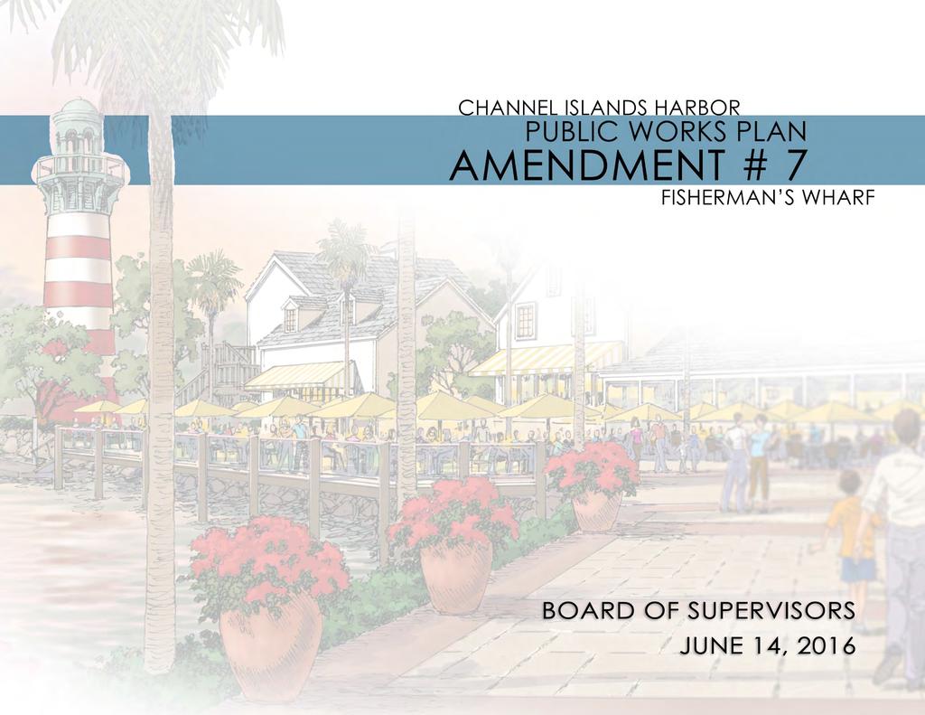
HEARING PUBLIC GOALS. Conduct a public hearing on the proposed Public Works Plan Amendment #7 (PWPA7);
|
|
|
- Rolf Nelson
- 6 years ago
- Views:
Transcription
1

2 HEARING PUBLIC GOALS Conduct a public hearing on the proposed Public Works Plan Amendment #7 (PWPA7); Find that adoption of PWPA7 is consistent with Coastal Act; Approve and authorize the Chair of the Board to execute the Resolution approving PWPA7 for submission to the Coastal Commission; and Authorize Harbor Director to submit PWPA7 to the Coastal Commission and to take all steps necessary to obtain its approval and certification by the Commission, including taking actions to ensure conformity between the Harbor Public Works Plan and the City of Oxnard Local Coastal Plan.


3 NOTICING PROVIDED FOR AMENDMENT #7 and Website Posting Direct Mailing Newspaper Publication NOTICING REQUIREMENTS (CALIFORNIA COASTAL COMMISSION)

4 DEVELOPERS PUBLIC OUTREACH MARCH Small group and Individual Meetings JANUARY 2016 Oxnard Chamber of Commerce Adjacent Neighbors of Fisherman s Wharf Friends of Channel Islands Harbor Channel Islands Beach Community Services District Hollywood by the Sea Neighborhood Council {canceled by them} Channel Islands Community Association Channel Islands Waterfront Homeowners Association FEBRUARY 2016 Seabridge Homeowners Association Lordon Management Company

5 AMENDMENT PUBLIC WORKS PLAN PURPOSE Amendment 7 to the Channel Islands Public Works Plan ( PWP ) allows for the redevelopment of Fisherman s Wharf by increasing height limitations and modifying the land use designation by adding Urban Village language for mixed use.
 to be re-used or replaced in kind")


6 CURRENT LAND USE DESIGNATION IN THE PWP The retail and commercial portion of the proposed project (northern end) to be re-used or replaced in kind with allowed uses. V.S.H.O. The southern portion of the proposed project, residential building, is not currently contemplated in the PWP. All of the Parcels are within the Visitor Serving Harbor Oriented land use designation as depicted in Figure 4 of the Certified PWP SUMMARY OF AMENDMENT: LAND USE

7 VISITOR SERVING HARBOR ORIENTED (V.S.H.O.) PERMITTED USES picnicking and other passive recreation lodging dining fast food shopping in chandleries gift shops boutiques motels restaurants convenience stores gas stations fire stations community centers/meeting places yacht clubs park areas marine museums marine oriented research facilities including a Boating Instruction and Safety Center SUMMARY OF AMENDMENT: LAND USE


8 CURRENT PARCEL CONFIGURATION: INTERNAL CONSISTENCY WITH THE PWP PROPOSED: Commercial retail is consistent with the Public Works Plan; amendment needed for residential. CONSISTENCY ANALYSIS

9 CONFORMITY WITH THE CITY OF OXNARD LOCAL COASTAL PROGRAM (LCP) The proposed Fisherman s Wharf complex falls within the City s Harbor Channel Islands sub-zone (HCI), which allows for a wide variety of uses: restaurants cocktail lounges cafés fast food facilities marine and tourist-related retail shops marine-related museum tourist hotels and motels bait and tackle sales boating and yacht club and clubhouse boat sales yard marine electronics sales and repair marine engineering sales and repair marine fuels sales marine hardware and chandlery marine supply store sailing or scuba school recreational boating launching dry storage of boats parking of boat trailers washing of boats and saltwater engine cooling systems boat and boat equipment sales rentals display brokerage charter offices and minor repair CONSISTENCY ANALYSIS

10 CONFORMITY WITH THE CITY OF OXNARD LOCAL COASTAL PROGRAM (LCP) The City of Oxnard recently (October 2011) adopted revised general plan policies, labeled 2030 General Plan Goals and Policies, in anticipation of updating its zoning code and LCP to conform to the policy decisions made by the City Council within that document. CONSISTENCY ANALYSIS


11 PROPOSED URBAN VILLAGE IN THE PWP CITY OF OXNARD: URBAN VILLAGE This new overlay applies to six neighborhoods within the City of Oxnard that are intended for mixed-use development Intended to allow residents to Live near their place of employment, make use of existing support and transit services, Reduce environmental impacts on the community, And facilitate walking and bicycling for short trips to meet daily needs. This overlay covers the site of the proposed Fisherman s Wharf project as Channel Islands Harbor Marina Village and provides for a development in accord with the County s proposed mixed use development SUMMARY OF AMENDMENT

12 CONFORMITY WITH THE CITY OF OXNARD LOCAL COASTAL PROGRAM (LCP) California State Planning Law makes specific requirements with regard to preparation of general plans by cities and counties. Government Code Section , in particular, states the Legislative intent that general plans and their elements comprise an integrated, internally consistent and compatible statement of policies for the adopting agency. Government Code Section states that any specific plan or other plan of the city that is applicable to the same areas or matters affected by a general plan amendment shall be reviewed and amended as necessary to make such plans consistent with the general plan. The law provides that no zoning ordinance may be adopted or amended within an area covered by a specific plan unless it is consistent with the adopted specific plan, in this case the LCP. The law thus requires the City of Oxnard to amend its LCP to be consistent with its newly revised general plan, and the Coastal Act requires that the CCC certify such an amendment. CONSISTENCY ANALYSIS
13 THE NEED FOR RESIDENTIAL To provide financial support to the retail portion of the project Responds to the need for rental housing, especially in the Coastal Zone, as documented in Exhibit A of the Consideration of Environmental Factors Within walking distance of commonly needed services Provide a financially sustainable project that will be used by both daily and weekend residents HOUSING NEED
14 PUBLIC WORKS PLAN AMENDMENT #7 Changes to the Public Works Plan are shown in both strikethrough and underline Section -1.4 Landside Facilities and Uses, Recreational Uses The landside recreational uses include: the swimming beach just inside the south jetty; linear bike and walkways adjacent to the boat basins and channels; public parks and overlooks on the peninsula, the east and west channels and the fishing, the picnic area atop the entrance mouth revetment (i.e., near Parking Lot W-1) and the Boating Instruction and Safety Center (near parking lot W-4, and on Figure III, Figure IV, and Appendix). In addition, visitor serving commercial and retail uses [1] also provide recreation for those who come to the Harbor to eat or shop in conjunction with boating or non-boating recreational activities. Residential uses at the corner of Victoria and Channel Islands provide support to the retail and commercial component when visitors are not present. These uses compliment complement rather than conflict with the Harbor s primary function as a small craft Harbor for recreational boating. This mixed use concept horizontally integrates the residential and commercial uses to create an urban village dynamic.
15 PUBLIC WORKS PLAN AMENDMENT #7 Changes to the Public Works Plan are shown in both strikethrough and underline VISITOR SERVING HARBOR ORIENTED (V.S.H.O.), Permitted Uses Permitted Uses are picnicking and other passive recreation, lodging, dining, fast food and shopping in chandleries, gift shops and boutiques, motels, restaurants, convenience stores, gas stations, fire stations, community centers/meeting places, yacht clubs, park areas, marine museums, marine oriented research facilities including a Boating Instruction and Safety Center as shown on Figure III, Figure IV, and Appendix B. All uses shall have parking facilities adequate to meet average weekend peak demands. The commercial areas of Channel Islands Harbor have been affected by changes in the marketplace, consumer desires and expectations, and the increase in the volume of available commercial alternatives. The absence of regular visitors at many times of the year, combined with a large number of second homes, combines to reduce patronage to the commercial areas sufficient to ensure economic health. Moreover, the Coastal Commission has already approved major commercial development in the vicinity, further competing with the Harbor s commercial lessees. The absence of sufficient non-transient rental housing is seen as a significant contributor to the challenge of the retail and commercial uses in the Harbor. This fact, combined with the general unmet housing needs in the coastal zone, has resulted in the County s proposal to introduce residential in close proximity to the existing major commercial center in Channel Islands Harbor to help support the commercial uses, so convenient to visitors when they are present. CONTINUED ON NEXT SLIDE
16 PUBLIC WORKS PLAN AMENDMENT #7 Changes to the Public Works Plan are shown in both strikethrough and underline CONTINUED. Urban Village Sub-Category to V.S.H.O. For the land areas beginning at the corner of Channel Islands Boulevard and Victoria Avenue, southward to the Public Boat Launch Ramp, and applicable only to Parcel V, development will consist of a mix of transit and pedestrian oriented residential, commercial, office and/or other similar uses, with a sense of place and identity. This urban village approach provides for mixed use areas designed to encourage persons to live near their place of employment and/or support services. As outlined in the City of Oxnard 2030 General Plan policies, Urban Villages should occur in the designated areas but may be proposed in other areas as a General, Specific, Coastal, or County Public Works Plan Amendment. The integration of complementary land uses is intended to promote a pedestrian orientation to reduce trips and vehicle miles traveled and reduce greenhouse gas emissions. Permitted uses are apartment dwellings consistent with the protection and enhancement of public access, combined with restaurant, retail, office, educational, recreational services for the use of Harbor visitors and residents. Urban village areas may include 30 or more units per acre according to the City of Oxnard 2030 General Plan policies, including mid to high-rise residential buildings, preferably as part of a mixed-use or urban village area or where high-rise residential development is appropriate. Live/work, work/live, and mixed use development is strongly encouraged.
17 PUBLIC WORKS PLAN AMENDMENT #7 Changes to the Public Works Plan are shown in both strikethrough and underline Section COASTAL ISSUES AND DEVELOPMENT POLICIES, 3.1 Public Access and Recreation Section of the Coastal Act requires that new development not interfere with the public s right of access to the sea where acquired through use or legislative authorization, including, but not limited to, the use of dry sand and rocky coastal beaches to the first line of terrestrial vegetation. Section 30252(4) of the Coastal Act states that new development must provide adequate parking facilities. To prevent overcrowding of public recreational facilities Section states that these public facilities be distributed equally throughout an area. Section identifies the visual and scenic qualities of coastal areas to be a resource importance that must be protected. The protection of these ocean oriented recreational lands and lower cost visitor and recreation facilities is stipulated by Sections 30220, and of the Coastal Act. Channel Islands Harbor devotes a significant percentage of the land area to public recreation and visitor serving uses.
18 PUBLIC WORKS PLAN AMENDMENT #7 Changes to the Public Works Plan are shown in both strikethrough and underline VISUAL ACCESS d. Future building or redevelopment of existing buildings in the Harbor shall not exceed two stories or 25 feet in height except as set forth herein. 1. On Parcel V 1 at the corner of Victoria Avenue and Channel Islands Boulevard building height shall not exceed feet.
19 PUBLIC WORKS PLAN AMENDMENT #7 Changes to the Public Works Plan are shown in both strikethrough and underline Table I Inventory of Existing Uses/Intensities by Parcel Use of Parcel Parcel Size (acres) Land No. of Slips or Dry Storage Intensity (units or floor area) URBAN VILLAGE PCL V Restaurant Retail/Commercial Office Residential 10.5 acres Boat Slips (Transient /Day Docks) 16 Public Park 1.0 acre sq. ft sq. ft sq. ft. 400 apts. CONTINUED ON NEXT SLIDE
20 PUBLIC WORKS PLAN AMENDMENT #7 Changes to the Public Works Plan are shown in both strikethrough and underline Table I Inventory of Existing Uses/Intensities by Parcel Use of Parcel Parcel Size (acres) Land No. of Slips or Dry Storage Intensity (units or floor area) PCL V, V-2, V-3 a 2.44 acres F. Mkt/Bait & Tackle 2000 sq. ft Fish & Chips 800 sq. ft Splty Shops (8) & Laundromat 5000 sq. ft Grocery PCL Y-2 a 1.44 acres Gift Shops & Conv. & Marine sq. ft oriented & Vis. Serv. Rec. Subtotal acres sq. ft CONTINUED ON NEXT SLIDE
21 PUBLIC WORKS PLAN AMENDMENT #7 Changes to the Public Works Plan are shown in both strikethrough and underline Table I Inventory of Existing Uses/Intensities by Parcel Use of Parcel Parcel Size (acres) Land No. of Slips or Dry Storage Intensity (units or floor area) PCL N-2 a - Office - Transient Dock - Launch Ramp 72 slips 16 slips (i.e. boats) 1330 sq. ft CONTINUED ON NEXT SLIDE
22 PUBLIC WORKS PLAN AMENDMENT #7 Changes to the Public Works Plan are shown in both strikethrough and underline Table I Inventory of Existing Uses/Intensities by Parcel Use of Parcel Parcel Size (acres) Land No. of Slips or Dry Storage Intensity (units or floor area) PCL F-2 Pub. Park 0.90 acres PL a PCL V 1 acre PL

23 EXISTING VS. NEW

24 URCHIN DOCK RELOCATION


25 PUBLIC ACCESS KEY UPGRADES Expanded promenade New public park Public docks Outdoor/ waterfront dining Benches

26 EXPANDED PARKING OPTIONS ENVIRONMENTAL FACTORS


27 CURRENT BUILDING HEIGHT The current height allowance on Parcel V-1 is 35 feet, while the actual lighthouse height has been verified at 51 feet, and the greatest current building height on the remainder of the property is 43 feet, as shown here. Within the certified PWP, building heights on these Parcels were limited to 35 feet on Parcel V-1, and two stories (or 25 feet) on the other Parcels. As documented in the past, many buildings in the Harbor far exceed 25 feet in height, including the existing structures on these Parcels. After consultation with CCC staff, the County has adopted the approach of correcting heights by amendment as individual parcels are presented to the CCC for redevelopment. SUMMARY OF AMENDMENT: HEIGHT
28 PROPOSED RESIDENTIAL BUILDING HEIGHT The proposed residential building height, at its maximum, is 55 feet, with parapets for architectural interest and height variations in building design with insets along the vertical structure to minimize the appearance of a block wall along the Harbor s streets and waterways. SUMMARY OF AMENDMENT: HEIGHT

29 BIRD STUDY No nesting has been documented on this site for more than five years. The nearest nesting sites are over 2000 feet away, and shielded by intervening apartments located on the Harbor s Peninsula Road. ENVIRONMENTAL FACTORS

30 Water services within the Harbor are provided by the Channel Islands Beach Community Services District (CIBCSD). Water needs for the project are within the acre feet of water supply to be made available to the Harbor area by contract between the County and CIBCSD. PROJECT SPECIFIC UTILITIES Sewer and trash services are and will continue to be provided by the City of Oxnard. ENVIRONMENTAL FACTORS

 for the purpose")

31 REDUCING GREEN HOUSE GAS EMMISSIONS to promote the development of better places to live and work through measures that encourage more compact development, varied housing options, bike and pedestrian improvements, and efficient transportation infrastructure. Senate Bill 375, signed in August 2008, requires the inclusion of sustainable communities strategies (SCS) for the purpose of reducing GHG emissions. The proposed project would place residential development about 0.25 miles away from everyday destinations, such as retail stores, restaurants, banks and a grocery store located in the shopping center near at the intersection of West Channel Islands Boulevard and Victoria Ave, thereby also meeting this SCS goal. ENVIRONMENTAL FACTORS


32 PROJECT SPECIFIC TRAFFIC ANALYSIS Cumulative traffic volumes were developed based on a list of approved and pending development projects provided by staff from the cities of Oxnard and Port Hueneme. The traffic study found that the currently unsignalized Victoria Avenue/Monaco Drive intersection could temporarily operate in the low level of service D range under existing conditions and all other approaches would operate in the LOS A and LOS B ranges. The Victoria/Monaco intersection is scheduled to be signalized in the near future as part of the City of Oxnard s Victoria Mixed-Use Development. Once signalized, the intersection will operate at a level of service A. Also, the Victoria Avenue/Doris Avenue intersection would operate in the level of service D range during the AM peak hour. This is the only D range location in the report for impacts from cumulative projects. The proposed project at Fisherman s Wharf would not generate any project specific impacts based on the applicable impact thresholds. No project specific mitigations are therefore required. ENVIRONMENTAL FACTORS
33 REQUIRED APPROVALS Amendment to the County s PWP for inclusion of rental housing units on the site to be approved by the Board of Supervisors and the California Coastal Commission; Amendment to the City of Oxnard LCP for inclusion of rental housing units on the site, and to provide consistency with the City s 2030 General Plan, which (as mentioned earlier) calls for Urban Village development at this project location; Approval of a NOID by the California Coastal Commission.

34 NEXT KEY STEPS Submit to the California Coastal Commission for review and action.
3.0 LAND USE PLAN. 3.1 Regional Location. 3.2 Existing Conditions Existing Uses. Exhibit Regional Location Map
 3.0 LAND USE PLAN 3.1 Regional Location The Anaheim Resort Specific Plan (ARSP) area is located in the City of Anaheim, which is 35 miles southeast of downtown Los Angeles and 7 miles northwest of Santa
Planning Commission Report
 Planning Commission Report To: From: Subject: Planning Commission Meeting: January 6, 2016 Agenda Item: 8-B Planning Commission David Martin, Planning & Community Development Director Introduction to the
Venice Pumping Plant Dual Force Main Project Draft EIR 5.11 PUBLIC FACILITIES AND SERVICES
 5.11 PUBLIC FACILITIES AND SERVICES RECREATIONAL FACILITIES AND PUBLIC RESOURCES This section of the EIR includes a description of the existing recreational facilities and public resources in the proposed
M i s s i o n B a y W a t e r f r o n t
 114 M i s s i o n B a y W a t e r f r o n t Character of the Area: The Mission Bay Waterfront extends from Pier 48 at China Basin Channel to 18th Street in the Central Basin. This area of the waterfront
MARINA MARKET & WATERFRONT DEVELOPMENT STUDY PORT ARANSAS, TEXAS
 MARINA MARKET & WATERFRONT DEVELOPMENT STUDY PORT ARANSAS, TEXAS FEBRUARY 2015 PRESENTATION OUTLINE 1 2 3 4 5 6 7 REGIONAL POSITIONING SITE IMPRESSIONS PLANNING & DESIGN PRINCIPLES EXISTING IMPROVEMENTS
Mark-up of the effect of the proposed Bronte Village Growth Area OPA No.18 on the text of section 24, Bronte Village, of the Livable Oakville Plan
 Mark-up of the effect of the proposed Bronte Village Growth Area OPA No.18 on the text of section 24, Bronte Village, of the Livable Oakville Plan Notes: This document is provided for information purposes
City Center Neighborhood Plan
 [1] City Center Neighborhood Plan As adopted by Ordinance No. 2014-09-049 and amended by Ordinance Nos. Formerly CBD Neighborhood as adopted by Ordinance No. 8868 and amended by Ordinance Nos. 8946, 9693,
WHEREAS, after consideration of the evidence presented at the public hearing on January 14, 2010, the Prince George's County Planning Board finds:
 R E S O L U T I O N WHEREAS, the Prince George s County Planning Board has reviewed DDS-600 requesting a departure for the location of two loading spaces without driveway access along Toledo Terrace in
STAFF REPORT NATIONAL MEDAL OF HONOR MUSEUM
 STAFF REPORT NATIONAL MEDAL OF HONOR MUSEUM For reference, the Zoning Code and Land Development Regulations are available online. AGENDA ITEM: 5.b. Case #: Request: Location: Type of Request: Public Hearing:
City of Chickasaw Land Use Comprehensive Plan 2030 Chapter5-Draft(2)Public review_
Public review_") Land Use Land Use refers to the activity or development characteristics of a given parcel of land. The Land Use Plan presented in the following pages, represents the City of Chickasaw s official position
Land Use Land Use refers to the activity or development characteristics of a given parcel of land. The Land Use Plan presented in the following pages, represents the City of Chickasaw s official position
2.0 THE PLATINUM TRIANGLE VISION
 2.0 THE PLATINUM TRIANGLE VISION The envisions an exciting future for the area surrounding Angel Stadium of Anaheim, the Honda Center and The Grove of Anaheim. 2.1 Planning Principles In order to further
Development Solicitation Request for Qualifications. The Historic Hollering Place Development
 City of Coos Bay Urban Renewal Agency Development Solicitation Request for Qualifications The Historic Hollering Place Development For More Information Contact: Eric Day Community Development Director
MIXED-USE VILLAGE OVERLAY FLOATING DISTRICT
 MIXED-USE VILLAGE OVERLAY FLOATING DISTRICT Zoning regulations developed by committee to the Planning Board for the Town of DeWitt, NY Issue date: 13 July 2017 revised 3/12/2018, revised 4/26/2018, 5/9/2018
4 January 11, 2012 Public Hearing APPLICANT:
 . 4 January 11, 2012 Public Hearing APPLICANT: MID-ATLANTIC AUTO PROPERTY OWNER: DZR, LLC STAFF PLANNER: Leslie Bonilla REQUEST: Conditional Use Permit (truck rental, automobile service, and automotive/bulk
LOS ANGELES CITY PLANNING DEPARTMENT STAFF REPORT
 LOS ANGELES CITY PLANNING DEPARTMENT STAFF REPORT LOS ANGELES CITY PLANNING COMMISSION CASE NO: CPC 2006-9374 CRA CEQA: Exempt DATE: December 21, 2006 Location: Valley Plaza and Laurel Plaza TIME: after
Chelsea Creek Municipal Harbor Plan
 Chelsea Creek Municipal Harbor Plan Public Meeting #1 June 11th, 2018 1 Presentation outline I. Introduction: Why are we doing this plan? II. Evolution of Chelsea Creek III. State of Chelsea Creek IV.
KEIZER STATION PLAN INTRODUCTION
 KEIZER STATION PLAN INTRODUCTION Planning for this area began in 1987 when the Keizer Comprehensive Plan established the Chemawa Activity Center and McNary Activity Center. The first Chemawa Activity Center
CHARLES PUTMAN CHARLES PUTMAN AND ASSOCIATES, INC
 MEMORANDUM CHARLES PUTMAN & ASSOCIATES, INC. LAND DEVELOPMENT CONSULTANTS PLANNING ZONING PERMITTING 4722 NW Boca Raton Boulevard, Suite C-106 Boca Raton, Florida 33431 Phone: 561/994-6411 FAX: 561/994-0447
3.1 Existing Land Use
 3.0 Land Use This strategy has been developed taking into account the position of the Town of Sidney as the economic center of the Saanich Peninsula. It acknowledges existing land use patterns in the downtown
COUNTY OF ALBEMARLE PLANNING STAFF REPORT SUMMARY
 COUNTY OF ALBEMARLE PLANNING STAFF REPORT SUMMARY Project Name: SP2006-43 Field School Planning Commission Public Hearing: April 4, 2007 Owners: Claudius Crozet Park, Inc. (Robert A. Maupin, President)
Venice Pumping Plant Dual Force Main Project Draft EIR
 City of Los Angeles 5.9 LAND USE PLANS 5.9.1 Environmental Setting Venice Pumping Plant Dual Force Main Project Draft EIR The Project lies within the bounds of Los Angeles County and the City of Los Angeles.
DEFINED VILLAGE CENTRES & NEIGHBOURHOODS
 DEFINED VILLAGE CENTRES & NEIGHBOURHOODS residents in Nanoose Bay support focusing attractive, planned future development in Red Gap Centre and the Area s neighbourhood centres. In addition, the development
SOUTHEAST AREA SPECIFIC PLAN. Planning Commission Study Session August 18, 2016
 SOUTHEAST AREA SPECIFIC PLAN Planning Commission Study Session August 18, 2016 Background: How did we get here? Directed by City Council to prepare Specific Plan (2012) Sustainability focused grant from
Cold Lake Marina Master Plan
 Cold Lake Marina Master Plan Intro to Team Moffatt & Nichol is recognized throughout the world for our role in the revitalization and redevelopment of urban waterfronts, including the evolution of modern
Institutional Overlay Zone (IOZ) Regulatory Framework
 Regulatory Framework") Institutional Overlay Zone (IOZ) Regulatory Framework Approved by Portland City Council November 20, 2017 APPLICABILITY All development proposed by Maine Medical Center (MMC) within the boundary of the
Institutional Overlay Zone (IOZ) Regulatory Framework Approved by Portland City Council November 20, 2017 APPLICABILITY All development proposed by Maine Medical Center (MMC) within the boundary of the
ARLINGTON COUNTY, VIRGINIA
 ARLINGTON COUNTY, VIRGINIA County Board Agenda Item Meeting October 15, 2005 DATE: September 28, 2005 SUBJECT: Request to Advertise the adoption of the 2005 Clarendon Sector Plan C. M. RECOMMENDATION:
The transportation system in a community is an
 7 TRANSPORTATION The transportation system in a community is an important factor contributing to the quality of life of the residents. Without a sound transportation system to bring both goods and patrons
George Hotel application STAFF REVIEW COMMITTEE OF THE WHOLE JANUARY 14, 2014
 George Hotel application STAFF REVIEW COMMITTEE OF THE WHOLE JANUARY 14, 2014 1 Presentation outline Purpose: to seek Council direction for next steps in the review process Application process to date
Planning Commission March 14, Presented by: City of Bellingham Port of Bellingham
 Planning Commission March 14, 2013 Presented by: City of Bellingham Port of Bellingham 1 Agenda Waterfront District Background Waterfront District Proposal Overview Sub-area Plan Development Regulations
Staff Report and Recommendation
 Community Planning and Development Planning Services 201 W. Colfax Ave., Dept. 205 Denver, CO 80202 p: 720.865.2915 f: 720.865.3052 www.denvergov.org/cpd TO: City Council Neighborhoods and Planning Committee
BROOKHILL NEIGHBORHOOD MODEL ZONING MAP AMENDMENT PREFACE TO APPLICATION
 BROOKHILL NEIGHBORHOOD MODEL ZONING MAP AMENDMENT PREFACE TO APPLICATION June 15, 2015 Revised: August 1, 2016 I. VISION Brookhill is a proposed community based upon the principles of Albemarle County
TABLE OF CONTENTS 1.0 INTRODUCTION... 3
 TABLE OF CONTENTS 1.0 INTRODUCTION... 3 1.1. BACKGROUND... 3 1.2. THE PROPOSAL... 5 2.0 EXISTING POLICY FRAMEWORK... 5 2.1. PROVINCIAL POLICY STATEMENT (PPS)... 5 2.2. CITY OF LONDON OFFICIAL PLAN (OP)...
CITY OF PUYALLUP. Background. Development Services
 CITY OF PUYALLUP Development Services 333 South Meridian Puyallup WA 98371 To: City Council From: Katie Baker, AICP, Planning Division Re: South Hill Neighborhood Plan Adoption Date: (Meeting date: February
MEMORANDUM AGENDA ITEM #IV.C
 MEMORANDUM AGENDA ITEM #IV.C DATE: NOVEMBER 27, 2017 TO: FROM: COUNCIL MEMBERS STAFF SUBJECT: LOCAL GOVERNMENT COMPREHENSIVE PLAN PROPOSED AND ADOPTED AMENDMENT CONSENT AGENDA Pursuant to Section 163.3184,
Attachment 4. TRPA Environmental Documentation, IEC/MFONSE
 Required Findings for Certification of the Final Initial Study/Mitigated Negative Declaration (IS/MND) and Initial Environmental Checklist/Mitigated Finding Of No Significant Effect (IS/MFONSE) TRPA Environmental
VILLAGE OF CLEMMONS PLANNING BOARD DRAFT STAFF REPORT
 VILLAGE OF CLEMMONS PLANNING BOARD DRAFT STAFF REPORT PETITION INFORMATION Docket # C-226 Staff Megan Ledbetter Petitioner(s) JBJH Properties, LLC Owner(s) JBJH Properties, LLC Subject Property 5892-49-1766
Online Survey Results 1 Port Street East
 Online Survey Results 1 Port Street East Inspiration Port Credit is about envisioning a bright, new future for the Port Credit waterfront. Through an online survey in the fall of 2014, we asked what the
REQUEST Current Zoning: O-15(CD) (office) Proposed Zoning: TOD-M(CD) (transit oriented development mixed-use, conditional)
 (office) Proposed Zoning: TOD-M(CD) (transit oriented development mixed-use, conditional)") Rezoning Petition 2016-117 Zoning Committee Recommendation January 4, 2017 REQUEST Current Zoning: O-15(CD) (office) Proposed Zoning: TOD-M(CD) (transit oriented development mixed-use, conditional) LOCATION
Rezoning Petition 2016-117 Zoning Committee Recommendation January 4, 2017 REQUEST Current Zoning: O-15(CD) (office) Proposed Zoning: TOD-M(CD) (transit oriented development mixed-use, conditional) LOCATION
3. Project Description
 3.1 PROJECT LOCATION The Platinum Triangle (herein after also referred to as the Project Area ) is located at the confluence of the Interstate 5 (I-5 Freeway) and the State Route 57 (SR-57 Freeway), in
Project Location and Description
 ATTACHMENT 1 TO REVISED NOTICE OF PREPARATION MARCH 2005 The Village at Loch Lomond Marina (Revised) Project Location and Description I. INTRODUCTION A. Location and Surrounding Uses B. On-site Existing
REPORT OF THE PLANNING AND DEVELOPMENT DEPARTMENT FOR APPLICATION FOR REZONING ORDINANCE TO PLANNED UNIT DEVELOPMENT AUGUST 18, 2016
 REPORT OF THE PLANNING AND DEVELOPMENT DEPARTMENT FOR APPLICATION FOR REZONING ORDINANCE TO PLANNED UNIT DEVELOPMENT AUGUST 18, 2016 AWH The Planning and Development Department hereby forwards to the Planning
Somers Point Master Plan
 Somers Point Master Plan Progress Report and Public Meeting August 20, 2014 Master Plan Reexamination Municipal Land Use Law require that all municipalities reexamine their master plan every ten years.
As is referenced in the site analysis, the current site access is along Loggers Lane and on to Galbraith Avenue.
 4.12 Archaeological Assessment The land above sea level at the Oceanfront was created over the last 100 years by the fill from dredging of the Mamquam Blind Channel, the Cattermole Slough and the Squamish
4.1.3 LAND USE CATEGORIES
 4.1.3 LAND USE CATEGORIES a. City Center District The City Center District incorporates the existing character and mix of uses in downtown Belmont to encourage redevelopment and new development in keeping
2.1 Location and Size
 2.0 Context 7 2.1 Location and Size The Saanich Penninsula The study area is centrally located within the Town boundaries on the east side of Highway 17, which runs through Sidney in a north-south direction.
Gold Line Bus Rapid Transit Transit Oriented Development (BRTOD) Helmo Station Area Plan
 Helmo Station Area Plan") Appendix F Gold Line Bus Rapid Transit Transit Oriented Development (BRTOD) Helmo Station Area Plan Introduction and Purpose of the Plan The Gold Line Bus Rapid Transit facility is an eleven-mile dedicated
Appendix F Gold Line Bus Rapid Transit Transit Oriented Development (BRTOD) Helmo Station Area Plan Introduction and Purpose of the Plan The Gold Line Bus Rapid Transit facility is an eleven-mile dedicated
Table of Contents. Executive Summary... vii
 Table of Contents Executive Summary... vii Section I: Background...1 Introduction... 3 Study History... 3 Purpose and Role of the Plan... 6 Plan Organization... 7 The Estuary Shoreline... 11 Multiple Jurisdictions...
PORT WHITBY COMMUNITY
 PORT WHITBY COMMUNITY SECONDARY PLAN UPDATE COMMUNITY IMPROVEMENT PLAN URBAN DESIGN GUIDELINES September 2015 DRAFT PROPOSED AMENDMENT NUMBER # to the Whitby Official Plan PURPOSE: The intent of this Amendment
6 PORT SYDNEY SETTLEMENT AREA
 Section 6 Port Sydney Page 61 6 PORT SYDNEY SETTLEMENT AREA 6.1 Basis and Principles Village of Port Sydney Waterfront Community Existing Services 6.1.1 Port Sydney is an historic settlement that has developed
Notice of Preparation (NOP) of an Environmental Impact Report and Public Scoping Meeting for the Alameda Shipways Residential Project
 of an Environmental Impact Report and Public Scoping Meeting for the Alameda Shipways Residential Project") Notice of Preparation (NOP) of an Environmental Impact Report and Public Scoping Meeting for the Notice is hereby given that the City of Alameda, Lead Agency, will prepare an Environmental Impact Report
Notice of Preparation (NOP) of an Environmental Impact Report and Public Scoping Meeting for the Notice is hereby given that the City of Alameda, Lead Agency, will prepare an Environmental Impact Report
AWH REPORT OF THE PLANNING AND DEVELOPMENT DEPARTMENT FOR APPLICATION FOR REZONING ORDINANCE TO PLANNED UNIT DEVELOPMENT
 AWH REPORT OF THE PLANNING AND DEVELOPMENT DEPARTMENT FOR APPLICATION FOR REZONING ORDINANCE TO PLANNED UNIT DEVELOPMENT MAY 8, 2014 The Planning and Development Department hereby forwards to the Planning
STAFF SUMMARY FOR S17-02 SPECIAL USE PERMIT APPLICATION
 APPLICATION SUMMARY Case Number: S17-02 Request: STAFF SUMMARY FOR S17-02 SPECIAL USE PERMIT APPLICATION SUP application in order to develop a convenience food store. Applicant: Property Owner(s): Cindee
Clairtrell Area Context Plan
 Clairtrell Area Context Plan March 2005 Urban Development Services City Planning Contents 1. Introduction... 4 2. Development Structure... 6 2.1 Streets... 7 2.1.1 Sheppard Avenue and Bayview Avenue...
Bourne Downtown Site Planning
 Prepared for: The Town of Bourne, MA In Cooperation with: Bourne Financial Development Corporation Prepared by:, Inc. June 24, 2009 Table of Contents Introduction and Summary... 1 Site Existing Conditions...
SECTION IV: DEVELOPMENT CONCEPT
 80 SECTION IV: DEVELOPMENT CONCEPT Section IV: DEVELOPMENT CONEPT This section provides an overall understanding and rationale for what is envisioned in The Preserve, the intended quality and character
Zoning and Development Considerations in the Boothbay Harbor Maritime/Water Dependent District
 Zoning and Development Considerations in the Boothbay Harbor Maritime/Water Dependent District Bob Faunce Lincoln County Planner Lincoln County Regional Planning Commission Board of Selectmen and Planning
City Of Sparks Planning Commission Item
 Page 1 of 12 City Of Sparks Planning Commission Item Meeting Date: May17, 2012 Subject: PCN12009, Public Hearing, Consideration and possible action on a Master Plan Amendment and Rezoning request to change
CHAPTER 1. Ms. Guajardo s Class - Central Elementary CH 1 1
 INTRODUCTION CHAPTER 1 Ms. Guajardo s Class - Central Elementary CH 1 1 1.1 SETTING South Centre City is a linear corridor south of Downtown Escondido paralleling Centre City Parkway and South Escondido
Appendix E Section 4(f) Evaluation
 Evaluation") Appendix E Section 4(f) Evaluation Appendix E Draft Section 4(f) Evaluation E.1 Introduction This appendix addresses a federal regulation known as Section 4(f), which protects parks, recreation areas,
Appendix E Section 4(f) Evaluation Appendix E Draft Section 4(f) Evaluation E.1 Introduction This appendix addresses a federal regulation known as Section 4(f), which protects parks, recreation areas,
Request Conditional Use Permit (Car Wash Facility) Staff Recommendation Approval. Staff Planner Jonathan Sanders
 Staff Recommendation Approval. Staff Planner Jonathan Sanders") Applicant Property Owner SunTrust Bank Public Hearing October 10, 2018 City Council Election District Princess Anne Agenda Item 2 Request Conditional Use Permit (Car Wash Facility) Staff Recommendation
Applicant Property Owner SunTrust Bank Public Hearing October 10, 2018 City Council Election District Princess Anne Agenda Item 2 Request Conditional Use Permit (Car Wash Facility) Staff Recommendation
Queensborough Eastern Neighbourhood Node. Community Open House
 Queensborough Eastern Community Open House The Vision The Queensborough Eastern will become the heart of eastern Queensborough. Through a sensitive mix of viable commercial and residential areas, the neighbourhood
Rezoning Petition Pre-Hearing Staff Analysis May 21, 2018
 Rezoning Petition 2018-018 Pre-Hearing Staff Analysis May 21, 2018 REQUEST Current Zoning: R-5 (single family residential), R-5 HD-O (single family residential, historic district overlay) and B-2(CD) HD-O
RE: AMENDMENT C375 GEELONG PLANNING SCHEME 1900 BARWON HEADS ROAD, BARWON HEADS
 Reference: #V157080 14 August 2018 Barwon Heads Lifestyle Group Pty Ltd C/- Best Hooper Lawyers Level 9, 451 Little Bourke Street MELBOURNE VIC 3000 Attention: Mr. Edward Mahony (Lawyer) Dear Edward RE:
11 May 9, 2012 Public Hearing APPLICANT: KROGER LIMITED PARTNERSHIP I
 REQUEST: Conditional Use Permit (Automobile Service Station (Fuel Sales) ADDRESS / DESCRIPTION: 3901 Holland Drive 11 May 9, 2012 Public Hearing APPLICANT: KROGER LIMITED PARTNERSHIP I PROPERTY OWNER:
1296 Kennedy Road - Zoning Amendment Application - Preliminary Report
 STAFF REPORT ACTION REQUIRED 1296 Kennedy Road - Zoning Amendment Application - Preliminary Report Date: January 15, 2016 To: From: Wards: Reference Number: Scarborough Community Council Acting Director,
EXISTING COMPREHENSIVE PLAN
 EXISTING COMPREHENSIVE PLAN Town Center Land Use Element: V. LAND USE POLICIES Town Center Mercer Island's business district vision as described in "Your Mercer Island Citizen-Designed Downtown" was an
Proposed Comprehensive Plan Strategies DRAFT for discussion June 28, 2017
 Proposed Comprehensive Plan Strategies DRAFT for discussion June 28, 2017 Land Use Rural Areas Refine the Farm and Forest area (FF) Update FF boundaries to account for existing lots less than five acres
Village of Fair Haven Goals & Objectives
 Village of Fair Haven Goals & Objectives 1 Natural Environmental Quality & Aesthetics Embrace policies and programs that preserve and enhance the Village s natural resources, environment, water quality,
Appendix C: Interim Mixed-Use Evaluation Criteria
 Appendix C: Interim Mixed-Use Evaluation Criteria C-1 Appendix C: Interim Mixed-Use Evaluation Criteria PURPOSE: The implementation of numerous policies contained within the Master Plan hinges on the creation
Highland Falls Waterfront Redevelopment Feasibility Study Village Board Meeting March 20, 2017
 Village Board Meeting March 20, 2017 Agenda I. Public Meeting #1 Visioning Summary II. Public Meeting #2 Comment Summary III. IV. IV. Case Study: Milton Train Station Schematic Design Concepts Schedule/Next
This Review Is Divided Into Two Phases:
 Semiahmoo Town Centre Review The purpose of this review: To review the Semiahmoo Town Centre Concept Plan, originally approved in 1993, to ensure that this centre will continue to serve the needs of South
III. PROJECT DESCRIPTION
 III. PROJECT DESCRIPTION LOCATION AND BOUNDARIES The City of Manhattan Beach is located in the South Bay region of Los Angeles County, California, approximately 2 miles south of the Los Angeles International
Institutional Master Plan The Arnold Arboretum of Harvard University
 Institutional Master Plan The Arnold Arboretum of Harvard University Submitted to: Boston Redevelopment Authority One City Hall Square Boston, MA 02201 Submitted by: The Arnold Arboretum of Harvard University
ARLINGTON COUNTY, VIRGINIA
 ARLINGTON COUNTY, VIRGINIA County Board Agenda Item Meeting of April 23, 2019 DATE: April 12, 2019 SUBJECT: SP #413 SITE PLAN AMENDMENT to permit a fixed bar in a private outdoor café space with associated
Public Meeting March 10 th 2011
 Public Meeting March 10 th 2011 Agenda 6:00-6:15 6:15-7:00 7:00-8:00 8:00-8:30 8:30-9:00 9:00 Welcome and Introductions Presentation» Project Overview» Recap Existing Conditions / Issues & Opportunities»
Vision for East Cowes
 Vision for East Cowes A better East Cowes for now and the future The East Cowes Regeneration project is a major regeneration scheme on the Isle of Wight. It will create a vibrant community with a long-term
QUEENSWAY BAY PLANNED DEVELOPMENT PLAN (PD-21)
") QUEENSWAY BAY PLANNED DEVELOPMENT PLAN (PD-21) Ordinance History: C-6356, 1987; C-7721, 2000; C-7757, 2001; C-7829, 2002 I. INTENT OF THE PLAN The intent of the Queensway Bay Planned Development Plan is
QUEENSWAY BAY PLANNED DEVELOPMENT PLAN (PD-21) Ordinance History: C-6356, 1987; C-7721, 2000; C-7757, 2001; C-7829, 2002 I. INTENT OF THE PLAN The intent of the Queensway Bay Planned Development Plan is
6. REGIONAL AND COMMUNITY FACILITIES DESIGNATIONS 6.1. OBJECTIVES FOR REGIONAL AND COMMUNITY FACILITIES LAND USE DESIGNATIONS
 6. REGIONAL AND COMMUNITY FACILITIES DESIGNATIONS INTRODUCTION The Regional and land use designations provide the primary locations for uses which satisfy the health, education and other service needs
City of Farmington. Downtown Plan. Amendment to the 1998 Master Plan Adopted October 11, 2004
 City of Farmington Amendment to the 1998 Master Plan Adopted October 11, 2004 Introduction Planning Background 1 Scope and Components of the Plan Amendment 2 Concept Introduction 3 Plan Concepts 3 Conceptual
14 October 10, 2012 Public Hearing APPLICANT: MPB, INC
 14 October 10, 2012 Public Hearing APPLICANT: MPB, INC PROPERTY OWNER: MUNDEN & ASSOCIATES, LP STAFF PLANNER: Karen Prochilo REQUEST: Conditional Change of Zoning (AG-1 & AG-2 to Conditional O-2) ADDRESS
MONTGOMERY COUNTY PLANNING DEPARTMENT THE MARYLAND-NATIONAL CAPITAL PARK AND PLANNING COMMISSION
 MONTGOMERY COUNTY PLANNING DEPARTMENT THE MARYLAND-NATIONAL CAPITAL PARK AND PLANNING COMMISSION MCPB Item No. Date: 05-22-14 Consent Item - Park Potomac: Site Plan Amendment No. 82004015K MCS. Molline
Questions for Carlsbad City Council Members and Candidates (July 1, 2016)
") Ponto is Carlsbad s Southern Coastal Gateway Questions for Carlsbad City Council Members and Candidates (July 1, 2016) 1. Are you aware of the 3 proposed developments in Ponto? What are your most important
Ponto is Carlsbad s Southern Coastal Gateway Questions for Carlsbad City Council Members and Candidates (July 1, 2016) 1. Are you aware of the 3 proposed developments in Ponto? What are your most important
Town Center (part of the Comprehensive Plan)
") Town Center (part of the Comprehensive Plan) Mercer Island Town Center Looking North (2014) In 1994, a year-long process culminated in a set of design guidelines and code requirements for the Town Center
Town Center (part of the Comprehensive Plan) Mercer Island Town Center Looking North (2014) In 1994, a year-long process culminated in a set of design guidelines and code requirements for the Town Center
8 October 14, 2015 Public Hearing
 8 October 14, 2015 Public Hearing APPLICANT & PROPERTY OWNER: PRICE S HOLDINGS, LLC STAFF PLANNER: Karen Lasley REQUEST: A. Conditional Use Permit (Automobile Repair Garage) B. Change in Nonconforming
TREASURE COAST REGIONAL PLANNING COUNCIL M E M O R A N D U M. To: Council Members AGENDA ITEM 5H
 TREASURE COAST REGIONAL PLANNING COUNCIL M E M O R A N D U M To: Council Members AGENDA ITEM 5H From: Date: Subject: Staff October 17, 2008 Council Meeting Local Government Comprehensive Plan Review Draft
CITY OF MERCER ISLAND DESIGN COMMISSION STAFF REPORT
 CITY OF MERCER ISLAND DESIGN COMMISSION STAFF REPORT Agenda Item: 2 March 9, 2011 Project: Description: Applicant: DSR11-004 The applicant is requesting approval to replace the existing exterior wood framed
Be it enacted by the Town Board of the Town of Guilderland that the following new A (Transit Oriented Development (TOD) District) is adopted:
 District) is adopted:") Local Law No. 4 of 2018 (Adoption of 280-18A (Transit Oriented Development District) Be it enacted by the Town Board of the Town of Guilderland that the following new 280-18A (Transit Oriented Development
Local Law No. 4 of 2018 (Adoption of 280-18A (Transit Oriented Development District) Be it enacted by the Town Board of the Town of Guilderland that the following new 280-18A (Transit Oriented Development
A. WHAT IS A GENERAL PLAN?
 I. Introduction A. WHAT IS A GENERAL PLAN? A general plan is the planning guideline for the future of a city. It contains goals and policies which regulate urban development, the protection of the natural
12 January 12, 2011 Public Hearing APPLICANT: TAILWIND DEVELOPMENT GROUP,LLC PROPERTY OWNER: CITY OF VIRGINIA BEACH
 12 January 12, 2011 Public Hearing APPLICANT: TAILWIND DEVELOPMENT GROUP,LLC PROPERTY OWNER: CITY OF VIRGINIA BEACH STAFF PLANNER: Faith Christie REQUEST: Conditional Change of Zoning (from PD-H1 Planned
DRAFT City of Titusville 2040 Comprehensive Plan Future Land Use, Housing, and Transportation Elements April 16, 2018
 DRAFT City of Titusville 2040 Comprehensive Plan Future Land Use, Housing, and Transportation Elements April 16, 2018 Prepared by Canin Associates for the City of Titusville About the Comprehensive Plan:
PLNPCM Carl s Jr. Commercial Parking Lot at Redwood Road and 1700 South
 Staff Report PLANNING DIVISION COMMUNITY & NEIGHBORHOODS To: Salt Lake City Planning Commission From: Casey Stewart; 801-535-6260 Date: November 4, 2016 Re: PLNPCM2015-00874 Carl s Jr. Commercial Parking
STAFF REPORT TO THE CITY COUNCIL. Conduct Public Hearing to vacate certain public right of way adjacent to Sycamore Avenue and San Pablo Avenue
 STAFF REPORT TO THE CITY COUNCIL DATE: Adjourned Regular Meeting of December 16, 2014 TO: SUBMITTED BY: SUBJECT: Mayor and Members of the City Council Holly Smyth, Planning Director Conduct Public Hearing
North Oakville East Parks Facilities Distribution Plan. November, 2009
 North Oakville East November, 2009 POLICY CONTEXT 1) Purpose a) The purpose of this document is to be a guide for the location, configuration, design and development of the parks system for the North Oakville
City of Woodinville Planning Commission Study Session. Development Regulations 101: An Overview of Specific Regulatory Items To Help You in 2012
 City of Woodinville Planning Commission Study Session Development Regulations 101: An Overview of Specific Regulatory Items To Help You in 2012 Development Regulations 101 Overview of the Different Zones
4121 Lawrence Avenue East Rezoning Application Preliminary Report
 STAFF REPORT ACTION REQUIRED 4121 Lawrence Avenue East Rezoning Application Preliminary Report Date: October 11, 2011 To: From: Wards: Reference Number: Scarborough Community Council Director, Community
McDonald s Restaurant - Purcellville Town of Purcellville Special Use Permit Statement of Justification July 24, 2014
 Introduction / Written Statement McDonald s Restaurant - Purcellville McDonald s Corporation is proposing to redevelop the existing McDonald s eating establishment with a drive-through located at 121 N
VIRGINIA KEY CONSENSUS MASTER PLAN
 VIRGINIA KEY CONSENSUS MASTER PLAN JULY 2010 Existing Conditions JULY 2010 STAKEHOLDER INTERVIEW PROCESS, January 18-22, 2007 PUBLIC MEETING #1: SITE INVENTORY AND ANALYSIS, March 29, 2007 PUBLIC MEETING
POLICY AMENDMENT AND LAND USE AMENDMENT TUXEDO PARK (WARD 9) CENTRE STREET N AND 26 AVENUE NE BYLAWS 36P2017 AND 234D2017
 CENTRE STREET N AND 26 AVENUE NE BYLAWS 36P2017 AND 234D2017") Page 1 of 11 EXECUTIVE SUMMARY This application proposes to redesignate a single parcel of land in the Community of Tuxedo Park from Commercial Corridor 2 (C-COR2 f1h10) District to Mixed Use Active Frontage
Page 1 of 11 EXECUTIVE SUMMARY This application proposes to redesignate a single parcel of land in the Community of Tuxedo Park from Commercial Corridor 2 (C-COR2 f1h10) District to Mixed Use Active Frontage
TEN MILE PLANNING COMMISSION AGENDA January 10, :30 p.m. Buffalo Mountain Meeting Room, County Commons 0037 Peak One Dr., SCR 1005, Frisco, CO
 PLANNING DEPARTMENT 970.668.4200 0037 Peak One Dr. PO Box 5660 www.summitcountyco.gov Frisco, CO 80443 TEN MILE PLANNING COMMISSION AGENDA January 10, 2019-5:30 p.m. Buffalo Mountain Meeting Room, County
BYLAW C A Bylaw of Rocky View County to amend Land Use Bylaw C
 BYLAW C-7720-2017 A Bylaw of Rocky View County to amend Land Use Bylaw C-4841-97. The Council of Rocky View County enacts as follows: PART 1 TITLE This Bylaw shall be known as Bylaw C-7720-2017. PART 2