Public Meeting March 10 th 2011
|
|
|
- Lionel Ashley Young
- 5 years ago
- Views:
Transcription
1 Public Meeting March 10 th 2011
2 Agenda 6:00-6:15 6:15-7:00 7:00-8:00 8:00-8:30 8:30-9:00 9:00 Welcome and Introductions Presentation» Project Overview» Recap Existing Conditions / Issues & Opportunities» Review Preliminary Scenarios Breakout Table Discussions Report Back Group Discussion and Questions Next Steps
3 Overview
4 Project Goals West Main / Coddington Development Master Plan will serve to guide development and redevelopment within the project boundaries. Study will focus efforts on the Core Area - 14 acres of land (Navy Lodge, Recreation Complex, Library, JKF School) Identify recommendations and strategies for: Redevelopment options for the Core Area Integration of the surrounding areas into the redevelopment Core Area o o Pedestrian and vehicle connections Options for enhancement and future redevelopment of private property that compliments the Core Area Streetscape improvements Transportation improvements

5 Process / Schedule

6 Study Area - Context
7 Study Area
8 Study Area & Core Study Area Study Area +/- 245 Acres Core Study Area +/- 14 acres Four Key Parcels

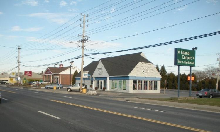
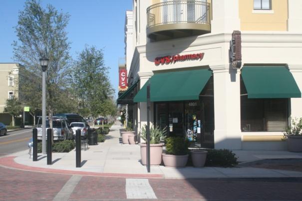
9 Core Study Area 1 Former Navy Lodge Site

10 Core Study Area 1 Former Navy Lodge Site 2 Recreation Complex

11 Core Study Area 1 Former Navy Lodge Site 2 Recreation Complex 3 Public Library

12 Core Study Area 1 Former Navy Lodge Site 2 Recreation Complex 3 Public Library 4 JFK School (Closed)
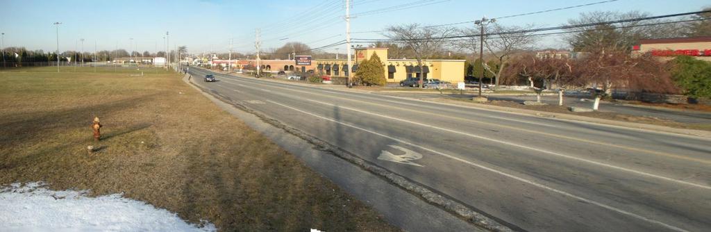
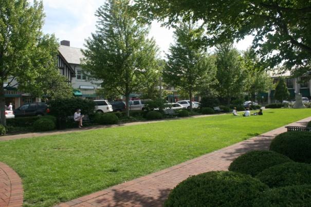
13 Existing Conditions
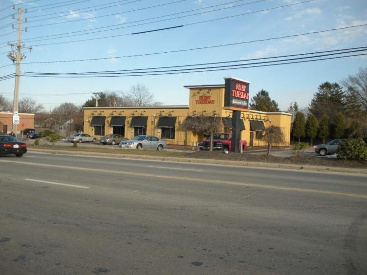
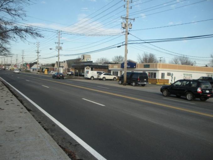
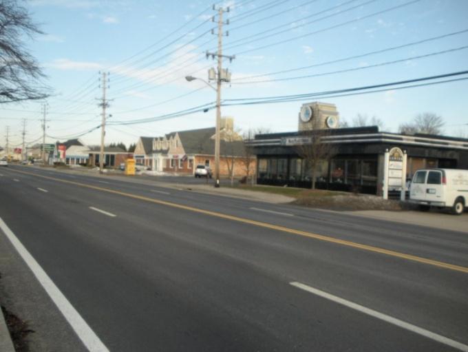
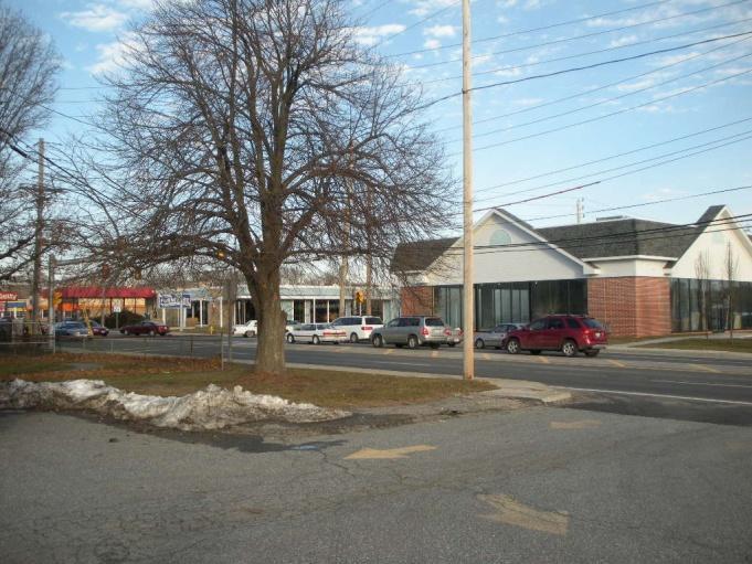
14 Existing Conditions
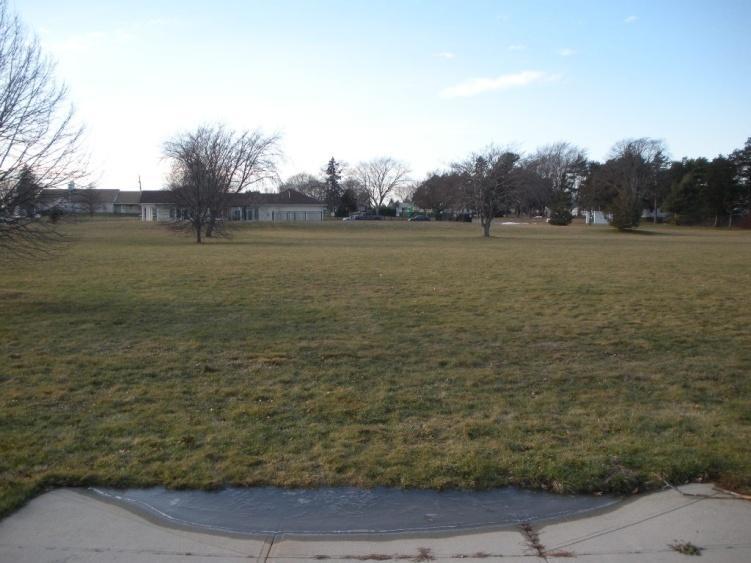
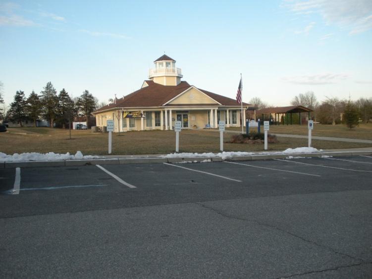
15 Existing Conditions
16 Existing Conditions
17 Stakeholder Interviews
18 Stakeholder Interviews Department of Public Works, Town Engineer Open Space and Fields Committee Middletown Public Library Middletown Public Schools Newport Navy Base Library Board of Trustees Landings Real Estate Group (The Anchorage) Picerne Properties (Harbor Village) Abutting business property owners
19 Summary comments from January 20th Public Meeting Where will the JFK School, Library, and Field go? No more land available in Middletown. We don t want the West Main corridor to turn into another Warwick Is the recapture of the sales leakage worth it? Percentage of people that would walk to this development? Keep sites as recreational. Filling vacant retail vs. building new Affects on the tax base? Middletown doesn t have a town center. Use this property to create a town center or civic center. Develop this area similar to downtown Barrington. Impacts be to the adjacent local roadways? The Town of Middletown has constructed things such as roads and ball fields over and over again.
20 Summary comments from January 20th Public Meeting What will happen to the businesses on the east side of West Main Road with the development of the west side? There are environmental issues (active spring) in the area of the recreational complex. Questions roundabouts: Operations/land needed/pedestrians/examples West Main Road will always be an arterial roadway. A walkable community should be developed along Coddington Highway or at the former Navy hospital, not on West Main Road. During the summer, this area already experiences slow speeds. Development should include good architecture, open space, and connection to the Landings development
21 Issues & Opportunities Existing Zoning Historic Resources Urban Design Utilities Transportation Real Estate Market
22 Issues & Opportunities Existing Zoning Historic Resources Urban Design Utilities Transportation Real Estate Market
23 Urban Design

24 Urban Design Study Areas

25 Urban Design Study Areas Building Footprints
26 Urban Design Study Areas Building Footprints Core Study Area
27 Urban Design Study Areas Building Footprints Core Study Area Gateway Opportunities at Coddington?
28 Urban Design Study Areas Building Footprints Core Study Area Gateway Opportunities at Coddington? at East Main?
29 Urban Design Study Areas Building Footprints Core Study Area Gateway Opportunities at Coddington? at East Main? at Valley?
30 Urban Design Study Areas Building Footprints Core Study Area Gateway Opportunities at Coddington? at East Main? at Valley? Streetscape / Street Edges

31 Urban Design Study Areas Building Footprints Core Study Area Gateway Opportunities at Coddington? at East Main? at Valley? Streetscape / Street Edges Connections
32 Transportation
33 Transportation Issues & Opportunities Access Management Issues Numerous driveways opening along adjacent roadways Numerous collisions caused at side streets and driveways Opportunities Provide internal circulation between parcels Locate internal parking/intersection conflicts away from intersection with roadway Limit the access points to adjacent roadways Restrict left-turning movements at uncontrolled intersection o Left-turning movements can be made at signalized intersections or at roundabouts Provide direct connection to The Landings and other adjacent residential developments
34 Study Area Roadway Network
35 Transportation Issues & Opportunities Public Transportation System Issues Existing weekend service limited Lack of bus stop amenities (shelters, benches) Opportunities Encourage Transit Oriented Developments Improve transit experience Encourage employers to embrace transit Provide additional bus service

36 Bus Service
37 Transportation Issues & Opportunities Pedestrian Transportation System Issues Lack of pedestrian accommodations south of Development Center Lack of direct connection from The Landings and Coddington Cove Navy Housing to Development Center Opportunities Incorporate pedestrian accommodations in future design projects Provide direct pedestian connections between adjacent developments to the Development Center
38 Pedestrian Accommodation
39 Transportation Issues & Opportunities Bicycle Transportation System Issues Adjacent roadways not suitable roadways for bicyclists Lack of connection to suitable roadways Opportunities Provide connection to existing suitable roadways for bicyclists o o Chases Lane/Burma Road (Defense Highway) bike route Coddington Highway bike route (with proposed road diet) Provide critical connection from proposed Shoreline Bikeway (Burma Road) to Coddington Highway and eventually to Downtown Newport


40 Aquidneck Island Transportation Study Intersection Alternatives Geometric Improvement Concept Roundabout Concept

41 Aquidneck Island Transportation Study Burma Road Extension?


42 Example Roundabouts in Rhode Island Quonset Gateway, North Kingstown, RI Twin River Road, Lincoln, RI
43 Market Study
44 Site and Location Characteristics Highly visible location at intersection West Main and Coddington Combined site (north to include JFK school) of 15-acres Good average daily traffic counts exceeding desired threshold for many retail uses Town is receptive to alternative and flexible zoning to facilitate future development opportunities
45 Market and Community Based Recommendations Phased development over time reflecting market demand and site conditions depending on mix of development could be 10+ years Strongest market demand indicators for some retail component as part of Phase 1 from approximately 35,000 SF to 75,000 SF Phase 2 opportunities for some limited office and/or residential (unless all retail desired) professional office space 20,000 SF to 30,000 SF Phase 2 more of a mixed use development with retail down and office up, or office down and residential up potential for personal and business services of 30,000 SF to 60,000 SF Phase 2 opportunity for community and municipal uses for remainder of site further review and study for desired uses and SF, such as repositioned/expanded library
46 Preliminary Scenarios
47 Scenario 1
48 Scenario 1: Existing parcels

49 Scenario 1: Existing parcels West side redevelopment
50 Scenario 1: Existing parcels West side redevelopment East side redevelopment (long term)
51 Scenario 1: Existing parcels West side redevelopment East side redevelopment (long term) West Main Road Cross Section Looking North


52 Scenario 1: Section Detail Cross Section Looking North
53 Scenario 1: Urban Design Goals:
54 Scenario 1: Urban Design Goals: Orient buildings towards West Main Road
55 Scenario 1: Urban Design Goals: Orient buildings towards West Main Road Enhance the pedestrian zone with off street angled parking
56 Scenario 1: Urban Design Goals: Orient buildings towards West Main Road Enhance the pedestrian zone with off street angled parking Multi-story buildings with retail at ground floor
57 Scenario 1: Urban Design Goals: Orient buildings towards West Main Road Enhance the pedestrian zone with off street angled parking Multi-story buildings with retail at ground floor Varied setback and building form to create pedestrian amenities
58 Scenario 1: Transportation Goals:
59 Scenario 1: Transportation Goals: Reduce curb cuts, consolidate entry / exit points, and restrict turning movements
60 Scenario 1: Transportation Goals: Reduce curb cuts, consolidate entry / exit points, and restrict turning movements Provide pedestrian connections to existing residential areas
61 Scenario 1: Transportation Goals: Reduce curb cuts, consolidate entry / exit points, and restrict turning movements Provide pedestrian connections to existing residential areas Improve traffic flow and safety
62 Scenario 1: Transportation Goals: Reduce curb cuts, consolidate entry / exit points, and restrict turning movements Provide pedestrian connections to existing residential areas Improve traffic flow and safety Parking at rear of buildings


63 Scenario 1: Transportation Goals: Reduce curb cuts, consolidate entry / exit points, and restrict turning movements Provide pedestrian connections to existing residential areas Improve traffic flow and safety Parking at rear of buildings Plan for improvements to key intersections West Main at Coddington West Main at Valley*

64 Scenario 1: Analogs
65 Scenario 1: Potential Program* Civic (Library) Civic Retail Office 28,000 S.F. 94,000 S.F. 82,000 S.F. Mix Use *Does not include Long Term uses for the East Side Gateway Retail
66 Scenario 2
67 Scenario 2: Existing parcels
68 Scenario 2: Existing parcels West side redevelopment
69 Scenario 2: Existing parcels West side redevelopment East side redevelopment (long term)
 West Main Road Cross Section Looking")
70 Scenario 2: Existing parcels West side redevelopment East side redevelopment (long term) West Main Road Cross Section Looking North
71 Scenario 2: Urban Design Goals:
72 Scenario 2: Urban Design Goals: Create a Municipal zone with a town common
73 Scenario 2: Urban Design Goals: Create a Municipal zone with a town common Orient buildings towards West Main Road
74 Scenario 2: Urban Design Goals: Create a Municipal zone with a town common Orient buildings towards West Main Road Varied setback and building form to create pedestrian amenities
75 Scenario 2: Urban Design Goals: Create a Municipal zone with a town common Orient buildings towards West Main Road Varied setback and building form to create pedestrian amenities Place parking at the rear of buildings
76 Scenario 2: Urban Design Goals: Create a Municipal zone with a town common Orient buildings towards West Main Road Varied setback and building form to create pedestrian amenities Place parking at the rear of buildings Multi-story buildings with retail at ground floor
77 Scenario 2: Transportation Goals:
78 Scenario 2: Transportation Goals: Provide pedestrian connections to existing residential areas
79 Scenario 2: Transportation Goals: Provide pedestrian connections to existing residential areas Improve traffic flow and safety with a new full access drive with pedestrian crossings
80 Scenario 2: Transportation Goals: Provide pedestrian connections to existing residential areas Improve traffic flow and safety with a new full access drive with pedestrian crossings Reduce curb cuts, consolidate entry / exit points, and restrict turning movements
81 Scenario 2: Transportation Goals: Provide pedestrian connections to existing residential areas Improve traffic flow and safety with a new full access drive with pedestrian crossings Reduce curb cuts, consolidate entry / exit points, and restrict turning movements Parking at rear of buildings
82 Scenario 2: Transportation Goals: Provide pedestrian connections to existing residential areas Improve traffic flow and safety with a new full access drive with pedestrian crossings Reduce curb cuts, consolidate entry / exit points, and restrict turning movements Parking at rear of buildings Plan for improvements to key intersections West Main at Coddington West Main at Valley (Entrance Only)

83 Scenario 2: Analogs

84 Scenario 2: Potential Program* Civic (Municipal Complex) Civic Retail Office 75,000 S.F. 80,000 S.F. 68,000 S.F. Town Common *Does not include Long Term uses for the East Side Mix Use Cross Section Looking East Gateway Retail
85 Scenario 3

86 Scenario 3: Existing parcels

87 Scenario 3: Existing parcels West side and East side redevelopment
88 Scenario 3: Existing parcels West side and East side redevelopment Expanded municipal commons and parking


89 Scenario 3: Existing parcels West side and East side redevelopment Expanded municipal green and parking Connections and redevelopment to west growth area Cross Section Looking East
90 Scenario 3: Urban Design Goals:
91 Scenario 3: Urban Design Goals: (Per Scenario 2) Create a municipal zone with a town common Orient buildings towards West Main Road Varied setback and building form to create pedestrian amenities Place parking at the rear of buildings Multi-story buildings with retail at ground floor
92 Scenario 3: Urban Design Goals: (Per Scenario 2) Create a municipal zone with a town common Orient buildings towards West Main Road Varied setback and building form to create pedestrian amenities Place parking at the rear of buildings Multi-story buildings with retail at ground floor 1 Urban Design Goals: (Additional) 1. Expanded town common with additional landscaping and parking
93 Scenario 3: Urban Design Goals: (Per Scenario 2) Create a municipal zone with a town common Orient buildings towards West Main Road Varied setback and building form to create pedestrian amenities Place parking at the rear of buildings Multi-story buildings with retail at ground floor Urban Design Goals: (Additional) 1. Expanded town common with additional landscaping and parking 2. Lining the internal street with buildings 2 1
94 Scenario 3: Urban Design Goals: (Per Scenario 2) Create a municipal zone with a town common Orient buildings towards West Main Road Varied setback and building form to create pedestrian amenities Place parking at the rear of buildings Multi-story buildings with retail at ground floor 2 1 Urban Design Goals: (Additional) 1. Expanded town common with additional landscaping and parking 2. Lining the internal street with buildings 3. Enhanced landscaping along Coddington 3
95 Scenario 3: Transportation Goals:
96 Scenario 3: Transportation Goals: Integrate pedestrian connections to existing residential areas
97 Scenario 3: Transportation Goals: Integrate pedestrian connections to existing residential areas Improve traffic flow and safety with a new full access drive with pedestrian crossings
98 Scenario 3: Transportation Goals: Integrate pedestrian connections to existing residential areas Improve traffic flow and safety with a new full access drive with pedestrian crossings Reduce curb cuts, consolidate entry / exit points, and restrict turning movements
99 Scenario 3: Transportation Goals: Integrate pedestrian connections to existing residential areas Improve traffic flow and safety with a new full access drive with pedestrian crossings Reduce curb cuts, consolidate entry / exit points, and restrict turning movements Parking at rear of buildings

100 Scenario 3: Transportation Goals: Integrate pedestrian connections to existing residential areas Improve traffic flow and safety with a new full access drive with pedestrian crossings Reduce curb cuts, consolidate entry / exit points, and restrict turning movements Parking at rear of buildings Plan for improvements to key intersections West Main at Coddington West Main at Valley (Entrance Only)

101 Scenario 3: Analogs
102 Scenario 3: Potential Program* Civic Retail Office Residential 75,000 S.F. 106,000 S.F. 56,000 S.F. 175 Units Civic (Municipal Complex) Expanded Town Common Residential Town Common Mix Use *Does not include Long Term uses for the East Side Gateway Retail
103 Break-out Table Discussions 7:00-7:20 Scenario 1 7:20-7:40 Scenario 2 7:40-8:00 Scenario 3 8:00-8:30 Report Back (5 minutes each)
104 Ground Rules Every opinion is valid Everyone gets to talk No negativity keep it positive No personal comments never make your friend or colleague the issue Keep the discussion moving don t get hung up on points of disagreement If you bring a problem to the table, bring a solution too
105 Report Back Group 1 Group 2 Group 3 Group 4
106 Next Steps See website:
ESTABLISH AN EFFICIENT TOWN CENTER
 ESTABLISH AN EFFICIENT TOWN CENTER 4 Overview Lisbon residents are proud of the history of Newent and at the same time recognize its current importance as a centralized location for a variety of municipal
Route 1 Corridor Study
 Route 1 Corridor Study Westbrook, Connecticut A Vision for the Connecticut Shoreline Public Informational Meeting July 28, 2015 Lower Connecticut River Valley Council of Governments Fitzgerald & Halliday,
Metro. Activity Center Design Guidelines. Recommendations For Developing Focused, Mixed-Use Commercial/Residential Centers
 Metro Activity Center Design Guidelines Recommendations For Developing Focused, Mixed-Use Commercial/Residential Centers Metro Activity Centers What is a MAC? Legacy, the adopted guide for the future growth
Lower Merion Commercial Districts Issues and Characteristics Handbook November 2013
 Lower Merion Commercial Districts Issues and Characteristics Handbook November 2013 DRAFT TOWNSHIP-WIDE VISION: To maintain and enhance commercial areas to complement the surrounding high-quality residential
This Review Is Divided Into Two Phases:
 Semiahmoo Town Centre Review The purpose of this review: To review the Semiahmoo Town Centre Concept Plan, originally approved in 1993, to ensure that this centre will continue to serve the needs of South
City of Farmington. Downtown Plan. Amendment to the 1998 Master Plan Adopted October 11, 2004
 City of Farmington Amendment to the 1998 Master Plan Adopted October 11, 2004 Introduction Planning Background 1 Scope and Components of the Plan Amendment 2 Concept Introduction 3 Plan Concepts 3 Conceptual
Small Area Plan. South Gateway
 Small Area Plan Adopted May 12, 2008 South Gateway Purpose. The South Gateway Small Area Plan defines the City s expectations for the future of the southern entrance to the City at Interstate 85 and Highway
Summary of Public Input & Discussion of Alternatives
 Meeting #4 Summary of Public Input & Discussion of Alternatives May 6 th, 2009 City of Bellingham, Washington April 1 April 15 April 22 May 6 Introduction, Character and Boundary Study Areas Public Realm:
THE WEST SIDE. 3. Provide more active and passive recreation for Portsmouth s citizens, including increased vistas and public access to the shoreline.
 THE WEST SIDE The West Side element is arranged differently than other elements in the Comprehensive Plan. While much of what is contained in the rest of the Plan is applicable to the West Side, there
Scope of Services. River Oaks Boulevard (SH 183) Corridor Master Plan
 Corridor Master Plan") Scope of Services River Oaks Boulevard (SH 183) Corridor Master Plan PROJECT AREA The project area consists of the River Oaks Boulevard (SH 183) corridor bounded by SH 199 at the northern end and the Trinity
Scope of Services River Oaks Boulevard (SH 183) Corridor Master Plan PROJECT AREA The project area consists of the River Oaks Boulevard (SH 183) corridor bounded by SH 199 at the northern end and the Trinity
MIXED-USE VILLAGE OVERLAY FLOATING DISTRICT
 MIXED-USE VILLAGE OVERLAY FLOATING DISTRICT Zoning regulations developed by committee to the Planning Board for the Town of DeWitt, NY Issue date: 13 July 2017 revised 3/12/2018, revised 4/26/2018, 5/9/2018
Olde Towne Vision Plan
 Olde Towne Vision Plan Introduction In 2016, the City of Bellevue will complete its move of City offices from Olde Towne Bellevue to its new municipal complex on Wall Street. The City intends to sell its
CONCORD PIKE (US 202) CORRIDOR MASTER PLAN
 CORRIDOR MASTER PLAN") PRESENTATION FOR THE CONCORD PIKE (US 202) CORRIDOR MASTER PLAN COMMUNITY VISIONING WORKSHOP November 14, 2018 Project Introduction Study Area Characteristics Diverse stakeholders: businesses, residents,
PRESENTATION FOR THE CONCORD PIKE (US 202) CORRIDOR MASTER PLAN COMMUNITY VISIONING WORKSHOP November 14, 2018 Project Introduction Study Area Characteristics Diverse stakeholders: businesses, residents,
Regency Developments. Urban Design Brief. Holyrood DC2 Rezoning
 Regency Developments Urban Design Brief Holyrood DC2 Rezoning Stantec Consulting Ltd. 7-31-2017 1. Overview Regency Developments intends to rezone the lands located at 8510 and 8511 93 Avenue, within the
Clairtrell Area Context Plan
 Clairtrell Area Context Plan March 2005 Urban Development Services City Planning Contents 1. Introduction... 4 2. Development Structure... 6 2.1 Streets... 7 2.1.1 Sheppard Avenue and Bayview Avenue...
Civic Center District
 Civic Center District The Civic Center district is the civic and social heart of Warrenville, containing such public buildings as the City Hall, Warrenville Public Library, Police Station, Park District
Stakeholders Advisory Working Groups (SAWGs) Smart Growth and TOD Land Use (#11) SAWG Meeting
 Smart Growth and TOD Land Use (#11) SAWG Meeting") Presentation - Part II Tappan Zee Bridge/I-287 Corridor Project July 21, 2010 Slide 1. David Kooris (Regional Plan Association) welcomed members of the Land Use Stakeholders Advisory Working Groups (SAWGs)
Presentation - Part II Tappan Zee Bridge/I-287 Corridor Project July 21, 2010 Slide 1. David Kooris (Regional Plan Association) welcomed members of the Land Use Stakeholders Advisory Working Groups (SAWGs)
PLAN ELEMENTS WORKSHOP. April 5, 2016
 PLAN ELEMENTS WORKSHOP April 5, 2016 needs more housing. But there is no one-size fits-all solution. Every neighborhood has its own character. In some places, density is not only appropriate it is badly
LAND USE AMENDMENT DOWNTOWN COMMERCIAL CORE (WARD 7) MACLEOD TRAIL SE AND 5 AVENUE SE BYLAW 254D2017
 MACLEOD TRAIL SE AND 5 AVENUE SE BYLAW 254D2017") Page 1 of 10 EXECUTIVE SUMMARY This Land Use Amendment application seeks to redesignate a full downtown block (currently the YWCA site) from a Direct Control based on the CM-2 District (Land Use Bylaw
Page 1 of 10 EXECUTIVE SUMMARY This Land Use Amendment application seeks to redesignate a full downtown block (currently the YWCA site) from a Direct Control based on the CM-2 District (Land Use Bylaw
RESEDA - WEST VAN NUYS COMMUNITY PLAN
 RESEDA - WEST VAN NUYS COMMUNITY PLAN Executive Summary As part of the initial outreach effort, the Department of City Planning hosted two workshops for the Reseda-West Van Nuys Community Plan Area during
Environmental: Urban land..51 acre wet (.30%); 1.01 acres/.59% within a 100 year floodplain; no other environmental indicators limit development.
; 1.01 acres/.59% within a 100 year floodplain; no other environmental indicators limit development.") A N DOV ER Downtown: Designated a State PDA Land Use: Downtown Andover (171.61 acres) is the Town s traditional central business district. It consists of offices, shops, restaurants, civic and institutional
A N DOV ER Downtown: Designated a State PDA Land Use: Downtown Andover (171.61 acres) is the Town s traditional central business district. It consists of offices, shops, restaurants, civic and institutional
Seneca Meadows. Block 4 Locate office, technology, and medical development adjacent to I Screen views of garage structures from I-270.
 Seneca Meadows Seneca Meadows has an industrial park in its southern end and a mixed-use employment area planned for the north end. The district benefits from extensive I-270 visibility, stream valley
Danvers High Street I-1 District Study
 Danvers High Street I-1 District Study Presentation of Final Recommendations Planning Board Presentation June 26 th, 2018 1 Introductions Metropolitan Area Planning Council Sam Cleaves AICP, Principal
Town Center (part of the Comprehensive Plan)
") Town Center (part of the Comprehensive Plan) Mercer Island Town Center Looking North (2014) In 1994, a year-long process culminated in a set of design guidelines and code requirements for the Town Center
Town Center (part of the Comprehensive Plan) Mercer Island Town Center Looking North (2014) In 1994, a year-long process culminated in a set of design guidelines and code requirements for the Town Center
Executive Summary. NY 7 / NY 2 Corridor
 Executive Summary NY 7 / NY 2 Corridor Transportation and Land Use Study December 2005 Prepared for: Town of Colonie Capital District Transportation Committee Prepared by: Introduction: Land use decisions
Broadway District Specific Plan. Community Workshop #2 February 23,2016
 Broadway District Specific Plan Community Workshop #2 February 23,2016 1 Agenda Introductions Project Progress Status Upcoming Milestones Emerging Framework Land Use Urban Design Circulation Infrastructure
Proposed Comprehensive Plan Strategies DRAFT for discussion June 28, 2017
 Proposed Comprehensive Plan Strategies DRAFT for discussion June 28, 2017 Land Use Rural Areas Refine the Farm and Forest area (FF) Update FF boundaries to account for existing lots less than five acres
URBAN DESIGN BRIEF. 2136&2148 Trafalgar Road. Town of Oakville
 URBAN DESIGN BRIEF 2136&2148 Trafalgar Road Town of Oakville Prepared By: METROPOLITAN CONSULTING INC For 2500674 Ontario Inc November 2016 TABLE OF CONTENTS Page No. 1.0 Introduction/Description of Subject
ORDINANCE AN ORDINANCE TO ADD A NEW SECTION 4.N. IN THE ZONING CODE FOR THE TOWN OF MIDDLETOWN, RELATING TO MIXED-USE DEVELOPMENT
 Introduced: November 5, 2018 Approved: ORDINANCE 18-11-01 AN ORDINANCE TO ADD A NEW SECTION 4.N. IN THE ZONING CODE FOR THE TOWN OF MIDDLETOWN, RELATING TO MIXED-USE DEVELOPMENT BE IT ENACTED BY THE MAYOR
Route 9 Gateway Project. October 9, 2014 Informational Meeting
 Route 9 Gateway Project NYS DOT P.I.N. 1759.67 Town of Lake George, New York October 9, 2014 Informational Meeting Open House 3:00-3:30 Presentation 3:30-4:15 Introductions Town Representatives Dennis
East Central Area Plan
 East Central Area Plan Steering Committee Meeting March 8 th, 2018 CHUN Tears McFarlane House Vision Statement Development Opportunities Analysis Vision Elements 1. Equitable, Affordable and Inclusive
ITEM #8. Regional Smart Growth Program. Regional Smart Growth Program. Presentation Overview. Coast Highway Vision and Stategic Plan.
 Regional Smart Growth Program Economic Development Commission What is Smart Growth? Adopted as part of the Regional Comprehensive Plan (RCP) RCP provides vision for region based on Smart Growth and sustainability
Rio/29 Small Area Plan. Design Plan & Implementation Framework Open House - January 25, 2018
 Rio/29 Small Area Plan Design Plan & Implementation Framework Open House - January 25, 2018 MEETING PURPOSE PRESENTATION 1. Orient to the updated design plans 2. Introduce implementing options 3. Explain
Dyersville Downtown Plan. Open House October 24, 2017
 Dyersville Downtown Plan Open House October 24, 2017 What is a Comprehensive Plan? - Vision - Guidance for decisions - Basis for regulations What is a Downtown Plan? - Understand priorities - Identify
Access Management: An Overview
 Figures 1-5 Below Evolution of development along a highway. In the early stages, land along the road is used for farming with little traffic generated. As time passes, the highway corridor becomes a de
Good Design Guidelines for Downtown. Preliminary Findings and Recommendations
 Good Design Guidelines for Downtown Preliminary Findings and Recommendations City Council Meeting - February 5, 2017 Advisory Committee Team: Larry Paul: Planning Commission /Architect Bruce Bagnoli: Business
Presentation to Town Council in association with Kubilins Transportation Group Rose & Associates Equinox Environmental
 Presentation to Town Council 03.03.09 in association with Kubilins Transportation Group Rose & Associates Equinox Environmental Vision Statement: Boone 2030 is...a friendly, vibrant, attractive community...financially,
The transportation system in a community is an
 7 TRANSPORTATION The transportation system in a community is an important factor contributing to the quality of life of the residents. Without a sound transportation system to bring both goods and patrons
City of Bristol Route 6 Corridor Implementation Program
 City of Bristol Route 6 Corridor Implementation Program FITZGERALD & HALLIDAY, INC. Innovative Planning, Better Communities June 2017 Route 6 Corridor Plan IMPLEMENTATION PROGRAM The following Implementation
hermitage town center
 hermitage town center A Community Vision prepared by Strada for The City of Hermitage and The Mercer County Regional Planning Commission January 2007 table of contents introduction 3 design principles
CHAPTER 7: Transportation, Mobility and Circulation
 AGLE AREA COMMUNITY Plan CHAPTER 7 CHAPTER 7: Transportation, Mobility and Circulation Transportation, Mobility and Circulation The purpose of the Transportation, Mobility and Circulation Chapter is to
178 Carruthers Properties Inc.
 178 Carruthers Properties Inc. Planning Rationale for 178 Carruthers Avenue Site Plan Control Application June 2014 Table of Contents 1.0 Introduction 2.0 Overview of Subject Property 3.0 Current Zoning
A. Background Summary of Existing Challenges and Potential Possibilities. 1. Summary of Existing Assets and Potential Opportunities
 A. Background 1 A Main Street Master Plan Study was performed and completed in October of 2007. The study was initiated to review current land uses and development patterns along Main Street, from Parrish
The GATEWAYS Sub Area Master Plan. City of Walker
 The GATEWAYS Sub Area Master Plan City of Walker Introduction: The Walker City Commission and Planning Commission decided in 2011 to create a sub-area master plan for the Remembrance Road and Wilson Avenue
New-Cast Mixed-use Development Proposal King Street West, Newcastle, Ontario
 URBAN DESIGN BRIEF New-Cast Mixed-use Development Proposal King Street West, Newcastle, Ontario TABLE OF CONTENTS: 1.0 Executive Summary 2.0 Creating Vibrant and Sustainable Urban Places: Excerpts from
SECTION TWO: Urban Design Concepts
 SECTION TWO: Urban Design Concepts The Gardnerville Plan for Prosperity shapes economic opportunities presented by regional growth. The Urban Design Concepts provide policies and concepts for land use,
Corridors. Re-vitalize our Corridors and Gateways
 Corridors Re-vitalize our Corridors and Gateways Artist s rendering from the 287 Strategic Plan, 2015 Corridors are the major throughways of Loveland but they also provide important commercial, community
Mix of Uses Guide for Transit-Oriented Development MIX OF USES
 MIX OF USES Creating a Destination Magnet A diversity of uses such as retail, housing, offices, civic and entertainment within the TOD creates a destination magnet for transit users and TOD neighbors.
PROPOSED REDEVELOPMENT OF THE GLEN ABBEY GOLF CLUB. STREETSCAPE DESIGN STUDY (excerpt from the Urban Design Brief) TOWN OF OAKVILLE.
 TOWN OF OAKVILLE.") PROPOSED REDEVELOPMENT OF THE GLEN ABBEY GOLF CLUB STREETSCAPE DESIGN STUDY (excerpt from the Urban Design Brief) TOWN OF OAKVILLE OCTOBER, 2016 for 2.4.2 STREETS Streets are the single largest component
PROPOSED REDEVELOPMENT OF THE GLEN ABBEY GOLF CLUB STREETSCAPE DESIGN STUDY (excerpt from the Urban Design Brief) TOWN OF OAKVILLE OCTOBER, 2016 for 2.4.2 STREETS Streets are the single largest component
Blueprint Denver Task Force Meeting #
 Blueprint Denver Task Force Meeting #1 6.23.16 1. Welcome and Introductions Your name and affiliation Name 1 thing you love about Denver Name 1 thing you d change about Denver All in 30 seconds! Ready,
Hockessin Community Redevelopment Plan
 Hockessin Community Redevelopment Plan 3.1 Introduction The Community Redevelopment Plan for the Village of Hockessin is the result of the people s vision for a distinct village center that serves as the
Don Mills Crossing Study and Celestica Lands Development Application Community Meeting, Open House, and Breakout Discussions
 Consultation Summary Don Mills Crossing Study and Celestica Lands Development Application Community Meeting, Open House, and Breakout Discussions This report is not intended to provide a verbatim transcript
Making Transit Oriented Development Work For Boonton, NJ
 Making Transit Oriented Development Work For Boonton, NJ Bloustein School of Planning and Public Policy Studio Dan Burton Loannie Dao Webster Slater Brandon Williams Ian Watson Maria Laham Nicola Mammes
EXISTING COMPREHENSIVE PLAN
 EXISTING COMPREHENSIVE PLAN Town Center Land Use Element: V. LAND USE POLICIES Town Center Mercer Island's business district vision as described in "Your Mercer Island Citizen-Designed Downtown" was an
CHAPTER 3 VISION, GOALS, & PLANNING PRINCIPLES. City of Greensburg Comprehensive Plan. Introduction. Vision Statement. Growth Management Goals.
 CHAPTER 3 VISION, GOALS, & PLANNING PRINCIPLES Introduction The Greensburg Comprehensive Plan is intended as a working community document. A combination of long and short-term goals, this document is intended
Status Update (2006 vs. Now) Citizen s Advisory Committee February Plan for Prosperity
 Citizen s Advisory Committee February Plan for Prosperity") Status Update (2006 vs. Now) Citizen s Advisory Committee February 2018 Plan for Prosperity 2000 2017 2000 2017 Gardnerville Population 6,000 5,760 5746 5,500 5,000 5,067 5,550 5,165 5,394 5,412 5,250
Status Update (2006 vs. Now) Citizen s Advisory Committee February 2018 Plan for Prosperity 2000 2017 2000 2017 Gardnerville Population 6,000 5,760 5746 5,500 5,000 5,067 5,550 5,165 5,394 5,412 5,250
4.1.3 LAND USE CATEGORIES
 4.1.3 LAND USE CATEGORIES a. City Center District The City Center District incorporates the existing character and mix of uses in downtown Belmont to encourage redevelopment and new development in keeping
Implementation Guide Comprehensive Plan City of Allen
 Implementation Guide 2030 Comprehensive Plan City of Allen DRAFT 2015 Implementation Guide Allen 2030 Comprehensive Plan INTRODUCTION The Comprehensive Plan serves as a guide for the growth and development
Introduction. Intent of the Plan. Urban Design and Land Use Approach
 Introduction Intent of the Plan This is the Second Public Open House for the. The intent of the is to update current City policy in order to encourage future development that will ensure a diverse, lively,
LUNDY S LANE COMMUNITY IMPROVEMENT PLAN STUDY
 PUBLIC INFORMATION MEETING #2 October 12, 2016 LUNDY S LANE COMMUNITY IMPROVEMENT PLAN STUDY AGENDA 5:00 to 5:30pm: Open House 5:30 to 6:15pm: Presentation 6:15 to 7:00pm: Individual paced workshop with
Institutional Master Plan The Arnold Arboretum of Harvard University
 Institutional Master Plan The Arnold Arboretum of Harvard University Submitted to: Boston Redevelopment Authority One City Hall Square Boston, MA 02201 Submitted by: The Arnold Arboretum of Harvard University
Public input has been an important part of the plan development process.
 Lakewood s Comprehensive Plan recognizes that transportation helps shape the community, and that the way the community provides for the safe and efficient movement of people affects the character of the
Municipal Development Plan Update Urban Service Area and Hamlets
 ENCLOSURE 1 Municipal Development Plan Update Urban Service Area and Hamlets Priorities Committee January 24, 2017 MUNICIPAL DEVELOPMENT PLAN UPDATE SHAPING OUR FUTURE MDP Update - Agenda MDP Update Public
Lambeth Main Street Streetscape Improvements
 Lambeth Main Street Streetscape Improvements Open House October 5th, 2017 Agenda 1. Introduction 2. Project Background 3. Context 4. Project Objectives 5. Design Principles & Approach 6. Streetscape Design
FOR IMMEDIATE RELEASE Contact: Dyana Koelsch
 FOR IMMEDIATE RELEASE Contact: Dyana Koelsch 401.831.1200 dkoelsch@nharbor.com Revised Gateway Plan Decreases Retail, Adds 70% More Office Space and Improves Entrance to Quonset Business Park Incorporating
SDOT DPD. SDOT Director s Rule DPD Director s Rule DCLU DR SED DR of 7 CITY OF SEATTLE
 SDOT SDOT Director s Rule 2-07 DPD Applicant: CITY OF SEATTLE Page 1 of 7 Supersedes: DCLU DR 11-93 SED DR 93-4 Seattle Department of Transportation (SDOT) Department of Planning and Development (DPD)
DRAFT. October Wheaton. Design Guidelines
 October 2011 DRAFT Wheaton Design Guidelines 2 Draft - Design Guidelines - Wheaton Sector Plan Contents 04 Section 1: Introduction 06 Section 2: Context 08 Section 3: Design Guidelines 09 Goal 1: Create
Lehigh Acres Land Development Regulations Community Planning Project
 Lehigh Acres Land Development Regulations Planning Effort Summary In July, 2010 Commissioner Frank Mann invited the Lehigh Acres community to start discussing how to achieve their recently adopted community
ELMVALE ACRES SHOPPING CENTRE MASTER PLAN
 ELMVALE ACRES SHOPPING CENTRE MASTER PLAN Contents 1.0 INTRODUCTION... 2 2.0 LOCATION... 2 3.0 EXISTING CONTEXT... 2 4.0 VISION & GUIDING PRINCIPLES... 2 5.0 LAND USE AND BUILT FORM... 4 5.1 St. Laurent
LEED-ND 101: Practical Strategies for Achieving Sustainability Goals. Travis Parker Lakewood Planning Director
 LEED-ND 101: Practical Strategies for Achieving Sustainability Goals Travis Parker Lakewood Planning Director Metro Vision Idea Exchange Oct 11, 2012 West Corridor Stations West Corridor Overview West
DRAFT. 10% Common Open Space
 % OF CHARLOTTE IS CATEGORIZED AS A. LAND USES : Placeholder map displaying location of Place Type GOALS: Accommodate XX% of future growth. Provide a concentration of primarily commercial and civic activity
VILLAGE OF CLEMMONS PLANNING BOARD DRAFT STAFF REPORT
 VILLAGE OF CLEMMONS PLANNING BOARD DRAFT STAFF REPORT PETITION INFORMATION Docket # C-226 Staff Megan Ledbetter Petitioner(s) JBJH Properties, LLC Owner(s) JBJH Properties, LLC Subject Property 5892-49-1766
University of the District of Columbia Van Ness Campus Master Plan Community Open House 3. December 8, 2010
 University of the District of Columbia Van Ness Campus Master Plan Open House 3 December 8, 2010 Introductions Sequence of Work: Campus Master Plan BEGIN: INTRODUCE AND START WORK Project Initiation Team
The West Vaughan Employment Area Secondary Plan Policies
 Part 2: The West Vaughan Employment Area Secondary Plan Policies 2.1 General Policies It is the policy of Council: 2.1.1. That the West Vaughan Employment Area (the WVEA), identified on Schedule 1, will
North Downtown Specific Plan MEMORANDUM
 North Downtown Specific Plan MEMORANDUM MEETING DATE: November 13, 2017 TO: Members of the North Downtown Specific Plan Advisory Committee FROM: Jeanine Cavalli, Senior Planner SUBJECT: Materials for the
The Lower SaLuda Greenway
 The Lower SaLuda Greenway InITIaTIve a FLourIShInG Greenway. a hub For economic GrowTh. a ConneCTIon BeTween CoMMunITIeS. In April 2017 the Michael J. Mungo Foundation and Lexington County commissioned
Downtown North Las Vegas Demonstration Site Project. Project Update
 Downtown North Las Vegas Demonstration Site Project Project Update 7.16.14 Presentation Overview Project Purpose and Process Planning Context Opportunities and Barriers Summary Community Input Preliminary
Land Use. Hardware Street Vendor Mixed-Use
 Land Use Definition Land Use is the way a piece of real estate is utilized. Existing, proposed, and adopted land uses all play a role in the planning process. Once a land use plan is adopted, the next
Complete Neighbourhood Guidelines Review Tool
 Complete Neighbourhood Guidelines Review Tool Prepared By: City of Regina Planning Department October 2014 Page 1 of 14 Community Development Review Checklist for Secondary Plans and Concept Plans The
TEAM INPUT SUMMARY. Postcard Image?
 DOWNTOWN MAULDIN TEAM PUBLIC INPUT TEAM INPUT SUMMARY Postcard Image? A nice neighborhood The main city center with government buildings Mauldin entry sign, high school, Cultural Center, Sunset Park, Hall
City of Lake Mary, Florida. Evolution of a Historic Downtown with Transit Oriented Development Strategies
 City of Lake Mary, Florida Evolution of a Historic Downtown with Transit Oriented Development Strategies What is Transit Oriented Development? Walkable villages located at and around transit stations in
SH 199 Corridor Master Plan. Community Meeting No. 2 May 31, 2017
 Community Meeting No. 2 May 31, 2017 Transportation Projects On or Near SH 199 SH 199 from 0.3 miles south of FM 1886 to south end of Lake Worth bridge Construct freeway mainlanes and frontage roads 10-Year
COMPLETE GREEN STREET CHECKLIST
 COMPLETE GREEN STREET CHECKLIST This document was developed to dissect the structure of an urban street and explore opportunities to make our streets more complete while also integrating green street strategies.
Anatomy of A Vibrant Downtown. Anatomy of a Vibrant Downtown
 Anatomy of A Vibrant Downtown The goal of MAIN ST. REVITALIZATION PLANNING is to provide a framework that will help transform your downtown into a VIBRANT DOWNTOWN a place where people love to LIVE, WORK,
Appendix C: Interim Mixed-Use Evaluation Criteria
 Appendix C: Interim Mixed-Use Evaluation Criteria C-1 Appendix C: Interim Mixed-Use Evaluation Criteria PURPOSE: The implementation of numerous policies contained within the Master Plan hinges on the creation
1.0 Purpose of a Secondary Plan for the Masonville Transit Village
 Report to Planning and Environment Committee To: Chair and Members Planning & Environment Committee From: John M. Fleming Managing Director, Planning and City Planner Subject: Masonville Transit Village
Delaware River Port Authority Southern New Jersey Waterfront Master Plan
 Delaware River Port Authority Southern New Jersey Waterfront Master Plan Press Conference January 11, 2006 Agenda Plan Purpose & Objectives Market Demand Residential Forecast Maritime Forecast Waterfront
PORT WHITBY COMMUNITY
 PORT WHITBY COMMUNITY SECONDARY PLAN UPDATE COMMUNITY IMPROVEMENT PLAN URBAN DESIGN GUIDELINES September 2015 DRAFT PROPOSED AMENDMENT NUMBER # to the Whitby Official Plan PURPOSE: The intent of this Amendment
Community Information Meeting
 Queensborough Eastern Community Information Meeting July 24, 2014 Cameron Chalmers, MCIP, RPP Platform Properties Meeting Format Purpose Format The purpose of the meeting is to invite the community to
Pattern 3: Parking. Parking in great amounts is not a characteristic of great streets. Allan Jacobs. Community Form and Mobility Principles
 Pattern 3: Parking Parking in great amounts is not a characteristic of great streets. Allan Jacobs Parking is an integral part of the municipal circulation system and is often as important as roads in
PUBLIC OPEN HOUSE HURONTARIO-MAIN CORRIDOR SECONDARY PLAN
 PUBLIC OPEN HOUSE HURONTARIO-MAIN CORRIDOR SECONDARY PLAN Tuesday, February 28, 2012 6pm 9pm 1 st Floor Atrium, City Hall 2 Wellington Street West, Brampton 1 POLICY FRAMEWORK The 2006 Provincial Growth
Chapter 1.0 Introduction
 Chapter 1.0 Introduction 1.1 Background The North Metro commuter rail line is part of the RTD FasTracks regional transit system expansion program to build more than 100 miles of rail transit throughout
Ivywild On The Creek PRELIMINARY CREEK DISTRICT MASTER PLAN
 Ivywild On The Creek PRELIMINARY CREEK DISTRICT MASTER PLAN Introduction: Rejuvenating an extraordinary Creekside neighborhood THE CREEKSIDE DISTRICT The Ivywild On The Creek Neighborhood District Master
Micco Park Village Development
 FOR SALE Call For Pricing Micco Park Village Development Proposed Project Property Details Micco Park Village Development PRICE Call For Pricing A monumental development opportunity of a lifetime! The
BUILDING SCALE AND SETBACKS 5 ELEMENTS:... 5 FAÇADES (COMMERCIAL/RESIDENTIAL) 5
 5") VISION STATEMENT 3 UTILIZATION OF THE GUIDELINES 3 IMPLEMENTATION 3 PROCEDURES FOR DESIGN REVIEW 3 LAND USE AND ZONING 4 LAND USE 4 ELEMENTS:... 4 ZONING 4 ELEMENTS:... 4 BUILDING SCALE AND SETBACKS 5
VISION STATEMENT 3 UTILIZATION OF THE GUIDELINES 3 IMPLEMENTATION 3 PROCEDURES FOR DESIGN REVIEW 3 LAND USE AND ZONING 4 LAND USE 4 ELEMENTS:... 4 ZONING 4 ELEMENTS:... 4 BUILDING SCALE AND SETBACKS 5
2900 Steeles Avenue East at Don Mills Road in the Town of Markham
 STAFF REPORT INFORMATION ONLY 2900 Steeles Avenue East at Don Mills Road in the Town of Markham Date: January 23, 2008 To: From: Wards: Reference Number: North York Community Council Director, Community
Community Meeting #2.1
 Community Meeting #2.1 Thursday, October 20, 2016, 7:00 p.m. to 9:00 p.m. Eliot Elementary School, 475 Old Gilroy Street, Gilroy, CA 95020 Meeting Summary The City of Gilroy held its third community meeting
RIVER ARTS DISTRICT TRANSPORTATION PROJECT
 RIVER ARTS DISTRICT TRANSPORTATION PROJECT A section of the Public Meeting #3 December 6, 2012 The RiverWay Plan The Wilma Dykeman RiverWay is a 17 mile corridor along the French Broad and Swannanoa Rivers.
Silver Line CPAM UPDATE. Transportation and Land Use Committee October 14, 2016
 Silver Line CPAM UPDATE Transportation and Land Use Committee October 14, 2016 Purpose Recap Project History and Map Changes Provide Overview of CPAM Components Discuss Transportation Impacts Discuss Fiscal
 Community Workshop #2 December 4, 2014 Team Tonight s Agenda 6:00 pm Welcome! 6:05 pm The Future of Downtown Tustin Ideas, Strategies and Recommendations 6:35 pm Questions and Comments 6:50 pm Open