SITE SUMMARY REPORT Rockingham Dump NONCD Richmond County
|
|
|
- Emerald Carpenter
- 6 years ago
- Views:
Transcription

1 SITE SUMMARY REPORT Rockingham Dump NONCD Richmond County Senate Bill 1492 State of North Carolina State Contract N06009S Schnabel Project No July 26, 2010 Prepared for: North Carolina Department of Environment and Natural Resources Superfund Section Inactive Hazardous Sites Branch 401 Oberlin Road, Suite 150 Raleigh, NC Prepared by: Schnabel Engineering South, P.C. 11-A Oak Branch Drive Greensboro, North Carolina (336) Benjamin L. Bradley Project Scientist/Report Author Signature Greg Kuntz, L.G. Senior Associate/Reviewer Signature
2 TABLE OF CONTENTS Site Location Research Summary Areas of Note Site Summary 1.0 Site Conditions 1.1 On-site Structures 1.2 Current Site Usage 1.3 On-site Water Supply Wells and Intakes 1.4 Surface Water Features 1.5 Disposal Area 1.6 Disposal Area Conditions 1.7 Evidence of Human Activity 1.8 Potential Landfill Gas Migration Pathways 1.9 Physical Barriers 1.10 Other Pertinent Information 2.0 Vicinity Conditions 2.1 Structures Located on Adjacent Properties 2.2 Water Supply Wells and Intakes 2.3 Current Land Usage 2.4 Surface Water Features 3.0 Aerial Photography Review Table 1 Tabulated GPS Coordinates TABLES Figure 1 Figure 2 Figure 3 Figure 4 Figure 5 Appendix A Appendix B Appendix C Appendix D Appendix E FIGURES USGS Topographic Map Site Map Vicinity Map Topographic Map Overlaid On LiDAR Shaded Relief LiDAR Shaded Relief APPENDICES Field Reconnaissance Sheet Tax Records Records of Communication\Site Visit Permission Letter Site Photographs Aerial Photographs FILE: G:\2006_PROJECTS\ _(NCDENR_OLD_UNLINED_LANDFILL)\TASK_24_RICHMOND_CO\0517- ROCKINGHAMDUMP\REPORT\FINAL\NONCD _ROCKINGHAMDUMP_FINALSITESUMMARYREPORT_ DOC
3 SITE LOCATION RESEARCH SUMMARY ID NUMBER: NONCD SITE NAME(S): Rockingham Dump LOCATION: Oral Bessie Lane, Rockingham, NC COUNTY: Richmond LANDFILL SIZE: PROPERTY SIZE: DATE OPENED: DATE CLOSED: 22.1 acres (Disposal Area enclosed by GPS points obtained during site visit and perimeter identified from aerial photographs and LiDAR) 227 acres (from Richmond County GIS) Late 1950 s (Mr. Richard Haughin, City of Rockingham Public Works Director) Early 1970 s (Mr. Richard Haughin, City of Rockingham Public Works Director) CURRENT OWNER: Ms. Anne Hedgpeth CURRENT OWNER CONTACT: Ms. Anne Hedgpeth, Property Owner CURRENT OWNER ADDRESS: 3926 Dover Road, Durham, NC CURRENT OWNER TELEPHONE NUMBER: Not listed TAX PARCEL No./PIN No.: DEED REFERENCE: Deed Book 698, Page 862 The Disposal Area appears to extend onto the following tax parcel(s): PARCEL 1 CURRENT OWNER: Mr. Thomas and Ronald Hudson CURRENT OWNER CONTACT: Thomas or Ronald Hudson, Property Owners CURRENT OWNER ADDRESS: P.O. Box 1232, Rockingham, NC CURRENT OWNER TELEPHONE NUMBER: TAX PARCEL No./PIN No.: DEED REFERENCE: Deed Book 1256, Page 115 PROPERTY SIZE: 10.0 acres COORDINATES: (at site entrance of Parcel from on-site reading from handheld GPS) State Plane Coordinates (NAD83, meters): Northing: Easting: Latitude: N34 o Longitude: W79 o Rockingham Dump NONCD
4 AREAS OF NOTE 1. Waste appears to extend beyond the property boundary of the Site on the southern boundary, extending onto tax parcel owned by Thomas and Ronald Hudson. 2. There is evidence of human activity on the Disposal Area as indicated by ATV trails and hunting stands. 3. Ebenezer Missionary Baptist Church and cemetery are located within 1,000 feet of the Disposal Area. 4. Springs were observed on the northern and north central parts of the Disposal Area. 5. A swampy area was observed on the southeastern perimeter of the Disposal Area near the sand pit. 6. Exposed debris consisted of tires, auto gas tanks, mufflers, empty 55-gallon drums, paint cans, white goods, fabric, insulation, roofing shingles, and plastic were observed on the eastern and southwestern parts of the Disposal Area. 7. An unrecognizable odor was detected on the western boundary of the Disposal Area along a dirt road. 8. Hummocky topography was observed on the eastern part of the Disposal Area. 9. A berm was observed along the southern part of the Disposal Area near the sand pit. Rockingham Dump NONCD
5 SITE SUMMARY 1.0 SITE CONDITIONS This section discusses the observed conditions on the Site, as defined as the properties (Tax Parcels and ) on which the Disposal Area is located. The Disposal Area is defined as the area observed or reported to have been used for waste placement or burial. The boundary (perimeter) of this area is the observed limit of waste material based on field observations and the inferred limit based on a review of historical aerial photographs and LiDAR. The site visit was conducted on March 3, Photographs illustrating site conditions are included in Appendix D. The Site is located in Richmond County, near Rockingham, NC. Driving directions to the Site from the intersection of US-220 and US-1 are as follows: 1. Drive west on US-1 for about 3.8 miles. 2. Take a left onto Oral Bessie Lane and drive about 0.1 mile to Rockingham Dump located at the end of dirt road. 1.1 On-site Structures An old barn is located on the southern part of the Site about 350 feet to the southwest of the Disposal Area. The old barn appeared abandoned and was covered with vines. 1.2 Current Site Usage According to Richard Haughin, City of Rockingham Public Works Director, the Site is not used. ATV trails and hunting stands were observed during the site visit. Rockingham Dump NONCD
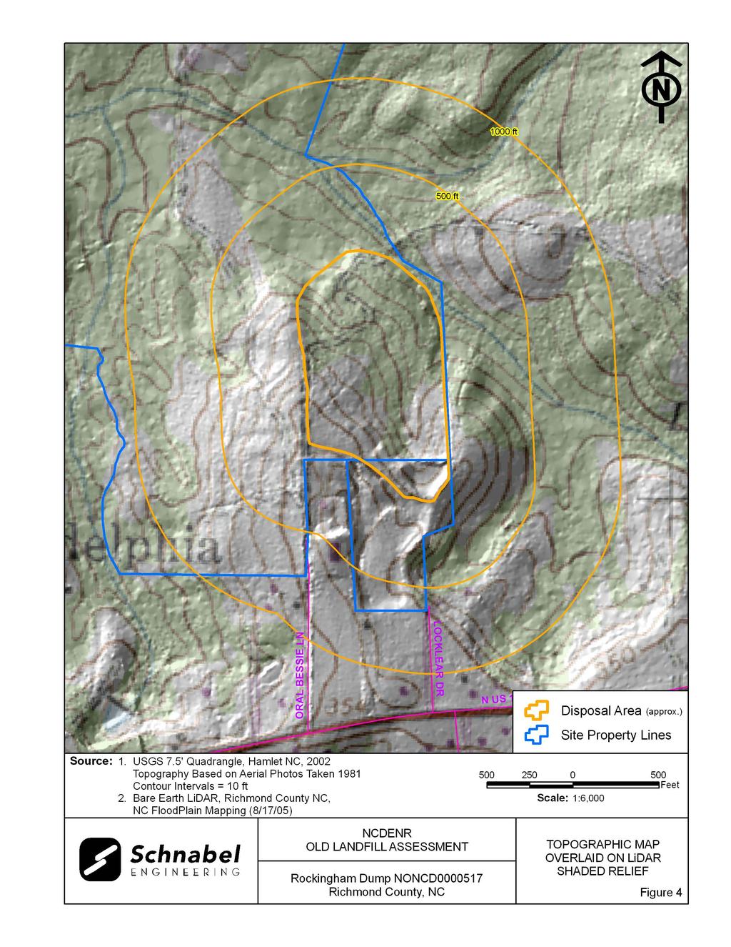
6 1.3 On-Site Water Supply Wells and Intakes No on-site water supply wells were observed on the Site during the site visit. No water meters or fire hydrants were observed on the Site during the site visit. 1.4 Surface Water Features A spring was observed on the northern part of the Disposal Area. The spring was approximately one foot wide with soft ground and stagnant pools of clear water. A second spring was observed on the north central part of the Disposal Area. The spring was approximately one foot wide with soft ground and stagnant pools of clear water. An unnamed perennial stream flows on the Site about 50 feet from the northeastern part of the Disposal Area. The unnamed perennial stream was about three feet wide with slow flowing clear water at the time of the site visit. A swampy area was observed on the southeastern perimeter of the Disposal Area near the sand pit. The swamp was stagnant with cloudy water observed at the time of the site visit. Disposal material was observed in the swamp and included a plastic drum, tires, and metal. 1.5 Disposal Area Access to the Disposal Area is along a dirt road from Oral Bessie Lane (Photo 1). The Disposal Area occupies 22.1 acres based on the estimated Disposal Area perimeter shown on Figures 1 through 3. The ground surface of the Disposal Area slopes relatively uniformly toward the northeast. A comparison of the topography from the 2002 USGS 7.5 minute topographic quadrangle map (10 foot contours, based on 1981 aerial photography) with the 2005 topographic map from NCDOT GIS Branch (4 foot contours), indicates that disposal material has filled in the drainage on the eastern part of the Disposal Area with up to 20 feet of material. The depth of waste is estimated based on a comparison of topographic maps of different vintages constructed using different Rockingham Dump NONCD
7 methods. Differences between elevations on the maps may reflect actual elevation changes or may be apparent differences due to the different map making methods. The elevation comparisons are approximate and differences in scale and methods of mapping are not sufficient to evaluate some changes in topography. GPS coordinates were taken of the Disposal Area using historical aerial photographs and LiDAR. The approximate Disposal Area perimeter is illustrated on the figures and on aerial photographs in Appendix E. A table of GPS coordinates for the Site entrance and the Disposal Area is presented in Table 1. The Disposal Area perimeter location is approximate and is based on visual observations made at the time of the site visit and interpretation of aerial photographs. Figures 4 and 5 show LiDAR shaded relief superimposed on the Disposal Area. 1.6 Disposal Area Conditions The Disposal Area was covered with kudzu, briars, pine trees four to seven inches in diameter, and scrub trees. Exposed disposal material was observed along the southern and eastern parts of the Disposal Area. The observed disposal material included tires, auto gas tanks, mufflers, empty 55-gallon drums, paint cans, white goods, fabric, insulation, roofing shingles, and plastic. A sand pit was observed on the southern part of the Disposal Area. Disposal material was observed along the rim of the sand pit including a large pile of tires. An unrecognizable odor was detected on the western boundary of the Disposal Area along the dirt road. Hummocky topography was observed on the eastern part of the Disposal Area. A berm was observed along the southern part of the Disposal Area near the sand pit. The observed Disposal Area was on multiple tax parcels, Parcel Numbers and The perimeter of the Disposal Area was visually evident with the majority of the Disposal Area on Parcel No The southern part of the Disposal Area extended onto Parcel No Rockingham Dump NONCD
8 Other than mentioned above, no notable erosion, depressions, stained or discolored soils, or slope failures were observed during the site visit. 1.7 Evidence of Human Activity ATV trails and numerous hunting stands were observed during the site visit. Several relatively unweathered empty plastic drink containers were also observed, suggesting recent human activities. 1.8 Potential Landfill Gas Migration Pathways There were no visible or evident potential gas migration pathways such as stormwater drain systems, underground utilities, septic systems, or drain fields observed on the Disposal Area or on the Site. An unrecognizable odor was detected on the western boundary of the Disposal Area along the dirt road that may be related to landfill gas. 1.9 Physical Barriers Site access is provided by a dirt road from Oral Bessie Lane. Site access for vehicles is blocked by a berm across the dirt road. Physical barriers were not observed along the property boundaries. Rockingham Dump NONCD
9 1.10 Other Pertinent Information Some history of the Site was obtained during conversations with persons familiar with the Site. The information obtained indicates that: Mr. Thomas Hudson, adjacent property owner, stated that: o His father owned the adjacent land to the south of the Disposal Area in the late 1950 s to early 1960 s. The Rockingham Dump was already in operation during this time. o He gave verbal permission to access his property. o He stated that the landfill did not extend onto his property. o His father used the adjacent property as a borrow area for parking lots, and other construction jobs. o He thought the landfill closed in the late 1960 s to early 1970 s. o Rockingham Dump was operated by the City of Rockingham. o He remembers City of Rockingham trucks driving by his property on their way to the landfill. o The property is currently used for the disposal of stumps and limbs. o The sand pit on the Disposal Area was used as a borrow area for construction jobs, and not used as a borrow area for the Disposal Area. Mr. Richard Haughin, City of Rockingham Public Works Director, stated that: o The landfill was operated by the City of Rockingham. o He believed the landfill operated from the late 1950 s to the early to mid 1970 s. Ms. Anne Hedgpeth, property owner, stated that she was not aware that a landfill was located on her property. o She gave verbal permission to access her property. Notes from conversations with people familiar with the site are included in Appendix C. The information obtained from these conversations has not been verified or confirmed. Rockingham Dump NONCD
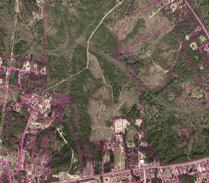
10 2.0 VICINITY CONDITIONS This section describes the observed general conditions in the vicinity of the Site, as defined as an area within 1,000 feet of the perimeter of the Disposal Area. Photographs illustrating vicinity conditions are included in Appendix D. 2.1 Structures Located on Adjacent Properties Structures described in this section are located on adjacent properties that have a shared property boundary with the Site. Several houses are located to the south and southwest of the Site on multiple tax parcels. Ebenezer Missionary Baptist Church and cemetery are located within 1,000 feet to the south of the Site. These structures are shown on Figure 2 and on aerial photographs in Appendix E. 2.2 Water Supply Wells and Intakes Water supply wells or well houses were not observed at residences along Oral Bessie Lane Road within a 1,000-foot radius of the Disposal Area. Water meters were observed in the yards of several of the residences within 1,000 feet of the Site. Fire hydrants were observed within 1,000 feet of the Site. No public water supply wells or intakes were listed on the NCDENR Public Water Supply Section s database (as of January 2010) within two miles of the Disposal Area. Rockingham Dump NONCD
11 2.3 Current Land Usage Property in the vicinity of the Site is primarily wooded, except for the area to the south and west which is residential. Land usage at the time of the site visit within 1,000 feet of the Disposal Area perimeter was: North: Wooded, apparent down-gradient direction from the Disposal Area. South: Cleared land, Ebenezer Missionary Baptist Church and cemetery, residences, apparent up-gradient direction from the Disposal Area. East: Wooded, apparent side-gradient direction from the Disposal Area. West: Wooded, apparent side- to down-gradient direction from the Disposal Area. 2.4 Surface Water Features An unnamed perennial stream flows from south to north off the northeastern boundary of the Disposal Area across the Site. The unnamed perennial stream was about three feet wide with slow flowing clear water at the time of the site visit. Rockingham Dump NONCD
12 3.0 AERIAL PHOTOGRAPHY REVIEW Aerial photographs were reviewed for the years 1956, 1968, 1983, and The reported years of operation were from the late 1950 s to the early 1970 s. Observations of each of the photographs are included in the following table. Copies of the aerial photographs are included in Appendix E. Some aerial photographs are reproductions of original aerial photographs and have some distortion; therefore, overlaid Disposal Area Boundaries and other features may vary from their actual locations. Hand drawn lines and notations on the photographs denote soils mapping information drawn on the original photographs by the USDA NRCS. Flight Year Observations Source 1956 The NRCS has drawn in a drainage on the eastern part of the Disposal Area. A dirt road is located on the northwestern part of the Disposal Area. The Disposal Area appears to be covered with ground vegetation. Structures are apparent to the south of the Site. The northern and western parts of the Disposal Area have been cleared with bare disturbed ground visible. The drainage on 1968 the eastern part of the Disposal Area is no longer apparent. A cleared area to the southwest of the Disposal Area is apparent. The southern and southeastern parts of the Disposal Area have 1983 been cleared. Dark vegetation is apparent on the northern part of the Disposal Area. A cleared area is apparent on the southeastern part of the Disposal Area. Light to dark colored vegetation covers the 2005 majority of the Disposal Area. ATV trails are visible in the central part of the Disposal Area. The aerial photograph shows conditions representative of those observed during the visit. Sources of aerial photos: 1) USDA NRCS office in Rockingham, NC 2) Richmond County GIS, This report was prepared specifically for the use of NCDENR Inactive Sites Branch under the Scope of Work defined in our contract dated October 26, Use of this document for other purposes or by other parties is at the sole risk of the user. Rockingham Dump NONCD
13 TABLE
14 TABLE 1 Tabulated GPS Coordinates Point State Plane Coordinates (meters) Latitude (deg, min, sec) Longitude (deg, min, sec) Northing Easting N W Site Entrance P P P P P P P P P P P P P P P P Notes: 1) Points obtained using a WAAS enabled Thales Mobile Mapper GPS and historical aerial photographs and LiDAR image. 2) All points in NAD83 datum.
15 FIGURES

16

17

18
19
20
21 APPENDIX A FIELD RECONNAISSANCE SHEET
22
23
24
25
26
27
28 APPENDIX B TAX RECORDS
29 Richmond County Property Cards Page 1 of 1 2/10/2010 OWNERSHIP PROPERTY DESCRIPTION TAX SUBDIVISIONS MAP NUMBER CARD NO HEDGPETH ANNE T ACRES VAC ROCKINGHAM RECORD NUMBER: DOVER RD NORTHSIDE FIRE ROUTE DURHAM, NC LISTER:1/12/96HH IO7 84 REVIEW:VJ TOPO STREET UTILITY ZONING ACRES ROLLING UNPAVED PUBWATER NOTES: : #LAND CLASS SIZE BASERATE*FRNT*DPTH*ADJ=ADJRATE*UNITS=LND-VALUE 231RWOODS AC ACF LAND VALUE: #OTHER FEAT SIZE BASERATE*COND =ADJRATE*UNITS=OFB-VALUE OTHER VALUE: 0 FNDATIONXTRFNISHROOFTYPEROOFMTRLSIZE/QTY WALLFNSHFLOORS HEAT&AIRHEATFUEL VACANT 0 #STRUCTURESKTCH-SF*STHT= AREA RATE*GRDF+HEAT+EXWL*WLHT=ADJRAT* AREA= RPCN* DEPF*CNDF=STR-VALUE STRUCTURE VALUE: 0 VALUATION VALUEPREV-VAL.P-N% TOTAL VALUE LAND % 1055LV/AC OTHERFEAT 0 STRUCTURE 0 TOTAL % APPRAISED-VALUE:

30

31
32 Richmond County Property Cards Page 1 of 1 2/10/2010 OWNERSHIP PROPERTY DESCRIPTION TAX SUBDIVISIONS MAP NUMBER CARD NO HUDSON E THOMAS JR & RONALD ACRES VAC ROCKINGHAM RECORD NUMBER: PO BOX 1232 NORTHSIDE FIRE ROUTE ROCKINGHAM, NC LISTER:2/20/96MB DEED: Q IO7 86 REVIEW:TL82806 TOPO STREET UTILITY ZONING ACRES ROLLING UNPAVED NOTES:LAND ADJ REAR & TOPO : #LAND CLASS SIZE BASERATE*FRNT*DPTH*ADJ=ADJRATE*UNITS=LND-VALUE 231KWOODS 10.00AC ACF LAND VALUE: #OTHER FEAT SIZE BASERATE*COND =ADJRATE*UNITS=OFB-VALUE OTHER VALUE: 0 FNDATIONXTRFNISHROOFTYPEROOFMTRLSIZE/QTY 1.00STHT WALLFNSHFLOORS HEAT&AIRHEATFUEL COMMRCIL 0 #STRUCTURESKTCH-SF*STHT= AREA RATE*GRDF+HEAT+EXWL*WLHT=ADJRAT* AREA= RPCN* DEPF*CNDF=STR-VALUE STRUCTURE VALUE: 0 VALUATION VALUEPREV-VAL.P-N% SALES-N% TOTAL VALUE LAND %QUALFIED 1303LV/AC OTHERFEAT STRUCTURE TOTAL % % APPRAISED-VALUE: 13030


33 Page 1 of 1 2/10/ / 1 100% Printed On: 2/10/2010 Disclaimer : All information on this map is prepared for the inventory of real property found within Richmond County. All data, including maps, is compiled from recorded deeds, plats, and other public records and data. Users of this data are hereby notified that the aforementioned public primary information sources should be consulted for verification of the information. All information contained herein was created for the County 's internal use. Richmond County, its agents and employees make no warranty as to the correctness or accuracy of the information set forth on this media whether express or implied, in fact or in law, including without limitation the implied warranties of merchantability and fitness for a particular use. Any resale of this data is strictly prohibited in accordance with North Carolina General Statute Grid is based on North Carolina State Plane NAD 83.
34 APPENDIX C RECORDS OF COMMUNICATION SITE VISIT PERMISSION LETTER
35 February 10, 2010 Ms. Anne T. Hedgpeth 3926 Dover Road Durham, NC Dear Ms Hedgpeth: The North Carolina Department of Environment and Natural Resources (NCDENR) has hired Schnabel Engineering South, PC (Schnabel) to assess old unlined landfills in several North Carolina counties. This project consists of researching the past use and current conditions of hundreds of sites. Your property on Oral Bessie Lane in Rockingham, NC (Tax ID no ) has been identified as a potential location of one of these old unlined landfills. We would like to visit your property and ask questions related to the history of the property to help prepare a report for the NCDENR. During the site visit our staff would walk over the property to observe the current conditions. No sampling or digging would be performed. After our site visit we will prepare a report and submit it to NCDENR. During the next few days one of our staff will be calling you to answer any questions you might have and to request permission to visit your property. If you have questions prior to our call, feel free to call me at the phone number listed below. If you call after business hours or during the weekend, please leave me a message. If you have general questions about the program you may also contact the NCDENR staff listed on the attached letter. Thank you for your assistance. Sincerely, SCHNABEL ENGINEERING SOUTH, PC GR/BB Attachment: Property Owner Letter from NCDENR NONCD cc: Bruce Lefler, NCDENR Benjamin L. Bradley Project Scientist \\greesvr1nt\projects\2006_projects\ _(ncdenr_old_unlined_landfill)\task_24_richmond_co\0517-rockinghamdump\report\final\propertyownerintroletter-hedgpeth doc
36
37 February 10, 2010 Messrs Thomas E and Ronald M Hudson P. O. Box 1232 Rockingham, NC Dear Messrs Hudson: The North Carolina Department of Environment and Natural Resources (NCDENR) has hired Schnabel Engineering South, PC (Schnabel) to assess old unlined landfills in several North Carolina counties. This project consists of researching the past use and current conditions of hundreds of sites. Your properties on Oral Bessie Lane (Tax ID nos and ) have been identified as a potential location of one of these old unlined landfills. We would like to visit your properties and ask questions related to the history of the properties to help prepare a report for the NCDENR. During the site visit our staff would walk over the properties to observe the current conditions. No sampling or digging would be performed. After our site visit we will prepare a report and submit it to NCDENR. During the next few days one of our staff will be calling you to answer any questions you might have and to request permission to visit your properties. If you have questions prior to our call, feel free to call me at the phone number listed below. If you call after business hours or during the weekend, please leave me a message. If you have general questions about the program you may also contact the NCDENR staff listed on the attached letter. Thank you for your assistance. Sincerely, SCHNABEL ENGINEERING SOUTH, PC GR/BB Attachment: Property Owner Letter from NCDENR NONCD cc: Bruce Lefler, NCDENR Benjamin L. Bradley Project Scientist \\greesvr1nt\projects\2006_projects\ _(ncdenr_old_unlined_landfill)\task_24_richmond_co\0517-rockinghamdump\report\final\propertyownerintroletter-hudson doc
38
39 11A Oak Branch Drive Greensboro, NC T/ F/ CONTACT: TITLE: ADDRESS: David Henderson NC Registered Forester 919 South Cox Street Suite B-1 Asheboro, NC CONVERSATION RECORD ORGANIZATION: DATE: TIME: PHONE: FAX: Henderson and Tugwell Consulting Foresters, P.A. March 11, PROJECT NAME: NC DENR Old Unlined Landfill Assessment PROJECT NO.: SITE NAME: Rockingham Dump NC DENR ID NO.: NONCD SUBJECT: SCHNABEL REP: Questions about property of interest Ben Bradley INCOMING CALL OUTGOING CALL MESSAGE LEFT FOR CONTACT MESSAGE RECEIVED MEETING REASON FOR INTERVIEW: Mr. Henderson was hired by Ms. Hedgpeth. PERMISSION GRANTED TO ACCESS PROPERTY: Not applicable LOCATION OF LANDFILL: Does not know. WHO OWNS THE LANDFILL PROPERTY: Ms. Anne Hedgpeth. LIMITS OF LANDFILL: Does not know. LANDFILL OPERATION DATES: Does not know. WHO PLACED WASTE IN LANDFILL: Does not know. MATERIALS PLACED IN LANDFILL: Does not know. HOW WAS MATERIAL PLACED IN LANDFILL: Does not know. WAS MATERIAL PLACED AFTER JANUARY 1, 1983: Does not know. AVAILABLE RECORDS: Does not know. PRESENT AND PRIOR LAND USE: Does not know. PUBLIC OR PRIVATE WATER SUPPLY: Does not know. OTHER CONTACTS: Does not know. ADDITIONAL INFORMATION: Mr. Henderson stated that he believed the landfill was not on Ms. Hedgpeth s property. Mr. Bradley responded that during the site visit, there was no question that Rockingham Dump was located on Ms. Hedgpeth s property. Mr. Henderson stated that he believed the landfill was located on Mr. Thomas Hudson s property. Mr. Bradley responded that Mr. Hudson s property was used for the recent disposal of trees and brush and was not part of Rockingham Dump. Mr. Bradley also responded that Town of Rockingham Officials concurred that the dump was on property owned by Ms. Hedgpeth. G:\2006_projects\ _(NCDENR_Old_Unlined_Landfill)\Task_24_Richmond_Co\0517-RockinghamDump\Report\Final\ROC_DavidHenderson_ docx
40 11A Oak Branch Drive Greensboro, NC T/ F/ CONTACT: TITLE: ADDRESS: Thomas Hudson Adjacent property owner 120 Yates Hill Road Rockingham, NC CONVERSATION RECORD ORGANIZATION: DATE: TIME: PHONE: FAX: March 17, PROJECT NAME: NC DENR Old Unlined Landfill Assessment PROJECT NO.: SITE NAME: Rockingham Dump NC DENR ID NO.: NONCD SUBJECT: Interview SCHNABEL REP: Ben Bradley INCOMING CALL OUTGOING CALL MESSAGE LEFT FOR CONTACT MESSAGE RECEIVED MEETING REASON FOR INTERVIEW: Mr. Hudson is the adjacent property owner to the Disposal Area. PERMISSION GRANTED TO ACCESS PROPERTY: Yes LOCATION OF LANDFILL: Landfill is located on property to the north of Mr. Hudson s. WHO OWNS THE LANDFILL PROPERTY: Ms. Anne Hedgpeth LIMITS OF LANDFILL: The landfill is on Ms. Anne Hedgpeth s property. LANDFILL OPERATION DATES: His father owned the adjacent land to the south of the Disposal Area in the late 1950 s to early 1960 s when the Rockingham Dump was already in operation. He thought the landfill closed in the late 1960 s to early 1970 s. WHO PLACED WASTE IN LANDFILL: City of Rockingham MATERIALS PLACED IN LANDFILL: Does not know. HOW WAS MATERIAL PLACED IN LANDFILL: He remembers City of Rockingham trucks driving by his property on their way to the landfill. WAS MATERIAL PLACED AFTER JANUARY 1, 1983: No AVAILABLE RECORDS: None that he is aware of. PRESENT AND PRIOR LAND USE: Used for timber harvesting. PUBLIC OR PRIVATE WATER SUPPLY: Public OTHER CONTACTS: No ADDITIONAL INFORMATION: Mr. Hudson stated that his property is currently used for the disposal of stumps and limbs. Mr. Hudson stated that the pit on the Disposal Area was used as a borrow pit for construction jobs, and not used as a borrow area for the Disposal Area. Mr. Hudson stated that the landfill did not extend onto his property. G:\2006_projects\ _(NCDENR_Old_Unlined_Landfill)\Task_24_Richmond_Co\0517-RockinghamDump\Report\Final\ROC_ThomasHudson_ docx
41 11A Oak Branch Drive Greensboro, NC T/ F/ CONTACT: TITLE: ADDRESS: Richard Haughin Public Works Director 514 Rockingham Road Rockingham, NC CONVERSATION RECORD ORGANIZATION: DATE: TIME: PHONE: FAX: City of Rockingham. March 17, PROJECT NAME: NC DENR Old Unlined Landfill Assessment PROJECT NO.: SITE NAME: Rockingham Dump NC DENR ID NO.: NONCD SUBJECT: Interview SCHNABEL REP: Ben Bradley INCOMING CALL OUTGOING CALL MESSAGE LEFT FOR CONTACT MESSAGE RECEIVED MEETING REASON FOR INTERVIEW: Mr. Haughin is the City of Rockingham Public Works Director. PERMISSION GRANTED TO ACCESS PROPERTY: Not applicable LOCATION OF LANDFILL: North of Oral Bessie Lane WHO OWNS THE LANDFILL PROPERTY: Ms. Anne Hedgpeth. LIMITS OF LANDFILL: Does not know. LANDFILL OPERATION DATES: From the late 1950 s to the early to mid 1970 s. WHO PLACED WASTE IN LANDFILL: City of Rockingham. MATERIALS PLACED IN LANDFILL: Does not know. HOW WAS MATERIAL PLACED IN LANDFILL: City of Rockingham trucks. WAS MATERIAL PLACED AFTER JANUARY 1, 1983: No AVAILABLE RECORDS: Does not know. PRESENT AND PRIOR LAND USE: Does not know. PUBLIC OR PRIVATE WATER SUPPLY: Public OTHER CONTACTS: Does not know. ADDITIONAL INFORMATION: No G:\2006_projects\ _(NCDENR_Old_Unlined_Landfill)\Task_24_Richmond_Co\0517-RockinghamDump\Report\Final\ROC_RichardHaughin_ docx
42 11A Oak Branch Drive Greensboro, NC T/ F/ CONTACT: TITLE: ADDRESS: Anne T. Hedgpeth Property Owner 3926 Dover Road Durham, NC CONVERSATION RECORD ORGANIZATION: DATE: TIME: PHONE: FAX: June 19, PROJECT NAME: NC DENR Old Unlined Landfill Assessment PROJECT NO.: SITE NAME: Rockingham Dump NC DENR ID NO.: NONCD SUBJECT: Property access and history SCHNABEL REP: Misti Benchabbat INCOMING CALL OUTGOING CALL MESSAGE LEFT FOR CONTACT MESSAGE RECEIVED MEETING REASON FOR INTERVIEW: Property Owner PERMISSION GRANTED TO ACCESS PROPERTY: Yes LOCATION OF LANDFILL: Ms. Hedgpeth did not know that a landfill was located on her property. WHO OWNS THE LANDFILL PROPERTY: Ms. Hedgpeth owns the property. LIMITS OF LANDFILL: Does not know. LANDFILL OPERATION DATES: Does not know. WHO PLACED WASTE IN LANDFILL: Does not know. MATERIALS PLACED IN LANDFILL: Does not know. HOW WAS MATERIAL PLACED IN LANDFILL: Does not know. WAS MATERIAL PLACED AFTER JANUARY 1, 1983: Does not know. AVAILABLE RECORDS: Does not know. PRESENT AND PRIOR LAND USE: The land is presently used for timber harvesting. PUBLIC OR PRIVATE WATER SUPPLY: Does not know. OTHER CONTACTS: Does not know. ADDITIONAL INFORMATION: Does not know. \\greesvr1nt\projects\2006_projects\ _(ncdenr_old_unlined_landfill)\task_24_richmond_co\0517-rockinghamdump\report\final\roc_annehedgpeth_ docx
43 APPENDIX D SITE PHOTOGRAPHS


44 PHOTOGRAPH No.: 1 Photo Taken: LOCATION: Disposal Area entrance is off of dirt road from Oral Bessie Lane. COMMENTS: Photo taken facing toward the north. PHOTOGRAPH No.: 2 Photo Taken: LOCATION: Southwestern part of Disposal Area. COMMENTS: Exposed disposal material including paint cans. Rockingham Dump, NONCD


45 PHOTOGRAPH No.: 3 Photo Taken: LOCATION: Southwestern part of Disposal Area. COMMENTS: Exposed roofing shingles. PHOTOGRAPH No.: 4 Photo Taken: LOCATION: North central part of Disposal Area. COMMENTS: Soft ground and spring. Rockingham Dump, NONCD


46 PHOTOGRAPH No.: 5 Photo Taken: LOCATION: South central part of Disposal Area. COMMENTS: Hummocky topography and exposed disposal material including tires, metal, white goods, and auto parts. PHOTOGRAPH No.: 6 Photo Taken: LOCATION: South central part of Disposal Area. COMMENTS: Hummocky topography and exposed furniture, foam insulation, metal, tires, and auto parts. Rockingham Dump, NONCD


47 PHOTOGRAPH No.: 7 Photo Taken: LOCATION: Southern part of Disposal Area. COMMENTS: Mound of disposal material. PHOTOGRAPH No.: 8 Photo Taken: LOCATION: Southern part of Disposal Area. COMMENTS: Pine trees of four to seven inches in diameter. Rockingham Dump, NONCD


48 PHOTOGRAPH No.: 9 Photo Taken: LOCATION: Southern part of Disposal Area. COMMENTS: Mound with exposed disposal material. PHOTOGRAPH No.: 10 Photo Taken: LOCATION: Southern part of Disposal Area. COMMENTS: Exposed disposal material and dense vegetation. Rockingham Dump, NONCD


49 PHOTOGRAPH No.: 11 Photo Taken: LOCATION: Southern part of Disposal Area. COMMENTS: Sand pit in foreground and mound of disposal material in wooded area. PHOTOGRAPH No.: 12 Photo Taken: LOCATION: Southeastern perimeter of Disposal Area. COMMENTS: Swampy area with exposed disposal material including tires, metal, and plastic barrel. Rockingham Dump, NONCD


50 PHOTOGRAPH No.: 13 Photo Taken: LOCATION: Southeast central part of Disposal Area. COMMENTS: Pile of tires. PHOTOGRAPH No.: 14 Photo Taken: LOCATION: Southeast central part of Disposal Area. Photo taken facing toward the northeast. COMMENTS: Hummocky topography, soft ground, and exposed disposal material. Rockingham Dump, NONCD


51 PHOTOGRAPH No.: 15 Photo Taken: LOCATION: Eastern part of Disposal Area. COMMENTS: Extensive area of exposed disposal material including white goods, auto parts, tires, metal, plastic, glass, foam insulation, roofing shingles, bed springs, and empty 55-gallon drums. PHOTOGRAPH No.: 16 Photo Taken: LOCATION: Eastern part of Disposal Area. COMMENTS: Exposed disposal material including white goods, auto parts, tires, and empty 55- gallon drums. Rockingham Dump, NONCD

52 PHOTOGRAPH No.: 17 Photo Taken: LOCATION: North central part of Disposal Area. COMMENTS: Briars and tall grass cover disposal material. Rockingham Dump, NONCD
53 APPENDIX E AERIAL PHOTOGRAPHS

54

55

56
57

58
SITE SUMMARY REPORT Arlington Dump NONCD Yadkin County
 SITE SUMMARY REPORT Arlington Dump NONCD 0000644 Yadkin County Hurricane Recovery Act of 2005 State of North Carolina State Contract N06009S Schnabel Project No. 06210002.15 July 31, 2009 Prepared for:
Triangle Land Conservancy Conservation Area Monitoring Report Carolina North
 Triangle Land Conservancy Conservation Area Monitoring Report Carolina North Property Name: Bolin Creek West Conservation Area Date of visit: 2.18.13, 2.18.13, 3.13.13, and 6.10.13 County: Orange Property
Triangle Land Conservancy Conservation Area Monitoring Report Carolina North
 Triangle Land Conservancy Conservation Area Monitoring Report Carolina North Property Name: Bolin Creek West Conservation Area Date of first visit: 3.12.14 County: Orange Date of second visit: 6.5.14 Property
Triangle Land Conservancy Conservation Area Monitoring Report Carolina North
 Triangle Land Conservancy Conservation Area Monitoring Report Carolina North Property Name: Bolin Creek West Conservation Area Date of visit: April 11, 2018 County: Orange Property Type: Restrictive Covenants
MEMORANDUM OF BOG TURTLE HABITAT INVESTIGATION
 MEMORANDUM OF BOG TURTLE HABITAT INVESTIGATION 410-728-2900 Fax: 410-728-3160 www.rkk.com To: From: CC: U.S. Fish and Wildlife Service, Pennsylvania Fish and Boat Commission Jennifer A Ottenberg Miller,
Sanford/Lee County Technical Review Committee (TRC) DEADLINES & MEETING DATES
 DEADLINES & MEETING DATES") Sanford/Lee County Technical Review Committee (TRC) DEADLINES & MEETING DATES The following 2019 information is based on the information available to staff at the time of creation. Dates & time may change
Sanford/Lee County Technical Review Committee (TRC) DEADLINES & MEETING DATES The following 2019 information is based on the information available to staff at the time of creation. Dates & time may change
Michael D, Harvey, Current Planning Supervisor. This project was originally approved in 2012 by the BOCC and is summarized as follows:
 PLANNING & INSPECTIONS DEPARTMENT Craig N. Benedict, AICP, Director Current Planning (919) 245-2575 (919) 644-3002 (FAX) www.orangecountync.gov 131 W. Margaret Lane Suite 201 P. O. Box 8181 Hillsborough,
Preliminary Sediment & Stormwater Management Plan Review Checklist DATE RECEIVED: PROJECT NUMBER: PROJECT NAME:
 Preliminary Sediment & Stormwater Management Plan Review Checklist DATE RECEIVED: PROJECT NUMBER: PROJECT NAME: General Information: 1. Completed application signed by the owner, review fee, one set of
USA Addition of South & East Side Residential Parcels. USA Deletion of a Town of Christiana Parcel. Conversion from USA to Limited Service Area
 Village of Rockdale Village of Rockdale 148 Water Street Cambridge, WI 53523 Phone 608.423.1497 Fax 608.423.9694 Urban Service Area (USA) Amendment USA Addition of South & East Side Residential Parcels
Procedures IV. V. Rural Road Design Option
 i IV. Procedures A. All applicants required to prepare a Conservation Design Subdivision shall provide the Planning Board with a conceptual conventional subdivision design as well as a proposed layout
McCormick Pit Category 1 Class A License, Pit Below Water For Blueland Farms Limited. Visual Impact Assessment Report February 2013
 McCormick Pit Category 1 Class A License, Pit Below Water For Blueland Farms Limited Visual Impact Assessment Report February 2013 TABLE OF CONTENTS EXECUTIVE SUMMARY... v 1.0 BACKGROUND... 1 Figure 1.
III. PROJECT DESCRIPTION
 III. PROJECT DESCRIPTION A. PROJECT LOCATION Regional Setting The project site is located in the southeast quadrant of the City of Chico in Butte County, California and is comprised of four parcels totaling
Plat Requirements CHECKLIST FOR SITE PLAN REVIEW
 This checklist is to be used as a guide for complying with the Town of Hollis Site Plan Regulations. It is to be used for each individual site plan review application submitted. Applicants are encouraged
138 ATTACHMENT 17. DEPARTMENT OF THE ARMY WlLMlNGTON DISTRICT, CORPS OF ENGINEERS
 138 ATTACHMENT 17 DEPARTMENT OF THE ARMY WlLMlNGTON DISTRICT, CORPS OF ENGINEERS B. EVERETT JORDAN DAM AND LAKE P.O. Box 144 MONCURE, NORTH CAROLINA 27559 April 11, 2007 Mr. Scott Radway Radway Design
SHORE PROTECTION ACT STAFF S FINDINGS & RECOMMENDATIONS
 SHORE PROTECTION ACT STAFF S FINDINGS & RECOMMENDATIONS TO: FROM: Shore Protection Committee: Commissioner Mark Williams, Chairman Mr. Richard Gardner Mr. Henry Morgan Mr. Zach Harris Mr. Bill Hodges Department
Application for Site Plan Review
 Application for Site Plan Review City of Pontiac Office of Land Use and Strategic Planning 47450 Woodward Ave, Pontiac, MI 48342 T: 248.758.2800 F: 248.758.2827 Property/Project Address: Sidwell Number:
TREE REMOVAL PERMIT PACKET
 PERMIT INTAKE HOURS Permit Applications will be accepted between 8:30 am and 4:30 pm. Community Development Engineering Division 38 Hill Street, Suite G-30 Roswell, GA 30075 770-641-3780 www.roswellgov.com
2018 Annual Landfill Inspection Report
 2018 Annual Landfill Inspection Report Landfill H.W. Pirkey Plant Southwestern Electric Power Company Hallsville, Texas December 17, 2018 Prepared for: Southwestern Electric Power Company H.W. Pirkey Plant
THE CITY OF MOBILE, ALABAMA
 THE CITY OF MOBILE, ALABAMA LETTER OF DECISION Ark of Safety, Inc. Mobile, AL 36617 Re: (Northwest corner of Main Street and First Avenue, extending to the Southwest corner of Esau Avenue and Main Street.)
PLANNED UNIT DEVELOPMENT & SUBDIVISION STAFF REPORT Date: May 18, 2017
 & PUD-0000102-2017 PLANNED UNIT DEVELOPMENT & SUBDIVISION STAFF REPORT Date: May 18, 2017 NAME SUBDIVISION NAME Dauphin Creek Estates Subdivision Dauphin Creek Estates Subdivision LOCATION CITY COUNCIL
OVERMOUNTAIN VICTORY TRAIL BURKE CALDELL CORRIDOR FEASIBLITY STUDY REQUEST FOR QUALIFICATIONS CALDWELL COUNTY PATHWAYS
 OVERMOUNTAIN VICTORY TRAIL BURKE CALDELL CORRIDOR FEASIBLITY STUDY REQUEST FOR QUALIFICATIONS CALDWELL COUNTY PATHWAYS Caldwell County Pathways along with our co-partners City of Lenoir, Town of Gamewell,
2. Would the proposed project comply with the Land Use map? 3. Would the proposed project require a rezoning? 4. What is the proposed zoning district?
 TOWN OF CHAPEL HILL Planning and Sustainability Department 405 Martin Luther King Jr. Blvd. Chapel Hill, NC 27514 www.townofchapelhill.org phone (919) 968 2728 Concept Plans are intended to be an opportunity
PCE PRELIMINARY DRAINAGE ANALYSIS REPORT FOR WESTWOOD MIXED USE NEIGHBORHOOD PROJECT 772 NORTH FOREST ROAD TOWN OF AMHERST, ERIE COUNTY, NEW YORK
 PCE PRELIMINARY DRAINAGE ANALYSIS REPORT FOR WESTWOOD MIXED USE NEIGHBORHOOD PROJECT 772 NORTH FOREST ROAD TOWN OF AMHERST, ERIE COUNTY, NEW YORK MAY 19, 2014 Prepared By: Timothy M. Lavocat, P.E., CFM
June 22, 2018 Project No /2100
 June 22, 2018 Project No. /2100 Riotrin Properties (Gloucester 3) Inc. c/o Riocan Management Inc. Riocan Yonge Eglinton Centre 2300 Yonge Street, Suite 500 Toronto, Ontario M4P 1E3 PHASE I ENVIRONMENTAL
October 28, May 25, 2010
 October 28, 2009 May 25, 2010 Jim Farr Staff Director, Acquisition and Restoration Council Office of Environmental Services Division of State Lands Florida Department of Environmental Protection 3900 Commonwealth
Project: Developer/Designer: Reviewer: I. Narrative: 1. Project Description: Describes the nature and purpose of the land disturbing activity.
 City of Charlottesville, Virginia Erosion and Sediment Control Plan Review Checklist 610 East Market Street, Charlottesville, VA 22902 Telephone 434-970-3182; Fax 434-970-3359 Project: Developer/Designer:
TOWNSHIP OF LOGAN SOIL & FILL IMPORTATION AND PLACEMENT APPLICATION SUBMITTAL CHECKLIST
 TOWNSHIP OF LOGAN SOIL & FILL IMPORTATION AND PLACEMENT APPLICATION SUBMITTAL CHECKLIST Applications: 5 copies of application - Applicant will reproduce the copies at his/her costs. The Township Clerk
CONCEPT PLAN APPLICATION
 CONCEPT PLAN APPLICATION TOWN OF CHAPEL HILL Planning Department 405 Martin Luther King Jr. Blvd phone (919) 968-2728 fa (919) 969-2014 www.townofchapelhill.org Parcel Identifier Number (PIN): 9880267455
Project phasing plan (if applicable) 12 copies of site plan
 12 copies of site plan") SITE PLAN REVIEW PERMIT APPLICATION City of Grand Haven, 11 N. Sixth Street, Grand Haven, MI 49417 Phone: (616) 847-3490 Fax: (616) 844-2051 Website: www.grandhaven.org 1. Project Information Address/location
SITE PLAN REVIEW PERMIT APPLICATION City of Grand Haven, 11 N. Sixth Street, Grand Haven, MI 49417 Phone: (616) 847-3490 Fax: (616) 844-2051 Website: www.grandhaven.org 1. Project Information Address/location
Gadsden County Planning Commission Agenda Request
 Date of Meeting: November 16, 2017 To: From: Through: Subject: Gadsden County Planning Commission Agenda Request Honorable Chairperson and Members of the Board Jill A. Jeglie, AICP, Senior Planner Clyde
KNOXVILLE/KNOX COUNTY METROPOLITAN PLANNING COMMISSION
 KNOXVILLE/KNOX COUNTY METROPOLITAN PLANNING COMMISSION FILE #: 12-A-13-UR AGENDA ITEM #: 33 AGENDA DATE: 12/12/2013 APPLICANT: OWNER(S): METRO KNOXVILLE HMA, LLC Metro Knoxville HMA., LLC TAX ID NUMBER:
Major Subdivision Sketch Plan Checklist
 This checklist provides specific requirements that are apart of the Sketch process. The entire process is described by the Huntersville Subdivision Review Process which details all the submittal and resubmittal
Community Development Rezoning Report REZ14-006
 Community Development Rezoning Report REZ14-006 Planning Commission Board of Supervisors March 4, 2014 March 26, 2014 Applicant M & N Real Estate, LLC Tax Map Id 125-(A)- L20E,125-(A)- L20E1, portion of
Town of Windham. Planning Department 8 School Road Windham, ME voice fax
 Town of Windham Planning Department 8 School Road Windham, ME 04062 voice 207.864-5960 fax 207.892.1916 MEMO DATE: TO: Staff Review Committee FROM: Amanda Lessard, Planner Cc: Ellen Rathbone, St. Germain
CITY OF ZEELAND PLANNING COMMISSION
 APPLICATION FOR SITE PLAN REVIEW AND SPECIAL LAND USE Date City Official App. Filing Fee Rec'd ($350) NOTE TO APPLICANT: Please submit this application for Site Plan Review along with twenty (20) copies
Community Development Planning Division
 Josephine County, Orego n Community Development Planning Division 700 NW Dimmick, Suite C / Grants Pass, OR 97526 (541) 474-5421 / Fax (541) 474-5422 E-mail: planning@co.josephine.or.us Dear Property Owner:
SECTION 4(f) DE MINIMIS DOCUMENTATION
 DE MINIMIS DOCUMENTATION") SECTION 4(f) DE MINIMIS DOCUMENTATION Illinois Route 60/83 IL 176 to the intersection of IL 60 (Townline Road) Lake County P-91-084-07 Mundelein Park and Recreation District Project Limit SECTION 4(f)
SECTION 4(f) DE MINIMIS DOCUMENTATION Illinois Route 60/83 IL 176 to the intersection of IL 60 (Townline Road) Lake County P-91-084-07 Mundelein Park and Recreation District Project Limit SECTION 4(f)
Plan Review Checklist
 Plan Review Checklist FOR EROSION AND SEDIMENT CONTROL PLANS _ Minimum Standards - All applicable Minimum Standards must be addressed. All minimum Standards must be adhered to during the entire project
MOBILE CITY PLANNING COMMISSION LETTER OF DECISION. October 22, 2010
 MOBILE CITY PLANNING COMMISSION LETTER OF DECISION Archbishop of Mobile 400 Government St. Mobile, AL 36602 Re: Case #SUB2010-00075 (Subdivision) 3650 Springhill Avenue (Northwest corner of Springhill
SITE PLAN REVIEW APPLICATION AND CHECKLIST
 SITE PLAN REVIEW APPLICATION AND CHECKLIST PROJECT SUMMARY: Project Name: City/ETA Location: City ETA (Application fee & number of copies needed are based on location) Property Location (Legal Description
STATE OF NORTH CAROLINA DECLARATION OF
 Prepared by and Return to: Orange County Parcel Identification Number(s): STATE OF NORTH CAROLINA COUNTY OF ORANGE DECLARATION OF RESTRICTIVE COVENANTS THIS DECLARATION OF RESTRICTIVE COVENANTS ( Declaration
Florence County Small Commercial Land Disturbance Permit Application
 Florence County Small Commercial Land Disturbance Permit Application Florence County Engineering Division 518 South Irby Street Florence, S.C. 29501 Phone (843) 676-8600 Fax (843) 676-8667 Tax Map Number:
Request Modification of Conditions of a Conditional Use Permit approved October 14, Staff Recommendation Approval. Staff Planner Stephen White
 Applicant Property Owner Public Hearing September 13, 2017 City Council Election District Lynnhaven Agenda Item 3 Request Modification of Conditions of a Conditional Use Permit approved October 14, 2003.
PROJECT SCOPE OF WORK CITY OF TOWN AND COUNTRY STORMWATER PROGRAM
 PROJECT SCOPE OF WORK CITY OF TOWN AND COUNTRY STORMWATER PROGRAM Project ID Number: 25-5 Problem: Stormwater collected from the neighborhood upstream is released at 9 Muirfield Lane and flows west toward
Agenda Item # 1. Meeting Date September 21, Prepared By. Approved By
 Agenda Item # 1 Work Session Meeting Date September 21, 2015 Prepared By Approved By Erkin Ozberk, Senior Planner Suzanne R. Ludlow City Manager Discussion Item Background Discussion of Site Plan Application
STAFF REPORT FOR STANDARD COASTAL DEVELOPMENT PERMIT #CDP FEBRUARY 26, 2015 CPA - 1 PO BOX 238 APTOS, CA 94001
 STAFF REPORT FOR STANDARD COASTAL DEVELOPMENT PERMIT #CDP 2014-0030 FEBRUARY 26, 2015 CPA - 1 OWNER/APPLICANT: AGENT: REQUEST: HANS HEIM PO BOX 238 APTOS, CA 94001 JAMES HAY PO BOX 762 MENDOCINO, CA 95460
St. Louis Ice Center in Creve Coeur Lake Memorial Park
 Carol S. Comer, Director Missouri Department of Natural Resources P.O. Box 176 Jefferson City, MO 65102 Re: St. Louis Ice Center in Creve Coeur Lake Memorial Park Dear Ms. Comer: We are writing on behalf
PARISH OF ASCENSION OFFICE OF PLANNING AND DEVELOPMENT PLANNING DEPARTMENT. Joint Planning and Zoning Meeting
 1. Call To Order 2. Roll Call of Members 3. Chairman's Comments PARISH OF ASCENSION OFFICE OF PLANNING AND DEVELOPMENT PLANNING DEPARTMENT Joint Planning and Zoning Meeting January 11, 2017 6:00 PM Courthouse
Poisoned Park? How Exide s Lead Contamination Risks Frisco s Grand Park
 Frisco City Hall has big plans to transform Stewart Creek into a Grand Park with lots of water features for kids to play in. Poisoned Park? How Exide s Lead Contamination Risks Frisco s Grand Park But
3.10 LAND USE SETTING PROJECT SITE EXISTING LAND USE DESIGNATIONS AND ZONING. General Plan Land Use Designations.
 This section of the Draft EIR addresses the existing land uses on and adjacent to the project site and discusses the potential impacts of the proposed project on existing land uses. Key issues addressed
CITY OF BEACON NOTICE TO LANDSCAPE ARCHITECTS GENERAL INFORMATION AND REQUEST FOR PROPOSALS
 CITY OF BEACON NOTICE TO LANDSCAPE ARCHITECTS GENERAL INFORMATION AND REQUEST FOR PROPOSALS The City of Beacon (the CITY) is issuing this Request for Proposals (RFP) for the selection of a landscape architect
R E S O L U T I O N. Designation: R-2A (1-Family, 2-acre Minimum Lot Size)
") PLANNING BOARD Arthur Adelman, Chair TOWN OF NORTH CASTLE WESTCHESTER COUNTY 17 Bedford Road Armonk, New York 10504-1898 R E S O L U T I O N Telephone: (914) 273-3542 Fax: (914) 273-3554 www.northcastleny.com
PLANNING BOARD Arthur Adelman, Chair TOWN OF NORTH CASTLE WESTCHESTER COUNTY 17 Bedford Road Armonk, New York 10504-1898 R E S O L U T I O N Telephone: (914) 273-3542 Fax: (914) 273-3554 www.northcastleny.com
CRESCENT RESOURCES INC.
 CRESCENT RESOURCES INC. Due Diligence Checklist Project Name: Client: Project No. Date: 1 Survey Review survey for compliance with Crescent Resources, Inc. s Instructions to Surveyors (see below): All
JOINT PUBLIC NOTICE. 26 June United States Army Corps of Engineers State of Louisiana
 JOINT PUBLIC NOTICE 26 June 2017 United States Army Corps of Engineers State of Louisiana New Orleans District Department of Environmental Quality Regulatory Branch Office of Environmental Services 7400
5. Would the proposed project require modifications to the existing regulations?
 TOWN OF CHAPEL HILL Planning and Sustainability Department 405 Martin Luther King Jr. Blvd. Chapel Hill, NC 27514 www.townofchapelhill.org phone (919) 968-2728 Concept Plans are intended to be an opportunity
UNIVERSITY PRESBYTERIAN CHURCH - RENOVATION & ADDITION 209 EAST FRANKLIN ST., CHAPEL HILL, NC 27514
 UNIVERSITY PRESBYTERIAN CHURCH - RENOVATION & ADDITION 209 EAST FRANKLIN ST., CHAPEL HILL, NC 27514 PROJECT DATA OVERALL SITE MAP HDC CONCEPT PLAN SUBMITTAL: OCT. 8, 2012 SUP SUBMITTAL: MAY 28, 2013 SUP
November 2, 2015 at 5:15pm City Council Chambers, 3rd Floor, City Hall, 1737 Main Street Columbia, South Carolina 29201
 Subject Property: PLANNING COMMISSION SITE/SUBDIVISION PLAN CASE SUMMARY 10.21 ACRES, WESTSIDE OF CLIF KINDER BOULEVARD COTTAGES AT BURNSIDE FARM BURNSIDE FARMS ASSOCIATES, LLC November 2, 2015 at 5:15pm
GRACE CHURCH EXPANSION
 GRACE CHURCH EXPANSION REVIEW: NOVEMBER 24, 2014 200 SAGE ROAD, CHAPEL HILL NORTH CAROLINA PROJECT DATA OVERALL SITE MAP SITE INFORMATION OWNER PIN ACREAGE VICINITY MAP GRACE CHURCH 9890503171 271,600
2.0 Hi s t o r y & Existing Co n d i t i o n s
 2.0 Hi s t o r y & Existing Co n d i t i o n s 2.1 Plan Area History The Lincoln East Specific Plan (Specific Plan) area is a significant part of the history of Sutter County. A 48,000 acre land grant
The Planner will identify the information required for the review to obtain a Development Permit from the following list:
 Josephine County, Oregon Board of Commissioners: Jim Riddle, Dwight Ellis & Jim Raffenburg PLANNING OFFICE Michael Snider, Director 510 NW 4th Street / Grants Pass, OR 97526 (541) 474-5421 / FAX (541)
Chapter 8: BEACH SOUTH OF ATLANTIC AVENUE NEIGHBORHOOD PLANNING AREA ANALYSIS
 Chapter 8: BEACH SOUTH OF ATLANTIC AVENUE NEIGHBORHOOD PLANNING AREA ANALYSIS The Beach South of Atlantic Avenue Neighborhood Planning Area includes the parcels adjacent to S Fletcher Avenue from Atlantic
Weston s Wetlands, Stormwater, & Open Space
 Weston s Wetlands, Stormwater, & Open Space Weston s Wetlands, Stormwater, & Open Space Conservation Commission Role and Responsibilities Laws that protect wetlands What residents can do to protect wetlands
Colerain Township report to. Hamilton County Regional Planning Commission. December 2, 2010, 1:00PM. t a f f r e p o r t
 Colerain Township report to Hamilton County Regional Planning Commission December 2, 2010, 1:00PM Preliminary Plan: Case No.: ZA2001-04, Forevergreen Prepared By: Amy Bancroft, Land Use Planner t a f f
I. INTRODUCTION. identify long-term capital improvements and rehabilitation measures for the existing drainage system;
 I. INTRODUCTION The Town of Windsor, Colorado is presently experiencing rapid growth and development within the boundaries of several of its major drainage basins. As growth continues within these basins,
Drexel, Barrell & Co.
 Drexel, Barrell & Co. June 18, 2018 Engineers/Surveyors Boulder Colorado Springs Greeley 3 South 7 th Street Colorado Springs, Colorado 80905-1501 719 260-0887 719 260-8352 Fax El Paso County Planning
CHEBOYGAN COUNTY PLANNING COMMISSION
 CHEBOYGAN COUNTY PLANNING COMMISSION 870 SOUTH MAIN ST. PO BOX 70 CHEBOYGAN, MI 49721 PHONE: (231)627-8489 FAX: (231)627-3646 CHEBOYGAN COUNTY PLANNING COMMISSION MEETING & PUBLIC HEARING WEDNESDAY, NOVEMBER
STAGE 1 ARCHAEOLOGICAL ASSESSMENT OF RATHBURN ROAD, FROM DUKE OF YORK BOULEVARD TO SHIPP DRIVE, CITY OF MISSISSAUGA. Submitted to:
 STAGE 1 ARCHAEOLOGICAL ASSESSMENT OF RATHBURN ROAD, FROM DUKE OF YORK BOULEVARD TO SHIPP DRIVE, CITY OF MISSISSAUGA Submitted to: McCormick Rankin Corporation 2655 North Sheridan Way, Suite 280 Mississauga,
ZONING ORDINANCE FOR THE ZONED UNINCORPORATED AREAS ARTICLE 1150 OF PUTNAM COUNTY, WEST VIRGINIA Page 95 ARTICLE 1150 SITE PLAN REVIEW
 OF PUTNAM COUNTY, WEST VIRGINIA Page 95 1150.01 PURPOSE 1150.02 APPLICABILITY 1150.03 APPLICATION PROCESS 1150.04 REVIEW PROCESS 1150.05 REVIEW CRITERIA 1150.06 SITE PLAN GUIDELINES 1150.01 PURPOSE ARTICLE
Advance Engineering & Surveying PLLC
 Advance Engineering & Surveying, PLLC Consulting in: Civil & Environmental Engineering Land Surveying Land Development 11 Herbert Drive Phone: (518) 698-3772 Latham, N.Y. 12110 Email:ncostape@gmail.com
Architectural Inventory Form
 COLORADO CULTURAL RESOURCE SURVEY Page 1 of 8 Official Eligibility Determination (OAHP use only) Rev. 9/98 OAHP1403 Date Initials Determined Eligible National Register Determined Not Eligible National
Inspection Report: Berryville Collection System, AFIN: , Permit #: AR FACILITY TYPE: 1 - Municipal
 FACILITY INFORMATION NAME: Berryville Collection System LOCATION: CITY: Berryville RESPONSIBLE OFFICIAL NAME: / TITLE Honorable Tim McKinney / Mayor COMPANY: City of Berryville MAILING ADDRESS: P.O. Box
PROPOSED DRAINAGE PATTERNS
 1121 1118.50 Basin Floor 1120 1119 0 N 100 200 PROPOSED DRAINAGE PATTERNS Deroiser Drive Riverwood Drive County 260 0 100 200 Project Name: Riverwood Drive LITTLE FALLS TOWNHOMES Project Location: LITTLE
LONDONDERRY PLANNING BOARD MINOR SITE PLAN APPLICATION & CHECKLIST
 LONDONDERRY PLANNING BOARD MINOR SITE PLAN APPLICATION & CHECKLIST Planning Department Date Stamp Design Review Formal Application Change of Use (No Site Improvements)* All information provided and submitted
Pasco County Watershed Meeting for Flood Impacted Areas Port Richey Watershed
 Pasco County Watershed Meeting for Flood Impacted Areas March 15, 2017 Regency Park Library, 9701 Little Road, New Port Richey, Pasco County The following is a summary of the meeting held on March 15,
Roy L. Wickland 15 Belvedere Avenue - Belvedere, CA 94920
 Roy L. Wickland 15 Belvedere Avenue - Belvedere, CA 94920 June 19, Ms. Irene Borba Director of Planning and Building City of Belvedere ~1anning Department 450 San Rafael Avenue Belvedere, CA 94920 JUN.
September 14, Ken Cunningham, Chief a I. Conservation Services Division ti9 r< New Mexico Department of Game and Fish. P0 Box
 September 14, 2011 j Conservation Services Division ti9 r< Ken Cunningham, Chief a I fl4j Richardson Building www.urscorp.com Fax: 575-526-1390 Phone: 575-526-1180 Las Cruces, NM 88005-2610 101 North Alameda,
Asbury Chapel Subdivision Sketch Plan
 Asbury Chapel Subdivision Sketch Plan PART 1: PROJECT SUMMARY Applicant: NVR Inc. Project Size: +/- 76.13 acres Parcel Numbers: 02101112,02116101,02116112, 02116113 Current Zoning: Transitional Residential
NOTICE OF PREPARATION
 NOTICE OF PREPARATION DATE: January 6, 2016 TO: LEAD AGENCY: Responsible Agencies, Organizations, and Interested Parties Contact: Tyler Barrington, Principal Planner Planning Department Community Development
Erosion & Sediment Control Plan Application Form & Checklist
 Erosion & Sediment Control Plan Application Form & Checklist GENERAL INFORMATION Application Date: Project Address: Tax Map / Parcel Number(s): PROPERTY OWNER / DEVELOPER Firm Name: Contact Person: Title:
PennDOT. single spann lanes and 3- mayy need to be to accommodate. any bridge. addition to III. Date: CRP 07/27/2015 CRP.
 (10/27/14) PennDOT Section 106 Field Assessments and Finding Combined Early tification/finding? Yes Concurrence required or requested: Yes MPMS: 51507 ER# (if consultation with PHMC required) ): County:
Non-Metallic Mining Reclamation Checklist
 Eau Claire County DEPARTMENT OF PLANNING AND DEVELOPMENT Eau Claire County Courthouse, Rm. 1510 721 Oxford Avenue Eau Claire, Wisconsin 54703-5481 (715) 839-4741 f Housing & Community Development 839-6240
PG&E WINTERS GAS OPERATIONS AND TECHNICAL TRAINING CENTER
 PG&E WINTERS GAS OPERATIONS AND TECHNICAL TRAINING CENTER CEQA scoping Meeting March 19 th, 2014 Winters City Council Chambers - 6:30 pm AGENDA FOR THE MEETING 6:30 Welcome (John Donlevy) 6:40 Overview
Funding is available to applicants on a first come, first served basis, and applications will be considered in the order they are received.
 Program Conditions and Instructions The City of Westwood Hills is partnering with the Johnson County Program to provide $5,000.00 for a stormwater management cost-share program. The program is intended
STREAM BUFFER PROTECTION AND MANAGEMENT
 ORDINANCE NO. 753 AN ORDINANCE AMENDING THE CODE OF ORDINANCES OF THE CITY OF PLEASANT HILL, IOWA 1998, BY ESTABLISHIING CHAPTER 104, STREAM BUFFER PROTECTION AND MANAGEMENT Be it enacted by the City of
Appendix D Fire Safety Requirements
 Appendix D Fire Safety Requirements SHASTA COUNTY FIRE DEPARTMENT MEMORANDUM DATE: May 22, 2008 BW TO: FROM: Russ Mull, Director Department of Resource Management Mike Chuchel Shasta County Fire Warden
HUDSON VALLEY REGIONAL COUNCIL 3 Washington Center, Newburgh NY
 PROJECT AREA: HYDE PARK HUDSON VALLEY REGIONAL COUNCIL 3 Washington Center, Newburgh NY 12550 http://www.hudsonvalleyregionalcouncil Insert aerial site photo with streets labeled GREEN INFRASTRUCTURE CONCEPT
City of Reedley Community Development Department 1733 Ninth Street Reedley, CA (559) FAX
 FAX") City of Reedley SPECIAL PERMIT Submittal Requirements Conditional Use Permit (CUP), Site Plan Review (SPR) & Variance (VAR) Please use this information sheet as a checklist to assemble materials required
City of Reedley SPECIAL PERMIT Submittal Requirements Conditional Use Permit (CUP), Site Plan Review (SPR) & Variance (VAR) Please use this information sheet as a checklist to assemble materials required
Stormwater Pollution Prevention Plan Oneonta Heights Oneonta, NY TABLE OF CONTENTS PAGE
 Oneonta Heights Oneonta, NY TABLE OF CONTENTS PAGE I. INTRODUCTION... 2 II. EXISTING CONDITIONS... 3 A. Topography/ Drainage... 3 B. Soils... 3 C. Wetlands... 3 D. Floodplain... 3 E. NYSDEC Environmental
Building & Site Design Standards Application
 FOR OFFICE USE ONLY Design standards plan review fee Building & Site Design Standards Application Phone: 208-468-5406 Fax: 208-468-5439 411 3rd Street South Nampa, Idaho 83651 5,000
CITY PLANNING COMMISSION AGENDA. ITEM NO: 6.a 6.b STAFF: LONNA THELEN
 Page 156 CITY PLANNING COMMISSION AGENDA ITEM NO: 6.a 6.b STAFF: LONNA THELEN FILE NO(S): A. - CPC ZC 08-00069 QUASI-JUDICIAL B. - CPC CU 08-00070 QUASI-JUDICIAL PROJECT: APPLICANT: OWNER: PHIL LONG VALUCAR
North Carolina Department of Transportation Project Development and Environmental Analysis Branch
 North Carolina Department of Transportation Project Development and Environmental Analysis Branch Citizens Informational Workshop I-85, from I-485 to NC 73 Mecklenburg and Cabarrus Counties October 30,
COUNTY COUNCIL OF PRINCE GEORGE'S COUNTY, MARYLAND, SITTING AS THE DISTRICT COUNCIL ORDER AFFIRMING PLANNING BOARD DECISION, WITH AMENDED CONDITIONS
 Case No. Applicant: Dawn Limited Partnership COUNTY COUNCIL OF PRINCE GEORGE'S COUNTY, MARYLAND, SITTING AS THE DISTRICT COUNCIL ORDER AFFIRMING PLANNING BOARD DECISION, WITH AMENDED CONDITIONS IT IS HEREBY
1. Request: The subject application is for approval of a gymnasium addition to an existing private school and church.
 R E S O L U T I O N WHEREAS, the Prince George's County Planning Board is charged with the approval of Detailed Site Plans pursuant to Part 3, Division 9 of the Zoning Ordinance of the Prince George's
MONTGOMERY COUNTY PLANNING DEPARTMENT THE MARYLAND-NATIONAL CAPITAL PARK AND PLANNING COMMISSION
 MONTGOMERY COUNTY PLANNING DEPARTMENT THE MARYLAND-NATIONAL CAPITAL PARK AND PLANNING COMMISSION MCPB Item No. Date: 06-12-14 King of the Nations Christian Fellowship Church: Limited Site Plan Amendment
The Maryland-National Capital Park and Planning Commission Prince George's County Planning Department Development Review Division
 The Maryland-National Capital Park and Planning Commission Prince George's County Planning Department Development Review Division 301-952-3530 Note: Staff reports can be accessed at www.mncppc.org/pgco/planning/plan.htm.
Planning Commission March 8, 2017 MINUTES Regular Meeting City of Hagerstown, Maryland
 Douglas S. Wright, Jr., chair, called the meeting to order at 4:04 p.m., on Wednesday, March 8, 2017, in the Conference Room, Fourth Floor, City Hall. Also present were commission members D. Miller, J.
BUILDER LOTS FOR SALE
 BUILDER LOTS FOR SALE NORTHERN CULPEPER - 135 ACRES RESIDENTIAL DEVELOPMENT 1256 Old Bridge Road, Amissville, VA 20106 SALE PRICE: $995,000 LOT SIZE: 135+ Acres APN #: Tax Map 2 Parcel 23 ZONING: R-1 ACCESS:
Architectural Inventory Form
 OAHP1403 Rev. 9/98 COLORADO CULTURAL RESOURCE SURVEY Architectural Inventory Form Official eligibility determination (OAHP use only) Date Initials Determined Eligible- NR Determined Not Eligible- NR Determined
CIVIL ENGINEERING PERMIT APPLICATION
 CIVIL ENGINEERING PERMIT APPLICATION OFFICIAL USE ONLY Engineering Permit # Date: Received By: Staff Contact: FOR STAFF USE ONLY: OFD RSH LOTT Stormwater Planning Water Shop PLEASE SUBMIT TWO (2) SETS
We have reviewed the proposed concept plans for Beehive Homes and have the following comments:
 12800 Arbor Lakes Parkway, P.O. Box 1180, Maple Grove, MN 55311-6180 FIRE-RESCUE DEPARTMENT Fire Operations Fire Prevention 763-494-6300 763-494-6090 763-494-6421 Fax 763-494-6439-Fax August 22, 2018 RE: