PIKE PLACE MARKET PC-1 NORTH PROGRESS REPORT PC-1 NORTH DEVELOPMENT PLAN AND WATERFRONT CONNECTIONS prepared by: Steinbrueck Urban Strategies
|
|
|
- Sabrina Allison
- 6 years ago
- Views:
Transcription

1 June 2013 PIKE PLACE MARKET PC-1 NORTH PROGRESS REPORT PC-1 NORTH DEVELOPMENT PLAN AND WATERFRONT CONNECTIONS prepared by: Steinbrueck Urban Strategies

2 Pike Place Market, about 1900
3 CONTENTS 0.0 EXECUTIVE SUMMARY 1.0 INTRODUCTION 1.1 Pike Place Market History 1.2 Purpose of Progress Report 1.3 Market Ownership and Governance Structure 1.4 Market Historical Commission and Guidelines 1.5 Market Foundation 2.0 PC1 BACKGROUND AND CONTEXT 2.1 Ownership and Early History of the Site 2.2 Municipal Market Building/North Arcade, Chronology 2.3 Market Historic District and Boundary Expansion 2.4 Pike Place Market Urban Renewal Plan Framework, Pike Place Urban Renewal Plan Goals 2.6 Plan Priority Uses 2.7 Plan Urban Design Objectives 2.8 PC1-N Existing Physical Site Conditions and Features 2.9 Burlington Northern Railroad Tunnel 2.10 Cultural and Archaeological 3.0 PAST PC1-N DESIGN STUDIES PC1-N Design Charrette 4.0 PC1-N DEVELOPMENT STUDIES, PDA Council Policy Framework: Design and Use Principles, Goals and Objectives 4.2 Priority Uses, Site Analysis and Preliminary Building Program 5.0 PC1-N DEVELOPMENT CONCEPT 5.1 Project Goals 5.2 Community Involvement and Design Collaboration 5.3 Design Concept 5.4 Market Views 5.5 Pedestrian Circulation 6.0 BUILDING PROGRAM 6.1 Public Spaces, Access and Connections 6.2 Retail 6.3 Housing and Social Services 6.4 Market Replacement Parking 7.0 CENTRAL WATERFRONT CONCEPT PLAN CITY OF SEATTLE 7.1 Central Waterfront Guiding Principles 7.2 Overlook Walk 8.0 MEMORANDUM OF UNDERSTANDING CITY OF SEATTLE 9.0 NEXT STEPS 9.1 Design Development 9.2 Timeline, Approvals, Funding 9.3 Funding & Implementation 10.0 RECOMMENDATIONS 10.1 Community Design 10.2 Design Integration 10.3 Victor Steinbrueck Park 10.4 Design for Health, Safety, and Sociability 10.5 Sustainable Design APPENDIX REFERENCES

4


5 Archival photo from Opending Day, Farmers 1st & Pike, 1912 Opposite page: Newly constructed Market Arcade, INTRODUCTION The Pike Place Market was founded in 1907 as Seattle s first public market, and is the oldest continuously operated farmers market in the United States. Internationally renowned, today the Pike Place Market flourishes as one of the most familiar and beloved icons of Seattle, drawing an estimated 10 million visitors per year. The Market, with its colorful legacy and tradition, serves as one of the most significant economic, cultural, and historic resources for Seattle and the region. 1.1 Pike Place Market History The Pike Place Market officially opened August 17, 1907 with much public outcry over middlemen and dishonest commission houses whose greed was undercutting the farmers. City Councilman Thomas P. Revelle, Father of the Pike Place Market was lead sponsor of the ordinance designating Pike Place as Seattle s public market. On November 30, 1907, Revelle, in his speech before an excited crowd of thousands at the opening dedication ceremony of the first sheltered Market farmers stalls, was prophetic: This market is yours, I dedicate it to you, and may it prove a benefit to you and your children. It is for you to defend, protect, and to uphold, and it is for you to see that those who occupy it treat you fairly, that no extortion be permitted and the purpose for which created be religiously adhered to. This is one of the greatest days in the history of Seattle, but it is only the beginning for soon this city will have one of the greatest markets in the world. 1 1 Shorett, Alice and Murray Morgan, The Pike Place Market: People Politics and Produce, Pacific Search Press, 1985, pgs From that day forward, local farmers selling local produce directly to consumers would have first priority as the Market s day stall tenants. In the early 1960 s in the era of suburbanization, advent of convenience store shopping and the auto-centric supermarket, the long neglected Public Market had fallen into disrepair and was declared an urban blight by the city. This opened the door for use of federal urban renewal funds to bulldoze the market and put in its place a massive complex of glitzy office towers, hotels, and a new boutique market along the high bluff overlooking Elliot Bay. The Friends of the Market, led by architect and preservationist Victor Steinbrueck, was formed in 1964 to block the City s plans to raze the Pike Place Market and entire surrounding area. After a protracted seven year civic battle led by the Friends, the Market was saved by a citizen led initiative, known as Save the Market Initiative No. 1 in November, 1971 ( Yes 76,369, No 53,263), which established a seven acre historic district within the 22 acre federally designated Pike Place Urban Renewal Project area. The citizens initiative was the most far reaching preservation plan ever adopted in the United States and expanded the concept of historic preservation In order to promote the educational, cultural, farming, marketing, and other economic resources, and to include retention of traditional marketrelated activities, goods and services supporting the low income community, small, owner operated shops and especially for the sale directly to consumer of market fresh local farm produce. 2 2 City of Seattle, Pike Place Market Historical District Ordinance No PIKE PLACE PC-1 NORTH PROJECT - PROGRESS REPORT Steinbrueck Urban Strategies 8
.")

6 1.2 Purpose of this Progress Report With the civic visioning of the central waterfront by the City and impending Elliott Bay Seawall replacement and removal of the 1949 Alaskan Way Viaduct, attention has again focused, for the third time since the early 1980 s, on redevelopment of the last remaining urban infill site in the nine acre Market Historical District, designated (PC1-N). For over 30 years, the Pike Place Market Public Development Authority (PDA) has sought to redevelop the PC1- site in order to re-establish historical uses and re-integrate it into the Market. Most recently in Spring 2011, the PDA, anticipating a new opportunity to fill a hole and complete the 1974 Urban Renewal Plan, initiated design and feasibility studies for re-development for one of the most complex and challenging urban infill projects located in the Market Historical District in the city today. The PC1-N site presents extraordinary development challenges including costs and financial feasibility, severe physical site constraints, a maze of development controls and regulations, and a massive structural hurdle requiring any new construction to straddle the Burlington Northern Railroad tunnel which transects the site. This PC1-N Development Plan Progress Report is intended to provide an historical context and help guide future planning, final design, and implementation of the overall Development Plan for the PC1-N and Waterfront Connections Project. 1.3 Market Ownership and Governance Structure The Market is owned and managed by the Pike Place Market Public Development Authority (PDA). Following passage of the Market InitiativeNo. 1 in 1971, The PDA was formed to rehabilitate, own, and operate the public Market. With an operating annual budget of over $13 million, the PDA is a quasi-public municipal corporation chartered in 1973 by the City of Seattle with the mission to promote enterprises essential to the functioning of the historic Pike Place Market and which includes the preservation and expansion of the market s surrounding low income residential community, the survival of small owner-operated businesses, the presence of fresh local farm produce and a wide range of ethnic goods, groceries, and sundries, as well as the expansion of services to the public market community. The PDA maintains and operates 14 buildings in the nine acre historic district, and is governed by a 12 member council with five standing committees. The purpose of the PDA as the public market s redevelopment agency is to provide a legal entity through which citizens may fulfill the aims and objectives of the Pike Place Market Historical District Ordinance 10045, and the Historic Preservation Plan for the Pike Place Urban Renewal Project? Area. The PDA, as authorized, may also be involved in the rehabilitation and redevelopment of surrounding areas that might impact the character of the Market Historic District. Accordingly, and consistent with the PDA s charter, the PDA has an ongoing interest and obligation to be engaged in plans for the removal of the Alaskan Way Viaduct and revitalization of the central waterfront. For nearly two years, the PDA has been collaboratively 9 Steinbrueck Urban Strategies PIKE PLACE PC-1 NORTH PROJECT - PROGRESS REPORT


7 engaged with the City and waterfront stakeholders in plans to develop a Waterfront Concept Plan). The Plan will integrate with the Market s design goals for the PC-1 N site in a way that celebrates, activates, and increases pedestrian access to the waterfront, the Market, and extends public views. 1.4 Market Historical Commission and Guidelines The Pike Place Market Historical Commission, a 12 member body appointed by the mayor, has quasi-judicial authority over use and design approvals within the Market Historical District, in accordance with Pike Place Market Historic District Ordinance No and Commission Guidelines. The Historical Commission s Guidelines (pursuant to the Market Preservation Ordinance SMC ), are used as an authoritative basis for decision-making on the approval of uses and designs in the Market to protect and preserve the Historic District. The Commission has discretionary powers to interpret and apply the Guidelines to specific development projects. The Guidelines are intended to stimulate harmonious and orderly development, while allowing gradual adjustment to varying and changing Market activities. 3 The Market Guidelines relevant to new development in the Market place strong emphasis on contemporary architectural forms that draw from the humble and anonymous character of typical buildings within the District, but do not attempt to mimic the style of existing buildings. Utmost emphasis is placed on enhancing primary pedestrian connections between the Market and central waterfront, and connections between the PC1-N site specifically, and adjacent portions of the District Victor Steinbrueck Park, the North Arcade, and Heritage House congregate care facility. Of particular importance under the Market Guidelines is the preservation or enhancement of public views through and from the Market and from Victor Steinbrueck Park, and visual connections between the Park and central waterfront shoreline. 1.5 The Market Foundation Integral to the Market s preservation goals, the Market Foundation was established in 1982 and is a private non-profit corporation with its own community governing board housed in the Market. Its mission is to Preserve the Pike Place Market as a vital historic Seattle landmark in which a diverse population lives and thrives. The Foundation supports programs in the Pike Place Market that provide critically needed food, medical care, child care and early education, and housing and employment services for more than 10,000 homeless people, and hundreds of low-income residents, and elderly people in downtown Seattle each year. The Foundation also supports the Market s heritage programs, public improvements, and repairs to the Market s historic buildings, developments of new low-income housing in the Market, and programs that assist the Market s farmers. Rachel, a full size bronze piggy bank at the foot of Pike Place, is the Market s most famous resident raising thousands of dollars for these populations annually and symbolizing the care and compassion of the entire Seattle community. 3 Market Historical Commission Use and Design Guidelines (as amended April 25, 2012) PIKE PLACE PC-1 NORTH PROJECT - PROGRESS REPORT Steinbrueck Urban Strategies 10

8


9 2.0 PC1-N BACKGROUND AND CONTEXT Archival photo of Municipal Market 2.1 Ownership and Early History of the Site The property known today as PC1-N is within the 22 acre Pike Place Urban Renewal Project area inclusive of the smaller nine acre Market Historical District. The PC1-N parcels along with other core Market properties were purchased with federal funds by the City of Seattle in 1974 under threat of condemnation for Market redevelopment purposes prescribed in the 1974 Pike Place Urban Renewal Program. The PC1-N site had been previously occupied since 1924 by the Municipal Market Building, part of an historical assemblage of core market properties owned by the Desimone family prior to passage of the 1971 Market Initiative. North Arcade was dedicated in August 1922, again under protest by the farmers, who claimed they had been deprived of their right to sell in the most desirable location, which had been turned over to the high stall venders selling produce from Californa. In June 1923 the second, northern portion of the North Arcade was dedicated, restoring farmer stalls to the location they more highly coveted for the foot traffic; the Muncipal Market was completed in March To service the new market center by car, a vehicle bridge across Western Avenue allowed shoppers access from Pike Place to circle through the top floor of the Municipal Market to pick up purchases possibly one of the nation s earliest drive-through farmers markets. caption Above image: caption Opposite page: caption caption 2.2 Municipal Market Building/North Arcade Chronology In October 1919, under citizen protest, the Seattle City Council voted to revoke farmer use of the Pike Place thoroughfare due to overcrowding and traffic congestion. Hearings were held before the City Council to build a new market structure across Western Avenue to rehouse displaced farmers.two private rival corporations Westlake Market and the Public Market & Department Store competed for the project. The City Council voted for the Pike Place location and authorized an agreement to permit the construction as a joint project the North Arcade and Muncipal Market buildings. An early form of public private fianancial partnership, the Arcade was publically financed, and the privately funded Municpal Market and completed space were operated by the city. In exchange, the City transferred use of the Pike Place sidewalk public right-of-way to the Public Market Corp. The first southern portion of the steel shedded By the late 1960 s the Municipal Market Building had become derelict and the roof top was repurposed for market shopper parking accessed from the old Desimone Bridge across Western Avenue. In 1974, the building was partially destroyed by fire. In June 1974 after the City of Seattle Building Department condemned the building as unsafe, the Market Historical Commission determined that it would be infeasible to rehabilitate the structure and requested authorization from the City Council to demolish the building and to study a replacement parking strategy for the site. The Desimone Bridge, now an untelligible historic artifact and bridge to nowhere, was enclosed in the 1980 s and serves as an extension of the North Arcade daystalls. A second arched pedestrian bridge at the far north end of the Arcade, rendered useless after the 1974 fire that destroyed the Municpal Market, was removed and later sold to a rural farm to serve as a livestock crossing over a large creek. PIKE PLACE PC-1 NORTH PROJECT - PROGRESS REPORT Steinbrueck Urban Strategies 12

10 2.3 Market Historic District and Boundary Expansion In 1986 and again in 1989, the original seven acre Market Historical District boundary was expanded west of Western Avenue to include Victor Steinbrueck Park, and later the entire PC1-N site and in order to ensure future redevelopment would serve Market needs and be compatible in design with historic character of the Market. The south half of PC1-N was redeveloped by the PDA in 1986 for market supported uses. Property of University of Washington Libraries, Special Collections 13 Steinbrueck Urban Strategies PIKE PLACE PC-1 NORTH PROJECT - PROGRESS REPORT
 to protect public views of the shoreline from the Main Arcade.")
11 2.4 Pike Place Market Urban Renewal Plan Framework Underlying base zoning for the PC1-N site is prescribed by the city zoning designation Pike Place Market Mixed (PPM-M), which sets the maximum height structural limit at 85 feet. The Pike Place Market Urban Renewal Plan further limits maximum heights (see height diagram) to protect public views of the shoreline from the Main Arcade. The Pike Place Market PDA has final determination over development of new buildings in the Market Historical District pursuant to its Use and Design Guidelines. 2.5 Pike Place Urban Renewal Plan Goals The Pike Place Urban Renewal Plan ( the Plan ) adopted by ordinance by the City of Seattle [and amended in 1974], sets forth five principal goals, which as a whole, establish the purposes of the Urban Renewal Project as it relates to the historical fabric, functions, phasing economic development, and aesthetic character 4 : 1. Preserve and perpetuate the cultural, economic and historical qualities related to the Pike Place Market and surrounding area, as set forth in the Historical District Ordinance. 2. Execute the work of the Project with the least possible disruption to the activity and quality of the Pike Place Market. 3. Stabilize and renew the economic and physical vitality of the Project area. 4. Develop a community which will sustain the vitality of the Project area. 5. Develop amenities which capitalize on and utilize the features unique to the Project area. Pike Place Urban Renewal Plan, January City of Seattle. Department of Community Development, Urban Renewal Plan Pike Place Market. Amended January 4, Seattle WA PIKE PLACE PC-1 NORTH PROJECT - PROGRESS REPORT Steinbrueck Urban Strategies 14
12 2.6 Plan Priority Uses The Plan designates 12 principal land use zones and specifies predominate uses for each zone [see land use map]. The mix of land uses for each designated zone is illustrative of types of predominate uses permitted in each zone, but does not restrict other similar compatible uses permitted in each land use category. The PC1-N site is located within the Market Historic District just south of Victor Steinbrueck Park. The property was designated PC-1 and assigned parking and commercial as priority uses under the amended 1974 Pike Urban Renewal Plan. The Plan states that the PC1-N Site, formerly the location of the Municipal Market built in 1924, 5 shall be the location of structures containing public parking for the Project Area and should provide for development of commercial, residential, and public spaces to complement the existing Market activity. The Plan also places heavy emphasis on the importance of maintaining and rehabilitating low income housing in the Market area, and sets priority uses for future redevelopment of the Pike Place Market Historic District and neighboring properties surrounding the district. Priority uses for PC1-N must by law be consistent with the uses prescribed and authorized under 1974 Pike Market Urban Renewal Plan, and should include a mix of uses that support traditional market functions and improve pedestrian and vehicular access to the market and central waterfront. These may include: parks and open space; recreational commercial (e.g. art galleries; libraries; museums; theaters; arts studies; restaurants; bars; etc.); replacement parking; 5 Urban renewal Plan p. 9 storage for market tenants and merchants; housing, and space for social services. 2.7 Plan Urban Design Objectives An enduring set of general design principles, the Plan sets forth the following 11 Urban Design Objectives intended to protect and reinforce the essential character and historic qualities of the Market area: 1. Preserve and improve the Pike Place Market Historical District in accordance with Guidelines set forth in the Market Historical District Ordinance. 2. Maintain the Market as a natural focal point in the area, and provide convenient links to the Waterfront and downtown core areas. 3. Perpetuate a Market environment which encourages the contributions of individuals as a source of diversity, social vitality and visual energy. 4. Plan and design residential areas which promote a sense of community and social well-being. 5. Achieve compatible relationships between rehabilitated buildings and new structures in the Project area. The materials and detailing of all new construction shall blend into the character of the Historical District and have qualities which visually demonstrate the passage of time without compromising the required performance of material. 6. Provide protective and transitional areas around the Pike Place Market through control of land use and the form and character of buildings 7. Design buildings to express their individual functions and relationship and contribution to harmony of the whole. 8. Preserve linear qualities of Pike Place (the street) as the organizing element for the Market portion of the Historic District. Irregular and contrasting building masses throughout the Project area shall rely on this street for visual and functional reference where possible. 9. Preserve views to the west through extensions of the approaching street corridors and by utilizing grade differentials top achieve a progression of views through, into, and over the Project area. 10. Provide a continuum of public spaces which respond to social habits of people, interlace functionally with the surrounding activities and enhance public enjoyment through the appropriate use of materials, scale, architectural detail, furniture and lighting. 11. Preserve and develop areas, enclaves and spaces of distinctive identity, contrasting character and experience, and maintaining the heterogeneous qualities of the Project area PC1-N Existing Physical Site Conditions and Features The entire PC1-N site encompasses the surface parking lot to the north and the Heritage House Congregate Care Residence, Food Bank and Market Garage to the south. The PDA has operated the surface level public parking under an agreement with the City since The north portion of the PC1-N site is bounded to the east by Western Avenue, to the west by the soon-to-be demolished Alaskan Way Viaduct (State Highway 99), Victor Steinbrueck Park to the north, and Heritage House to the South. The parking is critical service 6 Urban Renewal Plan, p Steinbrueck Urban Strategies PIKE PLACE PC-1 NORTH PROJECT - PROGRESS REPORT
, occupies the northern half of the PC1-N site and was completed in 1982.")
13 parking for market merchants, suppliers, vendors, market employees and Market customers. Victor Steinbrueck Park (originally Market Park), comprising 0.8 acre (39,142 square feet), occupies the northern half of the PC1-N site and was completed in The park lids a privately owned and operated parking structure between Western Avenue and the Alaskan Way Viaduct. Architect Victor Steinbrueck co-designed Market Park, as it was originally called, with Richard Haag, and described the promontory location as one of the grandest downtown lookout places. 7 The total land area of PC1-N is approximately three-quarters of an acre. The site is trapezoidal and elongated north south, and drops about 30 feet down to the southwest of Western Avenue. Remnants of the demolished Municipal Market structure remain, including a foundation wall buttressing Western Avenue. On the west side there is the possibility of expanding the PC1-N site through vacation of a narrow elongated strip of under-utilized street right-of-way owned by the city. A distinguishing historical feature of the city s original street grid pattern, where the differently oriented street grids converge at Pine and Stewart Streets to form a hinge point at the south end of the PC1-N site. The public views through this right-of-way corridor are intended to be preserved under the Plan. At the southwest corner on the west side of the property there is a public street end stair to the waterfront, which receives surprisingly heavy pedestrian use during peak season. Existing site, Victor Steinbrueck Park, views 7 Victor Steinbrueck, Market Sketchbook (1968), University of Washington Press, Seattle PIKE PLACE PC-1 NORTH PROJECT - PROGRESS REPORT Steinbrueck Urban Strategies 16


14 2.9 Burlington Northern Railroad Tunnel A horseshoe shaped tunnel owned by Burlington Northern Railroad completed in 1905 crosses the PC1-N property below grade at an acute angle from the southeast corner to the northwest corner where it daylights beyond the property to the west. The inside dimensions of the tunnel measure approximately 30 feet in width, and 26 feet in height. The tunnel walls are concrete and vary in thickness from three and one-half feet at the crown, to four and one-half feet below the spring line. A concrete header cap rising approximately three to four feet above the top of the crown was later constructed to fill a void left by excavation and reinforce the tunnel structure. Critical to the development plan structural design and engineering, in the summer of 2012, borings were undertaken to determine the precise location of the header cap elevations and tunnel exterior walls. In 1981, a feasibility study of site conditions and tunnel structure was undertaken by N.G. Jacobson & Associates, Inc. for the PDA. The report advised that, No new loads either vertical or lateral, can be added to the tunnel. The proposed structure must span the tunnel, between groups of large caissons that extend down at least to the tunnel floor elevation. The engineering report called for a bridge-like structure to span the tunnel using a heavy reinforced concrete frame. 8 More recent engineering studies conducted by the PDA s current design consultant team reaffirm the need for extreme measures to avoid disturbance, with either new over-bearing or eccentric loading of the 110 year old tunnel structure. Above: Tunnel construction drawing 8 N.G. Jacobson and Associates, Inc., Pike Place Market Parking Facility and Air Rights Development Study, Prepared for Pike Place Market PDA, Seattle, December 1981, pgs Above: Archival photos of early tunnel construction 17 Steinbrueck Urban Strategies PIKE PLACE PC-1 NORTH PROJECT - PROGRESS REPORT

15 2.10 Cultural and Archaeological Research into the early uses of the site, including the city s photographic archives, maps, and drawings revealed some interesting historical findings and artifacts, including old glass jugs, an iron horseshoe, and demolition debris from the old Municipal Market, and extensive heavy timber cribbing used to support the masonry tunnel. Prior to construction of the Burlington Northern Tunnel, a Sanborn Fire Insurance Map and early photographs reveal a random scattering of what was described as cheap shacks along the steep bluff above Elliott Bay and the tide flats. Of particular historical importance, Princess Angeline (circa 1820 May 31, 1896), a Duwamish Indian and eldest daughter of Chief Seattle, had her final home in one of these tiny abodes just south of the PC1-N site along Western avenue near the Pike Street Hill Climb. Kikisoblu (Kick-is-om-lo) as she was called in her native tongue of Lushootseed, did laundry for the uplanders and sold hand-woven baskets at the Olde Curiosity Shop on the waterfront below the market. Bent and wrinkled, the Duwamish Princess was a familiar figure on the streets famous all over the world; she was the last of the direct descendants of Chief Seattle for whom the city was named. 9 Archival image: Princess Angeline and her little shack 9 Princess Angeline, Wikipedia, and local photo historian Paul Dorpat PIKE PLACE PC-1 NORTH PROJECT - PROGRESS REPORT Steinbrueck Urban Strategies 18

16


17 PC1-N Study and Analysis History 3.0 PAST PC1-N DESIGN STUDIES 2002 PC1-N Charrette PC1-N Study and Analysis History Historic Priority Uses Considered for PC1 North Additional study The current PC1-N Redevelopment Plan has been a priority of the PDA for over 30 years, and builds on several past development proposals, feasibility studies, and design charrettes undertaken by the PDA. A summary of these is included in PC1-N A Short History of Discussions and Plans PDA Staff PC1-N Design Charrette In 2002, after nearly two years of extensive public outreach The PDA initiated a series of reports detailing workshops and public dialogue assisted by over 50 local architects, planners, designers, and engineers, over the future of the PC1-N site the last undeveloped parcel in the Pike Place Market Historic District. In the spring of 2002, the PDA conducted a Design Charrette, led by a six member team of designers. Six Alternative Design Concepts were produced by the team, with many common elements. The resulting eight Lessons Learned from the PC1-N Charette were developed with the hope they would assist in determining the future of the property: 1) The Market is a Public Resource; 2) Public Uses are Important; 3) Connect? to Victor Steinbrueck Park; 4) Make Public Pedestrian Connections; 5) Preserve and Enhance Views; 6) Architecture Should Have a Simple Straightforward Character; 7) Anticipate Removal of the Viaduct; and 8) Don t Wait to Develop the Site. The six teams specific recommendations were the adoption by the PDA Council of a statement of Guiding Principles for development of the PC1-N site; a list of Preferred Program Elements; and identification of Market Needs intended to provide program and design guidance for the future. As in earlier studies, much attention was devoted to the importance of protecting and enhancing public views from and through the site and from Victor Steinbrueck Park. Other common elements drawn from the Charrette emphasized the importance of public circulation from the Market Arcade through the site and Steinbrueck Park, public use and open space, strong waterfront connections, and complementary uses supporting Market activities. Design aesthetics urged for the PC1-N site suggest an architectural character that is simple and straightforward, providing a framework for the activities of the market, with people and products providing vitality and color. 10 Preferred Program Elements identified in the 2002 Charrette agreed to by the PDA Council included: Public Open Space; Public Circulation and Pedestrian Connections between Market, Steinbrueck Park and the Waterfront; Public Parking; Market-related Retail; Storage; restrooms; a Community Kitchen, and Food Bank. After another year of public workshops and continued community outreach, The PDA presented its final recommendations to the Seattle City Council in the fall of No further action was taken for several more years, while the city entered into a protracted public debate over the fate of the Alaskan Way Viaduct and replacement options. 10 PDA, PC1-N Design Charrette Summary Report, PDA Council Work Session, Attachments. August 14, Opposite page: NBBJ aerial sketch PIKE PLACE PC-1 NORTH PROJECT - PROGRESS REPORT Steinbrueck Urban Strategies 20

18
19 4.0 PC-1 N DEVELOPMENT STUDIES, Opposite page: SRG aerial In April 2011, the PDA recognized that replacement of the Alaskan Way Viaduct and Elliott Bay Seawall presented a once in a life time opportunity to rethink Seattle s central waterfront, as well as the need to move aggressively forward with a new development plan for PC1-N in conjunction with development of City-led civic visioning, Concept Design, and Framework Plan for the central waterfront. In August 2011 The PDA Council formed the ad hoc Waterfront Redevelopment Committee (WRC), and established an early policy framework to guide the conceptual design process for PC-1-North project. 4.1 PDA Council Policy Framework: Design and Use Principles, Goals and Objectives The PDA identified eight Key Objectives intended to advance and inform the building program and design process: 1. Preserve Market and public views from Main Arcade 2. Maximize open space and enhance pedestrian access 3. Complement and enhance Market s traditional commercial and retail activities 4. Increase Market storage 5. Increase public & service parking for the Market and improve vehicular access 6. Preserve the Market s spirit, historic character, and sense of arrival 7. Preserve Market s economic vitality and Meet the Producer principles 8. Define PDA s long-term stewardship and governance role in relation to the central waterfront planning efforts Between August 2011 and September 2012, the PDA approved four successive resolutions supporting redevelopment of the PC1-N site, including resolutions to adopt preliminary Priority Uses for PC1-N (August, 2011); Design and Development Planning (July, 2012); Final Concept Design (September, 2012), and approval of building program; a Memorandum of Understanding (MOU), with the City of Seattle for the terms and conditions for the transfer of ownership of the property to the PDA. A major milestone occurred on February , when the City Council passed ordinance No authorizing the execution of the MOU with the PDA Concerning the Redevelopment of the PC1- North Site within the Pike Place Market Historic District. 4.2 Priority Uses, Site Analysis and Preliminary Building Program Informed by years of past studies, extensive community outreach and work of staff and design consultants, the PDA Council confirmed by resolution (11-77) priority uses of PC1-N to be use(s) that foster facilitate and/or enhance a connection to the existing Market properties, shops and vendors, and /or use(s) that include an extension of the Market s functions, character and/or historical uses to PC1-N and perhaps to adjacent areas as part of the waterfront redevelopment, which uses might include commercial/residential activation, social service use, use for programs related to Market activities, parking and /or storage. The PDA Council approved Resolution PC1-N in December 2011, which established the preliminary building program for the PC1-N site and adjacent developable areas should serve to support and enhance area as part of waterfront redevelopment, and shall improve Market pedestrian connections to and from the central waterfront through the PC1-N site; adopted as its preliminary building program, consistent with the Market Historical Commission guidelines, general uses to include retail residential, replacement parking, storage, social services, public space, circulation, and pedestrian passage PPMPDA Council Resolution11-102, PC1-North Preliminary Building Program, Approved by Council, December 15, Seattle PIKE PLACE PC-1 NORTH PROJECT - PROGRESS REPORT Steinbrueck Urban Strategies 22

20
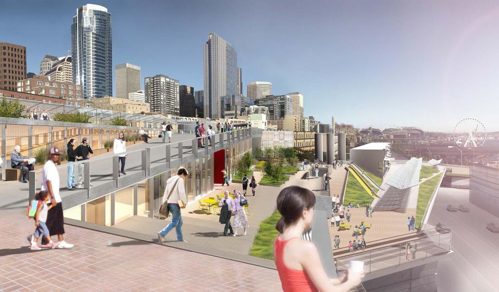
21 5.0 PC-1 N DEVELOPMENT CONCEPT With the City and State s plans to demolish the northern portion of the Alaskan Way Viaduct in 2016, a major impediment to redevelopment of the PC1-N site will be lifted, and the city s urban core can be rejoined after 50 years to the future re-designed waterfront through a dramatically enhanced pedestrian connection through PC1-N, the Overlook Walk, conceived of by the central waterfront city design team James Corner Field Operations. After more than 30 years of studies and indecision, plans for the PC1-N the last infill redevelopment project in the Pike Place Urban Renewal Project area can finally move forward with intention and greater certainty. 5.1 Project Goals The Market s overarching goal for the PC1-N project is to not only meet Market needs, but to work collaboratively with the city s design team to reach an integrated whole with the design of PC1-N, Victor Steinbrueck Park, and the new pedestrian connections extending to the revitalized waterfront. The pedestrian experience should be welcoming, comfortable, accessible, and provide seamless series of active, playful and unique spaces, terraces, and programs throughout the seasons. 5.2 Community Involvement and Design Collaboration The success of the project can only be assured through intense and continuous Market stakeholder involvement in the design process. The PDA, through its Waterfront Design Committee (WRC) and design consultant The Miller Hull Partnership, has met continuously and held working sessions over the past two years with the Market Historical Commission, Market Foundation, Market Constituency, Market and waterfront stakeholders, city staff, and the City s Waterfront Design Oversight Committee to seek comment and design direction in the development of this Concept Plan. 5.3 Design Concept The design rationale and use program for the PC1-N Final Concept Design were the result of extensive community and stakeholder involvement, and the close evaluation and analyses of the physical, zoning code and regulatory constraints, Market Commission Guidelines, primary public views, pedestrian circulation patterns, massing studies, parking feasibility, and economic feasibility. The resulting Concept Design has been heavily influenced by all of these factors, the designers Miller Hull cite as particularly relevant the Guideline goals of maintaining and enhancing pedestrian qualities, respecting and enhancing visual connections between Victor Steinbrueck Park, Elliott Bay, respecting surrounding historic buildings through creating a unique utilitarian architecture that differentiates new buildings from historic, while maintaining compatibility in massing, scale, size, granularity, structure, and materials. The design team also was inspired by the character of simple utilitarian building facades along Western Avenue, and the use of concrete post and beam structures commonly referred to as the Western Frame, and heavy timber structures commonly found throughout the Market. Opposite page: Concept rendering: View back toward the Market from the Overlook Walk PIKE PLACE PC-1 NORTH PROJECT - PROGRESS REPORT Steinbrueck Urban Strategies 24


22 5.4 Market Views Because of the Market s prominent location stretched out along the high bluff overlooking Elliott Bay, public views from and through the Market are among the most spectacular in downtown Seattle, are much a part of the ambience, and have always been important to the Market experience. Prominent public and semi-public views include city views of the Market, and from the Market sweeping panoramic views to the west of the Elliott Bay, Alki Point, and Olympic Mountain Range, the historic wharfs along the central shoreline, and to the south the grandeur of snowcapped Mt. Rainier, and the colorful towering cranes of Seattle s port facilities and Harbor Island. Past PC1-N development proposals that did not respect these highly valued public views were met with fierce opposition. Before proceeding too far into building design, the architects set out to identify, analyze, and qualify public views from various vantage points within and surrounding PC1-N Site. They established a hierarchy of primary interior and exterior views from within the Market District. Four viewpoints were determined to be primary iconic views of the Market from the city: Pike Street, Pine Street, and Victor Steinbrueck Park. Next, they identified as the primary interior views from within the North Arcade across the site, semi-public restaurant views in the Main Arcade, and views from the Desimone Bridge. Aided by sophisticated computer visualizations taken from various viewpoints, the designers then chiseled away at the allowable building envelope and massing until a sweet spot with the primary view sheds was determined. View from Pike St. View from Pine St. View from Stewart Street View from Victor Steinbreuck Park View from Pike Place 25 Steinbrueck Urban Strategies PIKE PLACE PC-1 NORTH PROJECT - PROGRESS REPORT

23 Pedestrian Circulation The Market is a veritable labyrinth of inter-connecting passage ways, heavily trafficked arcades, tucked away halls, stair climbs, alleyways and streets that invite the visitor to explore and discover unique corners of the neighborhood. Not unlike a Turkish bazaar, way finding can be challenging to those unfamiliar with the Market s complex aggregation of buildings, passages, and public places. Specific design goals were established through the architects circulation analysis for strengthening pedestrian flow through, and within, the PC1-N site and connections between PC1-N and the Main Market Arcade, Market Down Under levels, Victor Steinbrueck Park, Western Avenue, the Overlook Walk and the central waterfront. The pattern that emerges is a series of broad interconnected walks through retail areas, public spaces, Victor Steinbrueck Park, and roof top view terraces that support traditional market activities, store front activation of Western Avenue, greatly enhanced public view enjoyment, leisure activity, children s play, and waterfront access. 1. Connect to the Overlook Walk along the west edge of the site 2. Connect to Victor Steinbrueck Park 3. Connect to Western along south edge of site 4. Stair connection up to the Desimone Bridge 5. Activation of Western Avenue with commercial 6. Connect the Desimone bridge to Victor Steinbrueck Park which creates a larger circulation loop back across Western to the north end of Pike Place 7. Establish a new, second and lower level on the truss bridge to provide improved access to the DownUnder in the Market 8. Explored a new stair and pedestrian crossing at the north end of Market arcade PIKE PLACE PC-1 NORTH PROJECT - PROGRESS REPORT Steinbrueck Urban Strategies 26
24 Guiding Principles 1 To guide design and future development of PC1N site and participate constructively as a stakeholder in the city's Waterfront Concept Designs, the PDA Council has adopted a set of Guiding Principles for PC1N and adjacent areas west extending to Alaskan Way and the Waterfront Guiding Principles Pedestrian Access and Neighborhood Connectivity Vehicle Access PC1N Priority Uses Character and Identity Views 24/7 365 Activation Financial Viability Preservation and Sustainability 12

25 PC1-N Priority Uses 1. Parking loss of 130 spaces from surface lots and need to preserve as many of the existing 81 spaces as possible. 2. Storage Cold storage and dry storage is chronically in short supply. Key component in retention and recruitment of farmers, crafters, restaurants and businesses. 3. Commercial/Residential Activation Financial support for development and maintenance of PC1N could include commercial and/or residential activation along the edges. activating space along Western, new space facing the Waterfront and integrating with the Desimone bridge consistent with historic plans and concepts. 4. Social Services Many social services in the Market have adequate space to support their mission including the Senior Center, Pre-School and Childcare and Medical Clinic. The Foodbank, while operating successfully, faces ongoing challenges with access and space. Could improve access to the Foodbank and consider possible relocation and expansion. 5. Programs Provide opportunities to expand and support components of core programs including farming, education and busking will greatly aid in the successful activation of new public space created between the Market and the Waterfront. 1 PC1-N General Building Program December 15 th, 2011 RESOLUTION : PC1-North Preliminary Building Program Support and enhance the Market s core mission, functions and character, consistent with historical uses for PC1N and adjacent areas as part of Central Waterfront redevelopment Improve Market pedestrian connections to and from the Central Waterfront through the PC1N site Develop the PC1N site to its maximum potential for serving core Market mission and functions Remain consistent with Market Historic Commission Guidelines Include the following general uses: Retail Residential Replacement parking Storage Social Services Public Space Circulation and Pedestrian Passage BUILDING PROGRAM The PDA Council s adopted goal for the PC1-N site and adjacent developable areas is to serve and support the Market s core mission; functions, and character, consistent with the historical uses for PC1-N, and to seek to develop the site to its maximum potential. 12 After extensive study of both regulatory and physical/environmental site constraints, the Miller Hull Concept Design, approved by the PDA Council in September, 2012, was developed through a year-long integrated process of considering Historical Commission Guidelines, the Market s historical and priority needs for parking replacement, social services, housing, and complementary retail, construction and ongoing cost-estimating and financial feasibility, and the City s emerging design goals for creating major new connections to the central waterfront once the Alaskan Way Viaduct is demolished. The result, after years of studies, is a sensitively crafted building program and Concept Design to move the long stalled major public project forward, that balances public view protection, market connections, and waterfront access with 24/7 activation of site. Greater detail for interior program elements, specifically for the housing and retail components, will be further refined during the Schematic Design phase. 6.1 Public Spaces, Access and Connections The Pike Place Market is arguably the most democratic of people places in Seattle, where everyone is welcome. The Market bustles with millions of visitors and shoppers throughout the year and at times, is bursting at the seams with throngs of people shoulderto-shoulder. Open to all, seven days a week, the Market offers a variety of unique public spaces, such as seating and viewing areas, streets and arcades. At a time when public spaces in cities around the country are increasingly turning to sterilized, privately owned and controlled use, the Market thankfully remains the striking exception. The Miller Hull architecture team s approach to the design of public open space, pedestrian access and connections began with recognition that the project s success would depend on careful attention to the site s sloping grades and challenges it presents ensuring ADA accessibility. Integrated into the design is a system that manages the grade changes with the overall design solution. A series of low sloped ramps, landscaped terraces, and stairs connect people moving from and between the Market Arcade, Down Under, Victor Steinbrueck Park, and Western Avenue through the PC1-N site and onto the Overlook Walk leading to the waterfront and Seattle Aquarium on Alaskan Way below. For those needing more mobility assistance, all public areas are accessible by elevator. Public enjoyment of spectacular panoramic views to west and south will be greatly enhanced through provision of over three-quarters of an acre (30,000 SF) of new public space. Included in the open space design are opportunities for open air, seasonal market activities, vending, performance, public art, playscapes, and urban agriculture PDA Council Resolution , PC1-North Preliminary Building Program August 2011 PIKE PLACE PC-1 NORTH PROJECT - PROGRESS REPORT Steinbrueck Urban Strategies 28

26 6.2 Retail Retail uses on the site will be governed by the Market Historical Commission Guidelines, which prioritize small, owner-operated businesses and specialty shops. Food-related and locally produced goods that complement the existing Market will be a high priority. Approximately 20,000 square feet of indoor retail and restaurant will be provided, and outdoor deck areas will have operable weather protection to activate public spaces throughout the year for leisure, outdoor dining, and shopping. 6.3 Housing and Social Services The Market neighborhood is home to some of the most diverse residents in the city. There are many elderly and disabled people living in the Market district and surrounding area, including the 60 unit Heritage House Congregate Care facility immediately south of PC1-N. Many low income families, elderly and disabled people living and working downtown rely on the Market s social service agencies, including Market Senior Center, Medical Clinic, Pre-school, and Food Bank. The diverse community of low and higher income residents and working people of all walks contribute much to the color, life and vitality of the Market neighborhood. Small shops and an array of services in the Market create a synergy for social life and community. Over the past four decades since the Market Initiative was passed, thousands of low income residential units downtown have been lost to gentrification and displacement. The Pike Place Market Preservation Ordinance supports the retention of the low income elderly community in the Market. The PC1-N site provides the last opportunity to expand housing in the Market, particularly for low income people. 29 Steinbrueck Urban Strategies PIKE PLACE PC-1 NORTH PROJECT - PROGRESS REPORT
27 On the south end of the PC1-N site, a four story mixed-use building will include up to 40 studio and one bedroom units. A co-benefit, the residential use on-site will support 24/7 activation of the area, including eyes-on-the street, and the Overlook Walk below. 6.4 Market Replacement Parking Since the 1974 Pike Place Urban Renewal Plan was adopted, The PC1-N site was intended to support needs of Market shoppers and merchants for short term parking. The Highway 99 Tunnel and Alaskan Way Viaduct Replacement Project will result in the permanent loss of over 900 short term parking spaces currently serving Pike Place Market shoppers, merchants, and visitors to central waterfront. In September 2012, the PDA submitted a proposal to Washington State Department of Transportation (WSDOT) in response to a Request for Information (RFI) for AWV Parking and Mixed-Use Development for partial funding of replacement parking on the PC1-N site for up to 316 stalls. The Market PDA was selected to receive $5 million in state mitigation funding for this purpose. The PC1-N project will deliver 300+ parking stalls prior to demolition of the Viaduct. The garage structure will cover the entire site, straddle the 1904 Burlington Northern Railroad tunnel below, and provide a platform above for a mix of market-related uses including housing, as well as multiple public access points to waterfront connections and open spaces. The PDA was the only respondent to the RFI and is nearing completion of negotiations with WSDOT for $5 million in mitigation funding which includes $1 million to support furthering design and $4 million for construction. PIKE PLACE PC-1 NORTH PROJECT - PROGRESS REPORT Steinbrueck Urban Strategies 30

28


29 7.0 CENTRAL WATERFRONT CONCEPT PLAN Circulation Scheme Shared Scheme In 2003, following serious damage to the Alaskan Way Viaduct from the Nisqually earthquake in 2001, and need to replace the aging and deteriorated Elliott Bay Seawall, the City once again began a public process to develop a new community vision for the central waterfront that called for reconnecting Seattle s downtown neighborhoods to the shores of Elliott Bay. A critical component to central waterfront re-visioning, the PC1-N project must be seen in the larger context of the City s decades-long goals to revitalize the central waterfront and improve public access a complete re-visioning finally to be made possible by the removal of the Alaskan Way Viaduct. In 2011, New York based designers James Corner Field Operations was hired by the City to produce a Framework Plan, Concept Design, and Art Plan for the nearly two mile stretch of Elliott Bay shoreline from south downtown and the Stadium District, to Olympic Sculpture Park and Myrtle Edwards Park, which landscape architect James Corner describes as a unique and quintessential part of the city at the intersection of development, industry, and spectacular views of big nature. 13 Active Play Scheme Garden Scheme Opposite page: JCFO concept design image 13 James Corner Field Operations, Waterfront Seattle Design Summary: Concept Design and Framework Plan for Seattle s Central Waterfront, July 2012, p. 6. City of Seattle. PIKE PLACE PC-1 NORTH PROJECT - PROGRESS REPORT Steinbrueck Urban Strategies 32

30 7.1 Central Waterfront Guiding Principles To capture civic aspirations for the creation of new public spaces on the central waterfront, a set of seven Guiding Principles formed the underpinnings of the Concept Design. The principles (below), adopted by City Council Resolution #31264 in January 2011, were developed through extensive stakeholder involvement public process: Create a waterfront for all Put the shoreline and innovative, sustainable design at the forefront Reconnect the city to its waterfront Embrace, celebrate Seattle s past, present and future Improve access and mobility Create a bold vision that is adaptable over time Develop consistent leadership from concept to construction to operations Above: Archival photos of early tunnel construction 33 Steinbrueck Urban Strategies PIKE PLACE PC-1 NORTH PROJECT - PROGRESS REPORT

31 7.2 Overlook Walk Among several waterfront places conceived of by the city s design team, James Corner Field Operations, is the Overlook Walk, which seeks to connect people with the waterfront, Seattle Aquarium, and Pike Place Market over an elevated system of landscaped ramps, public stairs and building structures extending between Victor Steinbrueck Park and the PC1-N site, and the Aquarium(mentioned twice?) and new Alaskan Way Boulevard. Corner envisions the Overlook Walk to be as much of a place as a pedestrian connector, which will provide space and program for a host of activities including a series of playscapes, public viewpoints and leisure, a train overlook, urban gardens, and a mix of building programs tucked into the Overlook s under-spaces and openings that may include an aquarium annex, market related light manufacturing site, and artists live/work spaces. Archival image: Princess Angeline and her little shack PIKE PLACE PC-1 NORTH PROJECT - PROGRESS REPORT Steinbrueck Urban Strategies 34
32
33 8.0 MEMORANDUM OF UNDERSTANDING CITY OF SEATTLE The Community Renewal Act (RCW 35.81) authorizes the City to transfer property such as PC1-N designated for community renewal to public development authorities without consideration, for the purposes of advancing public purposes and public benefits, and to implement a public redevelopment plan. In February 2013, the Seattle City Council passed a key piece of legislation (by ordinance #117699) approving a Memorandum of Understanding Concerning the Redevelopment of the PC1-N Site. The ordinance granted authorization to the PDA for the redevelopment of the property for market-related uses, approved the project preliminary design, and provides for the eventual transfer of ownership of the PC1-N site to the PDA. The City s passage of the MOU and related legislation represent a significant milestone in the 30+ year history of studies and plans for the PC-1 site, allowing the Market to finally move forward with redevelopment of the last parcels acquired by the City under the Pike Place Market Urban Renewal Plan. Opposite page: Rendering view from Victor Steinbrueck Park PIKE PLACE PC-1 NORTH PROJECT - PROGRESS REPORT Steinbrueck Urban Strategies 36
34 Pike Place M Pike Place Market PC1-N Timeline FINANCIAL ANALYSIS Approval of Consulting Contract so that Pro Forma Baseline can be started based on Conceptual Design MOU APPROVAL PDA COUNCIL PDA Council Approved MOU with City of Seattle January 2013 DESIGN DEVELOPMENT Miller Hull DD for retail, restaurant, housing and public space SCHEMATIC DESIGN STARTS Next phase of Miller Hull work to include refinement of Concept Design and Schematic Design DEVELOPMENT AGREEMENT DESIGN DEVELOPMENT GC/CM SELECTION Begin process for selection GC/CM February 2013 MOU APPROVAL CITY COUNCIL April 2013 City Council Approves MOU, access to City matching funds up to $1M in 2013 Miller Hull DD for Substructure and Parking May 2013 June 2013 COMMITTED DOLLARS September 2013 MUP/ENVIRONMENTAL REVIEW Approval from City October October DEVELOPMENT AGREEMENT WSDOT CONTRACT Execution of WSDOT parking mitigation contract and access to portion of $5M in funding Start date no later then Ju $1M (PDA) $1M (City of Seattle) $730K (State Parking Mitigation) Full Council Approves Development Agreement July 2013 PC1-N CONSTRUCTION December 2013 Approval of Development Agreement by City Council June 201
35 Market PC1-N Timeline 9.0 NEXT STEPS PC1-N CONSTRUCTION ENDS STARTS End date no later than 2016 une, VIADUCT COMES DOWN, 2016 Central Waterfront Construction Underway 9.1 Design Development The PDA Council approved the resolution (13-14) authorizing schematic design services with Miller Hull. The schematic design process will involve further refinement of key program components including; parking, housing, retail space and the public realm. The work will develop much greater detail for all engineering and MEP elements, starting first with the garage. As the schematic design work nears completion in June and July of 2013, the PDA will undertake another formal review of cost estimates and financial analysis. In August/September of 2013, the PDA Council will consider a resolution authorizing additional funds for the Design Development phase which will take the project design through to construction drawings in early The PDA will continue direct community involvement in the project design process through public meetings, and regular notices of PDA committee and council meetings dealing with these issues. In addition, per the MOU with the City of Seattle, the PDA is required to make a presentation to the Full City Council in August of 2013 or when 30% of design is reached, whichever comes first. Finally, Miller Hull will continue the collaborative work with the James Corner Field Operations waterfront design team, in addition to several presentations to the Market Historic Commission. 9.3 Funding & Implementation Following the approval of the PC1-N Concept Design, the PDA reviewed a detailed financial pro-forma based on the concept including sensitivity testing. The analysis was conducted by the Seneca Group and presented at several committee and PDA council meetings in February and March The draft analysis is included in the Appendix of this report.. In brief summary, the analysis identified a number of current and potential funding sources, and outlined anticipated dates the funds would be available for use. The financial model also outlined project costs by key program component, overall project cash flow, and potential revenue. Through the sensitivity testing, the analysis demonstrated the limited debt capacity for the project without creating an undue burden for the Market. This limited capacity underscores the importance of substantial funding from the Waterfront LID as well as maximizing the number of parking spaces which provide critical base revenue to support ongoing operating costs. 9.2 Timeline, Approvals, Funding The following timeline outlines key decision points, anticipated dates for PDA Council and City Council actions, as well as design and construction milestones. Opposite page: Pike Place Market PC1-N Timeline PIKE PLACE PC-1 NORTH PROJECT - PROGRESS REPORT Steinbrueck Urban Strategies 38
36
City of Farmington. Downtown Plan. Amendment to the 1998 Master Plan Adopted October 11, 2004
 City of Farmington Amendment to the 1998 Master Plan Adopted October 11, 2004 Introduction Planning Background 1 Scope and Components of the Plan Amendment 2 Concept Introduction 3 Plan Concepts 3 Conceptual
ELK GROVE GENERAL PLAN VISION
 2-1 CHAPTER 2: 2-2 CREATING OUR The Community Vision for Elk Grove, expressed through a Vision Statement and a series of Supporting Principles, is a declaration of the kind of community that Elk Grove
Policies and Code Intent Sections Related to Town Center
 Policies and Code Intent Sections Related to Town Center The Town Center Vision is scattered throughout the Comprehensive Plan, development code and the 1994 Town Center Plan. What follows are sections
SECTION ONE: INTRODUCTION. introduction
 introduction 1 INTRODUCTION Since it was first established in 1843 as a trading post for the Hudson s Bay Company, Victoria has evolved into a Provincial capital city that is recognized across Canada and
CHAPTER 12 IMPLEMENTATION
 CHAPTER 12 IMPLEMENTATION The 2010 Town of Denton Comprehensive Plan is intended to capture a vision of the future of Denton. As such, it provides a basis for a wide variety of public and private actions
SUBJECT: PREDEVELOPMENT PLAN REVIEW OF PROJECT LOCATED AT 2632 EAST WASHINGTON BOULEVARD ('ST. LUKE MEDICAL CENTER')
") TO: FROM: Honorable Mayor and City Council Planning & Community Development Department SUBJECT: PREDEVELOPMENT PLAN REVIEW OF PROJECT LOCATED AT 2632 EAST WASHINGTON BOULEVARD ('ST. LUKE MEDICAL CENTER')
TO: FROM: Honorable Mayor and City Council Planning & Community Development Department SUBJECT: PREDEVELOPMENT PLAN REVIEW OF PROJECT LOCATED AT 2632 EAST WASHINGTON BOULEVARD ('ST. LUKE MEDICAL CENTER')
The Five Components of the McLoughlin Area Plan
 The Five Components of the McLoughlin Area Plan This documents contains the complete language of the five components of the McLoughlin Area Plan: The Vision Statement The Values The Guiding Principles
PLANNING ADVISORY BOARD AGENDA OCTOBER
 ! City of Langley PLANNING ADVISORY BOARD AGENDA OCTOBER 1, 2014 3-5pm LANGLEY CITY HALL - 112 2 nd Street, Langley WA 1) Call to Order and Roll Call 2) Approval of the Minutes September 10, 2014 3) Public
4- PA - LD - LIVELY DOWNTOWN. LD - Background
 4- PA - LD - LIVELY DOWNTOWN LD - Background The downtown has been the service centre for the community since the city s inception and the area continues to supply people with their personal services,
Workshop 3. City of Burlington Waterfront Hotel Planning Study. September 14, The Planning Partnership
 Workshop 3 City of Burlington Waterfront Hotel Planning Study September 14, 2017 The Planning Partnership The Waterfront Hotel Planning Study 01 The Brant & Lakeshore Planning Study will establish a Strategic
A. INTRODUCTION B. PROJECT LOCATION
 Chapter 1: Project Description A. INTRODUCTION The Lower Manhattan Development Corporation (LMDC), a subsidiary of the New York State Urban Development Corporation, doing business as the Empire State Development
SUBJECT: Waterfront Hotel Planning Study Update TO: Planning and Development Committee FROM: Department of City Building. Recommendation: Purpose:
 Page 1 of Report PB-23-18 SUBJECT: Waterfront Hotel Planning Study Update TO: Planning and Development Committee FROM: Department of City Building Report Number: PB-23-18 Wards Affected: 2 File Numbers:
The transportation system in a community is an
 7 TRANSPORTATION The transportation system in a community is an important factor contributing to the quality of life of the residents. Without a sound transportation system to bring both goods and patrons
Land Use Amendment in Southwood (Ward 11) at and Elbow Drive SW, LOC
 at and Elbow Drive SW, LOC") 2018 November 15 Page 1 of 10 EXECUTIVE SUMMARY This land use amendment application was submitted by Rick Balbi Architect on 2017 August 31 on behalf of Sable Developments Ltd, and with authorization from
2018 November 15 Page 1 of 10 EXECUTIVE SUMMARY This land use amendment application was submitted by Rick Balbi Architect on 2017 August 31 on behalf of Sable Developments Ltd, and with authorization from
ARLINGTON COUNTY, VIRGINIA
 ARLINGTON COUNTY, VIRGINIA County Board Agenda Item Meeting of April 12, 2014 DATE: April 2, 2014 SUBJECT: to the Arlington County Zoning Ordinance, Article 11.1 "CP-FBC" Columbia Pike Form Based Code
Page 1 of 19 URBAN DESIGN FRAMEWORK FOR BOLTON STREET WATERFORD
 Page 1 of 19 URBAN DESIGN FRAMEWORK FOR BOLTON STREET WATERFORD 1.0 Introduction: The relocation of the City Council stores and depot from Bolton Street creates an exciting opportunity for development
1.0 Purpose of a Secondary Plan for the Masonville Transit Village
 Report to Planning and Environment Committee To: Chair and Members Planning & Environment Committee From: John M. Fleming Managing Director, Planning and City Planner Subject: Masonville Transit Village
RESOLUTION NO. R Refining the route, profile and stations for the Downtown Redmond Link Extension
 RESOLUTION NO. R2018-32 Refining the route, profile and stations for the Downtown Redmond Link Extension MEETING: DATE: TYPE OF ACTION: STAFF CONTACT: Capital Committee Board PROPOSED ACTION 09/13/2018
Pike Place Market Preservation and Development Authority (PDA) WATERFRONT REDEVELOPMENT COMMITTEE (WRC) Meeting Minutes
 WATERFRONT REDEVELOPMENT COMMITTEE (WRC) Meeting Minutes") Pike Place Market Preservation and Development Authority (PDA) WATERFRONT REDEVELOPMENT COMMITTEE (WRC) Meeting Minutes Tuesday June 5 th, 5:00 p.m. to 6:00 p.m. Atrium Conference Room Committee Members
Pike Place Market Preservation and Development Authority (PDA) WATERFRONT REDEVELOPMENT COMMITTEE (WRC) Meeting Minutes Tuesday June 5 th, 5:00 p.m. to 6:00 p.m. Atrium Conference Room Committee Members
Welcome to the Oakridge Centre Open House
 Welcome to the Oakridge Centre Open House Why is the City hosting this event? This open house is to inform you of a rezoning application submitted to the City of Vancouver to amend the existing CD-1 (Comprehensive
Robbinsdale LRT Station. CDI Development Guidelines. August Overview
 Robbinsdale LRT Station August 2018 Overview The City of Robbinsdale may have the coolest opportunity site along the 13 mile stretch of the Bottineau LRT corridor / Blue Line extension. Located a block
CITY OF PUYALLUP. Background. Development Services
 CITY OF PUYALLUP Development Services 333 South Meridian Puyallup WA 98371 To: City Council From: Katie Baker, AICP, Planning Division Re: South Hill Neighborhood Plan Adoption Date: (Meeting date: February
CITY OF CHARLOTTESVILLE, VIRGINIA CITY COUNCIL AGENDA
 CITY OF CHARLOTTESVILLE, VIRGINIA CITY COUNCIL AGENDA Agenda Date: December 16, 2013 Action Required: Adoption of Resolution Presenter: Staff Contacts: Title: James E. Tolbert, AICP, Director of NDS James
PART 1. Background to the Study. Avenue Study. The Danforth
 The Danforth 1.1/ Study Purpose & Key Municipal Goals 1.2/ The Local Advisory Committee 1.3/ The Project Team 1.4/ Study Process/Summary of Method 1.5/ Summary of Consultation 1.1 Study Purpose and Key
This Review Is Divided Into Two Phases:
 Semiahmoo Town Centre Review The purpose of this review: To review the Semiahmoo Town Centre Concept Plan, originally approved in 1993, to ensure that this centre will continue to serve the needs of South
SAN RAFAEL GENERAL PLAN 2040 INTRODUCTION AND OVERVIEW
 SAN RAFAEL GENERAL PLAN 2040 INTRODUCTION AND OVERVIEW Steering Committee Presentation February 14, 2018 Purpose of General Plan Guide land use and development decisions Coordinate transportation, infrastructure,
TREASURE ISLAND PHASE ONE PROJECTS PUBLIC ART PROJECT OUTLINE
 TREASURE ISLAND PHASE ONE PROJECTS PUBLIC ART PROJECT OUTLINE BACKGROUND (DEVELOPMENT PROJECT OVERVIEW) The Treasure Island Development is an approved 405-acre redevelopment project on Treasure Island
SDOT DPD. SDOT Director s Rule DPD Director s Rule DCLU DR SED DR of 7 CITY OF SEATTLE
 SDOT SDOT Director s Rule 2-07 DPD Applicant: CITY OF SEATTLE Page 1 of 7 Supersedes: DCLU DR 11-93 SED DR 93-4 Seattle Department of Transportation (SDOT) Department of Planning and Development (DPD)
6. DOWNTOWN. The Downtown Element focuses on supporting and expanding the vitality and enhancement of Downtown Chico as the City s central core.
 VISION In 2030, Downtown Chico is the heart of the community and the center of cultural activity. Engaging and active at the street level, it is a multi-story, mixed-use hub, with specialty retail, restaurants,
Report to: Development Services Committee Report Date: April 24, 2017
 SUBJECT: Cornell Rouge National Urban Park Gateway - Report on Design Charrette and Next Steps PREPARED BY: Lilli Duoba, MES, MCIP, RPP, Manager, Natural Heritage (ext. 7925) REVIEWED BY: Marg Wouters,
burlington mobility hubs study Downtown Burlington Mobility Hub
 burlington mobility hubs study Downtown Burlington Mobility Hub Draft Precinct Plan Workbook PIC #3, September 7, 2017 downtown mobility hub objectives City staff and their consultants are proposing an
Steering Committee Meeting
 Neighborhood Planning Initiative NPI EAST CENTRAL AREA PLAN Steering Committee Meeting November 9, 2017 6:00PM 8:00PM Tears McFarlane House East Central Area Plan Steering Committee Meeting 11/9/17 AGENDA
THAT the attached Terms of Reference for the Thornhill Centre Street Study be approved.
 COMMITTEE OF THE WHOLE AUGUST 18, 2003 THORNHILL CENTRE STREET STUDY PLANNING FILE: 15.92 Recommendation The Commissioner of Planning recommends: THAT the attached Terms of Reference for the Thornhill
MALL REVITALIZATION CASE STUDIES
 MALL REVITALIZATION CASE STUDIES DECEMBER 9, 2012 MALL REVITALIZATION OVERVIEW Introduction Sample Case Studies prepared for Lacey Woodland District Steering Committee as it considers strategies to revitalize
Planning Districts INTRODUCTION
 INTRODUCTION To facilitate detailed examination of development prospects for all areas of the community, Delano has been divided into 14 planning districts. The location of these planning districts is
City Center Specific Plan Amendments And Background Report City of Richmond. PLANNING COMMISION FINAL DRAFT January, 2001
 City Center Specific Plan Amendments And Background Report City of Richmond PLANNING COMMISION FINAL DRAFT January, 2001 TABLE OF CONTENTS Page LIST OF TABLES... LIST OF FIGURES... INDEX... OVERVIEW...
EXHIBIT A. Tax Increment Reinvestment Zone No. 1 (Town Center) First Amended Project Plan 1
 First Amended Project Plan 1") EXHIBIT A Tax Increment Reinvestment Zone No. 1 (Town Center) First Amended Project Plan 1 1 As amended by Resolution No. 2008-02-001(TR1R) of the Tax Increment Reinvestment Zone No.1, and approved to
EXHIBIT A Tax Increment Reinvestment Zone No. 1 (Town Center) First Amended Project Plan 1 1 As amended by Resolution No. 2008-02-001(TR1R) of the Tax Increment Reinvestment Zone No.1, and approved to
8implementation. strategies
 PROGRAM STRATEGIES 8implementation strategies T he implementation actions of this chapter are designed to support and carry out the land use, economic development, transportation, urban design, and program
Concord Community Reuse Project Goals and Guiding Principles. Overarching Goals (OG)
") Concord Community Reuse Project Goals and Guiding Principles Overarching Goals (OG) No priority is implied by the order of presentation of the goals and guiding principles. Overarching goals for the Concord
Concord Community Reuse Project Goals and Guiding Principles Overarching Goals (OG) No priority is implied by the order of presentation of the goals and guiding principles. Overarching goals for the Concord
Academics Efficient use of space will be used to enhance investments in new pedagogies such as active learning classrooms.
 Goals and Assumptions Physical Planning Goals and Objectives The guiding principles of this Master Plan were developed in consultation with various constituencies that make up the NMSU community and were
REGIONAL ACTIVITY CENTER
 DRAFT REGIONAL ACTIVITY CENTER 70 EAST BENCH MASTER PLAN DRAFT 06 Introduction The East Bench Regional Activity center is comprised of large educational, research, medical, and employment centers. These
City Center Neighborhood Plan
 [1] City Center Neighborhood Plan As adopted by Ordinance No. 2014-09-049 and amended by Ordinance Nos. Formerly CBD Neighborhood as adopted by Ordinance No. 8868 and amended by Ordinance Nos. 8946, 9693,
3.0 LAND USE PLAN. 3.1 Regional Location. 3.2 Existing Conditions Existing Uses. Exhibit Regional Location Map
 3.0 LAND USE PLAN 3.1 Regional Location The Anaheim Resort Specific Plan (ARSP) area is located in the City of Anaheim, which is 35 miles southeast of downtown Los Angeles and 7 miles northwest of Santa
EXECUTIVE SUMMARY DRAFT CHAPTER 1 INTRODUCTION EXECUTIVE SUMMARY
 CHAPTER 1 EXECUTIVE SUMMARY INTRODUCTION Through the joint efforts of the City of Tulsa planning staff and the Land Services division of Indian Nations Council of Governments (INCOG), the Berryhill Land
The University District envisions, in its neighborhood
 Envisioning the University District Link Light Rail in Seattle s neighborhoods CIY OF SEALE CONCEP-LEVEL SAION AREA PLANNING RECOMMENDAION RESOLUION # 30165 EXHIBI L Vision 08.2000 he University District
TEMPLE MEDICAL & EDUCATION DISTRICT
 City of Temple, Texas TEMPLE MEDICAL & EDUCATION DISTRICT 1 Description. The City of Temple joined in partnership with key public and private entities to jointly promote education and medical activities
The John Bartram Association Action Plan to advance the 10 year Strategic Plan
 The John Bartram Association 2013-2015 Action Plan to advance the 10 year Strategic Plan We are poised to take significant leaps with the opportunities that surround us. In the next three years we are
EXISTING COMPREHENSIVE PLAN
 EXISTING COMPREHENSIVE PLAN Town Center Land Use Element: V. LAND USE POLICIES Town Center Mercer Island's business district vision as described in "Your Mercer Island Citizen-Designed Downtown" was an
Ivywild On The Creek PRELIMINARY CREEK DISTRICT MASTER PLAN
 Ivywild On The Creek PRELIMINARY CREEK DISTRICT MASTER PLAN Introduction: Rejuvenating an extraordinary Creekside neighborhood THE CREEKSIDE DISTRICT The Ivywild On The Creek Neighborhood District Master
This page intentionally blank.
 This page intentionally blank. Parks, Recreation, and Open Space Chapter Relationship to Vision Vision Parks, Recreation and Open Space Chapter Concepts County Government. County government that is accountable
Section 4 BUILDING THE MASTER PLAN
 The Master Plan 33 Section 4 BUILDING THE MASTER PLAN Figure 4:1. A collaborative effort characterized the two design workshops sponsored by DISC to create hypothetical Master Plans for the Towers Property
C. Westerly Creek Village & The Montview Corridor
 C. Westerly Creek Village & The VISION Community Vision When the goals of the city are achieved Westerly Creek Village, a distinctive community defined by Montview Boulevard and Westerly Creek, is a strong
Town Center (part of the Comprehensive Plan)
") Town Center (part of the Comprehensive Plan) Mercer Island Town Center Looking North (2014) In 1994, a year-long process culminated in a set of design guidelines and code requirements for the Town Center
Town Center (part of the Comprehensive Plan) Mercer Island Town Center Looking North (2014) In 1994, a year-long process culminated in a set of design guidelines and code requirements for the Town Center
3. VISION AND GOALS. Vision Statement. Goals, Objectives and Policies
 Vision Statement Queen Creek s interconnected network of parks, trails, open spaces and recreation opportunities provide safe and diverse activities and programs that sustain its unique, small town, equestrian
CHAPTER 1. Ms. Guajardo s Class - Central Elementary CH 1 1
 INTRODUCTION CHAPTER 1 Ms. Guajardo s Class - Central Elementary CH 1 1 1.1 SETTING South Centre City is a linear corridor south of Downtown Escondido paralleling Centre City Parkway and South Escondido
PLAN ELEMENTS WORKSHOP. April 5, 2016
 PLAN ELEMENTS WORKSHOP April 5, 2016 needs more housing. But there is no one-size fits-all solution. Every neighborhood has its own character. In some places, density is not only appropriate it is badly
ROBBINSDALE LRT STATION CDI DEVELOPMENT GUIDELINES
 August 2018 OVERVIEW The City of Robbinsdale has a prime-opportunity site in the middle of the 13 mile stretch of the Bottineau LRT corridor / Blue Line extension. Robbinsdale offers a prominent, vital,
India Basin/Hunters Point Shoreline Community Workshop May 21, 2008
 India Basin/Hunters Point Shoreline Community Workshop May 21, 2008 Workshop Agenda Welcome Process Overview Context & Existing Conditions Presentation of Draft Concepts Land Use and Open Space Priorities
III. PROJECT DESCRIPTION
 III. PROJECT DESCRIPTION LOCATION AND BOUNDARIES The City of Manhattan Beach is located in the South Bay region of Los Angeles County, California, approximately 2 miles south of the Los Angeles International
1.1 WATERFRONT SEATTLE
 1.1 WATERFRONT SEATTLE Over the past few years, the City of has been actively re-imagining the future of its Central Waterfront. The imminent replacement of the Elliott Bay Seawall and removal of the Alaskan
Section 1 Introduction
 Section 1 Section 1,, describes the role of the Official Plan. The Official Plan is one of five growth management plans that was completed under the umbrella of Ottawa 20/20. 1.1 The Role of the Official
GUIDING PRINCIPLES IN THIS CHAPTER
 GUIDING PRINCIPLES The guiding principles and design concepts in this chapter work together with the Chapel Hill 2020 Comprehensive Plan to support new public places that can be enjoyed by all while also
Beatties Ford Road & Mt. Holly-Huntersville Road Small Area Plan
 Beatties Ford Road & Mt. Holly-Huntersville Road Small Area Plan Town of Huntersville October 2005 Town of Huntersville Planning Department 101 Huntersville Concord Road Post Office Box 664 Huntersville,
Historic Preservation Element
 Casa Gardens by Carolyn Pelkey Historic Preservation Element Incorporated in 1928, the City of San Clemente was among the first master planned communities in the U.S. built from open grazing land. Before
Official Plan Review: Draft Built Form Policies
 PG.30.1 REPORT FOR ACTION Official Plan Review: Draft Built Form Policies Date: May 15, 2018 To: Planning and Growth Management Committee From: Chief Planner and Executive Director, City Planning Division
Midtown Greenway Land Use and Development Plan Executive Summary
 Midtown Greenway Land Use and Development Plan Executive Summary Introduction The Midtown Greenway Land Use and Development Plan sets policy direction for land use and development in the Midtown Greenway
3. STRATEGY FOR NEIGHBORHOOD SUSTAINABILITY
 3. STRATEGY FOR NEIGHBORHOOD SUSTAINABILITY This neighborhood plan focuses on assuring that Government Hill retains a high degree of sustainability, in that it conserves built resources that are part of
Staff Report and Recommendation
 Community Planning and Development Planning Services 201 W. Colfax Ave., Dept. 205 Denver, CO 80202 p: 720.865.2915 f: 720.865.3052 www.denvergov.org/cpd TO: City Council Neighborhoods and Planning Committee
Draft Cary Community Plan Review Part 3: Shop, Engage, Serve, Special Area Plans, Other Updates. October 27, 2015 Police Department Training Room
 Draft Cary Community Plan Review Part 3: Shop, Engage, Serve, Special Area Plans, Other Updates Committee for the Future October 27, 2015 Police Department Training Room AGENDA 1. Welcome and Call to Order
City of Hermosa Beach Administrative Policy #
 City of Hermosa Beach Administrative Policy # SUBJECT: Living Streets Policy Date: Approved by: City Council Authority: Public Works Department & Community Development Department Mayor, PURPOSE The City
Development Solicitation Request for Qualifications. The Historic Hollering Place Development
 City of Coos Bay Urban Renewal Agency Development Solicitation Request for Qualifications The Historic Hollering Place Development For More Information Contact: Eric Day Community Development Director
Status Update (2006 vs. Now) Citizen s Advisory Committee February Plan for Prosperity
 Citizen s Advisory Committee February Plan for Prosperity") Status Update (2006 vs. Now) Citizen s Advisory Committee February 2018 Plan for Prosperity 2000 2017 2000 2017 Gardnerville Population 6,000 5,760 5746 5,500 5,000 5,067 5,550 5,165 5,394 5,412 5,250
Status Update (2006 vs. Now) Citizen s Advisory Committee February 2018 Plan for Prosperity 2000 2017 2000 2017 Gardnerville Population 6,000 5,760 5746 5,500 5,000 5,067 5,550 5,165 5,394 5,412 5,250
Anatomy of A Vibrant Downtown. Anatomy of a Vibrant Downtown
 Anatomy of A Vibrant Downtown The goal of MAIN ST. REVITALIZATION PLANNING is to provide a framework that will help transform your downtown into a VIBRANT DOWNTOWN a place where people love to LIVE, WORK,
Welcome. Walk Around. Talk to Us. Write Down Your Comments
 Welcome This is an information meeting introducing the applications for proposed redevelopment of the Yorkdale Shopping Centre site at 3401 Dufferin Street and 1 Yorkdale Road over the next 20+ years,
2.7 ac park. TOTAL 5,403 DU 1,297,900 sf 1,105,450 sf 3.87 ac 5,563 DU 1,121,200 sf 1,105,450 sf 3.87 ac
 PLAN AMENDMENT 2013-I-B1: SEVEN CORNERS SPECIAL STUDY Summary of Pre-staffing Comments Planner: Bernard Suchicital bsuchi@fairfaxcounty.gov (703) 324-1254 Background On October 29, 2013, the Board of Supervisors
City of Long Beach. creating vibrant and exciting places
 City of Long Beach creating vibrant and exciting places Land Use Element Urban Design Element Overview of the two draft General Plan elements Discuss areas of change Economic goals of the plans Case study
John M. Fleming Managing Director, Planning and City Planner. Old East Village Dundas Street Corridor Secondary Plan Draft Terms of Reference
 Report to Planning and Environment Committee To: From: Subject: Chair and Members Planning & Environment Committee John M. Fleming Managing Director, Planning and City Planner Old East Village Dundas Street
Small Area Plan. South Gateway
 Small Area Plan Adopted May 12, 2008 South Gateway Purpose. The South Gateway Small Area Plan defines the City s expectations for the future of the southern entrance to the City at Interstate 85 and Highway
V. Vision and Guiding Principles
 V. Vision and Guiding Principles The Master Plan for the Powers Ferry Corridor seeks a foundation in the desires of the community. At times, various elements of the community offered opposing viewpoints,
Keyport. Vision for Keyport
 Keyport Vision for Keyport Keyport is a rural, historic waterfront village bounded and limited in size by its natural borders of water and the Naval Undersea Warfare Center. The community consists primarily
A. WHAT IS A GENERAL PLAN?
 I. Introduction A. WHAT IS A GENERAL PLAN? A general plan is the planning guideline for the future of a city. It contains goals and policies which regulate urban development, the protection of the natural
13 THORNHILL YONGE STREET STUDY IMPLEMENTATION CITY OF VAUGHAN OPA 669 AND TOWN OF MARKHAM OPA 154
 13 THORNHILL YONGE STREET STUDY IMPLEMENTATION CITY OF VAUGHAN OPA 669 AND TOWN OF MARKHAM OPA 154 The Planning and Economic Development Committee recommends the adoption of the recommendations contained
Planning Commission Report
 Planning Commission Report To: From: Subject: Planning Commission Meeting: January 6, 2016 Agenda Item: 8-B Planning Commission David Martin, Planning & Community Development Director Introduction to the
Developer s Program. The Station at East 54
 Developer s Program The Station at East 54 Existing Conditions The Station at East 54 is proposed for a 1.12 acre site at the northeast corner of Hamilton Road and Prestwick Road, tucked between the East
VICTORIA DOWNTOWN DEVELOPMENT PLANNING
 VICTORIA DOWNTOWN DEVELOPMENT PLANNING A Vision & Guide for the Future Downtown Victoria thrives as a center for the community, offering a great mix of entertainment, culture, business, and recreational
The Vision. Photo provided by The Minervini Group. 46 Vision, Objectives & Strategies
 Vision, Objectives & Strategies The is the public framework and guide for future development of the Grand Traverse Commons. The establishes public polices for infrastructure, the preservation of natural
MOUNTAIN VIEW ELEMENTARY SCHOOL SITE REDEVELOPMENT OPEN HOUSE. MacPherson Room, 10 am 5 pm
 MOUNTAIN VIEW ELEMENTARY SCHOOL SITE REDEVELOPMENT OPEN HOUSE MacPherson Room, 10 am 5 pm MOUNTAIN VIEW SCHOOL SITE REDEVELOPMENT 1 WELCOME TO THE OPEN HOUSE FOR THE MOUNTAIN VIEW SCHOOL SITE WHY WE ARE
S A C R A M E N T O C O U N T Y JACKSON HIGHWAY & GRANT LINE EAST VISIONING STUDY
 JACKSON HIGHWAY & GRANT LINE EAST S A C R A M E N T O C O U N T Y P L A N N I N G D E P A R T M E N T SUMMARY AND WORKBOOK November 19, 2008 History of the Visioning Study Sacramento County has two growth
Hockessin Community Redevelopment Plan
 Hockessin Community Redevelopment Plan 3.1 Introduction The Community Redevelopment Plan for the Village of Hockessin is the result of the people s vision for a distinct village center that serves as the
Bloor St. W. Rezoning - Preliminary Report
 STAFF REPORT ACTION REQUIRED 1638-1644 Bloor St. W. Rezoning - Preliminary Report Date: April 1, 2008 To: From: Wards: Reference Number: Toronto and East York Community Council Acting Director, Community
BROOKLYN PARK / 85TH AVE LRT STATION CDI DEVELOPMENT GUIDELINES DRAFT
 August 2018 Page intentionally left blank The Brooklyn Park Library adjacent to the 85th Ave LRT Station Area. OVERVIEW The Blue Line LRT Extension / Bottineau corridor offers a unique opportunity to leverage
Proposed Comprehensive Plan Strategies DRAFT for discussion June 28, 2017
 Proposed Comprehensive Plan Strategies DRAFT for discussion June 28, 2017 Land Use Rural Areas Refine the Farm and Forest area (FF) Update FF boundaries to account for existing lots less than five acres
ARLINGTON COUNTY, VIRGINIA
 ARLINGTON COUNTY, VIRGINIA County Board Agenda Item Meeting October 15, 2005 DATE: September 28, 2005 SUBJECT: Request to Advertise the adoption of the 2005 Clarendon Sector Plan C. M. RECOMMENDATION:
Gas Works Site Land-Use Study
 City of New Westminster Background Context 2 Neighbourhood Context 3 Program Elements 4 Proposed Site Planning Approach 5 Design Rationale 10 Design Elements 11 Phasing 21 C o n t e n t s b a c k g r o
Lehigh Acres Land Development Regulations Community Planning Project
 Lehigh Acres Land Development Regulations Planning Effort Summary In July, 2010 Commissioner Frank Mann invited the Lehigh Acres community to start discussing how to achieve their recently adopted community
Implementation Guide Comprehensive Plan City of Allen
 Implementation Guide 2030 Comprehensive Plan City of Allen DRAFT 2015 Implementation Guide Allen 2030 Comprehensive Plan INTRODUCTION The Comprehensive Plan serves as a guide for the growth and development
38 Queen s University Campus Master Plan Part 1
 38 Queen s University Campus Master Plan Part 1 46 The Campus at the City Scale Chapter 4 The Campus at the City Scale 39 Queen s is an urban University centrally located in Kingston. Decisions made by
MEMORANDUM. DATE: March 15, Chairman and Members Community Redevelopment Agency. Leif J. Ahnell, C.P.A., C.G.F.O. Executive Director
 MEMORANDUM DATE: March 15, 2019 TO: FROM: Chairman and Members Community Redevelopment Agency Leif J. Ahnell, C.P.A., C.G.F.O. Executive Director SUBJECT: Camino Square, IDA No. CRP-16-02, located at 171
Draft for Public Review. The Market and Octavia Neighborhood Plan
 Draft for Public Review The Market and Octavia Neighborhood Plan San Francisco Planning Department As Part of the Better Neighborhoods Program December 2002 IOverview Why Plan a Better Neighborhood Here
THE TOWN OF WASAGA BEACH
 THE TOWN OF WASAGA BEACH Downtown Development Master Plan Committee of the Whole Presentation January 26 th 2017 Uses within this designation should reflect a dependence on tourism as opposed to the permanent