FROM NOTHING TO A MAJOR URBAN CENTRE IN 40 YEARS: AN INCREMENTAL APPROACH TO INFRASTRUCTURE DEVELOPMENT THE CASE OF THE LOUVAIN NEW UNIVERSITY TOWN
|
|
|
- Shauna Lambert
- 6 years ago
- Views:
Transcription
1 UNIVERSITY COLLEGE LONDON - BARTLETT SHOOL OF PLANNING - 16 January 2013 FROM NOTHING TO A MAJOR URBAN CENTRE IN 40 YEARS: AN INCREMENTAL APPROACH TO INFRASTRUCTURE DEVELOPMENT THE CASE OF THE LOUVAIN NEW UNIVERSITY TOWN Pierre LACONTE President, Foundation for the Urban Environment

2 RTBF, Journal télévisé du samedi 29/09/2012.

3 The historical university city of Louvain, seat of the university since 1425, with teaching in Latin and later in French and Dutch. The suppression of the French-speaking section of the University in 1968 was the tipping point that led to the creation of a new University town replicating the urban environment of Louvain.

4 Map showing the metropolitan pattern of Central Belgium. The cities of Antwerp, Ghent Bruges and Louvain, North of Brussels, loosely suggest a diamond (losange). The cities of Charleroi, Nivelles, Ottignies and Wavre, South of Brussels loosely suggest a triangle All of them are commuting distance from each other (maximum 60 km).

5 The university bought ca 1000 ha of agricultural and forest land in a rural area close to Brussels Namur road (N4): the central part was set aside for urban development; forest land in the North was preserved. The overall master plan and architectural coordination was entrusted to the Groupe Urbanismearchitecture (R. Lemaire, J-P. Blondel and P. Laconte).

6 The first phase of the linear development started in 1972, from the existing road (N4). From 1976 an underground railway station was brought into service. The street and road network was developed by phases, as justified by the planned development of urban activities.

7 Planning for pedestrians. The pedestrian option was taken to save land and advance transport infrastructure investment. The diagram shows the multiplier of land consumption generated by automobile transport and related parking.

8 Planning for uncertainty. A linear pedestrian central spine in this case the University of Lancaster - allows a step by step mixed urban development, automobile access to buildings and parking being placed outside of the spine, with occasional underpasses.
, later extended to the railway station opened in 1976 (upper part), the centre of the city and the extension towards the western part of the")
9 The application of this principle is shown in the main pedestrian street of the first phase, starting from the existing N4 road, East of the site, in 1972 (lower part of the picture), later extended to the railway station opened in 1976 (upper part), the centre of the city and the extension towards the western part of the site.
, above an automobile underpass. It is a social gathering place with university buildings, shops and restaurants (arch. A.")
10 The centre of the first phase was the Science Library, a huge concrete building seen as the cathedral of a university town with its plaza (parvis), above an automobile underpass. It is a social gathering place with university buildings, shops and restaurants (arch. A. Jacqmain).

11 Trees are planted on the space next to it, by contrast to the concrete and wood library plaza.

12 Some trees are planted along the main pedestrian spine. Design vocabulary includes brick and concrete (arch. G. Epstein).

13 Parking. All parking spaces are planted with different tree species in order to attract different kinds of birds. They have become an ornithological reserve.

14 The new station (1976). It is entirely underground, in view of being covered at a later stage.

15 The full development of the East-West spine. It includes a slab on the lower part of the site, hosting the services, the parking and their underground access, in addition to the rail tracks.
.")
16 The slab is built up by offices and apartments, with shops on the ground floor, surrounding a market place ( architectura minor, by contrast to the iconic library, architectura major ).
 on the pedestrian spine is the place where the slab")
17 The Station. The arcaded entrance of the station (arch. Y. Lepere) on the pedestrian spine is the place where the slab starts.

18 The functioning of the slab. The diagram shows how the underground remains property of the university while the infrastructure and buildings are leased (leases of up to 99 years) to public and private investors.

19 Streets are narrow and generally canopied to save space and reduce infrastructure costs, as well as to protect pedestrians from rain and sun. Plots are whenever possible kept small to allow architectural diversity and to open access to small contractors.

20 Courtyards are open passages whenever justified for access to university buildings.

21 High-density low-rise buildings with interlocking courts and piazzas replicate the university colleges of traditional university towns (arch. E. Verhaegen).

22 The slab hosts numerous small public spaces planted with trees and sidewalk cafés.

23 Cafés and restaurants are occupying pedestrian spaces while automobile access uses the underground parking.

24 L Esplanade. In 2005 a large shopping centre was opened, next to the station, together with a new residential street, on the slab. It was an immediate success (8 million visitors per year) and is to be extended above the rail tracks.

25 All storm water is collected to an artificial lake that serves as reservoir and amenity.

26 A pre-monitoring of entering water and oxygen provision allow to check the fishing water quality of the lake.

27 An aerial view of the city taken in 2003 shows the overall high-density low-rise development and the potential for further extensions close to the lake.

28 Future threats are illustrated by the fate of Cumbernauld, the new town built near Glasgow. The centre was built as an icon in the middle of the site, surrounded by cars rather than walkways. It is today nearly empty, and vandalised.

29 Lateral extension of the linear spine include high density low-rise mixed developments interspersed with open green space. Here the private Hergé Museum when it was under construction (2008).

30 The private Hergé museum was located in connection to the main spine (architect de Portzamparc).

31 The development of the rail station as head of one of the Brussels S-Bahn lines is generating a challenge: combining transit pedestrian movements, park & ride and local residential development.

32 View showing the Shopping Centre, its future extensions above the Station and the future parking spaces combined with apartments. The challenge is the change of scale of projects, and of developers.

33 Cover page of the book published in 2009 at Certu (Lyon).

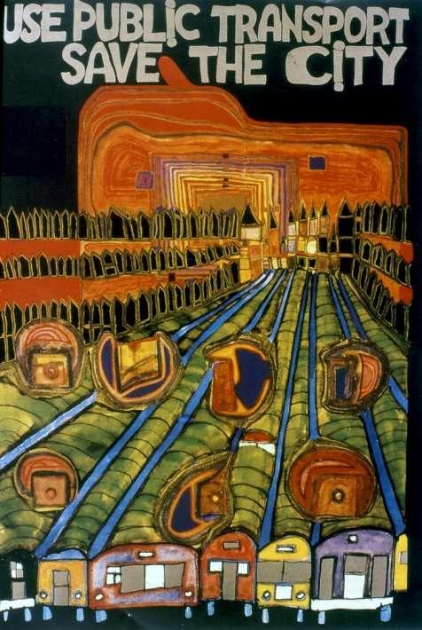
34 3 posters by Hundertwasser illustrate the planning spirit of a sustainable city: high-density compactness, transport corridors served by public transport and amenities making the city enjoyable.
35

36
The role of urban planning in anticipatory energy saving
 International Conference The human factor in the energy transition The role of urban planning in anticipatory energy saving Rome, 17 February 2015 Pierre LACONTE President, Foundation for the Urban Environment
Sustainable Mobility as Essential Ingredient for Vibrant Cities: 3 Cases in Point Pierre Laconte
 Pierre Laconte (Pierre Laconte, President Foundation for the Urban Environment, Hon. Sec. Gen. International Association for Public Transport UITP) 1 ZÜRICH Achieving smart urban mobility: the case of
Ingenuity at the service of sustainable regional development: four cases in point
 University College London - Sintropher Project Supporting Growth through Regional Connectivity How better transport links can promote regional development Ingenuity at the service of sustainable regional
OLD CITIES New Insights. Some remarks on the founding and development of Louvain-la-Neuve, the only new town of Belgium
 OLD CITIES New Insights Colloquium to celebrate Prof. Pr. Piet Lombaerde s career University of Antwerp 18th June 2015 Some remarks on the founding and development of Louvain-la-Neuve, the only new town
URBAN DENSITY INCREASE AND LAND RENT EQUALISATION
 URBAN DENSITY INCREASE AND LAND RENT EQUALISATION Paper presented at the international Conference LOCAL URBAN DISTRICTS Università Mediterranea di ReggioCalabria 4-5 July 2011 Pierre LACONTE President,
Policies and Code Intent Sections Related to Town Center
 Policies and Code Intent Sections Related to Town Center The Town Center Vision is scattered throughout the Comprehensive Plan, development code and the 1994 Town Center Plan. What follows are sections
WEST LOOP DESIGN GUIDELINES CHECKLIST
 WEST LOOP DESIGN GUIDELINES CHECKLIST Section 1.0 General Strategies 1.1 DESIGN EXCELLENCE: ENCOURAGE HIGH QUALITY AND INNOVATIVE DESIGN OF NEW BUILDINGS WITHIN THE WEST LOOP WITHOUT BEING PRESCRIPTIVE
Taming Tysons Corner Transforming the Quintessential Edge City
 Taming Tysons Corner Transforming the Quintessential Edge City Transit is the greatest catalyst for change at Tysons, but how do we take advantage of this billion-dollar investment? If transit is built
Lambeth Main Street Streetscape Improvements
 Lambeth Main Street Streetscape Improvements Open House October 5th, 2017 Agenda 1. Introduction 2. Project Background 3. Context 4. Project Objectives 5. Design Principles & Approach 6. Streetscape Design
Barnstaple's new riverside quarter
 Artist's impression of completed site Welcome to our exhibition of plans for new homes and commercial phases 2a and 2b of Anchorwood Bank. Anchorwood Bank is the most important development site in Barnstaple.
Metro. Activity Center Design Guidelines. Recommendations For Developing Focused, Mixed-Use Commercial/Residential Centers
 Metro Activity Center Design Guidelines Recommendations For Developing Focused, Mixed-Use Commercial/Residential Centers Metro Activity Centers What is a MAC? Legacy, the adopted guide for the future growth
THE LANDMARK PROJECT: ST. GEORGE CAMPUS BEFORE AND AFTER
 THE LANDMARK PROJECT: ST. GEORGE CAMPUS BEFORE AND AFTER The Landmark Project will reimagine the historic core of the St. George campus by creating dynamic, open spaces where students, faculty and the
Sustainably Repositioning Greyfield Sites. Greyfield Sites Anywhere
 Sustainably Repositioning Greyfield Sites Jim Constantine Looney Ricks Kiss Architects Todd Poole 4ward Planning Greyfield Sites Anywhere Pennsylvania Chapter American Planning Association Conference 2009
ELMVALE ACRES SHOPPING CENTRE MASTER PLAN
 ELMVALE ACRES SHOPPING CENTRE MASTER PLAN Contents 1.0 INTRODUCTION... 2 2.0 LOCATION... 2 3.0 EXISTING CONTEXT... 2 4.0 VISION & GUIDING PRINCIPLES... 2 5.0 LAND USE AND BUILT FORM... 4 5.1 St. Laurent
CITY OF MERCER ISLAND DESIGN COMMISSION STAFF REPORT
 CITY OF MERCER ISLAND DESIGN COMMISSION STAFF REPORT Agenda Item: 2 March 9, 2011 Project: Description: Applicant: DSR11-004 The applicant is requesting approval to replace the existing exterior wood framed
(DC1) Direct Development Control Provision DC1 Area 4
 Direct Development Control Provision DC1 Area 4") . General Purpose (DC) Direct Development Control Provision DC Area 4 The purpose of this Provision is to provide for an area of commercial office employment and residential development in support of the
. General Purpose (DC) Direct Development Control Provision DC Area 4 The purpose of this Provision is to provide for an area of commercial office employment and residential development in support of the
2. Form and Character. 2.1 Introduction. 2.2 The Downtown Addition Plan. 2.1 Introduction
 2.1 Introduction 2.1 Introduction This section of the Specific Plan describes and illustrates the desired form, character and uses of the Downtown Addition and explains the underlying design principles.
Green Infrastructure The Indianapolis Greenways Connection
 Green Infrastructure The Indianapolis Greenways Connection Fewer things in the transportation industry today make better since than combining the needs for pedestrian and bike trails with the need to locate,
Description of Preferred Alternative
 Chapter 2 Description of Preferred Alternative 2.1 Introduction This chapter of the programmatic Sammamish Town Center Sub-area Plan Final EIS provides a more detailed description of the Preferred Alternative
DRAFT. Waterfronts and Open Spaces. 10 The Riverfront Open Space System
 CHAPTER 4 Waterfronts and Open Spaces 10 The Riverfront Open Space System 12 Planned, proposed and envisioned riverfront recommendations. Figure 4.3.23 The riverfront will become a major new public amenity
Town Center (part of the Comprehensive Plan)
") Town Center (part of the Comprehensive Plan) Mercer Island Town Center Looking North (2014) In 1994, a year-long process culminated in a set of design guidelines and code requirements for the Town Center
Town Center (part of the Comprehensive Plan) Mercer Island Town Center Looking North (2014) In 1994, a year-long process culminated in a set of design guidelines and code requirements for the Town Center
CONTEXT + PROGRAM. CONTEXT - Site Photos RIALTO THEATRE STATION DEPOT HOTEL CONGRESS GREYHOUND SITE 4TH AVENUE BROADWAY BOULEVARD
 PROJECT SITE - View facing South - GREYHOUND SITE RIALTO THEATRE HOTEL CONGRESS STATION DEPOT BROADWAY BOULEVARD 4TH AVENUE CONGRESS STREET TOOLE STREET CONTEXT - Site Photos CONTEXT + PROGRAM 6th Avenue
Downtown Lead Revitalization Project Final Recommendations. Three Proposed Options for the Revitalization of Downtown Lead
 Downtown Lead Revitalization Project Final Recommendations Three Proposed Options for the Revitalization of Downtown Lead November 1, 2011 Three Proposed Options for the Revitalization of Downtown Lead
[PLANNING RATIONALE] For Site Plan Control and Lifting of Holding Zone By-Law 101 Champagne Avenue. May 23, 2014
![[PLANNING RATIONALE] For Site Plan Control and Lifting of Holding Zone By-Law 101 Champagne Avenue. May 23, 2014](/thumbs/75/71599615.jpg "[PLANNING RATIONALE] For Site Plan Control and Lifting of Holding Zone By-Law 101 Champagne Avenue. May 23, 2014") [PLANNING RATIONALE] For Site Plan Control and Lifting of Holding Zone By-Law 101 Champagne Avenue May 23, 2014 Contents 1.0 Introduction... 2 2.0 Site Context... 2 2.1 Adjacent Uses... 2 Figure 1: Site
[PLANNING RATIONALE] For Site Plan Control and Lifting of Holding Zone By-Law 101 Champagne Avenue May 23, 2014 Contents 1.0 Introduction... 2 2.0 Site Context... 2 2.1 Adjacent Uses... 2 Figure 1: Site
Little Mountain UDP Presentation
 Summary of UDP Evaluation of Dec 2015 Plan Dec 2015 Site Plan Transitional edges work well Central spine and permeability are strong Tree retention is good Establish Big Idea Sameness of built form contributes
Connecting Nine Buildings in Central Jakarta Together with the MRT. Mulyadi Janto, Director, PT Farpoint Prima
 Connecting Nine Buildings in Central Jakarta Together with the MRT Mulyadi Janto, Director, PT Farpoint Prima SEQUIS: INTER-SITE CONNECTIVITY 30/10/17 3.45pm 5.15 pm SEQUIS: INTER-SITE CONNECTIVITY 1.
Mix of Uses Guide for Transit-Oriented Development MIX OF USES
 MIX OF USES Creating a Destination Magnet A diversity of uses such as retail, housing, offices, civic and entertainment within the TOD creates a destination magnet for transit users and TOD neighbors.
EXISTING COMPREHENSIVE PLAN
 EXISTING COMPREHENSIVE PLAN Town Center Land Use Element: V. LAND USE POLICIES Town Center Mercer Island's business district vision as described in "Your Mercer Island Citizen-Designed Downtown" was an
Trafalgar Road Corridor Planning Study Open House
 Trafalgar Road Corridor Planning Study Open House June 24, 2013 6:30-8:30 p.m. Oakville & Trafalgar Rooms Overview The Livable Oakville Plan identifies the lands along Trafalgar Road, between the QEW and
SPRINGHILL LAKE TRANSIT VILLAGE
 Greenbelt Metro Area Sector Plan - Subarea Design Policies and Guidelines - Springhill Lake Transit Village 113 SPRINGHILL LAKE TRANSIT VILLAGE Residential Neighborhood and Village Center CONCEPT Springhill
PUTTING THE HEART INTO BATTERSEA. A vision
 PUTTING THE HEART INTO BATTERSEA A vision INTRODUCTION This document is a vision for creating a Battersea that its community can be proud of and it is about putting Battersea on the map. It is being proposed
Courthouse Square Planning & Urban Design Study. Courthouse Square Working Group #13 October 15, 2014
 Courthouse Square Planning & Urban Design Study Courthouse Square Working Group #13 October 15, 2014 1 Courthouse Square Process Working Group Community Courthouse Square Advisory Groups & Civic Associations
TOWN COUNCIL / PLANNING COMMISSION
 Workshop #3 TOWN COUNCIL / PLANNING COMMISSION January 20, 2011 Consultant Team In Attendance Tonight BMS Design Group Nevada City and San Francisco Michael Smiley, AICP, ASLA Partner-in-Charge Nancy L.
4 C OMMUNITY D ISTRICTS
 4 C OMMUNITY D ISTRICTS N ew development in the Area will include many different types of land uses, including a destination retail area that attracts people from all over the region; recreation opportunities
The Auburn Plan Designing the Future of Auburn February 28, 2005
 The Auburn Plan Designing the Future of Auburn February 28, 2005 Block-by-Block Bicycle Tour Aerial survey Focus Group Meetings September 7 and 8 Design Workshops October 11, 14, and 21 Revitalization
AROUND THE BLOCK INSIDE OUT
 AROUND THE BLOCK INSIDE OUT APPROACH TO THE SITE The Badel block is one of the largest blocks of the lower town of Zagreb, but in contrast to the other blocks, it is not accessible for public purposes.
Cambridge. West Cambridge site. What is a Shared Facilities Hub? Welcome
 Cambridge West Cambridge site What is a Shared Facilities Hub? Welcome Thank you for taking the time to attend our public exhibition on proposals for the Shared Facilities This will be a landmark building
Goals AND Guiding principles
 Historic photo of Eastlake Train Station sign Chapter 2: Goals AND Guiding principles 2-1 The Plan goals includes a desire to bridge present day conditions with a vision of the area s future. A central
DRAFT DRAFT DRAFT DRAFT
 # 19 EXPAND GREEN AND OPEN SPACES AND COMMUNITY FACILITIES IN TANDEM WITH NEW DEVELOPMENT The role of Eglinton will change in the coming years, along with the intensity of activity and land uses. As more
TOD 101 CREATING LIVABLE COMMUNITIES WITH TRANSIT
 1 CREATING LIVABLE COMMUNITIES WITH TRANSIT What are transit Centered Communities? Benefits of Partnerships to Support and Implement What You Will Learn Portland s Pearl District Your Trainers Today Catherine
Figure 3-1: Public Realm Plan
 3 Public Realm Figure 3-1: Public Realm Plan 3.1 Public Realm Concept The public realm concept for the Little Mountain site integrates a clear and accessible movement network with public spaces for social
TOWN BRANCH COMMONS & VINE STREET MOBILITY IMPROVEMENTS
 TOWN BRANCH COMMONS & VINE STREET MOBILITY IMPROVEMENTS CONTACT: Jeff Fugate, President O: 859-367-4972 F: 859-425-2292 JFugate@LexingtonDDA.com www.lexingtondda.com TOWN BRANCH COMMONS & VINE STREET MOBILITY
K. SMART ASSOCIATES LIMITED
 Planning Justification Report Zoning By-Law Amendment 185 King Street North Waterloo, Ontario April 7th, 2017 Project Reference Number 16-245 K. SMART ASSOCIATES LIMITED CONSULTING ENGINEERS AND PLANNERS
FRUITVALE TRANSIT VILLAGE (Phase 2) Residential Project
 Residential Project") FRUITVALE TRANSIT VILLAGE (Phase 2) Residential Project DEVELOPER: SIGNATURE PROPERTIES ARCHITECT: HKIT ARCHITECTS April 23, 2010 TABLE OF CONTENTS 3 Vision 4 Description of Site 5 Guiding Concepts 6
FRUITVALE TRANSIT VILLAGE (Phase 2) Residential Project DEVELOPER: SIGNATURE PROPERTIES ARCHITECT: HKIT ARCHITECTS April 23, 2010 TABLE OF CONTENTS 3 Vision 4 Description of Site 5 Guiding Concepts 6
LANDSCAPE IN URBAN PLANNING
 LANDSCAPE IN URBAN PLANNING LANDSCAPE PRACTICES EXAMPLES Addis Ababa [APRIL 2014] Anaïs PREVEL 1 INTRODUCTION Landscape in urban planning Urban planning requires several complementary areas of expertise
bo laugesen ad10-ark15 nørrebro station studytrip
 bo laugesen ad10-ark15 nørrebro station studytrip tunis souks Tunisia is a strange mixture of different mediteranean cultures: islamic, arabic, osman, roman and french is some of the most obvious. But
Jodie Milkman, Vice President for Communications, Delaware River Waterfront Corporation (o) , (c) ,
 , (c) ,") NEWS RELEASE CONTACTS: Jodie Milkman, Vice President for Communications, Delaware River Waterfront Corporation (o) 215 629-3216, (c) 267-228-2004, jmilkman@drwc.org Anusha Alikhan, Director of Communications,
NEWS RELEASE CONTACTS: Jodie Milkman, Vice President for Communications, Delaware River Waterfront Corporation (o) 215 629-3216, (c) 267-228-2004, jmilkman@drwc.org Anusha Alikhan, Director of Communications,
Hopkins. Development Guidelines May Overview. Sponsored by: Blake Road Corridor Collaborative City of Hopkins
 Hopkins Blake Road LRT Station Area Development Guidelines May 2015 Sponsored by: Blake Road Corridor Collaborative City of Hopkins Overview Hopkins is a dynamic community of over 17,000 residents located
SCHEDULE 12 TO THE DESIGN AND DEVELOPMENT OVERLAY GLEN WAVERLEY ACTIVITY CENTRE STRUCTURE PLAN
 DD/MM/YY Proposed C120 SCHEDULE 12 TO THE DESIGN AND DEVELOPMENT OVERLAY Shown on the planning scheme map as DDO12. GLEN WAVERLEY ACTIVITY CENTRE STRUCTURE PLAN 1.0 Design objectives DD/MM/YY Proposed
THE CIVIC DISTRICT DEVELOPMENT OPPORTUNITIES
 1 THE CIVIC DISTRICT DEVELOPMENT OPPORTUNITIES The Civic District is the physical and emotional heart of the downtown. It is also a major gateway into the central core, establishing the image and identity
appendix and street interface guidelines
 appendix five: building and street interface guidelines appendix 5 building and street interface guidelines BOULEVARDS Boulevards are generally characterized by higher levels of traffic movement at higher
Sustainable City of the Future LUSAIL
 Sustainable City of the Future March 2013 1 2013 - Lusail Real Estates Development Company 2 CITY Lusail City Vision To build a strong social and cultural foundation into a technologically advanced modern
Carlsbad Village Redevelopment Concept Summary of Features
 Carlsbad Village Redevelopment Concept Summary of Features Calthorpe Associates November 5, 2003 The Redevelopment Concept illustrates a vision for the future of Carlsbad Village. The overall vision of
Monroe Street Reconstruction. Final Corridor Design Presentation & Open House August 16, 2017
 Monroe Street Reconstruction Final Corridor Design Presentation & Open House August 16, 2017 Thank you to Wingra School! Tonight s Agenda 1. Project Overview 2. Design Proposal & Preparing for Reconstruction
REPORT BACK BROADSHEET 3 May 2016
 Paddington Place REPORT BACK BROADSHEET May 06 Architects and planners should work with the community first and then thinking about developers profits second. - Quote from participant at Paddington Place
Figure Example of out door dining in the public right-of-way.
 Section 2 Core Area Goal 2.2.1 To maintain and enhance the character of existing streets in the Downtown Area. Character Figure 2.2.1 Example of out door dining in the public right-of-way. A. Provide street
Derry Green Corporate Business Park
 Town of Milton Derry Green Corporate Business Park Urban Design Guidelines BMI/Pace - June 2010 Draft 3 Prepared by: Brook McIlroy Planning + Urban Design / Pace Architects Suite 300-51 Camden Street Toronto,
Pointe-Claire Community Destination
 Pointe-Claire Community Destination Lester John Vidal Sarah Gregoire-Caucci Gabriel Van Beverhoudt APRIL 2011 Table of Content 1. Executive Summary Problems & Solutions Current State Approach 2. Program
Architectural Standards
 Architectural Standards A collection of provisions working in concert to meet the community design objectives for downtown 1. Average Daylight Plane Concept. Provisions ensures that facades along streets
2.0 THE PLATINUM TRIANGLE VISION
 2.0 THE PLATINUM TRIANGLE VISION The envisions an exciting future for the area surrounding Angel Stadium of Anaheim, the Honda Center and The Grove of Anaheim. 2.1 Planning Principles In order to further
PUBLIC RIGHT-OF-WAY IN THIS CHAPTER PUBLIC REALM
 PUBLIC RIGHT-OF-WAY This section provides design guidelines for improvements in the public right-of-way. The public right-of-way refers to streets, sidewalks, non-vehicular thoroughfares, parks and greenways
B. PROPOSED REFINEMENTS POTENTIALLY AFFECTING URBAN DESIGN AND VISUAL RESOURCES
 Chapter 4: Urban Design and Visual Resources A. CONCLUSIONS OF THE FGEIS The FGEIS concluded that the Approved Plan will not result in any significant adverse impact on urban design or visual resources.
- - URBANISM RESILIENCE Volume 05 Historical Perspectives
 THE FOUNDING AND DEVELOPMENT OF LOUVAIN-LA-NEUVE, THE ONLY NEW TOWN IN BELGIUM Pierre Laconte Foundation for the Urban Environment The new university town of Louvain-la-Neuve originated from the 1968 decision
GUIDING PRINCIPLES IN THIS CHAPTER
 GUIDING PRINCIPLES The guiding principles and design concepts in this chapter work together with the Chapel Hill 2020 Comprehensive Plan to support new public places that can be enjoyed by all while also
3.1 Existing Land Use
 3.0 Land Use This strategy has been developed taking into account the position of the Town of Sidney as the economic center of the Saanich Peninsula. It acknowledges existing land use patterns in the downtown
ELK GROVE TOWN CENTER DESIGN GUIDELINES
 ......... ELK GROVE TOWN CENTER DESIGN GUIDELINES LAGUNA RIDGE SPECIFIC PLAN... June 2008 ............ DESIGN GUIDELINES Table of Contents Contents Section A: Town Center Overview...1 A.1. Purpose and
Developer s Program. The Station at East 54
 Developer s Program The Station at East 54 Existing Conditions The Station at East 54 is proposed for a 1.12 acre site at the northeast corner of Hamilton Road and Prestwick Road, tucked between the East
WELCOME and introduction
 1 WELCOME and introduction Mobility Hub Locations within Burlington STUDY OVERVIEW STUDY OBJECTIVES The City of Burlington is developing four Area Specific Plans, one for each of Burlington s Mobility
Public Consultation Summary: Lakeview Place Making Workshop January 30, 2008.
 Page 1 of 11 Public Consultation Summary: Lakeview Place Making Workshop January 30, 2008. 1.0 Introduction: On January 30, 2008 the City of Mississauga, in conjunction with the consulting team of Brook
Elephant and Castle. Elephant and Castle Area Vision Map. Elephant and Castle. 216 New Southwark Plan Proposed Submission Version NSP42 NSP49 NSP44
 Area Vision Map Lamberth North Station Waterloo Road Southwark Station NSP49 NSP43 Blackfriars Rd St George s Road Borough Road NSP48 Great Suffolk Street NSP42 NSP44 NSP45 Borough Station Newington Gardens
Report or technical documentations of the target areas in Siauliai
 WP 4 Energy Supply Report or technical documentations of the target areas in Siauliai 2011.10.27 Summary of the draft version of technical documentation for two target areas Lieporiai park 1.1. Works basis
Community Design Guidelines. Port Wallace DRAFT
 Community Design Guidelines Port Wallace DRAFT Energy 1 2 3 Nature Movement Connections Built Form DRAFT Layout Energy 1 Nature Community Design Guidelines GREAT COMMUNITIES PROTECT, CELEBRATE, AND CONSERVE
milano santa giulia Our Project, Your Retail
 milano santa giulia Our Project, Your 2 A new city district for a global city population density 3 Milan is the most populous city in Italy and the country s main industrial, financial and commercial centre,
Improve Neighborhood Design and Reduce Non Point Source Water Pollution
 HOW TO Planning Guide Improve Neighborhood Design and Reduce Non Point Source Water Pollution This document was funded by a grant from the New Hampshire Coastal Program with funding from the National Oceanic
EXISTING VEHICULAR & PEDESTRIAN CIRCULATION
 46 EXISTING CONDITIONS EXISTING VEHICULAR & PEDESTRIAN CIRCULATION Vehicular and pedestrian circulation patterns are illustrated on this graphic. Campus entry points and major vehicular circulation routes
RESTON TOWN CENTER DEVELOPMENT PLANS UNVEILED
 ReStOfl Land Corporation 11900 SUNRISE VALLEY DRIVE. SUITE 1400 news release FOR IMMEDIATE RELEASE RESTON, VIRGINIA 22091'S365 TELEPHONE f?o320 4780 RESTON TOWN CENTER DEVELOPMENT PLANS UNVEILED RESTON,
SINTROPHER* PARTNER SEMINAR BRUGES, APRIL INDIRECT EFFECTS OF PUBLIC TRANSPORT ON LAND USE: TWO LEGAL INNOVATIONS IN BELGIUM
 SINTROPHER* PARTNER SEMINAR BRUGES, APRIL 25 2013 INDIRECT EFFECTS OF PUBLIC TRANSPORT ON LAND USE: TWO LEGAL INNOVATIONS IN BELGIUM Pierre LACONTE, President Foundation for the Urban Environment, Honorary
EXISTING CONDITIONS 41. Existing Conditions
 EXISTING CONDITIONS 41 Existing Conditions The Existing Analysis phase of the planning process involved a study of the existing conditions on the campus in order to identify key planning issues to be addressed
DOWNTOWN RESIDENTIAL DISTRICT DEVELOPMENT OPPORTUNITES
 DOWNTOWN RESIDENTIAL DISTRICT DEVELOPMENT OPPORTUNITES Out of all the areas in Downtown Painesville, this district provides the greatest opportunity for change with the vacation of Lake East Hospital.
SOUTHWEST TRANSITWAY (STAGE 2) PUBLIC OPEN HOUSE
 PUBLIC OPEN HOUSE") WELCOME! SOUTHWEST TRANSITWAY (STAGE 2) PUBLIC OPEN HOUSE Monday, November 18, 2013 3:30 to 5:30PM and 7:00 to 9:00PM Tuesday, November 19, 2013 3:30 to 5:30PM and 7:00 to 9:00PM Welcome to the Southwest
WELCOME! SOUTHWEST TRANSITWAY (STAGE 2) PUBLIC OPEN HOUSE Monday, November 18, 2013 3:30 to 5:30PM and 7:00 to 9:00PM Tuesday, November 19, 2013 3:30 to 5:30PM and 7:00 to 9:00PM Welcome to the Southwest
GREENFIELD MEADOWS. Healthy Lifestyle. Refined by Nature. FOR BOOKINGS CALL. Call: Call: APPROVED BEHIND NITK, SURATHKAL
 FOR BOOKINGS CALL Call: +91 9900254184 Call: +918880116555 rangolimangalore GREENFIELD MEADOWS MUDA APPROVED This brochure is purely conceptual and is not a legal offering. The promoters or architects
City of Ennis. Downtown Master Plan Catalyst Projects
 City of Ennis Downtown Master Plan Catalyst Projects Revised Framework Plan REVISED Project Types and Descriptions Project Types A. Visitor Attracting Projects: Projects in this category are intended to
The Master Plan Framework
 The Master Plan Framework The East Harbour Master Plan advances the development of 60 acres of former industrial lands east of the Don River. The Master Plan outlines a vision for a vibrant, transit-oriented
The Cambie Corridor 2015 Fall workshop series. What we heard WORKSHOP OUTLINE
 The Cambie Corridor 2015 Fall workshop series W 16 AVE Area 5 CAMBIE CORRIDOR Phase 3 What we heard ovember 21, 2015, 9am-noon, 1:30-4:30pm Peretz Centre 89 Participants* WORKSHOP OUTLIE Introductions
TALL BUILDING GUIDELINES
 TALL BUILDING GUIDELINES Urban Design Guidance for the Site Planning and Design of Tall Buildings in Milton May, 2018 A Place of Possibility Contents 1.0 INTRODUCTION 1 1.1 What is a Tall Building? 2
Courthouse Square Planning & Urban Design Study. Clarendon / Courthouse Civic Association October 21, 2014
 Courthouse Square Planning & Urban Design Study Clarendon / Courthouse Civic Association October 21, 2014 1 Courthouse Square Process Working Group Community Courthouse Square Advisory Groups & Civic Associations
5. Bankside and The Borough 5.1. Bankside and The Borough Area Vision
 5. 5.1. Area Vision 5.1.1. are: A globally significant central London business district which is home to international business headquarters; At the heart of the commercial and cultural life of the capital
Bloor Street East Potential Ravine Portal Overlook and Access Passage to the Rosedale Valley and Don River Valley Ravine, Toronto, Canada
 TRANSFORMATIVE IDEA 2. GREAT STREETS Bloor Street Christie Pits Park Bloor St Spadina Ave Bathurst St Shaw St 1 Recognize the significant public realm improvements along Bloor Street and extend and enhance
Discovering Public Space: An Investigation of Portland s Civic Realm
 Discovering Public Space: An Investigation of Portland s Civic Realm Irie Searcy Architectural Programming Seminar J. Von Bargen, Fall 2008 December 8, 2008 Discovering Public Space: An Investigation of
1.4 TRANSIT VISION 2040 FROM VISION TO ACTION THEME 1: PUTTING TRANSIT AT THE CENTRE OF COMMUNITIES. Fully integrate transit with community design
 TRANSIT VISION 2040 FROM VISION TO ACTION TRANSIT VISION 2040 defines a future in which public transit maximizes its contribution to quality of life with benefits that support a vibrant and equitable society,
John M. Fleming Managing Director, Planning and City Planner. Old East Village Dundas Street Corridor Secondary Plan Draft Terms of Reference
 Report to Planning and Environment Committee To: From: Subject: Chair and Members Planning & Environment Committee John M. Fleming Managing Director, Planning and City Planner Old East Village Dundas Street
Parker Pine Curve Master Plan January 28th, 2009, Public Workshop Comments
 Group 1 Big Ideas Pedestrian friendly within and to development - bridge over Main Street from downtown. Campus feel. Parking garage like Castle Rocks - Taj garage may be tucked in hillside. Large (big
Rapid Transit Implementation Working Group Transit Oriented Development and Transit Villages January 12, 2017
 Rapid Transit Implementation Working Group Transit Oriented Development and Transit Villages January 12, 2017 Purpose of Presentation Highlight opportunities for Transit-Oriented Development in London
Field trip report. Field trip transport planning, , 2 ECTS, 2017S
 Field trip report Field trip transport planning, 231.043, 2 ECTS, 2017S Transit-Oriented Development (TOD) initiated by private railway companies in Japan The example of Utsukushigaoka on the Tama Den-en
THE NEIGHBORHOOD TODAY
 THE NEIGHBORHOOD TODAY CORE AREA VISION How are we Good Urbanism A Site s DNA thinking about Elements of great Unique elements urban communities embedded in a place the site and design? ELEMENTS LIKE:
3.0 URBAN DESIGN. December 6, OVERVIEW
 Urban Design 3.0 URBAN DESIGN December 6, 2007 3.1 OVERVIEW The highly urban character of Easton Place is defined by the overall design of the community. The following sections provide an overview of the
COURTHOUSE CAMPUS BARNSLEY Executive Summary March 2010
 COURTHOUSE CAMPUS BARNSLEY Executive Summary March 2010 Estell Warren Cartwright Pickard Buro Happold King Sturge BWA Barnsley Metropolitan Borough Council introduction Courthouse Campus is the last major
WESTERN ILLINOIS UNIVERSITY
 WESTERN ILLINOIS UNIVERSITY Quad Cities Riverfront Campus Preliminary Master Plan Presentation 2 February 1, 2006 Achieving Future Flexibility 1. Monitor space needs as the new buildings come on line and
Urban Stitching Rhythm and Stress-free in North Station-Rogier Metro Station Brussels, Belgium Nicolas Mansour
 Urban Stitching Rhythm and Stress-free in North Station-Rogier Metro Station Brussels, Belgium Nicolas Mansour The main focal point in my proposal is in the area between the City center and the Northern
Mariposa Lakes. Planned Community. Project Overview. Stockton, CA
 Planned Community Stockton, CA Project Overview March 2007 Summary of Proposed Community is a master-planned community proposed for development on approximately 3,810 acres in southeast Stockton. In 2004,