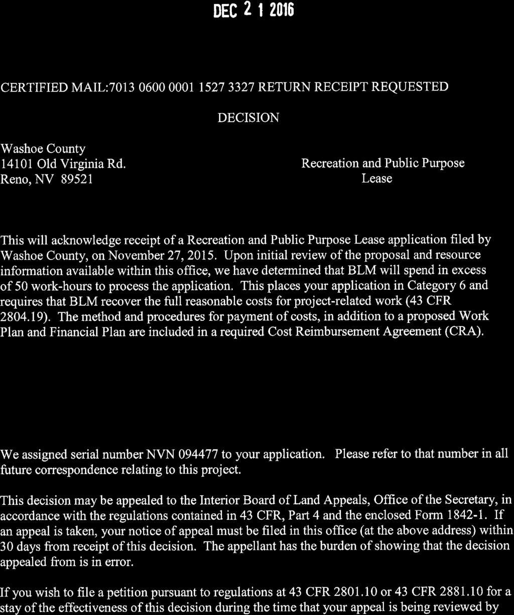
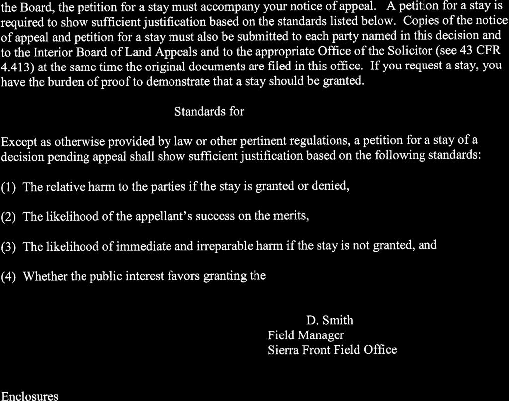
Special Use Permit for Sun Valley Middle School
|
|
|
- Amie Park
- 6 years ago
- Views:
Transcription


1 Special Use Permit for Sun Valley Middle School June 15, 2017 Submitted in partnership with: 9222 Prototype Drive Reno, Nevada Tel Fax
2 SUN VALLEY MIDDLE SCHOOL SPECIAL USE PERMIT Table of Contents Project Request... 1 Grading... 2 Figure 1 - Vicinity Map... 3 Figure 2 - Zoning Map... 4 Figure 3 - Slope Map... 5 Figure 4 - Site Photographs... 6 Figure 5 - Site Photographs... 7 Special Use Permit Findings... 8 Appendices Washoe County SUP Development Applications... A Maps Preliminary Earthwork... Map Pocket Preliminary Grading Plan... Map Pocket Cross Sections... Map Pocket Slope Map... Map Pocket Page i
3 SUN VALLEY MIDDLE SCHOOL SPECIAL USE PERMIT Project Request This application package includes the following request: 1) A Special Use Permit for Grading per Washoe County Development Code Section (a). The Washoe County School District (WCSD) is in the process of designing a new middle school located between northern Sun Valley and the Spanish Springs Valleys. The proposed site (APN ) is located on part of a larger ±642 acre parcel owned by the BLM. Approximately ±25.5 acres of the site will be utilized by the WCSD. That portion of the parcels ownership will also be transferred to the WCSD. The parcel has a split zoning of Open Space (88% of the parcel) and General Rural (12% of the parcel). The parcel has a master plan designation of Open Space (OS) and Rural (R). The site is located north of Donatello Drive in the northern portion of Sun Valley. Sun Valley Blvd. terminates and provides access into the parcel. The property is surrounded by single family homes, zoned Medium Density Suburban, to the south and vacant open space property to the north, east and west. The property is located within the boundaries of the Spanish Springs Area Plan. This special use permit application is for grading only, and does not include specific information on the proposed school use, however, background information has been provided to better explain the uniqueness of the property use and parcel ownership. In November of 2016, Washoe County votes approved WC-1, which gives the WCSD funding to repair and renovate older schools, and to build new schools to address overcrowding. This approval came at a time when population growth within Washoe County has placed a strain on the School District resources and has led to overcrowding in many local schools. As the community is coming out of one of the worst recessions in history, the WCSD is working to address overcrowding in schools. Construction of a new middle school in Sun Valley has been identified as a high priority and immediate need for the community. Page 1

4 SUN VALLEY MIDDLE SCHOOL SPECIAL USE PERMIT The school will provide the most immediate relief to Yvonne Shaw Middle School, which is currently at full capacity and is anticipated to exceed the capacity threshold over the next several years. The proposed Sun Valley Middle School will Photo of Depoali Middle School located in south Reno provide for grades 6-8. The approximate 200,000 square foot building will be two-stories and will provide 50+ classrooms, music room, gymnasium, library, and multi-purpose room/cafeteria. The school will also incorporate outdoor basketball courts, outdoor track and sports field, separate parking and loading areas for staff, buses, parents and visitors. The look and floor plan will be very similar to the Depoali Middle School, located in the South Meadows. Construction of the new school is anticipated to start in the fall of 2017 with completion and opening in the fall of Grading The purpose of the grading is to allow for development of a new middle school and associated outdoor fields, parking and circulation. Approximately 175,000 cubic yards of material will be moved around on the site, however the intent is to limit the amount of export, but using the non-structural material within slope and landscape areas. Approximately 25.5 acres of the site will be disturbed for grading and development of the site. The cut and fill slopes proposed on the site are designed using a maximum 3:1 ratio, with interception swales at the top of all slopes that will intercept drainage from above. Hydro seeding with temporary irrigation in combination with silt fences, fiber rolls, or straw matting will be utilized to prevent erosion. Retaining walls will be incorporated in the design with a maximum height of 8 and constructed of large gravity manufactured block. Visual mitigation will include revegetation and rounding of slopes. Page 2

5 SUN VALLEY MIDDLE SCHOOL SPECIAL USE PERMIT School Location Figure 1 - Vicinity Map Page 3

6 SUN VALLEY MIDDLE SCHOOL SPECIAL USE PERMIT Open Space School Location General Rural Medium Density Suburban Figure 2 - Zoning Map Page 4

7 SUN VALLEY MIDDLE SCHOOL SPECIAL USE PERMIT Figure 3 - Slope Map Page 5


8 SUN VALLEY MIDDLE SCHOOL SPECIAL USE PERMIT View of the property facing north. View of the property facing east. Figure 4 - Site Photographs Page 6


9 SUN VALLEY MIDDLE SCHOOL SPECIAL USE PERMIT View of the property facing south. View of the property facing west. Figure 5 - Site Photographs Page 7
10 SUN VALLEY MIDDLE SCHOOL SPECIAL USE PERMIT Special Use Permit Findings Prior to approving an application for a special use permit, the Planning Commission, Board of Adjustment or a hearing examiner shall find that all of the following are true: a. Consistency The proposed use is consistent with the action programs, policies, standards and maps of the Master Plan and the applicable area plan; The proposed project is in conformance with Washoe County Master Plan and the Spanish Springs Area Plan. Specific policies and standards include the following: Transportation Goal Three: The regional and local transportation system in the Spanish Springs planning area will be a safe, efficient, multi-modal system providing significant connections to the greater region, and access to commercial services, public lands and employment opportunities in the community. The system will contribute to the preservation and implementation of the community character as described in the Spanish Springs Vision and Character Statement. SS.3.6 Washoe County will support and be an advocate for new regional connections that provide alternatives to Pyramid Highway. Sun Valley Blvd. terminates at the property. The project has been designed to allow for the future extension of the roadway across the site. Scenic/Recreational/Cultural Resources Goal Four: Maintain open vistas of the surrounding ridges and more distant mountain ranges, and minimize the visual impact of hillside development. Policies SS.4.2 The Washoe County Departments of Community Development and Public Works will establish and oversee compliance with design standards for grading that minimize the visual impact of all residential and non-residential hillside development. Visual impacts have been mitigated using the retaining walls and landscape benches between the walls. The building has also been designed to screen the grading on the north side of the project. The building will physically screen views from the single family homes to the south and proposed grading on the north side of the property. SS.4.3 The grading design standards referred to in Policy SS.4.2 will, at a minimum, ensure that disturbed areas shall be finished and fill slopes will not exceed a 3:1 slope, Page 8
11 SUN VALLEY MIDDLE SCHOOL SPECIAL USE PERMIT and that hillside grading will establish an undulating naturalistic appearance by creating varying curvilinear contours. The cut and fill slopes proposed on the site are designed using a maximum 3:1 ratio, with interception swales at the top of all slopes that will intercept drainage from above. Hydro seeding with temporary irrigation in combination with silt fences, fiber rolls, or straw matting will be utilized to prevent erosion. Retaining walls will be incorporated in the design with a maximum height of 8 and constructed of large gravity manufactured block. Visual mitigation will include revegetation and rounding of slopes. Goal Seven: The Spanish Springs planning area will contain an extensive system of parks and trails that provides the community and the region with a broad range of recreational opportunities; provides connections between major developments, recreational facilities, the Regional Trail System, public lands and schools; and contributes to the preservation and implementation of the community character. SS.7.6 Access to existing trails will be protected and improved whenever possible. During the process of development review, the Washoe County Departments of Community Development and Parks and Recreation will request dedication of property and/or easements when appropriate trail alignments have been identified that link significant nodes within the Spanish Springs planning area or connect existing trails. The BLM property is currently developed with a trailhead and used as public open space, under the BLM ownership. The proposed school will utilize approximately 25.5 acres of land, leaving the remaining portion of the property under BLM s ownership and continued use as public open space. Goal Fifteen: Water resources will be provided to residential and non-residential uses in a manner that implements and preserves the community character as described in the Spanish Springs Vision and Character Statement. SS.15.1 Whenever applicable, all development within the Spanish Springs Suburban Character Management Area will connect to a community water service. The property is located within the boundaries of the Rural Character Management Area. Water service will be provided by the Sun Valley GID. Goal Sixteen: Wastewater treatment and disposal will be provided to residential and nonresidential uses in a manner that implements and preserves the community character as described in the Spanish Springs Vision and Character Statement. Policies Page 9
12 SUN VALLEY MIDDLE SCHOOL SPECIAL USE PERMIT SS.16.1 Whenever applicable, all development within the Spanish Springs Suburban Character Management Area will connect to a community sewer service. The property is located within the boundaries of the Rural Character Management Area. Sewer service will be provided by the Sun Valley GID. b. Improvements Adequate utilities, roadway improvements, sanitation, water supply, drainage, and other necessary facilities have been provided, the proposed improvements are properly related to existing and proposed roadways, and an adequate public facilities determination has been made in accordance with Division Seven; The school will tie into existing sewer and water line services provided through the Sun Valley GID. The proposed development incorporates grading design that allows for detention of storm water across the site. The full utility and roadway improvements will be part of the building permit package submitted to Washoe County for review. An internal driveway has been designed to provide circulation around the school that will mitigate traffic backing up during busy school drop off and pick up times. c. Site Suitability The site is physically suitable for the type of development and for the intensity of development; The property has some topographic constraints that require the grading. However, the grading plan has been design to balance the site, resulting in minimal import and/or export. d. Issuance Not Detrimental Issuance of the permit will not be significantly detrimental to the public health, safety or welfare; injurious to the property or improvements of adjacent properties; or detrimental to the character of the surrounding area; Issuance of the permit will not be significantly detrimental to the public health, safety or welfare of the surrounding area. The property to the south is developed as singlefamily residential. The property to the north, east and west sides are used as public open space. The adjacent residential homes will continue to back up to open space and will not be directly impacted by the proposed development. The site has two points of access, which will continue to serve as access routes. Page 10
13 SUN VALLEY MIDDLE SCHOOL SPECIAL USE PERMIT e. Effect on a Military Installation Issuance of the permit will not have a detrimental effect on the location, purpose or mission of the military installation. The proposed project has no effect on the location, purpose or mission of military installation. There are no military installations in the area. Page 11
14 Washoe County Development Application Your entire application is a public record. If you have a concern about releasing personal information, please contact Planning and Development staff at Project Information Staff Assigned Case No.: Project Name: Project Description: Project Address: Project Area (acres or square feet): Project Location (with point of reference to major cross streets AND area locator): Assessor s Parcel No.(s): Parcel Acreage: Assessor s Parcel No.(s): Parcel Acreage: Section(s)/Township/Range: Indicate any previous Washoe County approvals associated with this application: Case No.(s). Applicant Information (attach additional sheets if necessary) Property Owner: Professional Consultant: Name: Name: Address: Address: Zip: Zip: Phone: Fax: Phone: Fax: Cell: Other: Cell: Other: Contact Person: Contact Person: Applicant/Developer: Other Persons to be Contacted: Name: Name: Address: Address: Zip: Zip: Phone: Fax: Phone: Fax: Cell: Other: Cell: Other: Contact Person: Contact Person: For Office Use Only Date Received: Initial: Planning Area: County Commission District: Master Plan Designation(s): CAB(s): Regulatory Zoning(s): A - 1 October 2016
15 Account Detail Page 1 of 1 6/15/2017 Washoe County Treasurer Tammi Davis Washoe County Treasurer P.O. Box 30039, Reno, NV ph: (775) fax: (775) tax@washoecounty.us Account Detail Washoe County Parcel Information Parcel ID Status Last Update Active 6/15/2017 2:10:57 AM Current Owner: UNITED STATES OF AMERICA NONE RENO, NV Taxing District 4000 Back to Account Detail Change of Address Print this Page SITUS: 0 SUN VALLEY BLVD WASHOE COUNTY NV Geo CD: Legal Description SubdivisionName _UNSPECIFIED Township 20 Section 5 Lot Block Range 20 Pay Online No payment due for this account. $0.00 Pay By Check Please make checks payable to: WASHOE COUNTY TREASURER Mailing Address: P.O. Box Reno, NV Overnight Address: 1001 E. Ninth St., Ste D140 Reno, NV Tax Bill (Click on desired tax year for due dates and further details) Tax Year Net Tax Total Paid Penalty/Fees Interest Balance Due 2016 $0.00 $0.00 $0.00 $0.00 $ $0.00 $0.00 $0.00 $0.00 $0.00 $0.00 $0.00 $0.00 $0.00 $0.00 $0.00 $0.00 $0.00 $0.00 $0.00 $0.00 $0.00 $0.00 $0.00 $0.00 Total $0.00 Important Payment Information ALERTS: If your real property taxes are delinquent, the search results displayed may not reflect the correct amount owing. Please contact our office for the current amount due. For your convenience, online payment is available on this site. E-check payments are accepted without a fee. However, a service fee does apply for online credit card payments. See Payment Information for details. The Washoe County Treasurer s Office makes every effort to produce and publish the most current and accurate information possible. No warranties, expressed or implied, are provided for the data herein, its use, or its interpretation. If you have any questions, please contact us at (775) or tax@washoecounty.us This site is best viewed using Google Chrome, Internet Explorer 11, Mozilla Firefox or Safari.
16 A - 2


17 A - 3
18 A - 4


19 A - 5
20 A - 6
21 Special Use Permit Application for Grading Supplemental Information (All required information may be separately attached) Chapter 110 of the Washoe County Code is commonly known as the Development Code. Specific references to special use permits may be found in Article 810, Special Use Permits. Article 438, Grading, and Article 418, Significant Hydrologic Resources, are the ordinances specifically involved in this request. 1. What is the purpose of the grading? 2. How many cubic yards of material are you proposing to excavate on site? 3. How many square feet of surface of the property are you disturbing? 4. How many cubic yards of material are you exporting or importing? If none, how are you managing to balance the work on-site? Washoe County Planning and Development October 2016 SPECIAL USE PERMIT GRADING APPLICATION SUPPLEMENTAL INFORMATION A - 7
22 5. Is it possible to develop your property without surpassing the grading thresholds requiring a Special Use Permit? (Explain fully your answer.) 6. Has any portion of the grading shown on the plan been done previously? (If yes, explain the circumstances, the year the work was done, and who completed the work.) 7. Have you shown all areas on your site plan that are proposed to be disturbed by grading? (If no, explain fully your answer.) Washoe County Planning and Development October 2016 SPECIAL USE PERMIT GRADING APPLICATION SUPPLEMENTAL INFORMATION A - 8
23 8. Can the disturbed area be seen from off-site? If yes, from which directions, and which properties or roadways? 9. Could neighboring properties also be served by the proposed access/grading requested (i.e. if you are creating a driveway, would it be used for access to additional neighboring properties)? 10. What is the slope (Horizontal:Vertical) of the cut and fill areas proposed to be? What methods will be used to prevent erosion until the revegetation is established? 11. Are you planning any berms? Yes No If yes, how tall is the berm at its highest? Washoe County Planning and Development October 2016 SPECIAL USE PERMIT GRADING APPLICATION SUPPLEMENTAL INFORMATION A - 9
24 12. If your property slopes and you are leveling a pad for a building, are retaining walls going to be required? If so, how high will the walls be and what is their construction (i.e. rockery, concrete, timber, manufactured block)? 13. What are you proposing for visual mitigation of the work? 14. Will the grading proposed require removal of any trees? If so, what species, how many and of what size? Washoe County Planning and Development October 2016 SPECIAL USE PERMIT GRADING APPLICATION SUPPLEMENTAL INFORMATION A - 10
25 15. What type of revegetation seed mix are you planning to use and how many pounds per acre do you intend to broadcast? Will you use mulch and, if so, what type? 16. How are you providing temporary irrigation to the disturbed area? 17. Have you reviewed the revegetation plan with the Washoe Storey Conservation District? If yes, have you incorporated their suggestions? 18. Are there any restrictive covenants, recorded conditions, or deed restrictions (CC&Rs) that may prohibit the requested grading? Yes No If yes, please attach a copy. Washoe County Planning and Development October 2016 SPECIAL USE PERMIT GRADING APPLICATION SUPPLEMENTAL INFORMATION A - 11
26
27
28
29
RRW Stonebrook, LLC Tentative Map Findings
 RRW Stonebrook, LLC Tentative Map Findings FINDING T1: The request conforms to the Master Plan and zoning ordinances. RELATIONSHIP TO THE MASTER PLAN 1. The respective development is located within an
SPECIFIC PLAN Requirements
 CITY OF LANCASTER PLANNING DEPARTMENT 44933 Fern Avenue, Lancaster, California 93534 (661) 723-6100 SPECIFIC PLAN Requirements Purpose The purpose of a specific plan is to provide for the logical development
3.10 LAND USE SETTING PROJECT SITE EXISTING LAND USE DESIGNATIONS AND ZONING. General Plan Land Use Designations.
 This section of the Draft EIR addresses the existing land uses on and adjacent to the project site and discusses the potential impacts of the proposed project on existing land uses. Key issues addressed
City of Lafayette Study Session Staff Report Design Review Commission
 ++ City of Lafayette Study Session Staff Report Design Review Commission Meeting Date: January 08, 2018 Staff: Subject: Chris Juram, Planning Technician SS12-17 Miramar Homebuilders, R-20 Zoning: Request
THE CITY COUNCIL OF THE CITY OF SAN JUAN BAUTISTA DOES HEREBY ORDAIN AS FOLLOWS:
 ORDINANCE NO. 2016 01 AN ORDINANCE OF THE CITY OF SAN JUAN BAUTISTA AMENDING THE SAN JUAN BAUTISTA MUNICIPAL CODE TO ADD CHAPTER 11-08 HILLSIDE DEVELOPMENT REGULATIONS WHEREAS, the City Council has reviewed
Improve the appearance of off-street parking areas, vehicular use areas, and property abutting public and private roads;
 Bedford Township, MI (Monroe Co.) 2012 http://library.municode.com/index.aspx?clientid=02123 400.1907 - Landscaping and screening. Se 1907. 1. Intent. Landscaping, greenbelts, and screening are necessary
SUBMITTAL REQUIREMENTS
 WHEN PROCESS TYPE III IS USED References to Process Type III applications are found in several places in the Milton Municipal Code (MMC), indicating that the development, activity, or use, is permitted
Applicant Name Phone / Fax / Address City State Zip Code . Property Owner Phone / Fax / Address City State Zip Code
 Master Development Plan Application Community Development Department City of Redmond 411 SW 9 th Street Redmond, Oregon 97756 541-923-7721 541-548-0706 FAX Master Development Plan Fee $38,862.52 File Number
Huntington Stormwater Utility
 Huntington Stormwater Utility Stormwater Management & Sediment and Erosion Control Requirements for Construction Sites Authorized by Huntington City Code Articles: 971, 970, 930, 935, 955, Revised April
COMMISSION ACTION FORM
 ITEM #: 6 DATE: 09-06-17 COMMISSION ACTION FORM REQUEST: Introduction and Initial Review of Proposed Amendments to the Ames Urban Fringe Future Land Map for the North Growth Gap Area BACKGROUND INFORMATION:
Urban Planning and Land Use
 Urban Planning and Land Use 701 North 7 th Street, Room 423 Phone: (913) 573-5750 Kansas City, Kansas 66101 Fax: (913) 573-5796 Email: planninginfo@wycokck.org www.wycokck.org/planning To: From: City Planning
 NOTES: 1.) THE BOGGY CREEK RD. AND SIMPSON RD. IMPROVEMENTS DEPICTED ON THIS PLAN ARE BASED ON RECORD CONSTRUCTION PLANS AND HAVE NOT BEEN SURVEYED. 2.) EXISTING RESIDENTIAL BUILDING STRUCTURES AND ANCILLARY
Staff Report and Recommendation
 Community Planning and Development Planning Services 201 W. Colfax Ave., Dept. 205 Denver, CO 80202 p: 720.865.2915 f: 720.865.3052 www.denvergov.org/cpd TO: City Council Neighborhoods and Planning Committee
CITY OF CYPRESS 5275 Orange Avenue Cypress, California (714) DESIGN REVIEW COMMITTEE PERMIT PROCESS
 DESIGN REVIEW COMMITTEE PERMIT PROCESS") CITY OF CYPRESS 5275 Orange Avenue Cypress, California 90630 (714) 229-6720 DESIGN REVIEW COMMITTEE PERMIT PROCESS 1. Discuss project with Planning staff to determine zoning regulations, any unusual characteristics
CITY OF CYPRESS 5275 Orange Avenue Cypress, California 90630 (714) 229-6720 DESIGN REVIEW COMMITTEE PERMIT PROCESS 1. Discuss project with Planning staff to determine zoning regulations, any unusual characteristics
Sanford/Lee County Technical Review Committee (TRC) DEADLINES & MEETING DATES
 DEADLINES & MEETING DATES") Sanford/Lee County Technical Review Committee (TRC) DEADLINES & MEETING DATES The following 2019 information is based on the information available to staff at the time of creation. Dates & time may change
Sanford/Lee County Technical Review Committee (TRC) DEADLINES & MEETING DATES The following 2019 information is based on the information available to staff at the time of creation. Dates & time may change
Proposed Walkability Ordinance for City of Knoxville (6/16/17)
") Proposed Walkability Ordinance for City of Knoxville (6/16/17) New or revised text is highlighted Section 1: Purpose The purpose of this ordinance is to set requirements for walkability and pedestrian
Proposed Walkability Ordinance for City of Knoxville (6/16/17) New or revised text is highlighted Section 1: Purpose The purpose of this ordinance is to set requirements for walkability and pedestrian
PLANNED UNIT DEVELOPMENT & SUBDIVISION STAFF REPORT Date: May 18, 2017
 & PUD-0000102-2017 PLANNED UNIT DEVELOPMENT & SUBDIVISION STAFF REPORT Date: May 18, 2017 NAME SUBDIVISION NAME Dauphin Creek Estates Subdivision Dauphin Creek Estates Subdivision LOCATION CITY COUNCIL
SUPPORTING DOCUMENT STORMWATER POLLUTION PREVENTION PLAN (SWPPP) NARRATIVE
 NARRATIVE") SUPPORTING DOCUMENT STORMWATER POLLUTION PREVENTION PLAN (SWPPP) NARRATIVE Please complete this narrative form and submit with your SWPPP drawings. Refer to Kitsap County Stormwater Design Manual Vol.
SUPPORTING DOCUMENT STORMWATER POLLUTION PREVENTION PLAN (SWPPP) NARRATIVE Please complete this narrative form and submit with your SWPPP drawings. Refer to Kitsap County Stormwater Design Manual Vol.
SECTION 4(f) DE MINIMIS DOCUMENTATION
 DE MINIMIS DOCUMENTATION") SECTION 4(f) DE MINIMIS DOCUMENTATION Illinois Route 60/83 IL 176 to the intersection of IL 60 (Townline Road) Lake County P-91-084-07 Mundelein Park and Recreation District Project Limit SECTION 4(f)
SECTION 4(f) DE MINIMIS DOCUMENTATION Illinois Route 60/83 IL 176 to the intersection of IL 60 (Townline Road) Lake County P-91-084-07 Mundelein Park and Recreation District Project Limit SECTION 4(f)
APPLICATION FOR REZONING PROPERTY CITY OF HOLLAND, MICHIGAN. Name of Applicant. Address, and Phone # of Applicant
 APPLICATION FOR REZONING PROPERTY CITY OF HOLLAND, MICHIGAN Name of Applicant Address, Email and Phone # of Applicant Name and Address of Owner (if other than applicant) Ownership Interest of Applicant
TREE REMOVAL PERMIT PACKET
 PERMIT INTAKE HOURS Permit Applications will be accepted between 8:30 am and 4:30 pm. Community Development Engineering Division 38 Hill Street, Suite G-30 Roswell, GA 30075 770-641-3780 www.roswellgov.com
ARTICLE V PLANNED UNIT DEVELOPMENT DISTRICT
 ARTICLE V PLANNED UNIT DEVELOPMENT DISTRICT A. Purpose and Objective The Planned Unit Development (PUD) procedure provides a flexible land use and design regulation through the use of performance criteria
Glenborough at Easton Land Use Master Plan
 Implementation 114 9.0 IMPLEMENTATION 9.1 OVERVIEW This chapter summarizes the administrative procedures necessary to implement the proposed land use plan, infrastructure improvements, development standards,
Prado Ranch North Common Open Space Tentative Map. Washoe County Planning Commission July 3, 2018
 Prado Ranch North Common Open Space Tentative Map Washoe County Planning Commission July 3, 2018 Site Characteristics Intersection of Chickadee and Lemmon Drive ~1 mile north of Deodar/Lemmon Drive intersection
TOWNSHIP OF LOGAN SOIL & FILL IMPORTATION AND PLACEMENT APPLICATION SUBMITTAL CHECKLIST
 TOWNSHIP OF LOGAN SOIL & FILL IMPORTATION AND PLACEMENT APPLICATION SUBMITTAL CHECKLIST Applications: 5 copies of application - Applicant will reproduce the copies at his/her costs. The Township Clerk
City of Lafayette Staff Report
 City of Lafayette Staff Report For: By: Design Review Commission Greg Wolff, Senior Planner Meeting Date: April 27, 2015 Subject: SS03-15 Gundi & Peter Younger (Owners), R-40 Zoning: Request for a Study
City of Lafayette Study Session Staff Report Design Review Commission
 City of Lafayette Study Session Staff Report Design Review Commission Meeting Date: April 24, 2017 Staff: Payal Bhagat, Senior Planner Subject: HDP18-15 & HDP31-15 Ramesh Patel & Melcor Development (Owners),
PLANNED DEVELOPMENT (MASTER PLAN & UNIT PLAN)
") Central Permit Center 555 Santa Clara Street Vallejo CA 94590 Business License Building Fire Prevention Planning Public Works 707.648.4310 707.648.4374 707.648.4565 707.648.4326 707.651.7151 PLANNED DEVELOPMENT
Central Permit Center 555 Santa Clara Street Vallejo CA 94590 Business License Building Fire Prevention Planning Public Works 707.648.4310 707.648.4374 707.648.4565 707.648.4326 707.651.7151 PLANNED DEVELOPMENT
ZONING AMENDMENT & PLANNED UNIT DEVELOPMENT STAFF REPORT Date: April 4, 2013
 ZONING AMENDMENT & PLANNED UNIT DEVELOPMENT STAFF REPORT Date: April 4, 2013 NAME DEVELOPMENT NAME LOCATION DIP Exchange, LLC DIP Exchange, LLC 93 Sidney Phillips Drive (West side of Sidney Phillips Drive,
Application for Site Plan Review
 Application for Site Plan Review City of Pontiac Office of Land Use and Strategic Planning 47450 Woodward Ave, Pontiac, MI 48342 T: 248.758.2800 F: 248.758.2827 Property/Project Address: Sidwell Number:
Zoning Ordinance Chapter 10
 CHAPTER 10 - WASHES SECTION 10.0 GENERAL: A. The purpose of this Ordinance is to establish standards for development in or near Major and Minor Washes as defined in Appendix A Glossary of Terms and Definitions
Gadsden County Planning Commission Agenda Request
 Date of Meeting: November 16, 2017 To: From: Through: Subject: Gadsden County Planning Commission Agenda Request Honorable Chairperson and Members of the Board Jill A. Jeglie, AICP, Senior Planner Clyde
PROJECT SCOPE OF WORK CITY OF TOWN AND COUNTRY STORMWATER PROGRAM
 PROJECT SCOPE OF WORK CITY OF TOWN AND COUNTRY STORMWATER PROGRAM Project Name: 362 Featherstone Dr Project ID Number: 27-3 Problem: Anecdotal evidence suggests a natural spring exists in the backyard
STAFF REPORT FOR STANDARD COASTAL DEVELOPMENT PERMIT #CDP FEBRUARY 26, 2015 CPA - 1 PO BOX 238 APTOS, CA 94001
 STAFF REPORT FOR STANDARD COASTAL DEVELOPMENT PERMIT #CDP 2014-0030 FEBRUARY 26, 2015 CPA - 1 OWNER/APPLICANT: AGENT: REQUEST: HANS HEIM PO BOX 238 APTOS, CA 94001 JAMES HAY PO BOX 762 MENDOCINO, CA 95460
Institutional Master Plan The Arnold Arboretum of Harvard University
 Institutional Master Plan The Arnold Arboretum of Harvard University Submitted to: Boston Redevelopment Authority One City Hall Square Boston, MA 02201 Submitted by: The Arnold Arboretum of Harvard University
ARTICLE IV: DEVELOPMENT STANDARDS 404 MASTER PLANNING
 IV 13 404 MASTER PLANNING Master Planning through the Site Analysis (Master Planning Site Analysis) or Planned Development (Master Planning Planned Development) is provided to encourage development which
PRELIMINARY STAFF PLANNING REPORT TO THE WALWORTH COUNTY ZONING AGENCY X CONDITIONAL USE
 This report was prepared prior to the public hearing. This report may be supplemented or amended to reflect the review of additional information presented at the public hearing and written material submitted
SITE PLAN REVIEW APPLICATION AND CHECKLIST
 SITE PLAN REVIEW APPLICATION AND CHECKLIST PROJECT SUMMARY: Project Name: City/ETA Location: City ETA (Application fee & number of copies needed are based on location) Property Location (Legal Description
IV. Development in the Rural Overlay District
 Intracoastal Waterway Route 17 Route 168 Great Dismal Swamp VIRGINIA NORTH CAROLINA IV. Development in the Rural Overlay District IV-1 Route 17 in Chesapeake s Rural Overlay District affords distant views
Colerain Township report to. Hamilton County Regional Planning Commission. December 2, 2010, 1:00PM. t a f f r e p o r t
 Colerain Township report to Hamilton County Regional Planning Commission December 2, 2010, 1:00PM Preliminary Plan: Case No.: ZA2001-04, Forevergreen Prepared By: Amy Bancroft, Land Use Planner t a f f
ORDINANCE NO WHEREAS, the City of Kalama has many areas of timberland and open areas inside its City limits adjacent to residential areas;
 ORDINANCE NO. 1342 AN ORDINANCE OF THE CITY OF KALAMA, WASHINGTON ADOPTING A NEW KALAMA MUNICIPAL CODE CHAPTER 17.20 ESTATE LOT FLOATING ZONE TO PROVIDE TRANSITIONAL ZONING OPTIONS FOR RESIDENTIAL DEVELOPMENT
Special Use Permit WSUP
 Special Use Permit WSUP17-0014 Washoe County Board of Adjustment October 4, 2017 GAIL WILLEY 1 Vicinity Map Pleasant Valley 134 Andrew Lane Immediately south of Hwy 395 General Rural 35.9-acres 2 Overview
2. Would the proposed project comply with the Land Use map? 3. Would the proposed project require a rezoning? 4. What is the proposed zoning district?
 TOWN OF CHAPEL HILL Planning and Sustainability Department 405 Martin Luther King Jr. Blvd. Chapel Hill, NC 27514 www.townofchapelhill.org phone (919) 968 2728 Concept Plans are intended to be an opportunity
CONSENT CALENDAR CITY PLANNING COMMISSION AGENDA ITEM NO: A.1, A.2 STAFF: LARRY LARSEN
 Page 8 CONSENT CALENDAR CITY PLANNING COMMISSION AGENDA ITEM NO: A.1, A.2 STAFF: LARRY LARSEN FILE NO: CPC PUZ 14-00013 - QUASI-JUDICIAL FILE NO: CPC PUD 14-00014 QUASI-JUDICIAL PROJECT: APPLICANT: OWNER:
Gold Line Bus Rapid Transit Transit Oriented Development (BRTOD) Helmo Station Area Plan
 Helmo Station Area Plan") Appendix F Gold Line Bus Rapid Transit Transit Oriented Development (BRTOD) Helmo Station Area Plan Introduction and Purpose of the Plan The Gold Line Bus Rapid Transit facility is an eleven-mile dedicated
Appendix F Gold Line Bus Rapid Transit Transit Oriented Development (BRTOD) Helmo Station Area Plan Introduction and Purpose of the Plan The Gold Line Bus Rapid Transit facility is an eleven-mile dedicated
Planning & Zoning Commission Staff Report
 Planning & Zoning Commission Staff Report Meeting Date: May 26, 2015 Drafted by: Katherine Harrison-Rogers CASE # Z2886 PROJECT NAME: APPLICANT/ REPRESENTATIVE: Shawna Runyan PROPERTY OWNER: 1840 (previously
Ephrata Municipal Code, Chapter 19.07, Landscaping Regulations DRAFT January 28, 2013 Page 1
 Chapter 19.07 LANDSCAPING REGULATIONS Sections: 19.07.010 Purpose. 19.07.020 Landscape plan approval. 19.07.030 Failure to complete required landscaping Inspection. 19.07.040 General landscape requirements
KNOXVILLE/KNOX COUNTY METROPOLITAN PLANNING COMMISSION SUBDIVISION REPORT - CONCEPT/USE ON REVIEW
 KNOXVILLE/KNOX COUNTY METROPOLITAN PLANNING COMMISSION SUBDIVISION REPORT - CONCEPT/USE ON REVIEW FILE #: 10-SF-17-C 10-I-17-UR AGENDA ITEM #: 12 AGENDA DATE: 11/9/2017 POSTPONEMENT(S): 10/12/2017 SUBDIVISION:
APPROVED WITH CONDITIONS
 Provo City Planning Commission Report of Action October 26, 2016 ITEM 10 Provo City Parks and Recreation Department requests a variance to the Sensitive Lands Ordinance to grade within a hillside of 30%
The Estates at Marango Springs Master Plan Amendment & Regulatory Zone Amendment. Prepared by:
 The Estates at Marango Springs Master Plan Amendment & Regulatory Zone Amendment Prepared by: May 15, 2018 THE ESTATES AT MARANGO SPRINGS The Estates at Marango Springs MPA / RZA Prepared for: Dr. Harry
PRELIMINARY PLAT DESIGN REQUIREMENTS Updated 4/8/2016
 PRELIMINARY PLAT DESIGN REQUIREMENTS Updated 4/8/2016 The following items are required for the preliminary plat. Numbers correspond with those on the example preliminary plat. RENO COUNTY SUBDIVISION REQUIREMENTS
City of Stoughton Erosion Control Permit Application (effective 2/6/2018)
") City of Stoughton Erosion Control Permit Application (effective 2/6/2018) Incomplete applications will not be accepted Project Name: Address of subject property: Landowner Name(s): Applicant Name: Landowner
City of Stoughton Erosion Control Permit Application (effective 2/6/2018) Incomplete applications will not be accepted Project Name: Address of subject property: Landowner Name(s): Applicant Name: Landowner
STAFF REPORT INTRODUCTION
 STAFF REPORT SUBJECT: DATE: Application for Master Land Use Plan Modification Southern Village Master Land Use Plan (Project No. 12-101) May 22, 2013 (Community Design Commission) May 23, 2013 (Transportation
City of Reedley Community Development Department 1733 Ninth Street Reedley, CA (559) FAX
 FAX") City of Reedley SPECIAL PERMIT Submittal Requirements Conditional Use Permit (CUP), Site Plan Review (SPR) & Variance (VAR) Please use this information sheet as a checklist to assemble materials required
City of Reedley SPECIAL PERMIT Submittal Requirements Conditional Use Permit (CUP), Site Plan Review (SPR) & Variance (VAR) Please use this information sheet as a checklist to assemble materials required
SECTION 1 CLEARING /GRADING PERMIT APPLICATION:
 PLEASE REFER TO THE CLEARING & GRADING PERMIT CHECKLIST BELOW FOR SUBMITTAL REQUIREMENTS. SECTION 1 CLEARING /GRADING PERMIT APPLICATION: PROJECT ADDRESS (Street, Suite #): Parcel(s) #: Total Site Area
SUBMITTAL REQUIREMENTS: FINAL PLAN REVIEW- PROJECT DEVELOPMENT PLAN (PDP)
") 1) Application form and filing fee. Application Form.pdf Development Review Guide STEP 6 of 8 SUBMITTAL REQUIREMENTS: FINAL PLAN REVIEW- PROJECT DEVELOPMENT PLAN (PDP) 2) Transportation Development Review
1) Application form and filing fee. Application Form.pdf Development Review Guide STEP 6 of 8 SUBMITTAL REQUIREMENTS: FINAL PLAN REVIEW- PROJECT DEVELOPMENT PLAN (PDP) 2) Transportation Development Review
Master Plan Amendment and Zone Change for Pyramid/La Posada Commercial
 Master Plan Amendment and Zone Change for Pyramid/La Posada Commercial Submitted to Washoe County September 15, 2014 Prepared for Pyramid Urban Achievers 555 So. Center Street Reno, NV 89501 Prepared by
City of Sun Prairie Wetland Buffer Reduction Request
 City of Sun Prairie Wetland Buffer Reduction Request Westside Development Area January 9, 2017 Prepared by: City of Sun Prairie 300 E. Main Street Sun Prairie, WI 53590 BACKGROUND The City of Sun Prairie
PLANNED UNIT DEVELOPMENT Date: April 5, 2018
 PLANNED UNIT DEVELOPMENT Date: April 5, 2018 DEVELOPMENT NAME SUBDIVISION NAME LOCATION Robert Myers Robert Myers 2955 and 2989 Dauphin Street (Southeast corner of Dauphin Street and Sage Avenue) CITY
SITE PLAN REVIEW ITEMS - REFERENCE CHECKLIST
 City of Seminole 9199 113 th Street N. Seminole, FL 33772 Ph: (727) 392-1966 Fx: (727) 319-6583 SITE PLAN REVIEW ITEMS - REFERENCE CHECKLIST Note: This checklist is designed to aid designers in the review
RESOLUTION NO. WHEREAS, the proposed Master Plan for Villa Esperanza (VE), located at 2116
, located at 2116") RESOLUTION NO. A RESOLUTION OF THE CITY COUNCIL OF THE CITY OF PASADENA APPROVING A MASTER PLAN FOR VILLA ESPERANZA WHEREAS, the proposed Master Plan for Villa Esperanza (VE), located at 2116 Villa Street
RESOLUTION NO. A RESOLUTION OF THE CITY COUNCIL OF THE CITY OF PASADENA APPROVING A MASTER PLAN FOR VILLA ESPERANZA WHEREAS, the proposed Master Plan for Villa Esperanza (VE), located at 2116 Villa Street
PLANNING COMMISSION AGENDA REPORT SEPTEMBER 1, 2016
 PLANNING COMMISSION AGENDA REPORT SEPTEMBER 1, 2016 TO: Members of the Planning Commission FROM: Michael Klein, Planner FILE NO.: 150000780 PROPOSAL: APPLICANT: RECOMMENDATION: A request for a Site Plan
Design Review Application *Please call prior to submittal meeting to determine applicable fees*
 CITY OF EAGLE 660 E. Civic Lane, Eagle, ID 83616 Phone#: (208) 939-0227 Fax: (208) 938-3854 Design Review Application *Please call prior to submittal meeting to determine applicable fees* FILE NO.: CROSS
City of Waco Stormwater Management Regulations
 1.0 Applicability: City of Waco Stormwater Management Regulations These regulations apply to all development within the limits of the City of Waco as well as to any subdivisions within the extra territorial
North Oakville East Parks Facilities Distribution Plan. November, 2009
 North Oakville East November, 2009 POLICY CONTEXT 1) Purpose a) The purpose of this document is to be a guide for the location, configuration, design and development of the parks system for the North Oakville
ARTICLE 3 LANDSCAPING AND SCREENING REQUIREMENTS
 ARTICLE 3 CHAPTER 4 LANDSCAPING AND SCREENING REQUIREMENTS SEC 3.401 SEC 3.402 (D) (E) PURPOSE: The purpose of this Chapter is to establish minimum standards for the design, installation, and maintenance
Asbury Chapel Subdivision Sketch Plan
 Asbury Chapel Subdivision Sketch Plan PART 1: PROJECT SUMMARY Applicant: NVR Inc. Project Size: +/- 76.13 acres Parcel Numbers: 02101112,02116101,02116112, 02116113 Current Zoning: Transitional Residential
Building & Site Design Standards Application
 FOR OFFICE USE ONLY Design standards plan review fee Building & Site Design Standards Application Phone: 208-468-5406 Fax: 208-468-5439 411 3rd Street South Nampa, Idaho 83651 5,000
CHUGIAK-EAGLE RIVER SITE-SPECIFIC LAND USE PLAN
 CHUGIAK-EAGLE RIVER SITE-SPECIFIC LAND USE PLAN JUNE 2010 Final Prepared for The Heritage Land Bank, Municipality of Anchorage by Agnew: :Beck Consulting www.agnewbeck.com 907.222.5424 Chugiak-Eagle River
PLANNING COMMISSION Work Session Meeting Agenda
 PLANNING COMMISSION Work Session Meeting Agenda 5200 85TH AVENUE NORTH BROOKLYN PARK MN 55443 PHONE (763) 424-8000 FAX (763) 493-8391 Wednesday, September 27, 2017-7:00 P.M. Brooklyn Township Room If due
PLANNED UNIT DEVELOPMENT STAFF REPORT Date: June 2, 2016
 # 9 ZON2016-01032 PLANNED UNIT DEVELOPMENT STAFF REPORT Date: June 2, 2016 DEVELOPMENT NAME JJT Properties LLC LOCATION 1147 & 1151 East I-65 Service Road South and 1180 Sledge Drive (Southeast corner
CARVER COUNTY DIVISION OF PUBLIC WORKS LANDSCAPE POLICY. Adopted by the Carver County Board of Commissioners March 3, 2015
 CARVER COUNTY DIVISION OF PUBLIC WORKS LANDSCAPE POLICY Adopted by the Carver County Board of Commissioners March 3, 2015 Policy Statement Goals It is the goal of Carver County Public Works to provide
A. INTRODUCTION AND SUMMARY OF FINDINGS B. EXISTING CONDITIONS. Table 10-1 Adjacent Storm Drains
 Chapter 10: Stormwater Management A. INTRODUCTION AND SUMMARY OF FINDINGS This chapter describes existing and proposed stormwater management on the Site. Potential impacts to stormwater infrastructure
COASTAL DEVELOPMENT PERMIT REQUIRING A PUBLIC HEARING
 Santa Barbara County Coastal Development Permit-Hearing Application Page 1 COASTAL DEVELOPMENT PERMIT REQUIRING A PUBLIC HEARING A COASTAL DEVELOPMENT PERMIT REQUIRING A PUBLIC HEARING (CDH) necessary
MORAGA HILLSIDES AND RIDGELINES PROJECT
 MORAGA HILLSIDES AND RIDGELINES PROJECT STEERING COMMITTEE MEETING, JUNE 29, 2016 Project Overview The Hillsides and Ridgelines project will amend existing Town hillside regulations to increase certainty,
Major Subdivision Sketch Plan Checklist
 This checklist provides specific requirements that are apart of the Sketch process. The entire process is described by the Huntersville Subdivision Review Process which details all the submittal and resubmittal
Neo-Traditional Overlay Application
 MAYOR AND CITY COUNCIL OF LAUREL DEPARTMENT OF ECONOMIC AND COMMUNITY DEVELOPMENT 8103 Sandy Spring Road Laurel, Maryland 20707 (301) 725-5300 Internet Address http://www.cityoflaurel.org E-mail: ecd@laurel.md.us
SITE PLAN REVIEW PROCESS
 BOWNE TOWNSHIP PO Box 35, 8240 Alden Nash Road, Alto, Michigan 49302 Ph. 616-868-6846 Fax 616-868-0110 http://www.bownetwp.org SITE PLAN REVIEW PROCESS 1. Application Form and Fee Schedule Site Plan Review
Staff Report. Conditional Use PLANNING DIVISION COMMUNITY & ECONOMIC DEVELOPMENT. Salt Lake City Planning Commission
 Staff Report PLANNING DIVISION COMMUNITY & ECONOMIC DEVELOPMENT To: From: Salt Lake City Planning Commission Maryann Pickering, Principal Planner (801) 535-7660 Date: December 10, 2014 Re: Church of Scientology
Florence County Small Commercial Land Disturbance Permit Application
 Florence County Small Commercial Land Disturbance Permit Application Florence County Engineering Division 518 South Irby Street Florence, S.C. 29501 Phone (843) 676-8600 Fax (843) 676-8667 Tax Map Number:
Site Plan Review Residential Accessory Building
 COMMUNITY DEVELOPMENT DEPARTMENT Planning Division P.O. Box 490 333 Broadalbin Street SW Albany, OR 97321 Phone (541) 917-7550 Fax (541) 917-7598 www.cityofalbany.net Site Plan Review Residential Accessory
GENERAL INFORMATIONaaaaaaaaaaaaaaaaaaaaaaaaaaaaaaaa
 To: Planning and Zoning Commission From: City Staff Date: November 15, 2016 Re: Case #16026 Raymore Activity Center Site Plan GENERAL INFORMATIONaaaaaaaaaaaaaaaaaaaaaaaaaaaaaaaa Applicant/ Property Owner:
2.4 FUTURE LAND USE ELEMENT Goals, Objectives and Policies
 GOAL 1: To create developmental patterns that direct future growth to appropriate areas on campus, in a manner that promotes the educational mission of the University, the protection of environmentally
Essential Skills: Reading and Interpreting Maps and Plans
 Essential Skills: Reading and Interpreting Maps and Plans Prepared for: NYS Tug Hill Commission Local Government Conference March 31, 2016 Prepared by: Peter G. Vars, P.E. BME ASSOCIATES Stages of Plan
CITY OF LAGUNA BEACH COMMUNITY DEVELOPMENT DEPARTMENT STAFF REPORT DESIGN REVIEW BOARD IBOARD OF ADJUSTMENT Coast Highway APN
 CITY OF LAGUNA BEACH COMMUNITY DEVELOPMENT DEPARTMENT STAFF REPORT HEARING DATE: October 13,2011 TO: DESIGN REVIEW BOARD IBOARD OF ADJUSTMENT CASE: Variance 7717 Design Review 11-163 Coastal Development
Project Applicant Checklist for NPDES Permit Requirements SAN MATEO COUNTYWIDE STORMWATER POLLUTION PREVENTION PROGRAM
 Project Applicant Checklist for NPDES Permit Requirements SAN MATEO COUNTYWIDE STORMWATER POLLUTION PREVENTION PROGRAM I. PROJECT DATA Project Name Bay Meadows Development Phase II Project Address 2600
ARTICLE 17 SITE PLAN REVIEW
 ARTICLE 17 SITE PLAN REVIEW 17.01 INTENT AND PURPOSE The intent of this section is to provide for consultation and cooperation between the applicant and the township planning commission so that the applicant
Drexel, Barrell & Co.
 Drexel, Barrell & Co. June 18, 2018 Engineers/Surveyors Boulder Colorado Springs Greeley 3 South 7 th Street Colorado Springs, Colorado 80905-1501 719 260-0887 719 260-8352 Fax El Paso County Planning
O l so n M e morial Highway, S t e , G o l d e n V a l l e y, MN Delano Laketown Homes Concept Plan
 N O R T H W E S T A S S O C I A T E D C O N S U L T A N T S, I N C. 4 1 5 0 O l so n M e morial Highway, S t e. 3 2 0, G o l d e n V a l l e y, MN 5 5 4 2 2 T e l e p h o n e : 7 6 3. 9 5 7. 1 1 0 0 W
REQUEST Current Zoning: O-15(CD) (office) Proposed Zoning: TOD-M(CD) (transit oriented development mixed-use, conditional)
 (office) Proposed Zoning: TOD-M(CD) (transit oriented development mixed-use, conditional)") Rezoning Petition 2016-117 Zoning Committee Recommendation January 4, 2017 REQUEST Current Zoning: O-15(CD) (office) Proposed Zoning: TOD-M(CD) (transit oriented development mixed-use, conditional) LOCATION
Rezoning Petition 2016-117 Zoning Committee Recommendation January 4, 2017 REQUEST Current Zoning: O-15(CD) (office) Proposed Zoning: TOD-M(CD) (transit oriented development mixed-use, conditional) LOCATION
5. Would the proposed project require modifications to the existing regulations?
 TOWN OF CHAPEL HILL Planning and Sustainability Department 405 Martin Luther King Jr. Blvd. Chapel Hill, NC 27514 www.townofchapelhill.org phone (919) 968-2728 Concept Plans are intended to be an opportunity
ARTICLE VI: SITE PLAN REVIEW
 Section 6.01 - Site Plan Review (All Districts) ARTICLE VI: SITE PLAN REVIEW Site plans give the Planning commission an opportunity to review development proposals in a concise and consistent manner. The
HILLSIDE BUILDING COMMITTEE PLAN REVIEW DIRECTIONS
 HILLSIDE BUILDING COMMITTEE PLAN REVIEW DIRECTIONS 1 1. Review Hillside Regulations to ensure your design is in conformance with current Town Code. 2. Complete page 3 and contact Paul Mood at 480-348-3573,
Erosion & Sediment Control Plan Application Form & Checklist
 Erosion & Sediment Control Plan Application Form & Checklist GENERAL INFORMATION Application Date: Project Address: Tax Map / Parcel Number(s): PROPERTY OWNER / DEVELOPER Firm Name: Contact Person: Title:
ZONING COMPLIANCE PERMIT APPLICATION
 ZONING COMPLIANCE PERMIT APPLICATION 405 Martin Luther King Jr. Blvd phone (919) 968-2728 fax (919) 969-2014 www.townofchapelhill.org Parcel Identifier Number (PIN): Date: Section A: Project Information
PART 1: PROJECT SUMMARY. The application is Attachment A. The site plan is Attachment B.
 Belleterre Subdivision Sketch Plan Town Board 8.7.17 Belleterre Subdivision Sketch Plan PART 1: PROJECT SUMMARY Applicant: Bowman Development Project Size: +/- 20.85 acres Parcel Number: 01115104 and 01115121
Erosion Control for Home Builders in the. City of Jacksonville
 Erosion Control for Home Builders in the City of Jacksonville Eroding construction sites are a leading cause of water quality problems in Jacksonville. For every acre under construction, about a dump truck
ZONING ORDINANCE FOR THE ZONED UNINCORPORATED AREAS ARTICLE 1150 OF PUTNAM COUNTY, WEST VIRGINIA Page 95 ARTICLE 1150 SITE PLAN REVIEW
 OF PUTNAM COUNTY, WEST VIRGINIA Page 95 1150.01 PURPOSE 1150.02 APPLICABILITY 1150.03 APPLICATION PROCESS 1150.04 REVIEW PROCESS 1150.05 REVIEW CRITERIA 1150.06 SITE PLAN GUIDELINES 1150.01 PURPOSE ARTICLE
Drexel, Barrell & Co.
 Drexel, Barrell & Co. December 21, 2018 Engineers/Surveyors Boulder Colorado Springs Greeley 3 South 7 th Street Colorado Springs, Colorado 80905-1501 719 260-0887 719 260-8352 Fax El Paso County Planning
DECISION CRITICAL AREAS ALTERATION AND DETERMINATION OF NONSIGNIFICANCE (DNS)
") DECISION CRITICAL AREAS ALTERATION AND DETERMINATION OF NONSIGNIFICANCE (DNS) Development Services Department 17301 133rd Avenue NE Woodinville, WA 98072 425-489-2754 www.ci.woodinville.wa.us Project Name:
DECISION CRITICAL AREAS ALTERATION AND DETERMINATION OF NONSIGNIFICANCE (DNS) Development Services Department 17301 133rd Avenue NE Woodinville, WA 98072 425-489-2754 www.ci.woodinville.wa.us Project Name: