Master Plan Amendment and Zone Change for Pyramid/La Posada Commercial
|
|
|
- Belinda Henderson
- 5 years ago
- Views:
Transcription


1 Master Plan Amendment and Zone Change for Pyramid/La Posada Commercial Submitted to Washoe County September 15, 2014 Prepared for Pyramid Urban Achievers 555 So. Center Street Reno, NV Prepared by
2 Pyramid/La Posada Commercial Requested is a master plan amendment and regulatory zone amendment to allow for a commercial development on the subject parcels La Posada Drive 9.6± acres Southeast corner of Pyramid Highway and La Posada Drive ± acres ± acres S35 T21 R20 Washoe County c/o Parks Admin/Planning Wood Rodgers 1001 East 9th Street Building A 5440 Reno Corporate Drive Reno, NV Reno, NV jbudge@washoecounty.us adurling@woodrodgers.com Jennifer Budge Andy Durling Pyramid Urban Achievers KLS Planning & Design Group c/o Whittemore Law Firm S. Center 9480 Double Diamond Pkwy, #299 Reno, NV Reno, NV johnk@klsdesigngroup.com Brian Hagen, Esq. John Krmpotic
3 Requested is a Master Plan Amendment to (1) eliminate the limitation in the Spanish Springs Area Plan for the amount of commercial land use acreage found in Policy SS.17.2.c and (2) to change the land use of the subject parcels from Suburban Residential (SR) to Commercial (C).
4 The Washoe County Board of County Commissioners approved the elimination of Policy SS.17.2.c in Since that time, the Truckee Meadows Regional Planning Agency has been considering said request, specifically with regard to the industrial land use acreage. Further, the Washoe County Parks and Open Space Program identified that these parcels as appropriate for disposition in Provided that Washoe County has both approved of the elimination of the commercial acreage limitation and also identified that these properties are no longer required for their existing use, the properties are appropriate for a land use change at this time to commercial. The commercial land use is the most appropriate designation, given the properties size and location on the hard corner of Pyramid Highway and La Posada Drive at a signalized intersection. The property would not be appropriate for the underlying single family residential land use, nor would a multifamily designation be appropriate due to the properties relative small size, location, and current access issues. The subject properties are located on the southeast corner of Pyramid Highway and La Posada Drive. A legal description of the properties are provided with this application. Properties are identified by the Assessor's office as APN's & Suburban Residential 6.4± acres Commercial 6.4± acres Suburban Residential 3.2± acres Commercial 3.2± acres
5 Commercial Medium Density Residential, Business Park & General Commercial (City of Sparks) Suburban Residential and Open Space (City of Sparks) Commercial The subject properties are located on Pyramid Highway and La Posada Drive a signalized intersection. The subject properties were previously utilized as the Sky Ranch Park (a County park facility). This facility has since been offered for disposition and maintenance halted. Existing commercial development and commercially zoned vacant properties are located both to the north and west. Properties surrounding the project site to the south and east are within the Stonebrook Planned Unit Development (City of Sparks). While vacant, these properties are zoned for mix of medium density residential (15 du/acre), general commercial, business park and open space. The subject properties contain topography that is relatively flat with drainage channels along the southern boundary and southwest portion of the site. Currently, the site has a park facility, including parking lot, ball field, playground and general use turf areas.
6 A LOMR was approved, taking the property out of the floodplain subsequent to construction of the adjacent Reach 4 drainage channel. Wetlands are not anticipated on the site. The property is relatively flat.
7 No known or mapped faults exist on the site. The site is not located on a hillside or mountainous area, subject to avalanches or landslides. Flash flooding impacts are contained in the large Reach 4 drainage channel that traverses the southwest corner and smalller channel located along the southerly boundary of the site. None of the above apply. The site is developed and no known archaeological, historic, cultural or scenic resources are known to exist on or directly adjacent to the site.
8 Not applicable. Water rights will be obtained either from Washoe County DWR or on the open market at the time of building permit for the commercial development.
9 Washoe County DWR Not applicable. Washoe County DWR
10 Not applicable.. The project site is located on the southeast corner of Pyramid Highway (SR 445) and La Posada Drive (regional arterial). Truckee Meadows Fire Station 17 Renown and St. Mary's facilities located on Disc Drive Spanish Springs ES Shaw MS Spanish Springs HS Eagle Canyon Park Spanish Springs Library (Lazy 5) Route 5 (Sun Valley)
11 The proposed amendment supports the population growth estimates of the population element by providing neighborhood serving commercial services to serve the growing population within the Washoe County unincorporated TMSA in Spanish Springs. Specifically, the amendment supports the following Goals and Policies of the Population Element: Goal Three, POP.3.1, Goal Four, POP.4.1. The project site is located on a currently developed site with availability of municipal services (water and sewer), as well as appropriate drainage facilities and therefore supports the Conservation Element. No natural resources are detrimentally affected by this amendment. Specific Goals and Policies of the Conservation Element that support the amendment are: Goal 2, C.2.1, Goal Three, C.3.3, Goal Four. The requested amendment does not directly support the Housing Element's Goals and Policies. The Goals and Policies of the Housing Element largely encourage the retention and development of affordable housing. The co-location of neighborhood serving commercial with affordable housing is seen as a best practice for providing employment in close proximity to housing and reducing vehicle miles traveled. The proposed amendmet is supported by the Goals and Policies of the Land Use and Transportation Element by the following: Land Use - Goal 1, LUT.1.1, LUT.1.4, Goal Three, LUT.3.1, LUT.3.2, LUT.3.5, Goal Five, LUT.5.1, LUT.5.2, LUT.5.3, LUT.5.4, Goal Seven, LUT.7.1, LUT.17.4, LUT.18.1, LUT.26.1,
12 Public services and facilities exist adjacent to the site to serve the proposed future intensification. Specific Goals and Policies of the PUblic Services and Facilities Element that support the amendment include: PSF , PSF.1.23, PSF.1.24, PSF.3.8, PSF.4.2, PSF.4.5, PSF.4.9, PSF.5.2 The Project Description provided with this application package thoroughly addresses the fact that the Spanish Springs Area Plan's Character Statement, Goals and Policies support the proposed amendment. A narrative of the supporting features of the Character Statement and Goals and Policies is provided for all applicable elements of the Spanish Spring Area Plan. The Project Description provided with this application package thoroughly addresses the fact that the Spanish Springs Area Plan's Character Statement, Goals and Policies, including the Plan Maintenance policies, support the proposed amendment. A narrative of the supporting features of the Character Statement and Goals and Policies is provided for all applicable elements of the Spanish Spring Area Plan. Supporting documentation, including an Infrastructure Feasibility Report, Traffic Analysis, and Market Analysis is provided with this application package, per the requirements of the Plan Maintenance section of the Spanish Springs Area Plan.
13 Please see the Project Description, included with this application package, for additional analysis and supporting documentation regarding the proposed amendment.
14 Requested with this application package is a regulatory zone amendment to change 9.6± acres of Parks & Recreation to 9.6± acres of Neighborhood Commercial. The subject properties are located on the southeast corner of Pyramid Highway and La Posada Drive. A legal description of the properties are provided with this application. Properties are identified by the Assessor's office as APN's & 07.
15 GC Commercial NUD (Sparks) Vacant - Planned MFR, GC, BP NUD (Sparks) Vacant - Planned SFR GC Commercial & vacant As mentioned previously, the subject properties are located on Pyramid Highway and La Posada Drive a signalized intersection. The subject properties were previously utilized as the Sky Ranch Park (a County park facility). This facility has since been offered for disposition and maintenance halted. Existing commercial development and commercially zoned vacant properties are located both to the north and west. Properties surrounding the project site to the south and east are within the Stonebrook Planned Unit Development (City of Sparks). While vacant, these properties are zoned for mix of medium density residential (15 du/acre), general commercial, business park and open space Commercial* PR 6.4± acres NC 6.4± acres Commercial* PR 3.2± acres NC 3.2± acres *upon approval of MPA attached
16 The subject properties contain topography that is relatively flat with drainage channels along the southern boundary and southwest portion of the site. Currently, the site has a park facility, including parking lot, ball field, playground and general use turf areas. A LOMR was approved, taking the property out of the floodplain subsequent to construction of the adjacent Reach 4 drainage channel. Wetlands are not anticipated on the site. The property is relatively flat. No known or mapped faults exist on the site. The site is not located on a hillside or mountainous area, subject to avalanches or landslides. Flash flooding impacts are contained in the large Reach 4 drainage channel that traverses the southwest corner and smalller channel located along the southerly boundary of the site. The site is developed and no known archaeological, historic, cultural or scenic resources are known to exist on or directly adjacent to the site.
17 Not applicable. Water rights will be obtained either from Washoe County DWR or on the open market at the time of building permit for the commercial development.
18 Washoe County DWR Not applicable. Washoe County DWR
19 Not applicable. The project site is located on the southeast corner of Pyramid Highway (SR 445) and La Posada Drive (regional arterial). Truckee Meadows Fire Station 17 Renown and St. Mary's facilities located on Disc Drive Spanish Springs ES Shaw MS Spanish Springs HS Eagle Canyon Park Spanish Springs Library (Lazy 5) Route 5 (Sun Valley)
20
21 Please see the Project Description, included with this application package, for additional analysis and supporting documentation regarding the proposed amendment.
22 Pyramid/La Posada Commercial Master Plan Amendment & Regulatory Zone Amendment Application Project Description Project Location The Pyramid/La Posada Properties (herein after referred to as Project Site ) are located at the southeast corner of Pyramid Highway and La Posada Drive. The parcels are identified by the Washoe County Assessor s office as APN s and 07. A Vicinity Map depicting the Project Site is provided as Exhibit A following this Project Description. Additionally, Exhibits B, C, D, and E have been provided depicting the existing and proposed master plan and zoning mapping for the project site and surrounding area. Project Request Requested at this time is a master plan amendment and a regulatory zone amendment, with the ultimate goal of developing a neighborhood shopping center. To accomplish this, the following requests are included with this application: 1) Eliminate commercial properties from Policy SS.17.2(c) of the Spanish Springs Area Plan, which requires that commercial and industrial properties not exceed 9.86 percent of the Suburban Character Management Area, AND; 2) Amend the master plan designation on the subject properties from 9.6± acres of Suburban Residential to 9.6± acres of Commercial, AND; 3) Amend the regulatory zone from 9.6± acres of Parks and Recreation to 9.6± acres of Neighborhood Commercial. Amendment Request Rationale/Justification Project History: The project site is currently utilized as a Washoe County park (Sky Ranch Park). The park is located in Washoe County s Park District 2C, the master plan of which was updated in In the 2007 Park District 2C Master Plan update, the park was determined to be appropriate for disposition citing safety concerns due to the parks close proximity to the busy Pyramid/La Posada intersection. This master plan updated included an extensive public engagement (from 2005 to 2007) to establish the priorities for park development, acquisitions and dispositions. The Park District 2C Master Plan identifies Sky Ranch Park in section 3.2.C.4.1 Property Recommended for Disposal, stating: Due to high traffic volumes and planned roadway improvements encroaching on park property (RTC Pyramid Lake Highway/La Posada Intersection), Sky Ranch Park parcels (APN and APN ) are recommended for disposal. Safety concerns exist for park participants and highway travelers with such close proximity to this heavily traveled highway. Purchased in 1984 for $100,000 with Park District 2C Residential Construction Tax (RCT), it is recommended that all proceeds for this property be - 1 of 13 -
23 Pyramid/La Posada Commercial Master Plan Amendment & Regulatory Zone Amendment Project Description reallocated back into this tax district for future park acquisition and development, and not allocated into the general fund. In addition to the acquisition, all park improvements were constructed with RCT. This recommendation to dispose of Sky Ranch Park was approved as part of the Master Plan, which was presented publicly at numerous meetings with no opposition. To accommodate for the loss of the ball field at Sky Ranch Park, three additional ball fields were constructed with Phase 3 of the Eagle Canyon Park, located ½ mile west of Sky Ranch Park, in A total of five ball fields are provided at Eagle Canyon Park. The number of ball fields at Eagle Canyon Park were planned and constructed both in anticipation of the decommissioning of Sky Ranch Park, as well to help meet the growing demand for baseball facilities in the Spanish Springs community. Organized league usage of the Sky Ranch Park ball field ended in June, The youth leagues in Spanish Springs utilizing the facility were notified of the parks ultimate closure in Washoe County has proactively worked with the leagues to relocate some improvements and appurtenances to other parks in Park District 2C in anticipation of the properties sale. Master Plan Amendment Request: The requested master plan designation of Commercial and elimination of the 9.86 percent commercial cap is supported by the Spanish Springs Area Plan, the Truckee Meadows Regional Plan, as well as by locational criteria that is supportive of good planning practices for the project site. The following justifications have been provided to further detail the support of the proposed master plan amendment request. 1. The request complies with the Spanish Springs Area Plan Character Statement The Spanish Springs Area Plan contemplates the creation of additional commercial land uses within Pyramid Highway corridor. Specifically, the Area Plan s Character Statement identifies that additional commercial should be concentrated along the Pyramid Highway corridor and should serve the Spanish Springs community rather than the greater region, stating: Over the next 20 years, the community will provide a range of employment opportunities and a more limited, but still mixed, range of residential opportunities. Over this period, the distribution of land uses and the provision of public facilities and infrastructure will preserve and facilitate a community character that merges Spanish Springs scenic, low density, rural and western heritage with suburban residential, employment and commercial opportunities. Increasing employment opportunities will make it possible for more Spanish Springs residents to choose to work close to home, while an efficient Regional Transportation System will provide substantial and efficient links to the greater region. - 2 of 13 -
24 Pyramid/La Posada Commercial Master Plan Amendment & Regulatory Zone Amendment Project Description The existing and desired land use pattern in the Spanish Springs planning area is discussed in the following text. A distinct suburban core is, and will continue to be, concentrated along Pyramid Highway. This suburban core includes a broad mix of nonresidential uses together with residential densities of up to three dwelling units per acre. Spanish Springs Area Plan, page 1, September, 2010 (emphasis added) The suburban core, together with the transition zone, will be known as the Suburban Character Management Area (SCMA). This area will contain all commercial land use designations and residential densities greater than one unit per ten acres. The Suburban Character Management Area will be the designated growth area in the Spanish Springs Valley. Non residential uses in the SCMA will maintain a link to the scenic, rural, western and agricultural character of the Spanish Springs planning area by developing a built environment that respects this heritage and seeks to preserve it whenever possible. Future commercial land use designations will be aimed at providing services and employment opportunities to the local community and not the greater region. Spanish Springs Area Plan, page 2, September, 2010 (emphasis added) As can be gleaned from the Character Statement and the mapped Suburban Character Management Area (SCMA), existing and future commercial properties were intended to be concentrated within the Pyramid Highway corridor within the SCMA. The project site s adjacency to Pyramid Highway and location within the SCMA supports the desires of the Character Statement for future commercial land uses. 2. The request complies with the Goals and Policies of the Spanish Springs Area Plan The following Goals and Policies from the Spanish Springs Area Plan support the requested commercial land use designation: Goal One: The pattern of land use designations in the Spanish Springs Area Plan will implement and preserve the community character described in the Character Statement. As described in the above justification, the requested commercial land use designation implements the various elements of the Character Statement. Policy SS.1.3: The following Regulatory Zones are permitted within the Spanish Springs Suburban Character Management Area: e. Neighborhood Commercial/Office (NC) f. General Commercial (GC) GC limited to the areas designated GC prior to August 17, 2004 The requested Commercial land use designation, as well as the requested Neighborhood Commercial zoning is in compliance with the above policy. As this policy specifically limits the amount of General Commercial and not the Neighborhood Commercial, it stands to reason that additional Neighborhood Commercially zoned property was contemplated with the Area Plan. - 3 of 13 -
25 Pyramid/La Posada Commercial Master Plan Amendment & Regulatory Zone Amendment Project Description Goal Three: The regional and local transportation system in the Spanish Springs planning area will be a safe, efficient, multi modal system providing significant connections to the greater region, and access to commercial services, public lands and employment opportunities in the community. The system will contribute to the preservation and implementation of the community character as described in the Spanish Springs Vision and Character Statement. As the project site is located at the intersection of Pyramid Highway and La Posada Drive, the intensification of the site is supported by Goal Three. A commercial development at the project site will provide residents of Spanish Springs with additional neighborhood commercial opportunities that are easily accessible from the regional roadway system. SS.3.1 Washoe County s policy level of service (LOS) for local transportation facilities in the Spanish Springs planning area is LOS C. SS.3.2 The Washoe County Regional Transportation Commission (RTC) sets levels of service on regional roads. Washoe County will advocate for the RTC to establish policy levels of service C for all regional roads in the Spanish Springs planning area. SS.3.3 Washoe County will strongly advocate the prioritization of improvements to Pyramid Highway and qualified regional roads and arterials within the boundaries of this area plan in the Regional Transportation Improvement Program in order to achieve and maintain established levels of service. The project site is located on and will provide ingress/egress from regional roads. The commercial driveways on the project site are anticipated to operate at a LOS of C or better. Further, it is anticipated that the regional roadways (Pyramid Highway and La Posada Drive) will not see an increase in their current Level of Service. This position is supported by the fact that the project site will be developed as a neighborhood serving commercial property. As such, it is anticipated that traffic generated by the site would typically be pass by trips already occurring in Spanish Springs and the site would not be a regional attractor for additional traffic to the Spanish Springs area. SS.3.5 Washoe County will be an advocate for restricted access to Pyramid Highway pursuant to the provisions of the Pyramid Highway Corridor Management Plan. A restricted right in/right out driveway is anticipated on Pyramid Highway only. Additionally driveways are also anticipated on La Posada Drive. More precise driveway locations will be identified and reviewed with future special use permit and/or building permits for the proposed commercial development. SS.3.11 At the request of the Department of Public Works, non residential projects shall submit traffic reports and mitigation plans to the Departments of Public Works and Community Development for review and approval prior to the issuance of building permits for the project. - 4 of 13 -
26 Pyramid/La Posada Commercial Master Plan Amendment & Regulatory Zone Amendment Project Description A traffic study has been included with this master plan and rezone application (please see Appendix A). The study identifies that limited impacts will be experienced on the adjacent regional roadways. Mitigation efforts to appropriately place commercial driveways are included as well. An update to this report will be provided with future special use permit and/or building permit applications. Goal Five: The built environment will implement and preserve the community character as described in the Spanish Springs Vision and Character Statement. SS.5.1 Development, including that granted by a special use permit, but excluding educational facilities, within the Spanish Springs planning area will comply with the appropriate development standards and design guidelines as detailed in Appendix A Western Theme Design Guidelines and Appendix B Business Park Design Guidelines. SS.5.2 The Washoe County Development Code will incorporate the standards and guidelines referenced in Policy SS.5.1 above. Future development of the property will conform to the design guidelines established in the Spanish Springs Area Plan. Compliance with the above goal and policies will be demonstrated with future special use permit and/or building permits for the project site. Goal Seven: The Spanish Springs planning area will contain an extensive system of parks and trails that provides the community and the region with a broad range of recreational opportunities; provides connections between major developments, recreational facilities, the Regional Trail System, public lands and schools; and contributes to the preservation and implementation of the community character. SS.7.1 Updates to the Parks District Master Plan for the Spanish Springs planning area (District 2C) will look to this goal for direction. The Parks District 2C Master Plan will seek to preserve and implement the community character. As summarized above, the project site is the former Sky Ranch Park site. This park was included in the 2007 update to the master plan for Park District 2C as appropriate for disposition. Sky Ranch Park was identified during the public meetings for the 2007 update to the District 2C master plan as being unsafe due to the park s ball fields and other facilities close proximity to Pyramid Highway. To accommodate for the loss of the ball field at the project site, additional fields were programmed and subsequently built at Eagle Canyon Park, located just west of the project site on Eagle Canyon Drive. As such, the disposition of the property and proposed change to commercial is a more appropriate use for the project site and is supported by the Park District 2C master plan. Goal Twelve: Water resources will be supplied to land uses in the Spanish Springs planning area according to the best principles/practices of sustainable resource development. - 5 of 13 -
27 Pyramid/La Posada Commercial Master Plan Amendment & Regulatory Zone Amendment Project Description SS.12.1 Residential and commercial development must utilize one or a combination of the following reliable water resources that are replenished in quantities to meet the needs of the area without reliance upon groundwater mining or recharge from agricultural uses: a. Decreed Truckee River water rights or other approved imported surface water rights when used with an appropriate drought yield discount as determined by the water purveyor and approved by the State Engineer. b. Imported groundwater from a source that is replenished in sufficient quantity to meet the demands placed upon a source without groundwater mining. c. Certificated groundwater rights or permitted quasi municipal groundwater rights (that existed as of May 22, 1990) matched by imported, decreed surface water from a source such as the Truckee River. i. For residential developments, the quantity of imported water or decreed surface water shall be equal to 50 percent of the groundwater demand. ii. For developments other than residential (commercial, industrial, recreational, etc.), the quantity of the matching imported or decreed surface water rights shall be equal to 100 percent of the calculated demand. iii. The Truckee River surface water dedicated must be capable of diversion to the Orr Ditch. Goal Fifteen: Water resources will be provided to residential and non residential uses in a manner that implements and preserves the community character as described in the Spanish Springs Vision and Character Statement. SS.15.1 Whenever applicable, all development within the Spanish Springs Suburban Character Management Area will connect to a community water service. Municipal water facilities are available on the project site. Appropriate water rights will be dedicated with future building permits for the proposed commercial development. Goal Sixteen: Wastewater treatment and disposal will be provided to residential and nonresidential uses in a manner that implements and preserves the community character as described in the Spanish Springs Vision and Character Statement. SS.16.1 Whenever applicable, all development within the Spanish Springs Suburban Character Management Area will connect to a community sewer service. Municipal sewer facilities are located both in La Posada Drive, as well as to the southwest of the property in Pyramid Highway to serve the project site. An Infrastructure Feasibility Study has been conducted and provided with this application as Appendix C. Goal Seventeen: Amendments to the Spanish Springs Area Plan will be for the purpose of further implementing the Vision and Character Statement, or to respond to new or changing circumstances. - 6 of 13 -
28 Pyramid/La Posada Commercial Master Plan Amendment & Regulatory Zone Amendment Project Description Amendments must conform to the Spanish Springs Vision and Character Statement. Amendments will be reviewed against a set of criteria and thresholds that are measures of the impact on, or progress toward, the Vision and Character Statement. SS.17.1 In order for the Washoe County Planning Commission to recommend the approval of ANY amendment to the Spanish Springs Area Plan, the following findings must be made: a. The amendment will further implement and preserve the Vision and Character Statement. b. The amendment conforms to all applicable policies of the Spanish Springs Area Plan and the Washoe County Master Plan. c. The amendment will not conflict with the public s health, safety or welfare. The proposed master plan amendment meets the above findings. A detailed analysis of the findings is provided in the Findings section of this Project Description. SS.17.2 In order for the Washoe County Planning Commission to recommend approval of any amendment involving a change of land use, the following findings must be made: a. A feasibility study has been conducted, commissioned and paid for by the applicant, relative to municipal water, sewer and storm water that clearly identifies the improvements likely to be required to support the intensification, and those improvements have been determined to be in substantial compliance with all applicable existing facilities and resource plans for Spanish Springs by the Department of Water Resources. The Department of Water Resources will establish and maintain the standards and methodologies for these feasibility studies. A feasibility study has been included with this application package (Appendix C). The study finds that municipal water, sewer, and storm water facilities are available either on or adjacent to the project site and therefore it is anticipated that serving the project site will be feasible. b. A traffic analysis has been conducted that clearly identifies the impact to the adopted level of service within the [unincorporated] Spanish Springs Hydrographic Basin and the improvements likely to be required to maintain/achieve the adopted level of service. This finding may be waived by the Department of Public Works for projects that are determined to have minimal impacts. The Department of Public Works may request any information it deems necessary to make this determination. A traffic analysis has been provided with this application package (Appendix A). The traffic analysis maintains the adopted local and regional Levels of Service as established by Washoe County and the Regional Transportation Commission c. For commercial and industrial land use intensifications, the overall percentage of commercial and industrial regulatory zone acreage will not exceed 9.86 percent of the Suburban Character Management Area. - 7 of 13 -
29 Pyramid/La Posada Commercial Master Plan Amendment & Regulatory Zone Amendment Project Description This policy is proposed to be removed with this master plan request. In 2012, the Washoe County Board of County Commissioners approved an amendment to the Spanish Springs Area Plan to eliminate this policy. That amendment has yet to be ratified by the Regional Planning Commission and, as such, still exists as of the time of filing of this master plan amendment request. Specifically, this application proposes to remove the commercial portion from the policy, provided the existing Truckee Meadows Regional Plan supports the ability of Washoe County to provide neighborhood serving commercial in the unincorporated Truckee Meadows Service Area. Policy of the Truckee Meadows Regional Plan provides that local master plans may allow non residential uses of appropriate scale to serve the community and not the greater region. The project site, while containing a total of 9.6± acres will see approximately 6.5± acres developed in the future due to the constraint of existing drainage facilities reducing the overall developable area. A more detailed discussion of the elimination of this policy is provided below. e. If the proposed intensification will result in a drop below the established policy level of service for transportation (as established by the Regional Transportation Commission and Washoe County) within the Spanish Springs Hydrographic Basin, the necessary improvements required to maintain the established level of service are scheduled in either the Washoe County Capital Improvements Program or Regional Transportation Improvement Program within three years of approval of the intensification. For impacts to regional roads, this finding may be waived by the Washoe County Planning Commission upon written request from the Regional Transportation Commission. f. If roadways impacted by the proposed intensification are currently operating below adopted levels of service, the intensification will not require infrastructure improvements beyond those articulated in Washoe County and Regional transportation plans AND the necessary improvements are scheduled in either the Washoe County Capital Improvements Program or Regional Transportation Improvement Program within three years of approval of the intensification. As provided in the attached traffic analysis, the level of service will not be detrimentally affected by the proposed intensification. SS.17.3 For proposals to establish or intensify commercial land uses, a market analysis has been conducted that clearly establishes a community serving trade area, provides convincing evidence of a need to increase the inventory of community serving commercial land use opportunities, and demonstrates no negative impact on the qualitative jobs/housing balance in the Spanish Springs planning area (i.e. the relationship between anticipated employment types/wages and housing costs). A market analysis has been included with this application package (Appendix B). As the overall developable area of the project site (approximately 6.5± acres) is relatively small, there is an extensive trade area of existing and proposed residential units within close proximity, and the site is appropriately located for commercial development, the market analysis finds that this site is appropriate for the master plan and zoning designations proposed with this application. The market study found that approximately 192,000± additional square feet of commercial - 8 of 13 -
30 Pyramid/La Posada Commercial Master Plan Amendment & Regulatory Zone Amendment Project Description development could be accommodated for in the Spanish Springs trade area and the 56,000± of additional commercial proposed with this project does not surpass this. 3. The project site is appropriately located for commercial development. The project site is located on State Route 445 (Pyramid Highway) at the southeast corner of La Posada Drive. Adjacent surrounding land uses include: North: Existing commercial development (General Commercial) East: Existing commercial development (General Commercial), existing single family residential (Suburban Residential), and a mix of residential densities in the Stonebrook Planned Development (City of Sparks) South: Currently vacant land located in the Stonebrook PD (City of Sparks) the land to the south is planned for a mix of multifamily residential, business park, and general commercial development West: Existing commercial development (General Commercial) The project site provides an appropriate and viable location for additional commercial development. A commercial designation on the project site is more appropriate, given the properties proximity to a highway and arterial. Due to highway noise and proximity to existing commercial, the site is not appropriate for the existing underlying Suburban Residential master plan designation. Further, as has been stated above, the Washoe County Parks and Open Space Department identified the Sky Ranch Park as appropriate for disposition, citing concerns about safety and high traffic volumes due to the parks proximity to Pyramid Highway. 4. The Truckee Meadows Regional Plan supports the master plan amendment request. The Truckee Meadows Regional Plan supports both the elimination of the commercial cap (Spanish Springs Area Plan Policy SS.17.2.c), as well as a commercial designation on the subject properties. Specifically, the following Goals and Policies contained in the Regional Plan address this master plan request: Goal 1.3 Unincorporated Washoe County within the TMSA will support Module #1 by providing a development pattern that includes a range of residential densities appropriate to the location and typified by medium density, and shall include appropriate neighborhood or local serving retail uses, and employment opportunities design to reduce trips, enhance housing affordability, and promote jobs housing. Truckee Meadows Regional Plan, Module 1 Page 26, December 8, 2011 (emphasis added) Policy To conform with the Regional Plan, in unincorporated areas within the TMSA, local master plans may allow non residential uses of appropriate scale to serve the community and not the greater region. The appropriate scale of non residential development shall be based on generally accepted service standards for population, employment, service area, and market analysis. Industrial/warehouse uses are permitted only within existing or master planned multi - 9 of 13 -
31 Pyramid/La Posada Commercial Master Plan Amendment & Regulatory Zone Amendment Project Description business parks found in conformance with the Regional Plan. Truckee Meadows Regional Plan, Module 1 Page 27, December 8, 2011 (emphasis added) The project site s developable area of approximately 6.5± acres and proposed Neighborhood Commercial regulatory zone fulfills the requirements of the above goal and policy from the Regional Plan. Further, the market analysis provided supports the notion that the service area for a small neighborhood commercial project at this location will include the Spanish Springs valley only and not be regional serving. Additionally, the Regional Plan, via the above adopted policy, clearly contemplates the ability to provide new commercial uses within the unincorporated Washoe County TMSA. The cap on non residential uses to 9.86% of Spanish Springs contained in policy SS.17.2.c should only apply to industrial uses, not the ability to provide additional neighborhood serving commercial. Regulatory Zone Amendment Request: The requested Neighborhood Commercial regulatory zone complies with the amended master plan as described above. Neighborhood serving commercial and the supporting zoning designations are supported by the Spanish Springs Area Plan, the Truckee Meadows Regional Plan, as well as locational criteria fitting for commercial development. The sites location on a highway and arterial roadway, as well as surrounding land uses further support this proposal of 13 -
32 Pyramid/La Posada Commercial Master Plan Amendment & Regulatory Zone Amendment Project Description Master Plan Amendment Findings Review The Planning Commission shall make all required findings contained in the area plan for the planning are in which the property that is the subject of the Master Plan amendment is located and, at a minimum, make at least three (3) of the following general findings of fact unless a military installation is required to be noticed, then in addition to the above, a finding of fact pursuant to subsection (6) shall also be made: General Master Plan Amendment Findings: (1) Consistency with Master Plan. (i) Approval: The proposed amendment is in substantial compliance with the policies and action programs of the Master Plan. Response: The proposed master plan amendments are in substantial compliance with the policies and action programs of the Washoe County Master Plan as outlined in the Amendment Request Rationale/Justification provided above. The site supports the goals and policies of the master plan by locating neighborhood serving commercial development in close proximity to regional roadways and residential land uses. The establishment of commercial development on this property promotes the policies held in the Population, Land Use and Transportation, Housing, and the Public Services and Facilities Elements of the Washoe County Master Plan. Additionally, the amendment request is in substantial conformance with, and supported by, the goals and policies of the Spanish Springs Area Plan as outlined in this Project Description. Specific Goals & Policies that support the amendment request include: Population Element: Goal Three, POP.3.1, Goal Four, POP.4.1 Conservation Element: Goal 2, C.2.1, Goal Three, C.3.3, Goal Four Land Use and Transportation Element: Land Use Goal 1, LUT.1.1, LUT.1.4, Goal Three, LUT.3.1, LUT.3.2, LUT.3.5, Goal Five, LUT.5.1, LUT.5.2, LUT.5.3, LUT.5.4, Goal Seven, LUT.7.1, LUT.17.4, LUT.18.1, LUT.26.1 Public Services and Facilities Element: PSF , PSF.1.23, PSF.1.24, PSF.3.8, PSF.4.2, PSF.4.5, PSF.4.9, PSF.5.2 Spanish Springs Area Plan: Goal One, Policy SS.1.3, Goal Three, SS.3.1, SS.3.2, SS.3.3, SS.3.5, S.3.11, Goal Five, SS.5.1, SS.5.2, Goal Seven, SS.7.1, Goal Twelve, SS.12.1, Goal Fifteen, SS.15.1, Goal Sixteen, SS.16.1, SS.17.1, SS.17.2, SS.17.3 (2) Compatible Land Uses. (i) Approval: The proposed amendment will provide for land uses compatible with (existing or planned) adjacent land uses, and will not adversely impact the public health, safety or welfare. Response: The Commercial master plan designation is appropriate for the project site. Three of the four corners of the intersection of Pyramid Highway and La Posada Drive are currently master - 11 of 13 -
33 Pyramid/La Posada Commercial Master Plan Amendment & Regulatory Zone Amendment Project Description planned, and mostly all developed, as commercial properties. Additionally, vacant land to the south within the Stonebrook Planned Development (City of Sparks) has a mix of general commercial, business park, and high density residential. Furthermore, it should also be noted that the current master plan designation and use of the property (Sky Ranch Park) was found to not be a compatible land use with the 2007 update to the Park District 2C Master Plan. As such, the proposed commercial designation is a more compatible use for this location. (3) Response to Change Conditions. (i) Approval: The proposed amendment responds to changed conditions or further studies that have occurred since the plan was adopted by the Board of County Commissioners, and the requested amendment represents a more desirable utilization of land. Response: As mentioned earlier, this project site has been found to no longer be compatible for the existing use (Sky Ranch Park) due to proximity to Pyramid Highway and La Posada Drive. The same factors that support removing the existing park also support establishing commercial on this site. The proximity to the regional roadways at a signalized intersection is appropriate for commercial uses. Additionally, with respect to the elimination of the commercial cap of 9.86% of the land area in Spanish Springs, the Washoe County Board of Commissioners changed the condition in 2012 with their approval of the outright elimination of Spanish Springs Area Plan Policy SS.17.2.C. The Truckee Meadows Regional Plan Policy supports the elimination of the commercial cap by encouraging neighborhood serving commercial land uses in the unincorporated TMSA. (4) Availability of Facilities. (i) Approval: There are or are planned to be adequate transportation, recreation, utility, and other facilities to accommodate the uses and densities permitted by the proposed Master Plan designation. Response: The properties are located at a major intersection. Utilities and public facilities are located adjacent to the project site adequate to serve the future commercial development. An Infrastructure Feasibility Study has been conducted to support this master plan amendment request. (5) Desired Pattern of Growth. (i) Approval: The proposed amendment will promote the desired pattern for the orderly physical growth of the County and guides development of the County based on the projected population growth with the least amount of natural resource impairment and the efficient expenditure of funds for public services. Response: As outlined in the above findings responses, as well as the rationale and justification for this master plan amendment, the subject properties are most appropriate for commercial development. While they have been found by the County to no longer be appropriate for a park use, they present an opportunity for commercial development a logical and efficient use of the property. The site s location at a major intersection is a common and appropriate requirement for commercial - 12 of 13 -
34 Pyramid/La Posada Commercial Master Plan Amendment & Regulatory Zone Amendment Project Description development. Further, locating neighborhood serving commercial in close proximity to residential provides employment opportunities, as well as commercial amenities for residents. (6) Effect on a Military Installation. (i) Approval: The proposed amendment will not affect the location, purpose and mission of the military installation. Response: Not applicable. Spanish Springs Area Plan Findings: In order for the Washoe County Planning Commission to recommend the approval of ANY amendment to the Spanish Springs Area Plan, the following findings must be made: a. The amendment will further implement and preserve the Vision and Character Statement. Response: The Character Statement for the Spanish Springs Area Plan clearly contemplates future, additional commercial properties being located in the Pyramid Highway Corridor that are neighborhood serving in nature. Please refer to Item 1 above under the Amendment Request Rationale/Justification section of this Project Description for a detailed analysis of how the proposed amendment will further implement the Spanish Springs Area Plan Character Statement. b. The amendment conforms to all applicable policies of the Spanish Springs Area Plan and the Washoe County Master Plan. Response: A detailed analysis has been provided above to demonstrate the policies that support the proposed amendment. To address requirements of the plan maintenance policies, additional reports, including Infrastructure Feasibility, Traffic Analysis, and Market Studies have been included with this application package demonstrating that no detrimental impacts will occur because of the amendment and that the proposed commercial designation is appropriate at this location. c. The amendment will not conflict with the public s health, safety or welfare. Response: The proposed amendment will not conflict with the public s health, safety or welfare. As has been demonstrated above, arguably, this amendment and decommissioning of the existing Sky Ranch Park will improve the public s safety. Safety concerns have been raised regarding the parks location adjacent to Pyramid Highway, leading to the recommendation by the County that the park be disposed of of 13 -


35 EAGLE CANYON DR LA POSADA DR PYRAMID WAY Subject Parcels City of Sparks Boundary Feet [ Exhibit A - Aerial Pyramid / La Posada MPA / RZA September, 2014 Sources: Esri, HERE, DeLorme, TomTom, Intermap, increment P Corp., GEBCO, USGS, FAO, NPS, NRCAN, GeoBase, IGN, Kadaster NL, Ordnance Survey, Esri Japan, METI, Esri China (Hong Kong), swisstopo, MapmyIndia, OpenStreetMap contributors, and the GIS User Community, Source: Esri, DigitalGlobe, GeoEye, i-cubed, Earthstar Geographics, CNES/Airbus DS, USDA, USGS, AEX, Getmapping, Aerogrid, IGN, IGP, swisstopo, and the GIS User Community
36 EAGLE CANYON DR LA POSADA DR Subject Parcels City of Sparks Boundary PYRAMID WAY Washoe County Master Plan Suburban Residential Commercial Open Space Rural Sparks Master Plan 4 DU/AC BP OP OS General Commercial Feet [ Exhibit B - Existing Master Plan Pyramid / LaPosada MPA / RZA September, 2014


37 EAGLE CANYON DR LA POSADA DR Subject Parcels PYRAMID WAY City of Sparks Boundary Proposed Master Plan Commercial Washoe County Master Plan Suburban Residential Commercial Open Space Rural Sparks Master Plan 4 DU/AC BP OP OS General Commercial Feet [ Exhibit C - Proposed Master Plan Pyramid / LaPosada MPA / RZA September, 2014
38 EAGLE CANYON DR LA POSADA DR Subject Parcels PYRAMID WAY City of Sparks Boundary Washoe County Zoning A7 GC GR LDS MDS Mult NC OS PR PSP City of Sparks Zoning NUD Feet [ Exhibit D - Existing Zoning Pyramid / LaPosada MPA / RZA September, 2014
39 EAGLE CANYON DR LA POSADA DR Subject Parcels PYRAMID WAY City of Sparks Boundary Proposed Zoning Neighborbood Commercial Washoe County Zoning A7 GC GR LDS MDS Mult NC OS PR PSP City of Sparks Zoning NUD Feet [ Exhibit E - Proposed Zoning Pyramid / LaPosada MPA / RZA September, 2014
40 APPENDIX A TRAFFIC STUDY
41 Traffic Engineering & Transportation Planning September 11, 2014 Andy Durling, AICP Wood Rodgers, Inc Reno Corporate Drive Reno, NV Traffic Impact Study Pyramid / La Posada Commercial Center INTRODUCTION This report presents the findings of a Traffic Impact Study completed to assess the potential traffic impacts to local roadways and intersections associated with construction of the proposed Pyramid / La Posada Commercial Center. The study of anticipated traffic impacts was undertaken for planning purposes and to assist in determining what traffic controls or mitigation may be needed to reduce potential impacts. The project site is located in the southeast quadrant of the Pyramid Highway/La Posada Drive intersection in the Spanish Springs area of Washoe County as shown in Figure 1. The proposed project consists of a 6.5 acre commercial site assuming a 0.2 floor to area ratio, which translates to approximately 56,628 square feet of shopping center. Three access points are proposed for the development; one on Pyramid Highway (Driveway 1) and two on La Posada Drive (Driveway 2 and Driveway 3). Driveway 1 and Driveway 2 are proposed as right-in/right-out access only. Driveway 3, which forms a four-legged intersection with an existing intersection has left-in/right-in/right-out access to the proposed development. The driveway locations are also shown in Figure 2. This traffic impact study has been prepared to document existing traffic conditions, quantify traffic volumes generated by the proposed project, identify potential impacts, document findings and make recommendations to mitigate impacts if any are found. Study Area and Evaluated Scenarios The following three intersections were identified for this study because they serve as the primary access points to the project site: Pyramid Highway/Driveway 1 La Posada Drive/Driveway 2 La Posada Drive/Driveway 3/Existing Driveway The Pyramid Highway/La Posada Drive intersection was not included in this analysis because that intersection is part of the much larger scale Pyramid Freeway study and any minor impacts associated Traffic Works, LLC 6170 Ridgeview Court, Suite B, Reno, NV
42 Pyramid / La Posada Commercial Center Traffic Impact Study September 11,2014 with this project would be addressed by the Pyramid Highway improvement plans. Similarly, the existing roundabout intersection to the east of the project site was not evaluated because that intersection was constructed as a two-lane roundabout with capacity well in excess of the existing traffic volumes. No impacts would be anticipated at the La Posada Drive/Rockwell Boulevard intersection. It should be noted that the proposed project is intended to serve as a neighborhood commercial center serving the northern reaches of Spanish Springs. The majority of trips to and from the project site will be pass-by trips made by drivers already on Pyramid Highway, La Posada Drive, and at existing intersections. For this reason, the study focuses on the proposed driveways. This study includes analysis of the both the weekday AM peak hour and PM peak hour as these are the periods of time in which peak traffic is anticipated to occur. The evaluated development scenarios are: Existing Conditions (no project) Existing Plus Project Conditions Analysis Methodology Level of service (LOS) is a term commonly used by transportation practitioners to measure and describe the operational characteristics of intersections, roadway segments, and other facilities. This term equates seconds of delay per vehicle at intersections to letter grades A through F with A representing optimum conditions and F representing breakdown or over capacity flows. Signalized and Un-signalized Intersections The complete methodology is established in the Highway Capacity Manual (HCM), 2010, published by the Transportation Research Board. Table 1 presents the delay thresholds for each level of service grade at un-signalized and signalized intersections. Level of service calculations were performed for the study intersections using the Synchro 8 software package with analysis and results reported in accordance with the HCM 2000 methodology. Roadway Segments Table 2 shows the level of service thresholds for roadway segments as established in the Washoe County 2035 Regional Transportation Plan (RTP). The average daily traffic volumes were compared to the daily volume thresholds shown in Table 2 to determine roadway segment level of service. Page 2 of 11
43 Pyramid / La Posada Commercial Center Traffic Impact Study September 11,2014 Level of Service Table 1: Level of Service Definition for Intersections Brief Description Un-signalized Intersections (average delay/vehicle in seconds) Signalized Intersections (average delay/vehicle in seconds) A Free flow conditions. < 10 < 10 B Stable conditions with some affect 10 to to 20 from other vehicles. C Stable conditions with significant 15 to to 35 affect from other vehicles. D High density traffic conditions still 25 to to 55 with stable flow. E At or near capacity flows. 35 to to 80 F Over capacity conditions. > 50 > 80 Source: Highway Capacity Manual (2010), Chapters 16 and 17 Table 2: Average Daily Traffic LOS Thresholds by Facility Type for Roadway Planning Facility Type Maximum Service Flow Rate (daily for given service level) Number of Lanes LOS A LOS B LOS C LOS D LOS E Freeway 4 28,600 42,700 63,500 80,000 90, ,300 61,200 91, , , ,100 81, , , , , , , , ,500 Arterial-High Access Control 2 n/a 9,400 17,300 19,200 20,300 4 n/a 20,400 36,100 38,400 40,600 6 n/a 31,600 54,700 57,600 60,900 8 n/a 42,500 73,200 76,800 81,300 Arterial-Moderate Access Control 2 n/a 5,500 14,800 17,500 18,600 4 n/a 12,000 32,200 35,200 36,900 6 n/a 18,800 49,600 52,900 55,400 8 n/a 25,600 66,800 70,600 73,900 Arterial/Collector-Low Access Control 2 n/a n/a 6,900 13,400 15,100 4 n/a n/a 15,700 28,400 30,200 6 n/a n/a 24,800 43,100 45,400 8 n/a n/a 34,000 57,600 60,600 Arterial/Collector-Ultra-Low Access Control 2 n/a n/a 6,500 13,300 14,200 4 n/a n/a 15,300 27,300 28,600 6 n/a n/a 24,100 41,200 43,000 8 n/a n/a 33,300 55,200 57,400 Source: Washoe County RTP Table 3-4. Page 3 of 11
44 Pyramid / La Posada Commercial Center Traffic Impact Study September 11,2014 Level of Service Policy The 2035 Regional Transportation Plan (2035 RTP) establishes level of service criteria for regional roadway facilities in Washoe County, the City of Reno, and City of Sparks. The current Level of Service policy is: All regional roadway facilities projected to carry less than 27,000 ADT at the latest RTP horizon LOS D or better. All regional roadway facilities projected to carry 27,000 or more ADT at the latest RTP horizon LOS E or better. All intersections shall be designed to provide a level of service consistent with maintaining the policy level of service of the intersecting roadways. LOS E for the Pyramid Highway/Driveway 1 intersection and LOS D for other two intersections on La Posada Drive have been used as the criteria consistent with the above regional policies. Additionally, we understand Washoe County wishes to maintain LOS C on County roadways in the Spanish Springs area. EXISTING CONDITIONS Transportation Facilities A brief description of the key roadways in the study area is provided below. Pyramid Highway is a major thoroughfare through Spanish Springs. It is a four-lane roadway running generally in a north-south direction connecting the Reno metropolitan area to Pyramid Lake. According to the 2035 Regional Transportation Plan (RTP), Pyramid Highway is classified as a High Access Control (HAC) arterial. The posted speed limit is 55 miles per hour (mph). La Posada Drive is a two-lane east/west roadway that is designated a Medium Access Control (MAC) arterial in the 2035 RTP. The posted speed limit is 35 mph. Alternative Travel Modes Sidewalks exist on both the north and south sides of La Posada Drive, and on portions of Pyramid Highway. There are dedicated bike lanes adjacent to the project site on both Pyramid Highway and La Posada Drive. There are currently no public transit routes near the project site. Existing Intersection Traffic Volumes Traffic volumes were obtained by conducting new AM and PM peak hour turning movement counts at the La Posada Drive/Existing Driveway (location 3) on Wednesday, September 3, The traffic volumes on Pyramid Highway were obtained from the Washoe County RTC traffic counts database. The existing peak hour intersection traffic volumes are shown on Figure 3 attached. Page 4 of 11
45 Pyramid / La Posada Commercial Center Traffic Impact Study September 11,2014 Existing Intersection Conditions Level of Service Level of service calculations were performed using the existing traffic volumes, lane configurations, and traffic controls. The results are presented in Table 3 and the calculation sheets are provided in Appendix A, attached. Table 3: Existing Conditions Intersection Level of Service Summary Existing AM Existing PM Intersection Control LOS Delay (sec/veh) LOS Delay (sec/veh) Pyramid Hwy/Driveway 1 NA NA NA NA NA La Posada Dr/Driveway 2 NA NA NA NA NA La Posada Dr/Existing Driveway TWSC B 12.1 B 14.6 Delay = Worst Approach Delay at TWSC intersections, Delay = Overall Average Delay at Signalized and AWSC intersections LOS = Worst Approach Level of Service at TWSC intersections, LOS = Overall Level of Service at Signalized intersections TWSC = Two-Way Stop Control, AWSC = All-Way Stop Control As shown in Table 3, the La Posada Drive/Existing Driveway intersection operates at acceptable levels of service (LOS B ) during both the AM and PM peak hours. Detailed calculation sheets are provided in Appendix A. Existing Roadway Conditions Level of Service This section evaluates the roadway level of service on Pyramid Highway and La Posada Drive. Table 4 shows the existing daily traffic volumes and level of service conditions. Table 4: Existing Conditions Roadway Level of Service Summary Class Segment # Lanes Daily Volume LOS HAC MAC Pyramid Highway South of La Posada Drive La Posada Drive East of Pyramid Highway 4 27,000 C 4 8,000 B As shown in Table 4, the roadway segments currently operate at acceptable levels of service (LOS D or better). Page 5 of 11
46 Pyramid / La Posada Commercial Center Traffic Impact Study September 11,2014 PROJECT GENERATED TRAFFIC Project Description The project site is located in the southeast quadrant of the Pyramid/La Posada intersection in Spanish Springs. The site was formerly a county park but is now proposed as a 6.5 acre neighborhood commercial site. We have assumed a 0.2 floor to area ratio, which translates to approximately 56,628 square feet of building area. The anticipated land use is a neighborhood shopping center. Trip Generation Trip generation rates for the proposed project were obtained from the Trip Generation Manual, 8th Edition, published by the Institute of Transportation Engineers. Table 5 provides the Daily, AM Peak Hour, and PM Peak Hour trip generation calculation details for the proposed project. As shown in Table 5, the proposed project is estimated to generate 2,432 total daily trips, 57 total AM peak hour trips (35 Inbound and 22 Outbound), and 211 total PM peak hour trips (103 Inbound and 108 Outbound). 44% of the total PM peak hour trips were assumed to be pass-by trips based on the ITE standard rates. The ITE Trip Generation Manual does not provide any pass-by rates for the Daily or AM peak hour periods, hence 0% pass-by was assumed for calculating Daily and AM peak hour trips. This is a very conservative approach since many of the daily and AM peak hour trips will also be pass-by trips. Table 5: Trip Generation Estimates Shopping Total Trips Pass-By Trips Net New Trips Center (56,628 sq ft) Total In Out Total In Out Total In Out Daily Trips 2,432 1,216 1,216 No ITE pass-by for Daily 2,432 1,216 1,216 AM Peak Trips No ITE pass-by for AM Peak PM Peak Trips NOTES: ITE Land Use Code 820 Shopping Center Daily ITE Rate = 42.94/ksf (Inbound 50% and Outbound 50%) AM ITE Rate = 1.00/ksf (Inbound 61% and Outbound 39%) PM ITE Rate = 3.73 /ksf (Inbound 49% and Outbound 51%) Project Access Three access points are proposed for the proposed development; one on Pyramid Highway (Driveway 1) and two on La Posada Drive (Driveway 2 and Driveway 3). Driveway 1 and Driveway 2 are proposed as right-in/right-out access only. Driveway 3, which forms a four-legged intersection with the existing driveway intersection would have left-in/right-in/right-out access to the proposed development. The new configuration maintains full access into and out of the existing shopping center. The driveway locations are shown in Figure 2. The recommended configuration for the La Posada Drive/Driveway 3/Existing Driveway intersection is shown in Figure 4. Page 6 of 11
47 Pyramid / La Posada Commercial Center Traffic Impact Study September 11,2014 Access Spacing Existing access to the project site (formerly a County Park) consists of two driveways located on La Posada Drive. The existing west access has a right-in only configuration and is located approximately 150 feet from Pyramid Highway (measured between curb returns). The existing east driveway has a right-out only configuration and is located just east of the existing shopping center driveway (but on the opposite, south, side of La Posada Drive). The existing access configuration is not sufficient to serve a neighborhood commercial center. The project proposes to improve access spacing and access alignment on La Posada Drive by constructing a new right-in/right-out driveway (Driveway 2) approximately 200 feet west of Pyramid Highway, which is more consistent with the access management standards outlined in the 2035 Regional Transportation Plan, than the existing west driveway at 150 feet. The Driveway 2 location meets the 2035 RTP access standards for a Moderate Access Control (MAC) facility as it would be located at least 200 feet from Pyramid Highway. Since there is just over a 500 foot distance between Pyramid Highway and the existing shopping center driveway (on the north side of La Posada), a second right-in/right-out/left-in configuration driveway (Driveway 3) can be located opposite the existing driveway and for all intensive purposes will meet the access spacing criteria of 300 feet between adjacent driveways. It is commonly desirable in access management standards to align opposing driveways whenever possible, and this would be achieved, making it possible to construct the left-in movement, which is also permitted in the 2035 RTP access standards. Therefore, Driveway 2 and Driveway 3 can be constructed to meet the regional access spacing criteria. Driveway 1 is proposed as a right-in/right-out access on Pyramid Highway approximately 320 feet south of La Posada Drive. At least 250 feet of separation is required on this High Access Control (HAC) facility, and this would be achieved. This driveway will serve the high percentage of pass-by trips to/from northbound Pyramid Highway without forcing those drivers to travel through the Pyramid/La Posada intersection twice (northbound right turn and the westbound thru or right) and avoids those same passby trips making an eastbound to westbound U-turn at the roundabout east of the project when returning to Pyramid Highway. Without Driveway 1, traffic volumes would unnecessarily increase at the Pyramid/La Posada intersection, in both travel directions on La Posada Drive, and at the La Posada/Rockwell Boulevard roundabout. Driveway 1 will eliminate unnecessary trip length and reduce traffic conflicts overall. The right-turn volumes into and out of Driveway 1 are not anticipated to be high enough to require deceleration or acceleration lanes. Trip Distribution and Assignment Traffic generated by the project was distributed to the road network based on the location of the project, major activity centers, existing travel patterns, and roadway connections. The following trip distribution percentages were used for distributing primary project trips: Page 7 of 11
48 Pyramid / La Posada Commercial Center Traffic Impact Study September 11, % travelling to/from the north on Pyramid Highway 10% travelling to/from the south on Pyramid Highway 30% travelling to/from the east on La Posada Drive 30% travelling to/from the west on Eagle Canyon Road Project generated trips were assigned to the adjacent roadway system based on the distribution outlined above. The project trip assignment is shown on Figure 5, attached. EXISTING PLUS PROJECT CONDITIONS Intersection Level of Service Analysis Existing plus project traffic volumes were developed by adding the project generated trips (Figure 5) to the existing traffic volumes (Figure 3) and are shown in Figure 6, attached. Table 6 presents the level of service analysis summary for this study scenario assuming the existing intersection configurations. As shown in Table 6, even with the addition of project traffic, all the study intersections are anticipated to operate at acceptable levels of service (LOS D or better). Delay at the La Posada Drive/Existing Driveway/Driveway 3 intersection increases by approximately 1.6 seconds/vehicle with the addition of project traffic and the LOS changes from LOS B to LOS C. Since all the intersections operate at acceptable LOS conditions with the addition of project traffic, the project has no significant impacts on the study intersections. Detailed calculation sheets are provided in Appendix B. Table 6: Existing Plus Project Conditions Intersection Level of Service Summary AM Peak Intersection Pyramid Hwy/Driveway 1 La Posada Dr/Driveway 2 La Posada Dr/Existing Driveway/Driveway 3 Control PM Peak LOS Delay (sec/veh) LOS Delay (sec/veh) TWSC TWSC A A B B TWSC B 12.8 C 18.7 Delay = Worst Approach Delay at TWSC intersections, Delay = Overall Average Delay at Signalized and AWSC intersections LOS = Worst Approach Level of Service at TWSC intersections, LOS = Overall Level of Service at Signalized intersections TWSC = Two-Way Stop Control, AWSC = All-Way Stop Control Roadway Level of Service Analysis Existing plus project daily traffic volumes were developed by adding the project generated daily trips to the existing daily traffic volumes. Table 7 shows the existing plus project daily traffic volumes and level of service conditions. Page 8 of 11
49 Pyramid / La Posada Commercial Center Traffic Impact Study September 11,2014 Table 7: Existing plus Project Roadway Level of Service Summary Class Segment # Lanes Daily Volume LOS HAC MAC Pyramid Highway South of La Posada Drive La Posada Drive East of Pyramid Highway 4 27,243 C 4 10,189 B As shown in Table 7, the roadway segments operate at acceptable levels of service (LOS D or better) even with the addition of the project traffic. CONCLUSIONS & RECOMMENDATIONS The following is a list of our findings and recommendations to best manage the traffic generated by the proposed project: Project Trips: The proposed project is estimated to generate 2,432 total daily trips, 57 total AM peak hour trips (35 Inbound and 22 Outbound), and 211 total PM peak hour trips (103 Inbound and 108 Outbound). 44% of total PM peak hour trips were assumed to be pass-by trips. The ITE Trip Generation Manual does not provide any pass-by rates for the Daily or AM peak hour periods, hence 0% pass-by was assumed for calculating Daily and AM peak hour trips, which is very conservative. Project Access: Three access points are proposed for the development; one on Pyramid Highway (Driveway 1) and two on La Posada Drive (Driveway 2 and Driveway 3). Driveway 1 and Driveway 2 are proposed as right-in/right-out access only. Driveway 3, which forms a four-legged intersection with the existing driveway intersection would have left-in/right-in/right-out access to the proposed development. The new configuration maintains full access into and out of the existing shopping center. The driveway locations are shown in Figure 2. The recommended configuration of the La Posada Drive/Driveway 3/Existing Driveway intersection is shown in Figure 4. Existing access to the project site (formerly a County Park) consists of two driveways located on La Posada Drive. The existing west access has a right-in only configuration and is located approximately 150 feet from Pyramid Highway (measured between curb returns). The existing east driveway has a right-out only configuration and is located just east of the existing shopping center driveway (but on the opposite, south, side of La Posada Drive). The existing access configuration is not sufficient to serve a neighborhood commercial center. The project proposes to improve access spacing and access alignment on La Posada Drive by constructing a new right-in/right-out driveway (Driveway 2) approximately 200 feet west of Pyramid Highway, which is more consistent with the access management standards outlined in the 2035 Regional Transportation Plan, than the existing west driveway at 150 feet. The Driveway 2 location meets the 2035 RTP access standards for a Moderate Access Control (MAC) facility as it would be located at least 200 feet from Page 9 of 11
50 Pyramid / La Posada Commercial Center Traffic Impact Study September 11,2014 Pyramid Highway. Since there is just over a 500 foot distance between Pyramid Highway and the existing shopping center driveway (on the north side of La Posada), a second right-in/right-out/left-in configuration driveway (Driveway 3) can be located opposite the existing driveway and for all intensive purposes will meet the access spacing criteria of 300 feet between adjacent driveways. It is commonly desirable in access management standards to align opposing driveways whenever possible, and this would be achieved, making it possible to construct the left-in movement, which is also permitted in the 2035 RTP access standards. Therefore, Driveway 2 and Driveway 3 can be constructed to meet the regional access spacing criteria. Driveway 1 is proposed as a right-in/right-out access on Pyramid Highway approximately 320 feet south of La Posada Drive. At least 250 feet of separation is required on this High Access Control (HAC) facility, and this would be achieved. This driveway will serve the high percentage of pass-by trips to/from northbound Pyramid Highway without forcing those drivers to travel through the Pyramid/La Posada intersection twice (northbound right turn and the westbound thru or right) and avoids those same passby trips making an eastbound to westbound U-turn at the roundabout east of the project when returning to Pyramid Highway. Without Driveway 1, traffic volumes would unnecessarily increase at the Pyramid/La Posada intersection, in both travel directions on La Posada Drive, and at the La Posada/Rockwell Boulevard roundabout. Driveway 1 will eliminate unnecessary trip length and reduce traffic conflicts overall. The right-turn volumes into and out of Driveway 1 are not anticipated to be high enough to require deceleration or acceleration lanes. Impacts: The proposed project does not have any impacts that require mitigation at the study intersections. Even with the addition of project traffic, all the study intersections are anticipated to operate at acceptable LOS conditions. The intersection approaches operate at LOS C or better in accordance with Washoe County specific goals. Since there are no impacts requiring mitigation, no improvements are recommended, other than the reconfiguration for Driveway 3. Page 10 of 11
51

52 Study Intersections 1 Pyramid Highway & Driveway 1 2 La Posada Drive & Driveway 2 3 La Posada Drive & Driveway 3 Ea gle Ca ny on Ro ad Project Area Figure 1 Pyramid/La Posada Commercial Center Traffic Impact Study NO SCALE Project Location

53 e a d a iv r D os ap 3 0 ± Left-in/Right-in/Right-out 30 L 2 Right-in/Right-out ± 0 20 ± 0 32 Right-in/Right-out Py 1 ram id Hig hw ay Figure 2 Pyramid/La Posada Commercial Center Traffic Impact Study NO SCALE Proposed Access Plan
54 2046(1421) 1 Ea gle Ca ny on Ro 3 mi ra Py 29(143) 12(65) 2 12(54) 664(308) 693(451) La Posada Drive Existing Driveway Pyramid Highway wa y igh 2 dh 1 748(2310) ad La Posada Drive 34(227) 218(587) 252(814) LEGEND AM(PM) - Peak Hour Traffic Volumes Figure - Study Intersection - Lane Configuration NO SCALE 3 Pyramid/La Posada Commercial Center Traffic Impact Study Existing Volumes

55 New/Modified Raised Median ay 3 w e v e v i r i r D ad d a s o P a L Figure 4 Pyramid/La Posada Commercial Center Traffic Impact Study NO SCALE Driveway 3 Configuration
56 1 gle 0(0) 30% Ea Ca ny on 30% 7(32) Ro Pyramid Highway igh 2 3 dh 1 Py ra mi 30% 10% Driveway 1 4(33) 0(-27) wa y ad xx% Distribution of Primary Trips 0(0) 0(0) Existing Driveway 3 2 0(0) 9(41) 9(18) 9(41) La Posada Drive La Posada Drive 6(35) 0(0) 9(23) 11(26) Driveway 3 9(41) Driveway 2 11(8) 11(26) LEGEND Figure 5 Pyramid/La Posada Commercial Center Traffic Impact Study AM(PM) - Peak Hour Trip Assignment - Study Intersection NO SCALE Trip Distribution & Assignment
57 2046(1421) 1 Ea gle Ca ny on 7(32) Ro Pyramid Highway 3 Py ra mi dh igh 2 29(143) 12(65) Existing Driveway (54) 673(349) 9(18) 702(492) La Posada Drive La Posada Drive Driveway 3 LEGEND 6(35) 34(227) 227(610) 11(26) 9(41) Driveway 2 263(822) 11(26) AM(PM) - Peak Hour Traffic Volumes Driveway 1 4(33) 1 748(2283) wa y ad Figure - Study Intersection - Lane Configuration NO SCALE 6 Pyramid/La Posada Commercial Center Traffic Impact Study Existing Plus Project Volumes
58 APPENDIX A
59 HCM Unsignalized Intersection Capacity Analysis 3: La Posada Dr & Savemart Dwy 9/9/2014 Movement EBL EBT WBT WBR SBL SBR Lane Configurations Volume (veh/h) Sign Control Free Free Stop Grade 0% 0% 0% Peak Hour Factor Hourly flow rate (vph) Pedestrians Lane Width (ft) Walking Speed (ft/s) Percent Blockage Right turn flare (veh) Median type None Raised Median storage veh) 1 Upstream signal (ft) px, platoon unblocked vc, conflicting volume vc1, stage 1 conf vol 705 vc2, stage 2 conf vol 186 vcu, unblocked vol tc, single (s) tc, 2 stage (s) 5.8 tf (s) p0 queue free % cm capacity (veh/h) Direction, Lane # EB 1 EB 2 EB 3 WB 1 WB 2 SB 1 SB 2 Volume Total Volume Left Volume Right csh Volume to Capacity Queue Length 95th (ft) Control Delay (s) Lane LOS A C B Approach Delay (s) Approach LOS B Intersection Summary Average Delay 0.8 Intersection Capacity Utilization 35.4% ICU Level of Service A Analysis Period (min) Existing Pyramid La Posada TIA Timing Plan: AM Peak Page 1
60 HCM Unsignalized Intersection Capacity Analysis 3: La Posada Dr & Savemart Dwy 9/9/2014 Movement EBL EBT WBT WBR SBL SBR Lane Configurations Volume (veh/h) Sign Control Free Free Stop Grade 0% 0% 0% Peak Hour Factor Hourly flow rate (vph) Pedestrians Lane Width (ft) Walking Speed (ft/s) Percent Blockage Right turn flare (veh) Median type None Raised Median storage veh) 1 Upstream signal (ft) px, platoon unblocked vc, conflicting volume vc1, stage 1 conf vol 353 vc2, stage 2 conf vol 787 vcu, unblocked vol tc, single (s) tc, 2 stage (s) 5.8 tf (s) p0 queue free % cm capacity (veh/h) Direction, Lane # EB 1 EB 2 EB 3 WB 1 WB 2 SB 1 SB 2 Volume Total Volume Left Volume Right csh Volume to Capacity Queue Length 95th (ft) Control Delay (s) Lane LOS A C B Approach Delay (s) Approach LOS B Intersection Summary Average Delay 3.6 Intersection Capacity Utilization 36.4% ICU Level of Service A Analysis Period (min) Existing Pyramid La Posada TIA Timing Plan: PM Peak Page 1
61 Traffic Study APPENDIX B Existing Plus Project Conditions LOS Calculations
62 HCM Unsignalized Intersection Capacity Analysis 1: Pyramid Highway & Dwy 1 9/10/2014 Movement WBL WBR NBT NBR SBL SBT Lane Configurations Volume (veh/h) Sign Control Stop Free Free Grade 0% 0% 0% Peak Hour Factor Hourly flow rate (vph) Pedestrians Lane Width (ft) Walking Speed (ft/s) Percent Blockage Right turn flare (veh) Median type None None Median storage veh) Upstream signal (ft) px, platoon unblocked vc, conflicting volume vc1, stage 1 conf vol vc2, stage 2 conf vol vcu, unblocked vol tc, single (s) tc, 2 stage (s) tf (s) p0 queue free % cm capacity (veh/h) Direction, Lane # WB 1 NB 1 NB 2 NB 3 NB 4 SB 1 SB 2 SB 3 Volume Total Volume Left Volume Right csh Volume to Capacity Queue Length 95th (ft) Control Delay (s) Lane LOS A Approach Delay (s) Approach LOS A Intersection Summary Average Delay 0.0 Intersection Capacity Utilization 42.9% ICU Level of Service A Analysis Period (min) Existing plus Project Pyramid La Posada TIA Timing Plan: AM Peak Page 1
63 HCM Unsignalized Intersection Capacity Analysis 2: Dwy 2 & La Posada Dr 9/10/2014 Movement EBT EBR WBL WBT NBL NBR Lane Configurations Volume (veh/h) Sign Control Free Free Stop Grade 0% 0% 0% Peak Hour Factor Hourly flow rate (vph) Pedestrians Lane Width (ft) Walking Speed (ft/s) Percent Blockage Right turn flare (veh) Median type None None Median storage veh) Upstream signal (ft) px, platoon unblocked vc, conflicting volume vc1, stage 1 conf vol vc2, stage 2 conf vol vcu, unblocked vol tc, single (s) tc, 2 stage (s) tf (s) p0 queue free % cm capacity (veh/h) Direction, Lane # EB 1 EB 2 WB 1 WB 2 NB 1 Volume Total Volume Left Volume Right csh Volume to Capacity Queue Length 95th (ft) Control Delay (s) Lane LOS A Approach Delay (s) Approach LOS A Intersection Summary Average Delay 0.1 Intersection Capacity Utilization 22.7% ICU Level of Service A Analysis Period (min) Existing plus Project Pyramid La Posada TIA Timing Plan: AM Peak Page 2
64 HCM Unsignalized Intersection Capacity Analysis 3: La Posada Dr & Savemart Dwy 9/10/2014 Movement EBL EBT EBR WBL WBT WBR NBL NBT NBR SBL SBT SBR Lane Configurations Volume (veh/h) Sign Control Free Free Stop Stop Grade 0% 0% 0% 0% Peak Hour Factor Hourly flow rate (vph) Pedestrians Lane Width (ft) Walking Speed (ft/s) Percent Blockage Right turn flare (veh) Median type None Raised Median storage veh) 1 Upstream signal (ft) px, platoon unblocked vc, conflicting volume vc1, stage 1 conf vol vc2, stage 2 conf vol vcu, unblocked vol tc, single (s) tc, 2 stage (s) tf (s) p0 queue free % cm capacity (veh/h) Direction, Lane # EB 1 EB 2 EB 3 WB 1 WB 2 WB 3 NB 1 SB 1 SB 2 Volume Total Volume Left Volume Right csh Volume to Capacity Queue Length 95th (ft) Control Delay (s) Lane LOS A A A C B Approach Delay (s) Approach LOS A B Intersection Summary Average Delay 1.0 Intersection Capacity Utilization 35.7% ICU Level of Service A Analysis Period (min) Existing plus Project Pyramid La Posada TIA Timing Plan: AM Peak Page 3
65 HCM Unsignalized Intersection Capacity Analysis 1: Pyramid Highway & Dwy 1 9/10/2014 Movement WBL WBR NBT NBR SBL SBT Lane Configurations Volume (veh/h) Sign Control Stop Free Free Grade 0% 0% 0% Peak Hour Factor Hourly flow rate (vph) Pedestrians Lane Width (ft) Walking Speed (ft/s) Percent Blockage Right turn flare (veh) Median type None None Median storage veh) Upstream signal (ft) px, platoon unblocked vc, conflicting volume vc1, stage 1 conf vol vc2, stage 2 conf vol vcu, unblocked vol tc, single (s) tc, 2 stage (s) tf (s) p0 queue free % cm capacity (veh/h) Direction, Lane # WB 1 NB 1 NB 2 NB 3 NB 4 SB 1 SB 2 SB 3 Volume Total Volume Left Volume Right csh Volume to Capacity Queue Length 95th (ft) Control Delay (s) Lane LOS B Approach Delay (s) Approach LOS B Intersection Summary Average Delay 0.1 Intersection Capacity Utilization 43.6% ICU Level of Service A Analysis Period (min) Existing plus Project Pyramid La Posada TIA Timing Plan: PM Peak Page 1
66 HCM Unsignalized Intersection Capacity Analysis 2: Dwy 2 & La Posada Dr 9/10/2014 Movement EBT EBR WBL WBT NBL NBR Lane Configurations Volume (veh/h) Sign Control Free Free Stop Grade 0% 0% 0% Peak Hour Factor Hourly flow rate (vph) Pedestrians Lane Width (ft) Walking Speed (ft/s) Percent Blockage Right turn flare (veh) Median type None None Median storage veh) Upstream signal (ft) px, platoon unblocked vc, conflicting volume vc1, stage 1 conf vol vc2, stage 2 conf vol vcu, unblocked vol tc, single (s) tc, 2 stage (s) tf (s) p0 queue free % cm capacity (veh/h) Direction, Lane # EB 1 EB 2 WB 1 WB 2 NB 1 Volume Total Volume Left Volume Right csh Volume to Capacity Queue Length 95th (ft) Control Delay (s) Lane LOS B Approach Delay (s) Approach LOS B Intersection Summary Average Delay 0.4 Intersection Capacity Utilization 33.5% ICU Level of Service A Analysis Period (min) Existing plus Project Pyramid La Posada TIA Timing Plan: PM Peak Page 2
67 HCM Unsignalized Intersection Capacity Analysis 3: La Posada Dr & Savemart Dwy 9/10/2014 Movement EBL EBT EBR WBL WBT WBR NBL NBT NBR SBL SBT SBR Lane Configurations Volume (veh/h) Sign Control Free Free Stop Stop Grade 0% 0% 0% 0% Peak Hour Factor Hourly flow rate (vph) Pedestrians Lane Width (ft) Walking Speed (ft/s) Percent Blockage Right turn flare (veh) Median type None Raised Median storage veh) 1 Upstream signal (ft) px, platoon unblocked vc, conflicting volume vc1, stage 1 conf vol vc2, stage 2 conf vol vcu, unblocked vol tc, single (s) tc, 2 stage (s) tf (s) p0 queue free % cm capacity (veh/h) Direction, Lane # EB 1 EB 2 EB 3 WB 1 WB 2 WB 3 NB 1 SB 1 SB 2 Volume Total Volume Left Volume Right csh Volume to Capacity Queue Length 95th (ft) Control Delay (s) Lane LOS A A B E B Approach Delay (s) Approach LOS B C Intersection Summary Average Delay 4.2 Intersection Capacity Utilization 37.5% ICU Level of Service A Analysis Period (min) Existing plus Project Pyramid La Posada TIA Timing Plan: PM Peak Page 3
68 APPENDIX B MARKET STUDY
69 MEMORANDUM To: Andrew Durling, Wood Rodgers From: Jesse W. Walker Date: September 15, 2014 Re: Market Analysis for a Proposed Spanish Springs Commercial Development at Pyramid Highway and La Posada Drive New Economics & Advisory has conducted a market analysis for a proposed commercial development (Project) located at the south east corner of Pyramid Lake Highway and La Posada Drive in unincorporated Washoe County (County). The Project is located within the Spanish Springs Area Plan, which was adopted in September, 2010, and is currently used as a neighborhood park. As New Economics understands, the Project proposes to convert from its existing recreational zoning to Neighborhood Commercial (NC) zoning designation. In order to process the Project s application, the County requires that a Market Analysis be conducted to evaluate the market support for the proposed use, and to determine the Project s potential impact on the area s jobs/ housing balance. Specifically, policy SS.17.3 of the Spanish Springs Area Plan states the following: For proposals to establish or intensify commercial uses, a market analysis has been conducted that clearly establishes a community serving trade area, provides convincing evidence of a need to increase the inventory of community serving commercial land use opportunities, and demonstrates no negative impact on the qualitative jobs/ housing balance in the Spanish Springs planning area (i.e., the relationship between anticipated employment types/ wages and housing costs). To satisfy this requirement of the Area Plan, New Economics has performed a Market Analysis for this project, and this memorandum summarizes the results of our analysis. Summary of Findings Finding 1: While many details of the Project are as yet unknown, it is likely to comprise approximately 56,000 square feet of neighborhood serving commercial use. The Project s location at the intersection of La Posada and Pyramid Highway is along busy corridor that is close to population and employment centers, and offers great visibility and synergy with other nearby commercial centers. For these and other reasons, the Project is likely to competitive as a neighborhood serving shopping center. While the exact tenanting for the proposed commercial center has not yet been determined, a project of this character is likely to be anchored by a grocery, pharmacy, discount retailer, or other similar user, supported by a variety of in line tenants that could include restaurants, fast food, Office: (775) jesse@new econ.net econ.net PO BOX 33, Zephyr Cove, NV 89448
70 Spanish Springs Commercial Market Analysis September 15, 2014 dry cleaning, beauty salons, and other convenience oriented retailers or services. The market for this type of neighborhood serving use typically draws from an approximate 3 mile radius. Finding 2: Based on long term industry standards, this analysis concludes that while retail demand from existing Trade Area household spending will support the Project, future residential growth may be required to sustain the Project over time. The Trade Area s annual household spending on retail purchases is approximately $264 million, which will grow to an estimated $540 million once planned residential development in the area is constructed and occupied. Of this amount, New Economics projects that approximately $135 million would likely be spent at neighborhood shopping centers. Given these figures and the supply of existing neighborhood shopping centers the Trade Area can support an estimated 192,000 square feet of additional neighborhood serving retail space, although this relies upon the spending from planned residential development in the nearby area. Finding 3: The Project will not have a negative impact the area s jobs/ housing balance and is expected to have affordable housing options for Project employees within relatively close proximity. The Project will increase the number of jobs in the area without adding residential units, and will therefore not negatively impact the existing ratio of jobs to housing. Given the relatively small nature of the project, the actual number of new jobs created is unlikely to present a major impact to the local economy, but could fall within the range of approximately 75 to 125 positions. These employees are likely to be able to afford for sale or rental housing within the surrounding area. Project Description The Project is located on the south east corner of La Posada Drive and Pyramid Lakes Highway, and is currently used as a recreational park site. While the Project is situated on approximately 9.5 gross acres of land, we understand that only approximately 6.5 acres is developable since existing drainage infrastructure and other constraints limit its full development. Information provided by Wood Rodgers indicates that the Project will likely develop with a floor area ratio (FAR) of 20 percent, which would allow a total building size of approximately 56,000 square feet. The intersection at which the Project is located is among two busy vehicular thoroughfares, with eight lanes of traffic on both Pyramid Lake Highway and on La Posada Drive. The Pyramid Lake Highway serves as a major regional thoroughfare connecting neighborhoods in the northern portion of Washoe County to the central city area, and La Posada Drive (which becomes Eagle Canyon Road to the west) provides access to nearby residential and employment centers. The intersection is already a bustling commercial node, as the other three corners possess varying levels of commercial space. 2
71 Spanish Springs Commercial Market Analysis September 15, 2014 New Economics understands that the Project proponent is interested in converting the site from its existing recreational zoning category to a Neighborhood Commercial (NC) designation, as defined by the Spanish Springs Area Plan. The NC designation allows for a variety of potential use types, which are primarily characterized by a neighborhood serving retail use, such as retail sales (including convenience and specialty retail), child care, automobile servicing, entertainment, restaurant, professional services, gasoline stations, hotels, medical services, etc. Because of these allowances, the size of the site, its location amid a busy intersection, and its proximity to existing and proposed residential areas, a neighborhood serving retail center is the most likely candidate for development, possibly anchored by a grocery store, discount store, or pharmacy. It is also possible that the site could be oriented more toward convenience commercial including a gasoline station, convenience store, and supporting restaurants, similar to other nearby retail centers. Retail Development Trends This section provides some context into key trends pertaining to retail development in the U.S., and defines some key terms and retail typologies that are discussed throughout this memorandum. It is worth noting that retail development dynamics in the U.S., have changed significantly over the past several years, as factors such as changes in consumer tastes, residual effects from massive recession which began in 2007, and the rise of internet shopping have re shaped retail spending patterns in various ways. Many consumers now favor purchasing shoppers goods such as electronics from an online platform where they can quickly and easily compare prices, research specifications, and read reviews from the comfort of their home. Furthermore, patrons at brick and mortar shopping centers are now expecting a more compelling experience that includes walkable, park like settings with a variety of recreational options, outdoor dining, and other amenities which make shopping a more enjoyable activity. Big box stores have been particularly vulnerable during this transition, and some are adjusting to the new reality by building smaller format stores which appeal to younger and more urban oriented demographic. However, as these changes to the retail landscape have continued to occur over the past several years, local neighborhood oriented shopping centers seem to have fared more favorably, as groceries and other convenience oriented goods are still necessary components of household spending, and are often sought in a location that is close to home. Retail Center Types The Urban Land Institute (ULI) has defined several categories of shopping centers, ranging from small neighborhood serving commercial centers to large regional or 3
72 Spanish Springs Commercial Market Analysis September 15, 2014 super regional centers that are much larger and draw from a broader customer base among a wider geographic area. Table 1 below shows key attributes of these various retail shopping center types. As shown, Neighborhood Shopping Centers typically range in size from 30,000 to 100,000 building square feet on 3 to 10 acres. This type of center typically draws the majority of its customers from residents of the surrounding 1 to 3 mile radius, or 5 to 10 minute drive time. The typical anchor tenant for a neighborhood shopping center include a supermarket, drugstore/ pharmacy, or discount retailer such a dollar store or other similar retailer. Aside from these primary anchor types, the most popular tenants in Neighborhood Shopping Centers include medical and dental offices, hair salons, nail salons, pizza parlors, restaurants with liquor, and dry cleaners. Table 1 Spanish Springs Commercial Market Analysis Typical Attributes of Various Shopping Center Categories Typical Typical Typical General Minimum Typical Trade Shopping Center Type Anchor(s) GLA Range in GLA Site Area Area Radius (acres) [1] Neighborhood Community Regional Super Regional Supermarket, drugstore, discounter Supermarket, drugstore, discount department store, mixed apparel One or two full line department stores Three or more full line department stores 60,000 30, , miles 180, , , miles 600, , , miles 1,000, ,000 2,000, miles Source: The Urban Land Institute Retail Development Handbook, 2008 [1] The typical trade radii shown are general guidelines, which must be modified according to the characteristics of the specific shopping center being considered. Trade Area Characteristics Since the Regional, Super Regional, or Community Shopping Centers are not likely candidates for development at the Project for a variety of reasons (most prominently because of the limited developable area of the parcel), New Economics has conducted this analysis under the assumption that it will develop as a 4
73 Spanish Springs Commercial Market Analysis September 15, 2014 Neighborhood Shopping Center. For the purposes of this analysis, New Economics has established the Trade Area (which defines that area within which the majority of customers are located) as a 3 mile radius surrounding the site, which is a typical market area for a shopping center of this type. Trade Area Households and Future Growth New Economics has conducted an assessment of the overall demographics and socio economics of the Trade Area. As shown in Table 2, the Trade Area contains approximately 10,200 households and comprises a population of approximately 30,000 residents. The average annual income per household is $83,200. Table 2 Spanish Springs Commercial Market Analysis Demographics in Trade Area 2014 Item Number Households 10,237 Population 30,509 Persons Per Household 2.98 Average Household Income $83,198 Source: Claritas, Inc In addition to the existing residential and commercial uses in the Trade Area, significant new growth is anticipated for this area in the future. According to information provided by Wood Rodgers, there are approximately 10,700 single family homes in the Trade Area that have been approved by the County but are asyet unbuilt. In total, existing and planned development in the Trade Area comprise approximately 21,000 households, as shown in Table 3. 5
74 Spanish Springs Commercial Market Analysis September 15, 2014 Table 3 Spanish Springs Commercial Market Analysis Households in Trade Area Item Number Existing Households [1] 10,237 Planned Growth [2] 10,700 Total Existing and Planned Growth 20,937 [1] From Claritas [2] From Wood Rodgers Market Evaluation for Neighborhood Commercial Development This section provides the calculations and supporting information that pertain to a market evaluation which estimates the market support for neighborhood serving commercial development at the Project. This analysis is based on a careful assessment of the existing supply of competing commercial development within the Trade Area, and analyzes whether the demand for neighborhood serving retail (derived from spending from the residents of the surrounding area and future spending from new residents), is sufficient to support the development of additional commercial space. Existing Trade Area Commercial The Project is located within a larger node of commercial activity serving the surrounding area. Commercial development in the region is characterized by relatively low intensity neighborhood and community serving shopping centers comprising a mix of local and national retailers. There are three commercial centers of various sizes within the trade area that are located at the corner of La Posada and Pyramid Highway. These centers are summarized in Table 4, and more information about each center is provided in the following sections. 6
75 Spanish Springs Commercial Market Analysis September 15, 2014 Table 4 Spanish Springs Commercial Market Analysis Summary of Competing Retail Centers Within the Trade Area Parcel Building Retail Center Location Acreage Size (Sq. Ft.) Tenants Save Mart Shopping Center 9750 Pyramid Way ,900 Save Mart, Burger King, Port of Subs Eagle Landing 9725 Pyramid Highway ,000 Walgreens, Bullys Sports Bar, Autozone, Subway, McDonalds Eagle Canyon Center 15 Eagle Canyon Drive 2.0 3, , Simply Thai, Pizza Hut Total 138,900 Sources: Claritas, Google Earth, and Washoe County Assessor Save Mart Shopping Center The largest shopping center in the Trade Area is anchored by a Save Mart Grocery store. Other center tenants include Burger King, Port of Subs, Papa Murphy s, and a Chevron gasoline station. The Save Mart Shopping Center comprises approximately 82,000 square feet of commercial building space, and it is situated on approximately 12 acres. Eagle Landing The Eagle Landing shopping center is anchored by a Walgreens pharmacy, and includes a variety of other retailers, including a sports bar, pet store, automotive parts store, and a variety of fast food and casual restaurants. The center is relatively new, having been constructed in 2008 and 2009, and includes some vacant buildings. The center is 16 acres in total and includes 54,000 square feet of commercial space. 7
76 Spanish Springs Commercial Market Analysis September 15, 2014 Eagle Canyon Eagle Canyon is a convenience oriented commercial center that includes a 7 11 Convenience Store and gasoline station, as well as some other ancillary uses which include Pizza Hut, Simply Thai, and L7 Martial Arts. This is a small shopping center, whose total size is estimated at 3,000 square feet. Retail Demand from Household Spending New Economics has estimated total retail spending that could take place at the Project based on the Project s potential capture of retail expenditures from Trade Area households. Table 5, below, shows that existing households could support in the range of an estimated 162,000 square feet of neighborhood serving retail, and future households could support an additional 170,000 sq. ft. In total, existing and planned development would likely provide support for up to 332,000 square feet of neighborhood serving commercial space in the Trade Area. 8
77 Spanish Springs Commercial Market Analysis September 15, 2014 There are several key assumptions implicit in this analysis, which are described in the footnotes of Table 5 below. Table 5 Spanish Springs Commercial Market Analysis Summary of Neighborhood Retail Market Support Within Trade Area Existing Planned Total Households Development Existing and Planned Item Within PTA Within PTA Development (3 Mile Radius) (3 Mile Radius) Households 10,237 10,693 [1] 20,930 Average Household Income $83,198 $83,000 [2] Total Retail Expenditures [3] $264,026,357 $275,130,890 $539,157,247 Assumed Percentage at Neighborhood Centers [4] 25% 25% 25% Amount at Neighborhood Commercial Centers $66,006,589 $68,782,723 $134,789,312 Assumed Capture Rate [5] 80% 80% 80% Expenditures at Neighborhood Centers in Trade Area $52,805,271 $55,026,178 $107,831,449 Average Annual Sales Per Square Foot [6] $325 $325 $325 Supportable Square Feet in the Trade Area 162, , ,789 Sources: Claritas, Washoe County, Wood Rodgers, U.S. Bureau of Labor Statistics, and the Urban Land Institute [1] The number of new households is from an analysis of planned growth prepared by Wood Rodgers. Represents approved, unbuilt projects within a 3 mile radius. [2] Assumes household income levels of new households are similar to those of the existing households in the area. [3] Assumes total retail expenditures represent 31% of total household income, based on the Bureau of Labor Statistics Consumer Expenditure Survey (2011) for households with over $70,000 annual income. [4] Assumes retail expenditures and neighborhood shopping centers represent 25 percent of total retail expenditures. Remaining 75% of expenditures elsewhere, such as community, regional, super regional shopping centers, or other formats such as online shopping. This assumption has been commonly accepted in retail market studies for project throughout the West, but is subject to refinement since supporting data is not readily available. [5] Assumes that 80% of Trade Area households' retail spending at neighborhood shopping centers occur within the Trade Area. [6] Assumes average annual sales per square foot factor of $325, which is the approximate average for neighborhood shopping centers in the U.S., according to the Urban Land Institute. It should be noted here that the demand calculations in Table 5 use several conservative assumptions, and do not account for retail spending from employees in the surrounding area, nor does it account from pass by patronage from drivers on Pyramid Lakes Highway. Since these two customer cohorts could provide 9
78 Spanish Springs Commercial Market Analysis September 15, 2014 significant additional spending at the Project, in reality the market support is likely to be greater than the numbers shown in Table 5 above. The following section describes a methodology which measures leakage in retail sales, which better accounts for these factors and provides an alternative, illustrative method to measure demand for retail development. Existing Retail Leakage In order to inform and support this analysis of retail demand, New Economics has conducted an assessment of retail leakage in the Trade Area. Retail leakage was estimated based on data provided by Claritas, which compares retail demand in the Trade Area (using an estimate of household expenditures on retail goods) to the retail supply (using an estimate of actual retail sales within a defined area). It is important to note that this leakage analysis is conducted for the Trade Area only (which does not include any major Community or Regional Shopping Centers); therefore, it is not surprising that significant retail leakage exists, since most spending occurs in these major retail types. However, this exercise is useful in helping to determine the magnitude of retail spending that occurs outside the Trade Area, identify the various categories of leakage in these categories, and assess whether some of this leakage could be stemmed through construction of neighborhood serving retail at the Project. Table 6 summarizes the magnitude of leakage within the Trade Area. As shown, Trade Area households account for approximately $530 million in retail sales annually, yet only $96 million occurs within the Trade Area, leaving $434 million in spending to occur elsewhere. New Economics has taken a closer look at various retail store categories which comprise this leakage, and assessed which would be likely candidates to be housed at a neighborhood shopping center. Table 6 breaks out these stores that are conducive to neighborhood shopping centers, and shows that, together, these categories account for $185 million in retail leakage. In order to provide a better understanding of the significance of these results, the final column in the table shows the average annual sales at typical stores which fall within each of these categories. 10
79 Spanish Springs Commercial Market Analysis September 15, 2014 Table 6 Spanish Springs Commercial Market Analysis Summary of Retail Leakage in Primary Trade Area Category 2014 Demand 2014 Supply Leakage (Consumer Expenditures (Retail Sales) Typical Retail Store Annual Sales [1] Total Retail Sales $529,702,663 $95,856,526 $433,846,137 Retail Stores Conducive to Neighborhood Shopping Centers Food and Beverage Stores $61,959,980 $19,469,600 $42,490,380 $18,960,000 (Supermarket) Health and Personal Care Stores $25,600,580 $4,543,740 $21,056,840 $226,000 (Hair Salon) Gasoline Stations $50,020,251 $15,148,234 $34,872,017 n/a General Merchandise Stores $61,826,609 $24,591,139 $37,235,470 $832,000 (Dollar Store) Misc. Retailers (Florists, Office, etc.) $14,039,833 $3,406,936 $10,632,897 n/a Foodservice and Drinking Places $49,568,645 $10,809,484 $38,759,161 $989,000 (Restaurant w. Liquor) Subtotal $263,015,898 $77,969,133 $185,046,765 Sources: Claritas and the Urban Land Institute [1] These figures were derived by multiplying the median store size by the median sales per square foot for each store type, as provided by the Urban Land Institutes Dollars and Cents of Shopping Centers. Comparison of Supply and Demand for Retail Development Table 7 shows the total existing supply of neighborhood serving commercial within the Trade Area, as compared to the supportable square footage of neighborhood commercial uses from existing and planned development. As shown, the Trade Area can support up to 192,000 square feet of new neighborhood serving retail space, including both existing and planned residential development. Table 7 Spanish Springs Commercial Market Analysis Summary of Supportable Neighborhood Retail Sq. Ft. (Rounded) Item Square Feet Neighborhood Retail Demand Demand from Existing Households 162,000 Demand from Future Households 169,000 Total Existing and Future Neighborhood Retail Demand 331,000 Less Existing Neighborhood Commercial Retail (139,000) Total Supportable Neighborhood Retail 192,000 11
80 Spanish Springs Commercial Market Analysis September 15, 2014 The Project s Impact on the Area s Jobs/ Housing Balance New Economics has assessed the Project s likely impact on the jobs/ housing balance in the surrounding area. Because the Project only includes commercial uses (and does not include residential), the jobs/ housing ratio only stands to be improved by the addition of new employees. Even so, the sheer volume of new employees is not likely to be large and will not confer a major shift in the ratio of jobs to housing. Using a commonly accepted factor of 500 square feet per employee at retail businesses, a 56,000 square foot commercial center would include up to 125 jobs; thus the overall impact on the entire area is likely to be insignificant. In order to evaluate this issue in greater detail, New Economics has gone on to consider the quality of life for employees of the Project, and their ability to live near their place of employment, thus minimizing the time spent commuting, and also abating negative impacts on the region s roadways. A typical employee of a retailer within the Project is likely to fall within the retail sales representative, retail store manager, or other similar employment category. These types of employees will likely earn within the range of $30,000 to $50,000 per year for lower level employees, while management positions will likely range from $50,000 to $75,000 per year, based on research on available jobs listings in the area. Assuming that most households include two wage earners, and further assuming that the second household earner draws a similar wage, the total household income for Project employees is likely to fall generally within the range of $50,000 to $100,000 per year. The US Department of Housing and Urban Development (HUD) guidelines state that households should spend no more than 30 percent of their gross income on housing related expenses. As such, a household with an annual of approximately $50,000 could stand to spend approximately $15,000 per year on housing (or $1,250 per month). More experienced employees or those in management positions could earn significantly more than this amount, and assuming a total household income of $100,000 per year, could spend approximately $30,000 per year on housing (or approximately $2,500 per month). New Economics has reviewed home prices from Realtor listing data in the surrounding area, and found that the median asking price for homes within a 2 mile radius is $229,925, although the range of home prices is quite broad and there are many options are available below the $150,000 price point. At the median price point of $229,925, the total monthly mortgage expense would be approximately $ Assuming a 30 year fixed mortgage with a 5% interest rate, and a 20% down payment. Does not include utilities, insurance, taxes, or fees. 12
81 Spanish Springs Commercial Market Analysis September 15, 2014 In addition to for sale housing, there are several rental apartment complexes located in reasonably close proximity to the Project. Many fall below $1,200 per month, with some options in the $750 to $950 range. Thus, New Economics has determined that there are a variety of affordable housing options for employees of the Project, and the Project s development is not likely to negatively impact the jobs housing balance of the surrounding area. 13
82 APPENDIX C INFRASTRUCTURE FEASIBILITY STUDY


83 PYRAMID/LA POSADA MASTER PLAN AMENDMENT Prepared for: Pyramid Urban Achievers Prepared by: September 2014 jn: 3002 INFRASTRUCTURE FEASIBILITY STUDY
84 Pyramid/La Posada Master Plan Amendment Infrastructure Feasibility Report PURPOSE The purpose of this feasibility study is to fulfill the requirements of the Washoe County Spanish Springs Area Plan (Area Plan) with respect to a Master Plan Amendment to land use. Specifically, this report will address issues as outlined in the Spanish Springs Area Plan for modification and as shown below: A feasibility study (has) been conducted, commissioned and paid for by the applicant, relative to municipal water, sewer and storm water that clearly identifies (1) the improvements likely to be required to support the intensification, and (2) those improvements have been determined to be in substantial compliance with all applicable existing facilities and resource plans for Spanish Springs by the Department of Water Resources. The Department of Water Resources will establish and maintain the standards and methodologies for these feasibility studies. PROJECT LOCATION The project area is located southeast of the intersection of La Posada Drive and Pyramid Lake Highway in Unincorporated Washoe County. The project encompasses two parcels (APN and 07, consisting of a total of 9.58± acres) currently owned by Washoe County. Please reference to location maps included in the main application packet. PROJECT DESCRIPTION The parcel to be modified is currently master planned suburban residential (3 dwelling units per acre) according to Spanish Springs Master Plan. The proposed modification will change all 9.58± acres to Commercial within the Master Plan, of which approximately 6.5 acres is assumed to be developable due to existing utility Page 1 9/15/14
85 Pyramid/La Posada Master Plan Amendment Infrastructure Feasibility Report infrastructure and regional drainage improvements in the south portion of the property. Additionally, the area is zoned Parks/Open Space, and will be changed to Neighborhood Commercial. The areas to the north, west and east of the project are zoned Commercial, and the area to the south is within the City of Sparks. Subheadings of this report will cover various issues regarding the modification including sanitary sewer, domestic water and effluent water, existing and required infrastructure, onsite and offsite storm drainage issues, FEMA flood zone information, and dry utilities including gas, electric, etc. Please reference to applicable maps within the body of the main application packet for zoning, intensity, etc. DOMESTIC WATER The domestic water system within the area is under the jurisdiction of the Washoe County Department of Water Resources (WCDWR). Domestic wells in the area and wholesale water purchase from the Truckee Meadows Water Authority (TMWA) provide water to the WCDWR system. The following outlines possibilities with respect to domestic water service for the property in the ultimate build out condition. Although the following represent possibilities for service and storage in the area, a Discovery will be necessary through WCDWR to determine the full extent of necessary improvements/upgrades to the existing system and storage, if any: Service A 10 water line exists parallel to the east side of Pyramid Highway adjacent to the western edge of the subject property. The line lies within the Pyramid Highway right of way and turns east at the southern property boundary of the site and ties to the existing Spring Creek Wells 2 and 3 just east of the southeast corner of the site. Page 2 9/15/14
86 Pyramid/La Posada Master Plan Amendment Infrastructure Feasibility Report A 20 water line within an easement along the southern boundary of the site, and is part of the La Posada transmission main which runs east west along La Posada drive east of the site, and connects with mains along the west side of Pyramid Highway. Storage Several water storage tanks exist within the vicinity of the site, including the Desert Spring and Desert Spring 2B tanks to the northwest of the site, and the Spring Creek 4 tank east of the site. Please reference to Figure 1 for locations of potential connection points for domestic water. TMWA WATER RIGHTS METHODOLOGY FOR CALCULATING DEMAND AND WATER RESOURCES REQUIREMENTS WATER RIGHTS SUBJECT TO TMWA RULE 7 Project Site: 6± Acres Neighborhood Commercial (AFY = ac ft/year) 6.5 acres Assume 1.0 AFY/per acre retail/convenience store, etc. = 6.5 x 1.0 = 6.5 AFY Landscape (estimated 20% 3.41 AF/acre) = 4.1 AFY TOTAL WATER RIGHTS RESIDENTIAL AREA = = 10.6 AFY TOTAL WATER RIGHTS WITH 1.11 TRUCKEE RIVER RIGHTS MULTIPLIER 10.6 x 1.11 = 11.8 AFY * See Appendix for TMWA Rule 7 excerpts. Page 3 9/15/14
87 Pyramid/La Posada Master Plan Amendment Infrastructure Feasibility Report SANITARY SEWER The property lies under the jurisdiction of Washoe County Department of Water Resources (WCDWR) with respect to sanitary sewer service. The following outlines possibilities with respect to sewering of the property in the ultimate buildout condition: Option 1 is to utilize the existing 8 sanitary sewer line in La Posada Drive to the north and east of the property. The site drains slightly north to south, so La Posada is slightly uphill from the property. However, the sanitary sewer in La Posada is approximately 10 feet deep, so there is opportunity to connect to this line from at least the northern portions of the site. Option 2 is to connect directly to the City of Sparks 27 Northwest Interceptor Main which crosses the southwest corner of the property. The main is south of the North Spanish Springs Flood Detention Facility (NSSFDF) outlet channel (to be discussed under separate heading), which crosses the southwest portion of the property. Any connection to this main would require crossing of the outlet channel, however, the sanitary sewer main is sufficiently deep (up to 10 feet below the channel flow line) that crossing of the channel is not an issue. Total Sanitary Sewer outflow from the proposed zone change is as follows: Land Use Acreage Average Average Peaking Peak Daily (acres) Daily Flow Daily Flow Factor Flow (gpd) (gpd) Neighborhood 6.5 2,536 16, ,452 Commercial (NC) gpd/acre Total ,484 49,452 Page 4 9/15/14
88 Pyramid/La Posada Master Plan Amendment Infrastructure Feasibility Report * Flow rates per WCDWR Sewer Design Standards for Neighborhood Commercial (NC). Please reference to the Appendix. Please reference to Figure 1 for locations of potential connection points for sanitary sewer. It should also be noted that the sanitary sewer within the area is under jurisdiction of WCDWR. However, sanitary sewer from this area feeds south into the City of Sparks system and ultimately feeds to the Truckee Meadows Water Reclamation Facility (TMWRF). Through an interlocal agreement with the City of Sparks, WCDWR applies a reduction factor to the sewer connection fee of 75%, bringing the fee from $5,400 per equivalent residential unit (ERU) to $4,050. A connection fee in the amount of $5,618 per ERU is then required to be paid to the benefit of the City of Sparks for use of their system. DRY UTILITIES NV Energy currently has electrical lines running parallel to the east side of Pyramid Highway servicing properties to the north, adjacent to the west side of the property, and lines running east west along the south boundary of the property. An 8 gas main exists in La Posada Drive northeast of the property. In order to gage whether or not additional infrastructure would be necessary to service the subject property, a discovery would need to be performed by NV Energy, but it is anticipated that existing gas and electric facility will be sufficient to service the future uses on the property. Please reference to Figure 1 for locations of potential connection points for dry utilities. Page 5 9/15/14
89 Pyramid/La Posada Master Plan Amendment Infrastructure Feasibility Report FEMA FLOOD ZONE MITIGATION/STORM DRAINAGE FEMA Flood Zone Mitigation Historically, flooding from storm flows originating from drainage areas to the north, most specifically Griffith Canyon, have adversely impacted the overall Spanish Springs area, in particular the intersection of La Posada Drive and Pyramid Highway just to the north of the project site. The purpose of the NSSDF project was to alleviate these flooding issues. As part of the NSSDF, a large drainage channel was constructed along the southeast and south edges of the property. The NSSDF project was analyzed and designed by two separate studies. Hydrology was completed within the Application for Conditional Letter of Map Revision (CLOMR) for North Spanish Springs Detention Facility, Washoe County, Nevada in October of 2006 prepared for the Washoe County Department of Water Resources (Hydrologic Report). The hydraulics of the channel and detention facilities was completed within the Drainage Report for North Spanish Springs Flood Detention Facilities prepared by AMEC in May of 2006 for the Washoe County Department of Water Resources (Hydraulics Report). The scope of the NSSDF project included construction of a sedimentation basin, a large regional detention facility and conveyance channels. The large drainage channel constructed along the southeast and south edges of the property was completed as part of the NSSDF and FEMA flood zone is now contained in the channel. Reference Figure 2 for the channel location and the FEMA flood zone area. Page 6 9/15/14
90 Pyramid/La Posada Master Plan Amendment Infrastructure Feasibility Report Storm Drainage The property naturally drains to the south for eventual outflow south and east. In the proposed condition, storm drainage is anticipated to be piped for outfall into the NSSDF channel along the south edge of the property. Detention will likely be necessary, either underground or open, as the original studies for the NSSDF channel would have been completed assuming the area to be either suburban residential or open space/park. Neighborhood commercial will cause an increase in overall imperviousness of the area, and an increase in volume and peak runoff can be expected. Onsite detention should be provided to assure that outfall from the site meets the intent of the NSSDF design. CONCLUSION In conclusion, the findings included in this Infrastructure Feasibility Report support the requirements of the Area with respect to a Master Plan Amendments, specifically, (1) the improvements likely to be required to support the intensification, and (2) those improvements have been determined to be in substantial compliance with all applicable existing facilities and resource plans for Spanish Springs by the Department of Water Resources. Page 7 9/15/14
91 APPENDIX


92
93 EAGLE CANYON DR LA POSADA DR PYRAMID WAY Subject Parcels City of Sparks Boundary FEMA Flood Zone A Feet [ Figure 2 - FEMA Flood Zone Pyramid / LaPosada MPA / RZA September, 2014 Source: Esri, DigitalGlobe, GeoEye, i-cubed, Earthstar Geographics, CNES/Airbus DS, USDA, USGS, AEX, Getmapping, Aerogrid, IGN, IGP, swisstopo, and the GIS User Community
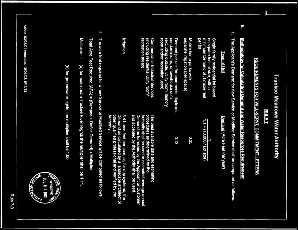
94
95
96
RRW Stonebrook, LLC Tentative Map Findings
 RRW Stonebrook, LLC Tentative Map Findings FINDING T1: The request conforms to the Master Plan and zoning ordinances. RELATIONSHIP TO THE MASTER PLAN 1. The respective development is located within an
The Estates at Marango Springs Master Plan Amendment & Regulatory Zone Amendment. Prepared by:
 The Estates at Marango Springs Master Plan Amendment & Regulatory Zone Amendment Prepared by: May 15, 2018 THE ESTATES AT MARANGO SPRINGS The Estates at Marango Springs MPA / RZA Prepared for: Dr. Harry
City Of Sparks Planning Commission Item
 Page 1 of 12 City Of Sparks Planning Commission Item Meeting Date: May17, 2012 Subject: PCN12009, Public Hearing, Consideration and possible action on a Master Plan Amendment and Rezoning request to change
Special Use Permit for Sun Valley Middle School
 Special Use Permit for Sun Valley Middle School June 15, 2017 Submitted in partnership with: 9222 Prototype Drive Reno, Nevada 89521 Tel. 775.827.6111 Fax 775.827.6122 www.lumosinc.com 1 SUN VALLEY MIDDLE
3.10 LAND USE SETTING PROJECT SITE EXISTING LAND USE DESIGNATIONS AND ZONING. General Plan Land Use Designations.
 This section of the Draft EIR addresses the existing land uses on and adjacent to the project site and discusses the potential impacts of the proposed project on existing land uses. Key issues addressed
RECREATION AND OPEN SPACE ELEMENT GOALS, OBJECTIVES, AND POLICIES
 RECREATION AND OPEN SPACE ELEMENT GOALS, OBJECTIVES, AND POLICIES Goal 7 To provide park facilities, recreation programs, and open space resources that are safe, adequate, and accessible to all City residents,
Baumgarten MPUD. Exhibit 3 Evaluation Criteria
 Pursuant to LDC subsections 10.02.13 B, 10.02.08 F and Chapter 3 G. of the Administrative Code, staff s analysis and recommendation to the Planning Commission, and the Planning Commission s recommendation
Information for File MVP MMJ; CSAH 10 Reconstruction (Waconia and Watertown Townships)
") Information for File MVP-2014-03830-MMJ; Reconstruction (Waconia and Watertown Townships) Applicant: Carver County Corps Contact: Melissa Jenny Address: 180 Fifth Street East, Suite 700, St. Paul, MN 55101
Information for File MVP-2014-03830-MMJ; Reconstruction (Waconia and Watertown Townships) Applicant: Carver County Corps Contact: Melissa Jenny Address: 180 Fifth Street East, Suite 700, St. Paul, MN 55101
COLVER ROAD INDUSTRIAL CONCEPT PLAN
 COLVER ROAD INDUSTRIAL CONCEPT PLAN A CONCEPTUAL LAND USE AND TRANSPORTATION PLAN FOR TA-4 AN URBAN RESERVE AREA OF THE CITY TALENT City of Talent Adopted by City Council Resolution No., June, 2015 PART
In November and December, SACOG staff conducted the following Blueprint Implementation land use activities:
 SACOG Board of Directors Item #18-1-16 Receive & File January 11, 2018 Blueprint Implementation Activities The purpose of this item is to regularly inform the Board of SACOG land use related activities
AWH REPORT OF THE PLANNING AND DEVELOPMENT DEPARTMENT FOR APPLICATION FOR REZONING ORDINANCE TO PLANNED UNIT DEVELOPMENT
 AWH REPORT OF THE PLANNING AND DEVELOPMENT DEPARTMENT FOR APPLICATION FOR REZONING ORDINANCE TO PLANNED UNIT DEVELOPMENT MAY 8, 2014 The Planning and Development Department hereby forwards to the Planning
CITY OF SPARKS, NV COMMUNITY SERVICES DEPARTMENT
 CITY OF SPARKS, NV COMMUNITY SERVICES DEPARTMENT To: From: Subject: Mayor and City Council Janet Stout, Administrative Secretary Report of Planning Commission Action PCN12028 Date: October 24, 2012 RE:
Secrest Short Cut and Monroe Expressway Small Area Plan AUGUST 29, 2018
 Secrest Short Cut and Monroe Expressway Small Area Plan AUGUST 29, 2018 Background and Process Monroe Expressway will be open by the end of 2018 Union County and Indian Trail identified a need to revisit
LAND USE AMENDMENT CORNERSTONE (WARD 3) 60 STREET NE AND COUNTRY HILLS BOULEVARD NE MAP 26NE BYLAW 22D2017
 60 STREET NE AND COUNTRY HILLS BOULEVARD NE MAP 26NE BYLAW 22D2017") Page 1 of 14 EXECUTIVE SUMMARY This Land Use Amendment application covers an area of 43.76 hectares ± (108.14 acres ±) located in northeast Calgary, bound by Country Hills Boulevard NE to the south and
Page 1 of 14 EXECUTIVE SUMMARY This Land Use Amendment application covers an area of 43.76 hectares ± (108.14 acres ±) located in northeast Calgary, bound by Country Hills Boulevard NE to the south and
PLANNING AND NATURAL RESOURCES COMMITTEE. Public Access Conceptual Design Alternatives for the Red Barn Area of La Honda Creek Open Space Preserve
 PLANNING AND NATURAL RESOURCES COMMITTEE R-17-56 May 9, 2017 AGENDA ITEM AGENDA ITEM 2 Public Access Conceptual Design Alternatives for the Red Barn Area of La Honda Creek Open Space Preserve GENERAL MANAGER
The Corporation of the Town of Milton
 Report To: From: Council Barbara Koopmans, Commissioner, Planning and Development Date: May 7, 2018 Report No: Subject: Making it Possible Positioning the Town s Strategy for Growth and Economic Development
Gold Line Bus Rapid Transit Transit Oriented Development (BRTOD) Helmo Station Area Plan
 Helmo Station Area Plan") Appendix F Gold Line Bus Rapid Transit Transit Oriented Development (BRTOD) Helmo Station Area Plan Introduction and Purpose of the Plan The Gold Line Bus Rapid Transit facility is an eleven-mile dedicated
Appendix F Gold Line Bus Rapid Transit Transit Oriented Development (BRTOD) Helmo Station Area Plan Introduction and Purpose of the Plan The Gold Line Bus Rapid Transit facility is an eleven-mile dedicated
EXHIBIT B PROJECT NARRATIVE POULSBO MEADOWS
 EXHIBIT B PROJECT NARRATIVE POULSBO MEADOWS Name of Project: Poulsbo Meadows; A Planned Residential Development (PRD)/Plat Applicants Name: PBH Group LLC/Byron Harris PO Box 1010 Silverdale, WA 98038 Description
DRAFT SCOPE FOR THE DRAFT ENVIRONMENTAL IMPACT STATEMENT FOR HUDSON HIGHLANDS RESERVE TOWN OF PHILIPSTOWN, NEW YORK June 5, 2018
 DRAFT SCOPE FOR THE DRAFT ENVIRONMENTAL IMPACT STATEMENT FOR HUDSON HIGHLANDS RESERVE TOWN OF PHILIPSTOWN, NEW YORK June 5, 2018 Project Name: Project Location SEQRA Classification of Project: Lead Agency:
Chapter Master Planned Communities (MPC) District
 District") Sections 14.53.010 Purpose and Intent 14.53.020 Applicability 14.53.030 Procedure 14.53.040 MPC Standards 14.53.050 Required Findings 14.53.010 Purpose and Intent Chapter 14.53 Master Planned Communities
Sections 14.53.010 Purpose and Intent 14.53.020 Applicability 14.53.030 Procedure 14.53.040 MPC Standards 14.53.050 Required Findings 14.53.010 Purpose and Intent Chapter 14.53 Master Planned Communities
JOINT PUBLIC NOTICE. 26 June United States Army Corps of Engineers State of Louisiana
 JOINT PUBLIC NOTICE 26 June 2017 United States Army Corps of Engineers State of Louisiana New Orleans District Department of Environmental Quality Regulatory Branch Office of Environmental Services 7400
6 Growth Management Challenges and Opportunities
 6 Growth Management Challenges and Opportunities The Town has established a goal of attaining a 50% participation rate with respect to employment opportunities versus residential population. The Town s
Application for Abandonment
 Application for Abandonment Of 6 th Street Alley Abandonment Prepared For: University Housing Group, Inc. 2770 Electric Road SW, Suite C Roanoke, VA 24018 Prepared By: KRATER CONSULTING Group A Nevada
OP Council Resolution June 16, Planning and Development Services
 OP-08-01 Council Resolution June 16, 2008 Planning and Development Services Kingsgate Landing Outline Plan Table of Contents 1.0 Introduction 1 1.1 Purpose of Plan 1 1.2 Plan Area Location 1 1.3 Ownership
Prado Ranch North Common Open Space Tentative Map. Washoe County Planning Commission July 3, 2018
 Prado Ranch North Common Open Space Tentative Map Washoe County Planning Commission July 3, 2018 Site Characteristics Intersection of Chickadee and Lemmon Drive ~1 mile north of Deodar/Lemmon Drive intersection
Note: Staff reports can be accessed at Zone: I-3. Tier:
 The Maryland-National Capital Park and Planning Commission Prince George s County Planning Department Development Review Division 301-952-3530 Note: Staff reports can be accessed at www.mncppc.org/pgco/planning/plan.htm.
EAST LAKE TARPON COMMUNITY OVERLAY
 EAST LAKE TARPON COMMUNITY OVERLAY East Lake Tarpon in Pinellas County Florida physical area is defined by the boundaries of the as shown in the map below and legal description in Appendix A. VISION: East
Mitchell Ranch South MPUD Application for Master Planned Unit Development Approval Project Narrative. Introduction
 Mitchell Ranch South MPUD Application for Master Planned Unit Development Approval Project Narrative Introduction Mitchell Ranch South is a proposed single family (detached) residential development on
Department of Community Development. Planning and Environmental Review Division Revised Notice of Preparation
 Department of Community Development Michael J. Penrose, Acting Director Divisions Building Permits & Inspection Code Enforcement County Engineering Economic Development & Marketing Planning & Environmental
Land Use element LAND USE POLICY AREAS ESTATE AND RURAL RESIDENTIAL AREAS/RURAL SHELDON AREA OLD TOWN ELK GROVE
 Land Use element Land Use is often considered the heart of the General Plan. The statement of future land uses describes how the City believes it should develop in the future where housing, shopping, open
SPECIFIC PLAN Requirements
 CITY OF LANCASTER PLANNING DEPARTMENT 44933 Fern Avenue, Lancaster, California 93534 (661) 723-6100 SPECIFIC PLAN Requirements Purpose The purpose of a specific plan is to provide for the logical development
Option 7A Alignment Map. 100-year Floodplain with or without Project
 1-year Floodplain with or without Project New 1-year Floodplain with Project 1-year Floodplain Removed with Project i.e., Benefitted Area) Option 7A Alignment increment P 37ft Corp., GEBCO, USGS,Town FAO,
Tucson Koi & Water Gardens
 OV113-031 Tucson Koi & Water Gardens CONDITIONAL USE PERMIT SITE ANALYSIS 05.22.2014 Property Owners Walter & Jane Wong Family Investments, LLP 5437 East 3rd Street Tucson, Arizona 85711 Tucson Koi and
Transportation Impact Study Technical Working Group (TISTWG) July 1, 2015 Meeting #10 1:30-3:30 PM Agenda
 July 1, 2015 Meeting #10 1:30-3:30 PM Agenda") Transportation Impact Study Technical Working Group (TISTWG) July 1, 2015 Meeting #10 1:30-3:30 PM Agenda 1) Final review and comment on Pro-Rata Share Approach 2) Summary and status of LATR Concepts moving
Transportation Impact Study Technical Working Group (TISTWG) July 1, 2015 Meeting #10 1:30-3:30 PM Agenda 1) Final review and comment on Pro-Rata Share Approach 2) Summary and status of LATR Concepts moving
General Location Annex, Rezone & Preliminary Plat Lansdowne Addition, Unit Three
 NEWFOUNDLAND I-5 Agricultural District Subject Site SUNDANCE ANDERSON Single Family Residential CHRISTY PUD Agricultural District Highway Business General Location Annex, Rezone & Preliminary Plat Lansdowne
Staff Report and Recommendation
 Community Planning and Development Planning Services 201 W. Colfax Ave., Dept. 205 Denver, CO 80202 p: 720.865.2915 f: 720.865.3052 www.denvergov.org/cpd TO: City Council Neighborhoods and Planning Committee
ARTICLE 6: Special and Planned Development Districts
 ARTICLE 6: Special and Planned Development Districts 6-10 Traditional Neighborhood Development (TND) District 6-10.10 Purpose and Intent The Traditional Neighborhood Development (TND) District provides
K. SMART ASSOCIATES LIMITED
 Planning Justification Report Zoning By-Law Amendment 185 King Street North Waterloo, Ontario April 7th, 2017 Project Reference Number 16-245 K. SMART ASSOCIATES LIMITED CONSULTING ENGINEERS AND PLANNERS
RECOMMENDATION REPORT
 DEPARTMENT OF CITY PLANNING RECOMMENDATION REPORT City Planning Commission Case No.: CPC-2012-1165-GPA-ZC Date: August 9, 2012 Time: After 8:30 AM Place: City Hall, Room 350 Public Hearing: Required CEQA
ARTICLE VI: SITE PLAN REVIEW
 Section 6.01 - Site Plan Review (All Districts) ARTICLE VI: SITE PLAN REVIEW Site plans give the Planning commission an opportunity to review development proposals in a concise and consistent manner. The
HAZARD MITIGATION GOALS AND OBJECTIVES
 SEWRPC Community Assistance Planning Report No. 282, 2nd Edition CITY OF MILWAUKEE ALL HAZARDS MITIGATION PLAN UPDATE Chapter IV HAZARD MITIGATION GOALS AND OBJECTIVES [NOTE: Throughout this plan update
City of Pittsburg: Billboard Corridor Study
 City of Pittsburg: Billboard Corridor Study Prepared for: City of Pittsburg Economic Development Department 65 Civic Avenue Pittsburg, California 94565-3814 Prepared by: Stantec Consulting Services Inc.
CONCEPTUAL DEVELOPMENT PLAN REVIEW - CITY OF MARYLAND HEIGHTS
 APPLICATION NUMBER: CDP15-0004 APPLICATION (PROJECT) NAME: MARYLAND OAKS APPLICANT: PROPERTY OWNER NAME: APPLICANT S REQUEST: McBride Maryland Oaks, LLC 16091 Swingley Ridge Road, Suite 300 Chesterfield,
November 2, 2015 at 5:15pm City Council Chambers, 3rd Floor, City Hall, 1737 Main Street Columbia, South Carolina 29201
 Subject Property: PLANNING COMMISSION SITE/SUBDIVISION PLAN CASE SUMMARY 10.21 ACRES, WESTSIDE OF CLIF KINDER BOULEVARD COTTAGES AT BURNSIDE FARM BURNSIDE FARMS ASSOCIATES, LLC November 2, 2015 at 5:15pm
PLANNING COMMISSION. Submitted
 PLANNING COMMISSION City Hall 1275 Main Street El Centro, CA 92243 Submitted PLANNING COMMISSION ACTION ITEM (1844) Meeting: 05/10/16 12:00 AM Department: Community Development Category: Public Hearing
Dwelling Units Max 12 dwelling units per acre/min 8 dwelling units per acre. Development Mix 80% non residential/20% residential
 13. OSTEEN LOCAL PLAN Background: The Osteen Local Plan area is located in southwest Volusia County along the SR 415 corridor between Lemon Bluff Road and Acorn Lake Road and includes 3,990 acres. The
ADMINISTRATION RECOMMENDATION 2016 November 03. That Calgary Planning Commission recommends APPROVAL of the proposed Land Use Amendment.
 Page 1 of 12 EXECUTIVE SUMMARY This Land Use Amendment application covers an area of 75.76 hectares ± (187.20 acres ±) located in northeast Calgary, bound by Stoney Trail NE to the north, 128 Avenue NE
6 PORT SYDNEY SETTLEMENT AREA
 Section 6 Port Sydney Page 61 6 PORT SYDNEY SETTLEMENT AREA 6.1 Basis and Principles Village of Port Sydney Waterfront Community Existing Services 6.1.1 Port Sydney is an historic settlement that has developed
178 Carruthers Properties Inc.
 178 Carruthers Properties Inc. Planning Rationale for 178 Carruthers Avenue Site Plan Control Application June 2014 Table of Contents 1.0 Introduction 2.0 Overview of Subject Property 3.0 Current Zoning
KEIZER STATION PLAN INTRODUCTION
 KEIZER STATION PLAN INTRODUCTION Planning for this area began in 1987 when the Keizer Comprehensive Plan established the Chemawa Activity Center and McNary Activity Center. The first Chemawa Activity Center
7.0 SOCIAL, ECONOMIC, AND ENVIRONMENTAL ISSUES
 7.0 SOCIAL, ECONOMIC, AND ENVIRONMENTAL ISSUES The following list of social, economic, and environmental issues have been identified based on a preliminary inventory of resources in the project area, an
Applicant Name Phone / Fax / Address City State Zip Code . Property Owner Phone / Fax / Address City State Zip Code
 Master Development Plan Application Community Development Department City of Redmond 411 SW 9 th Street Redmond, Oregon 97756 541-923-7721 541-548-0706 FAX Master Development Plan Fee $38,862.52 File Number
2.0 PROJECT DESCRIPTION
 Brunswick Street Apartment Project SCEA Project Description 2.0 PROJECT DESCRIPTION 2.1 PROJECT LOCATION The proposed project is located in Daly City, San Mateo County, California (Figure 2.0-1). The project
Land Use Element. policy areas are discussed in this Element:
 Land Use Element Land Use is often considered the heart of the General Plan. The statement of future land uses describes how the City believes it should develop in the future where housing, shopping, open
Planning Commission Staff Report March 15, 2007
 Planning Commission Staff Report Project: Request: Madeira East Tentative Subdivision Map, Design Review for Subdivision Layout & Abandonment of Easements Location: Phase IV of the Laguna Ridge Specific
Information for File # MHK
 Information for File #2014-03555-MHK Applicant: Corps Contact: Wimmer Communities Marie Kopka Address: 250 N. Sunnyslope Road, Suite 296 Brookfield, Wisconsin 53005 E-Mail: Marie.H.Kopka@usace.army.mil
Planning Commission Staff Report June 5, 2008
 Owner/Applicant Taylor Village Sacramento Investments Partners, LP c/o Kim Whitney 1792 Tribute Road #270 Sacramento, CA 95815 Staff Recommendation Planning Commission Staff Report Project: File: Request:
APPENDIX C SPECIAL PLANNING AREAS
 SPECIAL PLANNING AREAS There are five Special Planning Areas (SPAs) on the Land Use Diagram (Figure LU-2). The SPAs are areas with significant new growth potential that require more detailed subsequent
SAN RAFAEL GENERAL PLAN 2040 INTRODUCTION AND OVERVIEW
 SAN RAFAEL GENERAL PLAN 2040 INTRODUCTION AND OVERVIEW Steering Committee Presentation February 14, 2018 Purpose of General Plan Guide land use and development decisions Coordinate transportation, infrastructure,
ARTICLE 17 SITE PLAN REVIEW
 ARTICLE 17 SITE PLAN REVIEW 17.01 INTENT AND PURPOSE The intent of this section is to provide for consultation and cooperation between the applicant and the township planning commission so that the applicant
Prepared by: Casey Kempenaar, Senior Planner
 CITY OF CITRUS HEIGHTS PLANNING DIVISION STAFF REPORT PLANNING COMMISSION MEETING September 13, 2017 Prepared by: Casey Kempenaar, Senior Planner REQUEST The applicant requests a Design Review Permit Modification
5 TOWN OF MARKHAM OFFICIAL PLAN AMENDMENT NO. 144 MILLIKEN MAIN STREET SECONDARY PLAN
 5 TOWN OF MARKHAM OFFICIAL PLAN AMENDMENT NO. 144 MILLIKEN MAIN STREET SECONDARY PLAN The Planning and Economic Development Committee recommends the following: 1. The communication from Brendan O Callaghan,
Report on Site Selection SR-0188 SR-0176 SR-0319 SR-0819 SR-0818 SR-0817 SR-0816 SR-0576 SR-0813 SR-0225 SR-0293 SR-0811 SR-0810 SR-0865
 EB81Gi SR-188 SR-176 SR-319 SR-819 SR-818 SR-817 SR-576 SR-816 SR-225 SR-813 SR-293 SR-81 SR-811 SR-865 Report on Site Selection. EFDC-S2-1-Rev1 Date: September 216 Scale: 1:12,5 @A3 Content Source: Esri,
Glenborough at Easton Land Use Master Plan
 Implementation 114 9.0 IMPLEMENTATION 9.1 OVERVIEW This chapter summarizes the administrative procedures necessary to implement the proposed land use plan, infrastructure improvements, development standards,
East Panorama Ridge Concept Plan Amendment
 Page 1 of 7 L003 : East Panorama Ridge Concept Plan Amendment Corporate NO: L003 Report COUNCIL DATE: March 4, 2002 REGULAR COUNCIL LAND USE TO: Mayor & Council DATE: February 27, 2002 FROM: General Manager,
Major Subdivision Sketch Plan Checklist
 This checklist provides specific requirements that are apart of the Sketch process. The entire process is described by the Huntersville Subdivision Review Process which details all the submittal and resubmittal
Appendix E Preliminary Location Hydraulic Study
 Appendix E Prepared for: State of Alaska Department of Transportation and Public Facilities Prepared by: HDR Alaska, Inc. 2525 C Street, Suite 305 Anchorage, Alaska 99503 February 2014 This page intentionally
Chapter 10 IMPLEMENTATION RECOMMENDATIONS
 Chapter 10 IMPLEMENTATION RECOMMENDATIONS The recommended land use plan presented in the previous chapter provides a design for the attainment of the urban and rural development and open space preservation
LAND USE DESIGNATIONS AND ZONING CLASSIFICATIONS
 LAND USE DESIGNATIONS AND ZONING CLASSIFICATIONS One of the most significant issues addressed within the community plan process is land use. How land is utilized within a community directly affects the
Drexel, Barrell & Co.
 Drexel, Barrell & Co. December 21, 2018 Engineers/Surveyors Boulder Colorado Springs Greeley 3 South 7 th Street Colorado Springs, Colorado 80905-1501 719 260-0887 719 260-8352 Fax El Paso County Planning
City of Grande Prairie Development Services Department
 City of Grande Prairie Development Services Department ROYAL OAKS NORTH OUTLINE PLAN OP-07-03 NW 35-71-6 W6M May 7, 2007 Royal Oaks North Outline Plan TABLE OF CONTENTS 1.0 INTRODUCTION........ 3 1.1 Purpose
City of Heath. Town Center Concept
 In the give-and-take of getting projects designed, financed, and approved, the famous refrain from the film Field of Dreams is heard often: if you build it, they will come. From the perspective of the
Planning & Zoning Commission Staff Report
 Planning & Zoning Commission Staff Report Meeting Date: May 26, 2015 Drafted by: Katherine Harrison-Rogers CASE # Z2886 PROJECT NAME: APPLICANT/ REPRESENTATIVE: Shawna Runyan PROPERTY OWNER: 1840 (previously
IMPLEMENTING SOMERSET COUNTY S INVESTMENT FRAMEWORK
 IMPLEMENTING SOMERSET COUNTY S INVESTMENT FRAMEWORK SMART CONSERVATION THROUGH SMART GROWTH NJ LAND CONSERVATION RALLY March 22, 2014 Laurette Kratina, PP, AICP, Supervising Planner Somerset County Planning
Rapid City Planning Commission Rezoning Project Report
 Rapid City Planning Commission Rezoning Project Report April 5, 2018 Item # 4 Applicant Request(s) Case # 18RZ008 Rezoning request from General Agricultural District to Low Density Residential District
1934 Commerce Lane Suite 1 Jupiter, Florida Ph Fax Lic # LC-C ATTACHMENT G.
 Landscape Architects I Land Planners I Environmental Consultants 1934 Commerce Lane Suite 1 Jupiter, Florida 33458 Ph 561.747.6336 Fax 561.747.1377 www.cotleurhearing.com Lic # LC-C000239 ATTACHMENT G
CITY OF VACAVILLE PLANNING COMMISSION Item No. 8.A STAFF REPORT July 18, 2016 STAFF CONTACT: Amy Feagans, Contract Planner (707)
") CITY OF VACAVILLE PLANNING COMMISSION Item No. 8.A STAFF REPORT July 18, 2016 STAFF CONTACT: Amy Feagans, Contract Planner (707) 449-5140 TITLE: THE FARM AT ALAMO CREEK ENVIRONMENTAL IMPACT REPORT (EIR)
CITY OF VACAVILLE PLANNING COMMISSION Item No. 8.A STAFF REPORT July 18, 2016 STAFF CONTACT: Amy Feagans, Contract Planner (707) 449-5140 TITLE: THE FARM AT ALAMO CREEK ENVIRONMENTAL IMPACT REPORT (EIR)
STAFF REPORT FOR STANDARD COASTAL DEVELOPMENT PERMIT #CDP FEBRUARY 26, 2015 CPA - 1 PO BOX 238 APTOS, CA 94001
 STAFF REPORT FOR STANDARD COASTAL DEVELOPMENT PERMIT #CDP 2014-0030 FEBRUARY 26, 2015 CPA - 1 OWNER/APPLICANT: AGENT: REQUEST: HANS HEIM PO BOX 238 APTOS, CA 94001 JAMES HAY PO BOX 762 MENDOCINO, CA 95460
KANATA CENTRUM 255 KANATA AVENUE OFFICIAL PLAN AMENDMENT ZONING BY-LAW AMENDMENT
 KANATA CENTRUM 255 KANATA AVENUE OFFICIAL PLAN AMENDMENT ZONING BY-LAW AMENDMENT JUNE 2015 PREPARED BY: FOTENN Consultants Inc. 223 Mcleod Street Ottawa, ON K2P OZ8 (613) 730-5709 PREPARED FOR: Kanata
CHAPTER 2 SUMMARY 1. PROJECT SUMMARY DATA
 CHAPTER 2 SUMMARY This is an Initial Study format used to determine, pursuant to CEQA Guidelines Section 15177, whether a project 1) is within the scope of a Master EIR (MEIR), 2) may result in additional
LAND USE MEADOWS PLANNING AREA
 LAND USE MEADOWS PLANNING AREA I. Profile of Meadows Planning Area A. Location Meadows Planning Area is delineated by I-5 on the north, the Nisqually Bluffs representing the growth boundary on the east,
CHUGIAK-EAGLE RIVER SITE-SPECIFIC LAND USE PLAN
 CHUGIAK-EAGLE RIVER SITE-SPECIFIC LAND USE PLAN JUNE 2010 Final Prepared for The Heritage Land Bank, Municipality of Anchorage by Agnew: :Beck Consulting www.agnewbeck.com 907.222.5424 Chugiak-Eagle River
Appendix C: Interim Mixed-Use Evaluation Criteria
 Appendix C: Interim Mixed-Use Evaluation Criteria C-1 Appendix C: Interim Mixed-Use Evaluation Criteria PURPOSE: The implementation of numerous policies contained within the Master Plan hinges on the creation
The West Vaughan Employment Area Secondary Plan Policies
 Part 2: The West Vaughan Employment Area Secondary Plan Policies 2.1 General Policies It is the policy of Council: 2.1.1. That the West Vaughan Employment Area (the WVEA), identified on Schedule 1, will
EXHIBIT A. Tax Increment Reinvestment Zone No. 1 (Town Center) First Amended Project Plan 1
 First Amended Project Plan 1") EXHIBIT A Tax Increment Reinvestment Zone No. 1 (Town Center) First Amended Project Plan 1 1 As amended by Resolution No. 2008-02-001(TR1R) of the Tax Increment Reinvestment Zone No.1, and approved to
EXHIBIT A Tax Increment Reinvestment Zone No. 1 (Town Center) First Amended Project Plan 1 1 As amended by Resolution No. 2008-02-001(TR1R) of the Tax Increment Reinvestment Zone No.1, and approved to
Venice Pumping Plant Dual Force Main Project Draft EIR
 City of Los Angeles 5.9 LAND USE PLANS 5.9.1 Environmental Setting Venice Pumping Plant Dual Force Main Project Draft EIR The Project lies within the bounds of Los Angeles County and the City of Los Angeles.
Asbury Chapel Subdivision Sketch Plan
 Asbury Chapel Subdivision Sketch Plan PART 1: PROJECT SUMMARY Applicant: NVR Inc. Project Size: +/- 76.13 acres Parcel Numbers: 02101112,02116101,02116112, 02116113 Current Zoning: Transitional Residential
water resource specialists
 Vaughn Collins, PE, CFM, Northwest Hydraulic Consultants Brad Livingston, Oregon Department of Transportation Melissa Reich, North Coast Land Conservancy Location Necanicum River 75 sq mi watershed Active
SECTION 4(f) DE MINIMIS DOCUMENTATION
 DE MINIMIS DOCUMENTATION") SECTION 4(f) DE MINIMIS DOCUMENTATION Illinois Route 60/83 IL 176 to the intersection of IL 60 (Townline Road) Lake County P-91-084-07 Mundelein Park and Recreation District Project Limit SECTION 4(f)
SECTION 4(f) DE MINIMIS DOCUMENTATION Illinois Route 60/83 IL 176 to the intersection of IL 60 (Townline Road) Lake County P-91-084-07 Mundelein Park and Recreation District Project Limit SECTION 4(f)
Authority of the General Plan
 Authority of the General Plan This La Habra Heights General Plan will serve as the blueprint for future planning and development in the City. This General Plan describes the City s vision for the future
SHEFFIELD PARK Paulding County, GA DRI #588
 SHEFFIELD PARK Paulding County, GA DRI #588 Supplemental Information for RDC s DRI (Form 2) Review August 16, 2004 Prepared for: Mr. David Howerin Coosa Valley RDC 1 Jackson Hill Drive Rome, GA 30161 P.O.
Living in Albemarle County s Urban Places
 Living in Albemarle County s Urban Places ALBEMARLE COUNTY, VIRGINIA A Closer Look at Albemarle s Approach to Managing Growth and Creating Quality Urban Environments www.albemarle.org Page 2 Living in
CHAPTER 7: Transportation, Mobility and Circulation
 AGLE AREA COMMUNITY Plan CHAPTER 7 CHAPTER 7: Transportation, Mobility and Circulation Transportation, Mobility and Circulation The purpose of the Transportation, Mobility and Circulation Chapter is to
6. Consistency with Local Plans
 6. Consistency with Local Plans 6.1. Chapter Overview 6.1.1. Introduction This section presents the goals, objectives and policies of municipal, county and state planning entities, as well as known development/redevelopment
The Corporation of the TOWN OF MILTON
 Report to: From: Chair & Members of the Administration & Planning Standing Committee W.F. Mann, Director of Planning and Development Date: April 16, 2012 PD 022-12 (Z19/11) Subject: Technical Report Proposed
.404 acres (approximately 17,600 square feet) Existing Zoning
 Existing Zoning") COMMUNITY DEVELOPMENT DEPARTMENT Planning and Zoning Division 1725 Reynolds Street, Suite 200, Brunswick, GA 31520 Phone: 912-554-7428/Fax: 1-888-252-3726 BOARD OF COMMISSIONERS STAFF REPORT October 25,
COMMUNITY DEVELOPMENT DEPARTMENT Planning and Zoning Division 1725 Reynolds Street, Suite 200, Brunswick, GA 31520 Phone: 912-554-7428/Fax: 1-888-252-3726 BOARD OF COMMISSIONERS STAFF REPORT October 25,
Drexel, Barrell & Co.
 Drexel, Barrell & Co. June 18, 2018 Engineers/Surveyors Boulder Colorado Springs Greeley 3 South 7 th Street Colorado Springs, Colorado 80905-1501 719 260-0887 719 260-8352 Fax El Paso County Planning
PLANNING COMMISSION. Agenda Item # 3.
 PLANNING COMMISSION Agenda Item # 3. CASE SUMMARY Conditional District Rezoning Planning Commission February 4, 2015 CD-9-215 Jeff Walton, 341-3260, jeff.walton@wilmingtonnc.gov Staff recommendation CONDITIONAL
Mark-up of the effect of the proposed Bronte Village Growth Area OPA No.18 on the text of section 24, Bronte Village, of the Livable Oakville Plan
 Mark-up of the effect of the proposed Bronte Village Growth Area OPA No.18 on the text of section 24, Bronte Village, of the Livable Oakville Plan Notes: This document is provided for information purposes
Future Land Use and Transportation
 Planning & Zoning Board Workshop Comprehensive Plan for Village of Estero Future Land Use and Transportation April 6, 2017 January Kick-off Meeting Public Input What do you like about Estero? Location