FORMATION OF THE PLAN
|
|
|
- Lorin Scott
- 6 years ago
- Views:
Transcription


1 The Intracoastal Waterway Plan for Palm Beach County grew out of months of due diligence review by the project steering committee, which led to a seven-day public planning charrette conducted in May More than 150 participants from all walks of life were engaged in a full-day public input session, followed by a week-long studio on-site. Additional public input was gathered during the studio, which was open to the public daily from 9 AM until 9 PM. The multidisciplinary charrette team was comprised of architects, engineers, planners, economists, designers, and others, who combined efforts to develop the vision, strategies, and recommendations contained in the Plan. At the conclusion of the week, a presentation of work in progress was conducted, with residents, property and business owners, elected officials, agency and local government staff, and others in attendance. Public input continued throughout the development of the Plan. 7


2 The Initiation of the Plan Concept The idea of an Intracoastal Waterway Plan for Palm Beach County emerged through the development of Palm Beach County s 21st Century Strategic Economic Development Plan, which was adopted in March The Strategic Economic Development Plan is the guiding document by which the County capitalized on environmental and cultural assets to drive their regional economies. They have done so by linking cultural facilities such as botanical gardens, museums, and zoos to easy and friendly transportation modalities that include trails, ferries, and water taxis. Such a system is feasible for PBC s downtown venues along the Intracoastal Waterway. In addition, PBC s working waterfront has created strong value adjacent to the Port of Palm Beach through proposals such as the construction of mega yacht slips, racing sloop repair facilities, marina docks, day trip gambling, the Lockheed Undersea Research plant, and environmental attractions such as Peanut Island. Towards the goal of an Intracoastal Waterway Plan, the Palm Beach MPO initiated a public planning process that began in The Palm Beach MPO is responsible for integrating all modes of transportation planning and programming, including water-based transportation as well as economics, environmental sustainability, and quality of life enhancement. Palm Beach County s Strategic Economic Development Plan hopes to achieve a number of significant objectives, such as effectively reinforcing its tax base, generating revenues with minimal increase in public services, building a global entrepreneurial climate, enhancing and accenting the natural and built environment, highlighting arts and culture, and generating smart transportation and land uses. The Intracoastal Waterway Plan is a signature project within the Quality of Place strategic direction of the County s Plan. The Quality of Place strategic direction seeks to leverage the quality of the County s arts and cultural cluster as a strategic asset to support economic growth and provide a competitive advantage. The following quote is taken from Palm Beach County s Plan. Palm Beach County has an opportunity to capitalize on its 43- mile stretch of the Intracoastal Waterway by creating a regional economic strategy that builds on its unique environmental assets. Examples abound throughout the world where cities have Derived from the Safe, Accountable, Flexible, Efficient Transportation Equity Act: A Legacy for Users (SAFETEA-LU), the MPO operates with a broad set of planning factors as noted above from the agency s website. The navigational, operational, environmental, and planning characteristics of the Intracoastal Waterway are also directly overseen by the Florida Inland Navigational District (FIND), a special taxing district responsible for the continued management and maintenance of the waterway in Florida. Thus, the Palm Beach MPO and FIND partnered to enable this planning effort. The TCRPC was requested to organize and facilitate the process, which began with the formation of a multi-disciplinary, multi-agency steering committee, including the following: 8

3 Gary Hines, Business Development Board Kevin Johns, Palm Beach County Economic Development Office Jim Murley, Florida Atlantic University/ CUES David Roach, Florida Inland Navigational District Rob Robbins, Palm Beach County Environmental Resources Management Jamie Titcomb, Palm Beach County League of Cities Randy Whitfield, Palm Beach Metropolitan Planning Organization Headquartered in Palm Beach County, the Florida Inland Navigational District is responsible for the continued maintenance of the Atlantic Intracoastal Waterway in Florida through the twelve east-coast counties that comprise its district. The steering committee conducted extensive due diligence to better understand the range of issues relevant to the Intracoastal. Local governments, redevelopment authorities, public agencies, and nonprofit organizations educated the steering committee regarding various projects and programs related to the waterway. The committee also reviewed waterway plans from other parts of the nation and world. Through this background review, the steering committee determined the key areas for which additional technical insight would be necessary for plan development. The steering committee also FORMATION OF THE PLAN acknowledged the broad approach that would be necessary for the plan to be successful, expanding the scope to cover economics, transportation, and land use as well as natural systems, eco-tourism, recreation, and public access. Ultimately, the committee recommended a planning charrette be conducted to gain public input and enable a multi-disciplinary process to develop the Intracoastal Waterway Plan. The Process The Intracoastal Waterway Plan for Palm Beach County grew out of months of due diligence, background review, and ultimately, a public, seven-day planning charrette held from May 9 15, This Waterway Plan represents the citizens' vision and goals for the future of the Intracoastal, both with regards to activities on the waterway as well as those occurring on its upland. The charrette was held at Palm Beach Atlantic University in West Palm Beach and was well attended by a diverse cross-section of the community including residents, property owners, local business representatives, local governments, agencies, and various organizations. The charrette focused on the Intracoastal Waterway as well as the areas (both in-water and upland) located within a halfmile east and west of the channel centerline. Key issues addressed included public access, natural systems, transportation, land use, recreation and ecotourism, and the economics of the waterway. The project team for the development of the ICW Plan included the Treasure Coast Regional Planning Council (TCRPC) staff (Michael Busha, Marlene Brunot, Zachary Davis, Kim DeLaney, Wynsum Hatton, Michelle Hipps, Dana Little, Peter Merritt, and Greg Vaday) and a team of professionals that included Cambridge Systematics (Michael Williamson), Economic Research Associates (Tom Lavash and Alyssa Cohen), the Center for Urban and Environmental Solutions at Florida Atlantic University (Jim Murley), and urban designers Marcela Camblor, Daniel M. Cary, Steven Fett, and Jose Venegas. 9


4 At the end of the charrette week, a presentation of Work-in-Progress was held on Thursday, May 15, Residents, property and business owners, local government and agency staff, and elected officials were present. Since that presentation, work has continued following the initial public workshop. A series of final presentations by TCRPC staff were held during 2009 where additional agency, citizen, and professional input was gathered for the completion of the Intracoastal Waterway Plan. The Study Area: Existing Conditions The Intracoastal Waterway in Palm Beach County travels a nearly 43-mile north/south corridor through the eastern edge of the County. Initially developed by interconnecting natural lakes and lagoons, today s waterway is physically separated from the Atlantic Ocean by a series of barrier islands, with the During the public input session, participants were provided background information about the waterway s formation, conditions, and on-going plans and projects. The team assisted the citizens in studying the many challenges faced by the community and proposed specific solutions. The design team also relied heavily on input from various public agencies, including the Palm Beach MPO, Palm Beach County (particularly the Office of Economic Development and Departments of Environmental Resource Management and Parks and Recreation), local governments, and others. During the week of the charrette, the design team arranged an open working studio at Palm Beach Atlantic University where the doors remained open to the public all week. Residents, business owners, agency representatives, and others regularly visited the studio and made useful comments and suggestions regarding the work in progress. The primary public input session for the ICW Plan was held on May 8, 2008 at Palm Beach Atlantic College. 10


 includes approximately 110,000 residents, or just below 10%.")
5 interruption of four inlets cut through the land barrier that create saltwater feeds. To the west, the waterway is bound by uplands with the interruption of man-made canals designed for flood control, which introduce freshwater to the waterway. The Lake Worth Lagoon, Indian River Lagoon, and Loxahatchee River encompass the Intracoastal channel within their natural systems. The uplands on both sides of the Intracoastal include a wide range of land uses, from preservation areas, parks, and recreational facilities to residential neighborhoods and mixed-use downtowns to marine industrial uses and the Port of Palm Beach. To enable a comprehensive analysis of the Intracoastal Waterway, the steering committee recommended a study area which extended east and west a half-mile from the centerline of the Intracoastal. A map of this area is included in this chapter. The eastern portion of Palm Beach County contains its highest population densities and commercial intensity. Accordingly, the roughly 43 square mile study area (less than 2% of the County s land area) includes approximately 110,000 residents, or just below 10%. Of the 23 municipalities that abut the Intracoastal, seven maintain well-developed mixeduse downtowns that embrace the waterway, and the Port of Palm Beach is located directly on the water. The majority of private lands consist of mostly higher-valued residential development followed by More than 120 participants attended the primary public session, with dozens more visiting the studio to provide additional public input during the week. 11

6 The ICW Study Area highlighted in yellow and green. The northern and southen ends of the study area are denoted by the orange lines. 12
.")


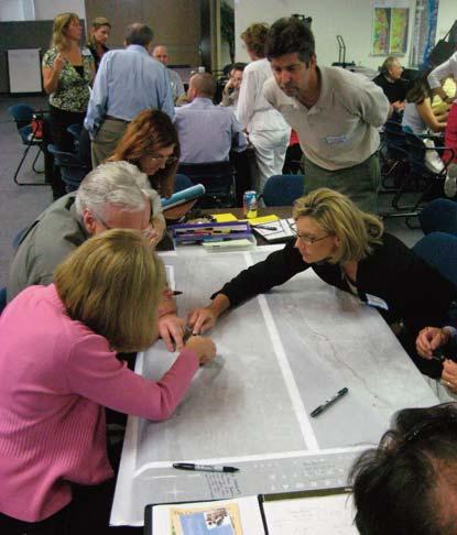
7 commercial use, and a variety of public uses (e.g., conservation, recreation, open space). Land values along the Intracoastal have continued to escalate over time, with continued pressure for mostly residential development until the market s recent downturn. Rising land values combined with escalating property taxes have caused considerable conversion of commercial and industrial properties to residential, causing a loss of working waterfronts in Palm Beach County and throughout the state. Two factors provide a respite from these historic pressures, including the current real estate market and Florida s recent adoption of Amendment 2 to provide property tax relief for marine industrial uses or working waterfronts. While Palm Beach County FORMATION OF THE PLAN has adopted policies to discourage additional conversion of marine industrial lands via no net loss provisions, there remain 23 municipal governments with individual land use control over these waterfront properties. Participants Requests From May 9th through May 15th, the public, municipalities, and public agencies participated in a seven-day charrette process. The initial Charrette participants sharing their tables ideas. 13


8 public workshop and susequent design sessions attracted more than 150 people. Participants discussed their ideas at tables facilitated by charrette team members and literally drew suggestions on study area maps at each table. At the end of the drawing session, a representative from each table presented their table s ideas. A sample listing of the main ideas generated in the public session includes the following: increase public access to the water via parks, bridges, and river walks restore spoil islands and habitat areas and allow camping and public access construct more public fishing piers and river Charrette participants sharing their tables ideas. walks explore water taxi programs to interconnect marine destinations clean and enhance canals, especially the C-51 Canal add more canoe/kayak launch sites in ICW and portages in canal spillways connect natural areas to each other improve upland and water transit access waterway and marine destinations create a county-wide water taxi system with different kinds of taxi stops make boat ramps more efficient with staging docks and day docks expand waterway destinations, e.g., day docks, 14
 utilize bridge replacement to")
 promote rebuilding of")
9 Charrette participants drawings from the Friday public session. spoil islands, restaurants remove derelict boats and clean waterway and explore mooring fields support marine industries with incentives and dredging ( Megayacht Mile ) utilize bridge replacement to increase public access and fishing opportunities maintain clear views to the water encourage use of green buildings, sustainable development practices, and renewable resources expand educational programs about natural resources, history, and hydrology support marina villages and other marine destinations (e.g., Jupiter s Riverwalk, proposed Lake Worth marina village) promote rebuilding of natural shoreline or plantings along existing sea walls Progress Presentation was held May 15 at Palm Beach Atlantic University where the team gathered more input. This Intracoastal Waterway Plan represents the collection, evaluation, and recommendations related to the ideas set forth during this process and the presentations that followed in The. A series of presentations will be conducted by TCRPC in 2009 to gather additional input and further refine the recommendations of this plan. Ultimately, the plan will be completed for adoption in Accordingly, this ICW represents the participants vision for the Intracoastal Waterway. After the initial public workshop, the charrette team investigated and tested ideas. The public visited the studio and offered additional input. The Work-in- 15


10 Charrette participants drawings from the Friday public session. 16


11 Charrette participants drawings from the Friday public session Charrette participants working on their drawings. 17


12 Regulatory Framework and Overview Development adjacent to the Waterway is subject to a broad range of plans and regulations originating at all levels of government. In the United States, unlike many countries that have parliamentary forms of government, our federal system of government allows for overlapping regulations by different levels of government. In the development of this plan, a regulatory review was conducted of the nearly forty regulatory, planning, and technical documents related to the ICW in Palm Beach County as well as the 23 local government comprehensive plans. A matrix listing these planning, regulatory, and other documents is included in the Appendix. regulate development on and along the ICW in Palm Beach County. For the individual projects identified in this ICW Plan, references have been noted where applicable regarding regulatory implications for their implementation. As noted in Chapter 10: Implementation, this plan recommends creation of a Palm Beach County Intracoastal Waterway Commission to assist and oversee implementation of the plan, including management and marketing of the Waterway as well as advocacy of the plan. This entity would also be envisioned to shepherd multi-jurisdictional projects through the various regulatory processes, with the comprehensive and broad vision detailed in this ICW report. The regulatory framewrok requires that individual projects be reviewed independently for project-related impacts, and in some cases, how the project impacts will cumulatively impact protected resources. Experience in other areas indicates that an overall plan for the entire Intracoastal Waterway in Palm Beach County may expedite the review and approval of individual projects by demonstrating cumulative impacts and also providing for coordinated mitigation of project level impacts. New development or redevelopment adjacent to the Waterway must demonstrate plan consistency and regulatory compliance with each relevant, binding authority at all levels of government. While arguably duplicative and inefficient, this intergovernmental review is inherent in our form of government that relies on federalism and home rule. This entire process can be further complicated by the intervention of third-party entities who disagree with the final agency decisions and have legal standing to bring administrative and judicial review of those decisions. These reviews can lead to delay and extra expense to proposed development projects adjacent to the Waterway. The development of this conceptual plan considers the various planning, regulatory, and programmatic plans of the various agencies that govern or otherwise 18

13 Review of Comparable Waterway Plans As part of the due diligence leading to the charrette, a review of waterway plans from around the United States and internationally was conducted to identify programs and practices of relevance. Across the globe and throughout the United States, governmental and private entities are collaborating to restore existing development and facilitate new development adjacent to navigable waterways, both natural and man-made. A summary matrix listing the various plans is included in the Appendix. In Europe and Great Britain, historic shipping canals have been rejuvenated by these new partnerships. The River Thames Waterway Plan provides a good example of an historic waterway that is maintained by commercial shipping and provides amenities and access to billion dollar new developments along its reach. Typical of advanced efforts to undertake multiple purpose activities, the Thames Plan puts a premium on sustainability of its waterway, such that it is usable, accessible, and productive for future generations. The Thames Plan anticipates increased population along the waterway and focuses on improving the environmental quality of the waterway as new development and new infrastructure comes on line. The British waterway initiatives are linked to their neighbors in the European Union (EU) through programs such as the Canal-Link Project in The North Sea. This effort pays special attention to the connections between the different waterways adjacent to the North Sea, seeking ways to create economic opportunities for tourism and recreation. In Europe, the EU has issued a comprehensive development plan for its member nations by setting positive incentives and breaking barriers in an effort to develop the inland waterways by linking them to land-based intermodal systems. These linkages are aimed at relieving traffic congestion and mastering energy use for sustainable development options. In the United States, there is growing interest in returning to the full, comprehensive use of our historic waterways to enhance our economies and individual communities. The Eire Canal National Heritage Corridor builds on enhancing the historic heritage of the historic communities that grew up along the canal. The Trinity River Corridor Project strives to connect the metropolitan Dallas by making the Trinity River part of the front yard of the communities adjacent to the river. River redevelopment plans have been prepared for the New River in Fort Lauderdale and the Miami River in Miami as well. Lessons learned from these international and national efforts can be summarized as follows: The plans strive to be sustainable over a long planning period (up to 50 years). The plans draw on the existing cultural and historic values inherent to the waterways. The plans view waterways as a mode of transportation serving adjacent developed areas. The plan maintain and enhance important environmental values existing within the waterways. The plans are important parts of integrated, economic development strategies that rely on government and private entities to closely collaborate towards agreed upon goals. These broad themes were acknowledged as applicable in the development of this ICW report. 19


14 20
DISCUSSION TOPIC: ST JOHNS RIVER & ITS TRIBUTARIES (BPII) 2030 COMPREHENSIVE PLAN POLICES AND REGULATORY FRAMEWORK
 2030 COMPREHENSIVE PLAN POLICES AND REGULATORY FRAMEWORK") DISCUSSION TOPIC: ST JOHNS RIVER & ITS TRIBUTARIES (BPII) 2030 COMPREHENSIVE PLAN POLICES AND REGULATORY FRAMEWORK St. John s River & Its Tributaries Issue Summary: The St. Johns River is an important
DISCUSSION TOPIC: ST JOHNS RIVER & ITS TRIBUTARIES (BPII) 2030 COMPREHENSIVE PLAN POLICES AND REGULATORY FRAMEWORK St. John s River & Its Tributaries Issue Summary: The St. Johns River is an important
{Best Practices. Summary of Tools, Strategies and Best Practices from 11 Michigan Case Study Communities
 Case Studies Michigan Coastal Community Working Waterfronts { Summary of Tools, Strategies and from 11 Michigan Case Study Communities Table of Contents Zoning...2 Community and Stakeholder Collaboration
CHAPTER 1 Introduction
 CHAPTER 1 Introduction From sea to summit, Lane County covers almost 4,800 square miles of diverse Oregon landscape. Stretching from the Pacific Ocean through the Coastal Range, the Willamette Valley to
DRAFT Subject to modifications
 TREASURE COAST REGIONAL PLANNING COUNCIL DRAFT M E M O R A N D U M To: Council Members AGENDA ITEM 7C From: Date: Subject: Staff September 17, 2010 Council Meeting Commuter Rail Update Resolution of Support
INTERGOVERNMENTAL COORDINATION ELEMENT
 Goals, Objectives and Policies COORDINATION ELEMENT GOAL 8.1.: ESTABLISH EFFECTIVE COORDINATION MEASURES AMONG ALL PERTINENT PUBLIC AND QUASI-PUBLIC ENTITIES SO TO BEST MAINTAIN PALM BEACH GARDENS' QUALITY
TREASURE COAST REGIONAL PLANNING COUNCIL M E M O R A N D U M. To: Council Members AGENDA ITEM 5H
 TREASURE COAST REGIONAL PLANNING COUNCIL M E M O R A N D U M To: Council Members AGENDA ITEM 5H From: Date: Subject: Staff October 17, 2008 Council Meeting Local Government Comprehensive Plan Review Draft
Kim DeLaney, Ph.D. Strategic Development Coordinator. Overview & Project Approach. Prepared by TCRPC (1/8/2014) 1
 1") Kim DeLaney, Ph.D. Strategic Development Coordinator Waterways Forum #2: Land Use & Upland Transportation Treasure Coast Regional Planning Council January 8, 2014 120+ Miles of Waterways St. Lucie County
Kim DeLaney, Ph.D. Strategic Development Coordinator Waterways Forum #2: Land Use & Upland Transportation Treasure Coast Regional Planning Council January 8, 2014 120+ Miles of Waterways St. Lucie County
Zoning and Development Considerations in the Boothbay Harbor Maritime/Water Dependent District
 Zoning and Development Considerations in the Boothbay Harbor Maritime/Water Dependent District Bob Faunce Lincoln County Planner Lincoln County Regional Planning Commission Board of Selectmen and Planning
Shoreline Master Program Town of La Conner, Washington
 Shoreline Master Program Town of La Conner, Washington Department of Ecology approval effective Adopted September 24, 2013 by Town of La Conner Ordinance No.1106 Amended May 13, 2014 by Town of La Conner
Concord Community Reuse Project Goals and Guiding Principles. Overarching Goals (OG)
") Concord Community Reuse Project Goals and Guiding Principles Overarching Goals (OG) No priority is implied by the order of presentation of the goals and guiding principles. Overarching goals for the Concord
Concord Community Reuse Project Goals and Guiding Principles Overarching Goals (OG) No priority is implied by the order of presentation of the goals and guiding principles. Overarching goals for the Concord
Best Practices Appendix: Waterfront Communities
 Redevelopment Ready Communities Best Practices Appendix: Waterfront Communities revised September 2014 Waterfront RRC defined The purpose of these additional criteria is to provide waterfront communities
CHAPTER 8 ISSUES, CONCERNS, CONSTRAINTS AND OPPORTUNITIES
 CHAPTER 8 ISSUES, CONCERNS, CONSTRAINTS AND OPPORTUNITIES Introduction This River Conservation Plan was developed during a time of tremendous activity and effort in planning the transformation of the Delaware
Transit / Housing Oriented Redevelopment
 Broward County Urban Planning and Redevelopment Department Kick-Off Meeting October 24, 2007 Transit / Housing Oriented Redevelopment 1 Future Land Use 2 Broward County Charter Voters approved in 1974.
SUBJECT: Waterfront Hotel Planning Study Update TO: Planning and Development Committee FROM: Department of City Building. Recommendation: Purpose:
 Page 1 of Report PB-23-18 SUBJECT: Waterfront Hotel Planning Study Update TO: Planning and Development Committee FROM: Department of City Building Report Number: PB-23-18 Wards Affected: 2 File Numbers:
RECREATION, OPEN SPACE AND GREENWAYS ELEMENT GOALS, OBJECTIVES, AND POLICIES
 RECREATION, OPEN SPACE AND GREENWAYS ELEMENT GOALS, OBJECTIVES, AND POLICIES GOAL R-1: DEVELOP A RECREATION, OPEN SPACE AND GREENWAYS SYSTEM AS AN INTEGRAL COMPONENT OF AN OVERALL, COUNTY-WIDE ECONOMIC
Waterways Forum #2: Land Use & Upland Transportation
 WATERWAYS PLAN FOR MARTIN & ST. LUCIE COUNTIES Waterways Forum #2: Land Use & Upland Transportation January 8, 2014 2:00 PM Fort Pierce Historic City Hall 315 Avenue A * Fort Pierce, FL 34950 1. Welcome
Support the implementation of Cape Coral's Comprehensive Plan. Protect and utilize the unique natural resources in the City.
 7.0 OVERVIEW - RECOMMENDATIONS Chapter 7 The preparation of the Cape Coral Parks and Recreation Master Plan spanned a period of approximately 12 months. Plan preparation included the input of a wide range
COASTAL MANAGEMENT ELEMENT. Last amended December 6, 2016 as part of the 2016 EAR
 COASTAL MANAGEMENT ELEMENT Last amended December 6, 2016 as part of the 2016 EAR Table of Contents Objective Page 7.1 Development and redevelopment of waterfront properties...7-1 7.2 Agency coordination
Designation Process: Step One
 WATERFRONTS FLORIDA P A R T N E R S H I P P R O G R A M Community Statement of Interest Designation Process: Step One The Waterfronts Florida Partnership Program is a program of the Department of Economic
TRANSPORTATION ELEMENT GOALS, OBJECTIVES, AND POLICIES
 TRANSPORTATION ELEMENT GOALS, OBJECTIVES, AND POLICIES GOAL 2 The City shall provide a safe, convenient, effective, and energy efficient multimodal transportation system which is coordinated with the Future
10.0 Open Space and Public Realm
 10.0 Open Space and Public Realm 10.0 Open Space and Public Realm The Public Open Space System is comprised of: outdoor spaces available for public use that are either publicly owned (e.g., parks and
SOUTH FLORIDA TOD GRANT UPDATE
 Palm Beach Transportation Planning Agency October 2018 SOUTH FLORIDA TOD GRANT UPDATE Presented by Treasure Coast Regional Planning Council in partnership with SFRTA & SFRPC What is Transit Oriented Development
A BLUEPRINT FOR BROCKTON A CITY-WIDE COMPREHENSIVE PLAN
 A BLUEPRINT FOR BROCKTON A CITY-WIDE COMPREHENSIVE PLAN Public Meeting October 2016 1 Plan Summary and Discussion Public Meeting May 4 2017 City of Brockton Bill Carpenter, Mayor Department of Planning
1 October Dear Citizens of Charlotte and Mecklenburg County,
 1 October 2011 Dear Citizens of Charlotte and Mecklenburg County, As co-chairs of the Center City 2020 Vision Plan Steering Committee, we are proud to present the Center City 2020 Vision Plan, which sets
Courthouse Planning Area
 Courthouse Planning Area Current Reality The Courthouse Planning Area is the characterized by expansive suburbanscale residential areas as well as the community resource planned area of athletic, educational,
Lynn Waterfront Master Plan
 Lynn Waterfront Master Plan Public Meeting #2 December 10th, 2018 1 Project Schedule Update September 26, 2018 December 10, 2018 Development of the Master Harbor Plan Amendment and Revised Waterfront Master
EXECUTIVE SUMMARY DRAFT CHAPTER 1 INTRODUCTION EXECUTIVE SUMMARY
 CHAPTER 1 EXECUTIVE SUMMARY INTRODUCTION Through the joint efforts of the City of Tulsa planning staff and the Land Services division of Indian Nations Council of Governments (INCOG), the Berryhill Land
1INTRODUCTION. Purpose of the Truckee Railyard Master Plan
 1INTRODUCTION Purpose of the Truckee Railyard Master Plan The purpose of the Truckee Railyard Master Plan is to capture and describe the Town s vision for the Railyard Area and to guide its future redevelopment.
Planning for Waterfront Communities
 Planning for Waterfront Communities Redevelopment Ready Communities Supplemental Training Program OFFICE OF THE GREAT LAKES Waterfront Community Best Practices and Guidelines New supplemental criteria
We provide exceptional solutions to help our clients achieve success.
 We provide exceptional solutions to help our clients achieve success. We began as a small, two-person surveying firm called M.E. Berry & Associates in Hollywood, Florida. Known today as Calvin, Giordano
MEMORANDUM AGENDA ITEM #6c
 South Florida Regional Planning Council MEMORANDUM AGENDA ITEM #6c DATE: FEBRUARY 1, 2010 TO: FROM: SUBJECT: COUNCIL MEMBERS STAFF CITY OF PARKLAND PROPOSED COMPREHENSIVE PLAN AMENDMENT (ALTERNATIVE REVIEW)
S A C R A M E N T O C O U N T Y JACKSON HIGHWAY & GRANT LINE EAST VISIONING STUDY
 JACKSON HIGHWAY & GRANT LINE EAST S A C R A M E N T O C O U N T Y P L A N N I N G D E P A R T M E N T SUMMARY AND WORKBOOK November 19, 2008 History of the Visioning Study Sacramento County has two growth
City Center Neighborhood Plan
 [1] City Center Neighborhood Plan As adopted by Ordinance No. 2014-09-049 and amended by Ordinance Nos. Formerly CBD Neighborhood as adopted by Ordinance No. 8868 and amended by Ordinance Nos. 8946, 9693,
Port Lavaca Future Land Use
 Port Lavaca Future Land Use Introduction The City of Port Lavaca is beginning to see sustained growth, after many years of relative stable population. New single family homes, apartments, and businesses
7Page 1 CLEMMONS COMMUNITY COMPASS 1 PLAN OVERVIEW
 1 Plan Overview WHAT IS I THE CLEMMONS COMMUNITY COMPASS? The Clemmons Community Compass is our community s comprehensive plan. It serves as our blueprint and provides direction for the future of the Village
DRAFT Subject to Modifications
 TREASURE COAST REGIONAL PLANNING COUNCIL M E M O R A N D U M To: Council Members AGENDA ITEM 8 From: Date: Subject: Staff May 19, 2017 Council Meeting Florida Department of Transportation Complete Streets
Ashbridges Bay Erosion and Sediment Control Project
 Ashbridges Bay Erosion and Sediment Control Project Project Brief Overview Toronto and Region Conservation Authority, in partnership with the City of Toronto, intends to carry out remedial erosion control
Local Growth Planning in North Central Green Line Communities
 2018 April 30 Page 1 of 6 EXECUTIVE SUMMARY This report outlines a high-level scope for local growth planning for north central Green Line communities. The catalyst for this review is the significant investments
Preliminary Plan Framework: Vision and Goals
 Preliminary Plan Framework: Vision and Goals Draft: May 2015 Introduction Since the Town of Milliken s comprehensive plan was last updated in 2010, the community was heavily impacted by the 2013 flood,
Dealing with the Loss of Waterfront Land in South Florida: The Monroe County Marine Management Strategic Plan
 Dealing with the Loss of Waterfront Land in South Florida: The Monroe County Marine Management Strategic Plan presented by Lenore Alpert, Ph.D., Assistant Director of Research Center for Urban & Environmental
Plano Tomorrow Vision and Policies
 Plano Tomorrow Vision and Policies PLANO TOMORROW PILLARS The Built Environment The Social Environment The Natural Environment The Economic Environment Land Use and Urban Design Transportation Housing
EXECUTIVE SUMMARY EXECUTIVE SUMMARY
 1 EXECUTIVE SUMMARY EXECUTIVE SUMMARY Penn s Landing is envisioned as a welcoming riverfront green space adjacent to a refurbished civic marina becoming the centerpiece for adjacent development. With a
The City shall enhance and improve the accessibility of parks and recreational facilities while protecting their quality. by:
 GOALS, OBJECTIVES AND POLICIES GOAL 1: To provide open space and recreation as an essential element needed for the betterment of the City s character and quality of urban life. The City shall plan for
A community driven catalyst for an equitable, healthy, (economically viable and environmentally) sustainable corridor
 sustainable corridor") Economy Environment Equity Building Sustainability Supporting neighborhoods Preserving municipal resources A community driven catalyst for an equitable, healthy, (economically viable and environmentally)
Economy Environment Equity Building Sustainability Supporting neighborhoods Preserving municipal resources A community driven catalyst for an equitable, healthy, (economically viable and environmentally)
Great Plans for a Great City
 CHAPTER 1 Great Plans for a Great City 1 Figure 1.1 South Michigan Avenue today Figure 1.2 South Michigan Avenue will be one of many higher intensity, mixed-use corridors that will extend out from the
Planning Commission March 14, Presented by: City of Bellingham Port of Bellingham
 Planning Commission March 14, 2013 Presented by: City of Bellingham Port of Bellingham 1 Agenda Waterfront District Background Waterfront District Proposal Overview Sub-area Plan Development Regulations
Vision 2020 Economic Redevelopment Team Final Report
 Vision 2020 Economic Redevelopment Team Final Report October 24, 2011 7/30/2011 1 2020 Visioning Redevelopment Economics Team Fritz Beiermeister Mike Evangelista Bill Largent Mark Lifter Team Members Shel
1.0 Purpose of a Secondary Plan for the Masonville Transit Village
 Report to Planning and Environment Committee To: Chair and Members Planning & Environment Committee From: John M. Fleming Managing Director, Planning and City Planner Subject: Masonville Transit Village
The State Road 7/U.S. 441 Collaborative. 8 th Annual New Partners for Smart Growth Building Safe, Healthy and Livable Communities
 The State Road 7/U.S. 441 Collaborative 8 th Annual New Partners for Smart Growth Building Safe, Healthy and Livable Communities J. Gary Rogers City of Lauderdale Lakes Florida Community Redevelopment
Route 1 Corridor Study
 Route 1 Corridor Study Westbrook, Connecticut A Vision for the Connecticut Shoreline Public Informational Meeting July 28, 2015 Lower Connecticut River Valley Council of Governments Fitzgerald & Halliday,
Highest & Best Use Study Marina Park Lands
 Executive Summary of Report MARCH 2006 TABLE OF CONTENTS 1. Introduction...1 2. Study Process...2 3. Highest And Best Use Program...3 4. Concept Plan...8 5. Public Area Animation...9 6. Marina Park Implementation
Animating the Rideau Canal December 2013
 Executive Summary Animating the Rideau Canal December 2013 Why study the Rideau Canal? The Rideau Canal has been an important part of Ottawa throughout its history, and has shaped and been shaped by the
TREASURE COAST REGIONAL PLANNING COUNCIL M E M O R A N D U M. To: Council Members AGENDA ITEM 10
 TREASURE COAST REGIONAL PLANNING COUNCIL M E M O R A N D U M To: Council Members AGENDA ITEM 10 From: Date: Subject: Staff March 18, 2016 Council Meeting Village of North Palm Beach Charrette Work-In-Progress
Comprehensive Plan ADOPTED APRIL 2014
 Comprehensive Plan ADOPTED APRIL 2014 8 8. Outstanding Recreational & Cultural Opportunities We are proud of our community s parks and recreation system. Our community will ensure that the legacy of our
Summary Community Workshop #1 Fruitvale San Antonio Senior Center Monday, March 23, :00-9:00 p.m.
 Summary Community Workshop #1 Fruitvale San Antonio Senior Center Monday, March 23, 2009 7:00-9:00 p.m. Workshop Format and Process The City of Oakland is preparing a Specific Plan that will help define
The Need to Develop a Transit Ready Community
 Evaluation & Appraisal Report (EAR) Major Issue # 6 The Need to Develop a Transit Ready Community July 3, 2007 EAR Major Issue # 6 Transit Ready Existing Comp Plan policies apply only to Indiantown Road:
Special Joint Meeting. Emerald Isle Planning Board. Emerald Isle Board of Commissioners. January 18, 2017
 Special Joint Meeting Emerald Isle Planning Board Emerald Isle Board of Commissioners January 18, 2017 STEERING COMMITTEE: Jim Normile Town Commissioner Ken Sullivan Planning Board Larry Watson Retail
Making TOD Work in the Heart of Suburban Sprawl
 Making TOD Work in the Heart of Suburban Sprawl Rocky Mountain Land Use Institute March 6, 2009 Speakers Ben Herman, FAICP, Principal Clarion Associates Darcie White, AICP, Principal Clarion Associates
Chapter 3. Community Vision and Goals
 Chapter 3. Community Vision and Goals 3.1 Public Involvement Charlevoix s master plan was prepared in a way that maximized public participation. Dating back to 2004, the Planning Commission and staff held
BUDGETING FOR OUTCOMES TRINITY RIVER CORRIDOR
 BUDGETING FOR OUTCOMES TRINITY RIVER CORRIDOR Trinity River Corridor Team Members: Kelly High, Streets Department Megan Lam, Office of Financial Services Mike Mikeska, Dallas Water Utilities Diana Ochoa,
Plan Overview. Manhattan Area 2035 Reflections and Progress. Chapter 1: Introduction. Background
 Plan Overview The Manhattan Urban Area Comprehensive Plan (the Comprehensive Plan) is a joint planning initiative of the City of Manhattan, Pottawatomie County, and Riley County. The 2014 Comprehensive
Intergovermental Coordination
 Intergovermental Coordination CITY OF WINTER PARK CHAPTER 8: INTERGOVERNMENTAL COORDINATION ELEMENT INTERGOVERNMENTAL COORDINATION ELEMENT GOAL 8-1: PROVIDE FOR IMPROVED INTERGOVERNMENTAL COORDINATION
North Fair Oaks Community Plan Summary and Information
 North Fair Oaks Community Plan Summary and Information WHAT IS THE NORTH FAIR OAKS COMMUNITY PLAN? The North Fair Oaks Community Plan is part of the San Mateo County General Plan, and establishes policies
Provide and maintain sufficient public parks, recreation facilities, and open space to meet the recreational needs of County residents and visitors.
 (ROS) Goal Provide and maintain sufficient public parks, recreation facilities, and open space to meet the recreational needs of County residents and visitors. OBJECTIVE ROS.01 The County shall acquire,
CHAPTER 12 IMPLEMENTATION
 CHAPTER 12 IMPLEMENTATION The 2010 Town of Denton Comprehensive Plan is intended to capture a vision of the future of Denton. As such, it provides a basis for a wide variety of public and private actions
Chapter 11. Implementation Plan
 Chapter 11 Implementation Plan 127 D O W N T O W N T AV A R E S R E D E V E L O P ME N T MA S T E R P L A N IMPLEMENTATION PLAN This section shows how the Master Plan translates to a phased series of
Town Center (part of the Comprehensive Plan)
") Town Center (part of the Comprehensive Plan) Mercer Island Town Center Looking North (2014) In 1994, a year-long process culminated in a set of design guidelines and code requirements for the Town Center
Town Center (part of the Comprehensive Plan) Mercer Island Town Center Looking North (2014) In 1994, a year-long process culminated in a set of design guidelines and code requirements for the Town Center
Lewisville Lake Master Plan Revision Public Information Meeting May 2 & 4, 2017
 Lewisville Lake Master Plan Revision Public Information Meeting May 2 & 4, 2017 Presented By Rob Jordan Lake Manager U.S. Army Corps of Engineers Fort Worth District US Army Corps of Engineers Purpose
Somers Point Master Plan
 Somers Point Master Plan Progress Report and Public Meeting August 20, 2014 Master Plan Reexamination Municipal Land Use Law require that all municipalities reexamine their master plan every ten years.
Leveraging Cultural Heritage for Community Identity and Economic Development
 Leveraging Cultural Heritage for Community Identity and Economic Development Anne Ketz and Nathan Moe 106 Group, www.106group.com Introduction Heritage-based planning and design is an approach to community
DRAFT MAP AMENDMENT FLU 04-4
 DRAFT MAP AMENDMENT FLU 04-4 SW 24 TH AVENUE ROADWAY CORRIDOR The University of Florida participates with the Metropolitan Transportation Planning Organization (MTPO) in its responsibilities for the continuing,
RECREATION AND OPEN SPACE ELEMENT GOALS, OBJECTIVES, AND POLICIES
 RECREATION AND OPEN SPACE ELEMENT GOALS, OBJECTIVES, AND POLICIES Goal 7 To provide park facilities, recreation programs, and open space resources that are safe, adequate, and accessible to all City residents,
Strategic Target: Utilize Pay-For-Use Services Whenever Possible
 2004 Strategic Planning Report The 2003 Strategic Planning Steering Committee compiled and presented this report to the Olathe City Council on March 25, 2004. This is the result of community meetings conducted
PUBLIC ENGAGEMENT & SIX THEMES OF THE PLAN
 Connecting the heart of Eagle to the soul of the river - Kathy Chandler-Henry, Commissioner Eagle County CHAPTER 1 PUBLIC ENGAGEMENT & SIX THEMES OF THE PLAN town of eagle - river corridor plan 1 PUBLIC
IMPLEMENTING SOMERSET COUNTY S INVESTMENT FRAMEWORK
 IMPLEMENTING SOMERSET COUNTY S INVESTMENT FRAMEWORK SMART CONSERVATION THROUGH SMART GROWTH NJ LAND CONSERVATION RALLY March 22, 2014 Laurette Kratina, PP, AICP, Supervising Planner Somerset County Planning
Keyport. Vision for Keyport
 Keyport Vision for Keyport Keyport is a rural, historic waterfront village bounded and limited in size by its natural borders of water and the Naval Undersea Warfare Center. The community consists primarily
SAN RAFAEL GENERAL PLAN 2040 INTRODUCTION AND OVERVIEW
 SAN RAFAEL GENERAL PLAN 2040 INTRODUCTION AND OVERVIEW Steering Committee Presentation February 14, 2018 Purpose of General Plan Guide land use and development decisions Coordinate transportation, infrastructure,
Kick-off Meeting,: September 11, 2014
 Town of Midland Downtown Master Plan Study Kick-off Meeting,: September 11, 2014 PRESENTATION OVERVIEW 1. Trip Agenda 2. Introduction 3. Work Program & Schedule Consultation Strategy Project Phases and
PD&E STUDY SR 9/I-95 FROM SOUTH OF SR 870/COMMERCIAL BOULEVARD TO NORTH OF CYPRESS CREEK ROAD FM # ETDM 14222
 PD&E STUDY SR 870/COMMERCIAL BOULEVARD TO NORTH OF CYPRESS CREEK ROAD FM # 435808-1-22-02 ETDM 14222 WELCOME TO THE KICK-OFF MEETING May 24, 2016 1 1 2 3 4 5 6 PLANNING PROJECT DEVELOPMENT AND ENVIRONMENT
DRAFT City of Titusville 2040 Comprehensive Plan Future Land Use, Housing, and Transportation Elements April 16, 2018
 DRAFT City of Titusville 2040 Comprehensive Plan Future Land Use, Housing, and Transportation Elements April 16, 2018 Prepared by Canin Associates for the City of Titusville About the Comprehensive Plan:
Rhode Island Shoreline Change Special Area Management Plan
 Rhode Island Shoreline Change Special Area Management Plan Draft Document Outline REVISED 10/12/2017 VOLUME 1 Executive Summary & How to Use this Document (Draft by Dec 2017) 1. Introduction (Revised draft
CITY OF CHARLOTTESVILLE, VIRGINIA CITY COUNCIL AGENDA
 CITY OF CHARLOTTESVILLE, VIRGINIA CITY COUNCIL AGENDA Agenda Date: December 16, 2013 Action Required: Adoption of Resolution Presenter: Staff Contacts: Title: James E. Tolbert, AICP, Director of NDS James
DOWNTOWN WATERFRONT MASTER PLAN
 DOWNTOWN WATERFRONT MASTER PLAN City of St. Petersburg, Florida How did the downtown waterfront come to be? Why is the DWMP being created? What is the DWMP? What will be included in the DWMP? What is the
HIGHWAY INFLUENCES ON REGIONAL DEVELOPMENT. Tony Hartzel, TxDOT Northeast Texas Public Information Mgr.
 HIGHWAY INFLUENCES ON REGIONAL DEVELOPMENT Tony Hartzel, TxDOT Northeast Texas Public Information Mgr. Feb. 2, 2018 Highways and Redevelopment Central Expressway LBJ Freeway 2 What is Dallas CityMAP? Process
3. VISION AND GOALS. Vision Statement. Goals, Objectives and Policies
 Vision Statement Queen Creek s interconnected network of parks, trails, open spaces and recreation opportunities provide safe and diverse activities and programs that sustain its unique, small town, equestrian
John M. Fleming Managing Director, Planning and City Planner. Old East Village Dundas Street Corridor Secondary Plan Draft Terms of Reference
 Report to Planning and Environment Committee To: From: Subject: Chair and Members Planning & Environment Committee John M. Fleming Managing Director, Planning and City Planner Old East Village Dundas Street
Economic Development & Housing Council Committee Comprehensive Plan Update September 20, 2005
 1 Economic Development & Housing Council Committee Comprehensive Plan Update September 20, 2005 Purpose To update the Committee on the ForwardDallas! Plan, including: Status Anticipated Products Public
CHAPTER 7: Transportation, Mobility and Circulation
 AGLE AREA COMMUNITY Plan CHAPTER 7 CHAPTER 7: Transportation, Mobility and Circulation Transportation, Mobility and Circulation The purpose of the Transportation, Mobility and Circulation Chapter is to
This page intentionally blank.
 This page intentionally blank. Parks, Recreation, and Open Space Chapter Relationship to Vision Vision Parks, Recreation and Open Space Chapter Concepts County Government. County government that is accountable
2030 Comprehensive Plan VISION STATEMENT
 RESOURCE DOCUMENT for Steering Committee Meeting #2 July 12, 2017 2030 Comprehensive Plan VISION STATEMENT Steering Committee from 2008 Established the Lauderdale s Vision as: Creating a livable, lovable
PART 1. Background to the Study. Avenue Study. The Danforth
 The Danforth 1.1/ Study Purpose & Key Municipal Goals 1.2/ The Local Advisory Committee 1.3/ The Project Team 1.4/ Study Process/Summary of Method 1.5/ Summary of Consultation 1.1 Study Purpose and Key
2011 ASLA Design Awards. Westside Creeks Restoration Plan Merit Award AECOM, Fort Collins. Planning & Urban Design
 2011 ASLA Design Awards Westside Creeks Restoration Plan Merit Award AECOM, Fort Collins Planning & Urban Design Project Fact Sheet Category of Entry: Rotating Specialty Award: 2011 2011 ASLA Colorado
Master Plan for Preservation and Scenic Conservation (1995)
") 3.2 Master Plan for Preservation and Scenic Conservation (1995) The Master Plan for Preservation and Scenic Conservation was developed under the direction of the Guilford Preservation Alliance in the 1980s
3.2 Master Plan for Preservation and Scenic Conservation (1995) The Master Plan for Preservation and Scenic Conservation was developed under the direction of the Guilford Preservation Alliance in the 1980s
City of Tacoma Planning and Development Services
 Agenda Item D-1 City of Tacoma Planning and Development Services To: Planning Commission From: Elliott Barnett, Planning Services Division Subject: Application #2014-08 Open Space Element Update Meeting
Bourne Downtown Site Planning
 Prepared for: The Town of Bourne, MA In Cooperation with: Bourne Financial Development Corporation Prepared by:, Inc. June 24, 2009 Table of Contents Introduction and Summary... 1 Site Existing Conditions...
Please read the entire document
 projects impacting the waterfront revitalization area. The waterfront revitalization area of the town will have to subareas to the west and east of the village. Page 6 of 6 Wayfinding master plan create
Northeast Florida Estuary Restoration Initiative: A District Perspective. Ron Brockmeyer, SJRWMD And a cast of thousands!!
 Northeast Florida Estuary Restoration Initiative: A District Perspective Ron Brockmeyer, SJRWMD And a cast of thousands!! Success and Local Partners Impoundment Reconnection / Restoration (Merritt Island
Parks Master Plan Implementation: Phase I Waterfront Use and Design REPORT #: September 7, 2016 File #
 0 'O DI Lan-171-14 1 - THE CORPORATION OF THE TOWN OF COBOURG..,. STAFF REPORT TO: FROM: Mayor and Members of Council Dean A. Hustwick, Director of Recreation and Culture DATE OF MEETING: Committee of
VILLAGE OF ROMEOVILLE
 VILLAGE OF ROMEOVILLE COMPREHENSIVE PLAN FRAMEWORK PLAN, KEY STRATEGIES & GUIDING PRINCIPLES December 8, 2016 KEY PLANNING THEMES 2 KEY PLANNING THEME #1 ADVANCING A BALANCED ECONOMIC BASE KEY PLANNING
CHAPTER 7: VISION AND ACTION STATEMENTS. Noble 2025 Vision Statement
 CHAPTER 7: VISION AND ACTION STATEMENTS This chapter presents the vision, policy and action statements that transform the comprehensive planning study, an analysis of Noble s past, future trends and community