HIGHWAY INFLUENCES ON REGIONAL DEVELOPMENT. Tony Hartzel, TxDOT Northeast Texas Public Information Mgr.
|
|
|
- Jewel Bell
- 5 years ago
- Views:
Transcription
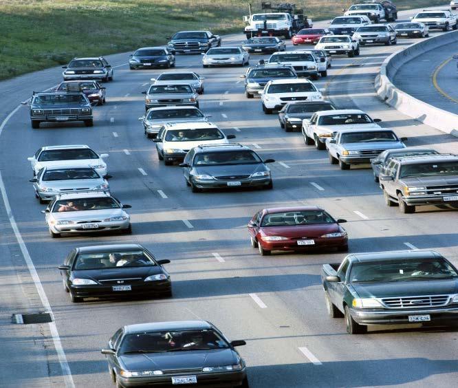


1 HIGHWAY INFLUENCES ON REGIONAL DEVELOPMENT Tony Hartzel, TxDOT Northeast Texas Public Information Mgr. Feb. 2, 2018


2 Highways and Redevelopment Central Expressway LBJ Freeway 2


3 What is Dallas CityMAP? Process championed by Commissioner Victor Vandergriff. Build a unique multidisciplinary team. Begin by listening to stakeholders first in one on one sessions. The City Center Master Assessment Process (CityMAP) is a collaborative effort to gather stakeholder and public input to help guide the future of Dallas major downtown highways and improve mobility, livability, connectivity and economic vitality. 3

4 Background I-345 Study 4

5 CityMAP Study Corridors 5

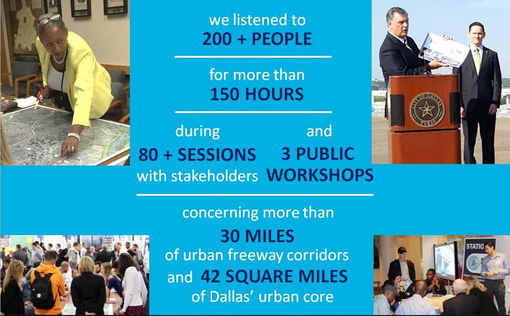
6 Where We Begin 6


7 Sampling of Stakeholder Input Strengthen NEIGHBORHOOD CONNECTIONS Public Workshop at the Dallas African American Museum Improve LIVABILITY and QUALITY OF LIFE within urban core Provide TRANSPORTATION, COMMUNITY AND DEVELOPMENT linkages of all scales Allow NEIGHBORHOOD PATTERNS TO EVOLVE Integration of HIGHWAYS AND COMPLETE STREETS Expand MOBILITY options and relieve TRAFFIC CONGESTION Public Workshop at the Dallas Regional Chamber Coordinate with OTHER INFRASTRUCTURE PROJECTS Promote ECONOMIC DEVELOPMENT opportunities Protect CULTURAL AND HISTORIC RESOURCES Bring back the MIDDLE CLASS to the urban core Help IMPROVE URBAN SCHOOLS 7
8 Factors Created from Stakeholder Input Factors evaluated for each scenario: Mobility Connectivity Economic Development and Resulting Tax Base Infrastructure Capital Cost (Highways and Local Streets) Facility Development & Construction Duration New Sidewalks/Trails Parks and Open Space Quantity Visual Impacts 8
9 I-345 Scenarios Development 9
 250,466 195,901")

10 Study Corridors Existing Average Daily Traffic (TxDOT 2015) 250, , , , , , , , , ,432 82,222 72,920 10


11 I-345/I-45 Observed Travel Patterns Downtown Trip Survey AM Traffic Flow AM Traffic 38% of I-45 northbound traffic use I-345 to reach destinations on US % of I-45 northbound traffic are destined for the downtown area 21% of I-45 northbound traffic continue through to I- 35E PM Traffic 24% of I-45 northbound traffic use I-345 to reach destinations on US % of I-45 northbound traffic are destined for the downtown area 21% of I-45 northbound traffic continue through to I- 35E PM Traffic Flow 11


12 I-345/I-45 Observed Travel Pattern Through Trip Survey I-45/I-345: Of the northbound vehicles on I-45, 67% remain north of Loop 12. Past Woodall Rodgers, the % dropped to 21%, and north of I-635 the through trip % was 13% I-45/I-345: Of the southbound vehicles on US 75, 29% remained south of Loop 12. South of Downtown Dallas, the % dropped to 7% and south of I-20 the through trip % was 5% 12
13 Existing
")
14 I-345 Modify Scenario (Removing Ramps to Elm, Main and Commerce) 14

15 I-345 Modify Scenario Potential 15

16 I-345 Modify Scenario Potential 16

17 I-345 Below Grade Scenario 17

18 I-345 Below Grade Scenario Potential 18


19 I-345 Below Grade Scenario Potential 19

20 I-345 Remove Scenario 20

21 I-345 Remove Scenario Potential 21


22 I-345 Remove Scenario Potential 22
23 I-345 Scenarios Economic Projection Comparison ( ) Metric I-345 Modify I-345 Below Grade I-345 Removal Existing Square Feet (2015) 1,634,350 Net New Square Feet ( ) 10,206,750 11,032,450 17,601,550 Existing Value (2015) $123,909,950 Net New Value $1,449,416,334 $1,457,973,399 $2,499,391,246 Additional Impacts (New New) Property Tax Revenue $39,134,241 $39,365,282 $67,483,564 Sales Tax Revenue $6,018,680 $4,881,151 $5,862,087 Hotel Tax Revenue $5,874,922 $5,874,922 $7,340,325 Increase to Existing Population 5,774 5,338 11,519 Increase to Existing Workforce 23,274 28,618 39,300 Net New Total Revenue $51,027,843 $50,121,355 $80,685,976 Complete CityMAP report can be find at 23

24 I-30 Scenarios Economic Projection Comparison ( ) 24

25 Mobility Study Area 25

26 CityMAP Executive Summary 26


27 Successful Example: Margret Hunt Hill Bridge Connecting East Dallas to West Dallas Introduced land redevelopments Trinity Groves 27

28 West Dallas (2008) Industrial Warehouses Vacant Lands 28
: $7,455,807 685% Increase in property value * Information from Dallas Central Appraisal District")
29 West Dallas - Today *Property Market Values Appraisal (2011): $ 949,471 Property Market Values Appraisal (2017): $7,455, % Increase in property value * Information from Dallas Central Appraisal District 29


30 West Dallas (Today) 30
31 Highway Influences in Developments Advantages Redevelopment Creating Employment Opportunities Generating Tax Revenues Increasing Property Values Disadvantages Gentrification Relocation Affordable Housing Sharp Property Tax Increase for Existing Businesses and Residents 31
Live Oak Ramp Removal
 Live Oak Ramp Removal Mobility Solutions, Infrastructure & Sustainability September 11, 2017 Tanya Brooks, Assistant Director Mobility and Street Services Presentation Overview Purpose Background Urban
2.0 PURPOSE AND NEED. 2.1 Purpose. 2.2 Need Traffic Congestion in and around Downtown Derry
 2.0 PURPOSE AND NEED Taking into consideration agency and public input, the purpose and need for the Project was identified early in Project planning. As noted in Appendix A, for purposes of meeting the
Honorable Members of the Mobility Solutions, Infrastructure and Sustainability Committee
 Memorandum DATE January 23, 2019 CITY OF DALLAS TO Honorable Members of the Mobility Solutions, Infrastructure and Sustainability Committee SUBJECT I-30 East Project Update On Monday, January 28, 2019,
Economic Development & Housing Council Committee Comprehensive Plan Update September 20, 2005
 1 Economic Development & Housing Council Committee Comprehensive Plan Update September 20, 2005 Purpose To update the Committee on the ForwardDallas! Plan, including: Status Anticipated Products Public
Southern Gateway Project and Public Green
 Southern Gateway Project and Public Green Transportation and Trinity River Project Committee May 23, 2016 Purpose of Presentation Provide the history and an overview of the Southern Gateway Project (SGP)
Tri-County Transportation & Land Use Study. Steering Committee Meeting May 14, 2009
 Tri-County Transportation & Land Use Study Steering Committee Meeting May 14, 2009 Agenda Recap of Study Goals and Objectives Update on CV Land Use Model: Business as Usual (BAU) Growth Scenario Pros vs
The Emerald Bracelet Dallas, Texas. October 2005
 The October 2005 TABLE OF CONTENTS: Tab I Project Summary Master Illustrative Plan Tab II Woodall Rodgers Freeway Segment Tab III U.S. Highway 75 Segment Tab IV Interstate Highway 30 Segment Tab V Interstate
TRANSPORTATION AND LAND USE
 CHAPTER 10 TRANSPORTATION AND LAND USE Transportation and land use are intimately linked. The expansion of a highway typically spurs housing, employment growth and land development in the communities that
I-84 Hartford Project Open Planning Studio #12. April 25, 2017
 I-84 Hartford Project Open Planning Studio #12 April 25, 2017 Meeting Agenda 1. I-84 Hartford Project alternatives update 2. Multimodal station area planning 3. I-84 / I-91 Interchange Study coordination
PREPARED FOR: PLATTEVIEW ROAD CORRIDOR STUDY EXECUTIVE SUMMARY
 PREPARED FOR: PLATTEVIEW ROAD CORRIDOR STUDY EXECUTIVE SUMMARY SEPTEMBER 2016 Introduction The Platteview Road Corridor Study was led by the Metropolitan Area Planning Agency (MAPA) with assistance from
SAN RAFAEL GENERAL PLAN 2040 INTRODUCTION AND OVERVIEW
 SAN RAFAEL GENERAL PLAN 2040 INTRODUCTION AND OVERVIEW Steering Committee Presentation February 14, 2018 Purpose of General Plan Guide land use and development decisions Coordinate transportation, infrastructure,
D2 Subway Project Development. Public Meeting September 12, 2018
 D2 Subway Project Development Public Meeting September 12, 2018 1 Agenda Project Background Process, Funding and Schedule Project Development (PD) Efforts Preliminary Engineering (PE) Environmental Impact
Southwest Light Rail Transit (LRT) A corridor of opportunity
 A corridor of opportunity") Southwest Light Rail Transit (LRT) A corridor of opportunity Minneapolis Jobs: 151,200 Suburban Jobs: 72,400 Downtown Minneapolis 147,000 emp.* West Calhoun 4,200 emp. Beltline Business Park 6,000 emp.
Southwest Light Rail Transit (LRT) A corridor of opportunity Minneapolis Jobs: 151,200 Suburban Jobs: 72,400 Downtown Minneapolis 147,000 emp.* West Calhoun 4,200 emp. Beltline Business Park 6,000 emp.
CHAPTER 3 VISION, GOALS, & PLANNING PRINCIPLES. City of Greensburg Comprehensive Plan. Introduction. Vision Statement. Growth Management Goals.
 CHAPTER 3 VISION, GOALS, & PLANNING PRINCIPLES Introduction The Greensburg Comprehensive Plan is intended as a working community document. A combination of long and short-term goals, this document is intended
The Lincoln Neighborhood Corridor Plan. The LiNC
 October 1, 2014 Planning Commission Study Session The Lincoln Neighborhood Corridor Plan The LiNC Purpose of Tonight s Meeting Introduction to The LiNC Review of Existing Conditions and Community Identified
[Leveraging & Improving Neighborhood Connections] Area A Riverfront
![[Leveraging & Improving Neighborhood Connections] Area A Riverfront](/thumbs/87/97077022.jpg "[Leveraging & Improving Neighborhood Connections] Area A Riverfront") Community Charrette LINC Dallas [Leveraging & Improving Neighborhood Connections] Area A Riverfront 06.02.12 LINC Workshop Area A PDs 774 and 784 cover the majority of Area A employing a form based code
Community Charrette LINC Dallas [Leveraging & Improving Neighborhood Connections] Area A Riverfront 06.02.12 LINC Workshop Area A PDs 774 and 784 cover the majority of Area A employing a form based code
Downtown Dubuque...it s a great time.
 Downtown Dubuque...it s a great time. Your timing could not be better to invest in Downtown. With hundreds of millions in public and private investment occurring on the City s downtown waterfront, millions
IH35 Corridor Plan Amendment to the Comprehensive Plan
 IH35 Corridor Plan Amendment to the Comprehensive Plan Background The corridor plan for the IH35 corridor is an amendment to the Burleson comprehensive plan. Generally, the purpose of a corridor plan is
City of Ennis. Downtown Master Plan Catalyst Projects
 City of Ennis Downtown Master Plan Catalyst Projects Revised Framework Plan REVISED Project Types and Descriptions Project Types A. Visitor Attracting Projects: Projects in this category are intended to
A Connected Region for Our Future. Tampa Bay Regional Planning Council
 A Connected Region for Our Future Tampa Bay Regional Planning Council TBARTA Vision A world class transportation network for the Tampa Bay region that will connect people and places, move goods and services,
South Norfolk Municipal Facilities Study
 South Norfolk Municipal Facilities Study City of Chesapeake, VA P r e s e n t e d b y H B A A r c h i t e c t u r e & I n t e r i o r D e s i g n, I n c. 1 Purpose of the Study (Phase I) Identify potential
Memorandum CITY OF DALLAS. Riverfront Boulevard Design From Continental Avenue to Cadiz Street
 Memorandum DATE November 10, 2011 CITY OF DALLAS TO Trinity River Corridor Project Committee Members: Vonciel Jones Hill (Chair) Linda Koop (Vice Chair), Monica Alonzo, Scott Griggs, Angela Hunt, and Delia
Introduction and Overview
 Introduction and Overview Articulate local values and priorities Guide land use and development decisions Coordinate transportation, infrastructure, and City services with expected growth and available
CITY OF UNION CITY MINUTES GENERAL PLAN ADVISORY COMMITTEE
 CITY OF UNION CITY MINUTES GENERAL PLAN ADVISORY COMMITTEE WEDNESDAY, MARCH 4, 2015, 6:30 P.M. IN THE CITY COUNCIL CONFERENCE ROOM OF CITY HALL 34009 ALVARADO-NILES BLVD., UNION CITY, CALIFORNIA Attachment
Concord Community Reuse Project Goals and Guiding Principles. Overarching Goals (OG)
") Concord Community Reuse Project Goals and Guiding Principles Overarching Goals (OG) No priority is implied by the order of presentation of the goals and guiding principles. Overarching goals for the Concord
Concord Community Reuse Project Goals and Guiding Principles Overarching Goals (OG) No priority is implied by the order of presentation of the goals and guiding principles. Overarching goals for the Concord
4/8/2015 Item #10D Page 1
 MEETING DATE: April 8, 2015 PREPARED BY: Christy Villa, Associate Civil Engineer DEPT. DIRECTOR: Glenn Pruim DEPARTMENT: Public Works CITY MANAGER: Larry Watt SUBJECT: NORTH COAST HIGHWAY 101 STREETSCAPE
Cumberland Region Tomorrow is a private, non-profit, citizen based regional organization working with Greater Nashville Regional Council
 Cumberland Region Tomorrow is a private, non-profit, citizen based regional organization working with Greater Nashville Regional Council and others in the public and private sectors, dedicated to planning
TOD 101 CREATING LIVABLE COMMUNITIES WITH TRANSIT
 1 CREATING LIVABLE COMMUNITIES WITH TRANSIT What are transit Centered Communities? Benefits of Partnerships to Support and Implement What You Will Learn Portland s Pearl District Your Trainers Today Catherine
Executive Summary. NY 7 / NY 2 Corridor
 Executive Summary NY 7 / NY 2 Corridor Transportation and Land Use Study December 2005 Prepared for: Town of Colonie Capital District Transportation Committee Prepared by: Introduction: Land use decisions
Joint Meeting City Council and the Plan Commission. September 1st, 2015
 Joint Meeting City Council and the Plan Commission September 1st, 2015 1 The City Plan Commission shall recommend a City Plan for the physical development of the City Article IX Section 2 of the City of
Definitions. Average Daily Traffic Demand (ADT): The actual number or projected number of cars that pass a point in a 24-hour period.
: The actual number or projected number of cars that pass a point in a 24-hour period.") Definitions Access Management: A combination of physical techniques and transportation policies used to control the flow of traffic between roads and the surrounding lands. Alternative City Form Scenarios:
Definitions Access Management: A combination of physical techniques and transportation policies used to control the flow of traffic between roads and the surrounding lands. Alternative City Form Scenarios:
IH35 Corridor Plan Amendment to the Comprehensive Plan
 IH35 Corridor Plan Amendment to the Comprehensive Plan Background The corridor plan for the IH35 corridor is an amendment to the Burleson comprehensive plan. Generally, the purpose of a corridor plan is
Broken Arrow Comprehensive Plan Update Public Workshop Meeting #3 January 23,
 Broken Arrow Comprehensive Plan Update Public Workshop Meeting #3 January 23, September 25,2018 2018 26 April 2016 AGENDA 1. Status Presentation - Charrette Recap - Proposed Vision Framework - Preliminary
Q:%4~ Memorandum CITY OF DALLAS
 Memorandum DATE December 10, 2010 CITY OF DALLAS TO Members of the Transportation and Environment Committee: Linda Koop (Chair), Sheflie Kadane (Vice Chair), Pauline Medrano, Vonciel Jones Hill, Jerry
ELK GROVE GENERAL PLAN VISION
 2-1 CHAPTER 2: 2-2 CREATING OUR The Community Vision for Elk Grove, expressed through a Vision Statement and a series of Supporting Principles, is a declaration of the kind of community that Elk Grove
Dallas CBD Second Light Rail Alignment (D2)
") Dallas CBD Second Light Rail Alignment (D2) Subway Project Refinement City of Dallas Transportation and Trinity River Project Committee February 13, 2017 Discussion Items Background Schedule Public/Stakeholder
Dallas CBD Second Light Rail Alignment (D2) Subway Project Refinement City of Dallas Transportation and Trinity River Project Committee February 13, 2017 Discussion Items Background Schedule Public/Stakeholder
Industrial Corridor Modernization Little Village
 Industrial Corridor Modernization Little Village Rahm Emanuel, Mayor David Reifman, Commissioner Dept. of Planning and Development Working Group April 26, 2018 dpd@cityofchicago.org cityofchicago.org/dpd
Anatomy of A Vibrant Downtown. Anatomy of a Vibrant Downtown
 Anatomy of A Vibrant Downtown The goal of MAIN ST. REVITALIZATION PLANNING is to provide a framework that will help transform your downtown into a VIBRANT DOWNTOWN a place where people love to LIVE, WORK,
Elm Fork Land Use. Trinity River Corridor Project Committee May 13, 2013
 Elm Fork Land Use Trinity River Corridor Project Committee May 13, 2013 Purpose Discuss Trinity River planned Land Use and Appropriate Compatible Uses, particularly with respect to the Elm Fork Area 2
SR Year Transportation & Land Use Plan Update NEW CASTLE COUNTY COUNCIL LAND USE COMMITTEE, AUGUST 30, 2016
 SR 141 20-Year Transportation & Land Use Plan Update NEW CASTLE COUNTY COUNCIL LAND USE COMMITTEE, AUGUST 30, 2016 Project background Route 141 is a major arterial which links the City of New Castle to
Corridor Vision. 1Pursue Minnehaha-Hiawatha Community Works Project. Mission of Hennepin County Community Works Program
 1Pursue Minnehaha-Hiawatha Community Works Project Minnehaha-Hiawatha Community Works is a project within the Hennepin Community Works (HCW) program. The mission of the HCW program is to enhance how the
495/MetroWest Development Compact Plan Citizen Planner Training Collaborative Conference. March 17, 2012
 495/MetroWest Development Compact Plan Citizen Planner Training Collaborative Conference March 17, 2012 Project Process Local and Regional Priority Areas Growth Scenarios Transportation Investment Categories
Comprehensive Plan Introduction Bristol, TN
 COMMUNITY MEETING #3 PROGRESS REPORT: Kick Off meeting with Staff Kick Off Meeting with Planning Commission and City Council Kick Off Meeting with Community Advisory Committee (CAC) 10-12 Individual and
Transit / Housing Oriented Redevelopment
 Broward County Urban Planning and Redevelopment Department Kick-Off Meeting October 24, 2007 Transit / Housing Oriented Redevelopment 1 Future Land Use 2 Broward County Charter Voters approved in 1974.
Robbinsdale LRT Station. CDI Development Guidelines. August Overview
 Robbinsdale LRT Station August 2018 Overview The City of Robbinsdale may have the coolest opportunity site along the 13 mile stretch of the Bottineau LRT corridor / Blue Line extension. Located a block
Northside Interjurisdictional Specific Plan and EIR
 Northside Interjurisdictional Specific Plan and EIR Presented by: DAVE MURRAY, Senior Planner City Of Riverside BRIAN MOONEY, FAICP Rick Community Planning And Sustainable Development KURT CULBERTSON,
Catalytic Development Areas
 V Catalytic Development Areas Downtown Dallas will only achieve its potential as a vibrant 21st-century urban center through intensive collaboration between the public and private sectors. Oftentimes municipalities
LAND USE MODEL UPDATE. Planning and Land Use Advisory Committee Meeting #2 September 4, 2014
 1 LAND USE MODEL UPDATE Planning and Land Use Advisory Committee Meeting #2 September 4, 2014 2 Presentation Outline Introduction and Recap Model Process Study Design Place Types Suitability Factors 3
City of Tacoma Planning and Development Services
 Agenda Item E-1 City of Tacoma Planning and Development Services To: Planning Commission From: Elliott Barnett, Planning Services Division Subject: Tacoma Mall Regional Center Subarea Plan and EIS Meeting
ALMONO. Hazelwood, City of Pittsburgh. A riverfront investment opportunity combining residential, office and light industrial uses A L M O N O S I T E
 Tecumseh St. ALMONO Hazelwood, City of Pittsburgh A riverfront investment opportunity combining residential, office and light industrial uses Downtown Pittsburgh Oakland South Side Flats Birmingham Bridge
Plano Tomorrow Vision and Policies
 Plano Tomorrow Vision and Policies PLANO TOMORROW PILLARS The Built Environment The Social Environment The Natural Environment The Economic Environment Land Use and Urban Design Transportation Housing
RESOLUTION NO. R Refining the route, profile and stations for the Downtown Redmond Link Extension
 RESOLUTION NO. R2018-32 Refining the route, profile and stations for the Downtown Redmond Link Extension MEETING: DATE: TYPE OF ACTION: STAFF CONTACT: Capital Committee Board PROPOSED ACTION 09/13/2018
Presentation to Town Council in association with Kubilins Transportation Group Rose & Associates Equinox Environmental
 Presentation to Town Council 03.03.09 in association with Kubilins Transportation Group Rose & Associates Equinox Environmental Vision Statement: Boone 2030 is...a friendly, vibrant, attractive community...financially,
EXHIBIT A. Tax Increment Reinvestment Zone No. 1 (Town Center) First Amended Project Plan 1
 First Amended Project Plan 1") EXHIBIT A Tax Increment Reinvestment Zone No. 1 (Town Center) First Amended Project Plan 1 1 As amended by Resolution No. 2008-02-001(TR1R) of the Tax Increment Reinvestment Zone No.1, and approved to
EXHIBIT A Tax Increment Reinvestment Zone No. 1 (Town Center) First Amended Project Plan 1 1 As amended by Resolution No. 2008-02-001(TR1R) of the Tax Increment Reinvestment Zone No.1, and approved to
Chapter 1: Introduction
 Chapter 1: Introduction The Penn Avenue Community Works Corridor Vision and Implementation Framework presents an integrated communitybased vision and a coordinated, long-term implementation framework for
PORTERVILLE WORKSHOP MINUTES
 Workshop 3 Policy Scenarios PORTERVILLE WORKSHOP MINUTES December 13, 2004 On December 13, 2004, 20 people attended a workshop in Porterville to discuss policy options for Tulare County s General Plan
STUDY AREA LOCATION & CONTEXT:
 UNLOCKING THE POTENTIAL OF THE KEATING CROSS ROAD BUSINESS CORRIDOR A PLAN TO CREATE + RETAIN JOB-GENERATING BUSINESSES AND TO GUIDE INFRASTRUCTURE INVESTMENT The Keating Cross Road Corridor (the Keating
Welcome. Tina Fischer. East Tampa Area Community Working Group September 25, Collaborative Labs, St. Petersburg College
 Welcome East Tampa Area Community Working Group September 25, 2018 Tina Fischer Collaborative Labs, St. Petersburg College Tonight s Agenda Open House Area (6:00 - ongoing) Information about related studies,
EXISTING COMPREHENSIVE PLAN
 EXISTING COMPREHENSIVE PLAN Town Center Land Use Element: V. LAND USE POLICIES Town Center Mercer Island's business district vision as described in "Your Mercer Island Citizen-Designed Downtown" was an
N Watt Avenue Corridor Plan. STOREFRONT WORKSHOP May 15-17, 2007
 N Watt Avenue Corridor Plan STOREFRONT WORKSHOP May 15-17, 2007 Workshop Overview May 15 12 & 2 pm General Overview/3D Modeling 4 pm Special Topic: Market Study 6 pm Special Topic: McClellan May 16 12
[Leveraging & Improving Neighborhood Connections] Area C Lamar Levee
![[Leveraging & Improving Neighborhood Connections] Area C Lamar Levee](/thumbs/78/78438669.jpg "[Leveraging & Improving Neighborhood Connections] Area C Lamar Levee") Community Charrette LINC Dallas [Leveraging & Improving Neighborhood Connections] Area C Lamar Levee 06.02.12 LINC Workshop Area C Schematic design has been completed on plans to extend the east levee
Community Charrette LINC Dallas [Leveraging & Improving Neighborhood Connections] Area C Lamar Levee 06.02.12 LINC Workshop Area C Schematic design has been completed on plans to extend the east levee
Existing Transportation System 5-1
 5-1 The Jackson County transportation system is served by several modes of transportation including streets and highways, multi-modal, non-motorized, rail, and aviation. While the focus of the transportation
Exhibit A. SH 161 RTC Work Program of New Projects. Collin County
 Exhibit A SH 161 RTC Work Program of New Projects Collin County 0918-24-969 N/A 0918-24-970 N/A 0918-24-973 N/A 2351-01-020 N/A 2679-03-010 N/A On Exchange Parkway from US 75 to Allen Heights On Country
2030 Comprehensive Plan VISION STATEMENT
 RESOURCE DOCUMENT for Steering Committee Meeting #2 July 12, 2017 2030 Comprehensive Plan VISION STATEMENT Steering Committee from 2008 Established the Lauderdale s Vision as: Creating a livable, lovable
South Davis County COMMUNITY SPOTLIGHT
 South Davis County COMMUNITY SPOTLIGHT Davis/SLC Community Connector Bus Rapid Transit line connecting SLC & Davis County RTP Phase 1 Project Generate 3,100 average weekday riders Relieve congestion on
GO Station Mobility Hubs: Draft Precinct Plans. Committee of the Whole July 12, 2018
 GO Station Mobility Hubs: Draft Precinct Plans Committee of the Whole July 12, 2018 Purpose of this Workshop Present Draft Precinct Plans for the 3 GO Station Mobility Hubs Continue the conversations that
Developer s Program. The Station at East 54
 Developer s Program The Station at East 54 Existing Conditions The Station at East 54 is proposed for a 1.12 acre site at the northeast corner of Hamilton Road and Prestwick Road, tucked between the East
BAGBY STREET RECONSTRUCTION PROJECT OCTOBER 2, 2015
 BAGBY STREET RECONSTRUCTION PROJECT OCTOBER 2, 2015 CLAIRE HEMPEL, PLA, AICP, LEED GA PREPARED BY Aspen Asheville Austin Chicago Denver Dubai Houston Lake Tahoe Los Angeles MIDTOWN : A MODEL OF URBAN DEVELOPMENT
ROBBINSDALE LRT STATION CDI DEVELOPMENT GUIDELINES
 August 2018 OVERVIEW The City of Robbinsdale has a prime-opportunity site in the middle of the 13 mile stretch of the Bottineau LRT corridor / Blue Line extension. Robbinsdale offers a prominent, vital,
Living in Albemarle County s Urban Places
 Living in Albemarle County s Urban Places ALBEMARLE COUNTY, VIRGINIA A Closer Look at Albemarle s Approach to Managing Growth and Creating Quality Urban Environments www.albemarle.org Page 2 Living in
Northwest Rail Corridor and US 36 BRT Development Oriented Transit Analysis 4.4 STATION AREA FINDINGS
 4.4 STATION AREA FINDINGS Each station is different, and each one requires a separate set of recommendations based on the vision for the site. This section outlines an initial TOD strategy and recommendations
COMMERCIAL CORRIDOR PLANNING SW 9 TH STREET CORRIDOR NE CORRIDOR MARKET DISTRICT KEO WAY CORRIDOR
 COMMERCIAL CORRIDOR PLANNING SW 9 TH STREET CORRIDOR NE CORRIDOR MARKET DISTRICT KEO WAY CORRIDOR Council Workshop July 29, 2013 SW 9 th Street Corridor Plan What is this initiative? A PUBLIC-PRIVATE pilot-partnership
TxDOT Experience with Long-Term Private Maintenance Agreements
 TxDOT Experience with Long-Term Private Maintenance Agreements June 2, 2015 Beau B. Buchanan, P.E. Project Manager TxDOT South Central Strategic Projects Office San Antonio, Texas Maintenance Agreements
DOWNTOWN STAKEHOLDER WORKING GROUP REPORT
 www.mobility35.org DOWNTOWN STAKEHOLDER WORKING GROUP REPORT October 2014 Forward from Senator Kirk Watson October 2014 This report is about preparing for Austin s future by planning a better I-35. It
St. Louis Park Wooddale LRT Station Site development guidelines
 St. Louis Park Wooddale LRT Station Site development guidelines November 2013 OVERVIEW St. Louis Park s convenient location as a neighbor to Minneapolis means you re only minutes away from some of the
City of Hermosa Beach Administrative Policy #
 City of Hermosa Beach Administrative Policy # SUBJECT: Living Streets Policy Date: Approved by: City Council Authority: Public Works Department & Community Development Department Mayor, PURPOSE The City
Dallas CBD Second Light Rail Alignment (D2)
") Dallas CBD Second Light Rail Alignment (D2) Subway Project Refinement Public Meetings January 19, 2017 Discussion Items Background Schedule Public/Stakeholder Involvement Subway Construction Overview Potential
Dallas CBD Second Light Rail Alignment (D2) Subway Project Refinement Public Meetings January 19, 2017 Discussion Items Background Schedule Public/Stakeholder Involvement Subway Construction Overview Potential
The Trinity River Corridor, offering Dallas areas of natural
 IMPLEMENTATION PLAN FOR THE TRINITY RIVER CORRIDOR The Trinity River Corridor, offering Dallas areas of natural beauty and untapped potential, runs through the heart of the city. Proposed improvements
INDEPENDENCE BOULEVARD AREA PLAN
 INDEPENDENCE BOULEVARD AREA PLAN Public Meeting October 28, 2008 Tonight s Agenda Introduction 4:00 4:05 Tom Warshauer Presentation 4:05 5:00 Blake Drury Group Exercises 5:00 5:50 All Wrap Up & Next Steps
1 October Dear Citizens of Charlotte and Mecklenburg County,
 1 October 2011 Dear Citizens of Charlotte and Mecklenburg County, As co-chairs of the Center City 2020 Vision Plan Steering Committee, we are proud to present the Center City 2020 Vision Plan, which sets
CITY S GOALS DRIVE MODE CHOICE IN WINSTON-SALEM, NC
 CITY S GOALS DRIVE MODE CHOICE IN WINSTON-SALEM, NC Taiwo Jaiyeoba HDR, Transit Principal, Atlanta, GA Claire Brinkley HDR, Transit Planner, Charlotte, NC AGENDA 1. Project Background 2. Project Process
Public input has been an important part of the plan development process.
 Lakewood s Comprehensive Plan recognizes that transportation helps shape the community, and that the way the community provides for the safe and efficient movement of people affects the character of the
CONTINUING EDUCATION CREDITS
 CONTINUING EDUCATION The sessions listed below have been registered with and the APA for the credit indicated. Sessions not appearing on this form do not receive continuing education credit. See last page
A BLUEPRINT FOR BROCKTON A CITY-WIDE COMPREHENSIVE PLAN
 A BLUEPRINT FOR BROCKTON A CITY-WIDE COMPREHENSIVE PLAN Public Meeting October 2016 1 Plan Summary and Discussion Public Meeting May 4 2017 City of Brockton Bill Carpenter, Mayor Department of Planning
REGIONAL ACTIVITY CENTER
 DRAFT REGIONAL ACTIVITY CENTER 70 EAST BENCH MASTER PLAN DRAFT 06 Introduction The East Bench Regional Activity center is comprised of large educational, research, medical, and employment centers. These
Request for Proposals: Architectural/Design Guidelines
 Request for Proposals: Architectural/Design Guidelines January 11, 2017 1.0 INTRODUCTION The City of Issaquah, Washington is soliciting proposals from qualified consulting firms to lead a community conversation
CHAPTER 7: Transportation, Mobility and Circulation
 AGLE AREA COMMUNITY Plan CHAPTER 7 CHAPTER 7: Transportation, Mobility and Circulation Transportation, Mobility and Circulation The purpose of the Transportation, Mobility and Circulation Chapter is to
E c o n o m i c D e v e l o p m e n t
 convenient location in town to leave the old jail site available for redevelopment. Action 6: Redevelop the county volunteer fire department site. The relocation of the volunteer fire department is in
Packet Contents. Joint Planning Work Session Timeline.. Introduction.. Work Session Directions... 5
 City Council and Planning & Zoning Commission Joint Planning Work Session Packet June 30, 2014 1 2 Packet Contents Joint Planning Work Session Timeline.. Introduction.. 4 4 Work Session Directions... 5
Principal development issues
 Principal development issues The transformation of the Bonaventure Expressway from Saint- Jacques to Brennan Streets will create a major urban boulevard with lanes located on either side of a string of
State Highway 121 Southwest Parkway. Fort Worth s Transportation Success Story in Design and Cooperation
 State Highway 121 Southwest Parkway Fort Worth s Transportation Success Story in Design and Cooperation Greater Fort Worth Association of Realtors October 24, 2007 Presented by: Dan Lamers, P.E. North
FUNDING CORRIDOR REVITALIZATION
 FUNDING CORRIDOR REVITALIZATION Integrated corridor planning for the 21 st Century America Planning Association Annual Conference Atlanta, GA April 27, 2014 Mariia Zimmerman, MZ Strategies, LLC mariia@mzstrategies.com
Public Open House. Yonge Street and Bernard Avenue (Bernard KDA) Planning Study Update Town of Richmond Hill. March 30, 2017
 Planning Study Update Town of Richmond Hill. March 30, 2017") Public Open House Yonge Street and Bernard Avenue (Bernard KDA) Planning Study Update Town of Richmond Hill March 30, 2017 Open House Review of Project Purpose and Process Policy Refresher Highlights of
Public Open House Yonge Street and Bernard Avenue (Bernard KDA) Planning Study Update Town of Richmond Hill March 30, 2017 Open House Review of Project Purpose and Process Policy Refresher Highlights of
Promoting Economic Development Through Upfront SEPA Review: Lessons from South Downtown Tacoma
 Promoting Economic Development Through Upfront SEPA Review: Lessons from South Downtown Tacoma 1 This session will focus on the City of Tacoma s South Downtown Subarea Plan and associated Non-Project SEPA
CITY OF RENO APRIL Progressive Urban Management Associates (P.U.M.A.) in association with. Economic and Planning Systems (EPS)
 in association with. Economic and Planning Systems (EPS)") CITY OF RENO APRIL 2017 City of Reno, Nevada Prepared By Progressive Urban Management Associates (P.U.M.A.) in association with Economic and Planning Systems (EPS) EXECUTIVE SUMMARY The City of Reno Downtown
CITY OF RENO APRIL 2017 City of Reno, Nevada Prepared By Progressive Urban Management Associates (P.U.M.A.) in association with Economic and Planning Systems (EPS) EXECUTIVE SUMMARY The City of Reno Downtown
OVERVIEW OF PLANS FOR THE JEFFERSON COUNTY COUNTRYSIDE FARM In the Context of Quality Place Characteristics
 OVERVIEW OF PLANS FOR THE JEFFERSON COUNTY COUNTRYSIDE FARM In the Context of Quality Place Characteristics By Steve Grabow, Professor and Community Development Educator University of Wisconsin-Extension,
Railyard Alternatives and I-280 Boulevard Feasibility Study. MTA Board Meeting May 6, 2014
 Railyard Alternatives and I-280 Boulevard Feasibility Study MTA Board Meeting May 6, 2014 Planned Infrastructure Major pieces of new infrastructure are planned including: Downtown Rail Extension (DTX)
TOWN OF NEW CASTLE - Master Plan Update
 Our Presentation Today (1) Recap the Master Planning Process To Date (2) Present the Outline of the Master Planning Work Plan (3) Present the Calendar for the Master Plan (4) Outline the scope of a Downtown
Regional Mobility & the US 380 Bypass Concept. Informational Meeting February 9, 2017
 Regional Mobility & the US 380 Bypass Concept Informational Meeting February 9, 2017 Purpose and Agenda Purpose: Regional Mobility Issues, Priorities, and Pressures US 380 as a Limited Access Facility
Planning Districts INTRODUCTION
 INTRODUCTION To facilitate detailed examination of development prospects for all areas of the community, Delano has been divided into 14 planning districts. The location of these planning districts is