Q:%4~ Memorandum CITY OF DALLAS
|
|
|
- Ezra Green
- 5 years ago
- Views:
Transcription
1 Memorandum DATE December 10, 2010 CITY OF DALLAS TO Members of the Transportation and Environment Committee: Linda Koop (Chair), Sheflie Kadane (Vice Chair), Pauline Medrano, Vonciel Jones Hill, Jerry R. Allen, Carolyn R. Davis, Ron Natinsky SUBJECT Complete Streets Initiative At the Transportation and Environment Committee Meeting on Monday, December 13, 2010, there will be a briefing on the Complete Streets Initiative. Please feel free to contact Theresa O'Donnell at if you need additional information. Q:%4~ "': Jordat Assistant City Manager c: The Honorable Mayor and Members of the City Council Mary K. Suhm, City Manager Thomas P. Perkins, Jr. City Attomey Deborah Watkins, City Secretary Craig Kinton, City Auditor Judge C. Victor Lander, Administrative Judge Ryan S. Evans, First Assistant City Manager A. C. Gonzalez, Assistant City Manager Forest Turner, Assistant City Manager Jeanne Chipperfield, Chief Financial Officer Edward Scott, Director, Controller's Office Frank Librio, Public Information Office Theresa O'Donnell, Director, Sustainable Development and Construction Helena Stevens-Thompson, Assistant to the City Manager - Council Office "Dallas~ Together, we do it better"
2 City of Dallas Complete Streets Initiative UrbanAdvantage Council Committee for Transportation and Environment December 13, 2010
3 Presentation Outline What are Complete Streets? Key Opportunities and Challenges Complete Streets Initiative Project Approach Goals and Anticipated Outcomes Public Involvement Project Budget, Funding Sources and Schedule 2

4 What are Complete Streets? Streets designed to suit the context and provide safe access to all users A broader role for streets UrbanAdvantage 3

5 Adding Lanes Will Not Solve Our Congestion Problems Despite plans to add significantly to the roadway network, congestion is projected to continue to increase 4

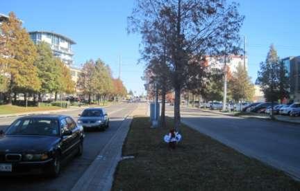
6 Auto-Oriented Streets UrbanAdvantage 5
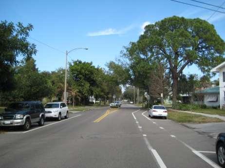
7 Multimodal Streets UrbanAdvantage 6

8 Multimodal Streets UrbanAdvantage 7
9 Key Complete Streets Principles Design for all transportation modes: pedestrians, bicycles, transit, automobiles Enhance the public realm Different solutions to address all types of streets in a wide range of contexts Respond to changing land uses and transportation needs over time 8
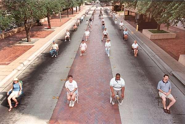
10 Balancing Transportation Needs Current Hierarchical Traffic Patterns Better Blocks, Dallas 9
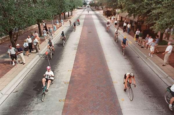
11 Balancing Transportation Needs Potential Traffic Re-Distribution 10

12 Balancing Transportation Needs Desired Mode Shift Auto traffic Transit traffic Bike/Ped traffic 11

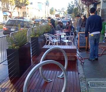
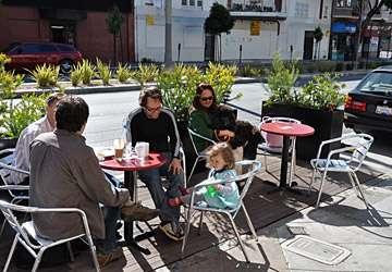
13 Enhancing The Public Realm Mixed Use Streets Wall sign Pedestrian lighting Awnings Active storefronts On-street parking Buildings at sidewalks Street trees Wide sidewalks Outdoor dining UrbanAdvantage 12

14 Enhancing The Public Realm Residential Streets 13


15 Enhancing the Public Realm Green Storm Water Management Sustainable approaches to storm water management 14 14

16 The Street Edge Shared Public-Private Zone ROW line Public-private zone UrbanAdvantage 15

17 The Street Edge Shared Public-Private Zone UrbanAdvantage 16

18 The Street Edge Shared Public-Private Zone UrbanAdvantage 17

19 Design to Suit the Context Mockingbird Variations 18

20 Range of Design Contexts Signature Streets Main Street, Downtown 19

21 Range of Design Contexts Multi-way Boulevards Las Ramblas, Barcelona 20


22 Range of Design Contexts Integrating On-Street Bike Facilities Octavia Blvd, San Francisco 21

23 Range of Design Contexts Neighborhood Streets 22

24 Range of Design Contexts Special Event Streets Better Blocks, Dallas 23

25 Range of Design Contexts Multipurpose/Flexible Street Space 24

26 Transition to Complete Streets Incremental Change Lamar Street - Downtown 25
27 Transition to Complete Streets Incremental Change Lamar Street - Downtown 26

28 Transition to Complete Streets Incremental Change Lamar Street - Downtown 27
29 Key Opportunities Move towards more sustainable transportation solutions Break the cycle of adding roadway capacity to reduce congestion Make more efficient use of existing roadways Meet the growing need for alternative modes of transportation Create more vibrant streets Support mixed use development Build Green Streets 28
30 Key Challenges Balancing regional and local automobile mobility with alternative transportation and land use needs Increasing infrastructure funding availability for alternative modes of transportation Accommodating potentially conflicting demands for use within existing public ROW Potential need for additional ROW Expanding flexibility in regulating function and operation along various segments of the same street at different times of day or week Higher capital and maintenance costs associated with complete streets solutions 29
31 Wide Ranging Policy Impacts Thoroughfare Plan Plat regulations Zoning regulations Roadway engineering design and operation policies, standards and enforcement Utility company franchise agreements ROW licenses and abandonments Public/private roles in capital funding, ongoing maintenance as well as liability Bond and Capital Improvement Programs 30
32 Complete Street Initiative Project Approach A citywide, comprehensive transportation and urban design project Led by Strategic Planning Division of Department of Sustainable Development and Construction Close collaboration with City Design Studio, Trinity Office and Public Works and Transportation Consultant team with strong multimodal transportation and urban design expertise 31
33 Complete Streets Initiative Project Approach A practical approach to developing ready-to-use tools and achieving results Engage the community in developing appropriate vision and strategies for each part of the city Build on momentum of related planning efforts 32

34 Build on Existing Momentum Advance the forwarddallas! Vision and the Trinity Corridor Plan Incorporate the Bike Plan Update Coordinate with the Streetcar System Plan 33
35 Build on Existing Momentum Bike Plan Update A significant shift in approach to bicycles within the roadway network Addresses on-street bicycle mobility and connectivity to trail system, transit, schools, employment centers and other destinations Establishes a new on-street bike network and design standards Identifies and prioritizes actions to implement the bike plan Provides a head start for the complete streets initiative 34
36 Build on Existing Momentum Streetcar System Plan Will define a future streetcar network aimed at greatly enhancing mobility choices in the central city area Addresses a 3-mile radius around Downtown Dallas Delineates streetcar corridors that demonstrate potential for success, linking key destinations within the study area Prioritizes streetcar corridors for detailed planning and implementation based on comparative analysis Develops feasible funding strategies for construction and operation of streetcar implementation projects Will establish a key element of the complete streets initiative 35
37 Building on Existing Momentum Area Plans Incorporate recommendations of: 1. Downtown Dallas Stemmons Corridor Southwestern Medical District Area Plan 3. UNT-Dallas Area Plan 4. West Dallas Plan Garland Road Vision 3 36

38 Downtown Dallas 360 Circulation Framework 37 37


39 Stemmons Medical District Area Plan 38

40 UNT-Dallas Area Plan 39

41 West Dallas Plan 40
42 Complete Streets Initiative Primary Project Goals Launch a systematic and phased transformation of our roadway network towards a Complete Street network Facilitate a sustainable balance between competing needs within the roadway right-of-way as the city continues to redevelop and invest in multimodal infrastructure 41
43 Complete Streets Initiative Anticipated Outcomes Three key components: Vision Map Comprehensive Policy Manual Strategic Implementation Plan 42
44 Anticipated Outcomes Complete Streets Vision Map Overlay of the citywide roadway network with a palette of well-defined, context sensitive complete street types Linked to specific policies and standards designed for integration into the regulatory framework 43
45 Anticipated Outcomes Complete Streets Manual Comprehensive reference manual articulating complete street policies, guidelines, processes and standards for application to the citywide roadway network Tied to well-defined palette of complete street types 44
46 Anticipated Outcomes Complete Streets Manual Intended to guide street design and operation related to a range of issues including: Street intersections Transit lines and stops Bike facilities On-street and indented parking Curb-cuts Median breaks; Mid-block crossings Landscape within the ROW Storm water management Street and pedestrian lighting Sanitation, electric and communication lines Emergency vehicle access 45
47 Anticipated Outcomes Strategic Implementation Plan Strategy for incremental implementation of the Complete Streets Vision Recommendations for integration of the Vision Map and Design Manual into the City s regulatory, administrative and procedural framework Prioritized schedule of projects and programs (including quick wins) for implementation of the Complete Streets Vision. Monitoring program to measure impacts and effectiveness of the Complete Streets Initiative over time Demonstration capital projects with conceptual plans, illustrations and rough cost estimates for specific roadway segments 46
48 Anticipated Outcomes Demonstration Projects Particular street segments selected for conceptual design development applying the new complete streets policies and standards: Variety of projects and contexts Geographic distribution Redevelopment opportunities Existing CIP projects Potential 2012 Bond projects Quick Wins 47

49 Public Involvement Area-Based Approach Area-based public involvement: Central Dallas West Dallas North Oak Cliff Northeast Dallas Southeast Dallas South Central Dallas North Dallas Southwest Dallas Northwest Dallas This map is preliminary and will be refined further 48
50 Public Involvement Stakeholder Committee Broad representation of stakeholder organizations and geographic areas Review progress at key milestones Ambassadors to the community Coordination with Streetcar System Plan and Bike Plan 49
51 Public Involvement Broad Based Input Two rounds of community workshops/open houses Visioning, goal setting, preliminary prioritization Preliminary draft plan review Better Blocks approach to hands-on community involvement where possible 50
52 Project Coordination City Council TEC City Sponsored Inter-Agency Coordination Group D2 Downtown Dallas 360 Streetcar System Plan TIGER Grant West Dallas N. Oak Cliff Planning Citywide Complete Streets Initiative Citywide Bike Plan Update 51 51
53 Project Funding Project budget $800,000 Regional Toll Revenue Funds $400,000 Source: TXDOT Administered by: Regional Transportation Council Transportation and Community $400,000 and System Preservation Grant Source: Federal Highway Administration Administered by: TXDOT 52
54 Project Schedule Select consultant: Dec 2010 Council action on consultant contract and Project kickoff: Jan/Feb 2011 Draft product: Jan/Feb
55 City of Dallas Complete Streets Initiative Council Committee for Transportation and Environment December 13, 2010
Memorandum CITY OF DALLAS. Riverfront Boulevard Design From Continental Avenue to Cadiz Street
 Memorandum DATE November 10, 2011 CITY OF DALLAS TO Trinity River Corridor Project Committee Members: Vonciel Jones Hill (Chair) Linda Koop (Vice Chair), Monica Alonzo, Scott Griggs, Angela Hunt, and Delia
Memorandum CITY OF DALLAS
 Memorandum DATE August 7, 2009 CITY OF DALLAS Members of the Transportation and Environment Committee: Linda L. Koop (Chair), Sheffie Kadane (Vice Chair). Jerry A. Allen, Tennell Atkins, Carolyn R. Davis.
CITY OF CHARLOTTESVILLE, VIRGINIA CITY COUNCIL AGENDA
 CITY OF CHARLOTTESVILLE, VIRGINIA CITY COUNCIL AGENDA Agenda Date: December 16, 2013 Action Required: Adoption of Resolution Presenter: Staff Contacts: Title: James E. Tolbert, AICP, Director of NDS James
Scope of Services. River Oaks Boulevard (SH 183) Corridor Master Plan
 Corridor Master Plan") Scope of Services River Oaks Boulevard (SH 183) Corridor Master Plan PROJECT AREA The project area consists of the River Oaks Boulevard (SH 183) corridor bounded by SH 199 at the northern end and the Trinity
Scope of Services River Oaks Boulevard (SH 183) Corridor Master Plan PROJECT AREA The project area consists of the River Oaks Boulevard (SH 183) corridor bounded by SH 199 at the northern end and the Trinity
Economic Development & Housing Council Committee Comprehensive Plan Update September 20, 2005
 1 Economic Development & Housing Council Committee Comprehensive Plan Update September 20, 2005 Purpose To update the Committee on the ForwardDallas! Plan, including: Status Anticipated Products Public
Memorandum CITY OF DALLAS
 Memorandum DATE September 23, 2016 CITY OF DALLAS TO The Honorable Members of the Transportation and Trinity River Project Committee: Lee M. Kleinman (Chair), Deputy Mayor Pro Tem Erik Wilson (Vice-Chair),
The Trinity River Corridor, offering Dallas areas of natural
 IMPLEMENTATION PLAN FOR THE TRINITY RIVER CORRIDOR The Trinity River Corridor, offering Dallas areas of natural beauty and untapped potential, runs through the heart of the city. Proposed improvements
Implementation Guide Comprehensive Plan City of Allen
 Implementation Guide 2030 Comprehensive Plan City of Allen DRAFT 2015 Implementation Guide Allen 2030 Comprehensive Plan INTRODUCTION The Comprehensive Plan serves as a guide for the growth and development
Honorable Members of the Mobility Solutions, Infrastructure and Sustainability Committee
 Memorandum DATE January 23, 2019 CITY OF DALLAS TO Honorable Members of the Mobility Solutions, Infrastructure and Sustainability Committee SUBJECT I-30 East Project Update On Monday, January 28, 2019,
Atlanta BeltLine Corridor Environmental Study. Scoping Meeting August 2008
 Atlanta BeltLine Corridor Environmental Study Scoping Meeting August 2008 What Will We Be Discussing Today? Study Overview - How Did We Get Here? - What Is the Study About? - Who Is Involved? - Where Is
Gold Line Bus Rapid Transit Transit Oriented Development (BRTOD) Helmo Station Area Plan
 Helmo Station Area Plan") Appendix F Gold Line Bus Rapid Transit Transit Oriented Development (BRTOD) Helmo Station Area Plan Introduction and Purpose of the Plan The Gold Line Bus Rapid Transit facility is an eleven-mile dedicated
Appendix F Gold Line Bus Rapid Transit Transit Oriented Development (BRTOD) Helmo Station Area Plan Introduction and Purpose of the Plan The Gold Line Bus Rapid Transit facility is an eleven-mile dedicated
ForwardDallas! Comprehensive Plan. City Council Briefing February 15, 2006
 ForwardDallas! Comprehensive Plan City Council Briefing February 15, 2006 Purpose Brief City Council on the preliminary products of the Forward Dallas! Comprehensive Plan 2 Where we are in the process
Streets for People, Place-Making and Prosperity. #TOcompletestreets
 COMPLETE STREETS FOR TORONTO Streets for People, Place-Making and Prosperity COMPLETE STREETS: A NEW APPROACH A Complete Streets design approach considers the needs of all users people who walk, bicycle,
Atlanta BeltLine, Inc. Pathways to Urban Sustainability
 Atlanta BeltLine, Inc. Pathways to Urban Sustainability September 30, 2010 WHAT IS THE ATLANTA BELTLINE? Transit 22-mile loop Parks 1300 + new acres Trails 33 miles Jobs & Economic Development 20 areas,
Town of Oakville Streetscape Strategy
 Town of Oakville Streetscape Strategy Endorsed by PDC on February 10, 2014 (PD-011-14) Town of Oakville Streetscape Strategy [endorsed by PDC February 10, 2014] 0 Town of Oakville Streetscape Strategy
RESOLUTION NO. R Refining the route, profile and stations for the Downtown Redmond Link Extension
 RESOLUTION NO. R2018-32 Refining the route, profile and stations for the Downtown Redmond Link Extension MEETING: DATE: TYPE OF ACTION: STAFF CONTACT: Capital Committee Board PROPOSED ACTION 09/13/2018
The transportation system in a community is an
 7 TRANSPORTATION The transportation system in a community is an important factor contributing to the quality of life of the residents. Without a sound transportation system to bring both goods and patrons
SH 199 Corridor Master Plan. Community Meeting No. 2 May 31, 2017
 Community Meeting No. 2 May 31, 2017 Transportation Projects On or Near SH 199 SH 199 from 0.3 miles south of FM 1886 to south end of Lake Worth bridge Construct freeway mainlanes and frontage roads 10-Year
Urban Planning and Land Use
 Urban Planning and Land Use 701 North 7 th Street, Room 423 Phone: (913) 573-5750 Kansas City, Kansas 66101 Fax: (913) 573-5796 Email: planninginfo@wycokck.org www.wycokck.org/planning To: From: City Planning
TORONTO COMPLETE STREETS GUIDELINES
 TORONTO COMPLETE STREETS GUIDELINES Presentation by Fiona Chapman, Manager, Pedestrian Projects Public Realm Section, Transportation Services, City of Toronto June 2017 PURPOSE OF THE PROJECT To develop
State Highway 5 Corridor Context Sensitive Master Plan
 ADOPTED June 17, 2014 (Resolution 2014-06-071) Travel Lane Travel Lane 11 11 Median 16 Min State Highway 5 Corridor Context Sensitive Master Plan 1 Prepared for: Prepared by: State Highway 5 Corridor
TRANSIT-ORIENTED DEVELOPMENT POLICY DRAFT. City Planning and Development Department Kansas City, Missouri
 TRANSIT-ORIENTED DEVELOPMENT POLICY DRAFT City Planning and Development Department Kansas City, Missouri What is Transit Oriented Development (TOD)? Development that focuses land uses around a transit
PLAN ELEMENTS WORKSHOP. April 5, 2016
 PLAN ELEMENTS WORKSHOP April 5, 2016 needs more housing. But there is no one-size fits-all solution. Every neighborhood has its own character. In some places, density is not only appropriate it is badly
Route 1 Corridor Study
 Route 1 Corridor Study Westbrook, Connecticut A Vision for the Connecticut Shoreline Public Informational Meeting July 28, 2015 Lower Connecticut River Valley Council of Governments Fitzgerald & Halliday,
Tysons Circulator Study: Process and Preliminary Results Summary. March 2012
 Tysons Circulator Study: Process and Preliminary Results Summary March 2012 Background: 1. The Comprehensive Plan for the Tysons Corner Urban Center calls for a System of Circulators in Tysons Corner to:
TRANSPORTATION ELEMENT GOALS, OBJECTIVES, AND POLICIES
 TRANSPORTATION ELEMENT GOALS, OBJECTIVES, AND POLICIES GOAL 2 The City shall provide a safe, convenient, effective, and energy efficient multimodal transportation system which is coordinated with the Future
1.0 Purpose of a Secondary Plan for the Masonville Transit Village
 Report to Planning and Environment Committee To: Chair and Members Planning & Environment Committee From: John M. Fleming Managing Director, Planning and City Planner Subject: Masonville Transit Village
Emergency Management. questions. need
 Memorandum CITY OF DALLAS DATE. TO December 9, 2016 Honorable Members of the Public Committee: Adam Medrano (Chair), B. Adam McGough (Vice Chair), S. Philip T. Kingston Jennifer Gates, Safety Sandy Greyson,
TENNESSEE STATE ROUTE 109 CORRIDOR MANAGEMENT AGREEMENT MEMORANDUM OF UNDERSTANDING CORRIDOR MANAGEMENT ALONG STATE ROUTE 109
 TENNESSEE STATE ROUTE 109 CORRIDOR MANAGEMENT AGREEMENT MEMORANDUM OF UNDERSTANDING CORRIDOR MANAGEMENT ALONG STATE ROUTE 109 I. Purpose The purpose of this Agreement is to provide a framework for the
Pedestrian and Bike Bridge LOGO
 6.2.2 Pedestrian and Bike Bridge The proposed pedestrian and bike crossing re-envisions the existing bridge at Pismo Creek on Cypress Street. The bridge is currently underutilized by vehicular through
Public input has been an important part of the plan development process.
 Lakewood s Comprehensive Plan recognizes that transportation helps shape the community, and that the way the community provides for the safe and efficient movement of people affects the character of the
Shift Rapid Transit Public Participation Meeting May 3, 2017
 Shift Rapid Transit Public Participation Meeting May 3, 2017 Shift Rapid Transit Initiative Largest infrastructure project in the city s history. Rapid Transit initiative will transform London s public
State Highway 121 Southwest Parkway. Fort Worth s Transportation Success Story in Design and Cooperation
 State Highway 121 Southwest Parkway Fort Worth s Transportation Success Story in Design and Cooperation Greater Fort Worth Association of Realtors October 24, 2007 Presented by: Dan Lamers, P.E. North
Ann Arbor Downtown Street Design Manual. Ann Arbor DDA IDA 2015 Awards Planning Category
 Ann Arbor Downtown Street Design Manual Ann Arbor DDA IDA 2015 Awards Planning Category 1 Ann Arbor s downtown streets are vibrant public spaces that accommodate multi-modal transportation, special events,
Introduction. Chapter 1. Purpose of the Comprehensive Plan Plan Organization Planning Process & Community Input 1-1
 Chapter 1 Introduction Lakewood 2025: Moving Forward Together Purpose of the Comprehensive Plan Plan Organization Planning Process & Community Input 1-1 Purpose of the Comprehensive Plan The Comprehensive
North Fair Oaks Community Plan Summary and Information
 North Fair Oaks Community Plan Summary and Information WHAT IS THE NORTH FAIR OAKS COMMUNITY PLAN? The North Fair Oaks Community Plan is part of the San Mateo County General Plan, and establishes policies
CHAPTER 1. Ms. Guajardo s Class - Central Elementary CH 1 1
 INTRODUCTION CHAPTER 1 Ms. Guajardo s Class - Central Elementary CH 1 1 1.1 SETTING South Centre City is a linear corridor south of Downtown Escondido paralleling Centre City Parkway and South Escondido
Dallas Complete Streets Initiative and Design Manual. City Council Briefing December 2, 2015
 Dallas Complete Streets Initiative and Design Manual City Council Briefing December 2, 2015 1 Purpose Update the Dallas City Council on the Draft Complete Streets Design Manual Discuss Upcoming Work Plan
Toronto Complete Streets Guidelines
 c. DTAH 58 60 3.1 70 3.2 Performance Measurement 71 3.3 Exceptions Chapter 3 describes the five general steps in the street design process. Not all projects follow these steps, as the number of steps and
Por favor, levanten la mano si necesita traduccion en espanol Please raise your hand if you need Spanish translation
 FEDERAL BOULEVARD CORRIDOR WIDE STUDY PUBLIC MEETING #1 APRIL 27, 2016 Por favor, levanten la mano si necesita traduccion en espanol Please raise your hand if you need Spanish translation HDR DESIGN WORKSHOP
JANUARY 19, 2011 CENTRAL AVENUE-METRO BLUE LINE TRANSIT-ORIENTED DEVELOPMENT IMPLEMENTATION PROJECT COMMUNITY FORUM
 CENTRAL AVENUE-METRO BLUE LINE TRANSIT-ORIENTED DEVELOPMENT IMPLEMENTATION PROJECT COMMUNITY FORUM JANUARY 19, 2011 THE MARYLAND-NATIONAL CAPITAL PARK AND PLANNING COMMISSION PRINCE GEORGE S COUNTY PLANNING
Developer s Program. The Station at East 54
 Developer s Program The Station at East 54 Existing Conditions The Station at East 54 is proposed for a 1.12 acre site at the northeast corner of Hamilton Road and Prestwick Road, tucked between the East
BUDGETING FOR OUTCOMES TRINITY RIVER CORRIDOR
 BUDGETING FOR OUTCOMES TRINITY RIVER CORRIDOR Trinity River Corridor Team Members: Kelly High, Streets Department Megan Lam, Office of Financial Services Mike Mikeska, Dallas Water Utilities Diana Ochoa,
John M. Fleming Managing Director, Planning and City Planner. Old East Village Dundas Street Corridor Secondary Plan Draft Terms of Reference
 Report to Planning and Environment Committee To: From: Subject: Chair and Members Planning & Environment Committee John M. Fleming Managing Director, Planning and City Planner Old East Village Dundas Street
CHAPTER 7: Transportation, Mobility and Circulation
 AGLE AREA COMMUNITY Plan CHAPTER 7 CHAPTER 7: Transportation, Mobility and Circulation Transportation, Mobility and Circulation The purpose of the Transportation, Mobility and Circulation Chapter is to
Welcome. Walk Around. Talk to Us. Write Down Your Comments
 Welcome This is an information meeting introducing the applications for proposed redevelopment of the Yorkdale Shopping Centre site at 3401 Dufferin Street and 1 Yorkdale Road over the next 20+ years,
Request for Proposal
 Request for Proposal 10 th Street Corridor Master Plan Department of Planning and Zoning 500 Quartermaster Court Suite 200 Jeffersonville, IN 47130 April 18, 2017 For further information contact: Chad
Route 110 Alternatives Analysis
 Route 110 Alternatives Analysis Public Meeting #1 December 15, 2014 Source: Town of Babylon Agenda Welcome/Introduction Hon. Antonio A. Martinez Deputy Supervisor, Town of Babylon Update on East Farmingdale
FOUR MILE RUN VALLEY WORKING GROUP AND CHARGE
 FOUR MILE RUN VALLEY WORKING GROUP AND CHARGE Adopted April 16, 2016 Amended July 19, 2016 Overview of Integrated Effort The overall goal of the Four Mile Run Valley (4MRV) initiative is to develop a comprehensive
Chapter 1.0 Introduction
 Chapter 1.0 Introduction 1.1 Background The North Metro commuter rail line is part of the RTD FasTracks regional transit system expansion program to build more than 100 miles of rail transit throughout
Definitions. Average Daily Traffic Demand (ADT): The actual number or projected number of cars that pass a point in a 24-hour period.
: The actual number or projected number of cars that pass a point in a 24-hour period.") Definitions Access Management: A combination of physical techniques and transportation policies used to control the flow of traffic between roads and the surrounding lands. Alternative City Form Scenarios:
Definitions Access Management: A combination of physical techniques and transportation policies used to control the flow of traffic between roads and the surrounding lands. Alternative City Form Scenarios:
38 Queen s University Campus Master Plan Part 1
 38 Queen s University Campus Master Plan Part 1 46 The Campus at the City Scale Chapter 4 The Campus at the City Scale 39 Queen s is an urban University centrally located in Kingston. Decisions made by
Portage Parkway Environmental Assessment Public Information Centre No. 1
 City of Vaughan Portage Parkway Environmental Assessment Public Information Centre No. 1 November 25, 2015 Welcome to the Public Information Centre This first Public Information Centre (PIC) introduces
Date: April 10, 2017 City Council Work Session April 24, 2017: Status Report on the Comprehensive Plan Update and Transportation Master Plan
 AGENDA REPORT To: From: By: Honorable Mayor and City Council Members Warren Hutmacher, City Manager Sharon Ebert, Director Community Development Date: April 10, 2017 Agenda: City Council Work Session April
12/9/2013. HOLLYWOOD/PINES CORRIDOR PROJECT AMPO 2013 Annual Conference October 24, Our Perspective. Broward.
 HOLLYWOOD/PINES CORRIDOR PROJECT AMPO 2013 Annual Conference October 24, 2013 Our Perspective Broward Fort Lauderdale 1 Broward Metropolitan Planning Organization Fort Lauderdale Fort Lauderdale Skyline
CITY COUNCIL AGENDA REPORT
 CITY COUNCIL AGENDA REPORT Subject: COUNCIL MOTION LRT ALIGNMENT REMOVAL FROM THE TRANSPORTATION MASTER PLAN On February 10, 2016 Councillor Hughes provided notice in accordance with Section 23 of Procedure
Parks Master Plan Implementation: Phase I Waterfront Use and Design REPORT #: September 7, 2016 File #
 0 'O DI Lan-171-14 1 - THE CORPORATION OF THE TOWN OF COBOURG..,. STAFF REPORT TO: FROM: Mayor and Members of Council Dean A. Hustwick, Director of Recreation and Culture DATE OF MEETING: Committee of
City of Hermosa Beach Administrative Policy #
 City of Hermosa Beach Administrative Policy # SUBJECT: Living Streets Policy Date: Approved by: City Council Authority: Public Works Department & Community Development Department Mayor, PURPOSE The City
TEMPLE MEDICAL & EDUCATION DISTRICT
 City of Temple, Texas TEMPLE MEDICAL & EDUCATION DISTRICT 1 Description. The City of Temple joined in partnership with key public and private entities to jointly promote education and medical activities
ITEM #8. Regional Smart Growth Program. Regional Smart Growth Program. Presentation Overview. Coast Highway Vision and Stategic Plan.
 Regional Smart Growth Program Economic Development Commission What is Smart Growth? Adopted as part of the Regional Comprehensive Plan (RCP) RCP provides vision for region based on Smart Growth and sustainability
1.0 INTRODUCTION & BACKGROUND
 1.0 INTRODUCTION & BACKGROUND 1.1 GENERAL The Consulting Team was retained by the City of Edmonton in 2010 to complete a for the replacement of the Walterdale Bridge and the approach roads, as required,
Town Center (part of the Comprehensive Plan)
") Town Center (part of the Comprehensive Plan) Mercer Island Town Center Looking North (2014) In 1994, a year-long process culminated in a set of design guidelines and code requirements for the Town Center
Town Center (part of the Comprehensive Plan) Mercer Island Town Center Looking North (2014) In 1994, a year-long process culminated in a set of design guidelines and code requirements for the Town Center
Preliminary Plan Framework: Vision and Goals
 Preliminary Plan Framework: Vision and Goals Draft: May 2015 Introduction Since the Town of Milliken s comprehensive plan was last updated in 2010, the community was heavily impacted by the 2013 flood,
2017 General Obligation Bond
 2017 General Obligation Bond Presentation of Public and Council Projects to the Transportation & Mobility Stakeholder Committee April 13, 2017 Agenda Deferred Maintenance Project Development Process Projects
The Illinois Department of Transportation and Lake County Division of Transportation. Route 173, including the Millburn Bypass
 The Illinois Department of Transportation and Lake County Division of Transportation welcome you to this Public Hearing for U.S. Route 45 from Illinois Route 132 to Illinois Route 173, including the Millburn
EXHIBIT A. Tax Increment Reinvestment Zone No. 1 (Town Center) First Amended Project Plan 1
 First Amended Project Plan 1") EXHIBIT A Tax Increment Reinvestment Zone No. 1 (Town Center) First Amended Project Plan 1 1 As amended by Resolution No. 2008-02-001(TR1R) of the Tax Increment Reinvestment Zone No.1, and approved to
EXHIBIT A Tax Increment Reinvestment Zone No. 1 (Town Center) First Amended Project Plan 1 1 As amended by Resolution No. 2008-02-001(TR1R) of the Tax Increment Reinvestment Zone No.1, and approved to
Executive Summary. NY 7 / NY 2 Corridor
 Executive Summary NY 7 / NY 2 Corridor Transportation and Land Use Study December 2005 Prepared for: Town of Colonie Capital District Transportation Committee Prepared by: Introduction: Land use decisions
Memorandum CITY OF DALLAS DATE: August 8, 2014 To: Honorable Members of the Public Safety Committee: Sheffie Kadane (Chair), Adam Medrano (Vice Chair)
, Adam Medrano (Vice Chair)") Memorandum CITY OF DALLAS DATE: August 8, 2014 To: Honorable Members of the Public Safety Committee: Sheffie Kadane (Chair), Adam Medrano (Vice Chair), Dwaine Caraway, Jennifer S. Gates, Sandy Greyson,
Memorandum CITY OF DALLAS DATE: August 8, 2014 To: Honorable Members of the Public Safety Committee: Sheffie Kadane (Chair), Adam Medrano (Vice Chair), Dwaine Caraway, Jennifer S. Gates, Sandy Greyson,
Independence Boulevard Area Plan Planning Committee Public Comment May 18, 2010
 Independence Boulevard Area Plan Planning Committee Public Comment May 18, 2010 Presentation Outline Focus on Key Recommendations within Draft Plan Plan Purpose and Development Process Draft Plan Policies
City of Brookfield 2035 Comprehensive Plan. DRAFT #2 October 6, 2009
 City of Brookfield 2035 Comprehensive Plan DRAFT #2 October 6, 2009 Public Hearing Presentation: December 1, 2009 Process Overview Phase I: Community Visioning (2008) - Developed long-term vision to direct
City of Tacoma Planning and Development Services
 Agenda Item E-1 City of Tacoma Planning and Development Services To: Planning Commission From: Elliott Barnett, Planning Services Division Subject: Tacoma Mall Regional Center Subarea Plan and EIS Meeting
Chapter 4. Linking Land Use with Transportation. Chapter 4
 Chapter 4 Linking Land Use with Transportation Chapter 4 59 Chapter 4 Linking Land Use with Transportation Community Design and Transportation Program Introduction Since the 1950s, the predominant development
Onondaga County Sustainable Streets Project. Onondaga County Planning Federation June 7, Onondaga County Sustainable Streets Project 1
 Onondaga County Sustainable Streets Project Onondaga County Planning Federation June 7, 2012 Onondaga County Sustainable Streets Project 1 Sustainable Streets 1. Introduction to the SMTC 2. Sustainable
Welcome to the Oakridge Centre Open House
 Welcome to the Oakridge Centre Open House Why is the City hosting this event? This open house is to inform you of a rezoning application submitted to the City of Vancouver to amend the existing CD-1 (Comprehensive
Making TOD Work in the Heart of Suburban Sprawl
 Making TOD Work in the Heart of Suburban Sprawl Rocky Mountain Land Use Institute March 6, 2009 Speakers Ben Herman, FAICP, Principal Clarion Associates Darcie White, AICP, Principal Clarion Associates
implementation r expression in landscape
 6 ubc okanagan implementation campus plan r expression in landscape 68 6 implementation campus plan sections The Campus Plan supports the academic mission, values and commitments of the University by providing
THAT the attached Terms of Reference for the Thornhill Centre Street Study be approved.
 COMMITTEE OF THE WHOLE AUGUST 18, 2003 THORNHILL CENTRE STREET STUDY PLANNING FILE: 15.92 Recommendation The Commissioner of Planning recommends: THAT the attached Terms of Reference for the Thornhill
Transit Implementation Strategy Westside Study Group Meeting
 Westside Study Group Meeting February 27, 2012 The Portland Streetcar Passing Through a Park Near Portland State University Westside Study Group Meeting February 27, 2012 1. TIA Update 2. TIS Process To-Date
Chapter 1: Introduction
 Chapter 1: Introduction The Penn Avenue Community Works Corridor Vision and Implementation Framework presents an integrated communitybased vision and a coordinated, long-term implementation framework for
WELCOME TO THE CHOUTEAU GREENWAY DESIGN, DEVELOPMENT AND CONSTRUCTION WORKING GROUP!
 WELCOME TO THE CHOUTEAU GREENWAY DESIGN, DEVELOPMENT AND CONSTRUCTION WORKING GROUP! Chouteau Greenway Steering Committee and Working Groups Overview Overview January 9, 2019 Chouteau Greenway will transform
PROJECT BACKGROUND. Preliminary Design Scope and Tasks
 PROJECT BACKGROUND Preliminary Design Scope and Tasks The purpose of this Study is the development of preliminary designs for intersection improvements for Trunk Highway (TH) 36 at the intersections of
Lesson 6. Corridor Planning
 Lesson 6 Corridor Planning 1 Learning Outcomes Identify land use strategies and solutions that can be incorporated into multimodal transportation corridor plans Identify land use stakeholders and describe
FOUR MILE RUN VALLEY WORKING GROUP AND CHARGE Adopted April 16, 2016 Amended July 19, 2016
 FOUR MILE RUN VALLEY WORKING GROUP AND CHARGE Adopted April 16, 2016 Amended July 19, 2016 Working Group Charge The Working Group is charged by the County Board to collaborate with staff to provide commission,
SECTION E. Realizing the Plan
 SECTION E Realizing the Plan 60 DESIGN REGINA - OFFICIAL COMMUNITY PLAN SECTION E Realizing the Plan Design Regina has been an ambitious plan-making exercise, with a high level of community, stakeholder,
Toronto Complete Streets Guidelines Stakeholder Advisory Group #
 Toronto Complete Streets Guidelines Stakeholder Advisory Group #1 2015-03-24 What are Complete Streets? 2 Streets designed with all users in mind: pedestrians/those with disabilities cyclists street car
Draft for Public Review. The Market and Octavia Neighborhood Plan
 Draft for Public Review The Market and Octavia Neighborhood Plan San Francisco Planning Department As Part of the Better Neighborhoods Program December 2002 IOverview Why Plan a Better Neighborhood Here
ARLINGTON COUNTY, VIRGINIA. County Board Agenda Item Meeting of January 28, 2017 SUPPLEMENTAL REPORT
 ARLINGTON COUNTY, VIRGINIA County Board Agenda Item Meeting of January 28, 2017 SUPPLEMENTAL REPORT DATE: January 26, 2017 SUBJECT: The Virginia Department of Transportation s Transform I-66 Inside the
Don Mills Crossing Study and Celestica Lands Development Application Community Meeting, Open House, and Breakout Discussions
 Consultation Summary Don Mills Crossing Study and Celestica Lands Development Application Community Meeting, Open House, and Breakout Discussions This report is not intended to provide a verbatim transcript
Issues Requiring Future Study
 Issues Requiring Future Study Transportation planning is an ongoing process that tends to identify new issues as it finds solutions for others. Some issues are so complex that a solution to one problem
Harlem Avenue Corridor Plan: Corridor Planning Across Municipal Boundaries
 Harlem Avenue Corridor Plan: Corridor Planning Across Municipal Boundaries Heather Tabbert, Manager, Local Planning and Programs Division Regional Transportation Authority (RTA) Jen McNeil Dhadwal, Principal
G. RECREATION AND OPEN SPACE ELEMENT. The following summarizes the Recreation and Open Space Element:
 G. RECREATION AND OPEN SPACE ELEMENT The purpose of the Element is to provide the framework and direction for a comprehensive system of public and private sites for recreation, including, but not limited
MAIN STREET ECONOMIC DEVELOPMENT STRATEGY
 MAIN STREET ECONOMIC DEVELOPMENT STRATEGY A PATHWAY TO A BETTER POUGHKEEPSIE DRAFT Working Paper #2: Planning Strategies Submitted December 1 st, 2015 to the City of Poughkeepsie LAND USE LAW CENTER PACE
c h a p t e r one Introduction
 c h a p t e r one Introduction Cities are fantastically dynamic places, and this is strikingly true of their successful parts, which offer a fertile ground of the plans of thousands of peoples. Jane Jacobs
Figure 5. Previously Identified Viable Corridors
 OVERVIEW The Central Florida Expressway Authority (CFX) is evaluating the potential to expand SR 408 from its current eastern terminus along SR 50 to SR 520 in northeastern Orange County, Fl. This new
KENDALL SQUARE INITIATIVE. Planned Unit Development Special Permit Application - SoMa September 8, 2015
 KENDALL SQUARE INITIATIVE Planned Unit Development Special Permit Application - SoMa September 8, 2015 GENERAL DEVELOPMENT GOALS Kendall Square PUD 2 PRE-ZONING PUBLIC ENGAGEMENT 2008-2009 2010-2012 2013
April 22, 2011 PART I
 AGREEMENT FOR PROFESSIONAL SERVICES BETWEEN VANASSE HANGEN BRUSTLIN, INC. d/b/a VHB MILLER SELLEN AND ESCAMBIA COUNTY COMMUNITY REDEVELOPMENT AGENCY VHB-MS CONTRACT NO. 81283.11 April 22, 2011 This Agreement
ARLINGTON COUNTY, VIRGINIA. County Board Agenda Item Meeting of January 28, 2017 SUPPLEMENTAL REPORT-2
 ARLINGTON COUNTY, VIRGINIA County Board Agenda Item Meeting of January 28, 2017 SUPPLEMENTAL REPORT-2 DATE: January 27, 2017 SUBJECT: The Virginia Department of Transportation s Transform I-66 Inside the
Introduction and Overview
 Introduction and Overview Articulate local values and priorities Guide land use and development decisions Coordinate transportation, infrastructure, and City services with expected growth and available
TORTI GALLAS and partners, inc. How to Retrofit Your Suburb to Make a Downtown
 How to Retrofit Your Suburb to Make a Downtown April, 2010 Where to Start What should the Town look like? How do I attract new residents, businesses and visitors?? Should we preserve our heritage? How
3. VISION AND GOALS. Vision Statement. Goals, Objectives and Policies
 Vision Statement Queen Creek s interconnected network of parks, trails, open spaces and recreation opportunities provide safe and diverse activities and programs that sustain its unique, small town, equestrian