REGIONAL SPATIAL DEVELOPMENT FRAMEWORK (RSDF )
|
|
|
- Robert Richards
- 6 years ago
- Views:
Transcription
1 REGIONAL SPATIAL DEVELOPMENT FRAMEWORK (RSDF ) CITY OF JOHANNESBURG: ADMINISTRATIVE REGION A DRAFT (REVIEW OF THE APPROVED 2009/10 RSDF)
2 RSDF A CITY OF JOHANNESBURG: ADMINISTRATIVE REGION A March 2010 ANNEXURE TO THE CITY OF JOHANNESBURG SPATIAL DEVELOPMENT FRAMEWORK - SUBMITTED AS A COMPONENT OF THE IDP IN TERMS OF THE MUNICIPAL SYSTEMS ACT, 2000 (TO BE SUBMITTED AS A COMPONENT OF THE CITY OF JOHANNESBURG S LAND DEVELOPMENT OBJECTIVE IN TERMS OF THE DEVELOPMENT FACILITATION ACT, 1995)
3 CONTENTS PAGE LIST OF TABLES... 3 LIST OF PLANS... 4 EXECUTIVE SUMMARY INTRODUCTION ROLE OF THE REGIONAL SPATIAL DEVELOPMENT FRAMEWORK HOW TO USE AND INTERPRET THIS DOCUMENT? DOCUMENT PROVISOS: UNDERSTANDING THE CONTEXT OF EACH DEVELOPMENT PROPOSAL IMPROVING THE QUALITY OF HUMAN SETTLEMENTS REGIONAL ANALYSIS REGIONAL CHARACTERISTICS Location Residential Development Nodal development Water Electricity Road Network Public Transportation Waste Management Sewer Storm-water Drainage KEY ISSUES Spatial and Economic issues Infrastructure and Services DEVELOPMENT POLICIES AND STRATEGIES DEVELOPMENT STRATEGIES Growth Management Strategy a) The Gautrain Station Precinct at Midrand Supporting an Efficient Movement System Ensuring Strong Viable Nodes Increased Densification of Strategic Locations Initiating and Implementing Corridor Development - North/South Development Corridor (NSDC) Supporting Sustainable Environmental Management Facilitating Sustainable Housing Environments in Appropriate Locations Managing Urban Growth and Delineating the Urban Development Boundary PROMOTING INNOVATIVE GOVERNANCE SOLUTIONS APPROVED PRECINCT PLANS/DEVELOPMENT FRAMEWORKS APPLICABLE TO REGION A Midrand Gautrain Station UDF,
4 3.3.2 Bambanani Industrial Node UDF, Diepsloot Government Precinct UDF, Diepsloot Activity Street UDF, Swazi Inn UDF, PROPOSED PRECINCT PLANS/DEVELOPMENT FRAMEWORKS APPLICABLE TO REGION A Diepsloot Development Framework and Business Plan SUB AREA DEVELOPMENT MANAGEMENT TABLE SUBURBS PER SUB AREA SUB AREA DEVELOPMENT MANAGEMENT TABLES SUB AREA 1 (LANSERIA PRECINCT) SUB AREA 2 (KYA SAND PRECINCT) SUB AREA 3 (DIEPSLOOT PRECINCT) SUB AREA 4 (FOURWAYS PRECINCT) SUB AREA 5 (BLUE HILLS PRECINCT) SUB AREA 6 (KYALAMI PRECINCT) SUB AREA 7 (SUNNINGHILL PRECINCT) SUB AREA 8 (WITPOORT PRECINCT) SUB AREA 9 (MIDRIDGE PARK, HALFWAY HOUSE, GRAND CENTRAL AIRPORT) SUB AREA 10 (EBONY PARK, IVORY PARK, RABIE RIDGE AND KAALFONTEIN) SUB AREA 11 (BUCCLEUCH)
5 LIST OF TABLES Table 1. An Assessment Framework for Prospective Developments Table 2. Development Strategies, Instruments and Objectives Table 3. Network of Road Hierarchy Table 4: Ancillary Use Guidelines for Mobility Spines Table 5: Ancillary Use Guidelines for Mobility Roads Table 6: Application of the Nodal Hierarchy in relation to Region A Table 7. Identified Neighbourhood Nodes Table 8. Environmentally Sensitive Areas in Region A Table 9. Current Housing Projects in Region A Table 10. Subdivision of Land Table 11. Land Use Management Schedule Table 12. Micro Enterprise Floor Area Allocation Table 13. Density Bonus Programme Table 14: Land Use Definitions Northern Areas Framework Table 15. Sub Area Management Table List of Townships
6 LIST OF PLANS Plan 1. Locality Plan Plan 2. Broad Land Uses Plan 3. Infrastructure Hotspots (Roads and Power) Plan 4. Infrastructure Hotspots (Stormwater, Sewer and Waste) Plan 5. Water Reservoir Upgrading Programme Plan 6. Bulk Water Distribution Programme Plan 7. Growth Management Strategy Plan 8. Movement Plan 9. Proposed Roads Region A Plan 10. Non Motorised Transport Plan 11. Nodes Plan 12. Johannesburg Metropolitan Open Space System Plan 13. Urban Development Boundary Plan 15. Sub Areas Plan 16. Northern Areas Development Framework Plan 17. Sub Area 1 Lanseria/Sunrella Plan 18. Lanseria Development Framework Plan 19. Lanseria Speciality Node Plan 20. Cradle City Master Plan (2008) Plan 21. Sub Area 2 Millgate/Farmal/ Chartwell AH/Kya Sand Plan 22.Kya Sands Development Framework Plan 23. Kya Sands Speciality Node Plan 24. Sub Area 3 - Diepsloot Plan 25. Diepsloot Development Framework Plan 26. Diepsloot Activity Street Development Framework Plan 27. Diepsloot Government Precinct Development Framework Plan 28. Diepsloot District Node Urban Development Framework Plan 29. Sub Area 4 Fourways/Dainfern Plan 30. Fourways Development Framework Plan 31. Fourways Regional Node Plan 32. Sub Area 5 Summerset/Bluehills Plan 33. Blue Hills Development Framework Plan 34. Sub Area 6 - Kyalami Plan 35. Kyalami Development Framework Plan 36. Kyalami Speciality Node Plan 37. Sub Area 7 - Sunninghill Plan 38. Sunninghill Development Framework Plan 39. Sunninghill Regional Node Plan 40. Sub Area 8 Glenferness & Kyalami A.H Plan 41. Witpoort Development Framework Plan 42. Sub Area 9 - Midrand Plan 43. Midrand Gautrain Development Framework Plan 44. Midrand Metropolitan Node Plan 45. Erand Precinct Plan Plan 46. Sub Area 10 Ebony & Ivory Park Plan 47. Bambanani Industrial Node Development Framework
7 Plan 48. Swazi Inn Urban Development Framework Plan 49. Sub Area 11 - Buccleuch Plan 50. Sub Area 12 Glen Austin A.H Plan 51. Glen Austin A.H. Development Plan
8 EXECUTIVE SUMMARY 6
9 EXECUTIVE SUMMARY Region A is located on the northern periphery of the City of Johannesburg Metropolitan area, bordered by Region C and Region E to the south, Mogale City Local Municipality to the west, City of Tshwane Municipality to the north and City of Ekhurhuleni Municipality to the east. This region is still largely undeveloped with large tracts of land still being agricultural holdings and farm portions. The predominant land uses include, but are not limited to, industries, conference and hospitality facilities, low to high-density residential areas and environmental conservation areas. There is potential for eco-tourism related activities and urban agriculture in the western part of the region, due to this area s environmental quality and its association with other regional tourism destinations, such as the Hartbeespoort Dam (in Mogale City Local Municipality). The region s unique defining features include the N1 Development Corridor 1, Midrand Metropolitan Node, Kyalami Speciality Node, Lanseria Airport and Grand Central Airport, all of which contribute towards the region s economy. Other existing and potential prominent areas of employment include the Fourways Regional Node, the industrial areas of Kya Sands, Commercia (in the City of Ekhuruleni Municipality) and Centurion (in the City of Tshwane Municipality), the Northgate Regional Node (in Region C) as well as the Woodmead and Rivonia Regional Nodes (in Region E). The Gautrain station at Midrand offers an opportunity for further land use intensification and urban regeneration within the Midrand CBD. Careful considerations have been made in the Midrand Gautrain Station Precinct UDF (2008) to integrate this development with the Midrand Node and surrounding proposed developments such as Zonki zizwe. The Bus Rapid Transit (BRT) System, Phase 1 of which affects Region A in Sunninghill, is a major public transport upgrade initiative by the City. Efforts have to be made to ensure that the marginalized areas of Greater Ivory Park and Diepsloot benefit from these major public transport initiatives. Major development pressures are experienced in Glen Austin A. H., the greater Kya Sands area and the greater Fourways and Kyalami area. There is currently a high demand for industrial storage facilities and guesthouses in the formalized areas in and around Glen Austin A.H. The high-density residential developments within the greater Fourways area and the pockets of informal settlements, particularly in the north and western parts of the region 2, could potentially encroach on the Urban Development Boundary and some of the region s environmentally sensitive areas. Development pressures on the city s UDB are exacerbated by developments that are taking place in the neighbouring municipality of Mogale City (for example), which are putting an additional strain on the City of Johannesburg s bulk infrastructure. Ivory Park and Diepsloot are two densely populated marginalised areas, where major backlogs still exist in terms of infrastructure and housing provision. The economic opportunities in these areas are still very limited and stronger linkages with other areas of opportunity are necessary. The negligible number of sites with business rights in these areas has resulted in the proliferation of illegal and unregulated informal sector activities. In terms of the City s Growth Management Strategy (GMS) the area possesses each of the categories classified in the GMS. The region has a large areas which are classified as Consolidation Areas (medium priority area) as well as large areas which fall outside of the Urban Development Boundary which forms part of the Peri Urban Management Areas (low priority area). The Greater Diepsloot and Greater Ivory Park areas are classified as Marginalised areas and are among the most prioritised areas in terms of the GMS. Together with this classification the Public Transport Management Area, which affects Sunninghill and Midrand, is also a high priority area in terms of public transport provision and transit oriented development. Expansion areas have also been identified in the region, which includes areas around Lanseria Airport, Diepsloot and Crowthorne and sections of Blue Hills. 1 The N1 corridor is a prominent feature, consisting of office and high technology industries along this major north-south linkage. 2 The informal settlements in the western and northern parts are mainly in the Kya Sands area and Diepsloot. 7
10 SECTION ONE INTRODUCTION 8
11 1. INTRODUCTION 1.1 ROLE OF THE REGIONAL SPATIAL DEVELOPMENT FRAMEWORK The Regional Spatial Development Framework (RSDF), together with the Spatial Development Framework (SDF), represents the prevailing spatial planning policy within the City of Johannesburg. These spatial planning policy documents are prepared and adopted in terms of the Municipal Systems Act, Act 32 of 2000 as an integral component of the City s Integrated Development Plan (IDP). This Regional Spatial Development Framework must be read in conjunction with the overarching Spatial Development Framework. The SDF provides a city wide perspective of challenges and interventions within the City and the RSDFs are primarily regional and local implementation tools that: Contextualise development trends and challenges within a regional context. Prescribe localised development objectives and guidelines (e.g. density, land use etc.). Provide a more detailed reflection of the SDF objectives, strategies and policies as they impact on local area planning. Reflect localised Precinct Plans and Development Frameworks adopted through official Council protocols. Capture the most updated information in terms of regional developmental trends, issues and community needs. Add substantive value to the budgeting and spatial development processes within the City by identifying local development interventions. The following figure illustrates the different City plans that are applicable to different scales. This range of plans is complimented by the Regional Urban Management Plans (RUMPS) that focuses on addressing urban management issues per administrative region. CITYWIDE GDS GROWTH DEVELOPMENT STRATEGY GMS GROWTH MANAGEMENT STRATEGY OUTCOMES: POLICY & STRATEGY IDP INTEGRATED DEVELOPMENT PLAN REGIONAL LOCAL SPATIAL PLANS SDF SPATIAL DEVELOPMENT PLANS RSDF REGIONAL SPATIAL DEVELOPMENT PLANS UDF URBAN DEVELOPMENT FRAMEWORKS and PRECINCT PLANS OPERATIONAL PLANS RUMP REGIONAL URBAN MANAGEMENT PLAN WARD BASED PLANS OUTPUTS/ PRODUCTS: PLANS, PROGRAMMES, PROJECTS CAPITAL BUDGET CIF CAPITAL INVESTMENT FRAMEWORK OPERATING BUDGET FINANCE Figure 1: Hierarchy of City Plans 9
12 1.2 HOW TO USE AND INTERPRET THIS DOCUMENT? The RSDF aims to be a concise and user-friendly document that comprises the following six (6) sections: SECTION 1: SECTION 2: SECTION 3: SECTION 4: Provides an introduction and overview to the document. Summarises the current state of the region that includes regional characteristics, issues, trends and implications. Sets outs the regional applicability of the city wide structuring elements, policies and strategies and relates this to the regional context. It also provides a short overview of approved and proposed Development Frameworks and Precinct Plans in the region. Includes the development management tables per Sub Area that prescribe localised development objectives and guidelines. 1.3 DOCUMENT PROVISOS: To guide the interpretation and application of the contents of this RSDF document and its plans and figures the following should be noted (Document Provisos): Details on the generic policies and strategies of the City such as that of the Nodal and Movement Strategies, etc, are contained within the city wide SDF. The regional specific RSDF and the SDF are to be used in conjunction with one another when assessing any potential development application. The Assessment Framework provides a tool for evaluating any potential application and should any particular development demonstrate a meaningful contribution to the City s strategies and desired urban structure, the merits should be considered. The interventions and guidelines in the Sub Area management tables and the proposals in approved Precinct Plans should guide and inform the assessment of any potential development application, but should not be considered to grant any specific rights nor negate the merits of any particular proposal. This document is the successor to the RSDF for this region as approved in This document subscribes to the vision, planning principles, strategies, policies, and by-laws of the City, and where ambiguities arise these shall prevail. This document subscribes to the legislative prescriptions of National and Provincial tiers of Government, and where ambiguities arise these shall prevail. This document is submitted as an annexure to the SDF, which in turn is a component of the IDP in terms of the requirements of the Municipal Systems Act. This document is a component of the SDF, which is the (LDO) submission to DPLG in terms of the DFA. This document may be superseded by Development Frameworks and Precinct Plans, project lists and programmes, policies, studies, sub-programmes, project-business plans that may be approved by Council subsequent hereto. This document incorporates certain previously approved Council Policies, Development Frameworks and Precinct Plans and where ambiguity exists or more information may be required, these shall act as source documents. Approved Development Frameworks and Precinct Plans within this RSDF are deemed to be relevant for up to five years. At the discretion of the Directorate: Development Planning and Facilitation, the Development Framework or Precinct Plan can either be rescinded, revised or retained. The maps and plans contained within the RSDF are strategic and conceptual and do not suggest a site-specific representation (unless stated as such under a Precinct Plan). The maps / diagrams and graphic representations are merely conceptual indications of the desired future functioning within the region and in order to achieve the desired functioning / goal; projects, sub-programmes, and programmes should be accordingly rolled out / implemented. 10
13 Any delineation of a line, which may have a perceived site-specific interpretation, should not be construed as such (unless stated as such under a Precinct Plan or cadastral delineated (e.g. Urban Development Boundary). The Administrative and Sub Area boundary lines are merely administrative and / or planning tools and should not be interpreted as a form of division. 1.4 UNDERSTANDING THE CONTEXT OF EACH DEVELOPMENT PROPOSAL Understanding the potential impact of each and every development irrespective of its scale and location is key to determining a future City that is sustainable, efficient and accessible to all. Prospective developments come in all shapes and sizes and the impact of a single development may be city wide or neighbourhood in nature. As an example, the establishment of a single, large shopping centre may impact significantly on the spending and traffic patterns of a number of regions. The impact of the development may even be felt city wide. Conversely, a single subdivision in a residential suburb, in line with an applicable Town-Planning Scheme, is unlikely to have a material impact on the ambience or functioning of a neighbourhood or the City as a whole. However, a proliferation of subdivisions or township establishment applications in an area may well begin to impact on the ambience, character and functioning of a suburb and ultimately the broader Region. Where physical and social infrastructure is planned and co-ordinated in conjunction with these trends the impact should be positive and not compromise the livelihoods of existing communities. In an instance where the provision of services is outpaced by development, the impact of this change is likely to be detrimental to the neighbourhood and broader region. The following figure illustrates a broad assessment framework for all prospective developments, irrespective of scale with a view to considering the bigger picture of a Johannesburg that aspires to be sustainable, efficient and accessible to all. The assessment framework compels a prospective developer to consider this bigger picture by assessing and demonstrating the contribution of a new development to the City s strategies and desired urban structure. The broad assessment framework is supported by the set of Development Indices based on Sustainable Human Settlement Principles that will also be used to ensure quality developments. 11


14 Table 1. An Assessment Framework for Prospective Developments OBJECTIVE CITY CONTEXT ASSESSMENT Assessing implications and demonstrating impact of development on city strategies and desired urban structure / form SITE SPECIFIC ASSESSMENT Assessing implications and demonstrating impact on the neighbourhood OPPORTUNITIES AND CONSTRAINTS Recognising opportunities / mitigating against constraints DETAILED DESIGN Optimising the development via application of sound urban design guidelines EXAMPLES OF ASPECTS TO CONSIDER RESOURCES AVAILABLE Movement Nodal development Densities Open space system Sustainable neighbourhoods Corridor development Alignment with Urban Development Boundary IDP / SDF Availability of infrastructure (social / physical) Compatibility/ Character of surrounding areas Adequacy of access Site topography Natural features SDF / RSDF Inputs from respective MOEs Linkages with public transport system Opportunities for increased density Provision of open space Scale / mix of developments RSDF Sub Area Management Tables Precinct Plans Arrangement of buildings / sites Promote frontage development Indicate pedestrian links / public space provision Focus intensive development on major routes and spaces Storm water treatment Urban Design Guidelines Site Development Plan Architectural drawings Service Agreements 1.5 IMPROVING THE QUALITY OF HUMAN SETTLEMENTS In addition, to the broad assessment framework discussed in the previous section, the City has introduced a set of Development Indices based on Sustainable Human Settlement (SHS) Principles. These principles are considered in the following section and represent the proposed minimum thresholds and requirements which apply to residential development proposals resulting into 20 dwelling units and non-residential development proposal on a 2000 square metre site or more. The principles of SHS would also need to be considered in any new Precinct Plan / Development Frameworks whether commissioned by the City or privately. In summary, SHS Indices is aimed at the following: Improving the spatial, social, economic and environmental quality of human settlements. Promoting sustainable land-use planning and management. Promoting the sustainable and integrated provision of infrastructure and services. Promoting sustainable energy and transport systems in human settlement. 12
15 Nine key elements are identified as vital to the creation of sustainable human settlements, and they are: Spatial integration. Integrated public transport and walkability. Resource management and environmental sustainability. Open space system. Legibility. Economic opportunities. Safety and security. Adequate infrastructure and service provision. Security of tenure and mixed housing typologies. The SHS indices are to be applied at the Township Establishment/Rezoning process and the Site Development Plan stage. The aforementioned SHS elements will be evaluated on each development proposal within the threshold. Under each element, there is a score and/or weighting which will determine the level of sustainability of the development on that particular element i.e. Spatial Integration and energy efficiency. The scoring and weighting incorporates both qualitative and quantitative aspects of the proposals and would become the basis for determining the level of sustainability. Should a development proposal not meet the minimum threshold, mitigating aspects would need to be negotiated to an acceptable sustainability standard between the City and the prospective developer. 13
16 SECTION TWO REGIONAL ANALYSIS 14
17 Plan 1. Locality Plan 15
18 Plan 2. Broad Land Uses 16
19 2. REGIONAL ANALYSIS 2.1 REGIONAL CHARACTERISTICS Location Region A, as illustrated on Plan No. 1, is one of seven demarcated administrative regions that constitute the City of Johannesburg. Within the larger Gauteng metropolitan area, Region A is bordered by Mogale City Local Municipality to the west, City of Ekurhuleni to the east and City of Tshwane to the north. Within the City of Johannesburg administrative boundary, Region C and Region E form the southern boundaries of Region A Residential Development The region includes formal townships, informal settlements, agricultural holdings and farm portions. The most urbanised areas are around the Fourways, Sunninghill and Midrand areas. Two prominent marginalized areas, Diepsloot and Greater Ivory Park (including Kaalfontein and Rabie Ridge) form part of Region A, as well as a number of informal settlements such as Kya Sands. The marginalized areas of Diepsloot and Greater Ivory Park require integration into the broader urban network. The most prominent needs arising from these marginalized areas encompass employment opportunities, business sites and local retail which have resulted in large scale, unregulated informal trade. As part of the Upgrading of Marginalized Areas Programmes, development frameworks (namely the Diepsloot Government Precinct UDF, Diepsloot Activity Street UDF, Bambanani Industrial Node UDF and the Swazi Inn UDF) addressing spatial, social and economic inequalities have been prepared. Increased densities and pressure for development in many parts of the region are causing infrastructure capacity constraints and a threat to the biodiversity of the environment Nodal development The Region has a satisfactory hierarchy of nodal developments that include Midrand Metropolitan Node, Fourways Regional Node, Sunninghill Regional Node, Carlswald District Node, San Ridge Square District Node, Cedar Square District Node and several neighbourhood nodes. Region A s speciality nodes such as Kya Sands, Lanseria Airport and Kyalami (from a tourism and industrial function perspective) play a significant role in the growth and sustainability of the region s wealth. These different nodes provide employment opportunities to populace residing within the region. Nodes in the adjacent regions and municipalities, due to their close proximity to and accessibility from Region A, present potential employment opportunities for the region s population and workforce. These nodes include Northgate Regional Node (in Region C), Strijdom Park Industrial Area (in Region B), Woodmead Regional Node (in Region E), Rivonia Regional Node (in Region E), Commercia (in the City of Ekurhuleni) and Centurion (in the City of Tshwane). The Kyalami Speciality Node, which contributes to the region s uniqueness, has significant potential to contribute to economic growth and tourism especially with the Fifa World Cup taking place in South Africa during The node s proximity to hospitality and conference facilities, other nodes, a major freeway and the city s road network enhances the node s capability to contribute to the region s economy. The management of Kya Sands industrial node (with particular reference to the existing informal settlements located in the surrounding area) is required to maintain the character of non-urban residential areas and prevent environmental degradation. The eastern half of the region is characterised by high-tech developments, warehousing, distribution centres and office developments along the N1 strip, which results in a large influx of skilled labour into the region on a daily basis. 17
20 Water The City is providing water infrastructure under two programmes: The Water Reservoir Upgrading Programme and the Bulk Water Distribution Programme (see Plans 5 and 6). The legends of these aforementioned plans can be described as follows: No upgrading: No programme is necessary for these areas as the reservoir capacity is adequate. Existing: A program is being implemented currently to address current (existing) backlogs. Existing and ultimate: A program is being implemented currently to address current (existing) backlogs and to provide additional capacity for future demand. 5 Year: Reservoir upgrading programmes will be initiated in 5 years time to address capacity in these areas. 5 year and ultimate: Reservoir upgrading programmes will be initiated in 5 years time to address capacity in these areas, and to create additional capacity for future demand. Ultimate: Reservoirs that serve these areas will only be upgraded in the long term Electricity There are currently two electricity distribution supply authorities in this Region. o City of Johannesburg (in the developed area) supplies approximately 40% but sells approximately 80% of the total demand in the developed areas. o Eskom supplies the rest of the area, especially the areas in Diepsloot, Ivory Park and Kaalfontein. The status of electricity capacity in the Eskom supplied areas remains unconfirmed. The current networks in many of the rural or low-density agricultural areas were not designed to cater for the high rates of development that are currently occurring in the region. Although legal connections were provided for the new houses built in Diepsloot and Ivory Park, a high number of illegal connections still exist in these areas. This raises concerns from both a safety and an investment return perspective. In areas such as Diepsloot and Extensions, less than 25% of power capacity is reached. This means that more work still needs to be done to service these areas. Kya Sands, Glen Austin and parts of Kaalfontein are power capacity hot spots for the region. The Grand Central Substation is currently being upgraded to service the Midrand CBD Road Network The north-south linkages such as the N1, R55, R511 and R512 link this Region to a variety of urban opportunities. Malibongwe Drive (R512), William Nicol (R511), Main road (R55), Witkoppen Road (R564), the N14 and N1 are well established and form the basis for strong mobility spines. The general conditions of roads in Greater Ivory Park and Diepsloot are poor. These areas are also experiencing a backlog in terms of the upgrading of gravel roads. The east-west linkages are less defined in comparison to the north-south linkages. Due to large traffic volumes travelling through the region daily, heavy congestion occurs along the region s major movement routes. The following intersections operate at a high level of congestion and this results in traffic delays: Olifantsfontein I/C West Terminal. Allandale I/C West Terminal. N1 Buccleuch Interchange. R562 (Olifantsfontein) / Lever Road. K 101 / K 58 West Street. K 101 / George Road. K 101 / Douglas Road. K 101 / Douglas Road. New Road / Sixteenth Road. K 101 / Allandale Road. Witkoppen Road/ Rivonia Road William Nicol Drive/ Fourways Boulevard 18
21 The existing road infrastructure within the region is inadequate to cater for the increased developments at the desired densities Public Transportation Region A has diverse transportation modes ranging from and dominated by taxis and buses that serve the residents and workers in the area. Due to a large number of people travelling through the region daily, heavy congestion occurs along the major movement routes and intersections particularly the N1 highway and William Nicol Drive. The Bus Rapid Transit system (Phase 1 affecting the Sunninghill area) and Gautrain Rapid Rail link (affecting the eastern parts of the region, particularly Midrand) are also being planned and developed to provide an alternative mode of public transport in the Region to provide citywide connectivity Waste Management Adequate service standards are provided in the developed suburbs including domestic, commercial, industrial, garden waste and special waste removal services. There are 100 skip containers servicing the informal areas within the Region. Enforcement of by-laws for the control of illegal dumping is ineffective and requires improvement. The large tracts of vacant land in the Region are vulnerable to illegal dumping. For disposal purposes the landfill site at Chloorkop is currently being used. A new landfill site is being proposed. Two potential sites are under consideration, the most likely one being situated near Northern Farm. The proposal is currently in process. The new site, if developed, will be large enough to service not only in Region, but will eventually be able to take over the role of the Linbro Park site in Region E Sewer The Western Klein Jukskei sub-catchment serves the built-up area in the western parts of the region. Expansion of the network will have to be investigated to supply the Blue Hills area. The growth in the N1 strip necessitates the urgent upgrade of the outfall sewer pipeline from the area north of Olifantsfontein Road. The main outfall has spare capacity to serve approximately extra people. The northwest half of the region is mostly without any waterborne sanitation, both bulk and reticulation. The western parts of the region lie within the Northern Drainage Basin and are served by the Northern Wastewater Treatment Works, which has spare capacity to serve an approximate additional persons. The controlling factor in this catchment area is the Diepsloot Outfall which can serve an approximate additional people Storm-water Drainage An established storm-water system serves the built-up areas of the region. Further densification in the built-up areas may, in certain instances, severely impact on the existing drainage system. Improvement of the system needs to take place in a planned manner. The lack of adequate control measures in the marginalised areas is causing serious problems with storm-water runoff, resulting in flooding and erosion. 19
22 Plan 3. Infrastructure Hotspots (Roads and Power) 20
23 Plan 4. Infrastructure Hotspots (Stormwater, Sewer and Waste) 21
24 Plan 5. Water Reservoir Upgrading Programme 22
25 Plan 6. Bulk Water Distribution Programme 23
26 2.2. KEY ISSUES Spatial and Economic issues The formalisation of a large number of informal settlements in the Region, including Kya Sands and Lion Park and Diepsloot. The majority of issues facing the region are related to the mushrooming of informal settlements in the largely non-urban sections of the region requiring to be formalised. The incorporation of lower-income housing typologies into the broader urban fabric to directly address the existing spatial inequalities within the region, while providing a range of different housing types for various income groups. There is a high level of informality in the marginalized areas that needs to be addressed. Marginalized areas and informal settlements have poor levels of infrastructure, high levels of poverty and unemployment. There is a need for residential and business development along and around the Gautrain station to support the functionality of the station. This will ensure optimal utilisation of the services and infrastructure, infill development is required in the remaining undeveloped land parcels within this part of the region. Businesses in the region occur haphazardly. Proper business sites and informal trading facilities need to be identified in strategic locations. Formal public transport facilities need to be located where clustering of mixed land uses exist. Proper structures need to be erected in order to address the needs of commuters, the transport industry and any other affected users. The region is affected by the lack of spatial integration. Due to spatial inequalities, marginalized areas and informal settlements are located on the outskirts of the region, resulting in long travelling distances and costly travelling fees. The urban areas of the region have grown dramatically over the past few years. Typical developments have included high-tech industries and offices along the N1highway and around the Fourways Regional Node. These developments, as well as the rapid development of residential areas, place substantial pressure on the city s bulk electricity, water and road infrastructure Infrastructure and Services The region in general has capacity limitations in bulk electricity and water provision. Infrastructure carrying capacity must be constantly monitored and upgraded to match the rate at which development take place within the region. Given the under-developed and agricultural nature of a large part of the region (especially the western parts of the region), a substantial part of the region is not serviced by bulk infrastructure. The urbanised areas are also experiencing problems with regards to bulk infrastructure due to urban expansion (such as that occurring in Kya Sands, Glen Austin and Kaalfontein). There is a need to address service delivery in the marginalised areas. Efforts in Diepsloot, Ivory Park and the surrounding areas should be focused on the upgrading of social and physical infrastructure as catalysts for economic development, proper land invasion management and the implementation of current housing programmes. 24
27 SECTION THREE DEVELOPMENT POLICIES AND STRATEGIES 25
28 3. DEVELOPMENT POLICIES AND STRATEGIES This section provides a more detailed reflection of the Spatial Development Framework s (SDF) objectives, strategies and policies as they impact on local area planning, as well as illustrating the Growth Management Strategy. It also provides brief overviews of the region-specific Development Frameworks and Precinct Plans that have been developed to give effect to the vision for the region and the City. 3.1 DEVELOPMENT STRATEGIES The SDF provides a comprehensive overview of the Spatial Development Strategies and the desired urban form for the City. Therefore this section should be read in conjunction with the SDF (2010/2011) Growth Management Strategy In addition to the SDF component, a Growth Management Strategy (GMS) was developed to compliment the seven other SDF strategies. The strategy is detailed in the Spatial Development Framework 2010/2011. The GMS prescribes where, and under what conditions, growth can be accommodated. The future growth of the City must ensure that population and economic growth is supported by complimentary services and infrastructure whilst also meeting spatial and socioeconomic objectives. The two key objectives of the strategy are to: Determine priority areas for short-medium term investment and allocation of future development rights. Re-direct the respective capital investment programmes of the City s service providers to address the short-term hotspots and strategic priority areas. The GMS sets high, medium and low priority areas across the City and describes specific interventions: High Priority (i.e Capital Investment and immediate Service Upgrading) Public Transport Priority Areas: The locations noted below represent the backbone of a revitalised and integrated public transportation system. The multi-billion Rand investments of Gautrain and the Bus Rapid Transit System (BRT) represents the City and State s commitment to realising a world-class public transportation system that facilitates movement within and beyond the City s borders and is efficient and accessible to all communities. The expanded system being developed represents a significant and complimentary advancement of the current bus and taxi services rendered within the City. The locations below also represent latent opportunities to restructure the current fragmented City form and to provide more inclusive environments for the City s communities. Issues relating to appropriate and effective densities, mixed-uses and infrastructure provision are foremost in the City s designation of these areas as priority areas from an infrastructure perspective. City budgets relating to infrastructure will be co-ordinated to ensure that these imperatives are met. Additionally, aspects relating to Inclusionary Housing to facilitate affordable and gap-market housing and incentives to facilitate socially geared developments in these locations are critical. In this regard the City has approved a density bonus incentive along the northern section of the BRT (Parktown to Sunninghill route) and is considering additional incentives such as the fast tracking of applications. The Public Transport Priority Areas for Region A are as follows and are explained as such: a) The Gautrain Station Precinct at Midrand In an attempt to reduce the traffic congestion along the city s major arterials, the Gautrain Rapid Rail Link was introduced. Together with the existing north-south linkages, the Gautrain Rapid Rail Link, connect the major urban centres in the City of Johannesburg and the City of Tshwane. The UDF for the Gautrain station precinct in Midrand was prepared and it is envisaged to become a catalyst for development, thereby contributing towards the revitalization of the Midrand CBD. 26
29 The City s main objective in this area is to urgently address the backlog in traffic, and to facilitate the development of inclusionary housing and mixed use developments within the station precinct. The Gautrain Station UDF s main objectives are to: Reduce traffic congestion by promoting public transport usage. Encourage pedestrian movement and the use of non-motorised transport. Attract investments into the precinct. Encourage mixed economic activities within and around the precinct. Promote high-density residential development. Opportunities within the Gautrain Station Precinct in Midrand The Midrand Gautrain station precinct: Has access to a good transportation network. Has large numbers of vacant land suitable for development. Has both urban and rural characters. Has mixed land uses ranging from economical, residential, institutional, social to recreational uses. Constraints within the Gautrain Station Precinct in Midrand Infrastructure constraints, especially in relation to water and electricity. Low densities to sustain major nodal developments. A deteriorating urban environment. Limited public transport facilities. Interventions in support of the objectives of the Midrand Gautrain Station UDF Support nodal and high residential development around the station precinct. Support station related uses such as a Gautrain Visitors Center. Support the establishment of a formal trade market. Improve public transport facilities. Encourage pedestrian links and cycling lanes. Encourage the sense of place within the station precinct. Protect open spaces and wetland. Upgrade the road infrastructure, stormwater drainage system and public environment. b) BRT Phase 1: Parktown-Sunninghill Opportunities within Sunninghill Has good transportation network that makes the area accessible Has large number of vacant land suitable for development Has mixed land uses ranging from economical, residential, institutional, social to recreational uses. Constraints within Sunninghill Infrastructure constraints, especially in relation to water and electricity Low densities to sustain major nodal development Limited public transport facilities Interventions in support of the Land-use and Design Guidelines for the BRT Support high residential development along the BRT Phase 1 corridor in Sunninghill. Support uses such as hotels and guesthouses to facilitate the use of the BRT Station. Improve public transport facilities Encourage pedestrian links and cycling lanes. Encourage the sense of place within the station precinct. Upgrade the road infrastructure, stormwater drainage system and public environment. Marginalised Areas 27
30 The continued City commitment to the upgrading and economic upliftment of the following locations places them within the highest priority category of the five Growth Management Areas and reinforces the commitment to service upgrading (e.g. gravel roads upgrading, eradication of informal settlements etc.). The transformation of these locations from their previous dormitory township status to vibrant, integrated communities are central to the principles of the Growth and Development Strategy such as facilitated social mobility and settlement restructuring The City via a series of incentives and targeted infrastructure provision will support developments that foster an increased economic development and labour-intensive industries. A full suite of incentives have been developed and include Fast-Tracking of applications, Application Fee and Bulk Contributions exemptions. The two marginalized areas in Region A are Diepsloot and Greater Ivory Park. Opportunities within marginalised areas They are regarded as high priority areas in terms of State housing provision. They are regarded as high priority areas in terms of municipal infrastructure provision. Informal settlement upgrade is already taking place within both marginalised areas. There is an opportunity to have various housing typologies and to provide a range of tenure options within both marginalised areas. There is an opportunity to support local economic development. There are possibilities to encourage private sector investment in the marginalised areas. Constraints within marginalised areas The presence of informal settlements. High population densities. Poor sanitation and storm water drainage. The presence of gravel roads. Unregulated small businesses. Limited social and institutional facilities. Interventions Identify Activity streets. Support nodal development and recognise them as structuring elements. Support high residential development along activity streets. Support the establishment of formal trade markets and incubator businesses. Improve public transport facilities. Encourage pedestrian links and cycling lanes. Improve the sense of place within demarcated nodes. Protect natural open spaces and wetlands. Upgrade road infrastructure, storm water drainage and public environment. Medium Priority (i.e. immediate remedial infrastructure upgrading. New Capital Investment ) Consolidation Areas The greatest impact of the Growth Management Strategy will undoubtedly be felt in the Consolidation Areas. The primary objective of the Consolidation Areas is to prevent the compounding of the infrastructure constraints, most notably relating to energy and traffic but also noting the significant impact of large-scale and incremental developments on water and sanitation, storm water management and social amenities. There are two sub-categories within the Consolidation Areas, namely: Infrastructure encumbered areas Non-encumbered infrastructure areas 28
31 Infrastructure encumbered areas: The areas are not within the public transportation footprint described earlier in the section and have been determined in relation to the capacity of City Power s sub-stations (where 90% or more of the design-capacity has been exceeded during Winter 2007 loadreadings). The status of these localities will be re-evaluated on an annual basis in consultation with the respective Municipal Owned Entities including City Power. It is within these localities that the City will actively limit further developments until current deficiencies are addressed (noting that they do not enjoy short-term priority status in terms of service upgrading). This limitation will apply to incremental and large-scale developments and will affect individual property owners and the development community alike. It is acknowledged that a number of the spatial policies relating to densification will be affected by these limitations (e.g. densification along the City s mobility routes). The City remains committed to these principles and long-term objectives. However, it cannot commit to the provision of the requisite infrastructure short-term and consequently will not as a matter of course support subdivisions, rezoning or township establishment development applications in the short term, noting the provisions of the section below. Exemptions to Limitations on Development Applications: The City would not support development applications in Encumbered Infrastructure Consolidation Areas relating to rezoning and / or township establishment and / or subdivisions unless: The application would necessitate less than 20% increase of the existing power and energy usage OR The application is able to carry the costs of the requisite bulk infrastructure upgrading at the cost of the developer AND The application would necessitate less than 20% of the current traffic generation of the current land use and intensity AND The rezoning has the implicit support of each of the Transportation / JHB Water / City Power and JHB Water and City Power commit to reserving capacity for the development The provisions of i) can be set-aside if energy efficient designs / components of the development can reduce the energy demands to standards prescribed by City Power. When the reserve capacity for each City Power depot is reached NO further Township Establishment approvals or rezoning to be approved until new reserves are made available. In the case of the non-encumbered infrastructure areas the prevailing provisions of the Regional Spatial Development Framework Sub Area Management Tables will apply. Region A has a large number of consolidation areas please refer to the Sub Area management tables in Section 4. Expansion Areas To the north and south of the City, potential land resources presently beyond the Urban Development Boundary (UDB) have been identified and the proposal to include them within the UDB are included in the SDF and RSDFs for Regions A and G. Conditions relating to Consolidation Areas for development applications are applicable for Expansion Areas. Low Priority (i.e. no infrastructure upgrading / provision before 2020) Peri Urban Areas Localities beyond the extent of the Urban Development Boundary comprise the Peri-Urban Management Areas. There are no short or medium term obligations or plans to service these areas. Region A has Peri-Urban Areas - please refer to the Sub Area management tables in Section 4. For details on the GMS refer to the Spatial Development Framework 2010/
32 The following table provides a summary of the other seven Development Strategies and their instruments and the SDF objectives. Table 2. Development Strategies, Instruments and Objectives Spatial Development Strategies Supporting an efficient movement system Ensuring Strong Viable Nodes Strategic Densification Initiating Implementing Corridor Development Supporting Sustainable Environmental Management and Facilitating sustainable housing environments in appropriate locations Managing Urban Growth and SDF instruments Road Hierarchy Strategic Public Transportation Network (SPTN) Gautrain Stations Existing rail network Nodal Hierarchy Nodal Profiles and Boundaries Management guidelines Strategic Densification Priority Areas Base and minimum density guidelines proposals East West Development Corridor (EWDC) North South Development Corridor (NSDC) Johannesburg Metropolitan Open Space System Design Guidelines Spatial location and database of the City s informal settlements Housing Programme Pilot Projects Land use guidelines Subdivision of Land Table Amendment Procedures Objectives Support public transport. Reduce travel and transport cost. Promote accessibility of communities to employment, recreation and social opportunities. Protect the mobility function of major arterials and roads. Ensure that the movement system links with and is supported by strong high intensity nodes and higher density residential development. Ensure clustering of various activities (work, live, play and pray) at appropriate locations. Support viable public transport. Maximise opportunities and diversity at accessible points. Promote appropriate densities and densification. Promote the optimal use of existing and future infrastructure and resources. Determine appropriate interventions. Maximise opportunities. Facilitate linkages. Manage new developments in a co-ordinated fashion. Create a network of open spaces Support sustainable storm water catchment practices. Protect important environmental areas. Promote the prevention and reduction of pollution. Develop appropriate housing typologies. Promote adequate provision of social and economic amenities. Combat urban sprawl. Create economies of urbanisation. 30
33 Spatial Development Strategies Delineating an Urban Development Boundary SDF instruments Objectives Focus on in-fill and redevelopment. Support efficient infrastructure provision (capital investment). Provide a mechanism for effective growth management. Support a more efficient urban form that is public transport orientated. Protect environmentally sensitive areas, agricultural land and open space. Support a multi-modal transportation system. 31
34 Plan 7. Growth Management Strategy 32
35 3.1.2 Supporting an Efficient Movement System The Movement Strategy is premised on the provision and maintenance of a highly accessible movement system and network that supports a range of modes (road, rail and non-motorised transport modes, public and private) and activities at various levels, intensity and scale. It specifically endorses the promotion of public transport as the means to increase accessibility of opportunities to all City users. Road Network Hierarchy and Management Guidelines In order to develop an appropriate and functional movement network for the City, a study was commissioned by the Johannesburg Roads Agency and Transportation Planning and Management Directorate, in The Transportation Department has recently updated this study (February 2010) in order to reflect the current status of the network as well as to align the classification of the City s roads with the official roads policy for planning and development of road infrastructure in South Africa; Road Infrastructure Strategic Framework for South Africa (RISFSA). The updated study focuses on the following elements: 1. Road Reclassification: according to the RISFSA classification scheme 2. A Proposed future Road Network based on 5 and 10 year scenarios which include: Priorities for implementation (upgrades and implementation of new roads) Land acquisition associated with the future road network Protection of road development corridors City s Freight Network Roads provide two types of services, namely the provision of traffic mobility and access. The relationship between these two factors differs depending on the functionality of the road and is further classified in Table 3 below. The reclassification of roads under the RISFSA classification system has resulted in a number of roads being downgraded from Mobility Spines and Mobility Roads. This has a direct impact on the permissible densities applied to the properties formally located on Mobility Spines and Mobility Roads. 33
36 Table 3. Network of Road Hierarchy FUNCTIONAL ROAD CLASSIFICATION LAND USE FUNCTION AND DESIGN REGION A Highway (Class 1) Mobility Spines (Class 2) A Mobility Spine is an arterial along which through traffic flows with minimum interruption ( focus on providing mobilityy). Development abutting the spine is in terms of specific policy criteria relating to the type of land use to be accommodated and to level of access. More often than not it will be the main arterial road between major nodes or between nodes and the freeway and motorway system. No direct access to land uses. Mixed land uses at identified intersection nodal points Predominantly higher density residential Non-residential uses to be determined by the relevant RSDF Subarea table, or if not specifically dealt with in the applicable RSDF then by Table 5.7: Ancillary Uses Guidelines for Mobility Spines Accommodates mainly national, regional and longer distance metropolitan trips. Access is restricted to the interchanges only. Mainly for inter regional and metropolitan trips. No direct access should be allowed. Access intersections provided at designated roads (highways and mobility roads) Access from side roads or service roads.. Restrictions on frontage access to be controlled. Provide public transport facilities at designated locations to ensure safe pedestrian access Incorporate designated SPTN / BRT routes. Ensure managed pedestrian access Consider pedestrian movement, NMT and public transport services. Provision for pedestrian safety. N1 N14/R28 Sixth Road Cedar Road William Nicol Drive Witkoppen Road Pelindaba Road Malibongwe Drive Main Road Pitts Main Fifth Avenue Pitts Road Allandale Kyalami Walton Road New Road Old Pretoria Main Road Republic Road (Proposed BRT) R562 K101 (Proposed BRT) Rivonia Road Woodmead Drive/K71 Dale Road K27/Olifantsfontein Road Mobility Roads (Class 3) A Mobility Road carries mainly intra regional traffic i.e. traffic of a local nature.. It is of a lower order than a mobility spine but maintains the focus on mobility along the route. It often connects mobility spines or neighbourhood nodes. Local nodal development Predominantly higher density residential Non-residential uses to be determined by the relevant RSDF Subarea table, or if not specifically dealt with in the applicable RSDF then by Table 5.8: Ancillary Uses Guidelines for Mobility Roads Shorter distance distribution and mainly metropolitan trips. Performs a collector and distributor function, by collecting and distributing trips onto the mobility spine network and to and from neighbourhood nodes. Incorporate future SPTN / BRT feeder and distribution routes. Must safely accommodate public transport and pedestrian movement Limited direct access. Provision of pavements and cycle lanes for pedestrians and cyclists. Uranium Street Zanneblom Lane Fourways Boulevard Garden Road Seventh Road Lever Road Harry Galaun 6th Road-Smuts Drive Baker Janadel Avenue Church Street Alexander Avenue Old Olifantsfontein Road Makhaya Drive (Ivory Park) Activity Street (Class 4) An Activity Street is a local street where access to the activity along the street is of paramount importance. Mobility is compromised in favour of the activity. Local Residential Street (Class 5) A local Residential Street is a local road that serves primarily local traffic accessing the served area. Residential Business Retail All uses to be of a local and fine grain nature Residential uses Low intensity nonresidential uses, as per relevant RSDF Subarea table. Accommodate pedestrian intensive uses with active frontages at street level. High level of (direct) access. Speed calming. Must safely accommodate public transport and pedestrian movement Provide public transport facilities. Priority for pedestrians and cyclists in traffic management. Activity preferably one erf deep. Provides direct access to residential property. Facilitates mixed traffic within neighbourhoods safely and at low speed. Provision of pavements for pedestrians. Feeds into arterial roads and used to access Activity Streets. Vehicle and Pedestrian conflicts to be addressed safely. Consider pedestrian movement and NMT Malibongwe Drive (Ivory Park) Makhanya Drive (Ivory Park Twenty/Ninth September/Acacia/Archerfish Roads (Ebony Park, Ivory Park, Kaalfontein) JB Marks Informal Settlement/ Diepsloot Road (Diepsloot Activity Street) 34
37 Table 4: Ancillary Use Guidelines for Mobility Spines No. of Storeys Permissible 7.5% 10% 15% developable ground floor area for nonresidential use* *Not exceeding 500m 2 Table 5: Ancillary Use Guidelines for Mobility Roads No. of Storeys Permissible 5% 7.5% 10% developable ground floor area for nonresidential use* *Not exceeding 500m 2 The east-west link between Ivory Park and the Midrand CBD is limited and needs to be addressed to ensure better spatial integration. The mobility function is critical for the existing east-west routes. It must be a primary consideration when reviewing applications pertaining to erven along Mobility Roads. There are specific cases where non-residential development or the allocation of rights for nonresidential uses on affected erven along identified Mobility Spines and Roads pre-date the implementation of the Movement Strategy. This has given rise to situations where existing rights are not recognised in terms of Council policy and applications to reinforce or improve these rights are rejected. Generally, major roads in Region A are overburdened and the construction of the following proposed major roads will in future enhance better mobility within the region: Proposed K46: North-south route that will follow the alignment of William Nicol Drive, which currently forms the eastern boundary of the Diepsloot settlement. Proposed K56: East-west link that connects the Region to Ekurhuleni and Mogale City. The road will also connect several significant nodes in the Region. Proposed K54/R562: East-west route that will run through the centre of the Diepsloot settlement. This route is critical towards the effective functioning of the Diepsloot/Tanganani areas Proposed K27: East-west route that ends at William Nicol Drive and is likely to have an impact on the expansion of Diepsloot. Proposed K33: North South route that traverses the western parts of the Region along Kya Sands toward Lanseria Proposed PWV 5 & PWV 9: East west and north south routes respectively through the region. The final category of road identified is the local residential street. These include the vast majority of the roads within Region A. 35
38 Public Transport Infrastructure and Initiatives in Region A Strategic Public Transport Network (SPTN) The high car ownership levels within Region A constitute some of the factors that contribute towards the severe traffic congestion and car related pollution within the region. The other factors include the region s central location between Johannesburg and Pretoria and; the region s major nodes that provide employment opportunities thereby attracting traffic from beyond the regional and municipal boundaries. The Strategic Public Transport Network is one of the initiatives by the City to improve accessibility, mobility, encourage the use of public transport and, reduce traffic congestion. The SPTN is based on a network of routes along the City s primary mobility spines linking and enhancing accessibility between residential departure points and nodal destination points. The physical features of the SPTN include: Dedicated lanes if traffic volumes warrant it. A network to give priority to public transport, e.g. High Occupancy Vehicle Lanes. Park and ride facilities. Public transport facilities focussed at nodes. Transfers at identified interchange nodes. Roads in Region A where public transport routes are proposed in terms of the SPTN include: Pelindaba Road K101 William Nicol Drive These routes are identified in the Sub Area Management Tables in Section 4. No additional density will be applied for erven affected by the proposed SPTN routes. Additional densities in terms of the SDF guidelines will be considered along Rivonia Road Phase 1 BRT route. Bus Rapid Transit (BRT) In November 2006 the City approved the upgrading of the SPTN to a Bus Rapid Transit (BRT) System which is defined as a high quality bus-based transit system that delivers fast, comfortable and cost-effective urban mobility through the provision of segregated right-of-way infrastructure, rapid and frequent operations, and excellence in marketing and consumer service (Wright and Hook, 2006 in Rea Vaya Scoping Study). BRT is not a move away from the SPTN, but a more aggressive system based on similar principles to the SPTN. Aspects of the SPTN have been retained to work in conjunction with BRT systems and routes. The long term vision of the BRT is to have a transport system that places more than 80% of the population of the City within 500m of the BRT route or its feeder system. This will achieve a goal the City has of improving the quality of life of citizens of the City by providing them with a high quality and affordable public transport system. The BRT system consists of a hierarchy of three routes, namely BRT trunk routes, complimentary routes and feeder routes. The full phase 1 BRT routes impacting on Region A are: 1. Lenasia to Sunninghill. To support the BRT initiative, the City will actively support higher density residential development proposals along the routes and at nodal destination points. The City has approved land use and design principles in February 2008, for the northern extent of phase 1, i.e. Parktown to Sunninghill (see plan and relevant Sub Area Management Tables in Section 4). Most of the BRT station locations have been finalised and further work on the BRT Land Use guidelines has been completed for the entire phase 1. Rivonia Road is the only road in Region A that is affected by the BRT system. The 36
39 implementation of the BRT Phase 1B, which affects the Region, has been refined and as such the route from Parktown to Sunninghill is planned for implementation in the longer term. Gautrain Currently Region A has no rail transport system. This is to change with the current construction of Gautrain Rapid Railway Link that will connect the Central Business District, Rosebank, Sandton and Midrand with OR Tambo International Airport and the City of Tshwane. The introduction of a highspeed rail system will add great economic value and will assist in alleviating traffic congestion in the region. The minimum frequency of trips between Johannesburg and Tshwane will initially be six trains per hour in each direction and will operate approximately 18 hours per day. This public transport service will include dedicated, exclusive bus services to transport passengers to and from stations along defined routes. One station is to be constructed in Region A at Midrand along K101. It is forseen that the link between Sandton and the City of Tshwane, affecting the Region at Midrand, will be completed by March The development of the station will concentrate commuters in the nodes concerned and will provide impetus for further economic opportunities and growth within these areas. Furthermore opportunities will arise within the node to accommodate commuters who rely upon the Gautrain to access other parts of the province. The physical, spatial and economic integration of the Gautrain Station precinct with surrounding areas and initiatives such as Greater Ivory Park and the proposed Zonkizizwe development on the Old Mutual Property land is crucial for its success. The Urban Development Framework addresses the strategic integration of the Gautrain Station at Midrand into the existing urban environment. The stations and the proposed road based distribution network will align closely to the Strategic Public Transport Network. The Gautrain will provide another alternative to car-based transport and will contribute directly to addressing traffic congestion in Region A, specifically along the N1 highway. Non Motorised Transport A framework for Non-Motorised Transport (NMT) was adopted in February 2008, which seeks to guide the planning and implementation of programmes and facilities for the multiple needs of NMT users. NMT includes all forms of transportation that is human powered. This includes walking, cycling, rickshaws, wheelchairs, animal-drawn carts and recreational activities such as equestrian sports, rollerblading, skating and scooters. In Johannesburg, non-motorised forms of transport are predominantly represented by walking and cycling modes. The strategic objectives of the NMT framework are to: Establish a dedicated network of high quality pedestrian and cycling routes across the city. Establish pedestrian and cycling modes of transport as preferred modes for short distance and convenience related trips within the City. Increase the percentage modal split of cycling and walking as preferred modes of transport. Facilitate access to the city for marginalized and low income communities. Integrate NMT modes with other strategic public transportation initiatives within the city including the Gautrain, Metrorail and BRT. Promote increased access to educational institutions by NMT modes. Place NMT at the forefront of congestion and environmental management plans wtihin the city. Maximise local economic development opportunities related to cycling. Maximise tourism opportunities related to NMT. 37
40 NMT is recognised as an important factor in supporting public transport, functioning both as a feeder to public transport nodes and enabling safe and easy access to key activities surrounding public transport nodes. It is acknowledged that good linkages to stations and a high quality public environment are crucial in supporting the investment currently being made in public transport infrastructure. A good public environment encourages people to use public transport and facilitates walking to and from the station and instils a sense of permanence, therefore economic investment in the City. The framework for NMT identifies numerous priority areas throughout the city including all Gautrain stations and BRT phase 1 stations. These align with GMS priority areas for infrastructure investment and densification. The priority areas in Region A are illustrated on the strategic route maps in Section 3 and includes: Diepsloot to Fourways Route along William Nicol Ivory Park to Schools and Midrand Route 38
41 Plan 8. Movement 39

42 Plan 9. Proposed Roads Region A 40
43 Plan 10. Non Motorised Transport 41
44 Ensuring Strong Viable Nodes The Nodal Strategy is premised on the clustering of various activities at appropriate and accessible nodal locations to provide the City with a network of opportunity centres. Nodes are locations of concentrated activity. They are associated with the concentration of employment opportunities and high density residential developments that are located along Mobility Roads and Spines. As such, nodes act as destinations points for public transport. The Nodal Strategy uses a Nodal Hierarchy to define the City s nodes and to describe the management approach to these nodes. Specific aspects of the nodal management guidelines are detailed below in the discussion pertaining to the major nodes in Region A and in the relevant Sub Area Management Tables. The nodes in Region A are critical in maintaining the economic prominence enjoyed by the City. The table below considers the metropolitan, regional, district and specialist nodes located within Region A as defined in terms of the Nodal Hierarchy. Table 6: Application of the Nodal Hierarchy in relation to Region A.Metropolitan Node Regional Nodes Midrand Sunninghill Fourways Waterfall City (emerging) District Nodes San Ridge Square Carlswald Lifestyle Centre Cedar Square Diepsloot Specialist Nodes Kya Sands Lanseria Diepsloot Government Node Bambanani A further category of nodes that affects Region A are neighbourhood nodes. These serve the immediate residential area wherein they are located, and are often located on Mobility Roads. In Region A there are a large number of such nodes (listed in Figure 9). Metropolitan Nodes These nodes are of metropolitan significance in terms of attracting people from areas beyond the metropolitan boundaries of the City. They have a distinct urban profile and are situated on Mobility Spines supported by Mobility Roads with access to highways. A variety of goods, services and speciality products are offered at these nodes. The ongoing redevelopment of these nodes is paramount. It is critical that the growth of the metropolitan node is managed in order to ensure access and circulation and to ensure that the interface with neighbouring areas is protected. Midrand is the only Metropolitan Node in Region A. Midrand The Midrand node is identified as a metropolitan node in the SDF. It is characterised by a wide range of land uses such as residential, industrial, retail and commercial developments that are supported by civic and service amenities. The node is located along two major arterials connecting the City of Johannesburg and the City of Tshwane. It has, in the last decade, seen significant growth in the information and telecommunications industries, high-tech and light industries, the corporate office market, and a relatively smaller retail component. The residential component of the node is increasing on an annual basis. 42
45 In terms of mobility, roads are performing at peak capacity with extreme congestion experienced along the major north-south links. The increasing residential infill developments west of the N1 warrant the need to improve the east-west linkages in order to encourage the maximum utilization of the node. For this reason a development framework has been formulated to provide development direction for the Midrand Station Precinct, namely the Midrand Gautrain Urban Development Framework (2008). The critical strategic planning issues for the Midrand node are: The implementation of the Midrand Gautrain Station Development Framework The lack of a defined core of the node. The decline in the number of shopping centres within the node. The need to increase infrastructure capacity to promote intense residential densities west of the N1 within the metropolitan node. Improving and expanding pedestrian connections within the node. Integrating the Gautrain Station development with the Midrand node. Upgrading the public environment. Integrating the disparate precincts that comprise the node. Promoting high-density residential development within the node. Addressing traffic congestion within the metropolitan node. Improving public transport facilities as part of the SPTN. The confinement of large-scale retail facilities within the nodal boundary. Regional Nodes These nodes serve specific regions or sub-regional areas. These nodes are situated on Mobility Spines supported by Mobility Roads and fulfil a variety of functions. Regional nodes in Region A are Sunninghill and Fourways. Sunninghill The Sunninghill node is characterised by a large concentration of offices, mainly in the form of office parks, including Sunninghill Office Park, Unisys Park, The Crescent and Ariel Office Park. A growing residential demand has seen a number of high-density residential developments emerging in the Node. Sunninghill Hospital as well as religious facilities, post office and pre-schools are also located within the node. The critical strategic planning issues for the Sunninghill node are: Limited Social Facilities Improving and expanding pedestrian connections within the node. Roads upgrade to address congestion Promote high-density residential development within the node Improve public Transport Facilities in relation to BRT and its integration with other modes of transport Fourways The Fourways node is characterised by major office developments such as Fourways Office Park, Fourways Golf Park, and Fourways Boulevard as well as retail and residential uses. Commercial developments include Fourways Crossing shopping centre, Fourways Mall regional shopping centre, Fourways Value Mart, Pine Slopes, and Monte Casino Gaming and Entertainment centre. The critical strategic planning issues for the Fourways node are: Define the south-eastern extent of the Fourways node. Contain non-residential development to the node. Protect against non-residential intrusion into residential areas. Support residential densification within the nodal boundary. Support the development of an internal shuttle for the Fourways node. Support the development of a network of pedestrian walkways within the three quadrants that make up Fourways node. 43
46 Promote high-density residential development within the node Facilitate the implementation of non-motorised transport route District Nodes These nodes serve one or more neighbourhoods (Sub Areas). They are predominantly located on Mobility Roads. Activities are of a local nature providing for convenience, daily needs and social services. Pedestrian access is relatively easy. The City of Johannesburg s policy towards district nodes in Region A is to ensure that they are contained within their delineated boundaries. Access to nodes via public transport and residential densification in support of public transport will be a critical guiding factor. Intensification of nonresidential uses will be permitted in district nodes in conjunction with ongoing revitalisation of the node. The district nodes within Region A are: San Ridge Square. Carlswald Lifestyle Centre. Cedar Square The guidelines for the development of district nodes are as follows: In support of the SPTN ensure that adequate provision is made for public transport in District Nodes and that development is integrated with the public transport facilities. Non-residential development to occur within nodes (offices, retail, institutional) and must be strengthened and encouraged in order to give further legibility to the node so that the node is developed as a destination. Residential densification in nodes will be supported in order to contribute to the development of vibrant nodes, and if applicable, the development of the proposed public transport network. Intensification of uses within district nodes is subject to the availability of services and infrastructure. The bulk infrastructure and height requirements should be applied to proposed developments in accordance with the site-specific requirements of the development applications, any precinct plan and town planning scheme that may be applicable. Neighbourhood Nodes Mixed-use neighbourhood nodes are nodes that serve a neighbourhood (township) and may even serve adjacent neighbourhoods. Neighbourhood nodes provide for daily needs, based primarily on convenience related services and products such as: Social and community facilities (i.e., libraries, crèches, etc). Open space. Doctor s consulting rooms. Convenience related shopping/services, which may include uses such as convenience grocers, dry cleaners, butchers, local fruit and vegetable shops, laundromat, video rental stores. Public garages. Restaurants, coffee shops and take-away shops. Hairdressers/beauty parlours. Region A has a number of neighbourhood nodes, which vary in size and function. The Spatial Development Framework 2009/10 (Section 5.2) outlines some of the current challenges for this nodal type across the City, which the RSDF is attempting to address. The following principles as outlined in the nodal guidelines of the SDF detail the City s approach towards neighbourhood nodes: Discourage the development of new neighbourhood nodes beyond identified locations. Support the redevelopment of existing neighbourhood nodes. Integrate new nodal development with public transport and the SPTN where possible. 44
47 Ensure a balance between parking at the node and public transport infrastructure. Residential densification is encouraged within, adjacent and contiguous to an existing neighbourhood node. The list below illustrates the neighbourhood nodes which are not in any way exhaustive. Section 4 provides more detail information relating to the management guidelines for neighbourhood nodes and include, but not limited to: Design guidelines. Guidelines on whether to expand or contain the nodes. Desired land uses within the nodes and land use controls where appropriate. Desired land uses in the surrounding area. Land use controls. Specific density requirements around the nodes Where reference is made to neighbourhood nodes in the Sub Area Management Tables, cognisance should be given to the above-mentioned principles and management guidelines. The neighbourhood nodes which have not been discussed in length in the Sub Area Management Tables is part of a longer term project to identify and establish management guidelines in terms of each node s characteristics and needs, which will be incorporated into subsequent reviews. Table 7. Identified Neighbourhood Nodes SUB NEIGHBOURHOOD NODE AFFECTED TOWNSHIP AREA 10 Kopanong Shopping Centre Ivory Park 10 Ebony Park Mall Ebony Park & Ivory Park 10 Rabie Ridge Rabie Ridge 10 Lord Khanyile Sports Complex Ivory Park 10 Swazi Inn Ivory Park 10 Proposed Yarona Shopping Centre Kaalfontein 10 Noorwyk Centre Noordwyk 5 Midway Mews Halfway House Ext 2, Halfway Gardens 6 Vorna Valley Halfway Gardens Ext 12, 13, 7; Vorna Valley Ext 71, 75, 48, 62; Kyalami Hills Ext 3, 4 6 Halfway Gardens Halfway Garnes Ext 40, 25, 13, 1; Vorna Valley Ext 80 6 Crowthorne Crowthorne A. H. 11 The Bridge Buccleuch 7 Sunninghill Village Sunninghill & Sunninghill Ext 3 7 Sunhill Centre Sunninghill 7 The Square Sunninghill 7 Chilli lane Centre Paulshof A.H. Ext 3 7 Cambridge Crossing Paulshof Ext 1, 45 4 Fourways Gardens Centre Fourways Ext 10; Witkoppen Ext 3 4 Waterford Craighavon A.H. 4 Riverwalk Maroeladal Ext 19 4 Valley Shopping Centre Dainfern Ridge 4 Lonehill Shopping Centre Lonehill Ext 9, 8 4 The Fern Dainfern 3 Diepsloot Diepsloot West 1 Hertford Junction Farm Bultfontein 533-JQ 4 & 2 Broadacres Shopping Centre Needwood, Stratford, Needwood Ext 4, Maroeladal Ext 8 45
48 Specialist Nodes Specialist nodes are of a specialised nature in terms of being used for a single retail, entertainment, commercial or industrial use. Region A has three specialist nodes of an industrial nature. The industrial nodes in Region A are: o Kya Sands o Lanseria o Kyalami. It is critical that the services, infrastructure and high levels of access are maintained to ensure that these nodes can maximise their economic potential. The City understands the importance of promoting the successful development of its economic base by directing industrial activities to the most competitive locations, so that these sectors may flourish and create employment opportunities for city residents. A Study on Industrial Land has just been completed and it: Specifies the industrial uses with growth potential in Johannesburg. Identifies competitive location for industrial uses to grow. Examines existing industrial areas and identify the highest and best uses for older industrial zones. Recommends policies, programmes, incentives and strategies required to resolving key issues in the supply of industrial land and in the development of older industrial zones. The study uses four categories of industrial nodes to illustrate potential and priorities. These categories are: the expansion of existing industrial nodes, the regeneration of existing industrial nodes, and the change in zoning away from industrial to new industrial areas. Two of these categories apply to Region A. The implications for Region A s industrial nodes are as follows: Expansion of existing industrial node/zoning: Nodes prioritised for sample assessments of potential expansion in Region A include the Kya Sands/Hoogland, which is partly in Region C. Kya Sands/Hoogland/Mosteyn Park Area: Residential uses are rapidly filling-in to areas surrounding Kya Sand and there is the likelihood that this area will become an island in the near future, with all of the attendant long-term issues. There are proposals for additional industrial development in the area and if land is zoned for industry to the north and west, then there is the opportunity for expansion and greater sustainability over the long-term. Ideally, such areas on the urban fringe should not be promoted for industrial development unless they offer significant competitive advantages. Such promotion is not truly environmentally sustainable. Due to the prospective development eventually putting a strain on infrastructure capacity in this area, the Kya Sand area has been ranked lower than some of the other prospective expansion nodes. Change of Zoning Away from Industrial: Several nodes were prioritised throughout the city for examining the potential for a change away from industrial use. Lanseria Airport in Region A was identified as one of the nodes. Lanseria Airport Area: Lanseria s designation as an international airport has added to speculation that it could become a hub for new industrial and other development. Whilst the airport is likely to spin-off a moderate amount of industry over time (to compliment the base that is already there), there is no other competitive advantage to this location for industrial development. It is suspected that such development would occur mainly because there are so few other Greenfield locations for industry. The airport is relatively isolated from other parts of the urbanised area and massive development there will exacerbate infrastructure constraints. Whilst there will be a need for employment opportunities near the emerging Cosmo City, Lanseria is located in the opposite direction from normal commuter movement patterns. Fiscal and other resources will be stretched and diverted to such newly developing areas and away from existing business nodes and urban infrastructure. 46
49 Even if the developers propose to build their own sewer system, it will require maintenance (along with roads, water, storm water, power, and other infrastructure) in perpetuity. Whilst it is extremely important to encourage the development of new industrial areas, such areas should ideally be oriented to expansion (and linkage) of existing industrial nodes, or located centrally within an existing infrastructure corridor where they help meet both economic development and planning objectives. Locating new industrial (let alone residential) development on the urban fringe is unsustainable. There is a need to conduct a fiscal cost-benefit analysis for development in this area to ensure that it would generate a net fiscal benefit to the City of Johannesburg, if such massive developments were allowed to go ahead industrial development should be limited to aviation and agricultural-related activities within the area immediately surrounding the airport. 47
50 Plan 11. Nodes 48
51 3.1.4 Increased Densification of Strategic Locations The City seeks to promote strategic residential densification across the regions in order to promote a more compact urban form. Strategic densification is promoted: In and around acknowledged and defined nodes as per SDF classification and relevant Development Frameworks/Precinct Plans. Along transport routes, notably the Phase 1 BRT routes, Gautrain Stations, Mobility Spines and Mobility Roads in support of public transport. Within areas of focussed public-sector investments (e.g. Midrand Station Precinct, Greater Ivory Park, Greater Diepsloot Area). In selected areas of strong private sector investment and economic activity as highlighted in the RSDFs. Residential densification in Region A is promoted within nodes; along critical mobility routes; in relation to low-income housing initiatives and; in consideration of the site specifics requirements of a given application. Densification must go hand in hand with the provision of housing solutions for low to middle income earners. Residential development must contribute to the development of a compact city. As discussed above the mixed-use nodes in Region A are identified as key areas for residential densification. There is a number of Mobility Roads, Spines and Activity Streets in Region A, as detailed above, where increased residential densities would be considered. Similarly, the phase 1 BRT route along Rivonia Road is eligible for increased densities. Other proposed Strategic Public Transport Network routes will not be eligible for the increased densities until such routes are in the planning and design phases. In Region A, increased densities relating to subsidised housing will relate to the provision of housing solutions for low to middle income groups, especially in eradicating informal settlements such as Diepsloot. Specific areas identified for the promotion of strategic residential densification relating to the GMS Priority areas in Region A are: Midrand Gautrain Station Precinct Sunninghill Node Diepsloot and Ivory Park (infill) NB: Motivations for densification proposals on proposed / planned new roads will only be considered where there is Medium-Term capital commitment by the implementing authority. For further information relating to strategic densification refer to the SDF. 49
52 3.1.5 Initiating and Implementing Corridor Development - North/South Development Corridor (NSDC) The development of corridors has been identified as a potential instrument to restructure the City into robust, efficient and well-connected urban areas, as well as contributing to city wide economic growth and job creation. This can be achieved by unlocking inherent and under-utilised economic and social development potential with existing nodal development, (current and proposed) road and rail infrastructure. The North South Development Corridor (NSDC) is one of two city corridor initiatives that have been developed to facilitate the social and economic restructuring of strategic sections of the City. It extends from Orange Farm, north via Lenasia and Soweto to the central anchor point of the CBD. From the CBD it continues north through Sandton to Midrand. It extends beyond the municipal boundaries to Sedibeng to the south and Tshwane to the north. Region A forms part of the central-north section of the NSDC, which is characterised by a high degree of investment, economic development and associated employment opportunities. Private transport dominates in this section and congestion is the main constraining mobility factor. The development of the corridor in Region A will aim at facilitating private investment through strategic public spending (Midrand Gautrain Stations) (see Section 5). Major movement lines that are incorporated in the NSDC in Region A include: The N1 Highway. Rivonia Road arterial. Louis Botha Avenue/Eastern Service Road/Pretoria Main Road. The Gautrain route. The opportunities focused upon in terms of the NSDC include: Utilising and upgrading existing infrastructure and amenities. Reinvestment and the identification and execution of development possibilities. Undertaking densification at strategic locations if services are available. Capitalising on redevelopment of Midrand and Sunninghill as a result of the development of the Gautrain and BRT respectively. The promotion of further economic growth and development Supporting Sustainable Environmental Management The Environmental Strategy promotes the effective management of the City s environmental resources to develop a sustainable and quality living environment for all. Defined open spaces function as ecological, social and institutional structuring elements that contribute directly to the preservation of the City s heritage. The guiding principles of the Integrated Environmental Management Framework apply to all land developments within the City. The Johannesburg Metropolitan Open Space System (JMOSS) lays the foundation of an interconnected and managed network of open spaces supporting interactions between social, economic and ecological activities, sustaining and enhancing both ecological processes and human settlements. The objectives of JMOSS are important considerations for spatial planning processes to ensure sustainable development. In Region A, environmental management, more specifically the management and further development of open spaces, is an important issue given the region s natural environment quality. Moreover, there are areas in the region such as Diepsloot and Ivory Park, where the quality of open spaces are generally poor and need to be upgraded. As such, the development and maintenance of open spaces, especially within key nodes and along key mobility roads, is critical. Similarly, the conservation of existing ecological open spaces within the region, and the identification of potential ecological open spaces are important. 50
53 The environmental policy issues relating to the management of open spaces and, to development applications close to watercourses and ridges apply. Water Courses The following requirements apply: A buffer of a minimum of 32 metres each side of the watercourse edge (or greater as is necessary to maintain ecological functioning) shall be provided adjacent to all wetlands and watercourses. The 1:100 year flood-line should be respected at all times. Wetlands are also an integral part of the ecological network and a preliminary study has been undertaken to identify wetlands in the City. Wetlands are indicated on the JMOSS plan for information purposes, to ensure that developments and development applications take them into account. Ridges (i.e. Rietfontein Ridge) Development on ridges should not be allowed. Where development is considered, it should be subject to certain conditions (i.e. ecological audit or an environmental impact study). Furthermore, a 200- metre buffer should be reserved between the foot of the ridge and the proposed development. Johannesburg Open Space Framework As densities increase, the need to preserve and manage the finite open spaces is increasingly important. In Region A, this is an important consideration, because of rapid development and existing backlogs of open spaces. The City has completed its Open Space Framework, which provides a policy framework that is linked to a GIS support tool for open spaces in the City. Development guidelines relating to open spaces are contained within the Open Space Framework and the SDF. Developments must address these conform to these guidelines in the conceptualisation, design and construction phases. Environmental Management Frameworks The City s Department of Environment has developed an Environmental Management Framework (EMF) for Kyalami and Modderfontein. The framework identifies sensitive environmental areas and prescribes parameters for the development of the areas concerned. Details of the EMF are captured in Section 4 (in the relevant Sub Areas). Future development must support the protection and enhancement of environmentally sensitive areas that have been identified by the Environmental Management Framework. Table 8 below highlights the environmentally sensitive areas in the Region. Table 8. Environmentally Sensitive Areas in Region A Ridges Rietfontein Ridge. Wetland Farm Waterval Lanseria Blue Hills Kya Sands Fourways Diepsloot Egoli Granite grassland Farm Waterval Farm Nietgedacht Lanseria Conservation Areas Rietfontein Ridge Conservation Area. Glen Austin Pan. Dyke Dolomitic Areas Ivory Park Kaalfontein Previously Mined Areas 51
54 Bushbaby Craigavon Salfred Witkoppen Fourways Giant Bullfrog Glen Austin Blue Hills Witpoort Farm Nietgedacht Urban Agriculture 52
55 Plan 12. Johannesburg Metropolitan Open Space System 53
56 3.1.7 Facilitating Sustainable Housing Environments in Appropriate Locations The Housing Strategy aims to facilitate fundamental change in the City by promoting the provision of sustainable human settlements that are in close proximity to economic opportunities and social amenities. Appropriate housing typologies meeting a range of needs throughout the City are a prerequisite to a City that is accessible, efficient and sustainable. Beyond the provision of accommodation, new housing delivery must address the provision of adequate social and economic amenities to ensure the concept of sustainable housing environments. The City s Housing programmes form the basis of the City s delivery targets of developing units by These units must be made available to include a range of tenure options and typologies. In Region A, the greatest housing backlogs are in Diepsloot, Ivory Park and numerous informal settlements within the region. Projects to facilitate sustainable housing environments that cater for a range of economic needs have been initiated by a range of State entities. Part of the City s housing strategy is to develop a policy for inclusionary housing. Inclusionary housing is currently defined as Inclusionary Housing seeks to fill gap between provision of subsidised public housing and private housing provision by leveraging off private residential developments. The provision of subsidised housing remains the core responsibility of State but is included in the definition of affordable housing and the tenets of Inclusionary Housing Policy. Due to the large number of informal settlements in the Region, private large-scale developments need to consider catering for this gap market in order to achieve sustainable housing environments in the Region. Section in the SDF details the City s current position on inclusionary housing. Table 9. Current Housing Projects in Region A Project Name No. of Units 1 Diepsloot West Ext Kya Sands Lion Park Ivory Park Consolidation Managing Urban Growth and Delineating the Urban Development Boundary The Urban Development Boundary is one of the growth management tools used by the City Of Johannesburg. The main purpose of this tool is to curb the costly peripheral expansion of the City and to direct growth towards the presently serviced and priority service areas of the City. The Northern Areas Development Framework proposed amendment of the UDB, which is now effected. However there are very specific conditions attached to these proposals, which are outlined below: Linkage to the Land Use Budget estimates for settlement expansion up to year Containment of urban sprawl and the promotion of infill and densification. The creation of corridors along primary routes. To allow for expansion of affordable housing projects, such as Cosmo City, and the formalisation of informal settlements, such as Nooitgedacht. The cost implications of establishing new infrastructure for new township developments in remote areas. The conservation of environmentally sensitive areas. The protection of high-potential agricultural land where applicable. Provision of inclusionary housing. Full provision of bulk engineering services by developers in areas of insufficient capacity. Social amenities that cannot be accommodated within the Urban Development (including Schools, Clinics, Cemetery, Religious facilities). Riverglen Extensions The City takes cognisance of the rights granted on Riverside View Ext. 9. These rights were gained via the Development Facilitation Act (DFA). The City has been active in negotiating how this development can be accommodated and developed given infrastructure and other developmental 54
57 issues on the properties affected. These negotiations have included discussions with neighbouring proposed and planned developments and the respective service utilities to ensure co-ordinated planning and infrastructure development. For the purposes of this review, contingent on the successful outcome of discussion relating to infrastructure in the area, the properties affected will be considered as being within the UDB and considered to be an Expansion Area in terms of the City s Growth Management Strategy. The formal amendment of the UDB will be considered in the relevant SDF review once the on-going discussion and deliberation with the City and service providers has been concluded. In considering the application, the City is cognisant of the following: Inclusionary Units to be made available on site (and in line with the City s definition of Inclusionary housing) Land donations for subsidised housing initiatives in the north The Developers undertaking to management of Porcupine Park Criteria for Development within and beyond the Urban Development Boundary Development within the City s UDB will be considered in terms of their compliance with prevailing RSDF (and their inherent Sub Area Management Tables), applicable Development Frameworks, Precinct Plans and schemes for a specific area. Land located beyond the City s UDB is predominantly rural and agricultural in nature. Naturally, the concurrent land uses tend to be of a lower-intensity and density. There are however areas where the distinction between urban and rural is blurred. Development outside the UDB will be considered in terms of compliance with the following criteria: Agriculture: purposes normally associated or reasonably necessary in connection with agricultural purposes and agri-villages. This includes only dwelling units related to the agricultural use of the property. Conservation Areas and Nature Reserves: Areas designated for nature conservation, which may include tourism facilities (accommodations/restaurants) and recreational facilities directly related to the main use. Tourism and recreational related facilities: Outdoor and tourism related activities including hiking trails, hotels, 4x4 trails, restaurants, curio markets, conference facilities, wedding venues, game lodges and other similar uses with a rural character not causing a nuisance or having a detrimental effect on the environment. Farm stalls. Rural residential uses and agricultural holdings. Any other related development or service, provided that the proposed development: Services primarily a local market; or Is located at a service delivery centre or central place to the community. Proposed activities that conform to the above land use criteria will be further evaluated noting whether: The development is in an area that has been identified to be ecologically sensitive or contains Red Data Species proposals would not generally be supported in these instances. The development would have a detrimental effect on the environment applicable environmental legislation will prevail. Bulk infrastructure capacities would be exceeded proposals would not generally be supported in these instances. The development will be in keeping with the character / ambience of the surrounds. The subdivision of land outside the UDB will only be allowed if it complies with the following criteria and associated table: Compliance with land use criteria noted above. Division is within the parameters of the subdivision of land. An existing second dwelling is not the primary motivation for the subdivision. 55
58 Subdivision of productive agricultural areas with agricultural potential should only be allowed in special circumstances and only with the written consent from the National Department of Agriculture. Where a subdivision is motivated because of a road, river or servitude physically severing land, the reason for the severance should be proven. The provision of services and registration of servitudes should be to the satisfaction of the local authority. There shall be no obligation on Council or MOE s to render services in any form whatsoever. Table 10. Subdivision of Land Category Size Min Portion Minor 4ha and below 1 Morgen (+/- 0.8ha) Intermediate 4ha - 10ha 1 ha Major (a) 10ha - 20ha 2 ha Major (b) 20+ha 4ha It is important to note that once a property has been divided in terms of the criteria above, it may not be further subdivided again unless there is a material change in circumstance within the broader area that would necessitate a review of the UDB. This condition is to be included in all division of land application approvals. 56
59 Plan 13. Urban Development Boundary 57
60 3.2. PROMOTING INNOVATIVE GOVERNANCE SOLUTIONS In order to contribute to achieving this principle of the Growth and Development Strategy through the spatial restructuring of Region A, there are a number of processes and relationships that need to be strengthened and defined. These are: The relationship between the City of Johannesburg, the Province, National Government and key stakeholders in Region A, in order to ensure that the development programmes within the region achieve their key objectives. Strengthening the relationship between the City of Johannesburg, City of Tshwane, Mogale City Local Municipality and the City of Ekurhuleni concerning the following issues: o Demarcation and municipal cross border issues (e.g. the management of the Ivory Park / Tembisa interface area by the City of Johannesburg and the City of Ekurhuleni). - Environmental management. - Key municipal projects such as: The development of the Swazi Inn precinct. The proposed Cradle City Development. The implementation of the Bus Rapid Transit The introduction of the Gautrain Rapid Rail Link. Building relationships with developers and property owners to ensure the sustainable development of Greenfield sites. 3.3 APPROVED PRECINCT PLANS/DEVELOPMENT FRAMEWORKS APPLICABLE TO REGION A For further details regarding these precinct plans and development frameworks, refer to the original precinct plan documents, and to the Sub Area Management Tables in Section 4 of the RSDF. The approved precinct plans and development frameworks that are applicable to Region A are: The Erand Precinct Plan. The Glen Austin Development Plan. The Sunninghill Node Precinct Plan. The Fourways North East Precinct Plan. Northern Areas Development Frameworks, 2008 Bambanani Industrial Node UDF, 2008 Midrand Gautrain Station UDF, 2008 Diepsloot Government Precinct UDF, 2008 Diepsloot Activity Street UDF, 2008 Diepsloot District Node, 2008 Swazi Inn Development Framework, 2008 The urban development frameworks that were approved in 2008 and 2009 are summarized below: Midrand Gautrain Station UDF, 2008 The Midrand Gautrain Station UDF encourages mixed land uses within and around the station precinct. It further promotes the use of public transport by providing effective public transport services with appropriate supporting vehicle and pedestrian links. The UDF supports a variety of business activities and other ancillary land uses such as a Gautrain Visitors Centre. Strategic densification within the station precinct is supported in order to encourage the proper functionality of the rail station. The UDF promotes the use of buses, taxis, and non-motorised transport, as well as pedestrian movement. The UDF proposes parking facilities that will enable the station to be an integrated transport hub. The UDF supports a public urban park and a market square to house a range of informal trading facilities Bambanani Industrial Node UDF, 2008 The Bambanani Industrial Node UDF promotes the concentration of mixed land uses (such as industrial and commercial land uses) within the industrial node that will contribute towards revamping the node, attracting investment into the area, supporting local economic development and, creating 58
61 employment opportunities for residents of Greater Ivory Park. The UDF supports incubator businesses, warehousing, manufacturing, offices, and retail. The overall vision of the UDF is to establish a central business district for Greater Ivory Park that is comprised of two existing nodes, one proposed node and the Bambanani Industrial node. The UDF promotes the utilisation of public transportation, thereby proposing the taxi rank upgrading. It further promotes pedestrian and cycling movement in support of the Non-Motorised Transport strategy Diepsloot Government Precinct UDF, 2008 Diepsloot Government Precinct aims to revitalize the Diepsloot West area by giving order to the land uses within this area, enhancing the public realm, promoting safety and, effective pedestrian and vehicular flows. The UDF supports the establishment of a defined institutional node with a retail component. Social facilities such as a community youth center, clinic and a police station are among the land uses that are supported by the UDF. Strategic residential densification is also supported within the precinct Diepsloot Activity Street UDF, 2008 The Diepsloot Activity Street UDF aims at guiding development along and, providing the strategic functionality of, the activity street. The Diepsloot Activity Street forms a critical connection between the two main east-west collector routes in the northern part of Diepsloot. The activity street is lined on both sides by small business ranging from taverns, spaza shops, telephone containers to informal trade. The UDF supports densification along the activity street; promotes a home-based business environment and; encourages the optimum utilisation of public open spaces. It further proposes road, sidewalk, and storm water upgrading to enable easy pedestrian and vehicular flows. The interventions aimed at promoting the use of public transportation include the formalization of taxi facilities Swazi Inn UDF, 2009 The objective of the Swazi Inn Urban Development Framework is to provide a set of development principles, as well as specific development guidelines and interventions, to enable the sustainability of the Swazi Inn precinct. The Framework among other interventions identifies Swazi Inn as neighbourhood node and, encourages both first and second economy activities to co-exist. Like the Diepsloot Activity Street UDF, it promotes a home-based business environment. The UDF proposes road and sidewalk upgrading in order to enhance pedestrian and vehicular flows. Like the Deipsloot Government Precicnt UDF, the Swazi Inn UDF promotes safety by proposing increased street lighting and traffic calming measures within the precinct. 3.4 PROPOSED PRECINCT PLANS/DEVELOPMENT FRAMEWORKS APPLICABLE TO REGION A Diepsloot Development Framework and Business Plan In 2008 the Johannesburg Development Agency undertook to implement projects in Diepsloot, based on the approved development Frameworks through the National Treasury s Neighbourhood Development Partnership Grant (NDPG) fund. The initial stages of implementation presented a number of challenges due to the lack of an overall spatial and infrastructure framework for Diepsloot. It was established that projects undertaken by the JDA, MOEs and other funders are not consolidated, coordinated or prioritised and are not based on a clear long term plan for the area. The above-mentioned issue, together with other issues regarding development in Diepsloot, has lead to the initiation of the Diepsloot Development Framework and Business Plan. The plan is to coordinate development efforts and prioritise developments through a comprehensive business plan to ensure sustainable development and expenditure in the area. The scope of work includes, but is not limited to, an overall spatial development framework, which takes cognisance of previous plans 59
62 and frameworks, urban design issues, housing and infrastructure plans and programming of capital investment projects in the area. 60
63 SECTION 4 SUB AREA DEVELOPMENT MANAGEMENT TABLES 61
64 4. SUB AREA DEVELOPMENT MANAGEMENT TABLE The intention of the development management table is to provide guidance as to how development must take place by taking into account growth pressures within the region. A large number of areas contained in the Sub Area table are guided and managed in term of the Northern Areas Frameworks. The key components of the frameworks are as follows: 8 Sub Area boundaries 3 ; Land use management guidelines that have been packaged into an easy-reference land use management schedule for guiding development applications; Land use definitions to accompany the LUM schedule; An allocation table for the floor area of micro enterprises; and A density bonus programme. 3 The sub area boundaries are functional boundaries that were demarcated for the purposes of the Northern Areas Development Frameworks study 62
65 Plan 14. Sub Areas 63
66
67 Plan 15. Northern Areas Development Framework 65
68
69 Table 11. Land Use Management Schedule Broad Land Use Category Land Use Category Zone 1 Zone 2 Zone 3 Zone 4A Zone 4B Zone 5A Zone 5B Zone 6A Mediumdensity residential zone Lowdensity residential zone Rural residential zone Metropolitan mixed-use nodal core Metropolitan mixed-use nodal periphery Regional mixeduse nodal core Regional mixeduse nodal periphery District mixeduse nodal core Zone 6B Zone 7 Zone 8 Zone 9 Zone 10 District mixeduse nodal periphery Commercial and light industrial zone Airport expansion zone Residential Very low-density Low-density Medium-density High-density Accommodation Community Educational Medical Religious Social Business Retail Office Entertainment Motor trade Micro enterprise Institutional Municipal Government Industrial Light Commercial Open space Active Institutional zone Passive Agriculture Agriculture Minimum FAR n/a n/a n/a 2.4 (4 ) 0.8 (2 ) 1.8 (3 ) 1.2 (2 ) 0.8 (2) n/a n/a n/a n/a n/a Maximum FAR n/a n/a n/a n/a Maximum Coverage n/a n/a n/a 60% 40% 60% 60% 40% 40% 40% 40% 40% n/a Maximum Height 4 storeys 3 storeys 2 storeys 8 storeys 6 storeys 6 storeys 4 storeys 4 storeys Conservation zone 3 storeys 2 storeys 2 storeys 2 storeys n/a Minimum Residential Density 30 u/ha 10 u/ha n/a n/a n/a n/a n/a n/a n/a n/a n/a n/a n/a Maximum Residential Density 160 u/ha 30 u/ha 2 u/ha n/a n/a n/a n/a n/a n/a n/a n/a n/a 1 u/ha Source: Maluleke Luthuli and Associates, 2007 Subject to developers providing own bulk services Subject to not impeding the future long-term expansion of Lanseria Airport Subject to relevant policy document 67
70 Development on Portion 119 of the farm Diepsloot (located in Zone 6A) is required to allocate 70% of its floor area for residential use Zone 1 and 3 allow for micro enterprises. Micro enterprises are defined as businesses or enterprises that are attached to and supplement a residential component. The residential component remains the primary land use associated with the property. This definition does not cater for the development of neighbourhood shopping centres. Such centres are better suited for the proposed mixed-use nodes, in particular the District Mixed-Use Nodes. District Mixed-Use Nodes have a 2km service radius, making such centres within easy reach for day-to-day shopping purposes. Table 12. Micro Enterprise Floor Area Allocation Land Use Zone 1: Medium-Density Residential Zone Zone 3: Rural Management Residential Zone Zone Number of 1 storey 2 storeys 3 storeys 4 storeys n/a building storeys Maximum % 5% 7.5% 10% 15% 20% of building floor area to be allocated to micro enterprises Ceiling Up to a maximum floor area of 500m2 per property building floor area to be allocated to micro enterprises The Table above provides guidelines for the approval of micro enterprises as part of the township establishment or rezoning application process. The provision of building floor area for micro enterprises is linked to the residential component of the building; requiring the residential floor area to remain the dominant land use associated with the building. The floor area provided for micro enterprises may not exceed 500m 2 per property. Practically, this translates to the following examples: A single storey 120m 2 house comprising a 6m 2 hairdresser A 2-storey 300m 2 house comprising a 22.5m 2 home office A 4-storey 1500m 2 walk-up comprising a 300m 2 café A single storey 400m 2 rural residential property comprising a 80m 2 veterinary clinic 68
71 Table 13. Density Bonus Programme Category Definition Metropolitan Mixed- Use Node Middle income dwelling units Low income dwelling units Very-low income dwelling units Communit y facilities Pedestrian facilities Vehicle access Dwelling units with a unit floor area not exceeding 80m2. Dwelling units with a unit floor area not exceeding 60m2. Dwelling units qualifying for and accessing the Housing Subsidy and Restructuring Grant within a Restructuring Zone. Zones 1A, 1B, 2A and 2B are considered Restructuring Zones. Including a crèche, primary school, secondary school, tertiary education institution, clinic, day-hospital, hospital, community hall, library, post office, police station or emergency service centre all open to the general public for a minimum period of 15 years. Including a pedestrian thoroughfare on the property, pedestrian mall on the property, town square on the property or a minimum 2m street-front sidewalk on the property all accessible to the general public for the lifespan of the density bonus Use of a non-public transport route vehicle entrance, shared vehicle access, service road access or park and ride facility for the lifespan of the density bonus Zone 4A Metropoli tan mixeduse nodal core Zone 4B Metropoli tan mixeduse node periphery Regional Mixed-Use Node Zone 5A Regional mixeduse nodal core Zone 5B Regional mixeduse node periphery District Mixed-Use Node Zone 6A District mixeduse nodal core Zone 6B District mixeduse nodal periphery 15% added to floor area if 10% of floor area is dedicated to medium-income units, with a 1.5% floor area increase for every percentage increase in floor area dedicated to medium-income dwelling units above 10% and; 20% added to floor area if 10% of floor area is dedicated to low income units, with a 2.0% floor area increase for every percentage increase in floor area dedicated to low-income dwelling units above 10% and; 25% added to floor area if 10% of floor area is dedicated to very low income units, with a 2.5% floor area increase for every percentage increase in floor area dedicated to very low-income dwelling units above 10% and; 10% added to floor area if 5% of floor area is dedicated to social facilities, with a 2% density increase for every percentage increase in floor area dedicated to social facilities above 5% and; 0.5m 2 added to floor area for every 1m 2 dedicate d to pedestria n facilities and; 0.5m 2 added to floor area for every 2m 2 dedicate d to pedestria n facilities and; 0.5m 2 added to floor area for every 1m 2 dedicate d to pedestria n facilities and; 0.5m 2 added to floor area for every 2m 2 dedicate d to pedestria n facilities and; 0.5m 2 added to floor area for every 2m 2 dedicate d to pedestria n facilities and; 0.5m 2 added to floor area for every 3m 2 dedicated to pedestria n facilities and; 10% added to building floor area for a non-public transport route vehicle entrance or a shared vehicle access or a service road access and 2m 2 added to floor area for every 1m 2 dedicated to a park and ride facility to a; Maximum FAR of: Maximum Coverage of: 60% 40% 60% 60% 40% 40% Maximum Height of: 12 storeys 9 storeys 9 storeys 6 storeys 6 storeys 4 storeys Parking reduction 1% parking reduction for every 0.1 FAR earned using density bonus Maximum parking reduction: 8% 4% 12% 4% 4% 3% Source: Maluleke Luthuli and Associates,
72 Table 14: Land Use Definitions Northern Areas Framework Broad Land Use Category Land Use Category Residential Very lowdensity Land Use Definition Land use allowing rural living on agricultural holdings using single dwelling units Low-density Land use allowing traditional suburban living using single dwelling units Medium-density Land use allowing the horizontal and vertical grouping of dwelling units up to 3 storeys in height High-density Land use allowing the horizontal and vertical grouping of dwelling units up to 4 storeys in height Accommodation Land use for the purpose of letting individual rooms for residential accommodation Community Educational Land use where childcare service are provided and where children, adolescence and adults receive formal education Medical Land use where patients are given medical treatment or advice Religious Place of worship and religious education Social Land use that provides municipal or social services to local communities Business Retail Land use that allows the trading of retail goods Typical Land Uses Single dwelling unit Single dwelling unit Group housing Second dwelling unit Backyard rental unit Semi-detached housing Commune Retirement village Children s home Row housing Walk-up apartments Flats Boarding house Hotel Guest house Resort Hostel Crèche Pre-primary school Primary school Secondary school Technical school Technical college Skills training centre Satellite campus Adult education centre Clinic Community hospital Day hospital Medical consulting rooms Church Mosque Temple Community hall Library Post office Pension pay-point Customer care centre Police station Fire brigade Emergency services Hypermarket Supermarket Specialist retailers (e.g. clothing and furniture) Banking branches 70
73 Broad Land Use Category Land Use Category Land Use Definition Office Land use for the performance of administrative or professional functions Entertainment Place of entertainment that is usually associated with the retail industry Motor trade Land use that allows the retail, repair and maintenance of motor vehicles Micro enterprise Business or enterprise attached to and supplementing a residential component. The residential component remains the primary land use associated with the property. Institutional Municipal Land use associated with the daily operation and functioning of the municipality Government Land use associated with the daily operation and functioning of the national or provincial government Industrial Light Land use for nonpollution industries used for manufacturing purposes Open space Commercial Land use for the handling and storage of cargo and the wholesale of goods Active Open space that has a recreational function linked to it Passive Open space that has a hazard avoidance or natural resource conservation function Typical Land Uses Professional offices Conference facility Entertainment centre Restaurant Fast food outlet Tavern Filling station Vehicle service centre Vehicle showrooms Home office Home-based medical consulting room Non-disturbing home enterprise (e.g. hair dresser or day care centre) Mini market Coffee shop Farm stall Administrative offices Parking garage Taxi holding and or parking area Municipal training facilities Bus depot Electrical purpose Equipment stores Administrative office Railway reserves and stations Telecommunication Non-noxious factories Maintenance and repair workshops Engineering works Builders yard Distribution centre Wholesale trade Warehousing Cartage and transport services Public park Play ground Sports field Sports club Cultural heritage site Amusement park Recreation area Private open space Conservancy Protected area River flood areas Geological unsuitable land Topographically unsuitable land Hazardous zones (e.g. pollutions areas) 71
74 Broad Land Use Category Land Use Category Land Use Definition Agriculture Agriculture Land use that is intended of subsistence of commercial farming purposes and uses generally associated with plants and animals. Typical Land Uses Subsistence farming Commercial farming Communal agriculture Agriculture skills training facilities Nursery Veterinary clinic Animal kennel 72
75 4.1. SUBURBS PER SUB AREA In order to deal with the application of the region-wide goals, objectives and development strategies regarding movement, activity and the environment, it was necessary to divide Region A into 12 Sub Areas, based on the following criteria: The area covered by community submissions. Homogeneity in residential density and character/requirements. Land use homogeneity. Natural/environmental features. Economic investment. NB: Development applications should be guided and approved in line with the GMS, Movement, Nodal and Density Strategies. Where applicable, the following strategies shall apply: UDB, JMOSS, IEM, NMT, SHS and relevant UDFs. Table 15. Sub Area Management Table List of Townships LIST OF TOWNSHIPS AS PER ALPHABETICAL ORDER Airdlin A.H. Sub Area 7 Barbeque A.H. Sub Area 6 Barbeque Downs Sub Area 7 Barbeque Downs Ext 5 Sub Area 6 Beaulieu Sub Area 6 Beverley A.H. Sub Area 4 Bloubosrand Extensions 2, 3, 10-12, Sub Area 4 Blue Hills Sub Area 5 Botesdal 529-JQ Sub Area 1 Boundary Park Ext 1 Sub Area 2 Brendavere Agricultural Holdings Sub Area 2 Broadacres Agricultural Holdings Sub Area 4 Broadacres Extensions 1 And 2 Sub Area 4 Buccluech Sub Area 11 Bultfontein 533-JQ Sub Area 1 Carlswald A.H. Sub Area 6 Carlswald Estate Sub Area 6 Chartwell Agricultural Holdings Sub Area 2 Countryview Sub Area 5 Craigavon Agricultural Holdings Sub Area 2 Crowthorne A.H. Sub Area 6 Dainfern Sub Area 4 Dainfern Ridge Sub Area 4 Diepsloot Sub Area 3 Diepsloot 388-JR (Diepsloot Nature Reserve) Sub Area 1 Diepsloot Agricultural Holdings Sub Area 3 Diepsloot Reception Area Sub Area 3 Diepsloot West and Extensions Sub Area 3 Ebony Park Sub Area 10 Erand A.H. Sub Area 9 Erand Gardens Sub Area 9 Farm Witkoppen 194-IQ Sub Area 2 Farmall Agricultural Holdings Sub Area 2 73
76 Farmall Agricultural Holdings Extension 1 Sub Area 1 Fourways Extensions 8, 10, 14, 15 Sub Area 4 Fourways Gardens Sub Area 4 Glen Austin Sub Area 12 Glen Austin Ext 1 Sub Area 12 Glen Nerine A.H. Sub Area 4 Glenferness A.H. & Extensions Sub Area 8 Grand Central Airport Sub Area 9 Halfway Gardens Sub Area 6 Halfway House & Extensions Sub Area 6 Halfway House Estates A.H. Sub Area 6 Headway Hill Sub Area 9 Houtkoppen 193-IQ Sub Area 2 Inandan Agricultural Holdings Sub Area 2 Ivory Park Sub Area 10 Johannesburg North Sub Area 2 Kaalfontein Sub Area 10 Kengies Sub Area 4 Kleve A.H. Sub Area 4 Knopieslaagte Sub Area 8 Kya Sand And Extensions Sub Area 2 Kyalami A.H. & Extensions Sub Area 8 Kyalami Estates Sub Area 6 Kyalami Gardens Sub Area 6 Kyalami Hills Sub Area 6 Kyalami Park Sub Area 6 Leeuwkop Prison Sub Area 8 Lindley 528-UQ Sub Area 1 Lonehill Sub Area 4 Marise A H Sub Area 7 Magaliessig Extensions 4 & 40 Sub Area 4 Maroeladal Extensions 5, 7, 8 Sub Area 2 Midridge Park Sub Area 9 Millgate Farm Agricultural Holdings Sub Area 2 Mostyn Park Agricultural Holdings Sub Area 2 Needwood Sub Area 4 Nietgedacht 535-JQ Sub Area 1 Nooitgedacht 534 JQ Sub Area 1 Noordwyk Sub Area 5 North Champagne Estates Agricultural Holdings Sub Area 2 Palmlands Agricultural Holdings Sub Area 4 Paulshof & Extensions Sub Area 7 Plooysville A.H. Sub Area 7 Rabie Ridge Sub Area 10 74
77 Randjiesfontein Sub Area 12 Randjiespark Sub Area 9 Randjiespark Estate Sub Area 12 Rietvallei 538-JQ Sub Area 4 Riverbend Agricultural Holdings Sub Area 2 Riverglen Sub Area 3 Saddlebrook Sub Area 8 Sagewood Sub Area 5 Salfred Sub Area 2 Sandpark A.H. Sub Area 2 Stratford Sub Area 4 Summerset Sub Area 5 Sunninghill Sub Area 7 Sunninghill Park Sub Area 7 Sunrella Agricultural Holdings Sub Area 1 Tanganani Sub Area 3 Treesbank A.H. Sub Area 4 Trevallyn Agricultural Holdings Sub Area 2 Trevallyn Agricultural Holdings Extension 1 Sub Area 2 Vorna Valley Sub Area 6 Waterval Sub Area 6 Willaway Sub Area 6 Witkoppen Extensions Sub Area 4 Zevenfontein Sub Area 4 Zwartkop/Rooiwal 530-JQ Sub Area SUB AREA DEVELOPMENT MANAGEMENT TABLES The tables below provide specific objectives, interventions and guidelines at a more detailed and local level, required from a Land Use Management (or other sector) perspective, in order to achieve the development objectives for the Sub Area. These interventions and guidelines should be used (in conjunction with City Policies and Precinct Plans) in considering whether development proposals would be permissible. Development Strategies as noted in Section 3 should be applied throughout each Sub Area where appropriate and where no specific controls are proposed. Where applicable, area-based and casespecific policies and plans should inform decision-making and guide development proposals and decisions. 75
78 SUB AREA 1 (LANSERIA PRECINCT) BULTFONTEIN 533-JQ, BOTESDAL 529-JQ, DIEPSLOOT 388-JR (DIEPSLOOT NATURE RESERVE), LANSERIA, LINDLEY 528-UQ, NIETGEDACHT 535-JQ, NOOITGEDACHT 534 JQ, SUNRELLA A.H. &ZWARTKOP/ROOIWAL 530-JQ Mogale City Local Municipality, the City of Tshwane and the N14 highway border sub Area 1 in the west, north and south respectively. The key-structuring element within the sub area is the Lanseria speciality node, which is surrounded by agricultural holdings and farm portions. Over half of the sub area is undevelopable due to the presence of large tracts of environmental conservation areas that are outside the Urban Development Boundary (UDB). The proposed Cradle City, which is a major development, straddles between Johannesburg, Tshwane and Mogale City. The proposed development (refer to the Cradle City Master Plan, 2008) is subject to the necessary infrastructure provision by the developer which must be in line and adhere to GMS Principles. Development applications in this sub area are to be assessed in accordance with the Lanseria Development Framework 2020 (2008), which should be read in conjunction with the Growth Management Strategy (GMS) noting that the area falls within the expansion areas and peri-urban areas. Unless the availability of infrastructure and other bulk services can be confirmed by the relevant MOEs and core departments, applications for densification, land use intensification and /or other uses will not be supported. DEVELOPMENT OBJECTIVE 1 Promote the development of a sustainable long term spatial structure to ensure the efficiency of the sub area in a city and provincial wide context. Interventions 1.1 Promote the development of the demarcated Specialist Node in the sub area (subject to the provision of infrastructure) 1.2 Promote mixed land use developments as shown and demarcated in the Lanseria Development Framework 2020 (2008). Guidelines Support suitable commercial and light industrial land uses within the node, which illustrates linkages and compatibility with airport, and transport activities No residential densification will be supported in this node, however accommodation establishments may be considered Apply Land Use Management Standards as contained in Land Use Management Schedule. 76
79 1.3 Promote higher density residential development in this sub area as demarcated in the Lanseria Development Framework 2020 (2008) Support densities between 30units/ha and 50units/ha along identified mobility roads Apply the Land Use Management Schedule as contained in the said framework Applications shall be assessed on their individual merits. Development controls shall be granted based on the suitability of the application within the local context as discussed in this sub area and Section DEVELOPMENT OBJECTIVE 2 To stimulate the economic development potential of Sub Area 1. Interventions 2.1 Promote hospitality services developments along Malibongwe Drive Extension (R512). Guidelines Integrate the hospitality corridor with Hartebeespoort Dam as a tourist destination and the International Heritage Site Permissible land uses shall include conference facilities, hotels, guesthouses and lodges, wedding facilities, ecotourism facilities, restaurants, arts and craft markets. 77
80 DEVELOPMENT OBJECTIVE 3 Promote the protection of open space and conservation areas in the sub area. Interventions 3.1 Protect and conserve the use of the Diepsloot Nature Reserve. 3.2 Formalise the landfill site in the Diepsloot Nature Reserve, with specific reference to: - Establish appropriate Integrated Environmental Management Plans (IEMP) and Systems (EMS). - Obtain approval from the Department of Water Affairs and Forestry. - Implement an interface with the Diepsloot residential area. - Ensure proper access management off William Nicol Drive. - Disease vectors: obtain specialist input on concerns. - Risk assessment to investigate implications of sub-standard or abnormal operating conditions. - Further consultation with interested and affected parties regarding the Diepsloot cemetery. Guidelines Support low-density residential developments to buffer and protect the nature reserve Support non-residential uses promoting eco- tourism Establish public-private partnerships Preserve the natural Open Spaces according to JMOSS IEMP Environmental Impact Assessment and Management Plan Implementation of EMF guidelines and recommendations. 78
81 Plan 16. Sub Area 1 Lanseria/Sunrella 79
82 Plan 17. Lanseria Development Framework 80
83 Plan 18. Lanseria Speciality Node 81


 82")
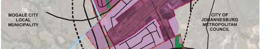
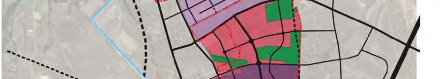

84 Plan 19. Cradle City Master Plan (2008) 82
UDF PLANS AND GUIDELINES
 UDF PLANS AND GUIDELINES 5 Land Use Land Use Development Plan Plan no. 3 Land Use Development Mixed Use Retail / Leisure Residential Civic and Institutional Proposed Zoning Table Development Edges Plan
Tāhuhu whakaruruhau ā-taone The sheltering ridge pole
 B2. Tāhuhu whakaruruhau ā-taone - Urban growth and form B2.1. Issues Tāhuhu whakaruruhau ā-taone The sheltering ridge pole Auckland s growing population increases demand for housing, employment, business,
4 RESIDENTIAL ZONE. 4.1 Background
 4 RESIDENTIAL ZONE 4.1 Background The residential areas within the City are characterised by mainly lowrise dwellings sited on individual allotments. Past architectural styles, settlement patterns and
Northern Territory Compact Urban Growth Policy
 Northern Territory Compact Urban Growth Policy A Reference Policy Document to clause 2.7 (Reference to Policy) of the NT Planning Scheme May 2015 Table of Contents 1 Policy Setting... 3 1.1 Context for
PART 5: DEVELOPMENT FRAMEWORK Figure 57: Proposed Height
 Figure 57: Proposed Height 103 Figure 58: Proposed Land Use 104 Figure 59: 3D Image of the Initial Height and Land Use in the Study Area 105 4.3.2 Landmarks and Nodes The growth of Sandton from an out
A Growing Community Rural Settlement Areas
 Town of Huntsville Official Plan Review - POLICY BACKGROUND PAPER A Growing Community Rural Settlement Areas BACKGROUND: In addition to the fully municipally-serviced Urban Settlement Area and the Hidden
Plan Modification to Chapter B2 of the Auckland Unitary Plan(AUP) Operative in part (15 November 2016)
 Operative in part (15 November 2016)") UNITARY PLAN UPDATE REQUEST MEMORANDUM TO FROM Phill Reid Linley Wilkinson DATE 25 September 2018 SUBJECT Plan Modification to Chapter B2 of the Auckland Unitary Plan(AUP) Operative in part (15 November
UNITARY PLAN UPDATE REQUEST MEMORANDUM TO FROM Phill Reid Linley Wilkinson DATE 25 September 2018 SUBJECT Plan Modification to Chapter B2 of the Auckland Unitary Plan(AUP) Operative in part (15 November
14.5 HOPEFIELD: (REFER PLAN 39 AND PLAN 40)
") URBAN DYNAMICS WESTERN CAPE INC. 248 14.5 HOPEFIELD: (REFER PLAN 39 AND PLAN 40) FIGURE 83: LOCALITY - HOPEFIELD Within the context of the Saldanha Bay Municipal area, Hopefield, an historical agricultural
URBAN DYNAMICS WESTERN CAPE INC. 248 14.5 HOPEFIELD: (REFER PLAN 39 AND PLAN 40) FIGURE 83: LOCALITY - HOPEFIELD Within the context of the Saldanha Bay Municipal area, Hopefield, an historical agricultural
I615. Westgate Precinct
 I615. Westgate Precinct I615.1. Precinct Description The Westgate Precinct is located approximately 18km west of the Auckland city centre. There are seven Sub-precincts in the Westgate Precinct: Sub-precinct
Draft Eastern District Plan
 Draft Eastern District Plan Submission_id: 31238 Date of Lodgment: 13 Dec 2017 Origin of Submission: Online Organisation name: Turrulla Gardens Pty Ltd C/- Mecone Organisation type: Industry First name:
HOROWHENUA DEVELOPMENT PLAN June create a safe crossing for children moving to and from the school and other areas. 7.8 Ohau
 7.8 Ohau create a safe crossing for children moving to and from the school and other areas. Ohau has a traditional village form with a collective of school, church and reserve at the main road intersection.
Official Plan Review
 Official Plan Review Summary Report - The Built Environment August 2014 Part 1: Introduction Planning for a healthy, prosperous and sustainable community is an important goal for our municipality. From
Appendix 1 Structure plan guidelines
 Appendix 1 Structure plan guidelines This appendix forms part of the regional policy statement [rps]. 1.1. Introduction Structure plans are an important method for establishing the pattern of land use
EXHIBIT A. Tax Increment Reinvestment Zone No. 1 (Town Center) First Amended Project Plan 1
 First Amended Project Plan 1") EXHIBIT A Tax Increment Reinvestment Zone No. 1 (Town Center) First Amended Project Plan 1 1 As amended by Resolution No. 2008-02-001(TR1R) of the Tax Increment Reinvestment Zone No.1, and approved to
EXHIBIT A Tax Increment Reinvestment Zone No. 1 (Town Center) First Amended Project Plan 1 1 As amended by Resolution No. 2008-02-001(TR1R) of the Tax Increment Reinvestment Zone No.1, and approved to
Appendix A. Planning Processes. Introduction
 1 Planning Processes Introduction This appendix outlines a number of planning processes which are used in the Auckland Region to support the effective management of development in the region s rural and
Land Use Amendment in Southwood (Ward 11) at and Elbow Drive SW, LOC
 at and Elbow Drive SW, LOC") 2018 November 15 Page 1 of 10 EXECUTIVE SUMMARY This land use amendment application was submitted by Rick Balbi Architect on 2017 August 31 on behalf of Sable Developments Ltd, and with authorization from
2018 November 15 Page 1 of 10 EXECUTIVE SUMMARY This land use amendment application was submitted by Rick Balbi Architect on 2017 August 31 on behalf of Sable Developments Ltd, and with authorization from
Draft Western District Plan
 Powered by TCPDF (www.tcpdf.org) Draft Western District Plan Submission_id: 31440 Date of Lodgment: 15 Dec 2017 Origin of Submission: Online Organisation name: Goodman Property Services Australia Pty Ltd
This page has been intentionally left blank.
 This page has been intentionally left blank. Chapter 3 3-2 3. Employment 3.A Niagara Economic Gateway 3.A.1 General The Niagara Economic Gateway comprises: a) The Gateway Economic Zone which includes all
6 Growth Management Challenges and Opportunities
 6 Growth Management Challenges and Opportunities The Town has established a goal of attaining a 50% participation rate with respect to employment opportunities versus residential population. The Town s
North District What we heard
 What we heard Vision to 2056 and Priorities Governance and implementation Infrastructure and funding The vision for a metropolis of three cities, and the 30 minute city. Feedback emphasised: That for the
CORNUBIA RETAIL PARK- PLANNING REPORT REVERT 3
 CORNUBIA RETAIL PARK- PLANNING REPORT 19.04.2013 REVERT 3 1 FOR: BY: 28 DEVONSHIRE AVENUE GLENWOOD DURBAN 4001 P.O. BOX 17390 CONGELLA 4013 T +27 31 202 9550 F +27 31 202 9551 1st FLOOR THE MEDIA MILL
The Proposed Auckland Unitary Plan (notified 30 September 2013)
") 3 Business zones Introduction There are 10 business zones in the Unitary Plan: City Centre Metropolitan Centre Town Centre Local Centre Neighbourhood Centre Mixed Use General Business Business Park Light
3 Business zones Introduction There are 10 business zones in the Unitary Plan: City Centre Metropolitan Centre Town Centre Local Centre Neighbourhood Centre Mixed Use General Business Business Park Light
Page 1 of 19 URBAN DESIGN FRAMEWORK FOR BOLTON STREET WATERFORD
 Page 1 of 19 URBAN DESIGN FRAMEWORK FOR BOLTON STREET WATERFORD 1.0 Introduction: The relocation of the City Council stores and depot from Bolton Street creates an exciting opportunity for development
CENTURY CITY URBAN DESIGN FRAMEWORK
 CENTURY CITY URBAN DESIGN FRAMEWORK REVISION 1 OCTOBER 2005 PLANNING PARTNERS : CENTURY CITY URBAN DESIGN FRAMEWORK October 2005 REVISION 1 ACKNOWLEDGEMENT This document has been prepared for Century City
CITY OF FREMANTLE LOCAL PLANNING SCHEME NO. 4 AMENDMENT NO. 68 SCHEME AMENDMENT REPORT
 CITY OF FREMANTLE LOCAL PLANNING SCHEME NO. 4 AMENDMENT NO. 68 SCHEME AMENDMENT REPORT CITY OF FREMANTLE PLANNING AND DEVELOPMENT SERVICES 8 WILLIAM STREET FREMANTLE WA 6160 PLANNING AND DEVELOPMENT ACT
Western City District What we heard
 What we heard Vision to 2056 and Priorities Governance and implementation Infrastructure and funding The protection of the natural landscape including biodiversity and the Metropolitan Rural Area for food
The Integrated Transport Plan: Non-motorised Transport in the City of Cape Town (1979) 1
 1") Integrating the Bicycle in Comprehensive Policies The Integrated Transport Plan: Non-motorised Transport in the City of Cape Town (1979) 1 The 1980-1985 Transport Plan for Cape Town Metropolitan Transport
Integrating the Bicycle in Comprehensive Policies The Integrated Transport Plan: Non-motorised Transport in the City of Cape Town (1979) 1 The 1980-1985 Transport Plan for Cape Town Metropolitan Transport
2A District-wide Policies
 2A Introduction This Chapter contains policies which are relevant to subdivision, use and development activities occurring across all zones and areas of the District. The policies in this Chapter implement
9 CITY OF VAUGHAN OFFICIAL PLAN AMENDMENT NO BOCA EAST INVESTMENTS LIMITED
 9 CITY OF VAUGHAN OFFICIAL PLAN AMENDMENT NO. 631 - BOCA EAST INVESTMENTS LIMITED The Planning and Economic Development Committee recommends the adoption of the recommendations contained in the following
SOCIO-ECONOMIC MOVEMENT ENVIRONMENT INFRASTRUCTURE TOWN PLANNING
 Table 7: SWOT Analysis SWOT ANALYSIS SOCIO-ECONOMIC MOVEMENT ENVIRONMENT INFRASTRUCTURE TOWN PLANNING STRENGTHS HIGH COMMUTER POPULATION DENSITY MAJORITY OF POPULATION BETWEEN AGE OF 15 & 34 LARGE AVAILABLE
The transportation system in a community is an
 7 TRANSPORTATION The transportation system in a community is an important factor contributing to the quality of life of the residents. Without a sound transportation system to bring both goods and patrons
KAMPLAN City of Kamloops. Section D. Land Use Policies D-1
 KAMPLAN City of Kamloops Section D Land Use Policies D-1 City of Kamloops KAMPLAN D 1 Land Management and Development This section links to the following Community Values: D-2 develop complete neighbourhoods
K. SMART ASSOCIATES LIMITED
 Planning Justification Report Zoning By-Law Amendment 185 King Street North Waterloo, Ontario April 7th, 2017 Project Reference Number 16-245 K. SMART ASSOCIATES LIMITED CONSULTING ENGINEERS AND PLANNERS
Joint Meeting City Council and the Plan Commission. September 1st, 2015
 Joint Meeting City Council and the Plan Commission September 1st, 2015 1 The City Plan Commission shall recommend a City Plan for the physical development of the City Article IX Section 2 of the City of
RSDF: REGION E ADMINISTRATIVE REGION E (REVIEW OF THE APPROVED 2009/10 RSDF) Prepared by: Development Planning and Facilitation
 Prepared by: Development Planning and Facilitation") ADMINISTRATIVE REGION E (REVIEW OF THE APPROVED 2009/10 RSDF) RSDF: REGION E Prepared by: Development Planning and Facilitation Department of Development Planning and Urban Management City of Johannesburg
ADMINISTRATIVE REGION E (REVIEW OF THE APPROVED 2009/10 RSDF) RSDF: REGION E Prepared by: Development Planning and Facilitation Department of Development Planning and Urban Management City of Johannesburg
DAREBIN PLANNING SCHEME AMENDMENT C137
 Who is the planning authority? Planning and Environment Act 1987 DAREBIN PLANNING SCHEME AMENDMENT C137 EXPLANATORY REPORT This amendment has been prepared by the Darebin City Council, who is the planning
LAND USE AMENDMENT CORNERSTONE (WARD 3) 60 STREET NE AND COUNTRY HILLS BOULEVARD NE MAP 26NE BYLAW 22D2017
 60 STREET NE AND COUNTRY HILLS BOULEVARD NE MAP 26NE BYLAW 22D2017") Page 1 of 14 EXECUTIVE SUMMARY This Land Use Amendment application covers an area of 43.76 hectares ± (108.14 acres ±) located in northeast Calgary, bound by Country Hills Boulevard NE to the south and
Page 1 of 14 EXECUTIVE SUMMARY This Land Use Amendment application covers an area of 43.76 hectares ± (108.14 acres ±) located in northeast Calgary, bound by Country Hills Boulevard NE to the south and
Welcome to the Oakridge Centre Open House
 Welcome to the Oakridge Centre Open House Why is the City hosting this event? This open house is to inform you of a rezoning application submitted to the City of Vancouver to amend the existing CD-1 (Comprehensive
The West Vaughan Employment Area Secondary Plan Policies
 Part 2: The West Vaughan Employment Area Secondary Plan Policies 2.1 General Policies It is the policy of Council: 2.1.1. That the West Vaughan Employment Area (the WVEA), identified on Schedule 1, will
YONGE STEELES CORRIDOR SECONDARY PLAN. Young + Wright / IBI Group Architects Dillon Consulting Ltd. GHK International (Canada) Ltd.
 Ltd.") PART A: PREAMBLE 1.0 PURPOSE The purpose of this Secondary Plan is to provide a development framework for intensification of the Yonge/ Steeles corridor including the north side of Steeles Avenue West
PART A: PREAMBLE 1.0 PURPOSE The purpose of this Secondary Plan is to provide a development framework for intensification of the Yonge/ Steeles corridor including the north side of Steeles Avenue West
EXECUTIVE SUMMARY DRAFT CHAPTER 1 INTRODUCTION EXECUTIVE SUMMARY
 CHAPTER 1 EXECUTIVE SUMMARY INTRODUCTION Through the joint efforts of the City of Tulsa planning staff and the Land Services division of Indian Nations Council of Governments (INCOG), the Berryhill Land
BERTRAMS PRIORITY BLOCK. Dra support documentation to the recommendations to SAHRA for the Priority Block, Bertrams, Johannesburg OCTOBER 2008
 BERTRAMS PRIORITY BLOCK Dra support documentation to the recommendations to SAHRA for the Priority Block, Bertrams, Johannesburg OCTOBER 2008 CONTENTS 1. Execu ve Summary 2. Report Structure 3. Background
WINCHESTER TOWN 3.1 LOCATION, CHARACTERISTICS & SETTING
 WINCHESTER TOWN 3.1 LOCATION, CHARACTERISTICS & SETTING 3.1.1 The area referred to by the City Council, as Winchester Town, consists of the Winchester Wards plus the adjoining built up areas of Badger
URBAN ISSUES AND RESPONSES. Nguyen Quang - Hanoi, March 04, 2016
 URBAN ISSUES AND RESPONSES Nguyen Quang - Hanoi, March 04, 2016 URBANIZATION TRENDS: INSIGHTFUL FIGURES Increasing urban demography By 2015, over half of the global population lives in cities This share
Local Growth Planning in North Central Green Line Communities
 2018 April 30 Page 1 of 6 EXECUTIVE SUMMARY This report outlines a high-level scope for local growth planning for north central Green Line communities. The catalyst for this review is the significant investments
Part I: Setting the Scene
 Part I: Setting the Scene B TABLE OF CONTENTS B.1 International imperatives... B.2 B.3 South African settlements - the policy environment... A vision for South African settlements... B A VISION FOR HUMAN
South District What we heard
 What we heard Vision to 2056 and Priorities Governance and implementation Infrastructure and funding Feedback supported: The vision for a metropolis of three cities, but emphasised the importance of infrastructure
DUBLIN DOCKLANDS MASTER PLAN AND RELATIONSHIP WITH OTHER PLANS
 .1 National Policy and Programmes.1.1 Sustainable Development A Strategy for Ireland, 1997.1.2 National Climate Change Strategy, 2007-2012.1. National Development Plan 2007-201.1.4 National Spatial Strategy,
SECTION E. Realizing the Plan
 SECTION E Realizing the Plan 60 DESIGN REGINA - OFFICIAL COMMUNITY PLAN SECTION E Realizing the Plan Design Regina has been an ambitious plan-making exercise, with a high level of community, stakeholder,
Integrated Urban Structuring in Australia An Overview of Principles and Practice
 ACNU08 Brisbane Integrated Urban Structuring in Australia An Overview of Principles and Practice Wendy Morris Ecologically Sustainable Design Pty Ltd Melbourne, Australia esdesign@netspace.net.au Ecologically
PORT WHITBY COMMUNITY
 PORT WHITBY COMMUNITY SECONDARY PLAN UPDATE COMMUNITY IMPROVEMENT PLAN URBAN DESIGN GUIDELINES September 2015 DRAFT PROPOSED AMENDMENT NUMBER # to the Whitby Official Plan PURPOSE: The intent of this Amendment
TABLE OF CONTENTS. Human Habitats, 155 Dorcas St South Melbourne, Victoria 3205
 TARNEIT JUNCTION Town Planning Report DECEMBER 2013 TABLE OF CONTENTS Table of contents... 1 1 Introduction... 2 2 SIte context and surrounds... 4 2.1 Site Features... 4 2.2 Surrounding land uses... 4
INCREMENTAL CHANGE AREA REVIEW March 2015 Page 1
 INCREMENTAL CHANGE AREA REVIEW March 2015 Page 1 Table of Contents Introduction... 3 Background to Review... 3 Comparison of the Schedules to the General Residential Zone... 7 Methodology... 7 Policy Context...
LAND USE AMENDMENT DOWNTOWN COMMERCIAL CORE (WARD 7) MACLEOD TRAIL SE AND 5 AVENUE SE BYLAW 254D2017
 MACLEOD TRAIL SE AND 5 AVENUE SE BYLAW 254D2017") Page 1 of 10 EXECUTIVE SUMMARY This Land Use Amendment application seeks to redesignate a full downtown block (currently the YWCA site) from a Direct Control based on the CM-2 District (Land Use Bylaw
Page 1 of 10 EXECUTIVE SUMMARY This Land Use Amendment application seeks to redesignate a full downtown block (currently the YWCA site) from a Direct Control based on the CM-2 District (Land Use Bylaw
8.0 Design and Form of Development 43/
 42/ 8.0 Design and Form of Development 43/ Rothwells Farm, Golborne/ Development Statement Figure 7. Site Constraints Key 44/ Site Boundary 360 Bus Route/Stops Existing Trees Underground Water Pipe Sensitive
elbridge Core Strategy
 C elbridge Core Strategy Celbridge is designated as a Moderate Growth Town in the RPGs. The County Development Plan reinforces this designation in its settlement strategy. Moderate Growth Towns within
Auckland City Council
 Auckland City Council Future planning framework version 3.0 9 September 2010 Find out more: Telephone (09) 379 2020 or visit www.aucklandcity.govt.nz www.itsmybackyard.co.nz Foreword Future planning framework
CITY CLERK. Parkland Acquisition Strategic Directions Report (All Wards)
") CITY CLERK Clause embodied in Report No. 10 of the, as adopted by the Council of the City of Toronto at its meeting held on November 6, 7 and 8, 2001. 10 Parkland Acquisition Strategic Directions Report
CITY CLERK Clause embodied in Report No. 10 of the, as adopted by the Council of the City of Toronto at its meeting held on November 6, 7 and 8, 2001. 10 Parkland Acquisition Strategic Directions Report
RURAL ZONE - POLICY. Rural Zone Policy. Issue: Rural Environment. Ruapehu District Plan Page 1 of 8
 Rural Zone Policy RU2 RURAL ZONE - POLICY RU2.1 Introduction The natural resources of the rural environment in the Ruapehu District provide the basis for the existing and potential character, intensity
HOLDING 88 OF THE LYTTELTON AGRICULTURAL HOLDINGS
 PROJECTS OF DUBRUTO URBAN PLANNING ALSO FOR SALE Unique Property for development for a mixed land use with a floor area ratio of 5 and Gautrain Urban Node parking standards for flats. Site is 550m from
Sustainable Growth. Sustainable Growth
 2 Sustainable Growth Sustainable Growth SUSTAINABLE GROWTH 2.1 COMMUNITY VISION... 2-5 2.2 THE CITY SYSTEM... 2-7 2.2.1 AREAS... 2-7 2.2.2 CITY-WIDE SYSTEMS... 2-8 2.2.3 PROVINCIAL PLAN BOUNDARIES AND
PRESENTATION ON JOHANNESBURG S BIODIVERSITY PROGRAMME
 PRESENTATION ON JOHANNESBURG S BIODIVERSITY PROGRAMME Member of Mayoral Committee: Cllr Prema Naidoo Environmental Management & Johannesburg City Parks PRESENTATION OVERVIEW Jo burg Overview & Context
Complete Neighbourhood Guidelines Review Tool
 Complete Neighbourhood Guidelines Review Tool Prepared By: City of Regina Planning Department October 2014 Page 1 of 14 Community Development Review Checklist for Secondary Plans and Concept Plans The
ROAD CLOSURE AND LAND USE AMENDMENT SILVER SPRINGS (WARD 1) NORTHEAST OF NOSEHILL DRIVE NW AND SILVER SPRINGS ROAD NW BYLAWS 2C2018 AND 29D2018
 NORTHEAST OF NOSEHILL DRIVE NW AND SILVER SPRINGS ROAD NW BYLAWS 2C2018 AND 29D2018") Page 1 of 19 EXECUTIVE SUMMARY This application proposes redesignating two parcels in the community of Silver Springs from Special Purpose Future Urban Development (S-FUD) District and undesignated road
Page 1 of 19 EXECUTIVE SUMMARY This application proposes redesignating two parcels in the community of Silver Springs from Special Purpose Future Urban Development (S-FUD) District and undesignated road
2.0 Strategic Context 4
 2.0 Strategic Context 4 2.1 The Area Action Plan is a non-statutory plan, which forms a corporate policy document, expressing particular issues and areas of concern while also providing a vision for the
178 Carruthers Properties Inc.
 178 Carruthers Properties Inc. Planning Rationale for 178 Carruthers Avenue Site Plan Control Application June 2014 Table of Contents 1.0 Introduction 2.0 Overview of Subject Property 3.0 Current Zoning
C. Westerly Creek Village & The Montview Corridor
 C. Westerly Creek Village & The VISION Community Vision When the goals of the city are achieved Westerly Creek Village, a distinctive community defined by Montview Boulevard and Westerly Creek, is a strong
GREENBANK DEVELOPMENT MASTERPLAN
 DEVELOPMENT MASTERPLAN POTENTIAL TRAIN STATION COMMUNITY CENTRE Greenbank will be a connected masterplanned community providing easy access to local and surrounding amenity. Affordable quality homes, green
CITY OF LANGLEY OFFICIAL COMMUNITY PLAN BYLAW, 2005, NO APPENDIX II - REGIONAL CONTEXT MAP
 CITY OF LANGLEY OFFICIAL COMMUNITY PLAN BYLAW, 2005, NO. 2600 APPENDIX II - REGIONAL CONTEXT MAP ± Legend Agricultural Mixed Employment Industrial Conservation & Recreation Regional City Centre Urban Containment
Central City District What we heard
 What we heard Vision to 2056 and Priorities Governance and implementation Infrastructure and funding The vision for a metropolis of three cities, and the 30 minute city. Feedback requested: Clearer communication
Rural Land Use Designations Kittitas County December 6, 2007 Draft
 KITTITAS COUNTY COMMUNITY DEVELOPMENT SERVICES 411 N. Ruby St., Suite 2, Ellensburg, WA 98926 CDS@CO.KITTITAS.WA.US Office (509) 962-7506 Fax (509) 962-7682 Rural Land Use Designations Kittitas County
The role of urban mobility in (re)shaping cities
shaping cities") The role of urban mobility in (re)shaping cities Mr. Andre Dzikus Urban Basic Services Branch Coordinator www.unhabitat.org Structure 1) Urbanisation - Challenges 2) Mobility shaping the city 3) Mobility
The role of urban mobility in (re)shaping cities Mr. Andre Dzikus Urban Basic Services Branch Coordinator www.unhabitat.org Structure 1) Urbanisation - Challenges 2) Mobility shaping the city 3) Mobility
Chapter 2: OUTLINE PLANNING APPLICATION PROPOSALS. A New Garden Neighbourhood Matford Barton 17
 Chapter 2: OUTLINE PLANNING APPLICATION PROPOSALS A New Garden Neighbourhood Matford Barton 17 2.1. SUMMARY AND STATUS OF THE PROPOSALS 2.1.1. The parameter plans and associated wording in this chapter
and services The protection and conservation of environmentally significant and sensitive natural heritage features and functions.
 6. Land Use 6.0 Preamble A healthy and livable city is one in which people can enjoy a vibrant economy and a sustainable healthy environment in safe, caring and diverse neighbourhoods. In order to ensure
NEW REGIONAL OFFICIAL PLAN HIGH LEVEL PROCESS & FRAMEWORK
 NEW REGIONAL OFFICIAL PLAN HIGH LEVEL PROCESS & FRAMEWORK Why A New Official Plan Originally the role of Regionally Planning and content of Regional Official Plan (1970s) primarily focused on protecting
Enclosures Appendix 1: Draft Golders Green Station Planning Brief. Summary
 Policy and Resources Committee 23 February 2017 Title Report of Wards Status Urgent Key Golders Green Station Draft Planning Brief Cath Shaw Commissioning Director - Growth & Development Interim Deputy
THREE PARKS ZONE Three Parks Special Zone The process of applying for resource consents in the zone.
 .25 Three Parks Special Zone The purpose of this zone is to provide for growth and to give effect to the Wanaka 2020 Community (2002) and the more recent Wanaka Structure (2007) and Wanaka Transport Strategy
City Regions Ireland
 City Regions Ireland 01 CITY REGIONS IRELAND COMPRISES OF CORK CHAMBER, DUBLIN CHAMBER, LIMERICK CHAMBER, WATERFORD CHAMBER AND GALWAY CHAMBER, ALL MEMBERS OF CHAMBERS IRELAND. 5 CITIES 8 PRINCIPLES A
Newcourt Masterplan. November Exeter Local Development Framework
 Newcourt Masterplan November 2010 Exeter Local Development Framework Background The Exeter Core Strategy Proposed Submission sets out the vision, objectives and strategy for the development of Exeter up
Employment and Commercial Review Analysis of Policy Directions
 Employment and Commercial Review Analysis of Policy Directions Appendix A The following analysis is town staff s response to the policy directions provided by the consultants who prepared the Employment
1.0 Purpose of a Secondary Plan for the Masonville Transit Village
 Report to Planning and Environment Committee To: Chair and Members Planning & Environment Committee From: John M. Fleming Managing Director, Planning and City Planner Subject: Masonville Transit Village
4 Sustainability and Growth Management
 4 Sustainability and Growth Management Introduction Traditionally, has assumed growth and development with limited consideration for the long-term negative social, environmental or economic impacts on
1.3 TRANSIT VISION 2040 FROM VISION TO ACTION THEME 1: PUTTING TRANSIT AT THE CENTRE OF COMMUNITIES. Fully integrate transit with community planning
 TRANSIT VISION 2040 FROM VISION TO ACTION TRANSIT VISION 2040 defines a future in which public transit maximizes its contribution to quality of life with benefits that support a vibrant and equitable society,
Regional Context Statement
 Regional Context Statement REGIONAL CONTEXT STATEMENT 3. REGIONAL CONTEXT STATEMENT In 1995, the Provincial Government passed into law the Growth Strategies Act. The purpose of this provincial initiative
Colchester Northern Gateway Master Plan Vision Review Draft. July 2016
 Colchester Northern Gateway Master Plan Vision Review Draft July 2016 Contents Introduction 4 Context 8 Purpose of the Report 8 Strategic Position 9 Overview of the Process 11 2012 Master Plan Vision 12
KEY ISSUES W.R.T. URBAN PLANNING GUIDELINES
 Land and Poverty Conference 2017: Responsible Land Governance - Towards an Evidence-Based Approach Source: Javier Mozas, Aurora Fernandez Per (2006), Density: New Collective Housing; UNHabitat 2013 NATIONAL-LEVEL
Gold Line Bus Rapid Transit Transit Oriented Development (BRTOD) Helmo Station Area Plan
 Helmo Station Area Plan") Appendix F Gold Line Bus Rapid Transit Transit Oriented Development (BRTOD) Helmo Station Area Plan Introduction and Purpose of the Plan The Gold Line Bus Rapid Transit facility is an eleven-mile dedicated
Appendix F Gold Line Bus Rapid Transit Transit Oriented Development (BRTOD) Helmo Station Area Plan Introduction and Purpose of the Plan The Gold Line Bus Rapid Transit facility is an eleven-mile dedicated
DRAFT GREATER SYDNEY REGION PLAN OBJECTIVES, STRATEGIES AND ACTIONS
 Greater Sydney Commission DRAFT GREATER SYDNEY REGION PLAN OBJECTIVES, STRATEGIES AND ACTIONS Issued: 26 OCTOBER 2017 Version: 1 Subject: Greater Sydney Region and District Plans This information note
The Corporation of the TOWN OF MILTON
 Report to: From: Chair & Members of the Administration & Planning Standing Committee W.F. Mann, Director of Planning and Development Date: April 16, 2012 PD 022-12 (Z19/11) Subject: Technical Report Proposed
Implementation Guide Comprehensive Plan City of Allen
 Implementation Guide 2030 Comprehensive Plan City of Allen DRAFT 2015 Implementation Guide Allen 2030 Comprehensive Plan INTRODUCTION The Comprehensive Plan serves as a guide for the growth and development
13 THORNHILL YONGE STREET STUDY IMPLEMENTATION CITY OF VAUGHAN OPA 669 AND TOWN OF MARKHAM OPA 154
 13 THORNHILL YONGE STREET STUDY IMPLEMENTATION CITY OF VAUGHAN OPA 669 AND TOWN OF MARKHAM OPA 154 The Planning and Economic Development Committee recommends the adoption of the recommendations contained
Chapter 10 IMPLEMENTATION RECOMMENDATIONS
 Chapter 10 IMPLEMENTATION RECOMMENDATIONS The recommended land use plan presented in the previous chapter provides a design for the attainment of the urban and rural development and open space preservation
Ten Mile Creek Planning Area
 PLANNING AREA POLICIES TEN MILE CREEK Ten Mile Creek Planning Area Location and Context The Ten Mile Creek Planning Area ( Ten Mile Creek area ) is located south of the current Boise AOCI, generally south
[PLANNING RATIONALE] For Site Plan Control and Lifting of Holding Zone By-Law 101 Champagne Avenue. May 23, 2014
![[PLANNING RATIONALE] For Site Plan Control and Lifting of Holding Zone By-Law 101 Champagne Avenue. May 23, 2014](/thumbs/75/71599615.jpg "[PLANNING RATIONALE] For Site Plan Control and Lifting of Holding Zone By-Law 101 Champagne Avenue. May 23, 2014") [PLANNING RATIONALE] For Site Plan Control and Lifting of Holding Zone By-Law 101 Champagne Avenue May 23, 2014 Contents 1.0 Introduction... 2 2.0 Site Context... 2 2.1 Adjacent Uses... 2 Figure 1: Site
[PLANNING RATIONALE] For Site Plan Control and Lifting of Holding Zone By-Law 101 Champagne Avenue May 23, 2014 Contents 1.0 Introduction... 2 2.0 Site Context... 2 2.1 Adjacent Uses... 2 Figure 1: Site
MAIN STREET ECONOMIC DEVELOPMENT STRATEGY
 MAIN STREET ECONOMIC DEVELOPMENT STRATEGY A PATHWAY TO A BETTER POUGHKEEPSIE DRAFT Working Paper #2: Planning Strategies Submitted December 1 st, 2015 to the City of Poughkeepsie LAND USE LAW CENTER PACE
CITY COUNCIL AGENDA REPORT
 CITY COUNCIL AGENDA REPORT Subject: COUNCIL MOTION LRT ALIGNMENT REMOVAL FROM THE TRANSPORTATION MASTER PLAN On February 10, 2016 Councillor Hughes provided notice in accordance with Section 23 of Procedure
Envision Skagit 2060 Citizen Committee Briefing Paper
 Envision Skagit 2060 Citizen Committee Briefing Paper Rural Villages & Fully Contained Communities (FCCs) By Mark Personius, AICP, Growth Management Consultant Rural Villages and Fully Contained Communities
SUBJECT: GO Station Mobility Hubs Preferred Concepts: Aldershot GO, Burlington GO and Appleby GO. Planning and Development Committee - Public Meeting
 Page 1 of Report PB-76-17 SUBJECT: GO Station Mobility Hubs Preferred Concepts: Aldershot GO, Burlington GO and Appleby GO TO: FROM: Planning and Development Committee - Public Meeting Planning and Building
Wollondilly Resilience Network (WReN) Inc. Comments on the Draft South West District Plan
 Inc. Comments on the Draft South West District Plan") Wollondilly Resilience Network (WReN) Inc. Comments on the Draft South West District Plan March 2017 About WReN Wollondilly Resilience Network (WReN) Inc. is a not for profit community association based
Wollondilly Resilience Network (WReN) Inc. Comments on the Draft South West District Plan March 2017 About WReN Wollondilly Resilience Network (WReN) Inc. is a not for profit community association based
SECTION 2.4 URBAN DEVELOPMENT AND STRATEGIC URBAN DIRECTIONS
 SECTION 2.4 URBAN DEVELOPMENT AND STRATEGIC URBAN DIRECTIONS 2.4.1 INTRODUCTION In 1993/94 the Hastings District Council completed the Hastings Urban Development Strategy. The purpose of this study was: