SUPPORTING PLANNING STATEMENT. Proposed Residential Development Land to the West of Cody Road, Waterbeach, Cambridgeshire. for.
|
|
|
- Hope Morris
- 6 years ago
- Views:
Transcription
1 SUPPORTING PLANNING STATEMENT Proposed Residential Development Land to the West of Cody Road, Waterbeach, Cambridgeshire for Manor Oak Homes Prepared by: Peter McKeown MSc, BSc (Hons) York House, Dukes Court, Newmarket Road, Cambridge, CB5 8DZ Tel: Fax:
2 CONTENTS 1. INTRODUCTION SITE DESCRIPTION PROPOSED DEVELOPMENT PLANNING POLICY ASSESSMENT EMERGING LOCAL PLAN OTHER MATERIAL CONSIDERATIONS HEALTH IMPACT ASSESSMENT AFFORDABLE HOUSING KEY BENEFITS OF THE PROPOSED DEVELOPMENT SUMMARY AND CONCLUSION... 48
3 1. INTRODUCTION 1.1 This Planning Statement has been prepared on behalf of Manor Oak Homes and in support of a full planning application for a residential development of 60 dwellings. A full description of the proposed development is set out below. The site is located on land to the west of Cody Road and to the rear of Nos Bannold Road in Waterbeach. The description of the proposed development is as follows: Full planning permission for the erection of 60 dwellings (Class C3) including affordable housing, access, car parking and associated works, open space, landscaping and a children s play area. 1.2 The application site is approximately 1.88 hectares in size and is identified on the Site Location Plan (Drawing No. 7777/002). The site is an undeveloped parcel of agricultural land and it is located immediately adjacent to the Development Framework boundary for Waterbeach. The site is currently clear of built development and a new access will be provided to serve the proposed development. The site is outside of any defined Conservation Area, and there are no nearby Listed Buildings, nor does the site incorporate any protected trees. The application site and the proposed development area are described in full in the Design and Access Statement that accompanies the planning application. 1.3 The application is supported by the following documentation: Application Forms and Certificates of Ownership; Site Location Plan (application site edged red) Drawing No. 7777/002 Application Drawings and list (rg+p Architects); Planning Statement (Januarys); Affordable Housing Statement within the Planning Statement (Januarys); Health Impact Assessment within the Planning Statement (Januarys); Design and Access Statement (rg+p Architects); Statement of Community Engagement (Januarys); Arboricultural Report (First Environment Limited); Transport Statement & Travel Plan (JPP Consulting); Januarys Consultant Surveyors Page 1 of 49
4 Landscape Supporting Statement (First Environment Limited); Phase 1 Habitat Survey (First Environment Limited); Flood Risk Assessment and Drainage Strategy (JPP Consulting); Services Report (JPP Consulting); Sustainability Report (Brookbanks Consulting Ltd); and Site Waste Management Plan (JPP Consulting). Background to the site 1.4 Waterbeach is a large fen-edge village located six miles north of Cambridge and falls within the administrative district of South Cambridgeshire. The application site itself is located to the west of Cody Road and is situated on the north eastern edge of Waterbeach. The site is an undeveloped parcel of land and is surrounded by residential development to the south and west, with land associated with the former MOD Barracks situated immediately to the north. Agricultural land is present to the east on the opposite side of Cody Road. The site is accessible to the services and facilities provided within the village by walking, cycling and public transport and the proposed development will provide a mix of both market and affordable housing. 1.5 Waterbeach is identified as a Minor Rural Centre in the Council s Core Strategy, making it a suitable village for some additional development. South Cambridgeshire District Council is currently in the process of preparing a new Local Plan for the area and The Strategic Housing Land Availability Assessment (SHLAA) has identified various site options for consideration in the new local plan; the application site was viewed as one with development potential. 1.6 The recently published Issues and Options Report has also identified the site as having development potential. In addition, South Cambridgeshire District Council cannot demonstrate a five year supply of deliverable housing sites; and this housing shortfall has been confirmed by the Local Planning Authority. In these circumstances, applications for residential development should be considered in the context of the presumption in favour of sustainable development, and should be approved unless any impacts of doing so would significantly and demonstrably outweigh the benefits. In summary, we consider that the proposal represents sustainable development, where there are no constraints or adverse impacts, and would contribute to the local housing supply. The site is a suitable location for development and there are substantial Januarys Consultant Surveyors Page 2 of 49
5 benefits associated with it. The scheme will provide much needed housing, including a mix of both market and affordable and as there is a shortfall in housing land in South Cambridgeshire, the principle of providing residential development on this suitably located, sustainable site is acceptable in planning terms. Pre-application Consultation 1.7 It had been the applicant s intention to meet with Waterbeach Parish Council to discuss the proposals for the site prior to submission. However, the applicant has tried to contact the Parish Council on three occasions regarding this and has only recently received a response back. As a result, we will be meeting with the Parish Council on the 2 nd April 2013 to discuss certain elements of the application. Discussions have been held with the Highways Authority regarding access and car parking provision at the site. In addition, a public exhibition was held to provide local residents, businesses and elected representatives with an opportunity to comment on the emerging proposals. The details of the pre-application consultation are provided in the Statement of Community Involvement 1.8 A public exhibition was held on 14 th February 2013 at the Village Primary School. There was support for the proposed development from the people that attended the exhibition and those that completed a comments form. The planned redevelopment of the site for residential purposes was generally well received. A number of detailed questions and comments were raised and these have all been carefully considered ahead of the application being submitted with amendments being made to the scheme. 1.9 The applicant has been keen to involve all local members of the community in their attempts to bring forward a sustainable development of this site, in a manner which will be of benefit to the area, and which will provide a positive and distinctive streetscape. The applicants will be prepared to continue with all relevant discussions with neighbours throughout the determination period of the application, and beyond, and seeking to be seen as a good neighbour to those already resident within the immediate locality. If considered necessary and worthwhile, the applicants are also prepared to meet with the Parish Council post submission to discuss the scheme. Januarys Consultant Surveyors Page 3 of 49
6 Report Structure 1.10 In Section 2 we describe the application site and the surrounding area. In Section 3 we provide details of the proposed development, and explain the rationale behind the different parts of the proposal. In Section 4 we set out the national and local planning policies that are relevant to the proposed development. In Section 5 we review the relevance of the emerging Local Plan. In Section 6 we highlight the other material considerations and decisions that are relevant to the determination of the application. In Section 7, we provide a Health Impact Assessment; within Section 8 a statement of affordable housing is provided. In Section 9 we highlight the benefits of the proposed development, before finally setting out our conclusions in Section 10. Januarys Consultant Surveyors Page 4 of 49
7 2. SITE DESCRIPTION Surrounding Area 2.1 Waterbeach is a large village situated to the north of Cambridge and to the south of Ely. Cambridge is 6 miles from the village and Ely is 10 miles away. The village is located to the east of the A10, one of the major arterial roads into Cambridge. The main route through the village is High street and this connects to the A10 via Denny End Road and Car Dyke Road. There are a number of bus routes through the village and these provide public transport links to a number of places including Cambridge and Ely. 2.2 The village is defined as a Minor Rural Centre in the South Cambridgeshire Core Strategy. Histon and Impington, which are approximately four miles from the village, is one of the five higher order Rural Centres in the District settlement hierarchy and as such would provide additional services and facilities not provided within Waterbeach. Cottenham (another Minor Rural Centre) is situated approximately four miles to the north west of the village. 2.3 Waterbeach is a sustainable village and this is strengthened by the presence of a railway station providing direct access to Cambridge and London. Additional housing has also been delivered in the village in recent years and a broader range of services and facilities are now available. The village contains the following facilities; Bakers, Butchers, two village stores, Pharmacy, Hairdressers, Garage, Hotel, five Public houses, two takeaways and a restaurant. The village also provides a wide range of services which include: a primary school, children s nurseries, post office, library, doctor s surgery, churches, village hall, sports and recreation pitches and children s play areas. Employment opportunities within the village exist at the Denny End Industrial Estate and the site is also in close proximity to the Cambridge Science Park with the Cambridge Park and Ride at Milton located only two miles away. 2.4 The site itself is currently used for agricultural purposes. The recently completed residential development at Cam Locks, is situated to the west and this boundary is formed by a mixture of mature trees and hedging. The residential properties at Nos Bannold Road are located to the south and a timber close boarded fence augmented by trees and vegetation is present along this boundary. Waterbeach barracks, formerly occupied by the MOD is present to the north and Januarys Consultant Surveyors Page 5 of 49
8 this area is to formally close at the end of The boundary at this location is formed by a concrete post and wire fence supported by a number of mature trees. 2.5 The site itself is generally flat and is well connected to the facilities available within the village. The site is in close proximity to the village centre with the site situated approximately 800m from the High Street and 300m from Waterbeach Community Primary School. The Railway Station is approximately 1km away from the site, with the nearest Bus stop situated 40m from the site entrance. Planning History 2.6 There is no planning application activity or history associated with this land at Cody Road, Waterbeach. There are accordingly no permissions which are relevant to the proposed development. 2.7 A couple of other applications have recently been approved within the District and these are relevant to the determination of this application. Application S/2509/12 for the erection 47 dwellings was approved in February 2013 on land at Long Drove and Beach Road, Cottenham. Application S/0440/12/FL for the erection of 26 dwellings at Station Road in Over was refused planning permission in February 2012 and this application was subsequently dismissed at appeal in February These are explained further within Section 6 of this report. Januarys Consultant Surveyors Page 6 of 49
9 3. PROPOSED DEVELOPMENT 3.1 The proposed development for the site is shown on the Site Plan (Drawing No.7777/001M), with the drawings package also including all the required floor plans and elevation drawings. The proposal is for a residential development comprising 60 dwellings. It also includes a new internal road network, parking areas, new pedestrian access, landscaping and a children s play area. 3.2 An indicative mix of residential accommodation is set out in Table 1 below. The development provides a wide mix of residential accommodation, including two, three, four and five bed houses, as well as one and two bed flats. This mix of accommodation is in accordance with Core Strategy Policy HG/2. Table 1: Schedule of Accommodation Dwelling Beds Affordable Market Total House House House House Flats Flats Total Affordable 24 Total Market 36 Total Units 60 Affordable Housing 3.3 It is proposed that 24 of the 60 dwellings would be affordable units, and this represents 40% of the total number of dwellings on site. This proportion of affordable housing provided within the scheme is in accordance with Policy HG/3 of the Core Strategy. The Council has confirmed that the mix of affordable property sizes and types is acceptable and that they would be willing to support the proposal. The Council s preferred tenure split would be 70/30 in favour of rented units. The Affordable Housing Statement is contained in Section 8 of this Planning Statement. Januarys Consultant Surveyors Page 7 of 49
10 Key Aspects of Proposed Development Design and Layout 3.4 The key design features of the development have been identified as follows: Creating a linear Public Open Space (POS) situated along the western boundary of the site connecting the proposed development with the adjacent Cam Locks site and area of POS. The POS provides room to incorporate a new pedestrian link between Cody Road and the Cam Locks site, as well as providing a new play area. The orientation of the proposed dwellings takes full advantage of the surrounding views as well as addressing the existing housing surrounding the site. The positioning of the dwellings also allows for natural surveillance to be provided throughout the site. A new access point for the development has been provided onto Cody Road. Where possible, car parking has been kept discrete and is situated away from plot frontages with a combination of surface/garage arrangements. The apartment blocks are situated to the Western boundary of the site and this allows for natural surveillance of the proposed and adjacent areas of POS. Access Arrangements 3.5 Highway access for the proposed development will be provided from Cody Road with a new access point being provided. Individual access points have been provided for the dwellings that front onto Cody Road. Height and Scale 3.6 The size of the properties varies in width from 7.3m to 14.7, and depths between 6.6m and 13.2m (including L-shaped configuration). The height of the dwellings range from 2 storey houses to 2 1/2 storey houses. The 2 storey apartment blocks are situated on part of the site overlooking the POS to increase activity and help provide natural surveillance. Materials used 3.7 The materials used across the proposed development include brick, render and timber. High quality modern and natural materials that are characteristic of the surrounding area will be used in the development, and this will ensure that a distinctive sense of place is created at the site. Januarys Consultant Surveyors Page 8 of 49
11 Informal Open Space 3.8 The scheme is very relaxed in terms of its layout, with areas of informal open space created within the site. A pleasant living environment will be created at the site that will be well connected with the rest of the village. With regards to the provision of private open space at the site generous house sizes are proposed with good outside spaces suitable for modern family living. Children s Play Area 3.9 A linear area of Public Open Space has been provided along the western boundary of the site and a children s play area containing pieces of play equipment has been provided within this area. It is proposed that this area will connect with and enhance the existing area of POS provided to the west of the site. Discussions regarding this area are currently ongoing between the applicant and the Parish Council and if a designated children s play area with play equipment is not required, then a commuted sum to enhance the existing play areas in the village will be provided. Highways 3.10 The application is supported by a Transport Statement and this has concluded that the proposed development is shown to be well served and accessible to more sustainable modes of transport. The proposed development is within close proximity of a number of facilities required by residential dwellings. It is also not predicted that this proposed development of 60 units will have an adverse impact on the surrounding highway infrastructure. Parking 3.11 Discussions have been held with the Highways Authority regarding the provision of car parking at the site. Parking Standards require that 1.5 to 2 car parking spaces are provided per dwelling with garages, where provided also counting as a parking space. Secure storage for a minimum of 1 cycle has also been provided within the garages or within a covered enclosure in the rear gardens. A communal covered cycle store has been provided for the flats. A total of 114 car parking spaces have been provided for the development and these arrangements comply fully with the standards set out at Appendix 1 of the Development Control Policies DPD. These are all shown on the Site Plan drawing 7777/001M. Januarys Consultant Surveyors Page 9 of 49
12 3.12 The site lies in a highly sustainable location, being close to the public transport infrastructure, with established major bus routes located within the village and on Cody Road. The site is also within easy walking and cycling distance of the services available in the village centre and the railway station. It can therefore be concluded that the development is acceptable in terms of its level of car and cycle provision and its close proximity to take advantage of other sustainable transport modes. Refuse Strategy 3.13 Each dwelling will be provided with three bins and these will be stored in garages or within designated areas in the rear gardens. A separate bin store containing larger commercial bins has been provided for the flats. The bins will be allocated for green waste, dry recyclables, and residual waste The refuse vehicle will enter the site and can turn within the site. The tracking diagrams that accompany the application confirm that this is the case. There are a couple of areas where the vehicle will not travel and in these areas a couple of refuse collection points have been provided and on collection day residents will deliver their bins to these areas where they will be emptied by refuse officers. Contaminated Land 3.15 The application is accompanied by a Contaminated Land Assessment prepared by RPS. This has indicated that there is potential for a degree of contamination to have occurred in the vicinity of the site associated with historical military activities (particularly the airfield). However, given the absence of any potentially contaminative land uses identified on the site and the apparent residential nature of land uses close to the site associated with the Barracks, there is a low likelihood of significant ground contamination impacting on the site The site is considered to be located in moderately sensitive environmental setting. It is partly above a Secondary Aquifer relating to the River Terrace Deposits, and partly above an Unproductive Strata relating to the Gault Formation (Mudstone). Residential properties are located adjacent to the site and a surface water drain lies 10m to the east. Januarys Consultant Surveyors Page 10 of 49
13 3.17 The risk of contamination at the site is considered to be low and no further investigation work is required. As a result, the future use of the land for residential purposes is considered to be entirely acceptable. Flood Risk Assessment and Drainage Assessment 3.18 The site is located within Flood Zone 1 (low probability) and as such, the report concludes the development to be in Flood Zone 1 and at a low risk of flooding from rivers or the sea. The development is assessed as having a less than 1 in 1,000 annual probability of river or sea flooding in any year (<0.1%). The report also considers that the possibility of flooding on the site from ground water as low. The application site is also not at risk of flooding from sewers or reservoirs With regard to the storm water drainage strategy at the site, surface water will be attenuated to greenfield runoff rates to ensure that the rate of surface water runoff from the site does not increase as a result of the proposed development. The indicative surface water layout plan enclosed at Appendix C of the FRA shows that surface water attenuation can be accommodated on the site and the method of discharge assuming that infiltration techniques are not viable. Information on runoff rates are included at Appendix D of the FRA and it is proposed that the surface water runoff from the proposed development will be limited to the Qbar greenfield equivalent rate of 3.2l/s via a vortex flow control device. The surface water will discharge into the drainage ditch located on the western boundary of the site. Foul water will discharge to Anglian Waters Sewer network located in Bannold Road In summary, surface water drainage from the site, post development, is such that the surface water will be managed and disposed of within the site boundary, thus complying with the Technical Guidance to the NPPF. Based on this, providing that the strategies within the report are adopted then the developed site will not contribute further to flood risk thus satisfying the principles of the NPPF. Services 3.21 The application is accompanied by an Incoming Services Appraisal. This confirms that the nearest Anglian Water Assets are located within Bannold Road. Details on storm water drainage and foul water drainage are provided within the accompanying FRA. Januarys Consultant Surveyors Page 11 of 49
14 3.22 Water supply to the development will be via Bannold Road and Cambridgeshire Water has confirmed that the water main at this location has adequate capacity to accommodate the development. UK Power Networks have confirmed that the proposed development can be supplied with electricity without the need for offsite reinforcement works. It has also been confirmed that the development can be provided with telecommunications. National Grid has confirmed that the proposed development can supplied with gas without the need for offsite reinforcement works. Phase 1 Habitat (Ecology) Survey 3.23 This report prepared by First Environment Consultants Ltd has concluded that the application site is of very limited wildlife value. The boundary hedgerow and trees were considered to hold some potential for nesting birds, and a couple of old woodpigeon and magpie nests were observed. The report has determined that the trees along the northern boundary had very low potential for bat roosting and/or hibernation. The site is also considered to be of relatively low value to foraging or commuting bats with all the trees and hedges along the site boundaries being retained as part of the proposals Due to the absence of ponds or wetland features within the site, it was determined to have low potential for amphibians and reptiles. The adjacent surface water attenuation pond and dry ditch did not contain any permeable water, and overall they were thought to have little potential for amphibians. There were also no sign of otters or water voles in these areas. As the site consists of arable farmland under continuous cultivation, with only very narrow strips of poor, semi-improved grassland around the boundaries, it was concluded that there was low potential invertebrate assemblages, in particular those species listed as a priority in the UK Biodiversity Action Plan and/or Local Biodiversity Action Plan With regards to future work required, no further surveys or mitigation measures are considered necessary as the existing vegetation along the site boundaries will be retained. Arboricultural 3.26 The application is accompanied by an Arboricultural Report prepared by First Environment Limited. A total of 18 individual trees, one group and three hedges were recorded during the survey. The schedule at Appendix B of the Report provides a detailed record of these Januarys Consultant Surveyors Page 12 of 49
15 components. Appendix C also provides a graphical representation of the survey data. This survey has concluded that in order to enable development to proceed on site it will be necessary to remove eight Cat C trees, one Cat U tree, one Cat C group and one Cat C hedge, and the partial clearance of one Cat C hedge. These are all Category C trees that are not considered to be worthy of retention and therefore their removal is acceptable in principle The proposed development will not cause any damage to any important trees or vegetation present within the site. Mature trees are present along the site boundaries and these help to give the site some enclosure. The applicant is committed to delivering a scheme which will preserve and enhance the landscaped appearance of the site. Landscaping 3.28 The development of the landscape strategy and layout has involved the collaboration of various disciplines, including architecture, landscape architecture, planning and highways. A key principle of this development is to marry and integrate the design of new build residential dwellings with areas of existing dwellings to the south and west and a former MOD site to the north of the proposed development The external landscape and environment has been developed to promote a distinct sense of place, address a range of visual issues and be capable for accommodating the development functions. The qualities of a successful landscape for the site will include: Providing a sustainable landscape; Delivering character and distinctiveness in keeping with the area of Waterbeach; Providing access and connectivity across the site; Providing for public amenity and accessibility; and Delivering enhanced biodiversity The scheme proposes the planting of semi-mature trees and other landscaping features to ensure that the buildings sit comfortably within a landscaped setting. The layout of the development allows these landscaped features to be provided in the key locations. Januarys Consultant Surveyors Page 13 of 49
16 Archaeology 3.31 It is considered that Archaeology will not be a constraint on development; therefore appropriate mitigation will be carried out via condition. We have held some initial discussions with the Archaeology Department at the County Council and they have confirmed that this is the case. The applicant would fully anticipate an appropriately worded condition on any planning approval. Sustainability 3.32 The application is accompanied by a Sustainability Statement prepared by Brookbanks Consulting Ltd. This document sets out a range of sustainability measures that can be implemented at the proposed development to meet national and local policy requirements whilst maximising and adding additional value to the local growth areas The proposals provide sustainability credentials across the development that will result in tangible benefits to the environment and to occupiers of the development. Along with reductions in water usage, the proposals substantially reduce the demand on fossil fuels and associated CO2 production, all corresponding to significant reduction in household bills. Januarys Consultant Surveyors Page 14 of 49
17 4. PLANNING POLICY ASSESSMENT 4.1 This section of the Planning Statement sets out the planning policy background against which the proposed development is to be considered. It sets out the relevant statements of planning policy within the statutory development plan and the National Planning Policy Framework (NPPF) that influence the scheme. 4.2 Section 38 (6) of the Planning & Compulsory Purchase Act 2004 states that if regard is to be had to the development plan for the purposes of any determination to be made under the Planning Acts, the determination must be made in accordance with the development plan unless material considerations indicate otherwise. Furthermore, paragraph 10 of The Planning System: General Principles published by the ODPM states in part that local authorities must determine planning applications in accordance with the statutory Development Plan, unless material considerations indicate otherwise. 4.3 Section 82(1) of the Local Democracy, Economic Development and Construction Act 2009 and Section 38(3) of the Planning & Compulsory Purchase Act 2004 state that the development plan is the regional strategy for the region within in which a proposal is located and the development plan documents that have been approved or adopted. The Localism Bill was granted Royal Assent on 15 th November Section 109 of the Localism Act 2011 makes provision for the abolition of regional strategies. The strategic environmental assessment procedure for the abolition of the east of England Plan has been completed. The Regional Strategy for the East of England (Revocation) Order 2012 came into force on the 3 rd January The order means that the East of England Plan, and the saved policies in the Cambridgeshire & Peterborough Structure Plan, no longer form part of the development plan. 4.4 Consequently, the statutory Development Plan insofar as it relates to the application site and the proposed development currently comprises: South Cambridgeshire Core Strategy (January 2007) South Cambridgeshire Development Control Policies DPD (July 2007) 4.5 Paragraphs 13 and 14 of the ODPM s The Planning System: General Principles go on to state that the Government s statements on planning policy are material considerations which must be taken into account, where relevant, in decisions on planning applications whilst emerging Januarys Consultant Surveyors Page 15 of 49
18 policies can be regarded as material considerations. Paragraph 18 goes on to explain that the weight to be attached to policies in emerging DPD will depend upon the stage of preparation or review, increasing as successive stages in their preparation are reached. 4.6 In this case, a South Cambridgeshire Local Plan is currently in the process of being prepared and The Strategic Housing Land Availability Assessment (SHLAA) has identified various options for consideration in the new local plan and the application site was viewed as one with development potential. The recently produced Issues and Options Report has also identified the site as having development potential. It is proposed that a draft local plan for consultation will be published towards the end of In addition to the statutory development plan, South Cambridgeshire District Council has also adopted a range of Supplementary Planning Documents (SPD), which provide further technical advice and guidance on the implementation of adopted planning policies. The relevant SPDs for this application are as follows: Open Space in New Development (January 2009) Public Art (January 2009) Trees and Development Sites (January 2009) Biodiversity (July 2009) Landscape in New Development (March 2010) District Design Guide (March 2010) Affordable Housing (March 2010) Health Impact Assessment (March 2011) 4.8 Cambridgeshire County Council has recently adopted an SPD relating to waste management, which sets out the design standards for waste collection facilities in new developments. Waste Management Design Guide SPD (February 2012) These documents are discussed in further detail, later on within this statement. Januarys Consultant Surveyors Page 16 of 49
19 National Planning Policy Guidance 4.9 The national planning policy context was until very recently provided in a number of separate statements of Government policy and guidance (Planning Policy Statements & Planning Policy Guidance notes). However, on 27 th March 2012, the Government published the National Planning Policy Framework (NPPF). This one statement of Government planning policy has superseded much of the guidance that had been contained in both the PPS & PPG with immediate effect. National Planning Policy Framework (2012) 4.10 The NPPF is a key part of the Government s reforms to make the planning system less complex and more accessible; and to promote sustainable development. At the outset, the NPPF explains (paragraph 6) that the purpose of the planning system is to contribute to the achievement of sustainable development. Paragraph 6 goes on to state that the NPPF constitutes the Government s view of what sustainable development in England means in practice for the planning system In paragraph 7 the NPPF explains that there are three dimensions to sustainable development: An economic role contributing to building a strong responsive and competitive economy, by ensuring that sufficient land of the right type is available in the right places and at the right time to support growth and innovation; and by identifying and coordinating development requirements, including the provision of infrastructure. A social role supporting strong, vibrant and healthy communities, by providing the supply of housing to meet the needs of present and future generations; and by creating a good quality built environment, with accessible local services that reflect the community s needs and supports its health and well-being; and An environmental role contributing to protecting and enhancing our natural, built and historic environment; and, as part of this, helping to improve biodiversity, use natural resources prudently, minimise waste and pollution, and mitigate and adapt to climate change, including moving to a low carbon economy Paragraph 8 goes on to say that: These roles should not be undertaken in isolation, because they are mutually dependent. Economic growth can secure higher social and environmental standards, Januarys Consultant Surveyors Page 17 of 49
20 and well-designed buildings and places can improve the lives of people and communities. Therefore, to achieve sustainable development, economic, social and environmental gains should be sought jointly and simultaneously through the planning system. The planning system should play an active role in guiding development to sustainable solutions Subsequently, in paragraph 14, it states that: At the heart of the National Planning Policy Framework, is a presumption in favour of sustainable development and subsequently, that for decision making, this means: approving development proposals that accord with the development plan without delay; and where the development plan is absent, silent or relevant policies are out of date, granting permission unless: o o any adverse impacts of doing so would significantly and demonstrably outweigh the benefits, when assessed against the policies in this Framework taken as a whole; or specific policies in this Framework indicate development should be restricted As set out below, in this case there is no five year supply of deliverable housing sites within the District. As set out in the supporting documents that accompany the application, there would be no adverse impacts associated with the proposed development. We consider that in these circumstances, this application should be considered within the context of the presumption in favour of sustainable development, and should be granted planning permission Paragraph 17 then sets out twelve core planning principles that should underpin plan making and decision taking. In respect of the proposed development scheme, key amongst these are to: proactively drive and support sustainable economic development to deliver the homes, business and industrial units, infrastructure and thriving local places that the country needs. Every effort should be made objectively to identify and then meet the housing, business and other development needs of an area, and respond positively to wider opportunities for growth always seek to secure high quality design and a good standard of amenity for all existing and future occupants of land and buildings; Januarys Consultant Surveyors Page 18 of 49
21 support the transition to a low carbon future in a changing climate, taking full account of flood risk and, encourage the use of renewable resources actively manage patterns of growth to make the fullest possible use of public transport, walking and cycling, and focus significant development in locations which are or can be made sustainable; and deliver sufficient community and cultural facilities and services to meet local needs In response to this the proposed development provides additional housing that is needed in the local area and which would contribute towards the district s shortfall of housing supply. Waterbeach has been identified as a suitable village for additional development and the application site represents a sustainable location for future residential development. The scheme will also deliver public open space and a children s play area. A well designed scheme which has carefully considered the characteristics of the surrounding area has been prepared for the site and this is explained in detail within the accompanying Design and Access Statement. The supporting application documents demonstrate that there would be no unacceptable adverse impacts associated with the proposal Under the heading of Promoting Sustainable Transport the NPPF notes in part (paragraph 35) that development should be located and designed where practical to: give priority to pedestrian and cycle movements and have access to high quality public transport facilities; create safe and secure layouts which minimise conflicts between traffic and cyclists or pedestrians 4.18 It goes on in paragraph 38 to state that: For larger scale residential developments in particular, planning policies should promote a mix of uses in order to provide opportunities to undertake day to day activities, including work, on site. Where practical, particularly within large scale developments, key facilities such as primary schools and local shops should be located within walking distance of most properties The NPPF then addresses Delivering a Wide Choice of High Quality Homes and notes that in order to boost significantly the supply of housing LPA are expected, amongst other things to Januarys Consultant Surveyors Page 19 of 49
22 use their evidence base to ensure that their Local Plan meets the full, objectively assessed needs for market and affordable housing in the housing market area, as far as is consistent with the policies set out in this Framework, including identifying key sites which are critical to the delivery of the housing strategy over the plan period (paragraph 47) Bullet point 2 of Paragraph 47 is particularly relevant to this application as this sets out what is expected of local planning authorities to maintain a housing land supply. It states: identify and update annually a supply of specific deliverable sites sufficient to provide five years worth of housing against their housing requirements with an additional buffer of 5% (moved forward from later in the plan period) to ensure choice and competition in the market for land. Where there has been a record of persistent under delivery of housing, local planning authorities should increase the buffer to 20% (moved forward from later in the plan period) to ensure choice and competition in the market for land Footnote 11 within this Paragraph seeks to clarify what deliverable means. It states: To be considered deliverable, sites should be available now, offer a suitable location for development now, and be achievable with a realistic prospect that housing will be delivered on the site within five years and in particular that development of the site is viable. Sites with planning permission should be considered deliverable until permission expires, unless there is clear evidence that schemes will not be implemented within five years, for example they will not be viable, there is no longer a demand for the type of units or sites that have long term phasing plans Paragraph 49 is also of particular relevance and states: Housing applications should be considered in the context of the presumption in favour of sustainable development. Relevant policies for the supply of housing should not be considered up-to-date if the local planning authority cannot demonstrate a five-year supply of deliverable housing site South Cambridgeshire District Council is not managing its housing land supply. The Core Strategy sets a target for housing land supply in South Cambridgeshire of 20,000 dwellings between 1999 and The most recent Annual Monitoring Reports have recorded allocations for 16,534 dwellings, however it also indicates that only 13,045 dwellings are projected to have been Januarys Consultant Surveyors Page 20 of 49
23 completed during the plan period to The District is not maintaining a five year supply of deliverable housing sites; the Annual Monitoring Report concluded that at the end of March 2012 the Council had a supply of deliverable housing land of just 2.4 years. The fact that the District is not maintaining a five year supply has been confirmed within recent application and appeal decisions (at Cottenham and Over); we comment on the outcome of these decisions in Section 6. In these circumstances, where there has been persistent under delivery of housing, there is a strong case for the additional 20% buffer to be applied; we note that recent appeal decisions have also suggested that it would be appropriate to apply a 20% buffer for the District. We consider that the proposed development should be approved because it provides additional housing that would contribute towards the housing shortfall, and is in a sustainable location Under the heading of Requiring Good Design the NPPF then notes that the Govt. attaches great importance to the matter of design, stating that Good design is a key aspect of sustainable development, is indivisible from good planning and should contribute positively to making places better for people (paragraph 56). It goes on to state in paragraph 58 that planning decisions should aim to ensure that developments: will function well and add to the overall quality of the area, not just for the short term but over the lifetime of the development; establish a strong sense of place, using streetscapes and buildings to create attractive places to live, work and visit; optimise the potential of the site to accommodate development, create and sustain an appropriate mix of uses (including incorporation of green and other public space as part of developments) and support local facilities and transport networks; respond to local character and history, and reflect the identity of local surroundings and materials, while not preventing or discouraging appropriate innovation; create safe and accessible environments where crime and disorder, and the fear of crime, do not undermine quality of life or community cohesion; and are visually attractive as a result of good architecture and appropriate landscaping. Januarys Consultant Surveyors Page 21 of 49
24 4.25 The design and layout of the proposed development is explained and justified in the Design and Access Statement and it is considered that a high quality and sustainable design has been proposed for the site The NPPF then goes on to address Promoting Healthy Communities. Paragraph 69 states in part that decisions should aim to achieve places which promote: opportunities for meetings between members of the community who might not otherwise come into contact with each other, including through mixed-use developments, strong neighbourhood centres and active street frontages which bring together those who work, live and play in the vicinity; safe and accessible environments, where crime and disorder and the fear of crime, do not undermine quality of life or community cohesion; and safe and accessible developments, containing clear and legible pedestrian riots, and high quality public space which encourage the active and continual use of public areas These matters have been addressed within the proposed site layout for the site and further justification is provided with the Design and Access Statement. The Health Impact Assessment in Section 7 considers the health-related impacts of the proposed development, including access to facilities, health facilities, sport and recreation and fresh food In addressing climate change, paragraph 96 of the NPPF states in part that in determining planning applications LPA should expect new development to: comply with adopted Local Plan policies on local requirements for decentralised energy supply unless it can be demonstrated by the applicant, having regard to the type of development involved and its design, that this is not feasible or viable; and take account of landform, layout, building orientation, massing and landscaping to minimise energy consumption Paragraph 99 deals with the potential outcomes of climate change, including flooding. It states: Local Plans should take account of climate change over the longer term, including factors such as flood risk, coastal change, water supply and changes to biodiversity and landscape. New development should be planned to avoid increased vulnerability to the range of impacts arising Januarys Consultant Surveyors Page 22 of 49
25 from climate change. When new development is brought forward in areas which are vulnerable, care should be taken to ensure that risks can be managed through suitable adaption measures, including through the planning of green infrastructure Paragraph 100 goes on to state: Inappropriate development in areas at risk of flooding should be avoided by directing development away from areas at highest risk, but where development is necessary, making it safe without increasing flood risk elsewhere The site is not at risk of flooding because it falls within Flood Zone 1. As a result, the development will not be at risk from flooding and the principle of redeveloping the site for residential purposes is entirely appropriate given the flood risk status of the land. It is also clear that the development will not increase the risk of flooding elsewhere. As such the development accords fully with the advice and guidance provided within the NPPF Under the heading of Conserving and Enhancing the Natural Environment paragraph 118 states in part that when determining planning applications, LPA should aim to conserve and enhance biodiversity by applying the following principles: if significant harm resulting from a development cannot be avoided (through locating on an alternative site with less harmful impacts), adequately mitigated, or, as a last resort, compensated for, then planning permission should be refused; opportunities to incorporate biodiversity in and around developments should be encouraged; planning permission should be refused for development resulting in the loss or deterioration of irreplaceable habitats, including ancient woodland and the loss of aged or veteran trees found outside ancient woodland, unless the need for, and benefits of, the development in that location clearly outweigh the loss 4.33 The Ecological Assessment indicates that there are no features of high ecological or biodiversity importance on the application site, and the development of this agricultural land would not result in significant ecological impact. Januarys Consultant Surveyors Page 23 of 49
26 4.34 The NPPF then addresses Conserving and Enhancing the Historic Environment. Paragraph 128 states in part that In determining applications, local planning authorities should require an applicant to describe the significance of any heritage assets affected, including any contribution made by their setting The final section of the NPPF addresses the matter of Decision-taking. Paragraph 187 states that: Local planning authorities should look for solutions rather than problems, and decision-takers at every level should seek to approve applications for sustainable development where possible. Local planning authorities should work proactively with applicants to secure developments that improve the economic, social and environmental conditions of the area Paragraphs 196 and 197 then state that: The planning system is plan-led. Planning law requires that applications for planning permission must be determined in accordance with the development plan, unless material considerations indicate otherwise. This Framework is a material consideration in planning decisions. In assessing and determining development proposals, local planning authorities should apply the presumption in favour of sustainable development The proposed development would provide additional housing, which would contribute towards meeting the shortfall in housing supply. South Cambridgeshire District Council cannot show a deliverable 5 year supply of housing land supply and as a result application sites situated outside development frameworks should be favourable considered and the presumption in favour of sustainable development applied. The proposed development is acceptable in design terms and it has been demonstrated that the site can accommodate a scheme of 60 dwellings. Therefore, the proposal represents sustainable development and as such should be approved Paragraph 204 deals with planning obligations. It states: Planning obligations should only be sought where they meet all of the following tests: necessary to make the development acceptable in planning terms; directly related to the development; and Januarys Consultant Surveyors Page 24 of 49
27 fairly and reasonably related in scale and kind to the development. The Planning System General Principles (2005) 4.39 The Planning System General Principles, provides advice on the determination of planning applications in terms of prematurity. It also notes that Government statements of planning policy are material considerations. Paragraph 13 states: The Courts have also held that the Government s statements of planning policy are material considerations which must be taken into account, where relevant, in decisions on planning applications. These statements cannot make irrelevant any matter which is a material consideration in a particular case. But where such statements indicate the weight that should be given to relevant considerations, decision-makers must have proper regard to them. If they elect not to follow relevant statements of the Government s planning policy, they must give clear and convincing reasons (E C Grandsen and Co Ltd v SSE and Gillingham BC 1985) At paragraph 17 the guidance notes that it may be justifiable to refuse planning permission in circumstances where a DPD is under preparation or review, but has not yet been adopted: where a proposed development is so substantial, or where the cumulative effect would be so significant, that granting permission could prejudice the DPD by predetermining decisions about the scale, location or phasing of new development which are being addressed in the policy in the DPD It then goes on to state that: A proposal for development which has an impact on only a small area would rarely come into this category. Subsequently in paragraph 18 the guidance notes that otherwise refusal on grounds of prematurity will not usually be justified and that planning applications should continue to be considered in the light of prevailing policies. However, it then notes that: account can also be taken of policies in emerging DPDs. The weight to be attached to such policies depends upon the stage of preparation or reviews, increasing as successive stages are reached. Paragraph 18 the continues Where a DPD is at the consultation stage, with no early prospect of submission for examination, then refusal on prematurity grounds would seldom be justified because of the delay which this would impose in determining the future use of the land in question. Januarys Consultant Surveyors Page 25 of 49
28 4.42 Prematurity cannot be considered to be an issue in the determination of this application as the new local plan is only at the very early stages of preparation. Circular 11/95 Conditions 4.43 This Circular provides guidance on the Government s intentions for appropriate use of conditions through the development control process. The imposition of a condition can be used in instances whereby planning permission may otherwise have to be refused. Paragraph 14 provides guidance upon the six tests that should be applied to the use of conditions, i.e. that: Conditions should be necessary, relevant to planning, relevant to the development to be permitted, enforceable, precise and reasonable in all other aspects It is anticipated that the planning permission will be subject to conditions. Community Infrastructure Levy (CIL) Regulations (2010) 4.45 The CIL Regulations came into force in April The Regulations have in part the effect of limiting the use of Planning Obligations to circumstances where: It is necessary to make the development acceptable in planning terms; It is directly related to the development; and It is fairly related in scale and kind to the proposed development (Regulation 122) 4.46 Furthermore, Regulation 123 limits the pooling of S106 funding or infrastructure provision South Cambridgeshire District Council is in the process of preparing a CIL Charging Schedule, which will in due course replace the Planning Obligations SPD. Until this process has been completed, the Council will continue to collect planning obligations through S106. Januarys Consultant Surveyors Page 26 of 49
29 The Development Plan 4.48 Key provisions of the statutory development plan and emerging development plan documents, insofar as they relate to the planning application, are addressed in the following paragraphs. This includes a detailed assessment of the scheme against relevant adopted plan policies. South Cambridgeshire Core Strategy 4.49 The South Cambridgeshire Core Strategy sets the strategic policies for the District and provides the overarching framework for the Site Specific Policies DPD and the Development Control Policies DPD Policy ST/2 identifies a housing target of 20,000 additional dwellings between 1999 and The housing target includes affordable housing. The dwellings will be directed to the following locations, in order of preference: the edge of Cambridge; Northstowe new town; and, in the Rural Centres and other villages. Large scale allocations have already been identified for development around Cambridge and for Northstowe. In both cases, delivery at the large scale strategic sites has been slower than expected. The application site falls within a defined village and as such is one of the preferred locations for development Paragraph 13 of the Council s AMR for 2011/2012 (published December 2012) compares the housing trajectory against the housing target within Policy ST/2 of the Core Strategy. The Council has identified 17,073 new dwellings that could be provided over the next 20 years (and beyond) based on existing allocations and planning permissions, including 4,531 dwellings that could be provided over the next five years. However, despite being able to identify this level of deliverable housing land, the Council has a shortfall against its five year housing land supply requirement. At Paragraph 13 the Council states that it has only 2.3 years of housing land supply based on the Core Strategy Policy ST/2 annualised average requirement. There is a clear shortfall in housing land in the short-term. In these circumstances suitable housing sites in sustainable location, such as the application site, should be brought forward and approved without delay as required by the NPPF Policy ST/5 identifies the Minor Rural Centres within the District and proposes that these are suitable villages for some additional development. Waterbeach is classified as a Minor Rural Centre, which reflects the scale of the existing village and the existing facilities and services that it provides. The application site is located immediately adjacent to the defined settlement Januarys Consultant Surveyors Page 27 of 49
30 boundary of the village. The Policy sets an indicative maximum threshold of 30 dwellings for individual residential schemes. This is a suggestive figure and it is felt that this particular Policy cannot be given much weight given the Councils failure to demonstrate a five year supply of deliverable housing sites. In any event, the efficient use of the site would deliver more than the 30 dwellings threshold. In these circumstances there is no basis to limit the scale of development at the site. South Cambridgeshire Development Control Policies DPD 4.53 The Development Control Policies DPD sets out the topic based policies that the application will be assessed against and each of these is addressed below: Sustainable Development 4.54 Objective DP/c seeks to ensure that new development promotes the principles of sustainable development. Policy DP/1 identifies the criteria that contribute to sustainable development. The application site is located immediately adjacent to the settlement boundary on the northern edge of Waterbeach. It is accessible to the facilities and services within the village by walking and cycling, which should reduce the need to travel by car. We deal with the other relevant aspects of sustainable development below e.g. energy use, renewable energy, water conservation, flood risk and drainage, and biodiversity Policy DP/1 also requires a Health Impact Assessment (HIA) to be submitted with major applications. The HIA for the application is contained in Section 7. Design 4.56 Objective DP/d seeks to deliver high quality development. Policy DP/2 identifies the criteria for assessing the design of new development. The relevant criteria for the proposed development include the impact on character of local area, impact on environmental assets, respect local distinctiveness, deliver a legible development, deliver a permeable development, provide a mix of house types and provide high quality landscaping. Policy DP/3 identifies the features that development should include, such as affordable housing, appropriate access from highway network, car parking, safe and secure cycle parking, outdoor play space and facilities for the collection of refuse. Policy HG/1 relates to housing density and specifies a district-wide density of 30 dwellings/hectare and a density of 40 dwellings/hectare in sustainable locations. The Januarys Consultant Surveyors Page 28 of 49
31 proposed development achieves a density of 33 dwellings/hectare, which is within the range specified in the policy. Monitoring data indicates that the density of the proposed development is quite moderate for larger developments, however, the planned urban extension and new settlements within the district are expected to achieve densities of 50 dwellings/hectare. The Design and Access Statement submitted with the application explains the design of the proposed development in detail In summary, we set out below how the proposed development complies with the design criteria: Preserve or enhance the character of the local area the design and layout of the development would be similar to existing established residential areas within the village. Retain important environmental assets a large number of the existing trees along the site boundaries will be retained. Respond to local context and respect local distinctiveness the design and setting of surrounding development has a strong influence on the design of the proposed development. Achieve both a legible and permeable development the layout is convenient for pedestrians, cyclists and vehicles. Be of appropriate scale, mass and proportion and use appropriate materials the houses will be predominantly two storey with a few two and a half storey dwellings and these will be constructed from similar materials to the existing buildings in the village. Provide a mix of house types the proposed development will provide a wide mix of house types comprising of two, three, four and five bed houses along with one and two bet flats. The scheme will also include a mix of both and private and affordable accommodation. Provide high quality public spaces Informal open space and a children s play area will be provided within the development. Deliver a safe and inclusive environment the layout has been designed to be safe and attractive for all residents and users. Januarys Consultant Surveyors Page 29 of 49
32 Include high quality landscaping additional trees, hedges and areas of soft landscaping have been provided as part of the development Policy NE/14 seeks to control external lighting associated with development. The proposed development would retain the existing street lighting provided along Cody Road and also provide lighting within the site. These are matters that would normally be addressed once the design and layout has been approved and as a result it is suggested that lighting is dealt with via a suitably worded planning condition Policy SF/6 relates to the delivery of public art in association with development. The Council encourages the provision or commission of publicly accessible art, craft and design works and would normally require developers to contribute a percentage of construction costs to public art. We suggest that public art is dealt with as a condition as it undecided as to whether or not this will be provided onsite or via a financial contribution. Housing 4.60 Objective HG/a seeks to ensure that a range of house types and sizes are provided, including affordable housing, to meet identified housing needs. Policy HG/2 carries forward Objective HG/a and states that.in developments of more than 10 dwellings a mix of units will be sought providing a range of accommodation, including one and two bed dwellings, having regard to economic viability, the local context of the site and the need to secure a balanced community. A proportion of new dwellings should be designed to lifetime mobility standards. The proposed development would provide two, three, four, and five bedroom houses and one and two bedroom flats. The development would provide both affordable and market houses. Therefore, the proposed development complies with Policy HG/2 by providing a mix of house types and sizes Policy HG/3 sets a District-wide affordable housing target of 40% and specifies that the affordable units should be distributed throughout developments in clusters of 6-8 dwellings. As set out in Section 3, which described the development, a total of 24 affordable units will be provided as part of the application, which represents 40% of the total number of dwellings on site. The proportion of affordable housing provided would therefore be in accordance with Policy HG/3. The Affordable Housing Statement is contained in Section 8, which sets out the proposed affordable housing mix within the proposed development. Januarys Consultant Surveyors Page 30 of 49
33 Trees and Landscape 4.62 The Trees and Development SPD seeks to retain high value trees. With regard to this the proposed development will not cause any damage to any trees or vegetation present within the site. The application is accompanied by an Arboricultural Impact Assessment report produced by First Environment Limited. There are no Tree Preservation Orders (TPO) present on the site and the layout has gone to considerable lengths to retain the majority of the trees on the site with minimum loss and disturbance of Root Protection Areas The Landscape in New Development SPD identifies the benefits of landscape within development. A Landscape Plan has been submitted alongside the application and this proposes the planting of a wide mix of semi-mature trees, shrubs and hedging to ensure the buildings sit comfortably within a landscaped setting. This more appropriate planting scheme further assimilates the scheme onto the site. The development is therefore able to create attractive spaces which draw inspiration from their surroundings with the proposed built form appearing well integrated within the sites wider setting. This approach complies entirely with the SPD. Natural Environment 4.64 Objective NE/c seeks to protect and enhance biodiversity. Policy NE/6 expects new development to aim to maintain, enhance, restore or add to biodiversity. This also indicates that opportunities should be taken to achieve positive gain through the form and design of development Ecological surveys of the site have been undertaken which confirm that the proposed development site is of relatively low biodiversity value. In summary, there are no features of high ecological or biodiversity importance on the application site, and the redevelopment of this site would not result in significant adverse ecological impact. The Landscaping proposals submitted alongside the application recommends that additional trees, hedges, and wildlife areas should be planted, which would create an attractive development in landscape terms but would also enhance biodiversity. Flood Risk and Drainage 4.66 The site falls within Flood Zone 1 according to the Environment Agency Flood Risk maps, which means it has a low risk of flooding and there are no constraints to the site being occupied by Januarys Consultant Surveyors Page 31 of 49
34 sensitive residential uses. In these circumstances the only consideration is the impact from surface water drainage. The surface water will discharge into the drainage ditch located on the western boundary of the site. Foul water will discharge to Anglian Waters Sewer network located in Bannold Road. Therefore, the proposed development complies with Policy NE/11, which seeks to minimise flood risk The Foul Sewage and Services Assessment demonstrate that the infrastructure is available to support the proposed development. The proposed development therefore complies with Policy NE/9, which seeks to ensure an adequate water supply, sewerage and land drainage system for new development. Water Conservation 4.68 Policy NE/12 seeks to conserve water. The Sustainability Report assessed water conservation, and included that grey or rainwater collection would not be practical or economically viable for the site, which means that other methods of water conservation will be necessary. As part of water conservation targets properties will have measures introduced to restrict water consumption to a maximum of 105 litres per day per person. This requirement will be achieved through the use of water efficient fittings, such as delayed inlet valves and flow restrictors, and water efficient appliances such as low flush WC s. Transport 4.69 The transport-related objectives are similar to national ones; to promote the use of more sustainable modes of travel and to direct development to accessible locations. Policy TR/1 seeks to promote more sustainable travel. As set out in the Transport Statement, the site is wellrelated to the services and facilities provided within the village. It has good non-car accessibility and is within easy walking and cycling distance of a wide range of facilities. This means that residents of the proposed development will be able to walk or cycle for short journeys within the village, instead of using the car. For journeys to key employment, leisure, shopping and recreational uses in Cambridge and other nearby towns, the village is served by a good quality bus service, which stops very close to the site on Cody Road. Waterbeach also benefits from having a Railway Station and this is situated in close proximity to the application site. The railways station offers direct access to Cambridge and London and this provides a realistic alternative to car travel for many journeys. The Cambridge Park and Ride facility at Milton is also Januarys Consultant Surveyors Page 32 of 49
35 situated only 2 miles away. We conclude that the location of the proposed development should enable residents make a choice about using non-car modes of transport The scheme will provide off-street parking and sufficient storage has also been provided for secure cycle parking. A total of 114 car parking spaces have been provided within the development, and this complies with the standards contained in Appendix 1 of the Development Control Policies DPD. Open Space 4.71 Policy SF/10 requires outdoor play space and informal open space to be delivered with development. Policy SF/11 defines the open space standards. The proposed development requires 0.19ha of open space to be provided and these areas are shown on the the accompanying Masterplan. These areas comprise a children s play area and other less formal areas. It is also proposed that linkages with the adjacent areas of open space provided for the adjacent Cam Locks site can also be provided as part of the development. Discussions regarding the future maintenance of these areas are currently ongoing. The open space is conveniently located to all parts of the development and will be overlooked by dwellings. Energy 4.72 A Sustainability Report has been prepared for the site. Policy NE/1 relates to energy efficiency, and seeks to reduce carbon dioxide emissions by 10% when compared with minimum building regulation requirements. Policy NE/3 relates to renewable energy technologies in new development, and expects 10% of energy to be generated from renewable sources. Where possible the houses and flats have been located and orientated to allow passive solar gain to all the primary living spaces. High levels of insulation, double glazed windows and well-sealed buildings will reduce the energy demands of the buildings. It is clear from the findings of the Sustainability Report that at least 10% of the developments predicted energy requirements can be provided on site from renewable energy resources. This document identifies a range of sustainability measures that can be provided at the proposed development that meets national and local policy requirements. It is important to provide an array of viable options/solutions for the development to ensure that a suitable strategy is available in an everchanging and evolving market. The sustainability report provides a number of options that could be implemented a site-wide strategy to achieve high levels of sustainability in line with the required local and Januarys Consultant Surveyors Page 33 of 49
36 national policies. The report has identified that Photovoltaic (PV) Panels represent the preferred and most suitable renewable energy provider and Co2 saving technique. As such this development is found to accord with the requirements of Policy NE/3. Site Waste Management 4.73 This document details the overall design philosophy adopted during the conception, design and specification processes in order to minimise the amount of waste generated by the development. The document confirms that the applicant will ensure that all waste generated by the site is disposed of in accordance with best practice, and indicative values are provided regarding waste arisings. Summary 4.74 In summary it is felt that Waterbeach is a sustainable village and as a result a similar approach that has recently been adopted in Cottenham should be applied to Waterbeach. The flexibility which was exercised at Cottenham was to allow a slightly larger scale of development adjoining the village which the Core Strategy would have allowed at least in principle within the village framework. It has been accepted by the LPA that there is a shortage of housing land supply in South Cambridgeshire District and in line with the Policies of the NPPF, the presumption in favour of sustainable development should be applied and this application approved. Januarys Consultant Surveyors Page 34 of 49
37 5. EMERGING LOCAL PLAN 5.1 South Cambridgeshire District Council are currently in the process of preparing a new Local Plan for the area and within the emerging plan, the application site has been identified as Site Option 48 and importantly as having development potential. As part of the review of the Local Plan, the Council has produced a Strategic Housing Land Availability Assessment to identify sites and options for consideration for allocation in the new Local Plan. The application site was appraised as part of this review and was assessed as being a site with development potential. A copy of this assessment is attached at Appendix The Village Classification Report published in June 2012 will be used to inform the preparation of the new Local Plan. Surprisingly, this report has indicated that Waterbeach does not meet the public transport test, despite the presence of the railway station which offers direct access to Cambridge, London, and Ely. It is felt that Waterbeach benefits from having excellent transport facilities and the village also scored well on the employment front. This Report has concluded that Waterbeach should either be retained as a Minor Rural Centre or downgraded to a new category called a Better Served Group Village. 5.3 Within the Issues and Options Report, the application site has been categorised as Green which means it has sustainable development potential. Within the report the application site has been identified as having good accessibility by bus, bike and on foot and also to have limited impacts on the landscape setting of the area. As a result it can therefore be concluded Waterbeach is a suitable village for further development and the Local Planning Authority considers that the site is capable of providing residential development. In summary the site represents a suitable and sustainable location for a development of the size proposed. Januarys Consultant Surveyors Page 35 of 49
38 6. OTHER MATERIAL CONSIDERATIONS 6.1 We set out the material considerations that we consider are relevant to the decision-making process for this application. In this case, the fact that South Cambridgeshire District Council does not have a five year supply of deliverable housing sites is a material consideration that means the application should be granted planning permission, particularly since the site is a suitable location for development and the proposal represents sustainable development. The land supply position has been accepted by officers as a material consideration for other similar sized applications on the edge of Minor Rural Centres, which justifies a recommendation to grant planning permission when considered alongside high quality design and no other constraints. This view has also been supported and accepted by Planning Committee as it would improve the housing land supply position in the District. Housing Land Supply Position 6.2 The latest housing land supply position for South Cambridgeshire District is set out in the Annual Monitoring Report 2022/2012 (published December 2012), and this report confirms that there is a shortfall in housing land supply in South Cambridgeshire, and that it does not have a five year supply of deliverable housing site; as set out below the housing land position has been confirmed in recent application and appeal decisions. 6.3 The Annual Monitoring Report was published in December 2012, and covers the monitoring period from 1 st April 2011 to 31 st March The housing trajectory for the district is set out in the table below: Plan Period of Housing To Date Residual Annual 5 Year Plan Target Completions Target Target Supply Core ,000-10,039/5 4,681/2,007 Strategy 4 years 20,000 9,961 9,961 = = = 2007 remaining 10,039 2, years Januarys Consultant Surveyors Page 36 of 49
39 6.4 Therefore despite having an annual target of 1,176 dwellings over the plan period the district has an average completion rate of 766 dwellings. This means that 9,961 dwellings have been completed when the targets required 15,276 dwellings resulting in a shortfall of 5,314 dwellings over the past 13 years. 6.5 Therefore, South Cambridgeshire District Council has sufficient sites for only 2.3 years, which is substantially below the requirement for a five years supply of deliverable housing sites. As set out within a recent application in Cottenham (a Minor Rural Centre) on a similar edge of settlement site the Council accepted that there is a house land supply shortfall. Application S/2509/12 was approved by Planning Committee in February as the application was consistent with the guidance in the NPPF and would help to address the identified housing land supply shortfall. A copy of the Planning Committee Report for this application is attached at Appendix 2. Interestingly this site was also assessed as part of the SHLAA and within the Issues and Options report it was assessed as being a site with development potential. 6.7 Over the past 13 years within South Cambridgeshire the targets required over 15,275 dwellings to be delivered, however only 9,961 have been completed and this has resulted in a shortfall of 5,314 dwellings. Only once in the past 13 years has South Cambridgeshire achieved the required targets and as a result a significant housing shortfall exists. This situation runs contrary to the expectations of the NPPF, which seeks to boost significantly the supply of housing (Paragraph 47) and identify and update annually a supply of specific deliverable sites sufficient to provide five years worth of housing against their housing requirements (bullet point 2 paragraph 47). The table below shows the completion dates in South Cambridgeshire District since 1999: Year 1999/ / / / / / / Completions Januarys Consultant Surveyors Page 37 of 49
40 2006/ /2008 1, / / / / Paragraph 49 of the NPPF states: Housing applications should be considered in the context of the presumption in favour of sustainable development. Relevant policies for the supply of housing should not be considered up-to-date if the local planning authority cannot demonstrate a five-year supply of deliverable housing sites. 6.8 Within a recent appeal decision (Ref: APP/W0530/A/12/ ) at Over in South Cambridgeshire the Planning Inspector has indicated that a 20% buffer could be justified due to the persistent undersupply of housing. This states: The South Cambridgeshire Annual Monitoring Report (AMR), December 2012, indicates a supply of 2.4 years in meeting the 20,000 dwelling target set by the Core Strategy between 1999 and 2016, and if the persistent under delivery over most of the plan period illustrated in Figure 5.1 justifies the 20% buffer recommended in para. 47 of the Framework, then the supply would drop to approximately two years. A copy of this decision is attached at Appendix Therefore, planning applications for residential development should be considered favourably where there is no five year supply of deliverable housing sites, as is clearly the case in South Cambridgeshire. The NPPF expects a 20% buffer to be applied where there has been a persistent record of under delivery as is the case in South Cambridgeshire. There is compelling case for granting planning permission at the application site on housing land supply grounds. In addition, we consider that the application site is a suitable location for residential use, there are no constraints to development or adverse impacts, and the proposal represents sustainable development. Januarys Consultant Surveyors Page 38 of 49
41 7. HEALTH IMPACT ASSESSMENT 7.1 Policy DP/1 of the Development Control Policies DPD requires a Health Impact Assessment (HIA) to be undertaken for major developments. The Council has published a Health Impact Assessment SPD which provides advice on the content of the assessment. 7.2 Paragraph 2.9 of the SPD explains the purpose of a HIA. It states: A Health Impact Assessment should: Appraise the potential positive and negative health and well-being impacts of the proposed development on planned new communities and the adjacent existing communities in the development area. Highlight any potential differential distribution effects of health impacts among groups within the population by asking who is affected? for the impacts identified. Suggest actions / mitigations that aim to minimise any potential negative health impacts and maximise potential positive health impacts, referencing where possible the most affected vulnerable group(s). 7.3 The proposed development is relatively small and is not complex or hazardous and we consider that it would be unlikely to have a significant impact on health. In addition, the application site is located immediately adjacent to the development framework for Waterbeach and has been identified as having development potential in both the SHLAA and the Issues and Options Report. Therefore, we have not undertaken a full HIA, but have assessed the site against health criteria to ensure that the proposed development would become a healthy and sustainable community; we have assessed the application against the health criteria identified by the Healthy Urban Development Unit (HUDU) which is set out in Appendix 3 of the SPD. Our assessment is set out below. Healthy Lifestyles 7.4 This criteria relates to access to outdoor space for sport, exercise and recreation. Waterbeach already contains playing fields, equipped children s play areas, other play areas, woodland and parkland. There are sports pitches for football, cricket, tennis courts and bowling green, as well as a LEAP at the Waterbeach Recreation Ground on Cambridge Road in the village. There are Januarys Consultant Surveyors Page 39 of 49
42 many opportunities for residents of the proposed development to undertake formal and informal exercise within the village and those facilities are accessible by walking or cycling. In addition, the proposed development includes informal open space and a children s play area, which should provide residents with a further opportunity to access outdoor space closer to where they live. Housing Quality 7.5 The criteria seeks to deliver high quality housing. All dwellings will be constructed in a similar style to ensure the character of the development is sympathetic to the vernacular style found within Waterbeach. The appearance of the scheme will fit in with the surrounding area through the use of materials such as render, brick, timber and traditional local detailing. The scheme will also be designed to reflect the recently built development adjacent. Access to Work 7.6 This criteria relates to access to employment and training opportunities. The proposed development will positively add to the health and wellbeing of the village as it will create potential local employment through the construction phase of the development and it will provide a needed new housing development in a sustainable location with excellent access to employment opportunities. One of the main advantages of Waterbeach is that it has a rail station which offers direct access to Cambridge and London and the wide range of employment opportunities that exist here. The site is also easily accessible to Ely and the Cambridge Park and Ride at Milton is 2 miles away. In addition, the Denny End Industrial Estate provides further job opportunities for residents of the proposed development. Accessibility 7.7 This criteria relates to accessibility and mobility within the development and seeks to reduce car dependency by minimising the need to travel and encouraging the use of public transport, walking and cycling. In particular it asks the following questions: is the community served by frequent, reliable, cheap public transport? And, are the streets pedestrian-friendly and cyclefriendly? Januarys Consultant Surveyors Page 40 of 49
43 7.8 The application site is well-related to the services and facilities provided within the village. It has good non-car accessibility and is within easy walking and cycling distance of a wide range of facilities. This means that residents of the proposed development will be able to walk or cycle for short journeys within the village, instead of using the car. For journeys to key employment, leisure, shopping and recreation uses in Cambridge, the village is served by a Railway Station which also provides direct access to London Kings Cross and London Liverpool Street. The village is also served by a good quality bus service, providing access to both Cambridge and Ely and which will provide a realistic alternative to car travel for many journeys. The trains between Waterbeach and Cambridge are very frequent, occurring on average at half hour intervals during peak periods. Bus Services 9 and 196 provide regular access to Cambridge and Ely with Whippet Service 196 stopping on Cody Road. Further information on the sustainable transport options available to future occupiers of the development is included within the accompanying Travel Plan. Food Access 7.9 This criteria relates to access to healthy food and also wholesome locally produced food. There are two village stores within the village, both selling a range of products including general groceries and fruit and vegetables. Waterbeach also benefits from having a butchers and bakery. These stores are within easy walking and cycling distance of the site and they would meet the day to day and top-up shopping needs of residents of the proposed development. Main shopping trips would most likely be undertaken at the larger supermarkets in Cambridge, with the Tesco store at Milton situated approximately 2.5 miles away. These stores are easily accessible by car from Waterbeach with the Tesco stores at Milton and in Ely connected by bus also. The supermarkets will provide local residents with further opportunities to purchase fresh food. Crime Reduction and Community Safety 7.10 This criteria relates to crime reduction and community safety and seeks to ensure that development provides effective security and street surveillance. The layout has been designed to be safe and attractive for all residents and visitors. The cycle and pedestrian routes through development would create activity in the street and connect the site with surrounding developments and the rest of the village. The proposed dwellings will overlook the street and the proposed areas of public open space, providing natural surveillance. Januarys Consultant Surveyors Page 41 of 49
44 Air Quality and Neighbourhood Amenity 7.11 This criteria relates to air quality and creating an attractive environment. Noise and air pollution are not an issue in Waterbeach and the recent vacating of the Barracks has resulted in less traffic on Cody Road and as a result less transport-related pollution. Public Services 7.12 This criteria relates to access to public services. The village currently provides a range of services including a post office, library, doctor s surgery, primary school and pharmacy. The application site is accessible to these services by walking and cycling. Resource Minimisation 7.13 This criteria relates to the reduction of waste and seeks to minimise energy and water use, minimise the use of non-renewable resources and promote recycling. Where possible the houses and flats have been located and orientated to allow passive solar gain to all the primary living spaces. High levels of insulation, double glazed windows and well sealed buildings will reduce the energy demands of the buildings. It is proposed to include water efficient fittings, such as delayed inlet valves and flow restrictors, and water efficient appliances, such as low flush WC s. As well as reductions in water usage, the proposals substantially reduce the demand on fossil fuels and associated CO2 production, all corresponding to significant reductions in household bills. There is sufficient space the external areas of the proposed dwellings to accommodate recycling facilities and to further encourage recycling kitchens have been provided with integral separate waste containers. Therefore, the proposed development would minimise energy and water use, and would accommodate waste collection facilities to encourage recycling. Climate Change 7.14 This criteria seeks to minimise greenhouse gases by reducing energy use. The Sustainability report has indicated that a large range of renewable energy options are available for the new development. The preferred and most suitable technology for the development would be Photovotaic arrays for the dwellings. These systems, particularly roof tiles, present an innovative and deliverable approach to delivering renewable energy. Advantages include the ability to be applied more flexibly and to create a better design solution than other technologies. Januarys Consultant Surveyors Page 42 of 49
45 8. AFFORDABLE HOUSING Planning Policy 8.1 The national planning policy context in respect of affordable housing is provided by the NPPF. Paragraph 47 states in part that: To boost significantly the supply of housing, local planning authorities should: use their evidence base to ensure that their Local Plan meets the full, objectively assessed needs for market and affordable housing in the housing market area 8.2 Subsequently in paragraph 50, the NPPF states: To deliver a wide choice of high quality homes, widen opportunities for home ownership and create sustainable, inclusive and mixed communities, local planning authorities should: plan for a mix of housing based on current and future demographic trends, market trends and the needs of different groups in the community (such as, but not limited to, families with children, older people, people with disabilities, service families and people wishing to build their own homes); identify the size, type, tenure and range of housing that is required in particular locations, reflecting local demand; and where they have identified that affordable housing is needed, set policies for meeting this need on site, unless off-site provision or a financial contribution of broadly equivalent value can be robustly justified (for example to improve or make more effective use of the existing housing stock) and the agreed approach contributes to the objective of creating mixed and balanced communities. Such policies should be sufficiently flexible to take account of changing market conditions over time. 8.3 The statutory development plan context in respect of affordable housing is provided in the South Cambridgeshire Development Control Policies DPD. South Cambridgeshire District Council has an affordable housing target of 40%, which is based on local housing need within the District. The proposed development will deliver 24 affordable units, which is 40% of the total number of units provided on site, and therefore meeting the requirements of the development plan. Januarys Consultant Surveyors Page 43 of 49
46 8.4 Policy HG/2 of the adopted Development Control Policies DPD relates to housing mix within residential developments. It states: 2. Affordable housing should be of an appropriate mix to respond to identified needs at the time of the development, in accordance with HG/ Policy HG/3 sets out the affordable housing policy. It states: 1. Proposals for housing developments will only be permitted if they provide an agreed mix of affordable housing, as defined in PPS31, to meet local needs. 2. The amount of affordable housing sought will be 40% or more of the dwellings for which planning permission may be given on all sites of two or more dwellings. The occupation of such housing will be limited to people in housing need. It must be available over the long-term. 3. Within individual developments, the proportion and type of affordable housing will be the subject of negotiation with applicants. Account will be taken of any particular costs associated with the development (e.g. site remediation, infrastructure provision) and other viability considerations, whether there are other planning objectives which need to be given priority, and the need to ensure balanced and sustainable communities. 4. The appropriate mix in terms of housing tenures and house sizes of affordable housing within a development will be determined by local circumstances at the time of planning permission, including housing need, development costs, the availability of subsidy, and the achievement of mixed and balanced communities. 5. In order to ensure sustainable communities, affordable housing will be distributed through the development in small groups or clusters. In exceptional circumstances, on smaller sites, the Council may accept financial contributions towards an element of offsite provision. Januarys Consultant Surveyors Page 44 of 49
47 Evidence of Need 8.6 The evidence base used to inform the affordable housing policies in the Development Control Policies DPD was the South Cambridgeshire Housing Needs Survey, undertaken in The Survey identified that, at that time, there was a backlog of housing need of 800 households, and that a further 1,047 households per annum were expected to fall into housing need. 8.7 The recently published South Cambridgeshire Local Plan Issues & Options consultation document indicates that affordable housing remains a key issue for the Council. The consultation document refers to the Council s Housing Strategy ( ) which aims to deliver a range of homes that are affordable to all and where people want to live that will support economic growth and economic activity. 8.8 Paragraph 9.12 identifies the current level of housing need. It states: there is a high level of housing need in the district, with provision of 15,049 affordable dwellings being required to fully meet identified needs in the period to Proposed Affordable Housing Provision 8.9 The application scheme proposes the provision of 40% affordable housing (24 dwellings). The mix of affordable housing required has been discussed with the Council s Housing Policy & Enabling Officer and the scheme will provide the following: 1 x 4 bed 5 x 3 bed 10 x 2 bed 4 x 1 bed flats 4 x 2 bed flats The Council have confirmed that the preferred tenure split would be 70/30 in favour of affordable rent units, and the following mix has been suggested: Januarys Consultant Surveyors Page 45 of 49
48 Affordable Rent 1 x 4 bed 2 x 3 bed 5 x 2 bed 4 x 2 bed flat 4 x 1 bed flat Shared Ownership 2 x 3 bed 5 x 2 bed 8.10 The proposed development is therefore in accordance with the affordable housing policies HG/2 and HG/3. Januarys Consultant Surveyors Page 46 of 49
49 9. KEY BENEFITS OF THE PROPOSED DEVELOPMENT 9.1 The detailed assessment of the proposed development demonstrates that that this application accords with the development plan, and where it does not there are material considerations that indicate planning permission should be granted. In addition, the proposed development would deliver a number of key benefits which are material considerations in the determination of this application. 9.2 The proposed development will, if approved, provide the following benefits: Much needed market and affordable housing, making a material contribution to the supply of housing within South Cambridgeshire District and within Waterbeach, which will provide a choice of high quality homes to meet local needs in a manner that can achieve sustainable growth and quality design; Secure the delivery of a significant number of new dwellings which will in turn generate a significant cash injection for the area through the New Homes Bonus ; Choice of high quality homes to meet local needs; New public open space, and play spaces that will support and complement the existing recreation areas located within the area; New potential pedestrian/cycle links between the proposed site and the adjacent Cam Locks residential development to the west; and Secure funding towards other infrastructure projects through the Community Infrastructure Levy including for education, primary health care and highway improvements. 9.3 We consider that the delivery of these items via the proposed development would provide a substantial benefit to the local community and to the village as a whole, an in our opinion provide additional support for the application. Januarys Consultant Surveyors Page 47 of 49
50 10. SUMMARY AND CONCLUSION 10.1 This full planning application seeks permission for the erection of 60 dwellings on a site located on the edge of Waterbeach. The proposed development also includes car parking, public open space, a children s play space and other associated landscaping Planning legislation requires that decisions on planning applications are determined in accordance with the development plan, unless material planning considerations indicate otherwise. In this case, South Cambridgeshire District cannot demonstrate a 5-year supply of deliverable housing land. Consequently, in terms of the NPPF, the extant development plan policies for housing are out of date and decisions on planning applications must consequently be determined against the policies of the NPPF which provide clear support for the application proposed. There are a number of recent application and appeal decisions at sites in South Cambridge which have confirmed a shortage of housing land in the District Waterbeach is identified to be one of the most sustainable villages in the District. There are a wide range of services and facilities present within the village and Waterbeach also benefits from having a railway station offering direct access to Cambridge, Ely and London Kings Cross. The application site is accessible to the services and facilities provided within the village by walking, cycling and public transport and the proposals will provide much needed housing for the District The application site is located to the north east of the village centre, immediately adjacent to the development framework. The landscape strategy for the site would enhance the southern and western boundaries of the site, which defines the edge of the village in this location and improves the visual relationship with the surrounding countryside. The existing hedgerows and hedgerow trees will be maintained and enhanced with additional planting, and supplemented with new meadow and wetland habitats to maximise site wide biodiversity The Design & Access Statement and accompanying package of drawings demonstrate that a high quality and well-designed sustainable scheme is proposed. The supporting technical documents demonstrate that there are no constraints to development at the site Paragraph 49 of the NPPF states: Housing applications should be considered in the context of the presumption in favour of sustainable development. Relevant policies for the supply of housing should not be Januarys Consultant Surveyors Page 48 of 49
51 considered up-to-date if the local planning authority cannot demonstrate a five-year supply of deliverable housing sites The District is also not maintaining a five year supply of deliverable housing sites; the South Cambridgeshire District AMR (December 2012) demonstrates that there is only a 2.3 years supply. The fact that the District is not maintaining a five year supply has been confirmed in recent decisions and the LPA has accepted that this is the case. In these circumstances, where there has been persistent under delivery of housing, there is a strong case for the additional 20% buffer to be applied; we note that a recent appeal decision has also suggested that it would be appropriate to apply a 20% buffer for the District We consider that the proposed development should be approved because it provides additional housing that would contribute towards the housing shortfall, and is in a sustainable location. Therefore, in these circumstances planning applications for residential development should be considered favourably where there is no five year supply of deliverable housing sites, as is clearly the case in South Cambridgeshire District. The results of the Issues and Options Consultation has also scored the site green and assessed it as being a site with development potential. In summary, the proposed development would contribute towards reducing the housing shortfall that has been identified within the South Cambridgeshire District The proposed development would provide an addition 24 affordable dwellings. The Council has confirmed that there is a considerable need for affordable housing across the District In addition, there are other benefits of the proposed development, including new open space areas and a children s play area. It is considered that the proposed development represents high quality design and the buildings will be constructed in similar style to ensure the character of development is sympathetic to the vernacular style found in Waterbeach The Coalition Government s position is clear that the answer to development should be yes. Local planning authorities are expected to approach decision-taking in a positive way to foster the delivery of sustainable development. In the light this strong advice, we request that planning permission should be granted for the proposed development. Januarys Consultant Surveyors Page 49 of 49
52 APPENDIX 1


53

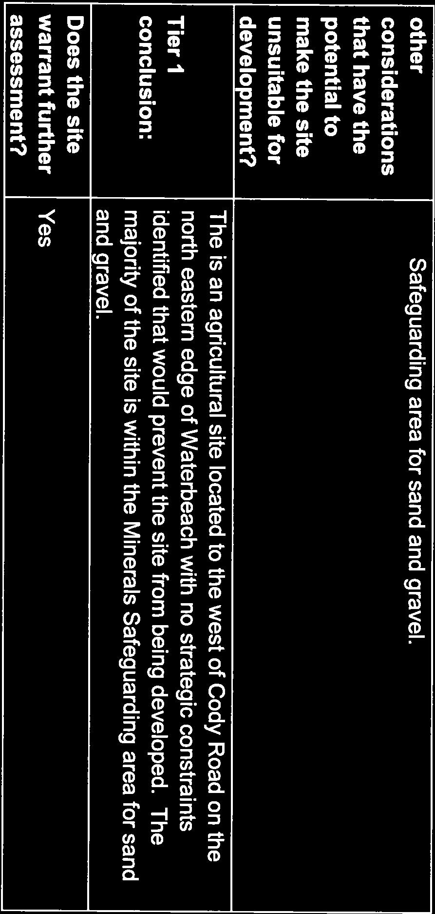
54

55

56
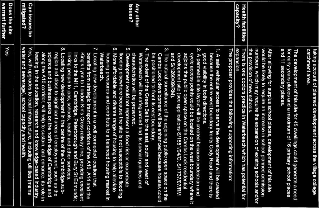
57

58

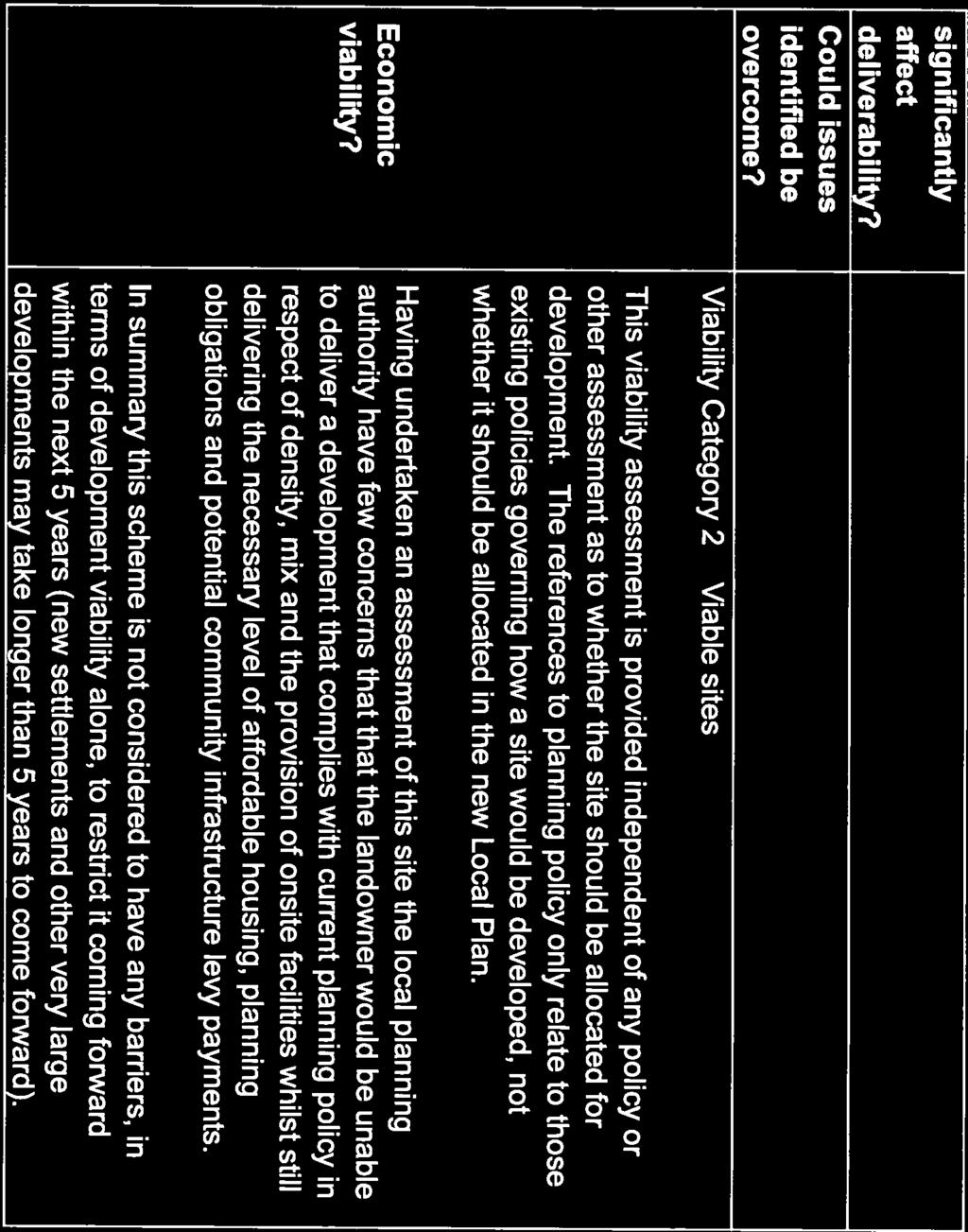
59
60 APPENDIX 2
61 Page 31 Agenda Item 7 SOUTH CAMBRIDGESHIRE DISTRICT COUNCIL REPORT TO: Planning Committee 6 February 2013 AUTHOR/S: Planning and New Communities Director S/2509/12/FL - COTTENHAM Erection of 47 dwellings, garages, public open space, landscaping, vehicular access and associated infrastructure, Land at the junction of Beach Road and Long Drove for Barrett Eastern Counties and Cedric John Abbs Recommendation: Approval Date for Determination: 8 This application has been reported to the Planning Committee for determination because it is major development that raises issues of broad relevance to planning policy. Major Development Departure Application To be presented by Ray McMurray, Principal Planning Officer Site and Proposal 1. The site is located on land adjoining the south eastern periphery of the village, with frontages onto Beach Road and Long Drove. The site has an area of 1.63ha, and is in agricultural use as pastureland. The site is flat. The boundaries of the site are marked with mature hedgerow and trees, and the site is fully screened from views along Beach Road. 2. The site is adjacent to residential dwellings in Beach Road, Coolidge Close, Coolidge Gardens, and Calvin Close along its north western boundary. For the most part these are semi-detached two storey properties, with a smaller number of bungalows. Calvin Close is an estate of 12 affordable houses granted planning permission as an exception site. To the south east and south west the site is bounded by roads; Long Drove and Beach Road respectively, beyond which the land is in agricultural use. The boundary with Beach Road includes a pedestrian footway which terminates at the junction with Long Drove. A detached farmhouse is located to the south west opposite the proposed entrance to the site, No.60 Beach Road. To the north east the site adjoins a horticultural nursery and dwelling, known as Arkley Nursery. 3. The full planning application, dated 7 December 2012, is a resubmission without further amendment of refused planning permission S/2317/ The proposal is for the erection of 47 dwellings laid out as a cul-de-sac served by a vehicular access to be provided centrally within the Beach Road frontage. The submitted drawings show two-storey development incorporating a central area of open space and a smaller subsidiary area of open space. The design has paid regard to principles for the historic development of the village as indicated in the Cottenham Village Design Statement, incorporating near uniform depths to most plots, and with larger dwellings framing the entrance to the site, following the examples of the farmhouses and villas in
62 Page 32 the village. The layout includes gaps between dwellings to allow views of the mature hedgerows and trees on the borders of the site. The design of dwellings includes a variety of gables and widths of plot, and a mixture of detached, semi-detached and terraced dwellings, to provide variety to the built form. The north-western end of the site is designed as a mews, including two flats over garages and a parking court behind dwellings. 5. The range of types of external materials is limited to reflect principles set out in the Cottenham Village Design Statement. The main dwellings are to be completed in buff brick with slate roofs. Garages are in some cases to be clad in timber. 6. The scheme is to provide 61 parking and car port spaces, and 22 garage spaces, a total of 83 spaces, equivalent to 1.7 spaces per dwelling. 7. The density of the scheme is 29 dwellings per hectare. The layout shows an informal play space area of 1420 square metres with an additional 419 square metres of landscaped open space provided to the east of the site. 8. The proposal includes 19 affordable dwellings, representing 40% of the scheme housing. All affordable dwellings will be designed to lifetime homes standard. Of the market housing 21% will have two bedrooms, 50% will have three bedrooms and 29% will have four bedrooms. Overall, the housing mix will be 36% with two bedrooms, 40% with three bedrooms and 23% with four bedrooms. 9. The proposal includes landscaping of the site. This seeks to ensure that the existing hedgerow along Long Drove forms a permanent southern boundary to the village. The site lies within the Fen Edge landscape character area, and is typical of this character area. Existing hedgerow within the site adjacent to Calvin Close and along the eastern boundary of the site is to be retained. The majority of the mature hedgerow along the western boundary is to be removed. A replacement yew hedge up to 1.2m in height is proposed to either side of the access to be formed. The design includes significant tree planting in the open space areas, together with small fruit trees to a number of rear gardens. 10. The agent has conducted a traffic survey on Beach Road adjacent to the site. The submitted Transport Statement Report concludes that the development would have very low impact (less than 6%) on peak time traffic flows. However the agent is in discussions with the Local Highway Authority to fund moving of the 30mph zone further south east (out of the village) and to erect stationary gate features near the approach to Cottenham. Additionally, the applicant is willing to fund improvements to pedestrian crossing over Beach Road at the junction with Brenda Gautrey Way, and at the High Street miniroundabout. These works would require a Traffic Regulation Order procedure outside the planning application, and would involve consultation. 11. The applicant has expressed willingness to enter into agreement with the Council for the payment of reasonable and proportionate sums in respect of education, rights of way, public art, open space (including an off-site equipped play area), community facilities, waste receptacles, waste recycling, and monitoring of obligations. These sums would total approximately 351,000 (comprising SCDC and Parish Council 186,000, and County Council 165,000). Discretionary highway works would be additional, estimated by the applicant to be in the order of 70,000. The applicant has estimated that the development would generate a payment under the New Homes Bonus of approximately 450,000, which would fall 80% to the District Council and 20% to the County Council, an allocation then being made to the Parish Council.
63 Page The application is supported by a Planning Statement, Overview Statement, Design and Access Statement, Transport Statement, Statement of Community Involvement, Flood Risk Assessment, Tree Survey and Report, Ecology Survey and Report, Landscape Appraisal, Archaeology Report, Foul Water and Utilities Statement, Phase 1 Contamination Desk Study, Sustainability Statement, Health Impact Assessment and an Outline Public Art Delivery Plan. 13. Planning History S/1346/79/O RESIDENTIAL DEVELOPMENT ACRES Refused S/1954/79/O ERECTION OF 4 HOUSES Refused S/0389/81/O RESIDENTIAL DEVELOPMENT Refused S/1799/81/O ONE DWELLING Appeal Dismissed S/1473/82/F ERECTION OF 6 CHICKEN HOUSES Refused S/0364/83/F AGRICULTURAL STORAGE BUILDING Refused S/2317/11 ERECTION OF 47 DWELLINGS, GARAGES Refused Adjacent land Appeal submitted. Hearing due 17 February 2013 Calvin Close S/0052/97/F 12 DWELLINGS (for Granta Housing Society) Approved Previous planning application S/2317/11 was refused for the following reasons: 1. The development proposal, by virtue of its scale and location, is incompatible with the spatial vision for the area in that it exceeds the indicative maximum of 30 dwellings in a Minor Rural Centre, being a village of reasonable but limited services and would result in unsustainable development. This harm is not balanced by any proposal to provide a high proportion of affordable dwellings to meet local housing need in order to be considered as a rural exception site. The proposal is therefore contrary to Policy ST/5 of the South Cambridgeshire Core Strategy 2007 and Policies DP/1, DP/2, DP/7, GB/3 and NE/4 of the South Cambridgeshire Local Development Framework 2007, which define the spatial strategy for sustainable development in South Cambridgeshire. 2. The siting of the development in the countryside and adjacent to the Cambridge Green Belt outside the Cottenham village development framework boundary, would result in the encroachment of the built environment into the countryside and setting of Cambridge Green Belt, resulting in an adverse impact upon the visual quality of the countryside and adjacent Green Belt. The proposal is therefore contrary to Policies DP/2, DP/3, DP/7, GB/3 and NE/4 of the South Cambridgeshire Local Development Framework 2007, which additionally safeguard the countryside and Green Belt setting from development which does not need to be located in the countryside. Planning Policy 15. National Planning Policy Framework (March 2012) This sets out a presumption in favour of sustainable development (NPPF ara.14). The Framework states that Local Planning Authorities should identify a supply of deliverable sites sufficient to provide five years worth of housing against their housing requirements with an additional buffer of
64 Page 34 5% or 20% depending upon the specific record of housing delivery. The purpose of this assessment is to provide a realistic prospect of achieving the planned supply and to ensure choice and competition in the market for land. Identification of the broad locations of sites sufficient for housing supply for up to 15 years is also required (NPPF para.47). Housing applications should be considered in the context of the presumption in favour of sustainable development. Relevant policies for the supply of housing should not be considered up-to-date if the local planning authority cannot demonstrate a 5-year supply of deliverable housing sites (NPPF para.49). Local planning authorities should in particular consider whether allowing some market housing in rural areas would facilitate the provision of significant additional affordable housing to meet local needs (NPPF para.54) To promote sustainable development in rural areas, housing should be located where it will enhance or maintain the vitality of rural communities (NPPF para.55) For twelve months from the date of publication of the NPPF (i.e. up to 27 ) decision-takers may continue to give full weight to relevant policies adopted since 2004 even if there is a limited degree of conflict with the Framework (NPPF para.214). South Cambridgeshire Local Development Framework (LDF) Core Strategy (2007) 16. ST/e (Strategic Vision and Objectives) - seeks to ensure that the scale and location of development in each village is in keeping with its size, character and function and that the buildings and open spaces which create their character are maintained and wherever possible enhanced. ST/j (Strategic Vision and Objectives) To ensure that the district s built and natural heritage is protected and that new development protects and enhances cherished townscape assets of local design, cultural, and conservation importance, and character of the landscape. ST/k (Strategic Vision and Objectives) To locate development where it will ensure maximum use of previously developed land and minimise loss of countryside and the best and most versatile agricultural land. ST/1 (Green Belt) A Green Belt will be maintained around Cambridge which will define the extent of the urban area. ST/2 (Housing Provision) Between 1999 and 2016 the District Council will make provision for 20,000 new homes. The supporting text states that 10,050 dwellings are likely to come from Rural Centres and other villages. ST/3 (Re-Using Previously Developed Land and Buildings) Between 1999 and 2016 at least 37% of new dwellings will either be located on previously developed land or utilise existing buildings. ST/5 (Minor Rural Centres) Residential development and redevelopment up to an indicative maximum scheme size of 30 dwellings will be permitted within the village frameworks of Minor Rural Centres, as defined on the Proposals Map. Where development of a larger scale (9 to 30 dwellings) would place a material burden on the existing village services and facilities the District Council will use its powers under Section 106 of the Town and Country Planning Act 1990 to secure financial contributions at an appropriate level towards their development or improvement. South Cambridgeshire Development Control Policies Development Plan Document (2007)
65 Page DP/1 (Sustainable Development) DP/2 (Design of New Development) DP/3 (Development Criteria) DP/4 (Infrastructure and New Developments) DP/6 (Construction Methods) DP/7 (Development Frameworks) GB/3 (Mitigating the Impact of Development Adjoining the Green Belt) HG/1 (Housing Density) HG/2 (Housing Mix) HG/3 (Affordable Housing) SF/6 (Public Art and New Development) SF/10 (Outdoor Playspace, Informal Open Space, and New Developments) SF/11 (Open Space Standards) NE/1 (Energy Efficiency) NE/3 (Renewable Energy Technologies in New Development) NE/4 (Landscape Character Areas) NE/6 (Biodiversity) NE/8 (Groundwater) NE/9 (Water and Drainage Infrastructure) NE/11 (Flood Risk) NE/12 (Water Conservation) NE/17 (Protecting High Quality Agricultural Land) TR/1 (Planning for More Sustainable Travel) TR/2 (Car and Cycle Parking Standards) TR/3 (Mitigating Travel Impact) Supplementary Planning Documents Cottenham Village Design Statement (2007) Open Space in New Developments SPD (2009) Public Art SPD (2009) Trees & Development Sites SPD (2009) Biodiversity SPD (2009) District Design Guide SPD (2010) Affordable Housing SPD (2010) Landscape in New Developments SPD (2010) Health Impact Assessment SPD (2011) Strategic Housing Land Availability Assessment 18. As part of the review of the Local Plan, the Council has produced a Strategic Housing Land Availability Assessment (SHLAA) to identify site options for consideration for allocation in the new Local Plan. The appeal site was appraised as part of this review and was assessed as being a site with development potential. A copy of the assessment is attached at Appendix Circular 05/2005 Planning Obligations: States that planning obligations must be relevant to planning, necessary, directly related to the proposed development, fairly and reasonably related in scale and kind to the proposed development, and reasonable in all other respects.
66 Page 36 Consultations 20. Cottenham Parish Council. Recommendation of refusal, commenting, The land is outside the village framework. The site exceeds the indicative maximum of 30 dwellings in a Minor Rural Centre. 21. Council s Planning Policy Manager: The Planning Policy Manager has stated: 22. The Core Strategy sets a target for housing land supply in South Cambridgeshire of 20,000 dwellings between 1999 and Despite the most recent Annual Monitoring Report recording allocations for 16,534 dwellings, it also records that only 13,045 dwellings are projected to have been completed during the plan period to Housing completions were increasing during the early years of the plan period but have been impacted since 2008 by the economic downturn. Nevertheless, the NPPF requires that the Council maintains a 5 year supply of deliverable housing land measured against the Core Strategy target. The Annual Monitoring Report concludes that at end March 2012 the Council had a supply of deliverable housing land of just 2.4 years. 24. In these circumstances the NPPF advises that relevant policies for the supply of housing should not be considered up-to-date (para 49) and that planning permission for housing should be granted unless any adverse impacts of doing so would significantly and demonstrably outweigh the benefits, when assessed against the policies in the Framework taken as a whole or specific policies in the Framework indicate development should be restricted (para 14). 25. The NPPF is fundamentally concerned with the achievement of sustainable development. The delivery of sustainable development is also at the heart of the Core Strategy which replaces previous policies for development in villages which have been found to be unsustainable for the delivery of development in the Cambridge Sub-Region. 26. Cottenham is designated a Minor Rural Centre in the Core Strategy where development of up to a maximum scheme size of 30 dwellings will be permitted within the village framework. Last summer as part of the updating of the Local Development Framework, the Local Plan Issues & Options Report consulted on upgrading Cottenham to a Rural Centre where there would be no limit on housing development within the village framework. 27. In the light of the advice in the NPPF, development of 47 dwellings adjoining the village framework in what is one of South Cambridgeshire s more sustainable villages would be the sort of scheme that could be supported whilst the Local Plan is being updated. 28. The updated Local Plan will reach a stage where weight can be attached to its proposals by the end of 2013 at the latest when it will be submitted to the Secretary of State and possibly by July when the draft Local Plan is published for consultation (following two rounds of issues and options consultation). 29. Council s Landscape Design Officer Generally satisfied with the proposals following negotiations with the developer. Discussions with the developer are ongoing to seek the retention of more hedgerow on the Beach Road frontage. 30. Council s Trees and Landscape Officer No objection, subject to a robust landscaping scheme being put in place. The TLO notes that the site has an established boundary hedge, but accepts that if development is granted sections of the hedge will be
67 Page 37 lost. Proposals for the future management of the hedge are acceptable. (brought forward from S/2317/11) 31. Council s Ecology Officer The Ecology Officer, while not objecting in principle, would like to see full protection given to the hedge along Long Drove as it is a locally important feature. It is noted that the site has been thoroughly cleared of vegetation other than boundary features. A condition should be used to secure a scheme of nest box provision.(brought forward from S/2317/11) 32. Council s Joint Urban Design Team - The design of the scheme has been altered to take account of the concerns of the JUDT. No objection. (brought forward from S/2317/11) 33. Council s Affordable Homes Manager The proposed site sits outside the development envelope and should therefore be considered as an exception site for the provision of affordable housing only. The Affordable Housing Supplementary Planning Document states that rural exception sites should be of a small scale, and typically range from 6-20 dwellings. With 47 dwellings proposed, this scheme is too large for a rural exception site. If the site was to be brought forward as rural exception site, and subject to planning permission being granted here, the AHO has confirmed that there is sufficient demand to meet a larger rural site of up to 20 units, as there are currently 143 households on the housing register with a local connection to Cottenham. 34. Should this application be determined not as an exception site, then the Council will seek to secure 40% or more affordable housing on developments of two or more dwellings. This application, following amendment, proposes 19 of the 47 dwellings to be affordable. This would meet the 40% planning policy requirement as contained within HG/3 of the Core Strategy Development Plan Document. 35. Following amendment, the proposed dwelling sizes and tenures remain in line with district requirements. The clustering of the affordable units into two smaller groups is more acceptable than all the affordable housing being situated in one area, as was originally proposed. 36. The units should meet the Homes and Communities Agency, Design and Quality Standards. There would be no requirement for this site to be made available for people with a local connection to Cottenham. The dwellings would be open to all applicants who are registered on the Councils Home Link system. South Cambridgeshire District Council has a legal obligation to give reasonable preference to all applicants assessed and placed in the highest housing need.(brought forward from S/2317/11) 37. Council s Arts and Culture Development Officer The ACDO has been in discussion with the consultant company which has prepared the submitted Outline Public Art Delivery Plan to ensure that construction timetable for any permanent artwork would be integrated into the phasing of the development.(brought forward from S/2317/11) 38. Council s Section 106 Officer The applicant has agreed in principle to financial contributions in respect of offsite and onsite public open space and maintenance, indoor community facilities, public art, section 106 monitoring, household waste receptacles. These financial contributions are compliant with the Community Infrastructure Levy (CIL) regulations to make the net impact of the development on these facilities, which have identifiable needs, acceptable in planning terms. (brought forward from S/2317/11) 39. Health and Environmental Services Director No objection in principle. Recommended conditions to address issues of noise disturbance to future residents
68 Page 38 from the adjacent commercial use and to limit noise disturbance during the construction period. (brought forward from S/2317/11) 40. Council s Scientific Officer (Contaminated Land) No further investigation of the site for contaminated land is necessary. (brought forward from S/2317/11) 41. Cambridgeshire Constabulary Crime Prevention Design Team Noted that the site is in an area of low crime risk. Detailed improvements to surveillance of car parking areas and siting of gates could be achieved. 42. County Council Archaeology Unit No objection. 43. County Council Growth and Economy Team The CC Growth and Economy Team has put forward a request for financial contributions for educational provision for preschool and primary school facilities, and for improvements to the local rights of way network, and household waste disposal and recycling. In the current application adjustments have been made to educational contributions. 44. In the previous application S/2317/11 the Growth and Economy Team requested a longer period of ten years to hold any financial contribution towards primary education to take into account strategic factors of provision. The Team commented: Although the County Council is not submitting a formal objection to the development proposals, officers feel it is important to highlight significant reservations about the timing of the planning application. These include: a) The existing pressure for primary school places within Cottenham; b) The need to conclude discussions and deliver additional primary school places in the village; c) The fact that the application site is outside the existing planning policy framework and has been submitted ahead of the refresh of the SCDC Local Plan. This creates uncertainty over the overall number of new homes to be planned for in Cottenham; and d) The contribution from the application site developers would likely be required, in the short-term, to pay for primary school provision at schools outside Cottenham. This could leave the County Council short of funding with which to secure additional school provision in Cottenham in the longer-term. (brought forward from S/2317/11) 45. Local Highway Authority No objection in principle, subject to conditions to be attached to any consent issued. The Highway Authority would seek to adopt those areas that serve a highway function. The proposed relocation of the 30mph speed limit cannot be guaranteed. 46. Environment Agency No objection in principle. Conditions to any approval to be issued are recommended. 47. Anglian Water No objection. There is capacity at Cambridge sewage treatment works to accept foul drainage from the development. (brought forward from S/2317/11) 48. Campaign to Protect Rural England (Cambridgeshire and Peterborough) Objection. The application is premature pending the review of housing allocation through the SHLAA procedure. This scale of site should be reviewed as part of the Local Plan, where alternatives could be fully tested, or through a neighbourhood plan under the Localism Act. As the site is not within the Green Belt, countryside policies which disallow this type of development should apply. (brought forward from S/2317/11)
69 Page Executive Headteacher of Cottenham Academy Very pleased to hear about the proposals for safer routes to schools, for community art and for pre- and primary education in Cottenham, as part of the proposals. (brought forward from S/2317/11) Representations 50. Cottenham Village Design Group The CVDG has met with the developer and has confirmed that a great number of initial concerns with the proposals have been addressed. There is a concern in principle about the development of a green field site, which represents a loss of green space and wildlife habitat, although it recognises that the site is obvious for infill development and the inclusion of affordable housing is a considerable advantage for the village. The CVDG recommends the incorporation of low walls or railings to front gardens facing the street, as a local tradition. The CVDG would prefer more use of native species and orchard style planting in the landscaping scheme. (brought forward from S/2317/11) 51. One letter of objection has been received to the current application, from 4 Paxton Close, on the grounds of: a) Green Belt land; b) Previous applications for development of the site for one house have been refused; c) Busy main road access; d) The school is not big enough, not enough shops. e) The village is too big already. 52. In response to the previous application letters of objection were received from nos 49 and 60 Beach Road, 2 Brenda Gautrey Way, 2 Coolidge Close, Arkley Nursery Ltd, Long Drove, and one letter with no address stated. The grounds for objection were: a) Too many houses for the site: 25 to 30 would be appropriate b) The development does not comply with ST/5 as it exceeds the maximum development size of 30 dwellings c) The development is not well served by public transport and so does not meet policy ST/6 d) The primary school is too far away to walk to. e) Affordable houses should be laid out closer to the entrance, to be nearer village facilities. f) Concern about surface water if the ditches are not properly maintained. g) Potential noise disturbance from the adjacent nursery h) Good security fencing is needed to prevent access to the nursery. i) Existing hedges should be properly maintained to retain their density j) Access from the site will be unsafe due the close proximity of Long Drove, and three accesses to land opposite, despite moving the speed limit position. k) Long Drove would be used as an access route to the north (Wilburton etc). The access onto Long Drove is already dangerous. l) The corner of Beach Road/ Demark Road is already dangerous at peak hours m) Beach Road is congested during rush hours. n) On Beach Road there should be speed humps and a giveway to oncoming traffic, as well as relocating the 30mph signage. o) There should be an emergency exit for traffic from the site. p) Loss of countryside and harm to the amenity of users of Long Drove for recreation. This would be an eyesore on this very attractive and natural area. q) The primary school already has temporary accommodation. Health Service and sewers in Cottenham are near breaking point. (brought forward from S/2317/11)
70 Page 40 Agent s comments 53. In the submitted Planning Statement, at Section 3, the agent has set out a case for exceeding the indicative maximum scheme size of 30 dwellings contained in Policy ST/5. The site would be inefficiently developed at this density and would not relate well to the pattern of this part of Cottenham. Significant sums of money will be made available towards school improvements, community facilities and recreation, play and sports provision and others. 54. There has been a limited supply of housing within South Cambridgeshire within recent years and over the next five years the supply is limited compared to the housing needs of the District. The Council s Annual Monitoring Report (AMR) identifies a significant shortfall against the Five Year Supply requirement, and when the delivery prospects of the large strategic sites in the AMR are considered there remains a significant shortfall in housing delivery. In the NPPF paragraphs 14 and 49 where a 5year housing supply cannot be demonstrated the local policies for housing supply become out of date. In that situation permission should be granted unless any adverse impacts of the development are not outweighed by the benefits. This application is in a sustainable location and, if approved, would bring about community benefits that outweigh the position of the site outside (but directly abutting) the village framework. There is a need for countrysidelocated sites to come forward to address the significant housing shortfall. 55. The agent states that the proposal will not harm the openness or rural character of the Green Belt to the south west by retaining trees and hedges (wherever possible) to the southern and western boundary along with additional tree and hedge planting. The houses are set back from the site frontages, so that planting, rather than the houses, is the prominent feature when viewing the site from the Green Belt. Planning Comments Five-Year Housing Supply and Sustainable Location 56. The previous application S/2317/11 was considered just as the NPPF was issued. The presumption in favour of sustainable development provided in the NPPF was considered but was not assessed to outweigh concerns about the suitability of Cottenham to as a sufficiently sustainable location in the hierarchy of settlements set out in the LDF Core Strategy. The Council s Planning Policy Manager has indicated the current review of the sustainability characteristics of Cottenham to warrant the higher status of a Rural Centre where there would be no limit on housing development within the village framework. 57. Also as part of the review of the Local Plan, the Council has produced a Strategic Housing Land Availability Assessment (SHLAA) to identify site options for consideration for allocation in the new Local Plan. The appeal site was appraised as part of this review and was assessed as being a site with development potential. 58. The issuing of the Village Classification Report and the SHLAA assessment subsequent to the determination of the application have reduced the weight to be given to the sustainability concerns set out in the first reason for refusal. The possible classification of Cottenham as a Rural Centre will gain further significance if the reclassification is put forward in the Draft Submission Plan consultation in the summer of The NPPF requires the delivery of sustainable development and having acknowledged that the economic downturn has caused a land supply shortfall, the issue is whether Cottenham is an appropriate location to make it up. The Local Plan review has made progress here and Cottenham was consulted on as a possible candidate for upgrading to a Rural Centre. The Council also consulted on allocating the application site. In so
71 Page 41 far as new development sites in villages are the only option available to the Council to increase supply in the short run, the results of the issues and options consultation leads the officers to recommend that the grant of planning permission is consistent with the emerging status of the village classification and the site and the guidance in the NPPF. 60. The changing policy context would overcome the first reason for refusal of previous planning permission S/2317/11. Landscaping 61. The loss of frontage hedgerow required to facilitate the development is a harm to the appearance of the site and was the basis of the second reason for refusal of planning permission S/2317/11. Discussions are continuing with the agent to seek additional retention and protection of the hedgerows on the boundaries of the site. This aspect could be dealt with as a condition to any planning permission issued and is not considered so harmful as to justify a refusal of planning permission in its own right. Other issues 62. The remaining issues raised by consultees and third parties have been assessed carefully but are not considered to amount to reasonable grounds for refusal of planning permission. The applicant has provided evidence that the site is within walking distance of the main facilities and services in the village and is conveniently close to bus routes, and so is in a sustainable location. The concerns about highway impact on the road network have not been supported by the Local Highway Authority in regard of the relevant evidence supplied by the applicant. Other issues raised could be addressed by appropriate conditions to be attached to any planning permission granted. 63. The mix of market housing does not achieve the proportion of smaller units envisaged in Policy HG/2, but in the case of larger sites the policy does not set fixed requirements for housing mix. The agent has emphasised that the site is aimed at a family sector, and that the housing mix has more medium-sized dwellings and fewer larger dwellings to meet current market demands. Officers consider that the circumstances of this fringe-ofsettlement site are such as to warrant acceptance of the submitted mix. 64. The density of dwellings is below the requirements of HG/1, however the scheme demonstrates that even with a lower density that attempts to take account of the fringeof-settlement location, the impact on the countryside setting of the village is very significant. 65. The application represents a departure from the development plan but is not required to be forwarded to the Secretary of State for review in the event of the Local Planning Authority being minded to grant approval. Recommendation 66. Approval subject to the resolution of the S106 Agreement and the following conditions: 1. The development hereby permitted shall be begun before the expiration of 3 years from the date of this permission. (Reason - To ensure that consideration of any future application for development in the area will not be prejudiced by permissions for development, which have not been acted upon.)
72 Page The development hereby permitted shall be carried out in accordance with the following approved plans: Drawing Number Title Location Plan 002 rev G Site Layout Plan 003 rev B Massing Plan 004 rev B Affordable Layout 005 rev B Street scenes 006 Refuse Plan 010 rev C House Type A Plans & elevations 011 rev C House Type A Plans & elevations -Gable Fronted 012 rev D House Type D Plans & elevations 014 rev C House Type B Plans & elevations 015 rev D House Type C Plans & elevations 016 rev D House Type G Floor Plans 017 rev D House Type G Elevations 018 rev B House Type H Floor Plans 019 rev D House Type H Elevations rev C FoG HA Plans & Elevations rev D FoG Private Plans & Elevations 021 rev C HA 2B House Floor Plans 022 rev D HA 2B House Elevations 023 rev D HA 2B House Elevations Gable Front 024 rev C HA 3B Floor Plans 026 rev C HA 3B - Elevations 027 rev C HA 4B- Floor Plans 028 rev C HA 4B- Elevations rev C HA 4B- Elevations 2 (Gabled variant) 033 rev C House Type E- Floor Plans 034 rev C House Type E- Elevations 036 House Type J- Floor Plans 037 rev A House Type J- Elevations 038 House Type K- Floor Plans & Elevations 047 Garage Type DG1 048 Garage Type DG2 049 Garage Type DG3 050 Garage Type SG1 051 Garage Type SG2 052 Carport Type C1 053 Carport Type C rev L Outline Landscape Proposals 43417/P/SK06 rev B Proposed Adoptable Highway Layout (Reason - To facilitate any future application to the Local Planning Authority under Section 73 of the Town and Country Planning Act 1990.) 3. No development shall take place until details of the materials to be used in the construction of the external surfaces of the buildings hereby permitted have been submitted to and approved in writing by the Local Planning Authority. Development shall be carried out in accordance with the approved details. (Reason - To ensure the appearance of the development is satisfactory in accordance with Policy DP/2 of the adopted Local Development Framework 2007.)
73 Page Plots 25 and 26: Notwithstanding the provisions of the Town and Country Planning (General Permitted Development) Order 1995 (or any order revoking and re-enacting that Order with or without modification), no windows, doors or openings of any kind, other than those expressly authorised by this permission, shall be constructed in the rear elevations of the dwellings at and above first floor level unless expressly authorised by planning permission granted by the Local Planning Authority in that behalf. (Reason - To safeguard the privacy of adjoining occupiers in accordance with Policy DP/3 of the adopted Local Development Framework 2007.) 5. The garages, hereby permitted, shall not be used as additional living accommodation and no trade or business shall be carried on therefrom. (Reason - To ensure the continued provision of off-street parking space in the interests of highway safety and to safeguard the amenities of adjoining occupiers in accordance with Policy DP/3 of the adopted Local Development Framework 2007.) 6. No development shall take place until full details of both hard and soft landscape works have been submitted to and approved in writing by the Local Planning Authority. These details shall include indications of all existing trees and hedgerows on the land and details of any to be retained, together with measures for their protection in the course of development. The details shall also include specification of all proposed trees, hedges and shrub planting, which shall include details of species, density and size of stock. (Reason - To ensure the development is satisfactorily assimilated into the area and enhances biodiversity in accordance with Policies DP/2 and NE/6 of the adopted Local Development Framework 2007.) 7. All hard and soft landscape works shall be carried out in accordance with the approved details. The works shall be carried out prior to the occupation of any part of the development or in accordance with a programme agreed in writing with the Local Planning Authority. If within a period of five years from the date of the planting, or replacement planting, any tree or plant is removed, uprooted or destroyed or dies, another tree or plant of the same species and size as that originally planted shall be planted at the same place, unless the Local Planning Authority gives its written consent to any variation. (Reason - To ensure the development is satisfactorily assimilated into the area and enhances biodiversity in accordance with Policies DP/2 and NE/6 of the adopted Local Development Framework 2007.) 8. In this condition "retained tree" means an existing tree which is to be retained in accordance with the approved plans and particulars; and paragraphs (a) and (b) below shall have effect until the expiration of 5 years from [the date of the first occupation of the dwellings hereby approved]. (a) (b) No retained tree shall be cut down, uprooted or destroyed, nor shall any retained tree be topped or lopped other than in accordance with the approved plans and particulars, without the written approval of the Local Planning Authority. Any topping or lopping approved shall be carried out in accordance with the relevant British Standard. If any retained tree is removed, uprooted or destroyed or dies, another tree shall be planted at the same place and that tree shall be of such size and species, and shall be planted at such time, as may be specified in writing by the Local Planning Authority.
74 Page 44 (c) The erection of fencing for the protection of any retained tree shall be undertaken in accordance with the approved plans and particulars before any equipment, machinery or materials are brought on to the site for the purposes of the development, and shall be maintained until all equipment, machinery and surplus materials have been removed from the site. Nothing shall be stored or placed in any area fenced in accordance with this condition and the ground levels within those areas shall not be altered, nor shall any excavation be made, without the written consent of the Local Planning Authority. (Reason - To protect trees which are to be retained in order to enhance the development, biodiversity and the visual amenities of the area in accordance with Policies DP/1 and NE/6 of the adopted Local Development Framework 2007.) 9. No demolition, site clearance or building operations shall commence until tree protection comprising weldmesh secured to standard scaffold poles driven into the ground to a height not less than 2.3 metres shall have been erected around trees to be retained on site at a distance agreed with the Local Planning Authority following BS Such fencing shall be maintained to the satisfaction of the Local Planning Authority during the course of development operations. Any tree(s) removed without consent or dying or being severely damaged or becoming seriously diseased during the period of development operations shall be replaced in the next planting season with tree(s) of such size and species as shall have been previously agreed in writing with the Local Planning Authority. (Reason - To protect trees which are to be retained in order to enhance the development, biodiversity and the visual amenities of the area in accordance with Policies DP/1 and NE/6 of the adopted Local Development Framework 2007.) 10. The existing hedges on the site s boundaries with Beach Road and Long Drove shall be retained except where otherwise expressly shown for removal on the approved drawings; and any trees or shrubs within them which, within a period of five years from the completion of the development or the occupation of the buildings, whichever is the sooner, die, are removed or become seriously damaged or diseased shall be replaced in the next planting season with others of similar size and species. (Reason - To protect the hedge which is of sufficient quality to warrant its retention and to safeguard biodiversity interests and the character of the area in accordance with Policies DP/1 and NE/6 of the adopted Local Development Framework 2007.) 11. Any removal of trees, scrub or hedgerow shall not take place in the bird breeding season between 15 February and 15 July inclusive, unless a mitigation scheme for the protection of bird-nesting habitat has been previously submitted to and approved in writing by the Local Planning Authority. (Reason - To avoid causing harm to nesting birds in accordance with their protection under the Wildlife and Countryside Act 1981 and in accordance with Policies DP/1, DP/3 and NE/6 of the adopted Local Development Framework 2007.) 12. No development shall take place until a scheme of ecological enhancement has been submitted to and approved in writing by the Local Planning Authority. The scheme shall include details of the features to be enhanced, recreated and managed for species of local importance both in the course of development and in the future. The scheme shall be carried out prior to the occupation of
75 Page 45 any part of the development or in accordance with a programme agreed in writing with the Local Planning Authority. (Reason - To enhance ecological interests in accordance with Policies DP/1, DP/3 and NE/6 of the adopted Local Development Framework 2007.) 13. No development shall take place on the application site until the implementation of a programme of archaeological work has been secured in accordance with a written scheme of investigation which has been submitted to and approved in writing by the Local Planning Authority. (Reason - To secure the provision of archaeological excavation and the subsequent recording of the remains in accordance with Policy CH/2 of the adopted Local Development Framework 2007.) 14. Prior to the commencement of the development a lighting scheme, to include details of any external lighting of the site such as street lighting, floodlighting, security lighting, shall be submitted to and approved in writing by the Local Planning Authority. This information shall include a layout plan with beam orientation, full isolux contour maps and a schedule of equipment in the design (luminaire type, mounting height, aiming angles and luminaire profiles, angle of glare and shall assess artificial light impact in accordance with the Institute of Lighting Engineers (2005) Guidance Notes for the Reduction of Obtrusive Light. The approved lighting scheme shall be installed, maintained and operated in accordance with the approved details measures unless the Local Planning Authority gives its written consent to any variation. (Reason -To minimise the effects of light pollution on the surrounding area in accordance with Policy NE/14 of the adopted Local Development Framework 2007.) 15. Notwithstanding the provisions of the Town and Country Planning (General Permitted Development) Order 1995 (or any order revoking and re-enacting that Order with or without modification), except as hereby approved, no vehicular access shall be made onto Beach Road or Long Drove unless expressly authorised by planning permission granted by the Local Planning Authority in that behalf. (Reason - In the interests of highway safety and safeguarding of existing hedgerow in accordance with Policies DP/3 and NE/4 of the adopted Local Development Framework 2007) 16. The visibility splays specified on approved Richard Jackson Engineering drawing no /P/SK06 rev B at the junction of the access road with the public highway shall be provided before the commencement of the development and shall thereafter be maintained free from any obstruction over a height of 600mm. The minimum dimensions to provide the required splay lines shall be 2.4m measured along the centre line of the proposed access road from its junction with the channel line of the public highway, and 120m measured along the channel line of the public highway from the centre line of the proposed access road. (Reason - In the interest of highway safety in accordance with Policy DP/3 of the adopted Local Development Framework 2007.) 17. If, during development, contamination not previously identified is found to be present at the site, then no further development (unless otherwise agreed in writing with the Local Planning Authority) shall be carried out until the developer has submitted, and obtained a written approval from the Local Planning Authority for, and addendum to the Remediation Strategy. This addendum must detail how this unsuspected contamination shall be dealt with
76 Page 46 and from the date of its approval the addendum(s) shall form part of the Remediation Strategy. (Reason: To prevent the increased risk of contamination to the water environment in accordance with Policies DP/1 and NE/8 of the adopted Local Development Framework 2007) 18. Prior to the commencement of any development, a scheme for the provision and implementation of sustainable surface water drainage shall be submitted to and approved in writing by the Local Planning Authority. The scheme shall be constructed and completed in accordance with the approved plans prior to the occupation of any part of the development or in accordance with the implementation programme agreed in writing with the Local Planning Authority. (Reason - To ensure a satisfactory method of surface water drainage and to prevent the increased risk of flooding in accordance with Policies DP/1 and NE/11 of the adopted Local Development Framework 2007.) 19. Prior to the commencement of any development, a scheme for the provision and implementation of pollution control shall be submitted to and approved in writing by the Local Planning Authority. The scheme shall be constructed and completed in accordance with the approved plans prior to the occupation of any part of the development or in accordance with the implementation programme agreed with the Local Planning Authority. (Reason - To reduce the risk of pollution to the water environment in accordance with Policy DP/1 and NE/8 of the adopted Local Development Framework 2007.) 20. No development shall commence until details of a) Energy efficiency measures b) Provision for renewable energy c) Provision for water conservation have been submitted to and approved in writing by the Local Planning Authority; the development shall be carried out in accordance with the approved details. Reason - Insufficient information was submitted with the application to assure the Local Planning Authority that energy efficiency, renewable energy and water conservation measures are adequate to comply with Policies NE/1, NE/3 and NE/12 of the adopted Local Development Framework 2007.) 21. During the period of construction, no power operated machinery shall be operated on the site before 0800 hours and after 1800 hours on weekdays and 1300 hours on Saturdays, nor at any time on Sundays and Bank Holidays, unless otherwise previously agreed in writing with the Local Planning Authority. (Reason - To minimise noise disturbance for adjoining residents in accordance with Policy NE/15 of the adopted Local Development Framework 2007.) 22. Should driven pile foundations be proposed, then before development commences, a statement of the method for construction of these foundations shall be submitted to and agreed by the Local Planning Authority in consultation with the District Environmental Health Officer. (Reason: In order to safeguard the amenity of the occupiers of nearby dwellings from disturbance from noise and vibration during the construction period in accordance with Policy DP/3 of the adopted Local Development Framework 2007). 23. No development shall take place until details of the following have been submitted to and approved in writing by the Local Planning Authority:
77 Page 47 i) Contractors access arrangements for vehicles, plant and personnel; ii) Contractors site storage area(s) and compounds(s); iii) Parking for contractors vehicles and contactors personnel vehicles; iv) Method statement for the control of debris, mud and dust arising from the development during the construction period. Development shall not be carried out other than in accordance with the approved details. (Reason - In the interests of residential amenity and highway safety in accordance with Policies DP/3 and DP/6 of the adopted Local Development Framework 2007.) Background Papers: the following background papers were used in the preparation of this report: National Planning Policy Framework South Cambridgeshire Local Development Framework (LDF) Core Strategy, adopted January 2007 South Cambridgeshire Development Control Policies Development Plan Document 2007 SPD Strategic Housing Land Availability Assessment 2012 Village Classification Report 2012 Planning File ref S/2509/12/FL Contact Officer: Ray McMurray Principal Planning Officer Telephone: (01954)
78 Page 48 This page is left blank intentionally.
79 Page 49
80 Page 50

81 Page 51
82 Page 52
83 Page 53
84 Page 54
85 Page 55
86 APPENDIX 3

87 Appeal Decision Inquiry held on January 2013 Site visit made on 17 January 2013 by J C Chase MCD Dip Arch RIBA MRTPI an Inspector appointed by the Secretary of State for Communities and Local Government Decision date: 15 February 2013 Appeal Ref: APP/W0530/A/12/ Land adjacent No 7 Station Road, Over, Cambridge, CB24 5NJ The appeal is made under section 78 of the Town and Country Planning Act 1990 against a refusal to grant planning permission. The appeal is made by Weston Homes (Housing) Ltd against the decision of South Cambridgeshire District Council. The application Ref S/0440/12/FL, dated 22 February 2012, was refused by notice dated 12 June The development proposed is the erection of 26 two storey dwellings (4 x 1 bed flats, 6 x 2 bed houses, 8 x 3 bed houses and 8 x 4 bed houses), of which 40% (10 No) affordable housing; with 39 parking spaces, alterations to vehicular access to Station Road; and formation of public open spaces. Decision 1. The appeal is dismissed. Procedural Matter 2. After the Inquiry, the main parties submitted an Agreement made in accordance with Section 106 of the Town and Country Planning Act, 1990, with the intention of providing affordable housing and contributions towards infrastructure. The proposal to include 10 affordable units in the scheme is taken into account in this decision. However, in other respects the Agreement would not address the determining matters in this case, and, because I am minded to dismiss the appeal on the basis of the assessment of the main issues, there is no necessity to establish whether the obligations would satisfy the tests in Regulation 122 of the Community Infrastructure Regulations Main Issues 3. Taking account of the Council s reasons for refusal, and the statement of common ground, the following two main issues were suggested at the start of proceedings: i) whether the site is in a sustainable location for housing, taking account of development plan policy and, if not, whether any harm would be outweighed by the shortfall in meeting housing targets, and ii) whether the development would preserve or enhance the setting of the Conservation Area and of the Grade 1 Listed Church. In response, the appellants considered that the issues should reflect the wording of the tests in para. 14 of the National Planning Policy Framework (the Framework ). This amendment is accepted for the reason given, and the first issue becomes i) whether the site is in a sustainable location for the proposed housing, and, if not, whether any harm would significantly and demonstrably outweigh the benefits of the
Plumpton Neighbourhood Development Plan Revised Pre Submission Document - Regulation 14 Consultation
 REPRESENTATIONS... Plumpton Parish Council Plumpton Neighbourhood Development Plan Revised Pre Submission Document - Regulation 14 Consultation Representations submitted on behalf of: Cala Homes (South
SOUTH CAMBRIDGESHIRE DISTRICT COUNCIL. REPORT TO: Planning Committee 1 April 2015 Planning and New Communities Director
 SOUTH CAMBRIDGESHIRE DISTRICT COUNCIL REPORT TO: Planning Committee 1 April 2015 AUTHOR/S: Planning and New Communities Director Application Number: Parish(es): Proposal: Site address: Applicant(s): Recommendation:
DEVELOPMENT MANAGEMENT REPORT
 ITEM A08-1 DEVELOPMENT MANAGEMENT REPORT TO: BY: DATE: DEVELOPMENT: SITE: WARD: APPLICATION: APPLICANT: Development Management Committee Development Manager Proposed live/work unit in connection with existing
Welcome. Site/11/04. Site/11/03. Proposed Site. 11,400 new homes needed in east Cambs
 Welcome Welcome to our consultation on our proposals for new homes on land north east of Soham Road, Fordham. Members of the project team are available to answer any questions you have and listen to feedback.
Examination of South Cambridgeshire Local Plan
 Matter SC6A - Policy SS/5 Waterbeach New Town Historic England( formerly English Heritage) 874 Rep Nos 59748, 60250, 60253 Examination of South Cambridgeshire Local Plan Historic England, Hearing Statement
Welcome to our public exhibition
 About our development Welcome to our public exhibition This exhibition gives you the chance to view and comment on our proposals for a new residential development of 165 high-quality homes, along with
Planning and Sustainability Statement
 Land adjacent to Manor Farm, Catterick Village Pallett Hill Sand and Gravel Co Ltd Proposed 10 new dwellings, (6 No market dwellings and 4 No affordable dwellings) with access, associated car parking and
SOUTH EAST LINCOLNSHIRE LOCAL PLAN: HOUSING PAPER DONINGTON (JUNE 2016)
") SOUTH EAST LINCOLNSHIRE LOCAL PLAN: HOUSING PAPER DONINGTON (JUNE 2016) 1 DONINGTON S PLACE IN THE SPATIAL STRATEGY 1.1 Policy 2 of the South East Lincolnshire Local Plan 2011-2036 Draft for Public Consultation
SOUTH EAST LINCOLNSHIRE LOCAL PLAN: HOUSING PAPER DONINGTON (JUNE 2016) 1 DONINGTON S PLACE IN THE SPATIAL STRATEGY 1.1 Policy 2 of the South East Lincolnshire Local Plan 2011-2036 Draft for Public Consultation
Parish of Repton NEIGHBOURHOOD DEVELOPMENT PLAN
 Parish of Repton NEIGHBOURHOOD DEVELOPMENT PLAN BASIC CONDITIONS STATEMENT December 2018 CEF 4 Legal Requirements This statement has been produced by the NDP Working Group on behalf of Repton Parish Council
Schedule of Planning Applications Committee Date: 23 May Reference: 06/17/0726/F Parish: Hemsby Officer: Mr J Beck Expiry Date:
 Schedule of Planning Applications Committee Date: 23 May 2018 Reference: 06/17/0726/F Parish: Hemsby Officer: Mr J Beck Expiry Date: 22-05-2018 Applicant: Proposal: Site: Mr Gillett Change of use to the
Garages To Rear Of The Willows 1025 High Road London N20 0QE
 Location Garages To Rear Of The Willows 1025 High Road London N20 0QE Reference: 15/03944/FUL Received: 25th June 2015 Accepted: 2nd July 2015 Ward: Totteridge Expiry 27th August 2015 Applicant: Mr Alex
SOUTH CAMBRIDGESHIRE DISTRICT COUNCIL. Planning and New Communities Director
 SOUTH CAMBRIDGESHIRE DISTRICT COUNCIL REPORT TO: Planning Committee 5 June 2013 AUTHOR/S: Planning and New Communities Director S/0747/13/FL HISTON Construction of Car Park at Histon Baptist Church, Station
LONGDEN VILLAGE DEVELOPMENT STATEMENT
 LONGDEN VILLAGE DEVELOPMENT STATEMENT 2017-2027 1 Longden Development Statement 2017-2027 15/01/18 1. Background 1.1 Longden Village Longden village is a very rural and traditional community first mentioned
Copyright Nigel Deeley and licensed for reuse under this Creative Commons Licence
 1 Copyright Nigel Deeley and licensed for reuse under this Creative Commons Licence Prepared by the Neighbourhood Plan Steering Group on behalf of Garway Parish Council with assistance from 2 Table of
Site Assessment Technical Document Appendix A: Glossary
 Central Bedfordshire Council www.centralbedfordshire.gov.uk Site Assessment Technical Document Appendix A: Glossary July 2017 1.1.11-1 - ii Appendix A: Glossary Term Agricultural Land Classification AONB
Welcome to our Public Consultation
 About our development This exhibition gives you the chance to view and comment on our emerging plans for a proposed residential development located on land to the West of Alwyn Road, Rugby. Welcome to
Newcourt Masterplan. November Exeter Local Development Framework
 Newcourt Masterplan November 2010 Exeter Local Development Framework Background The Exeter Core Strategy Proposed Submission sets out the vision, objectives and strategy for the development of Exeter up
LAND EAST OF MILL LANE, SHERBURN VILLAGE PLANNING STATEMENT
 LAND EAST OF MILL LANE, SHERBURN VILLAGE PLANNING STATEMENT On behalf of The Church Commissioners for England Land East of Mill Lane, Sherburn Village Planning Statement On Behalf of The Church Commissioners
1 The development hereby permitted shall be carried out in accordance with the following approved plans:
 Location The Avenue Tennis Club The Avenue London N3 2LE Reference: 16/6509/FUL Received: 10th October 2016 Accepted: 10th October 2016 Ward: Finchley Church End Expiry 5th December 2016 Applicant: Mrs
Land at Rampton Road. Cottenham
 Land at Rampton Road Cottenham Introduction TEP is preparing an outline planning application for 54 dwellings on 6.9 hectares of land adjacent to Rampton Road, Cottenham on behalf of the owners Cambridgeshire
Response by The Dartington Hall Trust
 Consultation Response by The Dartington Hall Trust Site Reference: SH_39_02_08/13 Contents Introduction 1 Site Description 2 Development Proposal and Context 3 Site Technical Assessment 4 Planning Policy
DEVELOPMENT MANAGEMENT REPORT
 ITEM A07-1 DEVELOPMENT MANAGEMENT REPORT TO: BY: Development Management Committee (South) Development Manager DATE: 21 June 2016 DEVELOPMENT: SITE: WARD: APPLICATION: APPLICANT: Outline application for
Public Consultation. Land at Monks Farm, North Grove. Welcome
 Welcome Welcome to our public exhibition for development on Land at Monks Farm, orth Grove. Gallagher Estates and Gleeson Strategic Land are preparing an outline planning application for new homes, open
Case Officer: Sarah Kay File No: CHE/14/00515/REM Tel. No: (01246) Plot No: 2/6132 Ctte Date: 15 th September 2014 ITEM 1
 Plot No: 2/6132 Ctte Date: 15 th September 2014 ITEM 1") Case Officer: Sarah Kay File No: CHE/14/00515/REM Tel. No: (01246) 345786 Plot No: 2/6132 Ctte Date: 15 th September 2014 ITEM 1 APPROVAL OF RESERVED MATTERS FROM APPLICATION CHE/12/00234/OUT (1) LAYOUT,
Case Officer: Sarah Kay File No: CHE/14/00515/REM Tel. No: (01246) 345786 Plot No: 2/6132 Ctte Date: 15 th September 2014 ITEM 1 APPROVAL OF RESERVED MATTERS FROM APPLICATION CHE/12/00234/OUT (1) LAYOUT,
APP/G1630/W/15/
 Appeal Decision Site visit made on 20 October 2015 by William Fieldhouse BA (Hons) MA MRTPI an Inspector appointed by the Secretary of State for Communities and Local Government Decision date: 20 November
Statement of Community Involvement LAND OFF SOUTHDOWN ROAD HORNDEAN, HAMPSHIRE
 LAND OFF SOUTHDOWN ROAD HORNDEAN, HAMPSHIRE CONTENTS Page 1. Introduction 3 2. Pre-application Discussions 4 3. The Consultation Process 5 4. Consultation Feedback 7 5. Responses to Consultation Feedback
SOUTH CAMBRIDGESHIRE DISTRICT COUNCIL. Executive Director (Operational Services) Corporate Manager (Planning and New Communities)
 Corporate Manager (Planning and New Communities)") SOUTH CAMBRIDGESHIRE DISTRICT COUNCIL REPORT TO: Planning Committee 12 January 2011 AUTHOR/S: Executive Director (Operational Services) Corporate Manager (Planning and New Communities) Notes: S/1848/10
SOUTH CAMBRIDGESHIRE DISTRICT COUNCIL REPORT TO: Planning Committee 12 January 2011 AUTHOR/S: Executive Director (Operational Services) Corporate Manager (Planning and New Communities) Notes: S/1848/10
Sustainability Statement. Whitby Business Park Area Action Plan
 Sustainability Statement Whitby Business Park Area Action Plan November 2014 Contents Page 1. Introduction 1 2. Scoping 3 3. Sustainability Appraisal of Options 6 4. Assessment of Draft Area Action Plan
Welcome to our public exhibition
 About Our Scheme Welcome to our public exhibition This exhibition gives you the chance to view and comment upon our emerging proposals for a new residential development of 68 new homes on the site of the
CA//17/02777/FUL. Scale 1:1,250. Planning Services Canterbury City Council Military Road Canterbury Kent CT1 1YW
 O CA//17/02777/FUL Scale 1:1,250 Map Dated: 15/03/2018 Planning Services Canterbury City Council Military Road Canterbury Kent CT1 1YW AGENDA ITEM NO 16 PLANNING COMMITTEE APPLICATION NUMBER: SITE LOCATION:
49 Broughton Avenue London N3 3EN
 Location 49 Broughton Avenue London N3 3EN Reference: 17/3448/RCU Received: 30th May 2017 Accepted: 1st June 2017 Ward: Finchley Church End Expiry 27th July 2017 Applicant: Mr P Atwal Proposal: Erection
an Inspector appointed by the Secretary of State for Communities and Local Government
 Appeal Decision Site visit made on 23 January 2017 by Gareth Wildgoose BSc (Hons) MSc MRTPI an Inspector appointed by the Secretary of State for Communities and Local Government Decision date: 6 February
2014/0590 Reg Date 26/06/2014 Chobham
 2014/0590 Reg Date 26/06/2014 Chobham LOCATION: PROPOSAL: TYPE: APPLICANT: OFFICER: ASCOT PARK POLO CLUB, WESTCROFT PARK FARM, WINDLESHAM ROAD, CHOBHAM, WOKING, GU24 8SN Erection of a two storey detached
Derry City and Strabane District Council Planning Committee Report
 Derry City and Strabane District Council Planning Committee Report COMMITTEE DATE: 23 rd March 2016 APPLICATION No: APPLICATION TYPE: PROPOSAL: LOCATION: APPLICANT: LA11/2015/0395/F Residential Development
an Inspector appointed by the Secretary of State for Communities and Local Government
 Appeal Decision Site visit made on 14 July 2015 by I Radcliffe BSc(Hons) MCIEH DMS an Inspector appointed by the Secretary of State for Communities and Local Government Decision date: 18 August 2015 Appeal
CA//16/00504/FUL. Canterbury City Council Military Road Canterbury Kent CT1 1YW. Crown copyright and database rights 2016 Ordnance Survey
 O Scale 1:1,250 Map Dated: 09/05/2016 CA//16/00504/FUL Crown copyright and database rights 2016 Ordnance Survey 100019614 Canterbury City Council Military Road Canterbury Kent CT1 1YW AGENDA ITEM NO 13
Stantonbury Neighbourhood Plan
 Stantonbury Neighbourhood Plan 2018-2031 Basic Conditions Statement October 2018 Intentionally blank 1.0 Basic Conditions Statement Introduction 1.1 This statement has been prepared by Stantonbury Parish
Welcome to our exhibition
 Welcome to our exhibition The Homes & Communities Agency (HCA) welcomes you to this public exhibition explaining our proposals for the redevelopment of the former Lea Castle Hospital site. About the Homes
Persimmon Homes Thames Valley Date received: 2 nd April week date(major): 2 nd July 2014 Ward: Nascot
: 2 nd July 2014 Ward: Nascot") PART A Report of: DEVELOPMENT MANAGEMENT SECTION HEAD Date of Committee: 26 th June 2014 Site address: Rounton, 28, Nascot Wood Road Reference Number: 14/00497/REM Description of Development: Reserved
PART A Report of: DEVELOPMENT MANAGEMENT SECTION HEAD Date of Committee: 26 th June 2014 Site address: Rounton, 28, Nascot Wood Road Reference Number: 14/00497/REM Description of Development: Reserved
Introduction. Grounds of Objection
 Planning application ref. number 18/04496/APP Planning application to Aylesbury Vale District Council for the erection of 17 dwellings and associated works to the South of Hogshaw Road Granborough. Granborough
Great Easton Neighbourhood Plan Statement of Basic Conditions
 Great Easton Neighbourhood Plan 2017-2031 Statement of Basic Conditions OCTOBER 2016 GREAT EASTON PARISH COUNCIL Contents 1.0 Introduction....Page 2 2.0 Summary of Submission Documents and Supporting Evidence..
SOUTH CAMBRIDGESHIRE DISTRICT COUNCIL. REPORT TO: Planning Committee 7 October 2015 Planning and New Communities Director
 SOUTH CAMBRIDGESHIRE DISTRICT COUNCIL REPORT TO: Planning Committee 7 October 2015 AUTHOR/S: Planning and New Communities Director Application Number: Parish: Proposal: Site address: Applicant(s): Recommendation:
BLETCHLEY PARK AREA - DEVELOPMENT FRAMEWORK
 ANNEX A To Item 9 REVISED TEXT: additions shown bold and underlined, deletions in (brackets and in italics). BLETCHLEY PARK AREA - DEVELOPMENT FRAMEWORK This framework sets out the key objectives and requirements
DONCASTER METROPOLITAN BOROUGH COUNCIL. PLANNING COMMITTEE - 15th October Expiry Date:
 DONCASTER METROPOLITAN BOROUGH COUNCIL PLANNING COMMITTEE - 15th October 2013 Application 3 Application Number: 13/01158/FUL Application Expiry Date: 31st July 2013 Application Type: Full Application Proposal
WELCOME. Land North of STEVENAGE. We would like to thank you for attending our public exhibition today.
 WELCOME We would like to thank you for attending our public exhibition today. The purpose of this event is to share our proposals and hear your thoughts on our ideas. Members of the project team are on
Ward: Southbourne. Outline application with all matters reserved. Erection of 5 no. dwellings and associated works.
 Parish: Southbourne Ward: Southbourne SB/16/00205/OUT Proposal Site Outline application with all matters reserved. Erection of 5 no. dwellings and associated works. Dunkirk South Lane Southbourne Emsworth
Everton s Neighbourhood Plan. Site Allocation - Assessment Criteria
 Everton s Neighbourhood Plan Site llocation - ssessment Criteria Introduction 1.1 This report assesses all the sites identified through the emerging Neighbourhood Plan for Everton and their potential for
Committee Report. Case Officer: Gemma Walker. Ward: Bacton & Old Newton. Ward Member/s: Cllr Jill Wilshaw.
 Committee Report Item No: 1 Ward: Bacton & Old Newton. Ward Member/s: Cllr Jill Wilshaw. Reference: DC/17/05423 Case Officer: Gemma Walker Description of Development Outline planning application (all matters
University Park, Worcester Non Technical Summary December 2011
 University Park, Worcester Non Technical Summary December 2011 Introduction UW Wrenbridge LLP, a Joint Venture Company of the University of Worcester and Wrenbridge Land Ltd (the Applicants ) intend to
Introduction. Welcome to this consultation regarding the draft redevelopment proposals for the former CeramTec factory on Sidmouth Road, Colyton.
 Introduction Welcome to this consultation regarding the draft redevelopment proposals for the former CeramTec factory on Sidmouth Road, Colyton. We are currently considering options for the mixed-use redevelopment
1 The development hereby permitted shall be carried out in accordance with the following approved plans:
 Location 59 Greenway Close London N20 8ES Reference: 16/00011/HSE Received: 30th December 2015 Accepted: 7th January 2016 Ward: Totteridge Expiry 3rd March 2016 Applicant: Mr Ankit Shah Proposal: Part
Reference: 15/06961/RCU Received: 13th November 2015 Accepted: 17th November 2015 Ward: Coppetts Expiry 12th January 2016
 Location 91 Manor Drive London N20 0XD Reference: 15/06961/RCU Received: 13th November 2015 Accepted: 17th November 2015 Ward: Coppetts Expiry 12th January 2016 Applicant: Mr Christos Papadopoulos Proposal:
Planning and Regulatory Committee 20 May Applicant Local Councillor Purpose of Report
 Planning and Regulatory Committee 20 May 2014 7. APPLICATION FOR PLANNING PERMISSION FOR THE CARRYING-OUT OF DEVELOPMENT PURSUANT TO PLANNING PERMISSION REFERENCE NUMBER 603451 DATED 28 FEBRUARY 2007 WITHOUT
DESIGN & ACCESS STATEMENT
 DESIGN & ACCESS STATEMENT January 2016 Contents Introduction section 1 Section 1 - Introduction Section 2 - Assessment Section 3 - Involvement Section 4 - Evaluation Section 5 - Design Section 6 - Layout
Perth and Kinross Council Development Management Committee 20 February 2013 Report of Handling by Development Quality Manager
 Perth and Kinross Council Development Management Committee 20 February 2013 Report of Handling by Development Quality Manager 4(4)(iii) 13/81 Erection of sports hall, associated changing facilities, offices
Ground Floor Flat 15 Redbourne Avenue London N3 2BP
 Location Ground Floor Flat 15 Redbourne Avenue London N3 2BP Reference: 17/4160/FUL Received: 28th June 2017 Accepted: 29th June 2017 Ward: West Finchley Expiry 24th August 2017 Applicant: Proposal: Mr
8.0 Design and Form of Development 43/
 42/ 8.0 Design and Form of Development 43/ Rothwells Farm, Golborne/ Development Statement Figure 7. Site Constraints Key 44/ Site Boundary 360 Bus Route/Stops Existing Trees Underground Water Pipe Sensitive
6B Bertram Road London NW4 3PN
 Location 6B Bertram Road London NW4 3PN Reference: 16/6621/RCU Received: 14th October 2016 Accepted: 19th October 2016 Ward: West Hendon Expiry 14th December 2016 Applicant: Proposal: Ms Kavita Singh Erection
Reference: 16/1447/FUL Received: 7th March 2016 Accepted: 7th March 2016 Ward: East Finchley Expiry 2nd May 2016
 Location 374B Long Lane London N2 8JX Reference: 16/1447/FUL Received: 7th March 2016 Accepted: 7th March 2016 Ward: East Finchley Expiry 2nd May 2016 Applicant: Ms Katrin Hirsig Proposal: Single storey
5 Gratton Terrace London NW2 6QE. Reference: 17/5094/HSE Received: 4th August 2017 Accepted: 7th August 2017 Ward: Childs Hill Expiry 2nd October 2017
 Location 5 Gratton Terrace London NW2 6QE Reference: 17/5094/HSE Received: 4th August 2017 Accepted: 7th August 2017 Ward: Childs Hill Expiry 2nd October 2017 Applicant: WSD (Gratton) Ltd Proposal: The
Derry City and Strabane District Council Planning Committee Report. Amended layout from approval A/2004/0462/F with reduction from 166 units
 Derry City and Strabane District Council Planning Committee Report COMMITTEE DATE: 1 st February 2017 APPLICATION No: APPLICATION TYPE: PROPOSAL: LOCATION: APPLICANT: AGENT: Full Planning application Amended
SOUTH CAMBRIDGESHIRE DISTRICT COUNCIL. Executive Director (Operational Services)/ Corporate Manager (Planning and New Communities)
/ Corporate Manager (Planning and New Communities)") SOUTH CAMBRIDGESHIRE DISTRICT COUNCIL REPORT TO: Planning Committee 6 July 2011 AUTHOR/S: Executive Director (Operational Services)/ Corporate Manager (Planning and New Communities) S/0226/11 - TOFT Erection
SOUTH CAMBRIDGESHIRE DISTRICT COUNCIL REPORT TO: Planning Committee 6 July 2011 AUTHOR/S: Executive Director (Operational Services)/ Corporate Manager (Planning and New Communities) S/0226/11 - TOFT Erection
Site ref: AS06 Site Name or Address: Murreys Court, Agates Lane
 Site ref: AS06 Site Name or Address: Murreys Court, Agates Lane Proposed Land Use: Total Site Area (Ha): Housing 1.85 Ha Description: It is understood that the owner has no plans to dispose of the site
LETTER OF OBJECTION LAND TO THE SOUTH WEST OF FORGE GARAGE, HIGH STREET, PENSHURST, KENT, TN11 8BU
 Senior Planning Officer Andrew Byrne Sevenoaks District Council Community & Planning Services PO Box 183 Argyle Road Sevenoaks Kent TN13 1GN 04 November 2011 Your Ref: 11/02258/FUL For the attention of
PLANNING STATEMENT (INCLUDING HOUSING, AFFORDABLE HOUSING STATEMENT AND SUSTAINABILITY STATEMENT) TO ACCOMPANY AN OUTLINE PLANNING
 TO ACCOMPANY AN OUTLINE PLANNING") PLANNING STATEMENT (INCLUDING HOUSING, AFFORDABLE HOUSING STATEMENT AND SUSTAINABILITY STATEMENT) TO ACCOMPANY AN OUTLINE PLANNING APPLICATION FOR THE DEVELOPMENT OF UP TO 230 DWELLINGS; CLASS B1 BUSINESS
PLANNING STATEMENT (INCLUDING HOUSING, AFFORDABLE HOUSING STATEMENT AND SUSTAINABILITY STATEMENT) TO ACCOMPANY AN OUTLINE PLANNING APPLICATION FOR THE DEVELOPMENT OF UP TO 230 DWELLINGS; CLASS B1 BUSINESS
Kibworth Harcourt. Introduction. Introduction
 Introduction Introduction Welcome to this public exhibition on the proposals for the delivery of new homes on land at The Kibworths. The purpose of today s exhibition is to give you the opportunity to
Rochford District Council Allocations Development Plan Document: Discussion and Consultation Document Sustainability Appraisal
 Option SWH1 Balanced Communities Option SWH1 1 To ensure the delivery of high quality sustainable communities where people want to live and work Will it ensure the phasing of infrastructure, including
Site north of Hattersley Road West (east of Fields Farm Road), Hattersley
, Hattersley") Application Number 17/00982/REM Proposal Site Applicant Recommendation Reason for report Application for the approval of reserved matters (means of access, landscaping, layout, scale and appearance) relating
Application Number 17/00982/REM Proposal Site Applicant Recommendation Reason for report Application for the approval of reserved matters (means of access, landscaping, layout, scale and appearance) relating
18 Birkbeck Road London NW7 4AA. Reference: 15/02994/HSE Received: 14th May 2015 Accepted: 26th May 2015 Ward: Mill Hill Expiry 21st July 2015
 Location 18 Birkbeck Road London NW7 4AA Reference: 15/02994/HSE Received: 14th May 2015 Accepted: 26th May 2015 Ward: Mill Hill Expiry 21st July 2015 Applicant: Proposal: Mrs Tania Kallis Single storey
Welcome to our public exhibition
 About our scheme Welcome to our public exhibition Taylor Wimpey East Anglia intends to submit a detailed planning application for a new residential development of 39 high-quality homes at the B&M Concrete
ROCHFORD LOCAL DEVELOPMENT FRAMEWORK: Sustainability Appraisal/ Strategic Environmental Assessment. Rochford Core Strategy Preferred Options Document
 ROCHFORD LOCAL DEVELOPMENT FRAMEWORK: Sustainability Appraisal/ Strategic Environmental Assessment Non Technical Summary Rochford Core Strategy Preferred Options Document October 2008 SUSTAINABILITY APPRAISAL
2014/0943 Reg Date 06/11/2014 Lightwater
 2014/0943 Reg Date 06/11/2014 Lightwater LOCATION: PROPOSAL: TYPE: APPLICANT: OFFICER: LAND REAR OF 4, 6 & 8 MACDONALD ROAD, LIGHTWATER, GU18 5TN Erection of 2 linked-detached two storey dwellings with
Land at Fiddington Hill Nursery, Market Lavington
 Land at Fiddington Hill Nursery, Market Lavington Briefing Report for Market Lavington Parish Council Persimmon Homes (Wessex) April 2016 Background This brief report has been prepared following the Market
DELEGATED DECISION on 1st September 2015
 Application N o : 14/04810/OUT LONDON BOROUGH OF BROMLEY TOWN PLANNING RENEWAL AND RECREATION DEPARTMENT DELEGATED DECISION on 1st September 2015 14/04810/OUT Claire Harris 4 Oaklands Road Bromley BR1
3 Abbey View Mill Hill London NW7 4PB
 Location 3 Abbey View Mill Hill London NW7 4PB Reference: 15/03203/HSE Received: 26th May 2015 Accepted: 16th June 2015 Ward: Mill Hill Expiry 11th August 2015 Applicant: Proposal: Mr Richard Benson Alterations
WHITELEY TOWN COUNCIL NORTH WHITELEY DEVELOPMENT SEPTEMBER 2014
 WHITELEY TOWN COUNCIL NORTH WHITELEY DEVELOPMENT SEPTEMBER 2014 Dear Resident This Special Edition of the Whiteley Voice which has been prepared in conjunction with the North Whiteley Consortium is to
BLACKHEATH SQUASH CLUB Blackheath Sports Club, Rectory Field, Charlton Road, London, SE7 7EY. Planning, Design and Access Statement
 Planning, Design and Access Statement Revised: 28 th Jan 2016 Peter Pendleton & Associates Ltd Introduction Planning permission will be sought for a refurbishment of existing courts and extension to provide
26 September 2014 CONSULTATION EXPIRY : APPLICATION EXPIRY : 22 July 2014 SUMMARY RECOMMENDATION: PERMISSION
 Item No.: 5 The information, recommendations and advice contained in this report are correct as at the date of preparation, which is more than one week in advance of the Committee meeting. Because of the
ROBINSON ESCOTT PLANNING LLP
 ROBINSON ESCOTT PLANNING LLP CHARTERED TOWN PLANNING AND DEVELOPMENT CONSULTANTS DOWNE HOUSE, 303 HIGH STREET. ORPINGTON KENT BR6 ONN TEL, 01689 836334 FAX, 01689878091 ernail: enquiries@replanning.co.uk
Outline planning permission including means of access (all other matters reserved) for the erection of 14 new dwellings
 for the erection of 14 new dwellings") APP 02 Application Number: 16/01630/OUT Major Outline planning permission including means of access (all other matters reserved) for the erection of 14 new dwellings AT Land East of Castle Road And North
APP 02 Application Number: 16/01630/OUT Major Outline planning permission including means of access (all other matters reserved) for the erection of 14 new dwellings AT Land East of Castle Road And North
SITE ASSESSMENT CHECKLIST
 1. Site Details a. What is the site s name/reference? SITE ASSESSMENT CHECKLIST CR3NPWHY 3007 Gasometer Site Godstone Road CR3 0EG b. Where is the site located? Wyhteleafe; Godstone Road. Urban category1
Committee Report. Committee Date: 23 February Item No: 3 Reference: 4242/16 Case Officer: DYJO
 Committee Report Committee Date: 23 February 2017 Item No: 3 Reference: 4242/16 Case Officer: DYJO Description of Development: Application for Outline Planning Permission (include access only) for the
Former Temple Cowley Pools, Oxford TEMPLE COWLEY LIBRARY * ELEVATION SHOWN IS INDICATIVE AND SUBJECT TO FINAL DESIGN AND AGREEMENT.
 OPEN SPACE TEMPLE COWLEY LIBRARY library beyond Proposed apartments Proposed apartments Proposed houses Temple Road * ELEVATION SHOWN IS INDICATIVE AND SUBJECT TO FINAL DESIGN AND AGREEMENT. * Welcome
A payment of 1080 is due in this instance, for a meeting and follow up written response, and will be made by card over the phone.
 JPPC ref: AG/6002 18 th September 2014 Planning Services Vale of White Horse District Council Benson Lane Crowmarsh Gifford Wallingford OX10 8ED Dear Sir/Madam REQUEST FOR PRE-APPLICATION ADVICE RE: RESIDENTIAL
Neighbourhood Plan Representation
 Date: 10 th November 2017 Neighbourhood Plan Representation Land to the east of Callow Hill Road, Alvechurch Introduction This representation has been prepared by RPS Planning and Development on behalf
ABOUT CALA HOMES CALA HOMES
 WELCOME Welcome to this public consultation event for our proposed development on land to the east of Salisbury Road, in Hungerford. Thank you for taking the time to come along today. Homes and Wates Developments
Planning Statement Extension to Notcutts Centre,Solihull. Prepared for. Notcutts
 Planning Statement Extension to Notcutts Centre,Solihull Prepared for Notcutts June 2018 Table of Contents 1 Introduction... 2 2 The Site and Surrounding Area... 3 3 Proposed Development... 6 4 Planning
PDP DESIGN & ACCESS STATEMENT
 PDP The Planning & Design Partnership Planning.. Architecture.. Interiors.. Landscape The Chicory Barn Studio, The Old Brickyards, Moor Lane, Stamford Bridge York, The East Riding Of Yorkshire, YO41 1HU.
PLANNING STATEMENT. Market House Market Place Kingston upon Thames KT1 1JS
 PLANNING STATEMENT To support planning and listed building consent applications for change of use from Class A1 shop and Class A3 cafe to Class A3 restaurant at: Market House Market Place Kingston upon
SOUTH CAMBRIDGESHIRE DISTRICT COUNCIL. Planning and New Communities Director
 SOUTH CAMBRIDGESHIRE DISTRICT COUNCIL REPORT TO: Planning Committee 9 January 2013 AUTHOR/S: Planning and New Communities Director S/2064/12/FL WATERBEACH Demolition of existing 35 no. shared amenity apartments
1. Objectives of this consultation
 1. Objectives of this consultation Provide an update on the results of the December 2014 consultation Provide a summary of the Pre-Submission Plan which is now out for formal consultation To ask for your
Settlement Boundaries Methodology North Northumberland Coast Neighbourhood Plan (August 2016)
") Introduction This background paper sets out a methodology for the definition of settlement boundaries in the North Northumberland Coast Neighbourhood Plan. The neighbourhood plan is planning positively
Introduction This background paper sets out a methodology for the definition of settlement boundaries in the North Northumberland Coast Neighbourhood Plan. The neighbourhood plan is planning positively
Neighbourhood Planning Local Green Spaces
 Neighbourhood Planning Local Green Spaces Introduction... 2 1. Why green space is important... 4 2. Neighbourhood plans and green space... 6 3. Evidence... 8 Statutory designations... 9 Green space audit...
3. Neighbourhood Plans and Strategic Environmental Assessment
 1. Introduction This report sets out a draft Screening Determination for the Preston Parish Council s Neighbourhood Plan and has been prepared by rth Hertfordshire District Council. The purpose of the
Reference: 16/1234/HSE Received: 25th February 2016 Accepted: 2nd March 2016 Ward: High Barnet Expiry 27th April 2016
 Location 7 Sunset View Barnet EN5 4LB Reference: 16/1234/HSE Received: 25th February 2016 Accepted: 2nd March 2016 Ward: High Barnet Expiry 27th April 2016 Applicant: Proposal: Mr & Mrs Peter & Anny Woodhams
Local Development Scheme
 Local Development Scheme 2012 2016 The Local Development Scheme (LDS) is a project plan that outlines how and when the Authority will update its planning policies and other associated documents. It ensures
Chapter 2: OUTLINE PLANNING APPLICATION PROPOSALS. A New Garden Neighbourhood Matford Barton 17
 Chapter 2: OUTLINE PLANNING APPLICATION PROPOSALS A New Garden Neighbourhood Matford Barton 17 2.1. SUMMARY AND STATUS OF THE PROPOSALS 2.1.1. The parameter plans and associated wording in this chapter
DUNSFOLD NEIGHBOURHOOD PLAN Site Selection Policies
 DUNSFOLD NEIGHBOURHOOD PLAN Site Selection Policies The criteria for assessing sites for future housing and business development in Dunsfold are set out below. (Development criteria, covering what it is
Perth and Kinross Council Development Management Committee 8 June Pre-Application Report by Development Quality Manager
 Perth and Kinross Council Development Management Committee 8 June 2016 5(3)(i) 16/259 Pre-Application Report by Development Quality Manager Residential development at St Martins Road, Land 120 metres West
PLANNING APPLICATION FOR ERECTION OF 258 DWELLINGS AND ASSOCIATED WORKS LAND TO THE REAR OF MILTON CRESCENT, LUPSET
 SEPTEMBER 2017 EH YOR.2801 PLANNING APPLICATION FOR ERECTION OF 258 DWELLINGS AND ASSOCIATED WORKS PLANNING STATEMENT LAND TO THE REAR OF MILTON CRESCENT, LUPSET ON BEHALF OF KEEPMOAT HOMES TOWN & COUNTRY