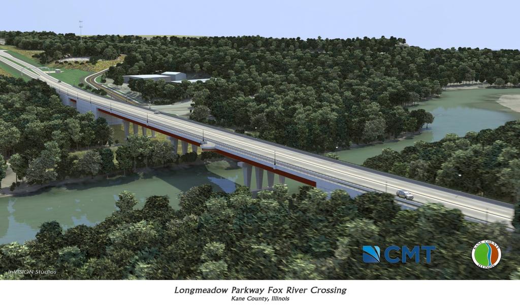
Longmeadow Parkway Fox River Bridge Corridor. August 6, 2015
|
|
|
- Jasper Spencer
- 6 years ago
- Views:
Transcription
1 Longmeadow Parkway Fox River Bridge Corridor August 6, 2015

2 Longmeadow Parkway Bridge Corridor 5.6 miles from Huntley Road to IL 62 Unique municipal/county/state/federal partnership Links Randall Road & 3 State Routes (IL 25, IL 31, IL 62)
3 Project Purpose Enhance Kane County s transportation network by reducing congestion and providing alternative and more direct routes Serve existing and planned land use through efficient access to central business districts, public services, and employment / commercial centers
4 Project Need No new river crossings in Upper Fox Valley since I-90 in 1950 s Congestion & Travel Delay increasing on area roadway network with negative impacts to local streets/neighborhoods Tenfold Population Increase west of Fox River since 1980s with northern Kane County; currently a Chicago region leader in new housing starts 2040 Growth Projection: additional 150,000+ people for immediate area with increasing impacts to existing bridges, streets and communities Impacts to Economic Growth & Existing Communities traffic congestion hampers access to local business districts, employment and commercial centers Carpentersville Main St. bridge carries increasing regional traffic with impacts to local neighborhoods on east side of river
5 It takes time From the Start 1990 Bridge Advisory Committee formed to comprehensively study 20+ potential new bridge crossings of Fox River extensive team of federal, state and local agencies including over a hundred environmental and engineering professionals evaluated potential bridge corridors Included four (4) Dundee-area corridors: County Line, Longmeadow Parkway, Miller/Lake Marian & Boncosky Evaluated land, water, air, structures, living organisms, social, cultural, and economic impacts with 30+ public meetings for the Environmental Impact Statement (EIS) process
6 Environmental Impact Statement -EIS Team included: Illinois Department on Natural Resources Illinois Environmental Protection Agency Illinois Historic Preservation Agency Illinois Nature Preserves Commission Illinois State Geological Survey U.S. Army Corps of Engineers U.S. Department of the Interior U.S. Department of Agriculture U.S. Environmental Protection Agency U.S. Fish & Wildlife Service Various Environmental & Engineering Consultants Municipalities Kane County Forest Preserve District Illinois Department of Transportation Federal Highway Administration


7 Environmental Impact Statement 2001 Federal approval of Final EIS 2002 Federal Record of Decision Longmeadow Parkway was found to: Best satisfy the purpose & need Least impact to the natural & human environment Selected based on processes in compliance w/nepa Eligible for Federal funding May advance through development process to construction
8 Environmental Impact Statement Final EIS process established the final alignment & included mitigation of open space impacts Alignment refined during EIS to minimize impacts 2002 Record of Decision established final alignment Design uses alignment approved in 2002 Open space mitigation is part of land acquisition requirements 2008 Brunner Forest Preserve acquisition considered and included the conveyance of the Longmeadow Right-of-Way
9 Recent Activities 100+ Public Meetings 2003 Phase I Engineering & Land Acquisition proceeds Algonquin, Carpentersville & County approved Longmeadow in Comprehensive Plans 2007 Municipalities requested County to make Longmeadow a toll bridge Longmeadow Task Force established to study toll option 2009 Federal review & approval of EIS change for toll option 2010 County Board approves Toll Bridge approach 2012 County Transportation Plan with Longmeadow adopted 2013 Phase I Eng./Design Approval by FHWA & Phase II Eng. Started Final Design and required environmental updates
10 Municipal Planning Municipal planning and public processes included Longmeadow Parkway: Carpentersville 2007 Comprehensive Plan Algonquin 2008 Comprehensive Plan Development planning & platting Right-of-Way acquisition Construction of roadway segments 10 Resolutions of support Algonquin, Barrington Hills, Carpentersville, East Dundee, Gilberts, Hampshire, Huntley, Lake-inthe-Hills, Sleepy Hollow, West Dundee

11 Village of Algonquin General Development Plan 1974
12 Regional / State Approvals & Construction Funding Support Metropolitan Planning Organization (CMAP) assisted with Planning, Programming, & Air Quality Conformance Analysis in accordance with federal requirements $5.1M in Congestion Mitigation Air Quality & other federal $5.0M from Kane/Kendall Council of Mayors $42.2M in IDOT funds for their portion of the project
")
13 Why a Toll Bridge? Challenge Federal, State & local funds are limited Funding Opportunity County may create toll bridges Bridge funding assisted through user fees (75% plus of area households have I-Pass) Supports other County capital projects by creating an additional revenue source for Longmeadow Provides mechanism for non-kane County Residents to help pay for the corridor

14 Toll Bridge Bridge is tolled with one facility east of Fox River Remainder of Longmeadow is not tolled and provides local accessibility much like any other local road Toll rate is anticipated to be $1.00 peak/50 cents off-peak
15 Project Development Cost to Date: $28.5M Studies, EIS, Engineering & ROW Following successful model of Stearns Road Bridge Corridor Many local, state & national awards Illinois Chapter American Planning Association Sustainability Award Kane-DuPage Soil & Water Conservation District Excellence for Efforts in Conservation of Land and Water Resources
16 Project Status / Costs / Next Steps Finalizing Phase II Engineering 2015 ($9M) Construction permitting process underway Continued coordination with resource agencies Land Acquisition 2015/2016 ~60% land acquired Intergovernmental Agreements Tollway, State Construction/CE Cost Estimate: $115M Construction Contracts / Staging TBD 1 st construction contract bid target Fall 2015 Remaining contracts target
17 Project Fund Sources Current Estimate $115M for Construction/CE with Cost Index Federal $ 10.1M State $ 39.4M Local $ 65.5M Total $115.0M Current Estimate for $65.5M Local Fund Sources No new taxes *$40M Bond Amount will likely decrease Impact Fees $ 3.5M Sales Tax $ 22.0M Bond Revenue $ 40.0M* Total $ 65.5M
18
19
State Highway 121 Southwest Parkway. Fort Worth s Transportation Success Story in Design and Cooperation
 State Highway 121 Southwest Parkway Fort Worth s Transportation Success Story in Design and Cooperation Greater Fort Worth Association of Realtors October 24, 2007 Presented by: Dan Lamers, P.E. North
The Village of Sugar Grove, in partnership with Kane County, the Illinois Department of Transportation, and the Illinois Tollway welcomes you to the
 The Village of Sugar Grove, in partnership with Kane County, the Illinois Department of Transportation, and the Illinois Tollway welcomes you to the first Public Meeting for the proposed interchange improvement
Illiana Corridor CPG/TTF Meeting #1
 Illiana Corridor CPG/TTF #1 March 14, 2013 #10 1 Agenda Tier One Recap What happens in Tier Two? Tier Two Purpose and Need Identify Range of Alternatives Landowner Outreach Initial Context Sensitive Solution
The Illinois Department of Transportation and Lake County Division of Transportation. Route 173, including the Millburn Bypass
 The Illinois Department of Transportation and Lake County Division of Transportation welcome you to this Public Hearing for U.S. Route 45 from Illinois Route 132 to Illinois Route 173, including the Millburn
Elgin O Hare Western Access Project Local Advisory Committee. February 10, 2014
 Elgin O Hare Western Access Project Local Advisory Committee February 10, 2014 Agenda Project status update Design and construction Funding Aesthetics Project events and outreach Land acquisition Next
5.0 IMPLEMENTATION STRATEGIES
 5.0 IMPLEMENTATION STRATEGIES 5.1 Recommended Alternative This chapter discusses the anticipated steps needed to move each project from recommendation to construction. Since full funding for these alternatives
I-290 Eisenhower Expressway
 I-290 Eisenhower Expressway From west of Mannheim Road to Racine Avenue SECTION 7.0 List of Agencies, Organizations, and Persons Receiving FEIS List of Agencies, Organizations and Persons Receiving FEIS
ILLINOIS 47 CORRIDOR PLANNING STUDY H E N R K A N E SEPTEMBER 2010
 WISCONSIN ILLINOIS 173 M 47 C ILLINOIS 47 H E 14 120 CORRIDOR PLANNING N R 176 STUDY Y SEPTEMBER 2010 72 20 47 90 72 20 RANDALL ROAD Participants Village of Burlington Village of Campton Hills City of
PROJECT STATEMENT LOCATION/DESIGN PUBLIC HEARING. 19 th AVENUE NORTH EXTENSION PROJECT FROM SPRINGDALE DRIVE TO NORTH 2 ND STREET/U.S.
 PROJECT STATEMENT LOCATION/DESIGN PUBLIC HEARING 19 th AVENUE NORTH EXTENSION PROJECT FROM SPRINGDALE DRIVE TO NORTH 2 ND STREET/U.S. 67 HEARING LOCATION: ERICKSEN COMMUNITY CENTER 1401 11 TH AVENUE NORTH
DuPage Mayors and Managers Conference June 21, 2013 TRANSPORTATION PROGRAM (STP) WORKSHOP
 WORKSHOP") DuPage Mayors and Managers Conference June 21, 2013 TRANSPORTATION PROGRAM (STP) WORKSHOP Lombard Village Hall Marilin Solomon, P.E. Field Engineer West Division (Central & North Central Cook County, DuPage
DuPage Mayors and Managers Conference June 21, 2013 TRANSPORTATION PROGRAM (STP) WORKSHOP Lombard Village Hall Marilin Solomon, P.E. Field Engineer West Division (Central & North Central Cook County, DuPage
Congestion Management Safety Plan. Michael Corbett State Program Administrator September 2017
 Congestion Management Safety Plan Michael Corbett State Program Administrator September 2017 Agenda Topic 1 What is the Congestion Management Safety Plan (CMSP)? 2 Relevance to Congestion Investments 3
Peoria Riverfront Development (Ecosystem Restoration) Upper Mid-sized Island Critical Restoration Project (September 2011)
 Upper Mid-sized Island Critical Restoration Project (September 2011)") Peoria Riverfront Development (Ecosystem Restoration) Upper Mid-sized Island Critical Restoration Project (September 2011) Description The Corps of Engineers, Rock Island District (District) and the Illinois
Peoria Riverfront Development (Ecosystem Restoration) Upper Mid-sized Island Critical Restoration Project (September 2011) Description The Corps of Engineers, Rock Island District (District) and the Illinois
1.0 INTRODUCTION 1.1 TH 14 WEST STUDY AREA Project Description Functional Classification Purpose of the Project
 1.0 INTRODUCTION 1.1 TH 14 WEST STUDY AREA 1.1.1 Project Description The Trunk Highway (TH) 14 West Corridor is a two-lane roadway approximately 22 miles in length. Located in Nicollet County, the corridor
Harlem Avenue Corridor Plan: Corridor Planning Across Municipal Boundaries
 Harlem Avenue Corridor Plan: Corridor Planning Across Municipal Boundaries Heather Tabbert, Manager, Local Planning and Programs Division Regional Transportation Authority (RTA) Jen McNeil Dhadwal, Principal
Capital Projects in and near Odenton Town Center
 Capital Projects in and near Odenton Town Center Map ID Anne Arundel County Department of Public Works This project provides for the design, right of way acquisition, and construction of approximately
SECTION 4(f) DE MINIMIS DOCUMENTATION
 DE MINIMIS DOCUMENTATION") SECTION 4(f) DE MINIMIS DOCUMENTATION Illinois Route 60/83 IL 176 to the intersection of IL 60 (Townline Road) Lake County P-91-084-07 Mundelein Park and Recreation District Project Limit SECTION 4(f)
SECTION 4(f) DE MINIMIS DOCUMENTATION Illinois Route 60/83 IL 176 to the intersection of IL 60 (Townline Road) Lake County P-91-084-07 Mundelein Park and Recreation District Project Limit SECTION 4(f)
Old Brick Township DRI Recommendation Report
 Old Brick Township DRI Recommendation Report City of Palm Coast Presented to NEFRC Planning and Growth Management; Board of Directors July 8, 2010 Recommendation #1 Conversion table limited by transportation
SR 15 SECTION 088 CSVT SOUTHERN SECTION PUBLIC MEETING JUNE 16, 2015
 PUBLIC MEETING JUNE 16, 2015 AGENDA PROJECT HISTORY NORTHERN SECTION UPDATE SOUTHERN SECTION OVERVIEW INTERCHANGES PROJECT SCHEDULE UPCOMING ACTIVITIES OPEN DISCUSSION & GROUP QUESTIONS ONE-ON-ONE QUESTIONS
TRANSPORTATION ELEMENT GOALS, OBJECTIVES, AND POLICIES
 TRANSPORTATION ELEMENT GOALS, OBJECTIVES, AND POLICIES GOAL 2 The City shall provide a safe, convenient, effective, and energy efficient multimodal transportation system which is coordinated with the Future
Appendix E Preliminary Location Hydraulic Study
 Appendix E Prepared for: State of Alaska Department of Transportation and Public Facilities Prepared by: HDR Alaska, Inc. 2525 C Street, Suite 305 Anchorage, Alaska 99503 February 2014 This page intentionally
Nine Mile Creek Regional Trail Update. Edina City Council Workshop March 4, 2014
 Nine Mile Creek Regional Trail Update Edina City Council Workshop March 4, 2014 Presentation Outline: Where we ve been - Recap of route assessment process and approved route Where we are now - Summary
Overview of Southwestern Pennsylvania Commission s (SPC) 2040 Long Range Transportation Plan (LRTP)
 2040 Long Range Transportation Plan (LRTP)") Overview of Southwestern Pennsylvania Commission s (SPC) 2040 Long Range Transportation Plan (LRTP) Presented to Pennsylvania Agency Coordination Meeting May 27, 2015 Doug Smith & Ryan Gordon 1 Southwestern
Overview of Southwestern Pennsylvania Commission s (SPC) 2040 Long Range Transportation Plan (LRTP) Presented to Pennsylvania Agency Coordination Meeting May 27, 2015 Doug Smith & Ryan Gordon 1 Southwestern
Issues Requiring Future Study
 Issues Requiring Future Study Transportation planning is an ongoing process that tends to identify new issues as it finds solutions for others. Some issues are so complex that a solution to one problem
ARLINGTON COUNTY, VIRGINIA. County Board Agenda Item Meeting of January 28, 2017 SUPPLEMENTAL REPORT
 ARLINGTON COUNTY, VIRGINIA County Board Agenda Item Meeting of January 28, 2017 SUPPLEMENTAL REPORT DATE: January 26, 2017 SUBJECT: The Virginia Department of Transportation s Transform I-66 Inside the
PREPARED FOR: PLATTEVIEW ROAD CORRIDOR STUDY EXECUTIVE SUMMARY
 PREPARED FOR: PLATTEVIEW ROAD CORRIDOR STUDY EXECUTIVE SUMMARY SEPTEMBER 2016 Introduction The Platteview Road Corridor Study was led by the Metropolitan Area Planning Agency (MAPA) with assistance from
ADOPTION OF THE REVISED OPEN SPACE AND CONSERVATION ELEMENT OF THE GENERAL PLAN
 TO: FROM: SUBJECT: Honorable Mayor and City Council Planning Department ADOPTION OF THE REVISED OPEN SPACE AND CONSERVATION ELEMENT OF THE GENERAL PLAN RECOMMENDATION: It is recommended that the City Council:
The Trinity River Corridor Project Update
 The Trinity River Corridor Project Update Councilmember Carolyn A. Davis Community Meeting October 14, 2008 The project covers 20 miles of the Trinity River, approx. 10,000 acres 2 Trinity River Corridor
4-Town Comprehensive Plan DRAFT 7/30/07
 4-Town Comprehensive Plan DRAFT 7/30/07 Acknowledgements ning Committee Town of Harrisburg Norman Roof Randy Nicol Town of Martinsburg Terry Thisse Paul Kelly Town of Montague Jan Bagdanowicz Wendy Perry
Intergovermental Coordination
 Intergovermental Coordination CITY OF WINTER PARK CHAPTER 8: INTERGOVERNMENTAL COORDINATION ELEMENT INTERGOVERNMENTAL COORDINATION ELEMENT GOAL 8-1: PROVIDE FOR IMPROVED INTERGOVERNMENTAL COORDINATION
1.0 PROJECT PURPOSE AND NEED
 1.0 PROJECT PURPOSE AND NEED The FasTracks Plan includes the extension of the Central Corridor from its current terminus at 30th/Downing to a connection to the East Corridor commuter rail service planned
RESPONSES TO PUBLIC CONCERNS AND QUESTIONS
 RESPONSES TO PUBLIC CONCERNS AND QUESTIONS Stations and Summary Questions for Public Meeting #2 June 23, 2015 General Questions / Concerns: 1. Is there any way this development can raise revenue for the
ARGENTA TRAIL (CSAH 28/63) REALIGNMENT SOUTH PROJECT (CP 63-25)
 REALIGNMENT SOUTH PROJECT (CP 63-25)") ARGENTA TRAIL (CSAH 28/63) REALIGNMENT SOUTH PROJECT (CP 63-25) Preliminary Design Report February 2015 Prepared For: City of Inver Grove Heights Dakota County Prepared By: Kimley-Horn and Associates,
ARGENTA TRAIL (CSAH 28/63) REALIGNMENT SOUTH PROJECT (CP 63-25) Preliminary Design Report February 2015 Prepared For: City of Inver Grove Heights Dakota County Prepared By: Kimley-Horn and Associates,
Right-of-Way Acquisitions and Relocations Technical Memorandum
 Right-of-Way Acquisitions and Relocations Technical Memorandum Southeast Extension Project Lincoln Station to RidgeGate Parkway Prepared for: Federal Transit Administration Prepared by: Denver Regional
REQUEST FOR QUALIFICATIONS
 REQUEST FOR QUALIFICATIONS for the City of Lake Forest Issue Date: September 23, 2015 Bid Due Date: October 19, 2015 The City of Lake Forest 800 N. Field Drive Lake Forest, Illinois 60045 THE CITY OF LAKE
RECREATION, OPEN SPACE AND GREENWAYS ELEMENT GOALS, OBJECTIVES, AND POLICIES
 RECREATION, OPEN SPACE AND GREENWAYS ELEMENT GOALS, OBJECTIVES, AND POLICIES GOAL R-1: DEVELOP A RECREATION, OPEN SPACE AND GREENWAYS SYSTEM AS AN INTEGRAL COMPONENT OF AN OVERALL, COUNTY-WIDE ECONOMIC
Planned Manufacturing District Review
 Mayor Emanuel s Industrial Corridor Modernization Planned Manufacturing District Review North Branch Framework Implementation Chicago Plan Commission July 20, 2017 Rahm Emanuel, Mayor David Reifman, Commissioner
Atlanta BeltLine Corridor Environmental Study. Scoping Meeting August 2008
 Atlanta BeltLine Corridor Environmental Study Scoping Meeting August 2008 What Will We Be Discussing Today? Study Overview - How Did We Get Here? - What Is the Study About? - Who Is Involved? - Where Is
Parks and Open Space Preservation and Dedication. January 26, 2016 Fort Worth City Council Pre-Council Meeting Randle Harwood and Richard Zavala
 Parks and Open Space Preservation and Dedication January 26, 2016 Fort Worth City Council Pre-Council Meeting Randle Harwood and Richard Zavala Purpose How does the City of Fort Worth preserve and protect
CHAPTER 1 Introduction
 CHAPTER 1 Introduction From sea to summit, Lane County covers almost 4,800 square miles of diverse Oregon landscape. Stretching from the Pacific Ocean through the Coastal Range, the Willamette Valley to
AASHTO SUBCOMMITTEE ON DESIGN. June 15, 2006 MARK ROBINSON, P.E. DISTRICT 5 INTERSTATE PROGRAM MANAGER FLORIDA DEPARTMENT OF TRANSPORTATION
 AASHTO SUBCOMMITTEE ON DESIGN June 15, 2006 MARK ROBINSON, P.E. DISTRICT 5 INTERSTATE PROGRAM MANAGER FLORIDA DEPARTMENT OF TRANSPORTATION CENTRAL FLORIDA INTERSTATE 4 FACTS Trucks and Others 12% Tourist
RESOLUTION NO. R Refining the route, profile and stations for the Downtown Redmond Link Extension
 RESOLUTION NO. R2018-32 Refining the route, profile and stations for the Downtown Redmond Link Extension MEETING: DATE: TYPE OF ACTION: STAFF CONTACT: Capital Committee Board PROPOSED ACTION 09/13/2018
METROPOLITAN COUNCIL 390 North Robert Street, St. Paul, MN Phone (651) ; TDD (651)
 ; TDD (651)") DATE: December 20, 2011 METROPOLITAN COUNCIL 390 North Robert Street, St. Paul, MN 55101 Phone (651) 602-1000; TDD (651) 291-0904 TO: Metropolitan Parks and Open Space Commission FROM: Tori Dupre, Senior
DATE: December 20, 2011 METROPOLITAN COUNCIL 390 North Robert Street, St. Paul, MN 55101 Phone (651) 602-1000; TDD (651) 291-0904 TO: Metropolitan Parks and Open Space Commission FROM: Tori Dupre, Senior
SUMMARY. Support the Southeast Arkansas Regional Intermodal Facility.
 SUMMARY THE I-69 LOCATION STUDY The proposed I-69 Location Study from El Dorado to McGehee, Arkansas, represents one section (Section of Independent Utility No. 13) of the nationally designated I-69 Corridor
COLVER ROAD INDUSTRIAL CONCEPT PLAN
 COLVER ROAD INDUSTRIAL CONCEPT PLAN A CONCEPTUAL LAND USE AND TRANSPORTATION PLAN FOR TA-4 AN URBAN RESERVE AREA OF THE CITY TALENT City of Talent Adopted by City Council Resolution No., June, 2015 PART
Kankakee River Bridge & Track Improvements Supplemental Environmental Assessment. May 5, 2016
 Kankakee River Bridge & Track Improvements Supplemental Environmental Assessment May 5, 2016 1 History: Chicago-St. Louis Corridor Since 1980 s IDOT has been looking at this corridor for high-speed service
Section 106 Consulting Party Meeting Summary Report March 29, 2018
 On, the Chicago Department of Planning and Development (DPD) and the Chicago Department of Transportation (CDOT) jointly hosted the second Section 106 Consulting Party Meeting at the Logan Center for the
This chapter describes the purpose of the Plan, introduces how the Plan is organized and provides contextual background for the Plan.
 Chapter 1: INTRODUCTION Purpose of a Comprehensive Plan The 2040 Comprehensive Plan establishes Medina s vision as a community and sets goals and objectives which guide future decisions and policies. The
ESTABLISH AN EFFICIENT TOWN CENTER
 ESTABLISH AN EFFICIENT TOWN CENTER 4 Overview Lisbon residents are proud of the history of Newent and at the same time recognize its current importance as a centralized location for a variety of municipal
SEWRPC. Joint Meeting of the Advisory Committees on Regional Land Use Planning and Regional Transportation Planning APRIL 26, 2018
 SEWRPC Joint Meeting of the Advisory Committees on Regional Land Use Planning and Regional Transportation Planning APRIL 26, 2018 WISCONSIN DEPARTMENT OF TRANSPORTATION BRETT WALLACE, FOXCONN PROJECT DIRECTOR
ARLINGTON COUNTY, VIRGINIA. County Board Agenda Item Meeting of January 28, 2017 SUPPLEMENTAL REPORT-2
 ARLINGTON COUNTY, VIRGINIA County Board Agenda Item Meeting of January 28, 2017 SUPPLEMENTAL REPORT-2 DATE: January 27, 2017 SUBJECT: The Virginia Department of Transportation s Transform I-66 Inside the
Support the implementation of Cape Coral's Comprehensive Plan. Protect and utilize the unique natural resources in the City.
 7.0 OVERVIEW - RECOMMENDATIONS Chapter 7 The preparation of the Cape Coral Parks and Recreation Master Plan spanned a period of approximately 12 months. Plan preparation included the input of a wide range
Poinciana Parkway Southport Connector Project Development and Environment (PD&E) Study
 Study") Poinciana Parkway Southport Connector Project Development and Environment (PD&E) Study From Florida s Turnpike to Pleasant Hill Road, Osceola County, Florida Financial Project Number: 433693-1-22-01 Agency
Poinciana Parkway Southport Connector Project Development and Environment (PD&E) Study From Florida s Turnpike to Pleasant Hill Road, Osceola County, Florida Financial Project Number: 433693-1-22-01 Agency
A Connected Region for Our Future. Tampa Bay Regional Planning Council
 A Connected Region for Our Future Tampa Bay Regional Planning Council TBARTA Vision A world class transportation network for the Tampa Bay region that will connect people and places, move goods and services,
TIRZ 17/Redevelopment Authority Capital Improvements Plan Projects
 Gessner Widening: T-1701 What: Widen the road from a six-lane divided boulevard to an eight-lane divided boulevard street section, increase turn lanes, update traffic signal system, improve drainage by
Corridor Management Committee. September 29, 2017
 Corridor Management Committee September 29, 2017 1 Today s Topics Chair s Update Proposed Corridor Protection Wall Aesthetic Design Overview Public Outreach Environmental Review Civil Construction Update
Atlanta BeltLine, Inc. Pathways to Urban Sustainability
 Atlanta BeltLine, Inc. Pathways to Urban Sustainability September 30, 2010 WHAT IS THE ATLANTA BELTLINE? Transit 22-mile loop Parks 1300 + new acres Trails 33 miles Jobs & Economic Development 20 areas,
Bypass #16 - Bend Parkway (new alignment for US 97) (MP )
 (MP )") Bypass #16 - Bend Parkway (new alignment for US 97) (MP 134.76-141.83) Description: The Parkway is on new alignment for US 97 through Bend. US 97 is a Statewide Highway on the National Highway System that
Bypass #16 - Bend Parkway (new alignment for US 97) (MP 134.76-141.83) Description: The Parkway is on new alignment for US 97 through Bend. US 97 is a Statewide Highway on the National Highway System that
STP/SNK BIKE AND PEDESTRIAN PROJECTS
 STP/SNK BIKE AND PEDESTRIAN PROJECTS Project Name West Covington Riverfront Commons - Shared Use Path Applicant Name City of Covington, KY Applicant Title Mayor Joseph Meyer Email jumeyer@covingtonky.gov
City of Fort Lupton Site Plan Process
 Form WKBK001 City of Fort Lupton Site Plan Process Purpose The Site Plan process is meant to promote orderly and sound development standards as they apply to the City. These site development standards
NORTH-SOUTH CORRIDOR STUDY EXECUTIVE SUMMARY. Executive Summary
 Executive Summary Background As congestion continues to affect mobility in the region, the Ozarks Transportation Organization (OTO) is particularly concerned with traffic movement. The North-South Corridor
March 1, PWG Meeting #4
 March 1, 2013 PWG Meeting #4 1 Meeting Agenda 2 History & Overview Circle Interchange was built in the late 1950 s and early 1960 s, and the facility is in need of major repair or reconstruction. 3 History
Route 1 Corridor Study
 Route 1 Corridor Study Westbrook, Connecticut A Vision for the Connecticut Shoreline Public Informational Meeting July 28, 2015 Lower Connecticut River Valley Council of Governments Fitzgerald & Halliday,
The City shall enhance and improve the accessibility of parks and recreational facilities while protecting their quality. by:
 GOALS, OBJECTIVES AND POLICIES GOAL 1: To provide open space and recreation as an essential element needed for the betterment of the City s character and quality of urban life. The City shall plan for
CHARLES COUNTY GOVERNMENT RFP NO POPES CREEK RAIL TRAIL DESIGN
 CHARLES COUNTY GOVERNMENT Department of Fiscal and Administrative Services Purchasing Division Telephone: 301-645-0656 July 7, 2015 RFP NO. 16-02 POPES CREEK RAIL TRAIL DESIGN ADDENDUM NUMBER ONE TO: All
ITS Concept Development Activity Descriptions
 ITS Concept Development Activity Descriptions October 2015 Procedures are subject to change without notice. Check the NJDOT website to ensure this is the current version. Table of Contents Concept Development
SUNBRIDGE PARKWAY PRELIMINARY DESIGN STUDY. Board of County Commissioners Public Hearing
 SUNBRIDGE PARKWAY PRELIMINARY DESIGN STUDY Board of County Commissioners Public Hearing March 20, 2018 Presentation Overview Study Overview Existing Conditions Project Development Plan Public Involvement
PARKS AND RECREATION
 PARKS AND RECREATION WHAT YOU WILL FIND IN THIS CHAPTER: Background information on the development of the Park, Recreation, and System Plan (PRSP). General overview of Ellensburg s parks and recreation
Transportation Committee
 Transportation Committee Business Item No. 2013-286SW Meeting date: October 14, 2013 For the Metropolitan Council meeting of October 16, 2013 Subject: Southwest Light Rail Transit (Green Line Extension):
Functional Areas of Practice AICP EXAM REVIEW. February 20, 2009 Georgia Tech Student Center
 Functional Areas of Practice AICP EXAM REVIEW February 20, 2009 Georgia Tech Student Center Areas of Practice Community development Comprehensive or long range planning Development regulation or administration
Chapter 5: Recreation
 Chapter 5: Recreation Introduction and Setting Recreational opportunities within Nevada County are varied, ranging from public parks with intensively used active recreational facilities, to vast tracts
Howard W. Peak Greenway Trails
 Howard W. Peak Greenway Trails Program Beginnings 1998 - Mayor Howard Peak and other Council members initiated and supported idea of creating linear parks along San Antonio creekways. 1999 - Program plan
1.0 Circulation Element
 5/9/18 1.0 Circulation Element 1.1 Introduction As growth and development occur in Apache County, enhancements to its circulation system will be necessary. With time, more roads will be paved and air and
This page intentionally blank.
 This page intentionally blank. Parks, Recreation, and Open Space Chapter Relationship to Vision Vision Parks, Recreation and Open Space Chapter Concepts County Government. County government that is accountable
Durango Parks & Recreation Department. Strategic Plan
 Durango Parks & Recreation Department Strategic 2019-2023 Adopted April 2019 Overview The purpose of the adopted 2010 Parks, Open Space, Trails and Recreation Master is to provide a 10-year road map for
MORRISVILLE TRANSPORTATION PLAN TOWN COUNCIL PRESENTATION AUGUST 22, 2017
 TOWN COUNCIL PRESENTATION AUGUST 22, 2017 SCENARIO PLANNING CORRIDORS Town Hall Drive Baseline + 2 McCrimmon Parkway Baseline + 2 NC 54 Baseline + 2 7 subregion model runs determining carrying capacity
Panama City Beach Community Redevelopment Agency ON THE MOVE IN PCB
 Panama City Beach Community Redevelopment Agency ON THE MOVE IN PCB Program Goals, Activities and Accomplishments I. Beach Front Multi-modal Transportation, Aesthetic and Parking Improvements III. Connector
Chapter 11. Implementation Plan
 Chapter 11 Implementation Plan 127 D O W N T O W N T AV A R E S R E D E V E L O P ME N T MA S T E R P L A N IMPLEMENTATION PLAN This section shows how the Master Plan translates to a phased series of
Meeting Purpose: Date and Time: Location: Attendance: Handouts:
 Meeting Purpose: Date and Time: Location: Attendance: Handouts: PA Turnpike / I-95 Interchange Project Design Advisory Committee (DAC)/Public Officials Meeting #8 April 12, 2012 at 1:30 p.m. Project Office,
We d like to thank you for attending this Wekiva Parkway Section 8 Preliminary Design Update hosted by the Florida Department of Transportation.
 We d like to thank you for attending this Wekiva Parkway Section 8 Preliminary Design Update hosted by the Florida Department of Transportation. We will provide you information on the overall project and
COMPREHENSIVE PLAN & UNIFIED DEVELOPMENT ORDINANCE
 Village of Forsyth COMPREHENSIVE PLAN & UNIFIED DEVELOPMENT ORDINANCE Community Planning #6 Prepared by: Vision Statement We envision the Forsyth Community as one which will continue to maintain a small
Chapter 13: Implementation Plan
 Implementation A. Introduction The Implementation Plan, in table form on the following pages, provides a summary of all the Action Items recommended in Chapters 2 through 12. The table also indicates which
2017 General Obligation Bond
 2017 General Obligation Bond Presentation of Public and Council Projects to the Transportation & Mobility Stakeholder Committee April 13, 2017 Agenda Deferred Maintenance Project Development Process Projects
DRAFT SECTION 4(f) EVALUATION INTERSTATE 73 FEIS: I-95 to I-73/I-74 in North Carolina
 EVALUATION INTERSTATE 73 FEIS: I-95 to I-73/I-74 in North Carolina") DRAFT SECTION 4(f) EVALUATION INTERSTATE 73 FEIS: I-95 to I-73/I-74 in North Carolina 1.0 INTRODUCTION Section 4(f) of the Department of Transportation Act of 1966, 49 U.S.C. 303, requires that prior to
DRAFT SECTION 4(f) EVALUATION INTERSTATE 73 FEIS: I-95 to I-73/I-74 in North Carolina 1.0 INTRODUCTION Section 4(f) of the Department of Transportation Act of 1966, 49 U.S.C. 303, requires that prior to
Transportation Projects Quarterly Report. Morrisville Planning Department May 22, 2018
 Transportation Projects Quarterly Report Morrisville Planning Department May 22, 2018 Transportation Improvements Most Common Ways the Town secures transportation improvements: 1. Development 2. Grant
Application for a Site Plan Review
 Application for a Site Plan Review Municipality of Anchorage Planning Department PO Box 196650 Anchorage, AK 99519-6650 PETITIONER* Name (last name first) Mailing Address PETITIONER REPRESENTATIVE (IF
BOISE, IDAHO COUNCIL WORK SESSION AGENDA September 19, :00 PM City Hall - Council Chambers
 BOISE, IDAHO COUNCIL WORK SESSION AGENDA September 19, 2017 5:00 PM City Hall - Council Chambers I. CALL TO ORDER II. WORK SESSION ITEMS 1. Interim Changes (10 mins) Presenter: Brent Davis, Finance and
Section 3: Land Use M C H E N R Y K A N E. Figure 3.1: Potential Future Municipal Boundaries. Future Municipal Boundaries. County Land Use Plans
 Section 3: Land Use Figure 3.1: Potential Future Municipal Boundaries Land use and transportation are intertwined; yet, land use and transpor- tation planning are often undertaken as separate disciplines.
RESOLUTION NO
 RESOLUTION NO. 2016-16 A RESOLUTION PROVIDING FOR THE SUBMISSION TO THE QUALIFIED ELECTORS OF THE CITY OF BELLINGHAM AT AN ELECTION TO BE HELD ON NOVEMBER 8, 2016 OF A PROPOSITION AUTHORIZING THE CITY
Yadkin River Greenway Feasibility Study Fact Sheet Village of Clemmons, Town of Lewisville, Town of Bermuda Run
 Fact Sheet Village of Clemmons, Town of Lewisville, Town of Bermuda Run Project Background The Yadkin River Greenway Feasibility Study is a joint project with the Village of Clemmons, the Town of Bermuda
Regional Mobility & the US 380 Bypass Concept. Informational Meeting February 9, 2017
 Regional Mobility & the US 380 Bypass Concept Informational Meeting February 9, 2017 Purpose and Agenda Purpose: Regional Mobility Issues, Priorities, and Pressures US 380 as a Limited Access Facility
Project Description WOO/LUC-SR /0.00. Waterville Bridge Replacement
 Ohio Department of Transportation District 2 317 East Poe Rd. Bowling Green, Ohio 43402 (419) 353-8131 John R. Kasich, Governor Jerry Wray, Director Todd Audet, P.E., District Deputy Director Project Description
T h e n, N o w & T o m o r r o w. 200 Years of Settlement, Development, Preservation and Planning for a Safe, Healthy and Livable Kane County
 T h e n, N o w & T o m o r r o w 200 Years of Settlement, Development, Preservation and Planning for a Safe, Healthy and Livable Kane County 1 8 4 0 2 0 1 0 2 0 4 0 A Report from the Regional Planning
7.0 SOCIAL, ECONOMIC, AND ENVIRONMENTAL ISSUES
 7.0 SOCIAL, ECONOMIC, AND ENVIRONMENTAL ISSUES The following list of social, economic, and environmental issues have been identified based on a preliminary inventory of resources in the project area, an
IMPLEMENTING SOMERSET COUNTY S INVESTMENT FRAMEWORK
 IMPLEMENTING SOMERSET COUNTY S INVESTMENT FRAMEWORK SMART CONSERVATION THROUGH SMART GROWTH NJ LAND CONSERVATION RALLY March 22, 2014 Laurette Kratina, PP, AICP, Supervising Planner Somerset County Planning
Turkey Creek Streamway Corridor
 Turkey Creek Streamway Corridor Turkey Creek Corridor Overview History Watershed Corridor Inventory Coalition Corridor Plan Stages of Development Benefits Funding Turkey Creek History Kansas and Missouri
TOD 101 CREATING LIVABLE COMMUNITIES WITH TRANSIT
 1 CREATING LIVABLE COMMUNITIES WITH TRANSIT What are transit Centered Communities? Benefits of Partnerships to Support and Implement What You Will Learn Portland s Pearl District Your Trainers Today Catherine
Mississippi Skyway Preliminary Engineering Report
 EXECUTIVE SUMMARY Mississippi Skyway Preliminary Engineering Report CITY OF RAMSEY, MINNESOTA DECEMBER 2014 City of RAMSEY EXECUTIVE SUMMARY Project Need and Intent The Mississippi Skyway pedestrian bridge
Planning Roles. Responsibilities
 Lesson 3 Planning Roles & Responsibilities 3-1 Learning Outcomes Identify and describe transportation and land use planning processes Describe the relationships among these processes and how they can be
WELCOME! 8 8:30 6: TH STREET IMPROVEMENTS. Open House. Presentation & Q&A
 WELCOME! 168 TH STREET IMPROVEMENTS 6:30 Open House 7 8 Presentation & Q&A 8 8:30 Open House WELCOME Todd Pfitzer City of Omaha Engineer Bob Stubbe City of Omaha Public Works Director Jon Meyer Project
I-90 Mississippi River Bridge & Interchange Project
 I-90 Mississippi River Bridge & Interchange Project Presentation Outline I. Background: Context & Need for Project II. Preferred Alternative Overview III. Project Development IV. Project Management Tools