SUNBRIDGE PARKWAY PRELIMINARY DESIGN STUDY. Board of County Commissioners Public Hearing
|
|
|
- Hollie Lloyd
- 5 years ago
- Views:
Transcription

1 SUNBRIDGE PARKWAY PRELIMINARY DESIGN STUDY Board of County Commissioners Public Hearing March 20, 2018
2 Presentation Overview Study Overview Existing Conditions Project Development Plan Public Involvement
3 Presentation Overview Study Overview Existing Conditions Project Development Plan Public Involvement


4 Study Overview Sunbridge Parkway PDS Study Kick Off: May 2017 Anticipated Completion: May 2018 Corridor Length: Approximately 6.1 Miles Limits: Aerospace Parkway/Dowden Road to the Orange/Osceola County Line Goal: Identify Context Sensitive & Cost Feasible Improvements Document Project Need Balance the Needs of All Users Safety, Mobility, and Comfort Automobiles Pedestrians Cyclists Transit Freight


5 Study Overview Associated Projects New Interchange on State Road 528 New Interchange Segment 1 Sunbridge Parkway Road Design Sunbridge Neighborhoods Preliminary Development Plan Camino Reale Regulating Plan Under Review

")


6 Study Overview Associated Projects Sunbridge Parkway (North East District) 19,000 Acres in Osceola County Future Connection to Cyrils Drive Extension and Access to Osceola Parkway Extension Cyrils Drive Extension
7 Presentation Overview Study Overview Existing Conditions Project Development Plan Public Involvement


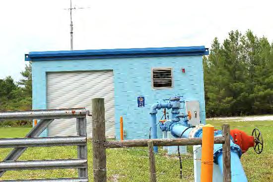

8 Existing Conditions Deseret Ranch 60 Year Old Cattle Ranch/Agricultural Operation One of the Largest Calf-Cow Operations in the US 45,000 Calf Producing Beef Cattle Predominately Pasture Lands or Undeveloped City of Cocoa Existing Water Supply Wells


9 Existing Conditions Environmental Considerations Environmental Land Stewardship Program Compliance Avoid/Minimize Wetland Impacts Maximize Use of Least Valuable Environmental Lands Protect Critical Wildlife Links


10 Existing Conditions Environmental Considerations Species of Special Concern American Alligator Eastern Indigo Snake Florida pine snake Gopher Tortoise Florida Burrowing Owls Florida Sandhill Crane Southeastern American Kestrel Wood Storks Sherman s Fox Squirrels Potential for Two Wildlife Crossings
11 Presentation Overview Study Overview Existing Conditions Project Development Plan Public Involvement

 Average Annual Daily")
12 Project Development Plan Opening Year Volume Dowden Road to Innovation Way South - 16,800 AADT Innovation Way South to County Line - 24,300 AADT Design Year Volume Dowden Road to Innovation Way South - 39,700 AADT Innovation Way South to County Line - 36,500 AADT *(AADT) Average Annual Daily Traffic

13 Project Development Plan Initial Design and Construction by Tavistock Segment Design Construct Segment 1 4-lane Urban 4-lane Urban Segment 2 2-lane Rural 2-lane Rural* Segment 3a 2-lane Rural 2-lane Rural* Segment 3b 2-lane Rural 2-lane Rural Segment 4 2-lane Rural 2-lane Rural *Segments 2 and 3a will ultimately be 4-lane Urban


14 Project Development Plan Urban Road Sections From Aerospace Parkway to Disston Canal Curb and Gutter Stormwater Treatment in Ponds Stormwater Pond Roadside Swale Rural Road Sections From Disston Canal to Orange/ Osceola County Line Stormwater Treatment in Roadside Swales


15 Project Development Plan Roadway Sections Segments 2, 3A and Part of 3B South of Aerospace Pkwy. to Disston Canal 133 ROW Phase 1 Initial 2-Lane Rural DESIGN SPEED 45 MPH 133 ROW Ultimate 4-Lane Urban Expansion


16 Project Development Plan Roadway Sections Segments 4 and Part of 3B - Disston Canal to the Orange Osceola County Line 160 ROW Phase 1 Initial 2-Lane Rural DESIGN SPEED 60 MPH 160 ROW Ultimate 4-Lane Rural Expansion
17 Project Development Plan Estimated Constructed Roadway Cost Public Private Partnership Roadway Agreement Approved by the BCC Impact Fee Credits Aerospace Parkway/Dowden Road to Orange/Osceola County Line Four Lane Ultimate Configuration Does Not Include the Cost of Mitigation Total Project Cost: $50,000,000
18 Presentation Overview Study Overview Existing Conditions Project Development Plan Public Involvement
19 Public Involvement Study Newsletter Study Website Public Community Meetings LPA/BCC Public Hearings All comments received throughout this Study will become part of the public record and included in the Final Study Report.


20 Public Involvement Lake Mary Jane Alliance Small Group Meeting Key Take Away: Focus on the Environment, Drainage and Preservation of Roberts Island Slough Community Meeting Key Take Away: Consider Timing of Phased Construction and Roadway Noise. Preservation of Roberts Island Slough Remains a Concern.


21 Public Involvement Public Involvement Activity Target Dates Community Meeting Local Planning Agency Work Session Local Planning Agency Public Hearing Board of County Commissioners Work Session Board of County Commissioners Public Hearing
 Seek public involvement (T1.1.1.2) Use METROPLAN modeling structure (T1.2.1) Ensure the CIP is responsive to demands (T1.3.2) Consider all available Funding Sources (T1.3.3) Provide an efficient and cost-effective transportation system (T1.")
22 Action Requested Consistency with the Comprehensive Plan Implement Long Range Transportation Plan (Obj. T1.1) Implement the Long Range Transportation Plan using 4-Step process (T1.1.1) Reflect the context of communities and the environment (T ) Seek public involvement (T ) Use METROPLAN modeling structure (T1.2.1) Ensure the CIP is responsive to demands (T1.3.2) Consider all available Funding Sources (T1.3.3) Provide an efficient and cost-effective transportation system (T1.3.6) Implement financially-feasible multimodal transportation system (Obj. T1.3) Participate in interlocal agreements, joint participation and other coordinated funding (T1.3.7) Ensure existing and new developments are connected (T3.2.2)

23 Action Requested Find the Sunbridge Parkway Preliminary Design Study Consistent with the Comprehensive Plan Recommendation for Approval of the Study

24 Questions and Discussion
SUNBRIDGE PARKWAY PRELIMINARY DESIGN STUDY. November 30, 2017
 SUNBRIDGE PARKWAY PRELIMINARY DESIGN STUDY November 30, 2017 Agenda Introductions and Overview Study Purpose Study Approach Key Analysis Components Study Context Existing Conditions Corridor Constraints
Agenda. Introductions and Overview Study Purpose Study Approach Key Analysis Components Study Context Development Activity ( )
") October 5, 2017 Agenda Introductions and Overview Study Purpose Study Approach Key Analysis Components Study Context Development Activity (2005-2017) Existing Conditions Alternatives Public Engagement
October 5, 2017 Agenda Introductions and Overview Study Purpose Study Approach Key Analysis Components Study Context Development Activity (2005-2017) Existing Conditions Alternatives Public Engagement
Frequently Asked Questions. What is Sunbridge?
 Frequently Asked Questions What is Sunbridge? Created by Tavistock, Sunbridge is a new, master-planned community in Central Florida. Spanning across 24,000 acres, Sunbridge will feature a variety of housing
SH 199 Corridor Master Plan. Community Meeting No. 2 May 31, 2017
 Community Meeting No. 2 May 31, 2017 Transportation Projects On or Near SH 199 SH 199 from 0.3 miles south of FM 1886 to south end of Lake Worth bridge Construct freeway mainlanes and frontage roads 10-Year
open public hearing and allow public comment request to continue LPA public hearing to January 16, 2014 at 10:30 am
 TODAY S AGENDA Work Session LPA Transmittal Public Hearing open public hearing and allow public comment request to continue LPA public hearing to January 16, 2014 at 10:30 am staff will issue a recommendation
ARGENTA TRAIL (CSAH 28/63) REALIGNMENT SOUTH PROJECT (CP 63-25)
 REALIGNMENT SOUTH PROJECT (CP 63-25)") ARGENTA TRAIL (CSAH 28/63) REALIGNMENT SOUTH PROJECT (CP 63-25) Preliminary Design Report February 2015 Prepared For: City of Inver Grove Heights Dakota County Prepared By: Kimley-Horn and Associates,
ARGENTA TRAIL (CSAH 28/63) REALIGNMENT SOUTH PROJECT (CP 63-25) Preliminary Design Report February 2015 Prepared For: City of Inver Grove Heights Dakota County Prepared By: Kimley-Horn and Associates,
Public Hearing. Charlotte County-Punta Gorda MPO - Meeting Rooms A and B March 14, open house at 4 p.m., formal presentation at 5 p.m.
 Public Hearing Charlotte County-Punta Gorda MPO - Meeting Rooms A and B March 14, 2019 open house at 4 p.m., formal presentation at 5 p.m. Welcome to the Public Hearing for the Harborview Road (CR 776)
I-4 Poinciana Parkway Connector Project Development and Environment (PD&E) Study. OCX Board Meeting
 Study. OCX Board Meeting") I-4 Poinciana Parkway Connector Project Development and Environment (PD&E) Study Presentation for: OCX Board Meeting January 14, 2014 Financial Project ID: 433693-2-22-01 ETDM No.: 13957 - Poinciana Parkway
I-4 Poinciana Parkway Connector Project Development and Environment (PD&E) Study Presentation for: OCX Board Meeting January 14, 2014 Financial Project ID: 433693-2-22-01 ETDM No.: 13957 - Poinciana Parkway
This page left intentionally blank.
 July 2012 This page left intentionally blank. Table of Contents Appendix A : Project Development Checklist Appendix B: At-Grade Rail Crossings Appendix C: Maintenance and Operations Examples Appendix D:
Scope of Services. River Oaks Boulevard (SH 183) Corridor Master Plan
 Corridor Master Plan") Scope of Services River Oaks Boulevard (SH 183) Corridor Master Plan PROJECT AREA The project area consists of the River Oaks Boulevard (SH 183) corridor bounded by SH 199 at the northern end and the Trinity
Scope of Services River Oaks Boulevard (SH 183) Corridor Master Plan PROJECT AREA The project area consists of the River Oaks Boulevard (SH 183) corridor bounded by SH 199 at the northern end and the Trinity
Poinciana Parkway Extension Project Development & Environment Study
 Poinciana Parkway Extension Project Development & Environment Study Nicole Gough, Dewberry Mary Brooks, Quest Corporation of America Clif Tate, Kimley-Horn and Associates February 19, 2019 Title VI Compliance
WELCOME! 8 8:30 6: TH STREET IMPROVEMENTS. Open House. Presentation & Q&A
 WELCOME! 168 TH STREET IMPROVEMENTS 6:30 Open House 7 8 Presentation & Q&A 8 8:30 Open House WELCOME Todd Pfitzer City of Omaha Engineer Bob Stubbe City of Omaha Public Works Director Jon Meyer Project
Old Brick Township DRI Recommendation Report
 Old Brick Township DRI Recommendation Report City of Palm Coast Presented to NEFRC Planning and Growth Management; Board of Directors July 8, 2010 Recommendation #1 Conversion table limited by transportation
Osceola County Board of County Commissioners 1 Courthouse Square, Suite 1100 Kissimmee, FL
 1/10/11 Item Number DRI08-0006 Osceola County Board of County Commissioners 1 Courthouse Square, Suite 1100 Kissimmee, FL 34741 407-742-0200 Applicant & Owner Center Lake Properties, LLLP and Formally
Pine Island Road Corridor Master Plan
 RECOMMENDED DEVELOPMENT PLAN Figure 9: Del Prado Village District Conceptual Framework The Conceptual Framework (Figure 8) for development of the Pine Island Corridor is to encourage mixed-use development
AASHTO SUBCOMMITTEE ON DESIGN. June 15, 2006 MARK ROBINSON, P.E. DISTRICT 5 INTERSTATE PROGRAM MANAGER FLORIDA DEPARTMENT OF TRANSPORTATION
 AASHTO SUBCOMMITTEE ON DESIGN June 15, 2006 MARK ROBINSON, P.E. DISTRICT 5 INTERSTATE PROGRAM MANAGER FLORIDA DEPARTMENT OF TRANSPORTATION CENTRAL FLORIDA INTERSTATE 4 FACTS Trucks and Others 12% Tourist
Gadsden County Planning Commission Agenda Request
 Date of Meeting: November 16, 2017 To: From: Through: Subject: Gadsden County Planning Commission Agenda Request Honorable Chairperson and Members of the Board Jill A. Jeglie, AICP, Senior Planner Clyde
Ten Mile Creek Planning Area
 PLANNING AREA POLICIES TEN MILE CREEK Ten Mile Creek Planning Area Location and Context The Ten Mile Creek Planning Area ( Ten Mile Creek area ) is located south of the current Boise AOCI, generally south
CHAPTER 2 TRANSPORTATION ELEMENT
 SUMMARY CHAPTER 2 TRANSPORTATION ELEMENT A City cannot continue to grow and develop if its citizens cannot reasonably access community facilities and commercial areas. A system of adequate and functional
Figure 5. Previously Identified Viable Corridors
 OVERVIEW The Central Florida Expressway Authority (CFX) is evaluating the potential to expand SR 408 from its current eastern terminus along SR 50 to SR 520 in northeastern Orange County, Fl. This new
I-95 Interchange & Ellis Road PD&E Study
 I-95 Interchange & Ellis Road PD&E Study Brevard County, Florida Presentation to the Space Coast TPO October 14, 2010 The Project Provide a New Interchange with I-95 Using the Ellis Road Corridor, Extend
Citizen Information Meeting
 Prince William County Government Citizen Information Meeting Vint Hill Road Extension May 11, 2016 Benefits: Route 28 Corridor Improvement Program Estimated significant cost savings versus bidding these
PUBLIC HEARING. Thursday, December 14, 2017 FDOT Urban Office 2198 Edison Avenue Jacksonville, FL 32204
 DISTRICT TWO PUBLIC HEARING I 10 (SR 8) from I 295 to I 95 Project Development & Environment Study Duval County, Florida Financial Project Number 213326 2 22 01 Efficient Transportation Decision Making
G. RECREATION AND OPEN SPACE ELEMENT. The following summarizes the Recreation and Open Space Element:
 G. RECREATION AND OPEN SPACE ELEMENT The purpose of the Element is to provide the framework and direction for a comprehensive system of public and private sites for recreation, including, but not limited
14 October 10, 2012 Public Hearing APPLICANT: MPB, INC
 14 October 10, 2012 Public Hearing APPLICANT: MPB, INC PROPERTY OWNER: MUNDEN & ASSOCIATES, LP STAFF PLANNER: Karen Prochilo REQUEST: Conditional Change of Zoning (AG-1 & AG-2 to Conditional O-2) ADDRESS
ORANGE COUNTY IMPLEMENTING THE FOUR C s
 ORANGE COUNTY IMPLEMENTING THE FOUR C s East Central Florida Corridor Task Force O R A N G E COUN TY P LA N N I N G DIVISION C O M M U N I T Y, E N V I R O N M E N T A L A N D D E V E L O P M E N T S E
PD&E STUDY SR 9/I-95 FROM SOUTH OF SR 870/COMMERCIAL BOULEVARD TO NORTH OF CYPRESS CREEK ROAD FM # ETDM 14222
 PD&E STUDY SR 870/COMMERCIAL BOULEVARD TO NORTH OF CYPRESS CREEK ROAD FM # 435808-1-22-02 ETDM 14222 WELCOME TO THE KICK-OFF MEETING May 24, 2016 1 1 2 3 4 5 6 PLANNING PROJECT DEVELOPMENT AND ENVIRONMENT
Parks, Trails, and Open space Element
 Parks, Trails, and Open space Element Parks, Trails, and Open Space element Parks, Recreation, and Open Space are important components of the quality of life desired by the residents of Elk Grove. This
I-494 Rehabilitation Project SP (I-394 to Fish Lake Interchange) June 2014 Section 4(f) De Minimis Determination
 June 2014 Section 4(f) De Minimis Determination") I-494 Rehabilitation Project SP 2785-330 (I-394 to Fish Lake Interchange) June 2014 Section 4(f) De Minimis Determination State Project Number 2785-330 Federal Project No. NHPP-I494 (002) Trunk Highway:
I-494 Rehabilitation Project SP 2785-330 (I-394 to Fish Lake Interchange) June 2014 Section 4(f) De Minimis Determination State Project Number 2785-330 Federal Project No. NHPP-I494 (002) Trunk Highway:
TRANSPORTATION ELEMENT GOALS, OBJECTIVES, AND POLICIES
 TRANSPORTATION ELEMENT GOALS, OBJECTIVES, AND POLICIES GOAL 2 The City shall provide a safe, convenient, effective, and energy efficient multimodal transportation system which is coordinated with the Future
I-4 Beyond the Ultimate. Florida Transportation Builders Association February 9, 2018
 I-4 Beyond the Ultimate Florida Transportation Builders Association February 9, 2018 FDOT: Improving Mobility & Safety in Central Florida FDOT is Designing and building a better I-4 through Central Florida
Project Overview. Get Involved. Public Information Meeting. Contact Information
 Get Involved VDOT representatives will review and evaluate information received as a result of this meeting. Please fill out the comment sheet provided in this brochure if you have any comments or questions.
 NOTES: 1.) THE BOGGY CREEK RD. AND SIMPSON RD. IMPROVEMENTS DEPICTED ON THIS PLAN ARE BASED ON RECORD CONSTRUCTION PLANS AND HAVE NOT BEEN SURVEYED. 2.) EXISTING RESIDENTIAL BUILDING STRUCTURES AND ANCILLARY
Michael D, Harvey, Current Planning Supervisor. This project was originally approved in 2012 by the BOCC and is summarized as follows:
 PLANNING & INSPECTIONS DEPARTMENT Craig N. Benedict, AICP, Director Current Planning (919) 245-2575 (919) 644-3002 (FAX) www.orangecountync.gov 131 W. Margaret Lane Suite 201 P. O. Box 8181 Hillsborough,
SDOT DPD. SDOT Director s Rule DPD Director s Rule DCLU DR SED DR of 7 CITY OF SEATTLE
 SDOT SDOT Director s Rule 2-07 DPD Applicant: CITY OF SEATTLE Page 1 of 7 Supersedes: DCLU DR 11-93 SED DR 93-4 Seattle Department of Transportation (SDOT) Department of Planning and Development (DPD)
9 th Street Sub Area Plan
 9 th Street Sub Area Plan In the 1990 s, when the Township prepared the last Master Plan, the 9 th Street corridor was studied as part of a larger 9 th Street Focus Area that included the West Main Street
Selected Area Study. Vision Plan Draft
 East Polk County Selected Area Study Draft 10.30.08 Contents Guiding Principles...4 Context Conclusions...5 Current Context...8 Scenarios...9 Scenario: Status Quo...10 Scenario: Connected & Directed Growth...12
5-E ====================================================== -==-= ====================================================
 PALM BEACH COUNTY BOARD OF COUNTY COMMISSIONERS 5-E AGENDA ITEM SUMMARY ------------====================================================== Meeting Date: September 11, 2007 Department: [] [] Consent [ ]
MODEL ACCESS MANAGEMENT PLAN MINNESOTA TRUNK HIGHWAY 7 COMPREHENSIVE PLAN AMENDMENT (HUTCHINSON SEGMENT)
") MODEL ACCESS MANAGEMENT PLAN MINNESOTA TRUNK HIGHWAY 7 (HUTCHINSON SEGMENT) COMPREHENSIVE PLAN AMENDMENT INTRODUCTION. The purpose of this plan is to provide consistent access management in the Trunk
MODEL ACCESS MANAGEMENT PLAN MINNESOTA TRUNK HIGHWAY 7 (HUTCHINSON SEGMENT) COMPREHENSIVE PLAN AMENDMENT INTRODUCTION. The purpose of this plan is to provide consistent access management in the Trunk
Longmeadow Parkway Fox River Bridge Corridor. August 6, 2015
 Longmeadow Parkway Fox River Bridge Corridor August 6, 2015 Longmeadow Parkway Bridge Corridor 5.6 miles from Huntley Road to IL 62 Unique municipal/county/state/federal partnership Links Randall Road
Tennessee Stormwater Management Program. Stormwater Management Site Assessment and Inventory Checklist. Quick Check o Vicinity Map within Watershed
 Tennessee Stormwater Management Program Project Name: Location: File Number: Reviewer: Date of Submittal: Review Date: Project Meeting Chronology: Type of Meeting: Date: Stormwater Management Site Assessment
BOISE, IDAHO COUNCIL WORK SESSION AGENDA September 19, :00 PM City Hall - Council Chambers
 BOISE, IDAHO COUNCIL WORK SESSION AGENDA September 19, 2017 5:00 PM City Hall - Council Chambers I. CALL TO ORDER II. WORK SESSION ITEMS 1. Interim Changes (10 mins) Presenter: Brent Davis, Finance and
SR 836 Southwest Extension
 SR 836 Southwest Extension Miami-Dade County, Florida August 8, 2018 MDX WORK PROGRAM NO.: 83618 Project Need Population growth and traffic in southwest Miami-Dade has significantly increased without the
Tysons Circulator Study: Process and Preliminary Results Summary. March 2012
 Tysons Circulator Study: Process and Preliminary Results Summary March 2012 Background: 1. The Comprehensive Plan for the Tysons Corner Urban Center calls for a System of Circulators in Tysons Corner to:
I. DESCRIPTION OF PROPOSED ACTION... 1 A. General Description... 1 B. Historical Resume and Project Status... 2 C. Cost Estimates...
 PROJECT COMMITMENTS SUMMARY... S-1 1. Type of Action... S-1 2. Description of Action... S-1 3. Summary of Purpose and Need... S-1 4. Alternatives Considered... S-2 5. NCDOT Alternatives Carried Forward...
DOMINION BOULEVARD CORRIDOR STUDY AND ECONOMIC DEVELOPMENT STRATEGIC PLAN A MODEL FOR CHESAPEAKE S FUTURE
 DOMINION BOULEVARD CORRIDOR STUDY AND ECONOMIC DEVELOPMENT STRATEGIC PLAN A MODEL FOR CHESAPEAKE S FUTURE Overview I. Draft Plan Process II. Draft Plan Overview a. Market Analysis b. Master Land Use Plan
East Central Florida Corridor Task Force Study Area
 1 East Central Florida Corridor Task Force Study Area TRANSMITTAL LETTER Dear Governor Scott: I am pleased to submit the final report of the East Central Florida Corridor Task Force, which was established
Parks, Trails, and Open Space Element
 P arks, Recreation, and Open Space are important components of the quality of life desired by the residents of Elk Grove. This Element of the General Plan addresses the City s goals, policies, and actions
We d like to thank you for attending this Wekiva Parkway Section 8 Preliminary Design Update hosted by the Florida Department of Transportation.
 We d like to thank you for attending this Wekiva Parkway Section 8 Preliminary Design Update hosted by the Florida Department of Transportation. We will provide you information on the overall project and
The Village of Sugar Grove, in partnership with Kane County, the Illinois Department of Transportation, and the Illinois Tollway welcomes you to the
 The Village of Sugar Grove, in partnership with Kane County, the Illinois Department of Transportation, and the Illinois Tollway welcomes you to the first Public Meeting for the proposed interchange improvement
Pond Siting Report Update
 Pond Siting Report Update Prepared for: Florida Department of Transportation District 5 CR 46A Realignment from SR 46 to North of Arundel Way Lake County, Florida FPID No. 238275-8-32-02 October 2013 (Draft
2035 General Plan Update and Belmont Village Specific Plan. Joint Study Session with the City Council and Planning Commission April 12, 2016
 2035 General Plan Update and Belmont Village Specific Plan Joint Study with the City Council and Planning Commission April 12, 2016 Agenda 1. Welcome and Introductions 2. General Plan Update Status of
2.0 AREA PLANS. Lakeside Business District. Lakeside Business District Land Use Categories:
 Lakeside Business District Lakeside Business District Land Use Categories: Campus Commercial Campus Commercial means a mixture of uses which includes corporate offices, office parks, hotels, commercial,
EXECUTIVE SUMMARY. Introduction
 EXECUTIVE SUMMARY Introduction State Route 68 is a designated scenic route that connects the world-renowned Monterey Peninsula to US Highway 101 and the Salinas Valley. SR 68 is a key route for bicycle,
DRAFT SECTION 4(f) EVALUATION INTERSTATE 73 FEIS: I-95 to I-73/I-74 in North Carolina
 EVALUATION INTERSTATE 73 FEIS: I-95 to I-73/I-74 in North Carolina") DRAFT SECTION 4(f) EVALUATION INTERSTATE 73 FEIS: I-95 to I-73/I-74 in North Carolina 1.0 INTRODUCTION Section 4(f) of the Department of Transportation Act of 1966, 49 U.S.C. 303, requires that prior to
DRAFT SECTION 4(f) EVALUATION INTERSTATE 73 FEIS: I-95 to I-73/I-74 in North Carolina 1.0 INTRODUCTION Section 4(f) of the Department of Transportation Act of 1966, 49 U.S.C. 303, requires that prior to
CHAPTER 7: Transportation, Mobility and Circulation
 AGLE AREA COMMUNITY Plan CHAPTER 7 CHAPTER 7: Transportation, Mobility and Circulation Transportation, Mobility and Circulation The purpose of the Transportation, Mobility and Circulation Chapter is to
Hurontario/Main Street Corridor Master Plan Mississauga and Brampton Building a new and integrated vision for the corridor
 Hurontario/Main Street Corridor Master Plan Mississauga and Brampton Building a new and integrated vision for the corridor Martin Powell, Commissioner of Transportation and Works, City of Mississauga Paper
Provide and maintain sufficient public parks, recreation facilities, and open space to meet the recreational needs of County residents and visitors.
 (ROS) Goal Provide and maintain sufficient public parks, recreation facilities, and open space to meet the recreational needs of County residents and visitors. OBJECTIVE ROS.01 The County shall acquire,
COLLIER BOULEVARD (CR 951) CORRIDOR
 CORRIDOR") Project(s) Goals Improve Traffic Circulation, Capacity & Safety Focus on Safety During Design & Construction Address Public Concerns Design an Aesthetically Pleasing Project Limit Environmental Impacts
Project(s) Goals Improve Traffic Circulation, Capacity & Safety Focus on Safety During Design & Construction Address Public Concerns Design an Aesthetically Pleasing Project Limit Environmental Impacts
Errol Heights Park and Community Garden Frequently Asked Questions March 22, 2018
 Errol Heights Park and Community Garden Frequently Asked Questions March 22, 2018 Question 1: What improvements are planned for Errol Heights Park? How will the community be engaged in the process to shape
Cobb County Design Guidelines Mableton Parkway & Veterans Memorial Highway Community Design Workshop January 12, 2017
 Community Design Workshop January 12, 2017 Agenda Opening Remarks / Introductions Scope of Work Existing Conditions Key Issues / Opportunities VPS Summary Draft Vision & Goal Statement Implementation Concepts
BeltLine Corridor Environmental Study
 BeltLine Corridor Environmental Study Joint TAC and SAC Meeting December 8, 2008 What We Will Discuss Today Outreach and Agency Coordination Scoping Results Existing Conditions Historical and Archeological
M E M O R A N D U M July 27, 2018
 Item #7 M E M O R A N D U M July 27, 2018 To: 2035 Corridor Planning Committee From: Kenneth Baker, Sr. Director of Planning and Development Services Subject: Item #7 Overview Michael Drive Purpose: Review
Mitchell Ranch South MPUD Application for Master Planned Unit Development Approval Project Narrative. Introduction
 Mitchell Ranch South MPUD Application for Master Planned Unit Development Approval Project Narrative Introduction Mitchell Ranch South is a proposed single family (detached) residential development on
Intergovermental Coordination
 Intergovermental Coordination CITY OF WINTER PARK CHAPTER 8: INTERGOVERNMENTAL COORDINATION ELEMENT INTERGOVERNMENTAL COORDINATION ELEMENT GOAL 8-1: PROVIDE FOR IMPROVED INTERGOVERNMENTAL COORDINATION
RECREATION, OPEN SPACE AND GREENWAYS ELEMENT GOALS, OBJECTIVES, AND POLICIES
 RECREATION, OPEN SPACE AND GREENWAYS ELEMENT GOALS, OBJECTIVES, AND POLICIES GOAL R-1: DEVELOP A RECREATION, OPEN SPACE AND GREENWAYS SYSTEM AS AN INTEGRAL COMPONENT OF AN OVERALL, COUNTY-WIDE ECONOMIC
McDonald s Restaurant - Purcellville Town of Purcellville Special Use Permit Statement of Justification July 24, 2014
 Introduction / Written Statement McDonald s Restaurant - Purcellville McDonald s Corporation is proposing to redevelop the existing McDonald s eating establishment with a drive-through located at 121 N
Gratigny Parkway East Extension Project Development & Environment (PD&E) Study
 Study") Gratigny Parkway East Extension Project Development & Environment (PD&E) Study Session 4: Presentation of Charrette Results December 8, 2010 MDX Work Program #: 92407 ETDM#: 11500 Project Location & Description
Gratigny Parkway East Extension Project Development & Environment (PD&E) Study Session 4: Presentation of Charrette Results December 8, 2010 MDX Work Program #: 92407 ETDM#: 11500 Project Location & Description
Fairfax County Parkway (Route 286) Widening Project
 Widening Project") Fairfax County Parkway (Route 286) Widening Project Route 29 (Lee Highway) to Route 123 (Ox Road) State Project No. 0286-029-259, P101; UPC 107937 Fairfax Station HOA Meeting January 30, 2018 7:00 to 9:00
Fairfax County Parkway (Route 286) Widening Project Route 29 (Lee Highway) to Route 123 (Ox Road) State Project No. 0286-029-259, P101; UPC 107937 Fairfax Station HOA Meeting January 30, 2018 7:00 to 9:00
Q:%4~ Memorandum CITY OF DALLAS
 Memorandum DATE December 10, 2010 CITY OF DALLAS TO Members of the Transportation and Environment Committee: Linda Koop (Chair), Sheflie Kadane (Vice Chair), Pauline Medrano, Vonciel Jones Hill, Jerry
PSRC REVIEW REPORT & CERTIFICATION RECOMMENDATION
 PSRC REVIEW REPORT & CERTIFICATION RECOMMENDATION KITSAP COUNTY COUNTYWIDE PLANNING POLICIES July 2, 2012 BACKGROUND A major emphasis of the Washington State Growth Management Act (GMA) is the need to
SEWRPC. Joint Meeting of the Advisory Committees on Regional Land Use Planning and Regional Transportation Planning APRIL 26, 2018
 SEWRPC Joint Meeting of the Advisory Committees on Regional Land Use Planning and Regional Transportation Planning APRIL 26, 2018 WISCONSIN DEPARTMENT OF TRANSPORTATION BRETT WALLACE, FOXCONN PROJECT DIRECTOR
Iowa 100 Extension Project Visualizations for Design and Public Involvement ASCE Transportation Conference November 6, 2013 Ames, Iowa
 Iowa 100 Extension Project Visualizations for Design and Public Involvement 2013 ASCE Transportation Conference November 6, 2013 Ames, Iowa Agenda Project Corridor Constraints Key Features Project History
Illiana Corridor CPG/TTF Meeting #1
 Illiana Corridor CPG/TTF #1 March 14, 2013 #10 1 Agenda Tier One Recap What happens in Tier Two? Tier Two Purpose and Need Identify Range of Alternatives Landowner Outreach Initial Context Sensitive Solution
This page intentionally blank.
 This page intentionally blank. Parks, Recreation, and Open Space Chapter Relationship to Vision Vision Parks, Recreation and Open Space Chapter Concepts County Government. County government that is accountable
Route 347. New York State Department of Transportation Region 10, Long Island. THE GREENING of ROUTE 347
 The GREENING of Route 347 The Greening of Route 347 The Greening of Route 347: History 3 The Greening of Route 347 4 The Greening of Route 347 5 The Greening of Route 347 Smith Haven Mall 6 The Greening
1.0 INTRODUCTION 1.1 TH 14 WEST STUDY AREA Project Description Functional Classification Purpose of the Project
 1.0 INTRODUCTION 1.1 TH 14 WEST STUDY AREA 1.1.1 Project Description The Trunk Highway (TH) 14 West Corridor is a two-lane roadway approximately 22 miles in length. Located in Nicollet County, the corridor
Support the implementation of Cape Coral's Comprehensive Plan. Protect and utilize the unique natural resources in the City.
 7.0 OVERVIEW - RECOMMENDATIONS Chapter 7 The preparation of the Cape Coral Parks and Recreation Master Plan spanned a period of approximately 12 months. Plan preparation included the input of a wide range
Gold Line Bus Rapid Transit Transit Oriented Development (BRTOD) Helmo Station Area Plan
 Helmo Station Area Plan") Appendix F Gold Line Bus Rapid Transit Transit Oriented Development (BRTOD) Helmo Station Area Plan Introduction and Purpose of the Plan The Gold Line Bus Rapid Transit facility is an eleven-mile dedicated
Appendix F Gold Line Bus Rapid Transit Transit Oriented Development (BRTOD) Helmo Station Area Plan Introduction and Purpose of the Plan The Gold Line Bus Rapid Transit facility is an eleven-mile dedicated
3. VISION AND GOALS. Vision Statement. Goals, Objectives and Policies
 Vision Statement Queen Creek s interconnected network of parks, trails, open spaces and recreation opportunities provide safe and diverse activities and programs that sustain its unique, small town, equestrian
CITY OF CHARLOTTESVILLE, VIRGINIA CITY COUNCIL AGENDA
 CITY OF CHARLOTTESVILLE, VIRGINIA CITY COUNCIL AGENDA Agenda Date: December 16, 2013 Action Required: Adoption of Resolution Presenter: Staff Contacts: Title: James E. Tolbert, AICP, Director of NDS James
North Ranch Master Plan
 North Ranch Master Plan Presentation to: East Central Florida Corridor Task Force Presentation by: Osceola County Office of Strategic Initiatives and Deseret Ranches Planning Team Kissimmee, Florida Friday,
Red Fox Commercial Outline Plan
 Red Fox Commercial Outline Plan City of Cold Lake, Alberta Prepared by Durrance Projects Ltd and Ross W. Sharp & Associates Ltd October 2014 Rupert 1 Table of Contents 1. PURPOSE...3 1.1. Location...4
The transportation system in a community is an
 7 TRANSPORTATION The transportation system in a community is an important factor contributing to the quality of life of the residents. Without a sound transportation system to bring both goods and patrons
Interchange Justification Report (IJR) and PD&E for S.R. 8 C.R. 4 (Antioch Road) Interchange
 and PD&E for S.R. 8 C.R. 4 (Antioch Road) Interchange") Interchange Justification Report (IJR) and PD&E for S.R. 8 (I-10) @ C.R. 4 (Antioch Road) Interchange Presented by: Greg Moore, PE FDOT Project Study Team Project Overview 1. Interchange Justification
Interchange Justification Report (IJR) and PD&E for S.R. 8 (I-10) @ C.R. 4 (Antioch Road) Interchange Presented by: Greg Moore, PE FDOT Project Study Team Project Overview 1. Interchange Justification
Photo by Carlton Ward Jr. Executive Summary
 Photo by Carlton Ward Jr. Executive Summary The Cooperative Conservation Blueprint (Blueprint) is a multi-partner strategic conservation process developed by the Florida Fish and Wildlife Commission (FWC)
12 January 12, 2011 Public Hearing APPLICANT: TAILWIND DEVELOPMENT GROUP,LLC PROPERTY OWNER: CITY OF VIRGINIA BEACH
 12 January 12, 2011 Public Hearing APPLICANT: TAILWIND DEVELOPMENT GROUP,LLC PROPERTY OWNER: CITY OF VIRGINIA BEACH STAFF PLANNER: Faith Christie REQUEST: Conditional Change of Zoning (from PD-H1 Planned
ARLINGTON COUNTY, VIRGINIA. County Board Agenda Item Meeting of January 28, 2017 SUPPLEMENTAL REPORT
 ARLINGTON COUNTY, VIRGINIA County Board Agenda Item Meeting of January 28, 2017 SUPPLEMENTAL REPORT DATE: January 26, 2017 SUBJECT: The Virginia Department of Transportation s Transform I-66 Inside the
FDOT/FTBA Construction Conference Work Plan
 FDOT/FTBA Construction Conference 19 2019 2023 Work Plan Ben Dreiling, P.E., Director of Construction Central Florida Expressway Authority January 18, 2019 Major Projects Map FY 2019-2023 Work Plan 2 FY
Pennsy Greenway Trail
 Town of Schererville Pennsy Greenway Trail DES. #s: 0401062, 1173595 & 1382661 Construction of Pennsy Greenway Trail beginning at Wilhelm Street and continuing northwest along the former Penn Central railroad
PRELIMINARY CONDITIONAL USE SUBMITTAL CHECKLIST REQUIREMENTS
 This checklist must accompany your submittal as the cover page. CONDITIONAL USE Application Submittal Checklist for PRELIMINARY AND FINAL APPROVAL Per Winter Park Land Development Code Sec. 58-90 PRELIMINARY
Alternatives Development Three conceptual alternatives were developed for the Race Road/Jessup Village Planning Study and are described below:
 Race Road/Jessup Village Planning Study (H550601) Project Newsletter Spring 2015 Project Description The Study Team, consisting of staff from Anne Arundel County (Department of Public Works and Department
 PORTLAND RETIREMENT RESIDENCE Approved Development 2 Congregate Care Facility 150 Suite (4 story) Retirement Residence 3 - Garage buildings & accessory buildings (one story) 102 Parking spaces 84%+ Landscape
Transportation Systems and Utility Infrastructure
 77 Audience Local and regional units of government, Landowners and developers, Community and citizen organizations, and Transportation/utility planners and engineers. Overview Transportation systems and
Cottage Grove Road Reconstruction. City of Madison Engineering
 Public Informational Meeting Cottage Grove Road Reconstruction October 8, 2015 Presentation Outline Introduction Project Purpose & Need Proposed Design Overview Environmental Concerns Pedestrian Needs
SPECIAL COMMITTEE OF THE WHOLE DECEMBER 9, 2002 BLOCK 57/58 WEST BLOCK PLAN BLOCK PLAN FILE BL.57/58W.99 HUNTINGTON BUSINESS PARK LAND OWNERS
 SPECIAL COMMITTEE OF THE WHOLE DECEMBER 9, 2002 BLOCK 57/58 WEST BLOCK PLAN BLOCK PLAN FILE BL.57/58W.99 HUNTINGTON BUSINESS PARK LAND OWNERS Recommendation The Commissioner of Planning recommends: THAT
11.0 TRANSPORTATION ELEMENT
 11.0 TRANSPORTATION ELEMENT Transit, Circulation and Parking Sub-Element: For all campuses, FIU's goal is to increase multimodal access. In combination with other measures - such as the development of
South Dakota 100 Corridor Preservation
 South Dakota 100 Corridor Preservation Purpose of this Public Hearing Inform Receive Input SD100 Project Progress East Side Corridor 1993 East Side Corridor EA March 20, 2003 SD100 Corridor Preservation
Potential Green Infrastructure Strategies May 6, 2015 Workshop
 Potential Green Infrastructure Strategies May 6, 2015 Workshop Background The City of Cortland is developing the Tioughnioga Urban Headwaters Green Infrastructure Action Plan with funding from the National
Regarding actual construction when development occurs, the following applicable guidelines are provided to address public safety issues:
 MIAMI-DADE COUNTY DEPARTMENT OF PLANNING AND ZONING General Comments 1. COMMENT: A careful review of the application provided shows that there is likely to be an impact on the Miami-Dade Police Department