The Village. Land Use Plan. Chapter 2 SPECIFIC PLAN
|
|
|
- Felix Stanley
- 6 years ago
- Views:
Transcription


1 The Village SPECIFIC PLAN Chapter 2
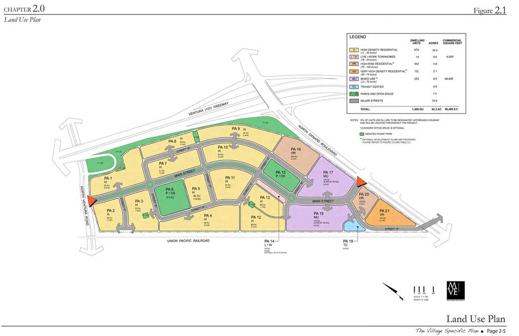
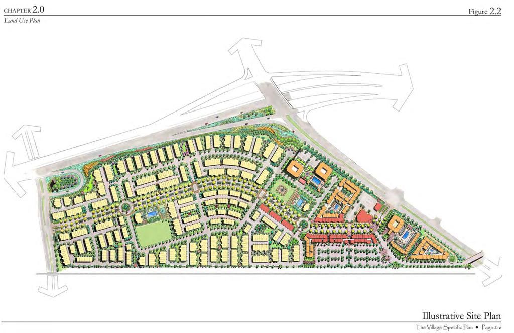
2 2.1 INTRODUCTION The provides the basic coordinating elements of this Specific Plan and establishes some of the key development requirements. This Chapter establishes: (1) the proposed land uses for The Village Specific Plan; (2) the general mix, location, size, and total number of residential dwellings, and the size of the commercial uses; (3) the range of permitted uses within the Specific Plan; and (4) the degree of flexibility permitted during construction of the Specific Plan. 2.2 LAND USE CONCEPT The Village Specific Plan proposes a mix of residential, commercial, recreational, and transit-oriented uses intended to serve a broad range of local and regional users without undermining the surrounding regional commercial market. Figure and Figure Illustrative Site Plan establish the plan s conceptual spatial layout and mix of uses, to which all development standards proposed as part of this Specific Plan apply. The Village Specific Plan envisions 1,500 total residential dwellings, approximately 50,400 square feet of ground floor commercial retail, and approximately 4,000 S.F. of optional office space within the live/work dwellings Planning Areas Areas proposed for development within The Village Specific Plan are differentiated by Planning Areas and have been grouped according to form, function, and density. A total of 21 Planning Areas are proposed. They are divided into 8 individual categories, which are intended to allow a variety of uses. The proposed Planning Area categories include:! High Density Residential (H): (15-30 DU/ acre)! Live/Work (L/W):(18-30 DU/ acre)! Very High Density Residential (VH): (30-70 DU/acre)! Mixed Use (MU): (25-70 DU/acre)! High Rise (HR): ( DU/gross acre)! Transit Center (TC)! Parks and Open Space (P/OS)! Major Streets The Village Specific Plan Page 2-1
3 Location and Characteristics of Planning Areas: Generally, the residential Planning Areas are spread throughout the Specific Plan in an orientation that creates a logical blend of stand-alone high density multi-family housing; high density mixed-use multi-family housing integrated above ground floor neighborhood commercial retail/office uses; very high density multi-family; and high rise multi-family. Each Planning Area and their representative characteristics are described in detail below. High Density Residential (H): The High Density Planning Areas are located in the western area of the Specific Plan. These neighborhoods consist of three-story townhouse and courtyard style building types connected by a network of pedestrian friendly streets. The streets are distinguished by broad sidewalks lined with street trees and landscaped parkways. These dwelling types either front onto a public street or are oriented around a landscaped courtyard. Parking is provided by traditional and tandem two-car garages accessed from an alley. Please refer to Chapter Residential Development Plan, Chapter Landscape Development Plan, and Chapter Design and Architectural Standards and Guidelines for applicable development standards. Live/Work (L/W): The Live Work Planning Area is located in the central area of the Specific Plan, south of the Village Green. This dwelling type has an architectural style and building footprint similar to the three-story townhouses located within the High Density Residential Planning Areas. However, this dwelling type permits the use of the ground floor as retail or office space. A total of 4,000 square feet of optional commercial space is allocated on the ground floor of the Live/Work Planning Area. Parking is provided by traditional two-car garages accessed from an alley. Please refer to Chapter Residential Development Plan, Chapter Landscape Development Plan, and Chapter 7.0 Design and Architectural Standards and Guidelines for applicable development standards. Very High Density Residential (VH): The Very High Density Residential Planning Area is located in the southeast corner of the Specific Plan adjacent to Oxnard Boulevard. This Planning Area includes four-story flats and four-story stacked townhouses over a two-level subterranean parking garage. The dwellings are arranged to front onto the surrounding public streets and around internal landscaped courtyards. Please refer to Chapter Residential Development Plan, Chapter 5.0- Landscape Development Plan, and The Village Specific Plan Page 2-2
4 Chapter Design and Architectural Standards and Guidelines for applicable development standards. Mixed Use (MU): The Mixed Use Planning Areas are envisioned as the Specific Plan s urban core. The multi-family buildings are multi-story and front onto the vibrant and pedestrian friendly Main Street, the neighborhood streets, and internal landscaped courtyards. These building types include a mix of two or three levels of residential dwellings above ground floor retail and stacked residential dwellings up to four stories. Parking is provided in a mixture of subterranean or on-grade structures and on and off-street surface parking. The subterranean parking is planned to extend down two levels; on-grade parking structures are planned to include four levels. Please refer to Chapter Mixed Use Development Plan, Chapter Landscape Development Plan, and Chapter 7.0 Design and Architectural Standards and Guidelines for applicable development standards. High Rise (HR): The High Rise Planning Areas are located in the northeastern portion of the Specific Plan, north of the Village Green and the southeastern portion of the Specific Plan adjacent to Oxnard Boulevard. The northern High Rise Planning Area envisions development of two high-rise buildings; the southeastern High Rise Planning Area envisions development of a single high rise building. All three high rises can include up to 25 floors (not including subterranean parking). Parking is provided in partially subterranean parking structures planned to include four stories above grade and up to two subterranean levels. Please refer to Chapter Residential Development Plan, Chapter Landscape Development Plan, and Chapter Design and Architectural Standards and Guidelines for applicable development standards. Transit Center (TC): The Transit Center Planning Area is strategically located in the southeast portion of the Specific Plan, adjacent to the existing railroad line utilized by Metrolink and Union Pacific Railroad. This Planning Area envisions the establishment of transit-oriented uses, including the Wagon Wheel Sub- Transportation Center, and state-of-theart multi-modal transportation services. Building and landscape designs are required to celebrate the western style architecture of the existing Wagon Wheel Motel. The Wagon Wheel Sub-transportation Center is envisioned as part of a larger Northern Oxnard Transportation Demand Management Program, which plans to provide residents, commuters, business owners, and their employees with direct access to bus and rail service, The Village Specific Plan Page 2-3
5 electric cars, car sharing, shuttle services, and vanpools. Transit services envisioned within the sub-transportation center include: 1. Gold Coast Transit and potentially VISTA bus services; 2. At least 50 park and ride spaces; 3. Metrolink shuttle service to and from the City s Transportation Center; 4. Mobility center with on-demand rental of Personal Electric Vehicles (PEV), Segways, bicycles and car sharing; 5. Commuter vanpools to regional employment centers; and 6. Potential for future Metrolink stop. Please refer to Chapter Mixed Use Development Plan, Chapter 5.0- Landscape Development Plan, and Chapter 7.0- Design and Architectural Standards and Guidelines for applicable development standards. Parks and Open Space (P/OS): The Parks and Open Space Planning Areas are designed to provide a variety of recreational opportunities primarily for residents of The Village. Well landscaped gathering places within the Mixed Use Planning Areas will be developed for the general public. The parks, streetscapes, corridors, and public spaces envisioned within The Village Specific Plan include formal greens and recreation centers, community gardens, landscaped courtyards and plazas, designated pedestrian and bicycle paths, and gateway and perimeter landscaping. Please refer to Chapter 5.0 for further discussions of landscaping and park designs, and more detailed descriptions of public and private recreation areas. The Specific Plan s parks and recreation areas vary in size and function, and thus provide a range of amenities, including formal recreation centers, active children s play areas, pool terraces, active and passive turf areas, passive gathering places, and pedestrian and bicycle pathways. The pedestrian pathways and corridors are designed to create opportunities for active and safe recreation while at the same time interconnecting the proposed residential neighborhoods with the neighborhood commercial services. The landscape environments envisioned for the perimeter of The Village Specific Plan include prominent monument signage designed to identify one s entry into the City of Oxnard and a green buffer between the US 101 Freeway, Oxnard Boulevard, Ventura Road, and The Village Specific Plan. The perimeter landscaping is planned partly within privately owned property and partly within the shoulder of the US 101 Freeway, which forms the Wagon Wheel property s northern border. The landscape buffer will significantly improve aesthetics along the projects 101 Freeway frontage, and buffer the project from the 101 Freeway, the Union Pacific Railroad line, and neighboring communities. The Village Specific Plan Page 2-4
6
7
8 2.2.3 Vehicle Circulation The Village Specific Plan roadway system balances the needs of pedestrians, bicyclists, and automobiles. Oxnard Boulevard, Ventura Road and U.S. Highway 101 will provide regional vehicle access to The Village Specific Plan. The existing intersection of Spur Drive and Oxnard Boulevard will remain the main entrance to the Specific Plan, as it was configured to meet Caltrans intersection standards for a four-way signalized intersection as part of the Oxnard Boulevard Interchange project. Wagon Wheel Road and all other existing roadways within the Specific Plan boundary will be redesigned to create an efficient interconnected network of streets. From the project entrance, Main Street is planned to meander through the center of the Mixed Use and the High Density Residential Planning Areas. This curved roadway is designed to provide a comfortable environment for pedestrians while slowing traffic. The street will function as an actual public space to be enjoyed by all, and not just a vehicular thoroughfare. The section of Main Street, within the Mixed-Use Planning Areas, is similar in form, function, and aesthetic quality to those found in downtown Oxnard, with one vehicle travel lane in each direction, angled parking, enhanced streetscape paving, traffic calming mechanisms, and wide pedestrian friendly sidewalks. Continuing west along Main Street to the Live/Work and High Density Planning Areas, the configuration of Main Street transitions from a more urban streetscape design to streetscape with a more suburban design. At this location, Main Street includes landscaped medians, one vehicle travel lane in each direction, striped Class II bike lanes, parallel vehicle parking, landscaped parkways, and sidewalks. Main Street continues in this configuration throughout the western portions of the Specific Plan. Neighborhood streets intersect with Main Street, forming a modified grid to provide multiple points of access to each residential neighborhood. Alleys provide direct access to rear loaded garages within the High Density Residential and Live/Work Planning Areas. Two roundabouts, on-street parking, enhanced paving for pedestrian crossings, tree-lined parkways, and sidewalks of ample width are planned at strategic locations along Main Street to calm traffic and to promote walking and cycling. The vehicle speed limit planned for all roadways is 30 mph or less. Reduced vehicle speeds will increase safety within the Specific Plan and permit the unrestricted use of PEVs on the street network as an alternative to automobile usage. See Figure 2.3 for the spatial arrangement of streets within The Village Specific Plan. The Village Specific Plan Page 2-7
9 CHAPTER 2.0 Figure 2.3 LEGEND Main Street (Parking On-Street) Neighborhood Streets (Parking On-Street) Alley Streets (Garage and Off-Street Parking) y eewa r F 1 S 10 U Ox na rd Bo ule va rd d a Ventura Ro Wagon Wheel Road Bridge Union Pacific Railroad Vehicle Circulation Concept The Village Specific Plan Page 2-8
10 2.2.4 Pedestrian Circulation Off-street pedestrian pathways, treelined sidewalks, landscaped corridors and public gathering spaces are proposed throughout the Specific Plan to encourage walking as an alternative to short auto trips. Figure 2.4 illustrates the planned pedestrian circulation system. Paramount to the village concept is the safety of pedestrians, which is established via a dedicated Class I bicycle/ pedestrian pathway along the northern edge of the Specific Plan area, and a well landscaped pedestrian pathway and sidewalk network which links the proposed residential neighborhoods with the commercial services, the recreational amenities, and the Wagon Wheel Sub-transportation Center. Class 2 bike lanes are planned along the residential portions of Main Street, Oxnard Boulevard, and Ventura Road. Class III bicycle lanes are proposed along the neighborhood streets and the commercial portions of Main Street. The location of planned bicycle pathways and connection points are shown in Figure Bicycle Circulation The Village Specific Plan will provide a regional bicycle linkage between major transportation corridors and the variety of uses present within the northern Oxnard area. A Class I bicycle pathway is proposed along the west side of Oxnard Boulevard, the northern edge of the Specific Plan, and the western and eastern sides of Ventura Road which will connect Oxnard Boulevard and Ventura Road with the City s future River Edge Trail and the Riverpark master planned community. The Village Specific Plan Page 2-9
 Secondary Pedestrian Pathways (Internal Courtyards and Paseos) Riverpark Project y eewa r F 1 S 10 U")
11 CHAPTER 2.0 Figure 2.4 LEGEND Major Pedestrian Pathways ( Sidewalks and Off-Street Trails) Secondary Pedestrian Pathways (Internal Courtyards and Paseos) Riverpark Project y eewa r F 1 S 10 U Esplanade Shopping Center Ox na rd Bo ule va rd il dge Tra River E Union Pacific Railroad Pedestrian Circulation Concept The Village Specific Plan Page 2-10

12 Figure 2.5 Class I Bicycle Trail (12 wide) E MAIN STREET CLASS I BICYCLE PATH (OXNARD BLVD.) SECTION E - E Bicycle Circulation Concept The Village Specific Plan Page 2-11
13 2.2.6 Vehicle Parking On-site parking for residents, commercial tenants, business owners and shoppers will be provided by a carefully planned mix of traditional and tandem two-car garage parking, structure parking, on-street parallel parking, on-street angled parking, and off-street surface parking areas. The structure and surface parking areas within the Mixed Use, Very High Density and High Rise Planning Areas are designed as Park Once or shared parking areas. Here, mixing uses reduces parking demand, which allows shoppers to complete multiple tasks without using multiple parking spaces. This approach also reduces the dependence on the automobile, and reduces spillover parking into the residential neighborhoods. Within the Park Once environment, adequate parking ratios for the commercial uses range from 1.5 to 2.5 parking spaces per 1,000 square feet. A parking ratio of 1.5 parking spaces/unit for owner occupied condominiums and 1.2 spaces per unit for apartments is required for the parking structures and surface parking supporting the Mixed Use, Very High Density and High Rise Planning areas. Reduced parking ratios can only be used if the City of Oxnard approves a formal Parking Management Study which confirms the ability to reduce parking ratios without creating parking spillover. Parking for the High Density Residential and Live/Work dwellings is proposed in alley loaded garages and in on and off-street guest parking areas at a parking ratio of 2.5 spaces per unit. Although parking shortages are not anticipated within the High Density Residential Planning Areas, if the City of Oxnard identifies a parking problem, then it may choose to implement a residential permit parking program. Please refer to Table 2.1 Parking Summary and Chapter 6, Section 6.9 for expanded discussion addressing vehicle parking. Table 2.1 Parking Summary Planning Areas Parking Type* Shared Parking 1 through 14 Attached 2- No Car Garage 16 Structure Yes 17 Structure Yes 18 Structure or Yes Surface 19 Structure or Yes Surface 20 Structure Yes 21 Structure Yes *Additional street parking provided on Main Street and Neighborhood Streets Affordable Housing The Village Specific Plan is located entirely within the boundary of the City of Oxnard s Historic Enhancement and Revitalization of Oxnard (HERO) Redevelopment Project Area. Within the redevelopment project area, the City of Oxnard requires that at least 15 percent of all new dwelling units within the project be dedicated to affordable housing. To comply with this requirement, The Village Specific Plan is subject to the requirement of providing two hundred twenty-five (225) rental affordable units which must remain The Village Specific Plan Page 2-12
14 affordable for at least 55 years, one hundred nineteen (119) of which must be available to Wagon Wheel Mobile Home Park residents/families. Of the one hundred nineteen (119) units to be made available to Wagon Wheel Mobile Home Park residents/families, ninety (90) shall be made available to and occupied by very low income households (persons and families whose gross incomes doe not exceed fifty percent (50%) of the area median income adjusted for size), thirteen (13) shall be made available to and occupied by lower income households (persons and families whose gross income do not exceed sixty percent (60%) of the area median income adjusted for size), ten (10) shall be made available to and occupied by low income households (persons and families whose gross incomes do not exceed eighty percent (80%) of the area median income adjusted for size), and six (6) shall be made available to and occupied by moderate income households (persons and families whose gross incomes do not exceed one hundred twenty percent (120%) of the area median income adjust to size). Prior to issuance of the building permit for the 1 st residential unit (market rate or affordable), (1) the owner of the project site shall have entered into an affordable housing loan agreement or owner participation agreement with the Oxnard Community Development Commission agreeable in form, content and substance to the Oxnard Community Development Commission, which includes at the least the following terms and conditions: (a) the owner of the project site shall execute an agreement containing covenants running the land restricting for at least 55 years the maximum income of tenants and the maximum rents that may be charged to tenants for the 225 affordable units, which agreement shall be recorded against the project site in first priority lien position, (b) a scope of development for the 225 affordable units, and (c) a schedule of performance providing for the timely satisfaction of all conditions precedent to the disbursement of any funds from the Oxnard Community Development Commission and the timely commencement and completion of construction of the 225 affordable units; and (2) the agreement containing covenants running with the land described above shall have been recorded against the project site in the first priority lien position. The final form of any affordable housing loan agreement or owner participation agreement shall be subject to the discretionary approval of the Oxnard Community Development Commission and shall include provisions and attachments customarily included in Oxnard Community Development Commission affordable housing agreements, including, but not limited to, conditions precedent to the disbursement of any funds form the Oxnard Community Development Commission. The Village Specific Plan Page 2-13
15 2.3 LAND USE CONSISTENCY All components of this Specific Plan are consistent with the City of Oxnard General Plan. To the extent possible, the Specific Plan used the General Plan Land Use Designation Map as a guide to establish the individual Planning Areas illustrated on Figure 2.1. However, the overall land use designation for The Village Specific Plan area reflected on the City s General Plan Land Use Map is a single land use termed Specific Plan Planning Areas The Specific Plan Area is comprised of 21 Planning Areas illustrated in Figure 2.1. They include: PA-1 through 5: High Density Residential (H); PA-6: Parks/Open Space (P/OS); PA-7 through 13: High Density Residential (H); PA-14: Live/Work (LW); PA-15: Parks/Open Space; (P/OS) PA-16: High Rise Residential (HR); PA-17, and 18: Mixed Use (MU); PA-19: Transit Center (TC); PA-20: High Rise Residential (HR): and PA-21: Very High Density Residential (VH) Each Planning Area establishes a specific set of permitted land uses, target densities, square footage, and other development regulations. The Planning Areas are utilized and referred to throughout this Specific Plan as the basic components of development to which all standards, guidelines, and implementation measures apply. 2.4 LAND USE REGULATION Summary Section 2.2 and Figure 2.1 describe the character and location of the proposed Planning Areas within The Village Specific Plan Planning Area Specifications Table 2.2 summarizes the gross acreage, target number of dwellings, target density ranges, and commercial square footages (if applicable) within each Planning Area Summary of Permitted Uses Table 2.3 describes the range of permitted uses envisioned within The Village Specific Plan. Permitted Land Uses are entitled uses that, once reviewed by the Development Services Director as part of any formal construction design package, do not generally require discretionary review and approval by the Planning Commission and/or City Council for their inclusion as part of the Specific Plan. Any proposed uses which are not listed in Table 2.3 may be included within The Village Specific Plan only after administrative approval by the City s Planning Manager, or if appropriate, by the Oxnard Planning Commission or City Council. For a more complete description of administrative review The Village Specific Plan Page 2-14
16 2.5 LAND USE FLEXIBILITY Given that The Village Specific Plan will be built-out over time, as described in Chapter 8, Administration and Implementation, the following measures give the developer flexibility during final design and construction. The goal of these measures is to insure that each development phase can meet current market demand at the time of construction Transfer of Residential Dwellings Within each Planning Area, the Developer may choose to construct dwellings within the range of permitted target net densities (defined as the number of units divided by the area of each planning area measured from the back of the sidewalk) established in Table 2.2, provided that the resulting total unit count does not exceed 1,500 and the total number of dwelling units for each dwelling type does not exceed the Planning Area s target unit count specified on Tables 2.2 and 2.3, and Figures 2.1 and 2.6. More specifically, this Specific Plan permits the transfer of residential units between all Planning Areas containing residential and/or commercial uses. For example, the townhouse dwellings within each High Density Residential Planning Areas could be constructed at a target net density ranging from units/acre but the total could not exceed 679 High Density Residential units. Any design modifications within a particular Planning Area in accordance with the above described dwelling transfer program would be subject to review and approval by the Planning Manager. Please refer to Chapter 8: Administration and Implementation, Section 8.7 for additional discussion of the administrative review approval requirements Choice of Frontage Types The form-based nature of this Specific Plan is designed to provide flexibility in the choice of building and frontage types within a given Planning Area, which is often times an essential component of ensuring consistency with current market trends and other construction phasing considerations. All Planning Areas established by this Specific Plan are regulated by development standards and guidelines designed to permit a range of building types, frontage types, and land uses. Less flexible standards are those that describe the desired treatment of building forms, architectural styles, and landscaping Development Options To address potential fluctuations in the real estate market, an optional development scenario has been developed for the Mixed Use Planning Areas 17 and 18, Transit Center Planning Area 19, High Rise Planning Area 20, and Very High Density Planning Area 21. The Village Specific Plan Page 2-15
17 One of two development options may be developed within Planning Areas 17 through 21. They include: Current Development Plan: as shown in Figure 2.1, Figure 2.2, and in Table 2.2, Planning Areas 17 through 21 propose up to 503 for-sale residential units and up to 46,400 square of commercial uses with subterranean and surface parking; or proposed as part of Planning Area 16, High Rise, has been reduced from 304 units to 207 under this development option. Figure 2.6 provides an illustrative sideby-side comparison of the development options described above. Tables 2.2 and 2.3 provide a tabular comparison. Development Option A: as shown in Figure 2.6 and Table 2.3, Planning Areas 17 through 21 propose up to 600 rental residential units with slightly modified building configurations. Under this option, all of the multi-family residential units and ground-floor commercial retail spaces are wrapped around ongrade parking structures. Up to 50,400 square feet of commercial space is proposed under this development option. This option removes the 3 rd high-rise tower and consolidates Planning Areas 20 and 21. A total of 176 residential units are proposed as part of Planning Area 17; a total of 219 residential units are proposed as part of Planning Area 18, and a total of 205 residential units are proposed as part of the consolidated Planning Area 20. Parking for Planning Areas 17 through 20 can be provided in above ground parking structures or in a combination of on-grade tuck under parking and surface parking as permitted by the City of Oxnard Planning Department. Note that total number of residential units The Village Specific Plan Page 2-16


18 Figure 2.6 Current Development Plan Planning Areas: 17, 18, 19, 20, 21 Option A Planning Areas: 17, 18, 19, Current Plan Summary Planning Area Gross Acreage Residential Units Commercial Sq. Ft , , N/A N/A N/A N/A Totals ,400 Option A Summary Planning Area Gross Acreage Residential Units Commercial Sq. Ft , , N/A N/A 20* N/A Totals ,300 *Note: Option A combines Planning Areas 20 and 21 as Very High Density Residential, removes 3rd high-rise and reduces unit count from 304 to 207 for High Rise Tower located in PA 16. Optional Development Plan The Village Specific Plan Page 2-17
19 Table 2.2 Land Use Summary High Density Residential Live/Work Target Density: Land Use Gross Acreage Target Commercial SF* Target Unit Count Per Planning Area** (15-30 du/ac) Planning Area Planning Area Planning Area Planning Area Planning Area Planning Area Planning Area Planning Area Planning Area Planning Area Planning Area Planning Area Subtotals Target Density: (18-30 du/ac) Planning Area , Subtotals 0.6 4, Very High Density Residential Target Density: High Rise Residential Mixed Use Target Density: Target Density: (30-70 du/ac) Planning Area Subtotals ( du/ac) Planning Area Planning Area Subtotals (25-70 du/ac) Planning Area , Planning Area , Subtotals , Transit Center Parks and Open Space Planning Area Subtotals 0.6 (Parks/Landscaping Areas) Planning Area Planning Area Perimeter/Interior Landscaping 3.7 Subtotals 7.4 The Village Specific Plan Page 2-18
20 Other Table 2.2 Land Use Summary Continued Land Use Gross Acreage Major Streets 12.9 Subtotals 12.9 Target Commercial SF* Target Unit Count per Planning Area** TOTALS FOR SPECIFIC PLAN AREA , acres square feet dwelling units *Commercial square footage can be added or subtracted from each of the Mixed Use and Live/Work Planning Areas under the condition that the total commercial area within the Specific Plan does not exceed 50,400 square feet. ** Units can be added or subtracted from each Planning Area under the condition that the total number of units within the Specific Plan does not exceed 1500, the maximum density for each Planning Area is not exceeded, and the total number proposed for each building type is not exceeded. Table 2.3 Land Use Summary for Development Option A Land Use* Mixed Use Development Option A Target Density: (25-70 du/ac) Gross Acreage Target Commercial SF* Target Unit Count per Planning Area* Planning Area , Planning Area , Subtotals , Very High Density Development Option A Target Density: High Rise Residential (30-70 du/ac) Planning Area (Note: PA 20 and 21 are combined) Subtotals Target Density: ( du/ac) Planning Area Subtotals TOTALS FOR DEVELOPEMNT OPTION A , *Note: Under Option A affects only Planning Areas listed above. All other Planning Areas remain as described above in Table 2.2. Under Option A, the total commercial square footage equals 50,300 SF; the total number of residential dwellings total 1,500, and the total number of units allocated for High Rise Residential Planning Area 16 is reduced from 304 to 207 units. The Village Specific Plan Page 2-19
21 Table 2.4 Summary of Permitted Uses by Land Use Category PLANNING AREA High Density Residential Live/Work ALLOWABLE USES! Multi-Family Residential Dwellings at DU/Acre! Day care facilities or other civic related uses! Churches! Multi-Family Residential Dwellings at DU/Acre; Very High Density Residential Acceptable office/service uses include, but are not limited to:! Professional and administrative offices, including attorneys, engineers, architects, retail, day care facilities, insurance, real estate, and other lower intensity office uses that are not engaged in merchandizing of goods or products! Churches! Similar uses as determined acceptable by the Planning Manager of the City of Oxnard! Multi-Family Residential Dwellings at DU/Acre! Day Care Facilities! Churches High Rise Residential! Multi-Family Residential Dwellings at DU/Acre! Day Care Facilities! Churches Mixed Use! Multi-Family Residential Dwellings uses at a density of DU/acre; Acceptable office/service uses include, but are not limited to:! Professional and administrative offices, including medical, dental, attorneys, dry cleaner, transportation oriented uses (such as segway rentals, bicycle rentals, etc.) engineers, architects, insurance, real estate agents, churches, day care facilities, and other offices/services not engaged in merchandizing of goods or products! Multi-Level Parking Structures! Churches! Banks; savings and loan associations and other financial institutions;! Pharmacies engaged primarily in the merchandising of pharmaceutical medical supplies; and Acceptable retail uses include, but are not limited to: Antique store Grocery, Fruit or Vegetable Store Restaurants (including outdoor dining)* Apparel, clothing store, or boutique retail store Art studio or gallery Nightclub/Bar (limited to non-amplified live music)* Delicatessens and sandwich shops Electronics, television, and radio store, The Village Specific Plan Page 2-20
22 PLANNING AREA Mixed Use (Cont.) ALLOWABLE USES Coffee Shop Convenience Store Jewelry store Sporting Good Store Boutique Retail Shop Cafe Florist Furniture store Gift store Health centers and clubs Hobby shop Interior decorating service Luggage store Retail stores or businesses not involved in any kind of manufacture.! Similar uses as determined acceptable by the Planning Manager for the City of Oxnard Transit Center! Transportation Center and associated small convenience retail. Acceptable convenience retail uses include, but are not limited to: Small coffee store/kiosk Newsstand Rental office for personal electrical vehicles, Segways and bicycles Train or Bus Ticket sales office! Similar uses as determined acceptable by the Planning Manager for the City of Oxnard Parks and Open Space Major Streets! Privately Maintained Community Parks, and Pocket parks,! Publicly and/or privately maintained landscaped areas (gateway landscaping, plazas, paseos, and corridors, etc.)! Publicly and/or privately maintained drainage facilities (such as detention basins, infiltration basins, and other similar storm water management facilities)! Similar uses as determined acceptable by the Planning Manager of the City of Oxnard! Publicly and/or privately maintained infrastructure facilities! Publicly and/or privately maintained landscaping! Similar uses as determined acceptable by the Public Works Director of the City of Oxnard * Note: Uses proposing sale of alcohol are subject to the approval of a Special Use Permit as required by the City of Oxnard. Timeshare uses are not permitted as part of this Specific Plan and are not permitted uses. The Village Specific Plan Page 2-21
The Village. Chapter 3. Mixed Use Development Plan SPECIFIC PLAN
 The Village SPECIFIC PLAN Chapter 3 3.1 INTRODUCTION 3.1.1 Purpose This Chapter describes the development regulations applicable to the Mixed-Use and Transit Center Planning Areas. These form-based regulations
Gold Line Bus Rapid Transit Transit Oriented Development (BRTOD) Helmo Station Area Plan
 Helmo Station Area Plan") Appendix F Gold Line Bus Rapid Transit Transit Oriented Development (BRTOD) Helmo Station Area Plan Introduction and Purpose of the Plan The Gold Line Bus Rapid Transit facility is an eleven-mile dedicated
Appendix F Gold Line Bus Rapid Transit Transit Oriented Development (BRTOD) Helmo Station Area Plan Introduction and Purpose of the Plan The Gold Line Bus Rapid Transit facility is an eleven-mile dedicated
EXISTING COMPREHENSIVE PLAN
 EXISTING COMPREHENSIVE PLAN Town Center Land Use Element: V. LAND USE POLICIES Town Center Mercer Island's business district vision as described in "Your Mercer Island Citizen-Designed Downtown" was an
2. Form and Character. 2.1 Introduction. 2.2 The Downtown Addition Plan. 2.1 Introduction
 2.1 Introduction 2.1 Introduction This section of the Specific Plan describes and illustrates the desired form, character and uses of the Downtown Addition and explains the underlying design principles.
DRAFT Land Use Chapter
 Stevens Creek Urban Village DRAFT 1 18 17 Land Use Chapter INTRODUCTION This Land Use Chapter describes how the Stevens Creek Urban Village will accommodate the growth that is planned for it in the Envision
Policies and Code Intent Sections Related to Town Center
 Policies and Code Intent Sections Related to Town Center The Town Center Vision is scattered throughout the Comprehensive Plan, development code and the 1994 Town Center Plan. What follows are sections
Mariposa Lakes. Planned Community. Project Overview. Stockton, CA
 Planned Community Stockton, CA Project Overview March 2007 Summary of Proposed Community is a master-planned community proposed for development on approximately 3,810 acres in southeast Stockton. In 2004,
RESEDA - WEST VAN NUYS COMMUNITY PLAN
 RESEDA - WEST VAN NUYS COMMUNITY PLAN Executive Summary As part of the initial outreach effort, the Department of City Planning hosted two workshops for the Reseda-West Van Nuys Community Plan Area during
Review of Opportunity Area C Draft Comprehensive Plan and Draft BOS Follow-On Motions. Special Working Group Meeting March 4, 2015
 Review of Opportunity Area C Draft Comprehensive Plan and Draft BOS Follow-On Motions Special Working Group Meeting March 4, 2015 The slides that follow identify where the draft Comprehensive Plan has
3.1 community vision. 3.3 required plan elements
 Chapter 3 Community Form 3.1 community vision 3.2 Parks & landscaping concepts 3.3 required plan elements D R A F T 20 Community Form Chapter 3 3.0 Community form 3.1 community vision The Specific Plan
BROOKHILL NEIGHBORHOOD MODEL ZONING MAP AMENDMENT PREFACE TO APPLICATION
 BROOKHILL NEIGHBORHOOD MODEL ZONING MAP AMENDMENT PREFACE TO APPLICATION June 15, 2015 Revised: August 1, 2016 I. VISION Brookhill is a proposed community based upon the principles of Albemarle County
SECTION IV: DEVELOPMENT CONCEPT
 80 SECTION IV: DEVELOPMENT CONCEPT Section IV: DEVELOPMENT CONEPT This section provides an overall understanding and rationale for what is envisioned in The Preserve, the intended quality and character
Property Profile 2954 WEST FRANKLIN ROAD MERIDIAN, ID
 082614 FOR SALE > MIXED-USE LAND Franklin & Ten Mile Land 2954 WEST FRANKLIN ROAD MERIDIAN, ID Property Profile > ~38 acres for sale, located on the NE corner of Franklin and Ten Mile > Power and gas running
Glenborough at Easton Land Use Master Plan
 Land Use Framework November 30, 2007 2.0 LAND USE FRAME- WORK 2.1 LAND USE HISTORY and Setting Glenborough at Easton is located on property that was used for mining in the 19th and 20th centuries and rocket
The Ritz-Carlton, Paradise Valley
 The Ritz-Carlton, Paradise Valley 7000 E. Lincoln Drive Keys to Success Community Conversation II June 4, 2015 RITZ-CARLTON PARADISE VALLEY Town Council Study Session June 4, 2015 General Plan 2012 Land
Lehigh Acres Land Development Regulations Community Planning Project
 Lehigh Acres Land Development Regulations Planning Effort Summary In July, 2010 Commissioner Frank Mann invited the Lehigh Acres community to start discussing how to achieve their recently adopted community
Town Center (part of the Comprehensive Plan)
") Town Center (part of the Comprehensive Plan) Mercer Island Town Center Looking North (2014) In 1994, a year-long process culminated in a set of design guidelines and code requirements for the Town Center
Town Center (part of the Comprehensive Plan) Mercer Island Town Center Looking North (2014) In 1994, a year-long process culminated in a set of design guidelines and code requirements for the Town Center
3.0 URBAN DESIGN. December 6, OVERVIEW
 Urban Design 3.0 URBAN DESIGN December 6, 2007 3.1 OVERVIEW The highly urban character of Easton Place is defined by the overall design of the community. The following sections provide an overview of the
1.0 VISION STATEMENT. December 6, PRINCIPLES
 Vision Statement Lincoln Regional Airport 1.0 VISION STATEMENT 1.1 City LOCATION of AND OVERVIEW The Easton Lincoln Place Land Use Master Plan identifies the principles, goals, policies, and standards
Town Center. Block 5 Existing multifamily residential units are expected to remain.
 Area Guidelines Germantown s districts should be developed as distinct communities with unique features that are supported through the guidelines. The guidelines not only help distinguish these districts
City of Farmington. Downtown Plan. Amendment to the 1998 Master Plan Adopted October 11, 2004
 City of Farmington Amendment to the 1998 Master Plan Adopted October 11, 2004 Introduction Planning Background 1 Scope and Components of the Plan Amendment 2 Concept Introduction 3 Plan Concepts 3 Conceptual
Metro. Activity Center Design Guidelines. Recommendations For Developing Focused, Mixed-Use Commercial/Residential Centers
 Metro Activity Center Design Guidelines Recommendations For Developing Focused, Mixed-Use Commercial/Residential Centers Metro Activity Centers What is a MAC? Legacy, the adopted guide for the future growth
5.1 Site Plan Guidelines
 5. Community Core Guidelines Development of the Community Core will take place by plan of subdivision and site plan approval. It will occur in a phased manner that will reflect the timing of residential
Citizen Comment Staff Response Staff Recommended Revision Planning Committee
 Citizen Comment Staff Response Staff Recommended Revision Planning Committee Area No. 1: Owner desires retail land uses. Area No. 1a: Owner of two small parcels adjacent to Area No. 1 desires retail land
Section4 Design Vision & Implementation Plan
 Section4 Design Vision & Implementation Plan W Woodschurch Rd 4.1 Design Focus Areas The Framework Plan is simply the starting point for directing the design and implementation of a wide range of transportation
TRANSIT ORIENTED DEVELOPMENT PINELLAS COUNTY MPO LIVABLE COMMUNITIES INITIATIVE PINELLAS COUNTY COMPREHENSIVE PLAN AMENDMENTS
 PINELLAS COUNTY MPO LIVABLE COMMUNITIES INITIATIVE MODEL LAND DEVELOPMENT CODE TRANSIT ORIENTED DEVELOPMENT PINELLAS COUNTY COMPREHENSIVE PLAN AMENDMENTS MPO Livable Communities Initiative Goal: Improve
Silver Line CPAM UPDATE. Transportation and Land Use Committee October 14, 2016
 Silver Line CPAM UPDATE Transportation and Land Use Committee October 14, 2016 Purpose Recap Project History and Map Changes Provide Overview of CPAM Components Discuss Transportation Impacts Discuss Fiscal
Clairtrell Area Context Plan
 Clairtrell Area Context Plan March 2005 Urban Development Services City Planning Contents 1. Introduction... 4 2. Development Structure... 6 2.1 Streets... 7 2.1.1 Sheppard Avenue and Bayview Avenue...
THE NEIGHBORHOOD TODAY
 THE NEIGHBORHOOD TODAY CORE AREA VISION How are we Good Urbanism A Site s DNA thinking about Elements of great Unique elements urban communities embedded in a place the site and design? ELEMENTS LIKE:
CHAPTER 7: Transportation, Mobility and Circulation
 AGLE AREA COMMUNITY Plan CHAPTER 7 CHAPTER 7: Transportation, Mobility and Circulation Transportation, Mobility and Circulation The purpose of the Transportation, Mobility and Circulation Chapter is to
VICTORIA DOWNTOWN DEVELOPMENT PLANNING
 VICTORIA DOWNTOWN DEVELOPMENT PLANNING A Vision & Guide for the Future Downtown Victoria thrives as a center for the community, offering a great mix of entertainment, culture, business, and recreational
SPRINGHILL LAKE TRANSIT VILLAGE
 Greenbelt Metro Area Sector Plan - Subarea Design Policies and Guidelines - Springhill Lake Transit Village 113 SPRINGHILL LAKE TRANSIT VILLAGE Residential Neighborhood and Village Center CONCEPT Springhill
III. PROJECT DESCRIPTION
 III. PROJECT DESCRIPTION LOCATION AND BOUNDARIES The City of Manhattan Beach is located in the South Bay region of Los Angeles County, California, approximately 2 miles south of the Los Angeles International
Civic Center District
 Civic Center District The Civic Center district is the civic and social heart of Warrenville, containing such public buildings as the City Hall, Warrenville Public Library, Police Station, Park District
Bourne Downtown Site Planning
 Prepared for: The Town of Bourne, MA In Cooperation with: Bourne Financial Development Corporation Prepared by:, Inc. June 24, 2009 Table of Contents Introduction and Summary... 1 Site Existing Conditions...
Carlsbad Village Redevelopment Concept Summary of Features
 Carlsbad Village Redevelopment Concept Summary of Features Calthorpe Associates November 5, 2003 The Redevelopment Concept illustrates a vision for the future of Carlsbad Village. The overall vision of
Ten Mile Creek Planning Area
 PLANNING AREA POLICIES TEN MILE CREEK Ten Mile Creek Planning Area Location and Context The Ten Mile Creek Planning Area ( Ten Mile Creek area ) is located south of the current Boise AOCI, generally south
1 Adapted from the Statewide Transit-Oriented Development Study by CalTrans, 2006
 APPENDIX C: LAND USE PLANNING FOR ENHANCED RAIL SERVICE 72 BACKGROUND One of the consistent themes heard from localities in the Route 29 corridor Planning Forums was the need for expanding rail service
Today Land & People. Northeast Nampa Gateway District. Employment. Land Use Characteristics. Demographics. Current Zoning
 Today Land & People Employment Major employers include Saint Alphonsus, the College of Western Idaho, the Auto Mall, Sorrento Lactalis and Walmart. 3,004 jobs in 2010 (COMPASS-CIM 2040 TAZ data) 4,345
Chapter 6--Urban Design
 6.1 Introduction... 6-1 6.1.1 Background & Scope... 6-1 6.1.2 Relationship to State Law... 6-2 6.1.3 Relationship to Other General Plan Chapters... 6-2 6.2 Guiding Principles... 6-2 6.3 Urban Design Guidelines...
2.0 THE PLATINUM TRIANGLE VISION
 2.0 THE PLATINUM TRIANGLE VISION The envisions an exciting future for the area surrounding Angel Stadium of Anaheim, the Honda Center and The Grove of Anaheim. 2.1 Planning Principles In order to further
Former Rockcliffe Airbase Community Design Plan Guiding Design Vision and Principles December 4, 2013
 APPENDIX 5 - Guiding Design Vision and Principles Former Rockcliffe Airbase Community Design Plan Guiding Design Vision and Principles December 4, 2013 Vision Statement The redevelopment of the former
Complete Neighbourhood Guidelines Review Tool
 Complete Neighbourhood Guidelines Review Tool Prepared By: City of Regina Planning Department October 2014 Page 1 of 14 Community Development Review Checklist for Secondary Plans and Concept Plans The
CHAPTER 3 VISION, GOALS, & PLANNING PRINCIPLES. City of Greensburg Comprehensive Plan. Introduction. Vision Statement. Growth Management Goals.
 CHAPTER 3 VISION, GOALS, & PLANNING PRINCIPLES Introduction The Greensburg Comprehensive Plan is intended as a working community document. A combination of long and short-term goals, this document is intended
Appendix C: Interim Mixed-Use Evaluation Criteria
 Appendix C: Interim Mixed-Use Evaluation Criteria C-1 Appendix C: Interim Mixed-Use Evaluation Criteria PURPOSE: The implementation of numerous policies contained within the Master Plan hinges on the creation
DRAFT. 10% Common Open Space
 % OF CHARLOTTE IS CATEGORIZED AS A. LAND USES : Placeholder map displaying location of Place Type GOALS: Accommodate XX% of future growth. Provide a concentration of primarily commercial and civic activity
City of Hermosa Beach Administrative Policy #
 City of Hermosa Beach Administrative Policy # SUBJECT: Living Streets Policy Date: Approved by: City Council Authority: Public Works Department & Community Development Department Mayor, PURPOSE The City
LAND USE CATEGORIES. City of Sparks Comprehensive Plan Chapter Two: Pathway to the Future - Draft 1
 LAND USE CATEGORIES The following tables summarize the land use categories identified on the Map, describing the s designation shown on the Map. The tables summarize the primary uses and other uses, residential
SECTION TWO: Urban Design Concepts
 SECTION TWO: Urban Design Concepts The Gardnerville Plan for Prosperity shapes economic opportunities presented by regional growth. The Urban Design Concepts provide policies and concepts for land use,
Millbrae TOD #2 Project Analysis
 Millbrae TOD #2 Project Analysis Project Description A Site Development Permit and Conditional Use Permit are proposed to allow for a mixed-use transitoriented development on approximately 9 Acres located
FORMER CANADIAN FORCES BASE (CFB) ROCKCLIFFE SECONDARY PLAN. Official Plan Amendment XX to the Official Plan for the City of Ottawa
 ROCKCLIFFE SECONDARY PLAN. Official Plan Amendment XX to the Official Plan for the City of Ottawa") FORMER CANADIAN FORCES BASE (CFB) ROCKCLIFFE SECONDARY PLAN Official Plan Amendment XX to the Official Plan for the City of Ottawa 1 INDEX THE STATEMENT OF COMPONENTS PART A THE PREAMBLE PAGE Purpose...
FORMER CANADIAN FORCES BASE (CFB) ROCKCLIFFE SECONDARY PLAN Official Plan Amendment XX to the Official Plan for the City of Ottawa 1 INDEX THE STATEMENT OF COMPONENTS PART A THE PREAMBLE PAGE Purpose...
4.9 Mendocino Avenue Corridor Plan Design Guidelines
 4.9 Mendocino Avenue Corridor Plan Design Guidelines The Mendocino Avenue Corridor Plan addresses the area between College Avenue and Steele Lane. Mendocino Avenue is a busy arterial that runs parallel
Micco Park Village Development
 FOR SALE Call For Pricing Micco Park Village Development Proposed Project Property Details Micco Park Village Development PRICE Call For Pricing A monumental development opportunity of a lifetime! The
CHAPTER 21 NC-PUD NEIGHBORHOOD COMMERCIAL PUD DISTRICT
 CHAPTER 21 NC-PUD NEIGHBORHOOD COMMERCIAL PUD DISTRICT Section 21.1. Title and Purpose. The Neighborhood Commercial Planned Unit Development District, designated the, is intended for commercial uses of
CHAPTER 3. Design Standards for Business, Commercial, Industrial, Recreational and Institutional Uses
 CHAPTER 3 Design Standards for Business, Commercial, Section Number Title Ordinance Number Date of Ordinance 16-3-1 Applicability 2006-11 2008-04 07-01-08 16-3-2 Uniform Standards for Architectural Design
OCEAN BOULEVARD PLANNED DEVELOPMENT DISTRICT (PD-5)
") OCEAN BOULEVARD PLANNED DEVELOPMENT DISTRICT (PD-5) Ordinance History: C-5562, 1982 The intent of the Planned Development Plan is to provide a framework to guide new development in a way that is sensitive
OCEAN BOULEVARD PLANNED DEVELOPMENT DISTRICT (PD-5) Ordinance History: C-5562, 1982 The intent of the Planned Development Plan is to provide a framework to guide new development in a way that is sensitive
PLAN ELEMENTS WORKSHOP. April 5, 2016
 PLAN ELEMENTS WORKSHOP April 5, 2016 needs more housing. But there is no one-size fits-all solution. Every neighborhood has its own character. In some places, density is not only appropriate it is badly
Silverdale Regional Center
 Silverdale Regional Center Vision for Silverdale Regional Center The Silverdale Regional Center Plan (Plan) will guide the evolution of the Silverdale Regional Center from a collection of strip malls and
appendix and street interface guidelines
 appendix five: building and street interface guidelines appendix 5 building and street interface guidelines BOULEVARDS Boulevards are generally characterized by higher levels of traffic movement at higher
PINE CURVE REZONING. BACKGROUND Purchased as two parcels in 2001 and 2002
 BACKGROUND Purchased as two parcels in 2001 and 2002 WHAT THE PROJECT IS AND IS NOT A Rezoning establishes the land use standards for Annexed and Zoned Greater Downtown District Historic Center September
9IMPLEMENTATION AND PHASING
 9IMPLEMENTATION AND PHASING Purpose A key objective of the Railyard Master Plan is the integration of the public and private realm to provide a network of places that connect to and complement Commercial
URBAN DESIGN BRIEF URBAN DESIGN BRIEF 721 FRANKLIN BLVD, CAMBRIDGE August 2018
 URBAN DESIGN BRIEF URBAN DESIGN BRIEF 721 FRANKLIN BLVD, CAMBRIDGE August 2018 DESIGN BRIEF CONTENTS PART A 1.0 INTRODUCTION 2.0 DESCRIPTION & ANALYSIS OF SITE CONTEXT 3.0 DESIGN CONSTRAINTS AND OPPORTUNITIES
(DC1) Direct Development Control Provision DC1 Area 4
 Direct Development Control Provision DC1 Area 4") . General Purpose (DC) Direct Development Control Provision DC Area 4 The purpose of this Provision is to provide for an area of commercial office employment and residential development in support of the
. General Purpose (DC) Direct Development Control Provision DC Area 4 The purpose of this Provision is to provide for an area of commercial office employment and residential development in support of the
Transportation. Strategies for Action
 Transportation A major priority for the Overlake Neighborhood is to develop a multimodal transportation system. To achieve this system, a balance has to be found among travel, circulation and access needs;
Additional information about land use types is given in Chapter 5. Design guidelines for Centers and Neighborhoods are given in Chapter 7.
 4. Place Types Introduction In Albemarle County s Development Areas, the Neighborhood is the fundamental unit of community planning. The County s Neighborhood Model, an adopted part of the Comprehensive
ATTACHMENT A. SILVERDALE DESIGN STANDARDS Amendments to the Waaga Way Town Center Chapter
 ATTACHMENT A SILVERDALE DESIGN STANDARDS Amendments to the Waaga Way Town Center Chapter Chapter 10. Waaga Way Town Center 10.1 Physical Identity Elements & Opportunities The Waaga Way Town Center includes
Neighborhood Districts
 NEIGHBORHOOD DISTRICTS SEVEN MAIN DISTRICTS Neighborhood Districts While the Development Plan provides a broad-scale overview of the neighborhood, this section focuses on uses and relationships at the
CHARLES PUTMAN CHARLES PUTMAN AND ASSOCIATES, INC
 MEMORANDUM CHARLES PUTMAN & ASSOCIATES, INC. LAND DEVELOPMENT CONSULTANTS PLANNING ZONING PERMITTING 4722 NW Boca Raton Boulevard, Suite C-106 Boca Raton, Florida 33431 Phone: 561/994-6411 FAX: 561/994-0447
CHAPTER 1. Ms. Guajardo s Class - Central Elementary CH 1 1
 INTRODUCTION CHAPTER 1 Ms. Guajardo s Class - Central Elementary CH 1 1 1.1 SETTING South Centre City is a linear corridor south of Downtown Escondido paralleling Centre City Parkway and South Escondido
LAND USE CATEGORIES. City of Sparks Comprehensive Plan Land Use Categories - Draft
 LAND USE CATEGORIES The following tables summarize the land use categories identified on the Map, describing the s designation shown on the Map. The tables summarize the primary uses and other uses, residential
URBAN DESIGN BRIEF. 2136&2148 Trafalgar Road. Town of Oakville
 URBAN DESIGN BRIEF 2136&2148 Trafalgar Road Town of Oakville Prepared By: METROPOLITAN CONSULTING INC For 2500674 Ontario Inc November 2016 TABLE OF CONTENTS Page No. 1.0 Introduction/Description of Subject
12600 S Existing Conditions
 STUDY AREA BOUNDARY Study Area Boundary Study Area Context The District Riverton Meadows Vista Station Mountain View Village Market Center 2 Mile Radius 12600 S Existing Conditions 12600 S is a river of
VILLAGE OF CLEMMONS PLANNING BOARD DRAFT STAFF REPORT
 VILLAGE OF CLEMMONS PLANNING BOARD DRAFT STAFF REPORT PETITION INFORMATION Docket # C-226 Staff Megan Ledbetter Petitioner(s) JBJH Properties, LLC Owner(s) JBJH Properties, LLC Subject Property 5892-49-1766
DRAFT City of Titusville 2040 Comprehensive Plan Future Land Use, Housing, and Transportation Elements April 16, 2018
 DRAFT City of Titusville 2040 Comprehensive Plan Future Land Use, Housing, and Transportation Elements April 16, 2018 Prepared by Canin Associates for the City of Titusville About the Comprehensive Plan:
EXHIBIT A. Tax Increment Reinvestment Zone No. 1 (Town Center) First Amended Project Plan 1
 First Amended Project Plan 1") EXHIBIT A Tax Increment Reinvestment Zone No. 1 (Town Center) First Amended Project Plan 1 1 As amended by Resolution No. 2008-02-001(TR1R) of the Tax Increment Reinvestment Zone No.1, and approved to
EXHIBIT A Tax Increment Reinvestment Zone No. 1 (Town Center) First Amended Project Plan 1 1 As amended by Resolution No. 2008-02-001(TR1R) of the Tax Increment Reinvestment Zone No.1, and approved to
Chapter 1: Introduction
 Chapter 1: Introduction The Penn Avenue Community Works Corridor Vision and Implementation Framework presents an integrated communitybased vision and a coordinated, long-term implementation framework for
Chapter 5.0 Guiding Principles
 Chapter 5.0 Guiding Principles TOD in the station area is more than adding higher density housing on the vacant sites near the Thornton Crossroads at 104th Station. The interweaving of the transit station,
Developer s Program. The Station at East 54
 Developer s Program The Station at East 54 Existing Conditions The Station at East 54 is proposed for a 1.12 acre site at the northeast corner of Hamilton Road and Prestwick Road, tucked between the East
2.0 AREA PLANS. Lakeside Business District. Lakeside Business District Land Use Categories:
 Lakeside Business District Lakeside Business District Land Use Categories: Campus Commercial Campus Commercial means a mixture of uses which includes corporate offices, office parks, hotels, commercial,
Table L-1 Summary Action Strategy. Action Item Timing Status Responsible Agency
 CHAPTER 4: CIRCULATION ELEMENT ISSUE #1: MAJOR THOROUFARES AND TRANSPORTATION ROUTES A balanced transportation system for Fontana is provided that meets the mobility needs of current and future residents
PINE CURVE REZONING. Property does not meet criteria for open space preservation and is not a candidate for a park
 PINE CURVE REZONING BACKGROUND Purchased as two parcels in 2001 and 2002 Annexed and Zoned Greater Downtown District Historic Center September 25, 2002 and October 7, 2002 WHAT THE PROJECT IS AND IS NOT
The University District envisions, in its neighborhood
 Envisioning the University District Link Light Rail in Seattle s neighborhoods CIY OF SEALE CONCEP-LEVEL SAION AREA PLANNING RECOMMENDAION RESOLUION # 30165 EXHIBI L Vision 08.2000 he University District
The transportation system in a community is an
 7 TRANSPORTATION The transportation system in a community is an important factor contributing to the quality of life of the residents. Without a sound transportation system to bring both goods and patrons
LAND USE MEADOWS PLANNING AREA
 LAND USE MEADOWS PLANNING AREA I. Profile of Meadows Planning Area A. Location Meadows Planning Area is delineated by I-5 on the north, the Nisqually Bluffs representing the growth boundary on the east,
Northwest commuter rail station US 36 BRT. Westminster Station
 Northwest commuter rail station Westminster Station US 36 BRT Westminster Center US 36 & Church Ranch Broomfield Flatiron/96 th St. US 36 & McCaslin Table Mesa Boulder Junction 13-month effort that will
Status Report: MD 355 Project
 Status Report: MD 355 Project OCTOBER 2006 M-NCPPC MONTGOMERY COUNTY PLANNING DEPARTMENT Summary of Community Comments, and break to the Results of the MD 355 Participation Session Brookside Gardens -
5 Land Use Element49
 5 Land Use Element 49 City of Forney - Comprehensive Plan Land Use Introduction Forney s Comprehensive Plan is a guide for physical and economic development in the City of Forney over the next 20-years.
4. SPECIFIC PLAN CONCEPTS
 4. SPECIFIC PLAN CONCEPTS 4.1 SPECIFIC PLAN OBJECTIVES The overall purpose of this Specific Plan is to generate momentum and provide comprehensive direction for the improvement of the Artesia Corridor
Westwind Developments Ltd. PIONEER LANDS AREA STRUCTURE PLAN - PROPOSED AMENDMENT
 FEBRUARY 2013 TABLE OF CONTENTS 1.0 BACKGROUND... 1 1.1 Amendment... 1 2.0 LOCATION & CONTEXT... 2 2.1 Land Ownership... 2 3.0 POLICY CONTEXT... 3 3.1 Municipal Development Plan... 3 3.2 Capital Region
SYRINGA VALLEY SPECIFIC PLAN NARRATIVE
 SYRINGA VALLEY SPECIFIC PLAN NARRATIVE Introduction With this application, Pleasant Valley South LLC ( Pleasant Valley ) seeks the City of Boise s approval of a new Specific Plan Ordinance to be added
Draft Memorandum #1: Goals and Vision for Revitalization
 Keizer Revitalization Plan Draft Memorandum #1: Goals and Vision for Revitalization Submitted to: City of Keizer April 12, 2018 (revised) Prepared By: Angelo Planning Group and Otak, Inc. Project No. 17482.A
4 LAND USE DESIGNATIONS
 4 LAND USE DESIGNATIONS Chapter 4 describes the land use designations and densities that will implement the development vision for North Burlingame outlined in Chapter 3. Land use densities are described
Gateway commercial MIXED USE MASTER SITE PLAN. CITILAND AIrDRIE GATEWAY VENTURE INC. airdrie GATEWAY COMMERCE CENTRE. airdrie, ALBERTA FEBRUARY 2012
 Gateway commercial MIXED USE MASTER SITE PLAN 1914 CENTRE STREET NORTH CALGARY, AB CANADA T2E 2S8 T. 403.264.7177 F. 403.264-7175 WWW.CITILAND.CA CITILAND AIrDRIE GATEWAY VENTURE INC. airdrie GATEWAY COMMERCE
4.1.3 LAND USE CATEGORIES
 4.1.3 LAND USE CATEGORIES a. City Center District The City Center District incorporates the existing character and mix of uses in downtown Belmont to encourage redevelopment and new development in keeping
FUTURE LAND USE ELEMENT
 FUTURE LAND USE ELEMENT GOAL I: To create and sustain a great place to live, play, and prosper Objective 1: The City of Ocala shall incorporate the principles and strategies of the Ocala 2035 Vision into
Seneca Meadows. Block 4 Locate office, technology, and medical development adjacent to I Screen views of garage structures from I-270.
 Seneca Meadows Seneca Meadows has an industrial park in its southern end and a mixed-use employment area planned for the north end. The district benefits from extensive I-270 visibility, stream valley
AMITY STATION Revised Concept Plan Review West Rosemary Street Chapel Hill, NC September 27, 2016
 AMITY STATION Revised Concept Plan Review West Rosemary Street Chapel Hill, NC September 27, 2016 DEVELOPER'S PROGRAM Introduction This is a request for review of a Revised Concept Plan by Chapel Hill
Wadsworth Boulevard S TAT I O N A R E A P L A N
 Wadsworth Boulevard S TAT I O N A R E A P L A N City of Lakewood Adopted November, 2006 The Vision The City of Lakewood s overall vision is to transform the area around the light rail station into a mixed-use
LAND USE OVERVIEW WHAT YOU WILL FIND IN THIS CHAPTER
 LAND USE WHAT YOU WILL FIND IN THIS CHAPTER Information about the City s expected population and employment growth. Description and capacity of existing and future land use designations. Policies that
Staff Report to the North Ogden City Planning Commission
 Staff Report to the North Ogden City Planning Commission SYNOPSIS / APPLICATION INFORMATION Application Request: Concept review on a legislative application to rezone land located at approximately 1750