Kiley ranch north phase 6
|
|
|
- Kathleen Lane
- 6 years ago
- Views:
Transcription


1 Kiley ranch north phase 6 Final Development Handbook Prepared by: Amended: May 2016
2 Job # KILEY RANCH NORTH PHASE 6 FINAL DEVELOPMENT HANDBOOK Prepared for: KM2 Development Inc Kiley Parkway Sparks, Nevada Prepared by: Rubicon Design Group, LLC 100 California Avenue, Suite 202 Reno, Nevada (775) AMENDED: May 2016
3 TABLE OF CONTENTS CHAPTER 1 INTRODUCTION AND IMPLEMENTATION Purpose Community Vision Sense of Place, People Gathering Places and Walkability Neighborhood Diversity: A New Urbanism/Suburban Eclectic Implementing the Vision Project Description Kiley Ranch North Master Plan Handbook Provisions General Provisions Binding Effect of Handbook Individual Project Approval Process General Provisions (Multi-Family for Rent Projects) Individual Multi-Family for Rent Project Residential Project Approval Process (Single Family Projects) Permitted Unit Transfers CHAPTER 2 DEVELOPMENT STANDARDS Purpose and Compliance Land Use Development Standards Phase 6 Land Use Description Land Use Areas Setbacks and Density/Intensity Requirements Permitted and Conditional Uses Streetscape Development Standards Circulation Plan Roadway Design Access Standards Streetscape Landscape Street Lighting Collectors and Local Streets Entries Neighborhood Entries Sidewalks and Trail Connections Trails Regional Trail Implementation Sun Valley Diversion Channel
4 CHAPTER 2 (continued): 2.7 Park Mailboxes CHAPTER 3 DESIGN STANDARDS AND GUIDELINES Purpose and Compliance Site Planning Standards and Guidelines Single Family Residential Areas Site Planning Multi-Family For-Rent/Attached Residential Site Planning Architecture Standards and Guidelines Background Architectural Theme Single Family Residential Architectural Standards Multi-Family Residential Architectural Standards CHAPTER 4 CONSTRUCTION, OPERATION, AND MAINTENANCE Clean Job Site Protection of Vegetation During Construction Temporary Protective Fencing Erosion Control Plan and Storm Water Pollution Prevention Plan Temporary Uses and Signs Residential Model Parks and Construction Yards Temporary Sales Office Within a Model Home and Model Home Complex Construction Yards List of Figures: Figure 1-1 Kiley Ranch North Land Use Plan Figure 1-2 Kiley Ranch North Phase 6 Master Plan Figure 1-3 Regional Location Map Figure 1-4 Flood Zone Map Figure 1-5 Site Context Figure 1-6 Individual Project Approval Process Figure 2-1 Phase 6 Land Use Figure 2-2 Typical LMR Residential Prototypes Figure 2-3 Typical MR Residential Prototypes Figure 2-4 Typical MHR Residential Prototypes Figure 2-5 Phase 6 Circulation Plan Figure 2-6 Collector Roadway Detail Figure 2-7 Neighborhood Entry Road
5 List of Figures (continued): Figure 2-8 Park Access Road Figure 2-9 Residential Local/Residential Alley Details Figure 2-10 Typical Light Fixtures Figure 2-11 Neighborhood Entries Figure 2-12 Trail System Figure 2-13 Trail Access Point Concept Figure 2-14 Regional Trail, Sun Valley Channel, Orr Ditch and Trail Access Point Plan Figure 2-15 Typical Bollards at Trail Access Points Figure 2-16 Future Trail at Sun Valley Diversion Channel Concept Figure 3-1 Residential Neighborhood Design Figure 3-2 Typical Forward Architecture Figure 3-3 Community Walls and Collector Fencing Figure 3-4 Typical View and Screen Fencing Figure 3-5 Typical Neighborhood Fencing Figure 3-6 Typical Conceptual Wayfinding Sign Figure 3-7 Typical Multi-Family Site Planning Figure 3-8 Typical Parking Treatment Figure 3-9 Typical Multi-Family Landscape Treatments Figure 3-10 Typical Multi-Family Wall Concepts Figure 3-11 Community Walls and Collector Fencing Figure 3-12 Typical View and Screen Fencing Figure 3-13 Typical Neighborhood Fencing Figure 3-14 Typical Multi-Family Service Areas Figure 3-15 Typical Multi-Family Entry Figure 3-16 Conceptual Wayfinding Sign Figure 3-17 Typical Single Family Building Mass and Form Figure 3-18 Typical Single Family Roof Forms and Materials Figure 3-19 Typical Garage Concepts Figure 3-20 Typical Multi-Family Building Mass and Form Figure 3-21 Typical Multi-Family Roof Form List of Tables: Table 1-1 Master Plan Land Use Designation Kiley Ranch North Table 1-2 Master Plan Land Use Designation Kiley Ranch North Phase Table 2-1 Land Use Matrix Table 2-2 Streetscape Landscape Standards Table 2-3 Streetscape Lighting Standards Table 2-4 Sun Valley Diversion Channel Design Standards
6 CHAPTER 1 - INTRODUCTION AND IMPLEMENTATION 1.1 Purpose The purpose of this Final Development Handbook is to provide for the orderly development of Kiley Ranch North Phase 6 as envisioned, while assuring that the stated desired level of quality is achieved. Since implementation of public and private improvements will occur in multiple phases, over many years, the standards and guidelines contained herein establish a common framework to guide individual improvement plans. The development of the property is controlled and restricted by these development requirements as well as by all applicable government codes and regulations. The City of Sparks shall enforce all provisions and standards including the graphic and textual elements of this Final Development Handbook. This Final Development Handbook is not intended to limit creativity or prevent variation necessary to respond to unique site conditions, but rather to generate consistency and quality throughout Kiley Ranch North. Improvement of public areas (excluding the Park) within Kiley Ranch North Phase 6 will be the responsibility of individual developers and/or the landowner unless assigned by agreement to other public or private parties. All improvements shall be designed consistent with these standards and guidelines. Maintenance of public areas within Kiley Ranch North Phase 6, including streets, parks, community gateways, Regional Trails, and landscape buffers/trails will be the shared responsibility of the Kiley Ranch North Landscape Association Inc., the adjacent property owner, a public utility company, or the City of Sparks, unless assigned by agreement to other public or private parties. Specific responsibilities for the improvement and maintenance of these areas are further addressed in later sections of this Final Development Handbook. This Final Development Handbook applies to Kiley Ranch North Phase 6. Phase 6 consists of Planning Units 20, 36, 37, and 43, along with OS 8, 9, and 10 and the Park (P) as identified in the Kiley Ranch North Land Use Plan. A total of ± acres are included within Phase 6. Figure 1-1 (following page) depicts the adopted Kiley Ranch Land Use Plan while Figure 1-2 (page 1-3) depicts the overall updated plan with the Phase 6 area subject to the development standards contained herein highlighted. 1.2 Community Vision The adopted Kiley Ranch North Master Plan and Design Handbook establish the overall vision and theme for Kiley Ranch North. The approved standards are carried over in to Phase 6 with supplemental guidelines and standards to reflect site specific conditions within this phase. 1-1

7 Figure 1-1 Kiley Ranch North Land Use Plan 1-2


8 Figure 1-2 Kiley Ranch North Phase 6 Master Plan 1-3
9 1.2.1 Sense of Place, People Gathering Places and Walkability Place-making is one of the key components in creating a vibrant and balanced community. A sense of place is fostered within Kiley Ranch North Phase 6 by creating human-scale environments in which the individual can feel both comfortable and safe. Kiley Ranch North Phase 6 organizes movement by providing connectivity between various activity centers. Integration of people gathering places that contain aesthetically pleasing and attractive amenities help promote social interaction and walkability within the community. This includes a community trail/path network providing connections between development and the City of Sparks regional trail system Neighborhood Diversity Kiley Ranch North Phase 6 provides for neighborhood diversity by allowing innovative residential dwelling design to support specific human interests and niches of different lifestyle and life stages. The variety of land uses creates a wide-ranging palette of housing styles that encourage creativity through controlled flexibility. The densities of these neighborhoods support surrounding business and commercial centers while adding to the vitality of the community Implementing the Vision The vision for Kiley Ranch North Phase 6 will be carried out through the guidance provided by the four overarching principles adopted in the Kiley Ranch North Master Plan. Its visual identity will be further defined and coordinated by the streetscape and landscape themes described in this handbook. Innovative use of materials, methods of construction and site planning proposed herein will also ensure the quality and character of the community as it develops over time. This Final Development Handbook will be used by the City of Sparks as a guide for reviewing the projects within Kiley Ranch North Phase Project Description Kiley Ranch North is located within the Kiley Ranch in the Spanish Springs Valley (Refer to Figure 1-3, Regional Location Map). The conceptual master plan for the ranch property was approved by the City of Sparks (as depicted previously in Figure 1-1) and included in the adopted City of Sparks Sphere of Influence Plan. The southern 743 acres of the ranch, known as the Southern Development Division, was annexed to the City of Sparks and is guided by a separate Development Design Handbook. The Southern Development Division of the ranch is comprised of multi-family, single family and commercial land uses. Specifically, this Final Development Handbook is pertinent only to Phase 6 of Kiley Ranch North. As previously described, Phase 6 includes ± acres and includes a mix of residential uses at varying densities. Figure 1-2 depicts Kiley Ranch North Phase 6 and the area covered under this Handbook. 1-4

10 Figure 1-3 Regional Location Map 1-5
11 Phase 6 of Kiley Ranch North is surrounded by dedicated open space to the east, a future park and regional trails on the south and east, planned single family and multi-family residential (at varying densities) and potential commercial to the west, and existing development within the Kiley Ranch Southern Development Division to the south. Due to limited physical site constraints, Kiley Ranch North Phase 6 is favorable to development (Refer to Figure 1-5, Site Context) and lies on the mid to lower portions of alluvial fans along the west side of Spanish Springs Valley. Channels are poorly defined with slopes mostly less than 3%. Runoff generally sheet flows into the existing jurisdictional wetlands and the City of Sparks flood detention area on the eastern edge of the plan area. The south portion of the site currently sheet flows north to south into the Sun Valley Diversion Channel. The Federal Emergency Management Agency (FEMA) has designated the project area as Zone X (outside the 500-year flood plain), with a small portion of Zone A (refer to Figure 1-4 on following page). 1-6
12 Figure 1-4 Flood Zone Map 1-7
. Of the property s 874.")
13 1.3.1 Kiley Ranch North Master Plan The Kiley Ranch North Master Plan introduces an intense and diversified mix of land uses within the Northern Sparks Sphere of Influence (Refer to previous Figure 1-1, Kiley Ranch North Master Plan). Of the property s ± acres, approximately 41 percent of the project is dedicated for residential development, 33 percent for commercial and business park uses and 15 percent for open space and park area (plus an additional 7 percent in formally landscaped areas included within non-residential development areas), 1 percent for public facilities and 10 percent for roadways. The tables on pages 1-9 and 1-11 (Master Plan Land Use Designation) summarize the overall project s land use components, as well as Phase 6 s components. Figure 1-5 Site Context 1-8
14 Land Use Designation Table 1-1: Master Plan Land Use Designation Kiley Ranch North Gross Acres Maximum Density or FAR Permitted Total Units Approx. Allowed Sq. Ft. Required Open Space Open Space Provided RESIDENTIAL Low-Medium du/ac LMR du/ac 1, Medium du/ac MR du/ac Medium-High du/ac MHR du/ac High du/ac HR du/ac 1, % 3.0 Mixed Use Residential MUR (5)(6) du/ac du/ac Total Residential ,536(1)(6) NON-RESIDENTIAL COMMERCIAL Arterial Commercial AC ,954 15% 5.0 Community Commercial CC (2) - 2,230,512 (2) 15% Village Center Commercial VC (8) 1,016,560 20% 5.19 Subtotal Commercial ,825, OFFICE/BUSINESS PARK Business Park BP ,799,986 20% 13.8 Office/Business Park OBP ,569,467 20% 12 Subtotal Office/Business Park ,369, PUBLIC FACILITIES Public/Institutional PI School S (7) 132,117 20% 2.02 Subtotal Public Facilities , OPEN SPACE Park P Open Space OS Subtotal Open Space (4) Total Non-Residential ,326, (4) Roadways (3) PROJECT TOTALS ,860(1)(6)(7)(10) 7,326, (4) (9) April 2016 Refer to following page for table notes. 1-9
15 Table 1-1 Notes: 1. Although the calculated total number of dwelling units equals 4,860 units, per the original tentative approval of the Kiley Ranch North PUD, the maximum amount of residential units allowed in Kiley Ranch North is 4, The maximum floor area ratio for the medical campus use in the Community Commercial/Medical Campus land use category shall be 0.85, providing an over total of 2,230,512 sq. ft. floor area in Community Commercial. 3. Roadways include all streets shown on the Land Use Plan on the following page. 4. In addition to the acres of open space, formally landscaped areas within other areas, which include landscape buffers, contribute approximately acres to the overall formal and informal open space within Kiley Ranch North. Per SMC 20.18, a minimum of 20% ( acres) common open space is required. A total of acres will be provided which equates to 21.95% common open space. 5. Assumes that project builds out either all multi-family residential or all single family residential, although a mix of uses could occur. 6. Number of units/density is not applicable to assisted living, group residential care, skilled nursing facility or residential retirement facilities that have common dining facilities. 7. A maximum of 242 residential units will be permitted within the school site if the school is not built. The allowable density of the adjoining residential area will be applied to the school site. If the school is built, then these units may be transferred to the Village Center. 8. Additional units may be transferred to the Village Center as define in Permitted Units Transfers in Chapter 1 of the Development Handbook. 9. Total open space equals commercial, office/business park, public facilities, subtotal open space and MUR required open space. 10. Over time, unused residential density may be transferred by the Master Developer to undeveloped parcels. 1-10
16 Land Use Designation Table 1-2: Master Plan Land Use Designation Kiley Ranch North Phase 6 PHASE 6 TOTALS , May 2016 Note: As noted in previous Table 1-1, 20% open space requirement is a cumulative total for all of Kiley Ranch North, not individual Phases. Refer to Note # 4 on Table 1-1 or Kiley Ranch North Tentative Development Handbook. 1.4 Handbook Provisions General Provisions This Kiley Ranch North Phase 6 Final Development Handbook (the Final Handbook ) describes in general terms when, where and how development will occur within Phase 6 of the Kiley Ranch North Development Project ( Phase 6 ). It provides sufficient specificity to establish a base qualitative standard (the Development Standards ) for all of Phase 6. It provides design parameters (the Design Parameters ) to which each Individual Project built within Phase 6 will conform. It is intended to offer design flexibility while at the same time maintaining minimum standards. Chapter 2 of the Handbook contains standards and regulations relative to development, which establish the Development Standards for Phase 6. Chapter 3 contains standards and parameters relative to design, which establish the Design Standards and Guidelines for new development within Phase Binding Effect of Handbook Gross Acres Maximum Density or FAR Permitted Total Units Open Space Provided Low-Medium LMR du/ac 623 du/ac Medium MR du/ac 446 du/ac Medium-High MHR du/ac 279 du/ac Total Residential ,348 - Community Park NP Open Space OS Subtotal Open Space Pursuant to NRS 278A.520, NRS 278A.570 and the Development Agreement, the Handbook cannot be modified or otherwise impaired by the action of the City without the consent of the Master Developer and any required landowner, except as specified in NRS 278A.410. Similarly, pursuant to NRS , as a result of the Development Agreement, the ordinances, resolutions or regulations applicable to Kiley Ranch North and governing the permitted uses in it, the density and standards for design, improvements and construction on it are those in effect at the time the Development Agreement was made. 1-11
17 Hence, the Handbook is binding on the City and cannot be changed without the consent of the Master Developer, as defined in the Kiley Ranch North Tentative Development Handbook. In the event that either (i) the City is required to consider a request under a discretionary approval process contained herein, or (ii) an application for Final Approval is not in Substantial Compliance with Tentative Approval and a public hearing is held to approve such application, then the City s approval of such request or application may be conditioned on a modification to a provision in the Handbook outside the scope of such request or application only if the City finds that there exists a reasonable relationship between such modification and the request or application, such finding to specify how the modification is reasonably related to the request or application. Subject to the foregoing sentence, a Final Approval of one Phase shall not alter, modify, or otherwise impair the Handbook as to the remaining phases of Kiley Ranch North. Furthermore, the City shall not allow amendments to this Handbook without the approval of the Master Developer, as required. The standards set forth in the Final Approval of Phase 6, as embodied in the NUD zoning classification and this Final Handbook shall, in accordance with NRS 278A.570, supersede any zoning and subdivision statutes that may otherwise apply. In case of a conflict, this Final Handbook and the terms of the Final Approval of Phase 6 shall control. When not addressed by this Final Handbook or the terms of a Final Approval, the provisions of the Sparks Municipal Code shall control. 1.5 Individual Project Approval Process General Provisions (Multi-Family For Rent Projects) The review process for Individual Multi-family for rent projects includes review by the Design Review Committee and the City of Sparks Community Services Department as well as other City departments. Phase 6 is comprised of one or more residential projects (each an Individual Project ). Prior to development of an Individual Project, such Individual Project shall be reviewed to determine that it meets and conforms to the standards and guidelines of this Final Handbook, following the plan review approval process set forth in this Section 1.5. In addition, any Individual Project requiring a Conditional Use Permit (as identified in Table 2-1) must adhere to the normal City of Sparks Conditional Use Permit process; provided that the application for a Conditional Use Permit may be processed concurrently with the Final Approval of Phase 6 in which the Individual Project is located and/or the review process set forth in this Section 1.5. An Owner, Master Developer or Guest Builder of an Individual Project is referred to hereinafter as the Project Applicant. Prior to submitting plans for an Individual Project to the City for review and approval, a Project Applicant shall first obtain approval of the plans from the Kiley Ranch North Design Review Committee (the DRC ), pursuant to a review and certification process set forth in covenants and conditions recorded by the Master Developer that encumber some or all of Kiley Ranch North ( Kiley Covenants ). After obtaining such certification, the plans shall be submitted to the City of Sparks Community Services Department to assure that each Individual Project meets or exceeds the Development Standards (see Chapter 2) and fits within the Design Standards and Guidelines (see Chapter 3) established by this Final Handbook. 1-12
18 With regard to all quantitative determinations made by the City under this Section 1.5 (whether by the Plan Review Committee, City Staff, the Administrator, Community Services Department or any other department of the City), the City may grant a Minor Deviation of up to ten percent (10%) from the standards and guidelines in the Handbook without conducting a hearing, so long as such deviation will not impair the purpose of the Handbook; provided, however, that in no event shall a Minor Deviation be granted to change the maximum number of residential units or commercial square footage and/or open space acreage, or change or relocate tentatively-approved land use designations as shown on the Master Plan, as set forth on Exhibit 1-2 of this Handbook (provided that adjustments to the boundaries of such land use designations due to changes in the locations of streets dividing two such designations shall not constitute a relocation of a land use designation). In accordance with the Sparks Municipal Code, the Administrator may grant minor deviations from requirements established for a zoning district without conducting a hearing if the applicant for a minor deviation obtains the written consent of the owner of any real property that would be affected by the proposed minor deviation. Minor deviations include, but are not limited to, adjustments of the location and/or dimensions of buildings, configuration of parking areas and internal roadways, etc., providing such adjustments do not change any points of ingress or egress to the site, or exceed the approved density. With regard to all quantitative determinations made by the City under this Section 1.5 (whether by the Plan Review Committee, City Staff, the Administrator, Community Services Department or any other department of the City), the City may grant a Major Deviation between ten percent (10%) and fifty (50%) with review and approval by the Sparks Planning Commission. Major Deviations shall follow the procedures established in Section of the Sparks Municipal Code. Furthermore, whenever the City (in all the foregoing capacities), at any time in the approval processes set forth in Section 1.5 of this Handbook, denies the request of a Project Applicant or grants its approval subject to conditions, the City shall state in writing with specificity the standards, guidelines or parameters with which the Individual Project fails to conform. If the Project Applicant does not accept the City s conclusions or conditions, the Project Applicant may appeal the City s decision to the Planning Commission, and thereafter to the City Council, pursuant to the general appeal rights in the Sparks Municipal Code (the Appeal Rights ). 1-13
19 Approval of the plans for an Individual Project may be sought either after Final Approval of this Final Handbook or concurrently with the Final Approval process; provided, however, that in no event shall approval from the City of Sparks Community Services Department be completed prior to completion of the Final Approval process of the Final Handbook. In the event of any conflict between the plan review process set forth in this Final Handbook and any other review process used by the City, this Final Handbook shall control. Where this Final Handbook is silent on a particular approval procedure, the Sparks Municipal Code or other regulations governing development of land in effect at the time shall prevail. Applications for residential Individual Projects are subject to different approval processes and are addressed separately in the following sections. For definition purposes, an Individual Single-Family Project is defined as one that is built as for sale residential housing, whether attached or detached and condominiums planned for rental; an Individual Multi-Family for Rent Project is defined as one that involves multi-family for rent projects. It is incumbent upon the Project Applicant to become familiar with the DRC s and the City s review process and application requirements. Refer to Figure 1-6 Individual Project Approval Process Individual Multi-Family for Rent Project PHASE I: PRE-APPLICATION PROCESS Step 1: A Project Applicant contacts the DRC and the City of Sparks Community Services Department to clarify the requirements, standards and policies as identified in this Final Handbook and requests a preapplication conference. Step 2: The Project Applicant attends a pre-application meeting first with the City Staff. The Project Applicant obtains feedback from attendees and obtains the necessary application(s) and submittal requirements. At this time it shall be determined whether a Conditional Use Permit will be required for the Project. PHASE II: CITY OF SPARKS APPROVAL PROCESS The second phase consists of the City of Sparks approval process. The process outlined below is somewhat simplified for reference purposes. Project Applicants should familiarize themselves with all City requirements and timelines. Step 3: A Project Applicant submits the required fee(s) and completed Administrative Review application(s) to the City (using the City of Sparks Application Checklist obtained from the City). The application is reviewed for completeness by City Staff and distributed to appropriate City departments and commenting agencies for comments. Evidence of DRC approval shall be submitted. 1-14
20 Step 4: The Project Applicant attends a Plan Review meeting(s) in which the City of Sparks Community Services Department will discuss the project s conformance with the Development Standards set forth in this Final Handbook. Following the Plan Review Meeting, the Community Services Department will issue a conditional approval letter or denial letter.* The Project Applicant may exercise their appeal rights if they do not accept the Community Services Department s denial or conditional approval. Step 5: If a Conditional Use Permit is required, a Planning Commission public hearing is held to approve the Conditional Use Permit. If an appeal is filed, a public hearing is held before the City Council to approve the Conditional Use Permit. *The City reserves the right to include as a condition of an Administrative Review approval that an individual project s architecture be reviewed and approved by the Planning Commission as a General Business item prior to the issuance of a building permit for the individual project. Step 6: Submit for Building Permit Residential Project Approval Process (Single Family Projects) The review process for Individual Single-Family Projects includes review by the DRC and the City of Sparks Community Services Department as well as other City departments. In addition, the review process for Individual Single-Family Projects includes approval of a Tentative Map and a Final Map. The process consists of three distinct, but interrelated phases generally described below, but more specifically described in NRS and NRS : 1) The first phase is the pre-application process. It is during this phase that the Project Applicant becomes familiar with the application requirements and obtains feedback on preliminary design ideas. 2) The second phase consists of both the DRC and the City of Sparks Tentative Map process. 3) The third phase is the Design Review/Final Map approval process by the City of Sparks. The Individual Single-Family Project approval process is referenced below but it is incumbent upon the Project Applicant to become familiar with the DRC and City review process and application requirements. Refer to Figure 1-6 Residential Project Approval Process for schematic of process for project approval. Individual Single Family Projects may include condominiums planned for rental. PHASE I: PRE-APPLICATION PROCESS Step 1: A Project Applicant contacts the DRC and the City of Sparks Department of Community Services to clarify the requirements, standards, and policies as identified in this Final Handbook and to request a preapplication conference. 1-15
21 Step 2: The Project Applicant submits to the DRC and the Community Services Department a preliminary Tentative Map and a general description of the public and/or private street network and public utilities, landscaping and common open space, a phasing plan, dwelling units per acre, the total number of units and the total acreage within the proposed Individual Single Family Project. Step 3: The Project Applicant attends a pre-application conference first with the DRC and then with the Department of Community Services staff and other appropriate City departments. The Project Applicant obtains feedback from attendees and obtains the necessary application(s) and submittal requirements. PHASE II: TENTATIVE MAP APPROVAL PROCESS Step 4: Following the procedures set forth in the Kiley Covenants, the Project Applicant obtains DRC Certification of its Tentative Map. Step 5: The Project Applicant shall submit DRC Certification, required fee(s) and completed application(s) to the City (using the City of Sparks Tentative Map Application Checklist obtained from the City). The application is reviewed for completeness by Community Services staff and distributed to appropriate City departments and reviewing agencies for comments. Step 6: The Project Applicant attends a meeting(s) with Community Services staff and appropriate City departments to discuss the application and offer comments. Staff will review the Tentative Map s conformance with the Sparks Master Plan, this Final Handbook, and all applicable statutes, regulations and ordinances. The Community Services staff recommends approval of the Tentative Map and provides conditions of approval to cause the Tentative Map to conform to this Final Handbook and the Sparks Master Plan. Step 7: The Community Services staff recommendations on the Tentative Map will be forwarded to the Planning Commission for their review. The Planning Commission shall review the Tentative Map application and shall forward their recommendation of approval with conditions to the City Council. Step 8: A City Council hearing is held to approve the Tentative Map. PHASE III: FINAL MAP APPROVAL PROCESS Step 9: The Project Applicant obtains DRC Certification of its Final Map. Step 10: The Project Applicant shall submit the DRC Certification, required fee(s) and completed final map application to the Community Services Department. Community Services staff reviews the proposed Individual Residential Project for compliance with the Tentative Map conditions and Development Standards of this Final Handbook. Step 11: The Administrator approves the architectural elevations and floor plans. 1-16
22 Step 12: City of Sparks Community Services Department schedules a fatal flaw review and a redline comments meeting with the Project Applicant. Step 13: Once the Project Applicant modifies the proposed Individual Single-Family Project based on the redline comments, the Project Applicant resubmits for final review. Step 14: Upon approval of the Administrator, Final Map is recorded. Step 15: The Project Applicant applies to receive building permit(s) Permitted Unit Transfers The Kiley Ranch North Phase 6 Master Plan, set forth on Exhibit 1-2 of this Handbook, designates several bubble areas for residential or mixed residential/commercial uses (each a Master Plan Area ). The number of dwelling units allowed within any specific Master Plan Area is calculated by multiplying the gross acreage for such Master Plan Area (as shown in the Master Plan) by the maximum allowed density for the land use designation for that area (the Permitted Units ). For purposes of this Section 1.5.4, Permitted Units shall refer to dwelling units only. Notwithstanding the Permitted Units allowed within any particular Master Plan Area, Permitted Units may be transferred from one Master Plan Area (the Sending Area ) to another Master Plan Area (the Receiving Area ) under the following conditions (unit transfers are not limited to only within a Final Handbook): (1) Permitted Units may be transferred from one Master Plan Area to another within Kiley Ranch North; no such transfers will be allowed to or from development areas outside Kiley Ranch North. (2) Before and after each transfer, the sum total of Permitted Units for all of the Master Plan Areas may not exceed 4,463; densities for residential uses may not be exchanged with or converted to non-residential uses under this agreement. (3) The number of Permitted Units transferred to any Receiving Area shall not exceed the maximum density for such area (as indicated in the Master Plan) by more than ten percent (10%), provided that the foregoing 10% limitation shall not apply when the Receiving Area is the area designated in the Master Plan as the Village Center. The Master Developer shall be responsible for tracking density figures/calculations (refer to example transfer letter on following page). 1-17
23 (4) The owner of the Receiving Area must present evidence satisfactory to Community Services Department that there will be adequate infrastructure serving the Receiving Area to accommodate the increase in Permitted Units. (5) The owner of the Receiving Area shall provide the Community Services Department with a Density Transfer Authorization letter demonstrating approval from the Master Developer (see example below). Date: The City of Sparks ATTN: Community Services Department 431 Prater Way Sparks, NV RE: Kiley Ranch North Density Transfer Authorization Please consider this letter authorization to transfer residential dwelling units from Village (Sending Area) to Village (Receiving Area). This transfer is permitted by the Master Developer as defined on the KRN Tentative Handbook Section Permitted Unit Transfers. Please acknowledge in writing the receipt of this letter and if you have any questions contact. Very truly yours, Agreed to and accepted by: (Sending Area) (Receiving Area) 1-18
24 To effectuate a transfer of Permitted Units, the owners of the Sending Area and Receiving Area must jointly petition to the City of Sparks for permission to transfer, using a form similar to the one depicted on the previous page. The City of Sparks Administrator may approve transfers of Permitted Units as part of the Tentative Map/Final Map process so long as the conditions set forth in Section have been met. Upon completion of the transfer, the Permitted Units become appurtenant to the real property of the Receiving Area. All transfers shall be logged onto a transfer log maintained by the City. Unit transfers shall not be limited solely to Kiley Ranch North Phase 6 and may include transfers to/from other Phases within the Kiley Ranch North Master Plan. These transfers shall be consistent with the Kiley Ranch North Tentative Handbook, Section

25 Figure 1-6 Individual Project Approval Process 1-20

26 CHAPTER 2 DEVELOPMENT STANDARDS 2.1 Purpose and Compliance The purpose of Chapter 2 is to set regulatory requirements for the various land uses located within Kiley Ranch North Phase 6. These requirements include standards for land use, density/intensity, and for the design of rights-of-way, landscape buffers, trails and entries. All development shall comply with the text, policies, standards, and associated tables and exhibits of this Final Handbook. Where a conflict exists between these development standards and the City of Sparks Municipal Code, the standards contained herein shall apply. Where this Final Handbook remains silent, the provisions and definitions within the City of Sparks Municipal Code and Subdivision Regulations shall apply. 2.2 Land Use Development Standards Phase 6 Land Use Figure 2-1 Phase 6 Land Use 2-1
27 2.2.2 Description The residential land uses with Phase 6 allow a variety of housing densities and types. Three land use designations are permitted within Phase 6 including Low-Medium, Medium, and Medium-High Residential. These categories are intended to provide for a mix of housing types over density ranges that may overlap in density with another category. Uses such as childcare facilities, schools, above ground utilities and churches which are determined to be compatible with and oriented towards the needs of these residential neighborhoods, may also be allowed (refer to allowed uses/land Use Matrix Table 2-1 and the Kiley Ranch North Tentative Development Handbook). The following is a description of each of these residential categories: LOW-MEDIUM (LMR) du/net acre The LMR designation allows single family detached homes in a variety of lot configurations and styles. Lot sizes typically range from 3,000 to 5,000 square feet. Typical housing types include standard single family detached, detached zero lot line, alley-loaded design, and cluster detached housing. This land use designation is generally located on the edge of the community. MEDIUM (MR) du/net acre This designation allows single family detached and attached homes. Lot sizes typically range from 2,000 to 4,500 square feet. Typical housing types include small lot single family detached, zero lot line, and alley loaded design. It also includes townhomes, cluster detached and attached housing, and for-sale or for-rent condominiums. This land use designation is primarily located near commercial uses and community facilities. MEDIUM-HIGH (MHR) du/net acre This designation allows rental and for-sale single family attached products and multi-family dwellings. Typical product types include townhomes, apartments, attached cluster products, row houses, and forsale/for-rent condominiums. This designation is generally located adjacent to business park uses and the Town Center. PARK (P) The purpose of this land use designation is to provide a park area that allows for both passive and active recreational activities. A community park has been identified at a key location at the southeastern portion of Kiley Ranch North Phase 6. The Park shall be transferred to the City of Sparks under the process outlined in NRS or a Residential Construction Tax Credit Agreement ( RCT Agreement ) may be entered into by the City and Master Developer. 2-2
28 OPEN SPACE (OS) The purpose of this land use designation is to provide pedestrian and bicycle trails, protection of steep slopes, drainage facilities, opportunities for passive recreational use, and lands that will remain in their natural condition. Typical uses of these areas include trails (including regional trails), passive recreational facilities, a wetland interpretive center, native or ornamental landscaping, storm drain channels, utility lines, and erosion protection needed for regional utilities and infrastructure. Open space within Phase 6 will be maintained by the Kiley Ranch North Landscape Association Inc., with the exception of any regional trails which will be owned and maintained by the City of Sparks Land Use Areas The following table summarizes the area of residential and other land use within Phase 6. Land Use LOW-MEDIUM RESIDENTIAL (LMR) MEDIUM RESIDENTIAL (MR) MEDIUM-HIGH RESIDENTIAL (MHR) PARK OPEN SPACE TOTAL Gross Acreage 78.84± acres 37.47± acres 15.60± acres 9.42± acres 5.35± acres ±acres 2-3


29 2.2.4 Setbacks and Density/Intensity Requirements 2-4
30 Figure 2-2 Typical LMR Residential Prototypes 2-5
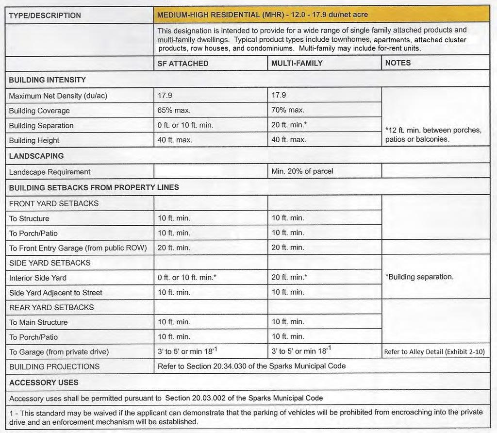
31 TYPE/DESCRIPTION BUILDING INTENSITY Maximum Net Density (du/ac) MEDIUM RESIDENTIAL (MR) du/net acre This designation is intended to provide single family detached and attached homes in a highly segmented range of product types. Typical housing types include small lot single family detached, zero lot line, alley-loaded design, townhomes, cluster detached and attached housing, and condominiums. This category may include forrent multi-family units. SF DETACHED SF ATTACHED MULTI-FAMILY NOTES Multi-family use shall not exceed Lot Size 2,000 sq.ft. min. N/A 6,000 sq.ft. min. 2 Minimum Lot Width 30 ft. N/A N/A Building Height 35 ft. max. 35 ft. max. 35 ft. max. LANDSCAPING Landscape Requirement See footnote 1 20% of site area BUILDING SETBACKS FROM PROPERTY LINES FRONT YARD SETBACKS To Main Structure w/ Front Entry Garage 10 ft. min. 10 ft. min. 10 ft. min. To Porch 10 ft. min. 10 ft. min. 10 ft. min. To Front Entry Garage (from public ROW) 20 ft. min. 20 ft. min. 20 ft. min. To Side Entry Garage 10 ft. min. 10 ft. min. 10 ft. min. To Main Structure w/ Alley Loaded Garage SIDE YARD SETBACKS 10 ft. min. 10 ft. min. 10 ft. min. Interior Side Yard 0 or 5 ft. min. 0 or 5 ft. min.* 20 ft. min. Side yard to Adjacent Street REAR YARD SETBACKS 10 ft. min. 10 ft. min. 10 ft. min. To Main Structure 15 ft. min. * 10 ft. min. 10 ft. min. To Alley Loaded Garage 5 ft. min. 5 ft. min. 5 ft. min. 70% building coverage. Building separation for multifamily shall be a min. of 20. * 10ft. min. bldg. separation (SF) * 20 ft. min. bldg. separation (MF) * 10 ft. min for cluster SFD 2-6
32 TYPE/DESCRIPTION MEDIUM RESIDENTIAL (MR) du/net acre This designation is intended to provide single family detached and attached homes in a highly segmented range of product types. Typical housing types include small lot single family detached, zero lot line, alley-loaded design, townhomes, cluster detached and attached housing, and condominiums. This category may include forrent multi-family units. SF DETACHED SF ATTACHED MULTI-FAMILY NOTES REAR YARD SETBACKS (continued) To Deep Recessed Garage 10 ft. min. 10 ft. min. 10 ft. min. BUILDING PROJECTIONS Refer to Section of the Sparks Municipal Code ACCESSORY USES Accessory uses shall be permitted pursuant to Section of the Sparks Municipal Code. NOTES 1 Setback areas must be landscaped with the exception of roadways, driveways and walk areas. 2 The minimum parcel size for a multi-family project is 6,000 sq.ft. If subdivided (i.e. condominiums or townhomes) individual units may include smaller parcel sizes. 2-7
33 Figure 2-3 Typical MR Residential Prototypes 2-8
34 2-9
35 Figure 2-4 Typical MHR Residential Prototypes 2-10
36 2.3 Permitted and Conditional Uses Permitted uses, uses requiring a Conditional Use Permit, and prohibited uses within Phase 6 are provided in the Land Use Matrix table (following page). This matrix organizes potential uses within the land use categories presented within the Development Plan. The following symbols are used in the matrix to indicate whether a proposed use is permitted, not permitted, or requires a Conditional Use Permit: P Permitted by right within the Development Plan CP Conditional Use Permit required AN Ancillary Use Uses only allowed when permitted uses are present for a particular land use Empty Cell Not permitted within the Development Plan Those uses not specifically listed in the Land Use Matrix table are subject to review based on the consistency with the purpose and intent of the land use designation these Development Standards. All uses shall require an Administrative Review and approval process from the City of Sparks as specified in Title 20 of the Sparks Municipal Code and Sections and of NRS (Nevada Revised Statutes). 2-11
37 Table 2-1 Land Use Matrix Low-Medium Residential Medium Residential Medium-High Residential Park Open Space Land Use Designations LMR MR MHR P OS RESIDENTIAL LAND USES Residential Land Uses including, but not limited to, the following uses: Apartments P P Condominiums P P Group residential care facilities, assisted living, and residential retirement homes P P P Homefinding/information center; temporary until community sales complete P P P Residences (single family detached) must comply with density of designation P P P Temporary real estate offices associated with Model Home complexes (per criteria section 6.1.6) P P P Townhouse P P Trail Access Points P P P P P OPEN SPACE USES Open Space land Uses include, but are not limited to, the following uses: Bicycle trails and bikeways P P P P P Pedestrian trails and walkways P P P P P Regional trail(s) P P P P P PARK LAND USES Community Park Land Uses include, but are not limited to, the following uses: Active parks including basketball courts, volleyball courts, playground equipment, etc. P P P P Athletic fields, excluding stadiums (no field lighting) P Bike Rentals CP CP Commercial Concessions CP Community/recreation centers AN AN AN P Passive parks and accessways including seating areas, picnic areas, trails, gardens, etc. P P P P NOTE: Uses not specifically listed are subject to review based on their consistency with the purpose and intent of each designation as determined by the KRN Design Review Committee (DRC) and the City of Sparks, 2-12
38 2.4 Streetscape Development Standards Circulation Plan The overall Kiley Ranch North project circulation is defined in the Master Handbook and handled through a hierarchy of arterials and collectors that define the structure of the community. The circulation plan is significant to the region because it encompasses the intersection of Sparks Boulevard and Pyramid Way. For the purposes of applying design standards and guidelines, the major roadways of Phase 6 are assumed to have the following classification: Kiley Parkway Windmill Farms Parkway Collector Collector Roadway Design Development of roads within Kiley Ranch North, including Phase 6, will generally conform to the circulation plan as shown in Figure 2-6, Phase 6 Circulation Plan. Exact alignments may vary depending on site specific conditions relevant to the individual development parcels. Plans and sections are provided to illustrate the location and hierarchy of roadways and sidewalk/trails. The intent of the roadway system is to provide regional circulation and access to all parcels from the surrounding areas. The plan utilizes curvilinear alignments and landscaped rights-of-way to establish an overall natural setting. Pedestrian trails are designed to be separate from vehicular traffic and will link the neighboring uses and communities to the Kiley Ranch North development. All roadways shall be constructed to the City of Sparks standards and in accordance with the sections for roadways presented in Figures 2-7 through 2-8. Regional Transportation Commission (RTC) roadways in Phase 6 (Kiley Parkway) shall be constructed to RTC standards. Landscaping within the landscape buffers is designed to enhance and beautify the street corridors along the roadways of Kiley Ranch North. Typical landscape designs for each roadway classification have been incorporated into Section 2.4.4, Streetscape Landscape Access Standards RTC access management standards and the City of Sparks Public Works design standards shall be used to direct the design of access and layouts for owners or users at their time of development. Accesses and layouts will be reviewed and approved by the Kiley Ranch North Design Review Committee (DRC) and the City of Sparks. 2-13
39 Alleys are an encouraged design alternative within single-family residential areas of Kiley Ranch North Phase 6. An alley is defined as a private way providing a secondary means of access to an abutting property and not intended for general traffic circulation. Alleys shall have a minimum width of 20 feet (Refer to Figure 2-10 for more detail). Alleys are not designed to be used as an emergency vehicle access road. Alleys shall be maintained by the adjoining property owner (through an easement agreement) or by a sub-association established by the Guest Builder. Figure 2-6 Phase 6 Circulation Plan 2-14
40 Note: 1. For Windmill Farms Parkway, the center median/turn pocket may be eliminated in the final design if approved by the City of Sparks Engineer. 2. The landscape median shall be owned (by virtue of common area parcel) and maintained by the LMA. Figure 2-7 Collector Roadway Detail 2-15
41 Figure 2-8 Neighborhood Entry Road 2-16
42 Figure 2-9 Park Access Road 2-17

43 ALLEY Figure 2-10 Residential Local/Residential Alley Details 2-18
44 2.4.4 Streetscape Landscape The collector streets of Kiley Ranch North Phase 6 have been designed to promote a feeling of openness throughout the development. Each of these streets is adjacent to a LMA landscape buffer between 10 feet to 25 feet on each side of the right-of-way, related to its classification and traffic volume. Table 2-2 outlines the Phase 6 landscape design for these areas. All landscaping within Kiley Ranch North shall be provided in accordance with the City of Sparks Municipal Code unless stricter requirements are identified in this Final Handbook. Landscape design for development projects will be reviewed and approved by the Kiley Ranch North Design Review Committee (DRC) and the City of Sparks. CONSTRUCTION Sidewalks shall be installed with the construction of the adjacent roadway. This applies to landscaping within the rights-of-way and landscape buffers along Kiley Parkway and collector roads. Landscape on the development side of the sidewalk will be installed with the initial development of the adjacent property by the Guest Builder. MAINTENANCE Landscape located within the right-of-way and the landscape buffer adjacent to collector roadways including local streets shall be maintained by the Kiley Ranch North Landscape Association Inc. (LMA), as spelled out in the adopted Kiley Ranch North Phase 6 Final Handbook. The City of Sparks shall be responsible for the maintenance of all sidewalks/trails within the public right-of-way (including Regional Trail). A public access easement or parcel shall be granted to the City of Sparks for all sidewalks/trails located outside the right-ofway. An access easement shall be granted to the LMA or lot owner for all landscape areas within the right-ofway. GENERAL REQUIREMENTS AND DEFINITIONS: a) Evergreen trees shall be 6' minimum height. b) Caliper width refers to deciduous species. c) Landscape easement may include a maximum of 10% organic and/or bark mulch as groundcover to satisfy landscaping requirements. d) At time of planting, all groundcover and shrub areas must have 100% coverage with organic, rock and/or bark mulch, to protect the soil. 2-19
45 e) Slope banks shall utilize native and/or adapted species to reduce maintenance and irrigation requirements. Adapted species refers to non-native or exotic plant species that are non-invasive and well adapted to the local climate and growing conditions. f) All trees should have a minimum 6' diameter mulched base. g) Large trees exceed 40 feet in height and 40 feet canopy diameter at maturity. h) Medium trees range from 20 feet to 40 feet in height and 10 feet to 40 feet in canopy diameter at maturity. i) Small trees range from 8 feet to 20 feet in height and 6 feet to 20 feet in canopy diameter at maturity. j) Riparian species refers to water-loving plants that are usually associated with drainage ways or riparian corridors. k) Formal groupings refer to the linear or patterned arrangement of plants at a regular spacing interval. l) Informal and clustered groupings refer to the random or irregular arrangement of plants in groups of 3 or more and spaced a maximum of 60 feet between clusters. Table 2-2: Streetscape Landscape Standards Roadway Landscape Buffer Sidewalk Collector (Kiley Pkwy. and 15 /15 5 /5 Windmill Farms Pkwy.) Tree Type: Medium fall color species 5 concrete Recommend accent landscape at entries. sidewalk Tree Size: 2 minimum caliper Pattern/Spacing: Linear row 20 on center, singular species theme each block. Other: 60% shrub/40% groundcover mix Additional Notes: - Maintained grass swales permitted in landscape buffer on development side of sidewalk. 2-20
46 2.4.5 Street Lighting The lighting for Kiley Ranch North Phase 6 will be designed to enhance the quality and safety of the streetscape corridors. Lighting design will contribute to the overall atmosphere by reinforcing the community structure through a cohesive, identifiably unique palette of materials. Lighting design will be reviewed and approved by the Kiley Ranch North Design Review Committee (DRC) and the City of Sparks. Lighting located within the right-of-way of arterials, collector roads, and local streets, and other public common areas will be installed by the Master Developer or Guest Builder and maintained by NV Energy or the City of Sparks (for standards poles/fixtures). This section provides lighting standards for collectors and local streets, as well as pedestrian, landscape and sign lighting within Kiley Ranch North Phase 6. The goals of these lighting standards are to: (1) Provide a safe level of illumination for both motorists and pedestrians; (2) Reinforce the pedestrian scale of the community; and (3) Allow for quality lighting design that reflects the theme of the community Collectors and Local Streets GENERAL REQUIREMENTS: a) Lighting fixture types shall be of a consistent scale, design and color along street corridors b) Lighting fixture types shall differentiate use areas within Kiley Ranch North Phase 6. c) Street lighting shall be directionally shaded to reduce offsite fugitive light and glare. d) Light fixture height shall not exceed the maximum heights indicated for the specific application. e) Refer to Table 2-3 for additional lighting standards. f) Street lights shall be maintained by NV Energy or the City of Sparks and operating costs will be paid by the City of Sparks (for standard poles/fixtures). g) The location and design of street lighting at roundabouts will be subject to the approval of the Kiley Ranch DRC and the City of Sparks. 2-21


47 Table 2-3 Streetscape Lighting Standards Figure 2-11 Typical Light Fixtures Roadway Designation Collector Neighborhood Local Roadway Location Model (Luminaire, mast arm and pole) Kiley Pkwy. NV Energy Selected from NV Energy Windmill Standards palette and to be Farms Pkwy. approved by KRNDRC 1 All public streets within a parcel or subdivision NV Energy Standards 1 KRNDRC Kiley Ranch North Design Review Committee Selected from NV Energy palette and to be approved by KRNDRC 1 Standards Placement Alternating 2 Alternating 2 Spacing Spaced at regular intervals Spacing Varies 2 Placement and Spacing of street lighting is subject to approval by NV Energy and the City of Sparks, as specified in Section of the City of Sparks Municipal Code Entries The consistent treatment of neighborhood entries will help establish a consistent community character, while allowing a variety of entry treatments and identities for individual neighborhoods. The design of entries will be reviewed and approved by the DRC and the City of Sparks. 2-22
48 2.4.8 Neighborhood Entries a) A neighborhood entry treatment shall be placed at the primary entrance to each neighborhood. The entry treatments shall be placed on both sides of the entry road. b) Entry treatments shall be located outside the sight visibility triangle of the road intersection. c) Neighborhood entry treatments shall be designed with similar characteristics to that of community gateways, but on a smaller scale. Entry monuments may incorporate the early turn-of-the-century historical development of the Reno-Sparks area. This can be accomplished through the use of materials, tone and texture that represent this era. d) The landscape theme shall incorporate native materials, predominantly designed to look natural and wild, with some manicured ornamental landscaping where necessary. e) A neighborhood entry treatment shall include a minimum of 15 trees. Minimum tree sizes are as follows: - Deciduous trees shall be a minimum 3 inch caliper - Evergreen trees shall be a minimum 10 feet tall - Specimen trees shall be a minimum 2 inch caliper f) Refer to Section for additional elements of neighborhood entries. g) Neighborhood entry treatments shall be reviewed and approved by the DRC and the City of Sparks with each project. h) Entry treatments shall be maintained by the Master Developer, Sub-Association, or the LMA. Refer to Figure 2-11 Neighborhood Entries (following page) 2-23
49 NO PARKING Note: Dimensions may be subject to change based on intersection sight distances. Figure 2-11 Neighborhood Entries 2-24
50 2.5 Sidewalks and Trail Connections Sidewalks and multi-use trails allow for pedestrians and bicyclists and are located within landscape buffers and along significant transportation corridors within Kiley Ranch North Phase 6. Additionally, individual neighborhoods include connections to the regional trail facilities located at the eastern edge of Phase 6. Refer to Figure 2-12, Trail System. The design of the connections will be reviewed and approved by the DRC and the City of Sparks. Conceptual/approximate trail access points are depicted in Figure Figure 2-13 (following page) provides trail access points detail. Figure 2-12 Trail System 2-25


51 Figure 2-13 (below) depicts typical trail access points/corridors Figure 2-13 Trail Access Point Concept 2-26
52 Sidewalks shall be constructed with the construction of the roadway or adjacent development by the party responsible for the installation of the adjacent improvements (Refer to Section 2.4.4). The City of Sparks shall be responsible for the maintenance of all sidewalks and trails within the rights-of-way, landscape buffers, public parks, and regional trails in Kiley Ranch North Phase 6. Refer to Figure 2-12, Trail System. A public access easement shall be granted to the City of Sparks for all sidewalks and trails if located outside the rightof-way. GENERAL GUIDELINES a) All pedestrian travel surfaces must conform to American Disability Act (ADA) standards. b) Trails and sidewalks located within the landscape buffers shall provide connections to the adjacent development. 2.6 Trails The following trail standards shall apply to residential developments within Phase 6: a) A minimum of one trail/path providing connection to regional trail facilities at the eastern edge of Phase 6 shall be provided within a Guest Builder project east of Kiley Parkway within Phase 6. b) Trails/paths shall be a minimum of 10 feet in width and include a concrete surface. c) Trail corridors shall be a minimum of 15 in width and shall include trees and shrubs. Trees shall be planted at a rate of one tree per 40 feet of lineal trail/path. Shrubs shall be planted at a rate of 4 per tree. Tree and shrub sizes shall conform to the landscape standards contained within this Handbook. Trail access points shall be maintained by the LMA, except for the Regional Trail(s) which is to be owned and maintained by the City of Sparks. d) Multi-family projects located on the west side of Kiley Ranch Parkway shall be required to provide sidewalk connections to Kiley Parkway and Windmill Farms Parkway in order to encourage pedestrian activity to the east, towards the regional trail system. e) Refer to Figure 2-14 for conceptual trail locations which are subject to change. f) Trail access points shall be protected with bollards to prevent vehicular traffic/access. Refer to Figure 2-15 for typical bollard detail. g) Final Location of trail access points shall be subject to the approval of the DRC and the City of Sparks. h) Concrete trails in the regional trail system of Phase 6 shall be maintained by the City of Sparks. 2-27
53 Figure 2-14 (below) depicts the master trail access point plan for Kiley Ranch North. Figure Regional Trail, Sun Valley Channel, Orr Ditch and Trail Access Point Plan 2-28
54 CONCEPTUAL BOLLARD Figure 2-15 Typical Bollards at Trail Access Points 2-29
55 2.6.1 Regional Trail Implementation The City of Sparks collects a Regional Park and Recreation Impact Fee (per NRS 278B) for Service Area No. 1, to which the Kiley Ranch North Project is wholly within. Contained within the Regional Park and Recreation Fee is a component for Regional Trail construction. In lieu of these facts, the Master Developer and/or Guest Builder at a minimum must do the following: 1. Transfer land sufficient for the construction and maintenance of Regional Trails. The timing of the transfer of land for the Regional Trail shall be determined with each adjacent tentative map or Administrative Review. 2. Pay the Regional Park and Recreation Impact fee with each building permit. However, in lieu of the above, the Master Developer or Guest Builder may elect to enter into an Impact Fee Credit Agreement ( Credit Agreement ) with the City of Sparks. Under this alternative, the Master Developer or Guest Builder shall: 1. Design, construct and transfer the Regional Trail or portion of the Regional Trail applicable per the Credit Agreement in exchange for Regional Park and Recreation Impact Fee Credits. The timing and segment of the applicable Regional Trail shall be contained in the Credit Agreement. Note, there could be multiple Credit Agreements Sun Valley Diversion Channel Trail Sections of the Sun Valley Diversion Channel and the areas of Regional Trail within it have previously been constructed. This includes areas adjacent to Villages 29, 30, 39, 40, 41 and 42. A small section of the Sun Valley Diversion Channel has been completed adjacent to Villages 37 and 43 but no Regional Trail or landscaping amenity have been constructed. Please refer to Figure 2-14 for clarification. a) The trail shall be located along the north side of the channel (Refer to Figure 2-16, Future Trail at Sun Valley Diversion Channel). b) Refer to Table 2-4 for design standards. c) The sloped portion of the existing channel shall be landscaped with a revegetated mix. 2-30
56 Table 2-4: Sun Valley Diversion Channel Design Standards Trail Section Landscape Area WIDTH 10ft. Min. 10 ft. on both sides of the path SURFACE 4 thick Portland cement Mulch at tree clusters concrete TREES Total of 18 trees per 20,000 sq.ft. of planted area (planted in clusters). Medium Trees 70% (of which 40% evergreen/60% deciduous) Small Trees 20% (all deciduous) Specimen Trees 10% (all deciduous) Tree Size 2 caliper (deciduous)/6 ft. minimum height (evergreen). Informal clusters, naturalistic groupings and distribution SEATING AREAS Location Located adjacent to trail and shall contain benches and trash receptacles Placement One seating area every 1,500± linear feet near tree clusters Refer to Exhibit 2-16 (following page) for Sun Valley Diversion Channel concept. 2-31
57 Figure Future Trail at Sun Valley Diversion Channel Concept 2-32
58 2.7 Park P Kiley Ranch North includes a 9.42± acre park (P) located within proximity of residential developments and open space. The layout and design of the park will be reviewed and approved by the DRC and the City of Sparks. The City of Sparks is the responsible agency for the construction and maintenance of the park within Kiley Ranch North. The park may be constructed by the City or property owner. The actual land cost, design and construction costs of the community park may become a credit to the owner or his assigns against payment of park tax with development if a residential construction park tax agreement is completed with the City. The Kiley Ranch North park is eligible for residential park tax funds and Impact District # 1 park tax funds. a) Park design and placement of plant materials, site furniture, play fields, play structures, parking areas and other amenities shall be determined by site specific design executed by a landscape architect approved by the DRC and the City of Sparks Parks and Recreation Commission. The park shall be designed consistent with the NRS requirements. b) The park shall be designed and maintained to provide for active and passive uses. c) The park shall be designed to the approval of the DRC and the City of Sparks Parks and Recreation Commission. 2.8 Mailboxes Individual mailboxes, if allowed by the United States Postal Service (USPS), shall be paired at driveways to serve adjacent homes. The style of the mailboxes, including address numbers shall be compatible with the architectural styles of the homes and shall be consistent throughout each project. Mailbox designs shall be approved by the Kiley Ranch North Design Review Committee and the USPS. Mailboxes shall be provided and installed by the Guest Builder prior to the issuance of certificates of occupancy for the individual homes or units. If individual mailboxes are not permitted, clustered boxes shall be located in convenient areas conducive to temporary parking. Placement of cluster boxes shall not be near intersections and shall not conflict with individual driveways or utilities. Locations shall be approved by the USPS and KRNDRC. The United States Postal Service (USPS) shall be responsible for the maintenance of mailboxes/mailbox cluster boxes within Kiley Ranch North Phase
59 CHAPTER 3 DESIGN STANDARDS AND GUIDELINES 3.1 Purpose and Compliance The purpose of this chapter is to establish a base qualitative standard through the use of design parameters which Guest Builders in Kiley Ranch North Phase 6 shall follow. The standards and guidelines in this chapter will shape the development of the various land use areas by providing specific design criteria for grading, building orientation, landscaping, lighting, signs, walls and fences, and other design elements integral to creating development projects that fit into the community. These standards and guidelines also address the community's underlying structure such as community entries, community walls, and trails. Architectural standards and guidelines are also provided to ensure buildings within Kiley Ranch North Phase 6 are attractive, and relate to one another and the community character. The pictures contained in this Chapter are provided to convey imagery of the standards and guidelines, but are not intended to require the specific design style depicted. Alternative themes with respect to design and architecture are encouraged in order to promote diversity of housing styles within Phase 6 as a whole. During the development review process, the Kiley Ranch North Design Review Committee (DRC) and the City of Sparks will review all development applications and ensure the proposed project meets the intent of these design standards and guidelines. 3.2 Site Planning Standards and Guidelines The purpose of the site planning standards and guidelines is to address general provisions of site development which include building orientation, grading and drainage, parking areas, landscape, lighting, signs, walls and fences, and service areas. Site planning controls the proper placement of buildings and internal roads that service and access the various land uses in the community. It addresses the linkages and land use relationships at a human-scale, in order to create a stimulating and visually pleasant community. The goal is to promote pedestrian activity and safety, create visual compatibility with surrounding neighborhoods and minimize negative impacts on the natural environment Single Family Residential Areas Site Planning Site planning, architectural design and landscape design shall be integrated into a unified neighborhood concept. This can be accomplished through a variety of devices including: unique entry features; theme wall and fencing; special landscape treatments, planters, and other elements; consistent use of building clusters; and trail linkages (Refer to Figure 3-1, Residential Neighborhood Design). This category may include single-family condominium projects (developed under the tentative map process) built for rental. 3-1
60 Figure 3-1 Residential Neighborhood Design 3-2

61 Single Family Neighborhood Design The residential neighborhoods of Kiley Ranch North Phase 6 will promote visual diversity and avoid monotonous development patterns. This can be achieved through the use of several techniques including: minimizing the visual impact of the garage; avoiding repetitious floor plans and footprints; varying setbacks at porches, garages and living areas; and opening corner lots through selective plan form. The following standards and guidelines promote visual diversity along the streetscape and promote the use of streetoriented architecture. a) House forward architecture shall be used in the design of homes. This is accomplished by placing entries, windows, front porches, and living areas towards the street on most plan variations (see example in Figure 3-2 below). Figure 3-2 Typical Forward Architecture b) With the exception of zero lot line lots, plans should be reversed and plotted so that garages and entries are adjacent to each other. This creates an undulating sense of setback. Occasionally this pattern should be broken so that it will not become overly repetitious or recreated by the massing across the street. c) The garage shall not be the dominant architectural feature of the building facade facing the street. d) So as not to contribute to a monotonous appearance along the street, the use of varying building setbacks from the street right-of-way is encouraged. Refer to Figure Figure A. 3-3
62 e) Neighborhoods shall provide connections into the community trail system. Open cul-de-sacs or trail access points may be required where a connection to the community trail system can be made. Refer to Figure 3-1. f) Alleys within single-family residential developments shall have a minimum width of 20 feet with no parking. Alleys shall not be used as an emergency access road. g) Alleys shall be maintained by the adjoining property owner through an easement agreement or by a sub-association to be set up by the Guest Builder. h) In order to avoid a continuous walled character along collector roads, special treatments such as open cul-de-sacs, view fencing, and variable fencing alignments can be used Single Family Grading a) The design of residential neighborhoods shall be sensitive to the natural terrain, and structures shall be located in such a manner so as to minimize necessary grading and preserve natural site features and drainage ways. Any grading of the site terrain shall blend with the natural topography of the site. b) Graded slopes shall be rounded resulting in smooth, harmonious transitions between the man-made terrain and the natural terrain. c) All graded slopes shall be revegetated prior to building occupancy. If climatic conditions or other circumstances prevent planting at the time of occupancy, a bond shall be provided for landscaping during the subsequent growing season or other arrangements made for revegetation, subject to the approval of the City of Sparks. Drought tolerant plant species shall be utilized to help minimize erosion. d) Slope banks used in conjunction of the terracing of residential lots shall be maintained by the property on the down slope side. e) The Master Developer or Guest Builder shall post a surety for reclamation and revegetation prior to issuance of a grading permit. f) The Master Developer or Guest Builder shall submit an erosion/dust control plan with each grading plan. 3-4
63 Single Family Landscape a) Trees shall be planted within each front yard at a regular interval of no greater than 50 feet apart, with a minimum of one street tree per residential lot street frontage. b) Each neighborhood shall use a mix of species of large canopy shade trees for all primary circulation routes within the neighborhood. c) The landscape character may vary from neighborhood to neighborhood. Each neighborhood may use an ornamental/flowering tree species unique to that neighborhood as approved by the DRC and City of Sparks. d) Front yard landscaping installation is required for all homes and will be reviewed and approved by the DRC and the City of Sparks as part of the Improvement Plans. e) Front yard landscape packages shall be provided by the Guest Builders subject to the review and approval of the DRC and the City of Sparks and must meet the following requirements: a variety of standard and upgraded front yard landscape packages with automatic irrigation systems shall be provided (minimum of 3 packages); front yard landscaping designs with berming, courtyards, or other creative features shall be offered for landscape designs; and at least one (1) package shall have a minimal use of turf/lawn (minimal is defined as no more than 25 percent of the planted area in the front yard). f) The minimum number of trees to be planted in the required landscape area shall be one tree per 300 square feet. g) Landscaping within Kiley Ranch North Phase 6 shall comply with the regulations governing landscaping contained within Section of the Sparks Municipal Code. Where a conflict exists between these development standards and the City of Sparks Municipal Code, the standards contained herein shall apply Single Family Lighting a) Exterior lighting shall be shielded from projection offsite and designed to be compatible with the architectural and landscape design of the home. b) Exterior lights shall not blink, flash or change intensity. String lights, building or roofline tube lighting, reflective or luminescent wall surfaces are prohibited unless approved by the DRC and the City of Sparks. c) Bollards shall have a maximum height of 45 inches. 3-5
64 d) Pedestrian lighting shall be spaced at intervals appropriate to facilitate the safety of the pedestrian. e) Light poles and fixtures within each project shall be approved by the Kiley Ranch DRC and the City of Sparks. Where NV Energy approved street lights are used, they shall be maintained by NV Energy or the City of Sparks (for standard poles). f) Lighting within Kiley Ranch North shall comply with the regulations governing lighting contained within the Sparks Municipal Code. Where a conflict exists between these development standards and the City of Sparks Municipal Code, the standards contained herein shall apply Single Family Walls and Fences Walls and fences within Phase 6 shall comply with the following standards as well as the regulations contained within Sections A and D of the Sparks Municipal Code. Where a conflict exists between these development standards and the City of Sparks Municipal Code, the standards contained herein shall apply. Fences shall be used to separate individual residential lots or between residential parcels. Fences shall be a maximum six (6) feet in height and be constructed of wood, metal, and/or masonry material. Decorative front yard fencing shall be a maximum of three (3) feet in height for solid construction and four (4) feet in height for open construction and not be within the visibility triangle for motorists. The fencing must also be incorporated into the architectural design of the house. All side yard fences shall be set back a minimum of two (2) feet from the front facade of the home. When changes in elevation occur, all walls shall be stepped in equal, vertical intervals. No step should exceed 12 inches, where feasible. Chain link may be used on a temporary basis at construction sites. Vinyl coated chain link may be used as a fencing material for outdoor private or public park facilities such as but not limited to perimeter fencing, baseball backstops, swimming pools, spas, or tennis courts. Barbed wire, plain exposed concrete block, and chain link are prohibited except in special cases deemed appropriate by the DRC and the City of Sparks. a) A master fencing plan for each project within Kiley Ranch North Phase 6 shall be prepared by the Guest Builder and submitted to the DRC and the City of Sparks for approval with the development application for the project in which the walls/fences are to be constructed. The master fencing plan shall identify locations for walls and collector fencing, and residential fences as well as set their design character. b) Walls may be used where necessary to provide privacy and security for single family projects. 3-6
65 c) Walls and fences within the community shall not become the dominant visual element and walls where needed shall blend into the overall landscape. Berming or berms with lower walls shall be considered as an alternative to typical community walls. d) View fencing shall be used on the open space perimeter of residential areas. Refer to Figure 3-4. e) Walls shall be a maximum of six feet in height. Appropriate materials include stone, stone veneer, split face/ precision block, tubular steel, concrete, stucco pilasters and cap, and wrought iron. The design style, color and detail shall be consistent throughout the Kiley Ranch North Phase 6. f) Walls shall blend into the overall landscape. Through site planning, product plotting, architectural detailing and landscaping this can be achieved. g) View fences may be used where the rear of individual lots are adjacent to open space. Refer to Figure 3-4, for examples of view fences. h) View fences shall be constructed of wrought iron or similar quality material and be consistent in terms of material, color and detail within each residential neighborhood or subdivision. i) All walls and fences associated with a project shall be installed concurrently with the project. Fences within residential lots shall be maintained by the lot owner. j) Fences along collector roadways shall be placed on the property line and shall be maintained by the LMA (exterior) and the adjoining property owner (interior). Fence replacement shall be the responsibility of the homeowner. COLLECTOR FENCES a) Collector fencing shall be in the rear yard of those lots abutting collector roadways (i.e. Kiley Parkway, Windmill Farms Parkway). b) Collector fencing shall not exceed six (6) feet in height and shall be placed within individual lots. c) Collector fences may be constructed from western red cedar or common redwood. Both sides shall include transparent stain as approved by the Kiley Ranch North Design Review Committee. d) Collector fences shall include a 2 x6 wooden cap at the top of the fence and a 2 x6 wooden nailer at the bottom. e) A 24 square pilaster to include decorative rock (as approved by the Kiley Ranch North Design Review Committee) shall be provided at intervals not to exceed 200 feet. 3-7
66 VIEW FENCES Kiley ranch north phase 6 Final Development Handbook a) View fences shall be used where residential uses abut parks, open space, trail access points, and trails. b) View fences shall not exceed six (6) feet in height and shall be maintained by the lot owner. c) View fences shall be constructed of black decorative wrought iron or tubular steel or other similar quality materials. d) View fencing may be used along trails and within open space areas or trail access points in order to define corridors, property lines, etc. Refer to Figure 3-4. SCREEN/PRIVACY FENCES a) All single family lots not adjoining open space, parks, trails, trail access points, etc. shall incorporate screen/privacy fences. b) Screen fences shall be six (6) feet in height. c) Screen fences may be constructed from western red cedar or common redwood. Both sides shall include transparent stain as approved by the Kiley Ranch North Design Review Committee. d) Screen/privacy fences may not include gates that open to roadways, open space, or parks. e) Lot owners shall be responsible for all screen/privacy fencing repair and maintenance. 3-8
67 SOLID WALL CONCEPT TYPICAL COLLECTOR FENCE Figure 3-3 Community Walls and Collector Fencing 3-9
68 Figure 3-4 Typical View and Screen Fencing 3-10
69 Figure 3-5 Typical Neighborhood Fencing 3-11
70 Single Family Neighborhood Entry a) A neighborhood entry treatment shall occur at the primary entry to each neighborhood project. Treatments may incorporate a local historical theme similar to that of Community Gateways but on a smaller scale. Neighborhood entry treatments shall be reviewed and approved by the DRC and the City of Sparks. b) Entries shall incorporate the following: - Ornamental trees - Groundcover or turf - Native materials designed to look natural and wild - Community name signage - Distinctive historical architectural elements (where achievable) c) Entry treatments shall be located outside the sight visibility triangle of the road intersection. d) A neighborhood entry treatment shall include a minimum of 15 trees. Minimum tree sizes are: -Deciduous trees shall be a minimum 3-inch caliper -Evergreen trees shall be a minimum 10-feet tall. -Specimen trees shall be a minimum 2-inch caliper. e) Entry treatments shall be maintained by the Master Developer or the LMA. 3-12

71 Single Family Signs a) Signs within Kiley Ranch North Phase 6 shall comply with the regulations governing signs contained within Chapter of the Sparks Municipal Code. Where a conflict exists between these development standards and the City of Sparks Municipal Code, the standards contained herein shall apply. b) Monument signs identifying a single family residential development shall be provided at the main entry(s) of each residential development or project. Refer to Section c) Monument signs shall have a maximum height of six (6) feet. No additional freestanding signs shall be permitted with the exception of directional wayfinding signs or traffic control signs. Pylon or pole signs are specifically prohibited. d) Neighborhood/project entry signs shall have a consistent design within each project. e) Monument signs shall be maintained by the Master Developer, the Guest Builder, or the LMA and approved by the DRC. A City of Sparks Sign Permit shall be required Single Family Wayfinding Signs a) A wayfinding sign is a permanent sign that directs the flow of pedestrians or vehicular traffic. Wayfinding signs shall have a maximum height of eight (8) feet. Wayfinding signs shall not be placed any nearer than one hundred (100') feet from intersections or round-abouts and not nearer than fifty (50') feet from required regulatory signage. b) Wayfinding signs will be maintained by the Master Developer or LMA and approved by the DRC. A City of Sparks Sign Permit shall be required. Figure 3-6 Conceptual Wayfinding Sign 3-13
72 Single Family Parking The following parking requirements are minimums for single family residential uses. All other general parking requirements and minimum number of spaces required shall comply with the Sparks Municipal Code as specified in Chapter Refer to Chapter 3 for design standards and guidelines addressing parking design and layout. Parking Required 1 space/bedroom, but not less than 2 per dwelling unit (DU) 3-14
73 3.2.2 Multi-Family For-Rent/Attached Residential Site Planning Site planning, architectural design, and landscape shall be integrated into a unified design of new multifamily housing or attached single family housing. These site planning standards and guidelines address the following issues: placement and orientation of attached homes or multi-family buildings; site grading and drainage; landscaping and public spaces; placement of parking/carports/garages; walls and fences; trash and storage areas; entries; signs; and lighting. These standards may also apply to condominium projects built for rental. General Standards a) All multi-family attached developments shall incorporate outdoor barbecue areas in centrally located regions or recreation areas of the project. Barbecues and other outdoor cooking devices are specifically prohibited from use in individual unit patios and decks. b) Multi-family /attached single family development over 25 units shall incorporate five (5) of the following recreational facilities: - swimming pool - tennis courts - horseshoe courts - spa - exercise equipment - game room - community room - par course - walking trails (minimum mile in length) - picnic areas (to include tables with barbecues) - volleyball court - pickle ball court - basketball court -lawn areas for field games, as approved by the City of Sparks. Note that this list is not intended to be comprehensive. The DRC and City of Sparks may consider other proposed recreational facilities. c) The recreational facilities shall be conveniently and centrally located for the majority of the units. d) Multi-family/attached single family development over 25 units shall have a children's play area with play equipment that is visible from as many units as possible. 3-15
74 e) All multi-family units shall have an outdoor patio/deck for each unit with a minimum depth of six (6) feet or provide a design solution that satisfies the intent of this standard. The alternative design is subject to the approval of the DRC and the City of Sparks Multi-Family Building Orientation a) Building placement and orientation shall be designed to create visual interest along public right-ofways and within the project. Buildings and landscape elements in a single project shall demonstrate a positive functional relationship to one another. b) Residential buildings should be grouped in clusters and sited to minimize the scale of the project. Larger building masses should provide larger open space areas. Small blocks of parking with walks, entries, and mailboxes within each cluster of buildings shall be utilized to provide a sense of identity and convenience. c) Buildings shall be oriented and clustered in such a way as to provide courtyards and open space areas (see Figure 3-7) The open space shall be usable area and not steep in slope. d) To provide privacy between living spaces, there should be distance separations, buffering or changes in the angles of units. e) All multi-family/attached single family developments shall incorporate pedestrian connections to adjoining residential, recreational and commercial uses as well as to the community trail system (see Figure 3-7). f) Projects along transit routes shall be designed to have a pedestrian entrance oriented towards transit stops for convenient access by transit riders (see Figure 3-7). g) There shall be common barbecue areas with tables provided within the multi-family/attached single family development, which can count towards recreational facilities. h) Private open space, such as decks or patios, shall be contiguous to the units with a minimum width of six (6) feet. 3-16


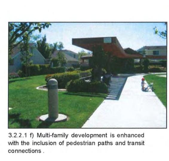
75 Figure 3-7 Typical Multi-Family Site Planning 3-17
76 Multi-Family Grading and Drainage a) The design of multi-family housing or attached single family housing shall be sensitive to the natural terrain, and structures shall be located in such as manner so as to minimize necessary grading and preserve natural site features and drainage ways. Any grading of the site terrain shall blend with the natural topography of the site. b) Site grading shall be designed to complement the architectural and landscape design character of the community, screening parking and service areas, reducing the perception of height and mass on larger buildings, and providing reasonable transitions between on-site uses. c) Graded slopes shall be rounded resulting in smooth, harmonious transitions between the man-made terrain and the natural terrain. d) All graded slopes shall be revegetated prior to building occupancy. If climatic conditions or other circumstances prevent planting at the time of occupancy, a bond shall be provided for landscaping during the subsequent growing season or other arrangements made for revegetation, subject to the approval of the Administrator. Drought tolerant plant species shall be utilized to help minimize erosion. e) The Guest Builder shall provide a final hydrological report for the project in conformance with the City's Hydrological Criteria and Drainage Design Manual (HCDDM) for review and approval by the Engineering Manager. f) The Guest Builder shall post a surety for reclamation and revegetation prior to issuance of a grading permit. g) The Guest Builder shall submit an erosion and dust control plan with each grading plan Multi-Family Parking The goal of the following standards and guidelines are to limit the impact of parking areas on the streetscape and provide a network of pedestrian paths within landscaped corridors that tie into the community trail system. a) Parking should be provided within 200 feet of all residential units. b) Parking areas shall be linked to the building and sidewalk network as an extension of the pedestrian system. Pedestrian systems shall be designed within the project to connect buildings and open space/recreational facilities (see Figure 3-8). This can be done using design features such as walkways with enhanced paving, trellis structures and/or landscaping treatments. 3-18

77 Figure 3-8 Typical Parking Treatment c) Carports and garages shall be designed as an integral part of the architecture of the development. They shall be the same in materials, color and detail to the principal buildings of the development. Carports should not have roof pitch of less than 3:12. No pole parking structures will be permitted. d) Parking in the perimeter of the property adjacent to the public right-of-way shall be screened according to the standards in Multi-Family Landscape Section e) Wheel stops shall be provided where parking adjoins landscaping and sidewalks unless an alternative design is approved by the DRC and the City of Sparks. The following parking requirements are minimums for multi-family residential uses. All other general parking requirements and minimum number of spaces required shall comply with the Sparks Municipal Code as specified in Section Resident Parking Guest Parking 1 space/efficiency DU (no separate bedroom) 1.5 spaces/1 bedroom DU 2 spaces/2 bedroom DU 2 spaces/3 bedroom DU 2.5 spaces/du larger than 3 bedrooms+ 0.5 space/additional bedroom 1 space/10 DU a) For units that do not include an attached garage, assigned residential parking shall be provided for. 3-19
78 Multi-Family Landscape Multi-family and attached single family residential landscaping provides a unique sense of identity for each project. The following standards and guidelines help to establish the landscape character for each project that will enhance the quality of the development and buffer the project from roadways and undesirable views. a) All landscaping shall comply with the minimum requirements contained in Chapter of the Sparks Municipal Code. b) Landscaping around the foundation of buildings shall be provided to enhance the area between the parking lot; walkways and the structure (see Figure 3-9). c) Stepping stones or other material shall be provided through a landscape planter to provide access from parking lots to walkways. d) Low water demand plant materials and turf shall be used in conjunction with low water demand principles and techniques. e) All landscaped areas shall be irrigated with permanent automatic irrigation systems. All irrigation systems shall be placed underground. f) Planting islands in parking lots shall have a minimum nine (9) square foot interior protected by a six (6) inch curb. g) The landscape along the street periphery shall be a minimum width of 15 feet from the right of way and provide a mix of trees, shrubs, and living groundcover. This 15 foot required width is not in addition to the landscape buffer width required adjacent to arterial and collector roads. The trees shall be a minimum of four (4) trees per 100 lineal feet and six (6) shrubs per tree. All parking lots and buildings shall incorporate landscaping at their street periphery. h) All sites shall incorporate screening (including walls/fences) at their periphery. Screening shall be implemented utilizing the following: Utilize evergreen shrubs and ornamental grasses that are 30 to 36 inches high at maturity to create a loose, informal landscape screen. Provide evergreen trees at four (4) trees per 100 lineal feet of landscape area. Evergreen trees shall be installed at a mix of 50% six (6) foot in height and 50% eight (8) foot in height. 3-20
 Landscaping shall be installed to provide shade and enhancement of open space and recreational areas.")
 Project area, open space, common areas and recreational areas shall be landscaped, as approved by the City of Sparks and the DRC.")
 Multi-family developments shall have a minimum of 10% of the net buildable area or lot area dedicated to usable open space, whether common or private, for recreation and social activities.")
79 A minimum 10-foot landscape buffer/planter shall be provided between the street and periphery walls/fences. i) Landscaping shall be installed to provide shade and enhancement of open space and recreational areas. The placement of plants shall consider security and safety by avoiding the creation of secluded areas. j) Project area, open space, common areas and recreational areas shall be landscaped, as approved by the City of Sparks and the DRC. k) The minimum number of trees to be planted in the required landscape area shall be one tree per 300 square feet. l) Multi-family developments shall have a minimum of 10% of the net buildable area or lot area dedicated to usable open space, whether common or private, for recreation and social activities. The 10 percent is not in addition to the 20% minimum total landscape requirement for multi-family developments. Clubhouses, recreation rooms/gymnasiums, community rooms, etc. shall count towards the 10% requirement. m) Landscaping within Kiley Ranch North Phase 6 shall comply with the regulations governing landscaping contained within Section of the Sparks Municipal Code. Where a conflict exists between these development standards and the City of Sparks Municipal Code, the standards contained herein shall apply. Figure 3-9 Typical Multi-Family Landscape Treatments 3-21
80 Multi-Family Lighting a) Lighting throughout Kiley Ranch North Phase 6 shall be designed to differentiate between land use areas, emphasize community amenities, provide continuity along street corridors and ensure the safety of residents and users. b) Parking lot, walkway and area lighting heights shall be in scale with the setting and complement the architecture. Any light source over ten (10) feet high shall incorporate a cut-off shield to prevent the light source from being directly visible from off-site areas to prevent glare. c) Parking lot, walkway and area lighting shall be directed downward with no direct projection of light off-site. The light source shall be kept as low to the ground as possible while ensuring safe and functional levels of illumination. The use of bollard lighting shall be encouraged in pedestrian areas. d) Overall lighting levels shall be compatible with neighborhood ambient levels and color shall be uniform throughout the development. Soft, indirect lighting shall be employed where feasible. e) Illumination for aesthetic purposes of any building or surrounding landscape utilizing exterior light fixtures that project light beyond the property line is prohibited. f) Support structures for lighting should be designed as part of the general theme of the building architecture and be consistent throughout the project. g) Minimal energy consumption shall be a factor in lighting selection. h) Exterior lights shall not blink, flash or change intensity. String lights, building or roofline tube lighting, reflective or luminescent wall surfaces are prohibited unless approved by the DRC and the City of Sparks. i) Lighting shall be placed along primary pedestrian pathways, at pedestrian bridge crossings, parks, and other special high use areas. j) Lighting shall have a common design and color within the development. k) Bollards shall have a maximum height of 45 inches. l) Pedestrian lighting shall be spaced at intervals appropriate to facilitate the safety of the pedestrian. m) Light poles and fixtures within each project shall be approved by the Kiley Ranch DRC and the City of Sparks. Where NV Energy approved street lights are used, they shall be maintained by NV Energy or the City of Sparks (for standard poles). 3-22
81 n) Lighting within Kiley Ranch North shall comply with the regulations governing lighting contained within the Sparks Municipal Code. Where a conflict exists between these development standards and the City of Sparks Municipal Code, the standards contained herein shall apply Multi-Family Walls and Fences Walls and fences within Phase 6 shall comply with the following standards as well as the regulations contained within Section of the Sparks Municipal Code. Where a conflict exists between these development standards and the City of Sparks Municipal Code, the standards contained herein shall apply. Decorative front yard fencing shall be a maximum of three (3) feet in height for solid construction and four (4) feet in height for open construction and not be within the visibility triangle for motorists. The fencing must also be incorporated into the architectural design of the house. All side yard fences shall be set back a minimum of two (2) feet from the front facade of the home. When changes in elevation occur, all walls shall be stepped in equal, vertical intervals. No step should exceed 12 inches, where feasible. Chain link may be used on a temporary basis at construction sites. Vinyl coated chain link may be used as a fencing material for outdoor private or public park facilities such as but not limited to perimeter fencing, baseball backstops, swimming pools, spas, or tennis courts. Barbed wire, plain exposed concrete block, and chain link are prohibited except in special cases deemed appropriate by the DRC and the City of Sparks. a) Multi-family and attached single family residential projects may minimize the use of solid walls adjacent to the right-of-way to the extent possible. Where walls are necessary, view fences or buildings sited in such a way that they serve the function of walls should be employed (see Figure 3-10). b) View fences shall include landscape with trees and shrubs to screen views of private yards from adjacent properties and public right-of ways (Refer to Figure 3-12). c) All walls and fences shall be incorporated into the design of the surrounding buildings. Design of all walls and fences shall be consistent in terms of material, color and detail within each multi family and attached single family residential project. 3-23

82 Figure 3-10 Typical Multi-Family Wall Concepts d) A master fencing plan for each project within Kiley Ranch North Phase 6 shall be prepared by the Guest Builder and submitted to the DRC and the City of Sparks for approval with the development application for the project in which the walls/fences are to be constructed. The master fencing plan shall identify locations for walls and collector fencing, and interior project fences as well as set their design character. e) Walls may be used where necessary to provide privacy and security for multi-family projects. f) Walls and fences within the community shall not become the dominant visual element and walls where needed shall blend into the overall landscape. Berming or berms with lower walls shall be considered as an alternative to typical community walls. g) View fencing shall be used on the open space perimeter of residential areas. Refer to Figure h) Walls shall be a maximum of six feet in height. Appropriate materials include stone, stone veneer, split face/ precision block, tubular steel, concrete, stucco pilasters and cap, and wrought iron. The design style, color and detail shall be consistent throughout the Kiley Ranch North Phase 6. i) Walls shall blend into the overall landscape. Through site planning, product plotting, architectural detailing and landscaping this can be achieved. 3-24
83 j) View fences may be used where the rear of individual lots are adjacent to open space. Refer to Figure 3-12, for examples of view fences. k) View fences shall be constructed of wrought iron or similar quality material and be consistent in terms of material, color and detail. l) All walls and fences associated with a project shall be installed concurrently with the project. Fences within multi-family projects shall be maintained by the property owner. m) Fences along collector roadways shall be placed on the property line and shall be maintained by the LMA (exterior) and the adjoining property owner (interior). Fence replacement shall be the responsibility of the property owner. COMMUNITY WALLS a) Multi-family projects may elect to use community walls, but are not required in Phase 6 to use them. b) Community walls (if elected for use) shall be located in areas to promote privacy, security and/or reduction from road noise. c) Community walls shall not exceed six (6) feet in height and shall be maintained by the Guest Builder or property owner if on private property or the Master Developer or the LMA if within a landscape buffer area. d) Community walls shall be constructed of permanent, durable, low maintenance decorative materials and be of a consistent design throughout the community of Kiley Ranch North Phase 6. e) The use of berms may be used to minimize wall height, but the combined height of the wall and berm shall not exceed six (6) feet. f) Long continuous lengths of perimeter walls shall be landscaped with trees and shrubs and shall incorporate at least one of the following for the entire length of the wall: 1) A minimum two (2) foot change in the wall plane for at least 10 feet; 2) A minimum 18-inch raised planter for at least 10 feet; 3) Use of pilasters at intervals (not to exceed 200 feet), at property corners or at changes in wall planes; 4) A section of view fencing a minimum of four (4) feet in height for at least 10 feet. g) Community walls shall only be used in conjunction with multi-family structures when they are necessary for protection from roadway noise or screening of service and utility areas from public rights of-way. 3-25
84 COLLECTOR FENCES a) Collector fencing shall be on the property abutting collector roadways (i.e. Kiley Parkway, Windmill Farms Parkway. b) Collector fencing shall not exceed six (6) feet in height and shall be placed within individual lots. c) Collector fences may be constructed from western red cedar or common redwood. Both sides shall include transparent stain as approved by the Kiley Ranch North Design Review Committee. d) Collector fences shall include a 2 x6 wooden cap at the top of the fence and a 2 x6 wooden nailer at the bottom. e) A 24 square pilaster to include decorative rock (as approved by the Kiley Ranch North Design Review Committee) shall be provided at intervals not to exceed 200 feet. VIEW FENCES a) View fences shall be used where residential uses abut parks, open space, and trails. b) View fences shall not exceed six (6) feet in height and shall be maintained by the property owner. c) View fences shall be constructed of black decorative wrought iron or tubular steel or other similar quality materials. d) View fencing may be used along trails and within open space areas in order to define corridors, property lines, etc. SCREEN/PRIVACY FENCES a) Screen fences shall be six (6) feet in height. b) Screen fences may be constructed from western red cedar, common redwood, or other material as approved by the DRC. Both sides shall include transparent stain as approved by the Kiley Ranch North Design Review Committee. c) Screen/privacy fences may not include gates that open to roadways, open space, or neighborhood parks. d) Parcel owners shall be responsible for all screen/privacy fencing repair and maintenance. 3-26
85 SOLID WALL CONCEPT TYPICAL COLLECTOR FENCE Figure 3-11 Community Walls and Collector Fencing 3-27

86 Figure 3-12 Typical View and Screen Fencing 3-28

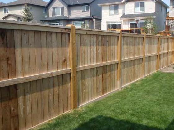
87 Figure 3-13 Typical Neighborhood Fencing 3-29

 Trash and storage areas shall be designed as an integral part of the structure(s) and shall not be oriented to any public right-of-way or pedestrian walkway without adequate screening.")
88 Multi-Family Service and Utility Areas a) Storage areas, utility meters, HVAC, trash enclosures, and other service functions shall be screened, recessed or enclosed (see Figure 3-14). Gas meters are excluded from the requirement to enclose due to NV Energy regulations. Gas meters however must be screened with either landscape or acceptable alternative method as approved by the DRC and the City of Sparks. b) Trash and storage areas shall be designed as an integral part of the structure(s) and shall not be oriented to any public right-of-way or pedestrian walkway without adequate screening. It is the intent to locate these facilities in the most inconspicuous manner as possible. c) Trash enclosures shall be finished using durable materials that complement the development's architecture and shall be screened with landscape on three sides. d) Switch boxes, transformers, electrical meters, including ground mounted air conditioning units and other above ground or building mounted utility elements (including antennas or satellite dishes), should be screened with elements compatible with the building architecture or located out of view from public roads, driveways and common public areas, such as exterior entrances, pathways and parks (see Figure 3-14). The use of landscaping as a method of screening the above is an acceptable form of screening, subject to the approval of the DRC and the City of Sparks. e) All trash and garbage bins shall be stored in an enclosure, approved by disposal services, the DRC and the City of Sparks. f) Trash enclosures shall be constructed to be architecturally compatible with the project. All trash enclosures shall be treated with anti-graffiti material. The trash enclosures shall be constructed of substantial building materials used in the design of the building(s). Gates shall be constructed of durable building materials that screens at a minimum 80% of the view into the trash enclosure. Wood or chain link gates are not allowed. Figure 3-14 Typical Multi-Family Service Areas 3-30
89 g) Exterior onsite utilities, including sewer, gas, water, electric, telephone and communications equipment must be installed underground. Transformers and other utility equipment that must be above ground shall be screened with landscaping or other means approved by the DRC, and incorporated into the streetscape to the approval of the utility company and the City of Sparks. h) Rooftop equipment on buildings shall be shielded from view from public streets. Screening will be compatible with the design, form, material and color of the building. All rooftop equipment shall be organized into major groups to the greatest extent possible. It is the intent to screen groupings of equipment with a single architectural massing made of durable materials incorporated into the building design. Lattice work will not be permitted Multi-Family Project Entry a) Primary multi-family project entry drives may have treatments that incorporate a theme similar to that of Community Gateways but on a smaller scale. b) Project entries shall provide an individual identity to the project such as special paving, graphic sign, specialty lighting, specimen trees, or flowering plants (see Figure 3-15). c) Project entry drives for multi-family/attached single family projects with more than 50 units should include at least two (2) of the following: - A minimum five (5) foot wide landscaped median. - Textured paving, interlocking pavers or rough textured concrete. - Gateway elements such as lights, bollards, monuments, or entry walls. - A roundabout containing landscaping and a water fountain/ feature or public art. - Community name signage d) Multi-family project entry drives shall have sidewalks on both sides connecting the street to the interior pathways of the project. e) Entry treatments shall be located outside the sight visibility triangle of the road intersection. f) Project entries shall be reviewed and approved by the DRC and the City of Sparks with each project. g) Project entries shall be maintained by the property owner. 3-31

90 Figure 3-15 Typical Multi-Family Entry Multi-Family Signs a) Signs within Kiley Ranch North Phase 6 shall comply with the regulations governing signs contained within Section of the Sparks Municipal Code. Where a conflict exists between these development standards and the City of Sparks Municipal Code, the standards contained herein shall apply. b) Monument signs identifying a multi-family residential project shall be provided at the main entry(s) of each residential development or project. c) Monument signs shall have a maximum height of six (6) feet. No additional freestanding signs shall be permitted with the exception of directional wayfinding signs or traffic control signs. Pylon or pole signs are specifically prohibited. d) Neighborhood/project entry signs shall have a consistent design within each project. e) Multi-family developments shall provide a directory of the complex at an easily accessible location for visitors. Signs shall be placed throughout the complex where appropriate to assist visitors in locating units. f) Monument signs shall be maintained by the property owner and approved by the DRC. A City of Sparks Sign Permit shall be required. 3-32
 feet.")
91 Multi-Family Wayfinding Signs a) A wayfinding sign is a permanent sign that directs the flow of pedestrians or vehicular traffic. Wayfinding signs shall have a maximum height of eight (8) feet. Wayfinding signs shall not be placed any nearer than one hundred (100') feet from intersections or round-abouts and not nearer than fifty (50') feet from required regulatory signage. b) Wayfinding signs will be maintained by the Master Developer or LMA and approved by the DRC. A City of Sparks Sign Permit shall be required. Figure 3-16 Conceptual Wayfinding Sign 3-33
92 3.3 Architecture Standards and Guidelines Background The purpose of these architectural guidelines is to provide general design criteria and guidance for the development of the neighborhoods of Kiley Ranch North Phase 6. The guidelines are not intended to be restrictive, but rather promote both visual compatibility and variety in a community setting achieved by utilizing complementary, traditional and contemporary architectural styles. The intended result is a high level of design direction and quality. 3-34
93 3.3.2 Architectural Theme In an effort to promote architectural richness through a diversity of styles, no single architectural vernacular has been chosen to characterize the residential neighborhoods within Kiley Ranch North Phase 6. While some Guest Builders may embrace more traditional styles such as the Craftsman Bungalow and Farmhouse styles, others may elect to pursue more contemporary or eclectic styles such as Contemporary, Mid Century Modern or Mediterranean variants. The end goal is to create an attractive community that provides diverse housing choices to suit the variable tastes of current and future Sparks residents, recognizing that not all consumers tastes are the same. The application of these architectural guidelines and standards to individual development projects will be reviewed and approved by the Kiley Ranch North Design Review Committee (DRC) and the City of Sparks. New interpretations of these classic combinations of materials are encouraged as they relate to a general feeling of neighborhood unity. The following sections provide guidelines and standards that will aid in the creation of a successful and enduring community Architectural Approval(s) All building architecture shall be reviewed and approved by the DRC and City of Sparks Community Services Department for compliance with Sections and of this handbook Single Family Residential Architectural Standards Single Family Architectural Standards Purpose One important goal of these guidelines and standards is to create a streetscape possessing both functional and visual variety. The architectural guidelines are intended to provide variety in appearance as well as a sense of individuality for each structure. Projects where identical buildings line the streets without variation in form and mass are discouraged. The application of detail and character to the architecture should be as authentic as possible to avoid the artificiality of "stage front" architecture. The guidelines provide general goals with regard to architectural elements with the intent of explaining their context to the overall design character of the community Single Family Building Mass and Form a) Facades of buildings shall be derived from the architectural style selected by the Guest Builder for their respective village or project. Such architectural styles shall make use of expressive structural elements such as brackets and columns, variable window types, a mixture of materials and distinctive porches. b) A minimum of three (3) distinctive floor plans shall be used within each subdivision. A subdivision with twenty (20) or less lots may have less than three (3) distinctive floor plans. 3-35
 Any building addition or additional building(s) (over 200 square feet) on a property shall match the main structure in building design, materials, roof pitch and architectural character.")
 varied setbacks, floorplans, facade detailing, massing and rooflines.")
94 c) The architectural detailing similar to that of the front elevations may be utilized on all sides of the home. d) Any building addition or additional building(s) (over 200 square feet) on a property shall match the main structure in building design, materials, roof pitch and architectural character. e) The exterior mass and form of residential architecture should be varied within neighborhoods to improve the streetscape. This can be accomplished through (but is not limited to) varied setbacks, floorplans, facade detailing, massing and rooflines. f) The stepping back or change in materials and color of a second story can be used to add variety to homes and the street (see Figure 3-17, below). The second story can be set back in relation to the garage face below it. If building form is viewed as a series of interlocking masses rather than a single volume, a more desirable design solution will result. However, certain styles will dictate a single volume solution. Figure 3-17 Typical Single Family Building Mass and Form 3-36
. Flat roofs, when consistent with the architectural theme selected by the Guest Builder, will be considered (i.e. in Modern/Contemporary architecture).")
95 Single Family Roof Form a) Roofs shall have variations in plane accomplished by use of dormers, gables, overhangs, hipped roofs and variations in pitch appropriate to the homes chosen architectural style (see Figure 3-18, below). Flat roofs, when consistent with the architectural theme selected by the Guest Builder, will be considered (i.e. in Modern/Contemporary architecture). b) Roof materials to be concrete tile, clay tile, or non-reflective architectural metal. Architectural grade composition asphalt shingles will be considered on a case by case basis. Figure 3-18 Typical Single Family Roof Forms and Materials Single Family Materials and Colors a) The materials and colors used in residential dwellings shall reflect the general theme of architectural style chosen for the subdivision as described in Section b) Exterior elevations shall demonstrate a logical use of materials and a unified appearance. The interface between the home and the garage shall use complementary materials and/or colors in keeping with the architectural style (see Figure 3-17). c) Change in materials or color shall occur at changes in plane or at a logical break on the facade, so as not to give the appearance of artificial quality in keeping with the architectural style. 3-37
96 d) Building materials and color schemes shall be consistent with the chosen architectural style. e) Homes shall incorporate a minimum of two building materials from the list below to the approval of the DRC and Administrator. Predominant exterior building materials shall be of high quality. They may include but are not limited to: - Brick or masonry products - Stained, painted, or weathered wood/composite siding or shingles, or cementious product - Tinted and/or textured stucco - Stone veneer/cultured stone - Other natural stone - Non-reflective metal as accent(s) Single Family Residential Building Articulation a) Bay windows, picture windows, double hung windows, door/window trims that are consistent and noticeable, sidelights and transoms are all encouraged and should match the architectural style. b) Front doors shall be varied and distinctive to each architectural style Single Family Residential Support Structures Residential exterior support structures such as HVAC and satellite dishes can have a negative impact on the appearance of the streetscape and neighborhood character. The impacts of these structures shall be minimized. a) Exposed gutters shall be colored to match the roof, trim or wall material. Exposed downspouts shall be colored to match the surfaces to which they are attached. b) All HVAC, soft water tanks, pool and spa equipment, and electric self-timer boxes for sprinklers or exterior landscape lighting shall be screened with landscaping or an architectural element. c) Skylights and solar panels shall be designed as an integral part of the roof. The glazing shall be clear or solar bronze. White glazing is prohibited. The framing materials shall be colored to match or blend with the roof. 3-38
97 d) Space shall be provided in an adjacent side yard or interior portion of the garage to handle the size of at least two recycling/trash containers. e) The use of patio structures is encouraged when architecturally appropriate. They shall be integrated into the building form to add articulation to otherwise large unbroken wall masses. Such structures must meet the setback requirements of the main structure. f) All homes shall be prewired to accommodate cable television service, telephone, and internet service. Guest Builders shall not install exterior antennas. However, once 18-inch satellite dish discretely placed on the side or rear wall elevations beneath the eaves and soffits of the structure will be permitted. g) Boat and recreational vehicle storage shall be limited to rear and side yards and be screened from any public right-of-way. h) Chimneys All fireplace vents (if through roof) shall be framed and boxed to give the appearance of a chimney. Exterior materials of chimneys shall be compatible with the exterior materials and colors of the house Single Family Garages a) The home and the yard rather than the garage shall be the primary emphasis of the street elevation. Home designs shall incorporate a house forward approach to de-emphasize the prominence of the garage in relation to the overall building design. b) Each subdivision house plan should incorporate one of the garage design techniques listed below. Please refer to Figure Methods to achieve this include, but are not limited to: Recessed Garage Setting the garage back a minimum of five (5) feet in relationship to the front of the house reduces the overall visual mass of the garage. Deep Recessed Garage Setting the garage back to the middle or rear of the lot. This creates a more pedestrian-friendly street environment by allowing the homes primary entryway to address the street. Alley Loaded Garage The use of alleyways locates garages off the street and creates a more traditional street scene, without garage facades fronting the street. The garage off the alley shall have architectural features that complement the main structure. 3-39


98 Side Entry Garage This design technique breaks up the continuous view of garage doors along the street. The facade of the garage facing the street shall incorporate architectural features, windows, faux windows, or other details. Corner Lot Garage This garage treatment is derived out of a plan layout where the garage changes from an interior lot plan to a corner lot plan. Figure 3-19 Typical Garage Concepts 3-40
99 3.3.4 Multi-Family Residential Architectural Standards Multi-Family Building Mass and Form a) Multi-family residential facades can often be box-like and monotonous in appearance, contributing to unpleasant visual qualities and poor community character. Facades of buildings shall be articulated utilizing the architectural theme selected by the Guest Builder. b) Buildings shall incorporate facade articulation with no long expanses of flat wall planes, vertically or horizontally, exceeding 50 feet (see Figure 3-20, following page). c) Architectural elements (i.e., exterior materials, fenestration, window trims, cornices, arches, etc) may be utilized on all sides of the building. d) The architecture facing a pedestrian area shall exhibit a human scale of detail, such as awnings, shutters, moldings, pilasters and other architectural details. e) Use of vertical elements such as towers, piers and varied rooflines may be used to break up the horizontal massing and provide visual interest. f) Attached dwelling units whose garage and/or carport are more than 50 percent of the total width of the unit shall incorporate architectural features such as shutters, garage door window trim and minimum offsets of 2 feet, to reduce the visual impact of garages and carports on the front facade. g) Garages and carports not attached to the main residential building shall match the main structure in building design, materials, roof pitch and architectural character. No pole mounted parking structures will be permitted. h) Building heights shall address sunlight penetration, ventilation, protection from prevailing winds, and views to the adjacent open space areas. i) All multi-family units shall have an outdoor patio/deck for each unit with a minimum depth of six (6) feet or provide a design solution that satisfies the intent of this standard. The alternative design is subject to the approval of the DRC and the City of Sparks. 3-41
 Roofs shall have variations in plane accomplished by use of dormers, gables, hipped roofs and")
.")
100 Figure 3-20 Typical Multi-Family Building Mass and Form Multi-Family Roof Form a) Roofs shall have variations in plane accomplished by use of dormers, gables, hipped roofs and variations in pitch appropriate to the chosen architectural style (see Figure 3-21, below). Flat roofs will be considered when architecturally appropriate (i.e. Modern/Contemporary styles). b) Roof materials shall be consistent with the chosen architectural style. Figure 3-21 Typical Multi-Family Roof Form 3-42
Kiley Ranch North. Prepared by: Phase Two Final Development Handbook. Prepared for: City of Sparks, Nevada. 431 Prater Way Sparks, NV 89432
 Prepared for: City of Sparks, Nevada 431 Prater Way Sparks, NV 89432 Kiley Ranch North Phase Two Final Development Handbook November 2013 City of Sparks, Nevada Prepared by: TABLE OF CONTENTS TABLE OF
Glenborough at Easton Land Use Master Plan
 Implementation 114 9.0 IMPLEMENTATION 9.1 OVERVIEW This chapter summarizes the administrative procedures necessary to implement the proposed land use plan, infrastructure improvements, development standards,
ARTICLE 6: Special and Planned Development Districts
 ARTICLE 6: Special and Planned Development Districts 6-10 Traditional Neighborhood Development (TND) District 6-10.10 Purpose and Intent The Traditional Neighborhood Development (TND) District provides
RRW Stonebrook, LLC Tentative Map Findings
 RRW Stonebrook, LLC Tentative Map Findings FINDING T1: The request conforms to the Master Plan and zoning ordinances. RELATIONSHIP TO THE MASTER PLAN 1. The respective development is located within an
SPECIFIC PLAN Requirements
 CITY OF LANCASTER PLANNING DEPARTMENT 44933 Fern Avenue, Lancaster, California 93534 (661) 723-6100 SPECIFIC PLAN Requirements Purpose The purpose of a specific plan is to provide for the logical development
Eastcreek Farm. Planned Development Standards September, 2014
 Eastcreek Farm Planned Development Standards September, 2014 ekfarm Contents 01. General Standards 02. Residential Development Standards 03. Architectural Design Standards 04. Landscape Design Standards
KASPER. City of Georgetown, Texas PUD Planned Unit Development. December 30, 2015 Revised January 27, 2016
 KASPER City of Georgetown, Texas PUD Planned Unit Development December 30, 2015 Revised January 27, 2016 Applicant: Sentinel Land Company, LLC 4910 Campus Drive Newport Beach, CA Prepared by: SEC Planning
North Oakville East Parks Facilities Distribution Plan. November, 2009
 North Oakville East November, 2009 POLICY CONTEXT 1) Purpose a) The purpose of this document is to be a guide for the location, configuration, design and development of the parks system for the North Oakville
Planning Commission Staff Report June 5, 2008
 Owner/Applicant Taylor Village Sacramento Investments Partners, LP c/o Kim Whitney 1792 Tribute Road #270 Sacramento, CA 95815 Staff Recommendation Planning Commission Staff Report Project: File: Request:
CITY PLANNING COMMISSION AGENDA ITEM: C STAFF: ROBERT TEGLER FILE NO: CPC PUD QUASI-JUDICIAL
 CPC AGENDA June 8, 2006 Page 37 CITY PLANNING COMMISSION AGENDA ITEM: C STAFF: ROBERT TEGLER FILE NO: CPC PUD 05-294 - QUASI-JUDICIAL PROJECT: APPLICANT: OWNER: PARKWOOD AT WOLF RANCH NASS DESIGN ASSOCIATES
PLANNED UNIT DEVELOPMENT Date: April 5, 2018
 PLANNED UNIT DEVELOPMENT Date: April 5, 2018 DEVELOPMENT NAME SUBDIVISION NAME LOCATION Robert Myers Robert Myers 2955 and 2989 Dauphin Street (Southeast corner of Dauphin Street and Sage Avenue) CITY
Gold Line Bus Rapid Transit Transit Oriented Development (BRTOD) Helmo Station Area Plan
 Helmo Station Area Plan") Appendix F Gold Line Bus Rapid Transit Transit Oriented Development (BRTOD) Helmo Station Area Plan Introduction and Purpose of the Plan The Gold Line Bus Rapid Transit facility is an eleven-mile dedicated
Appendix F Gold Line Bus Rapid Transit Transit Oriented Development (BRTOD) Helmo Station Area Plan Introduction and Purpose of the Plan The Gold Line Bus Rapid Transit facility is an eleven-mile dedicated
Planned Residential Neighborhoods Land Use Goals
 Planned Residential Neighborhoods Land Use Goals Issue: Guidelines that provide for diverse high quality residential areas that include a variety of housing styles and layouts are needed. Goal 1: Create
AWH REPORT OF THE PLANNING AND DEVELOPMENT DEPARTMENT FOR APPLICATION FOR REZONING ORDINANCE TO PLANNED UNIT DEVELOPMENT
 AWH REPORT OF THE PLANNING AND DEVELOPMENT DEPARTMENT FOR APPLICATION FOR REZONING ORDINANCE TO PLANNED UNIT DEVELOPMENT MAY 8, 2014 The Planning and Development Department hereby forwards to the Planning
MIDTOWN MIXED-USE VILLAGE. TECHNICAL DATA SHEET COMPONENT C-1 FOR PUBLIC HEARING - PETITION NUMBER Project No RZ1.1. Issued.
 N MIDTOWN MIXED-USE VILLAGE TECHNICAL DATA SHEET COMPONENT C- FOR PUBLIC HEARING - PETITION NUMBER 04-00 Project No. 496 Issued Revised SCALE: " = 0' N 0 0 0 40 RZ. c GENERAL PROVISIONS: a. SITE LOCATION.
EXHIBIT B PROJECT NARRATIVE POULSBO MEADOWS
 EXHIBIT B PROJECT NARRATIVE POULSBO MEADOWS Name of Project: Poulsbo Meadows; A Planned Residential Development (PRD)/Plat Applicants Name: PBH Group LLC/Byron Harris PO Box 1010 Silverdale, WA 98038 Description
OFFICE CONSOLIDATION SECONDARY PLAN AREA 22 THE BRAMALEA SOUTH INDUSTRIAL SECONDARY PLAN
 OFFICE CONSOLIDATION SECONDARY PLAN AREA 22 THE BRAMALEA SOUTH INDUSTRIAL SECONDARY PLAN November 2010 EXPLANATORY NOTES (Secondary Plan Area 22) General (pertaining to all secondary plan office consolidations)
Vintage at Kings Canyon Conceptual PUD. Prepared by:
 Vintage at Kings Canyon Conceptual PUD Prepared by: June 7, 2016 Vintage at Kings Canyon Conceptual PUD Prepared for: Vintage at Kings Canyon, LP Prepared by: Rubicon Design Group, LLC 100 California Avenue,
CITY OF KEIZER MASTER PLAN APPLICATION & INFORMATION SHEET
 CITY OF KEIZER MASTER PLAN APPLICATION & INFORMATION SHEET PRE-APPLICATION CONFERENCE Prior to the actual filing of a Master Plan application, it is strongly recommended that the applicant contact Planning
PLANNED UNIT DEVELOPMENT & SUBDIVISION STAFF REPORT Date: May 18, 2017
 & PUD-0000102-2017 PLANNED UNIT DEVELOPMENT & SUBDIVISION STAFF REPORT Date: May 18, 2017 NAME SUBDIVISION NAME Dauphin Creek Estates Subdivision Dauphin Creek Estates Subdivision LOCATION CITY COUNCIL
City of Yelm. Tahoma Terra Final Master Plan Development Guidelines. Table of Contents
 City of Yelm Tahoma Terra Final Master Plan Development Guidelines Table of Contents Table of Contents... 1 Purpose... 2 Low Density Residential (R4-6)... 3 Moderate Density Residential (R6-10)... 5 Neighborhood
Planning & Zoning Commission Staff Report
 Planning & Zoning Commission Staff Report Meeting Date: May 26, 2015 Drafted by: Katherine Harrison-Rogers CASE # Z2886 PROJECT NAME: APPLICANT/ REPRESENTATIVE: Shawna Runyan PROPERTY OWNER: 1840 (previously
2.0 AREA PLANS. Lakeside Business District. Lakeside Business District Land Use Categories:
 Lakeside Business District Lakeside Business District Land Use Categories: Campus Commercial Campus Commercial means a mixture of uses which includes corporate offices, office parks, hotels, commercial,
Applicant Name Phone / Fax / Address City State Zip Code . Property Owner Phone / Fax / Address City State Zip Code
 Master Development Plan Application Community Development Department City of Redmond 411 SW 9 th Street Redmond, Oregon 97756 541-923-7721 541-548-0706 FAX Master Development Plan Fee $38,862.52 File Number
Baumgarten MPUD. Exhibit 3 Evaluation Criteria
 Pursuant to LDC subsections 10.02.13 B, 10.02.08 F and Chapter 3 G. of the Administrative Code, staff s analysis and recommendation to the Planning Commission, and the Planning Commission s recommendation
ARTICLE IV: DEVELOPMENT STANDARDS 404 MASTER PLANNING
 IV 13 404 MASTER PLANNING Master Planning through the Site Analysis (Master Planning Site Analysis) or Planned Development (Master Planning Planned Development) is provided to encourage development which
CHAPTER 2 SUMMARY 1. PROJECT SUMMARY DATA
 CHAPTER 2 SUMMARY This is an Initial Study format used to determine, pursuant to CEQA Guidelines Section 15177, whether a project 1) is within the scope of a Master EIR (MEIR), 2) may result in additional
PUD GUIDE FOR THE RED MOUNTAIN RANCH PLANNED UNIT DEVELOPMENT
 PUD GUIDE FOR THE RED MOUNTAIN RANCH PLANNED UNIT DEVELOPMENT Exhibit B to the Annexation and Development Agreement October 15, 2018 *Notes in red are intended for Town of Eagle review purposes and are
CITY OF SPARKS, NV COMMUNITY SERVICES DEPARTMENT
 CITY OF SPARKS, NV COMMUNITY SERVICES DEPARTMENT To: From: Subject: Mayor and City Council Janet Stout, Administrative Secretary Report of Planning Commission Action PCN12028 Date: October 24, 2012 RE:
CHAPTER 22 Rural Open Space Community Developments
 CHAPTER 22 Rural Open Space Community Developments Section 22.1 Description and Purpose The intent of this Chapter is to offer property owners an alternative to traditional zoning requirements for rural
CHESAPEAKE LANDSCAPE ORDINANCE
 CHESAPEAKE LANDSCAPE ORDINANCE CONSERVATION PRESERVATION CZO 19-600 Effective October 16, 2008 BUFFER YARD C PARKING LOT REFORESTATION YEAR 1 REFORESTATION YEAR 4 BUFFER YARD F CBPA REFORESTATION Page
Complete Neighbourhood Guidelines Review Tool
 Complete Neighbourhood Guidelines Review Tool Prepared By: City of Regina Planning Department October 2014 Page 1 of 14 Community Development Review Checklist for Secondary Plans and Concept Plans The
Town of Portola Valley General Plan. Nathhorst Triangle Area Plan
 Town of Portola Valley General Plan Amended December 10, 1997 Table of Contents Introduction... 1 Planning Area... 1 Objectives... 2 Principles... 2 Standards... 4 Description... 4 Community Commercial...
City Of Sparks Planning Commission Item
 Page 1 of 12 City Of Sparks Planning Commission Item Meeting Date: May17, 2012 Subject: PCN12009, Public Hearing, Consideration and possible action on a Master Plan Amendment and Rezoning request to change
Staff Report to the North Ogden City Planning Commission
 Staff Report to the North Ogden City Planning Commission SYNOPSIS / APPLICATION INFORMATION Application Request: Concept review on a legislative application to rezone land located at approximately 1750
Watertown City Council
 City of Watertown Watertown City Council April 14 th, 2015 Agenda Item: City Comment on Sun Share CUP Application Request for Action: Motion to Approve City Comments regarding CUP Application Department:
Review of Opportunity Area C Draft Comprehensive Plan and Draft BOS Follow-On Motions. Special Working Group Meeting March 4, 2015
 Review of Opportunity Area C Draft Comprehensive Plan and Draft BOS Follow-On Motions Special Working Group Meeting March 4, 2015 The slides that follow identify where the draft Comprehensive Plan has
ORDINANCE WHEREAS, this Ordinance is consistent with the City of Winter Garden Comprehensive Plan; and
 ORDINANCE 17-06 AN ORDINANCE OF THE CITY COMMISSION OF THE CITY OF WINTER GARDEN, FLORIDA, CREATING ARTICLE XIV OF CHAPTER 118 OF THE CITY OF WINTER GARDEN CODE OF ORDINANCES PROVIDING FOR THE EAST PLANT
Major Subdivision Sketch Plan Checklist
 This checklist provides specific requirements that are apart of the Sketch process. The entire process is described by the Huntersville Subdivision Review Process which details all the submittal and resubmittal
SUBMITTAL REQUIREMENTS
 WHEN PROCESS TYPE III IS USED References to Process Type III applications are found in several places in the Milton Municipal Code (MMC), indicating that the development, activity, or use, is permitted
R E S O L U T I O N. Single-Family Residence/ Church. 2,488 sq. ft. 2,488 sq. ft. Area Parking Required: Church
 R E S O L U T I O N WHEREAS, the Prince George s County Planning Board is charged with the approval of Detailed Site Plans pursuant to Part 3, Division 9 of the Zoning Ordinance of the Prince George s
Planned Development Review Revisions (Project No. PLNPCM )
") Planned Development Review Revisions (Project No. PLNPCM2014-00139) Standard residential development Planned Development Example: Smaller lot sizes than what is allowed to create open space amenity. What
Planned Development Review Revisions (Project No. PLNPCM2014-00139) Standard residential development Planned Development Example: Smaller lot sizes than what is allowed to create open space amenity. What
ARTICLE 17 SITE PLAN REVIEW
 ARTICLE 17 SITE PLAN REVIEW 17.01 INTENT AND PURPOSE The intent of this section is to provide for consultation and cooperation between the applicant and the township planning commission so that the applicant
MONTGOMERY COUNTY PLANNING DEPARTMENT
 MONTGOMERY COUNTY PLANNING DEPARTMENT THE MARYLAND-NATIONAL CAPITAL PARK AND PLANNING COMMISSION MCPB Item No.: Date: 5-03-18 Pike and Rose, Phase I: Site Plan Amendment No. 82012002D Rhoda Hersson-Ringskog,
Application Number: SD Project Name: Walton Farms Preliminary Subdivision (acting as Master Plan)
") STAFF REPORT Town of Clayton Planning Department 111 E. Second Street, Clayton, NC 27520 P.O. Box 879, Clayton, NC 27528 Phone: 919-553-5002 Fax: 919-553-1720 Planning Board May 22, 2017 Application Number:
STAFF REPORT Town of Clayton Planning Department 111 E. Second Street, Clayton, NC 27520 P.O. Box 879, Clayton, NC 27528 Phone: 919-553-5002 Fax: 919-553-1720 Planning Board May 22, 2017 Application Number:
TOP TEN LIST OF COMMUNITY CONCERNS REGARDING PROPOSED AMENDMENTS TO CHAPTER 42
 TOP TEN LIST OF COMMUNITY CONCERNS REGARDING PROPOSED AMENDMENTS TO CHAPTER 42 1. Extend the urban area to Beltway 8 in stages, over say a three-year period, prioritizing development in transit and declining
C-I-10. The effect of establishing a comprehensive site review as follows will: B. Reduce the cluttered aspects of current development by:
 C-I-10 PART C SECTION I ARTICLE 10 GENERAL REGULATIONS PROJECT SITE REVIEW I. Purpose The effect of establishing a comprehensive site review as follows will: A. Protect streetscapes from projects that
Sec Development design approval and procedures.
 Sec. 27-185. Development design approval and procedures. (a) Design approval; when required; submission of application. (1) Required. Any property owner or agent thereof proposing to erect a building or
RESIDENTIAL DISTRICTS
 RESIDENTIAL DISTRICTS The residential district standards have been revised to reflect on-the-ground conditions, while continuing to respect the use patterns established within the neighborhoods. This will
4.1.3 LAND USE CATEGORIES
 4.1.3 LAND USE CATEGORIES a. City Center District The City Center District incorporates the existing character and mix of uses in downtown Belmont to encourage redevelopment and new development in keeping
Dwelling Units Max 12 dwelling units per acre/min 8 dwelling units per acre. Development Mix 80% non residential/20% residential
 13. OSTEEN LOCAL PLAN Background: The Osteen Local Plan area is located in southwest Volusia County along the SR 415 corridor between Lemon Bluff Road and Acorn Lake Road and includes 3,990 acres. The
ARTICLE V PLANNED UNIT DEVELOPMENT DISTRICT
 ARTICLE V PLANNED UNIT DEVELOPMENT DISTRICT A. Purpose and Objective The Planned Unit Development (PUD) procedure provides a flexible land use and design regulation through the use of performance criteria
City of Redmond. Urban Holding Area Master Planning Requirements and Approval Process
 City of Redmond Urban Holding Area Master Planning Requirements and Approval Process June 21, 2006 City of Redmond: Urban Holding Area Master Planning Requirements and Approval Process Table of Contents
3.4 REL: Religious Use District
 3.4 Intent - The s are established to promote and maintain the development facilities for divine worship within the Town of Plainfield. The development of religious facilities or the major expansion of
Chapter PEDESTRIAN COMMERCIAL (PC) ZONING DISTRICT
 ZONING DISTRICT") Chapter 11-17 PEDESTRIAN COMMERCIAL (PC) ZONING DISTRICT Sections: 11-17-01 GENERAL PURPOSE 11-17-02 PERMITTED BUILDING TYPES 11-17-03 USES PERMITTED WITH DESIGN REVIEW 11-17-04 USES PERMITTED BY CONDITIONAL
Chapter 11-17 PEDESTRIAN COMMERCIAL (PC) ZONING DISTRICT Sections: 11-17-01 GENERAL PURPOSE 11-17-02 PERMITTED BUILDING TYPES 11-17-03 USES PERMITTED WITH DESIGN REVIEW 11-17-04 USES PERMITTED BY CONDITIONAL
RULES AND REGULATIONS FOR GENERAL DEVELOPMENT PLANS
 RULES AND REGULATIONS FOR GENERAL DEVELOPMENT PLANS IN THE MIXED-USE ZONE DISTRICTS OS-1, R-MU-20, R-MU-30, C-MU-10, C-MU-20, C-MU-30, T-MU-30 Jointly adopted by the Departments of Community Planning and
Asbury Chapel Subdivision Sketch Plan
 Asbury Chapel Subdivision Sketch Plan PART 1: PROJECT SUMMARY Applicant: NVR Inc. Project Size: +/- 76.13 acres Parcel Numbers: 02101112,02116101,02116112, 02116113 Current Zoning: Transitional Residential
FLORIN ROAD CORRIDOR Site Plan and Design Review Guidelines Checklist
 FLORIN ROAD CORRIDOR Site Plan and Design Review Guidelines Checklist Applicant s Name: Project Address: Phone: Email: Applicant shall fill out the design guidelines checklist for all guidelines applicable
3.10 LAND USE SETTING PROJECT SITE EXISTING LAND USE DESIGNATIONS AND ZONING. General Plan Land Use Designations.
 This section of the Draft EIR addresses the existing land uses on and adjacent to the project site and discusses the potential impacts of the proposed project on existing land uses. Key issues addressed
The Ritz-Carlton, Paradise Valley
 The Ritz-Carlton, Paradise Valley 7000 E. Lincoln Drive Keys to Success Community Conversation II June 4, 2015 RITZ-CARLTON PARADISE VALLEY Town Council Study Session June 4, 2015 General Plan 2012 Land
Staff Report and Recommendation
 Community Planning and Development Planning Services 201 W. Colfax Ave., Dept. 205 Denver, CO 80202 p: 720.865.2915 f: 720.865.3052 www.denvergov.org/cpd TO: City Council Neighborhoods and Planning Committee
Drexel, Barrell & Co.
 Drexel, Barrell & Co. June 18, 2018 Engineers/Surveyors Boulder Colorado Springs Greeley 3 South 7 th Street Colorado Springs, Colorado 80905-1501 719 260-0887 719 260-8352 Fax El Paso County Planning
#8) T-1409 CENTENNIAL & LAMB TENTATIVE MAP
 T-1409 CENTENNIAL & LAMB TENTATIVE MAP") #8) T-1409 CENTENNIAL & LAMB TENTATIVE MAP STAFF REPORT To: Planning Commission Meeting Date: June 14, 2017 Item: T-1409 Prepared By: Robert Eastman GENERAL INFORMATION: Applicant: Property Owner(s): Requested
#8) T-1409 CENTENNIAL & LAMB TENTATIVE MAP STAFF REPORT To: Planning Commission Meeting Date: June 14, 2017 Item: T-1409 Prepared By: Robert Eastman GENERAL INFORMATION: Applicant: Property Owner(s): Requested
Gruene River Place PDD CONCEPT PLAN AND DEVELOPMENT STANDARDS
 Gruene River Place PDD CONCEPT PLAN AND DEVELOPMENT STANDARDS GRUENE RIVER PLACE PLANNED DEVELOPMENT DISTRICT As per Section 3.5, Chapter 144 of the City s Zoning Ordinance To: The Planning & Zoning Commission
FORMER CANADIAN FORCES BASE (CFB) ROCKCLIFFE SECONDARY PLAN. Official Plan Amendment XX to the Official Plan for the City of Ottawa
 ROCKCLIFFE SECONDARY PLAN. Official Plan Amendment XX to the Official Plan for the City of Ottawa") FORMER CANADIAN FORCES BASE (CFB) ROCKCLIFFE SECONDARY PLAN Official Plan Amendment XX to the Official Plan for the City of Ottawa 1 INDEX THE STATEMENT OF COMPONENTS PART A THE PREAMBLE PAGE Purpose...
FORMER CANADIAN FORCES BASE (CFB) ROCKCLIFFE SECONDARY PLAN Official Plan Amendment XX to the Official Plan for the City of Ottawa 1 INDEX THE STATEMENT OF COMPONENTS PART A THE PREAMBLE PAGE Purpose...
Exhibit A. 8:9 Scuffletown Rural Conservation District
 Exhibit A 8:9 Scuffletown Rural Conservation District 8:9.1 Intent and Purpose The Scuffletown Rural Conservation (SRC) District is intended to provide for residential development that supports the development
The Development Review Process. Presentation to the GSSC IAC
 The Development Review Process Presentation to the GSSC IAC July 19, 2011 Regulatory Processes in the Planning Department Natural Resource Inventory/Forest Stand Delineation Zoning (Development Plan) Special
Planning Commission Staff Report March 15, 2007
 Planning Commission Staff Report Project: Request: Madeira East Tentative Subdivision Map, Design Review for Subdivision Layout & Abandonment of Easements Location: Phase IV of the Laguna Ridge Specific
PC RESOLUTION NO
 PC RESOLUTION NO. 14-01-14-02 TENTATIVE TRACT MAP fttm) 17441. REZONE {RZ) 13-003, ARCHITECTURAL CONTROL (AC) 13-003, TREE REMOVAL PERMIT (TRP) 13-052. GRADING PLAN MODIFICATION (GPM) 13-002. CONDITIONAL
Proposed Walkability Ordinance for City of Knoxville (6/16/17)
") Proposed Walkability Ordinance for City of Knoxville (6/16/17) New or revised text is highlighted Section 1: Purpose The purpose of this ordinance is to set requirements for walkability and pedestrian
Proposed Walkability Ordinance for City of Knoxville (6/16/17) New or revised text is highlighted Section 1: Purpose The purpose of this ordinance is to set requirements for walkability and pedestrian
Zoning Technical Review Presented by Camiros. November 10, 2015
 Zoning Technical Review Presented by Camiros November 10, 2015 TECHNICAL REVIEW OVERVIEW Purpose of this Report Outline issues with current Ordinance Present preliminary approaches for revisions Set drafting
PLANNING AND DEVELOPMENT DEPARTMENT SITE PLAN REVIEW SECTION / CURRENT PLANNING APPLICATION FOR PRELIMINARY SITE DEVELOPMENT PLAN APPROVAL
 PLANNING AND DEVELOPMENT DEPARTMENT SITE PLAN REVIEW SECTION / CURRENT PLANNING APPLICATION FOR PRELIMINARY SITE DEVELOPMENT PLAN APPROVAL Project Number City Development Number Application Date (Assigned
DENVER DESIGN DISTRICT GDP
 DENVER DESIGN DISTRICT GDP Urban Design Standards and Guidelines November 17, 2008 Amended February 3, 2016 City and County of Denver CF Property Management, Inc. C/O Denver Design District - Starboard
EXHIBIT. PUD Written Description
 EXHIBIT D PUD Written Description Krispy Kreme at Merrill Road PUD Revised 09-30-2013 City Development Number: I. PROJECT DESCRIPTION The subject property identified as Real Estate No.120466 0030 on Panel
3.1 community vision. 3.3 required plan elements
 Chapter 3 Community Form 3.1 community vision 3.2 Parks & landscaping concepts 3.3 required plan elements D R A F T 20 Community Form Chapter 3 3.0 Community form 3.1 community vision The Specific Plan
SECTION II SECTION II STATEMENT OF GOALS, OBJECTIVES, PRINCIPLES, ASSUMPTIONS, POLICIES AND STANDARDS
 STATEMENT OF GOALS, OBJECTIVES, PRINCIPLES, ASSUMPTIONS, POLICIES AND STANDARDS 1 2 STATEMENT OF GOALS, OBJECTIVES, PRINCIPLES, ASSUMPTIONS, POLICIES AND STANDARDS INTRODUCTION The New Jersey Municipal
VANDEN MEADOWS SPECIFIC PLAN TABLE OF CONTENTS Page 1.0 INTRODUCTION SUMMARY Schools Foxboro Parkway
 0 VANDEN MEADOWS SPECIFIC PLAN TABLE OF CONTENTS Page 1.0 INTRODUCTION 6 1.1. SUMMARY 6 1.1.1. Schools 11 1.1.2. Foxboro Parkway 11 1.1.3. Improvements to Leisure Town Road 11 1.1.4. New Neighborhood Park
LAND USE CATEGORIES. City of Sparks Comprehensive Plan Chapter Two: Pathway to the Future - Draft 1
 LAND USE CATEGORIES The following tables summarize the land use categories identified on the Map, describing the s designation shown on the Map. The tables summarize the primary uses and other uses, residential
Municipal Development Plan. Summer Village of ROCHON SANDS. Bylaw #241-18
 Municipal Development Plan Summer Village of ROCHON SANDS Bylaw #241-18 TABLE OF CONTENTS PART ONE: BACKGROUND AND PURPOSE 3 SECTION 1: BACKGROUND 3 SECTION 2: GOALS AND POLICIES 3 PART TWO: PHYSICAL ENVIRONMENT
URBAN DESIGN BRIEF. 2136&2148 Trafalgar Road. Town of Oakville
 URBAN DESIGN BRIEF 2136&2148 Trafalgar Road Town of Oakville Prepared By: METROPOLITAN CONSULTING INC For 2500674 Ontario Inc November 2016 TABLE OF CONTENTS Page No. 1.0 Introduction/Description of Subject
Chesapeake Bay Critical Area Conservation Plan
 The Maryland-National Capital Park and Planning Commission Prince George s County Planning Department Development Review Division 301-952-3530 Note: Staff reports can be accessed at www.mncppc.org/pgco/planning/plan.htm.
PORT WHITBY COMMUNITY
 PORT WHITBY COMMUNITY SECONDARY PLAN UPDATE COMMUNITY IMPROVEMENT PLAN URBAN DESIGN GUIDELINES September 2015 DRAFT PROPOSED AMENDMENT NUMBER # to the Whitby Official Plan PURPOSE: The intent of this Amendment
ZONING AMENDMENT & PLANNED UNIT DEVELOPMENT STAFF REPORT Date: April 4, 2013
 ZONING AMENDMENT & PLANNED UNIT DEVELOPMENT STAFF REPORT Date: April 4, 2013 NAME DEVELOPMENT NAME LOCATION DIP Exchange, LLC DIP Exchange, LLC 93 Sidney Phillips Drive (West side of Sidney Phillips Drive,
PLANNING AND ZONING COMMISSION AGENDA MEMORANDUM
 PLANNING AND ZONING COMMISSION AGENDA MEMORANDUM City and County of Broomfield, Colorado To: Planning and Zoning Commission From: John Hilgers, Planning Director Anna Bertanzetti, Principal Planner Meeting
The Maryland-National Capital Park and Planning Commission Prince George's County Planning Department Development Review Division
 The Maryland-National Capital Park and Planning Commission Prince George's County Planning Department Development Review Division 301-952-3530 Note: Staff reports can be accessed at www.mncppc.org/pgco/planning/plan.htm.
Chapter RM MULTI FAMILY BUILDING ZONES
 Chapter 19.17 RM MULTI FAMILY BUILDING ZONES 19.17.010 Established 19.17.020 Primary Permitted Uses 19.17.030 Accessory Permitted Uses 19.17.040 Secondary Permitted Uses 19.17.050 Conditional Property
Mitchell Ranch South MPUD Application for Master Planned Unit Development Approval Project Narrative. Introduction
 Mitchell Ranch South MPUD Application for Master Planned Unit Development Approval Project Narrative Introduction Mitchell Ranch South is a proposed single family (detached) residential development on
DRAFT DESIGN GUIDELINES
 IHZ Booklet #7 May 6, 2010 DRAFT DESIGN GUIDELINES CANTERBURY 7 Overview During the recent planning process for the Plan of Conservation and Development community character was identified as an important
WASHINGTON COUNTY OREGON
 WASHINGTON COUNTY OREGON July 9, 2009 Revisions to Chapter 2 of the Bethany Community Plan The North Bethany Subarea Plan Exhibit pages 7 and 8 The sections for the Core and Flexible Streets were amended
4.0 Future Land Use Element
 4.0 The Florida Agricultural and Mechanical University (FAMU) represents existing and proposed development patterns within the campus boundaries to be coordinated and not conflict with the adjacent areas
VANDEN MEADOWS SPECIFIC PLAN TABLE OF CONTENTS Page 1.0 INTRODUCTION SUMMARY Schools Foxboro Parkway
 VANDEN MEADOWS SPECIFIC PLAN TABLE OF CONTENTS Page 1.0 INTRODUCTION 6 1.1. SUMMARY 6 1.1.1. Schools 11 1.1.2. Foxboro Parkway 11 1.1.3. Improvements to Leisure Town Road 11 1.1.4. New Neighborhood Park
CITY OF ZEELAND PLANNING COMMISSION
 APPLICATION FOR SITE PLAN REVIEW AND SPECIAL LAND USE Date City Official App. Filing Fee Rec'd ($350) NOTE TO APPLICANT: Please submit this application for Site Plan Review along with twenty (20) copies
Behnke Ranch Property, Pasco County: Master Plan Development Approach
 February 24, 2014 , Pasco County: Master Plan Development Approach Location & Program The (Legacy PUD) is located in southwest Pasco County along State Road 54 approximately 1.5 miles west of the Suncoast
Department of Community Development. Planning and Environmental Review Division Revised Notice of Preparation
 Department of Community Development Michael J. Penrose, Acting Director Divisions Building Permits & Inspection Code Enforcement County Engineering Economic Development & Marketing Planning & Environmental
REPORT OF THE PLANNING AND DEVELOPMENT DEPARTMENT FOR APPLICATION FOR REZONING ORDINANCE TO PLANNED UNIT DEVELOPMENT AUGUST 18, 2016
 REPORT OF THE PLANNING AND DEVELOPMENT DEPARTMENT FOR APPLICATION FOR REZONING ORDINANCE TO PLANNED UNIT DEVELOPMENT AUGUST 18, 2016 AWH The Planning and Development Department hereby forwards to the Planning
 Villa Vizcaya PUD Amendment No. 3 4 April 16, 2008 May 29, 2015 Presented to: City of Port St. Lucie Planning and Zoning Department 121 SW Port St. Lucie Boulevard Port St. Lucie, Florida 34984 Exhibit
1. Parks & Recreation Neighborhood Parks Community Parks Special Use Sites 2. Open Space 3. Trails
 Appendix A: Park Classifications The intent of parks and recreation classifications is to aid in making acquisition and design decisions for park sites, facilities and the organization of recreation space
LAND USE CATEGORIES. City of Sparks Comprehensive Plan Land Use Categories - Draft
 LAND USE CATEGORIES The following tables summarize the land use categories identified on the Map, describing the s designation shown on the Map. The tables summarize the primary uses and other uses, residential
GENERAL INFORMATIONaaaaaaaaaaaaaaaaaaaaaaaaaaaaaaaa
 To: Planning and Zoning Commission From: City Staff Date: November 15, 2016 Re: Case #16026 Raymore Activity Center Site Plan GENERAL INFORMATIONaaaaaaaaaaaaaaaaaaaaaaaaaaaaaaaa Applicant/ Property Owner:
VILLAGE OF CLEMMONS PLANNING BOARD DRAFT STAFF REPORT. Single Family Residential, Townhomes
 VILLAGE OF CLEMMONS PLANNING BOARD DRAFT STAFF REPORT PETITION INFORMATION Docket # C-212 Staff Megan Ledbetter Petitioner(s) Peacehaven Development LLC Owner(s) Larry Jarvis, William Alexander and Peacehaven