M2 JUNCTION 5 IMPROVEMENTS STUDY ENVIRONMENTAL STUDY REPORT
|
|
|
- Edgar Robertson
- 6 years ago
- Views:
Transcription


1 M2 JUNCTION 5 IMPROVEMENTS STUDY ENVIRONMENTAL STUDY REPORT NOVEMBER 2016
2 CONTENTS Page 1 Introduction and Overview 7 2 The Project 8 3 Alternatives Considered: 3 Junction Options 11 4 Environmental Impact Assessment Methodology 13 5 Air Quality 17 6 Cultural Heritage 31 7 Landscape 45 8 Nature Conservation 60 9 Geology and Soils Materials Noise and Vibration People and Communities Road Drainage and the Water Environment Assessment of Cumulative Effects Outline Environmental Management Plan Conclusions References Glossary
3 TABLES 2.1 Land Take Required by Junction Options 3.1 Traffic Forecasting Summary 4.1 Environmental Topics and Level of Assessment 4.2 Comparison of the Environmental Topics between the Revised Version of the DMRB Volume 11 (October 2015), Section 3 and the Previous Version 4.3 Arriving at the Significance of Effects 5.1 Assessment of Risk of Impacts During Construction 5.2 Summary of Defra Mapped Background Concentrations 5.3 Example of Local Authority Monitoring of NO 2 Using Diffusion Tubes. Concentrations Shown in Bold Exceed the UK Air Quality Objective 5.4 Ambient Air Quality Objectives relevant to the Air Quality Assessment of Impacts for the Options 5.5 Preliminary Assessment of Risk of Impacts and Significance of Effects for the Junction Options During the Construction Phase 5.6 Total NOx Emissions (in Tonnes per Day) within the AM, Inter-peak (IP), and PM Periods for Each Junction Option 5.7 Proximity and Number of Human Receptors to the Roadside for Each Junction Option 5.8 Qualitative Preliminary Assessment of Air Quality Impacts for Junction Options During the Operational Phase 6.1 Criteria Used to Determine Importance of Heritage Assets 6.2 Criteria used to Determine Scale of Harm (Impact) 6.3 Heritage Assets within the 1km Study Area 6.4 Non-Designated Heritage Assets within the 1km Study Area 6.5 Summary of Potential for Previously Unknown Heritage Assets to be Present 6.6 Importance/Sensitivity of the Heritage Assets Identified within the 1km Study Area 6.7 Magnitude of Impact and Significance of the Options 4, 10 and 12 on Below-ground Heritage Assets within the 1km Study Area 6.8 Magnitude of Impact and Significance of the Effect of Options 4 and 12 on the Setting of Heritage Assets within the 1km Study Area 6.9 Magnitude of Impact and Significance of the Effect of Option 10 on the Setting of Heritage Assets within the 1km Study Area 7.1 Significance of Effect Categories 7.2 Landscape Character Areas 7.3 Summary of Landscape and Visual Impacts 8.1 Criteria to be Considered when Identifying Valued Ecological Receptors (Adapted from CIEEM, 2006 and Ratcliffe, 1977) 8.2 Statutory and Non-Statutory Designated Sites within the Study Area 8.3 Summary of Tree and Building Suitability for Bat Roosts 8.4 Summary of Badger Setts Recorded during Badger Survey 8.5 Likely Significant Impacts Associated with the Junction Options 9.1 Qualitative Risk Assessment Classification of Consequence 9.2 Qualitative Risk Assessment Classification of Probability 9.3 Qualitative Risk Assessment Risk Category 9.4 Defining the Value (Sensitivity) of Attributes and Contaminated Land Receptors 9.5 Conceptual Site Model 9.6 Attribute Importance 9.7 Summary of Effects 10.1 Summary of Materials and Waste that may be Required or Generated by the Scheme 11.1 Assessment Category and Threshold Value 11.2 Assessment Category and Threshold Value 11.3 Noise Survey Locations 11.4 Summary of Noise Survey Results 11.5 Noise Sensitive Receptors 11.6 Magnitude of Operational Noise Impacts in the Short-term 11.7 Magnitude of Operational Noise Impacts in the Long-term 11.8 Qualitative Operational Noise Impact Assessment 12.1 DMRB Criteria for Views from the Road 12.2 LSOAs within the Scheme and Corresponding Index of Multiple Deprivation Values 12.3 Employment Statistics for Swale District Compared to Regional and National Figures - 4 -
4 12.4 Health Profile of Swale Compared to Regional and National Figures 12.5 Swale Borough Council Adopted Local Plan (2008) 12.6 The Maidstone Borough Wide Local Plan (2000) Saved Policies 13.1 Summary of Likely Significance 14.1 Planned Infrastructure Schemes for Consideration of Cumulative Effects 15.1 Outline Environmental Management Plan 16.1 Quantitative Summary of the Potential Effects of each Junction Option FIGURES Figure 1.1 M2 Junction 5 Study Area Figure 3.1 Junction Option 4 Figure 3.2 Junction Option 10 Figure 3.3 Junction Option 12 Figure 5.1 Proximity of Properties within 50m intervals of the Option 4 Scheme Boundary Figure 5.2 Proximity of Properties within 50m intervals of the Option 10 Scheme Boundary Figure 5.3 Proximity of Properties within 50m intervals of the Option 12 Scheme Boundary Figure 5.4 Monitoring, PCM Model Links, Human Receptors and AQMA Boundaries Figure 6.1 Heritage Assets within the 1km Study Area Figure 6.2 Mapped World War One Land Defences Shown Over Option 4 Figure 6.3 Mapped World War One Land Defences Shown Over Option 10 Figure 6.4 Mapped World War One Land Defences Shown Over Option 12 Figure 7.1 Landscape and Visual Impact Assessment Study Area Figure 7.2 Landscape Context Figure 7.3 Landscape Character Figure 7.4 Zone of Visual Influence and Photograph Locations Figure 7.5 Viewpoint 1 Wormhole Hill near Dunaway Figure 7.6 Viewpoint 2 Old Maidstone Road, Dunaway Figure 7.7 Viewpoint 3 Church Lane, Stockbury Figure 7.8 Viewpoint 4 Bull Lane, Near Nuffield House Figure 7.9 Viewpoint 5 Bowl Reed, Oad Street Figure 7.10 Viewpoint 6 Whipstakes Farm, Borden Hill Figure 8.1 Option 4 Ecological Constraints Figure 8.2 Option 10 Ecological Constraints Figure 8.3 Option 12 Ecological Constraints Figure 11.1 Noise Survey Locations Figure 13.1 Water Constraints Map APPENDICES Appendix 6.1 Appendix 6.2 Appendix 6.3 Appendix 8.1 Appendix 8.2 Appendix 11.1 Appendix 11.2 Appendix 11.3 Cultural Heritage: Methodology for Setting Assessment Cultural Heritage: Walkover Survey Cultural Heritage: Geophysical Survey Results Additional Ecological Surveys to Inform Junction Options Appraisal Assessment of Implications on European Sites Glossary of Noise and Vibration Terms Calibration Certificates Noise Monitoring Forms - 5 -
5
6 1 INTRODUCTION AND OVERVIEW The Project and Stage of Project The M2 Junction 5/A249 Stockbury Roundabout has capacity and network performance issues, both in terms of M2 east-west movements and A249 north-south Sittingbourne/ Maidstone movements. The junction currently has an unconventional design that could potentially be reconfigured to increase capacity and/or improve traffic flows through the junction. WSP Parsons Brinkerhoff (WSP PB) is currently considering options to improve the capacity of the junction in both the short and long-term and has identified alternative options for the reconfiguration of the junction. This Environmental Study Report (ESR) has been prepared to provide a high level environmental assessment of the junction options. It forms part of the requirements of the Project Control Framework (PCF) Stage 1. PCF Stage 1 is the Options Identification stage, whereby all options are assessed. Refined options are then brought forward to PCF Stage 2 Public Options Selection, where public consultation is carried out and the preferred option is selected. The Location of the Project The M2 Motorway is located in the County of Kent, in the south-east of England, and provides a strategically important transport corridor linking Dover with London. The broad M2 Junction 5 study area is shown in Figure 1.1. Purpose of the Report (including reporting of the determination process) This ESR has been prepared to provide a broad overview of the environmental constraints and relative environmental benefits associated with the various junction options, including potential mitigation measures that could be employed to reduce adverse impacts. Severe environmental constraints that could preclude further consideration of an option will be identified. It also identifies the further assessment that is likely to be required if potentially severe effects are associated with any of the junction options. Scope and Content The ESR considers the three options prepared by the design team, as described in Chapter 3. The baseline information has primarily been obtained through desk studies from readily available information sources. Site visits have also been undertaken to obtain further information where considered appropriate at this stage. Further monitoring and survey work will be required in PCF Stage 2 in order to close data gaps. These requirements are set out in the ESR where relevant
7 2 THE PROJECT Background to the Project The Strategic Case is presented in the Option Assessment Report (OAR) and summarised in the Strategic Outline Business Case report (OBC). The scheme is needed due to congestion and safety concerns, as identified during the Route Based Strategy (RBS) sifting process. Junction 5 is one of the top 50 national casualty locations, and one of the main areas within the Kent Corridors to M25 Route Strategy Evidence Report which interacts with vulnerable road users (Highways Agency, 2014). There are also economic reasons for the scheme. Swale Borough Council is anticipated to grow by 11,025 dwellings and 6,783 jobs up to 2031, with the anticipated location of impact at M2 Junction 5 and the A249, as identified with Section 3.1 of the Kent Corridors to M25 RBS evidence report. The report identified that a more efficient junction operation would be essential to secure the economic development potential of the area. Previous study work undertaken by Jacobs in July 2009 identified short term solutions (up to 2016), but also identified the need for longer term solutions. Further work was undertaken by WSP PB in September 2012 which considered further options for improvements. The commitment to undertake a detailed improvement study at M2 Junction 5 was made as part of the 2014 Autumn Statement and subsequently detailed in the Department for Transport s (DfT) Road Investment Strategy (RIS). The improvement is considered to contribute to national transport objectives by: Providing additional capacity; Enhancing journey time reliability; and Supporting the development of housing and the creation of jobs. This M2 Junction 5 (A249) improvement study aims to provide options for additional capacity at the junction through improvements to slip roads, enhanced approaches to the junction and potentially full grade separation providing a much need dedicated route for A249 through traffic. These options are referred to subsequently as the junction options. Regulatory Framework and the Project Objectives National Policy In 2014 the Government adopted a National Policy Statement for National Networks (NN NPS) (Department for Transport, 2014). The NN NPS sets out the Government s policies to deliver, development of nationally significant infrastructure projects (NSIPs) on the national road and rail networks in England. The Secretary of State will use the NN NPS as the primary basis for making decisions on development consent applications for national networks NSIPs in England. The NN NPS (Department for Transport, 2014) sets out the Governments position with regards to improvements on the highways network, and indicates that improvements vital to alleviate congestion, particularly in the South East. Para 2.17 states: - 8 -
8 It is estimated that around 16% of all travel time in 2010 was spent delayed in traffic, and that congestion has significant economic costs: in 2010 the direct costs of congestion on the Strategic Road Network in England were estimated at 1.9 billion per annum. The NN NPS (Department for Transport, 2014) indicates that all projects should be subject to an options appraisal, and that this should consider viable modal alternatives and may also consider other options. Where projects have been subject to full options appraisal in achieving their status within Road or Rail Investment Strategies, or other appropriate policies or investment plans, option testing need not be considered by the examining authority or the decision maker. For national road and rail schemes, proportionate option consideration of alternatives will have been undertaken as part of the investment decision making process In line with the NN NPS (Department for Transport, 2014), the high-level objectives for the M2 J5 Improvement Study are: To enhance capacity, connectivity, and resilience to support national and local economic activity and facilitate growth and create jobs; To support and improve journey quality, reliability and safety; To support the delivery of environmental goals and move to a low carbon economy; and To join communities and link them effectively to each other. The National Planning Policy Framework (DCLG, 2012) is a consideration in decisions on NSIPs, but only to the extent relevant to that project where the NN NPS (Department for Transport, 2014) is silent. It does not contain specific policies for NSIPs where particular considerations can apply. Relevant policies within both the NPPF (DCLG, 2012) and the NN NPS (Department for Transport, 2014) for each topic area are summarised in each topic chapter, as well as other relevant international and national legislation. The Scheme Specific Objectives The specific objectives identified for the scheme are as follows: Objective 1: To enhance the capacity, connectivity (including all modes of transport) and the resilience provided by the M2 J5 in order to contribute positively to strengthening the local and regional economic base, delivering housing allocations within the Swale Local Plan and promoting economic growth across the region. Objective 2: To improve the safety and security offered by M2 J5 to all road users. To reduce the number of KSI collisions, and to reduce the number of slight collisions. Objective 3: To improve the journey quality, journey time and reliability for all routes through M2 J5. Objective 4: To deliver a high standard of design for any M2 J5 improvement that reflects the quality of the landscape and setting, and that minimises the adverse environmental impact of new construction and supports the following objectives: Plan for climate change; - 9 -
9 Work in harmony with the environment to conserve natural resources and encourage bio-diversity; and Protect and enhance countryside and historic and archaeological environments Land Use Setting and Land Take The M2 motorway is located on the northern boundary of the Kent Downs AONB; the south western edge of the M2 / A249 junction at Stockbury Roundabout is located slightly within it. The M2 motorway and A249 are both two lane dual carriageways at Junction 5 where the A249 is at grade and the M2 is elevated on embankments and a viaduct. Stockbury Roundabout has road lighting, but there is no road lighting on the adjoining sections of the M2 or A249. The junction is located within a rural landscape. The nearest settlements with views of the M2 and/or A249 at this location are the small villages of Oad Street, Danaway and Stockbury. Extensive woodland (screen) planting has been undertaken along the routes of both the M2 and A249, and the Stockbury Roundabout junction. The various junction options are located on either existing highways estate or agricultural land. The approximate total land take anticipated to be required for each option (based on the designs shown in Figures 3.1 to 3.3) is shown in Table 2.1. Table 2.1: Land take required by junction options OPTION 4 OPTION 10 OPTION 12 Outside existing highway boundary 13.0 ha 11.1 ha 10.8 ha Inside existing highway boundary 23.0 ha 33.0 ha 18.6 ha Total land take 36.1 ha 44.2 ha 29.3 ha The potential land take implications of the junction options are considered in further detail in the People and Communities chapter. Construction, Operation and Long Term Management Construction, operational and long term management arrangements are not known at this stage. Any assumptions made within this assessment relating to the construction, operational or management arrangements are based on prior experience of similar schemes and professional judgement
10 3 ALTERNATIVES CONSIDERED: THREE JUNCTION OPTIONS Junction Options that have been examined Previous study work undertaken by Jacobs in July 2009 identified short term solutions (up to 2016) to improve the junction, but also identified the need for longer term solutions. Extensive optioneering was undertaken during PCF Stage 0, culminating in ten main options being considered further at PCF Stage 0. These have been further refined into three options to be taken forward for further assessment during PCF Stage 1. The three options that are currently being considered are shown in Figures 3.1, 3.2 and 3.3 and are described below: Option 4 Two tier intersection: This option sees the existing Stockbury Roundabout replaced with a new grade-separated interchange, with free flowing movement provided on the A249 under the junction. Additional free-flow links are included for the A249 southbound to M2 westbound, A249 northbound to M2 eastbound, and M2 eastbound to A249 northbound movements. The M2 eastbound to A249 northbound free-flow link avoids the roundabout. Local road connectivity is provided via a connection between Maidstone Road and Oad Street, with a connection provided to the Stockbury interchange. Earthworks will be modelled with 1:2 slopes. Option 10 Three tier intersection: This option sees the existing Junction 5 replaced with a traditional three-tier grade separated interchange; removing the unusual geometry of the junction and slip road alignments. The A249 has a dedicated through link at the lower-level, with the interchange at the mid-level, and M2 as existing at the top-level. There are additional free-flow links serving the M2 eastbound to A249 northbound, M2 northbound to A249 southbound and A249 northbound to M2 westbound movements. The interchange would be partially signalised. Local connections would be provided with a link between Oad Street, Maidstone Road and the interchange. The gyratory under the M2 viaduct would be provided with three lanes on both sides with the adjustment of entry, exit and free-flow lanes around the gyratory adjusted to suit. Earthworks will be modelled with 1:2 slopes. Option 12 At grade (Low Cost) option: This option sees the existing roundabout on the A249 retained and no realignment of the A249. Existing slip roads will be retained but a two lane diverge from the M2 eastbound and a free-flow lane from the M2 eastbound to A249 north-bound will be created. A free-flow lane from the A249 southbound to the M2 westbound merge slip road will also be added. A link will be created between Maidstone Road and Oad Street. The connection of Maidstone Road to the roundabout will be removed, and the existing access to the A249 from Oad Street west of the junction will be retained. Earthworks will be modelled with 1:2 slopes Traffic Forecasting Strategic traffic modelling is not available at this early stage of the design process. It will be undertaken at PCF Stage 2 and 3, once more information is available on the option designs and the emerging sub-regional traffic models become available. High level forecasting exercises have, however been undertaken as part of a micro simulation modelling exercise. This activity has been undertaken to
11 inform the air quality and noise assessments that follow based on historic traffic growth per annum of 2-3%. High level commentary on how each of the options is likely to perform in traffic terms is described in Table 3.1. However, it should be noted that the predicted performance of each option will change as the design of the options is refined and the strategic traffic model become available. Table 3.1: Traffic forecasting summary OPTION FORECAST Option 4 Anticipated demand based on traffic growth of 2-3% per annum, is an increase of 40% by Option 4 would result in a significant reduction in congestion and queuing during the AM and PM peaks on the main road approaches to the junction, especially the A249 through movement with a dedicated route. Some congestion and delay remains, especially on the local road connections. Option 10 Option 12 Anticipated demand based on traffic growth of 2-3% per annum, is an increase of 40% by Option 10 would result in a significant reduction in congestion and queuing during the AM and PM peaks on the main road approaches to the junction, especially the A249 through movement with a dedicated route. Some congestion and delay remains, especially on the local road connections. The DMRB standard layout results in increased queuing on the A249 northbound approach during the PM peak compared to Option 4. Anticipated demand based on traffic growth of 2-3% per annum, is an increase of 40% by Option 12 sees only a slight reduction in queuing and delay on the approach to the at grade junction. The local road connections show significant delay and congestion
12 4 ENVIRONMENTAL IMPACT ASSESSMENT METHODOLOGY General Approach This report follows the assessment approach in the DMRB Volume 11, and relevant Interim Advice Notes (IANs) (including IAN 125/15). Section 1 and 2 of the DMRB describes the approach of Simple and Detailed Assessment and IAN 125/15 sets out the topic structure for Environmental Study Reports (ESR). Scoping A Scoping Report was prepared in May 2015 in accordance with the DMRB Volume 11 Environmental Assessment and in particular Part 4 HA 204/08 (Scoping of Environmental Impact Assessments) and Part 6 HD48/08 (Reporting of Environmental Impact Assessments). The objective of the Scoping Report was to provide a proposed methodology for the review of the environmental constraints in order to determine the relative benefits and disadvantages associated with the various alternative junction options. Simple assessments, as defined by DMRB Volume 11, Section 3 where relevant, were proposed to provide proportionate assessments for the large number of options, and in view of the limited design information that was available. Due to the nature and variety of options proposed it was not possible to scope any topics out, but this will be considered again as the scheme is progressed further. The level of assessment and proposed approach for each topic is summarised in Table 4.1. Table 4.1: Environmental topics and level of assessment TOPIC LEVEL OF ASSESSMENT Air Quality Simple Assessment. High level preliminary assessment based on DMRB, Volume 11, Section 3, Air Quality, May 2007; IAN 174/13 Updated advice for evaluating significant local air quality effects for users of DMRB Volume 11, Section 3, Part 1 Air Quality (HA 207/07); and the Institute for Air Quality Management (IAQM), Guidance on the Assessment of dust from demolition and construction, January Cultural Heritage Landscape Simple Assessment. High level preliminary assessment based on Historic England guidance, Management of Research Projects in the Historic Environment (MoRPHE) (Historic England 2015); the Cultural Heritage Section (Volume 11, Section 3, Part 2) of the DMRB (Highways Agency, 2007); Chartered Institute for Archaeologists (CIfA) Standard and Guidance for Historic Environment Desk-based Assessment (2014) and CIfA Code of Conduct (2014). Simple Assessment Based on IAN 135/10 Landscape and Visual Effects Assessment (Highways Agency 2010); and the Guidelines for Landscape and Visual Impact Assessment (3rd Edition) (The Landscape Institute and Institute of Environmental Management and Assessment (GLVIA), 2013)
13 TOPIC Ecology and Nature Conservation Geology and Soils Materials Simple Assessment. LEVEL OF ASSESSMENT Based on the guidelines for Ecological Impact Assessment (EcIA) produced by the Chartered Institute of Ecology and Environmental Management (CIEEM). Simple Assessment. High level assessment based on Design Manual for Roads and Bridges (DMRB) Volume 11, Section 3, Part 11 Geology and Soils, June 1993; CIRIA C552: Contaminated Land Risk Assessment A Guide to Good Practice. Simple Assessment High level assessment based on IAN 153/11 (Highways Agency, 2011) on the environmental assessment of material resources. Noise and Vibration People and Communities Road Drainage and the Water Environment Simple Assessment High level assessment of construction phase noise and vibration impacts in accordance with BS5228-1&2; and qualitative assessment of operational phase impacts following guidance in DMRB. Simple Assessment High level assessment based on the approach in IAN 125/15, which combines DMRB Volume 11, Section 3, Parts 6 (Land Use), 8 (Pedestrians, Cyclists, Equestrians and Community Effects) and 9 (Vehicle Travellers) into one assessment of People and Communities. The published guidance for these topics has been used. Simple Assessment High level assessment based on DMRB Volume 11, Section 3, Part 10 (HD 45/09) Surveys and Predictive Techniques, Method and Constraints This section sets out the generic approach taken to the environmental assessment described in the ESR. Although there are methods and requirements specific to each assessment topic, the approach set out below is common to all topics and in accordance with relevant guidance and best practice. The environmental topic headings described in Section 3 of Volume 11 of the DMRB were amended most recently in 2015 IAN 125/15 (Table 4.2). has not yet issued environmental topic advice notes to reflect all the new topic headings. For those topics that have not been updated, DMRB guidance as published in Section 3 will be used as relevant, unless this is no longer considered appropriate, in which case the methodology has been set out in the topic chapter
14 Table 4.2 Comparison of environmental topics between the revised version of the DMRB Volume 11 (October 2015), Section 3 and the previous version PREVIOUS ENVIRONMENTAL TOPIC HEADING REVISED ENVIRONMENTAL TOPIC HEADING (OCTOBER 2015) CHANGES TO THE CONTENT OF EACH TOPIC AT THE TIME OF WRITING Air Quality Air Quality Each topic contains two additional content sections: Cultural Heritage Landscape Effects Cultural Heritage Landscape Individual Policies and Plans Ecology and Nature Conservation Nature Conservation Disruption due to Construction. Geology & Soils Geology & Soils Noise & Vibration Materials (to include waste) Noise & Vibration Vehicle Travellers People and Communities Vehicle travellers, Pedestrians, Cyclists, Equestrians, Land Use Pedestrians, Cyclists, and Community Effects Equestrians and Community assessments are all merged to Effects become People and Communities. Land Use Road Drainage and the Water Environment Road Drainage and the Water Environment Each topic contains two additional content sections: Individual Policies and Plans Disruption due to Construction. Policies & Plans N/A To be included in every topic. Disruption due to Construction N/A To be included in every topic Significance Criteria The topic chapters provide an assessment of the potential of the scheme to have significant adverse environmental effects. The significance of an effect is a factor of the importance or value of the resource affected, and the magnitude of the impact upon it. Unless otherwise stated, guidance in DMRB Volume 11, Section 2, Part 5 (Highways Agency, 2008), was used to determine the value of an affected resource, the magnitude of impact and the significance of effect. Any use of other guidance has been explained and justified within the relevant assessment topic. IAN 125/15 (, 2015) stressed that the prediction of significant effects does not require absolute certainty. Instead it is more about taking a reasonable view over likelihood. Furthermore, the determination of significance is only expected to be made using readily available information. The overall significance of effects was assessed using the matrix in DMRB Volume 11, Section 2 Part 5 (Highways Agency, 2008) as detailed below in Table 4.3. This approach to assessing significance is used throughout the assessments, unless specified in the topic chapter
15 Table 4.3: Arriving at the Significance of Effects ENVIRONMENTAL VALUE (SENSITIVITY) MAGNITUDE OF IMPACT (DEGREE OF CHANGE) No change Negligible Minor Moderate Major Very High Neutral Slight Moderate or Large High Neutral Slight Slight or Moderate Large or Very Large Moderate or Large Very Large Large or Very Large Medium Neutral Neutral or Slight Slight Moderate Moderate or Large Low Neutral Neutral or Slight Neutral or Slight Slight Slight or Moderate Negligible Neutral Neutral Neutral or Slight Neutral or Slight Slight Mitigation and Enhancement Mitigation is defined as measures intended to avoid, reduce and, where possible, remedy significant adverse environmental effects (DMRB Volume 11, Section 1, Part 7 (HA 218/08)). Enhancement measures are defined as 'measures over and above normal mitigation' (IAN 125/15) (, 2015). Some initial mitigation and enhancement measures have been identified in the topic chapters, however, further measures will be considered at a later stage in the design process, once further design information is available
16 5 AIR QUALITY Introduction This chapter presents the preliminary air quality assessment of the junction options, taking into consideration both construction and operational phases. Assessment Methodology The preliminary assessment of impacts has been made qualitatively with reference to the following guidance: Department for Transport, Design Manual for Roads and Bridges (DMRB), Volume 11, Section 3, Air Quality, May 2007; Department for Environment, Food and Rural Affairs (Defra), Part IV of the Environment Act 1995, Local Air Quality Management (LAQM), Technical Guidance LAQM TG(09) 2009; Highways Agency, Interim Advice Note (IAN) 174/13, Updated advice on evaluating significant local air quality effects for users of DMRB Volume 11, Section 3, Part 1 Air Quality, June 2013; Highways Agency, IAN 175/13, Updated advice on risk assessment related to compliance with the EU Directive on ambient air quality and on the production of Scheme Air Quality Action Plans for users of DMRB Volume 11, Section 3, Part 1 Air Quality (HA207/07);, IAN 185/15 Updated traffic, air quality and noise advice on the assessment of link speeds and generation of vehicle data into speed-bands for users of DMRB Volume 11, Section 3, Part 1 Air Quality and Volume 11, Section 3. Part 7 Noise, Jan 2015; Institute for Air Quality Management (IAQM), Guidance on the Assessment of dust from demolition and construction, January 2014; and Kent and Medway Air Quality Partnership Air Quality and Planning Technical Guidance, Baseline Baseline air quality has been assessed with reference to monitoring undertaken by in the vicinity of the scheme, as well as the air quality review and assessment reports prepared by Swale Borough Council (SBC) and Maidstone Borough Council (MBC) under the requirements of the UK s Local Air Quality Management regime. Construction The potential impacts during construction relate to dust soiling of surfaces, health impacts due to increased particulate matter (PM 10 ), and dust coverage of sensitive ecological receptors. There are no sites designated at local, national or international level for ecological reasons within close enough proximity to the construction works to be impacted, and, as a result, air quality impacts on ecology during construction have been scoped out of the assessment
17 5.2.4 The IAQM (2014) guidance on the assessment of construction dust states that the significance of effects should not be assessed prior to mitigation since such mitigation measures will be specified within a Construction Environmental Management Plan (CEMP) and are considered embedded within any scheme. The IAQM guidance states that the significance of any residual effects will, in general, be 'not significant'. However, prior to the assessment of significance of effects, the IAQM guidance assesses the risk of impacts in the absence of mitigation. This risk is based on an assessment of the sensitivity of the area to dust and nuisance effects (based on the numbers of receptors, their individual sensitivity, and distance from construction works) and the potential magnitude of the dust emissions (based largely on the scale of the works). Table 5.1 illustrates how the IAQM guidance assesses the risk of impacts. Table 5.1: Assessment of risk of impacts during construction SENSITIVITY OF AREA DUST EMISSIONS MAGNITUDE Large Medium Small High High Risk Medium Risk Medium Risk Medium High Risk Medium Risk Low Risk Low Medium Risk Low Risk Negligible IAQM (2014) guidance requires that risks be assessed for the various aspects of the construction phase, namely demolition, earthworks, track-out and construction. For this preliminary assessment, construction works are assessed as a single phase, with simple reference to the likely scale of construction dust emissions. Operation Air quality assessments rely inherently on information on existing and future traffic flows to predict potential impacts. The traffic data available for the air quality assessment were, for the future year scenario for each junction option: Indicative future year (2031) flows as a function of origin/destination; Route length through the junction as a function of origin/destination; and Speed bands, as set out in IAN 185/15 (, 2015), as a percentage of the distance travelled through the junction, as a function of origin/destination. It was an assumption of the traffic assessment that there would be no change to the demand or fleet mix through the junction from each of the four major links into the junction. With the data available, it was not possible to directly assess changes to roadside pollutant concentrations. The assessment of the junction options is therefore based on a semi-quantitative review of the potential impacts of the junction options as follows: On a regional level, by considering the total emissions from vehicles travelling through the junction in: The AM period, (07:00 10:00); The Inter-Peak (IP) period, (10:00 16:00); The PM period (16:00 19:00); and An average day
18 On a local level, by considering the number and proximity of properties within 50m bands from the physical extent of each junction option. Whether the impact of the junction option is beneficial or adverse has been determined by whether the junction option results in a decrease or increase in total emissions, and the number of receptors in close proximity to the road links. Study Area The study area for the construction air quality assessment is based on the extent of the physical works of the junction options and traffic routes. The study area for the operational phase is defined by the points at which any effects from the junction options on the local traffic flow are deemed insignificant. During construction, the effects of dust emissions can, following IAQM (2014) guidance, be assumed to be negligible at distances greater than 350m from physical works and 100m from construction traffic routes (out to a distance of 500m from the site). The study area is relatively sparsely populated with some ribbon development to the north and south of the junction options along the A249 and Maidstone Road. There are no statutory designated nature conservation sites within the construction dust study area. The operational study area is defined as corridors extending 200m either side of routes on which predicted changes in traffic are significant according to the guidance set out in the DMRB (HA 207/07). The final specification for the study area will therefore be based on the supplied traffic data. However, for this preliminary assessment, the operational study area is presumed to extend from the junction options: To the north along the A249 to the A2 (Sittingbourne) junction; To the south along the A249 towards the M20 and Maidstone; To the east along Oad Street towards Heart s Delight Road; To the north along Maidstone Road towards Wormdale Hill; To the east along the M2 towards Junction 6; and To the west along the M2 towards Junction 4. Figures show the extent of the study area (200m boundary from the centreline of the modelled links within each junction option), as well as the modelled properties which lie within 50m increments of each junction option. There are relatively few properties within 200m of the M2 between Junctions 4 and Junction 6 and along the A249, with the exception of properties near Junction 4 at Rainham, although the properties near Junction 4 are set back from the M2 by over 50m. The small settlement of Sittingbourne sits at the northern extent of the assessment area, along the A249. There are no notable air quality-sensitive receptors, such as care homes, hospitals, schools, etc. within the study area. There are no statutory designated nature conservation sites within the current operational air quality study area. However, Queendown Warren Special Area of Conservation (SAC) is located 1.9km west of the junction options. The SAC is designated for the protection of semi-natural dry grassland and scrubland, including important orchid sites. Once the regional traffic data is available, it is possible that the SAC may fall within the operational study area and it will therefore be considered as part of the assessment
19 Baseline Conditions Baseline air quality conditions across the study area have been assessed by means of a desk study, including a review of the data collected by, SBC and MBC, and national modelling undertaken by Defra for the European Union (EU) Air Quality Directive (2008/50/EC) compliance assessment reporting. Figure 5.4 shows the location of monitoring, Defra s Pollution Climate Mapping (PCM) model links, Air Quality Management Area (AQMA) boundaries, and all human receptors within 500m of the junction. The figure also includes a colour-banded key for the annualised Nitrogen Dioxide (NO 2 ) concentrations of both the monitored points and the projected with-plan concentrations for 2020 on Defra s PCM model links. Monitoring Air quality in the vicinity of the scheme is generally good, with a primarily rural setting crossed by major trunk roads. This is also true across the study area with areas of poor air quality (AQMAs) declared either in urban areas (Maidstone) or along trunks roads with particularly large traffic flows. Air pollutant concentrations around Junction 5 of the M2 are higher than concentrations further out, this is due to the high traffic flows and congestion at the junction. has undertaken monitoring at a series of locations in the vicinity of the scheme, extending beyond the air quality assessment area along the A2 towards Rainham and along the A278 towards Wigmore. The monitoring shows that NO 2 concentrations are generally slightly elevated near to the A249, A2, and the M2 in particular, and reduce with increased distance from the roadside. Whilst the monitoring shows an exceedance (41.7µgm -3 ) of the annual mean standard within the assessment area, at location M2J5_001, to the south of the junction, the exceedance occurs close to the roadside of the A249, away from the façade of the nearest buildings. Rural and Background locations (M2J5_008, M2J5_010, M2J5_011, and M2J5_018) show relatively low concentrations (all <20µgm -3 ) away from the sides of major roads. Defra PCM model Defra provides future projections of roadside NO 2 concentrations at major road links throughout the UK, modelled using the PCM model. This data is available for both baseline projection scenarios, and for with plan scenarios (wherein the measures outlined in the UK s 2015 Air Quality Plan for NO 2 are implemented) for 2013 (baseline only), 2020, 2025 and There are no PCM model links within the study area. The closest links are along the A2, either side of the junction with the A249, outside of the study area to the north-east. In 2013, baseline roadside NO 2 concentrations for these links were 28µgm -3 and 29µgm -3 respectively, and are predicted to decrease in subsequent years. The pollutant concentration at any location has two components, namely a contribution from local (modelled) sources and a contribution from more distant sources. Background pollutant concentrations for this assessment, i.e. those resulting from distant sources and pollutant transport, have been taken from the mapped data provided by Defra and interpolated to the locations of the selected receptors. This background concentration data have been provided by Defra as hindcasts / predictions
20 for all years from 2010 to The background concentration data for annual mean NO X in 2015 indicate that background concentrations at sites surrounding the junction options are 21µgm -3, or less away from the roadside. As shown in Table 5.2 the background pollutant concentrations are currently within the air quality objectives for the protection of human health for all pollutants. It is predicted that the background levels of pollution will decrease over time reducing by ~30% between 2015 and This decrease over time is the result of a predicted overall reduction in emissions from all emission sources from all sectors, both in the UK and the rest of Europe. Table 5.2: Summary of Defra mapped background concentrations. YEAR Nitrogen Oxides (NOx) ANNUAL MEAN CONCENTRATIONS ( µg/m 3 ) Nitrogen Dioxide (NO 2) Particulate Matter (PM 10) Mapped Data from Defra (Total Pollutant Concentrations) Particulate Matter (PM 2.5) Mapped Data from Defra (Concentrations with main road contribution removed) Objective - 40* 40* 20** *Annual mean over a calendar year **Annual mean to be achieved by 2020 Target value only (not legally binding) Local Air Quality Management The M2 Junction 5 is located at the boundary between SBC and MBC, and all the junction options have the potential to impact on air quality within both Boroughs. SBC has designated four AQMAs for exceedance of the UK s objective for annual meanno 2, due to high volumes of traffic on major roads and their associated exhaust emissions. Three of these AQMAs are within 6km of the junction options, with one located in Newington and two in Sittingbourne to the north of the junction options. The fourth AQMA is in Ospringe, near Faversham, approximately 14km to the east of the junction options. All have the potential to be affected by the junction options, particularly any options that result in a significant redistribution of traffic over the wider highway network. SBC monitor air quality through a network of automatic and non-automatic (NO 2 diffusion tubes) and automatic monitoring of PM 10. No monitoring is undertaken in the vicinity of M2 Junction 5 and the closest monitoring stations are located in Newington, over 2km to the north of the junction options. Error! Reference source not found. shows some examples of monitoring data from SBC for 2010 to 2014 with relevance to this assessment
21 Within the Newington, Sittingbourne and Faversham AQMA, concentrations of NO 2 exceed the air quality objective by a considerable margin at some roadside sites (e.g. SW42 and SW22), but rural and urban background concentrations are generally well below the objective. Monitoring sites SW62 and SW88 in Sittingbourne are located on the western edge of the town and, in the case of SW62, influenced by traffic on the A249. Monitoring at SW62, which until 2013 exceeded the air quality objective, indicates that NO 2 concentrations at receptors along the A249 are likely to be high. Monitoring of PM 10 is undertaken in Faversham and in 2013 annual mean concentrations were 29.4µg/m 3 and there were 21 exceedances of the daily mean objective of 50µg/m 3. Whilst these data are within the objectives for PM 10, they are elevated due to the influence of relatively distant but significant sources of particulate matter including London and continental Europe. MBC has declared an AQMA for the entire urban area of Maidstone although concentrations only exceed the air quality objective for NO 2 in proximity to major roads. The junction options have the potential to affect traffic flows in the north of the AQMA near the A249. Error! Reference source not found. 5.3 shows monitoring data for for Detling, a village that straddles the A249 to the north of Maidstone and to the south of the junction options. The data are consistent with the data for Sittingbourne i.e. at roadside (A249) sites, NO 2 concentrations potentially exceed the air quality objective (e.g. Maid 55), but rural concentrations are well within the objective (e.g. Maid 06). Table 5.3: Example Local Authority monitoring of NO 2 using diffusion tubes. Concentrations shown in bold exceed the UK air quality objective. SITE ID LOCATION SITE TYPE ANNUAL MEAN NITROGEN DIOXIDE Swale Borough Council (North of M2) SW19 Newington (AQMA) Roadside SW42 Newington (AQMA) Roadside SW62 Sittingbourne Roadside SW88 Sittingbourne Urban Background SW22 Faversham (AQMA) Roadside SW27 Faversham (AQMA) Roadside Maidstone Borough Council (South of M2) Maid06 Scragged Oak Lane Rural Maid55 1 Pilgrims Way Roadside Maid66 1 Pilgrims Way Roadside Maid67 Façade of Freshfield Roadside Maid83 1 The Street, Detling Roadside Regulatory and Policy Framework UK Air Quality Strategy and EU Ambient Air Quality Directive Under the requirements of the Environment Act 1995, the UK government published an Air Quality Strategy (1997, revised in 2000 and 2007) (Defra, 2007). The Strategy sets out the UK s national standards and objectives for ambient air quality, and measures to
22 help achieve the objectives. The overall aim of the Strategy is to achieve steady improvement in air quality into the long term The Environment Act 1995 also set out the principles for LAQM under which, Local Authorities are required to review current and future air quality within their area against the air quality objectives. Where it is anticipated that an air quality objective will not be met, the Local Authority is required to declare an AQMA and to produce an Action Plan in pursuit of the achievement of the air quality objectives. The air quality standards set out in the Strategy are purely health-based, and reflect levels of pollution thought to ensure the avoidance or minimisation of risks to health. The associated air quality objectives are policy targets, expressed as maximum permissible ambient (outdoor) concentrations 1 that take into account economic efficiency, practicability, technical feasibility and timescales. The EU Ambient Air Quality Directive (2008/50/EC) sets similar limit values for the concentration of pollutants in air for the protection of health and ecosystems. In contrast to the objectives in the UK Air Quality Strategy, which are policy targets, the limit values in the Directive are legally binding on Member States. The objectives are set down in UK legislation in the Air Quality (England) Regulations 2000 and the Air Quality (England) (Amendment) Regulations EU Directives, setting out limit values for air quality, are transcribed into UK legislation in the Air Quality Standards Regulations For the pollutants of interest for this scheme, the EU limit values are numerically identical to the UK s air quality objectives. Compliance with limit values is the duty of central government rather than Local Authorities. Error! Reference source not found. provides details of the air quality objectives relevant to the assessment of the junction options. Table 5.4: Ambient air quality objectives relevant to the air quality assessment of impacts for the options POLLUTANT AIR QUALITY STRATEGY OBJECTIVE/LIMIT VALUE MEASURED AS Set for the protection of human health NO g/m 3 1hr mean; not to be exceeded more than 18 times per year 40 g/m 3 Annual mean PM g/m 3 24hr mean not to be exceeded more than 35 times per year 40 g/m 3 Annual mean Set for the protection of vegetation NO X 30 g/m 3 Annual mean 75 g/m 3 24hr mean The Air Quality (England) Regulations 2000 make clear that likely exceedances of the objectives should be assessed in relation to the quality of the air at locations which are situated outside of buildings or other natural or man-made structures, above or below ground, and where members of the public are regularly present. Air quality 1 Maximum concentrations not to be exceeded either without exception or with a permitted number of exceedances within a specific timescale
23 assessments should, therefore, focus on those locations where members of the public are likely to be regularly present and are likely to be exposed for a period of time appropriate to the averaging period of the objective. The assessment should not consider exceedances of the objectives at any location where relevant public exposure would not be realistic. National Legislation and Policy The National Policy Statement for National Networks (NN NPS) (Department for Transport, 2014) makes extensive reference to air quality and requires all schemes with the potential to affect air quality to undertake an air quality assessment that describes baseline air quality and future air quality with and without the proposed scheme. Paragraph 5.11 of the NN NPS states that: Air quality considerations are likely to be particularly relevant where schemes are proposed: within or adjacent to AQMA; roads identified as being above Limit Values or nature conservation sites (including Natura 2000 sites and Site of Special Scientific Interest, including those outside England); and where changes are sufficient to bring about the need for a new AQMAs or change the size of an existing AQMA; or bring about changes to exceedances of the Limit Values, or where they may have the potential to impact on nature conservation sites Moreover, the NN NPS states that the Secretary of State should refuse consent for schemes where: after taking into account mitigation, the air quality impacts of the scheme will: result in a zone/agglomeration which is currently reported as being compliant with the Air Quality Directive becoming non-compliant; or affect the ability of a non-compliant area to achieve compliance within the most recent timescales reported to the European Commission at the time of the decision In relation to air quality, the National Planning Policy Framework (NPPF) states that: Planning policies should sustain compliance with and contribute towards EU limit values or national objectives for pollutants, taking into account the presence of AQMAs and the cumulative impacts on air quality from individual sites in local areas. Planning decisions should ensure that any new development in AQMAs is consistent with the local air quality action plan Furthermore, the NPPF states that: To prevent unacceptable risks from pollution and land instability, planning policies and decisions should ensure that new development is appropriate for its location. The effects (including cumulative effects) of pollution on health, the natural environment or general amenity, and the potential sensitivity of the area or proposed development to adverse effects from pollution, should be taken into account Therefore, for the scheme to accord with the NPPF, its construction and operation should be compatible with the actions set out in SBC s and MBC s Air Quality Action
24 Plans. In addition, particulate matter and dust emissions during construction should not result in adverse impacts on human health or any loss of general amenity. During operation, emissions from road transport should not result in adverse health impacts. Local Policy In relation to air quality, Policy SP2 of SBC s Local Plan (2008) (currently under review) states that: In order to provide a robust, adaptable and enhanced environment, planning policies and development proposals will protect and enhance the special features of the visual, aural, ecological, historical, atmospheric and hydrological environments of the Borough and promote good design in its widest sense. Development will avoid adverse environmental impact, but where there remains an incompatibility between development and environmental protection, and development needs are judged to be the greater, the Council will require adverse impacts to be minimized and mitigated. Where a planning decision would result in significant harm to biodiversity interests, which cannot be prevented or adequately mitigated against, appropriate compensation measures will be sought Kent and Medway Air Quality Partnership published Air Quality and Planning Technical Guidance (2011). The methodologies set out in the guidance are compatible with those published by and Defra. Design, Mitigation and Enhancement Measures, including Monitoring Requirements Mitigation Mitigation measures will be implemented during the construction phase to ensure that good construction practices are followed and construction dust effects are minimised. Although there is not sufficient detailed information regarding the design to allow detailed mitigation measures to be proposed, the following generic measures will be implemented wherever possible: Site Management: Records of dust and air quality complaints to be kept, including likely causes and mitigation measures to reduce impacts if appropriate; Site perimeter, fences etc. to be kept clean; and PM 10 at the site boundary to be monitored using continuous meters with appropriate alert and trigger levels set. Site Planning: Weather conditions, and the dust generating potential of material to be excavated, to be considered, prior to commencement of works; Site layout to be planned to maximise the distance from plant / stockpiles, etc. to sensitive receptors; and Dusty materials will be removed from the site as soon as possible. Construction Traffic: Loads entering and leaving the site with dust generating potential will be covered and wheel washing facilities made available;
25 Vehicles to comply with site speed limits (15mph on hard surfaces, 10mph on unconsolidated surfaces) and idling avoided; Water assisted sweeping of local roads to be undertaken if material tracked out of site; and Hard surfacing to be installed as soon as practicable on site and maintained in good condition. Site Activities: Exposed soils will be re-vegetated as soon as practicable. Where not possible to re-vegetate or cover with topsoil, hessian/mulches will be used if near residential properties or sensitive ecosystems (<50m); Dust generating activities will be minimised, particularly near residential receptors / sensitive ecosystems during prolonged dry, dusty weather, unless damping / other suppressants are used; An adequate water supply to site will be ensured and water used as a dust suppressant where applicable; Site machinery will be well maintained and in full working order; Equipment will be made available at all times for cleaning spills, etc.; and Sand and aggregates will be stored away from sensitive receptors and screened / shielded. Similarly concrete batching will take place away from sensitive receptors. The junction options have the potential to have significant construction traffic impacts, and a traffic management plan will be required, which will take into account air quality considerations. No air quality-specific operational phase mitigation measures are proposed for the operational phase of the scheme at this time, because the scheme is expected to ease congestion and may lead to improvements in air quality across the study area. Monitoring To add to the six months of monitoring currently available from, an additional six months of NO 2 diffusion tube monitoring (12 months in total), using the current network of sites, is recommended. Additionally, nitrogen oxide should also be monitored at a subset of monitoring locations. This air quality monitoring data will be used within the environmental assessment process to establish baseline NO 2 concentrations in the vicinity of the scheme. The survey includes roadside locations, as well as representative background sites. Future results will be used to inform the air quality assessment and verify any dispersion modelling undertaken for a future update to this ESR. Overall Assessment Construction As set out in the air quality assessment methodology (Section 5.2), the significance of the effects of construction on human receptors is likely to be not significant in relation to both dust soiling (nuisance) and human health as a result of increased PM 10 concentrations. However, there is a variation in the risk of impacts, and potentially the level of mitigation required, between the junction options
26 The sensitivity of the construction study area is assessed as being low for all junction options. This is due to the works being undertaken at a distance of greater than 30m from any residential receptors. The only exception to this may be one property at the junction of Oad Street and the A249, and whether it falls within this distance threshold will depend on the intended end use of the existing road surface where the road has been realigned to the north west. The existing concentrations of PM 10 are low with background concentrations at <20µg/m 3 which keeps sensitivity to health impacts in the area low. No ecological receptors that are specifically sensitive to dust deposition effects have been identified at this stage. In terms of the potential magnitude of dust emissions during construction works, Option 4 has the greatest physical extent and is likely to require extensive earthworks. Option 10 has a smaller physical extent but involves a complete realignment of the junction, which will also require considerable earthworks to remove the existing junction layout. Option 12 has the smallest physical extent of the three options, and requires the least extensive earthworks, although the difference between Option 12 and the other options is not sufficient to reduce the magnitude of the construction impact. Therefore, all three options are given a medium magnitude of dust impact rating. The potential risk of impacts was assessed using Error! Reference source not found.. The preliminary assessment of risks and significance of effects is shown in Table 5.5. As noted above, with the application of mitigation measures, no significant construction air quality effects are anticipated from any of the junction options. Table 5.5: Preliminary assessment of risk of impacts and significance of effects for the junction options during the construction phase. OPTION AREA SENSITIVITY TO CONSTRUCTION IMPACTS MAGNITUDE OF DUST EMISSIONS RISK OF IMPACTS PRIOR TO MITIGATION SIGNIFICANCE OF EFFECTS AFTER MITIGATION Option 4 Low Medium Low Risk Not Significant Option 10 Low Medium Low Risk Not Significant Option 12 Low Medium Low Risk Not Significant Operation Impacts due to the operation of the junction options can result from any combination of the following traffic impacts: A change in vehicle flows, both light and heavy duty vehicles; A change in vehicle speeds and, in particular, congestion relief; and A change in road alignment, affecting: Distance between road and receptor; and Vehicle-distance travelled. However, since the traffic study was limited in its extent at this stage, the impact on the wider highway network has not been assessed. Assessment during PCF Stage 2 will incorporate potential traffic redistribution in the wider area. As such, the focus of this assessment is the change in congestion through the junction
27 and change in road alignment impacts. This has been assessed by considering the total emissions of all vehicles through the junction and the proximity and number of properties to the links within each junction option The junction options are designed to reduce congestion, in relation to east-west flowing traffic on the M2 itself and also on the north-south flowing traffic on the A249. There are, however, relatively few properties in close proximity to the junction options and it is possible that operational impacts will be dominated by an overall change in traffic routing on the highway network and on the potential impacts within nearby AQMAs. Total Emissions The results of the congestion relief assessment are outlined in Table 5.6, below, which shows the total mass of emissions from all vehicles travelling through the junction in the AM, Inter-Peak (IP), PM, and average day periods. The mass of emissions varies with emission rate (in g/km per vehicle for each period) and total distance travelled through the junction in all directions. Emission rates 2 generally decrease with increased speed/reduced congestion, however, once the congestion on a road clears, emission rates begin to increase with speed (i.e. from free flow to high speed congestion bands). Total distance travelled through the junction is a function of option routing origin/destination demand, and length of routes (option dependent). Table 5.6: Total NO x emissions (in tonnes per day) within the AM, Inter-peak (IP), and PM periods for each junction option. SCENARIO MASS OF EMISSIONS (TONNES PER DAY) WITHIN: AM IP PM TOTAL EMISSIONS Do Nothing Option Option Option Overall, there is a large reduction (up to 44% for total emissions) in total emissions with each junction option when compared to the Do Nothing scenario. The inter-peak period is when the greatest mass of emissions are emitted in all scenarios, since it is the longest period considered, and therefore the largest overall volume of traffic. Whilst the AM and PM periods are shorter in duration, they have a greater flux of traffic flow, and are generally more congested. In addition, the flow in the AM and PM periods are very similar in magnitude, so variation in emissions mass is dominated by the congestion levels within each period. Option 4 results in the largest overall decrease in emissions for all periods, with the greatest reduction seen in the PM period. Of all the assessed junction options, Option 4 is the only option for which there is a smaller emissions mass within the PM period than in the AM. The benefit seen (reduction in total emissions when compared to the Do Nothing scenario) with Options 10 is slightly less than in Option 4, and further reduced with Option Emission rates for NOx taken from IAN 185/15 banding as g/km per vehicle
28 Receptor Proximity The results of the receptor proximity assessment are outlined in Table 5.7, below, which shows the number of properties within bands of 50m increments from the centreline of the roads under each junction option. The proximity of properties to the south west of the junction options are given particular consideration, as monitoring in this location (M2J5_001) indicates elevated pollutant concentrations in this region. Variation in road layout can affect pollutant concentration at specific receptors significantly, particularly where the receptor is in close proximity to the roadside. However, due to the nature of the scheme, there are very few receptors at the roadside of major links. Table 5.7: Proximity and number of human receptors to the roadside for each junction option. SCENARIO NUMBER OF HUMAN RECEPTORS WITHIN: Less than 50m 50m 100m 100m 150m 150m 200m Do Nothing Option Option Option Options 4 and 12 both result in a reduction in the number of properties within 50m of the road (four and two properties respectively). For both of these junction options, the properties removed from this band are in an area of relatively poor air quality. For Option 4, the properties are removed from this band due to the realignment of the A249, a relatively major road within the study area, resulting in a potential reduction in risk of exceedance of the air quality objectives. For Option 12, however, this is caused by the removal of a small portion of Oad Street, whilst the proximity of the properties to the A249 is unchanged. Option 4 also results in an additional property within the m banded region, due to the realignment of Oad Street. Since this property is in a relatively rural location, and since the flow on Oad Street is likely to be relatively low, this is unlikely to have a significant effect on air quality at this property. Option 10 results in little change to the number of properties within any banded distance from the roads. However, the distance between the properties in the south west (region of relatively poor air quality) and the A249 increases, which results in a potential reduction in risk of exceedance of the air quality objectives. Summary Table 5.8 sets out the air quality impacts, including EU limit value compliance (PCM model) and risk of exceedance of the air quality objectives, for the junction options during the operational phase
29 Table 5.8: Qualitative preliminary assessment of air quality impacts for junction options during the operational phase. OPTION EU LIMIT VALUE COMPLIANCE RISK OF EXCEEDANCE OF OBJECTIVE Option 4 Not Affected Potential Reduction Option 10 Not Affected Potential Reduction Option 12 Not Affected No assessed change CHANGE IN TRAFFIC DEMAND None Modelled None Modelled None Modelled TOTAL EMISSIONS Large Reduction Large Reduction Large Reduction PROXIMITY OF RECEPTORS TO SCHEME LINKS Slight Reduction No change Slight Reduction All options result in an overall benefit to air quality. Of the assessed options, Option 4 results in the greatest benefit to air quality, with the greatest reduction in overall mass of generated emissions, and the proximity of human receptors to the scheme links as well as potentially reducing in the risk of exceeding the air quality objectives. Of the assessed junction options, Option 12 results in the smallest overall benefit to air quality. Indication of any difficulties encountered The principal difficulty encountered in undertaking this assessment was the small scale junction centric traffic assessment which prevents understanding of the wider impact of the scheme. Whilst this is fitting for the assessment level, the likely impacts away from the junction remain unknown, especially in areas of known poor air quality. At the next stage of assessment the impacts on the wider network will be considered. The assessment will be expanded to take account of the A2 and B2006 junctions with the A249, to the north of the junction options, which will give an indication of the impact of the junction options on the wider traffic network, and, in particular the AQMA/PCM links along the A2 at Rainham, Newington, and East Street
30 6 CULTURAL HERITAGE Introduction This cultural heritage assessment has been undertaken in accordance with paragraphs 128 and 134 of the National Planning Policy Framework (NPPF) (DCLG, 2012) which requires the developer to determine the significance of any heritage assets affected and their settings. In addition it presents an archaeological and historical context for the junction options and an assessment of the impact of the junction options on the cultural heritage resource, including below-ground archaeological remains and built heritage assets. Assessment Methodology Data Collection The principal sources of information consulted were historical and modern maps, although published and unpublished secondary sources were also reviewed. The following sources were consulted during the data-gathering process: The Historic Environment Record (HER) held by Kent County Council; Kent Historic Landscape Characterisation; English Heritage Archive; Publicly available data including reports on any cultural heritage or archaeological interventions conducted in or close to the study areas; and Historical maps including Ordnance Survey. Terminology The technical terminology applied to the assessment process is based on that contained within Historic England guidance The Setting of Heritage Assets, Good Practice Advice in Planning: 3 (2015) and the Cultural Heritage section (Volume 11, Section 3, Part 2) of the Design Manual for Road and Bridges (DMRB) (Highways Agency, 2007). This latter document has been widely adopted throughout the heritage industry as a baseline methodology. Standards and Guidance This assessment has been written in compliance with the NPPF (See Section 6.5) and in accordance with the following professional guidelines outlined in Table 4.4. Sensitivity or importance of the asset The sensitivity or importance of a heritage asset is judged against a number of criteria based on neighbourhood, local/borough, county/regional, national and international context, and results in the cultural heritage sensitivity of the asset being determined along with the appropriate form of mitigation (Table 6.1)
31 Table 6.1: Criteria used to determine importance of Heritage Assets CULTURAL IMPORTANCE / SENSITIVITY Very high (international) High (National) Medium (Regional / County) Low (Local / Borough) World Heritage Sites; CRITERIA Sites of International Importance. Scheduled Monuments; All Listed Buildings; Registered Parks and Gardens; Areas of Archaeological Importance; Non-designated heritage assets of archaeological interest that are demonstrably of equivalent significance to scheduled monuments. Conservation Areas containing buildings that contribute significantly to its historic character; Locally listed buildings. Archaeological sites and remains with a local or borough interest for education and/or cultural appreciation; Assets which contribute to local or cultural understanding of the area. MITIGATION To be avoided To be avoided Avoidance recommended Avoidance recommended Negligible (Neighbourhood / Negligible) Relatively numerous types of remains, of some local importance; Isolated findspots with no archaeological context; Areas in which investigative techniques have revealed no, or minimal, evidence of archaeological remains, or where previous large-scale disturbance or removal of deposits can be demonstrated. Avoidance not envisaged Uncertain / Potential Potential archaeological sites for which there is little information. It may not be possible to determine the importance of the site based on current knowledge. Such sites are likely isolated findspots, place names or cropmarks identified on aerial photographs. Avoidance unnecessary Table 6.1 is a general guide to the attributes of cultural heritage assets and it should be noted that not all the qualities listed need be present in every case and professional judgement is used in balancing the different criteria. Potential Impact The CIfA 'Standard and Guidance for Historic Environment Desk-based Assessment' (2014) considers that an assessment of the significance of heritage assets should identify the potential impact of proposed or predicted changes on the significance of the asset and the opportunities for reducing that impact. Policy 129 of the NPPF states that this evidence should be taken into account when considering the impact of a proposal. Harm to significance of the asset is the basis of assessing impact. In order to assess the level of harm or potential impact of any future scheme on built heritage or buried archaeological remains, consideration has been afforded to: Assessing in detail any impact and the significance of the effects arising from any future development of the study area; Reviewing the evidence for past impacts that may have affected the archaeological sites of interest identified during the desk-based assessment;
32 Outlining suitable mitigation measures, where possible at this stage, to avoid, reduce, or remedy adverse impacts. Key impacts have been identified as those that would potentially harm the significance of the heritage asset. Each potential impact has been determined as the predicted deviation from the baseline conditions, in accordance with current knowledge of the study area and the junction options. The magnitude, or scale of an impact is often difficult to define, but will be termed as substantial harm, moderate harm, slight harm, or negligible, as defined in Table 6.2 below. Table 6.2: Criteria used to determine Scale of Harm (Impact) MAGNITUDE OF HARM (IMPACT) Substantial harm Moderate harm Slight harm Negligible DESCRIPTION Significant change in environmental factors; Complete destruction of the site or feature; Change to the site or feature resulting in a fundamental change in ability to understand and appreciate the resource and its cultural heritage or archaeological value / historical context and setting. Significant change in environmental factors; Change to the site or feature resulting in an appreciable change in ability to understand and appreciate the resource and its cultural heritage or archaeological value/historical context and setting. Change to the site or feature resulting in a small change in our ability to understand and appreciate the resource and its cultural heritage or archaeological value/historical context and setting. Negligible change or no material changes to the site or feature. No real change in our ability to understand and appreciate the resource and its cultural heritage or archaeological value / historical context and setting The interaction of the sensitivity of the heritage asset (Table 6.1) and the potential scale of harm (Table 6.2) produce the impact significance. This can be determined by using the matrix shown in Chapter 4, Table 4.4. It is normal practice to state that impacts of moderate or greater significance are regarded as significant impacts. Mitigation measures as appropriate for each heritage asset affected are presented in Section 6.7. Setting Assessment The methodology for the setting assessment is presented in full in Appendix 6.1: Setting Assessment Study Area This assessment has focused on the M2 Junction 5 although historic information for the surrounding area up to a distance of 1km from the maximum physical extent of the junction options (hereafter known as the 1km study area) was considered in order to provide an essential contextual background (Figure 6.1). The same study area was applied to the setting assessment of designated assets, that in this instance comprise of Scheduled Monuments, Grade I, II* and II Listed Buildings. The setting of a nondesignated but nationally significant First World War (WWI) landscape was also considered
33 Baseline Conditions Cultural Heritage Assets A total of 45 heritage assets were identified within the 1km study area (source: HER): A Scheduled Monument; A Grade I Listed Building; A Grade II* Listed Building; 20 Grade II Listed Buildings; 2 World War Two (WWII) crash sites; 1 non-designated historical landscape; 18 non-designated assets; and A findspot. The statutory designated assets identified within the 1km study area are presented in Table 6.3, and non-designated assets within the 1km study area are presented in Table 6.4. Figure 6.1 shows the location all heritage assets, with the exception of the features associated with the WWI Land Defences which are presented in Figures 6.2, 6.3 and 6.4. Table 6.3: Heritage Assets within the 1km study area HER REF NUMBER NAME DESIGNATION SENSITIVITY NATIONAL GRID REFERENCE HISTORICAL PERIOD INSIDE OR OUTSIDE THE SCHEME DKE19098 Stockbury Castle (Ringwork and Baileys at Church Farm) Scheduled Monument National TQ Late Medieval Outside MKE8527 St Mary Magdalene's Church, Stockbury Grade I Listed National TQ Late Medieval Outside MKE34226 Yew Tree Cottage Grade II* Listed National TQ MKE34244 Nunwell Farmhouse Grade II Listed National TQ Late Medieval Outside Post-medieval Outside MKE28549 Cowstead, Stockbury Grade II Listed National TQ Post-medieval Outside MKE28546 Nettlestead House, Stockbury Grade II Listed National TQ Post-medieval Outside MKE8604 The Old Forge, Stockbury Grade II Listed National TQ Late Medieval Outside MKE8603 Cherry Trees, Stockbury Grade II Listed National TQ Industrial Outside MKE8602 Street Foxes and Springfield, Stockbury Grade II Listed National TQ Post-medieval Outside MKE33463 Hoad House Grade II Listed National TQ MKE34042 The Olde House Grade II Listed National TQ Post-medieval Outside Late Medieval Outside
34 MKE34040 Little Pett Farmhouse Grade II Listed National TQ Late Medieval Outside MKE34194 Barn 30 yards south of Little Pett Farmhouse Grade II Listed National TQ Late Medieval Outside MKE28548 Headstone to Thomas Gover circa 7 yards north west of tower of Church of St Mary Magdalene Grade II Listed National TQ Post-medieval Outside MKE33752 Wormdale Farmhouse MKE34249 Barns 50 yards south of Wormdale House MKE34243 Thrognall (timber farmed house) Grade II Listed National TQ Grade II Listed National TQ Grade II Listed National TQ Post-medieval Outside Post-medieval Outside Post-medieval Outside MKE33418 Chesley House Grade II Listed National TQ Post-medieval Outside MKE33419 Barn 20 yards south west of Nunwell Farmhouse Grade II Listed National TQ Post-medieval Outside MKE29329 Church Farmhouse and Church Farm Cottage, Stockbury Grade II Listed National TQ Postmedieval to Industrial Outside MKE29482 Table Tomb circa 13 yards north of east end of north aisle of Church of St Mary Magdalene Grade II Listed National TQ Post-medieval Outside MKE28904 Headstone to Reginald Bonton circa 7 yards north of north aisle of church of St Mary Magdalene MKE28905 Headstone to Hannah Redman circa 8 yards north of north porch of church of St Mary Magdalene Grade II Listed National TQ Grade II Listed National TQ Post-medieval Outside Post-medieval Outside DKE21866 Crash site of Messerschmitt Bf109E-3 Protected Military Remains National TQ Modern Outside DKE21882 Crash site of Protected Supermarine Spitfire Military Remains I National TQ Modern Outside None Chatham Land Front (Historical Landscape) WWI Land Defences National (nondesignated) TQ Modern Outside The distance an asset lies from the junction options is not a measure of the impact upon its setting, and so the distance of individual assets from the junction options has not been provided in Table 6.3. All of the assets presented in Table 6.3 are shown on Figure
35 Table 6.4: Non-designated Heritage Assets within the 1km study area HER REF NUMBER NAME DESIGNATION SENSITIVITY NATIONAL GRID REFERENCE HISTORICAL PERIOD INSIDE OR OUTSIDE THE SCHEME None WWI Land Defences (Chatham Land Front) Nondesignated National TQ Modern Extends inside the Scheme MK40061 WWI Pill Box Nondesignated National TQ Modern Inside (bordering) MKE43031 Mid eighteenth Century Table Tomb, St Mary Magdalene's Church, Stockbury Local TQ Nondesignated Postmedieval Outside MKE78194 Local TQ Milestone on Nondesignated Maidstone Road, Borden Postmedieval Outside MKE85048 Farmstead north of Nettlestead House Local TQ Nondesignated Postmedieval Outside Local TQ MKE85050 Church Farm Nondesignated Postmedieval Outside Local TQ MKE85121 Pett Farm Nondesignated Postmedieval Outside MKE85122 Vale House Nondesignated Local TQ Post Medieval Outside MKE85123 Thrognall (a regular multiyard farmstead) Nondesignated Local TQ Medieval to Post- Medieval Outside MKE85124 Local TQ Chesley House Nondesignated Postmedieval Outside MKE85152 Farmstead at Danaway (site of) Nondesignated Local TQ Postmedieval Outside MKE85153 Outfarm at Danaway (Site of) Local TQ Nondesignated Postmedieval Outside MKE85154 Woodgate House Nondesignated Local TQ Postmedieval Outside MKE85155 Outfarm south west of Woodgate House (site of) Nondesignated Local TQ Postmedieval Inside MKE85156 Outfarm south west of Woodgate House (site of) Local TQ Nondesignated Postmedieval Outside MKE15784 Lime kiln, Borden Nondesignated Local TQ Industrial Outside MKE3125 Bloomery (site of) Nondesignated Local TQ Late Medieval Outside MKE3138 Area feature / Cropmark Nondesignated Local TQ Unknown Inside but destroyed by M2-36 -
36 MKE3144 Lead pilgrim's flask or ampulla Find Spot Local TQ Late Medieval Outside Potential for Previously Undiscovered Assets to be Present Table 6.5 presents a summary of the historical and archaeological background of the general area, which has been considered to determine the potential for previously unknown below-ground heritage assets to be present. Table 6.5: Summary of potential for previously unknown Heritage Assets to be present HISTORICAL PERIOD DATE RANGE POTENTIAL TO BE PRESENT Prehistoric Period: Palaeolithic Mesolithic Neolithic Bronze Age Iron Age 500,000 10,000 BC 10,000 3,500 BC 3,500 2,200 BC 2, BC 700 BC AD 43 There are no known archaeological remains or find spots associated with this period within the study area, although there is the potential for such remains in areas of previously undisturbed ground. Romano-British AD 43 AD 410 There are no known archaeological remains or find spots associated with this period within the study area, although there is the potential for such remains in areas of previously undisturbed ground. Early Medieval (Anglo- Saxon and Viking periods) AD 410 AD 1066 There are no known archaeological remains or find spots associated with this period within the study area, although there is the potential for such remains in areas of previously undisturbed ground. Late Medieval AD 1066 AD 1540 There are no known archaeological remains or find spots associated with this period within the study area, although there is the potential for such remains in areas of previously undisturbed ground. Post-medieval AD 1540 c1750 There are no known archaeological remains or find spots associated with this period within the study area, although there is the potential for such remains in areas of previously undisturbed ground. Industrial Period cad There are no known archaeological remains or find spots associated with this period within the study area, although there is the potential for such remains in areas of previously undisturbed ground. Modern Post-1901 The study area is the site of fire trenches, gun batteries and support trenches associated with the Chatham Land Front WWI land defences (Figure 6.2). A more detailed historical background is presented in Appendix 6.1. Given the significant depth of these features there is the potential for the remains of these features to survive below-ground. Setting Assessment A setting assessment was carried out on the designated heritage assets within the 1km study area in order to assess the significance of the setting to the value of the assets. The landscape associated with the WWI Chatham Front Defences has also been considered, which although non-designated, is considered to hold national significance. The methodology and results of the setting assessment are presented in Appendix 6.1 of this ESR
37 Importance or Sensitivity of Heritage Assets The importance or sensitivity of the heritage asset was established in a neighbourhood, local, regional, national and international context (refer to Table 6.1), which resulted in the cultural sensitivity of the asset being determined along with the appropriate preferred form of mitigation (Table 6.6). Table 6.6: Importance/Sensitivity of the Heritage Assets identified within the 1km study area IMPORTANCE / SENSITIVITY HERITAGE ASSETS PREFERRED MITIGATION International (Very High) None To be avoided National (High) Regional/County (Medium) DKE19098, MKE8527, MKE34226, MKE34244, MKE28549, MKE28546, MKE38604, MKE8603, MKE8602, MKE33463, MKE34042, MKE34040, MKE34194, MKE28548, MKE33752, MKE34249 MKE34243, MKE33418, MKE33419, MKE29329, MKE29482, MKE28904, MKE28905, MK40061 DKE21866, DKE21882 All below or above ground remains associated with the Chatham Land Front (WWI Defences) None To be avoided Avoidance recommended Local/Borough (Low) Neighbourhood (Low) MKE43031, MKE78194, MKE85048, MKE85050, MKE85121, MKE85122, MKE85123, MKE85124, MKE85152, MKE85153, MKE85154, MKE85155, MKE85156, MKE15784, MKE3125, MKE3138, MKE3144 None Avoidance recommended Avoidance unnecessary Uncertain None Avoidance unnecessary If any standing or buried remains associated with WWI within the Stockbury Valley are present within the study area, they will be considered to be of national importance and may merit preservation in situ. Regulatory and Policy Framework National Planning Policy Framework (NPPF) Sites of archaeological or cultural heritage significance that are valued components of the historic environment and merit consideration in planning decisions are grouped as 'heritage assets' (DCLG, 2012). The NPPF states that "heritage assets are an irreplaceable resource" the conservation of which can bring "wider social, cultural, economic and environmental benefits..." (DCLG, 2012, Section 12, 126). It also states that the "...significance of any heritage assets affected including any contribution made by their setting..." should be understood in order to assess the potential impact (op cit, 128). In addition to standing remains, heritage assets of archaeological interest can comprise
38 sub-surface remains and, therefore, assessments should be undertaken for a site with potential below-ground archaeological deposits It is normally accepted that non-designated heritage assets will be preserved by record, in accordance with their significance and the magnitude of the harm to or loss of the asset as a result of the proposals, to "...avoid or minimise conflict between the heritage asset's conservation and any aspect of the proposals..." (op cit, 129). Non-designated heritage assets of archaeological interest will also be subject to the policies reserved for designated heritage assets if they are of equivalent significance to Scheduled Monuments (op cit, 132). This policy suggests that if there is the potential for non-designated assets to be situated within the scheme extent, which could be physically impacted by construction works, archaeological investigations will be required prior to construction. In addition, non-designated assets receive the same protection as that of designated assets, if it can be demonstrated that they are of high importance and therefore may require preservation in situ. National Policy Statement for National Networks (NN NPS) (2014) The NN NPS (Department for Transport, 2014) states that in determining applications, the Secretary of State should seek to identify and assess the particular significance of any heritage asset that may be affected by the proposed development (including by development affecting the setting of a heritage asset), taking account of the available evidence and any necessary expertise from: relevant information provided with the application and, where applicable, relevant information submitted during examination of the application; any designation records; the relevant HER(s), and similar sources of information; representations made by interested parties during the examination and; expert advice, where appropriate, and when the need to understand the significance of the heritage asset demands it. The Secretary of State should take into account the desirability of sustaining and, where appropriate, enhancing the significance of heritage assets, the contribution of their settings and the positive contribution that their conservation can make to sustainable communities including their economic vitality. The Secretary of State should also take into account the desirability of new development making a positive contribution to the character and local distinctiveness of the historic environment. The consideration of design should include scale, height, massing, alignment, materials, use and landscaping (for example, screen planting) (ibid). When considering the impact of a scheme on the significance of a designated heritage asset, the Secretary of State should give great weight to the asset s conservation. The more important the asset, the greater the weight should be. Substantial harm to or loss of a Grade II Listed Building or a Grade II Registered Park or Garden should be exceptional. Substantial harm to or loss of designated assets of the highest significance, including World Heritage Sites, Scheduled Monuments, Grade I and II* Listed Buildings, Registered Battlefields, and Grade I and II* Registered Parks and Gardens should be wholly exceptional (ibid 74). Therefore, preservation in situ is the preferred course in relation to such sites unless exceptional circumstances exist
39 Where the scheme will lead to substantial harm to or total loss of significance of a designated heritage asset, the Secretary of State should refuse consent unless it can be demonstrated that the substantial harm or loss of significance is necessary in order to deliver substantial public benefits that outweigh that loss or harm, or alternatively that all of the following apply: the nature of the heritage asset prevents all reasonable uses of the site; no viable use of the heritage asset itself can be found in the medium term through appropriate marketing that will enable its conservation; and conservation by grant-funding or some form of charitable or public ownership is demonstrably not possible; and the harm or loss is outweighed by the benefit of bringing the site back into use. Where the loss of significance of any heritage asset has been justified by the applicant based on the merits of the new development and the significance of the asset in question, the Secretary of State should consider imposing a requirement that the applicant will prevent the loss occurring until the relevant development or part of development has commenced (ibid 75). Where there is evidence of deliberate neglect of or damage to a heritage asset the Secretary of State should not take its deteriorated state into account in any decision (ibid 75). Planning (Listed Buildings and Conservation Areas) (P(LBCA)) Act Section 1 of the P(LBCA) Act defines a 'listed building' as a building which is for the time being included in a list compiled or approved by the Secretary of State under that section. Decision makers in determining applications for planning permission for development that affects a listed building, or its setting, must have special regard to the desirability of preserving the building or its setting or any features of special architectural or historic interest which it possesses. Section 72 of the Act places a duty upon the decision maker in determining applications for planning permission within conservation areas to pay special attention to the desirability of preserving or enhancing the character or appearance of that area. Local Planning Policy The following policies in the Kent Downs Area of Outstanding Natural Beauty (AONB) Management Plan (English Heritage and Kent County Council, 2012) are applicable to this assessment; HCH1: The protection, conservation and enhancement of the historic character and features of the Kent Downs landscape will be pursued and heritage-led economic activity encouraged. HCH2: A wider understanding of the cultural, scientific and artistic importance of the Kent Downs landscape and its historic character will be supported in part to inform the interpretation and management of the AONB. HCH3: The preparation and use of best practice guidance for adapting the historic and cultural environment to climate change will be supported. HCH4: Opportunities to develop contemporary artistic, historic, cultural and scientific interpretation and celebration of the landscape and people of the Kent Downs will be pursued
40 HCH5: The application of high standards of design sympathetic to cultural heritage within the AONB, identified in guidance including the AONB Landscape Design Handbook, Kent Downs Farmstead Guidance and any relevant Village Design Statements and Neighbourhood Plans, will be pursued Design, Mitigation and Enhancement Measures, including Monitoring Requirements Current legislation draws a distinction between archaeological remains of national importance and other remains considered to be of lesser significance. Those perceived to be of international or national importance may require preservation in situ, whilst those of lesser significance may undergo preservation by record, where they are of Regional/County or Local/Borough significance. Data from Kent County Council suggest that there is a potential for hitherto unknown buried archaeological remains associated with the Prehistoric, Romano-British and Modern periods to be present within the footprint of the junction options. This includes the potential for WWI defences of national importance to be present; the survival of these assets is presently unknown and will warrant further investigation. If such remains are encountered and deemed to be important, preservation in situ may be required. Surveys Walkover Survey A walkover survey was carried out in January 2016 and comprised an inspection of farmland which could potentially be developed as part of the junction options. The purpose of the survey was to identify any features within the footprint of the junction options which may be associated with the WWI Chatham Land Front defence system. The survey formed part of the archaeological investigations intended to inform this ESR. The results of the walkover survey are present in Appendix 6.2, but in summary, the survey identified areas of ground disturbance in Fields 1 and 5 which could represent the locations of crenelated fire trenches and gun batteries associated with the WWI defences. With the exception of the WWI pillbox in Field 6, there were no other indications of the defence system. The survey did not identify any additional heritage assets to those detailed in Table 6.4. It remains that the only known asset at risk of impact are those below-ground remains associated with the Chatham Land Front. The WWI pill box (MK40061) is located adjacent to the southern footprint of the junction options; however, it is unlikely this asset will be subject to any physical impacts, based on current design. Geophysical Survey In February 2016 GSB Prospection were commissioned to undertake a geophysical survey of the area likely to be physically impacted by the junction options. The survey formed part of the archaeological investigations intended to inform this ESR. The results of the geophysical survey are present in Appendix 6.3. In summary, several anomalies were detected and have been interpreted as trenches forming part of the Chatham Land Front of WWI. The anomalies show a generally good correlation with the historical mapped data presented in Figures 6.2, 6.3 and 6.4; no other results of archaeological significance were detected. Anomalies and trends of Uncertain Origin
41 are barely visible over the magnetic background; therefore whilst an archaeological origin cannot be ruled out, natural or agricultural causes are the most probable. Magnetic disturbance is present throughout the dataset and is thought to be of modern origin Investigations to be undertaken Following the results of the geophysical and walkover survey, the Principal Archaeological Officer at Kent County Council has recommended a programme of evaluation trenching to be undertaken within areas of undeveloped land within the footprint of the junction options. It is considered appropriate that any investigation of the remains associated with the WWI defences is undertaken in collaboration with the Defence of Swale Project currently managed by Kent County Council. The project seeks to identify, record and promote twentieth century military and civil defence sites and their history in the Swale area of Kent (Mason, 2014). Any mitigation will be devised in consultation with the Principal Archaeological Officer at Kent County Council. Mitigation for Setting Historic England (2015) guidelines for mitigation of the impact of a development on the setting of a heritage asset suggest that in the first instance impacts are best mitigated for either by relocation of the development or changes to its design. Where relocation of the development is not possible, good design alone may be capable of reducing the harm. High quality design will be particularly important for the junction options that may have an adverse effect on the setting of heritage assets. Overall Assessment Below-ground Archaeology and Archaeological Earthworks All the junction options will require land-take across areas of previously undisturbed ground within which a geophysical and archaeological walkover survey have confirmed the presence of the archaeological remains of features associated with the Chatham Land Front WWI defences. Any ground disturbance will adversely impact on these features as shown in Figure 6.2, 6.3 and 6.4. The junction options extend through the site of crenelated fire trenches and associated gun emplacements. The degree of preservation and full extent of the defences is unknown and will require investigation. The baseline data suggests there is also potential for hitherto unknown archaeological remains associated with historical periods ranging from the Prehistoric through to the Modern period to be present. Table 6.7: Magnitude of impact and significance of the Options 4, 10 and 12 on belowground heritage assets within the 1km study area HERITAGE ASSET Chatham Land Front (WWI Defences) Hitherto Unknown buried archaeological SENSITIVIT Y OF THE ASSET High (National) Regional (Medium) MAGNITUDE OF HARM (IMPACT) Major Adverse Major Adverse SIGNIFICANCE OF EFFECT WITHOUT SIGNIFICANCE OF EFFECT WITH MITIGATION MITIGATION Large/Very If any remains associated with this Large Adverse asset are identified through archaeological investigation, it is likely that preservation in situ will be required. The effect will be reduced to Neutral through avoidance or appropriate investigation. Moderate/ Large Adverse The effect is likely to be reduced to Neutral through appropriate archaeological investigation. DURATION OF EFFECT Permanent Permanent
42 remains Built Heritage (Setting) The three junction options have the potential to have a slight adverse impact upon the setting of Stockbury Castle (DKE19098), the Grade I Listed St Mary Magdalene's Church (MKE8527), the Grade II Listed Church Farmhouse and Church Farm Cottage (MKE29329), three Grade II Listed headstones (MKE28548, MKE28905 and MKE28904) and one Grade II Listed table tomb (MKE29482). Options 4 and 12 are considered likely to have a moderate to large adverse impact (significant) upon the WWI Chatham Land Front landscape due to the interruption of a key view southwards. Option 10 is considered to have slight to moderate impact upon the WWI landscape due to the increase in noise pollutants in the vicinity of the WWI pill box (MK4061). For a full setting assessment please refer to Appendix 6.1. The heritage assets that will be subject to an impact from the junction options are listed below in Tables 6.8 and 6.9. The remaining assets identified in this report are considered unlikely to be harmed by the junction options. Table 6.8: Magnitude of impact and significance of the effect of Options 4 and 12 on the setting of heritage assets within the 1km study area HERITAGE ASSET NUMBER SENSITIVITY OF THE SETTING MAGNITUDE OF HARM (IMPACT) SIGNIFICANCE OF EFFECT DURATION OF EFFECT DKE19098, MKE8527, MKE29329, MKE28905, MKE28548, MKE28904, MKE29482 Very substantial Negligible: The structural elements of the Slight adverse Permanent junction options will change the view but not in ways that will alter the contribution of setting to the asset s significance; the existing character of the landscape and the long distance views would be retained and the skyline would not be altered. WWI Chatham Land Defences (Historical Landscape) Substantial Moderate Adverse: Any land take will be Moderate / considered harmful to the significance of Large Adverse the WWI landscape. It is likely that both options will obscure one or more key views associated with the Home Defence system. This will have an adverse effect upon the interpretability of this historic landscape. Permanent Table 6.9: Magnitude of impact and significance of the effect of Option 10 on the setting of heritage assets within the 1km study area HERITAGE NUMBER ASSET DKE19098, MKE8527, MKE29329, MKE28905, MKE28548, MKE28904, MKE29482 WWI Chatham Land Defences (Historical Landscape SENSITIVITY OF THE SETTING Very substantial Substantial MAGNITUDE OF HARM (IMPACT) SIGNIFICANCE OF EFFECT DURATION OF EFFECT Negligible: The structural elements of the Slight adverse Permanent junction option will change the view but not in ways that will alter the contribution of the setting to the asset s significance; the existing character of the landscape and the long distance views would be retained, and the skyline would not be altered. Minor Adverse: No key views will be Slight / obstructed as a result of the junction option Moderate however the realignment of the A249 adverse closer to the WWI pillbox (MK40061) will result in a likely increase in noise pollution which is considered to have an adverse effect on the appreciation of this asset. Permanent
43 Indication of Any Difficulties Encountered Based on the limited design information available for the junction options, this high level assessment has identified that there could potentially be slight adverse (not significant) impacts on the setting of designated assets in the study area and a moderate to large adverse (significant) impact upon the setting of a non-designated historical landscape of national significance. When more detailed design information is available a full setting assessment will be undertaken to identify potential effects on these assets, and to inform mitigation. The potential for impacts on below-ground archaeological remains will be subject to intrusive archaeological investigation as the precise extent of the junction options is refined. In particular there is the potential to disturb below-ground archaeological remains associated with the Chatham Land Front WWI defences, which could be of national importance and may require preservation in-situ
44 7 LANDSCAPE Introduction This chapter provides a high-level evaluation of the existing landscape resource and visual receptors in the vicinity of the M2 Junction 5, including Stockbury Roundabout. It identifies potential landscape and visual constraints and makes a preliminary assessment of the significance of effects associated with each of the proposed options. The study area for landscape and visual effects includes several landscape and visual receptors with high sensitivity to change including the Kent Downs Area of Outstanding Natural Beauty (AONB), residential properties, and recreational receptors, which lie in close proximity to the junction options. The M2 is contiguous with the northern boundary of the AONB and the southern part of Junction 5 is located within it. This assessment is presented in the sections described below: Section 7.2 Methodology: describes the guidance used to define the status of the landscape resource and views within the study area and the process used to determine the magnitude of impact and significance of effect; Section 7.3 Study Area: describes the spatial extent of the study area; Section 7.4 Baseline Studies: describes and evaluates the sensitivity of the surrounding landscape and elements that affect the visibility of the scheme. It includes a summary of relevant landscape designations within the study area; Section 7.5 Regulatory and Policy Framework: provides a brief summary of relevant landscape planning policies; Section 7.6 Design, Mitigation, Enhancement and Monitoring: describes briefly the key features of each option and advocates appropriate landscape mitigation and enhancement; Section 7.7 Overall Assessment: Identifies the key features of the proposed options that could have a landscape and/or visual impact. It presents the findings of the assessment in relation to specific landscape and visual receptors and categorises the significance of effects; and Section 7.8 Indication of any Difficulties Encountered: identifies the main limitations in the assessment undertaken Assessment Methodology Landscape and visual assessments are separate, although linked, procedures. The assessment of the former is concerned with effects on the landscape resource (i.e. landscape elements and character). Visual effects are assessed as one of the interrelated impacts on people. This chapter provides a Simple Assessment of the junction options based on the level of design information available at this time. It has been undertaken in accordance with guidance from Interim Advice Note (IAN) 135/10 Landscape and Visual Effects Assessment (Highways Agency, 2010) and the Guidelines for Landscape and Visual Impact Assessment (GLVIA) (LI/IEMA, 2013). The terminology used for the overall assessment of landscape and visual effects is based on IAN 135/10 (Highways Agency, 2010)
45 Baseline Studies A high level desk study and site analysis of the physical landscape (e.g. landform, vegetation) and its spatial components (e.g. scale and key views) was undertaken to identify key landscape characteristics and features, and key visual receptors, as well as broad site constraints and opportunities to be considered in the selection of the junction options. Magnitude of Impact (Change) In considering the magnitude of impact on views and the surrounding landscape, the junction options have been assessed in terms of their scale, spatial extent and massing. The magnitude of impact, which could be either adverse or beneficial, has been assessed using indicative criteria taken from IAN 135/10 (Highways Agency, 2010). Significance of Effect When determining significance, the GLVIA states There are no hard and fast rules about what makes a significant landscape effect, and there cannot be a standard approach since circumstances vary with the location and context and with the type of proposal. (LI/IEMA, 2013) When making a judgement about the significance of landscape effects it provides the following relevant guidance: Major loss or irreversible negative effects, over an extensive area, on elements and/or aesthetic and perceptual aspects that are key to the character of nationally valued landscapes are likely to be of the greatest significance; Reversible negative effects of short duration, over a restricted area, on elements and/or aesthetic and perceptual aspects that contribute to but are not key characteristics of landscapes of community value are likely to be of the least significance and may, depending on the circumstances, be judged as not significant; and Where assessments of significance place landscape effects between these extremes, judgements must be made about whether or not they are significant, with full explanations of why these conclusions have been reached. In making a judgement about the significance of visual effects the GLVIA (LI/IEMA, 2013) advises the following points should be considered: Effects on people who are particularly sensitive to changes in views and visual amenity are more likely to be significant; Effects on people at recognised and important viewpoints or from recognised scenic routes are more likely to be significant; and Large-scale changes which introduce new, non-characteristic or discordant or intrusive elements into the view are more likely to be significant than small changes or changes involving features already present in the view. The significance of potential landscape and visual effects of the scheme was derived by assessing the sensitivity of the landscape and visual receptors against the magnitude of impact using criteria in IAN135/10 (Highways Agency, 2010) as summarised in Table 7.1 below
46 Table 7.1: Significance of effect categories MAGNITUDE OF IMPACT (DEGREE OF CHANGE) No change Negligible Minor Moderate Major LANDSCAPE / VISUAL SENSITIVITY High Neutral Slight Slight or Moderate Moderate Neutral Neutral or Slight Low Neutral Neutral or Slight Moderate or Large Large or Very Large Slight Moderate Moderate or Large Neutral or Slight Slight Slight or Moderate Study Area The study area incorporates the potential physical extent of the junction options, including the M2, A249, and Stockbury Roundabout. The spatial scope of the study area for landscape and visual effects extends 2km from the centre of the scheme (see Figure 7.1). Baseline Conditions This assessment is based on a desk study and a site visit carried out on March Baseline information was obtained from: Published landscape character assessments; 1:25,000 Ordnance Survey Explorer map Sheet 149, Sittingbourne and Faversham to identify Public Rights of Way (PRoW), landform, settlements and transport routes; Google Earth Pro; and Government and local authority planning documents. Landscape Baseline The site and surrounding area The M2 motorway follows the northern boundary of the Kent Downs AONB within the study area. The M2 Junction 5 including Stockbury Roundabout, the M2 westbound offslip, and part of the M2 eastbound off-slip lie partially within the AONB. The M2 motorway and A249 are both two lane dual carriageways at Junction 5; the A249 is in cutting and the M2 crosses over it on embankments and a viaduct. Although Stockbury Roundabout is lit, there is no road lighting on the adjoining sections of the M2 or A249. The M2 Junction 5 is located within a rural landscape. The nearest settlements with views of the M2 and/or A249 are the small villages of Oad Street, Danaway, Borden Hill and Stockbury. Extensive woodland (screen) planting has been undertaken within the highway boundary next to the M2, A249, and Stockbury Roundabout. The A249 runs north to south along the floor of the steep sided, well wooded Stockbury Valley where it is substantially screened from the surrounding landscape. The M2 runs broadly east to west and is mainly at grade or within cutting in the study area. Landscape Designations Figure 7.2 Landscape Context illustrates relevant statutory designations within the
47 study area. Statutory and non-statutory designations include: The Kent Downs AONB forms the eastern end of an arc of designated landscapes stretching from the East Hampshire and Surrey Hills AONBs. It is a heavily used recreational resource and forms an integral part of tourist promotions of the Garden of England. Part of the scheme area lies within the Kent Downs AONB; A locally designated Area of High Landscape Value (AHLV) at Lower Hartlip which lies on the western edge of the study area. However, the status of the AHLV is being reviewed as part of the Local Development Framework; and One public footpath lies to the west of the A249 within the physical extent of the junction options and crosses over the M2 on a footbridge. Several other PRoWs lie within the study area. Landscape Features Landcover surrounding the M2 Junction 5 comprises large arable fields, orchards, and extensive areas of downland woodland within the Kent Downs AONB. Historically the landscape was predominantly shaped by agriculture and remains largely so today. This landscape includes some of the most fertile and productive farmland in southeast England and includes several traditional orchards, soft fruits and other horticultural crops within the vicinity of the scheme. It is a mainly open landscape with narrow shelterbelts characteristic of this fruit-growing area, however, the agricultural landscape is almost devoid of hedgerows. Woodlands are abundant in the southern part of the study area, many of which are ancient, but are in decline due to a lack of management. Within the physical extent of the proposed options, land within the M2 and A249 highway boundary includes extensive woodland, shrub and scrub planting areas with grass verges at the edge of the carriageway. The verges are closely mown to accommodate forward visibility of signs and junctions. The planting, which was undertaken over fifteen years ago following construction of both roads in the 1990s, has now achieved its design objectives. It comprises predominantly native species of trees and shrubs including oak, ash, beech, alder, field maple, hawthorn, blackthorn, goat willow, dogwood, elder and hazel. The highway landscape within Stockbury Roundabout comprises a distinct structure; grass verge, woodland edge, woodland, with scrub / herbaceous vegetation beneath the M2 Stockbury viaduct. Landscape Character The following published landscape character assessments have been used to describe and evaluate the quality and sensitivity of the landscape within the study area: National Character Area (NCA) 113 North Kent Plain and NCA 119 North Downs, Natural England (2012), The Landscape Assessment of Kent (2004), prepared for Kent County Council by Jacobs Babtie; Landscape Character Kent Downs AONB (n.d.), and Swale Landscape Character and Biodiversity Appraisal Supplementary Planning Document (2011), prepared for Swale Borough Council by Jacobs. The southern half of the study area lies within Natural England s National Character
48 Area (NCA) 119 North Downs, which includes the Kent Downs AONB, and the northern half is in NCA 113, North Kent Plain (refer to Figure 7.3). The Kent Downs AONB within the study area comprises an area of open, rolling hills which gradually decline in elevation to the north. The landform is emphasised by ancient woodlands in dry valleys. There are extensive drifts of clay with flints across the chalk geology, and consequently flint is a common building material With reference to the Landscape Assessment of Kent (2004), the M2 Junction 5 lies within three local landscape character areas (LCA) which are separated by the M2 and A249. The area north of the M2 lies within the Chatham Outskirts: Mid Kent Downs LCA; the south western section west of the A249 is in the Bicknor: Mid Kent Downs LCA; and the south eastern section is in the Fruit Belt LCA. The key characteristics of each LCA area and its sensitivity are described in Table 7.2 below. Table 7.2: Landscape Character Areas LANDSCAPE CHARACTER AREA SENSITIVITY Chatham Outskirts: Mid Kent Downs LCA Large arable plateau, steep rolling valleys and scarp slopes Patchwork of small pastures, grass and scrub Derelict orchard, few hedges Urban edge influence Long views to the industrial edge Moderate visibility in the vicinity of the junction options due to enclosure by woodland Bicknor: Mid Kent Downs LCA Chalk ridge with wide arable fields contained by dense belts of woodland Views across Swale Estuary Fruit Belt LCA Rural/agricultural landscape Complex fruit, hops, pastoral and arable divided by small woodlands Small scattered villages and farms The M2 and A2, ribbon development and urban features Sensitivity High Strong sense of place with distinctive characteristics that also have a strong time depth Sensitivity Low Due to lack of distinctiveness, weak sense of place Sensitivity Low Due to lack of distinctiveness, weak sense of place These descriptions have formed the basis upon which the magnitude of impacts and significance of effects have been judged. Visual Baseline Groups of similar visual amenity receptors were identified, and the extent and nature of their views broadly described. The sensitivity of the visual amenity receptors is dependent on the location and context of the view; the expectation, occupation or activity of the visual receptor; and the importance of the view, which may be determined by its popularity, the number of people affected, and whether it is a tourist attraction or has literary or artistic references. Figure 7.4 illustrates the zone of visual influence (ZVI) of the existing M2 Junction 5 and the location of photographs from representative receptor groups. Refer to Figures 7.5 to 7.10 for baseline views. The ZVI for the scheme was established through site survey. This confirmed how effectively the surrounding woodland, shelterbelts and tall hedges are screening views of the M2, A249 and Stockbury Roundabout even during the winter months. The high
49 M2 viaduct is relatively inconspicuous within the surrounding landscape and becomes noticeable due to moving vehicles / headlights and high sided vehicles in particular. Road lighting on the A249 at Stockbury Roundabout is set in a deep part of the Stockbury Valley where views are contained by the landform. Adjoining sections of the M2 and A249 are not lit High sensitivity residential receptors within 1km of the junction options include: Residential properties in Danaway village along Old Maidstone Road, south of the junction with Wormdale Hill (Figure 7.6); Church Farm on the eastern edge of Stockbury village (Figure 7.7); Bowl Reed and nearby residential properties on the south western edge of Oad Street village (Figure 7.9); and Whipstakes Farm and residential properties near the A249 to the north of Borden Hill village (Figure 7.10). High sensitivity recreational receptors include those using PRoWs in close proximity to the M2 Junction 5. Similarly, people using the Sittingbourne and Milton Regis Golf Course which adjoins the western side of the A249, have prolonged opportunities to view the M2 Junction 5 (Figure 7.5). Views from the golf course were not assessed because it is on private land and inaccessible to the public. Those using local roads are also potential receptors, however, the routes are characteristically narrow and winding, often single track, and enclosed by tall hedges which screen views of the M2 Junction 5. By contrast, panoramic views are available from local roads where they cross over the M2 and A249 (Figures 7.5, 7.8 and 7.10). Site survey confirmed views of the scheme are not available from Open Access land, or the AHLV within the study area. Chapter 6 Cultural Heritage considers the effects on heritage assets, including the setting of Stockbury Castle and St Mary Magdalene's Church, at Stockbury. Regulatory and Policy Framework National legislation A number of statutes exist to ensure direct and indirect protection of our most valued and important landscapes, their intrinsic visual qualities and their individual elements and features. Those with direct relevance include the Countryside and Rights of Way (CRoW) Act 2000 (HM Government, 2000) and the Wildlife and Countryside Act (WCA), 1981(HM Government, 1981). International policy AONBs are part of a global family of protected areas recognised and classified by the International Union for Conservation of Nature (IUCN). AONBs, National Parks and Heritage Coasts in England and Wales fall into Category V Protected Landscapes. The IUCN definition of Protected Areas Category V is defined as, A protected area where the interaction of people and nature over time has produced an area of distinct character with significant ecological, biological, cultural and scenic value: and where safeguarding the integrity of this interaction is vital to protecting and sustaining the area and its associated nature conservation and other values. (IUCN, 2016). The European Landscape Convention (Florence: Council of Europe, 2000, ETS 1X6)
50 defines Landscape as an area, as perceived by people, whose character is the result of the action and interaction of natural and/or human factors. It also recognises that all landscapes are potentially important, irrespective of location or condition and should be considered in any assessment of effects the landscape is an important part of the quality of life for people everywhere: in urban areas and in the countryside, in degraded areas as well as areas of high quality, in areas recognised as being of outstanding beauty as well as every day areas. (European Council, 2000). National policy The National Planning Policy Framework (2012) (NPPF) makes reference to valued landscapes and in particular those protected by designations, such as AONBs, but is less specific on areas outside these designations. Having regard to the European Landscape Convention, the Government recognises Landscape as being an important part of sustainable development and in particular its environmental role as a contributing factor in understanding the natural, built and historic environment. In carrying out sustainable development the Government attaches great importance to the design of the built environment and the need for good design which should contribute positively to making better places for people. If undertaking works in relation to, or so as to affect land in a National Park or AONB, it would need to comply with the respective duties in Section 11A of the National Parks and Access to Countryside Act 1949 and Section 85 of the CRoW Act 2000 (HM Government, 1949; 2000). Section 85 of the CRoW Act 2000 sets out the general duties of public bodies, etc., In exercising or performing any functions in relation to, or so as to affect, land in an area of outstanding natural beauty, a relevant authority shall have regard to the purpose of conserving and enhancing the natural beauty of the area of outstanding natural beauty (HM Government, 2000). The National Policy Statement for National Networks (Department for Transport, 2014) (NN NPS) provides landscape guidance for development within nationally designated areas at paragraphs It requires great weight to be given to conserving landscape and scenic beauty, and notes a strong presumption against any significant road widening within such areas. At paragraph the NN NPS states, The duty to have regard to the purposes of nationally designated areas also applies when considering applications for projects outside the boundaries of these areas which may have impacts within them. The aim should be to avoid compromising the purposes of designation and such projects should be designed sensitively given the various siting, operational and other relevant constraints (Department for Transport, 2014). NN NPS (Department for Transport, 2014) paragraph expects adverse landscape and visual effects to be minimised through appropriate siting of infrastructure, design (including choice of materials) and landscaping schemes. Although the statutes and national planning policy described above make no direct provision for the protection or conservation of specific views, they are an implicit part of the values and qualities recognised in national and local landscape designations. Local Planning Policy The study area falls within the jurisdiction of Swale Borough Council (SBC), Maidstone Borough Council (MBC) and the Kent Downs AONB Unit. The following policies are relevant to this assessment:
51 SBC Local Plan (2008) environmental policies: E1: General Development Criteria expects development to be of a scale, design and appearance that is appropriate to the location with a high standard of landscaping. E9: Protecting the Quality and Character of the Borough s Landscape relates to nationally and locally designated landscapes. It opposes all major development in the Kent Downs AONB and expects new development to protect and enhance the character and local distinctiveness of Areas of High Landscape Value. Maidstone Borough-Wide Local Plan 2000 (Maidstone Borough, 2000): Saved Policies: ENV6 expects development proposals to include a landscape scheme that retains characteristic landscape features and vegetation as well as providing new tree/woodland/hedgerow planting, preferably using native species of trees and shrubs. Kent Downs AONB Management Plan Sustainable Development policies: SD1: The need to conserve and enhance the natural beauty of the Kent Downs AONB is recognised as the primary purpose of the designation and given the highest level of protection within statutory and other appropriate planning and development strategies and development control decisions. SD8: Proposals which negatively impact on the distinctive landform, landscape character, special characteristics and qualities, the setting and views to and from the Kent Downs AONB will be opposed unless they can be satisfactorily mitigated. SD10: Positive measures to mitigate the negative impact of infrastructure and growth on the natural beauty and amenity of the Kent Downs AONB will be supported. SD11: Where it is decided that development will take place that will have a negative impact on the landscape character, characteristics and qualities of the Kent Downs AONB or its setting, mitigation measures appropriate to the national importance of the Kent Downs landscape must be identified, implemented and maintained. Landscape detractors must be removed or mitigated. SD12: Transport and infrastructure schemes are expected to avoid the Kent Downs AONB as far as practicable. Essential developments will be expected to fit unobtrusively into the landscape, respect landscape character, be mitigated by sympathetic landscape and design measures, and provide environmental compensation by benefits to natural beauty elsewhere. Kent Downs AONB Management Plan landscape policies: LLC1: The protection, conservation and enhancement of special characteristics and qualities, natural beauty and landscape character of the Kent Downs AONB will be supported and pursued. LLC5: The revision, development and use of co-ordinated landscape character assessments for the Kent Downs AONB will be supported and pursued. The Kent Downs AONB Landscape Design Handbook (n.d.) provides practical design guidance to ensure new landscape features conserve and enhance the special characteristics of the AONB as a whole, and the distinctiveness of its individual character areas. Landscape mitigation is described in Section
52 7.6 Design, Mitigation and Enhancement Measures, including Monitoring Requirements Design Chapter 3 provides a detailed description of the three options being considered. The conceptual 2D designs illustrate the broad horizontal alignment for the junction options. For the purpose of this assessment it is assumed the vertical height of all proposed structures will be no higher than the existing M2 viaduct. Detailed design information for the proposed structures, signage, lighting and earthworks, which could have an impact on views as well as the surrounding landscape, is not available at this stage. It is considered highly unlikely that any structures within the options will be higher than the existing M2 viaduct. The proposed works to the M2 are to the existing M2 slip roads, which are located away from the viaduct. However, if this requirement is identified at PCF Stages 2 and 3, further assessment of potential landscape and visual impacts would be undertaken. Mitigation and enhancement Landscape effects at the construction phase include loss of highway planting and grassland to accommodate the scheme and disturbance from the construction activities (noise, lighting, etc.). The area affected will be similar to the operational phase and cannot be fully mitigated. Although views of the construction activities cannot be fully screened and would usually be more adverse than at operation, they would temporary. During construction all existing tree, shrub and hedgerow planting within the highway boundary will be retained wherever possible and protected in accordance with BS5837:2012 titled Trees in relation to design, demolition and construction. Recommendations. At operation landscape mitigation and enhancement measures will follow guidance in the Design Manual for Roads and Bridges (DMRB), Volume 10: Environmental Design and Management, Section 0: Environmental Objectives (Highways Agency, 2001). The landscape proposals will be designed to complement the landscape elements and environmental functions of the adjoining soft estate and will comprise similar locally occurring desirable native species of trees, shrubs, wildflowers and grasses. The first principle of the landscape design will be to retain and protect as much of the existing roadside vegetation within the highway estate as possible. The second principle will be to carry out new planting for landscape and visual mitigation and to replace any vegetation lost due to construction of the improvements. Mitigation planting will be monitored annually between the opening year (year 1) and the design year (year 15) to ensure the intended design objectives are achieved, i.e.to reduce adverse landscape and visual impacts and to integrate the scheme into the surrounding landscape. Alternatives to masonry retaining walls (Option 10), which would have an urban appearance, could include gabion basket or timber crib gravity retaining walls, preferably with planting, which would be more aesthetically pleasing and sustainable. Landscape and visual integration could be achieved more effectively if the new gyratory structures (Options 4 and 10) reflected the design and materials/finishes used in the adjacent Stockbury Viaduct. Opportunities for landscape enhancement, such as additional offsite planting to screen views of the M2 from adjoining rural areas and residential properties, could also be
53 considered. Any works affecting offsite planting would require the consent of the landowner and the relevant statutory authorities Overall Assessment M2 Junction 5 is an established feature in the surrounding landscape. The A249 follows the floor of the Stockbury valley where it is enclosed by the steep valley sides and extensive woodland planting which integrate the junction into the surrounding landscape and screen views from some nearby residential properties and PRoWs. This assessment considers the potential landscape and visual impacts that would arise from the key features of Option 4, Option 10 and Option 12 and how these effects would differ from those associated with the existing junction. Because landscape mitigation (screen planting) cannot be guaranteed at this stage, potential effects are assessed without mitigation and the possible additional effects of mitigation are noted. Option Key features of Option 4 that would have landscape and/or visual effects are: A new two tier intersection lying within the Kent Downs AONB. The existing Stockbury Roundabout would be replaced with a grade-separated interchange comprising an enlarged roundabout at grade with the A249 elevated above the roundabout. 36.1ha of land would be required to construct free-flow links between the A249 and M2, and the Oad Street to Maidstone Road local road link. 23.0ha lies within the highway boundary and 13.0ha additional land would be required outside it. Loss of mature plantations and grassland within the highway boundary and agricultural land, scrub and hedgerows outside it. New earthworks comprising 1:2 slopes which could be planted with trees and shrubs for landscape and visual mitigation, subject to design and safety constraints Assessment of effects There would be a noticeable increase in the overall scale of the M2 Junction 5. Raising the A249 through the Stockbury Interchange would have additional adverse visual impacts on the Kent Downs AONB. Removal of mature highway plantations to accommodate the realigned A249 and new A249/M2 link roads would open up views of the new junction and traffic to nearby residential properties and PRoWs. Views over Option 4 would be available from properties south and west of the junction at Borden Hill, Stockbury and Whipstakes Farm. With time, potential impacts could be reduced substantially by mitigation (screen) planting providing it was similar in scale to the existing plantations. The field pattern would be disrupted in areas where agricultural land would be required for the new M2 eastbound to A249 northbound link, and the new Maidstone Road to Oad Street link. This would result in small areas of severed land that may not be suitable for agricultural use. Grassland, scrub and woodland would be lost from the footprint of the new junction within the highway boundary. With time these elements could be replaced with new
54 planting and seeding subject to available space within the highway boundary The loss of existing landscape elements (woodland, scrub and grassland) would be barely noticeable and the magnitude of impact on landscape resources is likely to be Minor Adverse. The magnitude of impact on the high sensitivity Kent Downs AONB would be Minor Adverse; the scheme would comprise new noticeable elements that are similar to those already present at M2 Junction 5. Impacts on the Chatham Outskirts: Mid Kent Downs LCA, the Fruit Belt LCA and Bicknor: Mid Kent Downs LCA would be Minor Adverse. This option would not quite be in keeping with the character of the immediate landscape and would include noticeable new features. At operation the overall significance of landscape effects from Option 4 on high sensitivity landscape receptors either without landscape mitigation or immediately after planting is considered to be a Slight Adverse (Negative) effect and would reduce by year 15 when mitigation planting had matured. There would be a noticeable deterioration in views from nearby residential receptors at Whipstakes Farm and residential properties near the A249 to the north of Borden Hill and Stockbury. The magnitude of visual impact on this group of receptors from Option 4 would be Moderate. The scheme would include new noticeable elements that would be readily apparent to the receptor. The visual effect either without landscape mitigation or at year 1 after planting is likely to be a Moderate Adverse (Negative) effect and significant. With mitigation, visual effects would reduce to Slight Adverse (Negative) and not significant at year 15 when the planting had achieved its design objectives. It is concluded that mitigation planting on a similar scale to the existing highway planting is necessary for visual screening and to integrate the new interchange into the surrounding landscape. With appropriate mitigation landscape and visual effects from Option 4 would be more adverse than the existing Stockbury roundabout. There would be a noticeable change to existing landscape character from the new grade separated junction. The deterioration in views from nearby residential and recreational receptors and the Kent Downs AONB could be mitigated with screen planting. Option Key features of Option 10 that would have landscape and/or visual effects are: A new three tier intersection lying partly within the Kent Downs AONB. The existing Stockbury Roundabout would be replaced with a grade-separated interchange beneath the M2 viaduct. The A249 would lie at the lower level through the junction; the interchange would be at the mid-level and M2 as existing at the top level. The interchange would be partly signalised. 44.2ha of land would be required to construct new road links between the A249 and M2, and the Oad Street to Stockbury interchange local road link. 33.0ha lies within the highway boundary and 11.1ha of additional land would be required outside it. New large scale built features including 1470m length of new retaining walls between 1.0m and 4.8m high and the proposed gyratory elevated above the A249. Loss of mature plantations and grassland within the highway boundary and loss of agricultural land, scrub and hedgerows outside it. New earthworks comprising 1:2 slopes, which could be planted with trees and
55 shrubs for landscape and visual mitigation, subject to design and safety constraints. The route of the redundant A249/M2 slip roads would be apparent from the layout of the remaining woodland plantations unless new woodland planting is undertaken. Assessment of effects The footprint of Option 10 would be smaller than the existing junction, particularly on the southern side of the M2 where the Stockbury Roundabout would be removed from the Kent Downs AONB. The new retaining walls and gyratory will produce a network of new built features that could have an urbanising effect unless they are designed to integrate with the surrounding rural landscape. Removal of the Stockbury Roundabout and adjoining A249/M2 slip roads could release areas for planting / habitat creation adjacent to the existing plantations to produce larger areas of woodland. The resulting woodland would integrate the new junction into the surrounding landscape which would have a beneficial effect in landscape terms on the Kent Downs AONB. Protection of the existing woodland planting would be necessary during construction. The field pattern would be disrupted on the south eastern side of the junction where agricultural land would be required for the new Maidstone Road to Oad Street link. This would result in small areas of severed land that may not be suitable for agricultural use. New planting adjacent to the proposed gyratory areas would reduce but not screen visual impacts by year 15. Landscape and visual integration could be achieved more effectively if the new structures reflected the design and construction of the adjacent Stockbury Viaduct. Widening the northern section of the A249 on Old Maidstone Road would be noticeable in views from residential properties on the western edge of Danaway, which could be mitigated with screen fencing and/or screen planting. The magnitude of impact on the landscape resource would depend on how the existing Stockbury Roundabout was reinstated and the extent of highway vegetation retained, assuming the land would remain within the highway estate and be reinstated for landscape and ecological enhancement. The new built landscape would be noticeable and the magnitude of impact on landscape character is likely to be Minor Adverse. The potential landscape impact on the high sensitivity Kent Downs AONB from the removal of Stockbury Roundabout would be Minor Beneficial. The potential impact on the Chatham Outskirts: Mid Kent Downs LCA, the Fruit Belt LCA and the Bicknor: Mid Kent Downs LCA would be Minor Adverse. The overall significance is likely to be a Slight Adverse (Negative) localised effect at year 1 reducing to Neutral at year 15 when mitigation planting had matured. This option would introduce new built features that would change the character of the surrounding landscape. This option would cause limited deterioration to views from nearby high sensitivity residential and recreational receptors within km of the proposals at Danaway, Stockbury and Borden Hill. The new intersection would be a noticeable feature of the
56 view that would be readily apparent to the receptor and would be slightly dissimilar from existing elements. The magnitude of visual impact is likely to be Moderate. The visual effect is likely to be a Moderate Adverse (Negative) effect and significant at year 1. With mitigation visual effects would reduce to Slight Adverse (negative) and not significant at year 15 when the planting would have achieved its design objectives It is concluded that design of the new built elements to ensure they blend into the rural landscape will be necessary to counteract potential urbanising effects from Option 10. Mitigation (screen) planting on a similar scale to the existing highway planting will be necessary for visual screening and to integrate the new interchange into the surrounding landscape. New woodland planting on the site of the former slip roads would create a new cohesive vegetation pattern within the highway boundary. With or without appropriate mitigation landscape and visual effects from Option 10 would be more adverse than those associated with the existing Stockbury roundabout, Option 4 or Option 12 (described below). There would be a noticeable change to existing landscape character from the new grade separated junction. The deterioration in views from nearby residential and recreational receptors could be mitigated with screen planting. Locating the proposed gyratory further north and removing Stockbury Roundabout would have a localised minor beneficial effect on the Kent Downs AONB. Option Under Option 12, the Stockbury Roundabout would be retained and there would be no change to the alignment of the A249. Key features of Option 12 that would have landscape and/or visual effects are: The interchange would comprise an enlarged roundabout, at grade, at the junction between the A249, Oad Street and the A249/M2 slip roads. 29.3ha of land would be required to construct free-flow links between the A249 and M2, and Oad Street to Stockbury interchange local road link. 18.6ha lies within the highway boundary and 10.8ha of additional land would be required outside it. Loss of mature plantations and grassland from within the highway boundary and scrub and hedgerows outside it. Loss of agricultural land to the proposed M2 to A249 northbound link and Maidstone Road to Oad Street link road. New earthworks comprising 1:2 slopes which could be planted with trees and shrubs for landscape and visual mitigation, subject to design and safety constraints. Assessment of effects There would be a minor increase in the overall scale of the M2 Junction 5 which would have a Slight Adverse impact on the Kent Downs AONB. Removal of mature highway plantations to accommodate the new A249/M2 link roads would open up views of the new junction and traffic to nearby residential properties and PRoWs. Views over Option 12 would be available from properties south and west of the junction at Borden Hill and Stockbury, and at Whipstakes Farm. With time, these potential minor adverse impacts could be mitigated with screen planting providing it was similar in scale to the existing plantations
57 The field pattern would be disrupted in areas where agricultural land would be required for the new M2/A249 northbound link and Maidstone Road to Oad Street link. This would result in small areas of severed land that may not be suitable for agricultural use. Grassland, scrub and woodland would be lost from the footprint of the new junction which, with time, could be replaced with new planting and seeding within the highway boundary. The loss of existing landscape elements would be barely noticeable and the magnitude of impact on landscape resources is likely to be Slight Adverse. The magnitude of impact on the high sensitivity Kent Downs AONB would be Slight Adverse; the scheme would comprise new noticeable elements that are similar to those already present at M2 Junction 5. Impacts on the Chatham Outskirts: Mid Kent Downs LCA, the Fruit Belt LCA and Bicknor: Mid Kent Downs LCA would be Slight Adverse. This option would include noticeable new features. At operation the overall significance of landscape effect from Option 12 on high sensitivity landscape receptors either without landscape mitigation or immediately after planting would be a Slight Adverse (Negative) localised effect reducing to Neutral at year 15 when mitigation planting had matured. There would be a slight deterioration in views from nearby residential receptors at Whipstakes Farm and residential properties near the A249 to the north of Borden Hill and Stockbury. The magnitude of visual impact on this group of receptors from Option 4 would be Slight. The scheme would include new elements that would be apparent to the receptor. The visual effect either without landscape mitigation or at year 1 after planting is likely to be a Slight Adverse (Negative) effect. With mitigation, visual effects would reduce to Neutral at year 15 when the planting had achieved its design objectives. It is concluded that mitigation (screen) planting on a similar scale to the existing highway planting is necessary for visual screening and to integrate the new interchange into the surrounding landscape. With appropriate mitigation landscape and visual effects from Option 12 would be similar to the existing Stockbury roundabout. There would be a change to existing landscape character from the new link roads. With time deterioration in views from nearby residential and recreational receptors would be mitigated with screen planting. Summary of effects Table 7.3 summarises potential landscape and visual impacts associated with each option at year 1 when planting would have little effect, which is the equivalent of no mitigation, and at year 15 when it would be effective. Table 7.3: Summary of landscape and visual impacts OPTION IMPACTS SENSITIVITY MAGNITUDE SIGNIFICANCE 4 Landscape impacts Increased built form with new two tier intersection, new link/realigned roads, earthworks, lighting and signage Loss of mature woodland and hedgerows within the highway boundary Loss of agricultural land including field boundaries and pattern New mitigation (screen) planting High Minor Adverse Year 1 Slight Adverse (Negative); Year 15 Neutral
58 Visual impacts Views of the scheme from residential properties Views of the scheme from Kent Downs AONB High Moderate Year 1 Moderate Adverse (Negative) and significant Year 15 Slight Adverse (Negative) 10 Landscape impacts Increased built form with new three tier intersection, new link/realigned roads, earthworks, lighting and signage Loss of mature woodland and hedgerows within the highway boundary Loss of agricultural land including field boundaries and pattern New mitigation (screen) planting High Minor Adverse Year 1 Slight Adverse (Negative); Year 15 Neutral Visual impacts Views of the scheme from residential properties Views of the scheme from Kent Downs AONB High Moderate Year 1 Moderate Adverse (Negative) and significant Year 15 Slight Adverse (Negative) 12 Landscape impacts Minor increase in built form with enlarged roundabout, new link roads, earthworks, lighting and signage Loss of mature woodland and hedgerows within the highway boundary Loss of agricultural land including field boundaries and pattern New mitigation (screen) planting High Minor Adverse Year 1 - Slight Adverse (Negative) Year 15 Neutral Visual impacts Views of the scheme from residential properties Views of the scheme from Kent Downs AONB High Minor Adverse Year 1 - Slight Adverse (Negative) Year 15 Neutral Indication of any difficulties encountered This preliminary assessment has identified where moderate adverse (significant) visual impacts are likely to arise from one or more options in relation to nearby residential and recreational receptors. The assessment was based on 2D design information and did not include aspects that could have landscape and/or visual effects such as the location and appearance of new structures and earthworks, lighting, etc. When further detailed design information is available regarding the alignment, earthworks, structures, lighting, etc. a detailed landscape and/or visual impact assessment will be undertaken to understand whether significant effects could be avoided or reduced by changing the design and/or providing landscape mitigation, and if not what significant residual effects would arise
59 8 NATURE CONSERVATION Introduction This chapter provides a provisional assessment of the potential impacts on ecological resources as a result of the junction options. Methodology Terminology The term Survey Area is used in this assessment to denote the potential land take requirements for the junction options and the wider Zone of Influence (ZOI) for particular protected and notable habitats (ancient woodland) and protected and notable species (for example badgers and bats). The term Ecological Study Area denotes a wider area beyond the Survey Area which was used as a search area to request desk study information. The Ecological Study Area includes the M2 carriageway and associated eastbound and westbound on and off slip-roads, A249 carriageway and Maidstone Road. The approximate Ordnance Survey (OS) National Grid Reference for the centre of the Ecological Study Area is TQ Desk Study A desk study was undertaken to obtain and review records of protected and notable species, habitats and designated nature conservation sites within defined Ecological Study Areas drawn from the Survey Area as follows: International statutory designated sites - 10km radius extending to a 30km radius for Special Areas for Conservation (SAC) designated for bats; National statutory and non-statutory designated sites 2km; and Protected and notable species 2km. These Ecological Study Areas were considered suitable to account for the ZOI for a relatively localised highway improvement scheme. The Ecological Study Areas are also based on guidance on undertaking ecological assessment provided in the Design Manual for Roads and Bridges (DMRB) (Department for Transport, 1993). The designated sites included within this search were as follows: United National Education, Scientific and Cultural Organisation (UNESCO) Biosphere Reserves; SAC; Special Protection Areas (SPA); Ramsar sites; Sites of Special Scientific Interest (SSSI); National Nature Reserves (NNR); Local Nature Reserves (LNR); Local Wildlife Sites (LWS); and Roadside Nature Reserve (RNR)
60 The following data sources were used, contacted and/or reviewed: OS mapping; A bespoke data search provided by Kent and Medway Biological Records Centre (KMBRC) for a 2km radius around the Survey Area; Multi Agency Geographic Information for the Countryside (MAGIC) (Defra, 2015); Natural England s Ancient Woodland Inventory (AWI) and Priority Habitat maps (contained in MAGIC data); The Woodland Trust s (2016) Ancient Tree Hunt map for the UK; and Publically available aerial imagery. Protected and notable habitats and species were considered if they were listed on any of the following pieces of statute or conservation registers: Annex 1 or Annex 2 of the Habitats Directive (Council Directive 92/43/EEC); Schedules 1, 5 or 8 of the Wildlife and Countryside Act, 1981 (as amended) (WCA 1981); Species and Habitats of Principal Importance in England, Section 41 of the Natural Environment and Rural Communities Act (NERC) 2006 (Natural England, 2015); Kent Biodiversity Action Plan (BAP) (Kent Biodiversity Action Plan Steering Group, 1997; Kent Biodiversity Partnership, 2009); Birds of Conservation Concern (Eaton et al., 2015); Joint Nature Conservation Committee (JNCC) (2014) Conservation Designations for UK Taxa spreadsheet containing details of species listed as National Notable, Nationally Rare or Nationally Scarce; and Important Hedgerows as defined by The Hedgerows Regulations 1997 (Defra, 2001). Extended Phase 1 Habitat Survey An Extended Phase 1 Habitat Survey was undertaken by two suitably experienced ecologists on 24 th March The original survey was undertaken in a season when plant growth is limited and many species are not in evidence. In addition, access to certain parts of the Survey Area was not possible in March Therefore a further Extended Phase 1 Habitat Survey was undertaken on 3 rd May 2016 and 13 th May The aim of this second survey was to validate findings from the March 2015 survey; to access areas which were previously inaccessible; and to provide increased seasonal coverage. The surveys assessed the ecological value of the Survey Area, and recorded any protected habitats and evidence of, or potential for, any protected or notable species on site or within the relevant surrounding area. The Extended Phase 1 Habitat Surveys followed the methodology published by the JNCC (2010). This methodology is a standardised technique for rapidly obtaining baseline ecological information over a large area of land. All habitat types present on site were recorded (see Figure ) and dominant plant species were recorded in accordance with standard nomenclature (Stace, 2010). Scientific names are only mentioned the first time the species occur in the report
61 In accordance with best practice, the standard survey methodology was extended to consider and include all protected/notable fauna and habitats suitable to support them (Institute of Ecology and Environmental Management, 2015). Any incidental records or evidence of species were target noted and each habitat was evaluated for its potential to support protected or notable species. Faunal and Floral Species Survey A number of additional ecological surveys were undertaken alongside the Extended Phase 1 Habitat Survey in May These included: Preliminary Bat Roost Assessment (PBRA); Badger Survey; Great Crested Newt (GCN) Habitat Suitability Index (HSI) Assessment; and National Vegetation Classification (NVC) survey of Church Wood. The requirement for these additional surveys was informed by findings from the March 2015 Extended Phase 1 Habitat Survey. These additional surveys do not preclude the requirement for further ecological survey work but were progressed at this stage in the assessment process for one of three reasons: 1) they are scoping surveys that define the scope and scale of future survey work (e.g. bats, GCN); 2) in the case of Church Wood and Chestnut Wood, impacts on AWI habitat were of particular concern to given the possibility of onerous mitigation, thus additional survey data was prioritised; or 3) in the case of badger, this survey data is easily collected alongside Phase 1 Habitat survey for limited additional effort. The survey methodology, baseline conditions and assessment of impacts for the above species groups are summarised in this chapter. Detailed methods and survey findings are presented in a technical appendix (Appendix 8.1). PBRA A PBRA was undertaken by two suitably experienced ecologists on the 3 rd May 2016 and followed best practice survey guidance (Collins, 2016). The survey included all trees and buildings considered to be at risk of being directly and/or indirectly affected by the scheme. The trees and buildings were classified into one of five categories of bat roost potential: confirmed roost, high potential, moderate potential, low potential and negligible potential. Badger Survey A badger survey was undertaken by two suitably experienced ecologists on 3 rd May The survey was carried out in accordance with best practice survey guidance (Harris et al., 1989). It comprised a walkover of the Survey Area and, where accessible, a buffer of approximately 30m beyond the Survey Area, to indicate possible indirect impacts on badger. 30m is used by ecologists as a broad guide to indicate possible disturbance impacts on a badger sett arising from certain heavy construction activities 3. Church Wood was also surveyed for evidence of badger (although parts of it are greater than 30m away from the junction options) as access was available during the NVC survey and Church Wood represented the highest quality badger habitat in the close proximity to the Survey Area (i.e. sloping, wooded ground ideal for sett 3 The 30m rule originates from English Nature and relates to heavy construction activities. It is no longer formal guidance as indirect badger impacts may arise at greater or lesser distances than this. English Nature [now Natural England] (2002). Badgers and Development. NE. Peterborough
62 excavation) The survey recorded all badger field signs including setts, dung pits/latrines, paths, scratching posts, snuffle holes, laying-up sites, hairs and paw prints. Nationally recognised sett classification criteria (Andrews, 2013) were used to categorise any setts identified as main, annexe, subsidiary or outlier. The level of usage of all badger setts was also classified where possible and appropriate, using guidance set out by Natural England (2009) in Guidance on Current Use in the Definition of a Badger Sett. Usage was categorised as either well used, partly used or disused. Great Crested Newt HSI Assessment A GCN HSI assessment was undertaken by a suitably experienced ecologist on 13 th May The survey was carried out in accordance with best practice survey guidance and comprised an assessment of all waterbodies within the Survey Area and within a 500m radius from the Survey Area. The HSI assessment is a tool which enables an assessment of the likelihood of a water body to support GCN. It incorporates 10 suitability indices (SI), all of which are factors thought to affect GCN. Each variable is assessed separately and then mathematically combined to give a pond suitability score between 0 and 1. A lower score indicates a less suitable habitat whereas a higher score represents optimal conditions favourable for GCN. National Vegetation Classification (NVC) Survey A NVC survey was undertaken by two suitably experienced ecologists on 3 rd May The aims of the survey were: to identify the NVC community types present in Church Wood AWI site; to ascertain if any rare, notable or protected plant species 4 were present; and to validate the categorisation of the woodland by Natural England as ancient woodland. Chestnut Wood, the second AWI woodland in the Survey Area, was not surveyed as land access was not available. However, information on this woodland was collected by viewing it from Public Rights of Way (PRoW). The survey was carried out in accordance with various best practice survey guidance (Rodwell, 1991; Rodwell et al., 2000; Hallet al., 2004; JNCC, 2006). Five quadrats samples were recorded in Church Wood which was considered to be a single homogenous stand of woodland. Within each quadrat all species were recorded with an estimate of percentage cover/abundance. Data was analysed to provide a best approximation to a published NVC type using the keys provided in British Plant Communities (Rodwell, 1991) and by use of the computer software MAVIS (Modular Analysis of Vegetation Information System) by the Centre for 4 Rare = listed on the JNCC conservation designation spreadsheet; protected = listed on Schedule 8 of the Wildlife and Countryside Act, 1981; and notable = plant species listed on Section 41 of the NERC Act as a Species of Principal Importance
63 Ecology and Hydrology. Assessment of Impacts The value of ecological receptors which were identified using desk based research and/or field survey data was categorised according to the guidelines for Ecological Impact Assessment (EcIA) (Chartered Institute of Ecology and Environmental Management (CIEEM), 2006). The value of sites, habitats, species assemblages and populations of species was evaluated with reference to both their importance in terms of 'biodiversity conservation' value (which relates to the need to conserve representative areas of different habitats and the genetic diversity of species populations) and their legal status. A review of the legislation, policy and the sensitivity of the ecological receptor was undertaken and the value of each the receptor was determined within a geographical context on the following basis: International; National (England); Regional; Authority Area (e.g. County or District); Local or Parish; and Site (i.e. within the Survey Area). Table 8.1, adapted from criteria proposed by Ratcliffe (1977), outlines the criteria taken into consideration for evaluating the value of both habitats and species in this assessment. Given the preliminary nature of design information currently available, this assessment was not based on detailed species and habitat surveys. In addition access could not be obtained to large parts of the Survey Area; therefore a precautionary baseline has been used within this assessment. Receptors have been valued on a reasonable worst case basis. Where a precautionary valuation has been undertaken this is fully justified in the impact assessment. It is impractical and inappropriate for an ecological assessment to consider every habitat and species that may be affected by proposed works. Accordingly, a threshold value was set and all ecological receptors that are of the threshold value of Local or higher will be included for consideration. Local or higher value receptors are described as Valued Ecological Receptors (VER). Table 8.1: Criteria to be considered when identifying VER (adapted from CIEEM, 2006 and Ratcliffe, 1977) VALUE / IMPORTANCE CRITERIA International (European) Habitats An internationally designated site or candidate site (SPA, provisional SPA, SAC, candidate SAC, Ramsar Site, Biogenetic/Biosphere Reserve, World Heritage Site) or an area that would meet the published selection criteria for designation. A viable area of a habitat type listed in Annex I of the Habitats Directive, or smaller areas of such habitat, which are essential to maintain the viability of a larger whole. Species
64 Any regularly occurring population of internationally important species, threatened or rare in the UK (e.g. a UK Red Data Book species or a species listed on Section 41 of the Natural Environment and Rural Communities (NERC) Act 2006) or of uncertain conservation status or of global conservation concern as defined by the International Union Conservation Union (IUCN). A regularly occurring, nationally significant population/number of an internationally important species. National (England) Regional Authority Area (e.g. County or District) Local Site (Immediate Local Area or Village importance) Negligible Habitats A nationally designated site, SSSI, NNR or a discrete area, which would meet the published selection criteria for national designation (e.g. SSSI selection guidelines). A viable area of a priority habitat identified in Section 41 of the NERC Act, or smaller areas of such habitat essential to maintain wider viability. Species A regularly occurring, regionally or county significant population / number of an internationally/nationally important species. Any regularly occurring population of a nationally important species, threatened or rare in the region or county (see Local BAP). A feature identified as of principal importance in Section 41 of the NERC Act. Habitats Sites that exceed the county-level designations, but fall short of SSSI selection criteria. Viable areas of key habitat identified in the regional BAP or smaller areas of habitat essential to maintain wider viability. Species Any regularly occurring, locally significant population of a species listed as being nationally scarce, which occurs in 16 of km 2 in the UK or in a regional BAP. A regularly occurring, locally significant population/number of a regionally important species. Sites maintaining populations of internationally/nationally important species that are not threatened or rare in the region or county. Habitats Sites recognised by local authorities, e.g. Site of Importance for Nature Conservation (SINC) and Site of Ecological or Geographical Interest (SEGI). County/district sites that the designating authority has determined meet the published ecological selection criteria for designation, including LNR. A viable area of habitat identified in county/district BAP. A diverse and/or ecologically valuable hedgerow network. Semi-natural ancient woodland greater than 0.25ha. Species Any regularly occurring, locally significant population of a species listed in a county/district BAP due to regional rarity or localisation. A regularly occurring, locally significant population of a county/district important species. Sites supporting populations of internationally/nationally/regionally important species that are not threatened or rare in the region or county, and not integral to maintaining those populations. Sites/features scarce in the county/district or that appreciably enrich the county/district habitat resource. Habitats Areas of habitat that appreciably enrich the local habitat resource (e.g. species-rich hedgerows, ponds). Sites that retain other elements of semi-natural vegetation that, due to their size, quality or the wider distribution within the local area, are not considered for the above classifications. Species Populations/assemblages of species that appreciably enrich the biodiversity resource within the local context. Sites supporting populations of county/district important species that are not threatened or rare in the region or county, and are not integral to maintaining those populations. Habitats Areas of heavily modified or managed vegetation of low species diversity or low value as habitat to species of nature conservation interest. Species A good example of a common or widespread species. No intrinsic ecological value This ecological assessment has been undertaken in accordance with the guidelines published by CIEEM (2006). This guidance states that an ecologically significant impact is defined as:
65 " an impact (negative or positive) on the integrity of a defined site or ecosystem and/or the conservation status of habitats or species within a given geographical area" In this assessment, the term ecological integrity applies to designated conservation sites (e.g. SSSIs) and is defined as follows: The integrity of a site is the coherence of its ecological structure and function, across its whole area that enables it to sustain the habitat, complex of habitats and/or the levels of populations of the species for which it was classified (Office of the Deputy Prime Minister, 2005) Based on CIEEM s (2006) interpretation of guidance set out in the European Commission (EC) Habitats Directive, 'conservation status' is determined as follows: For habitats, conservation status is determined by the sum of the influences acting on the habitat and its typical species, that may affect its long-term distribution, structure and functions as well as the long-term survival of its typical species within a given geographical area; and For species, conservation status is determined by the sum of influences acting on the species concerned that may affect the long-term distribution and abundance of its populations within a given geographical area (CIEEM, 2006: p. 37) This approach determines whether or not an impact is significant simply on the basis of its characteristics as they affect the integrity of the receptor, and takes no account of the value of the receptor. However, ecological impacts will only be considered on VER and not on receptors of lower than Local value. Therefore, if an impact is found to be Not Significant at the threshold level of Local value, it has been scoped out of this assessment, unless there are legal implications associated with the impact. It should be noted that in line with the guidance issued by CIEEM (2006), an impact which has been considered as Significant in ecological terms is the same as Significant in EIA terms. Study Area The geographical scope of the assessment comprised land within the Survey Area which incorporates the scheme as outlined in Section The scheme is partly located within the Kent Downs Area of Outstanding Natural Beauty (AONB) which is located directly south of the M2 carriageway. The immediate Survey Area environs include predominantly farmland, a golf course to the north, an area of ancient woodland (Church Wood) and orchards to the west. Baseline Conditions Desk Study Findings Designated Sites A summary of all designated nature conservation sites within the Ecological Study Area is presented in Table
66 Table 8.2: Statutory and Non-Statutory designated sites within the ecological study area SITE DESIGNATION AND NAME The Swale Ramsar Site & SPA North Downs Woodland SAC Medway Estuary & Marshes Ramsar Site & SPA APPROXIMATE DISTANCE AND ASPECT FROM JUNCTION 8km north east 7km south west 5.5km north KEY HABITAT TYPE Brackish and freshwater, floodplain grazing marsh, intertidal saltmarshes and mud-flats. Mature beech forest and yew woodland. Floodplain grazing marsh, intertidal saltmarshes and mud-flats. Queendown Warren SAC 1.9km west Unimproved chalk grassland and scrub. Queendown Warren LNR 1.9km west Unimproved chalk grassland and scrub. Stockbury Wood LWS 2.0km south west Yew, hornbeam and oak woodland. Squirrel Wood LWS 1.7km south Woodland. MA04 RNR 5 0.7km south west Unknown likely to be grassland. MA11 RNR 1.4km south west Unknown likely to be grassland No SACs designated for bats were identified within the Ecological Study Area. Four statutory designated sites of international importance were identified within the Ecological Study Area, the nearest being Queendown Warren SAC located approximately 1.9km west of the Survey Area. One statutory designated site of national importance was identified within the Ecological Study Area. This was Queendown Warren LNR which is also located approximately 1.9km west of the Survey Area. Four non-statutory designated sites were identified within the Ecological Study Area. The nearest non-statutory designated site was a RNR (MA04) approximately 0.7km south west of the junction options. All other non-statutory designated sites were between 1.4km and 2km from the junction options. Ancient Woodland Seven parcels of AWI woodland were identified within 2km of the Survey Area, the nearest parcels being Chestnut Wood and Church Wood which are located within or immediately south of the Survey Area. Phase 1 Habitat Survey Data incorporating NVC Survey Data for Church Wood The Survey Area supports various habitat types which may be affected by the junction options. Habitats recorded during the Phase 1 Habitat Survey are described below, with the JNCC Phase 1 Habitat code included in brackets after the habitat type. Habitats are mapped on the Phase 1 Habitat Survey map (Figure ). Semi-natural Broad-leaved Woodland (A1.1.1) including Semi-natural Ancient Woodland Semi-natural broadleaved woodland was recorded predominantly west of the Survey Area, bordering both sides of the M2 carriageway and the eastbound off-slip and on- 5 RNRs are non-statutory designated sites of local importance. RNRs are a network of roadside verges that have been identified through the Road Verge Project (a partnership between Kent County Council, Kent Highways and Kent Wildlife Trust) as containing scarce or threatened habitats or species
67 slip. Trees within this woodland comprised predominantly hazel (Corylus avellana) coppice and occasional mature oak (Quercus sp.) and ash (Fraxinus excelsior) The semi-natural broadleaved woodland parcels provide connectivity to Church Wood, a large parcel of AWI woodland directly south of the M2 carriageway. Another parcel of AWI woodland called Chestnut Wood is situated between the M2 westbound off-slip and Oad Street. Trees within the AWI parcels comprised predominantly sweet chestnut (Castanea sativa) coppice with occasion ash, pedunculate oak (Quercus robur), hawthorn (Crataegus monogyna), hazel, elder (Sambucus nigra) and silver birch (Betula pendula). Church Wood was confirmed as a single stand of homogenous vegetation for the purposes of NVC quadrat sampling on the basis that the canopy, scrub layer and field layer species were consistent and repeated across the whole woodland area. NVC surveys showed that sweet chestnut was the dominant canopy species with occasional pedunculate oak and silver birch. The understorey was comprised of occasional bramble, hazel, elder and common hawthorn. A degree of variation was observed in the abundance of different field layer species throughout Church Wood which was insufficient to result in more than one homogenous stand being identified but was detectable. The south eastern side of the woodland contained a sparser ground flora with a higher proportion of bare earth and bramble. The northern end of the woodland and the southern end of the woodland, where the ground was less steep, appeared to contain a higher abundance of bluebell (Hyacinthoides non-scripta) and wood anemone (Anemone nemorosa) this may be related to hydrological conditions in the soil which favour an increase abundance of these ground flora species. Church Wood has been included on Natural England s AWI as an area of woodland likely to be present before A.D The ecological information gathered during the NVC survey support this classification (further detail is provided in Appendix 8.1). Church Wood AWI site merges directly into broad-leaved semi-natural woodland inside the boundary on the southern cutting slope of the M2 ( the southern cutting slope woodland ). This woodland is not mapped as AWI by Natural England and is of a slightly differing character from the woodland inside Church Wood AWI site. Specifically, the southern cutting slope woodland contained frequent hazel as a coppice and understorey species and had frequent mature sycamore (Acer pseudoplatanus). Where in Church Wood AWI site these species were only occasionally present, sweet chestnut, oak and silver bird were more typical. It is possible that the southern cutting slope woodland is more recent woodland and/or that it was disturbed by the construction of the M2 in the past. The southern cutting slope woodland contained occasional ancient woodland indicator species (AWIS) including lesser celandine (Ficaria verna), dog s mercury (Mercurialis perennis) and early dog-violet (Viola reichenbachiana). These AWIS were more frequently closer to Church Wood AWI site (at the top of the cutting slope) indicating that they may have spread from a source population in Church Wood. No NVC survey was undertaken in Chestnut Wood due to land access restrictions. However, a Phase 1 Habitat survey was carried out from PRoW near to Chestnut Wood on 13 th May Findings indicate that Chestnut Wood comprises a very similar age, structure and floral species composition to that of Church Wood. On this basis, it is probable that that Chestnut Wood is also AWI woodland
68 Ancient woodland is an irreplaceable habitat; there is strong planning policy protection for ancient woodland in the National Planning Policy Framework (NPPF). The North Kent Downs AONB Management Plan prioritises protection and enhancement of this habitat. AWI woodland in Church Wood and Chestnut Wood is, therefore, considered to be of County value. The southern cutting slope woodland is not listed on Natural England s AWI and is of deferring character to Church Wood which it is continuous with. It is unlikely to be of ancient origin or at least it may have been degraded in the past by construction of the M2. On the basis that this woodland contains AWIS species which appear to have spread from Church Wood and that it is of supporting value to Church Wood by supporting similar ancient woodland species and buffering Church Wood from noise and vibration arising from the M2, this habitat is considered to be of District value. Non-AWI, semi-natural broadleaved woodland habitat is frequent in this part of Kent but all trees hold an intrinsic value due to their potential to support a range of flora and fauna. Non-ancient broad-leaved semi-natural woodland within the Survey Area is considered to be of Local value. Broad-leaved Plantation Woodland (A1.1.2) This woodland type was recorded throughout the Survey Area bordering both sides of the A249 carriageway and the M2 westbound off-slip, and within the centre of the M2/A249 roundabout. Trees within the plantation woodland east of the A249 included predominantly young field maple (Acer campestre), sycamore (Acer psuedoplatanus) and sweet chestnut. Other species recorded included elder and hazel. Semi-mature plantation woodland west of the A249 comprised a greater species diversity, including those species detailed above and other species such as hawthorn, dogwood (Cornus sanguinea) and cherry (Prunus avium). A traditional apple (varieties of Malus domestica) orchard was identified west of the site directly north of the M2 carriageway. The orchard could not be accessed but the trees were noted to be young and the ground flora was a mixture of short grassland and bare soil. Semi-natural broadleaved plantation woodland habitat is not nationally or locally rare and the broad-leaved plantation woodland recorded is relatively young and isolated and is unlikely to support rare or notable plant species which are associated with ancient woodland. However, all trees hold an intrinsic value due to their potential to support a range of flora and fauna. As such, broad-leaved semi-natural woodland within the Survey Area is considered of Local value. Traditional orchards are a Kent BAP Priority Habitat and a national Habitat of Principal Importance (HPI) under Section 41 of the NERC Act, However, the orchard appeared to be relatively recently planted and are not likely to qualify as the national Traditional Orchard HPI type (BRIG, 2011). The traditional orchards within the Survey Area are considered to be of Local value. Semi-Natural Mixed Woodland (A1.3.1) This woodland type was recorded east of the A249 bordering both sides of the M2 carriageway. Tree species recorded included predominantly yew (Taxus baccata) and beech (Fagus sylvatica). Based on these species this woodland is likely to be referable to lowland beech and yew woodland HPI type which occurs on chalk substrates in other parts of the Kent Downs AONB. Other occasional tree species recorded included elder,
69 sycamore and hawthorn. The woodland exhibited a dense structure with a very sparse understorey and field layer. Its presence on the existing road embankment indicates it may be a remnant of a formerly more extensive beech and yew woodland or it may originate from a highways planting scheme designed to replicate chalk woodland Semi-natural mixed woodland habitat is not nationally or locally rare. Although, lowland beech and yew woodland is a HPI, the woodland recorded comprised only young or semi-mature beech and yew trees. In addition, the woodland was narrow and isolated and was immediately adjacent to the M2 carriageway and was therefore subject to high levels of pollution (including large amounts of litter) and disturbance. On this basis lowland beech and yew woodland within the Survey Area is considered of no more than Local value. Dense / Continuous Scrub (A2.1) & Scattered Scrub (A2.2) Scattered scrub is present throughout a field directly north of the M2 carriageway between the A249 and Maidstone Road. The scattered scrub was more dense/continuous towards the northern edge of the field. Species recorded comprised predominantly bramble (Rubus fruticosus agg.) with occasional dogwood. Dense and scattered scrub is a commonplace and widely distributed habitat throughout Kent and the UK. It is considered to be of no more than Site value. Poor Semi-improved Grassland (B6) Multiple areas of species-poor semi-improved grassland occur throughout the Survey Area, predominantly along the carriageway verges. A large area of this habitat type is present throughout a field directly north of the M2 carriageway between the A249 and Maidstone Road. Floral species recorded comprised perennial rye-grass (Lolium perenne), red fescue (Festuca rubra), false oat-grass (Arrhenatherum elatius), Yorkshire-fog (Holcus lanatus), teasel (Dipsacus fullonum), ground ivy (Glechoma hederacea), willowherb (Chamerion spp.), bristly ox-tongue (Picris echioides) and creeping thistle (Cirsium arvense). Poor semi-improved grassland is a commonplace and widely distributed habitat throughout Kent and the UK. It is considered to be of no more than Site value. Tall Ruderal (C3.1) A single parcel of dense tall ruderal vegetation was recorded surrounding the water body adjacent the A249/Oad Street junction. Plant species recorded included predominantly common nettle (Urtica dioca), teasel (Dipsacus fullonum), bramble (Rubus fruticosa agg.), white dead nettle (Lamium album) and occasional willowherb. Tall ruderal vegetation is a commonplace and widely distributed habitat throughout Kent and the UK. It is considered to be of no more than Site value. Standing Water (G1) One water body was recorded within the Survey Area. The pond appeared to be deep with steep sided banks and was dry at the time of survey. Ponds hold an intrinsic value for wildlife, such as aquatic invertebrates and amphibians. However, the pond within the Survey Area appeared to be artificial, is highly likely to dry annually and had very sparse aquatic and marginal vegetation. On this basis
70 standing water habitat is considered to be of no more than Local value and does not qualify as the ponds HPI type (BRIG, 2011). Arable Land (J1.1) This habitat type was recorded throughout the Survey Area. Arable vegetation is typically poor in plant species diversity and is of negligible nature conservation interest; this habitat type was therefore considered to be of no more than Site value. Ephemeral/Short Perennial (J1.3) This habitat type is present in small patches throughout the Survey Area particularly on recently disturbed ground along the roadside verges and underneath the M2 bridge. Species recorded included bramble, common nettle (Urtica dioica), ragwort (Senecio jacobaea) and hemlock (Conium maculatum). Ephemeral/short perennial is a commonplace and widely distributed habitat throughout Kent and the UK. It is considered to be of no more than Site value. Introduced Shrub (J1.4) One area comprising three stands of cotoneaster (Cotoneaster sp.) was recorded within the Survey Area, on the north-east corner of the M2/A249 roundabout bordering the northern edge of the M2 westbound on-slip. Some species of cotoneaster are highly invasive and difficult to control. Five cotoneaster species are listed on Schedule 9 of the WCA 1981 as amended; it is illegal to encourage the growth or spread of these five species in the wild. Introduced shrub is considered to be of negligible value. Species Poor Defunct Hedge (J2.2.2) A hedgerow was recorded running parallel to Oad Street along the northern embankment and two further hedgerows were parallel to Maidstone Road along the western and eastern embankments respectively. The hedgerow along Oad Street comprised less than five woody shrub species along its length and exhibited a box shape structure indicating the hedge is regularly cut. It was very gappy along large sections. Both hedgerows along Maidstone Road were wide and tall, with a sparse understorey, indicating that the hedgerow is rarely cut. Woody species recorded within all three hedgerows comprised predominantly hawthorn, blackthorn (Prunus spinose), hornbeam (Carpinus betulus) and sycamore. Species poor defunct hedgerows are frequent in this part of Kent but all hedgerows hold an intrinsic value due to their potential to support and provide a variety of opportunities to a range of flora and fauna. Hedgerows comprised of over 80% native woody species qualify as a HPI and the hedges in the Survey Area qualify as HPI habitat. HPI conservation is a priority in the Kent Downs AONB Management Plan. For these reasons, species poor defunct hedgerows within the Survey Area are considered of up to District value. The species poor defunct hedges in the Survey Area may be Important Hedgerows under the Hedgerow Regulations 1997 if they support legally protected species (e.g. dormouse) and for other reasons not related to biodiversity (e.g. archaeological criteria). On the basis of plant species diversity alone, they are unlikely to meet the Important Hedgerow criteria (at least five woody species on average across its length)
71 Hedgerow with trees (J2.3) A hedgerow with trees was recorded running parallel to Oad Street along the southern embankment. The hedgerow exhibited an untrimmed structure with outgrowths and emergent trees indicating an absence of hedgerow management, and appeared to be very gappy along large sections. Woody species recorded comprised predominantly hawthorn, blackthorn, hornbeam, oak and sycamore. Species poor hedgerows with trees are frequent in this part of Kent but all hedgerows hold an intrinsic value due to their potential to support and provide a variety of opportunities to a range of flora and fauna and this hedge would qualify as a HPI. HPI conservation is a priority in the Kent Downs AONB Management Plan. For these reasons, species poor hedgerows with trees within the Survey Area are considered of up to District value. The hedgerow with trees may be an Important Hedgerow under the Hedgerow Regulations 1997 if it supports legally protected species (e.g. dormouse) and for other reasons not related to biodiversity (e.g. archaeological criteria). On the basis of plant species diversity alone, it is unlikely to meet the Important Hedgerow criteria (at least five woody species on average across its length). Buildings and Hardstanding (J.3.6) The Survey Area includes hardstanding in the form of the M2 and associated on and off slip-roads, the A249 and Maidstone Road. A small brick building forming part of the highways infrastructure was located west of the Survey Area adjacent to the M2 eastbound carriageway. In addition, a disused petrol station was situated in the north of the Survey Area. Buildings and hardstanding are considered to be of negligible value. Protected / Notable Species Assessment The Survey Area has the potential to support various protected, notable or invasive species. Desk study records are summarised below alongside field observations of potentially suitable habitat for protected and notable species. Invertebrates (Terrestrial and Aquatic) A number of invertebrate species are protected under the WCA 1981 (as amended) (HM Government, 1981). A number of invertebrate species are also listed as Species of Principal Importance (SPI) under Section 41 of the NERC Act (HM Government, 2006) and/or are IUCN Red List species (IUCN, 2016) and Kent BAP Priority Species (Kent Biodiversity Partnership, 2009) including the adonis blue butterfly (Lysandra bellargus) and the stag beetle (Lucanus cervus). Three invertebrate species listed under Schedule 5 of the WCA 1981 as amended (HM Government, 1981) have been previously recorded within the Ecological Study Area. These species were the stag beetle; chalk hill blue butterfly (Polyommatus coridon), and adonis blue butterfly. The nearest stag beetle record was approximately 0.9km north of the Survey Area. All chalk hill blue and adonis blue butterfly records were from the Queendown Warren LNR approximately 1.9km west of the Survey Area. No specific field surveys for invertebrates were undertaken and the majority of habitats present within the Survey Area (including plantation woodland, scrub and grassland) provided limited opportunities for protected and notable invertebrate species as they contained few important invertebrate microhabitats. For example, deadwood,
72 naturalistic woodland edge and herb-rich grassland habitats were generally absent As part of a precautionary assessment, it is assumed that the parcels of AWI within Church Wood and Chestnut Wood may provide potential for protected and notable invertebrate species to be present and are considered likely to be of at least Local value. At all other locations across the Survey Area, notable invertebrate species are not considered likely to occur. Great Crested Newt GCN (Triturus cristatus) is protected under the Conservation of Habitats and Species Regulations 2010 (as amended) (HM Government, 2010) and the Wildlife and Countryside Act 1981 (HM Government, 1981). GCN is also an SPI and a Kent BAP Priority Species (Kent Biodiversity Partnership, 2009). It is illegal to deliberately capture, injure or kill GCN, to intentionally or recklessly disturb them, or to deliberately take or destroy their eggs. It is also illegal to damage, destroy or intentionally or recklessly obstruct access to a breeding or resting place used by a GCN. All life stages of GCN are afforded the same level of protection. No records of GCN were identified within the Ecological Study Area as part of the desk study. A single water body was identified within the Ecological Study Area approximately 20m east of the eastern edge of the Survey Area along the A249/Oad Street Junction. A GCN HSI assessment of the single water body within the Ecological Study Area was undertaken. The water body was assessed as having a HSI score which corresponds to being of poor habitat suitability for breeding GCN (Amphibian and Reptile Groups of the United Kingdom, 2010). Given that the findings from the HSI assessment indicate that the water body comprises sub-optimal habitat unlikely to support breeding GCN; this species is considered likely to be absent from the water body and is therefore considered to be of Negligible value in the context of this assessment. Reptiles The four common native reptiles; grass snake (Natrix natrix), common lizard (Zootoca vivipara), slow worm (Anguis fragilis), and adder (Vipera berus) are partially protected under the Wildlife and Countryside Act (WCA) 1981 (HM Government, 1981). Under this legislation it is illegal to intentionally kill or injure a reptile. The four widespread reptile species are also SPIs. Other UK reptile species, namely smooth snakes (Corronella austriaca) and sand lizards (Lacerta agilis), have additional protection under the Conservation of Habitats and Species Regulations 2010 (as amended) (HM Government, 2010), however, the known distribution of these species does not overlap with the Ecological Study Area (Amphibian and Reptile Conservation, n.d.). There are desk study records for all four common reptile species in the Ecological Study Area. No targeted reptile surveys have been undertaken. The majority of habitats present within the Survey Area, including arable fields and woodland provide limited basking,
73 foraging and shelter opportunities for reptiles. However, the areas of scattered scrub, woodland and arable field edges, and grassland verges, do provide potential foraging and basking opportunities for reptiles As part of a precautionary assessment, it is assumed that the parcels of scattered scrub and grassland within the Survey Area may provide potential for reptile species to be present. On the basis of present evidence, reptiles are considered to be of up to County value because should a large population of several species be present, this may be eligible for LWS designation (Kent Wildlife Trust, 2015). However, the small isolated areas of habitat are highly unlikely to support a large population of any reptile species. Upon receipt of further design information, further reptile surveys may be required in order to determine their presence or likely absence, species diversity and population sizes, before an accurate baseline valuation can be completed. Breeding Birds The majority of UK bird species are protected under the WCA 1981 (HM Government, 1981). It is illegal to intentionally kill, injure, or take any wild bird, or take or destroy an egg of any wild bird. It is also an offence to damage or destroy the nest of any wild bird (whilst being built, or in use). A number of bird species are also listed as SPIs, and/or are Birds of Conservation Concern Red or Amber List species (British Trust for Ornithology, 2015), and Kent BAP Priority Species (Kent Biodiversity Partnership, 2009). Some bird species have extra protection and are listed in Schedule 1 of the WCA 1981 (HM Government, 1981). It is illegal to intentionally or recklessly disturb a bird listed on Schedule 1 while it is nest building, or at a nest containing eggs or young, or disturb the dependent young of such a bird. The desk study identified records for 86 different bird species within the Ecological Study Area. Five of these species are listed within Schedule 1 of the WCA (HM Government, 1981): barn owl (Tyto alba), kingfisher (Alcedo atthis), hoopoe (Upapa epops), fieldfare (Turdus pilaris) and redwing (Turdus iliacus). The records do not make clear if these are breeding records. For hoopoe, fieldfare and redwing breeding in the Ecological Study Area is highly unlikely as hoopoe is generally a vagrant species, and redwing and fieldfare are exclusive northern breeding species in the UK. No targeted bird field surveys were undertaken. The Phase 1 Habitat types and locations with the greatest potential to support notable and protected bird species is the AWI woodland in Church Wood and Chestnut Wood. However, these woodlands are relatively small, they are disturbed by their proximity to the M2 and they are predominantly even aged, late-cycle coppice woodlands with a sparse under storey vegetation and few large mature trees with standing deadwood. These woodland habitats are not favoured by SPI woodland birds such as nightingale, marsh tit and lesser spotted woodpecker (Symes and Currie, 2005). Other habitats in the Survey Area such as scrub, small areas of grassland, and small areas of arable crop are only likely to support common and widespread bird species. Habitats present within the Survey Area, including plantation broadleaved woodland, scrub and grassland provide suitable habitat to support a common assemblage of birds of no more than Local value. Bats All UK bat species are protected under the Conservation of Habitats and Species
74 Regulations (HM Government, 2010) as amended and under the WCA 1981 (HM Government, 1981). Various bats species are also listed as SPIs. Bats are subject to the same legal protection as outlined for GCN The desk study identified records for eight bat species within the Ecological Study Area: serotine (Eptesicus serotinus), Daubenton s (Myotis daubentonii), Natterer s (M. nattereri), common pipistrelle (Pipistrellus pipistrellus), soprano pipistrelle (P. pygmaeus), leisler s (Nyctalus leisleri), noctule (N. noctula) and brown long-eared (Plecotus auritus). No desk study records of bat roosts were identified within the Survey Area. 11 bat roosts comprising nine unknown roost types, one hibernation roost and one maternity roost were identified within the Ecological Study Area. The nearest bat roost record was of an unknown roost approximately 700m south west of the Survey Area. The M2 and A249 carriageway and immediately adjacent grassland verges, scrub and broadleaved plantation woodland were subject to artificial lighting from street lamps at night and were considered likely to support a low diversity and abundance of invertebrates, and were therefore considered to be of negligible suitability for foraging, commuting and roosting bats. Parcels of AWI within Church Wood and Chestnut Wood and hedgerows adjacent to Oad Street were considered to be of moderate suitability for foraging and commuting bats. No confirmed roosts were recorded in trees or buildings during the PBRA. A summary of the results of the assessment of tree and building suitability is presented in Table 8.3. A close-up inspection of a small isolated building used to house highways infrastructure/services between the M2 eastbound carriageway and the M2 eastbound off-slip was not undertaken due to health and safety restrictions. However, could be viewed from adjacent land and was considered to have negligible potential to support a bat roost. This is because of its modern age, simple structure (lacking cavities, voids or crevices), proximity and exposure to noise, vibration and lighting from the M2 carriageway, and absence of suitable connecting habitat such as woodland, hedgerows and scrub. A second building (BAT6) is located approximately 30m north of the Survey Area. This building was assessed as having low potential to support roosting bats. The building was partly demolished which provided multiple large access points into the building, particularly in a large void between the upper ceiling and roof. These features were however limited given their exposure to the elements (one side of the building was missing). In addition, no evidence of bat use (including bat droppings and staining) was recorded around any potential bat roost features. Survey work to inform this ESR was undertaken prior to confirmation of full extent of the likely land take requirements. Three clusters of buildings are located south of the intersection between the A249 and Oad Street. They are immediately outside the Survey Area but are within approximately 30m of the physical extent of Option 4 and Option 10. These buildings are the White House (TQ ), the Vale House (TQ ) and the Vale Cottages (TQ ). These buildings were not considered as part of the PBRA assessment, but may have potential to support a bat roost of nature conservation importance. Further bat surveys are required in order to determine the presence or likely absence of a bat roost, before an accurate baseline
75 valuation can be completed One tree was identified as having high suitability to support a bat roost (BAT3); 2 trees were identified as having moderate suitability to support a bat roost (BAT 1 and BAT4), and 2 trees were identified as having low suitability to support a bat roost (BAT2 and BAT5). Each of these trees are marked on Figures and is listed in Table 8.3. All other trees in the Survey Area were identified as having negligible potential to support a bat roost. None of these trees were located within the physical extent of land take for any of the junction options. The requirement for further bat survey is discussed in the Section 8.6 of this chapter. The current baseline data does not allow confirmation of whether roosts are present in those trees and buildings identified as having bat roost potential (high, moderate or low in Table 8.3). Small bat roosts of common species, if present, are likely to be of up to Local value. Large, maternity roosts of rarer bat species, if present, are likely to be of up to County value. Bat foraging and community habitat may be of between Local and County value depending on which species are present. Table 8.3: Summary of tree and building suitability for bat roosts TREE REFERENCE SPECIES AGE SUITABILITY APPROXIMATE DISTANCE (M) FROM COMMENTS JUNCTION OPTIONS BAT1 Ash Semi-Mature Moderate 45m south Exhibited small cavities approximately 2m above ground and a woodpecker hole approximately 5m above ground. Bracket fungus indicated the trunk is likely hollow. The tree is located along woodland edge. BAT2 Ash Semi-Mature Low 48m south Exhibited small pits and cavities and loose bark throughout trunk. All features appeared shallow with very limited potential to support roosting bats. The tree is located along woodland edge. BAT3 Ash Mature High 360m south Five trees approximately 10m apart. All exhibited multiple cavities and woodpecker holes throughout trunk. The trees are located within woodland clearing and woodland edge. BAT4 Sweet Mature Moderate 30m south Exhibited 2 woodpecker holes chestnut approximately 7m above ground. The tree is located within ancient woodland. BAT5 Ash Mature Low 260m south Exhibited 1 woodpecker hole and one cavity approximately 4m above ground. The tree is located within ancient woodland. BAT6 N/A N/A Low 30m west Derelict, former petrol station. Single storey constructed from brick and breeze block with a flat roof. The building was partly demolished with multiple large access points into the building. Large gaps in roof void between upper ceiling and roof. Dormice Dormice (Muscardinus avellanarius) are protected under the Conservation of Habitats and Species Regulations (2010) as amended and under the WCA 1981 (HM
76 Government, 1981). Dormice are also listed as an SPI and a Kent BAP Priority Species (Kent Biodiversity Partnership, 2009). Dormouse is subject to the same legal protection as outlined for GCN and bats The desk study identified 2 dormouse records within the Ecological Study Area. One dormouse record was from 2001 but no accurate OS grid reference was provided. The second dormouse record was from 1989, recorded approximately 2km north west of the Survey Area. No dormouse field surveys were undertaken. The parcels of AWI within Church Wood and Chestnut Wood, and to a limited extent the connecting semi-natural broadleaved woodland and broadleaved plantation woodland adjacent the M2 and A249 carriageway, were considered to provide suitable breeding, foraging, shelter and hibernating opportunities for dormice. Given the presence of desk study records and frequent suitable woodland and hedgerow habitat, it is highly likely that dormice occur within the Survey Area. Dormouse is nationally rare (PTES, 2016) but relatively widespread in Kent. As part of a precautionary assessment, it is assumed that the semi-natural broadleaved woodland parcels within the Survey Area may provide potential for a large population of dormice to be present and this would be of up to County value as they may meet the criteria for LWS designation (Kent Wildlife Trust, 2015). Further dormice surveys are required in order to determine their presence or likely absence and population size, before an accurate baseline valuation can be completed. Otter Otters (Lutra lutra) are protected under the Conservation of Habitats and Species Regulations (as amended) (HM Government, 2010) and under the WCA 1981 (HM Government, 1981). Otters are also listed as an SPI and a Kent BAP Priority Species (Kent Biodiversity Partnership, 2009). It is subject to the same legal protection as GCN, bats and dormouse. No records of otter were identified within the Ecological Study Area as part of the desk study. Given the absence of suitable aquatic habitat including running watercourses within close proximity to the site, otters are considered likely absent from the Survey Area and are not considered to be a receptor for the purpose of this assessment. Water Voles Water voles (Arvicola amphibius) are protected under the WCA 1981 (HM Government, 1981), and are also listed as an SPI and a Kent BAP Priority Species (Kent Biodiversity Partnership, 2009). It is illegal to possess, control or sell water voles or to intentionally kill, injure or take water voles. It is also an offence to intentionally or recklessly damage, destroy or obstruct access to a place that water voles use for shelter or protection or disturb water voles whilst using such a place. No records of water vole were identified within the Ecological Study Area as part of the desk study
77 No suitable aquatic habitats were identified within the Survey Area. Water voles are therefore considered likely absent within the Survey Area and are not considered further as a receptor in this assessment. Badger Badgers are protected under the Protection of Badgers Act 1992 (HM Government, 1992). It is illegal to wilfully take, kill, injure or ill-treat a badger, or possess a dead badger or any part of a badger. Under the Protection of Badgers Act, badger setts are also protected against obstruction, destruction, or damage in any part. The desk study identified multiple badger records within the Ecological Study Area. Two badger records from 2014 and 2010 were identified within the Survey Area, the nearest being directly north of the M2 carriageway between the A249 and Maidstone Road. No badger setts were recorded within the Survey Area or within 30m of the Survey Area. Evidence of badger activity (including dung pits, latrines, mammal paths, hairs and foraging signs) was recorded within the Survey Area indicating that the Survey Area is used by badger for foraging and commuting. The main focus of badger activity was within Church Wood where multiple sett entrances were recorded, the nearest sett (main sett) being approximately 80m south of the Survey Area. Other setts were also recorded beyond 80m of the Survey Area. Given the proximity of the setts and presence of well-worn paths often linking them, all setts are considered to be occupied by a single badger clan and therefore form one badger territory. The badger setts recorded are shown in Table 8.4. Badgers are common and widespread in Kent and are considered to use the Survey Area, excluding areas of hardstanding, for foraging and commuting. In addition, a network of badger setts including a main sett was recorded just outside the Survey Area. Badger is common and widespread in lowland England and in Kent; a single badger clan territory would be of no more than Local value. Table 8.4: Summary of badger setts recorded during badger survey SETT REFERENCE SETT CATEGORY LEVEL OF USAGE BAD1 Main Well used APPROXIMATE DISTANCE FROM JUNCTION OPTIONS 80m south COMMENTS Five entrances all recently excavated with large spoil heaps. Badger prints observed around entrances. Multiple well-worn paths leading to/from entrances. BAD2 Outlier Partly used BAD3 Annexe Partly used BAD4 Outlier Partly used BAD5 Outlier Partly used BAD6 Annexe Partly used BAD7 Outlier Partly used 110m south 145m south 270m south 290m south 255m south 270m south One entrance. No evidence of recent use. Faint path leading to/from main sett. Three entrances. No evidence of recent use. Wellworn path leading to/from main sett approximately 120m east. One entrance. No evidence of recent use. Well-worn path leading to/from it. One entrance. No evidence of recent use. Well-worn path leading to/from it. Four entrances. No evidence of recent use. No wellworn path leading to/from it. One entrance. No evidence of recent use. No wellworn path leading to/from it
78 Non-native Invasive Plants A number of plant species listed under Schedule 9 of the WCA 1981 (as amended) (HM Government, 1981) were identified within the Ecological Study Area as part of the desk study. The plant species identified were Japanese knotweed (Fallopia japonica), giant hogweed (Heracleum mantegazzianum), Himalayan balsam (Impatiens glandulifera), variegated yellow archangel (Lamiastrum galeobdolon subsp. argentatum) and a cotoneaster species (Cotoneaster spp.). A species of cotoneaster was recorded within the Survey Area during the survey: on the north-east corner of the M2/A249 roundabout bordering the northern edge of the M2 westbound on-slip. It was not possible to confirm whether this was one of the five species listed on Schedule 9 of the WCA 1981 (HM Government, 1981) as amended, as fruiting and flowing material was not in evidence at the time of survey making vegetative identification difficult. No evidence of other Schedule 9 (HM Government, 1981) invasive plant species was recorded within the Survey Area during the survey. Regulatory and Policy Framework The regulatory and policy framework of relevance for this ecological assessment is as follows: Wildlife and Countryside Act 1981 (as amended); The Conservation of Habitats and Species Regulations 2010 (as amended) (Habitat Regulations); The Countryside and Rights of Way Act 2000; NERC Act 2006; The Protection of Badgers Act 1992; The Hedgerow Regulations 1997; The UK Post-2010 Biodiversity Framework 2012; National Planning Policy Framework 2012; Maidstone Borough-wide Local Plan 2000 (saved policies ENV28 iterates the need to ensure development proposals in the countryside include measures for habitat restoration and creation to ensure no net loss of wildlife ); Swale Borough Local Plan 2008 (policies E11 and E12 relate to the need to consider biodiversity conservation in development planning); The Kent BAP; and DMRB 1993 (as amended). Section 41 of the NERC Act 2006 contains a list of SPI and HPI which are national conservation priorities for the conservation of biodiversity in England. These HPI and SPI are national conservation priorities. Definitions for HPI have been produced by the Biodiversity Reporting and Information Group (BRIG, 2011). The Kent Downs AONB is directly adjacent to the southern boundary of the M2/ land ownership boundary in the Survey Area. The Kent Downs AONB Management Plan (Kent Downs AONB, 2014) includes a number
79 of aims to promote biodiversity conservation. These include objectives to maintain and enhance designated sites and HPI, and to create new habitats to contribute to ecological networks The Survey Area includes part of the Kent Nature Partnership Biodiversity Opportunity Area (BOA), Mid Kent Downs Woods and Scarp. This targets (among other objectives) restoration and creation of chalk grassland, enhancement of species-rich neutral grassland and enhancement and reinstatement of woodland management. The Greater Thames Estuary Nature Improvement Area is approximately 5.6km north east of the Survey Area. Nature Improvement Areas are a landscape scale approach to nature conservation introduced by the Government as part of the Natural Environment White Paper (HM Government, 2011). The Greater Thames Estuary Nature Improvement Area objectives relevant to the scheme include: Working with landowners and managers to incorporate measures to improve biodiversity, geodiversity, pollination, water quality, soil quality and climate adaptation, and to prevent soil erosion in this important food providing landscape, while maintaining its historic character. These measures may include: i Ensuring that land outside designated areas used by bird populations for foraging and roosting is adequately protected and managed. ii Improving the area for important pollinators, including rare bumblebee species, by sympathetic habitat management, habitat creation and strategic conservation of flower-rich brownfield sites Encouraging a strategic approach to development that is informed by and makes a positive contribution to local character, incorporates green infrastructure which provides ecosystem services where they are needed most, and promotes recreation and addresses climate change, while maintaining important open mosaic and coastal habitats, and historic and geological features. s (2015) strategy document: Our plan to protect and increase biodiversity includes the following objectives which are of relevance to this assessment: Outcome 2 - The Strategic Road Network is managed to support biodiversity ; Outcome 3 - We have delivered biodiversity enhancements whilst implementing a capital programme of network improvement ; and Outcome 4 - We have addressed the legacy of biodiversity problems on our network via a targeted programme of investment. Among other priorities, these objectives aim to achieve no net loss of biodiversity, to work with conservation stakeholders and to contribute to the aims of NIA in England. Design, Mitigation and Enhancement Measures, Including Monitoring Requirements This section identifies mitigation and enhancement measures that are recommended based on this preliminary impact assessment. Without detailed design information, only broad recommendations for likely mitigation requirements are possible. As detailed design proposals emerge, further ecology surveys may be necessary to confirm the exact mitigation requirements necessary for individual junction options and to address specific impacts. In broad terms the following hierarchical approach to mitigation will be adopted this approach is strongly supported by guidance in the DMRB (Highways Agency, 1993) and national planning policy (DCLG, 2012):
80 8.6.2 Firstly, measures to avoid adverse ecological impacts (for example, the re-siting of construction compounds, or adjustments in road alignment, etc.) will be exhausted; Where an adverse impact cannot be avoided or reduced fully, options to ameliorate or reduce an adverse impact will be implemented (e.g. erection of barriers or bunds to reduce noise and vibration; use of Sustainable Drainage Systems to regulate water flows); As a last resort, measures that compensate for the loss of the particular ecological resource that is affected will be considered. For example, like-for-like replacement of lost habitats; and Compensation approaches may include enhancement of existing habitats by improved management and long-term monitoring. General mitigation measures, falling into one or more of the above categories, which would help to reduce the magnitude and significance of potential construction and operational impacts include 6 : Optimal timing of works to avoid key periods for particular species, such as avoidance of the bird nesting season for habitat clearance; Habitat creation, either through the translocation of existing habitats or seed banks; the enhancement of existing habitat; and/or the planting of new habitat; Translocation and/or exclusion/displacement of reptiles, dormouse and badger (if required) (under appropriate licences/agreements) from the scheme footprint to pre-prepared receptor sites to minimise impacts of habitat loss and species mortality; Appropriate design and use of lighting to minimise impacts on bats and other light sensitive species; Re-establishing connectivity between habitats affected by road construction and incorporation of features within the detailed design which would restore connectivity for protected species whose habitat has been fragmented by the road; The use of screening during construction to minimise the spread of noise, dust, lighting, etc. and the use of fencing to temporarily exclude species by restricting access into particular areas (such as reptile exclusion fencing); Appropriate landscaping and re-landscaping of all new roadside verges and disturbed habitat specifically for species known to be present in the area (where suitable for network and safety priorities). All landscaping should use species of local provenance; Installation of surface water run-off attenuation and treatment features to ensure water discharged to watercourses would not compromise the conservation value of the watercourse or the species that live within it; Implementation of general construction environmental best practice. This could include, but is not limited to, providing tool box talks for construction staff informing them of key ecological constraints within the area, the damping of haul routes to minimise the spread of dust, the use of drip trays and spill kits when refuelling vehicles and ensuring that open trenches are not left over night without safe means of egress for animals that may fall into them; and 6 The following measures only constitute the proposed generic mitigation. At this stage it is not possible to determine detailed mitigation measures
81 Production of a Construction Environmental Management Plan (CEMP) documenting all mandatory ecological avoidance and mitigation measures and methodologies and identifying those responsible for implementation. Option 10 would result in loss of approximately 0.3ha of ancient woodland habitat in Church Wood. Option 4 and Option 12 may degrade ancient woodland in Chestnut Wood as a result of dust pollution and/or tree root damage (there would be no direct habitat loss in Chestnut Wood). The preferred junction option will be designed to avoid any adverse impacts on ancient woodland wherever possible, given that this habitat is irreplaceable and cannot be compensated for. However, a combination of techniques including ancient woodland soil and vegetation translocation, new woodland planting and enhancement of existing woodland areas can be used to create new woodland of nature conservation value. As ancient woodland is irreplaceable, these techniques will be used only as a last resort. It is probable that indirect impacts on ancient woodland associated with Option 4 and Option 12 may be avoided through carefully controlled construction practices. Option 10 is highly likely to trigger the need for acquisition of land to create new woodland in compensation for loss of part of Church Wood. The exact quantity of compensation woodland would need to be agreed with Natural England and local authority stakeholders. In relation to biodiversity enhancement, considering the nature conservation aims and objectives of the nearby NIA, the BOA which include parts of the Survey Area, and s plan to protect and increase biodiversity, the following measures will be considered alongside development of a detailed scheme: Creation of new areas of woodland within farmland south west of the junction options, adjacent to retained areas of ancient woodland within Church Wood, or north of the junction options parallel to the A249 northbound carriageway. Once established this woodland would complement the existing connecting ancient woodland, and provide an array of opportunities for many species particularly for bats and dormice; and Management of new and existing areas of grassland along highway embankments with the aim of contributing to chalk grassland and species-rich neutral grassland Kent BAP targets by improving plant species diversity and invertebrate species diversity. Monitoring and Management Post-Construction A post-construction monitoring programme will be carried out during the first 5 years after construction (the initial maintenance period) to assess establishment of the ecological mitigation measures, help inform future management and, if necessary, allow for the implementation of remedial measures. An ecology aftercare plan will be developed based on the mitigation provided during the construction stage and the long-term objectives of the mitigation. This plan would be developed during the detailed design stage and finalised during the construction stage. It would provide an auditable record of the various mitigation commitments identified, and the requirements for regular maintenance of the mitigation features to ensure that their goals are achieved. It would feed into the Environmental Masterplan for the preferred option, which would be developed in accordance with DMRB Volume 10 to show all existing and proposed environmental aspects of the option. This information would be fed into the Environmental Database (EnvIS)
82 Monitoring mitigation measures are essential to identify appropriate habitat creation, management and monitoring methods to employ on other schemes, and to serve as a database and benchmark from which future road developments can benefit. Should any ecological mitigation be identified as failing by the monitoring surveys, undertaking remedial works to ensure that the mitigation achieves its objectives may be necessary. Overall Assessment This section characterises the potential ecological impacts that are likely to arise during construction and operation, taking into consideration the following parameters: beneficial/adverse effect, magnitude, extent, duration, reversibility, and timing/frequency. At the generic environmental assessment level, construction impacts are generally considered to be temporary effects from site activities and operational impacts to be the permanent effects resulting from the junction options. For this assessment, impacts that occur during construction including land-take and habitat loss (either temporary or permanent) are considered under construction impacts. All impacts are defined in the relevant sections. A detailed EcIA will be required once the detailed design is available for the preferred junction option. The following generic adverse construction impacts would be likely to occur without suitable mitigation: Permanent and temporary habitat loss; Habitat fragmentation; Habitat degradation; Direct mortality of animals and plants during site clearance and construction; Direct and indirect disturbance from construction activities including visual, noise and lighting; and Pollution caused by use of hazardous materials and incidental release of chemicals. The following generic adverse operational impacts would be likely to occur without suitable mitigation: Air quality effects resulting from vehicular emissions; and Disturbance effects resulting from increased noise, light and movement. The assessment of ecological impacts assumes that all mitigation measures outlined in Chapter 5 - Air Quality; Chapter 11 - Noise and Vibration, and Chapter 13 - Road Drainage and the Water Environment would be successfully implemented. It further assumes that successful best construction practice measures would be implemented to prevent accidental spillage of construction pollutants into watercourses and that dust arising from construction activities would be controlled. Lastly, the assessment assumes that design measures would be embedded in the scheme design to control the frequency and volume of water flows in and around the scheme so that they are not impacted beyond baseline conditions. Designated Sites An Assessment of Impacts on European Sites (AIES) following DMRB guidance (Highways Agency, 1993) is provided in Appendix
83 Four international statutory designated sites are present within the Ecological Study Area. There will be no direct impacts on any international statutory designated sites. Given the proximity of Queendown Warren SAC from the junction options (1.9km), indirect air quality impacts are unlikely. However, an assessment must be undertaken of potential changes in traffic volumes and resulting air quality changes, considering the wider road network which is affected by the scheme, before the potential for indirect impacts may be discounted. The chalk grassland habitat which is a qualifying feature of this SAC may be sensitive to changes in nutrient levels including nutrient enrichment airsing from air pollution. The DMRB (Highways Agency, 1993) uses a distance of 0.2km as an indicative zone where changes in air quality may affect sensitive ecological receptors. The SAC is within 0.2km of the M2 (at approximate grid reference TQ ). In addition a number of roads which intersect with the M2, including the minor roads Warren Lane and Yaugher Lane, are within 0.2km of the SAC. This assessment should be reviewed and updated when a preferred junction option is selected and detailed construction methods and traffic modelling is available. Indirect impacts and effects from deterioration in air quality are not considered likely for any of the junction options on The Swale Ramsar Site and SPA, North Downs Woodland SAC and Medway estuary and Marshes Ramsar site and SPA primarily because these European Sites are too distant from the scheme and they are not closely connected to a road network that could be affected by changes in traffic flows arising from the scheme. Because these European sites are greater than 2km from the scheme they do not require an AIES following DMRB guidance (Highways Agency, 1993). The closest national statutory designated site is Queendown Warren LNR. This overlaps the SAC of the same name and is the same distance away from the scheme. It is anticipated that indirect construction impacts such as dust, noise, vibration and temporary lighting will dissipate a short distance from the Survey Area and thus adverse effects on this national statutory designated site are highly unlikely. No indirect effects have been reported in the provisional assessments reported in Chapter 5 Air quality; Chapter 11 Noise and vibration; or Chapter 14 Road Drainage and the Water Environment. This assessment will need to be reviewed and updated when detailed construction methods are available and a preferred junction option is selected. Significant effects on any national statutory designated sites are considered highly unlikely. The junction options are not situated within or immediately adjacent to any nonstatutory designated sites. The nearest non-statutory designated site is an RNR approximately 0.7km from the junction options. On the basis of proximity, indirect impacts and effects on the ecological integrity of non-statutory designated sites, particularly habitat degradation (including smothering of vegetation) caused by enhanced dust deposition and reduced air quality, for example, is not considered likely. Significant effects on any non-statutory designated sites are considered highly unlikely. Habitats Construction works associated with the scheme may result in the following impacts on habitats (a summary is provided in Table 8.5). Ancient Woodland Option 10 would likely result in the permanent loss of ancient woodland in the northeast of Church Wood, immediately south of the M2 carriageway. The extent of loss
84 cannot be precisely quantified until detailed scheme design information is available but it is likely to be approximately 0.3ha (just under 5% of Church Wood s area). Option 4 and Option 12 would not result in the direct loss of ancient woodland Construction works associated with all junction options could potentially result in indirect adverse impacts on ancient woodland as a result of deterioration in air quality from dust deposition and root compaction. In particular, Option 4 and Option 12 both propose land take along Oad Street in close proximity (but not within) Chestnut Wood. The closest footprint of Option 4 is located approximately 20m from Chestnut Wood at its closest point, and for Option 12 is approximately 10m. As previously stated the footprint of Option 10 is located inside the north east part of Church Wood and thus will be directly adjacent to retained parts of Church Wood. The conservation status of ancient woodland is dependent on maintaining, amongst other things, its extent and species composition and connectivity to similar habitat. As ancient woodland cannot be fully recreated, both the permanent loss of ancient woodland habitat from Church Wood (associated with Option 10), and degradation of ancient woodland flora and trees as a result of root compaction and/or deterioration in air quality (associated with all junction options), are likely to result in a permanent adverse effect that is significant at up to the County level. Semi-natural Broad-leaved Woodland Option 10 would result in the complete loss of the southern cutting slope woodland. This impact is likely to result in a significantly adverse effect at the District level. Other junction options would not affect this woodland. All junction options would result in the permanent loss of small and narrow areas of semi-natural broadleaved woodland bordering the M2 carriageway and associated eastbound on-slips and off-slips. Loss of relatively small areas of semi-natural broadleaved woodland associated with any junction option is unlikely to affect the conservation status of this habitat type, which is frequent in Kent, and is unlikely to result in an adverse impact above the Local level which would be unlikely to be a significant effect. Broad-leaved Plantation Woodland All junction options would result in the permanent loss of small and narrow areas of broadleaved plantation woodland adjacent the M2 and A249 carriageway and associated eastbound and westbound on-slips and off-slips. Loss of relatively small areas of broad-leaved plantation woodland is unlikely to affect the conservation status of this habitat type and is unlikely to result in an adverse impact above the Local level which would not be a significant effect. Construction works are not anticipated to result in the permanent loss of orchard habitat. Semi-Natural Mixed Woodland Option 10 would likely result in the permanent loss of small and narrow areas of seminatural mixed woodland adjacent the M2 carriageway. Loss of relatively small areas of semi-natural mixed woodland associated with Option 10 is unlikely to affect the conservation status of this habitat type and is unlikely to result in an adverse impact above the Local level which would be unlikely to be a significant effect. There will be no loss of this habitat type from Option 4 or
85 Species Poor Defunct Hedge Options 4 and Option 12 would likely result in the loss of approximately 20m of speciespoor defunct hedgerow running parallel to Oad Street along the northern embankment. Option 10 is not anticipated to result in the loss of species-poor defunct hedgerow running parallel to Oad Street. Options 4 and Option 12 would likely result in the loss of approximately 75m of speciespoor defunct hedgerow running parallel to Maidstone Road along the eastern embankment. Option 10 would likely result in the loss of approximately 150m of species-poor defunct hedgerow running parallel to Maidstone Road along both the eastern and western embankment. All junction options are likely to result in the loss of species-poor defunct hedgerow. However Option 10 is likely to result in the greatest loss of hedgerow habitat. Loss of between 90m and 150m of hedgerow associated with all junction options is unlikely to affect the conservation status of hedge habitat type in Kent. However, this habitat is a HPI and conservation and enhancement of hedgerows is an objective in the Kent BAP (Kent Biodiversity Partnership, 2009) and the Kent AONB Management Plan (Kent Downs AONB, 2014). Construction of any junction option is, therefore, likely to result in an adverse impact which may be significant at up to the District level. If hedgerow loss is required, there may be a requirement to undertake a formal hedgerow survey to provide evidence to the local planning authority on whether the hedgerow is an Important Hedgerow under the Hedgerow Regulations 1997 (HM Government, 1997) (this includes other criteria beyond ecological features). If an Important Hedgerow is present, permission for removal must be obtained before clearance. Hedgerow with trees All junction options appear to avoid the hedgerow with trees running parallel to Oad Street. No adverse effects are predicted on this habitat. Buildings and Hard-standing Option 10 could potentially result in the permanent loss of a disused petrol station towards the northern extent of the Survey Area. Option 10 could also potentially result in the permanent loss of a small isolated building used to house highways infrastructure/services between the M2 eastbound carriageway and the M2 eastbound off-slip. Given the likely low biodiversity value of this habitat type, loss of this habitat type will not result in a significant effect. Potential impacts on bats potentially roosting in these buildings are discussed separately. Protected and Notable Species In the absence of detailed survey data for reptiles, dormice and bats, it is not possible to accurately determine the impacts resulting from each junction option. Therefore a precautionary approach has been used to assess the magnitude of impacts, often assuming species presence, where there is no data to confirm likely absence of a species (see Table 8.5). In order to verify these impacts further survey information may be necessary as a preferred junction option is progressed through to detailed design. Invertebrates (Terrestrial and Aquatic) Option 10 could result in the permanent loss of ancient woodland in Church Wood and Chestnut Wood which was identified as potential suitable habitat for notable
86 invertebrate species. Given the permanent loss of invertebrate habitat likely associated with Option 10, protected/notable invertebrate species could be directly adversely impacted As part of a precautionary assessment, Option 10 may result in an effect which would be significant at up to the County level should a notable assemblage of invertebrates be present in Church Wood. No significant impact on invertebrates is expected from Option 4 or 12. Great Crested Newt GCN are considered highly unlikely to be present within the Survey Area. Therefore there is no pathway for a significant effect. Reptiles All junction options could result in the permanent loss of habitats that are potentially utilised by reptiles for basking, commuting, foraging and hibernating. Habitat identified as having the highest potential importance for reptiles is the parcel of grassland and scrub directly north of the M2 carriageway between the A249 and Maidstone Road. As part of a precautionary assessment it is assumed that a large population of several species of reptile may be present. Loss of habitat supporting this population in the Ecological Study Area would not remove all suitable habitat for reptiles in the wider area around the scheme as this habitat is relatively widespread and thus would not compromise reptile conservation status. Direct loss of habitat would be adverse, but it is unlikely that it would result in an effect above the Local level which would not be significant. This assessment will need to be verified once further survey work has been undertaken. Although unlikely to result in a significant effect, the legal protection afforded to reptiles may necessitate mitigation for this species group. Breeding Birds Loss of breeding and foraging habitats for commonplace bird species and loss of bird habitat associated with all junction options are only likely to be adverse at the Site level which would not be significant. This is because of the common and widespread nature of the species which are likely to be present and/or the relatively small areas of habitat affected. Bats The suitability of the majority of habitats adjacent to and in the Survey Area for bat foraging is limited when considering the scarcity of mature or semi-natural vegetation and high levels of noise and visual disturbance from vehicle traffic and high levels of illumination from artificial lighting associated with the M2 and A249 carriageways. Based on present survey information (see Section 8.6), no junction option will result in direct loss of a tree or a building confirmed as having bat roost potential, as all such features are not within the physical extent of direct land take. However, ancient woodland in Church Wood and Chestnut Wood and hedgerows adjacent to Oad Street may offer suitable foraging and commuting opportunities for bats. It is possible that rare and notable bat species may be present in these habitats. Loss of a well-used bat commuting route (if present) caused by hedgerow removal may fragment bat flight paths which could, indirectly, degrade bat roosts outside of the Survey Area to which these commuting routes relate. For this reason, bat activity surveys are required to ascertain bat use of the Survey Area and to define which species are present
87 Although building BAT6 will not be directly affected, loss of vegetation surrounding it resulting from all junction options may degrade the suitability of this building as a potential roost site. Emergence surveys are, therefore required to ascertain if a bat roost is present in building BAT6 and to determine the conservation status of the roost before a robust impact assessment may be completed. The three clusters of buildings located immediately outside the Survey Area, south of the intersection between the A249 and Oad Street, will not be directly affected by construction works. However indirect impacts associated with construction works (for example loss of connecting semi-natural habitat and presence of inappropriate lighting) could adversely affect a bat roost in these buildings should one be present. At this stage in the assessment process potential adverse, significant effects cannot be ruled out relating to these potential bat roosts. Further PBRA and possible emergence survey work may be required should Option 4 or Option 10 be progressed. The requirement for further bat survey is in accordance with best practice guidance for similar sized schemes (Collins, 2016). In broad terms, if a bat maternity colony is found to be present relating to an uncommon species, indirect damage of this roost may result in a significantly adverse effect at up to the County level. Similarly, if high levels of bat activity relating to uncommon bat species are detected, removal of hedgerow and ancient woodland vegetation associated with all junction options may trigger an adverse effect at up to the County level. In contrast, indirect degradation of a transient roost for a common bat species is unlikely to result in an adverse effect above the Local level which would not be a significant effect (but may require mitigation to comply with legislation protecting bats and their roosts). Equally, if low levels of bat activity are observed relating to common bat species, habitat loss in the Survey Area would generally not trigger an adverse effect above the Local level which would not be significant. Dormice All junction options would likely result in the permanent loss of habitats that are potentially utilised by dormice in the Survey Area. These habitats include hedgerows, woodland (of all types) and scrub. The habitats identified of highest importance for dormice is the ancient woodland in Church Wood and Chestnut Wood which likely provide important foraging and nesting opportunities and are connected to hedgerows and other woodland in the wider landscape. Other areas of woodland in the Survey Area are highly fragmented (e.g. woodland between the M2 slip roads and the A249). For all junction options, given the small areas of suitable habitat likely to be lost, it is considered unlikely that loss of this habitat type would result in a significantly adverse effect on dormice conservation status given that Kent is a recognised national stronghold for this species. However, if a large population of dormouse was found to be present, damage or disruption of this population could lead to localised extinction. Of the different junction options, the loss of ancient woodland in Church Wood associated with Option 10 would likely have a greater adverse effect on dormice in comparison to the other junction options. However, the geographical level at which such an effect would be significant would depend on the size of the affected dormouse population and the extent to which populations of dormouse are fragmented by road construction. If a large dormouse population is affected, this could be a significantly adverse effect at up to the County level
88 Badger All junction options would likely result in the permanent loss of woodland, scrub and hedgerow habitats that are likely to be used by badgers for foraging and commuting. Notwithstanding survey access restrictions, no badger setts will be lost as a result of any junction option. Options 4 and Option 12 are not anticipated to result in indirect disturbance to badger setts given the absence of setts within 30m of these junction options. Option 10 will result in the loss of 0.3ha of woodland habitat from Church Wood, which is considered to be the territory of a single badger clan. The relatively small extent of this habitat loss, in comparison to the wide availability of suitable badger foraging habitat, is unlikely to result in an adverse effect above the Site level which would not be significant. Table 8.5: Likely significant impacts associated with the Junction Options PHASE 1 HABITAT / PROTECTED AND NOTABLE SPECIES Semi-natural Ancient Woodland JUNCTION OPTIONS COMMENTS / RECOMMENDATIONS The preferred option should strictly avoid any land take from ancient woodland. Semi-natural Broadleaved Woodland Broad-leaved Plantation Woodland Semi-natural Mixed Woodland Species Poor Defunct Hedge x x The preferred option should avoid any land take from seminatural broad-leaved woodland. x x x The preferred option should avoid or minimise any land take from broad-leaved plantation woodland. x x x The preferred option should avoid any land take from seminatural mixed woodland. The preferred option should avoid or minimise any loss of hedgerow. Hedgerow with Trees x x x No loss of hedgerow with trees is anticipated. Buildings and Hard standing x x x Further detailed design and survey information is required. Invertebrates x x Further detailed design and survey information is required. Reptiles x x x Further detailed design and survey information is required. Bats Further detailed design and survey information is required. Dormice Further detailed design and survey information is required. Badger x x x Further detailed design information is required. Significant impacts likely; No significant impacts anticipated Indication of any difficulties encountered Survey work to inform this ESR was undertaken prior to confirmation of full extent of the likely land take requirements. Option 10 and Option 4, in particular, extend further north and south along the A249 than originally understood at the time of commissioning the survey work. The land affected by these options is unlikely to be of high nature conservation value given it is in such close proximity to a major A-road (the A249) and is likely to be degraded by noise, vibration and lighting. However, there are three
89 clusters of buildings south of the intersection between the A249 and Oad Street (see Section 8.4 for location information). Should extensive vegetation loss occur around these buildings, and a bat roost is present in any of them, the roost could be degraded by habitat loss. Further assessment of these locations needs to be undertaken if Option 10 or Option 4 is to be progressed to ascertain the likely level and significance of any possible ecological effect Access to two small parcels of woodland bordered by the A249 and M2 carriageway and associated slip roads, and along the M2 carriageway embankments was not possible due to the health and safety implications of working adjacent and crossing a busy carriageway. This area was viewed from adjacent land, and habitat mapping was informed by desktop information including aerial photographs and OS maps. Given that the areas could be well viewed, it is likely that the habitats present have been accurately classified. In addition, land boundaries were surveyed as accurately as possible with particular attention to any indications of badger movement along the boundary of accessible and inaccessible land (e.g. paths, snagged hairs and dung pits). On this basis, it is considered unlikely that any active main badger setts along the M2 carriageway embankments would have been missed. A NVC survey was not undertaken in Chestnut Wood due to land access restrictions. However, findings obtain during the Phase 1 Habitat survey undertaken on 13 th May 2016 indicate that Chestnut Wood comprised a similar age, structure and floral species composition to that of Church Wood. On this basis it was assumed safe to conclude that Chestnut Wood can be validated as AWI woodland. A PBRA of a small isolated building used to house highways infrastructure/services between the M2 eastbound carriageway and the M2 eastbound off-slip was not undertaken due to the health and safety implications of working adjacent to and crossing a busy carriageway. However, the building was considered to have negligible potential to support a bat roost. The Extended Phase 1 Habitat surveys were carried out during March 2015 and April and May The NVC survey was carried out on a single day in May As such, seasonal variations could not be observed and potentially only a selection of all species that occur within the Survey Area will have been noted. The Extended Phase 1 Habitat survey provides a general assessment of potential nature conservation value. However, it is considered that the combination of biological records from the desk study and the site visit provides a representative account of the various species and habitat types present or potentially present within the Survey Area. In relation to the NVC survey, certain species may have been missed, for example, woodland species flowering later in the season which were not evident in May. However, in all cases constant species and sufficient numbers of frequent and occasional species could be identified to enable a confident NVC classification. The results of the Extended Phase 1 Habitat are shown on Figures and have been reproduced from field notes and plans. Whilst this provides a sufficient level of detail to fulfil the requirements of a preliminary EcIA, the maps are not intended to provide exact locations and distributions of key habitats. Furthermore the habitats and the management of the habitats are likely to change over time
90 9 GEOLOGY AND SOILS Introduction This chapter provides a high level assessment of potential impacts of the junction options detailed in Chapter 3 on geology and soils. This chapter also assesses the potential effects on contaminated land receptors, as land contamination can impose constraints on a proposed development. Assessment Methodology This assessment has been undertaken in accordance with the principles of: Highways Agency, Design Manual for Roads and Bridges (DMRB) Volume 11, Section 2, Part 5 Assessment and Management of Environmental Effects ( 2008); and, Highways Agency, Design Manual for Roads and Bridges (DMRB) Volume 11, Section 3, Part 11 Geology and Soils (1993). This chapter comprises Stage 1 of the assessment methodology set out in DMRB Volume 11, Section 3, Part 11 (Highways Agency, 1993). The objective at this stage is to identify attributes of importance (e.g. geology, geomorphology, soils), and the significance of potential effects upon them, to be taken into account when refining the junction options. To help meet this objective, a Phase 1 Preliminary Risk Assessment (PRA) has been undertaken to establish baseline conditions in the study area and assess potential interactions with geology and soils (including potential land contamination) during the construction and operational phases of the scheme. The baseline conditions of the site have been assessed with reference to the following sources of information: Envirocheck Report (2015); British Geology Survey (BGS) 1:50,000 Series Geological Map Sheet No. 272 Chatham (Drift ed.), 1977; BGS online Geology of Britain Viewer (2015) ( British Geological Survey web-hosted Onshore GeoIndex ( Environment Agency (EA), (2016). What s in your backyard? Groundwater Source Protection Zones Map ( and, Natural England, (2010). Agricultural Land Classification map: London and the South East (ALC007) ( A detailed review of street view imagery from Google Maps has been undertaken in place of a site walkover
91 Land Contamination The potential for land contamination within the study area has been assessed in accordance with the principles of the EA (2004) report CLR11 ( Model Procedures for the Management of Land Contamination ). In accordance with current UK Government guidance, qualitative risks on land contamination are assessed using a Source- Pathway-Receptor methodology, where the following definitions apply: Source/hazard: a substance or situation which has the potential to cause harm or pollution; Pathway: means by which a source/hazard can reach and impact upon a receptor; and Receptor: that which may be adversely affected by the presence of the source/hazard. This approach recognises that risks from site-based contaminants can only exist where all three components are present, constituting a complete contaminant linkage. This approach forms the basis of the methodology used in this assessment. The level of risk is evaluated in accordance with CIRIA C552: Contaminated Land Risk Assessment A Guide to Good Practice (Rudland et al., 2001). This involves qualitative classification of the magnitude of potential consequences and probability of each potential contaminant linkage occurring. The classifications are compared to determine the corresponding risk category. The framework for determining the classification of consequence, presented in full in CIRIA C552 (Rudland et al., 2001), is summarised in Table 9.1. The classification does not account for the probability of the consequence being realised. The severe classification relates only to acute risks (arising from short-term exposure). The medium classification relates to chronic harm (which may still constitute significant harm under Part 2A). Table 9.1: Qualitative risk assessment classification of consequence CLASSIFICATION DEFINITION Severe Medium Mild Minor Short term (acute) risks to human health, likely to result in significant harm. Shortterm risk of pollution of sensitive water resource. A short-term risk to a particular ecosystem, or organism forming part of such ecosystem. Chronic damage to human health (significant harm). Pollution of sensitive water resources. A significant change in a particular ecosystem, or organism forming part of such ecosystem. Pollution of non-sensitive water resources. Significant damage to crops, buildings, structures and services. Damage to sensitive buildings/structures/services or to the environment. Harm, not necessarily significant, which may result in a financial loss, or expenditure to resolve. Non-permanent health effects to human health. Easily repairable effects of damage to buildings, structures and services The framework for determining the classification of probability, presented in full in CIRIA C552 (Rudland et al., 2001), is summarised in Table 9.2. Table 9.2: Qualitative risk assessment classification of probability CLASSIFICATION DEFINITION High Likelihood There is a contaminant linkage and an event that appears very likely in the short term,
92 and/or almost inevitable over the long term, or there is evidence at the receptor of harm or pollution. Likely Low Likelihood Unlikely It is probable that an event will occur. Whilst not inevitable, it is possible in the short term and likely over the long term. Circumstances are possible under which an event could occur, but it is not certain that (even over a long time period) such an event would occur. It is improbable that an event would occur, even in the very long term Once the consequence and probability have been determined for a contaminant linkage, they are compared using a matrix (Table 9.3) to produce a risk category, ranging from very high risk to very low risk. Table 9.3: Qualitative risk assessment risk category CONSEQUENCE Severe Medium Mild Minor Highly Likely Very High Risk High Risk Moderate Risk Moderate to Low Risk Probability Likely High Risk Moderate Risk Moderate/ Low Risk Low Likelihood Moderate Risk Moderate/ Low Risk Low Risk Low Risk Very Low Risk Unlikely Moderate/ Low Risk Low Risk Very Low Risk Very Low Risk Value (Sensitivity) of Receptor A value (or sensitivity ) has been assigned to geological, geomorphological and soil attributes in accordance with the principles established in Volume 11, Section 2, Part 5 of the DMRB (Highways Agency, 2008). Following consideration of the potential for post-constructional effects, such as the remobilisation of contaminative substances following ground disturbance during the construction process, a value has also been assigned to the potential contaminated land receptors identified in the Conceptual Site Model (CSM). The values (and typical descriptors) assigned to attributes and contaminated land receptors are defined Table 9.4. Magnitude of Impact (Degree of Change) The magnitude of impact (and typical descriptors) is defined in Table 2.2 in Volume 11, Section 2, Part 5 of the DMRB (Highways Agency, 2008). Significance of Effect The significance of effects is determined using the matrix in DMRB Volume 11, Section 2 Part 5 (Highways Agency, 2008), detailed in Table 4.3 (Chapter 4). Assigning significance of impact relies on reason, professional judgement, and the advice of appropriate organisations (Highways Agency, 2008)
93 Table 9.4: Defining the value (sensitivity) of attributes and contaminated land receptors VALUE (SENSITIVITY) Geology & Geomorphology ATTRIBUTES CONTAMINATED LAND RECEPTORS Soils Controlled Waters Built Environment Construction Workers End Users High Nationally and internationally important geological or geomorphological features (SSSI) or mineral resource Good to excellent quality agricultural land Principal aquifer beneath site, and/or major surface water in close proximity Buildings of high historical Extensive earthworks value or other high sensitivity including demolition of buildings Residential development, allotments, play areas Medium Regionally Important Geological Sites (RIGS) or mineral resource Poor to moderate quality agricultural land Secondary aquifer beneath site and/or minor surface water in close proximity Buildings, including services and foundations Limited to moderate earthworks Landscaping or public open space Low No geological or mineral features of importance in close proximity Very poor quality agricultural land Made ground, with little potential for farming use Aquitard or aquiclude Not applicable beneath site, no surface water body in close proximity Minimal disturbance of ground No very high or negligible value (sensitivity) attributes or receptors pertaining to Geology and Soils are considered to exist. Hard end use (e.g. industrial use, road, car park) July
94 Study Area The study area comprises the anticipated maximum physical extent of the junction options, and a wider area extending 250m beyond this extent. Volume 11, Section 3 of the DMRB (Highways Agency, 1993) does not specify a minimum study area distance for the assessment of impacts to geology and soils. However, guidance contained within Research and Development Publication 66: Guidance for the Safe Development of Housing on Land Affected by Contamination (EA/NHBC, 2008) states that off-site features within an area up to 250m from the site boundary should typically be considered within the hazard identification stage of site assessment. Baseline Conditions Ground Conditions Made Ground The study area comprises mixed agricultural land and woodland, and topsoil present to a typical depth of 0.3m below ground level (b.g.l.) in BGS (2015) records. Localised artificial ground may exist in the agricultural land (e.g. where depressions have been filled to aid farming). BGS (2015) logs indicate that made ground is present with a variable thickness (up to 4.5m) along the existing highways network, and typically comprises sandy silty clay or clayey sand, with chalk and flint gravel and inclusions of asphalt, brick, and metal. Superficial Geology Stockbury Roundabout and the A249 within the study area are underlain by a linear northeast southwest orientated strip of Quaternary age Head Deposits (clay, silt, sand and gravel), likely reflecting the historical presence of a stream or dry valley. Head Deposits are also present in the northwest and southeast parts of the study area. BGS (2015) logs indicate the thickness of the Head Deposits ranges from <1.0m to 5.6m. The deposits are typically described as firm to stiff brown clay with gravels of flint and chalk and occasional lenses of brown sand. Where the deposits are relatively thick they are divided into upper cohesive deposits and lower more granular material (described as head gravel). Solid Geology The majority of the study area is underlain by the Seaford Chalk Formation. The Thanet Formation (sand, silt, and clay) outcrops in the northern, north eastern and eastern parts of the study area. Published stratigraphy indicates that the Seaford Chalk Formation underlies the Thanet Formation. BGS (2015) borehole records from within the Seaford Chalk describe Structureless Chalk comprising silt-sized chalk with moderately weak subangular fine to coarse gravel sized chalk fragments and occasional coarse gravel-sized flint. BGS (2015) borehole records from within the Thanet Formation describe compact greybrown ironshot fine silty sand with clayey pockets. At TQ86SE6, located within the
95 study area adjacent to the M2, the Thanet Formation is present from 2.5m b.g.l. to 15m b.g.l. (depths are approximate), underlain by the Seaford Chalk Formation BGS (2015) borehole logs TQ86SE4 and TQ86SE2 located within the study area describe cavities between 12.8m and 22.5m b.g.l. and between 13.4m and 18.3m b.g.l. respectively, within the upper surface of the chalk bedrock. These are likely solution features or relicts of historical chalk mining. Designated Sites There are no geological SSSI or RIGS within the study area. Soil Quality The study area comprises Grade 1 (excellent), Grade 2 (very good), and Grade 3 (good to moderate) agricultural land under the Agricultural Land Classification (ALC) system. All these grades are considered to be Best and Most Versatile (BMV) agricultural land. 7 Groundwater The superficial Head Deposits underlying the study area are a Secondary (Undifferentiated) Aquifer. The Seaford Chalk Formation is a Principal Aquifer. The Thanet Formation is a Secondary (A) Aquifer. The eastern part of the study area lies within a Zone 3 (total catchment) and Zone 2 (outer zone) groundwater Source Protection Zone (SPZ). The associated abstraction is ~800m northeast of the study area but there is no corresponding abstraction licence. No groundwater was encountered in BGS boreholes drilled within the study area to a maximum depth of 24m b.g.l. Groundwater is likely to flow north and northwest towards the River Medway and River Swale. Surface Water Review of EA (2016) indicative flood mapping suggests that a minor watercourse flows parallel to the A249 and, further north, to Maidstone Road and Chestnut Street. The ditch is likely to form part of the highway drainage system. In addition an attenuation pond has been identified adjacent to the eastern slip road (from the A249 to join the westbound M2 carriageway) and is believed to form part of the surface water management system for the highway network. Historical Land Use Envirocheck (2015) reports obtained for the site contain historic maps detailing the change in land use, allowing a timeline of developments to be constructed. The oldest available historical map from 1870 records the land use of the study area to be undeveloped rural land, agricultural land and woodland. The 1870 map also shows a minor roadway orientated northeast to southwest, in a similar alignment to the present day A249. By 1940 this road had been widened and some dwellings had been developed 250m to the south and southeast of the site. 7 The agricultural land classification map on which this review is based (published in 2010) is part of a series at 1: scale and is not sufficiently accurate for use in the assessment of individual sites
96 By 1967, these dwellings had expanded and are identified as The Gate House and Whipstake Farm (Whipstakes Farm in current mapping) respectively. The road had also become the A249 by The Stockbury Roundabout was constructed by 1967 to connect the A249 with the newly developed M2 to the north. The historical map shows further development of Whipstake(s) Farm approximately 250m southeast of Stockbury Roundabout. Three Ways Farm had been constructed approximately 260m south of Stockbury Roundabout by The 1999 map shows a new exit added to the Stockbury Roundabout due to reconstruction of the A249 sub-parallel and further north of its former alignment. The former alignment remained in existence as a minor road running through the settlement of Danaway and was renamed Maidstone Road. Notable off-site developments include the Vale House properties constructed approximately 150m to the southwest of the study area in 1898 and a significant increase in residential properties in in the hamlet of Danaway approximately 1km from the northeast edge of the study area. Current Land Use The A249 has been constructed within a valley and ground elevation rises moderately on each side of the road. Access to the M2 is north (westbound carriageway) and south (eastbound carriageway) of the Stockbury Roundabout. There are other minor access roads within the study area, including Maidstone Road (accessible from Stockbury Roundabout and running sub-parallel to the A249 towards Sittingbourne). Others provide access to residential properties in the vicinity. The study area otherwise comprises arable agricultural land and woodland areas. Envirocheck (2015) indicates none of the following sites, designations or licenses associated with industrial land use within the maximum physical extent of the study area: Contemporary Trade Directory Entries; Industrial site holding licences; Contaminated land register entries and notices; Authorised industrial processes (Integrated Pollution Control/Integrated Pollution Prevention and Control/Local Authority Pollution Prevention and Control); Fuel Station Entries; Licensed radioactive substances; Enforcements, prohibitions, or prosecutions; Pollution Incidents; Consents issued under the planning (Hazardous Substances) Act 1990; and Control of Major Accident Hazard (COMAH) sites. Potential for Land Contamination Where land has been contaminated as a result of former industrial processes, this has
97 the potential to be a constraint on development. Consideration must also be given to the potential for any post-construction impacts, due to the potential for remobilisation of contamination within ground disturbed by the construction processes. Sources The made ground associated with the existing road network, provenance and quality unknown, is a potential source of land contamination. BGS (2015) logs indicate that made ground is present, associated with the existing highways network, with a variable thickness (up to 4.5 m). There is also the potential for leaks or spills to have occurred from vehicles using the road network. These would likely be hydrocarbon based (e.g. diesel fuels, lubricants, etc.). No evidence of significant hydrocarbon spills was observed in a detailed review of recent imagery available from Google Maps, however such events may have impacted upon drainage routes which may not be fully competent. A disused petrol station is situated approximately 300m north of the study area; however as regional groundwater flow is likely to be northwards, it is unlikely that a viable pathway exists between the petrol station and the study area. Therefore, this potential contamination source is not considered any further within this assessment. The study area is in a lower probability radon area, with less than 1% of homes above the action level. No radon protective measures are therefore considered necessary. No landfills, animal burial sites, tanneries, knackers yards or other historical land uses with the potential to result in land contamination have been identified within the study area. No other relevant potentially contaminative land uses have been identified. Conceptual Site Model On the basis of the PRA, a preliminary CSM has been developed. The CSM is presented in Table 9.5. Table 9.5: Conceptual site model SOURCE(S) PATHWAY(S) RECEPTOR(S)* CONSEQUENCE PROBABILITY RISK Made ground associated with the existing road network; hydrocarbon releases from vehicles using the road network. Ingestion, inhalation and dermal contact with contaminated soil and ground gases. Inhalation of windblown dust. Lateral migration of aqueous and dissolved contaminants via groundwater flow or preferential pathways Vertical migration of aqueous and dissolved contaminants through made ground strata or via preferential pathways Chemical attack and degradation Construction workers Medium Unlikely Low Risk Surface waters Mild Unlikely Very Low Risk Groundwater Mild Unlikely Very Low Risk Buildings (buried concrete structures) Medium Unlikely Low Risk *There are no feasible exposure pathways to future site users due to the nature of the scheme ( hardstanding, roadway ) It is acknowledged that cavities and dissolution features are likely to be present in the chalk bedrock. However, these are not regarded as a potential source of contamination
98 in the expected absence of significant quantities of primary contaminative substances. Attribute Importance (Sensitivity) The attribute importance (sensitivity) assigned to the identified environmental attributes and contaminated land receptors are shown in Table 9.6. The attribute importance levels are defined in Table 9.4. Table 9.6: Attribute importance ATTRIBUTE / CONTAMINATED LAND RECEPTOR Geology and Geomorphology JUSTIFICATION There are no nationally important geological or geomorphological features (SSSI or RIGS) within the study area. ATTRIBUTE IMPORTANCE (SENSITIVITY) Low Soil Groundwater Surface Water Built Environment Construction Workers and End Users The study area contains land of ALC Grades 1-3 which is classified as BMV agricultural land. The Seaford Chalk Formation is a Principal Aquifer. The eastern part of the study area is within an SPZ. There is a single surface water feature within the study area, which is likely a small attenuation pond located 234m southeast of Stockbury Roundabout. The study area includes Stockbury Roundabout, the M2 (Junction 5), and various minor access roads. It is assumed that best practice will be adhered to throughout construction. The proposed future land use (i.e. a highway) is considered unlikely to expose end users to land contamination. High High Medium Medium Low Regulatory and Policy Framework The assessment of the potential environmental effects on geology, geomorphology and soils has been undertaken in accordance with the following legislation and guidance: National Planning Policy Framework (NPPF), Department for Communities and Local Government (DCLG), March 2012; National Policy Statement for National Networks (NN NPS), Department for Transport, 2014; The Contaminated Land (England) (Amendment) Regulations 2012; Contaminated Land Statutory Guidance, Department for Environment, Food and Rural Affairs (Defra), 2012; Technical Guidance to the National Planning Policy Framework, DCLG, 2012; DMRB Volume 11, Section 2, Part 5 Assessment and Management of Environmental Effects, Highways Agency, 2008; DMRB Volume 11, Section 3, Part 11 Geology and Soils, Highways Agency, June 1993; Guidance for the Safe Development of Housing on Land Affected by Contamination. R&D Publication 66, Volume 1, EA / National House-Building Council (NHBC), 2008; Model Procedures for the Management of Land Contamination (CLR11), Defra and Environment Agency, 2004; Environmental Protection Act 1990, Part 2A, Section 78;
99 Water Environment (Water Framework Directive) (England and Wales) Regulations 2003 (SI2003/3243); Water Resources Act 1991 (SI57) (as amended by the Water Act 2003); and Highways Act 1980 Section 105A Design, Mitigation and Enhancement Measures, including Monitoring Requirements Ground investigation work is required to characterise the existing ground conditions in relation to the CSM (to include consideration of soil, groundwater, ground gas, and geotechnical parameters). These works will be completed in accordance with BS10175:2011, CLR11 (Defra and Environment Agency, 2004), and other relevant standards and guidance. The information obtained during the investigation will be utilised in the further design stages and during construction. A Construction Environmental Management Plan (CEMP) is required to outline the mitigation, control and monitoring measures to be put in place to minimise the impact of the development options on ground conditions, land quality, and water resources during the construction process. Construction work will proceed in adherence to the following documents: Health and Safety Executive (HSE) Protection of Workers and the General Public during the Development of Contaminated Land, This document establishes the key principles to take into account when designing and implementing work on contaminated sites to ensure the proper protection of the health and safety of employees and others who may be affected by such work; and CIRIA A Guide to Safe Working on Contaminated Sites, R132, This document is similar to the HSE document but also includes checklists to help in the preparation of health and safety risk assessments and the development of safe working practises, etc There is some potential for soils to be retained and re-used, either as part of the scheme landscape works, or elsewhere. The geochemical suitability of the soils for reuse will be assessed based on an appropriate waste assessment. Overall Assessment The objective of this assessment is to assess the significance of the potential effects of the junction options on soils, geology, and geomorphology; and to consider interactions between the scheme and potentially contaminated land, thereby informing the selection of a preferred junction option. The extent of the physical works is yet to be fully determined. This assessment therefore provides only a high level consideration of the potential construction phase and operational phase effects. The PRA indicates that the study area is unlikely to contain significant contamination sources. Effects on contaminated land receptors are therefore likely to be similar for all the three junction options. The junction options are also expected to have similar impacts on geology, geomorphology, and soil
100 Geology and Geomorphology With no geological SSSIs or RIGS within the study area, there will be no change to these geological and geomorphological attributes and therefore effects from all junction options are considered to be neutral during both construction and operation. Soils Option 4 will require 13.0ha of land take from outside of the existing highway boundary. Option 10 will require land take of 11.1ha from outside of the existing highway boundary. Option 12 will require land take of 10.8ha from outside of the existing highway boundary. The magnitude of impact to soils is expected to be negligible adverse (land take of <20ha) during construction, with no change during operation. The significance of effect of all the junction option on soils is therefore expected to be slight adverse during the construction phase and neutral during the operational phase. Groundwater and Surface Water There is the potential for the creation of new migratory pathways for contaminants during construction. Although intrusive ground investigation works are yet to be undertaken, the PRA indicates the study area is unlikely to contain significant sources of contaminative substances. Therefore the creation of migratory pathways is unlikely to lead to a viable pollutant linkage. Therefore, no change to groundwater or surface water is expected and the effect of the junction options is considered to be neutral in both the construction and operational phases. Built Environment Chemicals that are destructive to concrete (e.g. sulphates and acids) have the potential to constrain the design of the junction options. However, it is assumed that laboratory data will be available at the detailed design stage to characterise the concentrations of these substances in soil and groundwater and that suitable construction materials resistant to any such substances will be used. The potential for the existence of cavities or dissolution features in the chalk bedrock may affect also constrain the junction options. A detailed ground investigation will be undertaken to confirm the absence of voids later in the design stages. On this basis, no change to the built environment is expected and therefore the effect of the junction options on the built environment will be neutral in both the construction and operational phases. Construction Workers and End Users Potential impacts to human health during construction, arising from possible oral, inhalation, or dermal exposure to substances in shallow soils, will be mitigated by adherence to best practice and guidance presented in the following documents: HSE, Protection of Workers and the General Public during the Development of Contaminated Land, 1991; and CIRIA, A Guide to Safe Working on Contaminated Sites, R132,
101 The PRA indicates the study area is unlikely to contain significant contamination sources. Therefore, no exposure pathways relevant to end users in the operational phase are expected. No change to construction workers and end users is expected and therefore the effect of the junction options on construction workers and end users is considered to be neutral in both the construction and operational phases. Summary of Effects The potential effects are summarised in Table 9.1. Table 9.1: Summary of Effects ASPECT SENSITIVITY MAGNITUDE OF IMPACT SIGNIFICANCE OF EFFECT Geology and Geomorphology Low - no geological SSSIs or RIGS within study area Construction Phase Operation Phase No change Neutral Neutral Soil Groundwater Surface Water High - study area contains Best and Most Versatile agricultural land. High - superficial geology is Secondary Aquifer; bedrock is Principal Aquifer. Medium - there is a single minor surface water feature within the study area. Negligible adverse during construction. No change during operation. No change - no known source (the creation of new migratory pathways is unlikely to lead to a viable pollutant linkage). No change - no known source (mobilisation of contaminants leading to surface water contamination is therefore considered to be unlikely). Slight adverse Neutral Neutral Neutral Neutral Neutral Built Environment Medium - Stockbury No change - availability of Roundabout and laboratory data at detailed M2J5. There is a design stage will aid potential for cavities or selection of construction dissolution features to materials. exist in the chalk bedrock. Construction Workers and End Users Low - adherence to best practice during construction and hard end use during operation. No change - availability of laboratory data at detailed design stage will aid selection of construction materials. Neutral Neutral Neutral Neutral Indication of Any Difficulties Encountered This assessment has been carried out using desk-based information only. It has been assumed that the information reviewed is correct and representative of current site conditions. No intrusive ground investigation work has been undertaken to inform this assessment. Any such future ground investigation will seek to confirm the absence of significant contamination sources, facilitate the determination of waste classification and the re-use potential of soils; and confirm the potential for geotechnical constraints associated with made ground and possible cavities / solution features
102 10 MATERIALS Introduction This chapter assesses the effects associated with the use of materials and generation of waste associated with the junction options. It is broadly based on guidance in Section 3, Part 6 of Design Manual for Roads and Bridges (DMRB) Volume 11 (Highways Agency, 2011) and Interim Advice Note (IAN) 153/11 (Highways Agency, 2011) on the environmental assessment of material resources. The assessment of materials considers the use of material resources and the generation and management of waste. It does not include the direct energy use associated with operation of the network. Material resources include the materials and construction products required for implementation of the junction options, both raw materials and manufactured items. Assessment Methodology The guidance in IAN 153/11 (Highways Agency, 2011) states that a Simple Assessment should be undertaken before detailed design. The simple assessment assembles data and information that is readily available to address potential effects identified before detailed design information is available. This level of assessment would usually be undertaken at the Scoping Stage, however as the options being assessed within this Environmental Study Report (ESR) are preliminary, the assessment undertaken below broadly follows this approach. There are no specific significance criteria used in the DMRB (Highways Agency, 2011) for the assessment of materials and waste. Therefore the assessment follows the approach to significance set out in Chapter 4 of this ESR. The sensitivity of the receptor is dependent on the capacity of the local environment to provide materials or dispose of waste. The quantities of materials to be used and the waste forecasts have been used to identify the magnitude of impact. The material requirements and waste generated by the three junction options is not currently known due to the limited design information available at this early stage in the design process. Furthermore, material sources are unknown. Calculations of waste arisings undertaken (for instance for the earth works balance) will be developed by the construction contractor for the preferred option, once it has been selected. This chapter provides a high level assessment of the impacts associated with materials use and waste generated by the junction options. Study Area The study area comprises the anticipated maximum physical extent of the junction options in addition to the locations of waste management facilities and associated transportation networks within the County of Kent. Some impacts on materials and waste may occur off site, or possibly outside of the UK. This includes the depletion of non-renewable resources, the production of waste at the point of extraction of minerals or during the manufacturing process, and transport. As these stages of the process are likely to have been subject to an environmental assessment, they have not been included within the scope of this assessment. This assessment will consider the more immediate impacts and effects resulting from the use of materials and generation of waste associated with the junction options
103 Baseline Conditions Materials Use The scheme will require materials to create the new infrastructure including carriageways. This may include the use of primary materials, for example aggregates, or secondary recycled materials e.g. recycled concrete sourced on site, or recycled materials brought in from off site, produced by another nearby construction project. Materials Generated During construction, materials will be generated when the existing highway infrastructure is broken up during site clearance and during construction in order to construct the new junction and install new infrastructure. Whilst some of the material generated may need to be disposed of as waste (for example, if it is contaminated), it is likely that the majority of this material can be recycled for either reuse within the scheme or elsewhere. For example concrete can be broken up and recycled, and topsoil (Type 5A) can be retained and used within the landscaping for the scheme. Similar materials may also be generated when the scheme is complete and in operation, as part of any maintenance works, or repairs. An indicative summary of the materials which may be required, and potentially generated during construction are set out in Table 10.1 below. Table 10.1: Summary of materials and waste that may be required or generated by the scheme SCHEME PROCESS TYPE MATERIALS POTENTIALLY REQUIRED FOR CONSTRUCTION MATERIALS POTENTIALLY GENERATED ON Site Clearance Concrete Bricks Concrete/Bricks Mix Wood Bitmac (road planings) Iron and Steel Mixed metals Plastics Soil and Stone Type 5A (topsoil/turf) Type 2 (general excavation/fill) Type 4 (landscaping/topsoil) Type 6F1 & 2 (aggregates) Vegetation Site Construction Concrete Bricks Wood Bitmac SITE Base, binder and wearing courses
104 Site Operation/ Maintenance SLX tack coat Iron and Steel Mixed Metals Plastic Soil and Stone Type 1 (803 sub-base/capping) Type 503 (pipe bedding) Type 505 (pipe filter material) Reclaimed Hedging Stone Type 5A (topsoil/turf) Type 2 (general excavation/fill) Type 4 (landscaping/topsoil) Vegetation Concrete Bricks Wood Bitmac Base, binder and wearing courses SLX tack coat Iron and Steel Mixed Metals Plastic Soil and Stone Type 5A (topsoil/turf) Type 2 (general excavation/fill) Type 4 (landscaping/topsoil) Type 6F1 & 2 Aggregates Type 1 (803 sub-base/capping) Type 503 (pipe bedding) Type 505 (pipe filter material) Reclaimed Hedging Stone Vegetation Waste Construction contributed to half (50%) of the total waste generated in the UK in The UK generated 44.8 million tonnes of non-hazardous Construction and Demolition (C&D) waste in 2012, of which approximately 86% was recovered (Defra, 2016). Waste Management Infrastructure It is generally recognised that there is a shortage of strategic waste management facilities, and an increase in waste management infrastructure is required to manage waste in the UK
105 The Kent County Council Minerals and Waste Local Plan (Kent County Council, 2016) states that Kent currently achieves net self-sufficiency in waste management facilities for all waste streams i.e. the annual capacity of the waste management facilities (excluding transfer) in Kent is sufficient to manage the waste arising in Kent. Regulatory and Policy Framework Statutory Requirements The European Union (EU) Waste Framework Directive (2008/98/EC) provides the overarching legislative framework for the collection, transport, recovery and disposal of waste. It explicitly sets a target for recycling/reuse of 70% for construction, demolition and excavation wastes by 2020 (EC, 2008). This requirement has been implemented at the national level through the Waste (England and Wales) Regulations 2011 (HM Government, 2012). There are a number of further legislative instruments in the UK which enact a wide range of secondary legislation that governs the storage, collection, treatment and disposal of waste. These legislative documents will apply to the storage, transport and disposal of any waste generated by the scheme during its construction and operation. Further details on how waste should be managed during construction are discussed in Section The legislation applicable to the management of waste from the scheme includes: The Control of Pollution Act 1974; The Control of Pollution (Amendment) Act 1989; Environmental Protection Act (EPA)1990; The Environment Act 1995; The Finance Act 1996; Waste Minimisation Act 1998; The Waste and Emissions Trading Act 2003; The Clean Neighbourhoods and Environment Act 2005; and The Waste (England and Wales) (Amendment) Regulations 2012 and National Policy Statement for National Networks (NN NPS) The National Policy Statement for National Networks (NN NPS) (Department for Transport, 2014) sets out the Government s policies to deliver the development of Nationally Significant Infrastructure Projects (NSIPs) on the national road and rail networks in England. Depending on the preferred junction option chosen, it is possible that this scheme will be categorised as an NSIP and require a Development Consent Order. If categorised as an NSIP, evidence of appropriate mitigation measures (incorporating engineering plans on configuration and layout, and use of materials) in both design and construction needs to be presented together with the arrangements for managing any wastes that are produced. The applicant will need to demonstrate that it has sought to minimise the volume of waste produced and the volume of waste sent for disposal unless it can be demonstrated that the alternative is the best overall environmental outcome
106 National Planning Policy for Waste (October 2014) This document sets out detailed waste planning policies (DCLG, 2014). It should be read in conjunction with the National Planning Policy Framework (NPPF) (DCLG, 2012), the Waste Management Plan for England (Defra, 2013), and the National Policy Statements for Waste Water and Hazardous Waste (2012). All local authorities should have regard to its policies when discharging their responsibilities. The document provides guidance to local authorities, including Kent County Council on the following: Using a proportionate evidence base when preparing waste plans; Identifying the need for waste management facilities; Identifying suitable sites and areas for facilities; and How to determine waste planning applications. Kent Minerals and Waste Local Plan The Kent Minerals and Waste Local Plan (MWLP) (Kent County Council, 2016) sets out the strategy for mineral provision and waste management in Kent. The scheme should align with the policies, guidance and objectives within this Plan. The MWLP (Kent County Council, 2016) outlines the following vision for waste management in the county: Move waste up the Waste Hierarchy 8, reducing the amount of non-hazardous waste sent to landfill; Encourage waste to be used to produce renewable energy incorporating both heat and power if it cannot be re-used or recycled; Ensure waste is managed close to its source of production; Make provision for a variety of waste management facilities to ensure that Kent remains at the forefront of waste management with solutions for all major waste streams, while retaining flexibility to adapt to changes in technology; Ensure sufficient capacity exists to meet the future needs for waste management; and Restore waste management sites to a high standard that will deliver sustainable benefits to Kent communities. It proposes the following strategic objectives for waste as instruments for achieving its vision (Kent County Council, 2016): Increase amounts of Kent s waste being re-used, recycled or recovered. Promote the movement of waste up the Waste Hierarchy by enabling the waste industry to provide facilities that help to deliver a major reduction in the amount of Kent s waste being disposed of in landfill. Promote the management of waste close to the source of production in a sustainable manner using appropriate technology and, where applicable, innovative technology, such that net self-sufficiency is maintained throughout the plan period. 8 The Waste Hierarchy is a concept devised by EUWFD (2008/98/EC) conveying waste management options in order of preference; waste prevention (most preferred) followed by reduction, recycling, recovery and disposal (least preferred)
107 Use waste as a resource to provide opportunities for the generation of renewable energy for use within Kent through energy from waste and technologies such as gasification and aerobic/anaerobic digestion. Provide suitable opportunities for additional waste management capacity to enable waste to be managed in a more sustainable manner. Restore waste management sites to the highest possible standard to sustainable afteruses that benefit the Kent community economically, socially or environmentally. Where possible, afteruses should conserve and improve local landscape character and incorporate opportunities for biodiversity to meet targets outlined in the Kent Biodiversity Action Plan, the Biodiversity Opportunity Areas and the Greater Thames Nature Improvement Area Design, Mitigation and Enhancement Measures, including Monitoring Requirements In order to limit the potential impacts upon resources and demonstrate that the design provides a long term economic benefit and sustainability, a number of material resource efficiency and waste measures will be considered throughout the design process. Mitigation included in Design Various standard mitigation measures will be incorporated within the design of the preferred option with the aim of reducing the requirement to import additional materials and the reduction of waste. At present there is not sufficient detail on the junction options to determine which mitigation methods would be most appropriate. Therefore, consideration of specific mitigation measures will be investigated once more detail on the junction options is available. However suggested generic measures are detailed below. The scheme will aim, within the physical and technical constraints, to balance the earthworks cut and fill volumes and minimise the export and import of fill materials. Consideration will be given to using topsoil stripped from the earthworks in the construction of verges and embankments and other landscaping in order to provide landscape features for planting and to avoid topsoil being sent to landfill. Where existing pavements or surfaces are to be replaced, they will be planed up and the arising graded for reuse either as sub-base or for inclusion within new scheme construction. Street lighting will be limited to only those areas where it is required for safety reasons. Reducing the lighting requirements elsewhere will result in fewer raw materials being used in the manufacture of lighting columns and lanterns, the reduced construction of foundations and cabling, reduced maintenance requirements, and a reduction in energy use during operation. All materials will be sourced from sustainable and/or recyclable stockpiles where possible to reduce the impact and volume of raw materials used on site. Use of recycled materials such as aggregates can also have the benefit of reducing construction costs, when compared to the use of primary materials or the costs associated with disposal of demolition material to landfill. All timber required for use in the works will be specified to be sourced from Forest Stewardship Council (FSC) or Programme for the Endorsement of Forest Certification
108 (PEFC) approved suppliers. It will also be specified that green waste from site clearance will be chipped to form mulch for use in landscaped areas Storage of surface water in storm conditions would preferably be installed within above ground attenuation basins rather than buried tanks or pipes that have to be backfilled with concrete. Mitigation Applied During Construction An Outline Site Waste Management Plan (SWMP) will be prepared for the preferred option at the detailed design stage with the aim of ensuring that the waste produced during the construction phase is dealt with in accordance with legal requirements, in particular the Duty of Care Provisions under the Environmental Protection Act 1990 (HM Government, 1990). These provisions set out the procedures and responsibilities through design, construction and operation of the scheme. Detailed Assessment of Materials A detailed assessment will be undertaken once the preferred option has been selected and more detail of the design is available. This assessment will identify how the use of materials conforms to high level strategic targets outlined in the policy documents and legislative instruments described in Section Overall Assessment No detailed information on materials use or waste generation associated with the junction options is available at this early stage in the design process. However, early indicative information on the cut-and-fill balance is available, which has been used to inform the assessment below. Option Option 4 sees the existing Stockbury Roundabout replaced with a new grade-separated interchange, with free flowing movement provided on the A249 under the junction. Additional free-flow links will be constructed for the A249 southbound to M2 westbound, A249 northbound to M2 eastbound, and M2 eastbound to A249 northbound movements. The M2 eastbound to A249 northbound free-flow link avoids the roundabout. A new local road connection between Maidstone Road and Oad Street will be constructed. Earthworks will be modelled with 1:2 slopes. The option also includes the rebuilding of an existing footbridge structure that crosses the M2. It is currently estimated that the cut-and-fill balance will result in the requirement for importing fill material in the region of 200,000m 3. Based on the limited information available at this stage in the design process, it is considered that Option 4 is therefore likely to have a moderate adverse effect on materials and waste. Options 10 Option 10 involves the creation of a three-tier grade separated interchange, removing the unusual geometry of the junction and slip road alignments. Additional free-flow links will be constructed, serving the M2 east bound to A249 north bound, M2 north bound to A249 south bound and A249 north bound to M2 west bound movements. Local connections would be provided with a link between Oad Street, Maidstone Road and the interchange. The gyratory under the M2 viaduct would be provided with three lanes on both sides with the adjustment of entry, exit and free-flow lanes around the gyratory
109 adjusted to suit. Earthworks will be modelled with 1:2 slopes. The option also includes the rebuilding of an existing footbridge structure that crosses the M Although this option involves the greatest level of new structures and additional areas of hard standing out of all the options, it is currently estimated that the cut-and-fill balance will result in the requirement for importing fill material in the region of 13,000m 3. This option is the closest to achieving a cut-and-fill balance out of all of the options, and therefore, based on the limited information available at this stage in the design process, it is considered that Option 10 is likely to have a slight adverse effect on materials and waste. Option Option 12 retains the existing roundabout and does not involve any realignment of the A249. A two lane diverge from the M2 eastbound and a free-flow lane from the M2 to A249 northbound will be created. A free-flow lane from the A249 southbound to the M2 westbound merge slip road will also be added. A link will be created between Maidstone Road and Oad Street. The connection of Maidstone road to roundabout will be removed, and the existing access to the A249 from Oad Street west of junction retained. Earthworks will be modelled with 1:2 slopes. The option also includes the rebuilding of an existing footbridge structure that crosses the M2. Although this option is considered to be the do-minimum option in terms of constructing new infrastructure, it is currently estimated that the cut-and-fill balance will result in an excess of material in the region of 130,000m 3 that will require use or disposal off-site. Based on the limited information available at this stage in the design process, it is considered that Option 12 is therefore likely to have a moderate adverse effect on materials and waste. Indication of any difficulties encountered No detailed information on materials use or waste quantities generated is available at this stage of design. This assessment will be updated in line with IAN 153/11 (Highways Agency, 2011) when more detailed information on materials requirements and waste production is available
110 11 NOISE AND VIBRATION Introduction This chapter describes the likely noise and vibration impacts arising from the junction options. It considers the current baseline noise conditions at the existing junction and in the surroundings, together with the likely noise and vibration impacts arising from the construction and operational phases of the scheme. Mitigation is proposed where applicable and the residual effects are presented. A glossary of the noise and vibration terminology used in this report is presented in Appendix 11.1 Assessment Methodology The likely noise and vibration impacts arising from the construction phase of the junction options will be assessed in accordance with British Standard (BS) &2 (2009+A1 2014) (British Standards Institution, 2008). The significance of impacts during the construction phase will be assessed based on the ABC method described in BS5228 (). This method bases the construction noise impact assessment upon the baseline ambient noise levels. Categories of threshold values are assigned in accordance with Table This method presents the threshold of significant effects at dwellings due to construction noise. Table 11.1: Assessment Category and Threshold Value EVALUATION PERIOD ASSESSMENT CATEGORY (DB L AEQ) A B C Night-time (23:00-07:00) Evening and Weekends* Daytime (07:00-19:00) * 19:00-23:00 weekdays, 13:00-23:00 Saturdays and 07:00-23:00 Sundays. Category A: threshold values to use when ambient noise levels (when rounded to the nearest 5dB) are less than these values. Category B: threshold values to use when ambient noise levels (when rounded to the nearest 5dB) are the same as Category A values. Category C: threshold values to use when ambient noise levels (when rounded to the nearest 5dB) are higher than Category A values. The Category (A, B or C) is to be determined separately for each time period and the lowest noise category is then used throughout the 24-hour cycle, e.g. a site which is category A by day and category B or C in the evening and night will be treated as category A for day, evening and night Where the construction noise level exceeds the thresholds for the appropriate category, then a significant impact will be determined as follows: negligible (<1dB); low (1-3dB); medium (3-5dB); high (5-10dB);
111 If a detailed list of plant used during construction is not available, typical noise levels for construction plant items presented in BS5228 (British Standards Institution, 2008) will be used to complete the assessment. Plant items associated with the site clearance, drainage & piling, and general road construction will be used in the calculations as presented in Table Table 11.2: Assessment Category and Threshold Value CONSTRUCTION ACTIVITY CALCULATED DB L AEQ AT 10M Site Preparation 90 Piling and Drainage 88 Road Construction A noise survey was carried out on 10 th and 11 th March 2016 to establish the existing noise climate at the receptors surrounding the junction options. Attended and unattended noise measurements were taken in accordance with BS7445 (The British Standards Institution, 2003) and the Calculation of Road Traffic Noise (CRTN) (Department for Transport, 1988) to assist the validation of the noise model. Attended measurements followed the Shortened measurement procedure in paragraph 43 of CRTN. Figure 11.1 shows the location of the noise survey locations, details of which are summarised in Table Table 11.3: Noise Survey Locations REFERENCE DISTANCE FROM MAIN ROAD TYPE OF MONITORING MEASUREMENT DURATION ML1 22 m from the M2 Unattended 24 hours ML2 ML3 8.5 m from the A249, north of M2 11 m from the A249, south of M2 Attended day time 3 hours Attended day time 3 hours The noise parameters recorded included L A10, L A90, L Aeq and L Amax. Weather conditions were suitable for noise measurements with no precipitation and wind speeds in a northerly direction, of less than 2 m/s. Calibration certificates for the equipment used in the survey are presented in Appendix Class 1 sound level meters have been used to undertake the measurements. The noise readings were taken at 1.2m above the ground level in free field conditions. A computer noise model using CadnaA will be prepared to determine the potential noise impact arising from the operational phase of the junction options. The prediction and assessment of noise from the junction options will be undertaken in accordance with the Design Manual for Roads and Bridges (DMRB) (Highways Agency, 2011) and the CRTN (Department for Transport, 1988). The quantification and assessment of the potential noise and vibration impacts of the junction options will be assessed by a combination of site surveys, desktop studies, consultations and predictions. The assessment for the operational phase of the junction options will be based upon the detailed assessment methodology set out in Chapter
112 and Annex 1 of DMRB (HA 213/11) (Highways Agency, 2011), explained later in this chapter The following comparisons have been made in accordance with guidance in DMRB (Highways Agency, 2011): do-minimum scenario in the opening year against do-minimum scenario in the design year; do-minimum scenario in the opening year against do-something scenario in the opening year; and do-minimum scenario in the opening year against do-something in the design year. Ordnance survey and topographical will be incorporated into the model. An address database layer will be used to obtain location and use of properties within the calculation area. Noise levels will be calculated from the façade of each sensitive building. To account for reflections, a correction of +2.5 db will be added to the results. Predictions will be used in future design stages to determine the entitlement for noise insulation treatment in accordance with the Noise Insulation Regulations 1975 (HM Government, 1988). At this stage a qualitative assessment has been prepared to determine the likely impacts arising from the three junction options. Study Area The study area for the construction assessment has been limited to noise sensitive receptors within 300m of the junction options. The study area for the operational phase has been defined in accordance with the methodology in DMRB (Highways Agency, 2011). The following steps have been taken into account to define the study area: i ii iii iv the start and end points of the physical works associated with the junction options were identified; the existing routes that are being by-passed or improved, and any proposed new routes, between the start and end points were identified; a one kilometre boundary from the carriageway edge of the routes defined above was defined; a 600m boundary from the carriageway edge around each of the routes identified in (2) and also 600m from any other affected route within the boundary defined in (3) were identified. An affected route is where there is a possibility of a change of 1 db(a) in the short term and 3 db(a) in the long term Baseline Conditions We have undertaken baseline noise monitoring to support the assessment. Observations during the survey confirmed that the noise climate is dominated by the road traffic on the M2 and A249 (Maidstone Road). Table 11.4 presents a summary of the noise levels recorded during the survey, based
113 on the noise parameter L A10. Results for measurements locations ML2 and ML3 have been extrapolated from 3 hours to 18 hours by subtracting 1dB in accordance with guidance in CRTN (Department for Transport, 1988). Appendix 11.3 presents the noise monitoring forms with a more detailed set of results. Table 11.4: Summary of Noise Survey Results SURVEY LOCATION L A10,18H DB ML1 72 ML2 81 ML The number of noise sensitive receptors has been determined within 300m and 600m from the road improvement boundary to assist the Noise Insulation Regulations 1975 (HM Government, 1975) and DMRB assessments. Residential and other noise sensitive receptors such as hospitals and schools have been considered. It should be noted that the buffer areas are based on a worst-case physical extent of works taken from the study area in Figure 1.1 presented in Chapter 1. Once the preferred option is selected, it is likely that the boundary will be smaller; hence, the number of properties within 300m and 600m are likely to be lower than the values presented in Table Table 11.5: Noise Sensitive Receptors RESIDENTIAL RECEPTORS WITHIN 300M RESIDENTIAL RECEPTORS WITHIN 600M There are four Noise Important Areas (NIA) in close proximity of the junction options (see Figure 11.1). NIA 4575 is located approximately 189m south of the Stockbury roundabout along the A249. NIA 4576 is located in Danaway, approximately 1,450m northeast of the Stockbury roundabout. NIA 4574 is located approximately 674m to the south of the Stockbury roundabout and NIA is located approximately 1,123m to the south of the Stockbury roundabout. Regulatory and Policy Framework Environmental Noise Directive (END), 2002 Directive 2002/49/EC of the European Parliament and of the Council of the European Union relates to the assessment and management of environmental noise, and it is normally referred to as the Environmental Noise Directive (END). END promotes the implementation of three steps (EC, 2009): Undertake strategic noise mapping to determine exposure to environmental noise; Ensure information on environmental noise is made available to the public; and Establish Action Plans based on the strategic noise mapping results, aiming to prevent and reduce the environmental noise where necessary, and to preserve environmental noise quality where it is considered good. END (EC, 2009) has been transposed as the Environmental Noise (England) Regulations 2006 (as amended) (HM Government, 2006) into English law. As part of
114 this process, noise mapping has been undertaken. Locations subject to the highest noise levels (top 1% of the population) have been identified as NIAs. The main objective of this process is to identify the areas which require potential action There are a number of NIAs in close proximity to the scheme (see Figure 11.1 for details). An objective of the scheme is therefore to reduce noise levels at the sensitive residential receptors which surround it. National Planning Policy Framework (NPPF), The NPPF (DCLG, 2012) sets out the Government s planning policies for England. It provides a framework within which local people and councils can produce their own Local and Neighbourhood Plans. The NPPF (DCLG, 2012) states that planning policies and decisions should aim to: Avoid noise from giving rise to significant adverse impacts on health and quality of life as a result of new development; Mitigate and reduce to a minimum other adverse impacts on health and quality of life arising from noise from new development, including through the use of planning conditions; Recognise that development will often create some noise and existing businesses wanting to develop in continuance of their business should not have unreasonable restrictions put on them because of changes in nearby land uses since they were established; and Identify and protect areas of tranquillity which have remained relatively undisturbed by noise and are prized for their recreational and amenity value for this reason. The NPPF (DCLG, 2012) refers to the Noise Policy Statement for England (Defra, 2010) to expand on the definition of adverse impacts. Noise Policy Statement for England (NPSE), The vision of the NPSE (Defra, 2010) is to promote good health and good quality of life through the effective management of noise within the context of Government policy on sustainable development. The NPSE (Defra, 2010) establishes the concept of effect levels, and whether the overall noise effect will be below the significant and lowest observed adverse effect levels. Significant observed adverse effect level is the level of noise exposure above which adverse effects on health and quality of life can be detected. Lowest observed adverse effect level is the level of noise exposure above which adverse effects on health and quality of life can be detected. The scheme should therefore aim to positively improve the health and quality of life of sensitive receptors surrounding junction options by reducing environmental noise levels generated by the road network at this location, through the design of the scheme. National Policy Statement for National Networks (NN NPS) (2014) The NN NPS (Department for Transport, 2014) provides details on the required content of an Environmental Impact Assessment (EIA) with regards to how environmental noise should be assessed. These requirements have been considered within this ESR at an
115 appropriate level for the current design stage, and will be updated as the design progresses. The NN NPS states that the following will needed to be considered when undertaking an EIA for a development in which significant noise impacts are likely to arise: A description of noise sources including likely usage (i.e. movements, fleet mix and diurnal pattern); Identification of noise sensitive premises and noise sensitive areas that may be affected; Characteristics of the existing noise environment; A prediction of how the noise environment will change with the scheme; An assessment of the effect of predicted changes in the noise environment on any noise sensitive areas; Mitigation measures, using best available techniques to reduce the noise impact; and The nature and extent of the noise assessment should be proportionate to the likely noise impact. Operational noise with respect to humans should be assessed using the principles of the relevant British Standards and other guidance. The prediction of road traffic noise should be undertaken using CRTN (Department for Transport, 1988). The applicant should consult Natural England with regards to assessment of noise on designated nature conservation sites, protected landscapes, protected species or other wildlife, where applicable. The Noise Insulation Regulations 1975, amended The Noise Insulation Regulations () 1975, amended 1988 (HM Government, 1988), provides the framework to determine the entitlement to noise insulation treatment at eligible buildings (i.e. dwellings and other building used for residential purposes within 300m from the nearest point on the new or altered highway). For properties to be entitled to noise insulation the following three conditions should be met: The combined expected maximum noise traffic level, i.e. the relevant noise level from the new or altered highway together with any other traffic in the vicinity must not be less than the specified noise level, L A10,18h 68 db; The relevant noise level is at least 1.0 db(a) more than the prevailing noise level, i.e. the total traffic existing before the works to construct or improve the highway were begun; and The contribution to the increase in the relevant noise level from the new or altered highway must be at least 1.0 db(a). The noise should be assessed at a reception point located 1m in front of the most exposed window or door in the façade of an eligible room. Traffic flows used in the calculations should be the maximum expected in a period of 15 years after opening to traffic. The predictions will be normally undertaken using the Annual Average Weekly Traffic (AAWT)
116 BS7445: BS 7445:2003 'Description and Measurement of Environmental Noise' (The British Standards Institution, 2003) defines and prescribes best practice during recording and reporting of environmental noise. It is inherently applied in all instances when making environmental noise measurements and is applicable to the baseline noise measurements taken to inform this Environmental Study Report (ESR). The document advises that the information to be reported should include: Measurement technique: o Type of instrumentation, measurement procedure and any calculation employed; o Description of the time aspect of the measurements, i.e. the reference and measurement time intervals, including details of sampling, if used; and o Positions of measurements. Conditions prevailing during measurements: o Atmospheric conditions: direction and speed of wind; rain; temperature at ground level and other levels; atmospheric pressure; relative humidity; o Nature and state of the ground between noise source(s) and measurement position(s); and o Variability of emission of noise sources. Qualitative data: o Possibility of locating the origin of the noise; o Possibility of identification of the sound source; o Nature of the sound source; o Character of the sound; and o Connotation of the sound. BS5228:2009+A1: BS5228 Code of practice for noise and vibration control on construction and open sites (The British Standards Institution, 2008) gives recommendations on noise control relating to construction activities. The standard provides advice on prediction methods, noise measurements and assessment for the associated impact. This standard has been used to inform the potential construction noise impact as a result of the junction options. Construction noise levels are predicted as a free field equivalent continuous noise level averaged over a one-hour period (L Aeq,1h ), and then subsequently averaged over a 12-hour working day to give the L Aeq,12h
117 Construction noise limits are specific to each of the junction options, and are agreed in consultation with the local authority. These limits take many factors into account, including the nature of the works, the times and durations of the activities, and the sensitivities of the closest receptors. The limits are expressed as an average level for a period of time (usually averaged over the working day), and thus it is possible that peak levels are in excess of the average levels. Design Manual for Roads and Bridges (DMRB), Volume 11, Section 3, Part 7, Noise and Vibration (HD 213/11) (Highways Agency, 2011) advises on the appropriate level of noise and vibration assessment for road schemes. The procedure to assess impact uses three levels: a) scoping, b) simple and c) detailed. Selecting the appropriate level of assessment depends on the following threshold criteria: Permanent change in magnitude of 1 db(a) in the short term (i.e. on opening); Permanent change in magnitude of 3 db(a) in the long term (i.e. between opening and future assessment years); and The predicted noise level during night-time L night,outside is greater than 55 db in any scenario. The night-time noise level will be calculated in line with the methodology prepared by TRL, introduced later in the chapter. A simple assessment is undertaken when the threshold values above are not expected to be exceeded. A detailed assessment will be appropriate when thresholds are expected to be exceeded at the assessed receptors. The assessment is based upon the criteria for short-term and long-term noise impacts outlined in Tables 11.6 and 11.7 below. Table 11.6: Magnitude of operational noise impacts in the short-term NOISE CHANGE, LA10,18H MAGNITUDE OF IMPACT 0 No Change Negligible Minor Moderate 5+ Major Table 11.7: Magnitude of operational noise impacts in the long-term NOISE CHANGE, LA10,18H MAGNITUDE OF IMPACT 0 No Change Negligible Minor Moderate 10+ Major Based on the tables above, a change in road traffic of 1 db(a) in the short-term, when the junction is opened, is the smallest considered perceptible. In the long-term, a 3 db(a) change is considered perceptible. It is expected that these thresholds will be exceeded at a number of dwellings, therefore, a detailed assessment will be
118 undertaken at the next stage The guidance advises on the use of low noise road surface. It specifies that for any situation a maximum allowable surface correction of -3.5 db(a) can be claimed from using thin surfacing systems (Highways Agency, 2011). On the other hand, DMRB states that where the mean traffic speed is <75 km/h, then a -1 db(a) surface correction should be applied to a low noise surface correction. Calculation of Road Traffic Noise (CRTN), The CRTN (Department for Transport, 1988) memorandum describes the methodology for calculating noise from road traffic at a given distance from the highway. It is divided in three sections: Section I: A general method of calculation is set out, step by step, for predicting noise levels at a distance from a highway; Section II: Provides additional procedures that may need to be considered when applying the method given in Section I to specific situations; and Section III: The procedure and requirements to be met during measurements are detailed, together with details of a shortened measurement procedure, which is acceptable in certain circumstances. The calculation described in Section I assumes a typical traffic and noise propagation conditions. Noise levels are presented in terms of the noise descriptor L 10,18h which is the noise level exceeded for just 10% of the time between 06:00 and 24:00 hours. Some of the variables used in the calculation of the traffic noise level are: the AAWT for the 18-hour period from 06:00 to 24:00 hours; mean traffic speed; road gradient; screening; percentage of heavy vehicles; type of road surface; distance of the receptor from the road; and nature of the ground cover between the road and the receptor. Method for Converting the UK Road Traffic Noise Index L A10,18h to the EU Noise Indices for road Noise Mapping, This report prepared by the Transport Research Laboratory (TRL) (2002) provides a method to convert the UK road traffic noise indicator to those utilised in the strategic noise maps (EU noise indices). The conversion from L A10,18h to Ln (L Aeq,8h ) will be used. It should be noted that this value is extrapolated from the value predicted for daytime (18 hours). Design, Mitigation and Enhancement Measures, including Monitoring Requirements A mitigation strategy will be developed at a later stage in the design process, after the
119 quantitative assessment is undertaken. This mitigation strategy will then be set out within the environmental management plan (EMP) as required by IAN 184/14 Environmental Management Plans (Highways Agency, 2014) During the construction phase, the Contractor will apply Best Practicable Means (BPM) to minimise any residual noise impact. General methods of noise control will include: The appropriate selection of plant, construction methods and programming: Only plant conforming with or better than relevant national or international standards, directives or recommendations on noise or vibration emissions will be used. Construction plant will be maintained in good condition with regards to minimising noise output and workers exposed to harmful noise and vibration; Construction plant will be operated and maintained appropriately, having regard to the manufacturer's written recommendations or using other appropriate operation and maintenance programmes which reduce noise and vibration emissions. All vehicles and plant will be switched off when not in use; Design and use of site hoardings and screens, where necessary, to provide acoustic screening at the earliest opportunity. Where practicable, gates will not be located opposite buildings containing noise sensitive receptors; Choice of routes and programming for the transport of construction materials, spoil and personnel to reduce the risk of increased noise and vibration impacts due to the construction of the junction; Vehicle and mechanical plant used for the purpose of the works will be fitted with effective exhaust silencers, be maintained in good working order and operated in such a manner as to minimise noise emissions. Plant items that comply with the relevant EU/UK noise limits applicable to that equipment will be used; The positioning of construction plant and activities to minimise noise at sensitive locations; Equipment that breaks concrete by munching or similar, rather than by percussion, will be used as far as is practicable; The use of mufflers on pneumatic tools; Where practicable, rotary drills actuated by hydraulic or electrical power should be used for excavating hard materials; The use of non-reciprocating construction plant where ever practicable; and The use, where necessary, of effective sound reducing enclosures. It is anticipated that a combination of BPM and temporary noise barriers has the potential to achieve a noise attenuation of between db(a) during construction at the closest receptors. Mitigation measures will be considered as appropriate to minimise any impact arising from the operational phase of the scheme. Noise barriers, low noise road surfacing and layout changes will be considered further during the design process. Implementation of a noise barrier has the potential to achieve a noise attenuation in the order of 10 db(a) when the line-of-sight is broken, typically achievable for a low-rise building. Implementation of low noise surfacing has the potential to achieve noise attenuation between db(a), depending on the traffic speed. The above mitigation measures will be considered particularly with respect to minimising any impact at the NIAs identified in this chapter, where practicable. This is
120 particularly important in recognition of 's Key Performance Indicator (KPI) to mitigate 1150 NIAs Overall Assessment There is insufficient information on the design and traffic forecasts to enable a quantitative assessment of the likely noise and vibration levels during construction and operation. A preliminary residential property count suggests that there are 46 dwellings within 300m of the junction options. These properties are within the study area considered under the Noise Insulation Regulations (NIR) 1975 (HM Government, 1975), as amended Qualification for sound insulation treatment in these properties under NIR 1975 will be determined once the noise model is complete. For the construction assessment it is likely that the nearest noise-sensitive receptors will fall into Assessment Categories A and B, as described in Table It would be expected that the noise & vibration impacts as a result of the construction phases is likely to be classified as medium or high according to the significance criteria presented in paragraph Dwellings potentially affected would be those located immediately south of Sittingbourne Road, to the south of the junction, and north of Maidstone Road, to the north of the junction. For the operational phase, a qualitative assessment has been undertaken in order to provide an indication of the likely noise impacts, which will be confirmed at a later stage when appropriate traffic modelling data is available. Table 11.8 presents a summary of the assessment, based upon the potential impacts expected in the long term. Table 11.8: Qualitative Operational Noise Impact Assessment JUNCTION OPTION QUALITATIVE NOISE IMPACT ASSESSMENT 4 Minor / moderate beneficial Negligible 10 Minor / moderate beneficial Negligible DESCRIPTION Dwellings immediately south of Sittingbourne Road (south of the junction) are likely to experience a reduction in noise levels resulting in a beneficial impact. Most dwellings in other areas are likely to experience a slight increase in noise levels which would be considered a negligible impact. Dwellings immediately south of Sittingbourne Road (south of the junction) are likely to experience a reduction in noise levels resulting in a beneficial impact. Most dwellings in other areas are likely to experience a slight increase in noise levels which would be considered a negligible impact. However care should be taken in assessing the NIAs at a later stage, such that END aspirations are met. Minor adverse Properties at Oad Street, north of the M2, are likely to experience an increase in noise levels resulting in a minor adverse impact. 12 Negligible Most dwellings in other areas are likely to experience a slight increase in noise levels which would be considered a negligible impact. However care should be taken in assessing the NIAs at a later stage, such that the END aspirations are met Indication of any difficulties encountered The assessment presented in this chapter will be updated once quantitative road traffic data becomes available and once the preferred option has been selected
121
122 12 PEOPLE AND COMMUNITIES Introduction This assessment follows the updated Design Manual for Roads and Bridges (DMRB) interim guidance contained within Interim Advice Note (IAN) 125/15 (Highways England, 2015), combining published guidance in DMRB Volume 11, Section 3, Parts 6 (Land Use), 8 (Pedestrians, Cyclists, Equestrians and Community Effects) and 9 (Vehicle Travellers) (Highways Agency, 1993; 2001) into one assessment of People and Communities. The assessment considers the following: Effects on All Travellers: Motorised Travellers (MT) (drivers and passengers of both public and private vehicles) and Non-Motorised Users (NMU) (pedestrians, cyclists and equestrians), including amenity and journey length; Effects on Communities and Private Assets, including development land, agricultural land, private and community land, community severance, tourism, recreation and housing; and Effects on People: including the local economy, employment, health and social profiles/population. The Environmental Study Report (ESR) provides a high level assessment of the potential for the junction options to affect existing travel patterns, journey lengths and communities within the study area. Road safety and effects on severance have also been considered at the local level. Assessment Methodology Effects on All Travellers Motorised Travellers: View from the Road The DMRB Volume 11, Section 3, Part 9 describes Views from the Road as the extent to which travellers, including drivers, are exposed to the different types of scenery through which a route passes (Highways Agency, 1993). Considerations should include: The types of scenery or the landscape character as described and assessed for the baseline studies; The extent to which travellers may be able to view the scene; The quality of the landscape as assessed for the baseline studies; and Features of particular interest or prominence in the view. Views from the road will be categorised by the following criteria in Table
123 Table 12.1: DMRB criteria for views from the road (Highways Agency, 1993) DMRB VIEW CATEGORY DESCRIPTION No View Road in deep cutting or contained by earth mounds, environmental barriers or adjacent structures. Restricted View Frequent cuttings or structures blocking the view. Intermittent View Road generally at ground level but with shallow cuttings or barriers at intervals. Open View View extending over many miles, or only restricted by existing landscape features. Motorised Travellers: Driver Stress Driver Stress is defined in Volume 11 of the DMRB as the adverse mental and psychological effects experienced by a driver traversing a road network. Stress can induce in drivers feelings of discomfort, annoyance, frustration, or fear culminating in physical or emotional tension that detracts from the value and safety of the journey when driving. Volume 11 of the DMRB indicates that with increased driver stress, a drop in driving standards occur, which may be expressed as an increase in aggression towards other road users, or a diminished response to visual and other stimuli. The level of stress experienced by a driver may be affected by a number of factors including road layout and geometry, surface riding characteristics, junction frequency and speed and flow per lane. There are three main components of driver stress: Driver frustration Caused by an inability to drive at a speed consistent with the standard of the road, and increases as speed falls in relation to expectations; Driver fear of potential accidents The main factors are the presence of other vehicles, inadequate sight distances and the likelihood of pedestrians, particularly children, stepping into the road. Fear is highest when speeds, flows and the proportion of heavy vehicles are all high, becoming more important in adverse weather conditions; and Driver uncertainty this relates to the route being followed, and is caused primarily by signing that is inadequate for the individual s purposes. The measurable aspect of Driver Stress is associated with frustration due to delays. However, no detailed modelling of the performance of the junction has been undertaken at this stage of assessment. As a consequence the level of Driver Stress has been determined through a qualitative assessment of the above factors. The magnitude of impact of the junction options on Driver Stress will be categorised as Major, Moderate, Minor or Negligible. Non-Motorised Users The proposed methodology is based on the procedures set out in the DMRB Volume 11, Section 3, Part 8 and 9 (Highways Agency, 1993) and the application of DMRB Volume 5, Section 2, Part 5, HD42/05 (Highways Agency, 2005), and will consider:
124 The junction option s impact on the journeys that pedestrians, cyclists and equestrians make in its locality; The impact on existing usage of the community facilities and routes by pedestrians and others; Changes in safety and the amenity value of routes which may be affected by the junction options; and The effects of the junction options on community severance The assessment involved a desk study and site visit to observe NMU activity, as well as how local community facilities are likely to be impacted by the construction and operation of the junction options and the potential adverse and beneficial effects. The level of new severance has been taken into account using criteria set out by DMRB Volume 11, Section 3, Part 8 (Highways Agency, 1993) which categorises the level of severance using a three point scale: Slight - In general the current journey pattern is likely to be maintained, but there will probably be some hindrance of movement; Moderate - Some residents, particularly children and elderly people, are likely to be dissuaded from making trips. Other trips will be longer and less attractive; Severe - people are likely to be deterred from making trips to an extent sufficient to induce a re-organisation of their habits. This would lead to a change in the location of centres of activity or in some cases to a permanent loss to a particular community. Alternatively, considerable hindrance will be caused to people trying to make their existing journeys. Effects on Communities and Effects on People The effects will be assessed qualitatively based on professional judgement, and will be carried out in the absence of specific guidance of the potential effects on both communities and people. Desk based research will be carried out and will include a review of publically available data. A Health Impact Assessment (HIA) screening for the scheme is being prepared, and an HIA will be completed to support the scheme if required at an appropriate design stage. Study Area Effects on All Travellers The study areas for the assessment of the effect on all travellers are as follows: Motorised Travellers (MT) The study area for both views from the road and driver stress is the maximum physical extent of all junction options as shown in Figures 3.1 to 3.3. Non-Motorised Users (NMU) The study area for the assessment of impact on NMU includes those Public Rights of Way (PRoW) and NMU routes directly affected by the junction options. It is anticipated that this will be limited to PRoW within 500m of the junction options
125 Effects on Communities The study areas for the assessment of effects on communities are as follows: Community Severance The study area will include communities and community facilities that are likely to have their accessibility impacted by the junction options, in the surrounding 500m; Tourism and Recreation The study area will include any facilities accessed by using the M2J5 and/or within the physical extent of the junction options; Housing Housing will be reviewed according to the relevant ward boundaries referred to by the Swale Borough Council (2008) and Maidstone Borough Council (2000) local plans; Land Use - The study area for land use (including private assets, agricultural land, and community assets) consists of the land area required to accommodate the scheme. Private Property is land outside the existing highways boundary that does not accommodate public open space or any other community facility or asset. It can be residential or commercial/industrial land; Community Land This will consider areas of public open space and other facilities such as schools, hospitals, libraries and recreation facilities relied upon for community health and well-being, within 500m of the options; and Development Land - Land designated within the development plan for particular development purposes, or for which planning permission has been granted or is pending within 2km. Effects on People The approach and study areas for the assessment of effects on people are as follows: Local Economy This will consider publicly available data for the relevant Lower Super Output Areas, by relevant wards, according to which data sets are available. They will be supplemented by 2011 Census data on employment; Social Profile This will consider publicly available data for the district of Swale, including Office of National Statistics (ONS) datasets; and Health Profile This will consider publicly available data for the district of Swale, according to the data sets within the published Public Health England Health Profile and available ONS datasets Baseline Conditions Effect on All Travellers Motorised Travellers: Views from the Road The views from the road in the study area are described as follows: Travelling eastbound on the M2 and approaching Junction 5 provides a mix of restricted and intermittent views of arable land within the Kent Downs Area of Outstanding Natural Beauty (AONB). As the junction nears, views become
126 increasingly restricted by mature trees, verges and other material that acts as a screen. As the MT passes over the A249 open views can be seen on both the southern and northern side of the road that extend for a considerable distance. These views contain arable land, wooded areas and large areas of the Kent Downs. After the crossing of the A249 views quickly become restricted through the presence of wooded areas adjacent to the highway and verges. The majority of the link roads connecting the M2 to the A249 have restricted views as a result of road site vegetation; however, there are occasional intermittent views of surrounding arable land and wooded areas In general, the views from the road of the surrounding area provide a positive experience for MT. Motorised Travellers: Driver Stress initiated a Route Based Strategy sifting process in the Kent Corridors to M25 Route Strategy Evidence Report (Highways Agency, 2014). Stage 1 of the sifting process considered congestion and safety concerns along the Kent Corridors to M25 routes, which includes Junction 5 of the M2. The approach to the junction from the east (between Junction 5 and 6) was identified as a suffering one with the highest level of vehicle hours delays. Congestion also affects the A249 southbound between Sittingbourne and M2 Junction 5, where the average peak hour speeds are well below the national speed limit due to delays on the route. M2 J5 was identified in the top 50 national casualty locations as well as being one of the main areas within the Kent Corridors to the M25 study route which interacts with vulnerable road users. 33 Collisions occurred from 2009 to 2011, and overall these collisions were considered to have the highest severity rating. Non-Motorised Users: Amenity and Journey Length There are several Public Rights of Way (PRoW) which are adjacent to or intersect with sections of road within the study area. These PRoW include a network of footpaths and a bridleway. The PRoW allow NMU travelling between the villages of Danaway, Stockbury and Lower Harlip to cross the existing junction. The PRoW present within the study area include: Footpath connecting Wormdale Hill Road outside Danaway and Bull Lane in Hartlip, running parallel to the east of the M2, and to the west of the A249; Footpath and bridleway along Green Lane in Stockbury, connecting to a footbridge across the M2; Footbridge connecting the above footpaths across the M2; and Footpath connecting Church Wood, and the above footbridge with the A249. The footpath does not include a safe crossing point on the A249, and is considered to be a dead end. There are four bus stops within the study area. Two of these are located on either side of the A249, located 60m south of where Oad Street meets the A249, and two others are found on either side of Maidstone Road approximately 800m north of the junction
127 Effects on Communities Effects on Communities: Community Severance Community severance is defined as the separation of residents from facilities and services that they use within their community, in this case as a result of the junction options. The scheme is located between Danaway and Stockbury, with the closest large settlement being Sittingbourne which is located approximately 5km northeast of the existing junction. Other communities near to the site include Borden, Oad Street, Newington, and South Green, among multiple other smaller settlements. It is likely that the junction provides primary access to larger settlements such as Maidstone and Kemsley. Sittingbourne Sittingbourne is a large town with a population of approximately 62,500. Due to its size it contains a large number of community facilities including shops, places of worship, a rail link, multiple infant, primary and secondary schools, a number of post offices, and other facilities such as a Leisure Centre, parks, pharmacies, and other leisure facilities including a go-kart circuit. Likely journeys to take place to and from Sittingbourne include: Journeys from smaller communities to Sittingbourne in order to access the wide range of facilities within Sittingbourne that cannot be provided by smaller settlements; Journeys to Sittingbourne from smaller local communities in order to access employment and education facilities; Journeys from Sittingbourne to communities within the Kent Downs AONB in order to access leisure activities linked with the AONB Danaway Danaway is a very small community located approximately 500m northeast of the existing junction. It is primarily residential and contains no community facilities and therefore it is expected that journeys will be made to surrounding larger settlements (e.g. Newington and Sittingbourne) in order to meet the requirements of its small population. Stockbury Stockbury is a village located within the Kent Downs AONB, found approximately 1.3km south west of the existing junction. Stockbury is primarily residential but contains a small number of community facilities including a pub and a parish church. Due to the small number of facilities in the village it is expected that trips to larger settlements will be required to meet the needs of the population. Trips to Maidstone or Sittingbourne are the most likely. Borden Borden is a village located approximately 2.85km northeast of the existing junction and has a population of approximately 2,500. The village contains a number of community
128 facilities such as a parish hall, parish church, a pub, and a cricket ground. Due to the proximity of the village to Sittingbourne it is expected that residents of Borden will travel to Sittingbourne to meet the majority of their needs Oad Street Oad Street is a very small community located approximately 1.5km east of the existing junction. It contains a small number of residential properties as well as a chapel, a pub and a craft centre which contains a café. It is expected that residents of Oad Street will travel to Sittingbourne along the A249, or Chatham along to M2, in order to meet their community requirements. Newington Newington is a village located approximately 2.75km north of the existing junction. The village contains a rail link, post office, multiple restaurants, a supermarket, a church, and a village hall. Due to its size it is expected that trips from Newington to local larger settlements will be less than when compared to smaller settlements in the area. Newington also has the potential to be seen as an alternate source of community facilities for local settlements. Effect on Communities: Tourism and Recreation The scheme is located on the boundary of the Kent Downs AONB which is considered to have both tourism and recreational value. The AONB provides walking, cycling, and equestrian facilities, as well as a number of woods, hills, churches and other features that people may visit for recreation or tourism. The closest recreational attraction to the scheme is Sittingbourne & Milton Regis Golf Club, located approximately 1.2km north of the existing junction. The junction also provides direct links to Sittingbourne which contains a number of recreational facilities such as the Sittingbourne Greyhound Track and Bayford Meadows Kart Circuit. Effects on Communities: Housing The junction options are not located within any areas designated for housing under either the Swale District or Maidstone Borough Local Plans. Effects on Communities: Demolition of Private Property None of the junction options will result in the demolition of private property. Effect on Communities: Agricultural Land The Agricultural Land Classification (ALC) classifies areas of land immediately adjacent to the junction options as Good to Moderate. Approximately 40m north west of the M2 eastbound slip road and 40m northeast of Maidstone Road the agricultural land classification changes to Very Good. Approximately 410m north west of the M2 eastbound slip road and 1.9km east of Maidstone Road the land is classified as Excellent. All these grades are considered to be Best and Most Versatile (BMV) agricultural land. Effect on Communities: Community Land The junction options are not located on or in close proximity to any community land
129 Effect on Communities: Development Land The junction options are not located within any areas designated for development under the Swale District or Maidstone Borough Local Plan. Effects on People Effects on People: Local Economy Deprivation The Indices of Multiple Deprivation (IMD) use a combination of information relating to income, employment, education, health, skills and training, barriers to housing and services, and crime to create an overall score of deprivation. A lower value indicates greater deprivation with the most deprived area being indicated by a rank of 1 and the least deprived area of the UK being indicated by a score of 32,884. The scores of the Lower-layer Super Output Areas (LSOAs) located in the study area are detailed in Table Table 12.2: LSOAs within the scheme area and corresponding Index of Multiple Deprivation values LSOA INDEX OF MULTIPLE DEPRIVATION RANK Swale 008A Swale 009A Swale 013C Maidstone 011D The LSOAs within the study area indicate that the scheme area is neither severely deprived nor overly affluent; however this may not be an accurate gauge of the area as a whole s deprivation level due to the small number of dwellings in the study area. Effects on People: Employment Employment statistics (Office for National Statistics, 2011) for the district of Swale show that the number of economically active employed and economically active unemployed residents is lower than the regional and national average, as shown in Table The number of economically inactive residents is lower than the national average, but higher than the regional average. Table 12.3: Employment statistics for Swale District compared to regional and national figures SWALE SOUTH EAST ENGLAND Residents aged ,607 6,274,341 38,881,374 Economically Active 63,375 (64.3%) 4,095,333 (65.2%) 24,142,464 (62.1%)
130 Economically Active Unemployed 4,538 (4.6%) 216,231 (3.4%) 1,702,847 (4.4%) Economically Inactive 30,694 (31.1%) 1,962,777 (31.4%) 13,036,063 (37.5%) Key industries in the district include Wholesale and Retail Trade (16.5%), Human Health and Social Work Activities (10.9%), Construction (10.6%) and Manufacturing (10.3%). The Swale District Local Plan identifies a number of areas for commercial development in the region. None of these sites are located within the physical extent of the junction options. Effects on People: Social Profile According to Census information provided by the ONS the following information can be determined about the social profile of the district (Office for National Statistics, 2011): The Swale District contains approximately 50.56% females and 49.44% males within its population, being close to the national average of 50.7% females and 49.3% males; The district is relatively under represented by ethnic minorities. 92.9% of the population of Swale District is classified as White British compared to 87% in England. Other ethnic groups of notable size in the district include: o Other White Persons (2.5%) o Black/African/Caribbean (0.7%) o White Irish (0.6%) o White Gypsy/Traveller (0.5%); The majority of the population of Swale District describe themselves as Christian (63%). Other faiths were largely under-represented when compared to regional and national averages Effects on People: Health Profile The overall number of people in very good health in Swale District is below the national average (Table 12.4). Furthermore, the number of people in bad and very bad health is above the national average. Table 12.4: Health profile of Swale District compared to regional and national figures SWALE SOUTH EAST ENGLAND Very Good health 60,198 (44.3%) 4,232,707 (49.0%) 25,005,712 (47.2%) Good Health 48,719 (35.9%) 2,989,920 (34.6%) 18,141,457 (34.2%)
131 Fair Health 19,118 (14.1%) 1,037,592 (12.0%) 6,954,092 (13.1%) Bad Health 6,008 (4.4%) 291,456 (3.4%) 2,250,446 (4.2%) Very Bad Health 1,792 (1.3%) 83,075 (1%) 660,749 (1.2%) The Public Health England (2015) Health Profile for Swale District indicates that 23.1% of children within the district live in poverty and adult life expectancy within the more deprived areas of Swale is reduced by between 6.6 and 5.7 years when compared to more affluent areas. As of % of adults and 20.7% of children within the district were classified as obese (Public Health England, 2015). Four Air Quality Management Areas (AQMAs) are located within Swale District, all of which monitor NO 2 levels. The presence of these AQMAs indicates that there are recognised air quality issues in the District that may have impacts to human health and well-being. More details on the specific air quality baselines within the study area can be found in Chapter 5 Air Quality. Recognised health priorities for the District include improving the proportion of people in the healthy weight range, enhancing the quality of mental health care, reducing the prevalence of smoking, alcohol and drug misuse, as well as reducing incidents of falls. Regulatory and Policy Framework National National Policy Statement for National Networks (NN NPS) The NN NPS (Department for Transport, 2014) sets out the Government s policies to deliver development of Nationally Significant Infrastructure Projects (NSIP) on the national road and rail networks in England. Depending on the preferred junction option chosen, it is possible that this scheme will be categorised as an NSIP and require a Development Consent Order. If categorised as an NSIP, the scheme will need to meet the policies outlined in the NN NPS, including the following relevant objectives (Department for Transport, 2014): Support and improve journey quality, reliability and safety; Support the delivery of environmental goals and the move to a low carbon economy; and Join up our communities and link effectively to each other These objectives have been used to develop the objectives within the Road Investment Strategy, and in turn the scheme objectives. National Planning Policy Framework (NPPF) The NPPF (DCLG, 2012) sets out a number of Core Planning Principles, which are necessary to deliver sustainable development. One of the principles, most relevant to this chapter, emphasises the need to manage patterns of growth to make the fullest
132 possible use of public transport, walking and cycling Section 4 of the NPPF (DCLG, 2012) sets out how transport should be considered within the context of planning decisions and sustainable development. The framework states that encouragement should be given to solutions that seek to reduce congestion and serve to facilitate the use of sustainable transport. The NPPF (DCLG, 2012) also encourages development that exploits opportunities for sustainable transport. Particularly by giving priority to pedestrian and cycle movements, and providing access to high quality public transport facilities. In addition, the NPPF encourages development that minimises conflict between vehicular traffic, cyclists and pedestrians. The NPPF (DCLG, 2012) states that local authorities should develop strategies for the provision of viable infrastructure necessary to support sustainable development. The Countryside and Rights of Way Act 2000 (CRoW Act) The CRoW Act (HM Government, 2000) regulates all PRoW and ensures access to them. It requires local highway authorities to publish a Rights of Way Improvement Plan (RoWIP), which should be reviewed every 10 years. The Act also obliges the highway authority to recognise the needs of the mobility impaired when undertaking improvements. The scheme design will therefore need to consider those who currently use the footpaths surrounding the junction options during the design process. Local The junction options are located on the border between two Councils, SBC on the eastern side of the M2, and MBC on the western side. SBC s Local Plan (2008) was adopted in February In July 2010, SBC received approval from the Secretary of State to save policies from the Local Plan beyond 20 th February The policies within the Local Plan will remain part of the development plan until they are replaced by the emerging Local Plan, which is currently under consultation. Policies relevant to this chapter are shown in Table Table 12.5: Swale Borough Council adopted Local Plan (2008) POLICY REFERENCE POLICY SP1: Sustainable Development SP5: Rural Communities Sustainable Development In meeting the development needs of the Borough, proposals should accord with principles of sustainable development that increase local self-sufficiency, satisfy human needs, and provide a robust, adaptable and enhanced environment. Relevant aspects include: avoid detrimental impact on the long term welfare of areas of environmental importance, minimise their impact generally upon the environment, including those factors contributing to global climate change, and seek out opportunities to enhance environmental quality; ensure that proper and timely provision is made for physical, social and community infrastructure; be of a high quality design that respects local distinctiveness and promotes healthy and safe environments; and promote human health and well-being. The Borough's rural communities and countryside planning policies and development proposals will seek to increase local self-sufficiency and satisfy local needs, whilst protecting, and where possible, enhancing the quality and character of the wider countryside
133 SP6: Transport and Utilities To meet the needs of those living, working, or investing in the Borough, planning policies and development proposals will ensure that sufficient infrastructure is available to overcome existing deficiencies and to facilitate development. In particular, they will: 1. provide new transport infrastructure to enable economic and urban regeneration opportunities to be realised and residential and town centre environments to be improved; 2. ensure that new developments are planned and located so as to be close to good quality public transport, housing, jobs, local services and local amenity, and the principal highway network; 3. phase new developments to ensure timely coordination with transport and other utility provision; 4. seek to reduce car dependence by ensuring that options for walking, cycling, and public transport are provided within new developments with links to and from the wider surrounding network; 5. maximise the Borough's potential for goods and passengers to be carried by rail and water; 6. ensure that utility services, including those to enable access to new technology, are planned and provided to serve new developments; and 7. permit well-planned and coordinated renewable energy schemes. SP7: Community Services and Facilities T4: Cyclists and Pedestrians To satisfy the social needs of the Borough's communities, planning policies and development proposals will promote safe environments and a sense of community by: 1. increasing social networks by providing new community services and facilities, increased use of local facilities or innovative ways of providing or continuing existing services, including improving access to them; 2. ensuring that services and facilities needed to support new developments are identified and provided in as timely a fashion as possible; and 3. safeguarding essential and viable services and facilities from harmful changes of use and development proposals. The Borough Council will only permit development where existing public rights of way are retained, or, exceptionally, diverted, and will support proposals for the creation of new routes in appropriate locations. As part of new development, the needs and safety of cyclists and pedestrians, including the disabled, should be given special attention through the provision of routes both within the site and to surrounding services and facilities, as agreed with the Borough Council. E8: Development on agricultural land will only be permitted when there is an overriding need Development that cannot be met firstly on land within the built-up area boundaries. Development on best on Agricultural and most versatile agricultural land (specifically Grades 1, 2 and 3a) will not be permitted Land unless: there is no alternative site on land of poorer agricultural quality; and alternative sites have greater importance for landscape, amenity, settlement separation, heritage or natural resource reasons; and the land proposed for development is more accessible to infrastructure, the workforce, or markets than the alternative; and the development will not result in the remainder of the agricultural holding becoming unviable The Maidstone Borough Wide Local Plan (2000) was adopted in The saved policies within the Plan constitute the major part of the Development Plan for the borough and will remain as so until they are replaced by the emerging Local Plan, which is currently being prepared. Table 12.6 outlines the saved policies relevant to this chapter
134 Table 12.6: The Maidstone Borough wide Local Plan (2000) saved policies POLICY REFERENCE ENV21: Strategic Transportation Corridors ENV26: Development Affecting Public Footpaths and Public Rights of Way POLICY OUTLINE Development will not be permitted which would harm the character, appearance and functioning of strategic routes within the borough. Planning permission will not be granted for development affecting any pubic rights of way unless the proposals include either the maintenance or the diversion of the public right of way as a route no less attractive, safe and convenient for public use Design, Mitigation and Enhancement Measures, including Monitoring Requirement Effect on All Travellers Motorised Travellers The preferred design solution should improve the experience of MT using the junction and connecting roads. The following mitigation and enhancement measures will contribute to an improved experience for MT: Where overriding landscape or design constraints do not restrict this, the view from the road for MT should not be further obstructed by new structure(s), and open views of the surrounding countryside should be retained; Signage and layout will be clear to understand and avoid creating route uncertainty. Any diversions or closures undertaken during construction will be clearly advertised so as not to lead to route uncertainty; and The design will include safety measures to reduce the fear of accidents. These design considerations will be addressed at the subsequent stage of design. Non-Motorised Users The preferred design solution should accommodate NMU, and either retain or improve the existing access arrangements. For example, the existing footpaths, which are both adjacent to the M2 and the footbridge across the M2 will be retained wherever possible. Any diversionary works or closure of NMU routes will be undertaken following proper consultation with affected groups or individuals, and the required consent orders obtained. Use of best practice design with regards to the safety of NMU will improve the amenity of users of local PRoW in the surrounding area. Additionally, landscaping that can provide screening of the road where possible and reduce noise levels for the wider network of PRoW will also improve amenity for users. Existing types of access to PRoW will be retained wherever possible, by not introducing new barriers such as stiles, which have the potential to restrict certain users, including the disabled, the elderly, or the pregnant. Effect on Communities Effect on Communities: Community Severance Existing footpaths will be retained and where crossed by the route, provided with proper means of access to prevent severance wherever possible. Existing roads will be incorporated into the scheme, allowing for crossing points within the design
135 Effects on Communities: Tourism and Recreation Use of best practice construction methods during construction will reduce disruption to users of facilities within the vicinity of the scheme. Effects on Communities: Agricultural Land Although agricultural land required within the footprint of the junction options will be lost permanently, the following measures can be implemented during construction: Agricultural land-take wherever possible, land required for construction, for example for site compounds, will be sited within the existing highways boundary. Where this is not possible, the land will be returned to its former use; Severance during construction will be minimised through the careful siting of construction compounds and lay down areas, and the careful planning of construction activities through consultation with landowners; Crop loss and timing impacts crop loss will be reduced by giving advanced warning to enable farmers to plan ahead; and Noise and dust will be kept to a minimum and within acceptable working limits, using best practice methods. Effects on People Economy Where possible, the workforce and project supply chain will be sourced locally to provide a benefit to the local economy. Social Profile The design will take account of vulnerable groups such as the disabled, children, and elderly people. Health Profile Best practice construction methods will be used to minimise noise and emissions to air during construction. PRoW will remain open wherever possible, or diverted if necessary, instead of closed to allow active travel and recreational use by residents. Overall Assessment All options Effects on All Travellers All of the options have the potential to impact views from the road through the removal of trees, verges and other screening as a result of the widening of existing highways and the creation of new carriageways. This is likely to result in the opening up of views, in turn having a beneficial impact on user s experience of the junction, although over the long term this benefit may reduce due to mitigation planting becoming established. Driver stress is expected to increase during the construction of all junction options as a result of increased road disruption and a decrease in journey time reliability, however the operational benefits of all the options are expected to decrease driver stress. The overall impact on MT is expected to be of moderate beneficial magnitude and moderate
136 significance for Options 4 and 10 and minor beneficial magnitude and slight beneficial significance for Option 12 during the operational phase NMU amenity has the potential to be affected by disruptions to PRoW within the study area. All of the junction options are likely to require the temporary closure and permanent diversion of a number of footpaths in the area which is likely to impact NMU amenity and journey time. For all junction options the PRoWs likely to be impacted include the footpath adjacent to Stockbury roundabout, the footbridge crossing the M2 west of the junction, and the footpath that runs adjacent to the A249 north of the junction leading to Danaway. If these PRoWs cannot be incorporated into, or improved through the option designs, adequate mitigation measures will be required. The impact on NMU is expected to be of minor adverse magnitude and slight adverse significance for all options. Effects on People All junction options are expected to provide a beneficial impact on commuter journeys and access across Swale District through more reliable journey times. This increased level of access also has the potential to provide economic benefits in the district. Furthermore none of the junction options result in land take from any strategically allocated employment land. This is likely to result in a beneficial impact of moderate significance. During Stage 1 a Equality Impact Assessment screening activity was conducted for the scheme and determined that the construction and operational phases of the scheme have the potential to impact certain vulnerable groups, in particular the elderly, the young and the pregnant. All the junction options have the potential to result in the temporary closure or relocation of bus stops south of Stockbury roundabout to allow the construction works to be conducted, which may adversely impact the elderly and the young who use public transport regularly. Appropriate mitigation will be implemented in order to limit the adverse impact on these vulnerable groups. With appropriate mitigation in place, the significance of this impact is considered likely to be neutral. Improved traffic flows through the junction have the potential to have beneficial air quality impacts, which has the potential to provide related health benefits. Furthermore any improvements to existing, or addition of new, PRoWs has the potential to have positive impacts on health through the improvement of walking and cycling infrastructure in the area. Noise levels at local sensitive receptors, such as Church Wood, isolated properties on Oad Street and on the A249, may also be impacted as a result of construction and operation of the scheme. In some cases, such as the properties on the A249 south of Stockbury roundabout, the option will move the carriageway further from dwellings which is likely to have a positive impact on health and wellbeing. Overall, the impacts on health and well-being from all the junction options are considered to be neutral. Effects on Communities All the junction options have limited potential to sever communities, however, the scheme is expected to provide a vital access route to larger settlements for a number of small towns and villages in the area. The option designs introduce new local link roads that are expected to increase local accessibility to the strategic road network. Option 10 grants greater connectivity with the local roads immediately surrounding the junction than Option 4, with new carriageways being constructed to the northeast of the junction which link the Maidstone road and Oad Street and directly to the A249/M2 interchange, although direct access from Oad Street to the A249 is removed under
137 Option 10. Any loss of access will be mitigated appropriately through effective diversions and construction regimes. It is anticipated that the level of severance experienced by communities for all options would be of neutral significance None of the junction options require the demolition of any private property and will not result in the loss of community assets or any land previously identified for future development. Natural England s (2009) Technical Information Note (TIN049) suggests that where a scheme would potentially result in the loss of 20ha or more of Best and Most Versatile (BMV) agricultural land, the developer should consult with Natural England. Option 4 is likely to result in the loss of Grade 2 classified agricultural land approximately 0.5km north west of the junction adjacent to the M2, 0.4km east of the junction parallel to the M2 and 0.5km north adjacent to the A249. Agricultural land classified as Grade 3 will also be lost immediately adjacent to the junction and associated slip roads to the north, northeast, southeast and southwest. Overall Option 4 results in the loss of 13.0ha outside the existing highway boundary. Options 10 and 12 are expected to permanently remove Grade 2 and 3 classified agricultural land in locations similar to Option 4. The loss of agricultural land under Option 10 is anticipated to be marginally less when compared to Option 4, with an overall land take of 11.1ha outside the existing highway boundary. The loss of agricultural land under Option 12 is anticipated to be marginally less when compared to Option 4 and 10, with an overall land take of 10.8ha outside the existing highway boundary. The total area of land take associated with each junction option is under the 20ha threshold requiring Natural England consultation. This is considered likely to result in a slight adverse effect. As the total of agricultural land take required will be less than the total land take required, it is unlikely that the 20ha threshold will be reached, even allowing for slight changes to the design of each option. The potential loss of BMV land associated with each junction options will need to be considered further as the design of the options is refined. If the design changes and a significant area of BMV agricultural land will be required to enable development of a junction option, there may be a need to undertake an Agricultural Impact Assessment (AIA). This should consider the impact of the preferred option on the existing agricultural business affected by the loss, and the future viability of any land which is severed by development. The AIA will be undertaken in conjunction with a consultation with the Department for Environment, Food and Rural Affairs (Defra) and the affected land owners. Indication of any difficulties encountered A people and communities site visit has not been carried out at this stage of assessment, and therefore the assessment is based on publicly available data only
138 13 ROAD DRAINAGE AND THE WATER ENVIRONMENT Introduction This chapter provides a preliminary assessment of the potential effects on road drainage and the surrounding water environment caused by the construction and operation of the junction options. The assessment of road drainage and the water environment has been undertaken in accordance with the methodology promoted within Design Manual for Roads and Bridges (DMRB) Volume 11, Section 3, Part 10 (HD 45/09) (Highways Agency, 2009). This chapter also provides a high level qualitative assessment of the potential impacts to groundwater resources associated with the generation of surface-borne pollutants, such as polluted surface water runoff. This chapter does not cover hydrogeological impacts associated with the disturbance of contaminated land or the movement of groundwater flow. Potential impacts to groundwater resources and groundwater quality associated within these aspects have been considered in Chapter 9, where applicable. Once the preferred option has been selected, the Environmental Study Report (ESR) for that option will be supported by a Flood Risk Assessment that will provide a detailed assessment of the potential impacts of flood risk to the preferred option, and to people and property elsewhere as a result of the preferred option. Assessment Methodology This assessment is based on the limited layout information that is available for each of the options. The method of assessment and reporting of significant effects is based on HD 45/09 guidance (Highways Agency, 2009). The DMRB promotes the following approach: i ii iii Estimation of the importance of the attribute; Estimation of the magnitude of the impact; Assessment of the significance of the impact based on the importance of the attribute and magnitude of the impact. The assessment of impacts on water quality, hydromorphology, resource availability and flood risk will be a predominantly qualitative assessment and it is not intended to apply the s Water Risk Assessment Tool (HAWRAT tool). The value and sensitivity of a potential receptor is considered in terms of indicators such as quality, scale, rarity and substitutability. The criteria in Table A4.3 of HD 45/09 (Highways Agency, 2009) have been used to estimate the importance of the water environment attributes in the study area. The criteria for assessing the magnitude of a potential effect are taken from Table A4.4 of HD 45/09 (Highways Agency, 2009). Not all effects are adverse and there is the potential for beneficial effects, for example a significant reduction in Annual Average Daily Traffic has the potential to reduce risks to water quality. The overall significance of potential impacts considers both the magnitude of the effect and the value of the receptor. The significance of an effect is also assessed with regards to the likelihood of the effect, the potential use of mitigation, and any legal obligations
139 Following the impact assessment process, mitigation measures are outlined to minimise any significant adverse effects upon the water environment. Any residual effects following these measures will be detailed. Study Area The study area consists of the area of the junction options and a buffer zone that extends approximately 500m from the junction options. Features that may be affected by pollutants transported downstream of the works could be greater than 500m from the junction options and these features will also be included within the assessment, where appropriate. Similarly, the potential impacts on flood risk could be experienced by receptors located at a distance greater than 500m from the proposed junction options and this will also be taken into consideration. A map illustrating key water features relevant to this assessment is provided in Figure Baseline Conditions Baseline information was obtained from the Environment Agency (EA) (2016) online maps for flood risk groundwater vulnerability zones and water abstractions and an Envirocheck Report (March 2015). Surface Water Review of EA indicative flood mapping suggests that a minor watercourse flows parallel to the A249 and, further north, to Maidstone Road and Chestnut Street. The project ecologist undertook a visual inspection of the watercourse and confirmed that the watercourse comprises a shallow and narrow ditch that is heavily vegetated with scrub and that was dry at the time of inspection. The ditch is likely to form part of the highway drainage system. However, this will need to be investigated further and confirmed with the relevant authorities. An attenuation pond has been identified adjacent to the eastern slip road (from the A249 to join the westbound M2 carriageway) and is believed to form part of the surface water management system for the highway network. The project ecologist undertook a visual inspection of the pond and reported that it appeared to be artificial and deep with steep sided banks, and was dry at the time of survey with very little marginal or aquatic vegetation. No licensed surface water abstraction points were identified within 500m of the junction options, as informed by a review of EA (2016) online mapping and the Envirocheck Report (2015). No licensed surface water discharge points are located within 500m of the junction options, as informed by the review of the Envirocheck Report (2015), although little is currently known about the existing highway drainage network that may discharge to the local water environment. Details of the surrounding highway drainage network will be obtained via site survey and consultation with the relevant authorities during later stages of the assessment and junction design. Flood Risk The EA (2015) Flood Map for Planning indicates that the existing alignment of the A249 and junction with the M2 motorway is located in the high risk Flood Zone 3 (see Figure
140 13.1). Flood Zone 3 is described as land assessed as having a 1% (1 in 100) or greater annual probability of flooding in any year. The floodplain is associated with the ditch discussed above that flows parallel to the A249 and, further north, Maidstone Road and Chestnut Street The EA (2015) Risk of Flooding from Surface Water map indicates that the area along the A249 and Maidstone Road is at high risk of flooding from surface water, most notably immediately to the south of the existing A249 / Junction 5 roundabout. Land at high risk of surface water flooding is described as having a 3.33% (1 in 30) or greater annual probability of flooding in any year. The extents of the floodplain are similar to those predicted for fluvial flood risk as discussed above. The EA (2015) Risk of Flooding from Reservoirs map does not identify the area of the junction options to be at risk of flooding from reservoirs. Groundwater Review of the EA (2015) Groundwater Source Protection Zone (SPZ) map (see Figure 13.1) indicates that the M2 Junction 5 is partially located within the Total Catchment (Zone 3) and Outer Zone (Zone 2) of a designated groundwater SPZ. The area further north between the M2 and the Key Street Roundabout is partially located within the Inner Zone (Zone 1) and Outer Zone (Zone 2) of a designated groundwater SPZ. The Groundwater Vulnerability Zones map (EA, 2015) indicates that the majority of the area beneath the junction options is underlain by Principal Aquifer overlain with soils of high leaching potential. Principal Aquifers are described as layers of rock that have high intergranular and/or fracture permeability; hence they usually provide a high level of water storage. They may support water supply and/or river base flow on a strategic scale. Groundwater in the area of the junction options has been assessed against the objectives of Water Framework Directive (WFD) and the results are provided on the EA website. The current quantitative quality is assessed to be poor while the current chemical quality is assessed to be good. No licensed groundwater abstraction points and no licensed discharge points to groundwater were identified within 500m of the junction options, as informed by the Envirocheck Report. The nearest licensed groundwater abstraction is located approximately 1.7km south west of Junction 5. Summary At this stage, the water environment receptors that are considered most likely to be affected by the junction options include: The ditch that flows parallel to the A249 the ditch is likely to be part of the existing highway drainage system, noting that this will have to be investigated further via site survey and consultation with the relevant authorities. At this stage of the assessment, the value of this ditch as an ecological habitat or water resource is considered to be low. The pond to the south of the junction options - The pond is likely to form part of the highway drainage system. Its value as an ecological habitat is assessed to be low
141 The underlying groundwater resources - The majority of the junctions options area is underlain by Principal Aquifer, much of which is designated as a SPZ, and is of good chemical quality. No groundwater abstraction points are identified within 500m of the junction options. The value of groundwater resources is considered to be very high. Fluvial floodplain The junction options are located within the mapped fluvial flood extents. Land surrounding the junction options is predominantly agricultural with only a relatively small number of properties within the vicinity of the scheme identified to be at risk or in close proximity to the flood extents, most notably within Danaway village. The value of the floodplain is therefore considered to be medium. People and property elsewhere - The junction options have the potential to adversely affect flood risk both to the junction options and to people and property elsewhere. Land surrounding the junction options is predominantly agricultural. A small number of residential properties are located along the A249 to the south of the scheme and Whipstake Farm is located approximately 200m to the east of the A249 junction. Danaway village is located approximately 400m to the north of the junction options. At this stage of the assessment, the value of the motorway is considered to be very high, the value of residential receptors is considered to be high, and the value of agricultural land and industrial properties is considered to be medium Regulatory and Policy Framework The management of water resources is governed by a range of legislative guidance set out in international, national and regional policies and plans. The assessment will be prepared whilst taking these plans and policies into account. The coordination of policies for the water environment is managed by the Department for Environment, Food and Rural Affairs (Defra). Many flood risk and water quality requirements are set at European level, which are then transposed into UK law. The enforcement of flood risk and water quality requirements in England is managed by the EA. European Legislation and Policy Water Framework Directive (2000/60/EC) The overall objective of the WFD (EC, 2000) is to bring about the effective co-ordination of water environment policy and regulation across Europe. The main aims of the legislation are to ensure that all surface water and groundwater reaches 'good' status (in terms of ecological and chemical quality and water quantity, as appropriate), promote sustainable water use, reduce pollution, and contribute to the mitigation of flood and droughts. The WFD (EC, 2000) also contains provisions for controlling discharges of dangerous substances to surface waters and groundwater and includes a 'List of Priority Substances'. Various substances are listed as either List I or List II substances, with List I substances considered the most harmful to human health and the aquatic environment. The purpose of the Directive is to eliminate pollution from List I substances and reduce pollution from List II substances
142 Floods Directive (2007/60/EC) The key objective of the Floods Directive is (EC, 2007) to coordinate the assessment and management of flood risks within Member States. Specifically it requires Member States to assess if all watercourses and coastlines are at risk from flooding, map the flood extent, and assets and humans at risk in these areas, and take adequate and coordinated measures to reduce this flood risk. The Directive also reinforces the rights of the public to access this information and to have a say in the planning process. Groundwater Directive (2006/118/EC) This Groundwater Directive (EC, 2006) aims to set groundwater quality standards and introduce measures to prevent or limit pollution of groundwater, including those listed within the 'List of Priority Substances'. The Directive has been developed in response to the requirements of Article 17 of the WFD (EC, 2000), specifically the assessment of chemical status of groundwater and objectives to achieve 'good' status. National Legislation and Policy National Policy Statement for National Networks (NN NPS) (2014) This policy recognises that infrastructure development can have adverse effects on the water environment, including groundwater, inland surface water, transitional waters and coastal waters. It states that the Government s planning policies make clear that the planning system should contribute to and enhance the natural and local environment by, amongst other things, preventing both new and existing development from contributing to, or being put at unacceptable risk from, or being adversely affected by, water pollution (Department for Transport, 2014). The Government has issued guidance on water supply, wastewater and water quality considerations in the planning system. It also states that for those projects that are improvements to the existing infrastructure, such as road widening, opportunities should be taken, where feasible, to improve upon the quality of existing discharges where these are identified and shown to contribute towards WFD commitments (Department for Transport, 2014). National Planning Policy Framework (NPPF) The NPPF (DCLG, 2012) sets out the Government's planning policies for England and provides a framework within which local councils can produce their own plans that better reflect the specific needs of their communities. Planning Practice Guidance Flood Risk and Coastal Change (HM Government, 2012) has been published alongside the NPPF to set out how certain policies, including those relating to flood risk, should be implemented. The NPPF (DCLG, 2012) and Practice Guidance Flood Risk and Coastal Change (HM Government, 2012) identify how new developments must take into account flood risks, including making allowance for climate change impacts. The sequential test is used as the principal step to identify preferred locations, i.e. those not exposed to risk of flooding. Then, if development is deemed necessary in a flood zone, an exception test can be conducted through an appraisal of risk, and appropriate reduction and management measures can be implemented
143 Flood Risk Regulations 2009 and Floods and Water Management Act The Flood Risk Regulations 2009 (HM Government, 2009) transpose the EC Floods Directive (EC, 2007) into UK law. Specifically, the Flood Risk Regulations 2009 place duties on the EA and the Lead Local Flood Authority (LLFA) to prepare a Preliminary Flood Risk Assessment, flood risk maps, flood hazard maps and flood risk management plans for areas at significant risk. The Floods and Water Management Act 2010 (HM Government, 2010) was prepared following the Pitt Review in The Act created the role of the LLFA (typically the unitary authority or country council, as applicable) to take responsibility for leading the co-ordination of local flood risk management in their areas. The Act is also guiding the role of the LLFA in the review and approval of surface water management systems. This has led to a recent change that requires the LLFA to review and comment on significant development in regard to the recently published national standards for Sustainable Drainage Systems (SUDS) (Non-statutory technical standards for sustainable drainage systems, Defra, March 2015). Together these documents have made significant changes to the way in which flood risks are assessed and managed throughout the UK. Environment Agency Groundwater Protection: Policy and Practice (GP3) The EA is the statutory body responsible for the protection and management of groundwater resources in England. This document sets out the framework for EA regulation; Part 4 of the document, Legislation and Policies, is of key importance to development proposals. In summary, Part 4 sets out i) the key groundwater legislation and how this is interpreted by the EA and ii) the EA's policy on activities that pose a risk to groundwater, and how the EA will respond to activities and proposals (EA, 2013). Environmental Permitting (England and Wales) Regulations The Environmental Permitting (England and Wales) Regulations 2010 (HM Government, 2010) replaced the Water Resources Act 1991(HM Government, 1991) as the key legislation for water pollution in the UK. Under the Environmental Permitting Regulations it is an offence to cause or knowingly permit a water discharge activity, including the discharge of polluting materials to freshwater, coastal waters, relevant territorial waters, or groundwater, unless complying with an exemption or an environmental permit. An environmental permit is obtained from the EA. The EA sets conditions which may control volumes and concentrations of particular substances or impose broader controls on the nature of the effluent, taking into account any relevant water quality standards from EC Directives. Local Policy Maidstone Borough-Wide Local Plan The following policies relate to drainage and the water environment (Maidstone Borough Council, 2000): Policy CF16 Sewage Any development proposals which would demonstrably overload the existing sewerage system in their vicinity will be permitted only if new off-site sewers are requisitioned
144 Policy ENV41 Ponds, Marshlands and other forms of Wetlands Development will not be permitted which would lead to the loss of ponds, wetlands and marshlands, or which would harm their visual and wildlife functions. Where the loss of a pond or area of wetland or marshland cannot be avoided, a condition will be imposed to ensure that a replacement is created Design, mitigation and enhancement measures, including monitoring requirements Detailed design and mitigation measures are not available at this stage of the design. An assessment of the detailed scheme design and proposed mitigation measures will be undertaken at a later stage in the design process when detailed information is available. However, likely mitigation measures are summarised below. At the construction stage it is recommended that a Construction Environmental Management Plan (CEMP) is prepared and adopted during construction to limit the risk of pollutants entering surface water features or discharging to ground. The CEMP will detail the procedures and methods that must be followed to minimise the potential environmental effects of construction activities. The CEMP will also describe the procedures to be followed in the event of an environmental emergency such as a fuel or chemical spillage. To mitigate for potential impacts during the operational phase of the scheme, it is recommended that existing water features are retained in their natural form wherever possible and that any culverting of minor watercourses maintain the channel capacity for events up to the 1 in 100 annual probability plus climate change event, whilst also taking ecological requirements into account. Consideration will need also to be given to the attenuation and treatment of runoff prior to discharge and the measures that will be required in the event of spillage. Multi-stage proposals that maximise passive treatment through the use of SUDS are recommended. Any loss of fluvial floodplain storage up to the 1 in 100 annual probability event (i.e. high risk Flood Zone 3) will require detailed assessment to ensure no increased risk to people and property elsewhere, and is likely to require the provision of compensatory floodplain storage provided on a like-for-like basis within a similar location. Overall Assessment The junction options have the potential to effect the water environment during construction and operation. A high-level assessment of potential impacts is presented below, and a more detailed assessment of the potential impacts will be undertaken as an update to the ESR during later stages of the design when further details of the design and mitigation measures are available. Option Option 4 requires significant works to the A249 south of the M2 within areas identified to be located in the high risk Flood Zone 3. The works may therefore reduce the existing floodplain and therefore increase the risk of flooding in the area or elsewhere, although the impact to adjacent properties is likely to be negligible. The area of the proposed works is also identified to be at risk of flooding from surface water. The proposed option may have an impact on the quality of surface water and groundwater resources. Appropriate mitigation measures will therefore be required during the construction and operational phase. Of particular concern will be the impact
145 to the identified ditch that may need to be diverted/realigned to allow for the proposed works, and impact to groundwater resources associated with deep excavations/foundations and especially proposed works in the area around Maidstone Road to the north of the M2 which is located in the Inner Zone of the groundwater SPZ Option 10 The proposed works are located partially in the mapped high risk Flood Zone 3, and may therefore have the potential to reduce the existing floodplain and increase the risk of flooding in the area or elsewhere, however the potential loss of floodplain storage may be relatively small if the existing A249 and roundabout to the south of the M2 are reinstated to existing ground levels. Some areas of the proposed works are also identified to be at risk of flooding from surface water that may pose risk to sections south of the M2 that will be located in cutting. The proposed option has the potential to impact the quality of surface water and groundwater resources. The greatest risk to the quality of groundwater resources is in the area located close to the Inner Zone of the groundwater SPZ, and associated with deep excavations/foundations. Appropriate pollution prevention measures will therefore be required during the construction and operational phase. In addition, particular consideration should be given to the potential impact to the identified ditch which flows along the A249 and Maidstone Road. The ditch may need to be diverted/realigned to allow for the proposed works, with the current proposals indicating three potential crossings of this ditch to the north of the M2. Option Option 12 involves mainly improvement works to the existing alignment of the A249 and the roundabout to the south of the M2 in areas that are indicated to be located in the high risk Flood Zone 3. The proposed works therefore have the potential to reduce the existing floodplain and increase the risk of flooding in the area or elsewhere, although the potential loss of floodplain storage will relatively small compared to other options and the impact to existing properties likely to be negligible. Option 12 has the potential to impact the quality of surface water resources and particular consideration will need to be given to the potential impact to the identified ditch that flows in the vicinity of the junction option. This may need to be diverted/realigned to allow for the proposed works. The works are also indicated to be located within the groundwater SPZ and potential risks to groundwater quality will need to be considered further, although the magnitude of works in the SPZ is less than that associated with Option 4 or Option 10. Summary A summary of likely significance is provided within Table This assessment is indicative only at this stage to provide an indication of possible effects of the scheme on the water environment. A detailed assessment must be undertaken that takes into consideration proposed design and mitigation measures, and that is informed by a more detailed assessment of baseline conditions and hydraulic modelling of affected watercourses and flood extents. Table 13.1: Summary of likely significance OPTION RECEPTOR IMPACT MAGNITUDE SIGNIFICANCE Option 4 Surface water features Risks to water quality during construction Moderate Adverse Slight Adverse Groundwater resources Risks to water quality during Minor Adverse Moderate
146 construction, particularly north of M2 Adverse Fluvial floodplain Loss of Flood Zone 3 associated with works to A249 south of the M2 Minor Adverse Slight Adverse People and property Increased flood risk to adjacent Negligible Adverse Slight Adverse properties associated with loss of floodplain and changes to flood flow conveyance Option 10 Surface water features Risks to water quality during construction Moderate Adverse Slight Adverse Groundwater resources Risks to water quality during construction, particularly north of M2 Minor Adverse Moderate Adverse Fluvial floodplain Loss of Flood Zone 3 associated with works to A249 south of the M2 Minor Adverse Slight Adverse People and property Increased flood risk to adjacent Negligible Adverse Slight Adverse properties associated with loss of floodplain and changes to flood flow conveyance Road users Increased flood risk to users of the Moderate Adverse Large Adverse road most notably within road in cutting Option 12 Surface water features Risks to water quality during construction Moderate Adverse Slight Adverse Groundwater resources Risks to water quality during Negligible Adverse Slight Adverse construction, particularly north of M2 Fluvial floodplain Loss of Flood Zone 3 associated with works to A249 south of the M2 Minor Adverse Slight Adverse People and property Increased flood risk to adjacent properties associated with loss of floodplain and changes to flood flow conveyance Negligible Adverse Slight Adverse Indication of any difficulties encountered There is limited design information available at this stage, and the junction layouts are likely to be refined, preventing a more detailed assessment of the potential effects associated with each junction option. The ditch identified along the A249, which is believed to form part of the existing highway drainage system, will need to be investigated further during site survey and via consultation with the relevant authorities. Little information is currently known regarding the existing highway drainage system. This will need to be investigated during a site visit and via consultation with the relevant authorities
147
148 14 ASSESSMENT OF CUMULATIVE EFFECTS Cumulative effects result from multiple actions on receptors and resources and over time and are generally additive or interactive (synergistic) in nature. Cumulative impacts can also be considered as impacts resulting from incremental changes caused by other past, present or reasonably foreseeable actions together with the project (Guidelines for the Assessment of Indirect and Cumulative Impacts as well as Impact Interaction, European Commission, May 1999, cited in DMRB ; HD 205/08). Cumulative effects are broadly effects that result from the accumulation of a number of individual effects that may also have synergistic aspects. Study Area The spatial scope of the cumulative effects assessment is taken to be the potential physical extent of the junction options being considered, and a 500m study area surrounding this area. At this early stage in the design process, the cumulative effects assessment focuses exclusively on potential cumulative impacts associated with the junction options, rather than examining cumulative impacts with different projects. Assessment Methodology Legislation and Guidance Applicable guidance used for this assessment included the European Union (EU) (1999) European Directorate XI: Guidelines for the Assessment of Indirect and Cumulative Impacts as well as Impact Interactions. In addition, the EIA Regulations require the scheme, as part of the environmental assessment process, to identify the potential for, and assess where present, the beneficial or adverse impact of cumulative effects in the wider environmental context. DMRB (HD 205/08) and Part 6 (HD 48/08) (Highways Agency, 2009) has also been referred to as guidance to assess the cumulative effects of the junction options. Scope of Assessment This assessment focuses on cumulative impacts from a single scheme. These are impacts arising from the combined action of a number of different impacts upon a single resource / receptor. This assessment identifies the specific receptors that would experience a number of different impacts from the construction and operational stage of the junction options. The significance of potential cumulative impacts has been described, but is not assigned an overall significance level at this stage of the assessment. Overall Assessment Effects on People and Local Communities Residences close to all junction options are likely to experience disturbance impacts associated with several environmental disciples. There is likely to be some nuisance cause by dust, noise, vibration, traffic and adverse visual impacts, during construction of the junction options. Disturbance from construction traffic and noise potentially extends to communities and travellers along connecting transport routes
149 During construction, the disturbance associated with the construction of Option 4 and Option 10 is likely to take place over a longer period of time (approximately 18 months) compared to Option 12 (approximately 12 months), as the activities will take longer to complete. The larger scale of Options 4 and 10 means the construction phase will be longer, prolonging nuisance effects experienced by local sensitive receptors. Option 12, which involves smaller scale construction works, is generally expected to have the lowest disturbance effects on people and local communities during the construction phase. During operation, the junction options will provide a different context to these effects. All options will improve traffic flows and in the majority of cases, reduce effects on residences and communities related to air quality and noise. Access to community facilities may be improved through a reduction in congestion and queuing times and the local economy is likely to benefit from the scheme over the longer term. Options 4 and 10 is considered likely to perform joint best in terms of traffic congestion and queuing, and therefore has the potential to provide a great overall benefit to people and local communities during operation compared to Option 12. Effects on Protected Species There is some potential for protected species to be subject to the same disturbance effects as local residences. They may be subject to adverse impacts associated with dust, noise, vibration and traffic during construction and noise, light and movement during operation. In addition, the same protected species may suffer from loss of habitat due to the land take required to build the junction options. The extent of cumulative impacts on protected species is difficult to quantify at this stage, although the assessment will be revisited following the completion of the appropriate Phase 2 Protected Species Surveys. Indications of Difficulties encountered This assessment does not feature an assessment of cumulative impacts from different projects cumulative with the scheme being assessed, as described in DMRB (HD 205/08) and Part 6 (HD 48/08) (Highways Agency, 2009). The main expected cumulative impacts from different projects with the scheme are considered likely to be from incremental habitat loss, as well as changes to the flows of traffic, and the associated environmental impacts on noise and air quality. The assessment of these effects will be undertaken at a later PCF Stage and supported by the Transport Assessment
150 Environmental Asses 15 OUTLINE ENVIRONMENTAL MANAGEMENT PLAN Table 15.1 provides a summary of the environmental mitigation and management measures that will be required, based on the current level of understanding of the impacts of the overall scheme. At this stage generic measures are provided that are likely to be required for all of the junction options currently being proposed. The specific detail of mitigation required will need to be revisited once a junction option has been selected and the impacts can be better understood. Table 15.1: Outline Environmental Management Plan TOPIC SENSITIVE RECEPTORS POTENTIAL IMPACT MANAGEMENT MEASURES TIME FRAME Air Quality Local residential and working population. Disturbance and pollution caused by dust creation during construction. Best practice mitigation measures in a Construction Environmental Management Plan (CEMP) Traffic Management Plan Prior to Construction. Cultural Heritage Buried remains associated with Chatham Land Front First World War (WWI) Defences and hitherto unknown buried archaeological remains associated with the Prehistoric, Romano-British and Modern periods. Physical disturbance caused during the excavation of new roads, service trenches, topsoil stripping, landscaping features and drainage ponds. Following the geophysical survey undertaken in February 2016, Kent County Council recommends a programme of evaluation trenching within areas of undeveloped land within the development footprint. Any mitigation required following this investigation will be devised in consultation with Kent County Council. Following selection of preferred junction option. Stockbury Castle, Grade I Listed St Mary Magdalene's Church, Grade II Listed Church Farmhouse and Church Farm Cottage, Grade II Listed headstones and Grade II Listed table tomb, WWI Chatham Land Defences (Historical Landscape). Impact on historic setting. High quality design and/or screening in the landscape management plan. Prior to submission for approval. Landscape Landscape resource (including Kent Downs Area of Outstanding Natural Beauty (AONB)), nearby residential properties, users of Public Rights of Way (PRoW). Loss of agricultural land including field boundaries and pattern. Deteriorated views of the scheme due to loss of grass verge, scrub, trees and shrubs within the highway boundary and increased built form. All existing tree, scrub, shrub and hedgerow planting within the highway estate to be retained wherever possible and protected in accordance with BS5837:2012. Loss of tree, scrub and shrub cover to be substituted elsewhere within the highway boundary in the vicinity of the junction options. Where proposed structures are sited in close proximity to the Stockbury Viaduct they should be similar in their design and selection of materials. Off-site landscape enhancement and planting to be considered to screen views of the M2 from adjoining rural and residential areas. Prior to submission for approval. Nature Queendown Warren Special Conservation Area of Conservation (SAC). Indirect impacts due to potential changes in air quality. Habitats Regulation Assessment (HRA) Screening. To accompany an update to the ESR, when more detailed design information is available. For
151 Environmental Asses Valued Habitats including Ancient Woodland. Temporary/permanent loss, fragmentation or degradation of these habitats. Indirect impacts due to changes in air quality and disturbance effects due to changes in noise and lighting. Option selection, design of the junction layouts, management plan and aftercare plan. In an update to the ESR, when more detailed design information is available. Protected Species. Loss of habitat, disturbance and direct harm. Undertake Phase II species surveys. Optimal timing of works. Best Practice measures in a CEMP. In an update to the ESR, at a later stage in the design process, to reduce the likelihood of surveys going out-of-date. Geology and Soils Geology and soils, construction, workers, ground and surface water. Contamination, accidental spillage, mobilisation of contaminants, loss of high quality agricultural land. Ground Investigation undertaken in accordance with BS10175:2011 and CR11. Best Practice measures in a CEMP. Where possible soils will be retained and re-used. Prior to Construction. End users and structures. Damage to the structure. Ground Investigation undertaken in accordance with BS10175:2011 and CR11. During the development of the design. Materials Waste disposal facilities and material resources. Use of finite resources and the production of waste. Undertake a detailed assessment of materials on the preferred option. Site Waste Management Plan. Prior to Construction. Noise and Vibration Residential properties, habitats and species. Construction noise disturbance and increased road traffic noise during operation. During construction, the contractor should apply Best Practicable Means (BPM) to minimise any residual noise impact, including appropriate choice of equipment and machinery which is well maintained and the use of mufflers on pneumatic tools. Design measures may include low noise surfacing, noise barriers or secondary glazing. In an update to the ESR, at a later stage in the design process. Prior to submitting for approval. People and Communities Motorised users. Reduced views from the road. All existing tree, scrub, shrub and Prior to hedgerow planting within the highway submitting for estate to be retained wherever possible approval. and protected in accordance with BS5837:2012. Non-motorised users. Temporary closure or permanent diversion of ProWs. Where possible PRoWs to be improved through the option design. In an update to the ESR when the final design is selected. Agricultural Land currently classified as Best and Most Versatile (BMV). Loss of BMV Agricultural Land. Agricultural Land Assessment to obtain Prior to more detailed information on the quality submitting for of the agricultural land. approval. Road Fluvial Floodplain, People Drainage and and property. the Water Environment Reduction in existing Prepare a Flood Risk Assessment. floodplain and changes to flood flow conveyance leading to increased risk of flooding in the area or elsewhere. In an update to the ESR, prior to submitting for approval. Surface and Groundwater Resources. Risks to water quality during construction. Best Practice measures in a CEMP. Prior to Construction. For
152 16 CONCLUSIONS Key Constraints associated with the Scheme The key constraints that apply to the scheme include the location of the scheme within the Kent Downs Area of Outstanding Natural Beauty (AONB), the Special Area of Conservation (SAC) within 1.9km; the ancient woodland immediately adjacent to the existing junction, the 45 heritage assets within the 1km study area (including a Scheduled Monument and Grade 1 Listed Building) for which setting may be a key constraint; and the fact the scheme lies within the area of fire trenches, gun batteries and support trenches associated with the Chatham Land Front First World War land defences. If features associated with these defences are found to be present within the footprint of the scheme, they could be considered of national importance and require preservation in situ, and effects on their setting would also need to be considered. Although the junction options appear unlikely to have an adverse effect on any statutory designated sites, this would need to be confirmed with a HRA when more detailed design information is available. The junction options have some potential to have adverse effects on protected species, but Phase 2 Species surveys will be required before the potential severity of any effects can be assessed. Summary of Potential Effects Associated with each Junction Option The potential effects associated with each junction option are set out in section to , then summarised in Table Option Option 4 is not considered likely to result in significant air quality effects during construction once mitigation measures are applied. The operational phase is likely to result in a significant beneficial impact due to a reduction in overall emissions, the reduction in distance of residential properties from the road, and the potential to reduce the risk of exceeding the air quality objectives due to the scheme. Option 4 could have a moderate to very large adverse effect on cultural heritage, due to the risk of damage to the Chatham Land Front WWI defences and unknown archaeological remains associated with historical periods ranging from the Prehistoric through to the Modern period. Archaeological investigation will be required to determine the nature, survival and extent of the WWI defences and any hitherto unknown buried archaeological remains. The effect is likely to be reduced to neutral through avoidance or appropriate investigation. In addition, this option may have a moderate to large adverse impact on the setting of the WW1 defences due to new structures obscuring key views associated with this historical landscape. Option 4 is considered likely to have a slight adverse effect on the landscape resource, primarily due to the loss of mature woodland and planting and an increase in the built form, with the impact reducing to neutral after mitigation landscape planting has established. This option is also likely to have a moderate adverse significant effect on visual receptors including nearby residential properties, reducing to slight and nonsignificant once landscape planting has established. Option 4 may have some adverse effects on habitat and protected and notable species including indirect disturbance effects on semi-natural ancient woodland, the loss of species poor defunct hedgerow, and potential impacts on bats and dormice, although
153 further species surveys will be required to determine the potential for significant effects. In addition, there is the potential for changes in air quality to affect Queendown Warren SAC, and this will be assessed further once appropriate traffic modelling is available. It should be noted, however, that significant effects on this designated site are considered unlikely Option 4 is likely to have a slight adverse effect on soils due to the potential loss of small amounts of Best and Most Versatile (BMV) agricultural land. In all other respects, the effects on geology and soils are considered to be neutral. Option 4 is likely to have a moderate adverse effect on materials, due to the anticipated quantities of material required to be imported for construction. Option 4 is likely to have a medium to high significant but temporary impact on residential properties due to construction noise. During operation, this option is likely to have a minor to moderate beneficial impact on dwellings immediately south of Sittingbourne Road and a slight adverse impact, but considered negligible, on all other dwellings considered in the assessment. The option is likely to have a slight beneficial effect on motorised users, a slight adverse effect on non-motorised users and neutral effects on health and well-being, severance and communities. A moderate beneficial effect is expected on people due to local economic benefits. Option 4 is likely to have a slight adverse impact on surface water quality during construction, due to the potential requirement to divert or realign a water course. In addition, the loss of fluvial floodplain may have a slight adverse impact on flood risk. A moderate adverse impact is considered likely on groundwater resources due to the deep excavations required under this junction option. Option Option 10 is not considered likely to result in significant air quality effects during construction once mitigation measures are applied. The operational phase is likely to result in a significant beneficial impact due to a reduction in overall emissions and the potential to reduce the risk of exceeding the air quality objectives due to the scheme. This option could have a moderate to very large adverse effect on cultural heritage, due to the risk of damage to the Chatham Land Front WWI defences and unknown archaeological remains associated with historical periods ranging from the Prehistoric through to the Modern period. Archaeological investigation will be required to determine the nature, survival and extent of the WWI defences and any hitherto unknown buried archaeological remains. The effect is likely to be reduced to neutral through avoidance or appropriate investigation. In addition, this option may have a slight to moderate adverse impact on the setting of the WWI defences due to the realignment of the A249 closer to the WWI pillbox associated with the historical landscape. Option 10 is considered likely to have a slight adverse effect on the landscape resource, primarily due to the loss of mature woodland and planting and an increase in the built form, with the impact reducing to neutral after mitigation landscape planting has established. This option is also likely to have a moderate adverse significant effect on visual receptors including nearby residential properties, reducing to slight and nonsignificant once landscape planting has established. Option 10 may have some adverse effects on habitat and protected and notable
154 species including direct loss of semi-natural ancient woodland and semi-natural broadleaved woodland, the loss of species poor defunct hedgerow, and potential impacts on invertebrates, bats and dormice, although further species surveys will be required to determine the potential for significant effects. In addition, there is the potential for changes in air quality to affect Queendown Warren SAC, and this will be assessed further once appropriate traffic modelling is available. It should be noted, however, that significant effects on this designated site are considered unlikely Option 10 is likely to have a slight adverse effect on soils due to the potential loss of small amounts of BMV agricultural land. In all other respects, the effects on geology and soils are considered to be neutral. Option 10 is likely to have a slight adverse effect on materials, due to the anticipated quantities of material required to be imported for construction. Option 10 is likely to have a medium to high significant but temporary impact on residential properties due to construction noise. During operation, this option is likely to have a minor to moderate beneficial impact on dwellings immediately south of Sittingbourne Road and a minor adverse impact on properties at Oad Street north of the M2. All other dwellings considered in the assessment are considered likely to experience a slight adverse but negligible impact. Option 10 is likely to have a moderate beneficial effect on motorised users, a slight adverse effect on non-motorised users and neutral effects on health and well-being, severance and communities. A moderate beneficial effect is expected on people due to local economic benefits. Option 10 is likely to have a slight adverse impact on surface water and ground quality during construction, due to the potential requirement to divert or realign a water course and excavations required. In addition, the loss of fluvial floodplain may have a slight adverse impact on flood risk. A large adverse impact is expected for road users due to the increased risk of surface water flooding for areas of new road that will be located in cutting. Option Option 12 is not considered likely to result in significant air quality effects during construction once mitigation measures are applied. The operational phase is likely to result in a significant beneficial impact due to a reduction in overall emissions and the reduction in distance of residential properties from the road. This option could have a moderate to very large adverse effect on cultural heritage, due to the risk of damage to the Chatham Land Front WWI defences and unknown archaeological remains associated with historical periods ranging from the Prehistoric through to the Modern period. Archaeological investigation will be required to determine the nature, survival and extent of the WWI defences and any hitherto unknown buried archaeological remains. The effect is likely to be reduced to neutral through avoidance or appropriate investigation. In addition, this option may have a moderate to large adverse impact on the setting of the WW1 defences due to new structures obscuring key views associated with this historical landscape. Option 12 is considered likely to have a slight adverse effect on the landscape resource, primarily due to the loss of mature woodland and planting and an increase in the built form, with the impact reducing to neutral after mitigation landscape planting has established. This option is also likely to have a slight adverse significant effect on
155 visual receptors including nearby residential properties, reducing to neutral once landscape planting has established Option 12 may have some adverse effects on habitat and protected and notable species including indirect disturbance effects on semi-natural ancient woodland, the loss of species poor defunct hedgerow, and potential impacts on bats and dormice, although further species surveys will be required to determine the potential for significant effects. In addition, there is the potential for changes in air quality to affect Queendown Warren SAC, and this will be assessed further once appropriate traffic modelling is available. It should be noted, however, that significant effects on this designated site are considered unlikely. Option 12 is likely to have a slight adverse effect on soils due to the potential loss of small amounts of BMV agricultural land. In all other respects, the effects on geology and soils are considered to be neutral. Option 12 is likely to have a moderate adverse effect on materials, due to the anticipated quantities of material that may be generated during construction and require disposal off-site. Option 12 is likely to have a medium to high significant but temporary impact on residential properties due to construction noise. During operation, this option is likely to have a negligible impact on the dwellings assessed. Option 12 is likely to have a slight beneficial effect on motorised users, a slight adverse effect on non-motorised users and neutral effects on health and well-being, severance and communities. A moderate beneficial effect is expected on people due to local economic benefits. Option 12 is likely to have a slight adverse impact on surface water and ground water quality during construction, due to the potential requirement to divert or realign a water course and the location of works within the groundwater Source Protection Zones. In addition, the loss of fluvial floodplain may have a slight adverse impact on flood risk. Summary Table 16.1 summarises the potential effects associated with each junction option, during the operational phase, using the 7 point scale from WebTAG, where large adverse is -3, large beneficial is 3, and neutral is 0 assuming normal mitigation measures. Where there are several different impacts arising from a DMRB topic or the impacts affect different receptors to a differing degree, the score in Table 16.1 presents the worst case impact relating to that topic. Table 16.1: Quantitative Summary of the Potential Effects of each Junction Option DMRB TOPIC Air Quality Cultural Heritage Landscape Nature Conservation Geology and Soils Materials Noise and Vibration People and Communities Road Drainage and Water Environment
156 Scoping For the Next Stage At this stage of assessment, with three different junction options still being considered, it is not possible to formally scope out any of the environmental topics from further assessments, as the likely significance of any effect will depend on the option chosen. However, it is possible to give an indication as to the areas that, at this stage, may be scoped out of further assessment at PCF Stage 2, to ensure a more proportionate environmental assessment going forward. We have undertaken this exercise to highlight those topics which are unlikely to result in significant effects. For all options (4, 10 and 12), further consideration should be given to scoping out geology and soils, and air quality. For Option 4, further consideration should be given to scoping out noise and vibration, and parts of people and communities. For Option 12, further consideration should be given to scoping out landscape, and noise and vibration, as well as parts of people and communities. Next Steps The three options which have been assessed at this PCF Stage 1 are exclusively alignments, and therefore much of the assessment set out above is based on assumptions about the likely approach to design, and mitigation. At PCF Stage 2 further assessment will be undertaken, and this will involve consideration of a preliminary design for mitigation. The extent to which mitigation is effective at reducing or mitigating environmental effects will be considered then
157
158 17 REFERENCES Introduction / The Project / Alternatives Considered / Environmental Impact Assessment Methodology Department for Transport, (2014), Road Investment Strategy. URL: [accessed on 03/10/2016] Department for Transport, (2014), National Policy Statement for National Networks. URL: psnn-print.pdf [accessed on 11/10/2016] Highways Agency, (2014), Kent Corridors to M25 Route Strategy Evidence Report. URL: Kent_Corridors_to_M25_Evidence_Report.pdf [accessed 03/10/2016] (2015), Interim Advice Note 125/15. URL: [accessed on 06/10/2016] Air Quality The Air Quality (England) Regulations 2000 (SI928/2000). URL: [accessed 06/10/2016] Department for Environment, Food and Rural Affairs, (2007), The air quality strategy for England, Scotland and Northern Ireland: Volume 1. URL: [accessed on 03/10/2016] Department for Environment, Food and Rural Affairs (2009) Part IV of the Environment Act URL: [accessed 06/10/2016]. Department for Transport, (2014), National Policy Statement for National Networks. URL: psnn-print.pdf [accessed on 11/10/2016] European Parliament, Council of the European Union, (2008) European Union Directive on ambient air and cleaner air for Europe, 2008/50/EC. URL: [accessed 03/10/2016] Highways Agency, (2007), Design Manual for Roads and Bridges Volume 11, Section 3, Part 1 (HA 207/07.) URL: [accessed on 03/10/2016]
159 Highways Agency (2013), Interim Advice Note 174/13. URL: [accessed on 03/10/2016], (2015), Design Manual for Roads and Bridges. URL: [accessed on 03/10/2016], (2015), Interim Advice Note 185/15. URL: [accessed 06/10/2016] Institute for Air Quality Management, (2014), Guidance on the Assessment of Dust from Demolition and Construction. URL: pdf [accessed 06/10/2016] Kent and Medway County Council, (2011), Air Quality Partnership Air Quality and Planning Technical Guidance URL: [accessed on 03/10/2016] Swale Borough Council, (2008), Swale Borough Local Plan URL: [accessed on 10/10/2016] Cultural Heritage CIfA, (2014) Code of Conduct, Reading. URL: [accessed on 03/10/2016] CIfA, (2014), Standards and Guidance for historic environment desk-based assessment, Reading. URL: [accessed on 03/10/2016] Department for Communities and Local Government, (2012) National Planning Policy Framework, London. URL: pdf [accessed on 03/10/2016] Department for Transport, (2014), National Policy Statement for National Networks. URL: psnn-print.pdf [accessed on 11/10/2016] English Heritage and Kent County Council (2012) Kent Downs Area of Outstanding Natural Beauty: Management Plan URL: lan_2014_-_2019.pdf [accessed on 03/10/2016] English Heritage, (2006) Management of Research Projects in the Historic Environment: The MoRPHE Project Managers Guide, Swindon. URL: [accessed on 03/10/2016]
160 Highways Agency, (2007) Design Manual for Roads and Bridges, Volume 2, Cultural Heritage, Section 3, Part 2, London. URL: [accessed on 04/10/2016] HM Government (1990) Planning (Listed Buildings and Conservation Areas) Act URL: [accessed on 03/10/2016] Kent County Council and English Heritage, (2015), The Historic Environment Record. URL: [accessed 03/10/2016] Kent County Council, (2001), Kent Historic Landscape Characterisation Mason, S. (2014) The Defence of Swale Project, Kent County Council Landscape Council of Europe, (2000), The European Landscape Convention ETS 176. URL: [accessed on 03/10/2016] Department for Transport, (2014), National Policy Statement for National Networks. URL: psnn-print.pdf [accessed on 11/10/2016] English Heritage and Kent County Council, (2012), Kent Downs Area of Outstanding Natural Beauty: Management Plan URL: lan_2014_-_2019.pdf [accessed on 03/10/2016] Highways Agency, (2001), Design Manual for Roads and Bridges Volume 10, Section 0 Environmental Objectives. URL: [accessed on 03/10/2016] Highways Agency, (2010), Interim Advice Note 135/10 Landscape and Visual Effects Assessment.URL: [accessed on 03/10/2016] HM Government, (1949), Nationals Parks and Assess to the Countryside Act. URL: [accessed on 07/10/2016] HM Government, (2000), Countryside and Rights of Way Act. URL: [accessed on 07/10/2016] HM Government, (1981), Wildlife and Countryside Act. URL: [accessed on 07/10/2016] International Union for the Conservation of Nature, (2016), Protected Area Categories. URL: [accessed on 10/10/2016]
161 Jacobs Babtie & Kent County Council, (2004), The Landscape Assessment of Kent. URL: data/assets/pdf_file/0014/12461/landscape- Assessment-of-Kent-October-2004_Part1.pdf [accessed on 03/10/2016] Kent Downs Area of Outstanding Natural Beauty Unit, (2015), Landscape Character Kent Downs AONB. URL: [accessed on 03/10/2016] Kent Downs Area of Outstanding Natural Beauty Unit, (n.d.), Landscape Design Handbook. URL: [accessed on 11/10/2016] The Landscape Institute and Institute of Environmental Management and Assessment, (2013), Guidelines for Landscape and Visual Impact Assessment (3rd Edition) Maidstone Borough, (2000), Maidstone Borough-Wide Local Plan 2000: Saved/Unsaved. URL: data/assets/pdf_file/0017/12068/maidstone-borough- Wide-Local-Plan-2000.pdf [accessed on 04/10/2016] Natural England, (2012), National Character Area 113 North Kent Plain. URL: [accessed on 03/10/2016] Natural England, (2013), National Character Area 119 North Downs, URL: [accessed on 03/10/2016] Swale Borough Council, (2011), Swale Landscape Character and Biodiversity Appraisal. URL: Policy/Landscape-Character-Appraisal-Final-Sept-2011/Introduction-reduced-size.pdf [accessed 03/10/2016] Nature Conservation Amphibian and Reptile Conservation, (n.d.), UK Distribution Maps. URL: [accessed on: 07/10/2016] Amphibian and Reptile Groups of the United Kingdom, (2010), ARG UK Advice Note 5: Great Crested Newt Habitat Suitability Index. ARG. URL: [accessed on 07/10/2016] Andrews, R (2013) The Classification of Badger (Meles meles) Setts in the UK: A Review and Guidance for Surveyors. Chartered Institute of Ecology and Environmental Management In Practice, 82: Biodiversity Information and Reporting Group, (2011), UK Biodiversity Action Plan; Priority Habitat Descriptions. JNCC. Peterborough British Trust for Ornithology, (2015), Birds of Conservation Concern 4: the Red List for Birds. URL: [accessed on 07/10/2016] Chartered Institute of Ecology and Environmental Management, (2006), Guidelines on Ecological Impact Assessment in the United Kingdom. URL: uidelines/tgsecia-ecia_guidelines-terestrial_freshwater_coastal.pdf [accessed on 03/10/2016]
162 Chartered Institute of Ecology and Environmental Management, (2012), Guidelines for preliminary ecological appraisal, Revised 2 nd edition. URL: PEA_April_2013.pdf [accessed on 03/10/2016] Collins, J, (2016), Bat Surveys for Professional Ecologists: Good Practice Guidelines (3rd Edn), The Bat Conservation Trust London Department for Communities and Local Government, (2012), The National Planning Policy Framework. URL: [accessed on 03/10/2016] Department for Environment, Food and Rural Affairs, (2015), Multi-Agency Geographic Information for the Countryside. URL: [accessed 03/10/2016] Department for Environment, Food and Rural Affairs, (2011), Biodiversity 2020: A strategy for England s wildlife and ecosystem services. URL: [accessed on 03/10/2016] Department for Environment, Food and Rural Affairs, (2001), The Hedgerows Regulations 1997: a Guide to the Law and Good Practice. HMSO, London Department for Transport, (2014), National Policy Statement for National Networks. URL: psnn-print.pdf [accessed on 11/10/2016] Eaton, M, Aebischer, N, Brown, A, Hearn, R, Lock, L, Musgrove, A, Nobel, D, Stroud, D and Gregory, R, (2015), Birds of Conservation Concern 4: the Population Status of Birds in the UK, Channel Islands and Isle of Man. British Birds, 108, Hall, J.E., Kirby, K.J., Whitbread, A.M., (2004), National vegetation classification field guide to woodland. JNCC. Peterborough Harris, S, Cresswell, P and Jefferies, D, (1989), Surveying Badgers. The Mammal Society Publication Number 9. Mammal Society Highways Agency, (1993), Design Manual for Roads and Bridges, Volume 11, Environmental Assessment. URL: [accessed on 07/10/2016], (2015), Our plan to protect and increase biodiversity. Highways England. Guildford. HM Government, (1981), The Wildlife and Countryside Act. URL: [accessed on 07/10/2016] HM Government, (2006), Natural Environment and Rural Communities Act. URL: [accessed on 07/10/2016] HM Government, (2010), Conservation of Habitats and Species Regulations (SI2010/490). URL:
163 [accessed on 07/10/2016] HM Government, (1992), Protection of Badgers Act. URL: [accessed on 07/10/2016] HM Government, (2011), The Natural Choice: Securing the Value of Nature. TSO, Blackwell Institute of Ecology and Environmental Management (2012). Guidelines for Preliminary Ecological Appraisal; Revised 2nd Edition July 2012 International Union for the Conservation of Nature, (2016), The IUCN Red List of Threatened Species. URL: [date accessed 07/10/2016] Joint Nature Conservation Committee, (2010), Handbook for Phase 1 habitat survey - a technique for environmental audit. URL: [accessed on 03/10/2016] Joint Nature Conservation Committee, (2014), Conservation Designations Spreadsheet. URL: [accessed on 07/10/2016] Joint Nature Conservation Committee (2006). National Vegetation Classification: Users Handbook. JNCC, Peterborough Joint Nature Conservation Committee and Department for Environment, Food and Rural Affairs, (2012). UK Post-2010 Biodiversity Framework.URL: [accessed on 03/10/2016] Kent Biodiversity Action Plan Steering Group, (1997), Kent Biodiversity Action Plan. Kent County Council Kent Biodiversity Partnership, (2009), Biodiversity Action for Kent s Wildlife. URL: [accessed on 07/10/2016] Kent Downs Area of Outstanding Natural Beauty, (2014), Kent Downs Area of Outstanding Natural Beauty Management Plan Kent Downs AONB Kent Wildlife Trust, (2015), Local Wildlife Sites in Kent - Criteria for Selection and Delineation. KWT. Maidstone National Biodiversity Network, (2015), NBN Gateway. URL: [accessed on 03/10/2016] Natural England (2015) UK BAP priority species and habitats URL: [accessed on 03/10/2016] Natural England, (2015), Species and Habitats of Principal Importance. URL: habsandspeciesimportance.aspx [accessed on 07/10/2016] Natural England (2009) Protection of Badgers Act 1992 (as amended): Interpretation of Disturbance in relation to badgers occupying a Sett, Guidance Note. URL:
164 rg.uk/images/wmlg16_tcm pdf [accessed 07/10/2016] Office of the Deputy Prime Minister, (2005), ODPM Circular 06/2005. URL: pdf [accessed on 07/10/2016] Oldham, R.S., Keeble, J., Swan, M.J.S. & Jeffcote, M., (2000), Evaluating the suitability of habitat for the Great Crested Newt (Triturus cristatus). Herpetological Journal 10(4), Peoples Trust for Endangered Species, (2016), The People s Trust for Endangered Species Hazel Dormouse. URL: [accessed on 07/10/2016] Ratcliffe, D.A (Ed.), (1977), A Nature Conservation Review. Cambridge University Press. URL (abstract only): eid=s x [accessed on 03/10/2016] Rodwell, J.S., (1991 et seq)., British Plant Communities. Published in Five Volumes. Cambridge University Press, Cambridge Rodwell, J.S., Dring, J.C., Averis, A.B.G., Proctor, M.C.F., Malloch, A.J.C., Schaminee, J.H.J. & Dargie, T.C.D., (2000), Review of coverage of the National Vegetation Classification. Joint Nature Conservation Committee Report No JNCC. Peterborough Stace, C., (2010), New Flora of the British Isles; Third Edition. Cambridge University Press, Cambridge Symes, N and Currie, F, (2005), Woodland Management for Birds: A guide to managing for declining woodland birds in England. RSPB Management Guides Woodlands Trust, (2016), Ancient Tree Hunt Interactive Map. URL: [accessed on 07/10/2016] Geology and Soils British Geology Survey, (2015), Geology of Britain Viewer. URL: [accessed 03/10/2016] British Geological Survey, (2015), Web-hosted Onshore Geoindex. URL: [accessed on 12/03/2015] Department for Communities and Local Government (DCLG), (2012), The National Planning Policy Framework. URL: pdf [accessed on 12/03/2015] Department for Communities and Local Government, (2012), Technical Guidance to the National Planning Policy Framework. URL: pdf [accessed on 7/04/2015]
165 Department for Environment, Food and Rural Affairs, (2012), Contaminated Land Statutory Guidance. URL: b13735cont-land-guidance.pdf [accessed on 03/10/2016] Department for Environment, Food and Rural Affairs, (2004) Land Contamination: Risk Management.URL: [accessed on 03/10/2016] Environment Agency and Department for Environment, Food and Rural Affairs, (2004), Model Procedures for the Management of Land Contamination, CLR11. URL: [accessed on 04/10/2016] Environment Agency, (2008), Guidance for the Safe Development of Housing on Land Affected by Contamination. URL: r-dpub66-e-e.pdf [accessed on 03/010/2016] Environment Agency, (2016), What s in your Backyard? URL: [accessed on 03/10/2016] Highways Agency, (2008) Design Manual for Roads and Bridges Volume 11, Section 2, Part 5 Assessment and Management of Environmental Effects. URL: [accessed on 03/10/2016] Highways Agency, (1993), Design Manual for Roads and Bridges Volume 11, Section 3, Part 11 Geology and Soils. URL: [accessed on 03/10/2016] HM Government, (1980), Highways Act 1990, Section 105A Environmental Impact Assessments. URL: [accessed 03/10/2016] HM Government, (1990), Environmental Protection Act 1990, Part 2A, Section 78. URL: [accessed on 03/10/2016] HM Government, (1991), Water Resources Act 1991 (SI 57). URL: [accessed on 04/10/2016] HM Government, (2003), Water Environment (Water Framework Directive) (England and Wales) Regulations (SI 2003/3243). URL: [accessed on 03/10/2016] HM Government, (2012), The Contaminated Land (England) (Amendment) Regulations. URL: [accessed on 03/10/2016] Health and Safety Executive, (1996), A Guide to Safe Working on Contaminated Sites (R132) Health and Safety Executive, (1991), Protection of Workers and the General Public During the Development of Contaminated Land
166 Natural England, (2010), Agricultural Land Classification Map: London and the southeast (ALC007). URL: [accessed: 06/10/2016] Rudland, D.J, Lancfield, R.M, Mayell, P.N (2001) Contaminated Land Risk Assessment. A guide to good practice (C552D) Materials Department for Communities and Local Government, (2012), The National Planning Policy Framework. URL: pdf [accessed on 04/10/2016] Department for Communities and Local Government, (2014) National Planning Policy for Waste. URL: _National_Planning_Policy_for_Waste.pdf [accessed on 06/10/2016] Department for Environment, Food and Rural Affairs, (2013), Waste Management Plan for England. URL: b14100-waste-management-plan pdf [accessed on 06/10/2016] Department for Environment, Food and Rural Affairs, (2016), UK Statistics on Waste. URL: UK_Statistics_on_Waste_statistical_notice_25_08_16_update 2_.pdf [accessed on 06/10/2016] Department for Transport, (2014), National Policy Statement for National Networks. URL: psnn-print.pdf [accessed on 11/10/2016] European Commission, (2008), The EU Waste Framework Directive. URL: [accessed on 03/10/2016] Highways Agency, (2011), Design Manual for Roads and Bridges, Volume 11, Section 3, Part 6 Land Use. URL: [accessed 06/10/2016] Highways Agency, (2011), Interim Advice Note 153/11. URL: [accessed on 06/10/2016] HM Government, (2012), National Policy Statement for Waste Water. URL: waste-water-nps.pdf [accessed on 06/10/2016] HM Government, (2012), The Waste (England and Wales) (Amendment) Regulations. URL: [accessed on 03/10/2016]
167 HM Government, (1974), The Control of Pollution Act URL: [accessed on 10/10/2016] HM Government, (1989), The Control of Pollution (Amendment) Act URL: [accessed on 10/10/2016] HM Government, (1990), Environmental Protection Act URL: [accessed on 10/10/2016] HM Government, (1995), The Environment Act URL: [accessed on 10/10/2016] HM Government, (1996), The Finance Act URL: [accessed on 10/10/2016] HM Government, (1998), Waste Minimisation Act URL: [accessed on 10/10/2016] HM Government, (2003),The Waste and Emissions Trading Act URL: [accessed on 10/10/2016] HM Government, (2005), The Clean Neighbourhoods and Environment Act URL: [accessed on 10/10/2016] Kent County Council, (2016),Kent Minerals and Waste Local Plan URL: [accessed on 06/10/2016] Noise and Vibration Department for Communities and Local Government, (2012), The National Planning Policy Framework. URL: pdf [accessed on 04/10/2016] Department for Environment, Food and Rural Affairs, (2010), Noise Policy Statement for England. URL: noise-policy.pdf [accessed on 7/04/2015] Department for Transport, (1988), Calculation of Road Traffic Noise. URL: [accessed on 03/10/2016] Department for Transport, (2014), National Policy Statement for National Networks. URL: psnn-print.pdf [accessed on 11/10/2016] European Commission, (2002), Environmental Noise Directive. URL: [accessed 06/10/2016] Highways Agency, (2011), Design Manual for Roads and Bridges Volume 11, Section 3, Part 7 (HD213/11). URL:
168 [accessed on 03/10/2016] Highways Agency, (2014), Interim Advice Note 184/14. URL: [accessed on 06/10/2016] HM Government, (1988), Noise Insulation Regulations 1975, as amended URL: [accessed 03/10/2016] HM Government, (2006), The Environmental Noise (England) Regulations 2006 (SI 2238/2006). URL: [accessed on 06/10/2016] The British Standards Institution, (2003), Description and Measurement of Environmental Noise. Guide to Quantities and Procedures The British Standards Institution, (2008), Code of practice for noise and vibration control on construction and open sites The British Standards Institution, (2014), Guidance on sound insulation and noise reduction for buildings Transport Research Laboratory, (2002), Method for Converting the UK Road Traffic Noise Index LA10,18h to the EU Noise Indices for road Noise Mapping. URL: ironment/noise/crtn/pdf/noise_crtn.pdf [accessed on 06/10/2016] People and Communities Department for Communities and Local Government, (2012), The National Planning Policy Framework. URL: pdf [accessed on 04/10/2016] Department for Transport, (2014), National Policy Statement for National Networks. URL: psnn-print.pdf [accessed on 11/10/2016] Highways Agency, (2014), Kent Corridors to M25 Route Strategy Evidence Report. URL: Kent_Corridors_to_M25_Evidence_Report.pdf [accessed 03/10/2016] Highways Agency, (2001), Design Manual for Roads and Bridges Volume 11, Section 3, Part 6. URL: [accessed on 03/10/2016] Highways Agency, (1993), Design Manual for Roads and Bridges Volume 11, Section 3, Part 8. URL: [accessed on 03/10/2016]
169 Highways Agency, (1993), Design Manual for Roads and Bridges Volume 11, Section 3, Part 9. URL: [accessed on 03/10/2016] Highways Agency, (2005), Design Manual for Roads and Bridges Volume 5, Section 2, part 5, (HD42/05). URL: [accessed on 06/10/2016] (2015), Interim Advice Note 125/15. URL: [accessed on 06/10/2016] HM Government, (2000), Countryside and Rights of Way Act URL: [accessed on 06/10/2016] Maidstone Borough, (2000), Maidstone Borough-Wide Local Plan URL: data/assets/pdf_file/0017/12068/maidstone-borough- Wide-Local-Plan-2000.pdf [accessed on 07/10/2016] Natural England, (2009), Agricultural Land Classification: Protecting the Best and Most Versatile Agricultural Land (TIN049). URL: [accessed on 07/10/2016] Office for National Statistics, (2011), Economic Activity, 2011 (KS601EQW) for Swale (Local Authority). URL: &c=swale&d=13&e=9&g= &i=1001x1003x1004&m=0&r=1&s= &enc=1&dsFamilyId=2484&nsjs=true&nsck=false&nssvg=false&nswid=1095 [accessed on 06/10/2016] Office for National Statistics, (2011), Industry, 2011 (KS6015EW) for Swale (Local Authority). URL: &c=swale&d=13&e=9&g= &i=1001x1003x1004&m=0&r=1&s= &enc=1&dsFamilyId=2538 [accessed on 06/10/2016] Office for National Statistics, (2011), Ethnic Group 2011 (QS201EW) For Swale (Local Authority). URL: &c=swale&d=13&e=61&g= &i=1001x1003x1032x1004&m=0&r=1&s= &enc=1&dsFamilyId=2575 [accessed on 06/10/2016] Office for National Statistics, (2011), Sex, 2011 (QS104EW) for Swale (Local Authority). URL: &c=swale&d=13&e=61&g= &i=1001x1003x1032x1004&m=0&r=1&s= &enc=1&dsFamilyId=2493 [accessed on 06/10/2016] Public Health England, (2015), Swale District Health Profile 2015 Swale Borough Council, (2008), Local Plan. URL: [accessed on 11/10/2016]
170 Road Drainage and the Water Environment Department for Communities and Local Government, (2012), The National Planning Policy Framework. URL: pdf [accessed on 04/10/2016] Department for Transport, (2014), National Policy Statement for National Networks. URL: psnn-print.pdf [accessed on 11/10/2016] Environment Agency, (2013), Groundwater Protection: Principles and Practice (GP3) URL: IT_7660_9a3742.pdf [accessed on 03/10/2016] Environment Agency, (2014), Pollution Prevention Guidelines URL: [accessed on 04/10/2016] Environment Agency, (2016), Groundwater Vulnerability Zones. URL: e&ep=map&scale=1&x= &y= [accessed on 06/10/2016] Environment Agency, (2016), Water Abstractions. URL: ang=_e&ep=map&scale=1&x= &y= [accessed on 07/10/2016] Environment Agency, (2016), Flood Risk. URL: ap&scale=1&x= &y= [accessed on 07/10/2016] Environment Agency, (2016), Flood Map for Planning. URL: ep=map&scale=1&x= &y= [accessed on 07/10/2016] Environment Agency, (2016), Risk of Flooding from Reservoirs. URL: on 07/10/2016] European Commission, (2000), Water Framework Directive (2000/60/EC). URL: [accessed on 03/10/2016] European Commission, (2006) Groundwater Directive (2006/118/EC). URL: [accessed on 03/10/2016]
171 European Commission (2007) Floods Directive (2007/60/EC). URL: [accessed on 03/10/2016] Highways Agency, (2009), Design Manual for Roads and Bridges Volume 11, Section 3, Part 10 (HD 45/09). URL: [accessed 03/10/2016] HM Government, (1991), Water Resources Act. URL: [accessed on 03/10/2016] HM Government, (2009), The Flood Risk Regulations. URL: k/uksi/2009/3042/contents/made [accessed on 03/10/2016] HM Government, (2010), Flood Water Management Act. URL: [accessed on 03/10/2016] HM Government, (2012), National Planning Policy Framework, Flood Risk and Coastal Change. URL: [accessed on 03/10/2016] HM Government, (2010), Environmental Permitting (England and Wales) Regulations. URL: [accessed on 07/10/2016] Maidstone Borough Council, (2000), Maidstone Borough Wide Local Plan. URL: data/assets/pdf_file/0017/12068/maidstone-borough- Wide-Local-Plan-2000.pdf [accessed on 03/10/2016] Assessment of Cumulative Effects European Union, (1999), European Directorate XI: Guidelines for the Assessment of Indirect and Cumulative Impacts as well as Impact Interactions. URL: [accessed on 07/10/2016] Highways Agency, (2009), Design Manual for Roads and Bridges Volume 11, Section 2, Part 5 (HA205/08). URL: [accessed on 03/10/2016] Conclusions Department for Transport, (2014), TAG Unit A3 Environmental Impact Appraisal. URL: [accessed on 03/10/2016]
172 18 GLOSSARY AAWT AHLV AIA AIES ALC AONB AQMA AWI BAP BOA BGS BMV BS CEMP CIEEM CifA COMAH CRoW CRTN CSM db Defra DfT DMRB EA EC EH EcIA EIA EMP EPA ESR EU Annual Average Weekday Traffic Areas of High Landscape Value Agricultural Impact Assessment Assessment of Implications on European Sites Agricultural Land Classification Area of Outstanding Natural Beauty Air Quality Management Area Ancient Woodland Inventory Biodiversity Action Plan Biodiversity Opportunity Area British Geological Survey Best and Most Versatile British Standard Construction Environmental Management Plan Chartered Institute of Ecology and Environmental Management Chartered Institute for Archaeologists Control of Major Accident Hazards Countryside and Rights of Way Act Calculation of Road Traffic Noise Conceptual Site Model Decibel(s) Department for Environment, Food and Rural Affairs Department for Transport Design Manual for Roads and Bridges Environment Agency European Commission English Heritage Ecological Impact Assessment Environmental Impact Assessment Environmental Management Plan Environmental Protection Act Environmental Study Report European Union
173 FSC GLVIA HAWRAT HER HPI HRA HSI IAN IAQM IP IUCN JNCC KMBRC KPI LAQM LCA LLFA LNR LSOAs LWS MAGIC MAVIS MBC MORPHE MT MWLP NCA NERC NIA NIR NMU NN NPS NNR NO x NO 2 Forest Stewardship Council Guidelines for Landscape and Visual Impact Assessment Highways Agency Water Risk Assessment Tool Historic Environment Record Habitat of Principal Importance Habitat Regulations Assessment Habitat Suitability Index Interim Advice Note Institute of Air Quality Management Inter Peak International Union for the Conservation of Nature Joint Nature Conservation Committee Kent and Medway Biological Records Centre Key Performance Indicators Local Air Quality Management Area Landscape Character Area Lead Local Flood Authority Local Nature Reserve Lower Layer Super Output Area Local Wildlife Site Multi-Agency Geographic Information for the Countryside Modular Analysis of Vegetation System Maidstone Borough Council Management of Projects in the Historic Environment Motorised Travellers Minerals and Waste Local Plan National Character Area Natural Environment Research Council Noise Important Area Noise Insulation Regulations Non-motorised Users National Policy Statement for National Networks National Nature Reserves Nitrous Oxides Nitrogen Dioxide
174 NPPF NPSE NSIP NVC OAR OBC OS WSP PB PBRA PCM PEFC PM 10 PRA PRoW RBS RIGS RIS RNR RoWIP SAC SBC SEGI SINC SPA SPI SPZ SSSI SUDS SWMP TRL UKBAP UNESCO VER WCA WFD National Planning Policy Framework Noise Policy Statement for England Nationally Significant Infrastructure Projects National Vegetation Classification Option Assessment Report Outline Business Case Ordnance Survey WSP Parsons Brinckerhoff Preliminary Bat Roost Assessment Pollution Climate Mapping Programme for the Endorsement of Forest Certification Particulate Matter of a diameter 10 micrometres. Preliminary Risk Assessment Public Rights of Way Route Based Strategy Regionally Important Geological Sites Road Investment Strategy Roadside Nature Reserves Rights of Way Improvement Plan Special Area of Conservation Swale Borough Council Site of Ecological or Geographical Interest Site of Importance for Nature Conservation Special Protection Areas Species of Principal Importance Source Protection Zone Site of Special Scientific Interest Sustainable Urban Drainage Systems Site Waste Management Plan Transport Research Laboratory UK Biodiversity Action Plan United Nations Educational, Scientific and Cultural Organisation Valued Ecological Receptors Wildlife and Countryside Act Water Framework Directive
175 WRA WWI ZVI Water Resources Act First World War Zone of Visual Influence
176 APPENDICES
177 APPENDIX 6.1 Cultural heritage methodology for setting assessment

178 September 2016 M2 JUNCTION 5 IMPROVEMENT STUDY APPENDIX 6.1 CULTURAL HERITAGE SETTING ASSESSMENT FINAL 1
179 M2 JUNCTION 5 IMPROVEMENT STUDY APPENDIX 6.1 CULTURAL HERITAGE SETTING ASSESSMENT Prepared for
180 APPENDIX 16.1 Cultural Heritage Setting Assessment CONTENTS Page 1 SETTING ASSESSMENT METHODOLOGY 3 2 SETTING ASSESSMENT 7 2
181 APPENDIX 16.1 Cultural Heritage Setting Assessment 1 SETTING ASSESSMENT METHODOLOGY Introduction to the Concept of Setting The definition of setting used here is taken from the NPPF (DCLG 2012): setting is the surroundings in which an asset is experienced. Its extent is not fixed and may change as the asset and its surroundings evolve. Elements of a setting may make a positive or negative contribution to the significance of an asset, may affect the ability to appreciate that significance or may be neutral. English Heritage (2011) considers that the significance of a heritage asset derives not only from its physical presence and historic fabric, but also from its setting - the surrounding within which it is experienced English Heritage in their guidance document, 'The Setting of Heritage Assets' (2011), has provided a stepped approach to the assessment of significance of setting to heritage assets. Following Step 1, which is the initial identification of the heritage assets as presented in Section 5, the subsequent steps comprise: Step 2: Assessing whether, how and to what degree the settings make a contribution to the significance of the heritage assets; Step 3: Assessing the effect of the proposed development on the setting, and the resulting implications for the significance of the heritage asset(s); Step 4: Maximising enhancement and minimising harm (mitigation) (Step 2) In assessing whether, how and to what degree the settings make a contribution to the significance of the heritage assets, a number of potential attributes of the setting should be considered. These are presented in Table 1, below. Table 1: Determining the Contribution of Setting to the Significance of the Heritage Asset(s) Contribution of Setting: Potential attributes / factors to consider The asset s physical surroundings: Topography; Other heritage assets (archaeological remains, buildings, structures, landscapes, areas or archaeological remains); Definition, scale and grain of surrounding streetscape, landscape and spaces; Historic materials and surfaces; Land use; Openness, enclosure and boundaries; Functional relationships and communications; Green spaces, trees and vegetation; History and degree of change over time; Integrity; Issues, such as soil chemistry and hydrology. Experience of the asset: Surrounding landscape and town character; Views from, towards, through and across, including the asset; Visual dominance, prominence or role as focal point; Intentional intervisibility with other historic and natural features; Noise, vibration and other pollutants and nuisances; 3
182 APPENDIX 16.1 Cultural Heritage Setting Assessment Tranquillity, remoteness, wildness ; Sense of enclosure, seclusion, intimacy or privacy; Dynamism and activity; Accessibility, permeability and patterns of movement; Degree of interpretation or promotion to the public; The rarity of comparable survivals of setting. The asset s associative attributes: Associative relationships between heritage assets; Cultural associations; Celebrated artistic representations; Traditions Having considered the factors and attributes presented above, the contribution and sensitivity of the setting can be defined as presented in Table 2, below. Table 2: Evaluation of the Contribution of the Setting to the Significance of the Heritage Assets Contribution Examples for settings to significance of the asset Very A defined setting that is contemporary with and historically substantial and functionally linked with the heritage asset, may contain other heritage assets of international or national importance, has a very high degree of intervisibility with the asset and makes a very substantial contribution to both the significance of the heritage asset and to the understanding and appreciation of the significance of the asset. Substantial Contemporary with and historically and functionally linked with the heritage asset, with minor alterations (in extent and/or character), has a high degree of intervisibility with the asset and which makes a substantial contribution to both the significance of the heritage asset and to the understanding and appreciation of the significance of the asset. Moderate Contemporary with and/or historically and/or functionally linked with the heritage asset but with alterations which may detract from the understanding of the heritage asset, and/or with a moderate degree of intervisibility with the asset and/or which makes a moderate contribution to the significance of the heritage asset and/or a moderate contribution to the understanding and appreciation of the significance of the asset. Minor Largely altered so that there is very little evidence of contemporaneous and/or historic and/or functional links with the heritage asset, and/or with a low degree of intervisibility with the asset and/or which makes a minor contribution to both the significance of the heritage asset and to the understanding and appreciation of the significance of the asset. Sensitivity of the setting Very high High Medium Low Step 3: Having assessed the contribution of the setting to the significance of the asset, the effect of the proposed development on the setting can be determined by 4
183 APPENDIX 16.1 Cultural Heritage Setting Assessment consideration of the potential attributes of the proposed development. These are outlined in Table 3 below: Table 3: Potential Attributes of the Proposed Development Attribute Location and siting of the development The form and appearance of the development Other effects of the development Permanence of the development Longer term or consequential effects of the development Factors to consider Proximity to asset; Extent; Position in relation to landform; Degree to which location will physically or visually isolate asset; Position in relation to key views. Prominence, dominance, or conspicuousness; Competition with or distraction from the asset; Dimensions, scale and massing; Proportions; Visual permeability; Materials (texture, colour, reflectiveness, etc.); Architectural style or design; Introduction of movement or activity; Diurnal or seasonal change. Change to built surroundings and spaces; Change to skyline; Noise, odour, vibration, dust, etc.; Lighting effects and light spill ; Change to general character (e.g. suburbanising or industrialising); Change to public access, use or amenity; Change to land use, land cover, tree cover; Changes to archaeological context, soil chemistry or hydrology; Changes to communications/accessibility/permeability. Anticipated lifetime/temporariness; Recurrence; Reversibility. Changes to ownership arrangements; Economic and social viability; Communal and social viability Once the sensitivity and contribution of the setting has been determined and the potential impacts of the proposed development upon it have been identified, the magnitude of the potential impact (adverse or beneficial) needs to be evaluated The criteria for assessing the magnitude of impact on setting are presented below (Table 4). This presents definitions of varying scales of harm or benefit to the contribution of the setting. 5
184 APPENDIX 16.1 Cultural Heritage Setting Assessment Table 4: Criteria for Assessment of Magnitude of an Impact on the Setting of a Cultural Heritage Asset Magnitude Major beneficial Guideline Criteria The contribution of setting to the cultural heritage asset s significance is considerably enhanced as a result of the development; a lost relationship between the asset and its setting is restored, or the legibility of the relationship is greatly enhanced. Elements of the surroundings that detract from the asset s cultural heritage significance or the appreciation of that significance are removed. Moderate beneficial Minor beneficial Negligible Minor adverse Moderate adverse Major adverse The contribution of setting to the cultural heritage asset s significance is enhanced to a clearly appreciable extent as a result of the development; as a result the relationship between the asset and its setting is rendered more readily apparent. The negative effect of elements of the surroundings that detract from the asset s cultural heritage significance or the appreciation of that significance is appreciably reduced. The setting of the cultural heritage asset is slightly improved as a result of the development, slightly improving the degree to which the setting s relationship with the asset can be appreciated. The setting of the cultural heritage asset is changed by the development in ways that do not alter the contribution of setting to the asset s significance. The contribution of the setting of the cultural heritage asset to its significance is slightly degraded as a result of the development, but without adversely affecting the interpretability of the asset and its setting; characteristics of historic value can still be appreciated, the changes do not strongly conflict with the character of the site, and could be easily reversed to approximate the pre-development conditions. The contribution of the setting of the cultural heritage asset to its significance is reduced appreciably as a result of the development. Relevant setting characteristics can still be appreciated but less readily. The contribution of the setting of the cultural heritage asset to its significance is effectively lost or substantially reduced as a result of the development, the relationship between the asset and its setting is no longer readily appreciable Changes may occur in the surroundings of an asset that neither affects their contribution to the significance of the asset, nor the extent to which its significance can be experienced. In such instances it will be considered that there is no impact upon setting The interaction of the sensitivity of the setting (Table 3) and the impact on the setting (Table 4) produces the significance of effect. This may be calculated by using the matrix shown in Table 5, which is included to allow a subject assessment to be presented. 6
185 APPENDIX 16.1 Cultural Heritage Setting Assessment Sensitivity of the setting Table 5: Significance of Effect Matrix for Adverse Impact on Setting No Change Negligible Very High Neutral Slight High Neutral Slight Medium Low Negligible Neutral Neutral Neutral Neutral / slight Neutral / slight Neutral / slight Minor adverse Moderate / large Slight / moderate Slight Neutral / slight Neutral / slight Moderate adverse Large / very large Moderate / large Moderate Slight Significance of the Effect Neutral / slight Major adverse Very large Large / very large Moderate / large Slight / moderate Slight It is best practice to state that effects of moderate or greater significance are regarded as significant effects for the purposes of Environmental Impact Assessment Step 4: Approaches to maximising enhancement and minimising harm to the setting and significance of the assets as appropriate are presented in the Mitigation Section 6.6 of Chapter 6 in the Environmental Study Report (ESR). 2 SETTING ASSESSMENT Introduction An assessment of the significance of the setting to the heritage assets was carried out on statutory designated heritage assets within the 1km study area in order to assess the significance of the setting to the value of the assets. The study area was visited during the winter months, when due to the lack of foliage, the worst case scenario could be assessed. The heritage assets comprise a Scheduled Monument, Grade I, II* and II Listed Buildings and a non-designated historical landscape of national significance The three junction options described in Section 3 of the ESR were considered in the assessment. Of the 24 designated assets identified, 16 have been scoped out as it is considered that none of the junction options proposed will have an impact on their settings; it is not envisaged there will be views from, towards, through and across; there will no noise or vibration impacts and there will be no change to their surroundings An impact is envisaged for Stockbury Castle Scheduled Monument (DKE19098), Grade I Listed St Mary Magdalene's Church (MKE8527), Grade II Listed Church Farmhouse and Church Farm Cottage (MKE29329), three Grade II Listed headstones (MKE28548, MKE28905 and MKE28904), Grade II Listed table tomb (MKE29482) and the WWI landscape known as the Chatham Land Front. All of the assets, with the exception the Chatham Land Front, are located in a group which lies on the rise of a chalk hill in the east of the study area. 7

186 APPENDIX 16.1 Cultural Heritage Setting Assessment DKE19098, MKE8527, MKE29329, MKE28548, MKE28905, MKE28904 and MKE The assets are set in an isolated position on top a chalk hill, which commands extensive views of the Central North Downs. This is characterised to the south and east by rolling hills, scattered with woodland and treelines that define large enclosed fields of mostly pastoral use. To the north is the Northern Horticultural Belt, a low-lying flat expanse of agricultural land interspersed with small settlements, orchard plots and winding lanes. The steep scarp slopes of the Stockbury Valley can be seen looking east, a dramatic landform which is occupied by the A259 and Junction 5. These views would have been of particular strategic importance to Stockbury Castle (DKE19098), as many castles of this period acted as strongholds for military operations and in some cases as defended aristocratic or manorial settlements The earthwork remains of Stockbury Castle (DKE19098) include the interior of a late medieval ringwork, along with its two baileys or outer wards. The ringwork is a roughly circular, raised, level area c.56m in diameter, which originally contained the main, residential buildings which are no longer visible as standing features. It is likely that the remains of these buildings survive beneath the footprint and grounds of a fifteenth century vicarage now known as Church Farmhouse and Church Farm Cottage (MKE29329), a Grade II Listed Building located immediately west of the monument (Plate 1) The ringwork is set within privately owned grounds that were being used for grazing sheep at the time of visit. Though no standing remains survive, and despite disturbance from a modern quarry at its western end, the earthworks were found in a good state of preservation, offering a good interpretation of the major structural elements. Plate 1: View west showing the church yard of St Mary Magdalene's Church (MKE8527) and Stockbury Castle (DKE19098) with Church Farmhouse and Church Farm Cottage (MKE29329) in the foreground. 8
187 APPENDIX 16.1 Cultural Heritage Setting Assessment Bordering the protected area of the castle is the twelfth century church and associated graveyard of St Mary Magdalene (MKE8527). Within the graveyard are three Grade II Listed headstones (MKE28548, MKE28904 and MKE28905) and table tomb (MKE29482). The church is set within the curtilage of a boundary wall, which in a similar manner to the church is constructed from local flint. Despite a number of alterations since its establishment, the integrity of the church and its associated features are well preserved, including the relationship between it, the former vicarage (Church Farmhouse) and Stockbury Castle, the latter of which was almost certainly occupied when the church was established. The temporal association between all the assets in this cluster is highly significant to the value of the assets, which can be most readily appreciated from the approach along Church Lane, a quiet road bordering the north of the church (Plate 2) Noise pollutantion from the M2 motorway and A249 highways are a significant feature of the setting and degrade the otherwise peaceful and tranquil experience. A small section of the M2 is visible when looking northeast from the front of the church, however, the A249 including Junction 5 is not visible due to intervening woodland and topography (Plate 3) The approaches to the assets are along Church Lane from the village of Stockbury to the west, and from the east along the steep and winding lanes of Church Hill Road and Honeycrock Hill. From Honeycrock Hill, extensive clear views are afforded of the Stockbury Valley including the south side of the A249 and Junction 5 (Plate 4). Chatham Land Front During World War I ( ) Stockbury church and ringwork were chosen as a good vantage point in the defence of London and the South East. Known as the Church Battery, observational points permitted long views out towards the Swale Estuary and surrounding area. Some of the scheduled earthworks within the curtilage of Stockbury Castle relate to this period. The landscape observed from the battery contain the above and below-ground remains of those defences known as the Chatham Land Front which comprise fire and communication trenches, both open and covered, redoubts, strong points, pillboxes, dugouts, shelters and barbed-wire entanglements (Smith, Anstee, and Mason 2015). One surviving pill box (MK40061) is located within the study area on the west side of the A249.The defences were erected at the beginning of the war through fears that a successful German invasion of the Isle of Sheppey (east of Swale) could have threatened the mainland. The line of defence ran from near Kemsley, about a mile from the Swale, south-west to Detling and Boxley Hill, passing through the villages and hamlets along the Stockbury Valley above the Maidstone Road (now the A249), utilising the best defensive positions (ibid). With the exception the M2 motorway, the lack of development in the Stockbury Valley has ensured that key views along the line of defence, towards the Swale and the Isle of Sheppey are retained Figure 1 shows the defence system as mapped in WWI superimposed over the existing Junction 5. The mapping shows a line of crenelated fire trenches and a gun battery in the north quadrant of the study area, three sections of crenelated fire trenches with associated gun emplacements, a communication trench in the east quadrant, a support trench and fire trench in the south quadrant, and fire trenches, support trenches and a pillbox in the west quadrant. The landscape in which the sites of these assets reside comprises rolling farmland and swathes of woodland interspersed by small settlements such Stockbury, Danaway and Hartlip. The Stockbury Valley carries the A249 at a low level through the landscape, connecting the mainland to the Isle of Sheppy in the north. The M2 traverses from east to west at 9

188 APPENDIX 16.1 Cultural Heritage Setting Assessment a higher level, resulting in a more audible and visual thoroughfare which is in stark contrast to the rural and tranquil farmland through which it cuts through A walkover survey (see Appendix 6.2 of the ESR) carried out in January 2016 found that at the site of a gun battery located on a hillock in the north quadrant of the study area, a panoramic view was achieved of the surrounding landscape, including lines of sight north towards potential invasion locations at Isle of Sheppey and Swale (Plate 5) and also south along the Stockbury Valley (Plate 6). The line of sight from the location of fire trenches in the east quadrant of the study area can also be achieved towards Sheppey and Swale (Plate 7), and were of great strategic importance to the Home Defence. In the west quadrant of the study area, the survey noted that there are unobstructed views from the pillbox (MK40061) north (Plate 8 and Plate 9) and west (Plate 10) along the site of an extensive fire trench system All the views described above should be regarded as key views associated with the Chatham Land Front and would have been of great strategic importance in the defence of Swale, should a German invasion have ever come to fruition. With the exception of the M2 flyover, there has been little in the way of development and lines of sight remain unobstructed. As the majority of remains associated with the defence system are only likely to survive below ground, key views, such as those described, are now one of the few ways to appreciate and gain an understanding of this First World War Landscape. The setting is considered to make a substantial contribution to the significance of this landscape. Plate 2: View east showing St Mary Magdalene's Church (MKE8527) and Church Lane. 10
189 APPENDIX 16.1 Cultural Heritage Setting Assessment 2.2 Assessment In all the junction options the existing M2 Stockbury Viaduct would be retained and where any bridge or flyover is proposed it would be lower in height in relation to it. Option Option 4 (illustrated in Figure 3.1 in the ESR), comprises a two tier intersection which sees the existing Stockbury Roundabout replaced with a new grade-separated interchange, with free flowing movement provided on the A249 under the junction. The A249 will be slightly re-aligned to the south of the M2, requiring partial land take of a field containing the remains of WWI pillbox (MK40061). A new slip road would connect the M2 east-bound to the A249 north-bound and two new local accesses would be constructed across agricultural fields which will connect Oad Street with the interchange, and Maidstone Road with Oad Street. DKE19098, MKE8527, MKE29329, MKE28548, MKE28905, MKE28904, MKE The local access roads are likely to traverse across elevated farmland and will therefore be visible looking north-east towards the junction options from the approach to the assets along Honeycrock Hill. These structural elements will change the view but not in ways that will alter the contribution of setting to the assets significance; the existing character of the landscape, long distance views would be retained, and the skyline would not be altered. It is unlikely that levels of noise and air pollutants will increase to any significant degree. Chatham Land Front Figure 6.2 of the ESR shows the location of the defences as mapped in WWI superimposed over this junction option. The figure shows that the proposed access between Maidstone Road with Oad Street will traverse close to the sites of two fire trenches and associated gun emplacements; however due to the siting of the access, key views north from these assets towards the Isle of Sheppey will be retained. The proposed slip road that would connect the M2 east-bound to the A249 north-bound is located immediately to the south of two gun batteries and a result, a line of sight south along the valley will be obscured and significant increases in noise are expected. In all instances, the addition of any treelines or hedges is likely to impose further harm upon the landscape as the complete loss of key views is likely. It is expected that the understanding of the WWI landscape would be diminished as a result of this junction option The realignment of the A249 will bring the road closer to the WWI pillbox (MK40061) resulting in a likely increase in noise pollution. It is, however, unlikely that the interpretability of the landscape will be affected to any significant degree as key views from the pillbox along the defence line will be retained The magnitude of the impact upon its setting will be moderate adverse therefore, the impact significance on the setting of the landscape is considered to be moderate/large adverse and therefore significant. Option Option 10 (illustrated in Figure 3.2 in the ESR) sees the existing Junction 5 replaced with a traditional three-tier grade separated interchange; the A249 has a dedicated through link at the lower- level, with the interchange at the mid-level, and the M2 as 11
190 APPENDIX 16.1 Cultural Heritage Setting Assessment existing at the top-level. The A249 would be re-aligned slightly to the south of the M2 requiring partial land take of a field containing the remains of WWI pillbox (MK40061) and a new local access would be constructed across agricultural fields which will connect Maidstone Road with Oad Street. DKE19098, MKE8527, MKE29329, MKE28548, MKE28905, MKE28904, MKE The access connecting Maidstone Road with Oad Street will traverse across elevated farmland and as a result, is likely to be seen at a distance from the approach to DKE19098, MKE8527, MKE29329, MKE28548, MKE28905, MKE28904 and MKE29482 along Honeycrock Hill. All other infrastructure associated with this junction option will be low lying and concentrated close to the M2 flyover, therefore the setting of the assets will not be altered in a way that diminishes their significance. It is unlikely that levels of noise and air pollutants will increase to any significant degree The setting of the assets makes a very substantial contribution to the significance of the assets. The magnitude of the impact upon their setting will be negligible therefore, the impact significance on the setting of the asset is considered to be slight adverse and therefore not significant. Chatham Land Front Figure 6.3 of the ESR shows the location of the defences as mapped in WWI superimposed over this junction option. The figure shows that the siting of the proposed access connecting Maidstone Road with Oad Street will ensure that key views from the sites of two fire trenches and associated gun emplacements towards the Isle of Sheppey will be retained Similar to Option 4, realignment of the A249 will bring the road closer to the WWI pillbox (MK40061) resulting in a likely increase in noise pollution, however key views north and west from the pillbox along the defence line will be retained The design of the junction option, largely in the footprint of the existing junction, means that it is unlikely that there would be any further harm to the WWI Landscape The magnitude of the impact upon its setting will be minor adverse and therefore, the impact significance on the setting of the landscape is considered to be moderate/slight adverse and therefore not significant. Option This option (illustrated in Figure 3.3 in the ESR), sees the existing roundabout on the A249 retained. The A249 will be re-aligned/widened south of the M2, requiring the partial land take of a field containing the remains of WWI pillbox (MK40061). A new slip road would connect the M2 east-bound to the A249 north-bound and two local accesses would be constructed across agricultural fields which will connect Oad Street with the interchange, and Maidstone Road with Oad Street. The existing access to the A249 from Oad Street west of the junction would be retained. DKE19098, MKE8527, MKE29329, MKE28548, MKE28905, MKE28904, MKE29482 and Chatham Land Front The impact of this junction option upon the setting of these assets is considered to be the same as Option 4, therefore, please refer to sections to for the assessment. 12
")
191 APPENDIX 16.1 Cultural Heritage Setting Assessment Plate 3: View north-east towards the study area from St Mary Magdalene's Church (MKE8527) Plate 4: View north-east towards the study area from the approach to DKE19098, MKE8527, and MKE29329 along Honeycrock Hill. 13


192 APPENDIX 16.1 Cultural Heritage Setting Assessment Plate 5: View north from the site of a WWI gun battery in the northern quadrant of the study area Plate 6: View south along the Stockbury Valley from the site of gun battery in the northern quadrant of the study area 14
193 APPENDIX 16.1 Cultural Heritage Setting Assessment Plate 7: View north along the Stockbury Valley towards the Isle of Sheppey from the site of WWI fire trenches in the eastern quadrant of the study area Plate 8: A WWI pillbox (MK40061) in the western quadrant of the study area 15


 at the the study area 16")
194 APPENDIX 16.1 Cultural Heritage Setting Assessment Plate 9: View north from the WWI pillbox (MK40061) at the site of a fire trench in the western quadrant of the study area Plate 10: View west from the WWI pillbox (MK40061) at the site of a fire trench in the western quadrant of the study area 16
 extending through the left arm of the junction, above which are gun batteries represented by u-shaped features")
195 APPENDIX 16.1 Cultural Heritage Setting Assessment Figure 1: Features associated with WWI Chatham Land Front defences. The plate shows crenelated fire trenches and associated gun emplacements (black dots) extending through the left arm of the junction, above which are gun batteries represented by u-shaped features and green dots. Support trenches are shown as black lines extending through the junction s right arm. 17
196 APPENDIX 6.2 Cultural heritage walkover survey


197 M2 JUNCTION 5 IMPROVEMENT STUDY: ARCHAEOLOGICAL WALKOVER SURVEY REPORT APPENDIX 6.2 September 2016

198 M2 JUNCTION 5 IMPROVEMENT STUDY; ARCHAEOLOGICAL WALKOVER SURVEY REPORT APPENDIX 6.2 HIGHWAYS ENGLAND FINAL Project no: Date: September 2016

199 iii TABLE OF CONTENTS 1 EXECUTIVE SUMMARY INTRODUCTION METHODOLOGY WALKOVER SURVEY RESULTS POTENTIAL IMPACT...10 M2J5 Junction Improvements Study
200 1 1 EXECUTIVE SUMMARY The walkover survey was carried out on the 19 th January 2016 and comprised an inspection of farmland which could potentially be developed as part of the M2 Junction 5 Improvement Study. The purpose of the survey was to identify any features within the proposed scheme area which may be associated with the Chatham Land Front; a World War One land defence system which included fire and communication trenches, both open and covered, redoubts, strong points, pillboxes, dugouts, shelters and barbed-wire entanglements. These defences were mapped during the First World War (WWI) and are shown on Figure 1. The survey was also intended to identify any above-ground features which may indicate activity from the Prehistoric and Romano- British periods, the potential for which has been identified in Chapter 6 of the Environmental Study Report (ESR) The survey identified areas of ground disturbance in Fields 1 and 5 which could represent the locations of crenelated fire trenches and gun batteries associated with the WWI defences. With the exception of the WWI pillbox in Field 6, there were no other indications of the defence system. The survey did not identify any additional heritage assets to those detailed in Table 6.4 of the ESR. It remains that the only known asset at risk of impact are those below ground remains associated with the Chatham Land Front. The WWI pill box (MK40061) is located adjacent to the proposed scheme area; however it is unlikely this asset will be subject to any physical impacts. M2J5 Junction Improvements Study
201 2 2 INTRODUCTION WSP Parsons Brinckerhoff (WSP PB) was commissioned by to undertake a walkover survey of undeveloped land in in the immediate vicinity of the M2 Junction 5 / A249 Stockbury Roundabout, Kent. WSP PB are currently considering options to improve the capacity of the junction in both the short and long-term and has identified alternative options for the reconfiguration of the junction The survey forms part of the archaeological investigations intended to inform the Environmental Study Report (ESR), of which Chapter 6 should be read in conjunction with this report. The chapter contains the baseline historical data for the local area and a gazetteer of heritage assets identified from the Historic Environment Record and located within a 1km radius of the existing junction. 3 METHODOLOGY The aim of the survey was to ascertain whether any heritage assets, particularly those associated with the First World War (WWI) Chatham Land Front defences were visible as earthworks above ground and to provide an assessment of how these might be affected by the proposed scheme. The surveyor was accompanied by Simon Mason, the Principal Archaeological Officer (PAO) at Kent County Council (KCC) and access to all locations was permitted with the exception of roads, road embankments and wooded areas enclosed by the M2 slip roads. The survey took place across agricultural land within areas likely to be impacted by the proposed junction options (for details of the options see Chapter 3 of the ESR). At the time of survey, the farmland comprised of young crop or pasture and the weather was dry and sunny Data provided by KCC showing the defence system as mapped in WWI was used as a guide during the survey (see Figure 1), however it was highlighted by the PAO that some defences were not mapped during the war and should be looked out for during the survey. The results of the survey are presented in full in Section 4. 4 WALKOVER SURVEY RESULTS FIELD Mapping shows that this field was the site of three sections of crenelated fire trenches with associated gun emplacements in addition to a communication trench which traversed roughly north-south and terminated in Field 3 (Figure 1). Two of the shorter trench sections were positioned on elevated land with clear views north along the Stockbury Valley towards the Swale and River Medway (Plate 1). An area of disturbed ground was identified at their approximate location comprising a south-east/north-west aligned ridge of approximately 3m in length and covered in rough sprouting grass. The ridge correlates well with the alignment and location of the most westerly trench on the WWI mapping, suggesting that remains of this asset survives below ground (Plates 2 and 3). The site of the third fire trench and the communication trench is currently occupied by Milton Bungalow, outhouses and horse paddocks. No traces of these features were observed above ground. With the exception of this earthwork, no other features of archaeological interest were identified. M2J5 Junction Improvements Study

202 3 Plate 1: View north from the location of WWI gun emplacements and fire trenches in Field 1 Plate 2: Earthwork indicating the potential location of a WWI gun emplacement and fire trenches in Field 1 M2J5 Junction Improvements Study


203 4 Plate 3: View west towards the site of two WWI fire trenches and gun emplacements in Field 1 FIELD This is the site of a support trench, which according to the WWI mapping follows a course through the eastern part of the field and west along the course of the M2. No traces of the defences were seen above ground and no other heritage assets were identified (Plate 4). FIELD This field is the site of a dense concentration of communication trenches, fire trenches, support trenches and gun emplacements which followed a north-east/south-west course across the area. No earthworks were identified during the survey that indicated the presence of these features and no other heritage assets were identified (Plate 5). FIELD Mapping shows that the Chatham Land Front defence system did not extend into this field. No associated earthworks and no additional heritage assets were identified. M2J5 Junction Improvements Study


204 5 Plate 4: View west towards the site of a WWI support trench in Field 2 Plate 5: View south-west across the site of WWI defences in Field 2 M2J5 Junction Improvements Study
, at which point it looped back north for a short section (Plate 7).")
205 6 FIELD 5 WWI mapping shows this is the site of an elongated crenelated fire trench. The mapping shows it traversed the full length of the field and continued north-west in Field 5 (Plate 6). The southern end of the trench terminated at a pillbox (MK40061), at which point it looped back north for a short section (Plate 7). The pillbox survives as a standing structure with a good degree of preservation (Plate 8). Although no clear indication of the fire trench was identified during the survey, a number of soft ridges were identified that had the potential to represent this defence line. No additional heritage assets were identified. Plate 6: View north-west along the site of a WWI crenelated fire trench in Field 5 M2J5 Junction Improvements Study
206 7 Plate 7: View south-west along the site of WWI crenelated fire trenches towards the standing remains of pillbox (MK40061) in Field 5 Plate 8: The standing remains of a WWI pillbox (MK40061) in Field 5 M2J5 Junction Improvements Study
.")
207 8 FIELD The WWI mapping shows that Field 6 is the site of two parallel crenelated fire trenches which extended south-west from the centre of the field. One trench continued in to Field 5 terminating at the pillbox (MK40061). The mapping also shows that immediately west of the trenches were two gun batteries, facing north towards the River Medway and The Swale. On visiting the site it was found that the locations of batteries were in the vicinity of a hillock, the top of which commands panoramic view of the wider landscape. The PAO at KCC suggested that this elevated ground was very likely to be an observation post associated with the defence line, as from the top it commands panoramic views of the wider landscape. It was also commented that such hillocks were favoured in the Prehistoric period as ideal areas for forts and burial grounds; however no evidence for this was identified during the survey Two patches of rough vegetation measuring approximately 2m by 5m were identified on the north facing slope of the hillock which indicates disturbed ground and the potential location of gun batteries (Plates 9 and 10). From these locations, there are long distance views north towards the River Medway and Trogall Farm, a large farmstead. In the event that the German army landed at the River Medway, batteries set up at these locations would be a key advantage for the British. Plate 9: A rough patch of grass indicating the potential location of a WWI gun battery in Field 6 M2J5 Junction Improvements Study

208 9 Plate 10: A rough patch of grass in the mid-distance suggests the location of a second WWI gun battery in Field 6 M2J5 Junction Improvements Study
209 10 5 POTENTIAL IMPACT The current junction options are unlikely to impact upon the remains of the gun batteries located in Field 5 as these features, in addition to the hillock upon which they are situated, lie outside the proposed road alignments. The WWI pillbox is located outside all the junction options and is therefore not at risk of physical impact. The disturbed ground in Field 1 which could indicate the presence of a fire trench lies very close to the footprint of Options 4, 10 and 12. This asset is therefore at risk of a direct physical impact Those sections of the defence system which are shown on the WWI mapping but were not identified during the walkover may still be present below ground and are at risk of disturbance if located within the schemes footprint. Given that the locations of the WWI trenching are within farmland, it is likely that the features will survive with a good degree of preservation. Furthermore, those inaccessible wooded areas surrounded by the A249 or the M2 slip roads also have the potential to contain remains associated with the defence system. Figures 6.2, 6.3 and 6.4 of the ESR show Options 4, 10 and 12 superimposed over the defence system and give an indication of the potential impact, an issue that is discussed in detail in Section 6.7 of the ESR Recommendations for mitigation are presented in Section 6.6 of the ESR which should be read in conjunction with this report. M2J5 Junction Improvements Study
 extending")

210 11 Figure 1: Features associated with WWI Chatham Land Front defences. The plate shows crenelated fire trenches and associated gun emplacements (black dots) extending through the left arm of the junction, above which are gun batteries represented by u-shaped features and green dots. Support trenches are shown as black lines extending through the junction s right arm. M2J5 Junction Improvements Study


211
212 APPENDIX 6.3 Geophysical Survey Results


213 GEOPHYSICAL SURVEY REPORT G1615 M2 Junction 5 Improvements Kent Client: Celebrating over 25 years at the forefront of Archaeological Geophysics On Behalf Of:
214 Geophysical Survey Report Project Name: M2 Junction 5 Improvements Job ref: G1615 Client: WSP Parsons Brinkerhoff Date: March 2016 TABLE OF CONTENTS 1 SUMMARY OF RESULTS INTRODUCTION METHODS, DATA PROCESSING & PRESENTATION RESULTS DATA APPRAISAL & CONFIDENCE ASSESSMENT CONCLUSION REFERENCES... 5 LIST OF FIGURES Figure 1 1: Site Location Diagram Figure 2 1:5000 Location of Survey Areas Figure 3 1:5000 Magnetometer Survey (All Areas) Greyscale Plots Figure 4 1:5000 Magnetometer Survey (All Areas) Interpretation Figure 5 1:2500 Magnetometer Survey (Areas 1-7) Greyscale Plots Figure 6 1:2500 Magnetometer Survey (Areas 1-7) Interpretation Figure 7 1:2500 Magnetometer Survey (Areas 9-11) Greyscale Plots Figure 8 1:2500 Magnetometer Survey (Areas 9-11) Interpretation Figure 9 1:2500 Magnetometer Survey (Area 8) Greyscale Plot and Interpretation DIGITAL CONTENT (CD) - Minimally Processed Greyscale Images and XY Trace Plots in DWG format - DWG Viewer - Digital Copies of Report Text and Figures (both PDF and native formats) APPENDICES Appendix A Appendix B Technical Information: Magnetometer Survey Method Technical Information: Magnetic Theory GSB Prospection Ltd
215 17 March 2016Geophysical Survey Report Project Name: M2 Junction 5 Improvements Job ref: G1615 Client: WSP Parsons Brinckerhoff Date: March SUMMARY OF RESULTS Several anomalies were detected and have been interpreted as trenches forming part of the Chatham Land Front of World War One; no other results of archaeological significance were detected. Anomalies and trends of Uncertain Origin are barely visible over the magnetic background; therefore whilst an archaeological origin cannot be ruled out, natural or agricultural causes are the most probable. Magnetic disturbance is present throughout the dataset and is thought to be of modern origin. Two pipes were detected 2 INTRODUCTION 2.1 Background synopsis GSB Prospection were commissioned to undertake a geophysical survey of an area outlined for residential development. This survey forms part of an archaeological investigation being undertaken by WSP Parsons Brinckerhoff on behalf of Highways Agency. 2.2 Site Details NGR / Postcode Location HER/SMR District Parish Topography Current Land Use Weather Conditions Soils Geology Archaeology Survey Methods Study Area TQ / ME9 7QE The site is located 3.3 miles southwest of Sittingbourne, centred around junction 5 of the M2. Kent HER Swale Stockbury Generally undulating, more steeply sloping in places. Pasture and arable, some wooded areas which were unsurveyable. Mostly sunny throughout the survey with only one day of rain. Andover 1 (343h) - shallow well drained calcareous silty soils over chalk on slopes and crests. Deep calcareous and non-calcareous fine silty soils in valley bottoms. Striped soil patterns locally (SSEW 1983). Bedrock - Seaford Chalk Formation Chalk, with a band of Thanet Formation - Sand, Silt and Clay to the north. Superficial deposits consist of Head - Clay, Silt, Sand and Gravel (BGS 2016). A number of WW1 land defences were identified in Environmental Assessment Report within the boundaries of the survey area, as well as a WW1 Pill Box and two crash sites located just outside (WSPPB 2015). Detailed magnetometer survey (fluxgate gradiometer) c.31ha GSB Prospection Ltd 1
216 17 March 2016Geophysical Survey Report Project Name: M2 Junction 5 Improvements Job ref: G1615 Client: WSP Parsons Brinckerhoff Date: March Aims and objectives To locate and characterise any anomalies of possible archaeological interest within the study area. The work forms part of a wider archaeological assessment being carried out by WSP Parsons Brinckerhoff on behalf of Highways Agency. 3 METHODS, PROCESSING & PRESENTATION 3.1 Standards & Guidance This report and all fieldwork have been conducted in accordance with the latest guidance documents issued by Historic England (2008) (then English Heriatge) and the Chartered Institute for Archaeologists (2002 & 2014). 3.2 Survey methods Detailed magnetic survey was used as an efficient and effective method of locating archaeological anomalies. Technique Instrument Traverse Interval Sample Interval Magnetometer Bartington Grad m 0.25m This project was carried out in accordance with Method Statement submitted to the Local Planning Authority (LPA). More information regarding this technique is included in Appendix A. 3.3 Data Processing The following schedule shows the basic processing carried out on the data used in this report: 1. Destripe 2. Destagger 3.4 Presentation of results and interpretation The presentation of the data for each site involves a plot of the minimally processed data as a greyscale plot and an XY trace plot showing extreme magnetic values. Magnetic anomalies have been identified and plotted onto the Interpretation of Anomalies' drawing. When interpreting the results several factors are taken into consideration, including the nature of archaeological features being investigated and the local conditions at the site (geology, pedology, topography etc.). Anomalies are categorised by their potential origin. Where responses can be related to very specific known features documented in other sources, this is done (for example: Abbey Wall, Roman Road). For the generic categories levels of confidence are indicated, for example: probable, or possible archaeology. The former is used for a confident interpretation, based on anomaly definition and/or other corroborative data such as cropmarks. Poor anomaly definition, a lack of clear patterns to the responses and an absence of other supporting data reduces confidence, hence the classification possible. GSB Prospection Ltd 2
217 17 March 2016Geophysical Survey Report Project Name: M2 Junction 5 Improvements Job ref: G1615 Client: WSP Parsons Brinckerhoff Date: March RESULTS 4.1 The datasets are dominated by magnetic disturbance. Such disturbance is typical of responses associated with relatively modern remains, and in this case the construction of the M2 is a likely cause. 4.2 Anomalies [1], [2], [3] and [4] have been tentatively categorised as WW1 Land Defences as their locations correspond (to varying degrees of precision) with plans of the Chatham Land Front defences of the First World War (WSPPB 2015). Without this a priori knowledge it is likely that these anomalies would not been identified as WW1 remains but would have been interpreted as magnetic disturbance caused by general debris. However, although anomaly [1] in Area 1 is typical of the magnetic response of a drain or pipe, the location shows good correlation with the mapped trenching. Anomalies [2] and [3] are almost indistinguishable from the magnetic background; response [2] in Area 8 correlates well but only a length of c.23m was detected. An adjacent anomaly [2a] is some 16m distant from the mapped position, but otherwise has an equal claim to represent trenching. Anomaly [3] in Area 11 is particularly ill-defined and spread out, but coincides well with the recorded trench location. In Area 5, anomaly [4] could represent a short length c.30m - of trench, as the alignment coincides with the trench records. Therefore, although these anomalies are only visible in truncated sections and are barely visible above the magnetic background, their correlation with mapped locations of World War One trenches has led to their classification as WW1 Land Defences. 4.3 Responses classified as Uncertain Origin have been highlighted across the survey areas. These responses include discrete anomalies and trends within the data. They lack the defined morphology of anomalies indicative of an archaeological origin and may reflect variations in the underlying geology and/or agricultural features. Whilst an archaeological origin should not be entirely ruled out for some of these anomalies, the former explanations are the most likely. 4.4 Area 3 contains a number of strong but variable and ill-defined anomalies characteristic of responses caused by high levels of geological or pedological background variation, or waterlogged ground. They have been assigned to the category Natural. 4.5 Services have been detected as large scale discrete anomalies (linear and non-linear) produced by a combination of surface and buried features (pipes in Areas 8 and 10) and a row of electricity poles in Area Ferrous responses adjacent to boundaries are due to fences and gates. Small scale ferrous anomalies ( iron spikes ) are present throughout the data, their form best illustrated in the XY trace plots, and these responses are characteristic of small pieces of ferrous debris in the topsoil and are commonly assigned a modern origin. The most prominent of these are highlighted on the interpretation diagram. GSB Prospection Ltd 3
218 17 March 2016Geophysical Survey Report Project Name: M2 Junction 5 Improvements Job ref: G1615 Client: WSP Parsons Brinckerhoff Date: March DATA APPRAISAL & CONFIDENCE ASSESSMENT 5.1 The site is relatively magnetically noisy probably due to debris resulting from the construction of Junction 5 of the M2, and it is possible that magnetically weak anomalies, if present, may have been masked. However, the identification of the possible World War One trenches suggests that any reasonably magnetically strong anomalies are likely to have been detected. 5.2 Site conditions were generally acceptable for survey. Some small areas, one to the north of Area 8 and one to between Areas 10 and 11, consisted of woodland and were thus unsurveyable. Several small gaps in the data in Areas 6 and 7 are due to farm buildings. 6 CONCLUSION 6.1 Four short linear anomalies have been tentatively identified as trenches from the World War One Chatham Land Front defences due the correlation of their locations with the recorded and mapped trenches. 6.2 Magnetic disturbance and strong responses of ferrous material were detected across the dataset, and are likely to be due to the construction of Junction 5 of the M Numerous anomalies and trends of Uncertain Origin were recorded and are likely to be of agricultural or natural origin. Pipes were detected in Areas 8 and 10. GSB Prospection Ltd 4
219 17 March 2016Geophysical Survey Report Project Name: M2 Junction 5 Improvements Job ref: G1615 Client: WSP Parsons Brinckerhoff Date: March REFERENCES BGS 2016 CIfA 2014 EH 2008 British Geological Survey, n.d., website: ( Geology of Britain viewer. [Accessed 9/03/2016] Standard and Guidance for Archaeological Geophysical Survey. Chartered Institute for Archaeologists.( cs_1.pdf) Geophysical Survey in Archaeological Field Evaluation. English Heritage IfA 2002 The Use of Geophysical Techniques in Archaeological Evaluations, IFA Paper No 6, C. Gaffney, J. Gater and S. Ovenden. Institute for Archaeology, Reading SSEW 1983 WSPPB 2015 Soils of England and Wales, Sheet 6 South East England. Soil Survey of England and Wales M2 Junction 5 Improvement Study. Unpublished draft report, WSP Parsons Brinckerhoff, Manchester GSB Prospection Ltd 5


220 N Site Location Title: Client: Site Location Diagram WSP Parsons Brinckerhoff COWBURN FARM 21 MARKET STREET THORNTON BRADFORD BD13 3HW TEL: FAX: Project: G1615 M2 Junction 5 Improvements Scale: 0 metres 2000 A3 Fig No: 1
221 N Area 2 Area 1 Area 3 Area 4 Woodland-not surveya ble Area 6 Magnetometer survey areas showing 30m grids Area 9 Area 5 Area 7 Area 8 Woodland-not surveyable Area 11 Area 10 CO WBURN FARM 21 MARKET STREET THORNTON BRADFORD BD13 3HW TE L: FAX: Title: Client: Location of Survey Areas WSP Parsons Brinckerhoff Project: G1615 M2 Junction 5 Improvements Scale: 0 metres 200 A 3 Fig No: 2


222 N Area 2 Area 1 Area 3 Area 4 2 nt Area 6-1 Area 9 Area 5 Area 7 Area 8 Area 11 Area 10 CO WBURN FARM 21 MARKET STREET THORNTON BRADFORD BD13 3HW TE L: FAX: Title: Client: Magnetometer Survey [All Areas] Greyscale Plots WSP Parsons Brinckerhoff Project: G1615 M2 Junction 5 Improvements Scale: 0 metres 200 A 3 Fig No: 3
 Area 6 Na tur al Pipe 4 2a 2 Area 9 Area 5 Area 7 Ferrous Area 8 3 Area 11 Area 10 CO WBURN FARM 21 MARKET STREET")
223 N Area 2 Area 1 1 Area 3 Area 4? WW1 Land Defences Magnetic disturbance Uncertain Origin (discrete anomaly / trend) Area 6 Na tur al Pipe 4 2a 2 Area 9 Area 5 Area 7 Ferrous Area 8 3 Area 11 Area 10 CO WBURN FARM 21 MARKET STREET THORNTON BRADFORD BD13 3HW TE L: FAX: Title: Client: Magnet ometer Survey [All Areas] Interpretation WSP Parsons Brinckerhoff Project: G1615 M2 Junction 5 Improvements Scale: 0 metres 200 A 3 Fig No: 4


224 N Area 2 Area 1 Area 3 2 Area 4 nt -1 Area 6 CO WBURN FARM Area 9 Area 5 Title: 21 MARKET STREET THORNTON BRADFORD BD13 3HW TE L: FAX: Magnetometer Survey [Areas 1-7] Greyscale Plots Area 7 Client: WSP Parsons Brinckerhoff Project: G1615 M2 Junction 5 Improvements Scale: 0 metres 100 A 3 Fig No: 5
 Natural Pipe Ferrous Area 6 2 Area 9 Area 5 4 Title: CO WBURN FARM 21 MARKET STREET THORNTON BRADFORD BD13")
225 N Area 2 Area 1 1 Area 3?WW1 Land Defences Magnetic disturbance Area 4 Uncertain Origin (discrete anomaly / trend) Natural Pipe Ferrous Area 6 2 Area 9 Area 5 4 Title: CO WBURN FARM 21 MARKET STREET THORNTON BRADFORD BD13 3HW TE L: FAX: Magnetometer Survey [Areas 1-7] Interpretation Area 7 Client: WSP Parsons Brinckerhoff Project: G1615 M2 Junction 5 Improvements Scale: 0 metres 100 A 3 Fig No: 6


![9-11] Greyscale Plots WSP Parsons Brinckerhoff Project:](/docs-images/79/79726479/images/226-2.jpg "G1615 M2 Junction 5 Improvements Scale: 0 metres 100")
226 N Area 9 Area 5 2 nt -1 a 8 Area 11 CO WBURN FARM 21 MARKET STREET THORNTON BRADFORD BD13 3HW TE L: FAX: Area 10 Title: Client: Magnetometer Survey [Areas 9-11] Greyscale Plots WSP Parsons Brinckerhoff Project: G1615 M2 Junction 5 Improvements Scale: 0 metres 100 A 3 Fig No: 7
227 N 4 2a 2 Area 9 Area 5?WW1 Land Defences Magnetic disturbance Uncertain O rigin (discrete anomaly / trend) Natural Pipe Ferrous rea 8 3 Area 11 CO WBURN FARM 21 MARKET STREET THORNTON BRADFORD BD13 3HW TE L: FAX: Area 10 Title: Client: Magnetometer Survey [Areas 9-11] Interpretation WSP Parsons Brinckerhoff Project: G1615 M2 Junction 5 Improvements Scale: 0 metres 100 A 3 Fig No: 8
 Pipe Ferrous COWBURN FARM 21 MARKET STREET")

228 N 2a 2 2 nt -1 Area 8 Area 8 Area 8 Area 8 2 nt -1?WW1 Land Defences Magnetic disturbance Uncertain Origin (trend) Pipe Ferrous COWBURN FARM 21 MARKET STREET THORNTON BRADFORD BD13 3HW TEL: FAX: Title: Client: Project: Scale: Magnetometer Survey [Area 8] Greyscale Plot / Interpretation WSP Parsons Brinckerhoff G1615 M2 Junction 5 Improvements 0 metres 100 A3 Fig No: 9
229 Appendix A - Technical Information: Magnetometer Survey Method Grid Positioning For hand held gradiometers the location of the survey grids has been plotted together with the referencing information. Grids were set out using a Trimble R8 Real Time Kinematic (RTK) VRS Now GNSS GPS system. For CARTEASY N collected data each data point had its position recorded using a Trimble R10 Real Time Kinematic (RTK) VRS Now GNSS GPS system. The geophysical survey area is georeferenced relative to the Ordnance Survey National Grid. An RTK GPS (Real-time Kinematic Global Positioning System) can locate a point on the ground to a far greater accuracy than a standard GPS unit. A standard GPS suffers from errors created by satellite orbit errors, clock errors and atmospheric interference, resulting in an accuracy of 5m-10m. An RTK system uses a single base station receiver and a number of mobile units. The base station rebroadcasts the phase of the carrier it measured, and the mobile units compare their own phase measurements with those they received from the base station. This results in an accuracy of around 0.01m. Technique Instrument Traverse Interval Sample Interval Magnetometer Bartington Grad m 0.25m Magnetometer CartEasy N cart system (Bartington Grad 601 sensors) 0.75m 0.125m Instrumentation: Bartington Grad601-2 / GSB CARTEASY N Cart system Both the Bartington and CARTEASY N instruments operate in a gradiometer configuration which comprises fluxgate sensors mounted vertically, set 1.0m apart. The fluxgate gradiometer suppresses any diurnal or regional effects. The instruments are carried, or cart mounted, with the bottom sensor approximately m from the ground surface. At each survey station, the difference in the magnetic field between the two fluxgates is measured in nanotesla (nt). The sensitivity of the instrument can be adjusted; for most archaeological surveys the most sensitive range (0.1nT) is used. Generally, features up to 1m deep may be detected by this method, though strongly magnetic objects may be visible at greater depths. The Bartington instrument can collect two lines of data per traverse with gradiometer units mounted laterally with a separation of 1.0m. The CARTEASY N system has four gradiometer units mounted at 0.75m intervals across its frame rather than working in grids, the cart uses an on-board survey grade GNSS for positioning. The cart system allows for the collection of topographic data in addition to the magnetic field measurements. The readings are logged consecutively into the data logger which in turn is daily down- loaded into a portable computer whilst on site. At the end of each site survey, data is transferred to the office for processing and presentation.
230 Data Processing Zero Mean Traverse Step Correction (Destagger) Interpolation This process sets the background mean of each traverse within each grid to zero. The operation removes striping effects and edge discontinuities over the whole of the data set. When gradiometer data are collected in 'zig-zag' fashion, stepping errors can sometimes arise. These occur because of a slight difference in the speed of walking on the forward and reverse traverses. The result is a staggered effect in the data, which is particularly noticeable on linear anomalies. This process corrects these errors. When geophysical data are presented as a greyscale, each data point is represented as a small square. The resulting plot can sometimes have a 'blocky' appearance. The interpolation process calculates and inserts additional values between existing data points. The process can be carried out with points along a traverse (the x axis) and/or between traverses (the y axis) and results in a smoother greyscale image. Display XY Trace Plot Greyscale Plot This involves a line representation of the data. Each successive row of data is equally incremented in the Y axis, to produce a stacked profile effect. This display may incorporate a hidden-line removal algorithm, which blocks out lines behind the major peaks and can aid interpretation. The advantages of this type of display are that it allows the full range of the data to be viewed and shows the shape of the individual anomalies. The display may also be changed by altering the horizontal viewing angle and the angle above the plane. This format divides a given range of readings into a set number of classes. Each class is represented by a specific shade of grey, the intensity increasing with value. All values above the given range are allocated the same shade (maximum intensity); similarly all values below the given range are represented by the minimum intensity shade.
231 Interpretation Categories In certain circumstances (usually when there is corroborative evidence from desk based or excavation data) very specific interpretations can be assigned to magnetic anomalies (for example, Roman Road, Wall, etc.) and where appropriate, such interpretations will be applied. The list below outlines the generic categories commonly used in the interpretation of the results. Probable Archaeology This term is used when the form, nature and pattern of the response are clearly or very probably archaeological and /or if corroborative evidence is available. These anomalies, whilst considered anthropogenic, could be of any age. Possible Archaeology Industrial / Burnt-Fired These anomalies exhibit either weak signal strength and / or poor definition, or form incomplete archaeological patterns, thereby reducing the level of confidence in the interpretation. Although the archaeological interpretation is favoured, they may be the result of variable soil depth, plough damage or even aliasing as a result of data collection orientation. Strong magnetic anomalies that, due to their shape and form or the context in which they are found, suggest the presence of kilns, ovens, corn dryers, metalworking areas or hearths. It should be noted that in many instances modern ferrous material can produce similar magnetic anomalies. Former Field Boundary (probable & possible) Anomalies that correspond to former boundaries indicated on historic mapping, or which are clearly a continuation of existing land divisions. Possible denotes less confidence where the anomaly may not be shown on historic mapping but nevertheless the anomaly displays all the characteristics of a field boundary. Ridge & Furrow Agriculture (ploughing) Land Drain Natural Magnetic Disturbance Service Ferrous Uncertain Origin Parallel linear anomalies whose broad spacing suggests ridge and furrow cultivation. In some cases the response may be the result of more recent agricultural activity. Parallel linear anomalies or trends with a narrower spacing, sometimes aligned with existing boundaries, indicating more recent cultivation regimes. Weakly magnetic linear anomalies, quite often appearing in series forming parallel and herringbone patterns. Smaller drains will often lead and empty into larger diameter pipes and which in turn usually lead to local streams and ponds. These are indicative of clay fired land drains. These responses form clear patterns in geographical zones where natural variations are known to produce significant magnetic distortions. Broad zones of strong dipolar anomalies, commonly found in places where modern ferrous or fired materials (e.g. brick rubble) are present. They are presumed to be modern. Magnetically strong anomalies usually forming linear features indicative of ferrous pipes/cables. Sometimes other materials (e.g. pvc) cause weaker magnetic responses and can be identified from their uniform linearity crossing large expanses. This type of response is associated with ferrous material and may result from small items in the topsoil, larger buried objects such as pipes, or above ground features such as fence lines or pylons. Ferrous responses are usually regarded as modern. Individual burnt stones, fired bricks or igneous rocks can produce responses similar to ferrous material. Anomalies which stand out from the background magnetic variation, yet whose form and lack of patterning gives little clue as to their origin. Often the characteristics and distribution of the responses straddle the categories of Possible Archaeology and Possible Natural or (in the case of linear responses) Possible Archaeology and Possible Agriculture; occasionally they are simply of an unusual form. Where appropriate some anomalies will be further classified according to their form (positive or negative) and relative strength and coherence (trend: weak and poorly defined).
232 Appendix B - Technical Information: Magnetic Theory Detailed magnetic survey can be used to effectively define areas of past human activity by mapping spatial variation and contrast in the magnetic properties of soil, subsoil and bedrock. Although the changes in the magnetic field resulting from differing features in the soil are usually weak, changes as small as 0.2 nanoteslas (nt) in an overall field strength of 48,000nT, can be accurately detected. Weakly magnetic iron minerals are always present within the soil and areas of enhancement relate to increases in magnetic susceptibility and permanently magnetised thermoremanent material. Magnetic susceptibility relates to the induced magnetism of a material when in the presence of a magnetic field. This magnetism can be considered as effectively permanent as it exists within the Earth s magnetic field. Magnetic susceptibility can become enhanced due to burning and complex biological or fermentation processes. Thermoremanence is a permanent magnetism acquired by iron minerals that, after heating to a specific temperature known as the Curie Point, are effectively demagnetised followed by remagnetisation by the Earth s magnetic field on cooling. Thermoremanent archaeological features can include hearths and kilns and material such as brick and tile may be magnetised through the same process. Silting and deliberate infilling of ditches and pits with magnetically enhanced soil creates a relative contrast against the much lower levels of magnetism within the subsoil into which the feature is cut. Systematic mapping of magnetic anomalies will produce linear and discrete areas of enhancement allowing assessment and characterisation of subsurface features. Material such as subsoil and nonmagnetic bedrock used to create former earthworks and walls may be mapped as areas of lower enhancement compared to surrounding soils. Magnetic survey is carried out using a fluxgate gradiometer which is a passive instrument consisting of two sensors mounted vertically 1m apart. The instrument is carried about 30cm above the ground surface and the top sensor measures the Earth s magnetic field whilst the lower sensor measures the same field but is also more affected by any localised buried field. The difference between the two sensors will relate to the strength of a magnetic field created by a buried feature, if no field is present the difference will be close to zero as the magnetic field measured by both sensors will be the same. Factors affecting the magnetic survey may include soil type, local geology, previous human activity, disturbance from modern services etc.
233 APPENDIX 8.2 Assessment of Implications on European Sites
234 M2 J5 Highway Improvements Preliminary Assessment of Implications on European Sites: Queendown Warren Special Area of Conservation Version 2.0 dated 29 th September 2016 M2 JUNCTION 5 IMPROVEMENTS Job Number Date Author Checked Authorised /09/2016 Thomas Knight Richard Gowing Rachael Bailey Version 2.0 WSP Parsons Brinckerhoff WSP Parsons Brinckerhoff WSP Parsons Brinckerhoff Ecologist Principal Ecologist Technical Director INTRODUCTION This Assessment of Implications on European Sites (AIES) relates to the assessment of the implications of the M2 Junction 5 scheme on the nature conservation interests of Queendown Warren Special Area of Conservation (SAC) 1. AIES is an iterative process, commencing at project inception and ensuring that information regarding implications is systematically collected, assessed, reported and taken into account. There is an inter-relationship between AIES and the wider environmental assessment process (as reported in the Environmental Study Report) and cross-reference is made where appropriate. The M2 Junction 5 Improvement study is currently at Project Control Framework (PCF) Stage 1. The improvement works involve reconfiguring the layout of the M2 Junction 5/A249 Stockbury Roundabout to improve the capacity and traffic flow of the junction, thereby reducing current and future traffic congestion and addressing safety concerns that have been identified at this location. In addition, the scheme would contribute to national transport objectives by: Providing additional capacity; Enhancing journey time reliability; and Supporting the development of housing and the creation of jobs. At this early stage in the project programme a preferred junction option is yet to be selected, and only outline design information is available. Three junction options are currently being considered for the highway improvement works on the M2 Junction 5 (Option 4, Option 10 and Option 12). The physical envelope encompassed by all of these junction options is collectively referred to in this AIES as the study area. It is known that the junction options will not be directly linked to, or necessary for management of a European Site. This AIES functions as a high-level screening exercise to review the likelihood of significant effects resulting from any of the three junction options on the Queendown Warren SAC, and it serves to highlight the requirement for a more detailed Appropriate Assessment (AA) at a later design stage which may require further ecological survey work. 1 SACs and SPAs are designated under two European Council Directives which have been transposed into UK law. The UK Government affords Ramsar sites designated under the Intergovernmental Convention on Wetlands ( the Ramsar convention ) the same level of protection as SACs and SPAs. All sites are collectively referred to as European Sites. Page 1 of 7
235 M2 J5 Highway Improvements Preliminary Assessment of Implications on European Sites: Queendown Warren Special Area of Conservation Version 2.0 dated 29 th September 2016 AIES Table template taken from Annex C: Screening Matrix, Design Manual for Roads and Bridges (DMRB) Volume 11 Section 4 Part 1 HS 44/09. Project Name: Natura 2000 Site under Consideration: M2 Junction 5 Highway Improvements Queendown Warren SAC Date: Author (Name/Organisation): Verified (Name/Organisation): 16 th September 2016 Thomas Knight WSP Parsons Brinckerhoff Ecologist Richard Gowing WSP Parsons Brinckerhoff Principal Ecologist Description of the Project: Describe any likely direct, indirect or secondary impacts of the project (either alone or in combination with other plans or projects) on the European Site by virtue of: Size and scale (road type and probable traffic volume) All junction options involve reconfiguration of the existing M2 Junction 5/A249 Stockbury roundabout and connected slip roads. Three junction options are currently being considered for the scheme. These are: Option 4: Two tier intersection This option sees the existing Stockbury Roundabout replaced with a new grade-separated interchange, with free flowing movement provided on the A249 under the junction. Additional free-flow links are included for the A249 southbound to M2 westbound, A249 northbound to M2 eastbound, and M2 eastbound to A249 northbound movements. The M2 eastbound to A249 northbound free-flow link avoids the roundabout. Local road connectivity is provided via a connection between Maidstone Road and Oad Street, with a connection provided to the Stockbury interchange. The land take both within and outside the existing highways boundary is anticipated to be approximately 36.1ha. Option 10: Three tier intersection This option sees the existing M2 Junction 5 replaced with a traditional threetier grade separated interchange; removing the unusual geometry of the junction and slip road alignments. The A249 has a dedicated through link at the lower-level, with the interchange at the mid-level, and M2 as existing at the top-level. There are additional free-flow links serving the M2 eastbound to A249 northbound, M2 northbound to A249 southbound and A249 northbound to M2 westbound movements. The interchange would be partially signalised. Local connections would be provided with a link between Oad Street, Maidstone Road and the interchange. The gyratory under the M2 viaduct would be provided with three lanes on both sides with the adjustment of entry, exit and free-flow lanes around the gyratory adjusted to suit. The land take both within and outside the existing highways boundary is anticipated to be approximately 44.2ha. Option 12: Do minimum option This option sees the existing roundabout on the A249 retained and no Page 2 of 7
236 M2 J5 Highway Improvements Preliminary Assessment of Implications on European Sites: Queendown Warren Special Area of Conservation Version 2.0 dated 29 th September 2016 realignment of the A249. Existing slip roads would be retained but a two lane diverge from the M2 eastbound and a free-flow lane from the M2 eastbound to A249 northbound would be created. A free-flow lane from the A249 southbound to the M2 eastbound merge slip road would also be added. A link would be created between Maidstone Road and Oad Street. The connection of Maidstone road to roundabout would be removed, and the existing access to the A249 from Oad Street west of junction retained. The land take both within and outside the existing highways boundary is anticipated to be approximately 29.3ha. At this early stage in the assessment process only scheme alignment information is available. Construction techniques and the design of bridges, embankments, cuttings and other features are not available. Only limited information is available on predicted operational traffic volumes. Land-take Distance from the European Site or key features of the site (from the edge of the project assessment corridor) Resource requirements (from the European Site or from areas in proximity to the site, where of relevance to consideration of impacts) Emissions (e.g. polluted surface water runoff both soluble and insoluble pollutants, atmospheric pollution) Transportation requirements The junction options include predominantly online highway improvements and some offline highway improvements to the M2 Junction 5. There will be no land take from Queendown Warren SAC. Queendown Warren SAC is approximately 1.9km west of the scheme. The scheme does not require resources from Queendown Warren SAC. The scheme will likely generate water-borne and air-borne pollution during the construction and operational phases. However, due to the distance from Queendown Warren SAC there is no probable hydrological pathway for these impacts to have an adverse affect. Given the proximity of Queendown Warren SAC from all junction options (1.9 km at the closest point), indirect air quality impacts are unlikely. However, an assessment must be undertaken of potential changes in traffic volumes and flows and any resulting air quality changes, considering the wider road network which is affected by the scheme, before the potential for indirect impacts may be discounted. The chalk grassland habitat which is a qualifying feature of this SAC may be sensitive to changes in nutrient levels including nutrient enrichment arising from air pollution. The DMRB uses a distance of 0.2km as an indicative zone where changes in air quality may affect sensitive ecological receptors 2. The SAC is located within 0.2km of the M2 (at approximate grid reference TQ ). In addition a number of roads which intersect with the M2, including the minor roads Warren Lane and Yaugher Lane, are within 0.2km of the SAC. This assessment should be reviewed and updated when a preferred junction option is selected and detailed construction methods and traffic modelling is available. Transportation requirements are currently unknown, however construction traffic is likely to access the construction area via the existing road network 2 Design Manual for Roads and Bridges, Volume 11 Section 3 Air Quality Page 3 of 7
237 M2 J5 Highway Improvements Preliminary Assessment of Implications on European Sites: Queendown Warren Special Area of Conservation Version 2.0 dated 29 th September 2016 and haul roads within the immediate surrounding area. Movement between local site compounds, storage depots and other facilities will also be required during construction. Given the distance between the junction options and Queendown Warren SAC, transporation requirements during the construction and operational phase are considered unlikely to have a significant negative effect on the features for which the SAC was designated. However, this assessment needs to be verified when construction traffic routes are known. Duration of construction, operation etc. Other The duration of the construction phase is currently unknown, although it is anticipated to be between 12 and 18 months, depending on the junction option taken forward. The scheme would be operational for approximately 120 years in accordance with the design life for such carriageways. N/A Description of Avoidance and/or Mitigation Measures: Describe any assumed (plainly established and uncontroversial) mitigation measures, including information on: Nature of proposals Location Evidence for effectiveness In the absence of greater detail relating to the junction options under consideration, and the selection of a preferred option, avoidance and mitigation measures cannot be progressed meaningfully at this early stage. As a minimum, pollution prevention measures designed in accordance with Environment Agency (EA) Pollution Prevention Guidelines (PPGs) will be used during construction. Although these guidelines were withdrawn in December 2015, they are still considered relevant and no alterative guidelines have been issued by the EA. Screens, barriers and temporary drainage solutions will be used during construction, as part of a construction phase drainage strategy designed to minimise the risk of uncontrolled pollution events to existing surface and/or ground water. The final drainage strategy to be implemented during the operational phase will similarly seek to minimise the risk of pollution events resulting from the scheme. This will include Sustainable Urban Drainage Systems (SuDS) and future ready designs to mitigate the potential effects of climate change. To mitigate adverse effects on air quality, construction activities will be undertaken in accordance with the Institute of Air Quality Management (IAQM) Guidance on the Assessment of Dust from Demolition and Construction, This may include measures such as vegetating spoil stockpiles and damping down the construction area. A range of measures will be proposed to prevent unintentional killing, injury and disturbance of faunal species which occur near to the construction zone. However, at this early stage of assessment specific measures that will be required cannot be confirmed. Hydrological and air quality mitigation measures (see nature of proposals above) will be applied where construction and operation may affect surface and/or ground water or generate construction dust. Although the location of construction compound sites is not known, these would be located away from sensitive areas and managed in accordance with a Construction Environmental Management Plan. The standard PPG mitigation measures to be implemented are proven to be effective in minimising the risk of pollution. Page 4 of 7
238 M2 J5 Highway Improvements Preliminary Assessment of Implications on European Sites: Queendown Warren Special Area of Conservation Version 2.0 dated 29 th September 2016 Mechanism for delivery (legal conditions, restrictions or other legally enforceable obligations) Detailed avoidance and mitigation measures will be developed as part of the design process. The construction phase avoidance and mitigation measures will be implemented as part of appropriate Construction Method Statements and Construction Environmental Management Plans in accordance with standard best practice and DMRB requirements. Natural England will be consulted on all works involving protected / notable species and designated sites of nature conservation value. Where licences and consents are required, these will be gained prior to works commencing. Characteristics of European Site: A brief description of the European Site should be produced, including information on: Name of European Site and its EU code Location and distance of the European Site from the proposed works European Site size Key features of the European Site including the primary reasons for selection and any other qualifying interests (taken from the SAC Citation Information Sheet) Vulnerability of the European Site any information available from the standard data forms on potential effect pathways (Taken from the Standard Data Natura 2000 form for the SAC) Queendown Warren SAC (UK ) Queendown Warren SAC is approximately 1.9km west of the scheme. Queendown Warren SAC is 14.48ha in area. Annex I habitats that are a primary reason for selection of this site: 6210 Semi-natural dry grasslands and scrubland facies on calcareous substrates (Festuco-Brometalia). This site hosts the priority habitat type "orchid rich sites". Queendown Warren consists of CG3 Bromus erectus grassland. It contains an important assemblage of rare and scarce species, including early spider-orchid Ophrys sphegodes, burnt orchid Orchis ustulata and man orchid Aceras anthropophorum. Principal threats to the SAC are from: Air pollution and air-borne pollutants; Other ecosystem modifications; and Changes in biotic conditions. European Site conservation objectives where these are readily available Ensure that the integrity of the site is maintained or restored as appropriate, and ensure that the site contributes to achieving the Favourable Conservation Status of its Qualifying Features, by maintaining or restoring: The extent and distribution of the qualifying natural habitats; The structure and function (including typical species) of the qualifying natural habitats; and The supporting processes on which the qualifying natural habitats rely. Assessment Criteria: Describe the individual elements of the project (either alone or in combination with other plans or projects) likely to give rise to impacts on the European Site. A general description of the junction options being considered are presented in the introduction to this AIES. The scheme design is at an options appraisal stage (PCF Stage 1), however, the bounds of the possible construction area encompassing all options are known. This AIES will be updated when detailed design information becomes available. Page 5 of 7
239 M2 J5 Highway Improvements Preliminary Assessment of Implications on European Sites: Queendown Warren Special Area of Conservation Version 2.0 dated 29 th September 2016 Initial Assessment: The key characteristics of the site and the details of the European Site should be considered in identifying potential impacts. Describe any likely changes to the site arising as a result of: Reduction in habitat area Disturbance to key species Habitat or species fragmentation Reduction in species density Changes in key indicators of conservation value (water quality, etc.) Climate change Interference with the key relationships that define the structure of the site Interference with the key relationships that define the function of the site The scheme will not result in any direct land take / habitat loss to Queendown Warren SAC. In addition, direct land take/habitat loss required as part of the scheme is not anticipated to indirectly adversely impact Queendown Warren SAC and the features for which it is designated. During the construction phase, activities will generate noise and visual disturbance (including movement and lighting changes). Construction activities will span both the existing road corridors and likely additional land, currently located beyond the road corridors within the study area. Furthermore, the operational phase will likely generate permanent increases in noise and visual disturbance associated with increases in traffic volumes, and artificial lighting. Given the distance between the scheme and the European Site, these impacts are unlikely to directly affect Queendown Warren SAC and the qualifying features for which it is designated for. Information on vehicle volumes and how the scheme may affect traffic, both on the M2, which runs approximately 200m north of the SAC, and associated local roads, is currently unknown. Therefore air quality effects cannot be discounted at this stage and should be investigated further during detailed design. Habitat and species fragmentation generated as part of the scheme is not anticipated to adversely impact Queendown Warren SAC and the qualifying features for which it is designated. The scheme is not anticipated to result in a reduction in plant species/habitat density to qualifying features for which Queendown Warren SAC is designated. Direct or indirect impacts to the key indicators of conservation value (e.g. air quality, water quality, low levels of disturbance) within Queendown Warren SAC are unlikely to occur given the proximity between Queendown Warren SAC and the junction options. Direct and indirect ecological impacts are highly unlikely to arise as a result of this scheme for reasons already outlined in this AIES. Thus in combination impacts associated with climate change are also unlikely. Structure is taken here to mean the distribution and abundance of habitats in Queendown Warren SAC. Interference with the structure Queendown Warren SAC is highly unlikely for reasons already presented in this AIES. Function is taken here to mean the capacity of Queendown Warren SAC to support the qualifying species for which it was designated. For reasons previously outlined in this AIES, the interference of the function of Queendown Warren SAC is highly unlikely. Indicate the significance as a result of the identification of impacts set out above in terms of: Reduction of habitat area The scheme will not result in a reduction of the area within Queendown Warren SAC. In addition, the footprint of the scheme is highly unlikely to Page 6 of 7

, which have the potential to affect qualifying plant species / habitats for which Queendown Warren SAC is designated.")
240 M2 J5 Highway Improvements Preliminary Assessment of Implications on European Sites: Queendown Warren Special Area of Conservation Version 2.0 dated 29 th September 2016 result in a reduction of habitats for which Queendown Warren SAC is designated. Disturbance to key species Habitat or species fragmentation There is uncertainty whether the scheme would generate air quality impacts as a result of increased traffic volumes on the M2 and associated local roads (Warren Lane, Mount Lane and Yaugher Lane), which have the potential to affect qualifying plant species / habitats for which Queendown Warren SAC is designated. The scheme is highly unlikely to result in fragmentation of qualifying habitats and / or species for which Queendown Warren SAC is designated. Loss The scheme is highly unlikely to result in loss of qualifying plant species / habitats for which Queendown Warren SAC is designated. Fragmentation The scheme is highly unlikely to result in fragmentation of plant species / habitats for which Queendown Warren SAC is designated. Disruption Disturbance Change to key elements of the site (e.g. water quality, hydrological regime etc.) The scheme is highly unlikely to result in disruption to qualifying plant species / habitats for which Queendown Warren SAC is designated. The scheme is highly unlikely to result in disturbance to qualifying plant species / habitats for which Queendown Warren SAC is designated. The scheme is highly unlikely to result in a change to the key elements of Queendown Warren SAC. Describe from the above those elements of the project, or combination of elements, where the above impacts are likely to be significant or where the scale or magnitude of impacts is not known Overall, adverse impacts to Queendown Warren SAC are at this stage unknown as any increases in traffic caused by the scheme may give rise to localised changes in air quality, which may affect qualifying species within the qualifying CG3 Bromus erectus grassland. Outcome of screening stage (delete as appropriate) Are the appropriate statutory environmental bodies in agreement with this conclusion (delete as appropriate and attach relevant correspondence) Significant Effects are Likely Sufficient Uncertainty Remains Not Likely to be Significant Effects No consultation has been undertaken to date. Page 7 of 7
241 APPENDIX 11.1 Glossary of Noise and Vibration Terms
242 Glossary of Acoustics Terminology Glossary of Acoustics Terminology Decibel (db) The decibel scale is used in relation to sound because it is a logarithmic rather than a linear scale. The decibel scale compares the level of a sound relative to another. The human ear can detect a wide range of sound pressures, typically between 2x10⁻⁵ and 200 Pa, so the logarithmic scale is used to quantify these levels using a more manageable range of values. Sound Pressure Level (SPL) The Sound Pressure Level has units of decibels, and compares the level of a sound to the smallest sound pressure generally perceptible by the human ear, or the reference pressure. It is defined as follows: SPL (db) = 20 Log 10 (P/P ref ) where P = Sound Pressure (in Pa) P ref = Reference Pressure 2x10⁻⁵ Pa An SPL of 0dB suggests the Sound Pressure is equal to the reference pressure. This is known as the threshold of hearing. An SPL of 140dB represents the threshold of pain. A-Weighting L 10 or L A10 and percentile measures Noise other The human ear can detect a wide range of frequencies, from 20Hz to 20kHz, but it is more sensitive to some frequencies than others. Generally, the ear is most sensitive to frequencies in the range 1 to 4 khz. The A-weighting is a filter that can be applied to measured results at varying frequencies, to mimic the frequency response of the human ear, and therefore better represent the likely perceived loudness of the sound. SPL readings with the A-weighting applied are represented in db(a). This represents the SPL which is exceeded 10% of the time, expressed in db or db(a). L A10 is used to quantify road noise levels. Other percentiles exist and are used for various types of noise assessment. These include L 01, L 50, L 90, L 99. A noise can be described as an unwanted sound. Noise can cause nuisance. Noise Sensitive Receptors (NSR's) Any identified receptor likely to be affected by noise. These are generally human receptors, which may include residential dwellings, work places, schools, hospitals, and recreational spaces.
243 APPENDIX 11.2 Calibration Certificates


244
245
246
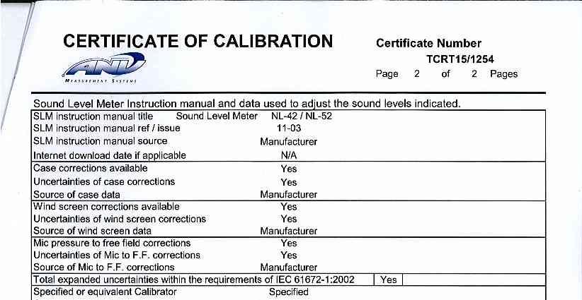
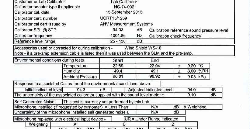
247
248 APPENDIX 11.3 Noise Monitoring Forms


249 Noise Monitoring Form Project: M2 / J5 Job Number: AIL-PTG Location: ML1 Equipment: NL-52 Engineer: Ben Saunders Pre-Calibration Level: 94.0 db General Weather Description: 10%CC / 1-2ms-1WS / 7deg Post-Calibration Level: 94.0 db Location: , Measurement Period Date Start / Stop Time Measurement Period Description of Audible Noise 10/03/ /03/ :10 12:10 24 hours Road noise from M2 dominant. Meter at 22m from the side of the road, 110 ML1 Unattended Results Leq Lmax L90 L Sound pressure level LA,F (dbre Pa) :10:00 14:10:00 16:10:00 18:10:00 20:10:00 22:10:00 0:10:00 2:10:00 4:10:00 6:10:00 8:10:00 10:10:00 Survey Period (10/03/16-11/03/16)


250 Noise Monitoring Form Project: M2 / J5 Job Number: AIL-PTG Monitoring Location ML2 Attended Equipment: NL-52 Pre-Calibration Level: 94.0 Post-Calibration Level: 94.0 Measurement Period Weather Engineer: General Weather Description: Location: Additional Comments: Statistical Noise Levels / db Ben Saunders 1-2ms-1 cc 10% , m to side of road Description of Audible Noise Date/Time Elapsed Minutes Wind Speed (m/s) Wind Direction (from) Temperature ( C) L Aeq L Amax L Amin L A10 L A90 10/03/ : E /03/ : E /03/ : E Road noise completely dominant. Occasional movement of lorries and cars in lay by.
 Weather Wind Direction (from) Temperature ( C) L Aeq L Amax L Amin L A10 L A90 11/03/2016 09:00 60.00 0-1 N 5 74.2 89.6 55.")

251 Noise Monitoring Form Project: M2 / J5 Job Number: AIL-PTG Monitoring Location ML3 Attended Equipment: NL-52 Pre-Calibration Level: 94.0 Post-Calibration Level: 94.0 Measurement Period Date/Time Elapsed Minutes Wind Speed (m/s) Weather Wind Direction (from) Temperature ( C) L Aeq L Amax L Amin L A10 L A90 11/03/ : N /03/ : N /03/ : N Engineer: Ben Saunders General Weather Description: 0-1ms-1 cc 10% Location: , m to side of road Additional Comments: Statistical Noise Levels / db Description of Audible Noise Road noise completely dominant. Occasional movement of vehicles along Honeycrock Hill
Grantham Southern Quadrant Link Road Environmental Statement
 Grantham Southern Quadrant Link Road Environmental Statement Non Technical Summary Introduction Lincolnshire County Council (LCC) is submitting a planning application for the proposed implementation of
Comments on the proposed scope are requested from WCC/NBBC officers to be provided to SLC Rail by 25 th March 2016 and sent to
 Introduction WCC have indicated that in advance of the surveys and assessments being undertaken consultation should be undertaken with technical officers of both Warwickshire CC and Nuneaton and Bedworth
Interim Advice Note 76 / 06 ASSESSMENT PART 1 AIMS AND OBJECTIVES OF ENVIRONMENTAL ASSESSMENT. Contents
 Interim Advice Note 76 / 06 VOLUME 11 SECTION 1: ENVIRONMENTAL ASSESSMENT INTRODUCTION PART 1 AIMS AND OBJECTIVES OF ENVIRONMENTAL ASSESSMENT Contents 1. Introduction and Application 2. Aims and Objectives
Strategic Environmental Assessment Screening Report. Dublin Port Masterplan Review 2017
 Strategic Environmental Assessment Screening Report Dublin Port Masterplan Review 2017 Table of Contents 1 Introduction... 1 2 Purpose of the Masterplan... 2 3 Task 1.1 Pre-Screening Check... 5 4 Task
University Park, Worcester Non Technical Summary December 2011
 University Park, Worcester Non Technical Summary December 2011 Introduction UW Wrenbridge LLP, a Joint Venture Company of the University of Worcester and Wrenbridge Land Ltd (the Applicants ) intend to
Sustainability Statement. Whitby Business Park Area Action Plan
 Sustainability Statement Whitby Business Park Area Action Plan November 2014 Contents Page 1. Introduction 1 2. Scoping 3 3. Sustainability Appraisal of Options 6 4. Assessment of Draft Area Action Plan
Longbridge Town Centre Phase 2 Planning Application
 Longbridge Town Centre Phase 2 Planning Application Non-Technical Summary of the Environmental Statement December 2013 Introduction A full application for Planning Permission has been submitted to Birmingham
Parish of Repton NEIGHBOURHOOD DEVELOPMENT PLAN
 Parish of Repton NEIGHBOURHOOD DEVELOPMENT PLAN BASIC CONDITIONS STATEMENT December 2018 CEF 4 Legal Requirements This statement has been produced by the NDP Working Group on behalf of Repton Parish Council
LAND SECURITIES REDEVELOPMENT OF NEWNHAM COURT SHOPPING VILLAGE, MAIDSTONE
 LAND SECURITIES REDEVELOPMENT OF NEWNHAM COURT SHOPPING VILLAGE, MAIDSTONE Land at Environmental Statement: Non-Technical Summary Introduction Land Securities plc is applying to Maidstone Borough Council
LONDON BRIDGE STATION ENVIRONMENTAL STATEMENT NON-TECHNICAL SUMMARY
 LONDON BRIDGE STATION ENVIRONMENTAL STATEMENT NON-TECHNICAL SUMMARY June 2011 1 EXECUTIVE SUMMARY 2 INTRODUCTION CONTENTS Page 2.1 Introduction 4 2.2 The Site 4 3 THE DEVELOPMENT 3.1 What is it? 5 3.2
11/04/2016. NPPF Paragraph 128. NPPF Paragraph 128. NPPF Paragraph 128. NPPF Paragraph 128. NPPF Paragraph 128
 Good practice in the preparation and understanding of NPPF-compliant heritage assessments/statements Stephen Bond, Heritage Places 1 NPPF Paragraphs 133-135 133: Where a proposed development will lead
volume 11 environmental assessment section 2 environmental impact assessment Part 7 ha 218/08
 DESIGN MANUAL FOR ROADS AND BRIDGES volume 11 environmental assessment section 2 environmental impact assessment Part 7 ha 218/08 glossary of terms Used in DMRB Volume 11, Sections 1 and 2 SUMMARY This
Ebbsfleet Development Corporation
 Title of Paper Planning and Housing Delivery Report September 2018 Presented by Sub-Committee Mark Pullin, Chief Planning Officer Planning Committee Purpose of Paper and Executive Summary This paper provides
Cotswolds AONB Landscape Strategy and Guidelines. June 2016
 Cotswolds AONB Landscape Strategy and Guidelines June 2016 Cotswolds AONB Landscape Strategy and Guidelines Introduction The evolution of the landscape of the Cotswolds AONB is a result of the interaction
A303 Stonehenge. Amesbury to Berwick Down Scheme Assessment Report Appendix D CSR and Policy Assessment. Volume 6
 A0 Stonehenge Amesbury to Berwick Down Scheme Assessment Report Appendix D CSR and Policy Assessment Volume 6 September 2017 Appendix D Client Scheme Requirements (CSRs) and Policy Assessment D.1 CSR Assessment
Replacement Golf Course Facilities and Residential Development, Churston. Environmental Statement Non-Technical Summary
 Replacement Golf Course Facilities and Residential Development, Churston Environmental Statement Non-Technical Summary July 2011 Reproduced from the Ordnance Survey s map with the permission of the Controller
Road Safety Impact Assessment
 Road Safety Impact Assessment October 2016 TRANSPORT INFRASTRUCTURE IRELAND (TII) PUBLICATIONS About TII Transport Infrastructure Ireland (TII) is responsible for managing and improving the country s national
CORRECTIONS WITHIN DESIGN MANUAL FOR ROADS AND BRIDGES AUGUST 2009
 DESIGN MANUAL FOR ROADS AND BRIDGES CORRECTIONS WITHIN DESIGN MANUAL FOR ROADS AND BRIDGES AUGUST 2009 SUMMARY OF CORRECTION HA 200/08 VOLUME 11, SECTION 1, PART 1 AIMS AND OBJECTIVES OF ENVIRONMENTAL
3. Neighbourhood Plans and Strategic Environmental Assessment
 1. Introduction This report sets out a draft Screening Determination for the Preston Parish Council s Neighbourhood Plan and has been prepared by rth Hertfordshire District Council. The purpose of the
WELCOME GYPSY LANE. Wider Site Location plan. Proposals for the development of LAND OFF FOXLYDIATE LANE WEBHEATH. Proposals for the development of
 WELCOME The developers are preparing an outline planning application for a residential led development and need the community s views in order to develop the proposals further WHAT IS PROPOSED? A high
Environmental Impact Assessment
 Environmental Impact Assessment Environmental impact assessment (EIA) is the process of systematically drawing together an assessment of the likely significant environmental effects of a development project.
Ipswich Issues and Options for the Ipswich Local Plan Review, August 2017, Public Consultation
 Ipswich Issues and Options for the Ipswich Local Plan Review, August 2017, Public Consultation Having reviewed the issues and options documents, the Society has made the following response: Part 1 Strategic
ROCHFORD LOCAL DEVELOPMENT FRAMEWORK: Sustainability Appraisal/ Strategic Environmental Assessment. Rochford Core Strategy Preferred Options Document
 ROCHFORD LOCAL DEVELOPMENT FRAMEWORK: Sustainability Appraisal/ Strategic Environmental Assessment Non Technical Summary Rochford Core Strategy Preferred Options Document October 2008 SUSTAINABILITY APPRAISAL
7 Scoping and Introduction to the Assessments
 7 Scoping and Introduction to the Assessments 7.1 Scope of the assessments 7.1.1 Rule 8 of the TWR makes provision for an applicant to request a scoping opinion from the SoS indicating the information
Plumpton Neighbourhood Development Plan Revised Pre Submission Document - Regulation 14 Consultation
 REPRESENTATIONS... Plumpton Parish Council Plumpton Neighbourhood Development Plan Revised Pre Submission Document - Regulation 14 Consultation Representations submitted on behalf of: Cala Homes (South
BREEDON NORTHERN LIMITED
 Non Technical Summary CONTENTS 1 INTRODUCTION... 1 2 SITE DESCRIPTION... 1 3 DESCRIPTION OF THE DEVELOPMENT... 6 4 NEED FOR THE DEVELOPMENT... 8 5 KEY ISSUES CONSIDERED IN THE ENVIRONMENTAL IMPACT ASSESSMENT...
Moat Lane Regeneration Project Environmental Statement
 AECOM Environment Towcester Regeneration Ltd. October 2012 Moat Lane Regeneration Project Environmental Statement Non-Technical Summary Prepared by:... Checked by:... Sophie Collins Scott Wilson Environmental
17A. Wind Microclimate
 17A. Wind Microclimate 17A.1 Introduction 17A.1.1 17A.1.2 17A.1.3 17A.1.4 This Chapter, which has been prepared by Waterman and BMT, provides further information with regard to the potential wind microclimate
Town and Country Planning (Environmental Impact Assessment Regulations) 2011 SCOPING OPINION
 2011 SCOPING OPINION") Town and Country Planning (Environmental Impact Assessment Regulations) 2011 SCOPING OPINION Application Site and Description of Development Proposed new quarry at Culham, Oxfordshire Land and Mineral
Town and Country Planning (Environmental Impact Assessment Regulations) 2011 SCOPING OPINION Application Site and Description of Development Proposed new quarry at Culham, Oxfordshire Land and Mineral
7. The Landscape. 7.1 Introduction. Environmental Impact Statement (EIS) Scoping Report
 Scoping Report") 7. The Landscape 7.1 Introduction The purpose of this section of the EIS Scoping Report is to describe the scope of work and methods to be applied in the identification and assessment of landscape and
7. The Landscape 7.1 Introduction The purpose of this section of the EIS Scoping Report is to describe the scope of work and methods to be applied in the identification and assessment of landscape and
9 Archaeology & Cultural Heritage
 High Clachaig Wind Farm Scoping Report Page 56 9 Archaeology & Cultural Heritage 9.1 Introduction Cultural heritage in this context means the above- and below-ground archaeological resources, built heritage,
Babergh and Mid Suffolk Joint Draft Local Plan Consultation, August 2017, Public Consultation
 Babergh and Mid Suffolk Joint Draft Local Plan Consultation, August 2017, Public Consultation Having reviewed the documents, the Society has made the following response: Housing Delivery Q 7. Do you agree
2.4 Site Photographs. 4 View of Listed Building looking East. 3 View looking north west of the field adjacent to the site from existing hard standing
 Looking north on to from the junction to 2 View towards the entrance of from 3 View of southern access to site from Riddles Road 4 3 2 4 Looking west on to from southern access to site View of Grade II
LAND AT HOWES LANE, BICESTER ENVIRONMENTAL STATEMENT NON-TECHNICAL SUMMARY. March 2017 Our Ref: Q70433
 LAND AT HOWES LANE, BICESTER ENVIRONMENTAL STATEMENT NON-TECHNICAL SUMMARY March 2017 Our Ref: Q70433 Contents 1 INTRODUCTION AND SITE DESCRIPTION... 1 2 EIA METHODOLOGY... 5 3 ALTERNATIVES... 6 4 DESCRIPTION
M4 Corridor around Newport Environmental Statement Volume 3: Appendices
 Environmental Statement Volume 3: Appendices Environmental Statement Volume 3: Appendices At Issue March 2016 CVJV/AAR 3 rd Floor Longross Court, 47 Newport Road, Cardiff CF24 0AD Volume 3: Contents 1
Chapter 4. Route Window C12: Mile End Park and Eleanor Street Shafts
 Chapter 4 Route Window C12: Mile End Park and Eleanor Street Shafts 48 Crossrail Amendment of Provisions 4 Route Window C12: Mile End Park and Eleanor Street Shafts Location plan of Mile End Park and Eleanor
Suffolk Coastal Local Plan Review Issues and Options, August 2017, Public Consultation
 Suffolk Coastal Local Plan Review Issues and Options, August 2017, Public Consultation Having reviewed the issues and options documents, the Society has made the following response: Part 1 - Strategic
Site Assessment Technical Document Appendix A: Glossary
 Central Bedfordshire Council www.centralbedfordshire.gov.uk Site Assessment Technical Document Appendix A: Glossary July 2017 1.1.11-1 - ii Appendix A: Glossary Term Agricultural Land Classification AONB
Great Easton Neighbourhood Plan Statement of Basic Conditions
 Great Easton Neighbourhood Plan 2017-2031 Statement of Basic Conditions OCTOBER 2016 GREAT EASTON PARISH COUNCIL Contents 1.0 Introduction....Page 2 2.0 Summary of Submission Documents and Supporting Evidence..
A38 Derby Junctions. Preliminary Environmental Information Report: Non-Technical Summary
 Preliminary Environmental Information Report: Preliminary Environmental Information Report Report No: P01 S4 September 2018 Table of contents Introduction... 1 The proposed scheme... 2 Scheme details...
LAND AT MIDDLETON STONEY ROAD AND HOWES LANE, BICESTER ENVIRONMENTAL STATEMENT NON-TECHNICAL SUMMARY. June 2017 Our Ref: Q70433
 LAND AT MIDDLETON STONEY ROAD AND HOWES LANE, BICESTER ENVIRONMENTAL STATEMENT NON-TECHNICAL SUMMARY June 2017 Our Ref: Q70433 Contents 1 INTRODUCTION... 2 2 SITE DESCRIPTION... 5 3 EIA METHODOLOGY...
Cardiff International Sports Village Waterfront Development Volume IV : Non-Technical Summary of the Environmental Statement
 Greenbank Partnerships Ltd October 2012 Cardiff International Sports Village Waterfront Development Volume IV : Non-Technical Summary of the Environmental Statement Environmental Statement - Non Technical
Thank you for coming. We want to hear your views on proposed improvements to the A1 between junction 65 (Birtley) and junction 67 (Coal House).
 and junction 67 (Coal House).") Welcome Thank you for coming. We want to hear your views on proposed improvements to the between junction 65 (Birtley) and junction 67 (Coal House). This is your opportunity to provide comments on our
Welcome Thank you for coming. We want to hear your views on proposed improvements to the between junction 65 (Birtley) and junction 67 (Coal House). This is your opportunity to provide comments on our
DEVELOPMENT MANAGEMENT REPORT
 ITEM A08-1 DEVELOPMENT MANAGEMENT REPORT TO: BY: DATE: DEVELOPMENT: SITE: WARD: APPLICATION: APPLICANT: Development Management Committee Development Manager Proposed live/work unit in connection with existing
South Macclesfield Development Area, Phase 1 Environmental Statement Non- Technical Summary. For Engine of the North
 South Macclesfield Development Area, Phase 1 Environmental Statement Non- Technical Summary For Engine of the North April 2015 Contents Contents 3 1 Introduction 1 2 The Proposals 5 3 Alternative Options
Cranbrook EXPANSION ENVIRONMENTAL STATEMENT: NON-TECHNICAL SUMMARY PRODUCED BY DAVID LOCK ASSOCIATES
 Cranbrook EXPANSION ENVIRONMENTAL STATEMENT: NON-TECHNICAL SUMMARY PRODUCED BY DECEMBER 2014 CRANBROOK EXPANSION AREAS ENVIRONMENTAL STATEMENT NON TECHNICAL SUMMARY Submitted in support of Outline Planning
Kier Infrastructure and Overseas Limited Greenburn Surface Mine, Dalgig Farm Site
 Kier Infrastructure and Overseas Limited Greenburn Surface Mine, Dalgig Farm Site Planning application pursuant to s.42 Town and Country Planning (Scotland) Act 1997 to amend the restoration scheme Volume
Statement of Community Involvement LAND OFF SOUTHDOWN ROAD HORNDEAN, HAMPSHIRE
 LAND OFF SOUTHDOWN ROAD HORNDEAN, HAMPSHIRE CONTENTS Page 1. Introduction 3 2. Pre-application Discussions 4 3. The Consultation Process 5 4. Consultation Feedback 7 5. Responses to Consultation Feedback
Schedule of Planning Applications Committee Date: 23 May Reference: 06/17/0726/F Parish: Hemsby Officer: Mr J Beck Expiry Date:
 Schedule of Planning Applications Committee Date: 23 May 2018 Reference: 06/17/0726/F Parish: Hemsby Officer: Mr J Beck Expiry Date: 22-05-2018 Applicant: Proposal: Site: Mr Gillett Change of use to the
ABBEY MANOR GROUP/SAINSBURY S SUPERMARKETS LTD
 ABBEY MANOR GROUP/SAINSBURY S SUPERMARKETS LTD Mixed Use Development including Business Park and Foodstore Land at Bunford Park, Bunford Lane, Yeovil Environmental Statement: Non-Technical Report June
CA//17/02777/FUL. Scale 1:1,250. Planning Services Canterbury City Council Military Road Canterbury Kent CT1 1YW
 O CA//17/02777/FUL Scale 1:1,250 Map Dated: 15/03/2018 Planning Services Canterbury City Council Military Road Canterbury Kent CT1 1YW AGENDA ITEM NO 16 PLANNING COMMITTEE APPLICATION NUMBER: SITE LOCATION:
Kibworth Harcourt. Introduction. Introduction
 Introduction Introduction Welcome to this public exhibition on the proposals for the delivery of new homes on land at The Kibworths. The purpose of today s exhibition is to give you the opportunity to
What now for home building?
 Successful Partners DELIVERING QUALITY 2017 Residential Seminar What now for home building? The post Brexit world May 2017 Successful Partners DELIVERING QUALITY 2017 Residential Seminar 30 March 2017
The Town and Country Planning (Environmental Impact Assessment) (Wales) Regulations 2016, Regulation 13 Scoping Opinion
 (Wales) Regulations 2016, Regulation 13 Scoping Opinion") Mr Graham Clark Berrys Newchurch Farm Kinnersley Hereford HR3 6QQ BY EMAIL The Town and Country Planning (Environmental Impact Assessment) (Wales) Regulations 2016, Regulation 13 Scoping Opinion SC/2017/0001
Mr Graham Clark Berrys Newchurch Farm Kinnersley Hereford HR3 6QQ BY EMAIL The Town and Country Planning (Environmental Impact Assessment) (Wales) Regulations 2016, Regulation 13 Scoping Opinion SC/2017/0001
Copyright Nigel Deeley and licensed for reuse under this Creative Commons Licence
 1 Copyright Nigel Deeley and licensed for reuse under this Creative Commons Licence Prepared by the Neighbourhood Plan Steering Group on behalf of Garway Parish Council with assistance from 2 Table of
DEFGH. Crystal Place Park. Environmental Impact Assessment (EIA) Elin Thomas and Emily Low Waterman Environmental
 Elin Thomas and Emily Low Waterman Environmental") DEFGH Crystal Place Park Environmental Impact Assessment (EIA) Elin Thomas and Emily Low Waterman Environmental 10.12.07 EIA Presentation Content What is EIA? Legal Requirements Process Q&A Key Topics
DEFGH Crystal Place Park Environmental Impact Assessment (EIA) Elin Thomas and Emily Low Waterman Environmental 10.12.07 EIA Presentation Content What is EIA? Legal Requirements Process Q&A Key Topics
Perth and Kinross Council Development Management Committee 8 June Pre-Application Report by Development Quality Manager
 Perth and Kinross Council Development Management Committee 8 June 2016 5(3)(i) 16/259 Pre-Application Report by Development Quality Manager Residential development at St Martins Road, Land 120 metres West
Development in the setting of the Cotswolds AONB
 COTSWOLDS CONSERVATION BOARD POSITION STATEMENT Development in the setting of the Cotswolds AONB.1. Introduction Areas of Outstanding Natural Beauty (AONBs) are designated by the Government for the purpose
MAIDSTONE MEDICAL CAMPUS LTD LAND AT NEWNHAM PARK, MAIDSTONE
 MAIDSTONE MEDICAL CAMPUS LTD LAND AT NEWNHAM PARK, MAIDSTONE Land at Environmental Statement: Non-Technical Summary Introduction Maidstone Medical Campus Ltd is applying to Maidstone Borough Council for
London Road, Derker. Non Technical Summary. Introduction
 London Road, Derker Non Technical Summary Introduction The Oldham Rochdale Housing Market Pathfinder was set up to tackle longstanding problems of poor quality housing and to provide the framework for
Welcome to our exhibition
 Welcome to our exhibition housing development A46 Wildmoor Alcester Road Canal Quarter A422 Town Centre housing development Warwickshire-based IM Properties, one of the UK s largest privately owned property
Public Consultation. Land at Monks Farm, North Grove. Welcome
 Welcome Welcome to our public exhibition for development on Land at Monks Farm, orth Grove. Gallagher Estates and Gleeson Strategic Land are preparing an outline planning application for new homes, open
Planning and Sustainability Statement
 Land adjacent to Manor Farm, Catterick Village Pallett Hill Sand and Gravel Co Ltd Proposed 10 new dwellings, (6 No market dwellings and 4 No affordable dwellings) with access, associated car parking and
Environmental Statement (Volume 1) Non Technical Summary
 Non Technical Summary") Environmental Statement (Volume 1) Non Technical Summary Prepared by: The Environment Partnership Haydock Point Environmental Statement (Volume 1): Non-Technical Summary March 2017 Contents 1. Introduction
Environmental Statement (Volume 1) Non Technical Summary Prepared by: The Environment Partnership Haydock Point Environmental Statement (Volume 1): Non-Technical Summary March 2017 Contents 1. Introduction
GUILDFORD BOROUGH GREEN BELT AND COUNTRYSIDE STUDY
 GUILDFORD BOROUGH GREEN BELT AND COUNTRYSIDE STUDY Volume II - Addendum On behalf of Guildford Borough Council PPG Ref : BNL.0287 April 2014 COPYRIGHT The conents of this document must not be copied or
HS2 Hybrid Bill Petitioning. Summary of SMBC Asks 23/09/13. Background
 Summary of SMBC Asks 23/09/13 Background The Council has a developed a significant number of asks and propositions for consideration by HS2 Ltd and Government throughout further development of the HS2
Peter Brett Associates LLP (PBA) act on behalf of db symmetry ltd in respect of the proposed symmetry park, Kettering development (the Site).
 act on behalf of db symmetry ltd in respect of the proposed symmetry park, Kettering development (the Site).") Our ref: 30062 2 nd August 2017 Kettering Borough Council Planning Department Municipal Offices Bowling Green Rd Kettering NN15 7QX 61 Oxford Street Manchester M1 6EQ T: +44 (0)161 245 8900 E: manchester@peterbrett.com
Our ref: 30062 2 nd August 2017 Kettering Borough Council Planning Department Municipal Offices Bowling Green Rd Kettering NN15 7QX 61 Oxford Street Manchester M1 6EQ T: +44 (0)161 245 8900 E: manchester@peterbrett.com
ROCKEFELLER UNIVERSITY
 ROCKEFELLER UNIVERSITY NEW RIVER BUILDING AND FITNESS CENTER Draft Environmental Impact Statement CEQR No. : 14DCP019M Lead Agency: New York City Department of City Planning Prepared By: AKRF, Inc. November
BRE Strategic Ecological Framework LI Technical Information Note 03/2016
 BRE Strategic Ecological Framework Technical Information Note 03/2016 September 2016 Contents 1. Introduction 2. Aims of BRE s Strategic Ecological Framework 3. How SEF is different from previous approaches
VALLEY PARK, DIDCOT. Non-Technical Summary. December On behalf of Taylor Wimpey UK Limited, Persimmon Homes and Hallam Land Management Ltd.
 VALLEY PARK, DIDCOT Non-Technical Summary December 2014 On behalf of Taylor Wimpey UK Limited, Persimmon Homes and Hallam Land Management Ltd. CONTENTS 1 Introduction... 2 2 The Proposed Development...
South Macclesfield Development Area Environmental Statement Non-Technical Summary March 2017
 South Macclesfield Development Area Environmental Statement March 2017 Contents 1.0 Introduction... 2 1.1 Background... 2 1.2 Environmental Assessment... 2 1.3 Site Description... 2 2.0 The Proposals...
The Place Solar Farm
 The Place Solar Farm Environmental Statement Non-Technical Summary 28 August 2014 Produced for Prepared by St John s House Queen Street, Manchester M2 5JB Contents Contents... 2 1 Introduction... 3 1.1
Definition of Cumulative Landscape and Visual Effects
 SECTION 5: GUIDANCE FOR ASSESSING CUMULATIVE LANDSCAPE AND VISUAL EFFECTS 5.1 Although this landscape sensitivity and capacity study has identified that parts of the National Park may be able to accommodate
College Green Project Environmental Impact Assessment Report
 Environmental Impact Assessment Report October 2017 Table of Contents EIS Non-Technical Summary 1. Introduction 2. Background to the Project and Alternatives Considered 3. Consultation 4. Proposed Project
Statutory and Non-Statutory Designated Sites and Ecology
 Statutory and Non-Statutory Designated Sites and Ecology The National Planning Policy Framework considers the conservation and enhancement of the natural environment in chapter 11 paragraphs 109-119, where
Response by The Dartington Hall Trust
 Consultation Response by The Dartington Hall Trust Site Reference: SH_39_02_08/13 Contents Introduction 1 Site Description 2 Development Proposal and Context 3 Site Technical Assessment 4 Planning Policy
Land at BROOK STREET PROPERTIES TENCREEK FARM, LISKEARD. Environmental Statement: Non-Technical Summary
 BROOK STREET PROPERTIES TENCREEK FARM, LISKEARD Land at Environmental Statement: Non-Technical Summary Introduction Brook Street Properties is applying to Cornwall Council for outline planning permission
Assessing the impact of smallscale wind energy proposals on the natural heritage
 Scottish Natural Heritage Assessing the impact of smallscale wind energy proposals on the natural heritage Guidance March 2016 Version 3 1 Contents 1. Introduction. 3 2. Encouraging a spatial approach
My role and specialisms. Worked at spawforths for nearly 13 years. Worked on EIA projects for approx. 10 years and had co-ordinator role for approx.
 My role and specialisms. Worked at spawforths for nearly 13 years. Worked on EIA projects for approx. 10 years and had co-ordinator role for approx. 9 years. Lead EIA activities in the company. The majority
WALES ONLY INTERIM ADVICE NOTE 135/10 (W) LANDSCAPE AND VISUAL EFFECTS ASSESSMENT
 LANDSCAPE AND VISUAL EFFECTS ASSESSMENT") Interim Advice Note 135/10 (W) Landscape and Visual Effects Assessment INTERIM ADVICE NOTE 135/10 (W) LANDSCAPE AND VISUAL EFFECTS ASSESSMENT WALES ONLY Summary This Interim Advice Note provides instructions
Interim Advice Note 135/10 (W) Landscape and Visual Effects Assessment INTERIM ADVICE NOTE 135/10 (W) LANDSCAPE AND VISUAL EFFECTS ASSESSMENT WALES ONLY Summary This Interim Advice Note provides instructions
Chapter 27 Route Window SE7 Church Manorway Bridge. Transport for London
 Chapter 27 Route Window SE7 Church Manorway Bridge Transport for London CHURCH MANORWAY BRIDGE 27 Route Window SE7 Church Manorway bridge Introduction 27.1 The North Kent Line will be converted to four
Newcourt Masterplan. November Exeter Local Development Framework
 Newcourt Masterplan November 2010 Exeter Local Development Framework Background The Exeter Core Strategy Proposed Submission sets out the vision, objectives and strategy for the development of Exeter up
Neighbourhood Planning Site Assessment Pro-forma and Guide Version 2
 Neighbourhood Planning Site Assessment Pro-forma and Guide Version 2 September 2014 Site HNP 006 Land East of Stanbridge Road and North of Lower Road 1. Background information Site location and use Site
Barvills Solar Farm Environmental Statement Non-Technical Summary
 Barvills Solar Farm Environmental Statement Non-Technical Summary 13 March 2015 Produced for Prepared by St John s House Queen Street, Manchester M2 5JB Contents Contents... 2 1 Introduction... 3 1.1 Development
Habitat Regulations Assessment (HRA) Screening Determination. May 2017
 Screening Determination. May 2017") Cholsey Parish Council Cholsey Neighbourhood Plan Habitat Regulations Assessment (HRA) Screening Determination May 2017 Cholsey Neighbourhood Plan Page! 1 of! 10 SASR - HRA v1.1 Page Left Intentionally
Cholsey Parish Council Cholsey Neighbourhood Plan Habitat Regulations Assessment (HRA) Screening Determination May 2017 Cholsey Neighbourhood Plan Page! 1 of! 10 SASR - HRA v1.1 Page Left Intentionally
INTERIM ADVICE NOTE 143/11
 INTERIM ADVICE NOTE 43/ Supplementary Advice and requirements for the Accessibility during planning, design, construction and handover of Improvement Schemes Summary This document provides additional advice
LONGDEN VILLAGE DEVELOPMENT STATEMENT
 LONGDEN VILLAGE DEVELOPMENT STATEMENT 2017-2027 1 Longden Development Statement 2017-2027 15/01/18 1. Background 1.1 Longden Village Longden village is a very rural and traditional community first mentioned
LAND AT WEST YELLAND. Environmental Statement Non-Technical Summary Welbeck Strategic Land LLP
 LAND AT WEST YELLAND Environmental Statement Non-Technical Summary Welbeck Strategic Land LLP May 2014 Quality Management Issue/revision Issue 1 Revision 1 Revision 2 Revision 3 Remarks Draft FINAL Date
METHODOLOGY FOR IMPACT ASSESSMENT ON HERITAGE ASSETS IDENTIFICATION OF THE RECEPTOR ASSESSMENT OF THE RECEPTOR S IMPORTANCE
 METHODOLOGY FOR IMPACT ASSESSMENT ON HERITAGE ASSETS The determination of impacts on heritage assets follows the standard procedures applied to all Environmental Impact Assessment. This entails the identification
Circular L8/08 2 September Water Services Investment and Rural Water Programmes Protection of Natural Heritage and National Monuments
 Circular L8/08 2 September 2008 Water Services Investment and Rural Water Programmes Protection of Natural Heritage and National Monuments 1. The purpose of this Circular is to provide local authorities
DRAFT STRATEGIC ENVIRONMENTAL ASSESSMENT REPORT
 DRAFT STRATEGIC ENVIRONMENTAL ASSESSMENT REPORT Published by Limpsfield Parish Council in accordance with EU Directive 2001/42 on Strategic Environmental Assessment and with the Environmental Assessment
STATEMENT OF OBJECTION TO THE PROPOSED DEVELOPMENT OF LAND AT CHURCH CLIFF DRIVE FILEY
 STATEMENT OF OBJECTION TO THE PROPOSED DEVELOPMENT OF LAND AT CHURCH CLIFF DRIVE FILEY You will be aware that Scarborough borough council have adopted a new local plan that includes land at Church Cliff
National Policy Statement for National Networks (NPSNN), (Dept for Transport, Dec 2014)
, (Dept for Transport, Dec 2014)") 11 EXTERNAL LIGHTING 11.1 INTRODUCTION 11.1.1 This chapter sets out the approach to assessing any likely significant effects of the Proposed Development in terms of external lighting. It describes the
11 EXTERNAL LIGHTING 11.1 INTRODUCTION 11.1.1 This chapter sets out the approach to assessing any likely significant effects of the Proposed Development in terms of external lighting. It describes the
i.6 Under this Key Area of Change the Daresbury Strategic Site will deliver:
 I.0 NON-TECHNICAL SUMMARY Introduction i.1 Redrow Homes NW Ltd is applying to Halton Borough Council for planning permission for the development of up to 300 high quality residential dwellings, including
WOKING DESIGN SUPPLEMENTARY PLANNING DOCUMENT (SPD)
") Agenda Item No. 5 EECUTIVE - 15 JANUARY 2015 Executive Summary WOKING DESIGN SUPPLEMENTARY PLANNING DOCUMENT (SPD) The report outlines the various responses to the consultation on the Design Supplementary
Agenda Item No. 5 EECUTIVE - 15 JANUARY 2015 Executive Summary WOKING DESIGN SUPPLEMENTARY PLANNING DOCUMENT (SPD) The report outlines the various responses to the consultation on the Design Supplementary
11. ISLINGTON ROUTE SECTION ENVIRONMENTAL BASELINE AND ASSESSMENT OF IMPACTS OVERVIEW OF ISLINGTON ROUTE SECTION... 2
 11. ISLINGTON ROUTE SECTION ENVIRONMENTAL BASELINE AND ASSESSMENT OF IMPACTS... 2 11.1 OVERVIEW OF ISLINGTON ROUTE SECTION... 2 11.2 POLICIES RELEVANT TO ALL WORKSITES IN ISLINGTON... 3 11.3 FARRINGDON
Preferred route announcement M25 junction 10/A3 Wisley interchange Improvement scheme
 Preferred route announcement M25 junction 10/A3 Wisley interchange Improvement scheme Winter 2017 Introduction This section of the M25 is of nationally-strategic importance, as it provides vital access
Former RAF Sealand Site EIA
 Praxis (Holdings) Ltd. Former RAF Sealand Site EIA Environmental Statement - Non Technical Summary February 2012 in association with P a g e 1 1. Introduction Praxis (Holdings) Ltd. is applying to Flintshire
Watford Local Plan Part 2 Publication Stage Environmental Report. Appendix 3: Consultation Comments
 Watford Local Plan Part 2 Publication Stage Environmental Report Appendix 3: Consultation Comments August 2016 Appendix 3 - Responses to Consultation of the Local Plan Part 2 As required by the SEA Directive,
Settlement Boundaries Methodology North Northumberland Coast Neighbourhood Plan (August 2016)
") Introduction This background paper sets out a methodology for the definition of settlement boundaries in the North Northumberland Coast Neighbourhood Plan. The neighbourhood plan is planning positively
Introduction This background paper sets out a methodology for the definition of settlement boundaries in the North Northumberland Coast Neighbourhood Plan. The neighbourhood plan is planning positively