FARGO-MOORHEAD METRO AREA FLOOD RISK MANAGEMENT PROJECT CEMETERY MITIGATION PLAN. U.S. Army Corps of Engineers, St Paul District
|
|
|
- Lillian Briggs
- 6 years ago
- Views:
Transcription

1 FARGO-MOORHEAD METRO AREA U.S. Army Corps of Engineers St. Paul District FLOOD RISK MANAGEMENT PROJECT CEMETERY MITIGATION PLAN U.S. Army Corps of Engineers, St Paul District Draft Report June 2015
2 Page intentionally left blank
3 Table of Contents EXECUTIVE SUMMARY INTRODUCTION Briefings, September 2013 to Present Cemetery Study, September 2013 June 2014 (Reference the Cemetery Study dated June 2014 included herein as Attachment 2, Appendix A) Upstream Cemetery Authority Formed Cemetery Site Visits, July and September Cultural Surveys and Rights of Entry, August 2014 to Present Cemetery Mitigation Study, August 2014 to Present (See Attachment 2) Addressing Specific Issues/Concerns: State Regulations and Guidance IMPACTED CEMETERIES SITE SPECIFIC ANALYSES Lower Wild Rice and Red River Cemetery Cass County, ND North Pleasant Cemetery Cass County, ND Hemnes Cemetery Richland County, ND South Pleasant/Lium Cemetery Richland County, ND South Pleasant Church Cemetery Richland County, ND Eagle Valley Evangelical Cemetery Richland County, ND Hoff Cemetery Clay County, MN Clara Cemetery Clay County, MN Comstock Cemetery Clay County, MN Roen Family Cemetery Clay County, MN Wolverton/Salem Lutheran Cemetery Wilkin County, MN CONCLUSIONS Summary of Impacts Due to Increased Depth, Duration, and Frequency of Flooding Mitigation for Cemeteries from a Section 106 Perspective Mitigation Plan Federal Mitigation Plan Non-federal Sponsors i
4 Table of Contents Attachment 1 Correspondence and Briefings Attachment 2 Cemetery Mitigation Study (HMG) List of Tables Table 1 Estimated Cost Per Site ($1,000)... 8 Table 2. Table from LWRRR Cemetery map sheet in Cemetery Study Report Table 3 Table from North Pleasant Cemetery map sheet in Cemetery Study Report Table 4 Table from Hemnes Cemetery map sheet in Cemetery Study Report Table 5. Table from South Pleasant Cemetery map sheet in Cemetery Study Report Table 6. Table from South Pleasant Church Cemetery map sheet in Cemetery Study Report Table 7. Table from Eagle Valley Evangelical Cemetery map sheet in Cemetery Study Report Table 8. Table from Hoff Cemetery map sheet in Cemetery Study Report Table 9. Table from Clara Cemetery map sheet in Cemetery Study Report Table 10. Table from Comstock Cemetery map sheet in Cemetery Study Report Table 11. Table from Roen Family Cemetery map sheet in Cemetery Study Report Table 12. Table from Wolverton Cemetery map sheet in Cemetery Study Report Table 13. Cemetery Mitigation Study Summary. 49 List of Figures Figure 1. Contours of pond north of Lower Wild Rice and Red River Cemetery (1 photo) Figure 2. Photos of Lower Wild Rice and Red River Cemetery (3) Figure 3 Photos of North Pleasant Cemetery (3) Figure 4 Photos of Hemnes Cemetery (4) Figure 5 Photos of South Pleasant (Lium) Cemetery (2) Figure 6. Photos of South Pleasant Church Cemetery (2) Figure 7. Photos of Eagle Valley Evangelical Cemetery (3) Figure 8. Photos of Hoff Cemetery (2) Figure 9. Photos of Clara Cemetery (2) Figure 10. Photos of Comstock Cemetery (2) Figure 11. Photo of Roen Family Cemetery (1) Figure 12. Photos of Wolverton Cemetery (2) ii
5 EXECUTIVE SUMMARY The Final Feasibility Report and Environmental Impact Statement for the Fargo-Moorhead Metropolitan Area Flood Risk Management Project (Project), finalized in 2011, stated that the cemeteries in the upstream staging area that would be impacted by the Project would be evaluated on a case by case basis. After the Supplemental Environmental Assessment for the Project was finalized in September 2013, information was gathered on cemeteries in the region to get a better understanding of potential Project impacts, to identify potential mitigation measures that could be used to offset Project impacts, and to form a general understanding of flooding issues associated with regional cemeteries. A Cemetery Assessment Team was formed and consisted of members from the Corps of Engineers and the non-federal sponsors and included geotechnical, hydraulic, civil site layout and county/city engineers, an archaeologist, a biologist/forestry specialist, and project managers. An effort was made to identify all cemeteries located within areas benefitted and impacted by the Project and to determine their points of contact in order to visit, photograph, and analyze the cemeteries. Twenty-eight of the 54 cemeteries identified for the region are located within the benefitted area. Eleven of the cemeteries are located upstream of the Project s diversion and connecting channels and would potentially be impacted by Project operation. Seven of the 11 potentially-impacted cemeteries are located within the Project s designated Staging Area (Lower Wild Rice and Red River Cemetery and North Pleasant Cemetery in Cass County, ND; Hemnes Cemetery in Richland County, ND; Hoff Cemetery, Clara Cemetery, Comstock Cemetery, and Roen Family Cemetery in Clay County, MN). The other four cemeteries are located outside and upstream of the Staging Area (South Pleasant/Lium Cemetery, South Pleasant Church Cemetery, and Eagle Valley Evangelical Cemetery in Richland County, ND; and Wolverton/Salem Lutheran Cemetery in Wilkin County, MN). On July 2014, the Cemetery Assessment Team visited 10 of the 11 cemeteries, with the eleventh cemetery being visited on 3 September The purpose of the site visits was to identify any additional information that would inform the pending development/analysis of mitigation alternatives. Others in attendance at these site visits included concerned families/citizens, church board members, caretakers and volunteers, MnDak Upstream Coalition members, Upstream Cemetery Authority members, and Diversion Authority representatives. Permission to enter the cemetery site was not always granted and discussions/interviews were then conducted from the adjacent public right-of-way. Past flood impacts to these cemeteries, clean-up efforts after previous floods, and possible measures for mitigating potential impacts from the Project were also discussed. Mitigation options mentioned included construction of an earthen ring berm around the entire cemetery and/or in other strategic areas, anchoring headstones, armoring areas susceptible to erosion, raising low portions of a cemetery with fill after removal and subsequent replacement of headstones, installing protective fencing around a cemetery as a debris barrier, flowage easements, and cemetery relocation. Other issues/concerns raised at these visits included grave buoyancy/eruption, grave and cemetery relocation, interior drainage if a ring berm is constructed, and raising roads to provide/maintain access to the cemetery. In order to comply with Section 106 of the National Historic Preservation Act, as amended, the eleven cemeteries that may be potentially impacted by the Project require Phase I cultural resource surveys 1
6 (phase I surveys hereafter) in order to record the features within them and to evaluate the cemeteries for eligibility for listing in the National Register of Historic Places (National Register). The surveys must be completed prior to implementing any mitigation. Phase I surveys have been completed at the Hemnes, Lower Wild Rice and Red River, Wolverton/Salem Lutheran, Hoff, Clara, Comstock, and South Pleasant/Lium cemeteries. The North Dakota SHPO has concurred with Hemnes and Lower Wild Rice and Red River cemeteries being eligible to the National Register. Clara Cemetery has been recommended as eligible. Wolverton/Salem Lutheran, Hoff, and Comstock cemeteries have been recommended as not eligible to the National Register. Recordation of South Pleasant/Lium Cemetery is in progress. Rights-of-entry have not been received for North Pleasant Cemetery, South Pleasant Church Cemetery, Eagle Valley Evangelical Cemetery, and Roen Family Cemetery. Therefore, the surveys for those cemeteries have not commenced. Starting in August 2014, a Cemetery Mitigation Study was conducted to analyze mitigation alternatives for each of the 11 potentially impacted cemetery sites. Site specific analysis of mitigation alternatives formulated for each cemetery considered the existing site conditions, the impacts of staged water due to the Project at the site, and the overall feasibility of the plan. Depending on the cemetery and the flood event, operation of the Project may result in increases in the water surface elevation and/or the duration of flooding at the cemetery. Impacts from the additional flooding may include damage from ice or debris, sediment or debris deposition, and the inability to access the cemetery. The water surface elevation and duration of flooding were evaluated for existing and with-project conditions for the 10- year, 50-year, 100-year and 500-year events. A cost estimate for each mitigation alternative for each cemetery was developed. Mitigation for impacts to the cemeteries is not required by the Fifth Amendment of the U.S. Constitution because there is no taking. None of the induced flooding would be more frequent than approximately once every ten years, nine of the 11 cemeteries would not have induced flooding at even the 10-year event, and the two cemeteries with induced flooding at the 10-year event would suffer only very minor additional flooding. In the past, flooding has caused only minimal damage to cemeteries in the area, and the induced flooding from the Project is likely to also cause only minor damage. In addition, any flood mitigation measure that involves physically altering the cemetery site, such as by adding a ring levee or fence, may adversely affect the historical integrity of the site and affect the visual and spiritual experiences of individuals with links to the cemetery. The Federal mitigation plan consists of requiring the Non-federal Sponsors to obtain flowage easements for the cemeteries within the staging area, as is required for other properties in the staging area for operation of the Project. Normal cemetery operations including burials and operation and maintenance activities will not be restricted by the flowage easement. No Federal mitigation is required for cemeteries located outside the staging area. In addition to obtaining flowage easements, the Non-federal Sponsors as part of the Project Operation and Maintenance (O&M) Plan, can clean-up or offer assistance to clean-up the staging area (cemeteries, roads, ditches, fields, etc.) after operation of the Project. The details for this work have yet to be established. Options for clean-up of the staging area include: Non-federal Sponsors or their contractors 2
7 conducting clean-up operations on public and private land (where rights of entry have been granted), private landowners (including cemeteries) cleaning-up debris on their property and stockpiling it on public rights of way for Non-federal Sponsors or their contractors to collect and dispose, or reimbursement of clean-up costs by private land owners by the Non-federal Sponsors. 3
8 CEMETERY MITIGATION PLAN 1 INTRODUCTION The Final Feasibility Report and Environmental Impact Statement (FEIS) for the Fargo-Moorhead Metropolitan Area Flood Risk Management Project (Project), stated that the cemeteries in the staging area of the Project would be evaluated on a case by case basis in the future. After the Supplemental Environmental Assessment was finalized in September 2013, information was gathered on cemeteries in the region to get a better understanding of potential Project impacts, to identify potential mitigation measures that could be used to offset Project impacts, and to form a general understanding of flooding issues associated with regional cemeteries. A Cemetery Assessment Team was formed and consisted of members from the Corps of Engineers (Corps) and the local sponsors and included geotechnical, hydraulic, civil site layout and county/city engineers, an archaeologist, a biologist/forestry specialist, and project managers. An effort was made to identify all cemeteries located within areas benefitted and impacted by the project and to visit, photograph, and analyze each site A comprehensive search was conducted to determine points of contact (POCs) for a majority of the 54 cemeteries on the list; the names and contact information are not included herein for privacy reasons. Site POC s are cemetery caretakers, church board representatives, farmers, etc. Of the 54 cemeteries identified in the region, 28 are located within the benefitted area, 2 are located along the Buffalo River in Minnesota, 2 are located west of Project, and 22 are located upstream of the Project. Eleven of the cemeteries located upstream of the Project would potentially be impacted by the Project. Of the 11 potentially impacted sites, 7 are located within the Project s designated staging area and 4 are located outside and upstream of the staging area. 1.1 Briefings, September 2013 to Present Briefings on cemeteries have been provided to the Diversion Authority, Clay County, City of Moorhead, the natural resource agency team including the Minnesota Department of Natural Resources (MnDNR), the North Dakota legislature, and the Governor of Minnesota. 1.2 Cemetery Study, September 2013 June 2014 (Reference the Cemetery Study dated June 2014 included herein as Attachment 2, Appendix A). In October 2013, an effort was made to visit a majority of the 54 sites and interview the POCs face-toface or via telephone to document impacts to cemeteries caused by flooding, level of effort to clean up and/or repair flooding impacts, and to determine possible flood impact mitigation options. A site form was filled out for each cemetery while conducting the first on-cemetery surveys October 28 th October 30 th. This information was used to further explore POCs and to set up on-site meetings with the Cemetery Assessment Team and the POCs from cemeteries that would be impacted by the project. The Cemetery Study details this information, presents the potential impacts to sites and identifies possible mitigation options, as follows: Possible impacts to cemeteries identified from flooding include: 4
9 Erosion in the cemetery affecting gravesites Erosion to driveways, parking lots, or roadways Sediment deposition Die-off of vegetation Debris scatter left behind from the flooding Gravestones tipped over and/or moved by flood waters Access issues caused by flooding o o Floodwaters prevented access to the cemetery No access because the cemetery was on the wrong side of an emergency management levee Crematorium is inaccessible due to flooding so they have to transport bodies for cremation to other crematoriums as far away as St. Cloud, MN Delay for burials and burial preparations Coffin/vault displacement (main factors are buoyancy of coffin/vault and ground water table versus weight of coffin/vault and amount of ground cover over coffin/vault; need site specific information). Clean up efforts after flooding include: Removal of sediment that has been deposited Stabilizing banks where erosion has occurred Repairing eroded areas Removal of temporary measures that prevent flooding (flood walls) Road, driveway, and parking lot repairs Returning gravestones to grave sites Leveling gravestones Repairing gravestones Replanting of vegetation that has died Mitigation options to remedy or prevent potential impacts: Earthen berm around entire cemetery (setback analysis along river required using site specific information) Earthen berm along river (setback analysis required using site specific information) Earthen berms in other strategic areas Armor areas where there is high potential for erosion Stabilize banks where susceptible to erosion Anchor gravestones Anchor coffins/vaults Use columbaria from which cinerary urns containing cremated remains can be removed ahead of flooding Adaptive management Flowage easements Cemetery relocation No Action 5
10 The Cemetery Study report was developed for informational purposes only - no cemetery mitigation decisions had yet been made. The information was used as a tool for discussing specific mitigation at impacted cemeteries. The Study was mailed to the POCs of all of the 11 potentially impacted sites in June 2014 and posted on Comments were requested but none were received so the Study was considered final. In addition, letters were sent to the POCs of upstream non-impacted sites informing them that the Project would not impact their site. See Attachment 1 for copies of all of these letters. 1.3 Upstream Cemetery Authority Formed In October 2013, the Upstream Cemetery Authority was formed to honor and respect those who lay at rest in cemeteries and consists of a group of 16 cemetery associations who believe their graveyards will be inundated by the Project. The Cemetery Assessment Team continued to communicate directly with POCs at each site to gather site-specific information. As demonstrated herein, eleven of the 16 cemeteries were carried forward as showing an impact if the project is constructed and operated for a 100-year event, the remaining 5 cemeteries showed no impact caused by project implementation and operation. 1.4 Cemetery Site Visits, July and September 2014 Results of the Cemetery Study were used to conduct site visits at each of the 11 potentially impacted cemeteries. The purpose of these visits was to identify any additional information that would inform the pending development/analysis of mitigation alternatives. Arrangements were made with each site POC(s) to meet them on-site. Members of the Cemetery Assessment Team visited 10 of 11 sites on July 21-22, 2014 and the 11 th site on September 3, Others in attendance included concerned families/citizens, church board members, caretakers and volunteers, MnDak Upstream Coalition, Upstream Cemetery Authority and Diversion Authority representatives. Permission was verbally requested to enter the cemetery site; in some cases, entrance was denied and the discussions/interviews were conducted off-site from public right-of-way. A list of questions was developed for the visits and asked of the site POCs. Representatives of several sites, including those that are currently flood prone, stated that the addition of water by the Project was disrespectful and unacceptable. In addition to the mitigation options identified in the June 2014 Cemetery Study, a site POC suggested raising low areas with fill and removing and replacing the affected headstones. Another option identified was to provide protective fencing as a debris barrier. Several sites expressed concern with access and requested that access be provided to the sites at all times throughout floods, even if they currently experience access issues. They also stated that if a protective berm (ring levee) is provided, that interior drainage and any necessary pump stations/power should be provided. One site POC stated he would rather be paid an upfront stipend by the Diversion Authority so they could perform their own maintenance and clean up. Overall the message from the Cemetery POCs was that they are opposed to the Project, and they are opposed to any impacts to their cemeteries caused by the project. 6
11 1.5 Cultural Surveys and Rights of Entry, August 2014 to Present Due to potential impacts that may result from the Project, the eleven cemeteries upstream of the Project require Phase 1 cultural resources surveys in order to record the cemeteries and the features within them and to evaluate the cemeteries for eligibility for listing in the National Register of Historic Places (NRHP). The surveys must be completed prior to implementation of any mitigation. The local sponsors researched and determined the ownership for each cemetery as shown in Attachment 1. The Cass County Joint Water Resource District sent Right of Entry (ROE) request letters to the landowners in North Dakota and the Buffalo-Red Water Resource District sent letters to landowners in Minnesota (see Appendix G for copies of these letters). After several attempts, not all of the landowners would consent to providing ROE. The Phase 1 surveys have been/are being performed for the sites that have granted ROE, of which three have been recommended as eligible to the NRHP (Hemnes, Clara and Wild Rice and Red River Cemeteries). Copies of the survey reports are being provided to the POCs as they become available. See Table 13 for a summary status of who has provided ROE and cultural surveys. 1.6 Cemetery Mitigation Study, August 2014 to Present (See Attachment 2) An alternatives analysis was conducted for each of the 11 potentially impacted cemetery site and cost estimates were developed. The analysis establishes a baseline, identifies problems, and assesses mitigation alternatives for each cemetery. The parameters used to formulate the mitigation alternatives include the existing site conditions, the impacts of staged water to the site, and overall feasibility of the alternatives. The impacts of staged water due to the Project at each site were evaluated in order to produce an understanding of each unique site. Impacts from the additional flooding may include damage from ice or debris, sediment or debris deposition, unstable bank slopes, and the inability to access the cemetery. Access into the cemetery site as well as access to the cemetery site from adjacent township, county, state and/or federal highways was also evaluated. The impacts were evaluated for existing and with Project conditions. Cemetery representatives identified their level of service expectations during site visits with the Corps, local sponsors, and consultants for the Project. The considerations identified as most important by the cemetery representatives included obtaining flood protection and the desire to prevent any disruption of the cemetery services during flood events. These two guidelines were used to set criteria, screen options, and determine feasible alternatives. Alternatives identified and analyzed for each site: Ring berm surrounding the cemetery to minimize impacts from staged water. Includes interior flood control features. Optional access to site Fence that is structurally capable of preventing potentially damaging floodwater debris from impacting the headstones or entering the site Anchor upright monuments (headstones) to provide increased resiliency from potential debris flowing within the floodwaters. Raising the site and resetting the removed markers/headstones A cost estimate for each alternative for each site was developed as follows: Note that constructing protective berms for all potentially impacted sites would cost approximately $11 million. 7

12 Table 1. Estimated Cost Per Site ($1,000) 1.7 Addressing Specific Issues/Concerns: Grave Buoyancy/Eruption. An analysis was performed to address the concern of buried caskets becoming buoyant and rising out of the ground due to submergence by flood water. The analysis was based on the soil types prevalent in the area and the caskets and vaults being completely air tight. It was found that the scenario of a caskets being buried without being in a vault would be the most buoyant, however if 2.5 feet of soil cover is provided over them, the caskets alone will not be buoyant and will not emerge from the ground. For caskets contained within a vault, 2.0 feet of soil cover is enough to keep them non-buoyant. Historically in this part of the country, the average soil cover is 4 feet and there has not been any reported issues of substance with caskets or vaults rising out of the ground; therefore buoyancy is not an issue. Grave Relocation. It was conveyed to concerned citizens that any relocation of graves would be conducted only as a last resort and that the only instance where it may be necessary is to relocate grave(s) required as part of constructing a protective berm; in these cases the grave(s) would be relocated to a site within the affected cemetery. Raising Roads to Provide/Maintain Access: Raising roads within the staging area may impact hydraulics during some flood events. Analysis using the Project s Phase 7 HEC-RAS model shows that raising roads to access cemeteries during floods will impact water surface elevations in the area. Impacts to Trees and Other Vegetation: The timing and duration of the flooding is an important component to consider when looking at how flooding could impact the trees in the cemeteries. Flooding during the growing season is more problematic to tree health than flooding while trees are dormant. The majority of the flooding that will be induced by the Project will be during the months of March, April, and early May, which is considered a period of dormancy for the tree species in the region. Flooding in May that extends into June could have an impact if it is over a 8
13 long period of time. Floodplain tree species in the cemeteries that would be impacted can survive months of flooding during the growing season as long as their canopies remain above water. Other species of trees commonly found in the cemeteries, to include spruce trees, have some tolerance to flooding but not as much as the native floodplain species, making them more likely to be impacted by flooding of several weeks during the months of June September. Bank Stability. There are cemeteries located on or in the vicinity of river banks. According to a Geomorphology Study conducted during the FMM Feasibility Study, the timing, depth, and duration of additional flooding upstream caused by the Project would not result in changes to bank stability. Project Ice Conditions. Ice-out on the Red River of the North is typically gradual without dynamic ice runs. A review of historic spring floods shows that most of the ice in the vicinity of the project has disappeared by the time the 20-year discharge (approximately 20,000 cfs) is reached, and the ice supply upstream of the proposed FMM project is limited by tight meanders and bends. Under existing conditions, the ice cover typically melts in place and is often confined within bends or held within the channel by natural levees or trees along the banks. While water levels may rise well above the top of bank elevation with project operation, the pool will fill from downstream to upstream with little change in the potential for ice to be drawn out of the channel. The Corps is not aware of any evidence regarding damage due to ice formation on an already-flooded cemetery. Therefore while the Corps realizes that damage due to the formation and movement of ice is not impossible, the likelihood of this happening is considered small and therefore can be addressed on an as-needed basis. Monument Integrity. All of the 11 potentially-impacted cemeteries are well maintained by established organizations of volunteers, church boards and members, families, etc.. Based on the Phase I cultural resources investigations at five of the cemeteries in or upstream of the Project s staging area, lawn-type grave markers are particularly susceptible to chipping and scratching damage from lawn maintenance equipment. Repairs to vertical headstones that have toppled and broken in the past are of varying quality. Most such stones have been repaired as close to their previous (unbroken) condition as possible, but some not so well. The Phase I cemetery investigation reports document the condition of all markers and monuments in the cemetery as of the date of that cemetery s survey fieldwork and thus serve as a baseline condition record for potential Project-related impacts. 1.8 State Regulations and Guidance Research was conducted for each state to identify any regulations related to cemetery impacts and mitigation. The only requirements identified pertain to relocation of graves as follows: For North Dakota sites: Individual burials may be relocated from one part of a cemetery to another part of that same cemetery by the authorities in charge of that cemetery with the approval of the local health officer; otherwise only a licensed funeral practitioner with the appropriate permit from the state registrar of vital statistics may disinter a burial (see North 9
14 Dakota Administrative Code section , Disinterment). According to the North Dakota Department of Health, if individual graves are to be relocated to another cemetery or the entire cemetery is to be relocated, then the Environmental Health Section becomes involved (see North Dakota Century Code Chapter 23-06, especially sections Endangered gravesites County action authorized, When body may be removed from cemetery, Protection of human burial sites Exceptions, and Abandoned cemeteries, and North Dakota Administrative Code Chapter , subsection , Depth of grave and requirements for above surface interments). For Minnesota sites: Individual burials may be relocated from one part of a dedicated cemetery to another part of that same cemetery by the authorities in charge of that cemetery upon receipt of the written and notarized authorization of the person or persons with the right to control the disposition of the deceased person (see Minnesota Statute 149A.96, Subdivision 3: Exception; movement within a dedicated cemetery, and Statute 149A.80: Death; Right to Control and Duty of Disposition). If individual graves are to be relocated to another cemetery or the entire cemetery is to be relocated, then the Minnesota Department of Health becomes involved (see Minnesota Statutes Chapter 149A Funeral Industry Law, especially section 149A.96 Disinterment and Reinterment; Minnesota Statutes Chapter 306 Public Cemetery, especially sections Land Acquired for Cemetery Purposes, Relocation, and Maintaining Abandoned Cemeteries; and Minnesota Statutes Chapter 307 Private Cemetery, especially section , subdivision 8 Burial ground relocation and subdivision 10 Construction and development plan review; and section Relocation). Per the Minnesota Department of Health s Mortuary Science Section, there is no state agency that oversees or regulates cemeteries. There are two non-regulatory groups in the state which deal with cemeteries: Minnesota Cemetery Association at (612) and Catholic Cemeteries at (651) Flood Event Definitions A 10-year event is a flood event that has a 10 percent chance of occurring in any particular year. A 50- year event is a flood event that has a 2 percent chance of occurring in any particular year. A 100-year event is a flood event that has a 1 percent chance of occurring in any particular year. A 500-year event is a flood event that has a 0.2 percent chance of occurring in any particular year. These terms are used interchangeably within these documents. 10
15 2 IMPACTED CEMETERIES SITE SPECIFIC ANALYSES As stated in the FEIS, a property-by-property analysis has been conducted to ensure that the specifics of each parcel are taken into account when determining the appropriate mitigation. 2.1 Lower Wild Rice and Red River Cemetery Cass County, ND As of the date of this report, this cemetery is located within the designated staging area for the Project. A site visit was conducted for this cemetery by the Cemetery Assessment Team on 21 July The site POCs were in attendance and requested that the Team not enter the site. Discussions and interviews were conducted on public right-of-way adjacent to the cemetery. Right of Entry was granted by the landowner and a Phase I Cultural Resources Survey was conducted on 6-7 November The site has been recommended as eligible for listing in the National Register of Historic Places (NRHP) under Criterion A for its association with historical events connected with the themes of religion and rural settlement. The North Dakota SHPO has concurred with this eligibility evaluation in a letter dated 2 April 2015 (see Attachment 1). An individual site map and photos can be found in Attachment 2, Appendix A USACE Cemetery Study (June 2014). The Lower Wild Rice and Red River Cemetery (LWRRR) is a 3.5-acre parcel (pin no ) located in the SW quarter of the SW quarter of the NW quarter of Section 6, Township 137 North, Range 48 West, Pleasant Township, Cass County, North Dakota. Based on the legal description from the Cass County Government 2013 Parcel Information web site, the LWRRR Cemetery parcel measures feet north-south by feet east-west. It is bounded by an intermittent drainage and a slough/pond on the north, a cultivated field on the east, a gravel road/driveway on the south, and County Road 81 on the west. There is an overhead power line and a wide ditch between the cemetery and County Road 81. According to the Natural Resources Conservation Service (NRCS) Web Soil Survey, soil at the cemetery is Fargo silty clay, 0 to 1 percent slopes, except for north of the east-west row of conifers at the north end of the cemetery where the soil is Fargo silty clay, depressional, 0 to 1 percent slopes. Vegetation in the cemetery consists of mown lawn grass and three north-south rows of trees, one row of alternating mature oak trees and young conifers on the west side of the cemetery, a second row of mature deciduous and coniferous trees up the middle of the cemetery, and a third row of alternating mature and young deciduous trees along the east border of the cemetery. An east-west row of conifers marks where the north side of the cemetery drops off into the drainage. The entrance to the cemetery is from the west off of County Road 81. This active cemetery contains 384 graves dating from 1872 to the present. Headstones include both vertical monuments (family plot markers, die-on-base, die-insocket, pedestal, and plaques) and horizontal slabs (lawn-type markers and government-issued veteran s lawn-type markers); some have inscriptions in Norwegian. There are at least 2 unmarked graves that are indicated by concrete grave curbs, with no headstones, at the cemetery. A church was built here in It was struck by lightning and burned down on July 17, 1940, and all cemetery records were lost. There is a commemorative marker and a scale model of the church in the north half of the cemetery where the church had been located, and the granite-and-wrought-iron cemetery sign 11
16 ( Lower Wild Rice and Red River Cemetery ), a veteran s memorial marker, and a flagpole at the entrance to the cemetery. All of the burials are in the south half of the cemetery. Ground surface elevations in the cemetery range from a low of about feet on the north and east sides to a high of about feet in the southwest corner. Under modeled existing conditions, for the 10-year event there is a peak water elevation of feet; for the 50-year event there is a peak water elevation of feet; for the 100-year event there is a peak water elevation of feet; and for the 500-year event there is a peak water elevation of feet. This means that under existing conditions, those parts of the cemetery at and under 908 feet elevation are flooded during a 10-year event for 0.5 day. The entire cemetery is flooded during a 50-year event to a depth of 5.3 feet, during a 100-year event to a depth of 5.9 feet, and during a 500-year event to a depth of 7.0 feet. Duration of flooding ranges from half a day for the 10-year event to 9 days for the 50-year event, 10 days for the 100-year event, and 14.5 days for the 500-year event. Based on aerial photography taken during the 1997 flood event, the LWRRR Cemetery was completely inundated (see Attachment 2, Appendix C Historic Inundation Maps). Aerial photography taken during the March 2009 flood event shows the southeast corner of the cemetery and the roads to the west and south of the cemetery as inundated. Water is backing into the cemetery entryway from County Road 81 and into its northeast corner from the drainage/slough to the north-northeast. Based on information gathered from site POCs and interviews, past effects on the cemetery due to flooding include corn debris washed into the cemetery from the adjacent field; headstones shifted or toppled; vegetation die off; some erosion in the road ditch; and loss of access. In 1997, there was ice, but no flow; water and ice rose and fell in place. Post-flood restoration has included cleaning up washed-in crop debris, resetting headstones, and replanting grass. This clean-up work was done by the cemetery association with the amount of time needed dependent on what had to be done. General clean-up took about one weekend. With the Project in place, for the 10-year event the peak water surface elevation would be at feet for 1 day, an increase of 0.2 foot (2.4 inches) for 0.5 day over existing conditions. For the 50-year event, peak water elevation would be at feet for 11 days, an increase of 8.2 feet for 2 additional days over existing conditions. For the 100-year event, peak water elevation would be at feet for 12 days, an increase of 8.3 feet for 2 additional days over existing conditions. For the 500-year event, peak water elevation would be at feet for 14 days, an increase of 7.2 feet for 0.5 day less than under existing conditions. As under existing conditions, the parts of the cemetery at and under 908 feet elevation would flood at the 10-year event. Similarly, the entire cemetery would be inundated during the 50-year or larger events. Maximum increase in water surface elevation with the Project in place would be 8.3 feet and maximum additional duration would be 2 days longer than that experienced under existing conditions. See summary table as follows: 12
17 Table 2. Table from Lower Wild Rice and Red River Cemetery map sheet in Cemetery Study Report Existing Conditions With Project Return Frequency Peak Water Elevation Duration (Days) of WSEL Above Natural Ground Peak Water Elevation Duration (Days) of WSEL Above Year Year Year Year Note: is the approximate lowest site elevation All Hydraulic Data Taken from Phase 7 HEC-RAS Models Possible effects on the cemetery due to flooding with the Project in place include (1) increased potential for grass and tree damage due to an additional 0.5 to 2 days of water on the cemetery if flooding occurs during the growing season, (2) continued need to reset headstones moved or tipped over by flood waters, (3) need to clean up crop debris and agricultural field soil that have been deposited in the cemetery, (4) barring a raise of County Road 81, continued problems with access to the cemetery as shown in Appendix C inundation maps; and (5) potential for flood damage to the scale model of the church and its contents. The parcel the cemetery is on is owned by the Norwegian Evangelical Lutheran Church of Lower Wild Rice and Red River. At the site visit on 21 July 2014, local participants raised concerns that a pond located just north of the Lower Wild Rice and Red River Cemetery was extremely deep and spring fed. On 17 September 2014 the St. Paul District Survey Crew surveyed the pond located just north of the Lower Wild Rice and Red River Cemetery at NW ¼ Section 6, T 137 N, R 48 W, Cass County, North Dakota. The survey crew was tasked with creating a topographic map of the bottom of this body of water in an effort to ascertain its depth. This was accomplished using a sonar-mite transducer that was towed behind a small row boat. This piece of equipment is capable of gathering continuous coverage of the bottom contours beneath a body of water. In addition the crew used a standard survey sounding pole as a field check to ensure that the sonar readings were correct. The sonar results revealed that the lowest elevation contour at the site was approximately 899 (NAVD 1988 survey feet). The surveyed water surface elevation at the site was approximately (NAVD 1988 survey feet). Therefore the water depth of the pond is, at most, about 6.4. It is much shallower (3-4 ) on average. A deep water spring source is often marked by bubbling at the water surface, but no bubbling was observed on the day of the survey. Water from the drainage ditch to the west of the site contributes to the pond. It is typical of groundwater springs to remain open during winter months due to the relative warmth of deeply derived spring water and to the flowing nature of spring water which by definition is under some pressure. A visual inspection of the subject site during the current winter (2015) revealed that the pond is entirely frozen over with no evidence of any 13

18 spring-like activity. Based on these observations, the Corps determined that the pond is primarily a surface-fed water body. The Lower Wild Rice and Red River Cemetery is incorporated and not church affiliated per the cemetery POC. The cemetery association s board of directors consists of a president and four members. They would need to approve any changes to the cemetery, including relocation of graves within the cemetery. The board of directors usually meets once a year in October, but can have special meetings. Figure 1. Contours of pond north of Lower Wild Rice and Red River Cemetery. 14

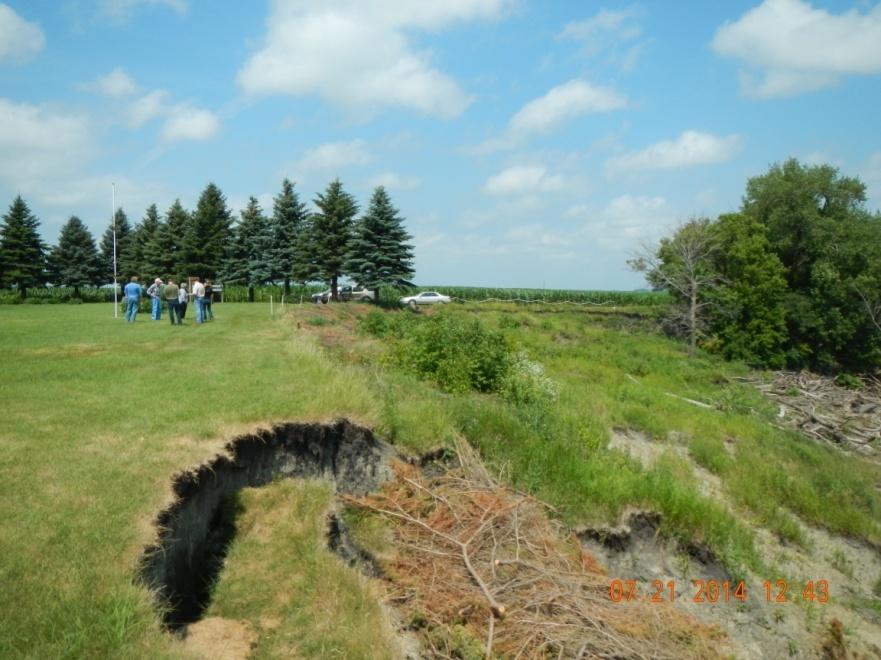
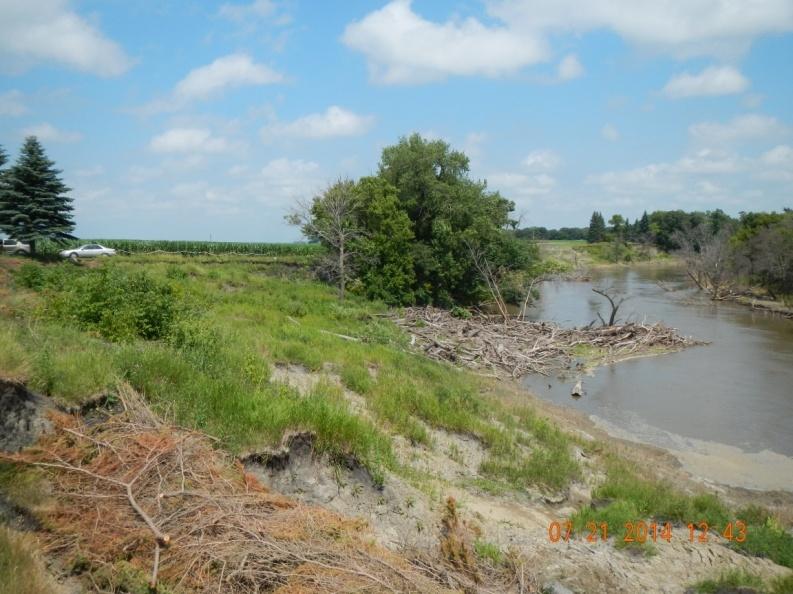
19 Figure 2. Photos of Lower Wild Rice and Red River Cemetery (3). 15
20 2.2 North Pleasant Cemetery Cass County, ND As of the date of this report, this cemetery is located within the designated staging area for the Project. A site visit was conducted for this cemetery by the Cemetery Assessment Team on 21 July The site POCs were in attendance and requested that the Team not enter the site. Discussions and interviews were conducted on public right-of-way adjacent to the cemetery. Right of Entry was granted by the landowner and a Phase I Cultural Resources Survey to record the site and evaluate its eligibility for listing in the National Register of Historic Places (NRHP) was conducted on May The site will be recommended as not eligible for listing in the National Register of Historic Places. The North Pleasant Cemetery report, once completed, will be submitted to the North Dakota State Historic Preservation Officer (SHPO) for concurrence with this evaluation. An individual site map and photos can be found in Attachment 2, Appendix A USACE Cemetery Study (June 2014). The North Pleasant Cemetery is a 2.83 acre parcel (pin no ) located in the S half of the SE quarter of the SW quarter of Section 27, Township 137 North, Range 49 West, Pleasant Township, Cass County, North Dakota. Based on the legal description from the Cass County Government 2013 Parcel Information web site, the North Pleasant Cemetery parcel measures 196 feet north-south by 627 feet east-west. It is bounded by a cultivated field on the west, north and east, and by a gravel road, 53rd Street SE, on the south. An overhead power line parallels the road along the cemetery side of road s north ditch. According to the NRCS s Web Soil Survey, soil at and near the cemetery consists of Fargo silty clay, 0 to 1 percent slopes. 16
21 Vegetation in the cemetery consists of mown lawn grass with a multi-row windbreak of deciduous trees on the north and east sides and a single row of conifers on the west side of the cemetery. A large deciduous tree stands in the middle of the western quarter of the cemetery. Headstones include both vertical monuments and horizontal lawn-type markers. A wrought iron arch bearing the cemetery s name ( NORTH PLEASANT ) faces the gravel road. There is no vehicle access point into the cemetery from the road. This active cemetery contains approximately 360 graves. The church formerly at this location was moved to Hickson, North Dakota in the early 1940s. It is possible there is an unmarked grave of a suicide victim outside the formal cemetery, as suicides would not be buried inside a consecrated cemetery. Ground surface elevation in the cemetery is approximately feet throughout, with areas of feet elevation to the west and northwest. Under modeled existing conditions, for the 10-year event there is no flooding; for the 50-year event there is a peak water surface elevation of feet; for the 100-year event there is a peak water surface elevation of feet; and for the 500-year event there is a peak water surface elevation of feet. This means that under existing conditions, there is no flooding at the cemetery for the 10-year, 50-year and 100-year events. Flooding does not occur until somewhere between the 100-year and 500-year events, when the peak water surface elevation reaches feet and the entire cemetery is flooded. For the 500-year event there would be 0.6 feet (7.2 inches) of water on the cemetery for 3.5 days. Based on aerial photography taken during the 1997 flood event, there was no flooding in the North Pleasant Cemetery (see Attachment 2, Appendix C Historic Inundation Maps). Aerial photography taken during the March 2009 flood event shows floodwater near the cemetery s north side in a low area in the agricultural field, but none in the cemetery. Because the cemetery has not previously flooded, no post-flood clean-up has been necessary. Two burials have been removed from this cemetery due to uncertainty of future flooding connected with the Project. With the Project in place, for the 10-year event the peak water surface elevation would be less than feet, so there would be no flooding of the cemetery. For the 50-year event, peak water elevation would be at feet for 3 days, an increase of 1.5 feet (actual water depth of 0.6 foot) for 3 days over existing conditions. For the 100-year event, peak water elevation would be at feet for 5 days, an increase of 1.7 feet (actual water depth of 1.4 feet) for 5 days over existing conditions. For the 500-year event, peak water elevation would be at feet for 6 days, an increase of 1.0 foot for 2.5 additional days over existing conditions. As under existing conditions, the cemetery would not flood during the 10- year event. For the 50-year and 100-year events, however, there would be 0.6 to 1.4 feet of flooding for 3 to 5 days with the Project in place where there is none under existing conditions. Maximum increase in water surface elevation with the Project in place would be 1.7 feet and maximum additional duration would be 5 days longer than that experienced under existing conditions. See summary table as follows: 17
22 Table 3. Table from North Pleasant Cemetery map sheet in Cemetery Study Report Return Frequency Existing Conditions Peak Water Elevation Duration (Days) of WSEL Above Natural Ground With Project Peak Water Elevation Duration (Days) of WSEL Above Year No flooding No flooding 50-Year Year Year Note: is the approximate lowest site elevation All Hydraulic Data Taken from Phase 7 HEC-RAS Models Possible effects on the cemetery due to flooding with the Project in place include (1) potential for damage to grass and trees due to standing water on the cemetery for 3 to 6 days if the flooding occurs during the growing season; (2) potential for headstones moving or tipping over due to flood waters; (3) potential for soil and crop debris from the adjacent agricultural field to wash into the cemetery with the flood waters, necessitating clean-up not needed under existing conditions; and (4) potential for lack of access to the cemetery, though the adjacent gravel road is at feet elevation. The land the cemetery is located on is owned by the North Pleasant Cemetery Association of the Norwegian Evangelical Lutheran Church of Hickson, North Dakota. The cemetery is operated by this same cemetery association. The North Pleasant Cemetery Association would need to approve any changes to the cemetery, including relocation of graves within the cemetery. The cemetery association s 5-person board usually meets once a year in the spring, but can meet anytime. 18
23 Figure 3. Photos of North Pleasant Cemetery (3). 19

24 2.3 Hemnes Cemetery Richland County, ND As of the date of this report, this cemetery is located within the designated staging area for the Project. A site visit was conducted for this cemetery by the Cemetery Assessment Team on 21 July 2014 and the site POCs were in attendance. Right of Entry was granted by the landowner and a Phase I Cultural Resources Survey was conducted on October The site has been recommended as eligible for listing in the National Register of Historic Places (NRHP) under Criterion A for its association with historical events connected with the themes of religion and rural settlement; under Criterion B for its association with persons significant in local and regional history; and under Criterion D for its potential to yield archaeological data important to the understanding of history. The North Dakota SHPO has concurred with this eligibility evaluation in a letter dated 2 April An individual site map and photos can be found in Attachment 2, Appendix A - USACE Cemetery Study (June 2014). The Hemnes Cemetery is an approximately 1.2 acre parcel (pin no ) located in the NE quarter of the NW quarter of the NW quarter of the SE quarter of Section 1, Township 136 North, Range 49 West, Eagle Township, Richland County, North Dakota. The parcel is bounded on its north, west and south sides by an agricultural field. The parcel is approximately 245 feet along its north border, 175 feet along its west border, and 350 feet along its south border. The east border follows an outside curve of the Red River for approximately 202 feet at the river s edge and 237 feet at the top of the riverbank. 20
25 The actual cemetery area is approximately 175 feet north-south by 140 feet east-west, with riverbank sliding having claimed a third of the cemetery parking area and part of its access road and now eating into the northeast corner of the actual cemetery area. According to the NRCS s Web Soil Survey, soils in the cemetery parcel above the slumping riverbank are Fargo-Hegne silty clays, 0 to 1 percent slopes and soils on the riverbank slope are Wahpeton-Cashel silty clays, wooded, 1 to 15 percent slopes, occasionally flooded. Vegetation in the cemetery consists of mown lawn grass with a row of mature conifers on the north, west and south sides and one deciduous tree in the southeast corner. The riverbank area is brushy, with a deciduous tree still upright in one of the most recent slumpblocks. Current access to the cemetery is from the north along a two-track road at the eastern edge of the agricultural field. A white-painted chain and post fence marks the upper edge of the slumping riverbank where the access road enters the cemetery parking area. This is the oldest Norwegian Lutheran Church Cemetery in North Dakota. It contains 58 marked graves, plus 18 unmarked graves primarily in the southeast quarter of the cemetery. The first burial in the cemetery dates to 1872, but its location is unknown. In 1875, a soldier from Fort Abercrombie was buried here. The cemetery also contains the graves of local pioneers and veterans of World War I and World War II. The most recent burial dates to Two burials have been relocated here from the North Pleasant Cemetery because their families wished to avoid any flooding. The cemetery is still accepting burials. Headstones at the Hemnes Cemetery include both vertical monuments (family plot markers, die-on-base, plaques, pulpits, tablets, obelisks, and pedestal) and horizontal slabs (lawn-type markers and government-issue military lawn-type markers), as well as some footstones. Unmarked graves are indicated by slight depressions or rises, changes in vegetation, or depicted on the cemetery s plot map. There is a wooden sign with the cemetery s name and a nearby wooden information board containing the history of the church and cemetery. A flagpole is also present. In 1889, the church for this cemetery was located one-quarter mile away in the NW corner of this section. After the congregation had dissolved, the church building was dismantled and moved to Strathcona, Minnesota, in 1935, where it is still in use. Ground surface elevation at the cemetery is feet, with much of the adjacent agricultural field at feet. The slumping riverbank drops down to 893 feet at the edge of the Red River. Under modeled existing conditions, for the 10-year event there is a peak water elevation of feet; for the 50-year event there is a peak water elevation of feet; for the 100-year event there is a peak water elevation of feet; and for the 500-year event there is a peak water elevation of feet. This means that there is no flooding during the 10-year, 50-year and 100-year events under existing conditions. Flooding would not occur until somewhere between the 100-year and 500-year events, when the peak water surface elevation reaches feet. For the 500-year event there would be 1.1 feet of water on the cemetery for 3 days. Based on aerial photography taken during the 1997 flood event, high water in the Red River reached nearly to the top of the riverbank adjacent to the Hemnes Cemetery (see Attachment 2, Appendix C 21
26 Historic Inundation Maps). There was no flooding inside the actual cemetery, however. Aerial photography taken during the March 2009 flood event shows the Red River not as high as in Because the cemetery has not previously flooded, no post-flood clean-up has been necessary. Pioneer Township has recently taken over maintenance at the cemetery, work which was formerly done by volunteers. Hemnes Cemetery has an existing serious riverbank erosion problem. Since the 1997 flood, the adjacent bank of the Red River has been actively sliding and has claimed a third of the parking area and part of the access road nearest the cemetery. Bank erosion is currently only 20 feet from graves in the northeast corner of the cemetery (Figure 4). Per the site POC, concern about the ongoing erosion is keeping people from getting buried here. Hemnes Cemetery is a significant historic site located on the Red River that is currently experiencing erosion issues that have impacted access and parking and may impact graves in the future. In June 2012, the cemetery POC wrote the Corps concerning the erosion issue. The Corps responded that the Project would not likely include any measures to stabilize the riverbank because it is not anticipated that the Project would worsen the current situation. It also stated they could request a Continuing Authorities Program (CAP) Section 14 project/study which would require a local cost share sponsor. See Attachment 1 for copies of these letters. The caretakers have requested assistance from Richland County and were told the county could not help with stabilization. As part of the FMM Feasibility Study, a Geomorphology Study was completed; the results of the study indicate that river bank stability will not change due to the Project. With the Project in place, for the 10-year event the peak water surface elevation would be at feet with no flooding, the same as under existing conditions. For the 50-year event, peak water elevation would be at feet for 0.5 days, an increase of 3.8 feet (actual water depth of 1.1 feet) for 0.5 day over existing conditions where there is no flooding. For the 100-year event, peak water elevation would be at feet for 3.5 days, an increase of 3.1 feet (actual water depth of 1.7 feet) for 3.5 days over existing conditions where there is no flooding. For the 500-year event, peak water elevation would be at feet for 6 days, an increase of 0.6 foot (7.2 inches) over 3 additional days compared to existing conditions. While there would be no flooding with or without the Project in place for the 10-year event, flooding at the cemetery would occur with the Project in place starting with the 50-year event. Under existing conditions, flooding does not start until somewhere between the 100-year and 500-year events. The maximum increase in water surface elevation with the Project in place would be 1.7 feet and the maximum additional duration would be 3.5 days longer than that experienced under existing conditions. See summary table as follows: 22
27 Table 4. Table from Hemnes Cemetery map sheet in Cemetery Study Report Existing Conditions With Project Return Frequency Peak Water Elevation Duration (Days) of WSEL Above Natural Ground Peak Water Elevation Duration (Days) of WSEL Above Year Year Year Year Note: is the approximate lowest site elevation All Hydraulic Data Taken from Phase 7 HEC-RAS Models Possible effects on the cemetery due to flooding with the Project in place include (1) increased potential for grass and tree damage due to water on the cemetery for 0.5 to 3.5 days longer than at present if the flooding occurs during the growing season; (2) need to clean-up crop debris and soil washed into the cemetery from the adjacent agricultural field; (3) potential for headstones tipping over or moving due to flood waters; and (4) no access to the cemetery. The land where the cemetery is and where the church formerly was located was donated by Nils Arentzen, the original landowner. The deed for the Hemnes Cemetery is to the Hamnes Hauges Lutheran Evangelical Church. The cemetery is within the NW quarter of Section 1, which quarter section parcel is currently owned by private citizens. The cemetery POC would need to approve any changes to the cemetery, including relocation of graves within the cemetery. Under State law, abandoned cemeteries become the responsibility of the county in which they are located. Graves located in a cemetery maintained by the county may be relocated by the county when they are in imminent danger by natural elements. 23


28 Figure 4. Photos of Hemnes Cemetery (4). 24
29 25
30 2.4 South Pleasant/Lium Cemetery Richland County, ND As of the date of this report, this cemetery is located upstream of the designated staging area for the Project. A site visit was conducted for this cemetery by the Cemetery Assessment Team on 3 September No site POCs were present at the site visit. Right of Entry was granted by the landowner and a Phase I Cultural Resources Survey was conducted on 1-2 April The site was recommended as not eligible for listing in the National Register of Historic Places (NRHP). The Lium Cemetery report, when completed, will be submitted to the North Dakota State Historic Preservation Office (SHPO) for concurrence with this evaluation. An individual site map and photos can be found in Attachment 2, Appendix A USACE Cemetery Study (June 2014). The South Pleasant Cemetery (also known as the Lium Cemetery) is an approximately 1.25 acre parcel (pin no ) located in the NE quarter of the NE quarter of the NE quarter of the NW quarter of Section 22, Township 136 North, Range 49 West, Walcott Township, Richland County, North Dakota. The cemetery parcel is approximately 180 feet north-south by 210 feet east-west. It is bounded by an agricultural field on the west, south and east, and by a gravel road, 57th Street SE, on the north. There is a shallow ditch between the road and the cemetery. According to the NRCS s Web Soil Survey, soils in the cemetery and the adjacent field are Fargo silty clay, 0 to 1 percent slopes. Vegetation in the cemetery consists of mown lawn grass with a line of conifer trees along its south edge, and scattered conifers along the east, north and west edges, plus several in the cemetery s interior. The entrance to the cemetery is marked by an arched metal pipe entranceway labeled SO. PLEASANT & CHRISTINE, with a pedestrian gate on either side, all of which is connected to the chain link fence which surrounds the cemetery. The entrance arch is flanked by two mature conifer trees. This cemetery contains at least 80 graves. Headstones include both vertical monuments and horizontal slabs. There are no buildings at the cemetery. Ground surface elevations in the cemetery range from a low of feet in the northwest corner to a high of along the east and south sides. Most of the cemetery is in the foot range. Under modeled existing conditions, for the 10-year event the peak water elevation is feet; for the 50- year event there is a peak water elevation of feet; for the 100-year event there is a peak water elevation of feet; and for the 500-year event there is a peak water elevation of feet. This means that there is no flooding for the 10-year event. Much of the cemetery is flooded to a depth of 2.6 feet during the 50-year event. The entire cemetery is flooded during the 100-year and 500-year events, to depths of 4.0 feet and 5.0 feet, respectively. Duration of flooding ranges from 5.5 days for the 50- year event, to 7.5 days for the 100-year event, to 10 days for the 500-year event. Based on aerial photography taken during the 1997 flood event, water from the nearby drainage to the west backed up the road ditch and flooded the northwest corner of the cemetery (see Attachment 2, Appendix C Historic Inundation Maps). The road itself was underwater west of the cemetery. Aerial photography taken during the March 2009 flood event shows less backup of water into the cemetery from the road ditch. There was no damage to the cemetery from past flooding. 26
31 With the Project in place, for the 10-year event the peak water surface elevation would be less than feet and there would be no flooding. For the 50-year event, peak water elevation would be at feet for 6.5 days, an increase of 0.1 foot and 1 day duration over existing conditions. For the 100- year event, peak water elevation would be at feet for 8 days, the same water elevation and an increase of 0.5 days duration over existing conditions. For the 500-year event, peak water elevation would be at feet for 10 days, the same elevation and an increase of 0.5 days duration over existing conditions. Except for a negligible water depth increase of 0.1 foot (1.2 inches) for the 50-year event, there would be no difference between existing conditions and with the Project in place. Duration of flooding would increase by 1 day for a 50-year event, 0.5 day for 100-year and 500-year events. See summary table as follows: Table 5. Table from South Pleasant Cemetery map sheet in Cemetery Study Report Existing Conditions With Project Return Frequency Peak Water Elevation Duration (Days) of WSEL Above Natural Ground Peak Water Elevation Duration (Days) of WSEL Above Year Year Year Year Note: is the approximate lowest site elevation All Hydraulic Data Taken from Phase 7 HEC-RAS Models The land where the South Pleasant Cemetery is located was deeded to the Christine Norwegian Lutheran Church. It is within a parcel of land owned by Janice Lindgren, which includes the N half of the NW quarter of the NE quarter and the N half of the N half of the NW quarter of Section 22. The cemetery is operated by the South Pleasant Cemetery Association. The South Pleasant Cemetery Association would need to approve any changes to the cemetery, including relocation of graves within the cemetery. The cemetery association s board usually meets once a year. 27

")
32 Figure 5. Photos of South Pleasant (Lium) Cemetery (2). 28
33 2.5 South Pleasant Church Cemetery Richland County, ND As of the date of this report, this cemetery is located upstream of the designated staging area for the FMM Project. A site visit was conducted for this cemetery by the Cemetery Assessment Team on 22 July 2014 and site POCs were in attendance. Right of Entry has not been granted by the landowner and a Phase I Cultural Resources Survey to recorded the site and evaluate its eligibility for listing in the National Register of Historic Places (NRHP) has not been conducted. An individual site map and photos can be found in Attachment 2, Appendix A - USACE Cemetery Study (June 2014). The South Pleasant Church Cemetery is an approximately 1.4 acre parcel (pin no ) located in the SW quarter of the SW quarter of the SE quarter of Section 21, Township 136 North, Range 49 West, Walcott Township, Richland County, North Dakota. The cemetery parcel is approximately 221 feet north-south by 268 feet east-west. It is bounded on the west by the churchyard, on the north by an agricultural field, on the east by a tributary drainage to the Wild Rice River, and on the south by a gravel road, 58th Street SE. According to the NRCS s Web Soil Survey, soils in the cemetery and churchyard are both Fargo silty clay, 0 to 1 percent slopes. Soils in the drainage to the east are Cashel-Fluvaquents, channeled complex, wooded, 0 to 35 percent slopes, frequently flooded. Vegetation in the cemetery consists of mown lawn grass with a line of deciduous trees on its north side continuing westward to the line of trees on the west side of the churchyard. The drainage to the east contains both brush and trees. A black chainlink fence surrounds the cemetery and churchyard, with the entryway to both through a squared arch labeled SOUTH PLEASANT leading to a concrete walkway to the church steps. This active cemetery contains 50 to 100 graves. Headstones include both vertical monuments and horizontal slabs. Services are no longer held at the church. Ground surface elevations in the cemetery range from a low of feet at its eastern edge to a high of feet in the southwest quarter. Under modeled existing conditions, for the 10-year event there is a peak water elevation of feet; for the 50-year event there is a peak water elevation of feet; for the 100-year event there is a peak water elevation of feet; and for the 500-year event there is a peak water elevation of feet. The cemetery is not flooded during the 10-year and 50-year events. The eastern third of the cemetery is flooded with 1.2 feet of water for 4 days during the 100- year event. The east half and much of the northwest quarter of the cemetery are flooded with 2.3 feet of water for 7 days during the 500-year event. Based on aerial photography taken during the 1997 flood event, most of the eastern third of the cemetery was inundated with water from the adjacent drainage (see Attachment 2, Appendix C Historic Inundation Maps). The access road to the cemetery was also inundated where it crossed that drainage and another drainage west of the cemetery. Aerial photography taken during the March 2009 flood event shows flooding only in the cemetery s southeast corner, estimated at 927 to 928 feet elevation. Per site POCs and interviews, past effects on the cemetery due to flooding include damage to the grass, tipping of headstones, and loss of access. Post-flood restoration has included having the monument company come out and reset monuments on their concrete footings. 29
34 With the Project in place, for the 10-year event the peak water surface elevation would be at feet and there would be no flooding. For the 50-year event the peak water elevation would be at feet with no flooding. For the 100-year event the peak water elevation would be at feet for 4 days, an increase of 0.1 foot (1.2 inches) over the same 4 days as under existing conditions. For the 500-year event the peak water elevation would be at feet for 7.5 days, which is the same water elevation, only for 0.5 days longer compared to existing conditions. Except for a negligible increase of 0.1 foot (1.2 inches) for the 100-year event, there would be no difference between existing conditions and with the Project in place. Duration of flooding is the same both with and without the Project in place except for an additional half day of flooding for the 500-year event with the Project in place. See summary table as follows: Table 6. Table from South Pleasant Church Cemetery map sheet in Cemetery Study Report Existing Conditions With Project Return Frequency Peak Water Elevation Duration (Days) of WSEL Above Natural Ground Peak Water Elevation Duration (Days) of WSEL Above Year Year Year Year Note: is the approximate lowest site elevation All Hydraulic Data Taken from Phase 7 HEC-RAS Models Possible effects on the cemetery due to flooding with the Project in place are expected to be the same as with existing conditions, i.e., damage to the grass, tipping of headstones, and loss of access. Any post-flood restoration currently needed would in all probability be the same in both type and extent for the comparable event with the Project in place. There are concerns that man-made flooding would void the monument company s warranty to reset shifted or tipped over monuments. The land where the South Pleasant Church Cemetery is located is owned by the South Pleasant Cemetery Association. It is a separate parcel from the parcel the church is located on. The cemetery is operated by the South Pleasant Cemetery Association. The South Pleasant Cemetery Association and all families affected would need to approve any changes to the cemetery, including relocation of graves within the cemetery. The cemetery association s board usually meets once a year. 30

35 Figure 6. Photos of South Pleasant Church Cemetery (2). 31
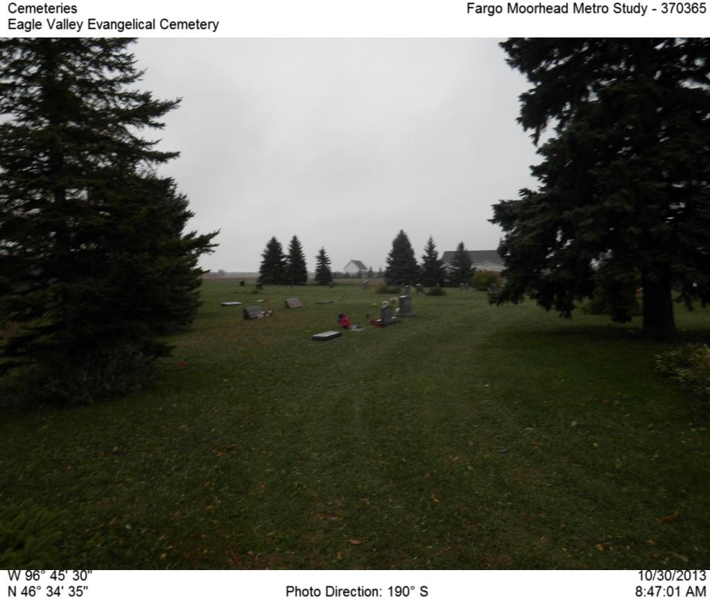
36 2.6 Eagle Valley Evangelical Cemetery Richland County, ND As of the date of this report, this cemetery is located upstream of the designated staging area for the Project. A site visit was conducted for this cemetery by the Cemetery Assessment Team on 22 July 2014 and site POCs were in attendance. Right of Entry has not been granted by the landowner and a Phase I Cultural Resources Survey to record the site and evaluate its eligibility for listing in the National Register of Historic Places (NRHP) has not been conducted. An individual site map and photos can be found in Attachment 2, Appendix A USACE Cemetery Study (June 2014). The Eagle Valley Evangelical Cemetery is located in two parcels totaling approximately 2 acres (pin nos and ) in the SW quarter of the NW quarter of the SW quarter and the NW quarter of the SW quarter of the SW quarter of Section 20, Township 136 North, Range 48 West, Eagle Township, Richland County, North Dakota. The cemetery consists of two adjoining irregularlyshaped parcels, with the north parcel having maximum dimensions of approximately 216 feet northsouth by 253 feet east-west (not counting the 100-foot-long entry road) and the south parcel having maximum dimensions of approximately 174 feet north-south by 316 feet east-west. The cemetery is bounded on the west and north by a drainage tributary to the Red River, on the east by a wooded slope down to the river bottomlands which are used as an agricultural field, and on the south by an agricultural field. According to the NRCS s Web Soil Survey, soils in the majority of the cemetery consist of Nutley-Fargo silty clays, 3 to 6 percent slopes. Soils in the drainage to the northwest and north and on the slope to the east consist of Wahpeton-Cashel silty clays, wooded, 1 to 15 percent slopes, occasionally flooded. Soils in the field to the south consist of Overly silty clay loam, 0 to 2 percent slopes. Vegetation in the cemetery consists of mown lawn grass with a scattering of mature deciduous trees in the north cemetery parcel and on the west side of the south parcel and with discontinuous lines of conifers on the south and east borders of the south cemetery parcel and the east border of the north parcel. Entrance to the cemetery is from the north-south gravel road, 175th Avenue SE, located west of the drainage. This active cemetery contains approximately 200 graves, dating from 1880 to the present. Headstones include both vertical monuments and horizontal slabs. The original Eagle Cemetery is the north parcel. It did not have a church building associated with it. The cemetery was expanded in the 1980s and is now associated with the Eagle Valley Evangelical Christian Church located one-quarter mile to the south. There are no buildings at the cemetery. Ground surface elevations in the cemetery range from a low of feet on the west to a high of feet where the two parcels abut. Much of the cemetery ranges from feet in elevation. There are steep slopes to the drainage to the west and north and especially to the Red River bottomlands to the east. Under modeled existing conditions, for the 10-year event there is a peak water elevation of feet; for the 50-year event there is a peak water elevation of feet; for the 100-year event there is a peak water elevation of feet; and for the 500-year event there is a peak water elevation of feet. This means that under existing conditions, there is no flooding at the cemetery for the 10-32
37 year and 50-year events. During the 100-year event, there is 1.7 feet of water in the southwest corner of the south parcel and in the north and west sides of the north parcel for 2.5 days. During the 500-year event, the entire cemetery would be flooded with up to 4.3 feet of water for 7 days. Based on aerial photography taken during the 1997 flood event, only the extreme southwest corner of the south parcel of the cemetery was flooded (see Attachment 2, Appendix C Historic Inundation Maps). The floodplain to the east and the drainage to the north and west were full of water. Aerial photography taken during the March 2009 flood event shows no flooding in the cemetery, but water filling the floodplain to the east and the drainage north and west of the cemetery s north parcel. Past effects on the cemetery due to flooding include possible tipping over of headstones (cemetery POC was not sure of this when asked). In 2009, there was water on one headstone in the low southwest corner area, the water coming from water backing up the drainage from the Red River. The adjacent road (175th Avenue SE) needed repairs after the 2009 flood from damage caused by overland flooding. Postflood restoration has included repairs to the adjacent gravel road and possibly resetting of headstones. With the Project in place, for the 10-year event the peak water surface elevation would be feet with no flooding, the same as with existing conditions. For the 50-year event, peak water elevation would be at feet for 4 days, an increase of 1.0 foot (actual water depth of 0.9 foot) in the extreme southwest corner of the south parcel and the northwest corner of the north parcel for 4 days over no flooding under existing conditions. For the 100-year event, peak water elevation would be at feet for 5 days, an increase of 0.5 foot for 2.5 days longer than under existing conditions. For the 500-year event, peak water elevation would be at feet for 8 days, the same water elevation but for 1 day longer than under existing conditions. The maximum increase in water surface elevation with the Project in place would be 0.9 foot and the maximum additional duration would be 4 days longer than that experienced under existing conditions. See summary table as follows: Table 7. Table from Eagle Valley Evangelical Cemetery map sheet in Cemetery Study Report Existing Conditions With Project Return Frequency Peak Water Elevation Duration (Days) of WSEL Above Natural Ground Peak Water Elevation Duration (Days) of WSEL Above Year Year Year Year Note: is the approximate lowest site elevation All Hydraulic Data Taken from Phase 7 HEC-RAS Models Possible effects on the cemetery due to flooding with the Project in place would be similar to what occurs under existing conditions, i.e., damage to grass, tipping over of headstones, and loss of access. There would be minimal flooding in part of the cemetery starting with the 50-year event with Project rather than the 100-year event under existing conditions. 33
38 The land parcels the cemetery is located on are owned by the Eagle Valley Evangelical Christian Church of Wolverton. The cemetery is operated by the church board. The Eagle Valley Evangelical Church s board would need to approve any changes to the cemetery, including relocation of graves within the cemetery. The church board usually meets once a month. Figure 7. Photos of Eagle Valley Evangelical Cemetery (3). 34
39 35
40 2.7 Hoff Cemetery Clay County, MN As of the date of this report, this cemetery is located within the designated staging area for the Project. A site visit was conducted for this cemetery by the Cemetery Assessment Team on 21 July The site POCs were in attendance and requested that the Team not enter the site. Discussions and interviews were conducted on public right-of-way adjacent to the cemetery. Right of Entry was granted by the landowner and a Phase I Cultural Resources Survey was conducted on 9-10 March The site has been recommended as not eligible for listing in the National Register of Historic Places (NRHP). The Hoff Cemetery report, once completed, will be submitted to the Minnesota State Historic Preservation Officer (SHPO) for concurrence with this evaluation. An individual site map and photos can be found in Attachment 2, Appendix A - USACE Cemetery Study (June 2014). The Hoff Cemetery is an approximately 1.6 acre parcel (pin no ) located in the SW quarter of the SW quarter of the SW quarter of the SW quarter of Section 9, Township 137 North, Range 48 West, Holy Cross Township, Clay County, Minnesota. The cemetery parcel is approximately 210 feet northsouth by 340 feet east-west. It is bounded on the north and east by brushy slopes down to Wolverton Creek, on the south by a gravel road, 140th Avenue South, and on the west by U.S. Highway 75. There is a wide ditch between the cemetery and Highway 75. Overhead power lines cross the western half of the cemetery with poles outside the cemetery to the north and south. According to the NRCS s Web Soil Survey, soils in the cemetery consist of Wahpeton silty clay, 2 to 6 percent slopes, occasionally flooded. Vegetation in the cemetery consists of mown lawn grass with a line of conifers inside a line of deciduous trees along the east side and scattered deciduous trees along the west and north sides of the cemetery. Access to the cemetery is from 140th Avenue South. This active cemetery contains 115 monuments marking family plots and individual and paired graves dating from 1904 to the present. One unmarked grave is also present. Any burials before 1960 could likely be in wood caskets. Headstones consist of both vertical monuments on bases and horizontal lawn-type slabs. There is a brick monument with a metal plaque with the cemetery s name on it facing U.S. Highway 75. No church building was ever present at this cemetery. There are no other buildings at the cemetery. Ground surface elevations in the cemetery range from a low of feet in the northeast corner to a high of feet along the south side of the cemetery. Under modeled existing conditions, for the 10- year event there is a peak water elevation of feet; for the 50-year event there is a peak water elevation of feet; for the 100-year event there is a peak water elevation of feet; and for the 500-year event there is a peak water elevation of feet. This means that under existing conditions, during the 10-year event the northeastern part of the cemetery is flooded by up to 1.5 feet of water for 3 days. During the 50-year event, about two-thirds of the cemetery is flooded by up to 5.5 feet of water for 9 days. During the 100-year event, three-quarters of the cemetery is flooded by up to 6.2 feet of water for 10 days. During the 500-year event, almost the entire cemetery is flooded by 7.1 feet of water for 14.5 days. Based on aerial photography taken during the 1997 flood event, the northern two-thirds of the cemetery were inundated by an overflowing Wolverton Creek (see Attachment 2, Appendix C Historic 36
41 Inundation Maps). Aerial photography taken during the March 2009 flood event shows a similar level and source of flooding and ice in the cemetery. Per site POCs and interviews, past effects on the cemetery due to flooding include vegetation loss, headstones tipped over, and debris washed in. The existing trees snag and hold logs. Post-flood restoration involved cemetery trustees doing the clean-up and the monument companies that had originally put out the headstones setting them back in place. Labor was a mix of volunteers and hired lawn-care workers. The cemetery association currently has a permit to build a levee to feet. They plan to build a ring levee after they know the mitigation plan for the Project. With the Project in place, for the 10-year event the peak water surface elevation would be at feet for 3 days, an increase of 0.1 foot (1.2 inches) over the same time period as with existing conditions. For the 50-year event, the peak water elevation would be at feet for 11.5 days, an increase of 8 feet for 2.5 additional days over existing conditions. For the 100-year event, the peak water elevation would be at feet for 12 days, an increase of 8 feet for 2 additional days over existing conditions. For the 500-year event, the peak water elevation would be at feet for 14 days, an increase of 7.1 feet for 0.5 day less than under existing conditions. Basically, the entire cemetery would be inundated during the 50-year or larger events with the Project in place. Maximum increase in water surface elevation with the Project in place would be 8.0 feet and maximum additional duration would be 2.5 days longer than that experienced under existing conditions. See summary table as follows: Table 8. Table from Hoff Cemetery map sheet in Cemetery Study Report Existing Conditions With Project Return Frequency Peak Water Elevation Duration (Days) of WSEL Above Natural Ground Peak Water Elevation Duration (Days) of WSEL Above Year Year Year Year Note: is the approximate lowest site elevation All Hydraulic Data Taken from Phase 7 HEC-RAS Models Possible effects on the cemetery due to flooding with the Project in place include (1) increased potential for grass and tree die-off due to 0.5 to 2.5 additional days of up to 8 feet of water on the cemetery if the flooding occurs during the growing season; (2) need to clean-up crop debris and soil washed into the cemetery from the adjacent agricultural field; (3) continued potential for headstones to be moved or tipped over by flood waters or floating debris; and (4) problems with accessing the cemetery during periods of high water. The land the cemetery is located on is owned by the Trustees of the Hoff Evangelical Lutheran Church. The cemetery is operated by a four-person board of the Hoff American Lutheran Church. 37
42 The cemetery board would need to approve any changes to the cemetery, including relocation of graves within the cemetery. The cemetery board meets whenever necessary. Figure 8. Photos of Hoff Cemetery (2). 38
43 2.8 Clara Cemetery Clay County, MN As of the date of this report, this cemetery is located within the designated staging area for the Project. A site visit was conducted for this cemetery by the Cemetery Assessment Team on 21 July 2014 and site POCs were in attendance. Right of Entry was granted by the landowner and a Phase I Cultural Resources Survey was conducted on January The site has been recommended as eligible for listing in the National Register of Historic Places (NRHP) under Criterion A for its association with historical events connected with rural settlement/pioneer settlement of the Red River Valley. The Clara Cemetery report has been submitted to the Minnesota State Historic Preservation Officer (SHPO) for concurrence with this evaluation (see letter dated 6 May 2015 in Attachment 1). An individual site map and photos can be found in Attachment 2 Appendix A - USACE Cemetery Study (June 2014). The Clara Cemetery is an approximately 2.7 acre parcel (pin no ) located in the SW quarter of the SW quarter of the SW quarter of the SW quarter of Section 17, Township 137 North, Range 17 West, Holy Cross Township, Clay County, Minnesota. The cemetery area is approximately 110 feet north-south by 100 feet east-west. It is bounded by an agricultural field on the north and east, by a gravel road, 150th Avenue South, on the south, and by another gravel road, 3rd Street South, on the west. According to the NRCS s Web Soil Survey, soils in the cemetery are Fargo silty clay, 0 to 1 percent slopes. 39
44 Vegetation in the cemetery consists of mown lawn grass with two rows of mature spruce trees along its north and east edges and one row of spruce trees along its west and south edges, plus a few lone spruce in the interior of the cemetery. There is a U-shaped grassy two-track road through the cemetery with access from the road on the south. This active cemetery contains 220 marked and 3 unmarked graves dating from 1894 to the present. Headstones, including vertical monuments, family plot markers, and horizontal lawn-type markers, as well as footstones mark the burials. This cemetery originally was a Swedish cemetery as reflected by the Swedish inscriptions on the earlier headstones. Members of the locally prominent Hicks family are buried here. There is a brick monument with a metal plaque with the cemetery s name ( CLARA LUTHERAN CEMETERY ) and a wooden sign board at the cemetery. There are no buildings at the cemetery. Ground surface elevations in the cemetery range from a low of feet on the north and east sides of the cemetery to a high of feet on the south side. Under modeled existing conditions, for the 10- year event there is a peak water elevation of feet; for the 50-year event there is a peak water elevation of feet; for the 100-year event there is a peak water elevation of feet; and for the 500-year event there is a peak water elevation of feet. This means that under existing conditions, there is no flooding of the cemetery during the 10-year and 50-year events. During the 100-year event, the west, north and east sides of the cemetery would be flooded by 0.4 foot (4.8 inches) of water for 2 days. During the 500-year event, most of the cemetery would be flooded by up to 1.8 feet of water for 6.5 days. Based on aerial photography taken during the 1997 flood event, there was floodwater just outside the west, north and east sides of the Clara Cemetery, but none in the cemetery itself (see Attachment 2, Appendix C Historic Inundation Maps). The roads to the west and south of the cemetery were also inundated where they crossed branches of the drainage northeast of the cemetery. Aerial photography taken during the March 2009 flood event also shows no flooding in the cemetery, but water and ice to its north and east. Because the cemetery has never flooded, no post-flood clean-up has been necessary. However, there may currently be problems with road access under existing conditions. With the Project in place, for the 10-year event the peak water surface elevation would be at feet with no flooding, the same as with existing conditions. For the 50-year event, peak water elevation would be at feet for 8 days, an increase of 7.0 feet (actual water depth of 6.6 feet) for 8 days over no flooding under existing conditions. For the 100-year event, peak water elevation would be at feet for 9.5 days, an increase of 6.9 feet for 7.5 additional days over existing conditions. For the 500- year event, peak water elevation would be at feet for 9.5 days, an increase of 5.5 feet for 3.0 additional days over existing conditions. As under existing conditions, there would be no flooding with the Project in place during the 10-year event. The major change with the Project in place would be that the cemetery would flood during the 50-year event, when there is no flooding under existing conditions. Maximum increase in water surface elevation with the Project in place for the 50-year, 100-year and 500-year events would be 6.6 feet and maximum additional duration would be 8 days longer than that experienced under existing conditions. See summary table as follows: 40
45 Table 9. Table from Clara Cemetery map sheet in Cemetery Study Report Existing Conditions With Project Return Frequency Peak Water Elevation Duration (Days) of WSEL Above Natural Ground Peak Water Elevation Duration (Days) of WSEL Above Year Year Year Year Note: is the approximate lowest site elevation All Hydraulic Data Taken from Phase 7 HEC-RAS Models Possible effects on the cemetery due to flooding with the Project in place include (1) increased potential for grass and tree damage over existing conditions due to greater depth and duration of flooding if the flooding occurs during the growing season; (2) potential for shifting or tipping over of headstones at and above a 50-year event; (2) need to clean-up crop debris and soil washed into the cemetery from the adjacent agricultural field; (3) potential for headstones tipping over or moving due to flood waters; (4) access problems to the cemetery for longer periods of time due to greater duration of flooding; and (5) potential need for repairs to gravel roads used for cemetery access and to the road within the cemetery. The land where the Clara Cemetery is located is within the SW quarter of Section 17, which parcel is owned by Robert H. Klein. The cemetery is operated by the Comstock Lutheran Church. The cemetery board for the Comstock Lutheran Church would need to approve any changes to the cemetery, including relocation of graves within the cemetery. The cemetery board holds an annual meeting in January, but an emergency meeting could be called with a minimum of two weeks notice in the church bulletin. 41

46 Figure 9. Photos of Clara Cemetery (2). 42
47 2.9 Comstock Cemetery Clay County, MN As of the date of this report, this cemetery is located within the designated staging area for the Project. A site visit was conducted for this cemetery by the Cemetery Assessment Team on 21 July 2014 and site POCs were in attendance. Right of Entry was granted by the landowner and a Phase I Cultural Resources Survey was conducted on January The site has been recommended as not eligible for listing in the National Register of Historic Places (NRHP). The Comstock Cemetery report, once completed, will be submitted to the Minnesota State Historic Preservation Officer (SHPO) for concurrence with this evaluation. An individual site map and photos can be found in Attachment 2, Appendix A - USACE Cemetery Study (June 2014). The Comstock Cemetery is a 2.6 acre parcel (pin no ) located in the NE quarter of the NE quarter of the NE quarter of the NE quarter of Section 28, Township 137 North, Range 48 West, Holy Cross Township, Clay County, Minnesota. The cemetery parcel is approximately 315 feet north-south by 270 feet east-west. It is bounded by paved County Road 2 (160th Avenue South) on the north, by a gravel road, 28th Street South, on the east, and by an agricultural field on the south and west. The city of Comstock is located one-half mile to the west. According to the NRCS s Web Soil Survey, soils in the western three-quarters of the cemetery are Bearden-Fargo complex, 0 to 2 percent slopes, and soils in the eastern quarter of the cemetery are Hegne-Fargo silty clays, 0 to 2 percent slopes. Vegetation in the cemetery consists of mown lawn grass with a single row of widely-spaced conifers and deciduous trees around the edge of the cemetery plus a couple of trees in the interior. An L-shaped gravel road passes through the cemetery from County Road 2 to the gravel road on the east. A brick monument with a metal plaque containing the name of the cemetery and a wooden sign ( COMSTOCK LUTHERAN CEMETERY ) with cemetery information are located near the north entrance. This active cemetery contains 338 marked graves and one unmarked grave dating from 1901 to the present. Headstones include vertical monuments, family plot markers, and horizontal lawn-type markers. This cemetery was the original Lutheran cemetery for the city of Comstock. There are no buildings at the cemetery. Ground surface elevation in the cemetery is approximately feet, with road ditches to the north and east at feet. Under modeled existing conditions for the 10-year, 50-year, 100-year, and 500- year events, there is no flooding at the cemetery, which means that the peak water elevation for these events is less than feet. Based on aerial photography taken during the 1997 flood event, there was water in the County Road 2 ditches but none in the Comstock Cemetery itself (see Attachment 2, Appendix C Historic Inundation Maps). Aerial photography taken during the March 2009 flood event shows a similar water level in the road ditches, but no flooding in the cemetery. Because the cemetery has never flooded, no post-flood clean-up has been necessary. However, they have had to repair vandalism to the cemetery. County Road 2 is above feet elevation and has not been flooded so access has not been a problem. Standing water was observed in the cemetery in 2014 after a heavy rainfall. 43
48 With the Project in place, for the 10-year event, the peak water surface elevation would be less than feet with no flooding. For the 50-year event, the peak water elevation would be at feet, also with no flooding, though there would be water in the adjacent road ditches. For the 100-year and 500-year events, peak water elevation would be at feet for 2 days, an increase of 0.3 foot (3.6 inches) over 2 additional days compared to existing conditions. As under existing conditions, there would be no flooding at the cemetery during the 10-year and 50-year events. The main change with the Project in place is that there would be 0.3 foot (3.6 inches) of water over the entire cemetery for 2 days during the 100-year and 500-year events, where there is no flooding under existing conditions. See summary table as follows: Table 10. Table from Comstock Cemetery map sheet in Cemetery Study Report Existing Conditions With Project Return Frequency Peak Water Elevation Duration (Days) of WSEL Above Natural Ground Peak Water Elevation Duration (Days) of WSEL Above Year No Flooding No Flooding 50-Year No Flooding Year No Flooding Year No Flooding Note: is the approximate lowest site elevation All Hydraulic Data Taken from Phase 7 HEC-RAS Models Possible effects on the cemetery due to flooding with the Project in place include (1) slight potential for damage to grass and trees if the flooding occurs during the growing season; (2) potential for crop debris and soil to wash into the cemetery from the adjacent agricultural field; and (3) loss of access to the cemetery during 100-year and greater events. The cemetery is owned by the Trustees of the Norwegian Lutheran Congregation of Comstock, Minnesota. The land where the Comstock Cemetery is located is within the NE quarter of Section 28, a parcel owned by Thomas and Katherine Askegaard. The cemetery is operated by the Comstock Lutheran Church. The cemetery board for the Comstock Lutheran Church would need to approve any changes to the cemetery, including relocation of graves within the cemetery. The cemetery board holds an annual meeting in January, but an emergency meeting could be called with a minimum of two weeks notice in the church bulletin. 44


49 Figure 10. Photos of Comstock Cemetery (2). 45
50 2.10 Roen Family Cemetery Clay County, MN As of the date of this report, this cemetery is located within the designated staging area for the Project. A site visit was conducted for this cemetery by the Cemetery Assessment Team on 21 July 2014 and site POCs were in attendance. Right of Entry has not been granted by the landowner and a Phase I Cultural Resources Survey to record the site and evaluate its eligibility for listing in the National Register of Historic Places (NRHP) has not been conducted. An individual site map and photos can be found in Attachment 2, Appendix A -- USACE Cemetery Study (June 2014). The Roen Family Cemetery is an unregistered cemetery located at the Roen family s farmstead along with various potentially historic buildings. The approximately 600-square-foot cemetery (pin no ) is located in the SW quarter of the NE quarter of the SW quarter of the SW quarter of Section 19, Township 137 North, Range 48 West, Holy Cross Township, Clay County, Minnesota. The cemetery is approximately 20 feet northwest-southeast by 30 feet northeast-southwest. It is located within two feet of the top of the bank of the Red River of the North with the farmyard to the northeast, east and south. According to the NRCS s Web Soil Survey, soils in the cemetery and farmyard are Wahpeton silty clay, 0 to 2 percent slopes, occasionally flooded. Soils on the river bank slope northwest and west of the cemetery are Fluvaquents, frequently flooded-hapludolls complex, 0 to 30 percent slopes. Vegetation in the cemetery consists of mown lawn grass, which is also present in the remainder of the farmyard. The slope down to the Red River is covered with deciduous trees and bushes. Access to the cemetery is northward through the farmyard from paved County Road 2 (160th Avenue South). This family cemetery contains three graves for a brother and sister (Ingvald Roen, age 5, buried 1884 and Ida Roen, age 18, buried 1901) and a cousin (Myrtle Roen, age 3, buried 1905). The slant-face vertical headstones were placed in the 1970s and may not accurately mark the actual grave locations. The cemetery is surrounded by a fence made of metal chainlink fence posts and horizontal metal rails, but no chainlink fencing. The original homesteader of the parcel containing the cemetery was Narve Roen, a Civil War veteran who received a grant of land (259.3 acres in Sections 19 and 30) from the Federal government under the Homestead Act. The log cabin and barn of that original homestead were built in 1871 in Section 30 and are no longer standing. In 1881, Narve built the first frame house in the community as well as a barn in Section 30, both of which are still standing, as are a blacksmith shop and a granary. Narve was also the first banker in the area. His son Stennom Roen built a four-story frame house, still standing, along with other farm buildings in in Section 19; this is the farmstead where the cemetery is located. A brother, Gilbert Roen, lived at the farm in Section 19 north of Stennom s. Other early buildings have been moved onto these farmsteads. Ground surface elevation at the cemetery is approximately feet, rising to feet in the farmyard, but dropping rapidly down the adjacent steep riverbank section to feet at the Red River. Under modeled existing conditions, for the 10-year event there is a peak water elevation of feet; 46
51 for the 50-year event there is a peak water elevation of feet; for the 100-year event there is a peak water elevation of feet; and for the 500-year event there is a peak water elevation of feet. This means there is no flooding for the 10-year and 50-year events, 0.5 foot for 1.5 days for the 100-year event, and 2.7 feet for 7.0 days for the 500-year event under existing conditions. Based on aerial photography taken during the 1997 flood event, water in the Red River inundated its floodplain and reached near the top of the riverbank adjacent to the Roen Family Cemetery and farmyard, neither of which was flooded (see Attachment 2, Appendix C Historic Inundation Maps). Aerial photography taken during the March 2009 flood event shows the cemetery and farmyard with no flooding, but with the Red River floodplain inundated to near the top of the riverbank. The landowner has stated that there has been no past flooding of the cemetery and thus no clean-up has been necessary. Maintenance, i.e., grass mowing, at the cemetery is done as part of farmyard mowing. With the Project in place, for the 10-year event the peak water surface elevation would be at feet with no flooding, the same as under existing conditions. For the 50-year event, the peak water elevation would be at feet for 7 days, an increase of 5.2 feet (actual water depth of 4.7 feet) for 7 days over existing conditions with no flooding. For the 100-year event, peak water elevation would be at feet for 8.5 days, an increase of 4.8 feet for an additional 7 days over existing conditions. For the 500- year event, peak water elevation would be at feet for 9 days, an increase of 2.9 feet for 2 additional days over existing conditions. The main change with the Project in place would be flooding of the cemetery at the 50-year event where there is no flooding under existing conditions. Maximum increase in water surface elevation with the Project in place for the 50-year, 100-year and 500-year events would be 4.7 feet and maximum additional duration would be 7 days longer than that experienced under existing conditions. See summary table as follows: Table 11. Table from Roen Family Cemetery map sheet in Cemetery Study Report Existing Conditions With Project Return Frequency Peak Water Elevation Duration (Days) of WSEL Above Natural Ground Peak Water Elevation Duration (Days) of WSEL Above Year Year Year Year Note: is the approximate lowest site elevation All Hydraulic Data Taken from Phase 7 HEC-RAS Models Possible effects on the cemetery due to flooding with the Project in place would be comparable to those experienced under existing conditions, i.e., damage to grass. There would be a slight increase in the potential for damage to the grass if flooding occurs during the growing season due to an additional 7 days of water in that area. 47
. 2.")
52 The land the cemetery is located on is owned by a Roen descendent. The landowner would need to approve any changes to the cemetery, including relocation of graves within the cemetery. Figure 11. Photo of Roen Family Cemetery (1) Wolverton/Salem Lutheran Cemetery Wilkin County, MN As of the date of this report, this cemetery is located upstream of the designated staging area for the Project. A site visit was conducted for this cemetery by the Cemetery Assessment Team on 21 July 2014 and site POCs were in attendance. Right of Entry was granted by the landowner and a Phase I Cultural Resources Survey was conducted on January The site has been recommended as not eligible for listing in the National Register of Historic Places (NRHP). The Wolverton-Salem Lutheran Cemetery report has been submitted to the Minnesota State Historic Preservation Officer (SHPO) for concurrence with this evaluation (see letter dated 4 May 2015 in Attachment 1). An individual site map and photos can be found in Attachment 2, Appendix A - USACE Cemetery Study (June 2014). The Wolverton Cemetery (also known as the Salem Lutheran Cemetery) is composed of two adjacent parcels totally approximately 2.1 acres (pin nos and ) located in the SW quarter of the SW quarter of the SW quarter of the NW quarter of Section 28, Township 136 North, Range 48 West, Wolverton Township, Wilkin County, Minnesota. This cemetery is approximately 215 feet northsouth by 395 feet east-west. It is located within the city limits of Wolverton and is bounded on the 48
53 south by Park Avenue, on the north and east by an agricultural field, and on the west by an unnamed tributary to the Red River of the North. A narrow, approximately two-foot-deep road ditch is located between the cemetery and the gravel road. The actual city of Wolverton is one-quarter mile to the east. According to the NRCS s Web Soil Survey, soils at the cemetery consist of Fargo silty clay, 0 to 2 percent slopes. Soils in the drainage adjacent to the west are Lamoure silty clay loam, 0 to 1 percent slopes, occasionally flooded. Vegetation in the cemetery consists of mown lawn grass with a row of deciduous trees on the west, north and east sides, an interior north-south line of deciduous trees one-third of the distance from the east edge, and scattered conifers in the interior of the western two-thirds of the cemetery. The main entrance to the cemetery is from Park Avenue into the western parcel. It is marked by a two-door wrought-iron gate between two square brick pillars. The metal plaque on the right-hand pillar gives the name of the cemetery as SALEM CEMETERY. A second entrance leads from the gravel road into the eastern parcel of the cemetery. This active cemetery contains 252 marked graves and 2 unmarked graves dating from the 1908 to the present. Headstones include vertical monuments, family plot markers, and horizontal lawn-type markers. The church associated with this cemetery is now gone, but was presumably located in the eastern parcel. There is a small storage shed for lawnmowers and other maintenance tools at the cemetery. Ground surface elevations in the cemetery range from a low of about feet in the southwest corner to a high of feet along the center of the north side and the east half of the south side. The eastern two-thirds of the cemetery is at or above feet. Under modeled existing conditions, for the 10-year event there is a peak water elevation of feet; for the 50-year event there is a peak water elevation of feet; for the 100-year event there is a peak water elevation of feet; and for the 500-year event there is a peak water elevation of feet. This means that for the 10-year event there is no flooding. During the 50-year event, the southwest corner of the cemetery is flooded up to 2 feet for 3.5 days. During the 100-year event, the western third of the cemetery is flooded up to 3.8 feet for 4 days. Almost the entire cemetery is inundated during a 500-year event, with the floodwater depth ranging from 1 foot over the eastern two-thirds of the cemetery to 7 feet in its southwest corner, with a duration of 8.5 days. Based on aerial photography taken during the 1997 flood event, the southwest corner and western edge of the cemetery were inundated by water from the adjacent tributary to the Red River (see Attachment 2, Appendix C Historic Inundation Maps). Aerial photography taken during the March 2009 flood event shows flooding of the cemetery s southwest corner to a lesser extent than in Per site POCs and interviews, past effects on the cemetery due to flooding include damage to grass in the southwest corner of the cemetery. There are no graves in this low corner of the cemetery. Park Avenue was washed out west of the cemetery during flooding and there are local plans to raise this road. With the Project in place, for the 10-year event the peak water surface elevation would be at feet with no flooding, the same as under existing conditions. For the 50-year event, the peak water elevation would be at feet for 5.5 days, an increase of 0.7 foot (8.4 inches) for 2 additional days over existing conditions. For the 100-year event, the peak water elevation would be at feet for 7 days, 49
54 an increase of 0.4 foot (4.8 inches) for 3 additional days over existing conditions. For the 500-year event, the peak water elevation would be at feet for 9.5 days, the same water elevation, but for 1 additional day over existing conditions. Maximum increase in water surface elevation with the Project in place would be 0.7 foot (8.4 inches) and the maximum additional duration would be 3 days longer than that experienced under existing conditions. The portion of the cemetery affected with the Project in place would be the same as under existing conditions, that is, only the southwestern corner would be flooded until greater than the 100-year event. See summary table as follows: Table 12. Table from Wolverton Cemetery map sheet in Cemetery Study Report Existing Conditions With Project Return Frequency Peak Water Elevation Duration (Days) of WSEL Above Natural Ground Peak Water Elevation Duration (Days) of WSEL Above Year Year Year Year Note: is the approximate lowest site elevation All Hydraulic Data Taken from Phase 7 HEC-RAS Models Possible effects on the cemetery due to flooding with the Project in place would be comparable to those experienced under existing conditions, i.e., damage to grass and loss of access. There would be a slight increase in the potential for damage to the grass if flooding occurs during the growing season in the low southwest corner of the cemetery due to an additional 2 to 3 days of water in that area. The land parcels the cemetery is located on are owned by the Trustees of the Swedish Evangelical Lutheran Salem Church of Wolverton and by the Faith Lutheran Church. The cemetery is operated by the church s cemetery board which is made up of three persons plus a treasurer. The cemetery board would need to approve any changes to the cemetery, including relocation of graves within the cemetery. The cemetery board holds an annual meeting in November, but is able to meet anytime. 50

55 Figure 12. Photos of Wolverton Cemetery (2). 51
City of Waco Stormwater Management Regulations
 1.0 Applicability: City of Waco Stormwater Management Regulations These regulations apply to all development within the limits of the City of Waco as well as to any subdivisions within the extra territorial
TOWNSHIP OF LOGAN SOIL & FILL IMPORTATION AND PLACEMENT APPLICATION SUBMITTAL CHECKLIST
 TOWNSHIP OF LOGAN SOIL & FILL IMPORTATION AND PLACEMENT APPLICATION SUBMITTAL CHECKLIST Applications: 5 copies of application - Applicant will reproduce the copies at his/her costs. The Township Clerk
NATIONAL REGISTER OF HISTORIC PLACES MULTIPLE PROPERTY DOCUMENTATION FORM CONTINUATION SHEET ASSOCIATED PROPERTY TYPES
 Section F, Page 1 ASSOCIATED PROPERTY TYPES Six common property types are identified with the 48 cemeteries surveyed in the Town of Southampton. These six property types are identified as being associated
Draft Rhode Island Stormwater Design and Installation Standards Manual
 Draft Rhode Island Stormwater Design and Installation Standards Manual Summary The May 2009 Public Review Draft version of the RI Stormwater Design and Installation Standards Manual consists of approximately
Evaluation of How O&M Costs Vary for Alternative Flood Control Strategies
 Evaluation of How O&M Costs Vary for Alternative Flood Control Strategies Fargo-Moorhead Diversion Channel ASFPM Conference June 13, 2013 Matt Redington, PE Jeremy Cook HDR Engineering Red River of the
CITY OF SCANDIA ORDINANCE NO. 174
 CITY OF SCANDIA ORDINANCE NO. 174 AN ORDINANCE AMENDING ORDINANCE NO. 122, THE SCANDIA DEVELOPMENT CODE, CHAPTER 2, SECTION 4.34, REGARDING SOLAR FARMS AND COMMUNITY SOLAR GARDENS The City Council of the
ARTICLE 17 SITE PLAN REVIEW
 ARTICLE 17 SITE PLAN REVIEW 17.01 INTENT AND PURPOSE The intent of this section is to provide for consultation and cooperation between the applicant and the township planning commission so that the applicant
Information for File # JTF
 Information for File # 2013-04665-JTF Applicant Corps Contact Enbridge Energy, Limited Partnership Josh Fitzpatrick Address 1554 Highway 2, Suite 2, Two Harbors, MN 55616 E-Mail joshua.t.fitzpatrick@usace.army.mil
5. LOW IMPACT DEVELOPMENT DESIGN STANDARDS
 5. LOW IMPACT DEVELOPMENT DESIGN STANDARDS Low Impact Development (LID) requires a shift in stormwater management away from conveying runoff to a small number of downstream points through hydraulically
Poisoned Park? How Exide s Lead Contamination Risks Frisco s Grand Park
 Frisco City Hall has big plans to transform Stewart Creek into a Grand Park with lots of water features for kids to play in. Poisoned Park? How Exide s Lead Contamination Risks Frisco s Grand Park But
FINAL MITIGATION PLAN to address
 CENTRAL CORRIDOR LRT STATE CAPITOL MALL HISTORIC FINAL MITIGATION PLAN February 2010 FINAL MITIGATION PLAN to address Adverse Effects of the Central Corridor LRT Project on the State Capitol Mall Historic
Understanding Drainage Options What s Feasible and Legal. February 2019
 Understanding Drainage Options What s Feasible and Legal February 2019 Outline for the Presentation Do you need a permit? Does common law apply? Does local government approve it? Will my neighbor allow
CORPORATE REPORT. NO: R137 COUNCIL DATE: June 29, 2015 REGULAR COUNCIL. TO: Mayor & Council DATE: June 24, 2015
 CORPORATE REPORT NO: R137 COUNCIL DATE: June 29, 2015 REGULAR COUNCIL TO: Mayor & Council DATE: June 24, 2015 FROM: General Manager, Parks, Recreation and Culture FILE: 4100-01 SUBJECT: Surrey Centre Cemetery
CHECKLIST FOR PHASE II DRAINAGE REPORT
 I. COVER SHEET CHECKLIST FOR PHASE II DRAINAGE REPORT A. Name of Project B. Address C. Owner D. Developer E. Engineer F. Submittal date and revision dates as applicable II. GENERAL LOCATION AND DESCRIPTION
PLANNED UNIT DEVELOPMENT & SUBDIVISION STAFF REPORT Date: May 18, 2017
 & PUD-0000102-2017 PLANNED UNIT DEVELOPMENT & SUBDIVISION STAFF REPORT Date: May 18, 2017 NAME SUBDIVISION NAME Dauphin Creek Estates Subdivision Dauphin Creek Estates Subdivision LOCATION CITY COUNCIL
MASTER DEVELOPMENT DRAINAGE PLAN FOR MONUMENT HEIGHTS
 MASTER DEVELOPMENT DRAINAGE PLAN FOR MONUMENT HEIGHTS DRAINAGE REPORT STATEMENT ENGINEER'S STATEMENT: The attached drainage plan and report were prepared under my direction and supervision and are correct
HAMPTON CEMETERY RULES, REGULATIONS & RATES
 HAMPTON CEMETERY RULES, REGULATIONS & RATES The Hampton Cemetery is owned and operated by the City of Hampton, Iowa. The management of the Hampton Cemetery shall be vested in the City Manager. The Hampton
STREAM BUFFERS
 88-415 STREAM BUFFERS 88-415-01 PURPOSE In the Kansas City region and throughout the nation, vegetated stream buffers have been clearly shown to protect stream stability and related infrastructure, improve
ARTICLE VI: SITE PLAN REVIEW
 Section 6.01 - Site Plan Review (All Districts) ARTICLE VI: SITE PLAN REVIEW Site plans give the Planning commission an opportunity to review development proposals in a concise and consistent manner. The
Design Review Application *Please call prior to submittal meeting to determine applicable fees*
 CITY OF EAGLE 660 E. Civic Lane, Eagle, ID 83616 Phone#: (208) 939-0227 Fax: (208) 938-3854 Design Review Application *Please call prior to submittal meeting to determine applicable fees* FILE NO.: CROSS
Appendix 1: Site Inventory Form
 Appendix 1: Site Inventory Form Wapsi Valley Archaeology, Inc. Anamosa, IA 56 X Cemetery Washington 83 24 2 NE X 1 5 approx. 200 approx. 201 unknown unknown Historic Resources Evaluation: 07A: Cemetery
Chapter 14 CEMETERIES
 PART I ADMINISTRATIVE LEGISLATION Chapter 14 CEMETERIES 14.1 Location and Establishment 14.2 Authority 14.3 Definitions 14.4 Records 14.5 Selling Gravesites, Cremation Sites, Private Mausoleum/Crypt Plots
STORMWATER MANAGEMENT CODES ANALYSIS RICHLAND COUNTY, SC SITE PLANNING ROUNDTABLE
 STORMWATER MANAGEMENT CODES ANALYSIS RICHLAND COUNTY, SC SITE PLANNING ROUNDTABLE Codes analyses for each subcommittee were completed to assist participants of the Richland County Site Planning Roundtable.
When planning stormwater management facilities, the following principles shall be applied where possible.
 2.0 Principles When planning stormwater management facilities, the following principles shall be applied where possible. 2.0.1 Drainage is a regional phenomenon that does not respect the boundaries between
APPENDIX A SIMPLIFIED APPROACH TO STORMWATER MANAGEMENT FOR SMALL PROJECTS. In West Sadsbury Township, Chester County, Pennsylvania
 APPENDIX A SIMPLIFIED APPROACH TO STORMWATER MANAGEMENT FOR SMALL PROJECTS In West Sadsbury Township, Chester County, Pennsylvania TABLE OF CONTENTS I. Introduction 3 II. Importance of Stormwater Management
Zoning Ordinance Chapter 10
 CHAPTER 10 - WASHES SECTION 10.0 GENERAL: A. The purpose of this Ordinance is to establish standards for development in or near Major and Minor Washes as defined in Appendix A Glossary of Terms and Definitions
HAZARD MITIGATION GOALS AND OBJECTIVES
 SEWRPC Community Assistance Planning Report No. 282, 2nd Edition CITY OF MILWAUKEE ALL HAZARDS MITIGATION PLAN UPDATE Chapter IV HAZARD MITIGATION GOALS AND OBJECTIVES [NOTE: Throughout this plan update
PROJECT SCOPE OF WORK CITY OF TOWN AND COUNTRY STORMWATER PROGRAM
 PROJECT SCOPE OF WORK CITY OF TOWN AND COUNTRY STORMWATER PROGRAM Project ID Number: 25-5 Problem: Stormwater collected from the neighborhood upstream is released at 9 Muirfield Lane and flows west toward
PROJECT BACKGROUND. Preliminary Design Scope and Tasks
 PROJECT BACKGROUND Preliminary Design Scope and Tasks The purpose of this Study is the development of preliminary designs for intersection improvements for Trunk Highway (TH) 36 at the intersections of
Figure 1 Cypress Street Study Area Location Map
 July 20, 2016 TO: FROM: Jim Massarelli Director of Engineering Jeff Julkowski, PE Michael Burke, PE SUBJECT: Cypress Street Study Area Stormwater Analysis (CBBEL Project No. 16-0058) At the request of
STORMWATER SITE PLAN INSTRUCTIONS AND SUBMITTAL TEMPLATE Medium and Large Projects
 DEPARTMENT OF COMMUNITY DEVELOPMENT 621 Sheridan Street, Port Townsend, WA 98368 Tel: 360.379.4450 Fax: 360.379.4451 Web: www.co.jefferson.wa.us/communitydevelopment E-mail: dcd@co.jefferson.wa.us STORMWATER
L 2-1 HERITAGE REPORT: REASONS FOR HERITAGE DESIGNATION. Cheyne Family Cemetery. Main Street South
 L 2-1 HERITAGE REPORT: REASONS FOR HERITAGE DESIGNATION Cheyne Family Cemetery Main Street South October 2013 L 2-2 PROFILE OF SUBJECT PROPERTY: Municipal Address Main Street South (Lot 14, Con 1, EHS)
PCE PRELIMINARY DRAINAGE ANALYSIS REPORT FOR WESTWOOD MIXED USE NEIGHBORHOOD PROJECT 772 NORTH FOREST ROAD TOWN OF AMHERST, ERIE COUNTY, NEW YORK
 PCE PRELIMINARY DRAINAGE ANALYSIS REPORT FOR WESTWOOD MIXED USE NEIGHBORHOOD PROJECT 772 NORTH FOREST ROAD TOWN OF AMHERST, ERIE COUNTY, NEW YORK MAY 19, 2014 Prepared By: Timothy M. Lavocat, P.E., CFM
PROJECT SCOPE OF WORK CITY OF TOWN AND COUNTRY STORMWATER PROGRAM
 PROJECT SCOPE OF WORK CITY OF TOWN AND COUNTRY STORMWATER PROGRAM Project Name: 362 Featherstone Dr Project ID Number: 27-3 Problem: Anecdotal evidence suggests a natural spring exists in the backyard
ST. MARY S SOIL CONSERVATION DISTRICT (SMSCD) AND DPW&T CONCEPT EROSION AND SEDIMENT CONTROL AND STORMWATER MANAGEMENT GUIDELINES AND CHECKLIST
 AND DPW&T CONCEPT EROSION AND SEDIMENT CONTROL AND STORMWATER MANAGEMENT GUIDELINES AND CHECKLIST") St. Mary s Soil Conservation District 26737 Radio Station Way, Suite B Leonardtown, MD 20650 Phone: 301-475-8402 ext. 3 Fax: 301-475-8391 www.stmarysscd.com St. Mary s County Government Department of Public
St. Mary s Soil Conservation District 26737 Radio Station Way, Suite B Leonardtown, MD 20650 Phone: 301-475-8402 ext. 3 Fax: 301-475-8391 www.stmarysscd.com St. Mary s County Government Department of Public
Appendix E Section 4(f) Evaluation
 Evaluation") Appendix E Section 4(f) Evaluation Appendix E Draft Section 4(f) Evaluation E.1 Introduction This appendix addresses a federal regulation known as Section 4(f), which protects parks, recreation areas,
Appendix E Section 4(f) Evaluation Appendix E Draft Section 4(f) Evaluation E.1 Introduction This appendix addresses a federal regulation known as Section 4(f), which protects parks, recreation areas,
Project phasing plan (if applicable) 12 copies of site plan
 12 copies of site plan") SITE PLAN REVIEW PERMIT APPLICATION City of Grand Haven, 11 N. Sixth Street, Grand Haven, MI 49417 Phone: (616) 847-3490 Fax: (616) 844-2051 Website: www.grandhaven.org 1. Project Information Address/location
SITE PLAN REVIEW PERMIT APPLICATION City of Grand Haven, 11 N. Sixth Street, Grand Haven, MI 49417 Phone: (616) 847-3490 Fax: (616) 844-2051 Website: www.grandhaven.org 1. Project Information Address/location
CORPORATE POLICY CEMETERY OPERATION AND MAINTENANCE
 POLIC STATEMENT CORPORATE POLIC CEMETER OPERATION AND CEMETER OPERATION AND This policy provides guidelines for the effective and efficient operation of Pioneer Cemetery. The establishment of this policy
At Your Disposal CUP Amendment, Lot 20, Village Service Commercial, at 128 Bastille Dr. (PLN17-208)
") MEMORANDUM Archuleta County Development Services Planning Department 1122 HWY 84 P. O. Box 1507 Pagosa Springs, Colorado 81147 970-264-1390 Fax 970-264-3338 TO: Archuleta County Planning Commission FROM:
MEMORANDUM Archuleta County Development Services Planning Department 1122 HWY 84 P. O. Box 1507 Pagosa Springs, Colorado 81147 970-264-1390 Fax 970-264-3338 TO: Archuleta County Planning Commission FROM:
Gloucester County PLAN SUBMITTER'S CHECKLIST
 Page 1 of 9 Gloucester County PLAN SUBMITTER'S CHECKLIST FOR EROSION AND SEDIMENT CONTROL PLANS Please fill in all blanks and please reference the plan sheets/pages where the information may be found,
Appendix E Preliminary Location Hydraulic Study
 Appendix E Prepared for: State of Alaska Department of Transportation and Public Facilities Prepared by: HDR Alaska, Inc. 2525 C Street, Suite 305 Anchorage, Alaska 99503 February 2014 This page intentionally
HISTORIC TEXAS CEMETERY REQUEST FOR DESIGNATION
 HISTORIC TEXAS CEMETERY REQUEST FOR DESIGNATION List additional descriptions or information on separate pages, if necessary. IDENTIFYING INFORMATION Primary name: Also known as: County: Type: Single grave
Wisconsin NRCS Direct Volume Method Bank Recession Rate Categorizations
 2 Executive Summary The City of Ramsey contracted the Anoka Conservation District to complete an inventory of riverbank condition along the entire 5.8 miles of City that border the Mississippi River. The
SITE PLAN REVIEW APPLICATION AND CHECKLIST
 SITE PLAN REVIEW APPLICATION AND CHECKLIST PROJECT SUMMARY: Project Name: City/ETA Location: City ETA (Application fee & number of copies needed are based on location) Property Location (Legal Description
Mitchell Ranch South MPUD Application for Master Planned Unit Development Approval Project Narrative. Introduction
 Mitchell Ranch South MPUD Application for Master Planned Unit Development Approval Project Narrative Introduction Mitchell Ranch South is a proposed single family (detached) residential development on
October 7, City of Thornton 9500 Civic Center Drive Thornton, CO (303) RE: Maverik Thornton, CO - Drainage Report
 RE: Maverik Thornton, CO - Drainage Report") October 7, 2016 City of Thornton 9500 Civic Center Drive Thornton, CO 80229 (303) 538-7295 RE: Maverik Thornton, CO - Drainage Report As per your request, we are submitting to you the drainage report and
October 7, 2016 City of Thornton 9500 Civic Center Drive Thornton, CO 80229 (303) 538-7295 RE: Maverik Thornton, CO - Drainage Report As per your request, we are submitting to you the drainage report and
Pollutant Removal Benefits
 Bioswales Bioswales Similar to biocells, but have a slight, but positive grade toward an outlet Designed to convey the WQv event at very low velocities Promote filtration through native vegetation, infiltration
APPENDIX C: STORMWATER CONTROL PLAN
 APPENDIX C: STORMWATER CONTROL PLAN STORM WATER MANAGEMENT PLAN FOR PLEASANT HILL, CALIFORNIA Prepared for Compliance with the Clean Water Program (C.3) and the San Francisco Bay Regional Water Quality
CEMETERY GENERAL PRICE LIST 2018
 CEMETERY GENERAL PRICE LIST 2018 GREENWOOD MEMORIAL GARDENS NEW ELM RIDGE SIERRA MEMORIAL LAWN FOREST VIEW (NOTICE: PRICES SUBJECT TO CHANGE WITHOUT NOTICE) 459 Hollow Way, Nevada City, CA 95959 (530)
Town of Peru Comprehensive Plan Executive Summary
 Town of Peru Comprehensive Plan Executive Communities that plan grow by choice, not by chance. A plan makes growth thoughtful, understandable, and predictable. A plan shows that a community is managing
IS THERE MONEY AVAILABLE FOR WORK IN HISTORIC CEMETERIES? The AHC is not aware of any funding available for cemetery preservation or maintenance.
 ALABAMA HISTORICAL COMMISSION The State Historic Preservation Office Voice: (334)242-3184 Fax: (334)262-1083 www.preserveala.org ALABAMA HISTORIC CEMETERY REGISTER WHAT IS THE ALABAMA HISTORIC CEMETERY
Landscape and fencing requirements of this Chapter shall apply to all new landscaped areas.
 Chapter 19.06. Landscaping and Fencing. Sections: 19.06.01. Purpose. 19.06.02. Required Landscaping Improvements. 19.06.03. General Provisions. 19.06.04. Landscaping Plan. 19.06.05. Completion of Landscape
WQ-23 MOUNTAINOUS AND STEEP SLOPE SITES
 Greenville County Technical Specification for: WQ-23 MOUNTAINOUS AND STEEP SLOPE SITES 1.0 Mountainous and Steep Slope Sites 1.1 Description The geographic locations of portions of Greenville County are
17.1 INTRODUCTION CONTEXT CONCLUSIONS
 CHAPTER 17. FLOODPLAIN 17.1 INTRODUCTION 17.1.1 CONTEXT A floodplain is part of an extensive drainage and filtration system and water cycle that serves to contain flood waters from storms. Floodplain areas
4.6. Low Impact and Retentive Grading
 4.6. Low Impact and Retentive Grading Low Impact Grading techniques focus on utilizing existing topography during Site layout to minimize cost. Proposing structures, roads, and other impervious surfaces
Town of Windham. Planning Department 8 School Road Windham, ME voice fax
 Town of Windham Planning Department 8 School Road Windham, ME 04062 voice 207.864-5960 fax 207.892.1916 MEMO DATE: TO: Staff Review Committee FROM: Amanda Lessard, Planner Cc: Ellen Rathbone, St. Germain
City of Stoughton Erosion Control Permit Application (effective 2/6/2018)
") City of Stoughton Erosion Control Permit Application (effective 2/6/2018) Incomplete applications will not be accepted Project Name: Address of subject property: Landowner Name(s): Applicant Name: Landowner
City of Stoughton Erosion Control Permit Application (effective 2/6/2018) Incomplete applications will not be accepted Project Name: Address of subject property: Landowner Name(s): Applicant Name: Landowner
> Schedule of Fees. Honouring the life of a loved-one and establishing a lasting legacy is an important decision.
 > Schedule of Fees October 2017 Honouring the life of a loved-one and establishing a lasting legacy is an important decision. Ballarat Cemeteries offers a significant number of options for families. This
STORM WATER UTILITY FREQUENTLY ASKED QUESTIONS
 STORM WATER UTILITY FREQUENTLY ASKED QUESTIONS In 2007, the City Council adopted Ordinance No. 1155 establishing a storm water utility in the City. No fee structure was adopted at that time. The idea of
3.10 LAND USE SETTING PROJECT SITE EXISTING LAND USE DESIGNATIONS AND ZONING. General Plan Land Use Designations.
 This section of the Draft EIR addresses the existing land uses on and adjacent to the project site and discusses the potential impacts of the proposed project on existing land uses. Key issues addressed
Phase One Archaeological Investigation Results, James Madison Park Master Development Plan Project, City of Madison, Dane County, Wisconsin
 Phase One Archaeological Investigation Results, James Madison Park Master Development Plan Project, City of Madison, Dane County, Wisconsin Prepared for the City of Madison Parks Department 28 January
Riparian Buffer on the Bushkill Creek. Policies
 Riparian Buffer on the Bushkill Creek Riparian buffers provide numerous benefits to landowners and the community by protecting groundwater recharge areas, providing flood control, providing stormwater
SPECIFIC PLAN Requirements
 CITY OF LANCASTER PLANNING DEPARTMENT 44933 Fern Avenue, Lancaster, California 93534 (661) 723-6100 SPECIFIC PLAN Requirements Purpose The purpose of a specific plan is to provide for the logical development
CHAPTER 26 LANDSCAPING (Chapter added in its entirety 05-08)
") CHAPTER 26 LANDSCAPING (Chapter added in its entirety 05-08) 26.01 DESCRIPTION AND PURPOSE. Landscaping is an important element of the use, development and preservation of land, and a significant factor
CHAPTER 26 LANDSCAPING (Chapter added in its entirety 05-08) 26.01 DESCRIPTION AND PURPOSE. Landscaping is an important element of the use, development and preservation of land, and a significant factor
TOWN OF MISHICOT CEMETERY RULES
 TOWN OF MISHICOT CEMETERY RULES Progressive Farmers St. John=s Saxonburg German Methodist The cemetery authorities will not be responsible for any damages done to the lots or structures thereon, or for
Decision Notice. Proposed Action
 Decision Notice Paving Weld County Road 105 USDA Forest Service Arapaho and Roosevelt National Forest and Pawnee National Grassland Pawnee National Grassland Ranger District Weld County, Colorado November
2018 Annual Landfill Inspection Report
 2018 Annual Landfill Inspection Report Landfill H.W. Pirkey Plant Southwestern Electric Power Company Hallsville, Texas December 17, 2018 Prepared for: Southwestern Electric Power Company H.W. Pirkey Plant
In Search of the Wyatt Chapel Cemetery Boundaries. Rice University Visiting Graduate Students Bill Baker Jared Sallee July 2010
 In Search of the Wyatt Chapel Cemetery Boundaries Rice University Visiting Graduate Students Bill Baker Jared Sallee July 2010 Review of Aerial Photographs - 2006 Review of Aerial Photographs - 1956 Review
Erosion & Sediment Control Plan Application Form & Checklist
 Erosion & Sediment Control Plan Application Form & Checklist GENERAL INFORMATION Application Date: Project Address: Tax Map / Parcel Number(s): PROPERTY OWNER / DEVELOPER Firm Name: Contact Person: Title:
COMMISSION ACTION FORM
 ITEM #: 6 DATE: 09-06-17 COMMISSION ACTION FORM REQUEST: Introduction and Initial Review of Proposed Amendments to the Ames Urban Fringe Future Land Map for the North Growth Gap Area BACKGROUND INFORMATION:
ENBRIDGE GAS DISTRIBUTION INC. Proposed Relocation for Ninth Line, Markham and Whitchurch-Stouffville. Environmental Screening Report
 Page 1 of 18 ENBRIDGE GAS DISTRIBUTION INC. Proposed Relocation for Ninth Line, Markham and Whitchurch-Stouffville Environmental Screening Report July 2011 Page 2 of 18 Table of Contents 1.0 INTRODUCTION
STREAM BUFFER PROTECTION AND MANAGEMENT
 ORDINANCE NO. 753 AN ORDINANCE AMENDING THE CODE OF ORDINANCES OF THE CITY OF PLEASANT HILL, IOWA 1998, BY ESTABLISHIING CHAPTER 104, STREAM BUFFER PROTECTION AND MANAGEMENT Be it enacted by the City of
ZONING ORDINANCE FOR THE ZONED UNINCORPORATED AREAS ARTICLE 1150 OF PUTNAM COUNTY, WEST VIRGINIA Page 95 ARTICLE 1150 SITE PLAN REVIEW
 OF PUTNAM COUNTY, WEST VIRGINIA Page 95 1150.01 PURPOSE 1150.02 APPLICABILITY 1150.03 APPLICATION PROCESS 1150.04 REVIEW PROCESS 1150.05 REVIEW CRITERIA 1150.06 SITE PLAN GUIDELINES 1150.01 PURPOSE ARTICLE
Urban Design Brief Woodland Cemetery Funeral Home 493 Springbank Drive
 Urban Design Brief Woodland Cemetery Funeral Home The Incorporated Synod of the Diocese of Huron April 15, 2016 Urban Design Brief April 15, 2016 TABLE OF CONTENTS Page No. INTRODUCTION... 1 SECTION 1
SITE SUMMARY REPORT Arlington Dump NONCD Yadkin County
 SITE SUMMARY REPORT Arlington Dump NONCD 0000644 Yadkin County Hurricane Recovery Act of 2005 State of North Carolina State Contract N06009S Schnabel Project No. 06210002.15 July 31, 2009 Prepared for:
THE REGIONAL MUNICIPALITY OF YORK BYLAW NO A bylaw to adopt Amendment No. 6 to the Official Plan for The Regional Municipality of York
 THE REGIONAL MUNICIPALITY OF YORK BILL NO. 13 BYLAW NO. 2014-13 A bylaw to adopt Amendment No. 6 to the Official Plan for The Regional Municipality of York WHEREAS the Planning Act, R.S.O. 1990, c.p.13,
Prepared for Stantec Consulting Services, Inc. 23 June 2017
 Phase I Archaeological and Cultural Resource Investigation Results: Proposed Lower Eastern Beaver River Course Realignment Project, Silver Bay Golf Course, Beaver Bay Township, Lake County, Minnesota.
Section 11 Grading and Drainage Standards
 Section 11 Grading and Drainage Standards 11.1 INTRODUCTION The proper grading, conveyance, storage and release of storm water is critical to maintain the integrity of the Property. Drainage facilities,
Urban Planning and Land Use
 Urban Planning and Land Use 701 North 7 th Street, Room 423 Phone: (913) 573-5750 Kansas City, Kansas 66101 Fax: (913) 573-5796 Email: planninginfo@wycokck.org www.wycokck.org/planning To: From: City Planning
DRAFT SECTION 4(f) EVALUATION INTERSTATE 73 FEIS: I-95 to I-73/I-74 in North Carolina
 EVALUATION INTERSTATE 73 FEIS: I-95 to I-73/I-74 in North Carolina") DRAFT SECTION 4(f) EVALUATION INTERSTATE 73 FEIS: I-95 to I-73/I-74 in North Carolina 1.0 INTRODUCTION Section 4(f) of the Department of Transportation Act of 1966, 49 U.S.C. 303, requires that prior to
DRAFT SECTION 4(f) EVALUATION INTERSTATE 73 FEIS: I-95 to I-73/I-74 in North Carolina 1.0 INTRODUCTION Section 4(f) of the Department of Transportation Act of 1966, 49 U.S.C. 303, requires that prior to
Rate Schedule. Effective December 15, 2009
 Rate Schedule Effective December 15, 2009 Office Hours Monday Thursday 8:00a.m. - 3:00p.m. Friday 8:00am 12:00 noon Closed Weekends and Holidays Phone 282-0747 P. O. Box 391 120 West Street Biddeford,
THE CITY OF MOBILE, ALABAMA
 THE CITY OF MOBILE, ALABAMA LETTER OF DECISION Ark of Safety, Inc. Mobile, AL 36617 Re: (Northwest corner of Main Street and First Avenue, extending to the Southwest corner of Esau Avenue and Main Street.)
5. FINAL DEVELOPMENT PLAN APPROVAL MENORAH MEDICAL CENTER OFFICE BUILDING Vicinity of the southwest corner of 119 th Street and Nall Avenue
 5. FINAL DEVELOPMENT PLAN APPROVAL MENORAH MEDICAL CENTER Avenue 1. APPLICANT: Hoefer Wysocki Architects, L.L.C., is the applicant for this request. 2. REQUESTED ACTION: The applicant is requesting final
HEALTH SCIENCES BUILDING REDEVELOPMENT PROJECT
 INTRODUCTION In recent years, the University of Cincinnati (University) has demonstrated a commitment to identifying and implementing sustainable goals and objectives throughout University s Uptown Campuses.
Erosion Control for Home Builders in the. City of Jacksonville
 Erosion Control for Home Builders in the City of Jacksonville Eroding construction sites are a leading cause of water quality problems in Jacksonville. For every acre under construction, about a dump truck
Site Plan Review Residential Accessory Building
 COMMUNITY DEVELOPMENT DEPARTMENT Planning Division P.O. Box 490 333 Broadalbin Street SW Albany, OR 97321 Phone (541) 917-7550 Fax (541) 917-7598 www.cityofalbany.net Site Plan Review Residential Accessory
Unit II Soil Management
 Unit II Soil Management Lesson 2: Using Soil Survey Manuals Soil survey manuals provide useful information for grassland management. Soil scientists evaluate the soil for chemical and physical properties,
2.1.8 Cultural Resources Regulatory Setting. Affected Environment, Environmental
 REVISED DRAFT ENVIRONMENTAL IMPACT REPORT/ Affected Environment, Environmental 2.1.8 Cultural Resources This section evaluates the potential for historical and archaeological resources within the proposed
Appendix I. Checklists
 Appendix I Checklists Town of Greenwich Drainage Manual Department of Public Works - Engineering Division Town Hall - 101 Field Point Road, Greenwich, CT 06836-2540 Phone 203-622-7767 - Fax 203-622-7747
Ci.ty e>f -V--:1rgi.rria Beach
 Ci.ty e>f -V--:1rgi.rria Beach VBgov.com OFFICE OF THE CITY MANAGER (757) 38 242 (757) 427-5626 FAX January 18, 2019 MUNICIPAL CENTER BUILDING 1, ROOM 234 2401 COURTHOUSE DRIVE VIRGINIA BEACH, VA 23456-9001
APPENDIX 1: SCOPED ENVIRONMENTAL IMPACT STATEMENT (EIS) FORM
 FORM") APPENDIX 1: SCOPED ENVIRONMENTAL IMPACT STATEMENT (EIS) FORM This form is intended for use by applicants (primarily private landowners) who need to conduct a Scoped EIS in support of minor development
APPENDIX 1: SCOPED ENVIRONMENTAL IMPACT STATEMENT (EIS) FORM This form is intended for use by applicants (primarily private landowners) who need to conduct a Scoped EIS in support of minor development
SECTION 4(f) DE MINIMIS DOCUMENTATION
 DE MINIMIS DOCUMENTATION") SECTION 4(f) DE MINIMIS DOCUMENTATION Illinois Route 60/83 IL 176 to the intersection of IL 60 (Townline Road) Lake County P-91-084-07 Mundelein Park and Recreation District Project Limit SECTION 4(f)
SECTION 4(f) DE MINIMIS DOCUMENTATION Illinois Route 60/83 IL 176 to the intersection of IL 60 (Townline Road) Lake County P-91-084-07 Mundelein Park and Recreation District Project Limit SECTION 4(f)
Master Land Use Plan Application
 Development Review Division Development Services Department CITY OF OVIEDO 400 Alexandria Boulevard Oviedo, Florida 32765 Application No. Date Received Phone: (407) 971-5775 Fax: (407) 971-5819 www.cityofoviedo.net
Town of Florence Rules and Regulations Governing the Care of Woodlawn Cemetery Adopted April 8, 2013
 Town of Florence Rules and Regulations Governing the Care of Woodlawn Cemetery Adopted April 8, 2013 The rules and regulations which follow apply to all of the sites in the Woodlawn Cemetery, regardless
East Corridor Final Environmental Impact Statement
 East Corridor Final Environmental Impact Statement Alternatives Considered Operating Plan The requirements for opening day operations versus year 2030 are based on ridership and operations. Opening day
STATUS OF REVIEW: ENGINEER WILL COMPLY
 OCTOBER 8, 2013 PROJECT NAME: UHAUL SELF-STORAGE @ S HWY 441 - MAJOR SITE PLAN PROJECT NUMBER: 1999007762 APPLICATION: #11903 Met with staff 10/24/13, DRC on 11/4/13 1. DEPARTMENT: ENGDRN - STORMWATER
LICENSES FOR UTILITY CROSSINGS OF PUBLIC LANDS AND WATERS ACCORDING TO MINNESOTA RULES CHAPTER [Rules Effective July 1, 2004]
![LICENSES FOR UTILITY CROSSINGS OF PUBLIC LANDS AND WATERS ACCORDING TO MINNESOTA RULES CHAPTER [Rules Effective July 1, 2004]](/thumbs/78/77546780.jpg "LICENSES FOR UTILITY CROSSINGS OF PUBLIC LANDS AND WATERS ACCORDING TO MINNESOTA RULES CHAPTER [Rules Effective July 1, 2004]") LICENSES FOR UTILITY CROSSINGS OF PUBLIC LANDS AND WATERS ACCORDING TO MINNESOTA RULES CHAPTER 6135 [Rules Effective July 1, 2004] Minnesota Department of Natural Resources Division of Lands and Minerals
LICENSES FOR UTILITY CROSSINGS OF PUBLIC LANDS AND WATERS ACCORDING TO MINNESOTA RULES CHAPTER 6135 [Rules Effective July 1, 2004] Minnesota Department of Natural Resources Division of Lands and Minerals
Public Hearing. Charlotte County-Punta Gorda MPO - Meeting Rooms A and B March 14, open house at 4 p.m., formal presentation at 5 p.m.
 Public Hearing Charlotte County-Punta Gorda MPO - Meeting Rooms A and B March 14, 2019 open house at 4 p.m., formal presentation at 5 p.m. Welcome to the Public Hearing for the Harborview Road (CR 776)
/s/ Michael T. Loeffler. Michael T. Loeffler Senior Director, Certificates and External Affairs. Attachment. September 14, 2018.
 Northern Natural Gas Company P.O. Box 3330 Omaha, NE 68103-0330 402 398-7200 September 14, 2018 Via efiling Ms. Kimberly D. Bose, Secretary Federal Energy Regulatory Commission 888 First Street, N.E. Washington,
SEMSWA s Role in the Land Development Process
 SEMSWA s Role in the Land Development Process One of SEMSWA s responsibilities is to ensure that any new development or redevelopment within its service area is designed and constructed in compliance with