Buffalo, Iowa. Facilitators: Scott Freres, The Lakota Group Daniel Grove, The Lakota Group
|
|
|
- Pamela Simmons
- 6 years ago
- Views:
Transcription
1 Buffalo, Iowa Facilitators: Scott Freres, The Lakota Group Daniel Grove, The Lakota Group Student Presenters: Myles Alexander, University of Illinois Jessica Morton, Western Illinois University

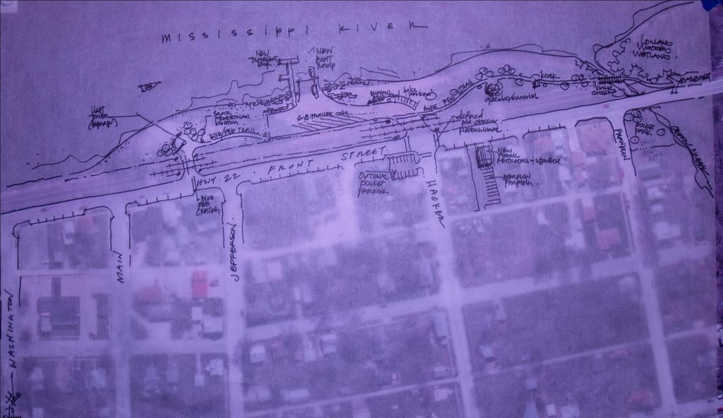
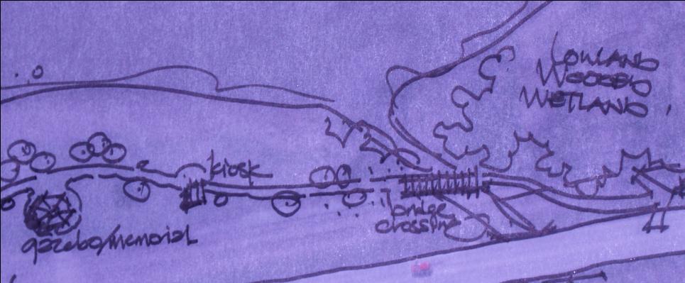
2 Buffalo Study Area War Memorial Gazebo Creek Kiosk Potential City Lot Locked Service Access Fill Sand Beach Historic Bldgs Boat Vehicle Access Natural Sand Beach Passive Park Significant Tree N Private owner willing to negotiate R.O.W


3 Buffalo Seen From the River Goals Passive park (as opposed to active) River education and Buffalo history Walking trails Beach and swimming area Play equipment Restrooms that are handicapped accessible Improve businesses by attracting more people Complete bike trail Improve boat launch Improved & expand dock Organized parking area More things to see, activity in vacant looking land, e.g. community garden Vision for the whole town
4 Challenges and Opportunities Connecting the bike path Working with the railroad Attaining permits Accessing the Western beach Negotiating private property Integrating wetlands Accessing grant money
5 Two Approaches to Buffalo s Beach Group #1 Fewest changes Lowest cost Integrating activities with town Build on current assets EXISTING USE PATTERNS Group #2 Big changes Lowest cost Original environment Restoration opportunities Integrating activities on the river bank RESTORED ENVIRONMENT PATTERNS

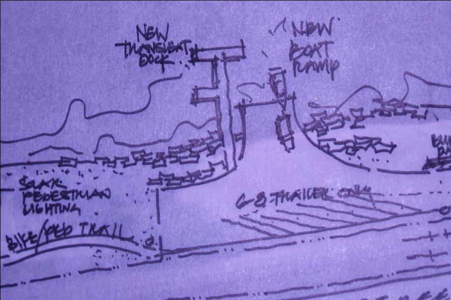
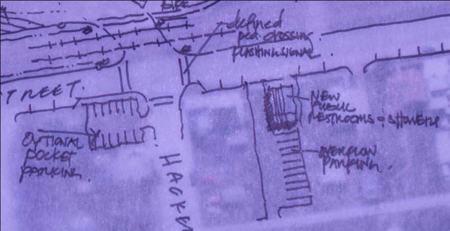
6 Group One New Picnic Area Existing Grass Area New Public Restrooms Existing Utilities New Front Street Character Based on Existing Buildings New Downtown Parking Existing Streets New Boat Ramps & Parking Existing Access & Dock New Boater Parking Existing Parking Lot

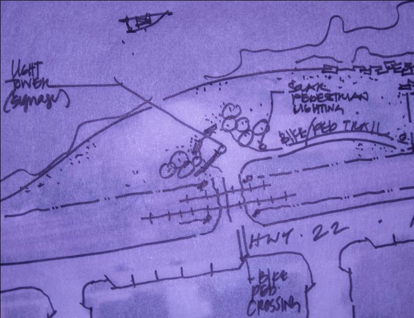
7 Passive Park Trail connects existing and eventually new features Bike & pedestrian bridge at creek, minimal permitting Access to downstream beach & beyond Natural Sand Beach

8 Pedestrian Crossing Zone Front Street crossing is opportunity for downtown entry Decorative fence defines waterfront and focuses RR crossings Draw people to the water

9 Fill Sand Beach Prairie planting provides natural character to water side Simple beach

10 Negotiate with bank to use Front Street parking for weekend boaters Reconfigure downtown street parking angled accommodates most cars & back-in is safest Motivate people to move between waterfront and downtown with businesses and services Fee parking on waterfront provides maintenance income from less parking on Mighty Miss. Most formal area, crisp sheet pile water edge

11 Group Two
12
13
14
15
16
17
18 Group One Ideas Sequential Potential Group Two Ideas Gain R.O.W across down river private property and permit to cross creek Install bike & pedestrian bridge Use fill sand beach until access gained to natural sand beach Create trail to connect uses on waterfront Swap lots and build public restrooms to serve 1) passive park and 2) boaters Historic Victorian buildings become model for development on Front Street Convert sand fill beach to more active boating Connect waterfront trail to regional trail Public restroom site developed to serve 1) boaters and 2) bicyclists Revise codes and ordinances so Front Street develops with consistent historic character consider form based code
MASTER PLAN for the EARL NEWHOUSE WATERFRONT
 MASTER PLAN for the EARL NEWHOUSE WATERFRONT on RESERVOIR POND - CANTON, MA Community Meeting #2 - Thursday, January 11 th PROJECT INTRODUCTION Project Goals: To prepare a MASTER PLAN which develops the
LPC Goals and Strategies. Transportation and Connectivity Employment Opportunities Food Access Waterfront Access Livable Communities
 LPC Goals and Transportation and Connectivity Employment Opportunities Food Access Waterfront Access Livable Communities Transportation and Connectivity Goal: Safe and ready access of all types allowing
Emerson Park Master Plan Update. Public Meeting III August 27, 2014
 Emerson Park Master Plan Update Public Meeting III August 27, 2014 Meeting Agenda: Project Update Presentation of Master Plan Components Discussion and Feedback The Path Forward: Building on the Concept
OPPORTUNITIES AND CONSTRAINTS - OXBOW PARK ENTRANCE AND PUT-IN
 OPPORTUNITIES AT OXBOW EXISTING WETLANDS Site is undeveloped and we can design a park that works well from the start. SAND BEACH Potential to eliminate invasive species. DEBRIS (CONCRETE, OLD CARS) VEGETATION
Centennial Hall Planning Comments Public Meetings, 9/19/2011. General Comments
 Centennial Hall Planning Comments Public Meetings, 9/19/2011 General Comments Space/Location Too tight. Acquire more space (Women s Club?) Is there a more central visitor center site? Site very important
Civic Center District
 Civic Center District The Civic Center district is the civic and social heart of Warrenville, containing such public buildings as the City Hall, Warrenville Public Library, Police Station, Park District
DISCUSSION TOPIC: ST JOHNS RIVER & ITS TRIBUTARIES (BPII) 2030 COMPREHENSIVE PLAN POLICES AND REGULATORY FRAMEWORK
 2030 COMPREHENSIVE PLAN POLICES AND REGULATORY FRAMEWORK") DISCUSSION TOPIC: ST JOHNS RIVER & ITS TRIBUTARIES (BPII) 2030 COMPREHENSIVE PLAN POLICES AND REGULATORY FRAMEWORK St. John s River & Its Tributaries Issue Summary: The St. Johns River is an important
DISCUSSION TOPIC: ST JOHNS RIVER & ITS TRIBUTARIES (BPII) 2030 COMPREHENSIVE PLAN POLICES AND REGULATORY FRAMEWORK St. John s River & Its Tributaries Issue Summary: The St. Johns River is an important
Mission Bay Park Master Plan Update: Fiesta Island Amendment (Information) Mission Bay Park Committee October 3, 2017
 Mission Bay Park Committee October 3, 2017") Mission Bay Park Master Plan Update: Fiesta Island Amendment (Information) Mission Bay Park Committee October 3, 2017 Tonight s Agenda Introduction & Project Overview Proposed Circulation Changes Overview
Mission Bay Park Master Plan Update: Fiesta Island Amendment (Information) Mission Bay Park Committee October 3, 2017 Tonight s Agenda Introduction & Project Overview Proposed Circulation Changes Overview
DRAFT ROOSEVELT ROAD. District Recommendations. Figure 5.23 The Roosevelt Road Corridor
 CHAPTER 5 Figure 5.23 The Road Corridor Road will develop as a mixed-use corridor, emphasizing regional retail, west of the river and mixed-use development east of the river. KEY RECOMMENDATIONS 1. High
City of Plattsburgh DRI: Downtown Streetscapes & Riverfront Access. Downtown Streetscape and Riverfront Access Design
 City of Plattsburgh DRI: Downtown Streetscapes & Riverfront Access Welcome Thank you for coming this evening. Agenda PART I - Project Context The Downtown Revitalization Program Our DRI Projects Other
PARKS. Chapter Introduction
 Chapter 4. PARKS 4.1. Introduction This Parks Element of the 2016 Comprehensive Plan Update provides direction and guidance, based on citizen input, in order to improve and maintain the City s existing
Durango Parks & Recreation Department. Strategic Plan
 Durango Parks & Recreation Department Strategic 2019-2023 Adopted April 2019 Overview The purpose of the adopted 2010 Parks, Open Space, Trails and Recreation Master is to provide a 10-year road map for
City of Iowa City Department of Neighborhood and Development Services Department of Parks and Recreation Department of Public Works City Manager s
 RFP Pre-submittal meeting December 18, 2015 City of Iowa City Department of Neighborhood and Development Services Department of Parks and Recreation Department of Public Works City Manager s Office Background
Park & Recreation Master Plan. March 31, 2017 Public Input Meeting
 Park & Recreation Master Plan March 31, 2017 Public Input Meeting Share Your Voice Shape Your Park Master plan Key implementation strategy City s primary park planning document City of Punta Gorda Comprehensive
Great Rivers Greenway CLEAN GREEN CONNEC TED T RAILS
 Great Rivers CLEAN GREEN CONNEC TED T RAILS Great Rivers (GRG) was established in 2000 to create a clean, green, connected St. Louis region. Today, many new and exciting projects demonstrate the social,
Draft Stillwater 2030 Comprehensive Plan- Goals and Policies
 Draft Stillwater 2030 Comprehensive Plan- Goals and Policies Instructions- Review each goal and policy and discuss with group any changes, deletions for additions to the list using your groups pen. Keep
Reconnecting to a Forgotten River St. Cloud MN. Aaron Hanson Design Design Thesis LA 572, Thesis, Spring 2012
 Reconnecting to a Forgotten River St. Cloud MN Aaron Hanson Design Design Thesis LA 572, Thesis, Spring 2012 site context 2.5 Miles Sartell St. Cloud to Fargo 170 Miles (2 hrs 45 mins) Hwy 10 infrastructure
Las Colonias Park Master Plan
 2013 Las Colonias Park Master Plan City of Grand Junction June 2013 Introduction Las Colonias Park, a 101 acre parcel on the edge of the Colorado River south of downtown, was deeded to the City of Grand
City of Naples Parks Master Plan (Draft)
") City of Naples (Draft) CSAB April 12, 2016 OVERVIEW Presentation Outline Overview Needs Assessment Recap Response to Needs Implementation Strategy Questions, Discussion Preserving Naples: A vision plan
City of Naples (Draft) CSAB April 12, 2016 OVERVIEW Presentation Outline Overview Needs Assessment Recap Response to Needs Implementation Strategy Questions, Discussion Preserving Naples: A vision plan
City of Royalton Comprehensive Land Use Plan 2005 to Revision February 8, 2011
 City of Royalton Comprehensive Land Use Plan 2005 to 2015 2011 Revision February 8, 2011 PART ONE: INTRODUCTION TO THE COMPREHENSIVE PLAN 1.0 Purpose and Introduction The Comprehensive Land Use Plan provides
Popp s Ferry Causeway Park Back Bay Environmental Educational Center CASHIO COCHRAN LLC
 Popp s Ferry Causeway Park Back Bay Environmental Educational Center CASHIO COCHRAN LLC A LIMITED LIABILITY COMPANY Popp s Ferry Causeway Park Master Plan Prepared for: City of Biloxi Department of Parks
Alderson, West Virginia. Prepared for the Town of Alderson. Strategic Riverfront Enhancement Plan
 Alderson, West Virginia Prepared for the Town of Alderson Strategic Riverfront Enhancement Plan March 2018 Strategic Riverfront Enhancement Plan Alderson, West Virginia Prepared for: Alderson Main Street
Please read the entire document
 projects impacting the waterfront revitalization area. The waterfront revitalization area of the town will have to subareas to the west and east of the village. Page 6 of 6 Wayfinding master plan create
Memorial Park Workshop Notes March 20, :30 10:30am
 Memorial Park Workshop Notes March 20, 2012 7:30 10:30am Black Team Veronica, Jeff, Shelly, Pat, Darcey, Gordy, Jeff Strengths River Size/Space Central Location History River Riffles in River View from/going
Hayesville Downtown Improvement Projects Martha Eberle DCA Intern Summer 2010
 Downtown Improvement Projects Martha Eberle DCA Intern Summer 2010 Project 1: Trail etwork Downtown Trail Hia wa ssee Clay County Health Dept Spikebuck Mound and Village Site July 14, 2010 July 14, 14,
PRELIMINARY DESIGN + DEVELOPMENT PLAN
 WELCOME! To The Public Open House May 30 th, 2017 HARBOUR WEST PARKS Vision Project Overview The City s vision for Port Credit Harbour West Parks is to develop a vibrant waterfront destination that integrates
Master Plan Implementation Committee Meeting
 MILTON VILLAGE ZONING AND WATERFRONT STUDY Master Plan Implementation Committee Meeting February 12, 2018 7:00-9:00 pm IMAGE: GOOGLE COMPILED MEETING FEEDBACK/SURVEY RESULTS Waterfront Principles - Prioritized
UNIVERSITY TOWN NEIGHBOURHOODS 5.2 ECO-CORRIDOR MELBOURNE CAMPUS MASTER PLAN 2014
 5.2 ECO-CORRIDOR 37 ECO-CORRIDOR EXISTING CONDITIONS & VISION NEIGHBOURHOOD VISION Investment in the Eco-corridor Neighbourhood will signify the University s commitment to supporting local ecology and
FY Capital Improvement Program Arroyo Projects
 FY 219-223 Capital Improvement Program FY 218 FY 219 FY 22 FY 221 FY 222 FY 223 1 2 3 4 5 6 7 8 9 1 Hahamongna - Implement Master Plan - Oak Grove Area Improvements (7756) Hahamongna - Implement Master
GOALS, OBJECTIVES, POLICIES & PROGRAMS
 Chapter 5 GOALS, OBJECTIVES, POLICIES & PROGRAMS 5.1 Goals, Objectives, Policies & Programs This is a joint plan adopted by both the Village of Waunakee and the Town of Westport. Both communities will
Highland Falls Waterfront Redevelopment Feasibility Study Village Board Meeting March 20, 2017
 Village Board Meeting March 20, 2017 Agenda I. Public Meeting #1 Visioning Summary II. Public Meeting #2 Comment Summary III. IV. IV. Case Study: Milton Train Station Schematic Design Concepts Schedule/Next
Small Area Plan. South Gateway
 Small Area Plan Adopted May 12, 2008 South Gateway Purpose. The South Gateway Small Area Plan defines the City s expectations for the future of the southern entrance to the City at Interstate 85 and Highway
Route 1 Corridor Study
 Route 1 Corridor Study Westbrook, Connecticut A Vision for the Connecticut Shoreline Public Informational Meeting July 28, 2015 Lower Connecticut River Valley Council of Governments Fitzgerald & Halliday,
PREVIOUS PUBLIC PARTICIPATION BRIEF October 2014
 Comprehensive Planning During the development of the county comprehensive plan, Cultivating Community: A Plan for Union County s Future from 2007 through 2009, and three concurrent multi municipal plans
Summary of Changes in the DRAFT Rivers Project Natural Resource Master Plan from the 2001 approved plan to 2014 plan
 Summary of Changes in the DRAFT Rivers Project Natural Resource Master Plan from the 2001 approved plan to 2014 plan The entire Master Plan format and layout has been changed to comply with regulation
LAND USE PLAN 7. Housing
 21 LAND USE PLAN While the land uses that have historically dominated the Corridor itself have been industrial/commercial, the Master Plan proposes a shift to mixed-use redevelopment, complimented by a
City of Poughkeepsie Waterfront Redevelopment Strategy. Poughkeepsie Waterfront Redevelopment Strategy
 City of Poughkeepsie Waterfront Redevelopment Strategy Poughkeepsie Waterfront Redevelopment Strategy City of Poughkeepsie Prime Assets: Major Waterfront Advantages: - Central City of the Hudson River
Wildflowers grow in the new community park on Oakwood Road
 Wildflowers grow in the new community park on Oakwood Road PLANNING AREA - NEW PARKS An important element in the plan for the City of Delafield is to look ahead for future park needs. The City has the
TRANSPORTATION PROJECTS
 TRANSPORTATION PROJECTS 40 BUFFALO S LWRP PROPOSED PROJECTS T1. Niagara Street/Great Lakes Seaway Trail Streetscape Project City of Buffalo Department of Public Works Niagara Street from Niagara Square
Mendota Heights 2040 Comprehensive Plan Draft Vers
 4 Parks and Trails The City of Mendota Heights boasts a variety of recreational and open space opportunities. Few cities can claim access to regional trails, riverside and lakeside parks, scenic bluffs
Minto-Brown Island. November 18, City of Salem, Parks & Transportation Services
 Minto-Brown Island Park Master Plan Public Meeting #1 November 18, 2014 City of Salem, Parks & Transportation Services Division, i i Public Works Welcome... and thanks for participating in the master planning
process of the Land Development Code to assure regional parks are available County-wide.
 GOAL 9.0. It is the goal of the Broward County Board of County Commissioners to provide safe and adequate recreation sites and facilities, including cultural art facilities, and open space to satisfy the
TASK FORCE MEETING #6 SUMMARY
 TASK FORCE MEETING #6 SUMMARY CITY OF REDWOOD CITY INNER HARBOR SPECIFIC PLAN Tuesday, January 14, 2013 7:00 P.M. 9:30 P.M. Seaport Conference Center, 459 Seaport Court, Redwood City, CA 94063 I. WELCOME
{Best Practices. Summary of Tools, Strategies and Best Practices from 11 Michigan Case Study Communities
 Case Studies Michigan Coastal Community Working Waterfronts { Summary of Tools, Strategies and from 11 Michigan Case Study Communities Table of Contents Zoning...2 Community and Stakeholder Collaboration
Waterlily Playscape Committee Waterlily Playscape, Waterlily Park, Ocean Shores Draft Concept Plan. G Issue D 14/07/16
 Waterlily Playscape Committee Waterlily Playscape, Waterlily Park, Ocean Shores Draft Concept Plan Issue D 14/07/16 New two level wharf for fishing and interacting with waters edge (exact location to be
TOWN COUNCIL / PLANNING COMMISSION
 Workshop #3 TOWN COUNCIL / PLANNING COMMISSION January 20, 2011 Consultant Team In Attendance Tonight BMS Design Group Nevada City and San Francisco Michael Smiley, AICP, ASLA Partner-in-Charge Nancy L.
Our Legacy Projects DOWNTOWN JACKSONVILLE MASTER PLAN
 DOWNTOWN JACKSONVILLE MASTER PLAN A major component of our master plan is the creation of a strong and accessible open space and recreation system. The four most vital links in that system are our legacy
RLRC COMMUNITIES THIEF RIVER FALLS AREA CHARACTER COMMUNITY TRAIL OPTIONS OAKLAND PARK EXISTING CONDITIONS OAKLAND PARK DESIGN DESIGN DETAILS
 THIEF RIVER FALLS AREA CHARACTER COMMUNITY TRAIL OPTIONS OAKLAND PARK EXISTING CONDITIONS OAKLAND PARK DESIGN DESIGN DETAILS 61 THIEF RIVER FALLS AREA CHARACTER Thief River Falls has a number of existing
CHAPTER 13 RECREATION AND OPEN SPACE ELEMENT
 CHAPTER 13 RECREATION AND OPEN SPACE ELEMENT Page 1 of 15 G:\Comp\Adopted Comprehensive Plans\15. Cylce 16-2 and 16-3\Elements not changed\ Rec & Open Space CHAPTER 13 RECREATION AND OPEN SPACE A. OVERVIEW
Current City Warehouse Facility. City Market Re-Use Concept. Indoor Market/ Maker s Incubator 1.06 acres +/- Open Air Market 1.
 Current City Warehouse Facility City Market Re-Use Concept Indoor Market/ Maker s Incubator 1.06 acres +/- Open Air Market Open 1.63 acres Air Market +/- 1.63 acres +/- 4.59 acres +/- Artists Workshops/
LITTLETON RIVER DISTRICT REDEVELOPMENT PROJECT A LEGACY OF LEADERSHIP & COMMUNITY INVOLVEMENT
 LITTLETON RIVER DISTRICT REDEVELOPMENT PROJECT A LEGACY OF LEADERSHIP & COMMUNITY INVOLVEMENT Background Information Littleton Saranac Street Design Charrette Sponsored by the Town of Littleton and Plan
Events, amenities, social character Access and Circulation Ecological significance Infrastructure Historical and cultural significance
 Events, amenities, social character Access and Circulation Ecological significance Infrastructure Historical and cultural significance Facilitator: Ana Nelson, P+W Table #: 1 1. Bike + pedestrian + disability
MCCOYS CREEK RESTORATION 30% DESIGN
 MCCOYS CREEK RESTORATION 30% DESIGN THE MCCOYS CREEK RESTORATION PLAN The restoration plan aims to reduce flooding, restore ecosystem health, expand recreational opportunities along the creek, and connect
Whitemarsh Comprehensive Plan Update: Housing & Land Use. Public Workshop #3: September 20, 2018
 Whitemarsh Comprehensive Plan Update: Housing & Land Use Public Workshop #3: September 20, 2018 Agenda Welcome Process Recap What We ve Heard The Plan Framework Review of Recommended Actions Land Use Housing
GOCO Grants Awarded to Projects in Arapahoe County through June 2015
 Grant Type Open Space Fiscal Year Applicant Project Title Grant Amount 2015 City of Aurora Acres Protected Triple Creek Greenway Corridor Phase 3 $2,050,000.00 0 Planning 2015 Arapahoe County High Line
a river of opportunity
 Kankakee Riverfront a river of opportunity Public Open House November 7, 2017 Can Kankakee use the river to connect its citizens? to support its economy? to attract more visitors? to reposition its brand?
Community Open House east sector master plan
 Community Open House 2.6.18 east sector master plan MEETING AGENDA 6:00-6:30 Dinner 6:30-6:50 Presentation 7:00-8:00 Discussion Tables 8:00-8:30 Report Back INTRODUCTION 2002 Buffalo Bayou & Beyond Master
ALTERNATIVE STATION AREA -
 ALTERNATIVE STATION AREA - THE 10 TH STREET GARDEN STATION Two alternative land use scenarios and designs are illustrated here: Scheme A - Transit-Oriented Development High to Mid-Density Residential /Office
PARTF Scoring System for Grants
 PARTF Scoring System for Grants The members of the N.C. Parks and Recreation Authority use the PARTF scoring system as one of several tools to select grant recipients. Please provide all of the information
Elliot Park 2. Neighborhood Master Plan. Historical Perspective
 Elliot Park 2 Neighborhood Master Plan Historical Perspective August 2002 Early History Development patterns and the growth of Minneapolis largely grew out of the city s historical response to its geography.
DRAFT. Waterfronts and Open Spaces. 10 The Riverfront Open Space System
 CHAPTER 4 Waterfronts and Open Spaces 10 The Riverfront Open Space System 12 Planned, proposed and envisioned riverfront recommendations. Figure 4.3.23 The riverfront will become a major new public amenity
Carteret. 1. Overview of Carteret and Its Waterfront. 1.1 Geographic Overview. 1.2 Demographics of Carteret. Carteret Borough
 Carteret 1. Overview of Carteret and Its Waterfront 1.1 Geographic Overview The Borough of Carteret is located in Middlesex County and is bordered on the north by the Rahway River and on the east by the
PHASE 3-4 PARKS SOUTH PARK AND CHANNEL PARK
 PHASE 3-4 PARKS SOUTH PARK AND CHANNEL PARK Sheet List L1.0 L2.0 L3.0 L4.0 L5.0 L6.0 L7.0 L8.0 L9.0 L10.0 L11.0 L12.0 L13.0 L14.0 L15.0 L16.0 L17.0 L18.0 L19.0 L20.0 L21.0 L22.0 Cover Open Space Context
The Lower SaLuda Greenway
 The Lower SaLuda Greenway InITIaTIve a FLourIShInG Greenway. a hub For economic GrowTh. a ConneCTIon BeTween CoMMunITIeS. In April 2017 the Michael J. Mungo Foundation and Lexington County commissioned
ASHTABULA COUNTY COASTAL MANAGEMENT PLAN
 Location Ashtabula County, Ohio Planning Grantwriting ODNR, Office of Coastal Management, $25,000 Local Match $25,000 Size 21 miles of coastal area Professional Services 2012 Project Team Randy Mielnik,
City of Bonney Lake Allan Yorke Park. MASTER PLAN SUMMARY REPORT June 30, 2016
 City of Bonney Lake Allan Yorke Park MASTER PLAN SUMMARY REPORT June 30, 2016 TABLE OF CONTENTS INTRODUCTION PUBLIC INVOLVEMENT PROCESS MASTER PLAN North Park Central Park South Park East Park Field Development
nokomis-hiawatha regional park master plan and park improvements
 master plan and park improvements CAC Workshop # August 26th, 2014 charge of the cac The Nokomis Hiawatha Regional Park CAC shall: Become knowledgeable about the project and its scope Understand and represent
APPENDIX C Township 9 Consistency with Applicable Plans
 Township 9 Consistency with Applicable Plans 1985 American River Parkway Plan Policies Project Consistency Policy 4.14: The following activities and facilities, which are incompatible with the Parkway,
APPENDIX K WINDSOR OFFICIAL PLAN
 CEAA ENVIRONMENTAL ENVIRONMENTAL IMPACT ASSESSMENT AMBASSADOR BRIDGE ENHANCEMENT PROJECT Replacement Span and Plaza Expansion APPENDIX K WINDSOR OFFICIAL PLAN Avalon Consulting Professionals of Ontario,
Community Development Committee Meeting date: July 20, 2015 For the Metropolitan Council meeting of August 12, 2015
 Business Item No. 2015-167 Community Development Committee Meeting date: July 20, 2015 For the Metropolitan Council meeting of August 12, 2015 Subject: Nokomis-Hiawatha Regional Park Master Plan, Minneapolis
EXISTING PLANS Harriet Festing Center for Neighborhood Technology Midlothian Community Meeting March 12, 2015
 EXISTING PLANS Harriet Festing Center for Neighborhood Technology Midlothian Community Meeting March 12, 2015 BENEFITS Bring economic, community + environmental benefits Enhance property values Use
Trinity Uptown - Peripheral Zones University Drive/ Jacksboro Highway Zone March 31, 2008
 Trinity Uptown - Peripheral Zones University Drive/ Jacksboro Highway Zone March 31, 2008 TRINITY UPTOWN CHARACTERISTICS Desirable density Residential and mixed uses Active waterfront Public spaces Pedestrian
Winter Island Park Public Meeting #1 Salem, Massachusetts
 Winter Island Park Public Meeting #1 Salem, Massachusetts Site Context The Willows Salem Center Dominion Power Station ti Marblehead Site Analysis and Programming Site Conditions Site Uses Site Structures
Cold Lake Marina Master Plan
 Cold Lake Marina Master Plan Intro to Team Moffatt & Nichol is recognized throughout the world for our role in the revitalization and redevelopment of urban waterfronts, including the evolution of modern
Stakeholders Advisory Working Groups (SAWGs) Smart Growth and TOD Land Use (#11) SAWG Meeting
 Smart Growth and TOD Land Use (#11) SAWG Meeting") Presentation - Part II Tappan Zee Bridge/I-287 Corridor Project July 21, 2010 Slide 1. David Kooris (Regional Plan Association) welcomed members of the Land Use Stakeholders Advisory Working Groups (SAWGs)
Presentation - Part II Tappan Zee Bridge/I-287 Corridor Project July 21, 2010 Slide 1. David Kooris (Regional Plan Association) welcomed members of the Land Use Stakeholders Advisory Working Groups (SAWGs)
Notice of Preparation (NOP) of an Environmental Impact Report and Public Scoping Meeting for the Alameda Shipways Residential Project
 of an Environmental Impact Report and Public Scoping Meeting for the Alameda Shipways Residential Project") Notice of Preparation (NOP) of an Environmental Impact Report and Public Scoping Meeting for the Notice is hereby given that the City of Alameda, Lead Agency, will prepare an Environmental Impact Report
Notice of Preparation (NOP) of an Environmental Impact Report and Public Scoping Meeting for the Notice is hereby given that the City of Alameda, Lead Agency, will prepare an Environmental Impact Report
Welcome to the Public Meeting!
 Welcome to the Public Meeting! Please sign in, grab a paper survey, and check out the boards around the perimeter of the room. Once you ve viewed all of the boards, come join us in the middle of the room
The Planning Partnership Baird + Associates TCI Management Consultants Ltd. Plan B Natural Heritage Wills Consulting Engineers Poulos & Chung Limited
 Little Lake Master Plan The Planning Partnership Baird + Associates TCI Management Consultants Ltd. Plan B Natural Heritage Wills Consulting Engineers Poulos & Chung Limited May 26, 2009 Purpose of Study
Lake O the Pines Master Plan Revision Public Information Meeting April 25 & 27, 2017
 Lake O the Pines Master Plan Revision Public Information Meeting April 25 & 27, 2017 Presented By Matthew Like, Lake Manager U.S. Army Corps of Engineers Fort Worth District US Army Corps of Engineers
Master Plan Workshop October 25, 2007 Charlotte Mecklenburg Government Center
 Master Plan Workshop October 25, 2007 Charlotte Mecklenburg Government Center Land Discussion 1. What are the most important land related issues we need to address? Protect natural areas Passive walking
A Vision for Walnut Creek
 A Vision for Walnut Creek Photo: City of Clive Walnut Creek Booklet 8 of 8 Greater Des Moines Water Trails and Greenways 1 Table of Contents Booklet 1: Water Trails Strategies and Policies Booklet 2: Beaver
Public Meeting May 20, 2014
 Public Meeting May 20, 2014 Overview Study Purpose Study Area Overview Strategies Potential Opportunities Implementation and Discussion Skeo Solutions Raleigh Walkable Watershed Pilot 2 Purpose Develop
Gold Line Bus Rapid Transit Transit Oriented Development (BRTOD) Helmo Station Area Plan
 Helmo Station Area Plan") Appendix F Gold Line Bus Rapid Transit Transit Oriented Development (BRTOD) Helmo Station Area Plan Introduction and Purpose of the Plan The Gold Line Bus Rapid Transit facility is an eleven-mile dedicated
Appendix F Gold Line Bus Rapid Transit Transit Oriented Development (BRTOD) Helmo Station Area Plan Introduction and Purpose of the Plan The Gold Line Bus Rapid Transit facility is an eleven-mile dedicated
ENVISION. Planning and Policy Initiatives Maintenance and Operations Initiatives Programming Initiatives
 ENVISION Through the master planning process, a range of ideas, concepts, policies and initiatives were developed and vetted internally with staff, the project Advisory Committee, and master plan team.
a) Inventory of all existing privately-owned, state-owned, or local governmentowned recreational facilities and open spaces within the context area
 Inventory of all existing privately-owned, state-owned, or local governmentowned recreational facilities and open spaces within the context area") 8.0 RECREATION AND OPEN SPACE ELEMENT (1) DATA REQUIREMENTS a) Inventory of all existing privately-owned, state-owned, or local governmentowned recreational facilities and open spaces within the context
8.0 RECREATION AND OPEN SPACE ELEMENT (1) DATA REQUIREMENTS a) Inventory of all existing privately-owned, state-owned, or local governmentowned recreational facilities and open spaces within the context
VIRGINIA KEY CONSENSUS MASTER PLAN
 VIRGINIA KEY CONSENSUS MASTER PLAN JULY 2010 Existing Conditions JULY 2010 STAKEHOLDER INTERVIEW PROCESS, January 18-22, 2007 PUBLIC MEETING #1: SITE INVENTORY AND ANALYSIS, March 29, 2007 PUBLIC MEETING
BUSINESS DISTRICT DESIGN GUIDELINES
 Des Plaines, Illinois Prepared for the City of Des Plaines by: The Lakota Group Laurie Marston, AICP March 2005 Section 5: Streetscape Elements Business District Design Guidelines STREETSCAPE ELEMENTS
Pedestrian Bridge at Vermijo Avenue. Kathleen Krager June 13, 2016
 Pedestrian Bridge at Vermijo Avenue Kathleen Krager June 13, 2016 The Downtown Action Plan -1992- Proposes pedestrian crossing of the railroad at Vermijo Avenue Pikes Peak Greenway Master Plan -June
MEMORIAL PARK MANAGEMENT PLAN
 MEMORIAL PARK MANAGEMENT PLAN Village of Elk Rapids, Michigan 2015 Developed by the Parks and Recreation Commission Planning Commission Approved, Village Council Approved, 1 Introduction The purpose of
Focus Groups. 8 Focus Group meetings including 2 with staff, 1 with seniors, and 1 with students
 Project Team Nan Lanahan, Parks & Recreation Jason Gallo, Parks & Recreation Rob Leslie, DEDP John Smolinsky, Planning Board Brent Meredith, Highway Joan Gavrilik, Friends of Parks & Rec MaryLyn Koval,
Urban runoff in my neighborhood (Capitol Hill) is heavy with trash and other debris.
 is heavy with trash and other debris.") South Platte River Meeting Comments & s #1 I am a huge fan of river areas and would love the Platte and surrounding waterways to improve to allow habitat for wildlife and recreation opportunities for citizens.
South Platte River Meeting Comments & s #1 I am a huge fan of river areas and would love the Platte and surrounding waterways to improve to allow habitat for wildlife and recreation opportunities for citizens.
A Vision For Miami s Twenty-first Century Parks And Public Spaces
 1 A Vision For Miami s Twenty-first Century Parks And Public Spaces Parks and Public Spaces in Miami 21 An urban renaissance is remaking the City of Miami as new residents, new visitors, and new investment
2007 Blaine Wharf District Master Plan ii
 INTRODUCTION... 1 BLAINE SETTING... 1 GENERAL LOCATION... 2 WHARF DISTRICT... 2 SITE HISTORY... 5 PLANNING AND ANALYSIS PROCESS... 5 BLAINE WHARF DISTRICT MASTER PLAN... 7 CITY OF BLAINE VISION STATEMENT
Yadkin River Greenway Feasibility Study Fact Sheet Village of Clemmons, Town of Lewisville, Town of Bermuda Run
 Fact Sheet Village of Clemmons, Town of Lewisville, Town of Bermuda Run Project Background The Yadkin River Greenway Feasibility Study is a joint project with the Village of Clemmons, the Town of Bermuda
Table of Contents. Planting of Trees and Grasses. Purpose. Research approach. Downtown District. Findings. Decorative Antique Lighting
 Community Redevelopment Authority 2017 Table of Contents Purpose Research approach Downtown District Findings Planting of Trees and Grasses Decorative Antique Lighting Pedestrian Services Cracked Sidewalks
REVISED DRAFT. Malone Memorial Recreational Park and West Street Park Facilities Enhancement Master Plan. Village of Malone, New York.
 West Street Park Salmon River REVISED DRAFT Malone Memorial Recreational Park and West Street Park Facilities Enhancement Master Plan Village of Malone, New York Revised Draft Date: February 24, 2014 DOS
DRAFT SECTION 4(F) EVALUATION STILLWATER MUNICIPAL BARGE FACILITY
 EVALUATION STILLWATER MUNICIPAL BARGE FACILITY") DRAFT SECTION 4(F) EVALUATION I. DESCRIPTION OF SECTION 4(F) RESOURCE The Section 4(f) resource discussed in this evaluation is known as the Stillwater Municipal Barge Facility property, known previously
DRAFT SECTION 4(F) EVALUATION I. DESCRIPTION OF SECTION 4(F) RESOURCE The Section 4(f) resource discussed in this evaluation is known as the Stillwater Municipal Barge Facility property, known previously
Mississippi Drive Corridor Revitalization. A DestinationTransportation Project...
 Mississippi Drive Corridor Revitalization A DestinationTransportation Project... Mississippi Drive Corridor Revitalization Welcome! Tonight s Agenda: Further define the Scope of the Project Discuss the
Little Neck Planning Area
 Little Neck Planning Area Current Reality The Little Neck Planning Area is characterized by established residential neighborhoods, Town Center and Pembroke. The Eastern and Western Branches of the Lynnhaven
Asbury Chapel Subdivision Sketch Plan
 Asbury Chapel Subdivision Sketch Plan PART 1: PROJECT SUMMARY Applicant: NVR Inc. Project Size: +/- 76.13 acres Parcel Numbers: 02101112,02116101,02116112, 02116113 Current Zoning: Transitional Residential