DHT 750_EDR_00 Ecological Deliverability Appraisal DHT Access Appraisal C DHT Heritage Overview
|
|
|
- Kellie Craig
- 5 years ago
- Views:
Transcription

1 Consultee ID: April 2017 Rep Summary TTV29 (7) Broom Park Field Legal, Compliant and Sound Hearing: DHT wish to participate in the examination hearings to further develop our comments, to enable us to respond to the views of other participants and to be able to provide specific technical clarification on points raised Attachments: Aug 2016 Submission Intro / Summary This representation is submitted by the Dartington Hall Trust (DHT). It has been informed by recent and in-depth strategic review of the Trust s purpose and draws on assessments prepared by a multi-disciplinary professional team. In the context of a new strategy which identifies the unique status of the estate as a rural campus delivering activity under a range of new priorities including Destination, Placemaking, Learning and Arts, this representation reflects on-going planning for the future of DHT landholdings integral to which will be on-going engagement and consultation with Parish residents and other key stakeholders. This representation should be read in conjunction with our earlier representations submitted in August 2016 which are attached for reference. DHT are the owners of the land at TTV29 (7) Broom Park and wish to support this allocation and confirm its availability and deliverability within the required time frame. This representation should be read in conjunction with our earlier representation submitted in August 2016 which is attached for reference. The following evidence documents, attached with our representation to TTV29(4) should also be referred to: DHT 750_EDR_00 Ecological Deliverability Appraisal DHT Access Appraisal C DHT Heritage Overview Site Context The Broom Park site comprises 8.59 ha agricultural land gently sloping down from North to South with fairly gentle gradients around most of the site. A small portion of at the South of the site lies within the Bidwell Brook flood zone, and this is to be avoided. The site is largely unconstrained, subject to the usual investigations. The site is within the 4km potential foraging buffer of the South Hams SAC and is away from the identified potential strategic flyways for Greater Horseshoe Bats (GHB). However, the Bidwell Brook may form an attractive dark corridor and potential feeding area for the GHBs. The Council s heritage impacts study highlights a large number of listed buildings close to the site though these are largely shielded by topography and mitigation measures have been identified. The site is well located adjacent to the Dartington settlement with a significant range of services. The Primary School and Bidwell Brook Special Educational Needs DHT Rep TTV29(7) Broom Park Field Page 1 of 2
2 Consultee ID: April 2017 school are adjacent to the site. Previous assessments have concluded that the site performs very well supporting sustainable residential-led development. The site is very well located for access to services. The Primary School and special educational needs school are adjacent and daily needs shopping is available within walking distance. There are numerous employment opportunities in the immediate vicinity (Webbers Yard, Shops at Dartington, and offices on the Dartington campus). The KEVICC secondary school is approximately 1.3 miles from the site along the NCN2 or the public footpath and Dartington C of E primary school is adjacent to the site. Totnes is the administrative hub of South Hams and the full range of employment, leisure, medical and community services are available in close proximity to the site, accessible by safe sustainable transport routes and public transport Development Context We have reviewed the representations on the previous JLP consultation. It is clear that many local residents object to greenfield development with the loss of Broom Park field a particular cause for concern locally. However, the allocation for 80 homes is low in relation to the sites capacity and reflects DHT s desire to find an appropriate balance of uses including between development, accessible open space, landscaping and green infrastructure. Broom Park field sits is bounded by a major A road to the East, village development to the South and clusters of buildings to the West and North. Given the JLP strategic objective of reinforcing the sustainable villages and not promoting development in more remote areas, development there is potential for future development on this site in preference to sites further away from local services or in more sensitive areas or areas subject to statutory designations. Housing Supply Contribution Broom Park is allocated for 80 dwellings and the Councils housing trajectory identifies home completions on this site to commence in 2026/27 and then deliver 30 dwellings in each of the next two years. This quantum and rate of development is easily achievable. DHT support the delivery later in the plan period as this will provide an opportunity to first focus on heritage-led regeneration projects on Dartington Estate and to continue to work with the local community on placemaking issues. As Council officers monitor progress on plan delivery the potential development in this area can be reviewed in light of changing demand. Finally, DHT wish to note that part of our work is to explore innovative, community-responsive placemaking and home building models in part as an alternative to the volume housebuilder model of delivery. We hope that as work progresses with other estate projects including Dartington Lane (TTV28(1)) and onestate projects we can find ways of helping meet local housing demand which will gain public support. DHT Rep TTV29(7) Broom Park Field Page 2 of 2


3 Consultation Response by The Dartington Hall Trust Site Reference: SH_14_01_08/13
4 Contents Introduction 1 Site Description 2 Development Proposal and Context 3 Site Technical Assessment 4 Site Suitability Assessment 5 Planning Policy Review 7 Summary 11
5 Introduction This document provides information related to the potential use of land at Broom Park, Dartington for residential development. It has been assembled by The Dartington Hall Trust (DHT) drawing on assessments prepared by a multi-disciplinary professional team in response to the consultation on the emerging Plymouth and South West Devon Joint Local Plan. It specifically addresses the question of suitability and deliverability of the site in terms of its ability to meet identified housing needs in the plan area and the proposed allocation of land in Totnes, including sites in Dartington and Berry Pomeroy. It provides a systematic and thorough analysis to ensure that the Joint Local Plan is founded on a sound evidence base. The work undertaken and reflected in this document supports the local planning authorities inclusion of the Broom Park field as a potential housing site for allocation in the Joint Local Plan. Its key findings are: The Broom Park site comprises 8.59 ha of land in a highly sustainable location. The site is available and is being promoted by DHT for the development of around 60 homes. This reflects the results of studies undertaken and the potential of other sites owned by DHT. The site is not constrained by technical issues including access, landscape, ecology, or servicing and is considered viable. The site is compliant with National Planning Policy Guidance. The site is deliverable within a phased programme to meet market demand. 1

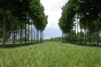
6 Site Description Figure 1: Site Photograph Broom Park field comprises 8.73 ha of agricultural land bounded to the east by the A384, Bidwell Brook to the south and west and adjacent to Broom Park, a 1930s residential cluster development constructed by DHT on the northern boundary and the access lane leading from St Mary s Church to the hamlet of Week. The land adjoins a 2 ha site to the south west on which the new 360 pupil Dartington Primary School was constructed in 2009, which is now being rebuilt. The land comprises a gently sloping large field under tenancy, contained mainly by traditional planted hedgerows and stock-proof fences to various boundaries. The original hedgerows have been removed over the years as the land has been used for arable production as part of DHT tenant farming activities. 2
7 Development Proposal and Context The Broom Park site is available for development and is being promoted by DHT as a site for around 60 homes. Part of site was submitted in the 2009 SHLAA as site SH_14_01_08 (referred to as Bidwell ). The site was assessed for suitability through the Site Allocations Sustainability Threshold Assessment in April 2010 as site DN3. This assessment concluded that the site performed very well in supporting sustainable development with the only caution being a small area on the southern edge, which occupies the Bidwell Brook flood zone. The site was not allocated in the Rural Areas DPD in 2011 as there was sufficient land to meet the then identified needs of Dartington through development of Webbers Yard and Sawmills East and Ashburton Road sites; the majority of which are now close to completion. There are no planning applications for the site identified on South Hams District Council s web site. 3
8 Site Technical Assessment Access The site is very well located for access to Dartington, Totnes and the wider road network. A number of footways serve the parish and provide connection to Totnes. There is a safe and direct link to the cycle route NCN2 which provides access to Totnes town and station via a designated cycle path. An access appraisal tested the trip generation from this site in combination with other potential and proposed developments in the area and it was demonstrated that the road network will be able to accommodate the vehicle movements arising. The access appraisal has demonstrated that there are no material highway or transportation matters that would preclude the Local Planning Authority from approving any planning application with regard to highways issues. Utilities An infrastructure report prepared by Jubb Consulting Engineers confirms that site water, drainage and energy services can be achieved without abnormal cost. Delivery The results of the technical assessment work confirms that there are no issues that would impede delivery and viability of the site and its ability to contribute to the district s identified housing requirements. 4
9 Site Suitability Assessment Location The site is very well located for access to services. The Primary School is adjacent and daily needs shopping is available nearby. There are numerous employment opportunities in the immediate vicinity (Webbers Yard, Shops at Dartington, and offices on the Dartington campus). The KEVICC secondary school is approximately 1.3 miles from the site along the NCN2 or the public footpath and Dartington C of E primary school is adjacent to the site. Totnes is the administrative hub of South Hams and the full range of employment, leisure, medical and community services are available in close proximity to the site, accessible by safe sustainable transport routes and public transport. Flood Risk The site is predominately outside Flood Zones 2 and 3 with the exception of the southern boundary along Bidwell Brook. There is no development proposed in this area, and on site drainage and attenuation can be easily achieved at the density proposed. Ecology The site falls wholly within the potential foraging area for Greater Horseshoe Bats from the South Hams Special Areas of Conservation (SAC). The design of any development in the area should reinforce potential flyways through landscaping and will be subject to appropriate mitigation for example conditions on external lighting. An Ecology overview report has been produced by EAD which outlines a scheme of detailed assessments to support mitigation considerations in detailed scheme design including: Extended Phase 1 Habitat Survey. Ecological Impact Assessment (EcIA). Bat Activity Survey (cf South Hams SAC Planning Guidelines). Possible other surveys if indicated (reptiles, amphibians, breeding birds, dormice, invertebrates). Based on the desk-based environmental assessment, no overriding ecological constraints to development are identified. Appropriate on site mitigation and enhancement will be required for any notable species. 5
10 Heritage Impacts A detailed assessment of heritage impacts will only be possible when the sites for development have been defined firmly and their nature and layout have been planned. It is likely that impacts on significance, if any, will result from changes to the settings of heritage assets in the vicinity. Two designated heritage assets are situated close to Broom Park: at its nearest point, the site is about 100 m from the Grade II* listed St Mary s Church and parts of the site are visible from the church yard; Church Cottage located immediately to the North of St Mary s is also Grade II listed. Historic England s Historic Environment Good Practice Advice in Planning: 2 observes: Development proposals that affect the historic environment are much more likely to gain the necessary permissions and create successful places if they are designed with the knowledge and understanding of the significance of the heritage assets they may affect. The first step for all applicants is to understand the significance of any affected heritage asset and, if relevant, the contribution of its setting to its significance. A detailed assessment of the settings of the two designated heritage assets close to Broom Park is currently being prepared to accord with Step 2 of guidance in paragraph 12 of Historic England s Historic Environment Good Practice Advice in Planning: 3. Early indications are that there is good scope at Broom Park to provide new development with acceptable levels of impact upon the significance of both heritage assets. Promotion of a modest number of dwellings on this site will provide opportunities to introduce landscaping and green infrastructure, which will ensure development does not impact the setting of the two heritage assets in the vicinity. Finally, development is likely to require archaeological investigation. 6
11 Planning Policy Review The consultation document issued on the South West Devon Joint Local Plan indicates that outside of Plymouth planning policy sets out to focus development on the market towns where employment, transport and community services are available. The Broom Park site represents an opportunity to deliver sustainable development which supports the sustainability objectives promoted by the council(s). DHT shares with the council the overarching aim to produce a sound local plan in order to guide development in a sustainable way over the coming years. This planning assessment includes reference to both policy compliance for proposed development and plan-making compliance for the forthcoming presubmission Draft Local Plan. Under Section 38(6) of the Planning and Compulsory Purchase Act 2004 the local development plan provides the primary guidance in consideration of planning proposals. However, this consultation is intended to inform the content of the new Joint Local Plan for the area so initial consideration of appropriateness of allocations and policies is based on the National Planning Policy Framework (NPPF) and National Planning Practice Guidance (NPPG). 7
12 National Policy Planning Balance The allocation of land for development on this site presents an opportunity to satisfy the NPPF objective to significantly boost the supply of housing, and the requirement for Local Planning Authorities to make plans and to determine planning applications based on the presumption in favour of sustainable development. Specifically, development is supported by the following: NPPF 7 notes that there are three dimensions to planning; economic, social and environmental. This proposal provides an opportunity to deliver housing in a well-located area, which avoids more sensitive environments and landscapes. This also provides an opportunity to support the charitable aims of DHT and to make provision for housing for significant numbers of people employed locally. NPPF 17 identifies core principles including to proactively drive and support sustainable economic development to deliver the homes, infrastructure and thriving local places that the country needs. NPPF 63 states that in determining applications, great weight should be given to outstanding or innovative designs, which help raise the standard of design more generally in the area. DHT has fully committed to enabling development that introduces more locally-responsive approaches to design and construction and this development presents a unique opportunity to fulfil this objective. NPPF 118 notes that local planning authorities should aim to conserve and enhance biodiversity through avoidance, mitigation and enhancement. Supporting development in this site, bounded on two sides by the existing built up area, helps achieve the required housing needs for the district without incursion into areas of undisturbed or sensitive ecology. NPPF 128 and 129 highlight the need to assess historic assets and potential impacts of any proposals. Discussions with architects and heritage experts confirms that plans within this area can be designed to be compatible with the listed buildings nearby and to add to the legibility and sense of arrival for the historic Estate. NPPF 14 (and 197) highlights the presumption in favour of sustainable development. For decisiontaking this means: In the absence of a robust plan the council should grant permission unless any adverse impacts of doing so would significantly and demonstrably outweigh the benefits... or specific policies in this Framework indicate development should be restricted. Based on this appraisal it is clear that this site accords with the requirements of the NPPF and the principle of development on this site would be supported by national policy. 8
13 National Policy Plan Soundness The NPPF sets out a number of requirements for plan making. NPPF 182 summarises the tests of soundness as being: positively prepared, justified, effective and consistent with national policy. The inclusion of Broom Park field helps meet these tests with particular support for the following: NPPF 15 highlights that policies in Local Plans should also follow the approach of the presumption in favour of sustainable development. NPPF 35 requires that plans should ensure development is located where it can exploit opportunities for the use of sustainable transport modes for the movement of goods or people etc. Broom Park provides ready access to public footpaths, NCN2 cycleway, public transport, and the strategic rail network. NPPF 37 seeks to ensure planning policies should aim for a balance of land uses within their area so that people can be encouraged to minimise journey lengths for employment, shopping, leisure, education and other activities. Many of these facilities are available in close proximity to the site. NPPF 47 To boost significantly the supply of housing local plans must identify developable and deliverable sites to meet their objectively assessed needs; this test of soundness is one of the most carefully examined. This site can contribute to meeting the council s identified need including delivery within years one to five. NPPF 55 requires that to promote sustainable development in rural areas, housing should be located where it will enhance or maintain the vitality of rural communities. The council recognised that the market towns provide the most sustainable approach to meeting housing needs in the district. Broom Park will help meet the housing needs of Totnes and immediately surrounding parishes. NPPF 173 notes the need for plans to be deliverable including considerations of viability. Allocating this site provides a more diverse basis for delivery. In practice, much of the discussion during the examination of the Joint Local Plan will hinge on deliverable housing land supply, namely NPPF 47 requirement that the council: meets the full, objectively assessed needs for market and affordable housing in the housing market area and identify a supply of specific deliverable sites sufficient to provide five years worth of housing and developable sites for years 6-10 and, where possible, for years This site forms one of DHT s potential development sites, which is clearly deliverable, is located in a sustainable location and can contribute to meeting the District s housing need whilst avoiding more sensitive and less sustainable sites. At present DHT wishes to focus its efforts on the Estate Framework developments on the Dartington campus. To that end it is recommended that the site be considered part of the overall land supply rather than the specific Five Year Housing Land Supply calculation. 9
14 Local Policy Analysis South Hams District Council is in the process of updating its Local Development Framework which was put in place in Site allocations which flowed from the Core Strategy in Totnes and Dartington have largely been taken up or are in the process of progressing. The Joint Local Plan is required to provide for new homes and employment to 2034 which necessarily requires additional sites to be brought forward. Much of this is being focused on Plymouth and the urban fringe. The market towns and area centres of South Hams and West Devon remain the focus of development needs. With limited land now available within the parish boundaries of Totnes, local policy is necessarily looking to the adjoining parishes of Dartington and Berry Pomeroy to meet the objectively assessed needs in this part of the South Hams. South Hams District Council assessed this site in April 2010 when considering requirements for the Rural Site Allocations DPD. That assessment found the site to be highly sustainable and deliverable. However, at that time, the village housing requirement could be met by allocations at Ashburton Road and Sawmills East/Webbers Yard and both of these allocations are scheduled for completion in the coming year. Neighbourhood Planning Dartington Parish is a designated Neighbourhood Plan area. DHT has been engaging in the Neighbourhood Plan process and hopes to align the Trust s development opportunities with the objectives of the local community. This includes development management policies as well as meeting overall requirements. DHT is committed to being responsive to the needs of the local and wider community and an allocation of the Broom Park field site makes provision for an amount of housing which is significantly below the capacity of the site. This will allow development to be brought forward in a way that responds to the community s desire for housing to be developed in a way which maintains the predominantly rural character of Dartington and the aspiration for design quality likely to be reflected in the policies of the Neighbourhood Plan. In looking forward for the next twenty years, the council has recognised that Totnes and its adjoining settlements form an integrated community and that Totnes is tightly constrained and built out to its boundary. As such the council will have to consider the relative performance of various sites in the area. It is assumed that when judged against most measures of sustainability this site will be identified as a good location for development. 10
15 Summary Analysis of policy makes it clear that allocation for development is appropriate and the principle of development on this site should be acceptable. Review of technical and design issues make it clear that the scheme is deliverable. On the basis of current policy, and in light of the lack of site constraints, this site could begin to deliver in the five year time frame. It will be for the council to determine the specific allocations and wording. However, in light of the unconstrained nature of the site, we would recommend that this allocation be made in the form of around 60 dwellings to provide certainty and a potential buffer in land supply. Proposed Delivery Programme Years one to twenty available for release in a phased programme as required. Consultants The appraisals have been prepared by the Dartington Hall Trust with support and advice from specialist consultants including: Planning advice Prof Chris Balch, Professor of Planning, Plymouth University Planning advice Mary Elkington, Figura Planning Masterplanning and Estate Framework Studio Partington Heritage Stephen Bond, Heritage Places Transport Assessment Hydrock Surface and foul drainage infrastructure Jubb Consulting Engineers Ecology EAD Ecology 11
16 Figure 2: Site Location Plan Scale A3 St Mary s Church Schumacher College/ Old Postern Old Parsonage Farm Upper Drive A384 Development Area Primary School Bidwell Brook 8.73 ha Foxhole Car Park Bidwell Brook Middle Drive Shops at Dartington Cott Road A385 A M 12
17 Figure 3: Site Constraints Plan Scale A3 Key to Site Constraints Plan Grade II* listed St Mary s Church Listed buildings Recreational area Hazel Park Upper Drive/ main visitor entrance to Dartington Hall Flood Map for Planning zone houses for estate workers 1:29 gradient 1:18 Flood Map for Planning zone 2 Steep gradient, arrow points in direction of fall 1:11 gradient 1:11 gradient Primary School Steep slope 1:4 gradient Area within flood zone Bidwell Brook M 1:2 gradient 13
Response by The Dartington Hall Trust
 Consultation Response by The Dartington Hall Trust Site Reference: (T6 in DPD) 14_56/2246/13/f Contents Introduction 1 Site Description 2 Development Proposal and Context 3 Site Technical Assessment 4
Response by The Dartington Hall Trust
 Consultation Response by The Dartington Hall Trust Site Reference: SH_39_02_08/13 Contents Introduction 1 Site Description 2 Development Proposal and Context 3 Site Technical Assessment 4 Planning Policy
Rep Summary TTV28 (1) Dartington Lane. Introduction. Update
 Dartington Lane. Introduction. Update") Consultee ID:1020173 April 2017 Rep Summary TTV28 (1) Dartington Lane Legal, Compliant and Sound Hearing: DHT wish to participate in the examination hearings to further develop our comments, to enable
Consultee ID:1020173 April 2017 Rep Summary TTV28 (1) Dartington Lane Legal, Compliant and Sound Hearing: DHT wish to participate in the examination hearings to further develop our comments, to enable
Plumpton Neighbourhood Development Plan Revised Pre Submission Document - Regulation 14 Consultation
 REPRESENTATIONS... Plumpton Parish Council Plumpton Neighbourhood Development Plan Revised Pre Submission Document - Regulation 14 Consultation Representations submitted on behalf of: Cala Homes (South
Plymouth and South West Devon Joint Local Plan
 Plymouth and South West Devon Joint Local Plan Totnes and Area Briefing 19 th July The Totnes Area Introduction to the Joint Local Plan Potential Development Sites The Local Issues Discussion The Totnes
Sustainability Statement. Whitby Business Park Area Action Plan
 Sustainability Statement Whitby Business Park Area Action Plan November 2014 Contents Page 1. Introduction 1 2. Scoping 3 3. Sustainability Appraisal of Options 6 4. Assessment of Draft Area Action Plan
SOUTH EAST LINCOLNSHIRE LOCAL PLAN: HOUSING PAPER DONINGTON (JUNE 2016)
") SOUTH EAST LINCOLNSHIRE LOCAL PLAN: HOUSING PAPER DONINGTON (JUNE 2016) 1 DONINGTON S PLACE IN THE SPATIAL STRATEGY 1.1 Policy 2 of the South East Lincolnshire Local Plan 2011-2036 Draft for Public Consultation
SOUTH EAST LINCOLNSHIRE LOCAL PLAN: HOUSING PAPER DONINGTON (JUNE 2016) 1 DONINGTON S PLACE IN THE SPATIAL STRATEGY 1.1 Policy 2 of the South East Lincolnshire Local Plan 2011-2036 Draft for Public Consultation
Settlement Boundaries Methodology North Northumberland Coast Neighbourhood Plan (August 2016)
") Introduction This background paper sets out a methodology for the definition of settlement boundaries in the North Northumberland Coast Neighbourhood Plan. The neighbourhood plan is planning positively
Introduction This background paper sets out a methodology for the definition of settlement boundaries in the North Northumberland Coast Neighbourhood Plan. The neighbourhood plan is planning positively
Parish of Repton NEIGHBOURHOOD DEVELOPMENT PLAN
 Parish of Repton NEIGHBOURHOOD DEVELOPMENT PLAN BASIC CONDITIONS STATEMENT December 2018 CEF 4 Legal Requirements This statement has been produced by the NDP Working Group on behalf of Repton Parish Council
Public Consultation. Land at Monks Farm, North Grove. Welcome
 Welcome Welcome to our public exhibition for development on Land at Monks Farm, orth Grove. Gallagher Estates and Gleeson Strategic Land are preparing an outline planning application for new homes, open
Land at Rampton Road. Cottenham
 Land at Rampton Road Cottenham Introduction TEP is preparing an outline planning application for 54 dwellings on 6.9 hectares of land adjacent to Rampton Road, Cottenham on behalf of the owners Cambridgeshire
ABOUT CALA HOMES CALA HOMES
 WELCOME Welcome to this public consultation event for our proposed development on land to the east of Salisbury Road, in Hungerford. Thank you for taking the time to come along today. Homes and Wates Developments
Ward: Southbourne. Outline application with all matters reserved. Erection of 5 no. dwellings and associated works.
 Parish: Southbourne Ward: Southbourne SB/16/00205/OUT Proposal Site Outline application with all matters reserved. Erection of 5 no. dwellings and associated works. Dunkirk South Lane Southbourne Emsworth
Newcourt Masterplan. November Exeter Local Development Framework
 Newcourt Masterplan November 2010 Exeter Local Development Framework Background The Exeter Core Strategy Proposed Submission sets out the vision, objectives and strategy for the development of Exeter up
WHITELEY TOWN COUNCIL NORTH WHITELEY DEVELOPMENT SEPTEMBER 2014
 WHITELEY TOWN COUNCIL NORTH WHITELEY DEVELOPMENT SEPTEMBER 2014 Dear Resident This Special Edition of the Whiteley Voice which has been prepared in conjunction with the North Whiteley Consortium is to
DEVELOPMENT MANAGEMENT REPORT
 ITEM A08-1 DEVELOPMENT MANAGEMENT REPORT TO: BY: DATE: DEVELOPMENT: SITE: WARD: APPLICATION: APPLICANT: Development Management Committee Development Manager Proposed live/work unit in connection with existing
Welcome. Site/11/04. Site/11/03. Proposed Site. 11,400 new homes needed in east Cambs
 Welcome Welcome to our consultation on our proposals for new homes on land north east of Soham Road, Fordham. Members of the project team are available to answer any questions you have and listen to feedback.
Joint Core Strategy Rushden Sustainable Urban Extension
 Date Page 1 of 18 Report Originator Title Planning Manager Joint Core Strategy Rushden Sustainable Urban Extension 1. PURPOSE OF REPORT 1.1 To consider representations received on the emerging Joint Core
Kibworth Harcourt. Introduction. Introduction
 Introduction Introduction Welcome to this public exhibition on the proposals for the delivery of new homes on land at The Kibworths. The purpose of today s exhibition is to give you the opportunity to
Welcome to our exhibition
 Welcome to our exhibition The Homes & Communities Agency (HCA) welcomes you to this public exhibition explaining our proposals for the redevelopment of the former Lea Castle Hospital site. About the Homes
Neighbourhood Planning Local Green Spaces
 Neighbourhood Planning Local Green Spaces Introduction... 2 1. Why green space is important... 4 2. Neighbourhood plans and green space... 6 3. Evidence... 8 Statutory designations... 9 Green space audit...
DUNSFOLD NEIGHBOURHOOD PLAN Site Selection Policies
 DUNSFOLD NEIGHBOURHOOD PLAN Site Selection Policies The criteria for assessing sites for future housing and business development in Dunsfold are set out below. (Development criteria, covering what it is
South Worcestershire Development Plan. South Worcestershire Design Guide Supplementary Planning Document
 South Worcestershire Development Plan South Worcestershire Design Guide Supplementary Planning Document Statement of Consultation: Early Engagement Scoping Paper February 2017 1. Introduction 1.1 This
Introduction. Grounds of Objection
 Planning application ref. number 18/04496/APP Planning application to Aylesbury Vale District Council for the erection of 17 dwellings and associated works to the South of Hogshaw Road Granborough. Granborough
Site Assessment Technical Document Appendix A: Glossary
 Central Bedfordshire Council www.centralbedfordshire.gov.uk Site Assessment Technical Document Appendix A: Glossary July 2017 1.1.11-1 - ii Appendix A: Glossary Term Agricultural Land Classification AONB
Statement of Community Involvement LAND OFF SOUTHDOWN ROAD HORNDEAN, HAMPSHIRE
 LAND OFF SOUTHDOWN ROAD HORNDEAN, HAMPSHIRE CONTENTS Page 1. Introduction 3 2. Pre-application Discussions 4 3. The Consultation Process 5 4. Consultation Feedback 7 5. Responses to Consultation Feedback
Carterton Construction Ltd is bringing forward plans for up to 85 new family homes and extra care facilities on land east of Burford.
 Welcome Carterton Construction Ltd is bringing forward plans for up to 85 new family homes and extra care facilities on land east of. We are at the early stages of designing our proposals and have a number
Suffolk Coastal Local Plan Review Issues and Options, August 2017, Public Consultation
 Suffolk Coastal Local Plan Review Issues and Options, August 2017, Public Consultation Having reviewed the issues and options documents, the Society has made the following response: Part 1 - Strategic
ROCHFORD LOCAL DEVELOPMENT FRAMEWORK: Sustainability Appraisal/ Strategic Environmental Assessment. Rochford Core Strategy Preferred Options Document
 ROCHFORD LOCAL DEVELOPMENT FRAMEWORK: Sustainability Appraisal/ Strategic Environmental Assessment Non Technical Summary Rochford Core Strategy Preferred Options Document October 2008 SUSTAINABILITY APPRAISAL
WELCOME. Land North of STEVENAGE. We would like to thank you for attending our public exhibition today.
 WELCOME We would like to thank you for attending our public exhibition today. The purpose of this event is to share our proposals and hear your thoughts on our ideas. Members of the project team are on
Great Easton Neighbourhood Plan Statement of Basic Conditions
 Great Easton Neighbourhood Plan 2017-2031 Statement of Basic Conditions OCTOBER 2016 GREAT EASTON PARISH COUNCIL Contents 1.0 Introduction....Page 2 2.0 Summary of Submission Documents and Supporting Evidence..
WELCOME GYPSY LANE. Wider Site Location plan. Proposals for the development of LAND OFF FOXLYDIATE LANE WEBHEATH. Proposals for the development of
 WELCOME The developers are preparing an outline planning application for a residential led development and need the community s views in order to develop the proposals further WHAT IS PROPOSED? A high
Chapter 2: OUTLINE PLANNING APPLICATION PROPOSALS. A New Garden Neighbourhood Matford Barton 17
 Chapter 2: OUTLINE PLANNING APPLICATION PROPOSALS A New Garden Neighbourhood Matford Barton 17 2.1. SUMMARY AND STATUS OF THE PROPOSALS 2.1.1. The parameter plans and associated wording in this chapter
OKEFORD FITZPAINE NEIGHBOURHOOD PLAN
 OKEFORD FITZPAINE NEIGHBOURHOOD PLAN Dear Parishioner, The Neighbourhood Plan Project Team have prepared this leaflet to summarise the full Neighbourhood Plan document. It provides a summary of the Vision,
Perth and Kinross Council Development Management Committee 8 June Pre-Application Report by Development Quality Manager
 Perth and Kinross Council Development Management Committee 8 June 2016 5(3)(i) 16/259 Pre-Application Report by Development Quality Manager Residential development at St Martins Road, Land 120 metres West
Babergh and Mid Suffolk Joint Draft Local Plan Consultation, August 2017, Public Consultation
 Babergh and Mid Suffolk Joint Draft Local Plan Consultation, August 2017, Public Consultation Having reviewed the documents, the Society has made the following response: Housing Delivery Q 7. Do you agree
Planning and Regulatory Committee 20 May Applicant Local Councillor Purpose of Report
 Planning and Regulatory Committee 20 May 2014 7. APPLICATION FOR PLANNING PERMISSION FOR THE CARRYING-OUT OF DEVELOPMENT PURSUANT TO PLANNING PERMISSION REFERENCE NUMBER 603451 DATED 28 FEBRUARY 2007 WITHOUT
STATEMENT OF COMMON GROUND (CD/H01) LAND ADJ A385 TOTNES ROAD COLLATON ST MARY APPEAL REFERENCE: APP/X1165/A/14/
 LAND ADJ A385 TOTNES ROAD COLLATON ST MARY APPEAL REFERENCE: APP/X1165/A/14/") STATEMENT OF COMMON GROUND (CD/H01) LAND ADJ A385 TOTNES ROAD COLLATON ST MARY APPEAL REFERENCE: APP/X1165/A/14/2214154 APPEAL BY TAYLOR WIMPEY (EXETER) LIMITED LOCAL PLANNING AUTHORITY TORBAY COUNCIL
STATEMENT OF COMMON GROUND (CD/H01) LAND ADJ A385 TOTNES ROAD COLLATON ST MARY APPEAL REFERENCE: APP/X1165/A/14/2214154 APPEAL BY TAYLOR WIMPEY (EXETER) LIMITED LOCAL PLANNING AUTHORITY TORBAY COUNCIL
INTRODUCTION NORTH HEYBRIDGE GARDEN SUBURB
 INTRODUCTION This event is being hosted by the promoters of the proposed North Heybridge Garden Suburb who are working with Maldon District Council and other key stakeholders on the preparation of a comprehensive
Stantonbury Neighbourhood Plan
 Stantonbury Neighbourhood Plan 2018-2031 Basic Conditions Statement October 2018 Intentionally blank 1.0 Basic Conditions Statement Introduction 1.1 This statement has been prepared by Stantonbury Parish
Development of land adjacent to Braggs Farm Lane and Rumbush Lane, Dickens Heath. Welcome. Today s exhibition. The proposal site
 Welcome Welcome to this event to discuss the development of land adjacent to Braggs Farm Lane. is currently in the preliminary stages of designing proposals to sensitively develop this site with high-quality
Copyright Nigel Deeley and licensed for reuse under this Creative Commons Licence
 1 Copyright Nigel Deeley and licensed for reuse under this Creative Commons Licence Prepared by the Neighbourhood Plan Steering Group on behalf of Garway Parish Council with assistance from 2 Table of
DEVELOPMENT MANAGEMENT REPORT
 ITEM A07-1 DEVELOPMENT MANAGEMENT REPORT TO: BY: Development Management Committee (South) Development Manager DATE: 21 June 2016 DEVELOPMENT: SITE: WARD: APPLICATION: APPLICANT: Outline application for
LEEDS SITE ALLOCATIONS PLAN MATTER 3 GREEN BELT KCS DEVELOPMENT AUGUST 2017
 LEEDS SITE ALLOCATIONS PLAN MATTER 3 GREEN BELT KCS DEVELOPMENT AUGUST 2017 Smith Limited Suite 9C Joseph s Well Hanover Walk Leeds LS3 1AB T: 0113 2431919 F: 0113 2422198 E: planning@peacockandsmith.co.uk
Replacement Golf Course Facilities and Residential Development, Churston. Environmental Statement Non-Technical Summary
 Replacement Golf Course Facilities and Residential Development, Churston Environmental Statement Non-Technical Summary July 2011 Reproduced from the Ordnance Survey s map with the permission of the Controller
Key Principles. 290 Phasing Principles and Programme
 4 Phasing principles and programme 4c The aims of the phasing strategy are to satisfy planning policy requirements and create a sustainable, strong and healthy new community where, from the outset, people
Elderberry Walk. Developer HAB Housing
 Case studies Elderberry Walk Developer HAB Housing Development of 161 new homes on the former Dunmail Primary School site, focused around a central green street, with retained trees, new multifunctional
University Park, Worcester Non Technical Summary December 2011
 University Park, Worcester Non Technical Summary December 2011 Introduction UW Wrenbridge LLP, a Joint Venture Company of the University of Worcester and Wrenbridge Land Ltd (the Applicants ) intend to
Droitwich Spa 6. Reasoned Justification
 87 Droitwich Spa 6 Reasoned Justification 6.1 Droitwich Spa is identified in the settlement hierarchy (Policy SWDP1) as a main town being the largest settlement in Wychavon District with an estimated population
LONGDEN VILLAGE DEVELOPMENT STATEMENT
 LONGDEN VILLAGE DEVELOPMENT STATEMENT 2017-2027 1 Longden Development Statement 2017-2027 15/01/18 1. Background 1.1 Longden Village Longden village is a very rural and traditional community first mentioned
Reserved Matters application for a site that straddles the boundary between CBC and BBC
 BBC APPLICATION 15/02682/MAR NUMBER CBC APPLICATION CB/15/04294/RM NUMBER LOCATION Wixams Land at former storage depot, Bedford Road, Wilstead Bedfordshire PROPOSAL Reserved Matters Application for Strategic
INTRODUCTION. Land south of Bishopswood Lane, Tadley
 0 INTRODUCTION THE SITE Introduction Gladman Developments Ltd. has successfully invested in communities throughout the UK over the past 0 years, developing high quality and sustainable residential, commercial
INTRODUCTION. Land West of Main Road, Stanton Harcourt THE SITE. Why is the Site Suitable for Development?
 0 INTRODUCTION THE SITE Application Boundary Gladman Developments Ltd has successfully invested in communities throughout the UK over the past 0 years, developing high quality and sustainable residential,
Neighbourhood Planning Site Assessment Pro-forma and Guide Version 2
 Neighbourhood Planning Site Assessment Pro-forma and Guide Version 2 September 2014 Site HNP 006 Land East of Stanbridge Road and North of Lower Road 1. Background information Site location and use Site
8.0 Design and Form of Development 43/
 42/ 8.0 Design and Form of Development 43/ Rothwells Farm, Golborne/ Development Statement Figure 7. Site Constraints Key 44/ Site Boundary 360 Bus Route/Stops Existing Trees Underground Water Pipe Sensitive
Welcome to our exhibition
 Welcome to our exhibition housing development A46 Wildmoor Alcester Road Canal Quarter A422 Town Centre housing development Warwickshire-based IM Properties, one of the UK s largest privately owned property
WELCOME. Welcome and thank you for visiting today.
 WELCOME Welcome and thank you for visiting today. Bellway Homes Ltd (Yorkshire) are preparing a reserved matters planning application for a residential development of 293 homes at land North of Yew Tree
Site ref: AS06 Site Name or Address: Murreys Court, Agates Lane
 Site ref: AS06 Site Name or Address: Murreys Court, Agates Lane Proposed Land Use: Total Site Area (Ha): Housing 1.85 Ha Description: It is understood that the owner has no plans to dispose of the site
WELCOME. Land west of Great Canfield Road, Takeley. Welcome. Have your say. Pegasus Urban Design
 01 WELCOME Welcome Gladman Developments Ltd have successfully invested in communities throughout the UK over the past 20 years, developing high quality and sustainable residential, commercial and industrial
CALA Homes is preparing a planning application for a development of up to 36 new homes, including a mix of properties to meet local demand.
 WELCOME Welcome to this public consultation event for our proposed development on land to the south of Twelve Leys in Wingrave. Thank you for taking the time to come along today. Homes is preparing a planning
SOUTH CAMBRIDGESHIRE DISTRICT COUNCIL. REPORT TO: Planning Committee 1 April 2015 Planning and New Communities Director
 SOUTH CAMBRIDGESHIRE DISTRICT COUNCIL REPORT TO: Planning Committee 1 April 2015 AUTHOR/S: Planning and New Communities Director Application Number: Parish(es): Proposal: Site address: Applicant(s): Recommendation:
Rochford District Council Allocations Development Plan Document: Discussion and Consultation Document Sustainability Appraisal
 Option SWH1 Balanced Communities Option SWH1 1 To ensure the delivery of high quality sustainable communities where people want to live and work Will it ensure the phasing of infrastructure, including
Welcome. Land adjacent Sandy Lane WALTHAM CHASE THE PROPOSED SITE
 Land adjacent Sandy Lane WALTHAM CHASE Existing Linden Homes developments Welcome Welcome to Linden Homes Southern s ( Linden ) public exhibition about its proposals for a range of high-quality homes for
Plumpton Neighbourhood Plan Site Assessment Report
 Plumpton Neighbourhood Plan Site Assessment Report May 2016 1 Contents 1. Introduction 3 2. Methodology 4 2.1 Identification of Potential Sites 4 2.2 Assessment Process 5 2.3 Assessment Criteria 6 2.4
Development in the setting of the Cotswolds AONB
 COTSWOLDS CONSERVATION BOARD POSITION STATEMENT Development in the setting of the Cotswolds AONB.1. Introduction Areas of Outstanding Natural Beauty (AONBs) are designated by the Government for the purpose
Planning and Sustainability Statement
 Land adjacent to Manor Farm, Catterick Village Pallett Hill Sand and Gravel Co Ltd Proposed 10 new dwellings, (6 No market dwellings and 4 No affordable dwellings) with access, associated car parking and
Public Consultation 23 January Peel Hall, Warrington Board 1. A message from Satnam... Site history...
 Board 1 A message from Satnam... Thank you for attending today s public consultation about proposals to develop a new residential neighbourhood at. The display boards show why the development is needed
Schedule of Planning Applications Committee Date: 23 May Reference: 06/17/0726/F Parish: Hemsby Officer: Mr J Beck Expiry Date:
 Schedule of Planning Applications Committee Date: 23 May 2018 Reference: 06/17/0726/F Parish: Hemsby Officer: Mr J Beck Expiry Date: 22-05-2018 Applicant: Proposal: Site: Mr Gillett Change of use to the
3. Neighbourhood Plans and Strategic Environmental Assessment
 1. Introduction This report sets out a draft Screening Determination for the Preston Parish Council s Neighbourhood Plan and has been prepared by rth Hertfordshire District Council. The purpose of the
Basic Conditions Statement Exmouth Neighbourhood Plan
 Exmouth Neighbourhood Plan 2018-2031. On behalf Exmouth Neighbourhood Plan Steering Group July 2018 Table of Contents 1. Introduction... 4 2. Legal Requirements... 5 3. Why there is a need for a Neighbourhood
Welcome to our Public Consultation
 About our development This exhibition gives you the chance to view and comment on our emerging plans for a proposed residential development located on land to the West of Alwyn Road, Rugby. Welcome to
PLANNING STATEMENT. Market House Market Place Kingston upon Thames KT1 1JS
 PLANNING STATEMENT To support planning and listed building consent applications for change of use from Class A1 shop and Class A3 cafe to Class A3 restaurant at: Market House Market Place Kingston upon
STATEMENT OF OBJECTION TO THE PROPOSED DEVELOPMENT OF LAND AT CHURCH CLIFF DRIVE FILEY
 STATEMENT OF OBJECTION TO THE PROPOSED DEVELOPMENT OF LAND AT CHURCH CLIFF DRIVE FILEY You will be aware that Scarborough borough council have adopted a new local plan that includes land at Church Cliff
Reporter: Section 3 Place, Drymen, pp reference: Body or person(s) submitting a representation raising the issue (including reference number):
 submitting a representation raising the issue (including reference number):") Issue 10 Drymen Development plan Reporter: Section 3 Place, Drymen, pp.66-69 reference: Body or person(s) submitting a representation raising the issue (including reference number): Nadja Ray (85) Stuart
Issue 10 Drymen Development plan Reporter: Section 3 Place, Drymen, pp.66-69 reference: Body or person(s) submitting a representation raising the issue (including reference number): Nadja Ray (85) Stuart
Perth and Kinross Council Development Management Committee 20 February 2013 Report of Handling by Development Quality Manager
 Perth and Kinross Council Development Management Committee 20 February 2013 Report of Handling by Development Quality Manager 4(4)(iii) 13/81 Erection of sports hall, associated changing facilities, offices
APP/G1630/W/15/
 Appeal Decision Site visit made on 20 October 2015 by William Fieldhouse BA (Hons) MA MRTPI an Inspector appointed by the Secretary of State for Communities and Local Government Decision date: 20 November
DRAFT STRATEGIC ENVIRONMENTAL ASSESSMENT REPORT
 DRAFT STRATEGIC ENVIRONMENTAL ASSESSMENT REPORT Published by Limpsfield Parish Council in accordance with EU Directive 2001/42 on Strategic Environmental Assessment and with the Environmental Assessment
Application Guide. Should you have any questions on the Outline Application please contact:
 Application Guide Application Guide This guide describes the structure of the Outline Application, explains the different documents that have been submitted with it and identifies what will happen next.
an Inspector appointed by the Secretary of State for Communities and Local Government
 Appeal Decision Site visit made on 14 July 2015 by I Radcliffe BSc(Hons) MCIEH DMS an Inspector appointed by the Secretary of State for Communities and Local Government Decision date: 18 August 2015 Appeal
LAND EAST OF MILL LANE, SHERBURN VILLAGE PLANNING STATEMENT
 LAND EAST OF MILL LANE, SHERBURN VILLAGE PLANNING STATEMENT On behalf of The Church Commissioners for England Land East of Mill Lane, Sherburn Village Planning Statement On Behalf of The Church Commissioners
Welcome to our public exhibition
 About our development Welcome to our public exhibition This exhibition gives you the chance to view and comment on our proposals for a new residential development of 165 high-quality homes, along with
Effingham Neighbourhood Plan 1. Basic Conditions Statement
 Effingham Neighbourhood Plan 1 Basic Conditions Statement Effingham Neighbourhood Plan 2016: Basic Conditions Statement 2 Contents This statement has been prepared by Effingham Parish Council to accompany
Blandford Forum Town Council, Blandford St Mary Parish Council and Bryanston Parish Council
 Blandford Forum Town Council, Blandford St Mary Parish Council and Bryanston Parish Council Blandford + Neighbourhood Plan 2 Pre-Submission Plan Consultation (November 2018) Representations submitted on
A payment of 1080 is due in this instance, for a meeting and follow up written response, and will be made by card over the phone.
 JPPC ref: AG/6002 18 th September 2014 Planning Services Vale of White Horse District Council Benson Lane Crowmarsh Gifford Wallingford OX10 8ED Dear Sir/Madam REQUEST FOR PRE-APPLICATION ADVICE RE: RESIDENTIAL
National Planning Policy Framework
 National Planning Policy Framework February 2019 Ministry of Housing, Communities and Local Government ( ( (!"#$%&"'()'"&&$&*()%'$+,( -."/01%.2( ( ( @$"0"/1"9(12(@&$
Committee Report. Case Officer: Gemma Walker. Ward: Bacton & Old Newton. Ward Member/s: Cllr Jill Wilshaw.
 Committee Report Item No: 1 Ward: Bacton & Old Newton. Ward Member/s: Cllr Jill Wilshaw. Reference: DC/17/05423 Case Officer: Gemma Walker Description of Development Outline planning application (all matters
an Inspector appointed by the Secretary of State for Communities and Local Government
 Appeal Decision Site visit made on 23 January 2017 by Gareth Wildgoose BSc (Hons) MSc MRTPI an Inspector appointed by the Secretary of State for Communities and Local Government Decision date: 6 February
Story Homes. Land at Thirsk Road, Kirklevington. An Introduction to Story Homes. Our Foundations. Commitment to Consultation.
 Story Homes An Introduction to Story Homes Founded by Fred Story in 1987, Story Homes has a long and successful reputation of building high quality and high specification homes. The family owned business
2014/0590 Reg Date 26/06/2014 Chobham
 2014/0590 Reg Date 26/06/2014 Chobham LOCATION: PROPOSAL: TYPE: APPLICANT: OFFICER: ASCOT PARK POLO CLUB, WESTCROFT PARK FARM, WINDLESHAM ROAD, CHOBHAM, WOKING, GU24 8SN Erection of a two storey detached
Neighbourhood Plan Representation
 Date: 10 th November 2017 Neighbourhood Plan Representation Land to the east of Callow Hill Road, Alvechurch Introduction This representation has been prepared by RPS Planning and Development on behalf
1.0 INTRODUCTION. Brantham Industrial Area Regeneration - Factory Lane - Brantham
 1.0 INTRODUCTION Welcome to this exhibition of our proposals for the regeneration of the Brantham Industrial Area located off Factory Lane in Brantham. This presentation will give you an opportunity to
Change Paper / Date CAIRNGORMS NATIONAL PARK AUTHORITY
 Change Paper / Date CAIRNGORMS NATIONAL PARK AUTHORITY Title: Prepared by: REPORT ON CALLED-IN PLANNING APPLICATION FIONA MURPHY (PLANNING OFFICER DEVELOPMENT MANAGEMENT) DEVELOPMENT PROPOSED: REFERENCE:
WINCHESTER TOWN 3.1 LOCATION, CHARACTERISTICS & SETTING
 WINCHESTER TOWN 3.1 LOCATION, CHARACTERISTICS & SETTING 3.1.1 The area referred to by the City Council, as Winchester Town, consists of the Winchester Wards plus the adjoining built up areas of Badger
Interim Advice Note 76 / 06 ASSESSMENT PART 1 AIMS AND OBJECTIVES OF ENVIRONMENTAL ASSESSMENT. Contents
 Interim Advice Note 76 / 06 VOLUME 11 SECTION 1: ENVIRONMENTAL ASSESSMENT INTRODUCTION PART 1 AIMS AND OBJECTIVES OF ENVIRONMENTAL ASSESSMENT Contents 1. Introduction and Application 2. Aims and Objectives
Ipswich Issues and Options for the Ipswich Local Plan Review, August 2017, Public Consultation
 Ipswich Issues and Options for the Ipswich Local Plan Review, August 2017, Public Consultation Having reviewed the issues and options documents, the Society has made the following response: Part 1 Strategic
Case Officer: Sarah Kay File No: CHE/14/00515/REM Tel. No: (01246) Plot No: 2/6132 Ctte Date: 15 th September 2014 ITEM 1
 Plot No: 2/6132 Ctte Date: 15 th September 2014 ITEM 1") Case Officer: Sarah Kay File No: CHE/14/00515/REM Tel. No: (01246) 345786 Plot No: 2/6132 Ctte Date: 15 th September 2014 ITEM 1 APPROVAL OF RESERVED MATTERS FROM APPLICATION CHE/12/00234/OUT (1) LAYOUT,
Case Officer: Sarah Kay File No: CHE/14/00515/REM Tel. No: (01246) 345786 Plot No: 2/6132 Ctte Date: 15 th September 2014 ITEM 1 APPROVAL OF RESERVED MATTERS FROM APPLICATION CHE/12/00234/OUT (1) LAYOUT,
Bradleys Both Parish Council
 Bradleys Both Parish Council Bradleys Both Housing Site Assessments April 2015 Contents 1.0 Introduction... 2 2.0 BR001 Health Lea and Land to Rear, Skipton Road... 2 3.0 BR002 Holly Tree House and Land
Ward: West Wittering. Proposal Change of use from public highway pavement to residential garden use.
 Parish: West Wittering Ward: West Wittering WW/17/03295/FUL Proposal Change of use from public highway pavement to residential garden use. Site Izora 1 Watersedge Gardens West Wittering PO20 8RA Map Ref
Land at Fiddington Hill Nursery, Market Lavington
 Land at Fiddington Hill Nursery, Market Lavington Briefing Report for Market Lavington Parish Council Persimmon Homes (Wessex) April 2016 Background This brief report has been prepared following the Market
Neighbourhood Planning Guidance Local Green Spaces
 Neighbourhood Planning Guidance Local Green Spaces Introduction This guidance note has been produced for communities preparing neighbourhood plans in North Dorset to help them to identify, assess and designate