CONTEXT. 2. Context. are the major clients, however location has resulted in a third, minor client being involved, the Pretoria Technikon.
|
|
|
- Gyles Palmer
- 5 years ago
- Views:
Transcription
1 are the major clients, however location has resulted in a third, minor client being involved, the Pretoria Technikon. 1.3 Ethnobotanic Research Centre [EBRC] A research facility is to be established to unify these institutions, the Ethnobotanic Research Centre (EBRC) is to fulfill this function. It will serve as a place for plant research through consultation with traditional healers and laboratory testing. The EBRC will act as an educational tool by exposing the importance of these medical systems, through this, the culture that resides within this practice will be exposed. Plant propagation will take place within a series of terrariums that specialise in medicinal plants from the climatic zones found around the country, which will be open to the public. 2. Context 2.1 Macro Analysis Pretoria city lies between two green belts to the north and south. These greenbelts are linked to a series of parallel greenbelts by means of the Apies River which begins in the Fountains Valley to the south of the city. Along the river there are a number of ecological assests, these include; the Groenkloof Nature Reserve, Wonderboom Nature Reserve, Bon Accord Dam, the three ridges (Salvokop at UNISA, Witwatersberg at Daspoort, Magaliesberg at Wonderboompoort) and tributaries of the Apies, which itself is a greenbelt. Roads generally run parallel and perpendicular to the Apies River, with two highways, the N4 and the N1 forming the major axis. The N1 links Pretoria and Johannesburg to the South, with the N4 linking Pretoria to Hartbeespoort in the west and Witbank in the east. This axis continued from the micro axis in the city, formed by the crossing of Church and Paul Kruger street. This axis is repeated on a smaller scale within the city at Marabastad. The environment becomes more rural towards the north forming important regions of indigenous vegetation, which are linked to the city through the mentioned movement spines. These paths and nodes form the growth/gathering/trade cycle for medicinal plants for Pretoria and its surroundings. 003

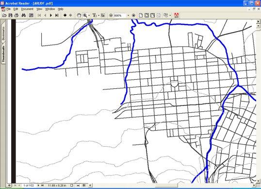


2 Bon University Accord Damof Pretoria etd - Butcher, A (2003) Apies River N1 Magaliesberg range Witwatersberg range Meintjieskop N4 PRETORIA CITY Salvkop 2.1 Apies River link to Pretoria Skanskop Klapperkop 004

.")


.")
3 2.2 View south over Groenkloof nature reserve from Salvokop Salvokop Voortrekker Monument 2.3 View South over Pretoria from Union Buildings 2.2 Meso Analysis Green open spaces Within the city there are a number of formal and informal green spaces The formal spaces are indicated in the open space map (See fig.2.4). Informal green spaces include the ridges in the north and south, the Apies River, Steenhoven Spruit, Walkerspruit and land south of Marabastad undeveloped due to land claims Urban Spaces While the green spaces surround the CBD, the urban spaces run through it, creating a strong north / south axis linking the public transport nodes of Belle Ombre in the north and the Pretoria train station in the south (See fig.2.4) Cultural Installations Places of cultural significance within the city are indicated in the cultural map (See fig.2.5). There is also a line of historical assets that run along the Apies River (figxxx). If the cultural map and the open space are overlayed, we see a picture of linkage and place (Trancik, 1986, p98). This image indicates an implied cultural ring around the CBD that is intersected with a physical cultural axis. Parallel to this axis in the north south direction, greenbelts inform the edges 005
![[3] [1] [2] [1] [2] [5] [4] [6] [2] [3] [4] Open Space Map 2.](/docs-images/83/88179358/images/4-1.jpg "4 Green and Urban open spaces Green spaces 1-Pretoria Zoo / Zoological")


4 [3] [1] [2] [1] [2] [5] [4] [6] [2] [3] [4] Open Space Map 2.4 Green and Urban open spaces Green spaces 1-Pretoria Zoo / Zoological gardens 2-Heroes Acre 3-Burgers Park 4-Calaldonian sports grounds 5-Union Buildings gardens Urban spaces 1-Church Square 2-Pretorius Square 3-Zoo 4-Melrose House 5-Sammy Marks Square 6-Strijdom Square of the CBD. The cultural axis, due to its link to transport nodes and cultural facilities carries a high pedestrian movement. The cultural ring is not as active as the cultural axis as the installations are not connected through sight lines and paths. 006
![[2] [1] [3] [13] [18] [17] [5] [4] [6] [19] [3] [9] [7] [10] [8] [12] [20] [11] [15] [14] [16 Cultural Installations Map 2.](/docs-images/83/88179358/images/5-1.jpg "5 Cultural installations in Pretoria Cultural Installations 1-Pretoria Zoological gardens 2-Aquarium and Snake park 3-State Model School Museum 4-Church")

5 [2] [1] [3] [13] [18] [17] [5] [4] [6] [19] [3] [9] [7] [10] [8] [12] [20] [11] [15] [14] [16 Cultural Installations Map 2.5 Cultural installations in Pretoria Cultural Installations 1-Pretoria Zoological gardens 2-Aquarium and Snake park 3-State Model School Museum 4-Church Square 5-Palace of Justice 6-Old Raadsaal 7-African Window 8-Transvaal Museum 9-Museum of Science and Technology 10-City Hall and Pretorius Square 11-Melrose House 12-Pretoria Station 13-Union Buildings 14-Pretoria Art Museum 15-Oeverzicht Art Village 16-NZASM Houses 17-Paul Kruger s Church 18-Kruger House 19-State Theatre 20-Burgers Park 007


6 University of Pretoria etd - Butcher, A (2003) Overlayed Map 2.6 Combined maps showing linkage and place Church Street moves through this linkage system and connects to the Union Buildings, creating a sub-axis link to the Pretoria Art Gallery. 2.7 Linkage and Place 008


7 2.3 Urban Form Many cities in the vicinity of rivers will inevitably develop on the river banks whereby its water can be used for transport, as a food source and channelled for irrigation. Because the river is such an important resource, development along it celebrates the river and becomes an intense spine of activity. Fig.2.8 shows how this type of development has taken place in a Japanese Agrarian rural village. The river starts as the interactive node with further development spreading away from it leaving the town bounded by greenbelts. The buildings develop with the responsive face towards the source of activity, in this case the river. With the responsive face river facing, interaction with the development and activity spine is assured. Pretoria can be considered as a relatively young city, only being established It was not forced to develop on the river, but was rather defined by the river, while water was provided to the city from the Fountains via water furrows. Instead, in part due to its political footings and the knowledge of what a contemporary city should look like, the Pretoria community was established above the river around Church Square on a grid that was defined by openings in the Daspoort and Schurweberg ridges ( Fisher. Le Roux. Mare, 1998, p61). Development occurred in the same way as previously mentioned with the buildings responsive face interacting with the activity node of Church Square. As each layer of development occurred, it would inherit the responsibility of being the defensive edge. Fig.2.11 shows in 1859 how Pretoria had already been established on a grid system. This development occurred in 2.9 River development Development edge Greenbelts bounding development 2.8 Japanese Agrarian village 009

8 Church Square 2.10 Pretoria Map 1889 Defensive edge 2.11 Pretoria Map 1859 of development an east/west direction due to the steeper gradients of the ridges in the north and south. Fig.2.10 indicates when the development reached the river, already by 1889, the grid pattern was disrupted and could not continue in its conventional manner. With the responsive face towards Church Square, the defensive edge was left facing towards the river. With its back on the river, a number of green spaces where left along the river forming a weak greenbelt, unfortunately with no interaction these spaces became lost, hostile spaces. Development could only take place in an east/west direction, so it continued in a similar pattern on the eastern side of the river to that on the western side, however, the responsive face was towards the west which allowed for interaction with the river, but the river was never celebrated as a natural resource. As the city expanded, there would have been little emphasis on preserving the natural environment within the city because of the vast landscape of fauna and flora surrounding it. Development pushed the biophysical environment further and further away leaving a few isolated patches that only remain because they are uninhabitable, these being the Apies River and the ridges in the north and south. Fig.2.9 shows the idea of how development on a river turns its responsive face to the river while forming a defensive edge behind it. Later development forms its responsive edge to interact with previous development, thus creating an activity spine along the river. 010
.")


9 2.4 Site The reasons for choosing the site are mostly based around maximising resources. Much of the research done with medicinal plants is with highly infectious bacteria, viruses and their related diseases, such as Tuberculosis, Aids etc. (Meyer, 2003). This work is currently done in the isolated laboratories at the MRC, it would not be economical to build more of these laboratories as they have the capacity for an increase in use. For this reason the EBRC needs to be linked physically to the MRC. A large component of the EBRC is the plant propagation within the terrariums as well as the open-air medicinal plant cultivation. It would be preferable if the site fitted into an existing greenbelt, while large spaces would be needed for the terrariums. Although brownfields sites are favoured in terms of sustainable development, it is justifiable to use a greenfields site if most of the site will be used to grow indigenous vegetation. In the Apies River Urban Design Framework there is an initiative to reintroduce indigenous plants to the Witwatersburg Ridge. There is an opportunity to continue this throughout the city by being linked to the ridges via the Apies River as at this point the rural environment meets the urban environment. Another advantage of being on the river is the possibility (through damming) of the establishment of a wetland for maximum plant diversity and using the water for irrigation. There needs to be a strong link to the existing medicinal plant trading node in Marabastad so as to direct this practice in a more sustainable direction. By connecting to Marabastad, there is also the possibility of creating an important link to Rural Urban Belle Ombre train station as it is through this gateway where much of the harvested plants are brought into the city Site overview from the south 2.13 Site overview from the east Rural Urban 011

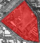


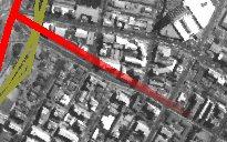
10 WITWATERSBERG BELLE OMBRE STATION MRC MEINTJIESKOP PTA TECH 2.14 Pretoria aerial photo SALVOKOP NELSON MANDELA DRIVE MUCKLENEUK 012
Urban Context 3.4/ 20 Muckleneuk. Mears Train Station Elandspoort Road UNISA. Urban Frame3.5/ 21 Movement Lines Active Edges Building Fabric
 CONTEXT STUDY 3/ CONTEXT STUDY 3/ Global Context Regional Context City Context Urban Context Urban Frame Arrival Threshold Site 3/ 001 Context is the application of idea to place: it gives reality to the
University of Pretoria
 B Situating N o 2 The valley between the Ridges and the Rivers Figure 2.1 ~ Early Pretoria.psd Early Pretoria, established in the valley between the ridges and rivers Source: Hilton T 32 HYBRID 2.1 Ridges
21 December Summer Solstice 08:00 10:00 12: June Winter Solstice 013 CONTEXT. sunlight is diffuse radiation (AAL 310, 2002, p19). 2.
. 2.") 08:00 10:00 12:00 21 December Summer Solstice 08:00 10:00 12:00 21 June Winter Solstice 2.5 Sunshine The Pretoria area receives a very high sunshine percentage with an annual maximum of 80% and a minimum
08:00 10:00 12:00 21 December Summer Solstice 08:00 10:00 12:00 21 June Winter Solstice 2.5 Sunshine The Pretoria area receives a very high sunshine percentage with an annual maximum of 80% and a minimum
CHAPTER 4 CONTEXT CONTEXTUAL PROBLEM CONTEXT. ECOSYSTEMIC SYPPLY CHAIN l a Research and Development Centre for Urban Agriculture l
 04 52 ECOSYSTEMIC SYPPLY CHAIN l a Research and Development Centre for Urban Agriculture l CHAPTER 4 SOUTH AFRICA TSHWANE Figure 24: Pretoria Location Diagram GAUTENG PRETORIA UAL PROBLEM The site is located
TSHWANE INNER CITY REGENERATION. March 2015
 TSHWANE INNER CITY REGENERATION March 2015 LOOKING INTO THE HORIZON The Tshwane Vision 2055 envisioned the City to be a liveable, resilient and inclusive City where the citizens can enjoy a high quality
14.5 HOPEFIELD: (REFER PLAN 39 AND PLAN 40)
") URBAN DYNAMICS WESTERN CAPE INC. 248 14.5 HOPEFIELD: (REFER PLAN 39 AND PLAN 40) FIGURE 83: LOCALITY - HOPEFIELD Within the context of the Saldanha Bay Municipal area, Hopefield, an historical agricultural
URBAN DYNAMICS WESTERN CAPE INC. 248 14.5 HOPEFIELD: (REFER PLAN 39 AND PLAN 40) FIGURE 83: LOCALITY - HOPEFIELD Within the context of the Saldanha Bay Municipal area, Hopefield, an historical agricultural
6.2 Current condition of the Walker Spruit and Apies River
 6 Urban Framework Illus. 6.2: The Apies River and Walker Spruit running through the city. (Botha, April 2011) 6.1 Introduction The site analysis was done before the urban framework. This is due to the
PUBLIC OPEN HOUSE SEPTEMBER 8 TH, 2010 CITY OF LETHBRIDGE DEVELOPMENT SERVICES
 PUBLIC OPEN HOUSE SEPTEMBER 8 TH, 2010 CITY OF LETHBRIDGE DEVELOPMENT SERVICES INTRODUCTION Why is the City creating the West Lethbridge Employment Centre Area Structure Plan? West Lethbridge Urbanization
Sustainable Campus: Towards a Model for the University of Pretoria
 Sustainable Campus: Towards a Model for the University of Pretoria Neal E Dunstan Resident Landscape Architect Department of Facilities Management University of Pretoria Introduction We must put the 21st
1.1 Background 1.2 Problem se ng
 9 1 INTRODUCTION 1.1 Background 2008 is the University of Pretoria`s centenary year. In celebrating this event, master students had to choose a campus of the University of Pretoria for their thesis study
CONTEXT: FIRST READING
 03 CHAPTER THREE CONTEXT: FIRST READING INFRASTRUCTURE AT THE SCALE OF THE CITY Introduction Investigating Infrastructure through Boundary and Symbolism 03 CONTEXT: FIRST READING INFRASTRUCTURE AT THE
3.0 CONTEXT ANALYSIS
 3.0 CONTEXT ANALYSIS 3.1 INTRODUCTION The context of the problem is also part of the solution to the problem. The process of analysing and interpreting the parts of the problem is prerequisite to reassembling
3.1 Environment Stormwater Ecology Integration with sport, social and heritage. 3.2 Heritage Levels of scale 3.2.
 40 3.1 Environment 3.1.1 Stormwater 3.1.2 Ecology 3.1.3 Integration with sport, social and heritage 3.2 Heritage 3.2.1 Levels of scale 3.2.2 Chimneys 3.3 Social 3.3.1 Providing for all visitors 3.4 Sport
Fig. 3.1 Three dimensional view of the site in its context in the CBD SITE AND RATIONALE 03
 44 Fig. 3.1 Three dimensional view of the site in its context in the CBD 45 SITE AND RATIONALE 03 46 Site Location The Site is located on the corner of Paul Kruger and Struben Street in the Tshwane/ Pretoria
Submitted by : Piet du Preez Student number : Study Supervisor : Prof. Roger Fisher
 Submitted by : Piet du Preez Student number : 25084692 Study Supervisor : Prof. Roger Fisher Submitted in fulfillment of part of the requirements for the degree Master in Architecture (Professional) in
C O N T E X T. chapter 02 [02] [44] [46] 2.1 PHYSICAL CONTEXT 2.2 LEGAL CONTEXT 2.3 METAPHYSICAL CONTEXT
![C O N T E X T. chapter 02 [02] [44] [46] 2.1 PHYSICAL CONTEXT 2.2 LEGAL CONTEXT 2.3 METAPHYSICAL CONTEXT](/thumbs/90/103881684.jpg "C O N T E X T. chapter 02 [02] [44] [46] 2.1 PHYSICAL CONTEXT 2.2 LEGAL CONTEXT 2.3 METAPHYSICAL CONTEXT") C O N T E X T chapter 02 2.1 PHYSICAL CONTEXT 2.2 LEGAL CONTEXT 2.3 METAPHYSICAL CONTEXT [02] [44] [46] 1950 1975 2000 2015 02/2 fig 2.1 Cities with populations over 1 million. 2.1_PHYSICAL CONTEXT The
C O N T E X T chapter 02 2.1 PHYSICAL CONTEXT 2.2 LEGAL CONTEXT 2.3 METAPHYSICAL CONTEXT [02] [44] [46] 1950 1975 2000 2015 02/2 fig 2.1 Cities with populations over 1 million. 2.1_PHYSICAL CONTEXT The
context, framework, site investigation of site and surroundings
 3 context, framework, site investigation of site and surroundings Figure 3.1: Aerial photo showing Ditsong: National Museum of Natural History in context 3.1 17 3.2 3.3 18 Figure 3.2: View of main entrance
5 DESIGN DEVELOPMENT 5.1 ORGANIZATION OF SPACE. Projects, due to their programmatic adversity and complexity, function as small cities.
 5 DESIGN DEVELOPMENT IN THE ARCHITECTURE OF SPATIAL POSSIBILITY, ARCHITECTURE IS USED TO PROVIDE A SPATIAL FRAMEWORK THAT IS CAPABLE OF ABSORBING CHANGE, ACTING AS A HOLDING STRUCTURE TO DEFINE THE PARK
UNIVERSITY TOWN NEIGHBOURHOODS 5.2 ECO-CORRIDOR MELBOURNE CAMPUS MASTER PLAN 2014
 5.2 ECO-CORRIDOR 37 ECO-CORRIDOR EXISTING CONDITIONS & VISION NEIGHBOURHOOD VISION Investment in the Eco-corridor Neighbourhood will signify the University s commitment to supporting local ecology and
2.1 Project location. Figure 2.1 Southern Africa with Pretoria, Tshwane, in the North of Gauteng (Samaps, 2009).
.") 18 2.1 Project location Figure 2.1 Southern Africa with Pretoria, Tshwane, in the North of Gauteng (Samaps, 2009). Figure 2.2 The CBD of Tshwane with Marabastad highlighted in red and the specific site
18 2.1 Project location Figure 2.1 Southern Africa with Pretoria, Tshwane, in the North of Gauteng (Samaps, 2009). Figure 2.2 The CBD of Tshwane with Marabastad highlighted in red and the specific site
University of Pretoria
 INtroduction Problem statement: How do we deal with the changing identity of a post-apartheid city? South Africa is still a country in transition where the current democracy can be jeopardised by factors
Surfaces & Services. A Public Space for Communication, Information & Discussion
 Surfaces & Services A Public Space for Communication, Information & Discussion Submitted as part of the requirements for MArch(Prof), Faculty of Engineering, Built Environment and Information Technology,
page 258 THE OLIFANTS RIVER VALLEY
 page 258 THE OLIFANTS RIVER VALLEY page 259 page 260 5.10 VREDENDAL (population: ± 20 400) (IDP 2012-2017) 5.10.1 SPATIAL ANALYSIS, see Figures 5.101.1 Sub-regional location Vredendal is located at the
MEINTJIESKOP INNER CITY BEREA SALVOKOP
 context study Urbanism Our relation to the past is not a simple one. As Henry James pointed out, We are divided between liking to feel the past strange and liking to feel it familiar; the difficulty is,
3.3. Urban Structure Defining a New Hierarchy of Routes and Spaces >Images
 Section 3.0 I The Masterplan Framework 18 >Images Examples of high quality routes and spaces 3.3. Urban Structure The success of any masterplan lies in a clear definition of the future urban structure
NEIGHBORHOOD DESIGN ELEMENT
 NEIGHBORHOOD DESIGN ELEMENT INTRODUCTION The following recommendations constitute an urban design oriented "neighborhood analysis" of Plantation. It is an optional Comprehensive Plan Element. The five
THE 355/270 CORRIDOR:
 THE 355/270 CORRIDOR: Strategic Ideas for Sustaining a Livable Work Place Project Summary ACCESS LIFE DESIGN HEALTH WORK Montgomery County Planning Department The Maryland-National Capital Park and Planning
Physical Structure. This historic image from 1882 emphasizes the dramatic topography that distinguishes Cornell s setting at the top of East Hill.
 Physical Structure The natural, agrarian and urban setting for Cornell s campus is a precious resource to protect and enhance. It has also shaped the physical structure of the campus. Buildings, roads
4.1 Concept diagram Catalyst Green spine Material selection Concept plans and sections
 69 FIGURE 141 -Concept to site diagram, Author, 2008 4.1 Concept diagram 4.1.1 Catalyst 4.1.2 Green spine 4.1.3 Material selection 4.1.4 Concept plans and sections 4.2 Concepts applied on Groenkloof campus
Landscape Conservation and Sustainable Development
 MRSS1123 Landscape Conservation and Sustainable Development Khairul Kamarudin October 2017 DEVELOPMENT CONSERVATION SUSTAINABLE DEVELOPMENT LANDSCAPE DEFINITION Landscape is the environment experienced
ILASA Conference 2010
 ILASA Conference 2010 CASE STUDY: The Life Sciences Development At The University of The Western Cape Presented by: Penny Unsworth Introduction Project commenced: November 2007 Works Completion Reached:
index University of Pretoria
 2 BRIEF DEVELOPMENT AND CONTEXT STUDY University of Pretoria etd - Strydom, C (2003) List of figures 4 1. Introduction 6 Visual Culture Philosophy Reflection Visual Culture & Architecture Le Parc de la
PROTOTYPE DESIGN/INTRODUCTION
 PART III: PROTOTYPE DESIGN These concepts and guidelines described earlier were used to develop a prototype design for an emerging suburban area located west of the City of Milwaukee. This was done to
3.0 master plan concept
 3.0 master plan concept 3.1 introduction The purpose of the Huron Church Road Master Plan Concept is to provide an overview of the Master Plan design process, identify preliminary streetscape installations
UNION STUDIO Greater Kennedy Plaza!
 April May 2013 UNION STUDIO Greater Kennedy Plaza! It s time: Providence s civic plaza and transit hub is re-imagined as a vibrant urban gathering place 1 Kennedy Plaza Reborn THE TEAM Client: The City
ITA and Vicinity Master Plan Update
 1 ITA and Vicinity Master Plan Update PHASE 3 SEPTEMBER 27, 2017 Three Phase Process 2 Phase 1 - Understanding October 13th Public Meeting Phase 2A - Exploring Ideas November 17th Public Meeting Phase
Chapter 5: Recreation
 Chapter 5: Recreation Introduction and Setting Recreational opportunities within Nevada County are varied, ranging from public parks with intensively used active recreational facilities, to vast tracts
The Big Hole Precinct
 Development of The Big Hole Precinct in Kimberley South Africa A Minor Field Study Department of Spatial Planning, Blekinge Institute of Technology, 2005 Supervisors professor Anita Larsson and Mr Gerhard
1.0 PLANNING MARKHAM S FUTURE CONTENTS
 1-1 Planning Markham s Future 1.0 PLANNING MARKHAM S FUTURE CONTENTS 1.1 THE PURPOSE OF THE OFFICIAL PLAN 1.2 THE MARKHAM CONTEXT 1.3 THE REGULATORY CONTEXT 1.3.1 Province of Ontario 1.3.2 York Region
SUSSEX COUNTY COMPREHENSIVE PLAN COUNTY PLANNING AND ZONING COMMISSION WORKSHOP
 SUSSEX COUNTY COMPREHENSIVE PLAN COUNTY PLANNING AND ZONING COMMISSION WORKSHOP August 21, 2017 TODAY S WORKSHOP Public Comment Utilities Update Economic Development Update Future Land Use Discussion Public
HOROWHENUA DEVELOPMENT PLAN June create a safe crossing for children moving to and from the school and other areas. 7.8 Ohau
 7.8 Ohau create a safe crossing for children moving to and from the school and other areas. Ohau has a traditional village form with a collective of school, church and reserve at the main road intersection.
Status Report: MD 355 Project
 Status Report: MD 355 Project OCTOBER 2006 M-NCPPC MONTGOMERY COUNTY PLANNING DEPARTMENT Summary of Community Comments, and break to the Results of the MD 355 Participation Session Brookside Gardens -
ESTABLISH AN EFFICIENT TOWN CENTER
 ESTABLISH AN EFFICIENT TOWN CENTER 4 Overview Lisbon residents are proud of the history of Newent and at the same time recognize its current importance as a centralized location for a variety of municipal
4 RET AP CH PRECEDENTS
 4 CHAPTER PRECEDENTS Four precedents will be discussed. First, the New York High Line Park was chosen for its ability to form a coherent whole, yet with a multiplicity of functions and open ended uses.
PEDESTRIAN ROUTE. Fig 202. Route to entrance of building
 PEDESTRIAN ROUTE The prospect of a pedestrian entrance directly from the north, from the public transport node, was also considered. However, it was decided that this configuration was too conventional
University of Pretoria etd - Van Wyk, H (2003) Site Analysis P G S ite Analysis
 Site Analysis P G S ite Analysis") University of retoria etd - Van Wyk, H (2003) University of retoria etd - Van Wyk, H (2003) LOCATION Zoological arden Site Church Square retorius Street Trevenna Schoeman Street Ne lso re e t St on x at
University of retoria etd - Van Wyk, H (2003) University of retoria etd - Van Wyk, H (2003) LOCATION Zoological arden Site Church Square retorius Street Trevenna Schoeman Street Ne lso re e t St on x at
FUNDAMENTAL BUILDING BLOCKS
 FUNDAMENTAL BUILDING BLOCKS THE WEB OF GIBSONS - EXISTING Lacks Community Structure and Support Circulation, surface water flow and buildings are disjointed from the community Social neighbourhoods are
Downtown Papillion. Concepts for the Enhancement and Growth of Papillion s Traditional Town Center
 Downtown Papillion Concepts for the Enhancement and Growth of Papillion s Traditional Town Center Developed for the City of Papillion by RDG Planning & Design T raditional downtown districts occupy a particular
Part 10 Other plans
 Contents of Part 10 Part 10 Other plans... 10-1 10.1 Preliminary... 10-1 10.2 Palmview Structure Plan... 10-2 10.2.1 Preliminary... 10-2 10.2.2 Master Strategic Framework... 10-6 10.2.3 Master Precincts
Ecological Landscape Planning and Design of an Urban Landscape Fringe Area: A Case Study of Yang an District of Jiande City
 Available online at www.sciencedirect.com Procedia Engineering 21 (2011) 414 420 2011 International Conference on Green Buildings and Sustainable Cities Ecological Landscape Planning and Design of an Urban
PART AOTEA PRECINCT
 CONTENTS... PAGE AOTEA PRECINCT...4 14.5.1 INTRODUCTION...4 14.5.2 RESOURCE MANAGEMENT ISSUES...4 14.5.3 RESOURCE MANAGEMENT OBJECTIVES AND POLICIES... 4 14.5.4 RESOURCE MANAGEMENT STRATEGY...5 14.5.5
CORNUBIA RETAIL PARK- PLANNING REPORT REVERT 3
 CORNUBIA RETAIL PARK- PLANNING REPORT 19.04.2013 REVERT 3 1 FOR: BY: 28 DEVONSHIRE AVENUE GLENWOOD DURBAN 4001 P.O. BOX 17390 CONGELLA 4013 T +27 31 202 9550 F +27 31 202 9551 1st FLOOR THE MEDIA MILL
Volume 2: Assessment of Environmental Effects 438
 Volume 2: Assessment of Environmental Effects 438 28 Social Effects Overview The purpose of this Chapter is to provide a summary of the assessment of the social effects of the Project. The assessment has
Tāhuhu whakaruruhau ā-taone The sheltering ridge pole
 B2. Tāhuhu whakaruruhau ā-taone - Urban growth and form B2.1. Issues Tāhuhu whakaruruhau ā-taone The sheltering ridge pole Auckland s growing population increases demand for housing, employment, business,
Urban Development and Upgrading of Unplanned Districts of Jeddah, Saudi Arabia. Bani-Malek East Al-Boughdadiyah. 10th October 2012
 Urban Development and Upgrading of Unplanned Districts of Jeddah, Saudi Arabia Bani-Malek East Al-Boughdadiyah 10th October 2012 Presentation Overview Introduction Effat Team Principle of Sustainable urbanism
South of Hillside Road West, Rothbury. Design and Access Statement with Design Code. Outline Planning Application May 2016
 Outline Planning Application May 2016 Design and Access Statement with Design Code Jane Darbyshire and David Kendall Ltd This Design and Access Statement has been produced by Jane Darbyshire and David
Mark-up of the effect of the proposed Bronte Village Growth Area OPA No.18 on the text of section 24, Bronte Village, of the Livable Oakville Plan
 Mark-up of the effect of the proposed Bronte Village Growth Area OPA No.18 on the text of section 24, Bronte Village, of the Livable Oakville Plan Notes: This document is provided for information purposes
Ten Mile Creek Planning Area
 PLANNING AREA POLICIES TEN MILE CREEK Ten Mile Creek Planning Area Location and Context The Ten Mile Creek Planning Area ( Ten Mile Creek area ) is located south of the current Boise AOCI, generally south
Lecture - 32 Historic Cities and Heritage Areas
 Architectural Conservation and Historic Preservation Prof. Sanghamitra Basu Department of Architecture and Regional Planning Indian Institute of Technology, Kharagpur Lecture - 32 Historic Cities and Heritage
WELLINGTON HOSPITAL DESIGN GUIDE TABLE OF CONTENTS
 WELLINGTON HOSPITAL DESIGN GUIDE TABLE OF CONTENTS 1.0 Introduction Page 2 The Place of Wellington Hospital 2 The Future of the Hospital 2 2.0 The Intention of the Design Guide 3 3.0 Analysis 4 General
Urban Analysis. Downtown Zanesville like any city, has been physically modified through time as it
 Urban Analysis As a part of the consulting team s reconnaissance effort, an urban analysis was performed. Before the future of a place can be envisioned, one must understand the physical characteristics
CLOUGHJORDAN SETTLEMENT PLAN
 CLOUGHJORDAN SETTLEMENT PLAN 1.0 General Introduction and Development Context Location The market town of Cloughjordan lies close to the border with Offaly at the junction of the R490 and R491 Regional
Mollers Lane, Leopold, Victoria Significant Landscape Overlay Re-assessment
 XURBAN Mollers Lane, Leopold, Victoria Significant Landscape Overlay Re-assessment For: TGM Group November 2016 Final Mollers Lane, Leopold, Victoria Significant Landscape Overlay Re-assessment Client
Public Consultation. Land at Monks Farm, North Grove. Welcome
 Welcome Welcome to our public exhibition for development on Land at Monks Farm, orth Grove. Gallagher Estates and Gleeson Strategic Land are preparing an outline planning application for new homes, open
Dwelling Units Max 12 dwelling units per acre/min 8 dwelling units per acre. Development Mix 80% non residential/20% residential
 13. OSTEEN LOCAL PLAN Background: The Osteen Local Plan area is located in southwest Volusia County along the SR 415 corridor between Lemon Bluff Road and Acorn Lake Road and includes 3,990 acres. The
UDF PLANS AND GUIDELINES
 UDF PLANS AND GUIDELINES 5 Land Use Land Use Development Plan Plan no. 3 Land Use Development Mixed Use Retail / Leisure Residential Civic and Institutional Proposed Zoning Table Development Edges Plan
M A K E K A D E S I G N L A B. CONCEPT l CONTENT l CRAFT
 M A K E K A D E S I G N L A B CONCEPT l CONTENT l CRAFT FT ropolitan Rail Overlay 20 YEAR INTEGRATED SETTLEMENT CONCEPT DEVELOPMENT INFORMATION CONCEPT Provisional Application of Concept M A K E K A D
New Official Plan Quest November 2013
 City of Markham New Official Plan Quest November 2013 Building Markham s Future Together - 6 Key Strategic Priorities 1. Growth - Managing our Growth 2. Transportation/Transit - Improving transportation
Regional Context Statement
 Regional Context Statement REGIONAL CONTEXT STATEMENT 3. REGIONAL CONTEXT STATEMENT In 1995, the Provincial Government passed into law the Growth Strategies Act. The purpose of this provincial initiative
Subdivision and Development
 Subdivision and Development 8.0 Introduction - Subdivision and Development The principle purpose of subdivision is to provide a framework for land ownership so that development and activities can take
Wireless Hill Vision 2020
 Wireless Hill Vision 2020 Key Themes and Objectives for the Future of Wireless Hill Revision: Draft Issue Date: 23/04/2009 Document No: Wireless Hill Vision 2020 Page 1 4/30/2009 Table of Contents 1 Overview...
these opportunities are often funded by the resources of the wealthy. The introduction
 01_INTRODUCTION People are drawn towards cities for the economic, social, cultural and recreational opportunities that they offer. These facilities should be accessible to all users of the city (Dewar
Keystone Business Park Precinct Structure Plan North East Industrial Precinct. Part 2 Design Principles
 Keystone Business Park Precinct Structure Plan North East Industrial Precinct Part 2 Design Principles Context Issues Services Landform Issues Geotech and contamination Ecology Traffic and access Issues
Settlement Boundaries Methodology North Northumberland Coast Neighbourhood Plan (August 2016)
") Introduction This background paper sets out a methodology for the definition of settlement boundaries in the North Northumberland Coast Neighbourhood Plan. The neighbourhood plan is planning positively
Introduction This background paper sets out a methodology for the definition of settlement boundaries in the North Northumberland Coast Neighbourhood Plan. The neighbourhood plan is planning positively
2.1 Location and Size
 2.0 Context 7 2.1 Location and Size The Saanich Penninsula The study area is centrally located within the Town boundaries on the east side of Highway 17, which runs through Sidney in a north-south direction.
Market Place Bythell Place Queen Street Park Riverside Park. Public Spaces. Blenheim CBD Streetscape Final Report 36
 37 39 41 43 Market Place Bythell Place Queen Street Park Riverside Park Final Report 36 Market Place Market Place is a key space for Blenheim s street life, it is a meeting place, retail edge and pedestrian
Chapter IV: Development Pattern
 Chapter IV: Development Pattern Introduction The 2002 Prince George s County Approved General Plan designates three growth policy tiers Developed, Developing, and Rural as well as three center designations
Planning & Zoning Commission Staff Report
 Planning & Zoning Commission Staff Report Meeting Date: May 26, 2015 Drafted by: Katherine Harrison-Rogers CASE # Z2886 PROJECT NAME: APPLICANT/ REPRESENTATIVE: Shawna Runyan PROPERTY OWNER: 1840 (previously
4.2 Ecological Principles
 4.2 Ecological Principles Introduction The overall character of the campus is one of open woodland in which locally and regionally indigenous tree species predominate. The colours, textures and quality
SCHEDULE THREE TO THE DEVELOPMENT PLAN OVERLAY EASTERN GOLF COURSE KEY REDEVELOPMENT SITE
 DD/MM/YY SCHEDULE THREE TO THE DEVELOPMENT PLAN OVERLAY Shown on the planning scheme map as DPO3 EASTERN GOLF COURSE KEY REDEVELOPMENT SITE 1.0 A permit may be granted before a development plan has been
Historic England Advice Report 26 August 2016
 Case Name: Kingsland Castle Case Number: 1435892 Background Historic England has been asked to review the scheduling for Kingsland Castle. The land on which the monument lies is understood to be for sale.
Chapter 5 Urban Design and Public Realm
 5.1 Introduction Public realm is all areas of the urban fabric to which the public have access. It is where physical interaction takes place between people. It therefore, includes buildings and their design,
Business Plan for development of the Water Palace waterfall.
 Business Plan for development of the Water Palace waterfall. Index Background... Error! Bookmark not defined. Business Plan... 3 Purpose... 3 Proposed End State of the area... 3 Proposed Development...
PEQUITSIDE FARM ONE PROPERTY, MANY USES
 PEQUITSIDE FARM ONE PROPERTY, MANY USES Laura Campbell March 8, 2016 A plan for the public use of a historic estate Introduction At 33 acres, Peuitside Farm is the largest public owned open space in the
CONTENTS 2.0 A FRAMEWORK FOR SUSTAINABLE GROWTH 2.1 MANAGING SUSTAINABLE GROWTH THE VISION TO GOALS AND OBJECTIVES 2.3 MARKHAM STRUCTURE
 2 A Framework for Sustainable Growth 2.0 A FRAMEWORK FOR SUSTAINABLE GROWTH CONTENTS 2.1 MANAGING SUSTAINABLE GROWTH THE VISION TO 2031 2.2 GOALS AND OBJECTIVES 2.2.1 Protecting the Natural Environment
PUBLIC REALM STRATEGY
 CONSULTATION DRAFT PUBLIC REALM STRATEGY Trenchard Street & Frogmore Street City Design Group Place Directorate Public Realm Strategy Trenchard Street & Frogmore Street Contents 1. Introduction 2. Understanding
I. Introduction 3 minutes a. Introduce myself b. Discuss: what is an archives? - show PowerPoint pictures
 6 th Grade Osborn Program Activity Overview I. Introduction 3 minutes a. Introduce myself b. Discuss: what is an archives? - show PowerPoint pictures II. III. IV. PowerPoint (just includes photos) 3 minutes
Northern Territory Compact Urban Growth Policy
 Northern Territory Compact Urban Growth Policy A Reference Policy Document to clause 2.7 (Reference to Policy) of the NT Planning Scheme May 2015 Table of Contents 1 Policy Setting... 3 1.1 Context for
Town of Portola Valley General Plan. Nathhorst Triangle Area Plan
 Town of Portola Valley General Plan Amended December 10, 1997 Table of Contents Introduction... 1 Planning Area... 1 Objectives... 2 Principles... 2 Standards... 4 Description... 4 Community Commercial...
APPENDIX C. Architectural and Environmental Design Standards. Environmentally sensitive areas should be protected.
 APPENDIX C Architectural and Environmental Design Standards Environmentally Sensitive Areas Goal A. Environmentally sensitive areas should be protected. Development, such as roads, houses, and other structures,
Master in architecture. (Urban Landscape Design)
") Master in architecture () 1. Details of module and its structure Module detail Subject name Paper name Module name/title Objectives Keywords M.arch - architecture Urban landscape design Case study _ fort
Master in architecture () 1. Details of module and its structure Module detail Subject name Paper name Module name/title Objectives Keywords M.arch - architecture Urban landscape design Case study _ fort
MAYFIELD WEST SECONDARY PLAN PHASE 2
 MAYFIELD WEST SECONDARY PLAN PHASE 2 Public Open House #3 February 25, 2010 Draft Preferred Land Use Scenario TOWN OF CALEDON PLANNING & DEVELOPMENT DEPARTMENT Open House Agenda TOWN OF CALEDON 1. Welcome
Building a green infrastructure concept and process in the Gauteng City Region, South Africa. Kerry Bobbins Researcher GCRO
 Building a green infrastructure concept and process in the Gauteng City Region, South Africa Kerry Bobbins Researcher GCRO kerry.bobbins@gcro.ac.za IGU Regional Conference Krakow, Poland 1 18 22 August
Baselands Trails Master Plan Public Meeting. April 28, 2015 Fire Academy, 895 Eastern Avenue, Toronto 6:30 p.m. to 9:00 p.m.
 Baselands Trails Master Plan Public Meeting April 28, 2015 Fire Academy, 895 Eastern Avenue, Toronto 6:30 p.m. to 9:00 p.m. Baselands Trails Master Plan Meeting Purpose To present and get feedback on:
Micco Park Village Development
 FOR SALE Call For Pricing Micco Park Village Development Proposed Project Property Details Micco Park Village Development PRICE Call For Pricing A monumental development opportunity of a lifetime! The
CHAPTER 5: GUIDING PRINCIPLES
 CHAPTER 5: GUIDING PRINCIPLES The following 10 principles were developed based on public consultation, planning policy and the background analysis conducted during Phase 1. The Guiding Principles significantly
SUSTAINABLE CONSERVATION SYSTEMS FOR PRESERVATION OF MONUMENTS, SITES IN THEIR SETTINGS
 SUSTAINABLE CONSERVATION SYSTEMS FOR PRESERVATION OF MONUMENTS, SITES IN THEIR SETTINGS Staneva Hristina / Bulgarian National Correspondent of the HEREIN Project Associated member of the ICVA This paper
Design Guidance. Introduction, Approach and Design Principles. Mauritius. November Ministry of Housing and Lands. .. a
 sig evelo r D Mauritius s. Utilities.. Individu a s. er itects.to ls chpers.po e Public. T. h rban D Sc U e me Promot e h ners. A Design Guidance o.h Planne rs n w iticians r l useholde National Development
The Old Minato River. Sean zhu
 Sean zhu CONTENTS Introduction Problems & Issues Analysis 1. History 2. Location & Traffic 3. Economy 4. Culture 5. Site Macro-design 1. Policy of the Kobe city 2. Masterplan & Strategies Micro-design
Chp 1 CONTEXT: CONTEXT STUDY. - Site. - Historic Timeline. - Proposed Frameworks. - Site Parameters. - Land Usage. - Movement.
 Chp 1 CONTEXT: - Site - Historic Timeline - Proposed Frameworks - Site Parameters - Land Usage - Movement - Site Perception - Site Context 1 REASONS FOR SITE CHOICE: The primary aim of the proposed Family