ITA and Vicinity Master Plan Update
|
|
|
- Adele Rich
- 5 years ago
- Views:
Transcription

1 1 ITA and Vicinity Master Plan Update PHASE 3 SEPTEMBER 27, 2017


2 Three Phase Process 2 Phase 1 - Understanding October 13th Public Meeting Phase 2A - Exploring Ideas November 17th Public Meeting Phase 2B - Developing Plan December through August Phase 3 - Deciding Public Meetings - September 27th and October 10th 2017

3 2010 to 2016 What has Changed? Ownership / City-Owned Property 3 Market and Economic Conditions City Priorities Major Stakeholders Planned / Implemented Projects Increasing need to focus on Stormwater and Flood Resiliency

4 ITA, Courthouse East and Vicinity 4 Dam Neck Road Princess Anne Road The Portrait of Existing Conditions shows the current land uses in the study area Nimmo Pkwy The Study Area now includes the former Rock Church property and Courthouse East Much of the land is agricultural, undeveloped, and rural Indian River Road

5 Current Projects in the ITA 5 Dam Neck Road Princess Anne Road Nimmo Pkwy Expansion of the Princess Anne Athletic Complex Biotech Campus along Princess Anne Road Development adjacent to the Historic District Veterans Care Center Infrastructure improvements Indian River Road


6 City-Owned Property 6 The City has been active in acquiring property in the ITA and Transition Area. Dam Neck Road Princess Anne Road Holland Road The majority of the study area is City-owned. Salem Road North Landing Road CITY-OWNED PROPERTY (2010) This provides a great opportunity for a coordinated approach to development and preservation. Indian River Road CITY-OWNED PROPERTY 2016
 Brown + Brenneman Farms (~590 ac.) North Landing Park (~77 ac.")
7 Developable Land Analysis 7 Bio-Medical Park (~155 ac.) Brown + Brenneman Farms (~590 ac.) North Landing Park (~77 ac.) Net Developable Land = ~822 acres NET DEVELOPABLE LAND
8 Illustrative Master Plan 8 Dam Neck Southeast Parkway Alignment Salem Road Indian River Road Princess Anne Road Holland Road North Landing Protect the operational viability of Oceana and Fentress Build an extensive open space network. Expand and improve the road infrastructure. Improve storm resiliency using advanced storm water management techniques. Concentrate commercial development around developed areas in the north. Build a consolidated Municipal Services Campus for the city. Create an agricultural research facility. Create an environmental research center focused on the Albermarle watershed. Preserve and enhance the historic, cultural, rural and natural heritage of the area. ILLUSTRATIVE PLAN
9 9 Frameworks: Roads and Stormwater Management

10 Road Frameworks Plan Landstown Road Extension 2. Nimmo Parkway Extension to Landstown Road 3. Nimmo Extension to Salem Road 4. Salem Road Improvements 5. Indian River Road Improvements


11 Nimmo Parkway Extension 11 Dam Neck Road Salem Road Landstown Road Princess Anne Road North Landing Road Indian River Road 6' 10' 17' +/- 8' 12' 12' 20' 12' 12' 8' 17' +/- 10' Trail Vegetative Swale Shoulder Travel Lanes Median Travel Lanes Shoulder Vegetative Swale Trail 150' R.O.W. 6'


12 Indian River Road Improvements 12 Dam Neck Road Salem Road Landstown Road Princess Anne Road Nimmo Parkway North Landing Road 7' 6' 12' 12' 6' 7' Natural Areas Private Lots Swale Travel Lane Travel Lane Swale Natural Areas 50' R.O.W. Private Lots


13 Stormwater Management Objectives for the Plan 13 Increase Resiliency to Sea Level Rise, storms, and wind-driven tides Exceed the latest Stormwater Regulations with public infrastructure to incentivize development that is consistent with the plan Water Quality Water Quantity Utilize cutting edge stormwater solutions to maximize public education opportunities Natural Channel Design/Stream Restoration Constructed Wetlands Wet Swales Bioretention Wet Pond Level 1 and 2 Permeable Pavements
14 14 Initiative Areas

15 Land Use Plan 15 Bio-Tech Park Sports Center Municipal Services Center Preservation and Passive Recreation Agricultural Production North Landing Park


16 Historic Princess Anne Center Princess Anne Road Create a commercial center at the intersection of Princess Anne Road and North Landing Road. 16 AICUZ 65 DNL LINE Provide services for nearby office workers and residents North Landing Road E X IS T I NG MUN I CIPAL BU ILD I NGS E X I S T I NG MUN I C I PA L I NF I L L BU I LD I NGS E X IS T I NG COMMERCI AL BU ILD I NGS Buffington House E X IS T I NG M I XED - USE BU ILD I NGS PARKING G ARAGE A I CU Z 6 5 DN L L I NE PRINCESS ANNE HISTORIC DISTRICT HISTORIC PRINCESS ANNE GATEWAY

17 Municipal Center Princess Anne Road AICUZ 65 DNL LINE Use of structure parking to free up land for mixed-use development. Introduce a mix of residential units and provide affordable housing for City workers. Line streets with mixed-use buildings to create a consistent pedestrian friendly network. 17 Preserved Courthouse E X IS T I NG MUN I CIPAL BU ILD I NGS NEW MUN I C I PA L I NF I L L BU I LD I NGS North Landing Road E X IS T I NG COMMERCI AL BU ILD I NGS NE W COMMERC I A L I NF I L L BU I LD I NGS NEW MULT I - FAMILY RESIDENT I AL NEW SINGLE - FAMILY RESIDENT I AL PARKING G ARAGES A I CU Z 6 5 DN L L I NE ILLUSTRATIVE PLAN

18 Bio-Tech Park and Sports Center Plan 18 Dam Neck Road Princess Anne Road Landstown Road Expanded Recreational Fields Bio-Tech Park Existing Oak Grove

19 Preservation and Passive Recreation 19 Preservation and Passive Recreation Landstown Road Nimmo Parkway Design the area for recreational canoeing, kayaking, fishing, hiking, and ornithology. Use stormwater facilities to expand wildlife habitats. Increase tree, shrub, and plant life. Build trails for equestrian, bicycling, and hiking. Design stormwater facilities capable of storing water during storm events. Salem Rd

20 Trail Network 20 Dam Neck Rd Princess Anne Rd Salem Rd North Landing Rd Existing Trail Network Planned Trail Network Extension Proposed Additional Extensions Indian River Rd

21 City Municipal Services Campus 21 SPSA Transfer Station (currently located at Rosemont Road and Concert Drive Landstown Road Public Works Operations and Maintenance Public Utilities Operations and Maintenance Citizen Waste & Recycling Drop-Off Storage and Recycling of Storm Debris Nimmo Parkway SITE OUTLINE

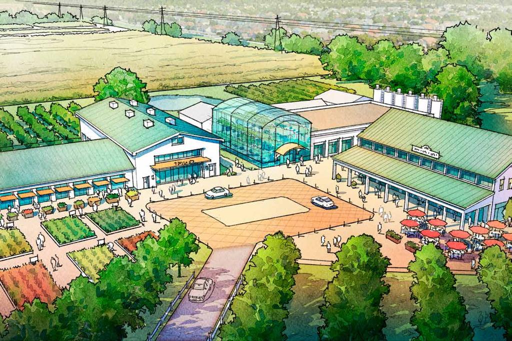
22 Agricultural Production Landstown Road N Landing Road Agricultural land preservation Crop experimentation and testing Nursery Stock Value-added processing High-value crops Industry Partnerships Distribution methods and opportunities Educational outreach Small-farm economic viability Training young farmers Test kitchen and farm-to-table restaurant 22 Indian River Road
23 23

 Albemarle")
24 North Landing Park Indian River Road 792-acre property with ~77 usable acres Passive Recreation focus: Adventure ropes course Walking, Running, and Equestrian Trails Wildlife Observation Kayak Launch Points, Fishing Access Picnic Areas Camping and Chickees (covered platform camping) Albemarle Conservation Center 24
25 25


26 Plan Overview 26 Dam Neck Road Bio-Tech Park and Sports Center Plan Princess Anne Road Indian River Road New City Park Landstown Road Municipal Services Facility Nimmo Pkwy North Landing Park Salem Road Agricultural Production and Research N Landing Road Indian River Road
27 27 Courthouse East


28 Courthouse East 28 Urbanized Area Princess Anne Road ITA Study Area Indian River Road Transition Area Princess Anne Rd Nimmo Pkwy Holland Road 1st Settlers Ave Justice Walk Ln Fenwick Way Rural Area Princess Anne Rd TRANSITION AREA PRINCESS ANNE ROAD TRANSITION AREA URBANIZED AREA RURAL AREA COURTHOUSE EAST STUDY AREA ITA STUDY AREA James Madison Blvd Mattaponi Rd Courthouse Drive George Mason Dr W Neck Rd 10-MINUTE WALK TRANSITION AREA AND THE STUDY AREA ITA/PAC BOUNDARY COURTHOUSE EAST STUDY AREA PRINCESS ANNE ROAD PORTION OF COURTHOUSE EAST IN THE URBANIZED AREA COURTHOUSE EAST STUDY AREA TRANSITION AREA PORTION OF COURTHOUSE EAST IN THE TRANSITION AREA STUDY AREA AND ADJACENT ITA/PAC STUDY AREA

 BUILDABLE AREA (Area remaing that is located outside the 100-year floodplain.")
29 Developable and Buildable Land 29 Nimmo Pkwy Holland Road Nimmo Pkwy Holland Road Nimmo Pkwy Holland Road Fenwick Way Fenwick Way Fenwick Way 1st Settlers Ave Justice Walk Ln 1st Settlers Ave Justice Walk Ln 1st Settlers Ave Justice Walk Ln Princess Anne Rd Princess Anne Rd Princess Anne Rd Princess Anne Rd Princess Anne Rd Princess Anne Rd Courthouse Drive Courthouse Drive 0 Courthouse Drive DEVELOPABLE AREA EASEMENT CITY DEFINED WETLAND FLOODWAY STANDING WATER BUILDABLE AREA EASEMENT 100-YEAR FLOODPLAIN CITY DEFINED WETLAND FLOODWAY STANDING WATER TOPOGRAPHY AND ELEVATION LEVELS DEVELOPABLE AREA (~ 35 acres) BUILDABLE AREA (Area remaing that is located outside the 100-year floodplain. Approximately 22 acres)

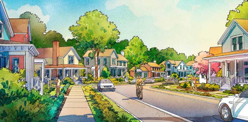
30 Development Following the Transition Area Guidelines Court Cir 1st Settlers Ave Kingsman Arch Holland Road Justice Walk Ln Princess Anne Rd Nettleford Way Residential units are based on 1 acre/ unit of developable land allowed for residential uses in the Transition Area The recommended minimum lot size is 15,000 sf This results in approximately 35 lots. 30 Princess Anne Rd Courthouse Drive LOTS DEVELOPMENT 100-YEAR FLOODPLAIN FLOODWAY TRANSITION AREA GUIDELINES PLAN
31 Cluster Development Alternative Court Cir Courthouse Drive 1st Settlers Ave Princess Anne Rd Kingsman Arch Holland Road Justice Walk Ln Princess Anne Rd Nettleford Way Courthouse East is designated in the Transition Area Master Plan as a "special place" and important node for aggregation of residential units and commercial space. The 15,000 sf lot size may be reduced if the units are located to maximize views and active open space is nearby. The units can be clustered together on smaller lots to create a hamlet, similar to historic settlements. Through use of the Planned Development regulations of the Zoning Ordinance, with smaller lots, the developer can achieve 53 lots. 31 LOTS DEVELOPMENT 100-YEAR FLOODPLAIN FLOODWAY HAMLET LOT ALTERNATIVE PLAN
32 Cluster Alternative 32


33 Village Center Retail This intersection has been a commercial center for generations. Cluster retail and restaurants around a central public square. Connect to adjacent neighborhoods and the Municipal Center with safe pedestrian walks. 33 Princess Anne Rd RETAIL LOTS DEVELOPMENT 100-YEAR FLOODPLAIN EXAMPLE OF SMALL VILLAGE RETAIL COMMERCIAL AREA PLAN

34 Village Center Retail 34 VISUALIZING A NEW HAMLET CENTER


35 Developing Historic Properties Property north of Princess Anne Road is in the Comprehensive Plan's Suburban Area 35 Per AICUZ regulations, residential density is determined by comparable surrounding densities Future Residential Lots Houses are grouped around a commons The historic house and frontage along Princess Anne Road is preserved Shared Lawn Historic Kellam House Princess Anne Rd RETAIL LOTS DEVELOPMENT 100-YEAR FLOODPLAIN THE HISTORIC KELLAM HOUSE AS VIEWED FROM PRINCESS ANNE ROAD THE KELLAM HOUSE WITH NEW HOMES ADDED


36 Viewshed Preservation Area: Princess Anne Road Preserve the historic viewshed of Princess Anne road. Protect the landscape including lawns and trees. Build sidewalks and safe crossings ' 10' 5' Princess Anne Rd 200' min. 100' PRESERVATION SETBACK 100' REAR & SIDE SETBACK PRIVATE LOT 100' min. P R ESER VAT I O N SETBACK PHOTO OF EXISTING SETBACK PHOTO OF EXISTING SETBACK


37 ITA and Vicinity Updated Master Plan 37 Dam Neck Holland Road Princess Anne Road Southeast Parkway Alignment PRESERVATION AND PASSIVE RECREATION CLUSTER DEVELOPMENT FOR COURTHOUSE EAST Salem Road North Landing Indian River Road AGRICULTURAL PRODUCTION VILLAGE CENTER RETAIL NORTH LANDING PARK MIXED USE INFILL IN MUNICIPAL CENTER
Courthouse East vision and policy plan
 August 2017 Courthouse East vision and policy plan Virginia Beach, Virginia 2017 URBAN DESIGN ASSOCIATES SITE PLANNING APPROACH 10-minunte walk from the Courthouse COURTHOUSE EAST IN THE ITA VICINITY Site
THE PRINCESS ANNE COMMONS & TRANSITION AREA. It s Our Future
 THE PRINCESS ANNE COMMONS & TRANSITION AREA www.ourfuturevb.com It s Our Future THE PRINCESS ANNE COMMONS/ TRANSITION AREA Quality Development Planned Mix of Public and Private Uses Exceptional Open Spaces
Revisions to 2009 Comprehensive Plan Policy Document Chapter 4: Princess Anne & Transition Area November 2014
 Revisions to 2009 Comprehensive Plan Policy Document Chapter 4: Princess Anne & Transition Area November 2014 (Pages 4-1 et subseq. of the Policy Document: Text to be deleted is shown as strikethrough.
1.4 - PRINCESS ANNE COMMONS & TRANSITION AREA
 1.4 - PRINCESS ANNE COMMONS & TRANSITION AREA INTRODUCTION Princess Anne Commons and the Transition Area are strategically located below the Green Line, between the Suburban Area of the City to the north
Virginia Beach, Virginia
 Interfacility traffic Area and Vicinity master plan: Virginia Beach, Virginia U r b a n d e s i g n a s s o c i a t e s July 2017 Interfacility Traffic Area and Vicinity Master Plan PREPARED FOR City of
1.4 - PRINCESS ANNE COMMONS & TRANSITION AREA
 1.4 - PRINCESS ANNE COMMONS & TRANSITION AREA INTRODUCTION Princess Anne Commons and the Transition Area are strategically located below the Green Line, between the Suburban Area of the City to the north
Virginia Beach, Virginia
 Interfacility traffic Area and Vicinity master plan: Virginia Beach, Virginia U r b a n d e s i g n a s s o c i a t e s October 2017 Interfacility Traffic Area and Vicinity Master Plan PREPARED FOR City
Virginia Beach, Virginia
 Interfacility traffic Area and Vicinity master plan: Virginia Beach, Virginia U r b a n d e s i g n a s s o c i a t e s October 2017 Adopted by the City Council on December 12, 2017 Interfacility Traffic
Courthouse Planning Area
 Courthouse Planning Area Current Reality The Courthouse Planning Area is the characterized by expansive suburbanscale residential areas as well as the community resource planned area of athletic, educational,
Ten Mile Creek Planning Area
 PLANNING AREA POLICIES TEN MILE CREEK Ten Mile Creek Planning Area Location and Context The Ten Mile Creek Planning Area ( Ten Mile Creek area ) is located south of the current Boise AOCI, generally south
12 February 9, 2011 Public Hearing APPLICANT: WILDLIFE RESPONSE, INC.
 12 February 9, 2011 Public Hearing APPLICANT: WILDLIFE RESPONSE, INC. PROPERTY OWNER: CITY OF VIRGINIA BEACH REQUEST: Conditional Use Permit (Wildlife Rehabilitation Center) STAFF PLANNER: Karen Prochilo
Centerville SGA. virginia beach, va. Prepared for the City of Virginia Beach February,
 Centerville SGA virginia beach, va Phase 3 presentation Prepared for the City of 12-13 February, 2013 www.vbgov.com/centervilleplan urban design associates miles agency, rclco, urs, vhb & wpl A Three Phase
Descriptive Summary of the Comprehensive Plan Amendment
 Applicant City of Virginia Beach Public Hearing October 12, 2016 2016 Comprehensive Plan Amendment Establishing the Historic Seatack & Vicinity Suburban Focus Area (SFA) in Chapter 1, Section 1.3 Agenda
Courthouse Square Planning & Urban Design Study. Courthouse Square Working Group #13 October 15, 2014
 Courthouse Square Planning & Urban Design Study Courthouse Square Working Group #13 October 15, 2014 1 Courthouse Square Process Working Group Community Courthouse Square Advisory Groups & Civic Associations
Subarea 4 Indian Creek. Vision The combination of park networks and transportation amenities make Subarea 4 the greenest hub in the Corridor.
 indian creek 180 extends south from 101st Street to I-435. The I-435 and Metcalf intersection is one of the primary intersections in the Kansas City Metro Area. The area includes several residential neighborhoods
OPEN HOUSE. Future. Neighborhood. Thursday April 27, :30 8:30 PM Refreshments provided Discovery Center, 4444 Hadley Avenue North
 OPEN HOUSE Thursday April 27, 2017 6:30 8:30 PM Refreshments provided Discovery Center, 4444 Hadley Avenue North The City Council has ini ated a planning process to guide future development on 206 acres
Virginia Beach, Virginia u r b a n
 i n t e r fac i l i t y t ra f f i c a re a a n d v i c i n i t y m as t e r p l a n : Virginia Beach, Virginia u r b a n d e s i g n a s s o c i a t e s october 2010 Adopted by reference as part of the
D1 September 11, 2013 Public Hearing APPLICANT:
 D1 September 11, 2013 Public Hearing APPLICANT: BEACH MUNICIPAL FEDERAL CREDIT UNION PROPERTY OWNER: SISTERS II, LLC STAFF PLANNER: Karen Prochilo REQUEST: Conditional Change of Zoning (AG-2 Agriculture
Glenborough at Easton Land Use Master Plan
 Vision Statement Sunrise Blvd. Hazel Ave. Prairie City Rd. Gencorp Property Lincoln Regional Airport 1.0 VISION STATEMENT The identifies City of the principles, goals, policies, and standards Lincoln that
A citizen s guide to the. Comprehensive Plan. City of Lakeville, Minnesota 1
 A citizen s guide to the Comprehensive Plan 2008 City of Lakeville, Minnesota 1 Introduction The City of Lakeville completed an update of its Comprehensive Plan in 2008. A comprehensive plan is a tool
LAND USE ELEMENT. Purpose. General Goals & Policies
 LAND USE ELEMENT Purpose This Land Use Element contains the goals and policies necessary to support the City s responsibility for managing land resources and guiding development through implementing regulations,
Town of Peru Comprehensive Plan Executive Summary
 Town of Peru Comprehensive Plan Executive Communities that plan grow by choice, not by chance. A plan makes growth thoughtful, understandable, and predictable. A plan shows that a community is managing
Provide and maintain sufficient public parks, recreation facilities, and open space to meet the recreational needs of County residents and visitors.
 (ROS) Goal Provide and maintain sufficient public parks, recreation facilities, and open space to meet the recreational needs of County residents and visitors. OBJECTIVE ROS.01 The County shall acquire,
Presentation of the Staff Draft. July 17, 2014 SSRVP Team, Area 3
 Presentation of the Staff Draft July 17, 2014 SSRVP Team, Area 3 Presentation Overview Introduction Plan Framework Plan Recommendations Implementation Next Steps and Request for Public Hearing on September
Former Rockcliffe Airbase Community Design Plan Guiding Design Vision and Principles December 4, 2013
 APPENDIX 5 - Guiding Design Vision and Principles Former Rockcliffe Airbase Community Design Plan Guiding Design Vision and Principles December 4, 2013 Vision Statement The redevelopment of the former
The West Vaughan Employment Area Secondary Plan Policies
 Part 2: The West Vaughan Employment Area Secondary Plan Policies 2.1 General Policies It is the policy of Council: 2.1.1. That the West Vaughan Employment Area (the WVEA), identified on Schedule 1, will
Obey Creek July 17, Vicinity Map. Concept Plan Submittal. No
 15/501 Fordham Blvd. 15/501 By-Pass To Downtown Chapel Hill Vicinity Map 0 1000 2000 FT Arlen Park DR. Bennett Road Mt. Carmel Church Rd. Southern Village Parkside Circle Market St. 15/501 Founder's Ridge
14 October 10, 2012 Public Hearing APPLICANT: MPB, INC
 14 October 10, 2012 Public Hearing APPLICANT: MPB, INC PROPERTY OWNER: MUNDEN & ASSOCIATES, LP STAFF PLANNER: Karen Prochilo REQUEST: Conditional Change of Zoning (AG-1 & AG-2 to Conditional O-2) ADDRESS
GREENBANK DEVELOPMENT MASTERPLAN
 DEVELOPMENT MASTERPLAN POTENTIAL TRAIN STATION COMMUNITY CENTRE Greenbank will be a connected masterplanned community providing easy access to local and surrounding amenity. Affordable quality homes, green
IV. Development in the Rural Overlay District
 Intracoastal Waterway Route 17 Route 168 Great Dismal Swamp VIRGINIA NORTH CAROLINA IV. Development in the Rural Overlay District IV-1 Route 17 in Chesapeake s Rural Overlay District affords distant views
ELECTION DISTRICT: PRINCESS ANNE
 D3 April 10, 2013 Public Hearing APPLICANT: HOLLOMON- BROWN FUNERAL HOME, INC. PROPERTY OWNER: HOLLOMON- BROWN FUNERAL HOME, INC. & TIDEWATER CEMETERY CORP. STAFF PLANNER: Karen Prochilo REQUEST: Conditional
AWH REPORT OF THE PLANNING AND DEVELOPMENT DEPARTMENT FOR APPLICATION FOR REZONING ORDINANCE TO PLANNED UNIT DEVELOPMENT
 AWH REPORT OF THE PLANNING AND DEVELOPMENT DEPARTMENT FOR APPLICATION FOR REZONING ORDINANCE TO PLANNED UNIT DEVELOPMENT MAY 8, 2014 The Planning and Development Department hereby forwards to the Planning
Cornwall Park Neighborhood Plan
 [1] Cornwall Park Neighborhood Plan As adopted by Ordinance No. 8868 and amended by Ordinance Nos. 8946, 9200, 9201, 9233, 9301, 9305, 9749, 9787, 9764, 10502 and 10738, 2000-12-094, 2004-12-087, 2004-12-091,
Implementation Guide Comprehensive Plan City of Allen
 Implementation Guide 2030 Comprehensive Plan City of Allen DRAFT 2015 Implementation Guide Allen 2030 Comprehensive Plan INTRODUCTION The Comprehensive Plan serves as a guide for the growth and development
2018 Northampton Township Comprehensive Plan
 2018 BUCKS COUNTY, PENNSYLVANIA What is a? A comprehensive plan is a municipality s main policy document that details the collective vision for the future, the historic, environmental, and cultural facilities
include playgrounds, sports fields, community gardens and picnic areas.
 DEVELOPMENT PLAN OPEN SPACE SYSTEM OPEN SPACE SYSTEM The neighborhood provides for a range of open space types. The Village Square is an important open space in the neighborhood. It serves as a gathering
2 August 14, 2013 Public Hearing APPLICANT: CRESCENT COMMUNITY CENTER CORP. PROPERTY OWNER: S. L. ETHERIDGE, LLC
 2 August 14, 2013 Public Hearing APPLICANT: CRESCENT COMMUNITY CENTER CORP. PROPERTY OWNER: S. L. ETHERIDGE, LLC REQUEST: Conditional Use Permit (religious use) STAFF PLANNER: Karen Prochilo ADDRESS /
Gold Line Bus Rapid Transit Transit Oriented Development (BRTOD) Helmo Station Area Plan
 Helmo Station Area Plan") Appendix F Gold Line Bus Rapid Transit Transit Oriented Development (BRTOD) Helmo Station Area Plan Introduction and Purpose of the Plan The Gold Line Bus Rapid Transit facility is an eleven-mile dedicated
Appendix F Gold Line Bus Rapid Transit Transit Oriented Development (BRTOD) Helmo Station Area Plan Introduction and Purpose of the Plan The Gold Line Bus Rapid Transit facility is an eleven-mile dedicated
13. VANDORF-PRESTON LAKE SECONDARY PLAN 13.1 INTRODUCTION
 13. VANDORF-PRESTON LAKE SECONDARY PLAN 13.1.1 Purpose 13.1 INTRODUCTION The Vandorf-Preston Lake Secondary Plan establishes the principles, objectives and general policies, as well as specific strategies
M E M O R A N D U M November 9, 2018
 M E M O R A N D U M November 9, 2018 To: Southlake 2035 Corridor Planning Committee From: Kenneth Baker, Sr. Director of Planning and Development Services Subject: Item #8 Up to thirteen (13) residential
Potential Green Infrastructure Strategies May 6, 2015 Workshop
 Potential Green Infrastructure Strategies May 6, 2015 Workshop Background The City of Cortland is developing the Tioughnioga Urban Headwaters Green Infrastructure Action Plan with funding from the National
Agenda. Introductions and Overview Study Purpose Study Approach Key Analysis Components Study Context Development Activity ( )
") October 5, 2017 Agenda Introductions and Overview Study Purpose Study Approach Key Analysis Components Study Context Development Activity (2005-2017) Existing Conditions Alternatives Public Engagement
October 5, 2017 Agenda Introductions and Overview Study Purpose Study Approach Key Analysis Components Study Context Development Activity (2005-2017) Existing Conditions Alternatives Public Engagement
Development Guidelines - Florin-Vineyard Community Plan Administrative Draft
 TABLE OF CONTENTS 1.0 INTRODUCTION... 1-1 1.1 Purpose and Intent... 1-1 1.2 Setting... 1-1 1.3 Land Use Summary... 1-3 2.0 RESIDENTIAL LAND USES... 2-1 2.1 Residential Densities... 2-1 2.2 Existing Neighborhood
2. Would the proposed project comply with the Land Use map? 3. Would the proposed project require a rezoning? 4. What is the proposed zoning district?
 TOWN OF CHAPEL HILL Planning and Sustainability Department 405 Martin Luther King Jr. Blvd. Chapel Hill, NC 27514 www.townofchapelhill.org phone (919) 968 2728 Concept Plans are intended to be an opportunity
Description of Preferred Alternative
 Chapter 2 Description of Preferred Alternative 2.1 Introduction This chapter of the programmatic Sammamish Town Center Sub-area Plan Final EIS provides a more detailed description of the Preferred Alternative
Section4 Design Vision & Implementation Plan
 Section4 Design Vision & Implementation Plan W Woodschurch Rd 4.1 Design Focus Areas The Framework Plan is simply the starting point for directing the design and implementation of a wide range of transportation
Staff Planner Jimmy McNamara. Location 2641 Princess Anne Road GPIN Site Size 10.8 acres AICUZ Less than 65 db DNL
 Applicant & Property Owner Public Hearing July 13, 2016 City Council Election District Princess Anne Agenda Item 4 Request Modification of Conditions (Conditional Use Permit approved by City Council on
Secrest Short Cut and Monroe Expressway Small Area Plan AUGUST 29, 2018
 Secrest Short Cut and Monroe Expressway Small Area Plan AUGUST 29, 2018 Background and Process Monroe Expressway will be open by the end of 2018 Union County and Indian Trail identified a need to revisit
Glenborough at Easton Land Use Master Plan
 Public Facilities 102 7.0 PUBLIC FACILITIES 7.1 OVERVIEW This chapter describes the public facilities that will provide high-quality services in the Glenborough at Easton community, to include three schools,
RECREATION, OPEN SPACE AND GREENWAYS ELEMENT GOALS, OBJECTIVES, AND POLICIES
 RECREATION, OPEN SPACE AND GREENWAYS ELEMENT GOALS, OBJECTIVES, AND POLICIES GOAL R-1: DEVELOP A RECREATION, OPEN SPACE AND GREENWAYS SYSTEM AS AN INTEGRAL COMPONENT OF AN OVERALL, COUNTY-WIDE ECONOMIC
Gloucester County s Comprehensive Plan. The Community Connection
 Gloucester County s Comprehensive Plan The Community Connection Current Comp Plan Adopted in 1991 with a 20 year planning horizon Updated in 1995 with Part V- Implementation Recommendations and Appendix
Courthouse Square Planning & Urban Design Study
 Courthouse Square Planning & Urban Design Study Pedestrian Advisory Committee November 12, 2014 Kris Krider, AICP, Planning Supervisor Center for Urban Design and Research Department of Community Planning,
CHAPTER 4 FUTURE LAND USE AND URBAN SERVICES DISTRICTS
 CHAPTER 4 FUTURE LAND USE AND URBAN SERVICES DISTRICTS Introduction This chapter discusses how Benzie County should grow and change in the future. A community can grow and change in many different ways.
Elm Fork Land Use. Trinity River Corridor Project Committee May 13, 2013
 Elm Fork Land Use Trinity River Corridor Project Committee May 13, 2013 Purpose Discuss Trinity River planned Land Use and Appropriate Compatible Uses, particularly with respect to the Elm Fork Area 2
PLAN ELEMENTS WORKSHOP. April 5, 2016
 PLAN ELEMENTS WORKSHOP April 5, 2016 needs more housing. But there is no one-size fits-all solution. Every neighborhood has its own character. In some places, density is not only appropriate it is badly
for Master Planned Development Framework Design Standards & Guidelines
 B L A C K D I A M O N D DE S I G N G U I D E L I N E S for Master Planned Development Framework Design Standards & Adopted June 18, 2009 Introduction and Purpose The Master Planned Development (MPD) Framework
Dwelling Units Max 12 dwelling units per acre/min 8 dwelling units per acre. Development Mix 80% non residential/20% residential
 13. OSTEEN LOCAL PLAN Background: The Osteen Local Plan area is located in southwest Volusia County along the SR 415 corridor between Lemon Bluff Road and Acorn Lake Road and includes 3,990 acres. The
Preliminary Recommendations Tk Takoma/Langley Crossroads Sector Plan
 Preliminary Recommendations Tk Takoma/Langley Crossroads Sector Plan Vision is to achieve a Transit Oriented, pedestrian friendly Community that Celebrates and builds upon the cultural Diversity of the
VILLAGE & TOWN OF BERGEN: COMPREHENSIVE PLAN
 VILLAGE & TOWN OF BERGEN: COMPREHENSIVE PLAN CPC Public Hearing April 21, 2016 History 1996 Comprehensive Plan Comprehensive Plan Update Committee Consultant (LaBella Associates): December 2014 Residents
DRAFT ROOSEVELT ROAD. District Recommendations. Figure 5.23 The Roosevelt Road Corridor
 CHAPTER 5 Figure 5.23 The Road Corridor Road will develop as a mixed-use corridor, emphasizing regional retail, west of the river and mixed-use development east of the river. KEY RECOMMENDATIONS 1. High
Town of Lyons Parks Flood Recovery Planning Process. Photograph courtesy of Ed Bruder
 Town of Lyons Parks Flood Recovery Planning Process Photograph courtesy of Ed Bruder Lyons Parks and Recreation Flood Recovery Update 1. Meadow Park Phase II - Project PW20B1 Estimated Completion: Summer
Landscaping and Landscape Architecture
 A. General Overview This planning and landscape section has been prep ared to provide Property Owners, Architects, Contractors, and Builders/Developers with important information related to the development
Comprehensive Plan & Station Area Zoning
 Village of Tarrytown Comprehensive Plan & Station Area Zoning Public Workshop November 5, 2017 Warner Library WXY architecture + urban design Pace University - Land Use Law Center George M. Janes & Associates
Courthouse Square Planning & Urban Design Study. Clarendon / Courthouse Civic Association October 21, 2014
 Courthouse Square Planning & Urban Design Study Clarendon / Courthouse Civic Association October 21, 2014 1 Courthouse Square Process Working Group Community Courthouse Square Advisory Groups & Civic Associations
Commercial Node Plan Devine Street/Jackson Blvd. COLUMBIA, SC
 Commercial Node Plan Devine Street/Jackson Blvd. COLUMBIA, SC 9.17.13 AGENDA 1 Introductions 2 Project Update 3 Concepts 4 Recommendations 5 Next Steps Introductions Project Update Process 5-Phase Process
Planning & Zoning Commission Meeting Date: June 18, 2012
 Meeting Date: June 18, 2012 Request Applicant Owner Zoning Location Attachments Proposed Master Plan for 11.5 acres of undeveloped property in the Tuscan Lakes PUD. The land is platted as one lot, and
WESTERN ILLINOIS UNIVERSITY
 WESTERN ILLINOIS UNIVERSITY Quad Cities Riverfront Campus Preliminary Master Plan Presentation 2 February 1, 2006 Achieving Future Flexibility 1. Monitor space needs as the new buildings come on line and
COMMUNITY SUSTAINABILITY AND ENVIRONMENTAL MASTER PLAN IMPLEMENTATION UPDATE
 Attachment 1 COMMUNITY SUSTAINABILITY AND ENVIRONMENTAL MASTER PLAN IMPLEMENTATION UPDATE Priorities and Key Initiatives Committee May 2013 Page E-1 How we grow Goal 2: To ensure sustainable development
12 November 10, 2010 Public Hearing APPLICANT: CHUNMA TAE KWON DO
 12 November 10, 2010 Public Hearing APPLICANT: CHUNMA TAE KWON DO PROPERTY OWNER: MOUNTAIN VENTURES VIRGINIA BEACH, LLC REQUEST: Conditional Use Permit (indoor recreational facility) STAFF PLANNER: Leslie
Seneca Meadows. Block 4 Locate office, technology, and medical development adjacent to I Screen views of garage structures from I-270.
 Seneca Meadows Seneca Meadows has an industrial park in its southern end and a mixed-use employment area planned for the north end. The district benefits from extensive I-270 visibility, stream valley
SECTION II SECTION II STATEMENT OF GOALS, OBJECTIVES, PRINCIPLES, ASSUMPTIONS, POLICIES AND STANDARDS
 STATEMENT OF GOALS, OBJECTIVES, PRINCIPLES, ASSUMPTIONS, POLICIES AND STANDARDS 1 2 STATEMENT OF GOALS, OBJECTIVES, PRINCIPLES, ASSUMPTIONS, POLICIES AND STANDARDS INTRODUCTION The New Jersey Municipal
Chapter 6: Community Character
 Chapter 6: Community Character The term "community character" covers a broad spectrum of concerns. First and foremost, community character is a visual concept. In Long Grove, however, community character
BURTON STATION STRATEGIC GROWTH AREA PLAN UPDATE PUBLIC MEETING 3/26/18
 BURTON STATION STRATEGIC GROWTH AREA PLAN UPDATE PUBLIC MEETING 3/26/18 1 WHERE WE ARE? 2 PRIMARY OBJECTIVES OF THE PLAN UPDATE 1. Update the land use designation for Burton Station Village to reflect
UNIVERSITY OF MICHIGAN:
 Chapter Eight UNIVERSITY OF MICHIGAN: North Campus I. Introduction The University of Michigan currently owns approximately 800 acres of land in the northeast section of Ann Arbor. North Campus refers to
PUBLIC OPEN HOUSE HURONTARIO-MAIN CORRIDOR SECONDARY PLAN
 PUBLIC OPEN HOUSE HURONTARIO-MAIN CORRIDOR SECONDARY PLAN Tuesday, February 28, 2012 6pm 9pm 1 st Floor Atrium, City Hall 2 Wellington Street West, Brampton 1 POLICY FRAMEWORK The 2006 Provincial Growth
A Vision for Walnut Creek
 A Vision for Walnut Creek Photo: City of Clive Walnut Creek Booklet 8 of 8 Greater Des Moines Water Trails and Greenways 1 Table of Contents Booklet 1: Water Trails Strategies and Policies Booklet 2: Beaver
Design Specifications & Requirements Manual
 11 PARKS & OPEN SPACES 11.1 DEFINITIONS... 1 11.1.1 Neighbourhood Parks... 1 11.1.2 District Parks... 1 11.1.3. Sport Parks... 1 11.1.4 Urban Parks... 1 11.1.5 Civic Spaces... 1 11.1.6 Open Space System...
Conservation Development
 Acknowledgements RIDEM: Scott Millar Anthony Lachowicz-Planning and Zoning Consultant Director of Planning 1 : a creative land use technique that allows a community to guide growth to the most appropriate
Managing Stormwater Naturally. July 17, 2013
 Managing Stormwater Naturally July 17, 2013 1 This image cannot currently be displayed. Guiding Documents 2 Stormwater Purpose Statement The City Council hereby finds, determines and declares the City
REQUEST FOR COUNCIL ACTION 6A AGENDA ITEM
 DATE REQUEST FOR COUNCIL ACTION 6A AGENDA ITEM ORIGINATING DEPT. AGENDA ITEM CITY ADMINISTRATOR APPROVAL Community Development PUD Concept & Development Stage Plan Preliminary Plat & Final Plat PREVIOUS
Danvers High Street I-1 District Study
 Danvers High Street I-1 District Study Presentation of Final Recommendations Planning Board Presentation June 26 th, 2018 1 Introductions Metropolitan Area Planning Council Sam Cleaves AICP, Principal
Municipal Plan*Assessment
 Municipal Plan*Assessment This tool was developed to assist in reviewing municipal master plans and in determining if these plans are consistent with smart growth principles, neighboring municipal plans,
Portage Parkway Environmental Assessment Public Information Centre No. 1
 City of Vaughan Portage Parkway Environmental Assessment Public Information Centre No. 1 November 25, 2015 Welcome to the Public Information Centre This first Public Information Centre (PIC) introduces
Planning Board Briefing
 Planning Board Briefing Why Now? The Sector Plan Implementation Chapter States: Before Stage 1 begins, the following must occur: Approval of the Sectional Map Amendment. Approval of the Greater Lyttonsville
Public Meeting May 20, 2014
 Public Meeting May 20, 2014 Overview Study Purpose Study Area Overview Strategies Potential Opportunities Implementation and Discussion Skeo Solutions Raleigh Walkable Watershed Pilot 2 Purpose Develop
FORT MISSOULA REGIONAL PARK
 FORT MISSOULA REGIONAL PARK Master Plan Refinement/ Design Development www.missoulaparks.org DHM Design/WGM Group December 3, 2008 Master Plan Report Fort Missoula Regional Park Guiding Principals i 6/14/01
OVERVIEW OF PLANS FOR THE JEFFERSON COUNTY COUNTRYSIDE FARM In the Context of Quality Place Characteristics
 OVERVIEW OF PLANS FOR THE JEFFERSON COUNTY COUNTRYSIDE FARM In the Context of Quality Place Characteristics By Steve Grabow, Professor and Community Development Educator University of Wisconsin-Extension,
SECTION 4(f) DE MINIMIS DOCUMENTATION
 DE MINIMIS DOCUMENTATION") SECTION 4(f) DE MINIMIS DOCUMENTATION Illinois Route 60/83 IL 176 to the intersection of IL 60 (Townline Road) Lake County P-91-084-07 Mundelein Park and Recreation District Project Limit SECTION 4(f)
SECTION 4(f) DE MINIMIS DOCUMENTATION Illinois Route 60/83 IL 176 to the intersection of IL 60 (Townline Road) Lake County P-91-084-07 Mundelein Park and Recreation District Project Limit SECTION 4(f)
RURAL AREA. It s Our Future
 RURAL AREA www.ourfuturevb.com It s Our Future RURAL AREA STRATEGY... MEANS Preserving Rural Heritage Ensuring Viable Agriculture Protecting Natural Resources Enable Rural Growth RURAL AREA Description
Route 347. New York State Department of Transportation Region 10, Long Island. THE GREENING of ROUTE 347
 The GREENING of Route 347 The Greening of Route 347 The Greening of Route 347: History 3 The Greening of Route 347 4 The Greening of Route 347 5 The Greening of Route 347 Smith Haven Mall 6 The Greening
Adopted by reference as an amendment to the Virginia Beach Comprehensive Plan
 Adopted by reference as an amendment to the Virginia Beach Comprehensive Plan TABLE OF CONTENTS PURPOSE AND LOCATION. 5 DEVELOPMENT AND USES.. 8 DESIGN PRINCIPLES... 11 SPECIAL PLACES IN THE TRANSITION
open public hearing and allow public comment request to continue LPA public hearing to January 16, 2014 at 10:30 am
 TODAY S AGENDA Work Session LPA Transmittal Public Hearing open public hearing and allow public comment request to continue LPA public hearing to January 16, 2014 at 10:30 am staff will issue a recommendation
The Trinity River Corridor Project Update
 The Trinity River Corridor Project Update Councilmember Carolyn A. Davis Community Meeting October 14, 2008 The project covers 20 miles of the Trinity River, approx. 10,000 acres 2 Trinity River Corridor
A larger version of this map is located on the last page of this PDF.
 MAP Committee Input McLoughlin Area Draft Vision Map A larger version of this map is located on the last page of this PDF. 1. The map above is intended to portray a vision for the McLoughlin area. It highlights
Standards (R-3) Figure B-11: R-3 Residential Standards Exhibit
 Figure B-11: R-3 Residential Standards Exhibit") Avila Ranch Avila Ranch Specific Plan Development Standards High Medium Density - High Residential Density Residential Lot and Building Lot and Standards Building (R-3) Standards (R-3) EXAMPLES These sketches
Avila Ranch Avila Ranch Specific Plan Development Standards High Medium Density - High Residential Density Residential Lot and Building Lot and Standards Building (R-3) Standards (R-3) EXAMPLES These sketches
Concord Community Reuse Project Goals and Guiding Principles. Overarching Goals (OG)
") Concord Community Reuse Project Goals and Guiding Principles Overarching Goals (OG) No priority is implied by the order of presentation of the goals and guiding principles. Overarching goals for the Concord
Concord Community Reuse Project Goals and Guiding Principles Overarching Goals (OG) No priority is implied by the order of presentation of the goals and guiding principles. Overarching goals for the Concord
Whitemarsh Comprehensive Plan Update: Housing & Land Use. Public Workshop #3: September 20, 2018
 Whitemarsh Comprehensive Plan Update: Housing & Land Use Public Workshop #3: September 20, 2018 Agenda Welcome Process Recap What We ve Heard The Plan Framework Review of Recommended Actions Land Use Housing
EXHIBIT 887C STREETS PLAN
 NOEL RD MONTFORT DR ALPHA RD PRESTON RD FN4 - FN5 - FN6 - FN7 - DALLAS NORTH TOLLWAY PETERSON LN - JAMES TEMPLE DR - TYPE C TYPE B NOEL RD FN4 - MONTFORT DR FN5 - FN8 - FN6 - PRESTON RD LBJ FWY * NOT TO
Kirtland, Ohio - Comprehensive Plan Update 2022
 Kirtland, Ohio - 2022 Comprehensive Plan Update November 2012 INTRODUCTION City of Kirtland Officials... 1 Update: Preface... 2 City Charter Requirement: Purpose & Process... 3 THE PLAN Comprehensive Update:
S A C R A M E N T O C O U N T Y JACKSON HIGHWAY & GRANT LINE EAST VISIONING STUDY
 JACKSON HIGHWAY & GRANT LINE EAST S A C R A M E N T O C O U N T Y P L A N N I N G D E P A R T M E N T SUMMARY AND WORKBOOK November 19, 2008 History of the Visioning Study Sacramento County has two growth