Scoping Opinion of the Mineral Planning Authority, Dartmoor National Park Authority
|
|
|
- Giles Murphy
- 5 years ago
- Views:
Transcription


")
")


1 Scoping Opinion - Town and Country Planning (Environmental Impact Assessment) (England and Wales) Regulations 2011 Regulation 13(1) Scoping Opinion of the Mineral Planning Authority, Dartmoor National Park Authority Proposal: Extension to existing quarry Site: Linhay Hill Quarry, Ashburton, Newton Abbot, Devon Developer: E&JW Glendinning Ltd. Amec Foster Wheeler Environment & Infrastructure UK Limited
2
3 3 Amec Foster Wheeler Environment & Infrastructure UK Limited Executive summary This report has been produced for the purpose of providing Scoping Opinion under the Town and Country Planning (Environmental Impact Assessment) (England and Wales) Regulations 2011 Regulation 13(1) This is the scoping Opinion of the Mineral Planning Authority, Dartmoor National Park Authority (DNPA). The scoping opinion relates to the following proposals Proposals: Extension to existing quarry Site: Linhay Hill Quarry, Ashburton, Newton Abbot, Devon Developer: E&JW Glendinning Ltd. Glentor Ashburton Newton Abbot Devon TQ13 7LF Agent: Atkins Ltd. The Octagon Pynes Hill Court Rydon Lane Exeter Devon EX2 5AZ In July 2015 DNPA received a scoping request from Atkins Ltd. on behalf of E&JW Glendinning Ltd. requesting a formal Scoping Opinion from the Dartmoor National Park Authority to inform the preparation of an Environmental Statement (ES). The ES is required to accompany a planning application for a proposed extension of Linhay Hill Quarry, Ashburton which lies with a Mineral Consultation Area. The scoping request was made under Regulation 13 of The Town and Country Planning (Environmental Impact Assessment) Regulations This followed an earlier scoping request submitted by the applicant in February 2015 and a scoping opinion published by DNPA in March This Scoping Opinion is made in response to the July 2015 request and should be read in conjunction with the Applicant s Scoping Request. The proposed extension falls within Schedule 1 of the Regulations because the site is over the threshold size of 25 hectares specified in Paragraph 19 of Schedule 1. All development within Schedule 1 is defined as Environmental Impact Assessment (EIA) development irrespective of the nature of the proposals, or the sensitivity of the site, so a Screening Opinion is not required. The planning application does however need to be accompanied by an Environmental Statement and the application needs to be determined as an EIA application. Environment Impact Assessment (EIA) is an important procedure for ensuring that the likely effects of the new development on the environment are fully understood and taken into account before the development is allowed to go ahead. The Town and Country Planning (Environmental Impact Assessment) (England and Wales) Regulations 2011 ( The Regulations ) provide a procedure which enables developers to apply to the planning authority for a scoping opinion on the issues which should be included within an EIA in a particular case. The proposed development is for the extension of an existing limestone quarry at Linhay Hill, Ashburton. As well as an increased area for extraction the application will include the provision of a new diverted highway
4 4 Amec Foster Wheeler Environment & Infrastructure UK Limited and public footpath and landscaping works. The extension will extend the life of the quarry by an additional 40 years
5 5 Amec Foster Wheeler Environment & Infrastructure UK Limited Contents 1. Introduction Background Consultation 7 2. The proposed development Description of the site and surroundings Description of the proposed development Environmental statement Description of the site and surroundings Description of the proposed development Need Cumulative assessment Environmental statement Non-technical summary 26 Appendix A Guidance from Natural England
6 6 Amec Foster Wheeler Environment & Infrastructure UK Limited
7 7 Amec Foster Wheeler Environment & Infrastructure UK Limited 1. Introduction 1.1 Background In July 2015 DNPA received a scoping request from Atkins Ltd. on behalf of E&JW Glendinning Ltd. requesting a formal Scoping Opinion from the Dartmoor National Park Authority (DNPA) to inform the preparation of an Environmental Statement (ES). The ES is required to accompany a planning application for a proposed extension of Linhay Hill Quarry, Ashburton which lies with a Mineral Consultation Area. The scoping request was made under Regulation 13 of The Town and Country Planning (Environmental Impact Assessment) Regulations This followed an earlier scoping request submitted by the applicant in February 2015 and a scoping opinion published by the NPA in March This Scoping Opinion is made in response to this request and should be read in conjunction with the Applicant s Scoping Request. The proposed extension falls within Schedule 1 of the Regulations because the site is over the threshold size of 25 hectares specified in Paragraph 19 of Schedule 1. All development within Schedule 1 is defined as Environmental Impact Assessment (EIA) development irrespective of the nature of the proposals, or the sensitivity of the site, so a Screening Opinion is not required. The planning application does however need to be accompanied by an Environmental Statement and the application needs to be determined as an EIA application. Environment Impact Assessment (EIA) is an important procedure for ensuring that the likely effects of the new development on the environment are fully understood and taken into account before the development is allowed to go ahead. The Town and Country Planning (Environmental Impact Assessment) (England and Wales) Regulations 2011 ( The Regulations ) provide a procedure which enables developers to apply to the planning authority for a scoping opinion on the issues which should be included within an EIA in a particular case. The proposed development is for the extension of an existing limestone quarry at Linhay Hill, Ashburton. As well as an increased area for extraction the application will include the provision of a new diverted highway and public footpath and landscaping works. The extension will extend the life of the quarry by an additional 40 years This Opinion sets out the information that the NPA considers should be included in the ES for the proposed development. The Opinion has taken account of: The EIA Regulations; The nature and scale of the proposed development; The nature of the receiving environment; Current best practice in the preparation of environmental statements; and The comments of the statutory consultees The NPA will not be precluded from requiring additional information if it is considered necessary in connection with the ES submitted with the application when considering the application for an extension to Linhay Hill Quarry. 1.2 Consultation The applicant s scoping request was sent to the consultation bodies as required by the EIA Regulations and also to internal consultees within the National Park Authority and Teignbridge District Council. These comprised: Devon County Council Highways Authority;
8 8 Amec Foster Wheeler Environment & Infrastructure UK Limited DNPA archaeology; DNPA ecology; DNPA landscape; Environment Agency; Highways England; Historic England; Natural England; and Teignbridge District Council EHO. Those issues raised by the consultees which relate to the scope of the ES are contained in Section 3 below.
9 9 Amec Foster Wheeler Environment & Infrastructure UK Limited 2. The proposed development The following is a summary of the information on the proposed development and its site and surroundings prepared by the Applicant and included in their Scoping Request. The information has not been verified and it has been assumed that the information provided reflects the existing knowledge of the proposed development and the potential receptors/resources. This information has been drawn from the Scoping Request submitted to DNPA in July Description of the site and surroundings The Application Site The existing Linhay Hill Quarry is a major limestone quarry located to the north-east of Ashburton. The quarry is immediately adjacent to the A38, which runs along its south-eastern boundary, and at this point is the boundary of the Dartmoor National Park. Consequently the existing quarry and the proposed extension area lie within the Dartmoor National Park. The site is not subject to any other environmental designations, but it lies within a Mineral Consultation Area. The quarry comprises a large void containing further reserves, with primary and secondary processing plant located within it, and further associated workshops, plant and storage areas located on its western and northern side. A tip for overburden and quarry spoil is also located to the north of the void. The tip is being progressively restored to agricultural use. The quarry is surrounded by vegetated bunds, high tree screens or fences, which help to screen it from view from many public viewpoints. The quarry has two accesses in the south-western corner onto Balland Lane, which connects with the B3352 and a four way junction onto the A38. The site is immediately adjacent to the A38, the main arterial route in Devon between Exeter and Plymouth, and all traffic leaving the quarry does so via a nearby four way junction. The surrounding area To the south of Balland Lane is the Linhay Business Park and playing fields of South Dartmoor School. The School occupies Place House as a 6 th form centre. This building is owned by the company and leased on a peppercorn basis and is located to the north of the quarry workshop area. The nearest dwellings to the quarry are at Place, near the school; at Waye, and at Lower Waye to the north of the quarry. A turf business is based at Lower Waye. All other land surrounding the quarry is agricultural, some of which is organic. The north-eastern boundary of the quarry is Alston Lane, a single track lane leading from a restricted twoway junction with the A38. The site of the proposed extension is land beyond Alston Lane and alongside the A38 and comprises fields within Alston Farm and Caton Farm. Most of the proposed extension area is farmed as a livestock farm, but the western fields are one of several turf growing sites used by the turf business located at Lower Waye. Alston Lane which lies between the existing quarry and the extension area would be removed as part of the proposals. This area is mapped as being underlain with Devonian Limestone by the BGS and the presence and quality of the resource has been confirmed by drilling. The area nearest the existing quarry will be quarried as an extension to the quarry at Linhay Hill. In order to access the limestone, part of the overburden which overlies the limestone will be stripped off. Some overburden will be used to create screening bunds and new permanent landforms and the remainder will be deposited back into the mineral void. The nearest dwellings to the extension area are Alston Farm house and Alston Cottage, which are in the ownership of the applicants, but privately occupied. There are two further dwellings at Lower Waye, one of
10 10 Amec Foster Wheeler Environment & Infrastructure UK Limited which is owned by the applicant, again both are privately occupied. To the north east, beyond the proposed screening bunds and tipping area, is the small hamlet of Caton, comprising several private houses. Other private residences are located to the north and west. 2.2 Description of the proposed development The extension area is approximately 44 hectares in extent. The proposed area for extraction is some 20 hectares, and the remainder is the surrounding bunding / tipping and other associated landscaping. The extension area will be developed progressively in two main phases. The main determinant of the division between the phases will be the extent of overlap between ongoing extraction of the existing quarry at Linhay Hill and of the extension, and therefore whether or not the overburden from the extension area can be backfilled into the existing void. Site establishment In preparation for the start of actual quarrying, it will be necessary to remove the section of Alston Lane currently running along the north-eastern boundary of Linhay Hill Quarry because it falls within the area where the extended quarry would be. A number of options were considered and following careful consideration and consultation with local residents it was decided that the best route was to follow the approximate route of the public footpath leading south westwards behind the existing quarry to join Balland Lane a short distance beyond the school. This route is a track for most of its length, and becomes a path for the final 350 m or so. The ES will describe the preferred route for the lane and the footpath and explain the reasons for the choice. In addition a replacement route for access to Alston Farm and Alston Cottage will be created from the existing access lane at a point near Alston Cottage to meet Alston Lane close to the junction with the Waye Lane route. The Scoping request notes for both stretches of road, the ES will describe the preferred route for the lane, Alston access and the footpath and explain the reasons for the choice. Other preparation work will include: The phased relocation of hedgerows from the extraction area and from the tipping areas; Further landscape planting; and Measures for the control of surface water drainage Service diversions. Operation Two main phases are proposed. During phase 1, work will start on the extension area, including overburden stripping, formation of storage mounds and extraction whilst extraction continues in the existing quarry. During Phase 2 extraction will have progressed in the existing quarry to the point that the void can be partially backfilled with overburden from the extension. Restoration The restoration plan is still to be confirmed but the proposed solution set out in the scoping request is for nature conservation, recreation and employment. On completion of quarrying, the void would be left to naturally fill with water up to the level of the underlying water table. The restoration of the quarry itself will be directed to treatment of the edges of the flooded void. The proposed after use is for nature conservation in the further parts of the flooded void, informal recreation
11 11 Amec Foster Wheeler Environment & Infrastructure UK Limited (walking, boating and fishing) in the southern part and employment use on the current workshop and yard area (north west part of the site).
12 12 Amec Foster Wheeler Environment & Infrastructure UK Limited
13 13 Amec Foster Wheeler Environment & Infrastructure UK Limited 3. Environmental statement The requirements for the EIA and the contents of the Environmental Statement are set out in Schedule 4 of The Town and Country Planning (Environmental Impact Assessment) Regulations The following section outlines these requirements in the context of the proposals for the extension of Linhay Hill Quarry. This section has been informed by the responses of the statutory and other consultees. 3.1 Description of the site and surroundings The ES should include a section that summarises the site and surroundings. The application boundary, which should define the site should include the existing quarry, the new road and the extension area and identify land that could be directly affected by the proposed development including access and landscaping/overburden areas. Any land included within the study area for the environmental assessment or for mitigation purposes should also be described. For the avoidance of doubt and as required for the planning application, other land within the applicant s control should be included on the application drawings, edged in blue. The description should describe the physical characteristics of land affected in terms of its use and appearance, including the existing quarry and operations. The description should identify any relevant designations and sensitive receptors, including: Internationally, nationally and locally designated habitats and species; Any features covered by statutory and non-statutory heritage designations including listed buildings, spot finds, and identified archaeological landscapes; Areas at risk of flooding, groundwater protection areas and any sensitive catchments; Landscape designations defined by Natural England and DNPA; and Areas in the surrounding area designated in the Development Plan. The description of current operations, land uses and environmental conditions together with the more detailed baseline conditions described in the various topic chapters of the Environmental Statement should form the baseline which underpins the environmental assessment. 3.2 Description of the proposed development The Applicant should ensure that the description of the proposed development that is being applied for is as accurate and firm as possible as this will form the basis of the environmental impact assessment. It should include a description of the enabling works, including the location and construction method for the new road and the closure of Alston Lane. It should also describe the working methods for stripping overburden and mineral extraction including the management of top soil, subsoil and wastes. The nature of any on-site processing should also be described with reference to materials imported and exported to and from the site. The restoration proposals should also be detailed here to allow a complete assessment of the likely environmental effects arising from the scheme. Any essential or desirable diversion of services and utilities should also be included here, whether or not it is the applicant s responsibility to secure consent or undertake these works. It would also be helpful to outline the requirements of the existing consent and extant conditions and which of these would change under any new consent.
14 14 Amec Foster Wheeler Environment & Infrastructure UK Limited Phasing A detailed phasing plan should be drawn up, showing each stage of works. These include the enablement phase, allowing for the construction of the new road, and service diversions and subsequent stages as set out in the exhibition. Phasing plans should show working in the existing quarry as well as the proposed areas of extraction and depths expected to be achieved in each phase of the existing quarry and extension and should be in periods of less than 10 years, depending on working programme. Phased restoration should also be shown on the plans where appropriate. 3.3 Need The need assessment within the EIA should set out the types of material to be extracted and their particular uses. Alternatives The ES should include an assessment of realistic alternatives to the scheme. This should include alternatives to the road closure and routes for the new road, to the materials extracted, alternative working practices (e.g. deepening), and alternatives to the proposed restoration. The do nothing alternative should also be considered. The ES should also outline the realistic alternatives to the proposed scheme and the reason for the selection of the preferred site. All of the factors determining the choice (including environmental, socio economic and policy factors) should be explained Glendinning s land at Greenawell Park Farm, West Ogwell should be included within this assessment, Assessment should include the cost of and scope for this development plus some assessment of environmental impacts based on available desktop information. Sustainability and climate change The Environmental Statement should give consideration to sustainability issues and should include a description of the sustainable aspects of the development and the measures envisaged to prevent, reduce or offset any significant adverse effects on the environment, including greenhouse gas emissions and other contributors to global warming. Energy efficiency, water and waste management should all be addressed and it should be demonstrated how concepts of sustainability underpin all aspects considered in the environmental statement. The ES should include a description of the Company s current and intended management approach. 3.4 Cumulative assessment It is essential that the EIA includes a consideration of cumulative impacts. This is normally undertaken as part of each subject area, however an overview/summary of this area can also be helpful as a separate section of the ES. The Scoping Request recognises the cumulative impact of the ongoing operation of the existing quarry. The proposal is to extend an existing quarry and that is likely to have a cumulative impact that will need to be considered in terms of the extended winning/ working area and potentially the extended lifetime of the quarry processing plant and machinery. The ES should include an impact assessment to identify, describe and evaluate the effects that are likely to result from the project in combination with other projects and activities that are being, have been or will be carried out. The following types of projects should be included in such an assessment, (subject to available information): Existing completed projects; Approved but uncompleted projects, such as the widening of Balland Lane and utilities diversions if they are not considered to be part of this application;
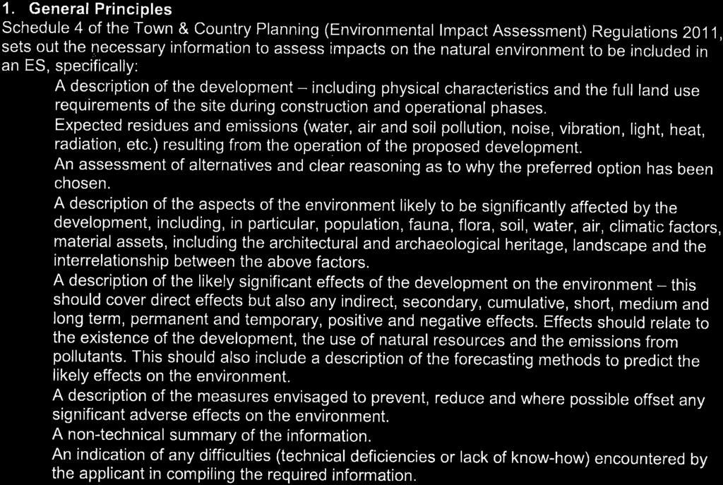
15 15 Amec Foster Wheeler Environment & Infrastructure UK Limited Ongoing activities at the quarry and in the surrounding area; Plans or projects for which an application has been made and which are under consideration by the consenting authorities; and Plans and projects which are reasonably foreseeable, i.e. projects for which an application has not yet been submitted, but which are likely to progress before completion of the development and for which sufficient information is available to assess the likelihood of cumulative and incombination effects. The ES should also consider cumulative effects on a single receptor for example noise and visual disturbance on a property. 3.5 Environmental statement Each technical chapter of the ES should include: A topic specific description of current environmental conditions under current operating conditions which forms the baseline including data collection methodologies, outcome of any planning and technical consultations, An assessment of compliance with relevant legislation and policy (including the NPPF, the Minerals Plan and the Dartmoor National Park Development Plan), and clear justification for any non- compliance; An assessment of potential impact upon the special qualities of the National Park and the purposes of National Park designation; An indication of any difficulties (technical deficiencies or lack of know-how encountered by the applicant in requiring information; A methodology for the assessment of effects for each topic including criteria to determine significance of effects; Mitigation measures to avoid, reduce or compensate for any potential adverse effects arising from the all stages of the scheme along with any proposed enhancement measures; An assessment of predicted residual effects and their significance at each stage of the development including restoration; An assessment of the interrelationship between the environmental aspects where appropriate which should be covered in the Chapter on Cumulative Impacts; and Conclusions It would be helpful in terms of the assessment if all of the likely impacts and their associated effects together with any proposed mitigation/compensation/control of such impacts along with any list of clear environmental undertakings could be provided in a separate chapter presented in a tabulated form. Topics to be scoped out No matters have been scoped out. Topics to be scoped in The following topics have been identified as having the potential to be significantly affected by the proposed scheme.
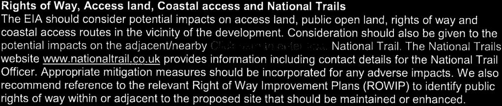
16 16 Amec Foster Wheeler Environment & Infrastructure UK Limited Population Effects on the local population as receptors will be picked up throughout many chapters and include effects of noise, vibration, dust, visual change, driver delay, accidents and safety. This section therefore identifies those potentially significant effects on the local human population which are not identified in other sections. Recreation issues The Environmental Statement should give consideration to potential impacts on recreational facilities and should include: An assessment of the impact of the development on Ashburton Footpath 16 which is to be diverted; Details of proposed mitigation measures to reduce, prevent, or offset any adverse impacts including details of measures to be taken to protect the visual amenity of users of Ashburton Footpath 16 including hedge management and/or provision of additional screening and measures to prevent flooding; and An assessment of the likely effectiveness of any mitigation measures. Socio-economic effects The EIA should assess The potential effects of the scheme on employment opportunities in the locality (including job creation, retention and an assessment of jobs lost through land-use changes); The effects in existing businesses as a result of land take and highways diversion The effect of the loss of farmland; The potential socio-economic effects of the proposed restoration scheme to amenity and employment uses (biodiversity will be assessed elsewhere); Consideration of the security/safety of the site during operations and in perpetuity once restored; and Mitigation proposed to off-set any adverse socio-economic effects. Noise and vibration The noise assessment will consider the potential for impact from noise sources from the extension in relation to the nearest noise sensitive properties in the vicinity. Separate assessments will be made for the preliminary works of hedgerow relocations and bund construction, and subsequent operations when extraction is in progress. Note will be made of anticipated changes due to the extraction moving progressively across the extraction area and by deepening of the proposed void. Background noise levels will be established by taking noise meter readings in positions to correspond to the three closest sensitive receptors to the extension area and at the School in respect of Waye Lane, using daytime spot measurements over one day and 24 hours monitoring over a week. This would be supplemented by calculating the noise levels from traffic flows on the A38. The noise assessment for the construction and operational phases will be made on the basis of calculations of predicted noise levels from the results of the survey measurements and calculations of the noise arising from the extension area works. The methodology will be based on the advice in BS5228: Construction Noise and Vibration or BS4142: Rating Industrial Noise affecting mixed residential and industrial areas as appropriate. This information will inform the noise assessment of the impact of the different elements of the proposals on the local noise sensitive receptors.
17 17 Amec Foster Wheeler Environment & Infrastructure UK Limited PPG 30 Noise includes a table summarising the noise exposure hierarchy, based on the likely average response. The assessment of noise impact on the identified sensitive receptors must be made by reference to this noise exposure hierarchy and to the advice on noise emissions for mineral operations in the Planning Practice Guidance. If it is found that the standards are likely to be exceeded, appropriate forms of mitigation must be proposed to provide compliance. Residual effects will be reported taking account of the mitigation measures. Current and proposed methods and frequency of blasting should be described. The potential impacts of blasting, in terms of vibration, should be included. Teignbridge District Council s Environment Control Team has noted that the assessment should include continued extraction, processing and transport movements from the existing Linhay Hill Quarry, the extension area preparation/construction phase and construction of the new highway. Furthermore ongoing operations will extend the noise envelope for the site and therefore additional noise receptors and monitoring locations for the extension areas will be required. The following baseline noise monitoring locations have been agreed: Long Term measurement: Place House and Dwellings on the B3352. These locations were added to address cumulative impact of the ongoing operation of the existing quarry. Long term measurements have also been taken at Momalda and Caton to gain a baseline for the extension itself. Short Term measurements: Waye (this will also serve as proxy for Waye House) (short term measurements with longterm measurement at Lower Waye/Momalda). Short term measurements have been taken at other locations around the extension area Ashburton College (this will also serve as proxy for Rock Park Cross and Gallows Cross, which are further away in the same direction); Long Park; and Dwelling/caravan on south side of A38 (closer to the quarry than Mead Cross). Baseline noise levels should inform the assessment and the proposals will include ongoing monitoring at key locations. The effects of noise on the occupiers of these properties should be addressed in the ES. Noise assessment need to cover the impact on receptors of all sources of noise including stripping and placement of soils and overburden and quarry waste during each phase of working including restoration. The report should produce enough information to enable the applicants to assess the implications and if monitoring indicates that mitigation is required, to provide effective mitigation of noise and vibration for the protection of each of the effective receptors. Dust and air quality Dust impacts may arise from engineering works, soil stripping, mineral extraction, stockpiling and transportation and have the potential to result in disturbance / loss of amenity to neighbouring sensitive properties. Vehicle emissions resulting from transportation of mineral have the potential to impact on air quality and should also be assessed. Dust and air quality issues arising from [some of] the operations are already subject to Environmental Permits. Copies of these documents should be submitted with the ES, Air quality impacts need to cover emissions from vehicle and plant and emissions from materials and processes where applicable.
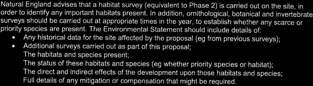
18 18 Amec Foster Wheeler Environment & Infrastructure UK Limited It is recommended that the ES should consider air quality matters separately to visible dust, and the methodology for dust assessment should make provision for pre-commencement boundary dust monitoring. We understand that dust monitoring is already under way. Consideration should be given to the extended use of the existing processing plant in terms of dust, odour and emissions. The haulage distances from the extension area should be taken into account in terms of vehicle emissions and this should be a separate topic within the dust and air quality chapter of the ES. The methodology for this assessment should be agreed between the MPA/NE/EHO and the applicant before the ES is finalised. Dust assessments need to cover the impact on receptors of all sources of dust including stripping and placement of soils and overburden and quarry waste during each phase of working including restoration. Fauna and flora The scheme would involve removal/relocation of hedgerows and loss of grassland (improved, semi-improved and Marshy Grassland), small pockets of scrub and agricultural land. A number of trees would also need to be felled. A range of surveys have been undertaken for protected species including dormice, bats, great crested newts and birds although the Scoping Request does not indicate the findings of these surveys. The Environmental Statement should include ecological information presented in a clear and succinct form and must include: A desk based assessment of species and habitats identified around the site including historical data for the site(including any geological interest); Results of detailed ecological surveys which have been undertaken, a description of species and habitats which may be affected, an assessment of the status of these habitats and population levels of potentially affected species; Details of the methodologies used to carry out the assessments including the times of year at which surveys were conducted and the qualifications/experience of individuals carrying out the surveys; Details of any proposed mitigation measures to prevent, reduce or offset adverse impacts to ecology and biodiversity to include details of opportunities taken to manage invasive species, create and/or restore BAP habitats as part of the restoration proposed for the site. Where habitats are lost compensatory habitat requirements should be calculated using Defra s offset metric See ( offsetting pilot and offsetting) A full assessment of the likely direct and indirect effects of the development on the features of special interest within nearby Special Areas of Conservation (SACs) (including Haytor & Smallacombe Iron Mines SAC and South Ham SAC, Sites of Special Scientific Interest (SSSls) County Wildlife Sites, species protected by the Wildlife and Countryside Act 1981 (as amended) and by the Conservation of Habitats and Species Regulations 2010 and other features of nature conservation interest. These impacts should be clearly summarised on an annotated map(s). The assessment should include effects such as transport, hydrology and air quality impacts that may arise as a result of the development during the site preparation, extraction and restoration phases; A balance sheet of any losses and gains to show overall net gain for wildlife should be provided along with a simple table within which the applicant quantifies predicted habitat loss/degradation and proposed retention, creation, mitigation and enhancement along with timetables for these predicted impacts and activities set against the life of the mineral operation. The avoidance, mitigation, compensation and enhancement measures required should be set out in one Conservation Action Statement that can be pulled out of the ES report and used to support the planning application;
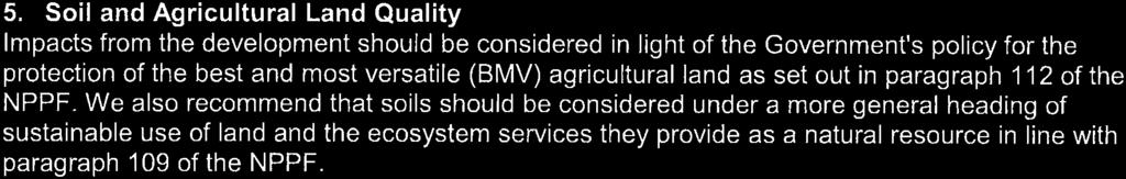
19 19 Amec Foster Wheeler Environment & Infrastructure UK Limited An assessment of the likely effectiveness of any mitigation measures; A restoration plan and long-term landscape and biodiversity action plan covering the operational and post operational phases of the quarry incorporating protected and priority habitats and species requirements as well as maximising wildlife benefit, preserving or enhancing geological features and ensuring ecological functionality within the wider landscape. It should include a sequence of plans showing the progressive restoration of the site during the operational phase of the quarry and quarry extension; and A copy of the Devon Wildlife Checklist should be included with the report. See Further guidance on biodiversity assets and EIA is set out in an advice note by Natural England which is included as Appendix A. The application will also need to be accompanied by an assessment under the Conservation of Habitats and Species Regulations The methodology for this is defined elsewhere. Soil Soil stripping to facilitate mineral extraction has the potential to result in damage to soil structures during handling/storage. The ES should set out the planned management of soil resources, having regard to national guidance published by the Defra on soils handling and management and include a strategy for the stripping, handling, storage and reuse of soils during site operation and restoration. The impact on farmers and other businesses through land loss should be assessed in the socio-economic assessment. Water Mineral extraction has the potential to adversely affect the ground and surface water regime (including flooding) in terms of quality and flow/recharge and siting of fuel oils on extension area has the potential to cause pollution of surface water and to have indirect impacts on features of ecological interests or potable water supplies. The main flood risk in Ashburton is the confluence of the Balland Stream and the River Ashburn. The quarry is in the catchment of the Balland Stream, which has a long history of flooding issues and the proposed new road is in the flood zone of the Balland Stream, so there is an issue of whether it could become impassable during a flood. The EIA should draw heavily on: The FRA which must consider the frequency of flooding in this catchment and any changes over time in relation to changes made in the local drainage system and downstream capacity of the Balland Stream; A Hydrogeological Risk Assessment which should include assessment of changes to recharge via removal of the unsaturated zone and demonstrate that the activity will not significantly affect controlled waters, third party abstractions or significantly affect surface water or groundwater regimes; Water Management Plan for surface and groundwater encompassing the quarry including the extension together with the catchment area impacted upon by the quarry both upstream and downstream and which includes measures to mitigate potential impacts of the proposed extension which have been identified in the FRA, hydrological risk assessment and mass balance calculations including the management measures and associated physical infrastructure proposed and the measures and controls proposed. These should be set out systematically for each stage of working and restoration including during the preparatory, operational and post operational stages of the development; and
20 20 Amec Foster Wheeler Environment & Infrastructure UK Limited In the past (20-30 years ago), the watercourses to the north of the current quarry had some sort of overflow fitted. We are not sure if this overflow is still in place or working. The study should investigate this flood defence function and the watercourse on/or adjacent to the extension area. The ES should include: A detailed plan and description of the current drainage regime (the baseline) including existing streams, pipes and watercourses entering and leaving the site; internal pumping regimes and volumes, associated control mechanisms and protocols (including the overflows originally installed on streams north of the quarry to direct some flood waters into the quarry's low spot), together with existing discharge consents; Modelling of current hydrological systems including re-checking the surface and groundwater baseline and modelling for Alston Farm given the presence of a former mill and sink holes; An assessment of whether water storage within the quarry currently contributes to flood attenuation in the event of heavy rain; Assessment of all hydrological changes likely to arise from the quarry extension including the siting of screening bunds and overburden tips during site operation as well as the potential hydrological effects which might occur following restoration to water; Appropriate modelling and assessment to demonstrate the effectiveness and appropriateness of the proposed measures and the alternative options considered and to demonstrate compliance with relevant legislation and guidance and should also provide for the future proofing, taking into account climate change and other factors and future maintenance, monitoring and upkeep of all associated infrastructure; Mitigation measures including SUDs, options for water management and opportunities for the proposed scheme to contribute to the alleviation of existing water management issues in the catchment which should also be assessed for their likely impacts on sensitive receptors in terms of landscape impact and biodiversity in the relevant ES chapter; An assessment of the restoration proposal which determines as accurately as possible the likely water level and seasonal fluctuations in the quarry once pumping has ceased; and the length of time needed for water levels to rise to this level; and The assessment should also evaluate the surface water, groundwater and flood risk implications on the surrounding area of the modelled increase in water levels in the quarry post restoration and include measures to prevent or mitigate any resultant effects. Climatic factors The applicant does not anticipate that the proposals will have a significant impact on climate change. An assessment of the proposed scheme on climate change should include a description of the climate of the receiving environment. It should assess the potential for the development to contribute to climate change through its emissions; it is likely that most of this will be derived from transport and plant both within the quarry and vehicles travelling to and from the quarry. Mitigation measures should be outlined which will demonstrate how emissions of greenhouse gases will be reduced. Climate change should also be incorporated into hydrological models and any assessments of the do nothing scenario to Material assets, including the architectural and archaeological heritage Heritage assets including historic buildings The following is a response to information provided by the Scoping Request, desk top assessment and site inspection of existing quarry activity and surrounding historic environment, in particular heritage assets and settings. Likewise, potential impact on the character and significance of existing heritage assets in surviving
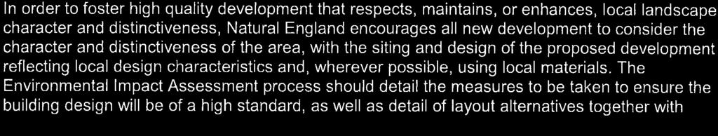
21 21 Amec Foster Wheeler Environment & Infrastructure UK Limited settings, contexts etc. by the proposed development has been clarified as far as possible, although there is insufficient information to fully understand the nature and extent of proposals and their impact at this time. Proposed quarrying activity and associated spoil disposal resulting from the proposals for the existing quarry and extension will bring operations close to the core of t additional historic farmstead and buildings at Alston Farm which is owned by Glendinning, and also Caton, where again their ownership of land and buildings in the settlement extends right up to the lane. The area of the site for the proposed development is a medieval landscape (with the potential to be older still) with small settlements in the form of scattered nucleated farmsteads with early medieval origins and later development - refer HER records attached for Alston and Caton etc. These are substantial survivals and represent an important part of the cultural heritage of Dartmoor National Park. In planning terms, the NPPF indicates that such survivals by definition are referred to as heritage assets as they contain a degree of significance meriting consideration in planning decisions because of their heritage interest. In particular, the following issues need more detailed consideration: This particular area of cultural landscape contains an historic environment which is emblematic of the south eastern fringe of Dartmoor. It is important that a thorough assessment of the medieval landscape and connection with historic farmsteads and settlement is carried out, and potential impact on heritage value of the proposed development ascertained. The proposals would bring quarrying operations including spoil disposal closer to listed buildings at Alston. Alston Farm and Alston Cottage and other farm buildings are listed buildings and heritage assets. In line with advice in the NPPF, an assessment of the significance of these assets is required, of which setting, defined as "the surroundings in which an asset is experienced", can be a component. It will be important to understand the significance of the heritage assets and their settings, whether the change is harmful and if so, to what extent, appropriate mitigation can be achieved either to the buildings or their settings. The potential impact of proposals on the settlement of Caton should be understood to ensure that the wellbeing of the settlement and its cultural heritage can be ensured. Reference can be made to government guidance and advice in connection with the NPPF and historic environment which can be accessed via the following links: and enhancing the historic environment/ books/publications/gpa2 managing significance in decision taking/ books/publications/gpa3 setting of heritage assets/ Archaeological heritage Archaeological investigations of the existing field boundaries in the proposed extension area are to be carried out in accordance with a method of working to be approved by DNPA to determine whether the field boundaries may possibly be part of the Bronze Age Reave system based at Ripon Tor. The results of this exercise will be assessed and provided to DNPA; and agreement will be reached regarding the need for any further action. Landscape The Environmental Statement (ES) should include a full assessment of the potential impacts of the proposed development on the landscape and visual amenity of the surrounding area. This should include an assessment of impacts at each phase of the works and after operations have ceased (i.e. for the restoration scheme).
22 22 Amec Foster Wheeler Environment & Infrastructure UK Limited Section 3.9 through to 3.33 of the Revised Scoping Request identifies the potential effects of the proposal on the landscape and visual resource, and outlines the approach, methodology and scope of the Landscape and Visual Impact Assessment (LVIA). The suggested methodology is considered to be satisfactory and its compliance with best practice guidance (GLVIA3) is welcome. The following provides further detail of the key concerns to be addressed in the LVIA and detailed requirements regarding visual impact assessment: Approach The scope of works suggests assessing the development during the construction phase, during operation at Year 1 (site establishment) and during operation at Year 15 (paragraph 3.11). It is unclear how these timeframes relate to the five stages or phases shown on the exhibition boards. Assessment of the landscape and visual effects should relate to the changes associated with each phase of works, each time assessing it against the baseline. This would allow greater consideration of the actual timescales for which significant effects may occur. ZTV A preliminary ground level Zone of Theoretical Visibility (ZTV) ( _Linhay_Wider_ZTV_00) has been used in identifying the current selection of viewpoints and considers the proposed excavation however a second ZTV should be produced based on the maximum height and extent of the proposed overburden mounds and perimeter bunds to identify any additional viewpoints which might be affected by the quarry operation. Particular attention should be given as to whether visitors to locations such as Rippon Tor to the northwest, Buckland Beacon to the west and the swathe of access land surrounding them need to be brought into the assessment. The identified visual envelope should then be used to help refine the study area. Photomontages With regard to the choice of photomontage locations, we suggest that the following viewpoints are used: Location Rationale Existing Viewpoints Viewpoint 17: (A38 footpath) Viewpoint 20: (Parkers Farm) Viewpoint 26: (Balland Lane) Viewpoint 27: (Waye Lane near Place House) Represents views as experienced by eastbound drivers and their passengers as well as users of the highway footpath along this side of the A38. Represents views from the holiday park. Represents views of the proposed road. Represents views of the proposed road. Additional Viewpoints Pen Park At a suitable location along the unnamed public highway between the Hooks Cross and the A383 (south of Penpark Plantation). Location to be agreed with DNPA. Baseline environment and receptors We would expect the landscape assessment to assess the potential effects upon the following three broad landscape receptor groups: Landscape elements within the site. This should include effects on potentially aged or veteran trees and important hedgerows that make up the distinctive historic field patterns;
23 23 Amec Foster Wheeler Environment & Infrastructure UK Limited Landscape character as determined through reference to existing landscape character assessments and refined through field survey; and Landscape designations including the effects upon the special qualities of the National Park as set out in the Dartmoor National Park Management Plan. Assessment of landscape elements within the site should refer to the findings of an Arboricultural Assessment as part of the baseline information. The majority of proposed viewpoints agreed to date represent views from private residential properties. We suggest that the following groups of receptors should be also be considered and agreed following confirmation via field surveys: Users of the unnamed public highway between Hooks Cross and the A383 (south of Penpark Plantation); Users of the unnamed public highway south of the Higher Brownswell and Lower Brownswell properties; Residents and users along Roborough Lane, Ashburton; Users of the Terrace Walk Public Footpath west of Roborough Lane, Ashburton; and Recreational receptors using open access land and to the north and west including visitors to Buckland Beacon. Any additional viewpoints identified through the generation of a ZTV for the maximum height and extent of overburden mounds within the site should also be considered. Potential landscape and visual impacts The landscape and visual impact assessment should consider: The effects on landscape elements within the site boundary that may be removed to accommodate the footprint of the development; Effects of the operation and restoration scheme on the key characteristics of the landscape within the study area as defined by extant landscape character assessments; Effects of the operation and restoration scheme on the special qualities of the National Park; Effects of the operation and restoration scheme on the views of visual receptors identified through the generation of ZTVs; and Effects on the setting of heritage assets, in particular Alston Farm and other Grade II Listed buildings and structures locally (see DNPA Archaeologist s comments). In assessing the above effects we would expect the following impacts to be considered: Impact of operational machinery and temporary/permanent soil and overburden mounds, Impact of any structures and extension area enclosure; Impact of any proposed hard or soft landscaping; Light pollution and its impact; Impact relating to the diversion of overhead lines which cross the site; and Impact of any proposed principles for restoration. Cumulative landscape and visual impacts Cumulative visual effects may occur where more than one existing, permitted or proposed mineral development, including the proposed extension and ongoing operations within Linhay Quarry (i.e. extending
24 24 Amec Foster Wheeler Environment & Infrastructure UK Limited the duration of processing operations), can be seen either simultaneously from viewpoints or visual receptor locations, or sequentially from major road routes. Consideration should also be given to the potential cumulative landscape effects as a result of the extraction and subsequent restoration of these sites. The study area for the cumulative assessment should be the same as that used for the LVIA. Potential mitigation measures It is recognised that there is scope to mitigate adverse effects as well as potential opportunities to enhance the landscape. These should be clearly illustrated in mitigation plans and detailed within the assessment. Restoration information which accompanies the planning application and the ES should be clear about the design, extent and effectiveness of restoration. The applicant needs to clarify detailed restoration proposals set against the phasing of work applied for in the planning application and assessed in the ES. If the applicant intends to defer restoration pending completion of extraction then this needs to be made very clear in both the planning application and the ES as the longer term impacts of delaying restoration should be assessed in such circumstances. Presentation of results In presenting the findings of the LVIA please ensure that: Photomontages that are included in the environmental statement must meet appropriate standards as set out in paragraph 8.20 of GLVIA3. This references the LI advice note Photography and photomontage in landscape and visual impact assessment (2011). Any updated advice from the Landscape Institute that may become available within the timescales of the EIA should also be reflected. Further guidance on presentation techniques can also be found in references the Scottish Natural Heritage s Visual Representation of Wind Farms, (2014). This sets guidelines on the presentation of baseline viewpoint photography, particularly in stating horizontal field of view and recommended viewing distance to be simply viewed at a comfortable arm s length. Viewing material should indicate the size of the sheet upon which it should be viewed; It is noted from recent communications that the applicant intends to prepare photomontages for a point in time where mitigation measures (i.e. planting) has established. Given the timescales associated with the planting reaching a height where it is expected that it would be fulfilling an effective landscape and visual role, it is recommended that this timeframe be revisited and suitable timescales agreed with DNPA once phasing plans have been finalised; and The LVIA report is succinct and focused on key issues highlighted in this response, and where possible text associated with viewpoints is included within the viewpoint figure, for ease of use and understanding at the viewpoint; and Conclusions and summaries are expressed objectively without bias. Highways The Applicant met with the Highway Authority and Highways England, where the situation with respect to stopping up various highways and closing junctions on the highway network, particularly the trunk road (A38) was discussed. A full Transport Assessment will be required in support of the application and the routes proposed instead of the existing highways, even though it is proposed to perpetuate rather than intensify the existing operations. Changes to the highway network and road safety matters which should be addressed within the Transportation Assessment (TA). In line with IEMA guidelines, the TA will be an appendix to the ES and Highway matters will be addressed in a topic chapter in the ES.The TA is not part of the EIA process and the ES should not contain highway network or road safety matters unless they or their mitigation are in themselves likely to have significant environmental effects. The proposed new road and re-routed footpath should be included within the red line site boundary. The Highway Authority requires a Stage 1 Safety Audit for the proposed new section of highway, assuming the applicant is submitting an indicative plan with some flexibility in terms of an alignment. This should include
25 25 Amec Foster Wheeler Environment & Infrastructure UK Limited the proposed footpath crossing. Again this will not form part of the EIA although it will inform the design of the final scheme to be assessed by the EIA. In addition, Highways England has highlighted safety concerns with the Caton Cross- A38 junction which is located within the diverge taper for the Goodstone Cross junction. The junction signing has been improved in recent years with the presence of the Caton junction now indicated on the advance direction signs but the road layout remains challenging. There are currently no restrictions on the use of Caton Lane, The Traffic Assessment should explore whether the closure of Alston Lane might result in additional traffic using the Caton Junction and suggest mitigation measures if required. The Highway Agency requires the scheme design to avoid any surface water flowing on the Strategic Road Network (A38) carriageway. Furthermore it has prohibited any new connection to the Highways Drainage network. In the case of an existing permitted connection, this can only be retained if there is no land use change. The ES should concern itself with the likely impacts on the environment from transportation associated with the project, including those arising from routing vehicles from Alston Lane through the western edge of Ashburton and any other consequential changes to vehicle routeing on the local network. Direct effects on people as a result of driver delay, highway link capacity, community effects (severance etc.) accidents and safety should be included within the transport section of the ES Indirect impacts arising from changes in traffic should be contained within the relevant chapters of the ES i.e. impacts on Air Quality, Noise, Pollution, Landscape and Biodiversity. It is important that all of the likely significant effects from highways movements and emissions are contained in the appropriate chapters of the ES so that all of the likely significant effects on (for example) noise or air quality from the construction phase and use of the new highway may be considered together and in combination with other impacts on these receptors. The Highway Authority understands that applicant has a consultation running with Caton residents. The options assessed and the responses of the consultation exercise, together with the preferred option should be included in the proposals and assessed in the TA and ES Transport section. The scheme should include the following measures identified by the Applicant: Replacement highway to compensate for the closure of Alston Lane; The proposed re-aligned footpath, separated from the proposed new road by a hedge. No diversion of the footpath is required at Upper and Lower Way and the route should be suitable for year round use and provide an unbound surface; safe crossing of new road with no stiles, no steep gradients, and not at increased risk of flooding. Details of construction should be included in the application; and Widening of Balland Lane to a minimum of 4.8m and alterations to the Coach Turning Circle (these are additional elements of the proposals voluntarily included in the application for the benefit of the local community). The ES needs to include: Description of the changes to the highway network including detailed design proposals for the A38 Alston Cross road closure works new highway (a Stage 1/2 Road Safety Audit for the application but not the EIA); An assessment of transport related impacts (including construction traffic) on the local and strategic highway networks and junctions in line with guidance contained within the Transport Evidence Bases in Plan Making and Travel Plans, Transport Assessments and Statements in Decision-Taking, updated in October 2014, and DfT Circular 02/2013 The Strategic Network and the Delivery of Sustainable Development; Assessment of the environmental impact arising from any disruption as a result of construction, changes in traffic volume, composition or routing and transport infrastructure modification;
26 26 Amec Foster Wheeler Environment & Infrastructure UK Limited Consideration of changes to noise and to air quality, including in relation to compliance with the European air quality limit values ; and Appropriate mitigation where required in line with current guidance. Highways England has further commented that the effects of the proposed development should be assessed cumulatively with other schemes and would expect the applicants to agree an appropriate list of relevant other schemes with the Council and itself to inform the preparation of the Transport Assessment. The list of schemes for the cumulative assessment should include committed development in the area and be agreed with the Highways Agency. The Applicant has advised that no additional schemes have been suggested by HA or DCC to date but are intending to reference the recently completed alterations to Drumbridges Roundabout in the TA. 3.6 Non-technical summary The information in the Environmental Statement must be summarised in a non-technical summary. This should set out the main findings of the Environmental Statement in accessible plain English to ensure that the public can comment fully on the Environmental Statement. The non-technical summary should be produced as a stand-alone document.
27 A1 Amec Foster Wheeler Environment & Infrastructure UK Limited Appendix A Guidance from Natural England
28 A2 Amec Foster Wheeler Environment & Infrastructure UK Limited


29


30

31


32

33
34

35 3 AMEC Environment & Infrastructure UK Limited
NON-TECHNICAL SUMMARY
 Proposed Sand and Gravel Extraction and Associated Processing Operations with Restoration to a Mixture of Agriculture and Nature Conservation including Areas of Shallow Water at Hedgeley, Northumberland
University Park, Worcester Non Technical Summary December 2011
 University Park, Worcester Non Technical Summary December 2011 Introduction UW Wrenbridge LLP, a Joint Venture Company of the University of Worcester and Wrenbridge Land Ltd (the Applicants ) intend to
BREEDON NORTHERN LIMITED
 Non Technical Summary CONTENTS 1 INTRODUCTION... 1 2 SITE DESCRIPTION... 1 3 DESCRIPTION OF THE DEVELOPMENT... 6 4 NEED FOR THE DEVELOPMENT... 8 5 KEY ISSUES CONSIDERED IN THE ENVIRONMENTAL IMPACT ASSESSMENT...
Replacement Golf Course Facilities and Residential Development, Churston. Environmental Statement Non-Technical Summary
 Replacement Golf Course Facilities and Residential Development, Churston Environmental Statement Non-Technical Summary July 2011 Reproduced from the Ordnance Survey s map with the permission of the Controller
The Town and Country Planning (Environmental Impact Assessment) (Wales) Regulations 2016, Regulation 13 Scoping Opinion
 (Wales) Regulations 2016, Regulation 13 Scoping Opinion") Mr Graham Clark Berrys Newchurch Farm Kinnersley Hereford HR3 6QQ BY EMAIL The Town and Country Planning (Environmental Impact Assessment) (Wales) Regulations 2016, Regulation 13 Scoping Opinion SC/2017/0001
Mr Graham Clark Berrys Newchurch Farm Kinnersley Hereford HR3 6QQ BY EMAIL The Town and Country Planning (Environmental Impact Assessment) (Wales) Regulations 2016, Regulation 13 Scoping Opinion SC/2017/0001
Request for a Scoping Opinion by Provectus. Proposed Surface Mining of Coal on Land west off the A61, Hill Top Farm, Clay Cross, Derbyshire
 Request for a Scoping Opinion by Provectus Proposed Surface Mining of Coal on Land west off the A61, Hill Top Farm, Clay Cross, Derbyshire January 2012 Contents 1 Introduction & Background... 1 2 Site
PANSHANGER QUARRY, Hertfordshire
 PANSHANGER QUARRY, Hertfordshire Proposed enhanced restoration of Phases F & H Briefing Note 1 March 2015 INERT (INACTIVE) RESTORATION MATERIALS, CONTROLS AND OPERATIONS 1 Introduction This briefing note
Barvills Solar Farm Environmental Statement Non-Technical Summary
 Barvills Solar Farm Environmental Statement Non-Technical Summary 13 March 2015 Produced for Prepared by St John s House Queen Street, Manchester M2 5JB Contents Contents... 2 1 Introduction... 3 1.1 Development
volume 11 environmental assessment section 2 environmental impact assessment Part 7 ha 218/08
 DESIGN MANUAL FOR ROADS AND BRIDGES volume 11 environmental assessment section 2 environmental impact assessment Part 7 ha 218/08 glossary of terms Used in DMRB Volume 11, Sections 1 and 2 SUMMARY This
Kier Infrastructure and Overseas Limited Greenburn Surface Mine, Dalgig Farm Site
 Kier Infrastructure and Overseas Limited Greenburn Surface Mine, Dalgig Farm Site Planning application pursuant to s.42 Town and Country Planning (Scotland) Act 1997 to amend the restoration scheme Volume
Town and Country Planning (Environmental Impact Assessment Regulations) 2011 SCOPING OPINION
 2011 SCOPING OPINION") Town and Country Planning (Environmental Impact Assessment Regulations) 2011 SCOPING OPINION Application Site and Description of Development Proposed new quarry at Culham, Oxfordshire Land and Mineral
Town and Country Planning (Environmental Impact Assessment Regulations) 2011 SCOPING OPINION Application Site and Description of Development Proposed new quarry at Culham, Oxfordshire Land and Mineral
E&JW Glendinning Ltd.
 Proposed extension and deepening of quarry for extraction of minerals for high specification aggregate and other products, and construction of spoil tip at Pigsdon Quarry Non Technical Summary of Environmental
Linhay Hill Quarry Extension Request for Scoping Opinion E&JW Glendinning Ltd. February 2015
 E&JW Glendinning Ltd February 2015 Notice This document and its contents have been prepared and are intended solely for the information of E&JW Glendinning Ltd and for the specific purpose and use in relation
The Place Solar Farm
 The Place Solar Farm Environmental Statement Non-Technical Summary 28 August 2014 Produced for Prepared by St John s House Queen Street, Manchester M2 5JB Contents Contents... 2 1 Introduction... 3 1.1
volume 11 environmental assessment section 2 environmental impact assessment Part 4 ha 204/08 scoping of environmental impact assessments
 DESIGN MANUAL FOR ROADS AND BRIDGES volume 11 environmental assessment section 2 environmental impact assessment Part 4 ha 204/08 scoping of environmental impact assessments SUMMARY This Advice Note provides
Statement of Community Involvement LAND OFF SOUTHDOWN ROAD HORNDEAN, HAMPSHIRE
 LAND OFF SOUTHDOWN ROAD HORNDEAN, HAMPSHIRE CONTENTS Page 1. Introduction 3 2. Pre-application Discussions 4 3. The Consultation Process 5 4. Consultation Feedback 7 5. Responses to Consultation Feedback
Environmental Impact Assessment
 Environmental Impact Assessment Environmental impact assessment (EIA) is the process of systematically drawing together an assessment of the likely significant environmental effects of a development project.
Comments on the proposed scope are requested from WCC/NBBC officers to be provided to SLC Rail by 25 th March 2016 and sent to
 Introduction WCC have indicated that in advance of the surveys and assessments being undertaken consultation should be undertaken with technical officers of both Warwickshire CC and Nuneaton and Bedworth
Non-technical summary
 Non-technical summary Introduction NTS.1 is applying for outline planning permission for a residential development of up to 80 dwellings on land at Hambrook, on the northern fringe of Bristol. NTS.2 An
SOUTH CAMBRIDGESHIRE DISTRICT COUNCIL. Planning and New Communities Director
 SOUTH CAMBRIDGESHIRE DISTRICT COUNCIL REPORT TO: Planning Committee 9 January 2013 AUTHOR/S: Planning and New Communities Director S/2270/12/FL FEN DRAYTON 850m long flood defence embankment ranging in
Land at Rampton Road. Cottenham
 Land at Rampton Road Cottenham Introduction TEP is preparing an outline planning application for 54 dwellings on 6.9 hectares of land adjacent to Rampton Road, Cottenham on behalf of the owners Cambridgeshire
Plumpton Neighbourhood Development Plan Revised Pre Submission Document - Regulation 14 Consultation
 REPRESENTATIONS... Plumpton Parish Council Plumpton Neighbourhood Development Plan Revised Pre Submission Document - Regulation 14 Consultation Representations submitted on behalf of: Cala Homes (South
NON-TECHNICAL SUMMARY
 Hybrid outline/detailed planning application comprising an outline planning application for 196 residential dwellings, landscaping, open space, estate roads and infrastructure, plus 4 permanent gypsy and
3. Neighbourhood Plans and Strategic Environmental Assessment
 1. Introduction This report sets out a draft Screening Determination for the Preston Parish Council s Neighbourhood Plan and has been prepared by rth Hertfordshire District Council. The purpose of the
Derry City and Strabane District Council Planning Committee Report. Amended layout from approval A/2004/0462/F with reduction from 166 units
 Derry City and Strabane District Council Planning Committee Report COMMITTEE DATE: 1 st February 2017 APPLICATION No: APPLICATION TYPE: PROPOSAL: LOCATION: APPLICANT: AGENT: Full Planning application Amended
Grantham Southern Quadrant Link Road Environmental Statement
 Grantham Southern Quadrant Link Road Environmental Statement Non Technical Summary Introduction Lincolnshire County Council (LCC) is submitting a planning application for the proposed implementation of
South Whitehaven, Cumbria EIA
 South Whitehaven, Cumbria EIA Environmental Statement - Non Technical Summary June 2013 in association with 1. Introduction Story Homes is applying to Copeland Borough Council (CBC) for a new residential
Site Assessment Technical Document Appendix A: Glossary
 Central Bedfordshire Council www.centralbedfordshire.gov.uk Site Assessment Technical Document Appendix A: Glossary July 2017 1.1.11-1 - ii Appendix A: Glossary Term Agricultural Land Classification AONB
Public Consultation. Land at Monks Farm, North Grove. Welcome
 Welcome Welcome to our public exhibition for development on Land at Monks Farm, orth Grove. Gallagher Estates and Gleeson Strategic Land are preparing an outline planning application for new homes, open
London Road, Derker. Non Technical Summary. Introduction
 London Road, Derker Non Technical Summary Introduction The Oldham Rochdale Housing Market Pathfinder was set up to tackle longstanding problems of poor quality housing and to provide the framework for
Re-location of Rugby Farmers Mart
 Re-location of Rugby Farmers Mart LaSalle Investment Management Barberry Logo here Environmental Statement Non-Technical Summary August 2017 Re-location of Rugby Farmers Mart Non-Technical Summary Report
An Bord Pleanála. Eirgrid Plc. Meath County Council Cavan County Council Monaghan County Council
 An Bord Pleanála Ref: PL02.VS0002 Prospective Applicant: Eirgrid Plc. Local Authorities: Meath County Council Cavan County Council Monaghan County Council Nature of Application: Written opinion on information
ABBEY MANOR GROUP/SAINSBURY S SUPERMARKETS LTD
 ABBEY MANOR GROUP/SAINSBURY S SUPERMARKETS LTD Mixed Use Development including Business Park and Foodstore Land at Bunford Park, Bunford Lane, Yeovil Environmental Statement: Non-Technical Report June
Longbridge Town Centre Phase 2 Planning Application
 Longbridge Town Centre Phase 2 Planning Application Non-Technical Summary of the Environmental Statement December 2013 Introduction A full application for Planning Permission has been submitted to Birmingham
ROCHFORD LOCAL DEVELOPMENT FRAMEWORK: Sustainability Appraisal/ Strategic Environmental Assessment. Rochford Core Strategy Preferred Options Document
 ROCHFORD LOCAL DEVELOPMENT FRAMEWORK: Sustainability Appraisal/ Strategic Environmental Assessment Non Technical Summary Rochford Core Strategy Preferred Options Document October 2008 SUSTAINABILITY APPRAISAL
LAND AT HOWES LANE, BICESTER ENVIRONMENTAL STATEMENT NON-TECHNICAL SUMMARY. March 2017 Our Ref: Q70433
 LAND AT HOWES LANE, BICESTER ENVIRONMENTAL STATEMENT NON-TECHNICAL SUMMARY March 2017 Our Ref: Q70433 Contents 1 INTRODUCTION AND SITE DESCRIPTION... 1 2 EIA METHODOLOGY... 5 3 ALTERNATIVES... 6 4 DESCRIPTION
Welcome to our exhibition
 Welcome to our exhibition The Homes & Communities Agency (HCA) welcomes you to this public exhibition explaining our proposals for the redevelopment of the former Lea Castle Hospital site. About the Homes
Interim Advice Note 76 / 06 ASSESSMENT PART 1 AIMS AND OBJECTIVES OF ENVIRONMENTAL ASSESSMENT. Contents
 Interim Advice Note 76 / 06 VOLUME 11 SECTION 1: ENVIRONMENTAL ASSESSMENT INTRODUCTION PART 1 AIMS AND OBJECTIVES OF ENVIRONMENTAL ASSESSMENT Contents 1. Introduction and Application 2. Aims and Objectives
PLANNING FOR THE SUPPLY OF BUILDING AND ROOFING STONE The Planning Officers Society 2008
 PLANNING FOR THE SUPPLY OF BUILDING AND ROOFING STONE The Planning Officers Society 2008 Extraction of minerals, including building and roofing stone, from the land requires planning permission under the
7. The Landscape. 7.1 Introduction. Environmental Impact Statement (EIS) Scoping Report
 Scoping Report") 7. The Landscape 7.1 Introduction The purpose of this section of the EIS Scoping Report is to describe the scope of work and methods to be applied in the identification and assessment of landscape and
7. The Landscape 7.1 Introduction The purpose of this section of the EIS Scoping Report is to describe the scope of work and methods to be applied in the identification and assessment of landscape and
Neighbourhood Planning Site Assessment Pro-forma and Guide Version 2
 Neighbourhood Planning Site Assessment Pro-forma and Guide Version 2 September 2014 Site HNP 006 Land East of Stanbridge Road and North of Lower Road 1. Background information Site location and use Site
Neighbourhood Planning Local Green Spaces
 Neighbourhood Planning Local Green Spaces Introduction... 2 1. Why green space is important... 4 2. Neighbourhood plans and green space... 6 3. Evidence... 8 Statutory designations... 9 Green space audit...
Town And Country Planning Act 1990 (As Amended) Town And Country Planning (General Development Procedure) Order 1995
 Town And Country Planning (General Development Procedure) Order 1995") Cornwall Council Council Offices St Clare Penzance TR18 3QW Tel: 01736 331166 Email: planning.west1@cornwall.gov.uk Web: www.cornwall.gov.uk Agent: Mr Paul Connelly LDA Design Kings Wharf The Quay Exeter
Cornwall Council Council Offices St Clare Penzance TR18 3QW Tel: 01736 331166 Email: planning.west1@cornwall.gov.uk Web: www.cornwall.gov.uk Agent: Mr Paul Connelly LDA Design Kings Wharf The Quay Exeter
Ref: A073350/SM/sm Date: 13 September 2013
 Ref: A073350/SM/sm Date: 13 September 2013 Ian Parkinson Development Control Team Leader Planning Portsmouth City Council Civic Offices Guildhall Square Portsmouth PO1 2AY Dear Ian LIGHT & GLEAVE VILLA
TOWN AND COUNTRY PLANNING ACT 1990 (AS AMENDED).
.") FAO: D. Williams Isle of Anglesey County Council Council Offices Llangefni Anglesey LL77 7TW 16 November 2017 DCRM Ref. No: WN0904-QUD-OS-LET-00002_English Dear Mr Williams TOWN AND COUNTRY PLANNING ACT
FAO: D. Williams Isle of Anglesey County Council Council Offices Llangefni Anglesey LL77 7TW 16 November 2017 DCRM Ref. No: WN0904-QUD-OS-LET-00002_English Dear Mr Williams TOWN AND COUNTRY PLANNING ACT
Cranbrook EXPANSION ENVIRONMENTAL STATEMENT: NON-TECHNICAL SUMMARY PRODUCED BY DAVID LOCK ASSOCIATES
 Cranbrook EXPANSION ENVIRONMENTAL STATEMENT: NON-TECHNICAL SUMMARY PRODUCED BY DECEMBER 2014 CRANBROOK EXPANSION AREAS ENVIRONMENTAL STATEMENT NON TECHNICAL SUMMARY Submitted in support of Outline Planning
South Macclesfield Development Area Environmental Statement Non-Technical Summary March 2017
 South Macclesfield Development Area Environmental Statement March 2017 Contents 1.0 Introduction... 2 1.1 Background... 2 1.2 Environmental Assessment... 2 1.3 Site Description... 2 2.0 The Proposals...
DEVELOPMENT MANAGEMENT REPORT
 ITEM A08-1 DEVELOPMENT MANAGEMENT REPORT TO: BY: DATE: DEVELOPMENT: SITE: WARD: APPLICATION: APPLICANT: Development Management Committee Development Manager Proposed live/work unit in connection with existing
Environmental Assessment (Scotland) Act 2005: Clackmannanshire Council Sustainability Strategy Scoping Request
 Act 2005: Clackmannanshire Council Sustainability Strategy Scoping Request") TAYSIDE & CLACKMANNANSHIRE Tel: 01738 458582(direct line) Fax: 01738 458616 e-mail addresses: denise.reed@snh.gov.uk Niall Urquhart Team Leader Sustainability Clackmannanshire Council Kilncraigs Greenside
TAYSIDE & CLACKMANNANSHIRE Tel: 01738 458582(direct line) Fax: 01738 458616 e-mail addresses: denise.reed@snh.gov.uk Niall Urquhart Team Leader Sustainability Clackmannanshire Council Kilncraigs Greenside
UTT/17/2075/FUL - (BERDEN) (Referred to Committee by Councillor Janice Loughlin. Reason: In the Public Interest)
 (Referred to Committee by Councillor Janice Loughlin. Reason: In the Public Interest)") UTT/17/2075/FUL - (BERDEN) (Referred to Committee by Councillor Janice Loughlin. Reason: In the Public Interest) PROPOSAL: LOCATION: APPLICANT: Amendments to the design of a scheme for a 49.99MW battery
UTT/17/2075/FUL - (BERDEN) (Referred to Committee by Councillor Janice Loughlin. Reason: In the Public Interest) PROPOSAL: LOCATION: APPLICANT: Amendments to the design of a scheme for a 49.99MW battery
7 Scoping and Introduction to the Assessments
 7 Scoping and Introduction to the Assessments 7.1 Scope of the assessments 7.1.1 Rule 8 of the TWR makes provision for an applicant to request a scoping opinion from the SoS indicating the information
DEFGH. Crystal Place Park. Environmental Impact Assessment (EIA) Elin Thomas and Emily Low Waterman Environmental
 Elin Thomas and Emily Low Waterman Environmental") DEFGH Crystal Place Park Environmental Impact Assessment (EIA) Elin Thomas and Emily Low Waterman Environmental 10.12.07 EIA Presentation Content What is EIA? Legal Requirements Process Q&A Key Topics
DEFGH Crystal Place Park Environmental Impact Assessment (EIA) Elin Thomas and Emily Low Waterman Environmental 10.12.07 EIA Presentation Content What is EIA? Legal Requirements Process Q&A Key Topics
Wyvern Park Skipton Environmental Statement. Non-technical Summary - April 2015
 Wyvern Park Skipton Environmental Statement Non-technical Summary - April 2015 BWB Consulting Ltd Whitehall Waterfront 2 Riverside Way Leeds LS1 4EH Telephone: +44(0)113 233 8000 Copyright This Report
Report reference: LT/WTE/LZH/1655/01/SCOPING June 2015
 PROPOSALS FOR THE SCOPE AND CONTENT OF AN APPLICATION FOR PLANNING PERMISSION AND AN ENVIRONMENTAL STATEMENT FOR THE EXTRACTION OF LIMESTONE FROM EXTENSION AREAS AT WHITWELL QUARRY, DERBYSHIRE Report reference:
Burgess Hill, Land South of Freeks Farm Phase 1 of Burgess Hill Northern Arc East Environmental Statement Non-Technical Summary September 2016
 Burgess Hill, Land South of Freeks Farm Phase 1 of Burgess Hill Northern Arc East Environmental Statement September 2016 Contents 1.0 Introduction... 1 1.1 Background... 1 1.2 Environmental Assessment...
WELCOME GYPSY LANE. Wider Site Location plan. Proposals for the development of LAND OFF FOXLYDIATE LANE WEBHEATH. Proposals for the development of
 WELCOME The developers are preparing an outline planning application for a residential led development and need the community s views in order to develop the proposals further WHAT IS PROPOSED? A high
Newcourt Masterplan. November Exeter Local Development Framework
 Newcourt Masterplan November 2010 Exeter Local Development Framework Background The Exeter Core Strategy Proposed Submission sets out the vision, objectives and strategy for the development of Exeter up
Assessing the impact of smallscale wind energy proposals on the natural heritage
 Scottish Natural Heritage Assessing the impact of smallscale wind energy proposals on the natural heritage Guidance March 2016 Version 3 1 Contents 1. Introduction. 3 2. Encouraging a spatial approach
64 Mineral Extraction Area Rules
 64 Mineral Extraction Area Rules 64.1 Introduction For the purposes of this Chapter: Active Area, in relation to a Mineral Extraction Area (MEA), is that part of the Mineral Extraction Area which is owned
Reserved Matters application for a site that straddles the boundary between CBC and BBC
 BBC APPLICATION 15/02682/MAR NUMBER CBC APPLICATION CB/15/04294/RM NUMBER LOCATION Wixams Land at former storage depot, Bedford Road, Wilstead Bedfordshire PROPOSAL Reserved Matters Application for Strategic
Review of the Environmental Statement for Brook Green, Braintree, Essex
 Review of the Environmental Statement for Brook Green, Final Review Report Prepared by LUC in association with Cascade Consulting and Clewlow Consulting November 2017 Planning & EIA Design Landscape Planning
CORRECTIONS WITHIN DESIGN MANUAL FOR ROADS AND BRIDGES AUGUST 2009
 DESIGN MANUAL FOR ROADS AND BRIDGES CORRECTIONS WITHIN DESIGN MANUAL FOR ROADS AND BRIDGES AUGUST 2009 SUMMARY OF CORRECTION HA 200/08 VOLUME 11, SECTION 1, PART 1 AIMS AND OBJECTIVES OF ENVIRONMENTAL
Inert Recycling (UK) Ltd Boxgrove Quarry Restoration Environmental Statement
 Ltd Boxgrove Quarry Restoration Environmental Statement") November 2013 Non-Technical Summary Empress House, 12 Empress Road, Lyndhurst, SO43 7AE Tel: 023 8028 3226 Email: waste.enquiries@wyg.com Introduction Background EIA is a process by which the environmental
November 2013 Non-Technical Summary Empress House, 12 Empress Road, Lyndhurst, SO43 7AE Tel: 023 8028 3226 Email: waste.enquiries@wyg.com Introduction Background EIA is a process by which the environmental
E16: MAINTENANCE OF LANDSCAPED AREAS
 HIGH SPEED TWO INFORMATION PAPER E16: MAINTENANCE OF LANDSCAPED AREAS This paper outlines the proposed approach to the maintenance of landscaped areas created for HS2 Phase One. It will be of particular
17A. Wind Microclimate
 17A. Wind Microclimate 17A.1 Introduction 17A.1.1 17A.1.2 17A.1.3 17A.1.4 This Chapter, which has been prepared by Waterman and BMT, provides further information with regard to the potential wind microclimate
Former RAF Sealand Site EIA
 Praxis (Holdings) Ltd. Former RAF Sealand Site EIA Environmental Statement - Non Technical Summary February 2012 in association with P a g e 1 1. Introduction Praxis (Holdings) Ltd. is applying to Flintshire
LAND AT WEST YELLAND. Environmental Statement Non-Technical Summary Welbeck Strategic Land LLP
 LAND AT WEST YELLAND Environmental Statement Non-Technical Summary Welbeck Strategic Land LLP May 2014 Quality Management Issue/revision Issue 1 Revision 1 Revision 2 Revision 3 Remarks Draft FINAL Date
Strategic Environmental Assessment Screening Report. Dublin Port Masterplan Review 2017
 Strategic Environmental Assessment Screening Report Dublin Port Masterplan Review 2017 Table of Contents 1 Introduction... 1 2 Purpose of the Masterplan... 2 3 Task 1.1 Pre-Screening Check... 5 4 Task
Schedule of Planning Applications Committee Date: 23 May Reference: 06/17/0726/F Parish: Hemsby Officer: Mr J Beck Expiry Date:
 Schedule of Planning Applications Committee Date: 23 May 2018 Reference: 06/17/0726/F Parish: Hemsby Officer: Mr J Beck Expiry Date: 22-05-2018 Applicant: Proposal: Site: Mr Gillett Change of use to the
Settlement Boundaries Methodology North Northumberland Coast Neighbourhood Plan (August 2016)
") Introduction This background paper sets out a methodology for the definition of settlement boundaries in the North Northumberland Coast Neighbourhood Plan. The neighbourhood plan is planning positively
Introduction This background paper sets out a methodology for the definition of settlement boundaries in the North Northumberland Coast Neighbourhood Plan. The neighbourhood plan is planning positively
Response by the Wiltshire Archaeological and Natural History Society
 Highways England Consultation A303 Stonehenge Response by the Wiltshire Archaeological and Natural History Society Background About the Society Founded in 1853 to educate the public by promoting, fostering
Circular L8/08 2 September Water Services Investment and Rural Water Programmes Protection of Natural Heritage and National Monuments
 Circular L8/08 2 September 2008 Water Services Investment and Rural Water Programmes Protection of Natural Heritage and National Monuments 1. The purpose of this Circular is to provide local authorities
Appendix 10.3 Ecological Mitigation & Enhancement Strategy (EMES) Stages 0-5
 Stages 0-5") Appendix 10.3 Ecological Mitigation & Enhancement Strategy (EMES) s 0-5 Ecological Mitigation & Enhancement Strategy (EMES) s 0-5 E&JW Glendinning Ltd May 2016 Notice This document and its contents have
Appendix 10.3 Ecological Mitigation & Enhancement Strategy (EMES) s 0-5 Ecological Mitigation & Enhancement Strategy (EMES) s 0-5 E&JW Glendinning Ltd May 2016 Notice This document and its contents have
Rannoch 132 / 33 kv Substation Extension
 Who we are Scottish and Southern Energy Power Distribution is part of the SSE plc group of companies. We own, maintain and invest in the networks in the north of Scotland the electricity transmission network
Departure from the Development Plan. Town Council objection to a major application. DETERMINE
 Item No. 9 APPLICATION NUMBER CB/17/01642/OUT LOCATION Land rear of 43 to 91 Silver Birch Avenue South of Alder Green and Aspen Gardens, Aspen Gardens, Stotfold PROPOSAL Outline application for up to 95
Development in the setting of the Cotswolds AONB
 COTSWOLDS CONSERVATION BOARD POSITION STATEMENT Development in the setting of the Cotswolds AONB.1. Introduction Areas of Outstanding Natural Beauty (AONBs) are designated by the Government for the purpose
Cardiff International Sports Village Waterfront Development Volume IV : Non-Technical Summary of the Environmental Statement
 Greenbank Partnerships Ltd October 2012 Cardiff International Sports Village Waterfront Development Volume IV : Non-Technical Summary of the Environmental Statement Environmental Statement - Non Technical
Land at BROOK STREET PROPERTIES TENCREEK FARM, LISKEARD. Environmental Statement: Non-Technical Summary
 BROOK STREET PROPERTIES TENCREEK FARM, LISKEARD Land at Environmental Statement: Non-Technical Summary Introduction Brook Street Properties is applying to Cornwall Council for outline planning permission
Test Valley Borough Council Southern Area Planning Committee 8 January 2019
 ITEM 11 APPLICATION NO. 18/02218/FULLS APPLICATION TYPE FULL APPLICATION - SOUTH REGISTERED 23.08.2018 APPLICANT Rugby Football Union SITE The Trojans Club, Stoneham Lane, Eastleigh, SO50 9HT, CHILWORTH
M4 Corridor around Newport Environmental Statement Volume 3: Appendices
 Environmental Statement Volume 3: Appendices Environmental Statement Volume 3: Appendices At Issue March 2016 CVJV/AAR 3 rd Floor Longross Court, 47 Newport Road, Cardiff CF24 0AD Volume 3: Contents 1
BRE Strategic Ecological Framework LI Technical Information Note 03/2016
 BRE Strategic Ecological Framework Technical Information Note 03/2016 September 2016 Contents 1. Introduction 2. Aims of BRE s Strategic Ecological Framework 3. How SEF is different from previous approaches
PERSIMMON HOMES (SW) LIMITED LAND AT ADDINGTON, LISKEARD ENVIRONMENTAL STATEMENT NON-TECHNICAL SUMMARY
 LIMITED LAND AT ADDINGTON, LISKEARD ENVIRONMENTAL STATEMENT NON-TECHNICAL SUMMARY") PERSIMMON HOMES (SW) LIMITED LAND AT ADDINGTON, LISKEARD ENVIRONMENTAL STATEMENT NON-TECHNICAL SUMMARY APRIL 2010 INTRODUCTION This document is the Non-Technical Summary (NTS) of an Environmental Statement
PERSIMMON HOMES (SW) LIMITED LAND AT ADDINGTON, LISKEARD ENVIRONMENTAL STATEMENT NON-TECHNICAL SUMMARY APRIL 2010 INTRODUCTION This document is the Non-Technical Summary (NTS) of an Environmental Statement
PLANNING APPLICATION CONONISH GOLD MINE, TYNDRUM. Planning and Environmental Statement Non-Technical Summary August 2017
 PLANNING APPLICATION CONONISH GOLD MINE, TYNDRUM Planning and Environmental Statement Non-Technical Summary August 2017 0 Scotgold Resources Ltd Cononish Gold Mine, Tyndrum On behalf of Scotgold Resources
My role and specialisms. Worked at spawforths for nearly 13 years. Worked on EIA projects for approx. 10 years and had co-ordinator role for approx.
 My role and specialisms. Worked at spawforths for nearly 13 years. Worked on EIA projects for approx. 10 years and had co-ordinator role for approx. 9 years. Lead EIA activities in the company. The majority
Lead Local Flood Authority SuDS Policy Statement
 Lead Local Flood Authority SuDS Policy Statement Meeting Sustainable Drainage System Standards in Hertfordshire Addendum to the Local Flood Risk Management Strategy for Hertfordshire March 2015 Contents
NON-TECHNICAL SUMMARY
 NON-TECHNICAL SUMMARY THE HIDE, BISHOP AUCKLAND PROPOSED ECO CHALET DEVELOPMENT NON-TECHNICAL SUMMARY 1 Introduction 1.1.1 This non-technical summary for the (ES) prepared in relation to the proposed eco-chalet
9 Archaeology & Cultural Heritage
 High Clachaig Wind Farm Scoping Report Page 56 9 Archaeology & Cultural Heritage 9.1 Introduction Cultural heritage in this context means the above- and below-ground archaeological resources, built heritage,
NON TECHNICAL SUMMARY
 CONTENTS Introduction...1 Site Setting and Description...3 Proposed Development...3 Proposed Time Extension...4 Proposed Lateral Extension...4 Improvement of the main access road (Downs Lane)...4 Restoration
Ʊ ± ªº Œª ºª ø ª ª ± ª
 Ʊ ± ªº Œª ºª ø ª ª ± ª ø º Õ± ± ± Œ±øºÙ Õ ß Æª ø檺 ±Æ ƪ ø檺 æß Æ± Ʊ ª ø ø fl ª ª ± ê ø Õ øæß ª ª æªæ Ó ÔÌ Non-Technical Summary Introduction A planning application has been submitted to the Vale
High Speed Rail (London- West Midlands)
") High Speed Rail (London- West Midlands) Draft Environmental Minimum Requirements Annex 3: Draft Heritage Memorandum November 2013 ESA 4.4 High Speed Rail (London- West Midlands) Draft Environmental Minimum
High Speed Rail (London- West Midlands) Draft Environmental Minimum Requirements Annex 3: Draft Heritage Memorandum November 2013 ESA 4.4 High Speed Rail (London- West Midlands) Draft Environmental Minimum
NON TECHNICAL SUMMARY
 NON TECHNICAL SUMMARY INTRODUCTION NTS.1 CEMEX UK Properties Limited is applying for planning permission to South Cambridgeshire District Council (SCDC) for the redevelopment of the former CEMEX cement
Kings Road Industrial Development, Immingham. Environmental Impact Assessment. Non Technical Summary
 Environmental Impact Assessment Non Technical Summary Report prepared by: Ecus Ltd. Brook Holt 3 Blackburn Road Sheffield S61 2DW 0114 266 9292 December 2013 Page left intentionally blank INTRODUCTION
Velindre Cancer Centre Environmental Statement Vol.1: Environmental Statement Text. Chapter 1: Introduction
 Velindre Cancer Centre Environmental Statement Vol.1: Environmental Statement Text Chapter 1: Introduction Draft - March 2017 Prepared by: Address: Email: Website: Mott McDonald, The Urbanists and HLM
WHITELEY TOWN COUNCIL NORTH WHITELEY DEVELOPMENT SEPTEMBER 2014
 WHITELEY TOWN COUNCIL NORTH WHITELEY DEVELOPMENT SEPTEMBER 2014 Dear Resident This Special Edition of the Whiteley Voice which has been prepared in conjunction with the North Whiteley Consortium is to
Cotswolds AONB Landscape Strategy and Guidelines. June 2016
 Cotswolds AONB Landscape Strategy and Guidelines June 2016 Cotswolds AONB Landscape Strategy and Guidelines Introduction The evolution of the landscape of the Cotswolds AONB is a result of the interaction
YENNADON QUARRY, DOUSLAND, YELVERTON, DEVON, PL20 6NA EXTRACTIVE MATERIALS MANAGEMENT STATEMENT. For YENNADON STONE LTD
 YENNADON QUARRY, DOUSLAND, YELVERTON, DEVON, PL20 6NA EXTRACTIVE MATERIALS MANAGEMENT STATEMENT For YENNADON STONE LTD 27 th November 2013 Job No: 7397/EMMS Report Status: Project Number: Final 7397/EMMS
Shenley Neighbourhood Development Plan Pre-Submission Plan, Regulation 14 Consultation
 Amanda Leboff, Clerk Shenley Parish Council Shenley Neighbourhood Plan c/o Shenley Parish Council The Hub London Road Shenley Herts WD7 9BS Sent by email to: clerk@shenleyvillage.org Hertfordshire County
SOUTH EAST LINCOLNSHIRE LOCAL PLAN: HOUSING PAPER DONINGTON (JUNE 2016)
") SOUTH EAST LINCOLNSHIRE LOCAL PLAN: HOUSING PAPER DONINGTON (JUNE 2016) 1 DONINGTON S PLACE IN THE SPATIAL STRATEGY 1.1 Policy 2 of the South East Lincolnshire Local Plan 2011-2036 Draft for Public Consultation
SOUTH EAST LINCOLNSHIRE LOCAL PLAN: HOUSING PAPER DONINGTON (JUNE 2016) 1 DONINGTON S PLACE IN THE SPATIAL STRATEGY 1.1 Policy 2 of the South East Lincolnshire Local Plan 2011-2036 Draft for Public Consultation
Land to the North of Main Road, Wybunbury
 Land to the North of Main Road, Wybunbury Environmental Statement Non-Technical Summary November 2014 Land to the North of Main Road, Wybunbury Environmental Statement Non-Technical Summary Prepared on
College Green Project Environmental Impact Assessment Report
 Environmental Impact Assessment Report October 2017 Table of Contents EIS Non-Technical Summary 1. Introduction 2. Background to the Project and Alternatives Considered 3. Consultation 4. Proposed Project