CITY PLANNING COMMISSION AGENDA ITEM NO: 8 STAFF: ANDREW FIRESTINE FILE NO: CPC PUD QUASI-JUDICIAL
|
|
|
- Eric Kory Carson
- 5 years ago
- Views:
Transcription
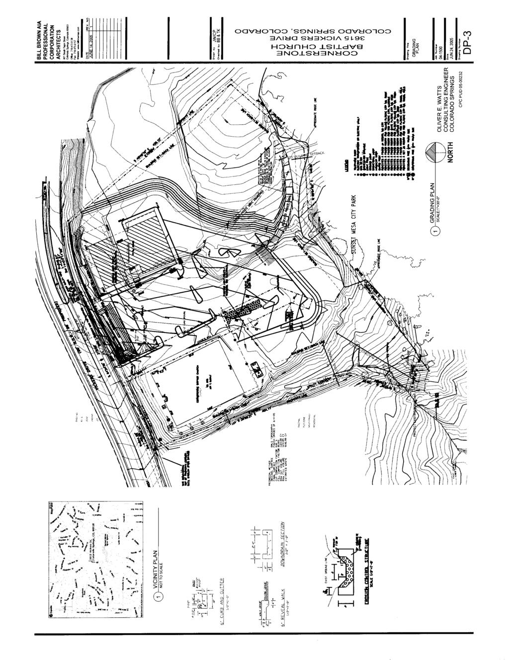
1 Page 97 CITY PLANNING COMMISSION AGENDA ITEM NO: 8 STAFF: ANDREW FIRESTINE FILE NO: CPC PUD QUASI-JUDICIAL PROJECT: APPLICANT: OWNER: CORNERSTONE BAPTIST CHURCH BILL BROWN AIA P.C. CORNERSTONE BAPTIST CHURCH PROJECT DESCRIPTION: The applicant is proposing a PUD development plan to implement the Cornerstone Baptist Church PUD Plan, approved by City Planning Commission on August 4, 2005 and by the City of Colorado Springs on December 9, The ordinance approving the PUD zone district is attached as Figure 1. The PUD development plan proposes a 12,746 square foot gymnasium and classroom building on a 6.46-acre lot platted as Lot 1 of the Cornerstone Baptist Church Subdivision. The property is located east of Flintridge Drive and south of Vickers Drive (Figure 2). STAFF'S RECOMMENDATION: ITEM NO: 8 CPC PUD PUD DEVELOPMENT PLAN Approve the Cornerstone Baptist Church PUD Development Plan (Figure 3), based upon the findings that the PUD development plan meets the review criteria for a PUD development plan as set forth in Section of the City Code and meets the review criteria for a Hillside Development Plan as set forth in Section D.3 of the City Code. This recommendation for approval is subject to compliance with the changes to the Cornerstone Baptist Church PUD Development Plan as set forth in the Technical and Information Modifications to the PUD Development Plan portion (pages ) of the CPC agenda. BACKGROUND PROJECT INFORMATION: Existing Zoning/Land Use: PUD/HS/NP/CR/Existing church Surrounding Zoning/Land Use: North PUD/HS/Single-family residential South R1-6000/Sunset Mesa Park East PUD/HS/NP/CR/Unplatted church property West PUD/HS/Ridge Condominiums Annexation: 1971, Pring Ranch Addition #1 Subdivision: April 1977, Cornerstone Baptist Church Subdivision PUD Plan: Cornerstone Baptist Church PUD Plan Zoning Enforcement Action: None Physical Characteristics: The site is adjacent to the Sunset Mesa Park. The elevation increases from approximately 6,790 feet at the west property line to 6,820 feet approximately 500 feet to the east. A large plateau exists in this area at an approximate elevation of 6,810 feet. East of the plateau, the elevation drops approximately 36 feet to the north and east to Vickers Drive.
2 Page 98 DEPARTMENTAL REPORTS: City Planning received the development application on June 23, The initial department review comments are included in the City Planning review letter dated July 28, 2005 (Figure 4). Planning staff has met with the applicant and/or other departments regarding their concerns. Additional letters were sent to the applicant on September 28, 2005 and November 18, 2005 which outline the revised review comments on the Cornerstone Baptist Church PUD Development Plan (Figure 5). The PUD development plan was resubmitted on December 12, 2005 to be considered for the City Planning Commission agenda. Although a review letter was not drafted prior to the City Planning Commission staff report deadline, agency review comments based on the third review of the PUD development plan are included in the staff report as Figure 6 and are incorporated into the Technical and Informational Modifications to the PUD Development Plan. As the Traffic Engineering review comments were still outstanding as of December 20, 2005, the Technical and Informational Modifications to the PUD Development Plan may not account for all of the Traffic Engineering comments on the PUD development plan resubmitted on December 12, A revised set of comments will be provided at the City Planning Commission hearing on if there are additional Traffic Engineering comments. PETITIONER'S JUSTIFICATION: See Figure 7 for the applicant s justification. STAKEHOLDER PROCESS: The Cornerstone Baptist Church originally submitted a PUD plan application on January 25, 2005 and the development plan application on June 23, Although the applications were reviewed separately, the public participation was inextricably linked. Some of the comments obtained from the neighborhood through the review of the PUD plan were more applicable to the review of the PUD development plan and as such are included with the comments received during the review of the PUD development plan (Figure 8). Comments obtained from the neighborhood were considered in the internal review of the PUD development plan. Property owners were notified through the mail (two mailings) and the property has been posted on two occasions. The first notification was mailed on August 11, 2005 at the internal review stage and a neighborhood meeting was held on August 23, ANALYSIS OF MAJOR ISSUES: Notes were added to the PUD plan to require that several major issues be addressed through the review of a PUD development plan. These issues included drainage and erosion induced damage to the Sunset Mesa Park and public improvements to Vickers Drive. A note on the PUD plan states: The Cornerstone Baptist Church shall submit an updated drainage report with the PUD development plan. The drainage report shall address the off-site drainage problems and the Cornerstone Baptist Church will be required to reach agreement with the Parks, Recreation, and Cultural Services Department and City Engineering on acceptable grade control structures. The drainage improvements shall be installed in conjunction with the expansion of the church. An updated drainage report was submitted with the development plan, which was approved by City Engineering on September 19, 2005 (Figure 9). The drainage report and the grading plan propose to grade the site so that all of the drainage in the parking lot will be routed to Vickers Drive, which will reduce the existing runoff into the Sunset Mesa Park and the Ridge Condominiums. Also, whereas a stormwater quality pond was initially proposed adjacent to the Ridge Condominiums, it is located along Vickers Drive east of the existing driveway on the PUD development plan. The approved drainage report illustrated erosion control drop structures in the Sunset Mesa Park. Pursuant to a meeting with the Parks, Recreation, and Cultural Services Department, City Engineering, and the church s engineer on December 6, 2005, the drop structures will be replaced by a headwall on
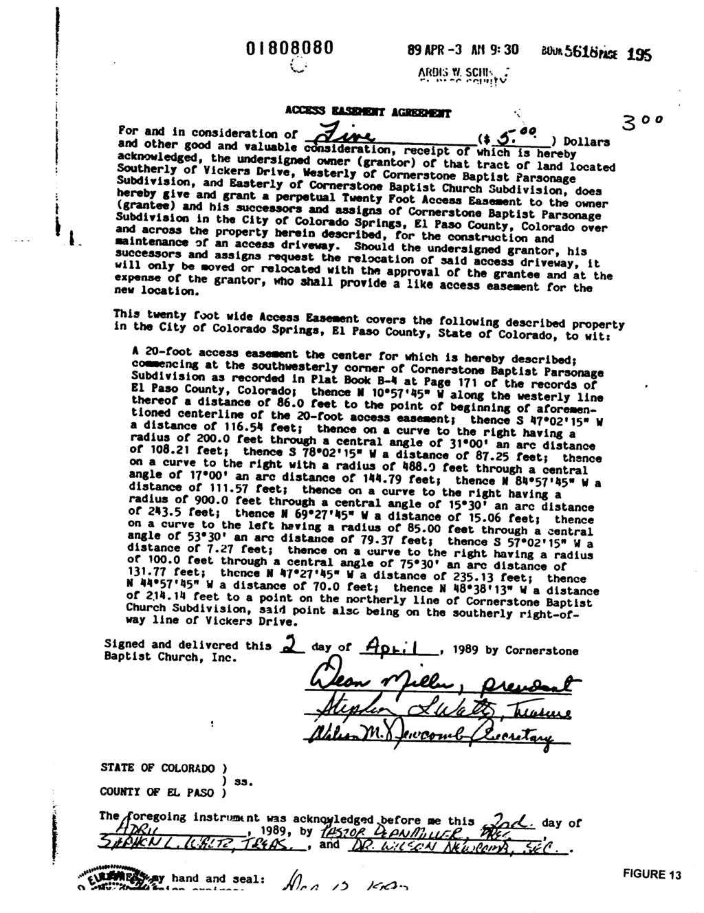
3 Page 99 the church property and a 12 diameter high density polyethylene (HDPE) pipe through the Sunset Mesa Park, which is illustrated on the most recent grading plan. The HDPE pipe will direct drainage to the existing concrete lined channel to the south. The church will be required to obtain a revocable permit to install the 12 diameter HDPE pipe within the Sunset Mesa Park. The revocable permit will allow the church to install the pipe and it will grant a 20 wide easement to the church for the long-term maintenance of the infrastructure. The Parks, Recreation, and Cultural Services Department has requested six conditions be added to the PUD development plan. The conditions are essentially: 1) to obligate the church to obtain a revocable permit and to install the HDPE pipe; 2) to protect the Sunset Mesa Park during the installation of the HDPE pipe; 3) to adopt appropriate remediation for all disturbed areas within the Sunset Mesa Park; and 4) to obligate the church to any long-term maintenance of the HDPE pipe. The conditions are included in the requested Technical and Informational Modifications to the PUD Development Plan. A copy of the revocable permit as drafted by the Parks, Recreation, and Cultural Services Department is attached as Figure 10. The PUD plan notes that the existing median on Vickers Drive will be reconfigured to accommodate the westbound full left-turn lane and adequate storage at the existing full movement entry drive and is to be shown on the PUD development plan. Traffic Engineering noted in the initial review letter dated July 28, 2005 that the left-turn lane at the full movement access off of Vickers Drive is to be installed with the first phase of development. Traffic Engineering also noted that as a safety concern, it is recommended that the right-turn lane also be installed with the first phase of development. In the revised PUD development plan, the applicant has illustrated a reconfigured median and has added the right-turn lane. Notes were added to the PUD development plan committing to the improvements with this development and obligating the church to submitting a street improvement plan prior to the issuance of building permits. The notes require minor modifications, which are outlined in the requested Technical and Informational Modifications to the PUD Development Plan. No sidewalks were shown on the PUD plan, but a note was added requiring a 5 detached sidewalk along Vickers Drive and pedestrian access from the public street into the site. The development plan illustrates a 5 detached sidewalk and pedestrian access to the proposed development from Vickers Drive. A public improvement easement will be required where the public sidewalk is located on church property, as is noted in the Technical and Informational Modifications to the PUD Development Plan. Another issue that was identified through the review of the PUD development plan is the private driveway to access the parsonage on the east side of the Cornerstone Baptist Church property. When the parsonage development plan was reviewed in 1986, it proposed an access road to Vickers Drive parallel to the east property boundary. The City objected to the access road because the width and the grades did not meet City standards (Figure 11). The access road was approved, but with the understanding that it was temporary and would be addressed again when the property to the west was developed. In 1989 an amendment to the development plan was reviewed and the access road was relocated to its current location through Lot 1 of the Cornerstone Baptist Church Subdivision and the unplatted parcel. It was also approved with the understanding that the access was temporary (Figure 12). Through the review of the Cornerstone Baptist Church PUD Development Plan, the City requested that the driveway through Lot 1 of the Cornerstone Baptist Church Subdivision meet City standards. The church has agreed to this request and is proposing a driveway with an HS-20 load rating at a minimum width of 12 and a maximum grade of 10 percent. The termination of the driveway into the proposed parking lot is addressed in the Technical and Informational Modifications to the PUD Development Plan. As an access easement was recorded for the driveway in its existing location (Figure 13), a new access easement will need to be recorded illustrating the proposed location of the driveway. The height of the proposed development is 54 6 to the top of the steeple from the finished grade. The applicant was referred to Section F on calculating building height in a hillside overlay. Per the City Code, hillside building height is calculated as the distance from the building grade to the corresponding highest point of the roof, including ornamental features. The major corners of the proposed structure are used to establish the control points with the building grade and from which the measurements are to be taken. A revision to the plans is needed to illustrate the hillside building height.
4 Page 100 Regardless of the proposed hillside building height, it must be noted that although the PUD plan approved a 30' height restriction for this use, it applied Section C.1 (Height Exceptions: Places of Public Assembly) to this use. This allows churches, schools, and other places of public assembly to exceed the height limitations if the side and rear building setback requirements are increased by an additional foot more than that which is required for each foot that the height of such building exceeds the maximum height requirements. The intent was to allow the church to increase the height of the gymnasium and classroom building if it were sited away from the Sunset Mesa Park. In addition to these issues, it should also be noted that the third draft of the PUD development plan exhibits many minor errors and omissions that must be addressed prior to approval. It is staff s opinion that the major issues have been resolved and that the remaining requested revisions to the PUD development plan do not preclude staff from making a recommendation of approval. The Technical and Informational Modifications to the PUD Development Plan are ordered based on their occurrence in the November 18, 2005 review letter. PUD DEVELOPMENT PLAN REVIEW CRITERIA: A development plan for land within a PUD zone shall be approved if it substantially conforms to the approved PUD plan and the development plan review criteria listed below. The standards and other requirements set forth in a development agreement may be used to demonstrate compliance with development plan review criteria. An application for a development plan shall be submitted in accord with Section of the City Code. Unless otherwise specified by a development agreement, the project shall be vested by the development plan in accord with Section and C.2 of the City Code. A. Consistency with City Plans: Is the proposed development consistent with the Comprehensive Plan or any City approved master plan that applies to the site? The proposed development is consistent with the Cornerstone Baptist Church PUD Plan approved on December 9, B. Consistency with Zoning Code: Is the proposed development consistent with the intent and purposes of this Zoning Code? The proposed development is consistent with the intent and purposes of the City Code. C. Compatibility of the Site Design with the Surrounding Area: 1. Does the circulation plan minimize traffic impact on the adjacent neighborhood? The proposed development includes improvements to Vickers Drive, including a westbound left turn lane and an eastbound deceleration lane into the site. The improvements to Vickers Drive will minimize the impact of additional traffic on the adjacent neighborhood. 2. Do the design elements reduce the impact of the project's density/intensity? The classroom buildings are sited closer to Vickers Drive than the gymnasium, which reduces the intensity of the gymnasium. Landscaping proposed along Vickers Drive and the topography of the site should also minimize the intensity of the proposed development. 3. Is placement of buildings compatible with the surrounding area? The proposed development is situated away from the ridgeline and the Ridge Condominiums and is compatible with the area. 4. Are landscaping and fences/walls provided to buffer adjoining properties from undesirable negative influences that may be created by the proposed development? The development proposes landscaping along Vickers Drive and internal to the site, including the area around the proposed stormwater quality pond. 5. Are residential units buffered from arterial traffic by the provision of adequate setbacks, grade separation, walls, landscaping and building orientation? No residential units are proposed on this development plan.
5 Page 101 D. Traffic Circulation: 1. Is the circulation system designed to be safe and functional and encourage both on and off site connectivity? The proposed development includes improvements to Vickers Drive, including a westbound left turn lane and an eastbound deceleration lane into the site. The improvements will increase the safety of the site access. 2. Will the streets and drives provide logical, safe and convenient vehicular access to the facilities within the project? The existing unimproved parking lot will be paved and shall meet the dimensional requirements for parking spaces and maneuvering areas as defined in Section D of the City Code. In addition to this, the existing private drive will be relocated and improved to City standards where it is located on Lot 1 of the Cornerstone Baptist Church Subdivision. 3. Will adequately sized parking areas be located to provide safe and convenient access, avoid excessive parking ratios and avoid expanses of pavement? The proposed parking area will provide adequate parking for the existing and proposed uses. 4. Are access and movement of handicapped persons and parking of vehicles for the handicapped appropriately accommodated in the project design? The existing and proposed development requires a total of five accessible parking spaces, of which one must be served by an 8 wide accessible aisle. The proposed development includes a total of nine accessible parking spaces, four of which are located in proximity to the existing and proposed development. 5. As appropriate are provisions for transit incorporated? No accommodations for transit are provided, although the applicant has been informed as to the existing transit routes in the area. E. Overburdening of Public Facilities: Will the proposed development overburden the capacities of existing and planned streets, utilities, parks, and other public facilities? The proposed development will not overburden the capacities of existing streets, utilities, parks, or other public facilities. F. Privacy: Is privacy provided, where appropriate, for residential units by means of staggered setbacks, courtyards, private patios, grade separation, landscaping, building orientation or other means? No residential units are proposed on this development plan. G. Pedestrian Circulation: 1. Are pedestrian facilities provided, particularly those giving access to open space and recreation facilities? The development proposes a 5 wide sidewalk along Vickers Drive, with pedestrian access to the proposed development. 2. Will pedestrian walkways be functionally separated from vehicular ways and located in areas that are not used by motor vehicles? The internal pedestrian walkways will be improved as additional development plans are reviewed. The development proposes the addition of a 5 wide public sidewalk on Vickers Drive, which will improve pedestrian safety. H. Landscaping: 1. Does the landscape design comply with the City's landscape code and the City's landscape policy manual? Once the Technical and Informational Modifications to the PUD Development Plan are addressed, the landscape design will comply with the Landscape Code and Policy Manual.
6 Page The use of native vegetation or drought resistant species including grasses is encouraged. The City's landscape policy manual or City Planning's landscape architect can be consulted for assistance. I. Open Space: 1 Residential Area: a. Open Space: The provision of adequate open space shall be required to provide light, air and privacy; to buffer adjacent properties; and to provide active and passive recreation opportunities. All residential units shall include well-designed private outdoor living space featuring adequate light, air and privacy where appropriate. Common open space may be used to reduce the park dedication requirements if the open space provides enough area and recreational facilities to reduce the residents' need for neighborhood parks. Recreational facilities shall reflect the needs of the type of residents and proximity to public facilities. No residential units are proposed on this development plan. b. Natural Features: Significant and unique natural features, such as trees, drainage channels, slopes, and rock outcroppings, should be preserved and incorporated into the design of the open space. The Parks and Recreation Advisory Board shall have the discretion to grant park land credit for open space within a PUD development that preserves significant natural features and meets all other criteria for granting park land credit. No residential units are proposed on this development plan. 2. Nonresidential; Natural Features: The significant natural features of the site, such as trees, drainage channels, slopes, rock outcroppings, etc., should be preserved and are to be incorporated into the design of the open space. The development plan identifies the approximate location of the ridgeline and of all existing vegetation, including one-seed junipers, ponderosa pine, and scrub oak. The relocated private drive is the only development activity proposed in an area with significant features. The grading plan includes a note to protect the existing trees and significant vegetation in this area. HILLSIDE DEVELOPMENT PLAN REVIEW CRITERIA: In accordance with Section D.3, a Hillside Development Plan, in addition to the PUD development plan review criteria listed in Section of the City Code, criteria for review of a development plan in a designated hillside area shall include the following: a. Does the plan meet the spirit and intent of the hillside design manual? The proposed development meets the spirit and intent of the Hillside Development Design Manual. b. How will the streetscape retain a hillside character after the street is constructed? Is terrain disturbance minimized? The streetscape should reflect the natural setting of the development. The natural elements such as vegetation and rock features should be a major part of the streetscape. Removal of significant vegetation will be discouraged for construction of the streets, installation of utilities and construction of houses. It is, however, recognized that some amount of vegetation will be removed for development in hillside areas. The hillside characteristics of the site are located along the property boundary shared with the Sunset Mesa Park. The proposed grading will not affect the hillside characteristics of the site. The relocated private drive will be removed from the ridgeline and will preserve the existing vegetation.
7 Page 103 c. Have visual impacts upon off site areas been reduced or reasonably mitigated? Significant ridgelines and other prominent sites within the City should be given special consideration when a development plan is being prepared. Additional mitigation measures are necessary in these highly visible areas. Mitigation measures that may be demonstrated on the development plan may include, but are not limited to: (1) Alternate siting of structures to include increased setbacks from ridgelines; (2) Use of significant vegetation to soften structural mass when building sites are located in highly visible areas; (3) Designation of special height restrictions; (4) Use of native vegetative cover and retaining walls faced with stone or earth colored materials as stabilization measures for cuts and fills; and (5) Alternate street placement to reduce visibility of structures. The proposed location of the development will minimize the visual impacts to the Sunset Mesa Park. The proposed development is a minimum of 250 feet from the ridgeline. d. Have the significant natural features and the significant vegetation been placed in preservation area easements? Because of the terrain in hillside areas it is recognized that utilities and some drainage improvements may have to be located within an easement. The review will consider the necessity of locating these facilities within the preservation area easement. No preservation easements are proposed at this time, but as the site develops adjacent to the Sunset Mesa Park, it may be appropriate to include the ridgeline and the existing vegetation in a preservation easement. e Have geologic, soil and other natural hazards been identified and evidence of mitigation techniques been provided? Various natural hazards are encountered when developing in the hillside terrain. It is important to identify and begin the process of addressing the various mitigation techniques. A geologic hazards study shall be provided as required by article 4, part 5, "Geological Hazard Study And Mitigation", of this chapter. A Geologic Hazard Study was reviewed and approved by City Engineering. As was identified in the study, the geologic and physiographic conditions will impose minor constraints on the proposed development and should be mitigated by implementing common engineering and construction practices. Technical and Informational Modifications to the PUD Development Plan: 1. Applicant shall resolve all comments received from Traffic Engineering before final approval of the PUD development plan. 2. Applicant shall address and modify the Landscape Plan as per comments received from the City Landscape Architect before final approval of the PUD development plan. 3. Applicant shall resolve all comments received from Colorado Springs Utilities before final approval of the PUD development plan. 4. Include a reference to the approved PUD plan file CPC PUP where Ordinance is cited. 5. The border around the data table must be positioned so that it does not overwrite any text.
8 Page Illustrate the proposed building height per Section F of the City Code. 7. Remove the parking spaces from the drive aisle in the vicinity of the relocated private drive. Remove any parking spaces that may impede line-of-sight. 8. Revise the discrepancy between the data table, which accounts for 140 provided parking spaces, and the graphic illustration, which depicts 132 parking spaces (excluding the 4 parking spaces to be removed for the drive aisle). 9. Per Section C of the City Code, a maximum of 40 percent of the required parking spaces may be compact. Provide assurance that a minimum of 60 parking spaces will be provided at a width of 9 and a depth of Include at least one accessible parking space that is served by an 8 wide accessible aisle (van accessible). 11. Remove the text master plan from the data table. 12. Remove the note that reads: If the Cornerstone Baptist Church PUD zone change request and PUD plan applications (CPC PUZ , CPC PUP ) are approved before the Conditional Use development plan, the conditional use development plan shall be adapted to a PUD development plan and shall be subject to PUD development plan review criteria. Additional information on this revision will be provided to you if the PUD is approved. The conditions were to reference the PUD development plan file (CPC PUD ), to add the conditions of record approved in the PUD ordinance, and to reference the approved PUD plan file. With the exception of the reference to the approved PUD plan file, the condition has been addressed. 13. Illustrate the correct landscape setbacks and buffers on Sheet 1/ Revise the Geologic Hazard Report note to include the file number CPC PUD Prior to resubmitting the PUD development plan, review the plan for spelling errors and consistently use the same font in the note table. 16. Show an accurate representation of all existing vegetation on all sheets. 17. Show and label the existing 20 access easement recorded on Book 5618, Page 195. Draft and record a new access easement illustrating the proposed location of the relocated driveway. The proposed access easement shall also be shown on the PUD development plan. 18. Add a note to the PUD development plan indicating that when the undeveloped portion of the site develops, the road grade, driveway width, and paving of the remainder of the driveway shall be reviewed and shall meet City standards. 19. Reword the note regarding the left-turn lane at the full movement access off of Vickers Drive and the right-turn lane into the site. The note shall state: Street improvement plans for the modification to the existing median to accommodate the taper for the westbound left turn and the deceleration lane shall be submitted prior to building permit approval. 20. Illustrate standard pedestrian ramps on the public sidewalk. A public improvement easement shall be granted where the public sidewalk is located on private property. 21. Provide a 6 wide sidewalk where the 5 wide attached sidewalk is shown or detach the 5 wide sidewalk. 22. All curb returns shall meet City standards. 23. The location of the refuse enclosure on the site plan does not match the elevation drawing as an area labeled as a potential addition adjacent to the enclosure on the site plan is shown as a structure on the elevation drawing. This shall be revised prior to final approval of the PUD development plan. 24. An area labeled as a potential addition on the west elevation of the proposed development extends onto the sidewalk. If this was unintentional, the linework shall be redrawn to show a continuous 9 wide sidewalk on the west elevation of the proposed development, otherwise the reduced width sidewalk is acceptable. 25. An erosion control plan shall be included with the PUD development plan prior to final approval, which shall meet all requirements of Section of the City Code and the Drainage Criteria Manual Volume 2: Storm Water Quality Policies, Procedures and Best Management Practices. 26. Update the grading plan details as appropriate to illustrate the agreed upon 12 diameter HDPE pipe in place of the erosion control drop structures. 27. Add a note to the grading plan that states: All facilities, vegetation and other items required by the approved grading, erosion and storm water quality control and reclamation plans shall be properly maintained by the owners of the property. Such maintenance shall include, but not be limited to, keeping all erosion control facilities in good order and functional, repairing any erosion
9 Page 105 damage that occurs, keeping all vegetation healthy and in growing condition and replacing any dead vegetation as soon as practical. 28. Show the ridgeline and all significant vegetation on Sheet 3/ Per the Parks, Recreation, and Cultural Services Department, add the following notes to the PUD development plan: 1. A revocable permit shall be obtained prior to construction of the 12" HDPE Drainage Pipe within the Mesa Open Space. This revocable permit will allow the pipe to be installed and for a 20' easement for any long term maintenance. 2. The developer shall be responsible for the installation of this 12" HDPE Drainage Pipe, as well as any long term maintenance. If the developer does not maintain the pipe to City Standards the permit shall be revoked. If the developer encroaches outside of the granted easement then the permit shall be revoked. 3. Prior to installing the 12" HDPE Drainage Pipe, the developer must verify the future location of the pipe with Parks, Recreation and Cultural Services Staff and the City Forester. The City Forester shall determine which vegetation can be removed and if vegetation is removed the value of that vegetation. That value shall be determined by either of two methods deemed most appropriate and standardized by the International Society of Arboricultural; the cost replacement method or the trunk formula method. Dollar values shall then be assessed to the Developer for damaged and/or removed trees. 4. Any damage to the vegetation during construction shall be at the owners expense. When the 12" HDPE Drainage Pipe must be serviced and/or maintained at a later date the developer is responsible for damage to any vegetation. The developer must follow the 2005 Parks and Recreation (or most current) Specs for installation and maintenance of the vegetation. 5. During construction on the 12" HDPE Drainage Pipe, construction fence must be installed along the easement boundary. Additional protective measures, such as silt fencing and straw bales may be needed to protect property downhill of this construction. Assessment & documentation shall occur prior to construction. In addition, construction fence must be installed around any tree within the easement, at the City Foresters discretion. The developer must follow the 2005 Parks and Recreation (or most current) Specs for vegetation protection. 6. Following construction within the Mesa Open Space all disturbed areas must be reinspected by all interested parties to reassess any remediation deemed necessary. Corrective measures must be addressed prior to formal completion of this project. Disturbed areas may then be reseeded with the Foothills Seed Mix and erosion control matting shall be placed over all disturbed areas within the Open Space.
10 Page 106
11 Page 107
12 Page 108
13 Page 109
14 Page 110
15 Page 111
16 Page 112
17 Page 113
18 Page 114
19 Page 115
20 Page 116
21 Page 117
22 Page 118
23 Page 119
24 Page 120
25 Page 121
26 Page 122
27 Page 123
28 Page 124
29 Page 125
30 Page 126
31 Page 127
32 Page 128
33 Page 129
34 Page 130
35 Page 131
36 Page 132
37 Page 133
38 Page 134
39 - - Page 135
40 - - Page 136
41 - - Page 137
42 - - Page 138
43 - - Page 139
44 Page 140
45 Page 141
46 Page 142
47 Page 143
48 Page 144
49 Page 145
50 Page 146
51 Page 147
52 Page 148
53 Page 149
54 - - Page 150
55 Page 151
56 Page 152
57 Page 153
58 Page 154
59 Page 155
60 Page 156
61 Page 157
62 Page 158
63 Page 159
64 Page 160
65 Page 161
66 Page 162
67 Page 163
68 Page 164
69 Page 165
70 Page 166
71 Page 167
72 Page 168

73 - - Page 169
74 Page 170

75 - - Page 171
76 Page 172
77 Page 173
78 Page 174
79 - - Page 175
80 Page 176
81 Page 177
82 Page 178
83 Page 179
84 Page 180
85 Page 181
86 Page 182
87 Page 183
88 Page 184
89 Page 185
CITY PLANNING COMMISSION AGENDA ITEM: C STAFF: ROBERT TEGLER FILE NO: CPC PUD QUASI-JUDICIAL
 CPC AGENDA June 8, 2006 Page 37 CITY PLANNING COMMISSION AGENDA ITEM: C STAFF: ROBERT TEGLER FILE NO: CPC PUD 05-294 - QUASI-JUDICIAL PROJECT: APPLICANT: OWNER: PARKWOOD AT WOLF RANCH NASS DESIGN ASSOCIATES
CITY PLANNING COMMISSION AGENDA ITEMS: 11, 12, 13 STAFF: RYAN TEFERTILLER
 Page 139 CITY PLANNING COMMISSION AGENDA ITEMS: 11, 12, 13 STAFF: RYAN TEFERTILLER FILE NO(s): CPC PUZ 05-00047 QUASI-JUDICIAL CPC PUD 05-00048 QUASI-JUDICIAL CPC FP 05-00049 QUASI-JUDICIAL PROJECT: RIDGEVIEW
CITY PLANNING COMMISSION AGENDA. ITEM NO(s): C.1 C.3 STAFF: STEVE TUCK
: C.1 C.3 STAFF: STEVE TUCK") Page 34 CITY PLANNING COMMISSION AGENDA ITEM NO(s): C.1 C.3 STAFF: STEVE TUCK FILE NOS: CPC ZC 12-00035 QUASI-JUDICIAL CPC NV 12-00036 QUASI-JUDICIAL AR DP 12-00039 QUASI-JUDICIAL PROJECT: APPLICANT: OWNER:
Page 34 CITY PLANNING COMMISSION AGENDA ITEM NO(s): C.1 C.3 STAFF: STEVE TUCK FILE NOS: CPC ZC 12-00035 QUASI-JUDICIAL CPC NV 12-00036 QUASI-JUDICIAL AR DP 12-00039 QUASI-JUDICIAL PROJECT: APPLICANT: OWNER:
CONSENT CALENDAR CITY PLANNING COMMISSION AGENDA ITEM NO: A.1, A.2 STAFF: LARRY LARSEN
 Page 8 CONSENT CALENDAR CITY PLANNING COMMISSION AGENDA ITEM NO: A.1, A.2 STAFF: LARRY LARSEN FILE NO: CPC PUZ 14-00013 - QUASI-JUDICIAL FILE NO: CPC PUD 14-00014 QUASI-JUDICIAL PROJECT: APPLICANT: OWNER:
CITY PLANNING COMMISSION AGENDA ITEM NO: 11 STAFF: JIM GAGLIARDI FILE NO: CPC CU QUASI-JUDICIAL
 Page 203 CITY PLANNING COMMISSION AGENDA ITEM NO: 11 STAFF: JIM GAGLIARDI FILE NO: CPC CU 08-00095 QUASI-JUDICIAL PROJECT: APPLICANT: OWNER: CHARTER SCHOOL CONDITIONAL USE PERMIT LAND DEVELOPMENT CONSULTANTS,
CITY PLANNING COMMISSION AGENDA ITEMS: C.1, C.2 STAFF: MEGGAN HERINGTON FILE NO(S): CPC PUZ QUASI-JUDICIAL CPC PUD QUASI-JUDICIAL
: CPC PUZ QUASI-JUDICIAL CPC PUD QUASI-JUDICIAL") Page 32 CITY PLANNING COMMISSION AGENDA ITEMS: C.1, C.2 STAFF: MEGGAN HERINGTON FILE NO(S): CPC PUZ 13-00036 QUASI-JUDICIAL CPC PUD 13-00037 QUASI-JUDICIAL PROJECT: APPLICANT: OWNER: ESTANCIA AT CORDERA
Page 32 CITY PLANNING COMMISSION AGENDA ITEMS: C.1, C.2 STAFF: MEGGAN HERINGTON FILE NO(S): CPC PUZ 13-00036 QUASI-JUDICIAL CPC PUD 13-00037 QUASI-JUDICIAL PROJECT: APPLICANT: OWNER: ESTANCIA AT CORDERA
CONSENT CALENDAR CITY PLANNING COMMISSION AGENDA ITEM: A.1-A.3 STAFF: STEVE TUCK
 Page 8 CONSENT CALENDAR CITY PLANNING COMMISSION AGENDA ITEM: A.1-A.3 STAFF: STEVE TUCK FILE NOS: 1. - CPC MPA 07-00308-A4MJ09 LEGISLATIVE 2. - CPC PUZ 09-00057 QUASI-JUDICIAL 3. - CPC PUD 09-00058 QUASI-JUDICIAL
Project phasing plan (if applicable) 12 copies of site plan
 12 copies of site plan") SITE PLAN REVIEW PERMIT APPLICATION City of Grand Haven, 11 N. Sixth Street, Grand Haven, MI 49417 Phone: (616) 847-3490 Fax: (616) 844-2051 Website: www.grandhaven.org 1. Project Information Address/location
SITE PLAN REVIEW PERMIT APPLICATION City of Grand Haven, 11 N. Sixth Street, Grand Haven, MI 49417 Phone: (616) 847-3490 Fax: (616) 844-2051 Website: www.grandhaven.org 1. Project Information Address/location
City of Lafayette Study Session Staff Report Design Review Commission
 City of Lafayette Study Session Staff Report Design Review Commission Meeting Date: April 24, 2017 Staff: Payal Bhagat, Senior Planner Subject: HDP18-15 & HDP31-15 Ramesh Patel & Melcor Development (Owners),
City of Lafayette Study Session Staff Report Design Review Commission
 ++ City of Lafayette Study Session Staff Report Design Review Commission Meeting Date: January 08, 2018 Staff: Subject: Chris Juram, Planning Technician SS12-17 Miramar Homebuilders, R-20 Zoning: Request
CITY PLANNING COMMISSION AGENDA
 Page 22 CITY PLANNING COMMISSION AGENDA ITEM: C STAFF: STEVE TUCK FILE NO: CPC CU 11-00080 QUASI-JUDICIAL PROJECT: FIRST & MAIN APARTMENTS PHASE 1 APPLICANT: OWNER: NASS DESIGN ASSOCIATES FIRST & MAIN
Neo-Traditional Overlay Application
 MAYOR AND CITY COUNCIL OF LAUREL DEPARTMENT OF ECONOMIC AND COMMUNITY DEVELOPMENT 8103 Sandy Spring Road Laurel, Maryland 20707 (301) 725-5300 Internet Address http://www.cityoflaurel.org E-mail: ecd@laurel.md.us
GENERAL INFORMATIONaaaaaaaaaaaaaaaaaaaaaaaaaaaaaaaa
 To: Planning and Zoning Commission From: City Staff Date: November 15, 2016 Re: Case #16026 Raymore Activity Center Site Plan GENERAL INFORMATIONaaaaaaaaaaaaaaaaaaaaaaaaaaaaaaaa Applicant/ Property Owner:
ARTICLE 6: Special and Planned Development Districts
 ARTICLE 6: Special and Planned Development Districts 6-10 Traditional Neighborhood Development (TND) District 6-10.10 Purpose and Intent The Traditional Neighborhood Development (TND) District provides
Zoning Ordinance Chapter 10
 CHAPTER 10 - WASHES SECTION 10.0 GENERAL: A. The purpose of this Ordinance is to establish standards for development in or near Major and Minor Washes as defined in Appendix A Glossary of Terms and Definitions
Landscaping Standards
 CHAPTER 29 ARTICLE 403 29.403 Landscaping Standards Purpose: The purpose of this section is to protect and promote the public health, safety and general welfare by requiring landscaping in relation to
CITY PLANNING COMMISSION AGENDA. ITEM NO: 6.a 6.b STAFF: LONNA THELEN
 Page 156 CITY PLANNING COMMISSION AGENDA ITEM NO: 6.a 6.b STAFF: LONNA THELEN FILE NO(S): A. - CPC ZC 08-00069 QUASI-JUDICIAL B. - CPC CU 08-00070 QUASI-JUDICIAL PROJECT: APPLICANT: OWNER: PHIL LONG VALUCAR
PLANNED UNIT DEVELOPMENT Date: April 5, 2018
 PLANNED UNIT DEVELOPMENT Date: April 5, 2018 DEVELOPMENT NAME SUBDIVISION NAME LOCATION Robert Myers Robert Myers 2955 and 2989 Dauphin Street (Southeast corner of Dauphin Street and Sage Avenue) CITY
CITY PLANNING COMMISSION AGENDA ITEM: K STAFF: STEVE TUCK FILE NO.: CPC CU QUASI-JUDICIAL
 Page 92 CITY PLANNING COMMISSION AGENDA ITEM: K STAFF: STEVE TUCK FILE NO.: CPC CU 08-00043 QUASI-JUDICIAL PROJECT: APPLICANT: OWNER: COTTONWOOD ARTISTS SCHOOL & ART GALLERY COTTONWOOD ARTISTS SCHOOL ELMER
At Your Disposal CUP Amendment, Lot 20, Village Service Commercial, at 128 Bastille Dr. (PLN17-208)
") MEMORANDUM Archuleta County Development Services Planning Department 1122 HWY 84 P. O. Box 1507 Pagosa Springs, Colorado 81147 970-264-1390 Fax 970-264-3338 TO: Archuleta County Planning Commission FROM:
MEMORANDUM Archuleta County Development Services Planning Department 1122 HWY 84 P. O. Box 1507 Pagosa Springs, Colorado 81147 970-264-1390 Fax 970-264-3338 TO: Archuleta County Planning Commission FROM:
ARTICLE V PLANNED UNIT DEVELOPMENT DISTRICT
 ARTICLE V PLANNED UNIT DEVELOPMENT DISTRICT A. Purpose and Objective The Planned Unit Development (PUD) procedure provides a flexible land use and design regulation through the use of performance criteria
COMPLIANCE CHECKLIST HILLSIDE RESIDENTIAL DESIGN GUIDELINES MANUAL
 COMPLIANCE CHECKLIST HILLSIDE RESIDENTIAL DESIGN GUIDELINES MANUAL The following checklist summarizes development guidelines and standards. See the appropriate section for a complete explanation of the
REQUEST Current Zoning: O-15(CD) (office) Proposed Zoning: TOD-M(CD) (transit oriented development mixed-use, conditional)
 (office) Proposed Zoning: TOD-M(CD) (transit oriented development mixed-use, conditional)") Rezoning Petition 2016-117 Zoning Committee Recommendation January 4, 2017 REQUEST Current Zoning: O-15(CD) (office) Proposed Zoning: TOD-M(CD) (transit oriented development mixed-use, conditional) LOCATION
Rezoning Petition 2016-117 Zoning Committee Recommendation January 4, 2017 REQUEST Current Zoning: O-15(CD) (office) Proposed Zoning: TOD-M(CD) (transit oriented development mixed-use, conditional) LOCATION
PLANNED UNIT DEVELOPMENT & SUBDIVISION STAFF REPORT Date: March 15, 2012
 PLANNED UNIT DEVELOPMENT & SUBDIVISION STAFF REPORT Date: March 15, 2012 DEVELOPMENT NAME SUBDIVISION NAME LOCATION OSR Subdivision OSR Subdivision 5559 Old Shell Road (South side of Old Shell Road, 570
Glenborough at Easton Land Use Master Plan
 Implementation 114 9.0 IMPLEMENTATION 9.1 OVERVIEW This chapter summarizes the administrative procedures necessary to implement the proposed land use plan, infrastructure improvements, development standards,
ARTICLE VI: SITE PLAN REVIEW
 Section 6.01 - Site Plan Review (All Districts) ARTICLE VI: SITE PLAN REVIEW Site plans give the Planning commission an opportunity to review development proposals in a concise and consistent manner. The
CITY PLANNING COMMISSION AGENDA
 Page 198 CITY PLANNING COMMISSION AGENDA ITEM NO: 7 STAFF: RYAN TEFERTILLER FILE NO: CPC CU 13-00022 QUASI-JUDICIAL PROJECT: APPLICANT: OWNER: GABION APARTMENTS SPRINGS ENGINEERING C & A PROPERTIES, LLC
CHESAPEAKE LANDSCAPE ORDINANCE
 CHESAPEAKE LANDSCAPE ORDINANCE CONSERVATION PRESERVATION CZO 19-600 Effective October 16, 2008 BUFFER YARD C PARKING LOT REFORESTATION YEAR 1 REFORESTATION YEAR 4 BUFFER YARD F CBPA REFORESTATION Page
SITE CITY PLANNING COMMISSION AGENDA ITEM NO: 5 STAFF: LONNA THELEN FILE NO: CPC CU QUASI-JUDICIAL ART C. KLEIN CONSTRUCTION
 Page 58 CITY PLANNING COMMISSION AGENDA ITEM NO: 5 STAFF: LONNA THELEN FILE NO: CPC CU 10-00022 QUASI-JUDICIAL PROJECT: APPLICANT: OWNER: COLORADO SPRINGS CHARTER ACADEMY ART C. KLEIN CONSTRUCTION COLORADO
PC RESOLUTION NO
 PC RESOLUTION NO. 14-01-14-02 TENTATIVE TRACT MAP fttm) 17441. REZONE {RZ) 13-003, ARCHITECTURAL CONTROL (AC) 13-003, TREE REMOVAL PERMIT (TRP) 13-052. GRADING PLAN MODIFICATION (GPM) 13-002. CONDITIONAL
CHAPTER 26 LANDSCAPING (Chapter added in its entirety 05-08)
") CHAPTER 26 LANDSCAPING (Chapter added in its entirety 05-08) 26.01 DESCRIPTION AND PURPOSE. Landscaping is an important element of the use, development and preservation of land, and a significant factor
CHAPTER 26 LANDSCAPING (Chapter added in its entirety 05-08) 26.01 DESCRIPTION AND PURPOSE. Landscaping is an important element of the use, development and preservation of land, and a significant factor
Planned Development Review Revisions (Project No. PLNPCM )
") Planned Development Review Revisions (Project No. PLNPCM2014-00139) Standard residential development Planned Development Example: Smaller lot sizes than what is allowed to create open space amenity. What
Planned Development Review Revisions (Project No. PLNPCM2014-00139) Standard residential development Planned Development Example: Smaller lot sizes than what is allowed to create open space amenity. What
CITY OF ZEELAND PLANNING COMMISSION
 APPLICATION FOR SITE PLAN REVIEW AND SPECIAL LAND USE Date City Official App. Filing Fee Rec'd ($350) NOTE TO APPLICANT: Please submit this application for Site Plan Review along with twenty (20) copies
F. The following uses in the HR District: attached single-family dwellings, condominiums, and institutional uses; and
 1102 DESIGN REVIEW 1102.01 PURPOSE AND APPLICABILITY Section 1102 is adopted to provide standards, criteria, and procedures under which design review may be approved. Design review is required for: A.
The following specific definitions shall apply to the landscaping and screening regulations contained in this article:
 ARTICLE XII. LANDSCAPING Sec. 5-421. Purpose. The purpose of landscaping and screening requirements is to improve certain setback and yard areas, including off-street vehicular parking and open-lot sales
Landscape and fencing requirements of this Chapter shall apply to all new landscaped areas.
 Chapter 19.06. Landscaping and Fencing. Sections: 19.06.01. Purpose. 19.06.02. Required Landscaping Improvements. 19.06.03. General Provisions. 19.06.04. Landscaping Plan. 19.06.05. Completion of Landscape
CITY OF KEIZER MASTER PLAN APPLICATION & INFORMATION SHEET
 CITY OF KEIZER MASTER PLAN APPLICATION & INFORMATION SHEET PRE-APPLICATION CONFERENCE Prior to the actual filing of a Master Plan application, it is strongly recommended that the applicant contact Planning
PLANNED DEVELOPMENT (MASTER PLAN & UNIT PLAN)
") Central Permit Center 555 Santa Clara Street Vallejo CA 94590 Business License Building Fire Prevention Planning Public Works 707.648.4310 707.648.4374 707.648.4565 707.648.4326 707.651.7151 PLANNED DEVELOPMENT
Central Permit Center 555 Santa Clara Street Vallejo CA 94590 Business License Building Fire Prevention Planning Public Works 707.648.4310 707.648.4374 707.648.4565 707.648.4326 707.651.7151 PLANNED DEVELOPMENT
KASPER. City of Georgetown, Texas PUD Planned Unit Development. December 30, 2015 Revised January 27, 2016
 KASPER City of Georgetown, Texas PUD Planned Unit Development December 30, 2015 Revised January 27, 2016 Applicant: Sentinel Land Company, LLC 4910 Campus Drive Newport Beach, CA Prepared by: SEC Planning
City of Lafayette Staff Report
 City of Lafayette Staff Report For: By: Design Review Commission Greg Wolff, Senior Planner Meeting Date: April 27, 2015 Subject: SS03-15 Gundi & Peter Younger (Owners), R-40 Zoning: Request for a Study
PROPOSED BLOCK LENGTH CODE AMENDMENT
 10.426 Street Circulation Design and Connectivity. These standards are intended to assure that development will ultimately result in complete blocks bound by a network of public streets, and/or private
ARTICLE 3 LANDSCAPING AND SCREENING REQUIREMENTS
 ARTICLE 3 CHAPTER 4 LANDSCAPING AND SCREENING REQUIREMENTS SEC 3.401 SEC 3.402 (D) (E) PURPOSE: The purpose of this Chapter is to establish minimum standards for the design, installation, and maintenance
Required Internal Landscaping Percentage of Ground Cover in Living Materials Percentage of Tree Size
 CHAPTER 12-24 LANDSCAPE STANDARDS 12-24-101 Purpose 12-24-102 Landscaping Required 12-24-103 Parking Lot Screening 12-24-104 Parking Lot Trees 12-24-105 12-24-106 Landscaped Setbacks Buffers 12-24-107
ZONING ORDINANCE FOR THE ZONED UNINCORPORATED AREAS ARTICLE 1150 OF PUTNAM COUNTY, WEST VIRGINIA Page 95 ARTICLE 1150 SITE PLAN REVIEW
 OF PUTNAM COUNTY, WEST VIRGINIA Page 95 1150.01 PURPOSE 1150.02 APPLICABILITY 1150.03 APPLICATION PROCESS 1150.04 REVIEW PROCESS 1150.05 REVIEW CRITERIA 1150.06 SITE PLAN GUIDELINES 1150.01 PURPOSE ARTICLE
BUFFERS, TREE PROTECTION AND LANDSCAPING. Sec Purpose and Intent.
 ARTICLE 20 BUFFERS, TREE PROTECTION AND LANDSCAPING Sec. 20.1. Purpose and Intent. Trees improve air and water quality, reduce soil erosion, reduce noise and glare, provide habitat for desirable wildlife,
F. Driveways. Driveways which provide access to off-street parking or loading from public streets shall comply with the following:
 Section 20.945.040 General Design Standards for Surface Parking Areas. A. Review Authority. Parking lot design and drainage shall be subject to review and approval of the City Transportation Manager. B.
AWH REPORT OF THE PLANNING AND DEVELOPMENT DEPARTMENT FOR APPLICATION FOR REZONING ORDINANCE TO PLANNED UNIT DEVELOPMENT
 AWH REPORT OF THE PLANNING AND DEVELOPMENT DEPARTMENT FOR APPLICATION FOR REZONING ORDINANCE TO PLANNED UNIT DEVELOPMENT MAY 8, 2014 The Planning and Development Department hereby forwards to the Planning
MIDTOWN MIXED-USE VILLAGE. TECHNICAL DATA SHEET COMPONENT C-1 FOR PUBLIC HEARING - PETITION NUMBER Project No RZ1.1. Issued.
 N MIDTOWN MIXED-USE VILLAGE TECHNICAL DATA SHEET COMPONENT C- FOR PUBLIC HEARING - PETITION NUMBER 04-00 Project No. 496 Issued Revised SCALE: " = 0' N 0 0 0 40 RZ. c GENERAL PROVISIONS: a. SITE LOCATION.
PLANNING APPROVAL & PLANNED UNIT DEVELOPMENT Date: November 2, 2017
 PLANNING APPROVAL & PLANNED UNIT DEVELOPMENT Date: November 2, 2017 DEVELOPMENT NAME LOCATION Mobile Christian School 5900 Cottage Hill Road (North side of Cottage Hill Road, 230 ± West of Freemont Drive
5.1.1 The streetscape along US Highway 64 (Brevard Road); and, The built environment within new residential developments; and,
; and, The built environment within new residential developments; and,") Article 5. Landscaping 5.1 Purpose The Town of Laurel Park s landscape standards are designed to create a beautiful, aesthetically pleasing built environment that will complement and enhance community
Article 5. Landscaping 5.1 Purpose The Town of Laurel Park s landscape standards are designed to create a beautiful, aesthetically pleasing built environment that will complement and enhance community
Major Subdivision Sketch Plan Checklist
 This checklist provides specific requirements that are apart of the Sketch process. The entire process is described by the Huntersville Subdivision Review Process which details all the submittal and resubmittal
ARTICLE IX SPECIAL PERMIT USES
 ARTICLE IX SPECIAL PERMIT USES All special permit uses cited in Article IX and Attachment A of this Ordinance or any other Section of this Ordinance shall be subject to Site Plan Review. The procedures
COMMUNITY DESIGN. GOAL: Create livable and attractive communities. Intent
 COMMUNITY DESIGN Intent An attractive, well-designed County will attract quality development, instill civic pride, improve the visual character of the community, and create a strong, positive image for
ARTICLE 17 SITE PLAN REVIEW
 ARTICLE 17 SITE PLAN REVIEW 17.01 INTENT AND PURPOSE The intent of this section is to provide for consultation and cooperation between the applicant and the township planning commission so that the applicant
City of Sun Prairie Wetland Buffer Reduction Request
 City of Sun Prairie Wetland Buffer Reduction Request Westside Development Area January 9, 2017 Prepared by: City of Sun Prairie 300 E. Main Street Sun Prairie, WI 53590 BACKGROUND The City of Sun Prairie
ARTICLE 9: LANDSCAPING AND FENCING REQUIREMENTS
 ARTICLE 9: LANDSCAPING AND FENCING REQUIREMENTS Section 9.01 Intent The intent of the landscaping requirements are to improve the appearance of lot areas and soften paved areas and buildings; to provide
PLANNED UNIT DEVELOPMENT & SUBDIVISION STAFF REPORT Date: May 18, 2017
 & PUD-0000102-2017 PLANNED UNIT DEVELOPMENT & SUBDIVISION STAFF REPORT Date: May 18, 2017 NAME SUBDIVISION NAME Dauphin Creek Estates Subdivision Dauphin Creek Estates Subdivision LOCATION CITY COUNCIL
UNFINISHED BUSINESS CITY PLANNING COMMISSION AGENDA ITEM NOS: 4, 5, 6, 7, 8 STAFF: ROBERT TEGLER
 Page 139 UNFINISHED BUSINESS CITY PLANNING COMMISSION AGENDA ITEM NOS: 4, 5, 6, 7, 8 STAFF: ROBERT TEGLER FILE NOS: CPC LUM 05-00277 - LEGISLATIVE CPC MPA 05-00278 - LEGISLATIVE CPC PUZ 05-00279 - QUASI-JUDICIAL
R E S O L U T I O N. Designation: Section 2, Block 17, Lot 20.G-1 ( ) R-2A (1-Family, 2-acre Minimum Lot Size) 46 North Greenwich Road
 R-2A (1-Family, 2-acre Minimum Lot Size) 46 North Greenwich Road") PLANNING BOARD Arthur Adelman, Chair TOWN OF NORTH CASTLE WESTCHESTER COUNTY 17 Bedford Road Armonk, New York 10504-1898 R E S O L U T I O N Telephone: (914) 273-3542 Fax: (914) 273-3554 www.northcastleny.com
PLANNING BOARD Arthur Adelman, Chair TOWN OF NORTH CASTLE WESTCHESTER COUNTY 17 Bedford Road Armonk, New York 10504-1898 R E S O L U T I O N Telephone: (914) 273-3542 Fax: (914) 273-3554 www.northcastleny.com
Improve the appearance of off-street parking areas, vehicular use areas, and property abutting public and private roads;
 Bedford Township, MI (Monroe Co.) 2012 http://library.municode.com/index.aspx?clientid=02123 400.1907 - Landscaping and screening. Se 1907. 1. Intent. Landscaping, greenbelts, and screening are necessary
APPENDIX A SIMPLIFIED APPROACH TO STORMWATER MANAGEMENT FOR SMALL PROJECTS. In West Sadsbury Township, Chester County, Pennsylvania
 APPENDIX A SIMPLIFIED APPROACH TO STORMWATER MANAGEMENT FOR SMALL PROJECTS In West Sadsbury Township, Chester County, Pennsylvania TABLE OF CONTENTS I. Introduction 3 II. Importance of Stormwater Management
Asbury Chapel Subdivision Sketch Plan
 Asbury Chapel Subdivision Sketch Plan PART 1: PROJECT SUMMARY Applicant: NVR Inc. Project Size: +/- 76.13 acres Parcel Numbers: 02101112,02116101,02116112, 02116113 Current Zoning: Transitional Residential
R E S O L U T I O N. Single-Family Residence/ Church. 2,488 sq. ft. 2,488 sq. ft. Area Parking Required: Church
 R E S O L U T I O N WHEREAS, the Prince George s County Planning Board is charged with the approval of Detailed Site Plans pursuant to Part 3, Division 9 of the Zoning Ordinance of the Prince George s
Bylaw A Bylaw to amend Bylaw 12800, as amended, The Edmonton Zoning Bylaw Amendment No. 2239
 Bylaw 17672 A Bylaw to amend Bylaw 12800, as amended, The Edmonton Zoning Bylaw Amendment No. 2239 WHEREAS City Council at its meeting of February 22, 2001, gave third reading to Bylaw 12800, as amended;
Exhibit A. 8:9 Scuffletown Rural Conservation District
 Exhibit A 8:9 Scuffletown Rural Conservation District 8:9.1 Intent and Purpose The Scuffletown Rural Conservation (SRC) District is intended to provide for residential development that supports the development
Approved: CITY OF ARDEN HILLS, MINNESOTA PLANNING COMMISSION WEDNESDAY, AUGUST 5, :30 P.M. - ARDEN HILLS CITY HALL
 Approved: CITY OF ARDEN HILLS, MINNESOTA PLANNING COMMISSION WEDNESDAY, AUGUST 5, 2015 6:30 P.M. - ARDEN HILLS CITY HALL PLANNING CASES A. Planning Case 15-016; Final Planned Unit Development Arden Plaza;
SITE PLAN REVIEW APPLICATION AND CHECKLIST
 SITE PLAN REVIEW APPLICATION AND CHECKLIST PROJECT SUMMARY: Project Name: City/ETA Location: City ETA (Application fee & number of copies needed are based on location) Property Location (Legal Description
VILLAGE OF CLEMMONS PLANNING BOARD DRAFT STAFF REPORT. Single Family Residential, Townhomes
 VILLAGE OF CLEMMONS PLANNING BOARD DRAFT STAFF REPORT PETITION INFORMATION Docket # C-212 Staff Megan Ledbetter Petitioner(s) Peacehaven Development LLC Owner(s) Larry Jarvis, William Alexander and Peacehaven
ARTICLE 13 STREETS General
 ARTICLE 13 STREETS 13.1 General Streets shall be designed to suit their functions. Many streets have purposes other than vehicular traffic. As an alternative to current N.C. Department of Transportation
PLANNED UNIT DEVELOPMENT STAFF REPORT Date: June 2, 2016
 # 9 ZON2016-01032 PLANNED UNIT DEVELOPMENT STAFF REPORT Date: June 2, 2016 DEVELOPMENT NAME JJT Properties LLC LOCATION 1147 & 1151 East I-65 Service Road South and 1180 Sledge Drive (Southeast corner
CHAPTER 22 Rural Open Space Community Developments
 CHAPTER 22 Rural Open Space Community Developments Section 22.1 Description and Purpose The intent of this Chapter is to offer property owners an alternative to traditional zoning requirements for rural
The subject site plan amendment proposes the following revisions to the approved site plan:
 PROPOSED AMENDMENT The subject site plan amendment proposes the following revisions to the approved site plan: 1. The building footprint was modified to accommodate the revised architectural design. 2.
CITY OF DEERFIELD BEACH Request for City Commission Agenda
 Item: CITY OF DEERFIELD BEACH Request for City Commission Agenda Agenda Date Requested: February 7, 2012 Contact Person: Gerald R. Ferguson - Director of Planning & Development Services Description: 3901
Section 11 Grading and Drainage Standards
 Section 11 Grading and Drainage Standards 11.1 INTRODUCTION The proper grading, conveyance, storage and release of storm water is critical to maintain the integrity of the Property. Drainage facilities,
PRELIMINARY PLAT DESIGN REQUIREMENTS Updated 4/8/2016
 PRELIMINARY PLAT DESIGN REQUIREMENTS Updated 4/8/2016 The following items are required for the preliminary plat. Numbers correspond with those on the example preliminary plat. RENO COUNTY SUBDIVISION REQUIREMENTS
Article 7.05 Manufactured Home Park Districts
 Article Manufactured Home Park Districts.01 Intent The purpose of the MHP Manufactured Home Park District is to give recognition to the fact that manufactured homes can provide satisfactory living conditions
14825 Fruitvale Ave.
 REPORT TO THE PLANNING COMMISSION Meeting Date: August 26, 2015 Application: PDR14-0017 Location/APN: 14825 Fruitvale Ave. / 397-18-028 Applicant/Owner: Staff Planner: Sin Yong Michael Fossati 14825 Fruitvale
VILLAGE OF CLEMMONS PLANNING BOARD DRAFT STAFF REPORT
 VILLAGE OF CLEMMONS PLANNING BOARD DRAFT STAFF REPORT PETITION INFORMATION Docket # C-226 Staff Megan Ledbetter Petitioner(s) JBJH Properties, LLC Owner(s) JBJH Properties, LLC Subject Property 5892-49-1766
Chapter PEDESTRIAN COMMERCIAL (PC) ZONING DISTRICT
 ZONING DISTRICT") Chapter 11-17 PEDESTRIAN COMMERCIAL (PC) ZONING DISTRICT Sections: 11-17-01 GENERAL PURPOSE 11-17-02 PERMITTED BUILDING TYPES 11-17-03 USES PERMITTED WITH DESIGN REVIEW 11-17-04 USES PERMITTED BY CONDITIONAL
Chapter 11-17 PEDESTRIAN COMMERCIAL (PC) ZONING DISTRICT Sections: 11-17-01 GENERAL PURPOSE 11-17-02 PERMITTED BUILDING TYPES 11-17-03 USES PERMITTED WITH DESIGN REVIEW 11-17-04 USES PERMITTED BY CONDITIONAL
C-I-10. The effect of establishing a comprehensive site review as follows will: B. Reduce the cluttered aspects of current development by:
 C-I-10 PART C SECTION I ARTICLE 10 GENERAL REGULATIONS PROJECT SITE REVIEW I. Purpose The effect of establishing a comprehensive site review as follows will: A. Protect streetscapes from projects that
STAFF REPORT INTRODUCTION
 STAFF REPORT SUBJECT: DATE: Application for Master Land Use Plan Modification Southern Village Master Land Use Plan (Project No. 12-101) May 22, 2013 (Community Design Commission) May 23, 2013 (Transportation
REZONING APPLICATION MPD SUPPLEMENT
 REZONING APPLICATION MPD SUPPLEMENT For Staff Use Only: DATE/TIMESTAMP: ZA# RECEIVED BY: The intent of the Master Planned District (MPD) designation is to allow flexibility in the design and construction
Watertown City Council
 City of Watertown Watertown City Council April 14 th, 2015 Agenda Item: City Comment on Sun Share CUP Application Request for Action: Motion to Approve City Comments regarding CUP Application Department:
PART 1: PROJECT SUMMARY. Proposed Land Use: 120 single-family lots. The application is Attachment A. The site plan is Attachment B.
 PART 1: PROJECT SUMMARY Applicant: JBH Development, LLC and Hopper Communities, INC Project Size: +/- 80.48 acres Parcel Number: 01513107, 01513108, 01513109, 01513113, 01513120, 01513121, 01513122, 01513124,
ARLINGTON COUNTY, VIRGINIA
 ARLINGTON COUNTY, VIRGINIA County Board Agenda Item Meeting of October 23, 2004 DATE: October 6, 2004 SUBJECT: SP #106-3 Site Plan Amendment for changes to façade, plaza deck, landscaping, number of units,
The purpose of the requirements in this Article is to provide for landscaping and screening of parking and other outdoor areas that will:
 XIII. LANDSCAPING & SCREENING A. Purpose The purpose of the requirements in this Article is to provide for landscaping and screening of parking and other outdoor areas that will: 1. Protect residential
ARTICLE 13 STREETS General
 ARTICLE 13 STREETS 13.1 General Streets shall be designed to suit their functions. Many streets have purposes other than vehicular traffic. As an alternative to current N.C. Department of Transportation
A. Reducing noise pollution, air pollution, and visual pollution;
 A well designed landscape, when made an integral part of a development plan, provides aesthetic appeal and makes an important contribution to the health, safety, and general welfare of the community by:
Planning Commission Staff Report June 5, 2008
 Owner/Applicant Taylor Village Sacramento Investments Partners, LP c/o Kim Whitney 1792 Tribute Road #270 Sacramento, CA 95815 Staff Recommendation Planning Commission Staff Report Project: File: Request:
PLANNED UNIT DEVELOPMENT & PLANNING APPROVAL STAFF REPORT Date: April 4, 2013
 PLANNED UNIT DEVELOPMENT & PLANNING APPROVAL STAFF REPORT Date: April 4, 2013 NAME LOCATION The North American Islamic Trust, Inc. 63 East Drive (East side of East Drive, 400 South of Old Shell Road, and
BOULEVARD AND PARKWAY STANDARDS
 88-323 BOULEVARD AND PARKWAY STANDARDS 88-323-01 PURPOSE Considerable public and private investment exists and is expected to occur adjacent to boulevards and parkways within the city. The following standards
Chair Leskinen and Planning Commission Members Jessica Loftus, City Administrator
 Agenda Item 3 Date Application Received: 10/21/15 Date Application Considered as Complete: 10/30/15 120-Day Review Period Expires: 02/27/16 To: From: Chair Leskinen and Planning Commission Members Jessica
Sec Intent and purpose.
 1 of 5 10/12/2012 10:33 AM Hastings, Michigan, Code of Ordinances >> PART II - CODE OF ORDINANCES >> Chapter 90 - ZONING >> ARTICLE XII. - LANDSCAPING >> ARTICLE XII. - LANDSCAPING Sec. 90-1006. - Intent
McDonald s Restaurant - Purcellville Town of Purcellville Special Use Permit Statement of Justification July 24, 2014
 Introduction / Written Statement McDonald s Restaurant - Purcellville McDonald s Corporation is proposing to redevelop the existing McDonald s eating establishment with a drive-through located at 121 N
City of Fort Lupton Administrative Site Plan Process
 City of Fort Lupton Administrative Site Plan Process Purpose The Site Plan process is meant to promote orderly and sound development standards as they apply to the City. These site development standards
SECTION 1 CLEARING /GRADING PERMIT APPLICATION:
 PLEASE REFER TO THE CLEARING & GRADING PERMIT CHECKLIST BELOW FOR SUBMITTAL REQUIREMENTS. SECTION 1 CLEARING /GRADING PERMIT APPLICATION: PROJECT ADDRESS (Street, Suite #): Parcel(s) #: Total Site Area
D1 September 11, 2013 Public Hearing APPLICANT:
 D1 September 11, 2013 Public Hearing APPLICANT: BEACH MUNICIPAL FEDERAL CREDIT UNION PROPERTY OWNER: SISTERS II, LLC STAFF PLANNER: Karen Prochilo REQUEST: Conditional Change of Zoning (AG-2 Agriculture
DEPARTURE FROM DESIGN STANDARDS DDS-586
 The Maryland-National Capital Park and Planning Commission Prince George s County Planning Department Development Review Division 301-952-3530 Note: Staff reports can be accessed at www.mncppc.org/pgco/planning/plan.htm.
Request Conditional Rezoning (R-10 Residential & I-1 Light Industrial to Conditional I-1 Light Industrial) Staff Recommendation Approval
 Staff Recommendation Approval") Applicant & Property Owner Public Hearing January 9, 2019 City Council Election District Beach Agenda Item 1 Request Conditional Rezoning (R-10 Residential & I-1 Light Industrial to Conditional I-1 Light
Applicant & Property Owner Public Hearing January 9, 2019 City Council Election District Beach Agenda Item 1 Request Conditional Rezoning (R-10 Residential & I-1 Light Industrial to Conditional I-1 Light
LANDSCAPE STANDARDS PURPOSE AND INTENT OF LANDSCAPE ORDINANCE
 LANDSCAPE STANDARDS COMMUNITY DEVELOPMENT DEPARTMENT / PLANNING DIVISION 8130 Allison Avenue, La Mesa, CA 91942 Phone: 619.667-1177 Fax: 619.667-1380 PURPOSE AND INTENT OF LANDSCAPE ORDINANCE The regulations