taken from publically accessible locations within the been considered in this appraisal. These have been
|
|
|
- Edwin Blake
- 5 years ago
- Views:
Transcription


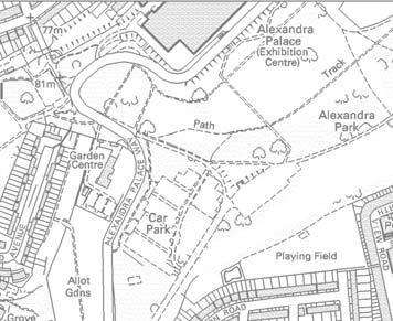
1 Visual Receptors 3.64 Visual receptors are people within the surrounding area whose views or visual amenity would be effected by the development proposals Visual receptors that will be most sensitive to changes in visual amenity include: 3.66 Visual receptors are people within the surrounding area whose views or visual amenity would be affected by development proposals Visual receptors that will be most sensitive to changes to views include: 1. Users of public rights of way, whose focus is on amenity; 2. Users of public open spaces; and 3. Residents with an outlook in the direction of a Site Other receptors who as a result of their context or activity tend to be less sensitive to changes to views and visual amenity include: 4. Motorists, their passengers and people using public transport whose views are transient and generally not focussed on visual amenity (unless using a tourist route); and 5. People at work or engaged in other activities such as shopping In addition consideration has been given to the visual role that the Site plays in the setting of heritage assets. Representative Views 3.70 The views chosen reflect the key views over a range of distances and the main receptors of changes to views and visual amenity. For reasons of proportionality and practicality the views are taken from publically accessible locations within the surrounding area Views from the locations listed in table 1 have been considered in this appraisal. These have been identifed through consultation iwth the Council and discussions at the local Quality Review Panel Two locally listed views have been incorporated within the assessment as the Site is located within the view corridor as defined by Council, please see Views 4 and 23. The LVMF identifies a panorama from the viewing terrace at Alexandra Palace, in this instance the Site is not within the viewing corridor of the protected view. Notwithstanding, a representative view has been included that provides a more open aspect in the direction of the Site Photographs taken from these locations are shown in Section 5 together with an analysis of the character and amenity of the view, the key elements within it, the visual receptors and their susceptibility to change Accurate visual representations (AVRs) have been prepared from a selection of locations. Wireline images (AVR1) were prepared initially to confirm the height, mass and location of the proposed new buildings in each of the representative views. Where the building is seen in the context of the surrounding townscape photomontages have been prepared to show the materials and details and how the development will relate to its context The methodology for the photography and the preparation of visualisations is contained in Appendix 2. SITE LOCATION Image 15: Urban Character Study - Views and Vistas, Source: Haringey Council, 2015 Image 16: London Panorama: Alexandra Palace, London View Management Framework,

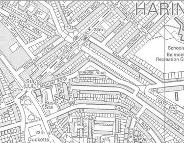
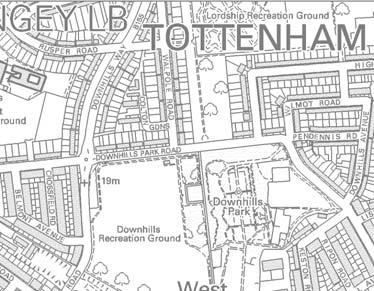
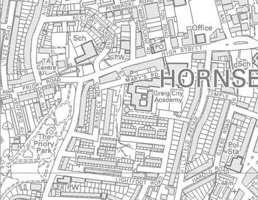
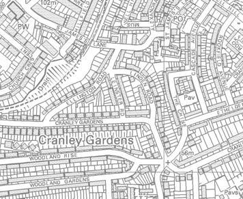
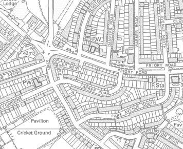
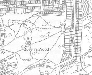
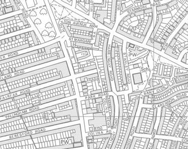
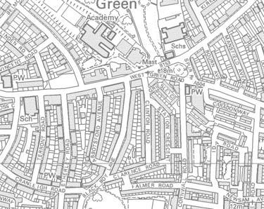
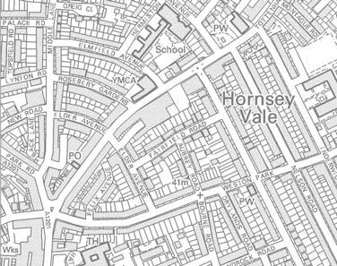
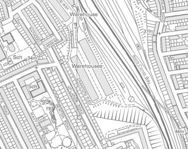
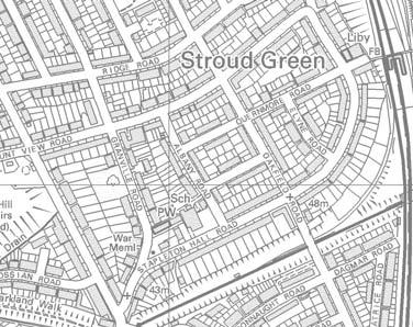
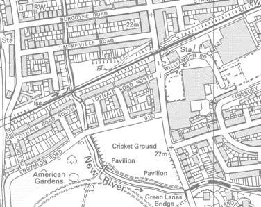
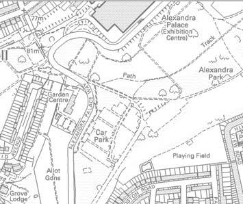
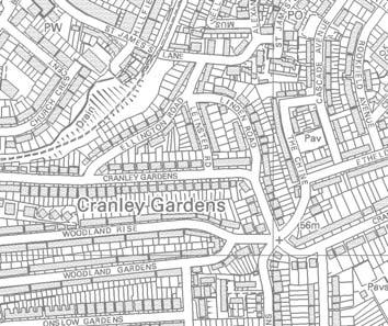
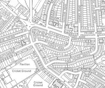
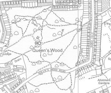
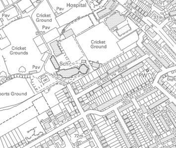
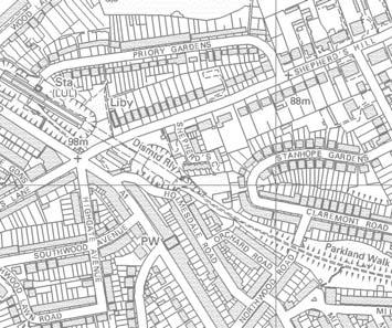
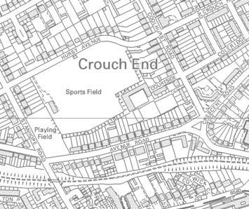
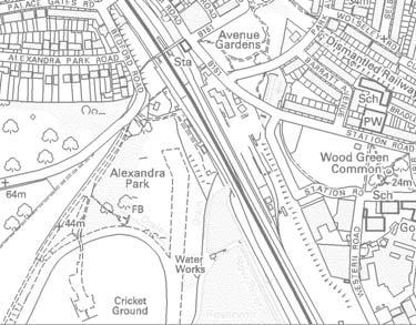
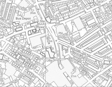
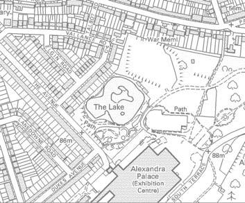
2 Table 2: Representative View Details Viewpoint Name Distance from Site Visual Receptors Reference 1 Hornsey Park Road 350m P, M, C 2a Break in residential blocks between Denmark Road and 82m R, P Wightman Road 2b Denmark Road 18m R, P 3 Raleigh Road West 137m R, P, C, M 4 Raleigh Road Centre PROW m R, P, C, M 5 Raleigh Road East 441 R, P, C, M 6 Hampden Road Centre 205m P, C, M 7 Hampden Road (New River) 20m P, C, M, E 8 Hampden Road (Site Frontage) 10m P, C, M, E 9 Fairfield Gardens 353m R, P, M, RE 10 Tottenham Lane 408m R, P, C, M 11 Gisburn Road 106m R, P, C, M 12 St Mary s Churchyard 284m P, RE 13 New River Village 244m R, P, M, RE 14 Ducketts Common 466m P, C, RE 15 Harold Road 573m R, P, C, M 16 Hornsey High Street (west) 554m R, P, C, M, E 17 Hornsey High Street (east) 455m P, C, M 18 Alexandra Palace 1400 P, C, M, RE 19 Seven Sister Road (close to intersection with Amhurst Park) 2150 R, P, RE 20 Cranley Gardens 2285 R, C, M P - Pedestrians M - Motorists C - Cyclists R - Residents RE - Recreation 24 KEY Boundary of application Representative Viewpoints Public Right of Way Distance Buffers

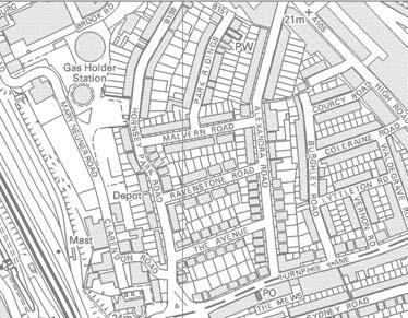
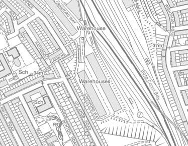
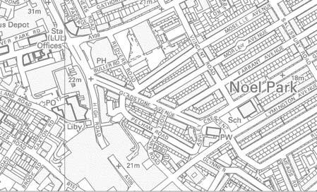
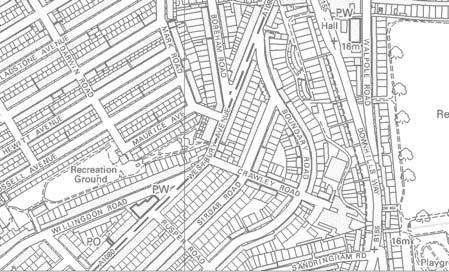
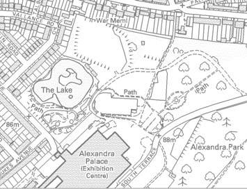
3 Figure 17: Representative Views re et om re m et il 1k b 2a
4 Heritage Assets 3.76 A baseline assessment was undertaken using a combination of desk-based study and fieldwork to identify the location of above ground heritage assets near the Site such as listed buildings and conservation areas and the visual role the existing Site plays in their setting The desk-based study considered The National Heritage List for England and relevant mapping, plans and documents to identify elements of built heritage importance in surrounding streets and spaces. This included the Council s local list of buildings of architectural or historic interest As required by the NPPF, the significance of the heritage assets affected by the proposals, both within and surrounding the Site, has been established. This enables an assessment to be made of the effects of the development proposals on that significance The NPPF highlights the importance of understanding and describing the significance of heritage assets and using this understanding to inform development proposals. Setting and Significance 3.80 Where heritage assets are indirectly affected by the development proposals, the role of the Site within the setting of the heritage asset is of importance, as is the contribution of setting to the significance of the heritage asset The current role of the Site in the setting of above ground heritage assets depends on both their proximity and context. The assessment includes a judgement on the current contribution of the Site to the settings of heritage assets in Section The role of the Site in the setting of a heritage asset can relate to more than inter-visibility and also takes account historic associations between the Site and the heritage asset where these exist. Changes to the setting of a heritage asset are therefore considered in terms of their overall effect on the significance of the heritage asset. Where there is no visual or historical association between the application Site and the heritage asset, the Site is considered to have a nil role in the setting Where the setting of an above ground heritage asset is extensive, a view has been formed as to the overall change to the setting The analysis predicts how the setting of the above ground heritage assets will change as a result of the application proposals. A combination of photographs, application drawings and Accurate Visual Representations have been used to predict and evaluate the change The sensitivity of the setting to change has been assessed having regard to: 1. The significance of the heritage asset; 2. The contribution of the setting to its significance; 3. The relationship of the application Site to the heritage asset; 4. The nature (positive, neutral, negative) of the existing elements that form part of the setting; and, 5. The magnitude and nature (positive, neutral, negative) of the change to the setting as a result of the development The impact of the proposed development on the settings of heritage assets is considered in terms of scale, height, massing, alignment, materials and use. Assessment of Effects on Setting 3.87 The qualitative effect of the change to the character of the existing scene is defined as beneficial, neutral or adverse Using the standard terminology for the significance criteria and nature of effects, the assessment criteria can be arranged on a scale as follows: 1. Substantial beneficial; 2. Moderate beneficial; 3. Minor beneficial; 4. Neutral/negligible; 5. Minor adverse; 6. Moderate adverse; and 7. Substantial adverse It is recognised that whilst the description of the baseline, the identification of sensitive receptors and the prediction of the nature of the effects, can be objectively established, the sensitivity of receptors and the significance of the effect are essentially a qualitative judgement The assessment of the effects of the proposed development on the setting and significance of identified heritage assets is included in Section x. Designated Heritage Assets Conservation Areas 3.91 As previously noted there are three conservations areas within 500 metres of the Site namely: 1. Hornsey High Street (14); 2. Hornsey Water Works and Filter Beds (15) ; and 3. Hillfield (25) Each of the identified Conservation Areas (CA) is relevant from a heritage, townscape and visual perspective as they usually provide an indication of how the defined area has evolved with particular emphasis on notable and valued assets. Notwithstanding, the following documents, whilst not adopted, provide an indication of the assets and features within the relevant conservation areas. Listed Buildings 3.93 The settings of following listed buildings may change as a result of the proposed development. It is noted that there would be no change to ground level views that would effect the setting of the Church of St John the Baptist or the Vicarage of St Peter on Wightman Road and therefore these have been excluded from the assessment 1. Tower of Old Parish Church of St Mary (Grade II* listed) 2. 69, High Street N8 (Grade II listed) 3. 71, High Street N8 (Grade II listed) 4. Alexandra Palace including Former Alexandra Palace Station to North (Grade II listed); Alexandra Palace Registered Park and Garden (RP&G); Alexandra Park Conservation Area 5. Cast Iron Lamp Column, Cattle Trough and Drinking Fountain, Hornsey High Street (Grade II listed) 6. The Great Northern Railway Tavern, High Street (Grade II listed) 7. Tomb of Harriet Long and Jacob Walker in the Churchyard of the Old Parish Church of St Mary (Grade II listed) Conservation Area No Hillfield Conservation Area Character Appraisal (Consultation Draft) Primarily made up of Hillfield Avenue and its subsidiary Harold Road this area accommodates a good variety of late Victorian and Edwardian development on elevated land south of Hornsey Village. Key views from the CA include long views north from Hillfield Avenue towards Hornsey High Street and views of the Grade II* listed Church Tower from the northern section of the CA. Conservation Area No. 14 Hornsey High Street (Draft Conservation Area Statement) Primarily made up of Hillfield Avenue and its subsidiary Harold Road this area accommodates a good variety of late Victorian and Edwardian development on elevated land south of Hornsey Village. Key views from the CA include long views north from Hillfield Avenue towards Hornsey High Street and views of the Grade II* listed Church Tower from the northern section of the CA.
 19. Nos.")


5 No 31, High Street 18. No. 120 (Bank Chambers) 19. Nos. 1-3 Tottenham Lane (Consecutive) Timber Framed Chalet Structure Adjoining Hornsey Rail Station 20. No. 5 Tottenham Lane (The Wishing Well, Former Railway Public House) 21. No. 7 Tottenham Lane. Former Lotus Motor Racing Car Factory Conservations Areas Non - Designated Heritage Asset Listed Building Distance Buffers Boundary of application KEY 1859 Sluice House MWB on New River; Site of 1859 Waterwheel Adjoining Sluice House; Campsbourne Well House; Former Hornsey Pumping Station; TWA Waterworks Gatehouse; New River Aqueduct North to Embankment Tunnel; New River Aqueduct South to Embankment Tunnel 1. The assessment will also consider the following locally listed buildings, some of which have been grouped due to their nature and proximity 4 Figure 18: Heritage Assets 3.94 re t e m o kil 1 Non-designated Heritage Assets re 50 0 m et

6 4 The Proposed Development 4.1 The proposed development involves the demolition of the existing buildings on the Site and their replacement with a residential led, mixed use redevelopment. 4.2 The application scheme proposes two linear apartment buildings, arranged perpendicular to Hampden Road, extending to the north-west. 4.3 Block A is adjacent to the railway line. The tallest element is 14 storeys and set back from the Hampden Road frontage, close the footbridge to Hornsey Station. The built form of this block steps down in 4 stages to 4 storeys adjacent to the New River. The ground level of the block is largely occupied by car and cycle parking, refuse storage and a CHP unit with residential development above to raise residential accommodation above Hampden Road and the railway. A pocket park is proposed on the Hampden Road frontage to provide a landscaped edge to the Site. 4.4 Block B to the north-west is 11 storeys and steps down in 2 stages to 4 storeys along the New River. This building includes a commercial (B1) at ground floor with apartments above. 4.7 The following provides a summary of the key design features: 1. The facades have been designed to have a base middle and top, including a rusticated ground floor. 2. Visual interest and articulation is provided to break down the mass by the arrangement of fenestration to break up the vertical emphasis of the blocks, the use of projecting balconies and the stair cores 3. There is subtle variation in materials with three shades of brick, alternated to articulate building features and two shades of panelling; 4. Sedum and wildflower roofs are provided on all roofs with the exception of the two tallest elements which will incorporate solar panels; 5. Further details on the proposed design are included in the Design and Access Statement and application drawings. 4.5 The central street between the two blocks provides access to the scheme and car parking with semi mature trees planted between the bays. Existing trees are retained to provide a visual termination of the view and communal spaces integrated. Overlooking will be provided from adjoining flats. 4.6 These form part of a series of open spaces along the New River, including a play space to the east, set in woodland planting and gardens to the north. 28 Figure 19: Proposed massing strategy, Source: Formation Architects, 2016

7 Figure 20: Landscape Strategy Plan, Source: D4P 2016 BLOCK A BLOCK B 29 Hampden Road
8 5 Townscape and Visual Appraisal Townscape Appraisal 5.1 The townscape effects have been considered in terms of the effects on the Site and surrounding local townscape character areas as well as the Wood Green and Hornsey Neighbourhoods identified in the UCS. 5.2 The analysis considers the degree of change to the townscape and the sensitivity of the townscape to change based on the criteria set out in Appendix 1. The sensitivity of the townscape to change is determined having regard to its value and susceptibility to change arising from the development proposal. A judgement is then made as to whether the proposal will result in a minor, moderate or major effect and whether that effect would be beneficial, neutral or adverse. It considers the changes to the aspects of townscape character which were identified as being important through the character assessment or the policy context. Townscape Character of the Site 5.3 The existing buildings and uses on the Site are detracting, poor quality buildings that do not positively contribute to the quality of the townscape at the western end of Hampden Road. The trees are positive elements within an otherwise degraded Site but are in poor condition and the interface between the Site and the New River is poor. 5.4 The majority of trees on the northern boundary of the Site are proposed to be retained and will become a focal point in the design. Whilst a limited number of trees within the Site will be removed, these are of limited quality. 5.5 The Site has a low townscape value. It has a low susceptibility to change as it can readily accommodate, and benefit from, a residential led redevelopment. Overall the Site has a low sensitivity to change. 5.6 The replacement of the existing buildings with a high quality purpose-designed development with an appropriate residential and commercial use and new public realm and landscaping will considerably improve the townscape character of the Site. 5.7 The effect of the removal of trees is more than outweighed by the provision of an area of publicly accessible green space with additional tree planting on the frontage to the New River and Hampden Road, within areas of open space within the Site and along the street. The introduction of landscaped areas will be a particular improvement to the townscape character of the Site. 5.8 The built form and architectural design will create a more attractive frontage seen from a number of directions. The built form better defines the Hampden Road frontage, articulated in two blocks with the set-back block overlooking a small pocket park. The scheme will create a more active frontage to and better define the street. The north-west south-east alignment of the blocks creates the potential for views out to the north as well as creating amenity areas to the rear. The western façade of block A addresses the railway. 5.9 The proposed development will optimise the potential of the Site consistent with policy objectives. The building heights proposed exceed the heights envisaged in the UCS, however, the taller built form supports the creation of a more slender and better proportioned element that acts as a local landmark adjacent to the Hornsey Train station. The stepping down of the built form to the north-west responds to and creates an appropriate interface with the New River and existing four storey development on Denmark Road to the north. The effect on building heights within the surrounding area has been considered in the appraisal The quality of the frontages will be enhanced by the articulation of the elevations. The proposed materials complement the predominant use of brick in the surrounding area and the use of alternate stock bricks as well as darker shades to articulate particular features provides definition which will contribute to the architectural interest of the buildings The proposed development and landscaping represent a high degree of enhancement compared to the existing situation. The proposals will create a more positive townscape within the Site with an active frontage, well designed buildings, a better relationship to the public realm and with improved hard and soft landscaping; including the publicly accessible open space As a result the proposals will considerably improve the townscape character of the Site giving rise to a moderate beneficial townscape effect. Effect on the Townscape of the Surrounding Area 5.13 The following sections appraise the effects of the proposed development in terms of the local townscape character areas identified through the analysis of the existing conditions and also in relation to the wider neighbourhoods defined in the UCS. TCA1 Infrastructure / Industry Corridor 5.14 The analysis of this area found that it had a very low sensitivity to changes to the townscape. The Site is located within this character area and therefore the proposal will include direct and indirect effects on the townscape of the area. Residential led redevelopment is compatible with policy objectives and would be beneficial. The footprints of the buildings and their orientation is compatible with other buildings and an appropriate response Whilst it is acknowledged that the 12 and 14 storey elements of the scheme are substantially taller than the existing heights of the built context in the area, this is compatible with the policy objective of optimising the development potential of the Site. The separation provided by the railway and its associated infrastructure and the New River enable much taller buildings to be accommodated The character of the area is dominated by the rail lines which effect permeability and legibility. In this context the development will act as a visual marker, or landmark, close to the entrance to the station from the Wood Green side. This will increase the legibility of the station within the wider area Further, the scheme has been designed to transition from the 14 storeys to four stories, in order to integrate with the existing four storey development located on Denmark Road (TCA2 20th Century Blocks). From this aspect the stepped appearance of the development will help to articulate the elevations of the new buildings with the large windows, balconies and brick detailing articulating the façade The material palette and architectural quality of the proposal will be a notable improvement on the existing context of the TCA. The scheme has been designed to complement the materials of the local area, and the visual interest of the scheme will reinforce the sense of being within an urban area, and enhance the image of the Hornsey and reinforce the impression of regeneration and investment The Site would be a notable departure from this character type but is compatible with broad policy objectives of delivering a mixed use residenital led scheme and optimising potential. It helps to address the legibility of the station which is an important element in this area. Due to the site s separate nature and prevailing land use, the height and mass would have no harmful effects on this area. There would be a high degree of change and the proposal would result in a moderate beneficial effect on this part of the townscape. TCA2 20th Century Blocks 5.20 This area has a low sensitivity to changes to the townscape and is located on the north side of the New River. It is a predominantly residential area characterised by mid-late 20th century buildings of 3-7 storeys which are of no particular architectural merit and have larger footprints than the residential areas dating from the 19th and early 20th centuries The proposed residential use is more compatible with the townscape character of this adjoining area and, whilst elements of the buildings are taller, the scheme has been designed to step down to four storeys on the northern boundary to respond to the scale of development on Denmark Road. Whilst it is acknowledged, the proposed scheme will still be noticeably taller there are legibility benefits associated with this and the townscape character is sufficiently varied that this would not appear incongruous. The use of brick, fenestration detailing and architectural details all help to articulate the structures in a manner that is appropriate to and complements the surrounding context Views of the lower levels of the scheme will be gained from the Denmark Road, whilst the upper levels will be visible from Turnpike Lane/ Hornsey Park Road where not screened by intervening
9 development. The existing buildings are currently evident from this area and their replacement will benefit visual amenity The proposed landscaping strategy will retain existing trees along the New River corridor and introduce new tree planting that will soften views to the proposed buildings. There will be an improved outlook from the northern edge of the area that is more compatible with its prevailing character The proposed development would result in a low degree of change to this townscape character area being an indirect effect on views. Overall, the change will improve the outlook from this area compared to the existing situation and provide some legibility benefits. The effect of the proposed development is considered to be minor beneficial. TCA3 The Ladder 5.25 The Ladder is a coherent and consistent townscape that is locally valued. The analysis of this area found that it had a medium sensitivity to changes to the townscape. The Site is not located within this area and the scheme would have no effect on any of the defining physical characteristics of the townscape such as street alignment, consistent built form and relationship of buildings to the streets, use, architectural character or materials. The effects would be indirect effects primarily associated with views of the wider context Due to the consistent building height to street width ratio and level of screening provided by street trees there is a high degree of visual enclosure within the streetscapes of the Ladder. Accordingly the effects of the proposed development will only relate to three of the east-west streets at the top of the ladder. Due to the alignment of Sydney Road, Raleigh Road and Hampden Road the proposed development will be seen as a terminating feature in views westwards. In some of the views, particularly at the western end of Hampden Road and Raleigh Road the building will replace the existing unattractive structures on the Site. Views will be restricted to the upper levels of the scheme and, due to articulation provided by its materials and detailing, the architectural treatment of the facades, whilst different, would be compatible with the context The proposed building height will contrast with the generally low rise scale of this townscape character area but will act as a local landmark demarking the location of Hornsey Station There would be a low magnitude of change to the townscape character of this area as a whole which is considered on balance to result in a minor beneficial change to the townscape. TCA4 Victorian Streets 5.29 This area of predominantly two storey Victorian villas and terraces has a fine grain. Views out the north are influenced by the taller Wood Green Shopping centre. The analysis of this area found that it had a medium sensitivity to changes to the townscape The Site is approximately 250 metres away therefore potential effects are limited to perceptual or aesthetic influences associated with changes to views of the wider context. The TZV produced demonstrates that the visibility of the proposed scheme within the public realm will be limited, but would include the southern end of Hornsey Park Road (View 1 of the visual appraisal), and parts of Park Ridings and Alexandra Road where the upper levels of the scheme will be seen at the ends of the roads as part of the wider context At this distance the buildings will not appear unduly tall and the materials and detailing will help to visually integrate the development with the surrounding context. Given the role of taller buildings to the north in the townscape of these northsouth orientated streets, views of the proposed development would not be detrimental. The scheme will also act as a local landmark in views along Hornsey Park Road There would be a negligible degree of change to the townscape character The proposals would result in a negligible effect on townscape of the Victorian Terraces TCA. TCA5 Hornsey High Street 5.34 The analysis of this area found that it had a medium sensitivity to changes to the townscape. There would be no physical changes to the character of the townscape. The effects would relate to changes to views. The alignment of the High Street is not in the direction of the Site and therefore views, where seen would be above intervening buildings and trees, where longer views are enabled by a reduced level of enclosure. Mature trees also contribute to the screening and filtering of views of the proposal from the key locations on High Street (views 16 and 17) and from the church yard (view 12). The locations from which the building will be seen will be limited and only a very small part of the top of the building would be seen The proposed materials and articulation of the upper levels will ensure that the appearance of the building will be compatible with and blend in with the context The church tower in St Mary s Churchyard, is an important local landmark along the High Street. The skyline role and the prominence of this local feature will not be adversely altered as a result of the proposed development. Further analysis of this is provided in the visual analysis in the next section The proposals would result in a negligible effect on the townscape of the Hornsey High Street TCA. TCA6 North Hornsey 5.38 The analysis of this area found that it had a low sensitivity to changes to the townscape Due to the distance of the character area from the Site, topography and the intervening railway, any views of the development will be the top parts of the taller buildings. The extent of the effect on views would be limited to the open areas associated with the New River Village (view 13) The development would be seen in the context of the railway infrastructure and existing buildings in the wider area. The use of brick will mean that the appearance of the building is in keeping with this context. This area is typified by a coarse grain of residential development as reconstructed in the 1960 s and will be an acceptable addition in the view of the wider context from the character area The proposals would have a negligible effect on the townscape of the North Hornsey TCA. TCA7 South Hornsey 5.42 The townscape comprises a consistent area of predominantly terraced housing developed in the late 19th century on land to the south of High Street with a street pattern that reflects varied topography of the area. The area includes the Hillfield Avenue Conservation Area. The analysis of the area found that it has a high sensitivity to changes to the townscape This area is relatively well separated from the Site meaning potential effects will be limited to changes to the views out of the area. A small portion of the area directly adjoins the railway and this influences the context of the views seen from this location (view 11) Visibility within this area is largely constrained by the orientation of streets and the degree of enclosure to views provided by the frontage development. Where seen only the upper sections of the development will be visible and will be relatively distant and therefore a small element in the view (e.g. views 10 and 15). The extent of the effect on views out of the area are therefore very limited. In addition, due to its materials the building will not appear particularly out of place. The proximity to Hornsey Station will also mean that the development would act as a local landmark signalling the location of the station The proposals would result in a negligible effect on the townscape of the South Hornsey TCA. Wood Green Neighbourhood 5.46 The Site is located on the western edge of the Wood Green Neighbourhood as defined in the UCS adjacent to the railway It is located in a part of the neighbourhood, where there is a prevalence of medium to large footprint buildings and is compatible with that pattern The scheme increases access to and improves the setting of the New River, which is identified as being a positive element within the neighbourhood The edge of the railway is identified as being an appropriate location for mid to high rise buildings of 6-11 storeys in the UCS. The scheme is largely consistent with that identified range with the exception of the southern end of Block A which rises to 14 storeys. This is considered to be appropriate in this particular location as it marks the location of the access to the station and acts as a local landmark. 31
10 5.50 The UCS identifies the negative influence of tall buildings within this neighbourhood that have failed to act as landmarks which reference significant locations. This was noted as contributing to a lack of legibility within the local area. The proposed development will mitigate this weakness by emphasising the location of Hornsey Station The use of brick will mean that it is sympathetic to the predominant building material of the area It is considered that the proposed development is compatible with the character of the Wood Green neighbourhood and responds well to the opportunities presented by the Site to provide residential development, create a landmark that will assist legibility and will enhance the setting of the new River. Overall it is considered that it will have a minor beneficial effect on the Wood Green neighbourhood. Hornsey Neighbourhood 5.53 The Site lies to the east of the Hornsey neighbourhood and is separated from it by the railway. The proposed development would have no effects on any of the attributes of the neighbourhood identified in Table The development will be seen from some limited locations in parts of this area but will have no physical effects on its townscape character. The potential for effects on the wider setting or context is limited by the intervening railway and the developed, urban character of the area. Overall, it is considered that it will have a negligible effect on the Hornsey neighbourhood. 32 Table 3: Summary of Townscape Appraisal Townscape Receptor Level of Effect Infrastrucutre / industry Moderate Beneficial Corridor 20th Century Blocks Minor Beneficial The Ladder Minor Beneficial Victorian Streets Negligible Hornsey High Street Negligible North Hornsey Negligible South Hornsey Negligible Wood Green Neighbourhood Minor Benficial Hornsey Neighbourhood Negligible Visual Effects 5.55 The visual analysis has been undertaken with reference to 21 representative views that have been agreed with officers at the London Borough of Haringey, including two locally protected views (View 23 - Seven Sisters Road and View 4 - Cranley Gardens). Photographs of the existing view from each position are provided together with commentary on the key components of the view (skyline element, composition, characteristic features, positive and negative attributes). For each location an overview of the receptors affected is given together with an assessment of their sensitivity to changes in visual amenity A description of the proposal is given with commentary, where relevant, on the effects on the composition of the view. Consideration is given to the effects on the skyline, any obstruction or distraction from existing important elements and characteristic aspects such as scale, grain, massing, appearance and materials The visual effects are then assessed having regard to: the sensitivity of the visual receptors, considering both the value of the view and the capacity of the receptors (or people) to accept changes to views. This is dependent on their activity and perception and the values attributed to that view; and the predicted degree (or scale) of change to the view. Reference has been made to a combination of photographs, accurate visual representations (AVRs) and application drawings to determine the changes to the view The nature of the change has been assessed as beneficial, neutral or adverse having regard to the visual characteristics of the townscape and the change arising from the application proposals. Consideration has also been given to whether the visual effect would be minor, moderate or major Details regarding the assessment methodology for views is included in Appendix 1. Appendix 2 details the visualisation methodology.


11 Figure 21: Viewpoint plan re et om re m et il 1k b 2a


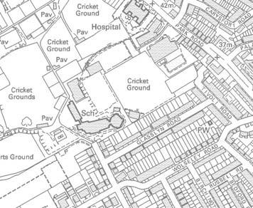
12 1. Hornsey Park Road 1 34 Image Details Date: Time: 10:55 Focal Length Lens: 50mm Details: f20; 1/80z Distance from Site 317m Existing 5.60 This view is taken from Hornsey Park Road looking south towards the intersection with Turnpike Lane. The top of the existing three storey building on the Site and associated telecommunication infrastructure can be seen on the skyline The main components of the view include: 1. Hornsey Park Road, a relatively wide urban road is seen in the foreground fronted on its western side by three storey Victorian townhouses and the gables of two storey development to the east; 2. The junction of the Hornsey Park Road and Turnpike Lane is seen in the middle distance, terminated by a three storey late 20th century three storey red brick apartment building and partly defined by trees on the frontage to the health centre.; 3. The rooflines of development on Denmark Road and Hampden Road can be discerned seen in the background Visual receptors at this viewpoint are pedestrians, cyclists and motorists moving south along Hampden Park Road. Their primary focus is likely to be on their journey therefore awareness of visual amenity will be secondary and transitory. Their susceptibility to visual change will be medium. The value of the view is considered to be low due to the lack of scenic or amenity value The sensitivity of the visual receptors to change is considered to be low overall.
13 Visual Effects 5.64 The upper floors of the proposed development will be seen above the existing frontage buildings on Turnpike Lane in place of the existing unsightly three storey building and telecommunications array The development will terminate the view along Hornsey Park Road and introduce new taller buildings on the skyline. The view is framed by existing buildings. The development provides a focal point for the vista but is not unduly dominant or out of keeping in relation to the layering of existing building on Turnpike Lane and Denmark Road. The scheme will aid legibility within the local area, emphasising the location of Hornsey Station. The scale, materials and detailing of the proposed development is compatible with the existing context of development on Hornsey Park Road. The windows, balconies and brick detailing incorporated in the façade will provide visual interest The proposal would result in a medium degree of visual change to the view. Whilst the upper floors of the development will be visible they will not adversely the effect character of the scene Overall, it is considered that there would be a minor beneficial change to the view as a result of the proposed development. 35


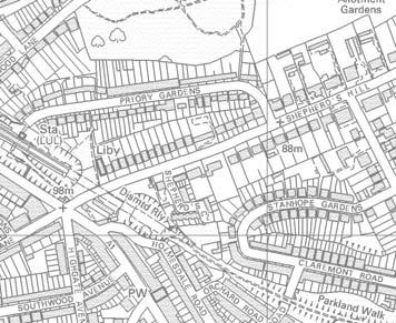
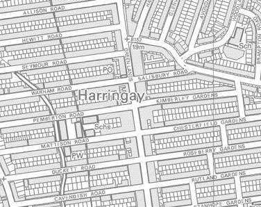
14 2a. Denmark Road- footpath link 2a 3 2b 36 Image Details Date: Time: 10:41 Focal Length Lens: 24mm Details: f20; 1/25 Distance from Site 84m Existing 5.68 View 2 is taken from the footpath connection between Denmark Road and Wightman Road looking south-west towards the Site. The upper floor and roof line of Wilmott House is clearly visible. The existing Poplar trees on the boundary with New River are seen between the buildings The main components of the view include: 1. Denmark Road, parking spaces and the amenity grass and vegetation on the frontages are seen in the foreground together with part of the gable of the adjacent building; 2. In the middle ground the three storey terraced townhouses and flats along Denmark Road. The blank flank of the terrace is in the centre of the image and the front façade is partially screened by low level vegetation. The building frontages are of no particular architectural quality or interest; and 3. In the background are trees along the new river corridor and existing poor quality buildings on the Site The receptors of this viewpoint are the residents of Denmark Road and pedestrians using the pedestrian link to Denmark Road. The primary focus of the receptors is likely to be on visual amenity associated with their residences. Their susceptibility to visual change will be high. The value of the view is considered to be low it is an incidental view in an existing housing area and has no particular visual interest The sensitivity of the visual receptors to change is considered to be medium.

15 Visual Effects 5.72 The upper floors of the proposed development will be visible from this location above the frontage development on Denmark Road and associated fencing. It will replace the existing building in the view The new development would be noticeably taller than the foreground buildings but the stepped form, materials and trees help to soften the transition The architectural language and materials are compatible with the context of the scene. There will be some screening of the buildings in the summer months and winter screening will increase over time due to the proposed tree planting along the New River The proposed development would result in a medium degree of visual change It is considered that on balance the development would result in a moderate neutral visual effect. 37


16 2b. Denmark Road 2a 3 2b Image Details Date: Time: 10:28 Focal Length Lens: 24mm Details: f18; 1/30 Distance from Site 57m Existing 5.77 This view is from Denmark Road close to the junction with Wightman Road looking in a westerly direction. The Site is visible in the centre of the image on the far side of the New River with both Wilmott House and the three storey building clearly visible The main components of the view include: 1. Denmark Road in the foreground including bollards, boundary railings and poor quality timber fencing. The end of the three storey residential terrace on the frontage is seen together with the adjoining grassed amenity space 2. The focus of the view are the poor quality existing buildings on the Site at present. The upper floors of the three storey building are finished in corrugated metal cladding with relatively small windows. An extensive array of telecommunication masts and dishes is evident and gives the structure a utilitarian appearance; and 3. Several semi mature and mature trees are evident that filter views to the Site The receptors of this viewpoint are pedestrians entering Denmark Road and residents of Denmark Road. The primary focus of the receptors is likely to be on visual amenity associated with the residences. Their susceptibility to visual change will be high. The view is an incidental view at the entrance to a residential estate. There are notable detracting features and few elements that contribute to visual amenity The sensitivity of the visual receptors to change is considered to be low.

17 Visual Effects 5.81 The proposed development will be a prominent new element in the view from the entrance to this residential estate that will be seen in place of the existing three storey commercial building and array of rooftop telecommunication antennae and dishes The majority of the western façade of block B is visible, with Block A beyond, however, the ground level will be screened or heavily filtered by intervening vegetation and boundary fencing. The stepping of the form down to the residential development is appreciated from this position and helps to integrate with the adjoining development on Denmark Road The stepping of the facades, fenestration, balconies and brick detailing all help to provide visual interest and break up the scale of the building. The colour of the materials fits well with the colour palette of the immediate context There would be a high degree of change to the view. Notwithstanding this the character and quality of the view will markedly improve as a result of the proposed development. There would be a moderate beneficial visual effect. 39


18 3. Raleigh Road West 4 2a 3 2b 6 40 Image Details Date: Time: 10:48 Focal Length Lens: 24mm Details: f18; 1/50 Distance from Site 132m Existing 5.85 This view is from the pavement of Raleigh Road, approximately 60 metres from the junction with Wightman Road looking west. The existing three storey structure on the Site is evident in the background The main components of the view include: 1. The two storey terraced frontages of the brickbuilt Victorian terraced houses which together with the more recent infil development frame the view. The parked cars are a prominent element in the foreground; 2. The bay windows and other decorative details of the Victorian dwellings contribute to the visual interest of the street together with the vegetation within the small front gardens however, the apartment block has lesser interest; and 3. The view is terminated by poor quality frontage development on Wightman Road and the development within the Site which are seen on the skyline partly filtered by trees Receptors of this view are the pedestrians using Raleigh Road. The primary focus of the receptors is likely to be on their journey, with visual amenity as a secondary focus. Their susceptibility to visual change will be medium. The value of the view is medium. Whilst there is visual interest in the Victorian frontages the termination of the view is of poor quality and detracts from the scene The sensitivity of the visual receptors to change is medium.
Garden Bridge Planning Application
 Planning Application Additional Verified photomontages and assessment September 2014 Contents Page 1 Visual assessment 2 1.1 Introduction 2 1.2 Baseline 2 1.3 Potential effects and good environmental
WELLINGTON HOSPITAL DESIGN GUIDE TABLE OF CONTENTS
 WELLINGTON HOSPITAL DESIGN GUIDE TABLE OF CONTENTS 1.0 Introduction Page 2 The Place of Wellington Hospital 2 The Future of the Hospital 2 2.0 The Intention of the Design Guide 3 3.0 Analysis 4 General
Wide asphalt driveway abutting school property. garage built with incompatible materials, too close to park. incompatible fencing materials
 Wide asphalt driveway abutting school property incompatible fencing materials garage built with incompatible materials, too close to park Lack of plantings as a buffer between private property and open
Conservation Area Designation, amendments and Review
 Conservation Area Designation, amendments and Review Location: No.s 37-49 (odd) Twickenham Road Date Assessed: January 2018 Adjacent Conservation Area Significance: Teddington Lock CA. The Teddington Lock
Euston Area Plan. Background Report Appendix 3. Proposed modifications (shown as tracked changes)
") Euston Area Plan Background Report Proposed modifications (shown as tracked changes) September 2014 . Testing the impacts of tall buildings on strategic and local views Introduction This appendix provides
Euston Area Plan Background Report Proposed modifications (shown as tracked changes) September 2014 . Testing the impacts of tall buildings on strategic and local views Introduction This appendix provides
MATURE SUBURBS RESIDENTIAL DEVELOPMENT GUIDELINES
 MATURE SUBURBS RESIDENTIAL DEVELOPMENT GUIDELINES DRAFT FEBRUARY 2005 BIRMINGHAM CITY COUNCIL 1 Introduction Mature Suburbs Residential Development Guidelines - Interim Supplementary Planning Advice -
New-Cast Mixed-use Development Proposal King Street West, Newcastle, Ontario
 URBAN DESIGN BRIEF New-Cast Mixed-use Development Proposal King Street West, Newcastle, Ontario TABLE OF CONTENTS: 1.0 Executive Summary 2.0 Creating Vibrant and Sustainable Urban Places: Excerpts from
SCHEDULE 12 TO THE DESIGN AND DEVELOPMENT OVERLAY GLEN WAVERLEY ACTIVITY CENTRE STRUCTURE PLAN
 DD/MM/YY Proposed C120 SCHEDULE 12 TO THE DESIGN AND DEVELOPMENT OVERLAY Shown on the planning scheme map as DDO12. GLEN WAVERLEY ACTIVITY CENTRE STRUCTURE PLAN 1.0 Design objectives DD/MM/YY Proposed
Chapter 5 Urban Design and Public Realm
 5.1 Introduction Public realm is all areas of the urban fabric to which the public have access. It is where physical interaction takes place between people. It therefore, includes buildings and their design,
APPENDIX MATAKANA COMMERCIAL URBAN DESIGN GUIDELINES
 APPENDIX MATAKANA COMMERCIAL URBAN DESIGN GUIDELINES 1.0 INTRODUCTION The following urban design guidelines are to be utilised by landowners, planners and other persons involved in development at early
Proposed Illustrative Masterplan Cumulative Revised Proposals. Properties
 Proposed Illustrative Masterplan Cumulative Revised Proposals Earls Court Project Application 2 Royal Borough of Kensington & Chelsea Environmental Statement, Volume II - Site Wide Development Option -
East Bayshore Road Neighbourhood
 East Bayshore Road Neighbourhood Northridge Property Management Urban Design Brief 3195 East Bayshore Road City of Owen Sound January 2016 East Bayshore Road Neighbourhood Northridge Property Management
Conservation Area Designation, amendments and Review
 Conservation Area Designation, amendments and Review Location: Any area largely confined to Park Road and St. James Avenue which includes the following properties: St. James Church, St. James Road; No.
WINDSOR GLEN DESIGN GUIDELINES
 WINDSOR GLEN DESIGN GUIDELINES Adopted by Council, 2006 WINDSOR GLEN REDEVELOPMENT DESIGN GUIDELINES August 2006 1.0 Master Plan Organization For this area of the Coquitlam Town Centre, a mix of high,
4.0 Design Guidelines For The Village Centre. South fields Community Architectural Design Guidelines Town of Caledon
 4.0 Design Guidelines For The Village Centre 4.0 Design Guidelines for the Village Centre The Village Centre is the focal point of the entire South Fields Community and is designed as a traditional commercial
I615. Westgate Precinct
 I615. Westgate Precinct I615.1. Precinct Description The Westgate Precinct is located approximately 18km west of the Auckland city centre. There are seven Sub-precincts in the Westgate Precinct: Sub-precinct
STATEMENT OF OBJECTION TO THE PROPOSED DEVELOPMENT OF LAND AT CHURCH CLIFF DRIVE FILEY
 STATEMENT OF OBJECTION TO THE PROPOSED DEVELOPMENT OF LAND AT CHURCH CLIFF DRIVE FILEY You will be aware that Scarborough borough council have adopted a new local plan that includes land at Church Cliff
Tall Buildings Strategy
 Chapter 8 Tall Building Strategy Mayor of London 115 existing & consented tall buildings effect on views of palace of westminster Chapter 8 Tall Buildings Strategy tall building cluster upto 150m with
DESIGN & ACCESS STATEMENT. REVISION A Residential Development, Neon Social Club, Nairn Street, Jarrow.
 DESIGN & ACCESS STATEMENT. REVISION A Residential Development, Neon Social Club, Nairn Street, Jarrow. The following Design & Access Statement is in support of a Full Planning Application for a residential
I539. Smales 2 Precinct
 I539. Smales 2 Precinct I539.1. Precinct Description The Smales 2 Precinct applies to a 4.8 hectare block of land located on the southern side of Northcote Road and fronting Lake Pupuke, Takapuna. The
Regency Developments. Urban Design Brief. Holyrood DC2 Rezoning
 Regency Developments Urban Design Brief Holyrood DC2 Rezoning Stantec Consulting Ltd. 7-31-2017 1. Overview Regency Developments intends to rezone the lands located at 8510 and 8511 93 Avenue, within the
GUIDELINES REPLACEMENT HOUSING GUIDELINES LOCATION INTRODUCTION URBAN DESIGN GUIDELINES
 Replacement housing in the former City of North York will be consistent with the following urban design guidelines. They provide a framework for residential re-development in the former City of North York
Page 1 of 19 URBAN DESIGN FRAMEWORK FOR BOLTON STREET WATERFORD
 Page 1 of 19 URBAN DESIGN FRAMEWORK FOR BOLTON STREET WATERFORD 1.0 Introduction: The relocation of the City Council stores and depot from Bolton Street creates an exciting opportunity for development
Neighbourhood Plan Representation
 Date: 10 th November 2017 Neighbourhood Plan Representation Land to the east of Callow Hill Road, Alvechurch Introduction This representation has been prepared by RPS Planning and Development on behalf
Urban Design Brief to 1557 Gordon Street & 34 Lowes Road West
 Urban Design Brief 1533 to 1557 Gordon Street & 34 Lowes Road West Reid s Heritage Homes Ltd. & 883928 Ontario Ltd. and RHH Property Management Ltd. City of Guelph Zoning By-law Amendment November 2017
Schedule of Planning Applications Committee Date: 23 May Reference: 06/17/0726/F Parish: Hemsby Officer: Mr J Beck Expiry Date:
 Schedule of Planning Applications Committee Date: 23 May 2018 Reference: 06/17/0726/F Parish: Hemsby Officer: Mr J Beck Expiry Date: 22-05-2018 Applicant: Proposal: Site: Mr Gillett Change of use to the
Chapter 13 Residential Areas: Appendices APPENDIX 1 Residential Areas
 Chapter 13 Residential Areas: Appendices Page 1 Chapter 13 Residential Areas: Appendices APPENDIX 1 Residential Areas Design Code for Intensive Housing INTRODUCTION DESIGN ELEMENTS A NEIGHBOURHOOD DESIGN
7.2.9 Eudlo local plan code
 7.2.9 local plan code 7.2.9.1 Application (1) This code applies to assessable development:- (a) within the local plan area as shown on Map ZM29 contained within Schedule 2 (Mapping); and (b) identified
The Proposed Auckland Unitary Plan (notified 30 September 2013)
") 3 Business zones Introduction There are 10 business zones in the Unitary Plan: City Centre Metropolitan Centre Town Centre Local Centre Neighbourhood Centre Mixed Use General Business Business Park Light
3 Business zones Introduction There are 10 business zones in the Unitary Plan: City Centre Metropolitan Centre Town Centre Local Centre Neighbourhood Centre Mixed Use General Business Business Park Light
4.0 URBAN DESIGN FRAMEWORK. The vision for the future development of the plan area is to:
 4.0 The vision for the future development of the plan area is to: Create a new neighbourhood that focuses on the highly valued natural and aesthetic features of the lands and provides good quality homes,
Design Guidelines - 1 -
 Design Guidelines REAR YARDS Rear yard decks and porches, attached to a garden or garage suite, should be permitted provided minimum rear yard setbacks, separation distances, and necessary site access
Milford Shopping Centre Proposed Plan Change Assessment of Visual and Landscape Effects
 Milford Shopping Centre Proposed Plan Change Assessment of Visual and Landscape Effects LA4 Landscape Architects PO Box 5669, Wellesley Street Auckland Table of Contents 1.0 Introduction 3 2.0 The Proposed
URBAN DESIGN BRIEF URBAN DESIGN BRIEF 721 FRANKLIN BLVD, CAMBRIDGE August 2018
 URBAN DESIGN BRIEF URBAN DESIGN BRIEF 721 FRANKLIN BLVD, CAMBRIDGE August 2018 DESIGN BRIEF CONTENTS PART A 1.0 INTRODUCTION 2.0 DESCRIPTION & ANALYSIS OF SITE CONTEXT 3.0 DESIGN CONSTRAINTS AND OPPORTUNITIES
5.1 Site Plan Guidelines
 5. Community Core Guidelines Development of the Community Core will take place by plan of subdivision and site plan approval. It will occur in a phased manner that will reflect the timing of residential
Longbridge Town Centre Phase 2 Planning Application
 Longbridge Town Centre Phase 2 Planning Application Non-Technical Summary of the Environmental Statement December 2013 Introduction A full application for Planning Permission has been submitted to Birmingham
City of Vaughan Urban Design Guidelines for Infill Development in Established Low-Rise Residential Neighbourhoods
 City of Vaughan Urban Design Guidelines for Infill Development in Established Low-Rise Residential Neighbourhoods DRAFT - September 2016 Contents 1. Introduction 1 2. Policy Context 3 3. Characteristics
Highland Village Green Design Guidelines
 Highland Village Green Design Guidelines Publishing Information Title Highland Village Green Design Guidelins Author The City of Calgary Status DRAFT - Proposed document subject to changes Additional Copies
Chapter 2: OUTLINE PLANNING APPLICATION PROPOSALS. A New Garden Neighbourhood Matford Barton 17
 Chapter 2: OUTLINE PLANNING APPLICATION PROPOSALS A New Garden Neighbourhood Matford Barton 17 2.1. SUMMARY AND STATUS OF THE PROPOSALS 2.1.1. The parameter plans and associated wording in this chapter
SOUTH CAMBRIDGESHIRE DISTRICT COUNCIL. Executive Director (Operational Services) Corporate Manager (Planning and New Communities)
 Corporate Manager (Planning and New Communities)") SOUTH CAMBRIDGESHIRE DISTRICT COUNCIL REPORT TO: Planning Committee 12 January 2011 AUTHOR/S: Executive Director (Operational Services) Corporate Manager (Planning and New Communities) Notes: S/1848/10
SOUTH CAMBRIDGESHIRE DISTRICT COUNCIL REPORT TO: Planning Committee 12 January 2011 AUTHOR/S: Executive Director (Operational Services) Corporate Manager (Planning and New Communities) Notes: S/1848/10
DRAFT Northeast Quadrant of Kipling Avenue and Highway 7 DRAFT AUGUST 29, Goals Land Use. The goals of this Plan are to:
 AUGUST 29, 2017 12.15 Northeast Quadrant of Kipling Avenue and Highway 7 12.15.1 Goals 12.15.2 Land Use The goals of this Plan are to: 12.15.2.1 General Provisions: a) Ensure the development of a compact
5. Bankside and The Borough 5.1. Bankside and The Borough Area Vision
 5. 5.1. Area Vision 5.1.1. are: A globally significant central London business district which is home to international business headquarters; At the heart of the commercial and cultural life of the capital
Long Branch Neighbourhood Character Guidelines Final Report
 STAFF REPORT ACTION REQUIRED Long Branch Neighbourhood Character Guidelines Final Report Date: October 26, 2017 To: From: Wards: Reference Number: Etobicoke York Community Council Director, Community Planning,
Character Area 1: Town Core
 Character Area 1: Town Core Map S 354 Copyright Cotswold District Council 109 Character Area 1: Town Core Key Characteristics 355 356 357 358 359 360 361 362 363 364 365 366 367 368 369 370 Copyright Cotswold
Building and Public Space Design Guidelines
 AMERICA'S CUP WYNYARD HOBSON Building and Public Space Design Guidelines INTRODUCTION 10 April 2018 The 36 th America s Cup in Auckland requires the construction of new wharf and breakwater structures.
97 Lea Bridge Road, Leyton, E10 7QL London Borough of Waltham Forest December 2015
 97 Lea Bridge Road, Leyton, E10 7QL London Borough of Waltham Forest December 2015 Public Realm and Landscape Proposals LEA BRIDGE ROAD, WALTHAMSTOW Public Realm & Landscape Proposals BDP(90)RPT001 December
13. New Construction. Context & Character
 13. New Construction Context & Character While historic districts convey a sense of time and place which is retained through the preservation of historic buildings and relationships, these areas continue
3.0 Area-Wide Strategies 30
 3.0 Area-Wide Strategies 30 3.6 Tourism Strategy This section of the plan aims to develop and improve the tourism potential of the area. Strategic Context The City Plan outlines the potential of Cork to
8.0 Design and Form of Development 43/
 42/ 8.0 Design and Form of Development 43/ Rothwells Farm, Golborne/ Development Statement Figure 7. Site Constraints Key 44/ Site Boundary 360 Bus Route/Stops Existing Trees Underground Water Pipe Sensitive
Tables of Criteria and Matrices for Landscape Assessment (LSCA & LVIA)
") Carly Tinkler CMLI Environmental, Landscape and Colour Consultancy 46 Jamaica Road, Malvern, Worcestershire WR14 1TU Tel +44 (0)7711 538854 carlytinkler@hotmail.co.uk Tables of Criteria and Matrices for
Carly Tinkler CMLI Environmental, Landscape and Colour Consultancy 46 Jamaica Road, Malvern, Worcestershire WR14 1TU Tel +44 (0)7711 538854 carlytinkler@hotmail.co.uk Tables of Criteria and Matrices for
Stoke Newington High Street 1.0 Site Analysis
 1.0 Site Analysis 9-11 Stoke Newington Church Street Grade II Existing Entrance via Wilmer Place Stoke Newington Church Street 187-191, 18th C; Grade II* including forecourt wall, railings and gates Rights
4 RESIDENTIAL ZONE. 4.1 Background
 4 RESIDENTIAL ZONE 4.1 Background The residential areas within the City are characterised by mainly lowrise dwellings sited on individual allotments. Past architectural styles, settlement patterns and
MVRC ARCHITECTURAL DESIGN STATEMENT
 11251 MOONEE VALLEY RACING CLUB MAY 201 CONTENTS 0 Contents Introduction 1 Site Analysis a. Site Features b. Built form Interfaces c. Existing Streetscape d. Site Opportunities and Constraints 2 Masterplan
UPPER GORDON ROAD TO CHURCH HILL, CAMBERLEY CONSERVATION AREA
 Introduction This leaflet explains the purpose of conservation areas and the implication of their designation for residents, property owners and the Council. It provides you with a plan of the area and
HeritageCollectiveLLP
 Appendix C, Review of Archaeology and Cultural Heritage Assessment Introduction 1. This information (SEI) addresses the likely significant impacts of a six-turbine development in which T6 is removed from
CONTENTS 8.0 LAND USE 8.1 GENERAL LAND USE 8.2 RESIDENTIAL 8.3 MIXED USE 8.4 COMMERCIAL 8.5 EMPLOYMENT LANDS
 8-2 Land Use 8.0 LAND USE CONTENTS 8.1 GENERAL LAND USE 8.1.1 Uses provided for in all Land Use Designations 8.1.2 Uses prohibited in Hazardous Lands, Hazardous Sites and Special Policy Areas 8.1.3 Uses
PLANNING COMMITTEE. 14 October 2014
 AGENDA ITEM NO 8 PLANNING COMMITTEE 14 October 2014 APPLICATION NUMBER : CA//14/01744/FUL PROPOSAL : Extension and conversion of roof space of an existing detached bungalow together with enhanced parking
Section Three, Appendix 16C Medium Density Housing, Design Assessment Criteria (Residential 8A zone)
") APPENDIX 16C MEDIUM DENSITY HOUSING, DESIGN ASSESSMENT CRITERIA (RESIDENTIAL 8A ZONE) PURPOSE OF APPENDIX 16C (RESIDENTIAL 8A ZONE) In the Residential 8A Zone the following are defined as restricted discretionary
APPENDIX 16C MEDIUM DENSITY HOUSING, DESIGN ASSESSMENT CRITERIA (RESIDENTIAL 8A ZONE) PURPOSE OF APPENDIX 16C (RESIDENTIAL 8A ZONE) In the Residential 8A Zone the following are defined as restricted discretionary
RESIDENTIAL ACTIVITY PERFORMANCE STANDARDS
 Preferred Options Consultation Q&A Sheet RESIDENTIAL ACTIVITY PERFORMANCE STANDARDS What are the key goals for managing the design of residential buildings in the Second Generation Plan (2GP)? The key
QUEEN-RIVER SECONDARY PLAN
 34 QUEEN-RIVER SECONDARY PLAN 34. QUEEN RIVER SECONDARY PLAN 1. INTRODUCTION The Queen-River area is approximately 6.4 hectares and is located at the eastern edge of the Downtown as shown on Map 34-1.
Design Review Report Former YMCA Building, Bridgend DCFW Ref: N164 Meeting of 12th April 2018
 Design Review Report Former YMCA Building, Bridgend DCFW Ref: N164 Meeting of 12 th April 2018 Review Status PUBLIC Meeting date 12 th April 2018 Issue date 18 th April 2018 Scheme location Bridgend Scheme
Urban Design Guidelines Townhouse and Apartment Built Form
 Urban Design Guidelines Townhouse and Apartment Built Form Town of Wasaga Beach Table of Contents 1. Introduction 1.1. Purpose 1.2. Urban Design Principles 1.3. Application of Guidelines 2. Site Design,
SITE ANALYSIS CALVARY HOSPITAL NORTH ADELAIDE LARGE INSTITUTIONS AND COLLEGES DPA CALVARY HOSPITAL
 SITE ANALYSIS Located at: 81-100 Strangways Terrace 55-79 Barnard Street 2-34 Hill Street 312-320 Ward Street HISTORY The Calvary Hospital was established in 1900 and is one of Adelaide's oldest hospitals.
Duplex Design Guidelines
 Duplex Design Guidelines Adopted by Council May 29, 2006 Prepared By: Table of Contents 1.0 Application and Intent 1 2.0 Areas of Application 2 3.0 Design Principles 3 4.0 Design Guidelines 4 4.1 Site
Urban Design Manual PLANNING AROUND RAPID TRANSIT STATIONS (PARTS) Introduction. Station Study Areas
 Introduction. Station Study Areas") 111111 PLANNING AROUND RAPID TRANSIT STATIONS (PARTS) Introduction The ION rapid transit system will link Waterloo, Kitchener and Cambridge through a central transit corridor (CTC). There are a number
111111 PLANNING AROUND RAPID TRANSIT STATIONS (PARTS) Introduction The ION rapid transit system will link Waterloo, Kitchener and Cambridge through a central transit corridor (CTC). There are a number
(DC1) Direct Development Control Provision DC1 Area 4
 Direct Development Control Provision DC1 Area 4") . General Purpose (DC) Direct Development Control Provision DC Area 4 The purpose of this Provision is to provide for an area of commercial office employment and residential development in support of the
. General Purpose (DC) Direct Development Control Provision DC Area 4 The purpose of this Provision is to provide for an area of commercial office employment and residential development in support of the
Huddersfield Urban Design Framework. 3. Framework
 3. Framework The illustrative plan has been used as the basis for developing an urban design framework and strategy in Part 3 of this report. This is based on a series of regulatory plans that code the
D18. Special Character Areas Overlay Residential and Business
 D18 Overlay Residential and Business D18. Overlay Residential and Business D18.1. Background The Overlay Residential and Business seeks to retain and manage the special character values of specific residential
Milburngate House Site, Durham City. Design and Development Brief for Consultation. Summary for Public Consultation
 Milburngate House Site, Durham City Design and Development Brief for Consultation Summary for Public Consultation October 2011 Introduction to the Brief Background The Milburngate House site is a large
Urban Design Brief Fanshawe Park Road. Competition Toyota
 Urban Design Brief 1300 Fanshawe Park Road Competition Toyota May 2, 2014 TABLE OF CONTENTS Page No. INTRODUCTION... 1 SECTION 1 LAND USE PLANNING CONTEXT... 1 1.1 The Subject Lands... 1 1.2 The Proposal...
DRAFT/02. Our Place. Westbury-on-Trym. City Design Group. July 2013 City Design Group
 DRAFT/02 City Design Group Contents Preface 1. Introduction 2. Character and distinctiveness 3. Character Areas 1 Henbury Road environs 2 Commercial core 3 College and Church Road environs 4 Channell
Buildings may be set back to create small plazas provided that these setbacks do not substantially disrupt the street wall s continuity.
 6-22 Community Design Street Walls and Street-front Setbacks The siting of buildings will play a critical role in establishing the character and sense of place for the District. Siting buildings at the
medium desnity housing
 This section updated September 2013 This part of the Plan sets out the assessment criteria for medium density housing. The criteria are designed to give designers and builders flexibility and to provide
INSTITUTIONAL USE DESIGN COMPATIBILITY TECHNIQUES
 INSTITUTIONAL USE DESIGN COMPATIBILITY TECHNIQUES INTRODUCTION Community institutions are an important part of the character and vitality of neighborhoods in Forsyth County. Institutional uses include
edge of gas line corridor setback edge of gas line corridor aligned with Schlumberger building 37.0 m AOD 33.0 m AOD max
 7. Heights and Street Frontage: In accordance with the approved heights parameters, heights to along Western Access Road must respond to the existing low density character in this location. Heights are
HIGHLAND VILLAGE GREEN URBAN DESIGN PRINCIPLES/GUIDELINES
 URBAN DESIGN GUIDING PRINCIPLES/GUIDELINES CONTEXT/CHARACTER The City of Calgary s Municipal Development Plan (MDP), Transit-Oriented Development (TOD) Policy Guidelines and Main Street/Corridor policy
Viewpoint 1. Location: View from Murch Road on the north eastern boundary of Application Site. Viewing south / southwest.
 Application Site (eastern field) Former site of St. Cyres Lower School Murch Road 1 Location: View from Murch Road on the north eastern boundary of Application Site. Viewing south / southwest. Baseline
Keystone Business Park Precinct Structure Plan North East Industrial Precinct. Part 2 Design Principles
 Keystone Business Park Precinct Structure Plan North East Industrial Precinct Part 2 Design Principles Context Issues Services Landform Issues Geotech and contamination Ecology Traffic and access Issues
BLETCHLEY PARK AREA - DEVELOPMENT FRAMEWORK
 ANNEX A To Item 9 REVISED TEXT: additions shown bold and underlined, deletions in (brackets and in italics). BLETCHLEY PARK AREA - DEVELOPMENT FRAMEWORK This framework sets out the key objectives and requirements
22.15 OUTDOOR ADVERTISING SIGNAGE POLICY
 22.15 OUTDOOR ADVERTISING SIGNAGE POLICY This policy applies to all land where a planning permit is required to construct or display a sign under the provisions of the Kingston Planning Scheme. 22.15-1
Colchester Northern Gateway Master Plan Vision Review Draft. July 2016
 Colchester Northern Gateway Master Plan Vision Review Draft July 2016 Contents Introduction 4 Context 8 Purpose of the Report 8 Strategic Position 9 Overview of the Process 11 2012 Master Plan Vision 12
6 Site Framework Strategies
 6 Site Framework Strategies 6.1 Introduction Section 6 identifies a number of specific areas which are considered to be key sites within the Plan area and which may have potential for development / redevelopment.
URBAN DESIGN BRIEF. 2136&2148 Trafalgar Road. Town of Oakville
 URBAN DESIGN BRIEF 2136&2148 Trafalgar Road Town of Oakville Prepared By: METROPOLITAN CONSULTING INC For 2500674 Ontario Inc November 2016 TABLE OF CONTENTS Page No. 1.0 Introduction/Description of Subject
Section Three, Appendix 17C Multiple Unit Housing Design Assessment Criteria
 APPENDIX 17C MULTIPLE UNIT HOUSING DESIGN ASSESSMENT CRITERIA Purpose of Appendix 17C In the Residential 9 Zone the construction and use of multiple household units located within the Multiple Household
Clairtrell Area Context Plan
 Clairtrell Area Context Plan March 2005 Urban Development Services City Planning Contents 1. Introduction... 4 2. Development Structure... 6 2.1 Streets... 7 2.1.1 Sheppard Avenue and Bayview Avenue...
Urban Design Brief 1576 Richmond Street City of London
 Urban Design Brief City of London Treadstone Developments October 31, 2014 Urban Design Brief October 31, 2014 TABLE OF CONTENTS Page No. INTRODUCTION... 1 SECTION 1 LAND USE PLANNING CONCEPT... 1 1.1
Memo. B R A Y H e r i t a g e
 6 1 3. 5 4 2. 3 3 9 3 6 1 3. 5 4 9. 6 2 3 1 c a r l @ b r a y h e r i t a g e. c o m Memo To: Jennifer Murray, Windmill Development Corporation From: Carl Bray, Bray Heritage Date: Monday, June 5, 2017
Reference: 16/1234/HSE Received: 25th February 2016 Accepted: 2nd March 2016 Ward: High Barnet Expiry 27th April 2016
 Location 7 Sunset View Barnet EN5 4LB Reference: 16/1234/HSE Received: 25th February 2016 Accepted: 2nd March 2016 Ward: High Barnet Expiry 27th April 2016 Applicant: Proposal: Mr & Mrs Peter & Anny Woodhams
Official Plan Review: Draft Built Form Policies
 PG.30.1 REPORT FOR ACTION Official Plan Review: Draft Built Form Policies Date: May 15, 2018 To: Planning and Growth Management Committee From: Chief Planner and Executive Director, City Planning Division
8. Camberwell 8.1. Camberwell Area Vision
 8. 8.1. Area Vision 8.1.1. is: Centred on a medieval village centre which has become a thriving modern town centre surrounded by residential streets laid out in the Georgian era; Linked by rail to central
Project Title: Deephams Sewage Works Upgrade. Figure Title: Viewpoint 8. For Information Only. Figure 13.4
 Project Title: Deephams Sewage Works Upgrade Figure Title: Viewpoint 8 For Information Only Figure 13.4 June 2014 13.9 Visual Impact Assessment 13.9.1 Likely visual effects are assessed for significance
6. Bermondsey 6.1. Bermondsey Area Vision
 6. 6.1. Area Vision 6.1.1. is: An inner-london neighbourhood characterised by modest worker ho associated with the historic Rotherhithe docks and local manufacturing industries such as biscuits, jam, vinegar
URBAN DESIGN BRIEF Gordon Street City of Guelph. Prepared on behalf of Ontario Inc. March 25, Project No. 1507
 URBAN DESIGN BRIEF 1131 Gordon Street City of Guelph Prepared on behalf of 1876698 Ontario Inc. March 25, 2016 Project No. 1507 423 Woolwich Street, Suite 201, Guelph, Ontario, N1H 3X3 Phone (519) 836-7526
STRENSALL RAILWAY BUILDINGS CONSERVATION AREA APPRAISAL. In association with Strensall with Towthorpe Parish Council
 STRENSALL RAILWAY BUILDINGS CONSERVATION AREA APPRAISAL In association with Strensall with Towthorpe Parish Council CONTENTS Page 1 Introduction 2 2 Location and Context 3 3 Topography and Setting 4 4
Urban Design Guidelines
 Urban Design Guidelines These Urban Design Guidelines comprise the Key Design Objectives below, the Roads Design Guidelines overleaf and Neighbourhood Framework Plans. Together with Section 3: Urban Design
GREENFORD HALL & ADJOINING LAND
 GREENFORD HALL & ADJOINING LAND CONTENTS 1. Introduction 1. Introduction 2. Urban Context 2.1 The Site and Surroundings 2.2 Urban Context Map 2.3 Access and Movement 3. Planning Context 3.1 Planning History
Next Steps / Development Process. Structure Plan. June submitted to City of Fremantle. Structure Plan. July supported for advertising
 overview What is today about? In July 0, the City of Fremantle resolved that the be advertised for public comment. Today is about: Understanding the history and context of the site Having your say on the
MOMENTUM. Design Brief. Site Plan Control and Minor Variance Applications. 59 Russell Avenue
 MOMENTUM PLANNING AND COMMUNICATIONS Design Brief Site Plan Control and Minor Variance Applications 59 Russell Avenue December 2014 Revised February 2015 Prepared by: Dennis Jacobs MCIP, RPP Index 1. Introduction
Subdivision Design Criteria. Penihana North GUIDELINES TO THE RULES
 Created September 2013 Penihana North Subdivision Design Criteria GUIDELINES TO THE RULES This part of the Plan sets out the design criteria for subdivision in Penihana North. The criteria will be considered
LONGDEN VILLAGE DEVELOPMENT STATEMENT
 LONGDEN VILLAGE DEVELOPMENT STATEMENT 2017-2027 1 Longden Development Statement 2017-2027 15/01/18 1. Background 1.1 Longden Village Longden village is a very rural and traditional community first mentioned
Bel-Air Lexus Automobile Service Station
 Bel-Air Lexus Automobile Service Station Design Brief 443-447 McArthur Avenue Ottawa April 30, 2015 14-1299-MCA Site Details Application: Site Plan Control Legal Description and Municipal Addresses: 443