Public Notice. Applicant: The City of Fort Worth Permit Application No.: SWF Date: June 6, 2014
|
|
|
- Avice Mitchell
- 5 years ago
- Views:
Transcription

1 Public Notice Applicant: The City of Fort Worth Permit Application No.: SWF Date: June 6, 2014 The purpose of this public notice is to inform you of a proposal for work in which you might be interested. It is also to solicit your comments and information to better enable us to make a reasonable decision on factors affecting the public interest. We hope you will participate in this process. Regulatory Program Since its early history, the U.S. Army Corps of Engineers has played an important role in the development of the nation's water resources. Originally, this involved construction of harbor fortifications and coastal defenses. Later duties included the improvement of waterways to provide avenues of commerce. An important part of our mission today is the protection of the nation's waterways through the administration of the U.S. Army Corps of Engineers Regulatory Program. Section 10 The U.S. Army Corps of Engineers is directed by Congress under Section 10 of the Rivers and Harbors Act of 1899 (33 USC 403) to regulate all work or structures in or affecting the course, condition or capacity of navigable waters of the United States. The intent of this law is to protect the navigable capacity of waters important to interstate commerce. Section 404 The U.S. Army Corps of Engineers is directed by Congress under Section 404 of the Clean Water Act (33 USC 1344) to regulate the discharge of dredged and fill material into all waters of the United States, including wetlands. The intent of the law is to protect the nation's waters from the indiscriminate discharge of material capable of causing pollution and to restore and maintain their chemical, physical and biological integrity. Contact Name: Mr. Darvin Messer Phone Number:
2 JOINT PUBLIC NOTICE U.S. ARMY CORPS OF ENGINEERS, FORT WORTH DISTRICT AND TEXAS COMMISSION ON ENVIRONMENTAL QUALITY SUBJECT: Application for a Department of the Army Permit under Section 404 of the Clean Water Act (CWA) and for water quality certification under Section 401 of the CWA to discharge dredged and fill material into waters of the United States (WOUS) associated with the proposed East 1 st Street Project, located in the city of Fort Worth, Tarrant County, Texas. APPLICANT: City of Fort Worth APPLICATION NUMBER: SWF DATE ISSUED: June 6, 2014 LOCATION: The proposed project is located within the city of Fort Worth in Tarrant County, Texas, The East 1st Street Expansion is situated between Beach Street and Oakland Boulevard. It is located north of Interstate Highway 30. The project will start near the intersection of Beach Street and Haltom Road and extend east to Oakland Boulevard. The proposed project would be located approximately at N latitude; W longitude within the Haltom City 7.5-minute USGS quadrangle map in the Lower West Fork Trinity River USGS Hydrologic Unit OTHER AGENCY AUTHORIZATIONS: State Water Quality Certification PROJECT DESCRIPTION: The applicant proposes to discharge approximately 8,910 total cubic yards of dredged and fill material into approximately 1.35 acres of WOUS in conjunction with the expansion of the existing East 1 st Street (Between Beach Street and Oakland Boulevard). Total proposed impacts to WOUS include the direct and permanent impacts to acres of non-forested wetlands, 252 lf (0.16-acre) of perennial stream, and 1,884 lf (0.06-acre) of ephemeral stream. I. INTRODUCTION: The City of Fort Worth is proposing to expand the existing roadway to a 4 lane roadway with a constructed median. The applicant s stated purpose for the project is to replace an existing bridge structure that does not meet current safety standards and to help aid with the current and projected public roadway congestion in and around the vicinity of the proposed project area. The proposed route of the roadway expansion is situated between Beach Street to the west and Oakland Boulevard to the east. The proposed roadway expansion would include the construction of one new bridge structure with associated support spanning the West
3 Fork Trinity River as well as two other smaller bridge structures beneath the roadway west of the river crossing. In addition to the bridge construction the existing roadway would be expanded to four-lanes with a constructed median through a majority of the project area. Approximately 1,600 linear feet at the west end would not contain a median. The bridge construction would include support columns, rip rap, and additional fill material for the bridge embankment areas. In addition, the lane expansion would require additional fill to get the right-of-way up to grade. II. EXISTING CONDITIONS: The proposed project area extends east/west along the north side of the existing East 1 st Street between the intersection of Beach Street and Oakland Boulevard, city of Fort Worth, Tarrant County, Texas. The project area is primarily surrounded by undeveloped land to the north, developed areas to the east and west, and a park area to the south. The general topography within the proposed project area is gently sloping and ranges from approximately 500 to 550 feet above mean sea level. The Federal Emergency Management Agency (FEMA) Flood Insurance Rate Map shows that a large portion of the proposed project area is mapped within the 100-year floodplain. The National Wetland Inventory (NWI) Map shows the historical presence and route of West Fork Trinity River as well as other wetland features within the proposed right-of-way. According to the Soil Survey of Tarrant County six soil series are located within the proposed project area: Arents (frequently flooded), Arents (loamy), Bastil fine sandy loam, (0 to 3 percent slopes), Bastil-Urban land complex (0 to 5 percent slopes), Frio silty clay (occasionally flooded), and Ovan clay (occasionally flooded). The project area contains one perennial stream (West Fork Trinity River), three ephemeral streams, and eight non-forested wetland features. There are approximately 494 lf of perennial stream (West Fork Trinity River), 3,499 lf of ephemeral stream, and 1.13-acres of non-forested wetland features within the proposed project area. The West Fork Trinity River flows from the north to the south through the project site. The un-named ephemeral tributaries of the West Fork Trinity originate on both the east and west side. The eight wetland features are situated between Beach Street to the west and the West Fork Trinity River to the east. The wetland features receive their hydrology during heavy rain events or the rising of the West Fork Trinity during flooding situations. These wetland features consist primarily of cedar elm (Ulmus crassifolia), black willow (Salix nigra), corralberry (Symphoricarpos orbiculatus), Chinese privet (Ligustrum sinense), and sumpweed (Iva annua). III. ADVERSE IMPACTS TO WOUS: Total fill within the non-forested wetlands associated with the project is approximately 3,794 cubic yards in order to bring areas up to grade for construction of road. Approximately 3,000 cubic yards of concrete would be installed with the associated bridge piers. This includes concrete placed under the natural ground level. Areas under the 2 relief bridges and Trinity River Bridge would have rip rap to prevent erosion. Total rip rap fill in WOUS would be approximately 500 cubic yards. Total fill with the stream features associated with the project would be approximately 1,616 cubic yards of soil to bring areas up to grade. Total proposed impacts to WOUS include the direct and permanent impacts to
4 1.13-acres of non-forested wetlands, 252 lf (0.16-acre) of perennial stream, and 1,884 lf (0.06- acre) of ephemeral stream. IV. APPLICANTS ALTERNATIVES: The applicant has provided initial alternatives analysis that includes three proposed alternatives. 1. No Action Alternative. The first alternative (no build) would include no new bridge and no expansion of the existing East 1 st Street. This is not a practicable solution because the condition and safety of the bridge would not be addressed, proposed traffic demands would not be met, and improved accessibility in the area would go unaddressed. Alternative 1 would include the improvements to the existing roadway and existing bridge over the West Fork Trinity River while following the existing road alignment and ROW. 2. Widen East 1 st Street. The second alternative would widen East 1 st Street to a four lane divided urban roadway and obtain any additional ROW needed along the north and south sides of the existing alignment. The existing bridge over the West Fork of the Trinity River was determined to be a historic structure and is eligible for listing in the National Register of Historic Places. Because of the existing structure s historic significance, the City of Fort Worth proposes to preserve the existing bridge and incorporate it into a trail for pedestrian and bicyclist use. The proposed roadway classification would remain as a minor arterial, which according to the Transportation Planning and Programming (TPP) Division, has a projected 2015 average daily traffic (ADT) of 5,200 vehicles per day (vpd), versus the 2035 ADT of 7,200 vpd. Improvements to the existing bridge would be considered an adverse effect to a National Register of Historic Places eligible bridge, which would require a Section 4(f) analysis. In addition to the historic significance of the existing bridge structure, it has been determined that the existing bridge poses safety concerns. The existing bridge is currently load restricted for 16,000 pounds (lbs.) and is classified as structurally deficient according to the Texas legal load limit of 80,000 lbs. In addition, the bridge is narrow (20 feet wide) and does not satisfy current two-lane design standards from the American Association of State Highway and Transportation Officials (AASHTO) Standard Specifications for Highway Bridges. Current TxDOT and AASHTO design standards specify a minimum roadway width of two 10-foot traffic lanes with 2-foot shoulders. Traffic data compiled for this project also reflects a projected increase in traffic utilizing this roadway in the coming years. According to the TPP Division, vehicular traffic along East 1 st Street is projected to increase by approximately 28 percent, from 2015, the estimated date of construction completion, to design year The ADT for 2015 is 5,200 vpd and the corresponding traffic for year 2035 is projected to be 7,200 vpd. Additionally, following the existing East 1 st Street Alignment would require additional ROW along the south side of the road, which would encroach on Gateway Park, which is considered a Section 4(f) resource. Because of impacts to historic resources and recreational areas, along with associated safety concerns of retaining the existing bridge structure this alternative was eliminated from further study. 3. Construction of a New Bridge (Applicant s Preferred Alternative). The third and applicant s preferred alternative would include the construction of a new bridge and approach roadway to bypass the existing bridge over the West Fork Trinity River, add two relief structures in the
5 floodplain, and widen East 1 st Street to a four lane divided urban arterial with no control of access. The purpose of this project is to increase safety and improve the condition of the bridge to current design standards and meet the existing and proposed traffic demands. The road expansion to the north was chosen because it would provide a new wider bridge on a new alignment for motorized traffic while utilizing the existing historic bridge for pedestrian and cyclists. Widening East 1 st Street to the north would result in less interference with pedestrian traffic and existing property, since the majority of the land to the north is undeveloped. Safety is the key component of this build alternative that is not found in other potential options. As proposed, it would provide a bridge structure designed to safely accommodate increase traffic numbers and weight loads. Due to the historic nature of the existing bridge, expanding or altering the structure in attempt to meet regulations was not a practicable alternative. The project area has only been expanded far enough to accommodate a new bridge structure as well as associated tie-ins. Along with the construction of the new bridge structure, additional ROW has been acquired to expand existing lanes and create space for recommended medians as well. These features associated with this alternative allow for safe vehicular travel as well as meeting all design standards of a minor arterial roadway. Another notable goal of this project is to increase pedestrian access and safety associated with this roadway. As mentioned above, this alternative would utilize the existing bridge structure for pedestrian use while also meeting the requirements of an updated bridge for vehicular travel. Additionally, East 1 st Street is designated as Bike Route 340 through the City of Fort Worth. This alternative allows the city to use the historic bridge as a safe bicycle route over the Trinity River. This design increases the overall safety for not only drivers but also for bicyclists and pedestrians. This alternative as proposed would expand the existing ROW to the north where the current land is primarily uninhabited and undeveloped. Because the areas to the north are mostly undeveloped there will be less interference with existing property. Portions of this undeveloped land are located in the 100-year floodplain which would restrict certain development in the future. By utilizing the north side of the existing roadway the goals of this project can be met while incorporating areas that may not be suitable for development in the future. This also preserves the southern adjacent properties associated with Gateway Park that can be utilized for public use as laid out by the City of Fort Worth and the Trinity River Authority as a component of the Central City projects. This build alternative provides a means to meet all goals and design requirements for this roadway expansion. It provides the ability to install safety features and requirements to help protect the growing population in this area of Fort Worth. Public safety is a consistent point of reference for the layout of this design alternative. The upgrade of the bridge structure, elevated medians, and expanded shoulders helps to ensure safe travel through this area and provides preventative measures for potential incidents that may occur. It also takes into consideration those pedestrians and bicyclists who are not in vehicles who utilize this travel corridor. By providing designated areas for pedestrian travel via expanded lanes and utilizing the existing bridge structure, this project will provide an effective travel route for those traveling by vehicle,
6 bicycle, and on foot. This along with the limited impact to established residential developments and existing multi-use facilities (Gateway Park) make this design a viable alternative. V. COMPENSATORY MITIGATION: The applicant proposes to compensate for the loss of WOUS with the purchase of mitigation credits from a currently serviceable mitigation bank. Currently the applicant proposes to purchase 12.8 credits from the Trinity River Mitigation Bank calculated according to the approved Mitigation Banking Instrument as follows: 1.13 acre emergent wetland X 2 credits/acre = 2.26 rounded to 2.3 credits; 252 linear feet perennial stream X credit/linear foot = 4.78 rounded to 4.8 credits; and 1884 linear feet ephemeral stream X credit/linear foot = 5.65 rounded to 5.7 credits. The project application was received prior to the implementation of the Fort Worth District Stream Mitigation Method and is not subject to its mitigation alternative sequencing. VI. FIGURES: A. Figure 1: Large-Scale Vicinity Map B. Figure 2: Local Vicinity Map C. Figure 3: Aerial Project Map D. Figure 4: Topographic Project Map E. Figure 5: FEMA Floodplain Map F. Figure 6: National Wetlands Inventory (NWI) Map G. Figure 7: Soils Map H. Figure 8: WOUS Map I. Figure 9: Impacts to WOUS Map J. Figures 10-11: Plan and Profile views K. Figures 12-14: Plan and Cross-Section Views PUBLIC INTEREST REVIEW FACTORS: This application will be reviewed in accordance with 33 CFR , the Regulatory Program of the U. S. Army Corps of Engineers (USACE), and other pertinent laws, regulations, and executive orders. Our evaluation will also follow the guidelines published by the U. S. Environmental Protection Agency pursuant to Section 404(b)(1) of the CWA. The decision whether to issue a permit will be based on an evaluation of the probable impact, including cumulative impact, of the proposed activity on the public interest. That decision will reflect the national concerns for both protection and utilization of important resources. The benefits which reasonably may be expected to accrue from the proposal must be balanced against its reasonably foreseeable detriments. All factors which may be relevant to the proposal will be considered, including its cumulative effects. Among the factors addressed are conservation, economics, aesthetics, general environmental concerns, wetlands, historic properties, fish and wildlife values, flood hazards, floodplain values, land use, navigation, shore erosion and accretion, recreation, water supply and conservation, water quality, energy needs, safety, food and fiber production, mineral needs, considerations of property ownership, and, in general, the needs and welfare of the people. The USACE is soliciting comments from the public; federal, state, and local agencies and officials; Indian Tribes; and other interested parties in order to consider and evaluate the impacts
7 of this proposed activity. Any comments received will be considered by the USACE in determining whether to issue, issue with modifications, or conditions, or deny a permit for this proposal. To make this decision, comments are used to assess impacts on endangered species, historic properties, water quality, general environmental effects, and the other public interest factors listed above. Comments are used in the preparation of an Environmental Assessment and/or an Environmental Impact Statement pursuant to the National Environmental Policy Act. Comments are also used to determine the need for a public hearing and to determine the overall public interest of the proposed activity. STATE WATER QUALITY CERTIFICATION: This project would result in a direct impact of less than three acres of waters of the state but more than 1,500 linear feet of streams (or a combination of the two is above the threshold), and as such would not fulfill Tier I criteria for the project. Therefore, Texas Commission on Environmental Quality (TCEQ) certification is required. Concurrent with USACE processing of this Department of the Army application, the TCEQ is reviewing this application under Section 401 of the Clean Water Act, and Title 30, Texas Administrative Code Section to determine if the work would comply with State water quality standards. By virtue of an agreement between the USACE and the TCEQ, this public notice is also issued for the purpose of advising all known interested persons that there is pending before the TCEQ a decision on water quality certification under such act. Any comments concerning this application may be submitted to the Texas Commission on Environmental Quality, 401 Coordinator, MSC-150, P.O. Box 13087, Austin, Texas The public comment period extends 30 days from the date of publication of this notice. A copy of the public notice with a description of the work is made available for review in the TCEQ's Austin Office. The TCEQ may conduct a public meeting to consider all comments concerning water quality if requested in writing. A request for a public meeting must contain the following information: the name, mailing address, application number, or other recognizable reference to the application; a brief description of the interest of the requestor, or of persons represented by the requestor; and a brief description of how the application, if granted, would adversely affect such interest. ENDANGERED AND THREATENED SPECIES: The USACE has reviewed the U.S. Fish and Wildlife Service's latest published version of endangered and threatened species to determine if any species may occur in the project area. The proposed project would be located in Tarrant County where the whooping crane (Grus americana) and least tern (Sterna antillarum) are known to occur or may occur as migrants. The whooping crane and least tern are endangered species. Our initial review indicates that the proposed work would have no effect on federallylisted endangered or threatened species. NATIONAL REGISTER OF HISTORIC PLACES: The proposed realignment of East 1 st Street has been surveyed for the presence of historic and prehistoric cultural properties. The remains of one historic Albright Bridge are present in the area. The bridge was originally built in 1897, but collapsed in 1922, leaving only current evidence of the original abutments and corrugated piers. The Albright Bridge remains are not considered to be eligible for inclusion in the National Register of Historic Places (NRHP) and no additional work is proposed. The Texas State Historic Preservation Office concurred with this determination in a letter dated April 10, 2009.
8 Deep testing for buried prehistoric sites did not identify any evidence or potential for impacts to these types of resources within the area of the proposed construction. The existing East 1 st Street bridge, considered eligible for inclusion in the NRHP, would remain intact to the south of the current work. This bridge would not be affected by this project and will remain in use as a pedestrian and bicycle path. FLOODPLAIN MANAGEMENT: The USACE is sending a copy of this public notice to the local floodplain administrator. In accordance with 44 CFR part 60 (Flood Plain Management Regulations Criteria for Land Management and Use), the floodplain administrators of participating communities are required to review all proposed development to determine if a floodplain development permit is required and maintain records of such review. SOLICITATION OF COMMENTS: The public notice is being distributed to all known interested persons in order to assist in developing fact upon which a decision by the USACE may be based. For accuracy and completeness of the record, all data in support of or in opposition to the proposed work should be submitted in writing setting forth sufficient detail to furnish a clear understanding of the reasons for support or opposition. PUBLIC HEARING: Prior to the close of the comment period any person may make a written request for a public hearing setting forth the particular reasons for the request. The District Engineer will determine whether the issues raised are substantial and should be considered in his permit decision. If a public hearing is warranted, all known interested persons will be notified of the time, date, and location. CLOSE OF COMMENT PERIOD: All comments pertaining to this Public Notice must reach this office on or before July 7, 2014, which is the close of the comment period. Extensions of the comment period may be granted for valid reasons provided a written request is received by the limiting date. If no comments are received by that date, it will be considered that there are no objections. Comments and requests for additional information should be submitted to ; Regulatory Division, CESWF-DE-R; U. S. Army Corps of Engineers; Post Office Box 17300; Fort Worth, Texas You may visit the Regulatory Branch in Room 3A37 of the Federal Building at 819 Taylor Street in Fort Worth between 8:00 A.M. and 3:30 P.M., Monday through Friday. Telephone inquiries should be directed to Mr. Darvin Messer at (817) Please note that names and addresses of those who submit comments in response to this public notice may be made publicly available. DISTRICT ENGINEER FORT WORTH DISTRICT CORPS OF ENGINEERS

9 Tarrant County Approximate Project Location Legend DALP Project # Approximate Project Boundary Figure 1 East 1st Street Expansion Waters of the U.S. Delineation Vicinity Map 4/2/2014 Service Layer Credits: Sources: Esri, DeLorme, HERE, USGS, Intermap, increment P Corp., NRCAN, Esri Japan, METI, Esri China (Hong Kong), Esri (Thailand), Miles TomTom Path: G:\Production\Municipal\2006\ \Environmental\Individual Permit 2014\GIS\Figure 1 - Vicinity.mxd
, Esri (Thailand), TomTom Figure 2 East 1st St")
10 Approximate Project Location Legend DALP Project # Approximate Project Boundary Service Layer Credits: Sources: Esri, DeLorme, HERE, USGS, Intermap, increment P Corp., NRCAN, Esri Japan, METI, Esri China (Hong Kong), Esri (Thailand), TomTom Figure 2 East 1st Street Expansion Waters of the U.S. Delineation Local Area Map 4/2/ ,000 2,000 Feet Path: G:\Production\Municipal\2006\ \Environmental\Individual Permit 2014\GIS\Figure 2 - Local Area.mxd

11 Legend DALP Project # Approximate Project Boundary Source: National Agriculture Imagery Program Fort Worth Quad 2012 Aerial Figure 3 East 1st Street Expansion Waters of the U.S. Delineation Aerial Map 4/2/ ,000 Feet Path: G:\Production\Municipal\2006\ \Environmental\Individual Permit 2014\GIS\FIgure 3 - Aerial.mxd
12 Legend DALP Project # Approximate Project Boundary Source: USGS 7.5 Minute Topographic Map Haltom City Quad 1978 Figure 4 East 1st Street Expansion Waters of the U.S. Delineation Topographic Map 4/2/ ,000 Feet Path: G:\Production\Municipal\2006\ \Environmental\Individual Permit 2014\GIS\Figure 4 - Topographic Map.mxd

13 Legend DALP Project # Approximate Project Boundary Zone AE - studied 100-year floodplain, Floodway Zone AE- Studied 100-year floodplain Zone A year floodplain Source: Federal Emergency Management Agency Tarrant County DFIRM Data Effective 9/25/2009 Figure 5 East 1st Street Expansion Waters of the U.S. Delineation FEMA Map 4/2/ ,000 Feet Path: G:\Production\Municipal\2006\ \Environmental\Individual Permit 2014\GIS\Figure 5 - FEMA.mxd
14 Legend Approximate Project Boundary NWI Classification PEM1A PFO1A PFO1C PUBFx R2UBH DALP Project # Description Palustrine, Emergent, Persistent, Temporarily flooded Palustrine, Forested, Broad-leaved deciduous, Temporarily flooded Palustrine, Forested, Broad-leaved deciduous, Seasonally flooded Palustrine, Unconsolidated bottom, Semipermanently flooded,excavated Riverine, Lower perennial, Unconsolidated bottom, Permanently flooded Source: National Wetlands Inventory Map Data Accessed 4/2/2014 Figure 6 East 1st Street Expansion Waters of the U.S. Delineation NWI Map 4/2/ ,000 Feet Path: G:\Production\Municipal\2006\ \Environmental\Individual Permit 2014\GIS\Figure 6 - NWI.mxd
15 W W W W Legend Approximate Project Boundary DALP Project # Soil Boudary Soil Unit Soil Description 7 Arents, frequently flooded 8 26 Arents, loamy 9 Bastil fine sandy loam, 0 to 3 percent slopes 10 Bastil-Urban land complex, 0 to 5 percent slopes 26 Frio silty clay, occassionally flooded 53 Ovan clay, occasionally flooded W Source: Soil Data Mart Tarrant County Soils Figure 7 78 East 1st Street Expansion Waters of the U.S. Delineation Soils Map 4/2/ ,000 4 Feet Path: G:\Production\Municipal\2006\ \Environmental\Individual Permit 2014\GIS\Figure 7 - Soils.mxd
16 Legend Approximate Property Boundary Permanent Drainage Easement Existing ROW Waters of the U.S. Abandoned Mine (AM) Depression Slough West Fork Trinity River Figure 8 East 1st Street Expansion Waters of the U.S. Delineation Waters of the U.S Map 4/2/2014 Streams ,000 Source: National Agriculture Imagery Program 2012 Aerial Tarrant County Feet DALP Project # Path: G:\Production\Municipal\2006\ \Environmental\Individual Permit 2014\GIS\Figure 8 - Waters of the U.S..mxd


17 AM 4 AM 3 AM 2 AM 1 Depression 1 Ephemeral Stream 2 AM 5 AM 6 Slough 1 Ephemeral Stream 3 Ephemeral Stream 1 West Fork Trinity River Legend Approximate Property Boundary Permanent Drainage Easement Existing ROW Waters of the U.S. Abandoned Mine (AM) Depression Slough West Fork Trinity River Streams Figure 9 East 1st Street Expansion Waters of the U.S. Delineation Impacts to Waters of the U.S Map 4/2/2014 Impacts to Waters of the U.S ,000 Source: National Agriculture Imagery Program 2012 Aerial Tarrant County Feet DALP Project # Path: G:\Production\Municipal\2006\ \Environmental\Individual Permit 2014\GIS\Figure 9 - Impacts to Waters of the U.S..mxd
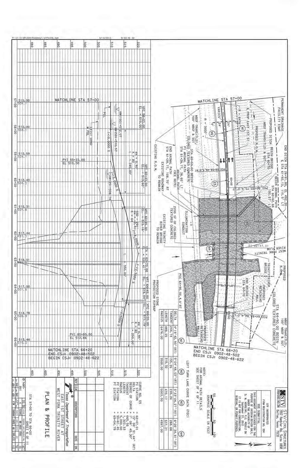
18 SWF Figure 10
19

20

21
22
JOINT PUBLIC NOTICE. 26 June United States Army Corps of Engineers State of Louisiana
 JOINT PUBLIC NOTICE 26 June 2017 United States Army Corps of Engineers State of Louisiana New Orleans District Department of Environmental Quality Regulatory Branch Office of Environmental Services 7400
Pittsburgh District Pittsburgh, PA Notice No Closing Date: May 29, 2015
 Public Notice U.S. Army Corps In Reply Refer to US Army Corps of Engineers, Pittsburgh District of Engineers Notice No. below 1000 Liberty Avenue Pittsburgh District Pittsburgh, PA 15222-4186 Application
PURPOSE: The purpose is to provide commercial facilities in the Vancouver and Clark County vicinity.
 US Army Corps of Engineers Seattle District Joint Public Notice Application for a Department of the Army Permit and a Washington Department of Ecology Water Quality Certification and/or Coastal Zone Management
January 18, JOINT PUBLIC NOTICE Savannah District/State of Georgia
 DEPARTMENT OF THE ARMY SAVANNAH DISTRICT, CORPS OF ENGINEERS 100 WEST OGLETHORPE AVENUE SAVANNAH, GEORGIA 31401-3640 January 18, 2019 Regulatory Branch SAS-2009-00770 JOINT PUBLIC NOTICE Savannah District/State
Appendix E Preliminary Location Hydraulic Study
 Appendix E Prepared for: State of Alaska Department of Transportation and Public Facilities Prepared by: HDR Alaska, Inc. 2525 C Street, Suite 305 Anchorage, Alaska 99503 February 2014 This page intentionally
The Illinois Department of Transportation and Lake County Division of Transportation. Route 173, including the Millburn Bypass
 The Illinois Department of Transportation and Lake County Division of Transportation welcome you to this Public Hearing for U.S. Route 45 from Illinois Route 132 to Illinois Route 173, including the Millburn
Information for File # MHK
 Information for File #2014-03555-MHK Applicant: Corps Contact: Wimmer Communities Marie Kopka Address: 250 N. Sunnyslope Road, Suite 296 Brookfield, Wisconsin 53005 E-Mail: Marie.H.Kopka@usace.army.mil
October 5, JOINT PUBLIC NOTICE Savannah District/State of Georgia
 DEPARTMENT OF THE ARMY SAVANNAH DISTRICT, CORPS OF ENGINEERS 100 W. OGLETHORPE AVENUE SAVANNAH, GEORGIA 31401-3604 October 5, 2016 Regulatory Division SAS-1998-00190 JOINT PUBLIC NOTICE Savannah District/State
Public Hearing. Charlotte County-Punta Gorda MPO - Meeting Rooms A and B March 14, open house at 4 p.m., formal presentation at 5 p.m.
 Public Hearing Charlotte County-Punta Gorda MPO - Meeting Rooms A and B March 14, 2019 open house at 4 p.m., formal presentation at 5 p.m. Welcome to the Public Hearing for the Harborview Road (CR 776)
Information for File MVP MMJ; CSAH 10 Reconstruction (Waconia and Watertown Townships)
") Information for File MVP-2014-03830-MMJ; Reconstruction (Waconia and Watertown Townships) Applicant: Carver County Corps Contact: Melissa Jenny Address: 180 Fifth Street East, Suite 700, St. Paul, MN 55101
Information for File MVP-2014-03830-MMJ; Reconstruction (Waconia and Watertown Townships) Applicant: Carver County Corps Contact: Melissa Jenny Address: 180 Fifth Street East, Suite 700, St. Paul, MN 55101
INTER-AGENCY COORDINATION MEETING
 Virginia Department of Transportation INTER-AGENCY COORDINATION MEETING Joint Permit Application DEQ COE VMRC I. VDOT PROJECT INFORMATION PERMIT #: PRE-APP#: Route: VDOT Project Number: City/County: Contract
STATE OF TENNESSEE DEPARTMENT OF TRANSPORTATION ENVIRONMENTAL DIVISION
 STATE OF TENNESSEE DEPARTMENT OF TRANSPORTATION ENVIRONMENTAL DIVISION Suite 900 - James K. Polk Building 505 Deaderick Street Nashville, Tennessee 37243-0334 MEMORANDUM TO: FROM: Files Joe W. Matlock,
WELCOME! 8 8:30 6: TH STREET IMPROVEMENTS. Open House. Presentation & Q&A
 WELCOME! 168 TH STREET IMPROVEMENTS 6:30 Open House 7 8 Presentation & Q&A 8 8:30 Open House WELCOME Todd Pfitzer City of Omaha Engineer Bob Stubbe City of Omaha Public Works Director Jon Meyer Project
Joint Public Notice. Public Notice Date: February 9, 2015 Expiration Date: March 11, 2015
 US Army Corps of Engineers Seattle District Joint Public Notice Application for a Department of the Army Permit and a Washington Department of Ecology Water Quality Certification and/or Coastal Zone Management
Clay Street Bridge Replacement Project
 Clay Street Bridge Replacement Project Frequently Asked Questions (FAQs) No. 2 April 4, 2018 The project is located in downtown Placerville on Clay Street between US Highway 50 and Main Street and Cedar
DRAFT MAP AMENDMENT FLU 04-4
 DRAFT MAP AMENDMENT FLU 04-4 SW 24 TH AVENUE ROADWAY CORRIDOR The University of Florida participates with the Metropolitan Transportation Planning Organization (MTPO) in its responsibilities for the continuing,
North Carolina Department of Transportation Project Development and Environmental Analysis Branch
 North Carolina Department of Transportation Project Development and Environmental Analysis Branch Citizens Informational Workshop I-85, from I-485 to NC 73 Mecklenburg and Cabarrus Counties October 30,
SUMMARY. Support the Southeast Arkansas Regional Intermodal Facility.
 SUMMARY THE I-69 LOCATION STUDY The proposed I-69 Location Study from El Dorado to McGehee, Arkansas, represents one section (Section of Independent Utility No. 13) of the nationally designated I-69 Corridor
ARTICLE VI: SITE PLAN REVIEW
 Section 6.01 - Site Plan Review (All Districts) ARTICLE VI: SITE PLAN REVIEW Site plans give the Planning commission an opportunity to review development proposals in a concise and consistent manner. The
Existing Conditions and Environmental Consequences Floodplains
 3.9 Environmental Consequences 3.8 3.8.1 WHAT ARE FLOODPLAINS? are low-lying areas adjacent to rivers, streams, and other waterbodies that are susceptible to inundation (flooding) during rain events. These
Asbury Chapel Subdivision Sketch Plan
 Asbury Chapel Subdivision Sketch Plan PART 1: PROJECT SUMMARY Applicant: NVR Inc. Project Size: +/- 76.13 acres Parcel Numbers: 02101112,02116101,02116112, 02116113 Current Zoning: Transitional Residential
OVERMOUNTAIN VICTORY TRAIL BURKE CALDELL CORRIDOR FEASIBLITY STUDY REQUEST FOR QUALIFICATIONS CALDWELL COUNTY PATHWAYS
 OVERMOUNTAIN VICTORY TRAIL BURKE CALDELL CORRIDOR FEASIBLITY STUDY REQUEST FOR QUALIFICATIONS CALDWELL COUNTY PATHWAYS Caldwell County Pathways along with our co-partners City of Lenoir, Town of Gamewell,
SECTION 4(f) DE MINIMIS DOCUMENTATION
 DE MINIMIS DOCUMENTATION") SECTION 4(f) DE MINIMIS DOCUMENTATION Illinois Route 60/83 IL 176 to the intersection of IL 60 (Townline Road) Lake County P-91-084-07 Mundelein Park and Recreation District Project Limit SECTION 4(f)
SECTION 4(f) DE MINIMIS DOCUMENTATION Illinois Route 60/83 IL 176 to the intersection of IL 60 (Townline Road) Lake County P-91-084-07 Mundelein Park and Recreation District Project Limit SECTION 4(f)
When planning stormwater management facilities, the following principles shall be applied where possible.
 2.0 Principles When planning stormwater management facilities, the following principles shall be applied where possible. 2.0.1 Drainage is a regional phenomenon that does not respect the boundaries between
TOWNSHIP OF LOGAN SOIL & FILL IMPORTATION AND PLACEMENT APPLICATION SUBMITTAL CHECKLIST
 TOWNSHIP OF LOGAN SOIL & FILL IMPORTATION AND PLACEMENT APPLICATION SUBMITTAL CHECKLIST Applications: 5 copies of application - Applicant will reproduce the copies at his/her costs. The Township Clerk
WASHINGTON COUNTY OREGON
 WASHINGTON COUNTY OREGON LONG RANGE PLANNING DIVISION North Bethany Subarea Stream Corridors: Existing Regulations In Oregon, there is a distinct difference between the land use rules that apply in rural
Section 4(f) De Minimis Memorandum for the Hickman Road over Tuolumne River Bridge Replacement Project (Bridge No. 38C 0004)
 De Minimis Memorandum for the Hickman Road over Tuolumne River Bridge Replacement Project (Bridge No. 38C 0004)") 11060 White Rock Road, Suite 200 Rancho Cordova, CA 95670 Phone: (916) 363 4210 Fax: (916) 363 4230 M e m o r a n d u m To: Julie Myrah, Branch Chief Date: May 5, 2017 California Department of Transportation
11060 White Rock Road, Suite 200 Rancho Cordova, CA 95670 Phone: (916) 363 4210 Fax: (916) 363 4230 M e m o r a n d u m To: Julie Myrah, Branch Chief Date: May 5, 2017 California Department of Transportation
NOTICE OF PREPARATION
 NOTICE OF PREPARATION To: All Interested Parties Subject: Notice of Preparation of an Environmental Impact Report From: City of Petaluma Address: 11 English Street, Petaluma, CA 94952-2610 Contact: Heather
Berkshire Regional Planning Commission Clearinghouse Review Report
 August 19, 2013 SUBJECT: Reconstruction of Housatonic Street, Dalton, MA EOEA#: 15083 LOCATION: Dalton ESTIMATED COST: $8.1 million REVIEW TYPE: ENF PROPONENT: MassDOT and Town of Dalton COMMENTS DUE:
7.0 SOCIAL, ECONOMIC, AND ENVIRONMENTAL ISSUES
 7.0 SOCIAL, ECONOMIC, AND ENVIRONMENTAL ISSUES The following list of social, economic, and environmental issues have been identified based on a preliminary inventory of resources in the project area, an
MEMORANDUM OF BOG TURTLE HABITAT INVESTIGATION
 MEMORANDUM OF BOG TURTLE HABITAT INVESTIGATION 410-728-2900 Fax: 410-728-3160 www.rkk.com To: From: CC: U.S. Fish and Wildlife Service, Pennsylvania Fish and Boat Commission Jennifer A Ottenberg Miller,
SH 199 Corridor Master Plan. Community Meeting No. 2 May 31, 2017
 Community Meeting No. 2 May 31, 2017 Transportation Projects On or Near SH 199 SH 199 from 0.3 miles south of FM 1886 to south end of Lake Worth bridge Construct freeway mainlanes and frontage roads 10-Year
CITY OF VACAVILLE PLANNING COMMISSION Item No. 8.A STAFF REPORT July 18, 2016 STAFF CONTACT: Amy Feagans, Contract Planner (707)
") CITY OF VACAVILLE PLANNING COMMISSION Item No. 8.A STAFF REPORT July 18, 2016 STAFF CONTACT: Amy Feagans, Contract Planner (707) 449-5140 TITLE: THE FARM AT ALAMO CREEK ENVIRONMENTAL IMPACT REPORT (EIR)
CITY OF VACAVILLE PLANNING COMMISSION Item No. 8.A STAFF REPORT July 18, 2016 STAFF CONTACT: Amy Feagans, Contract Planner (707) 449-5140 TITLE: THE FARM AT ALAMO CREEK ENVIRONMENTAL IMPACT REPORT (EIR)
Master Land Use Plan Application
 Development Review Division Development Services Department CITY OF OVIEDO 400 Alexandria Boulevard Oviedo, Florida 32765 Application No. Date Received Phone: (407) 971-5775 Fax: (407) 971-5819 www.cityofoviedo.net
17.18 SENSITIVE AREAS
 17.18 SENSITIVE AREAS 17.18.010 Purpose...1 17.18.020 Definitions...1 17.18.030 Review Process...1 17.18.040 Sensitive Areas Analysis...2 17.18.050 Standards and Development Plan...3 17.18.060 Geotechnical
Department of Community Development. Planning and Environmental Review Division Revised Notice of Preparation
 Department of Community Development Michael J. Penrose, Acting Director Divisions Building Permits & Inspection Code Enforcement County Engineering Economic Development & Marketing Planning & Environmental
ARTICLE IV: DEVELOPMENT STANDARDS 404 MASTER PLANNING
 IV 13 404 MASTER PLANNING Master Planning through the Site Analysis (Master Planning Site Analysis) or Planned Development (Master Planning Planned Development) is provided to encourage development which
CHECKLIST FOR PHASE II DRAINAGE REPORT
 I. COVER SHEET CHECKLIST FOR PHASE II DRAINAGE REPORT A. Name of Project B. Address C. Owner D. Developer E. Engineer F. Submittal date and revision dates as applicable II. GENERAL LOCATION AND DESCRIPTION
City of Fort Lupton Administrative Site Plan Process
 City of Fort Lupton Administrative Site Plan Process Purpose The Site Plan process is meant to promote orderly and sound development standards as they apply to the City. These site development standards
Northern Branch Corridor SDEIS March 2017
 Northern Branch Corridor SDEIS March 2017 15. 15.1. Chapter Overview 15.1.1. Introduction This chapter discusses changes to the Preferred Alternative resulting in the potential for project improvements
DRAFT SECTION 4(f) EVALUATION INTERSTATE 73 FEIS: I-95 to I-73/I-74 in North Carolina
 EVALUATION INTERSTATE 73 FEIS: I-95 to I-73/I-74 in North Carolina") DRAFT SECTION 4(f) EVALUATION INTERSTATE 73 FEIS: I-95 to I-73/I-74 in North Carolina 1.0 INTRODUCTION Section 4(f) of the Department of Transportation Act of 1966, 49 U.S.C. 303, requires that prior to
DRAFT SECTION 4(f) EVALUATION INTERSTATE 73 FEIS: I-95 to I-73/I-74 in North Carolina 1.0 INTRODUCTION Section 4(f) of the Department of Transportation Act of 1966, 49 U.S.C. 303, requires that prior to
water resource specialists
 Vaughn Collins, PE, CFM, Northwest Hydraulic Consultants Brad Livingston, Oregon Department of Transportation Melissa Reich, North Coast Land Conservancy Location Necanicum River 75 sq mi watershed Active
Poisoned Park? How Exide s Lead Contamination Risks Frisco s Grand Park
 Frisco City Hall has big plans to transform Stewart Creek into a Grand Park with lots of water features for kids to play in. Poisoned Park? How Exide s Lead Contamination Risks Frisco s Grand Park But
OP Council Resolution June 16, Planning and Development Services
 OP-08-01 Council Resolution June 16, 2008 Planning and Development Services Kingsgate Landing Outline Plan Table of Contents 1.0 Introduction 1 1.1 Purpose of Plan 1 1.2 Plan Area Location 1 1.3 Ownership
Understanding Drainage Options What s Feasible and Legal. February 2019
 Understanding Drainage Options What s Feasible and Legal February 2019 Outline for the Presentation Do you need a permit? Does common law apply? Does local government approve it? Will my neighbor allow
STAFF REPORT FOR STANDARD COASTAL DEVELOPMENT PERMIT #CDP FEBRUARY 26, 2015 CPA - 1 PO BOX 238 APTOS, CA 94001
 STAFF REPORT FOR STANDARD COASTAL DEVELOPMENT PERMIT #CDP 2014-0030 FEBRUARY 26, 2015 CPA - 1 OWNER/APPLICANT: AGENT: REQUEST: HANS HEIM PO BOX 238 APTOS, CA 94001 JAMES HAY PO BOX 762 MENDOCINO, CA 95460
D3 January 14, 2015 Public Hearing
 D3 January 14, 2015 Public Hearing APPLICANT: DONALD J. BOUCHER, JR. PROPERTY OWNER: D.J.B. SERVICE CENTER, LLC STAFF PLANNER: Kristine Gay REQUEST: A. Conditional Change of Zoning (I-1 to B-2) B. Conditional
Environmental Challenges and Opportunities
 Environmental Challenges and Opportunities Introduction This section evaluates various resources in the US 24/40 Corridor including aesthetic, wetlands, geology and soils, water, ecological, terrestrial,
STREAM BUFFERS
 88-415 STREAM BUFFERS 88-415-01 PURPOSE In the Kansas City region and throughout the nation, vegetated stream buffers have been clearly shown to protect stream stability and related infrastructure, improve
Section General Tree Preservation Requirements for New Nonresidential and Residential Development
 DIVISION 2: TREE PRESERVATION AND PROTECTION Section 5.5.2.1 General Tree Preservation Requirements for New Nonresidential and Residential Development (a) Application. The provisions of this Section apply
Appendix E Section 4(f) Evaluation
 Evaluation") Appendix E Section 4(f) Evaluation Appendix E Draft Section 4(f) Evaluation E.1 Introduction This appendix addresses a federal regulation known as Section 4(f), which protects parks, recreation areas,
Appendix E Section 4(f) Evaluation Appendix E Draft Section 4(f) Evaluation E.1 Introduction This appendix addresses a federal regulation known as Section 4(f), which protects parks, recreation areas,
Baumgarten MPUD. Exhibit 3 Evaluation Criteria
 Pursuant to LDC subsections 10.02.13 B, 10.02.08 F and Chapter 3 G. of the Administrative Code, staff s analysis and recommendation to the Planning Commission, and the Planning Commission s recommendation
NOTICE OF PREPARATION
 NOTICE OF PREPARATION DATE: January 6, 2016 TO: LEAD AGENCY: Responsible Agencies, Organizations, and Interested Parties Contact: Tyler Barrington, Principal Planner Planning Department Community Development
2.4 FUTURE LAND USE ELEMENT Goals, Objectives and Policies
 GOAL 1: To create developmental patterns that direct future growth to appropriate areas on campus, in a manner that promotes the educational mission of the University, the protection of environmentally
PLNPCM Carl s Jr. Commercial Parking Lot at Redwood Road and 1700 South
 Staff Report PLANNING DIVISION COMMUNITY & NEIGHBORHOODS To: Salt Lake City Planning Commission From: Casey Stewart; 801-535-6260 Date: November 4, 2016 Re: PLNPCM2015-00874 Carl s Jr. Commercial Parking
AGENDA ITEM: IOWA. west] that were not FISCAL IMPACT. the City of Clive. STAFF REVIEW. Resolution II. Amendment PREPARED BY: REVIEWED BY:
![AGENDA ITEM: IOWA. west] that were not FISCAL IMPACT. the City of Clive. STAFF REVIEW. Resolution II. Amendment PREPARED BY: REVIEWED BY:](/thumbs/93/112428810.jpg "AGENDA ITEM: IOWA. west] that were not FISCAL IMPACT. the City of Clive. STAFF REVIEW. Resolution II. Amendment PREPARED BY: REVIEWED BY:") AGENDA ITEM: CITY OF WAUKEE, IOWA CITY COUNCIL MEETING COMMUNICATION MEETING DATE: March 7, 2016 AGENDA ITEM: Consideration of approval of a resolution approving Engineering Services Amendment No. 1 with
AGENDA ITEM: CITY OF WAUKEE, IOWA CITY COUNCIL MEETING COMMUNICATION MEETING DATE: March 7, 2016 AGENDA ITEM: Consideration of approval of a resolution approving Engineering Services Amendment No. 1 with
PROJECT STATEMENT LOCATION/DESIGN PUBLIC HEARING. 19 th AVENUE NORTH EXTENSION PROJECT FROM SPRINGDALE DRIVE TO NORTH 2 ND STREET/U.S.
 PROJECT STATEMENT LOCATION/DESIGN PUBLIC HEARING 19 th AVENUE NORTH EXTENSION PROJECT FROM SPRINGDALE DRIVE TO NORTH 2 ND STREET/U.S. 67 HEARING LOCATION: ERICKSEN COMMUNITY CENTER 1401 11 TH AVENUE NORTH
City of Waco Stormwater Management Regulations
 1.0 Applicability: City of Waco Stormwater Management Regulations These regulations apply to all development within the limits of the City of Waco as well as to any subdivisions within the extra territorial
JOINT PUBLIC NOTICE CORPS OF ENGINEERS STATE OF ARKANSAS Application Number: SWL Date: July 5, 2018 Comments Due: July 30, 2018
 US Army Corps of Engineers Little Rock District JOINT PUBLIC NOTICE CORPS OF ENGINEERS STATE OF ARKANSAS Application Number: SWL 2014-00257-1 Date: July 5, 2018 Comments Due: July 30, 2018 TO WHOM IT MAY
PRELIMINARY CONDITIONAL USE SUBMITTAL CHECKLIST REQUIREMENTS
 This checklist must accompany your submittal as the cover page. CONDITIONAL USE Application Submittal Checklist for PRELIMINARY AND FINAL APPROVAL Per Winter Park Land Development Code Sec. 58-90 PRELIMINARY
Project Narrative For Fruita RV Resort Conditional Use Permit
 Project Narrative For Fruita RV Resort Conditional Use Permit Date: November 18, 2016 Prepared by: Robert W. Jones, II, P.E. Vortex Engineering & Architecture, Inc. 2394 Patterson Rd., Ste. 201 Grand Junction,
PUBLIC HEARING. Thursday, December 14, 2017 FDOT Urban Office 2198 Edison Avenue Jacksonville, FL 32204
 DISTRICT TWO PUBLIC HEARING I 10 (SR 8) from I 295 to I 95 Project Development & Environment Study Duval County, Florida Financial Project Number 213326 2 22 01 Efficient Transportation Decision Making
Chesapeake Bay Critical Area Conservation Plan
 The Maryland-National Capital Park and Planning Commission Prince George s County Planning Department Development Review Division 301-952-3530 Note: Staff reports can be accessed at www.mncppc.org/pgco/planning/plan.htm.
PennDOT. single spann lanes and 3- mayy need to be to accommodate. any bridge. addition to III. Date: CRP 07/27/2015 CRP.
 (10/27/14) PennDOT Section 106 Field Assessments and Finding Combined Early tification/finding? Yes Concurrence required or requested: Yes MPMS: 51507 ER# (if consultation with PHMC required) ): County:
LICENSES FOR UTILITY CROSSINGS OF PUBLIC LANDS AND WATERS ACCORDING TO MINNESOTA RULES CHAPTER [Rules Effective July 1, 2004]
![LICENSES FOR UTILITY CROSSINGS OF PUBLIC LANDS AND WATERS ACCORDING TO MINNESOTA RULES CHAPTER [Rules Effective July 1, 2004]](/thumbs/78/77546780.jpg "LICENSES FOR UTILITY CROSSINGS OF PUBLIC LANDS AND WATERS ACCORDING TO MINNESOTA RULES CHAPTER [Rules Effective July 1, 2004]") LICENSES FOR UTILITY CROSSINGS OF PUBLIC LANDS AND WATERS ACCORDING TO MINNESOTA RULES CHAPTER 6135 [Rules Effective July 1, 2004] Minnesota Department of Natural Resources Division of Lands and Minerals
LICENSES FOR UTILITY CROSSINGS OF PUBLIC LANDS AND WATERS ACCORDING TO MINNESOTA RULES CHAPTER 6135 [Rules Effective July 1, 2004] Minnesota Department of Natural Resources Division of Lands and Minerals
City of Fort Lupton Site Plan Process
 Form WKBK001 City of Fort Lupton Site Plan Process Purpose The Site Plan process is meant to promote orderly and sound development standards as they apply to the City. These site development standards
ITS Concept Development Activity Descriptions
 ITS Concept Development Activity Descriptions October 2015 Procedures are subject to change without notice. Check the NJDOT website to ensure this is the current version. Table of Contents Concept Development
Joe Pool Lake Master Plan Revision Public Information Meeting May 23, 2017
 Joe Pool Lake Master Plan Revision Public Information Meeting May 23, 2017 Presented By Jason Owen Lake Manager U.S. Army Corps of Engineers Fort Worth District US Army Corps of Engineers Purpose of this
Appendix G Response to Comments
 Appendix G Response to Comments This appendix contains the comments received during the public circulation and comment period (May 27, 2008 to July 11, 2008). The comments have been numbered (Comment Set
Mitchell Ranch South MPUD Application for Master Planned Unit Development Approval Project Narrative. Introduction
 Mitchell Ranch South MPUD Application for Master Planned Unit Development Approval Project Narrative Introduction Mitchell Ranch South is a proposed single family (detached) residential development on
City of Grande Prairie Development Services Department KENNEDY DEVELOPMENTS LTD. OUTLINE PLAN OP-09-01
 City of Grande Prairie Development Services Department KENNEDY DEVELOPMENTS LTD. OUTLINE PLAN OP-09-01 July 27, 2009 TABLE OF CONTENTS 1.0 Introduction... 1 1.1 Plan Area Location & Context... 1 1.2 Ownership
Open House Public Involvement Meeting Howland High School Cafeteria, 200 Shaffer Drive NE, Warren, Ohio. Informational Handout
 Open House Public Involvement Meeting Howland High School Cafeteria, 200 Shaffer Drive NE, Warren, Ohio SR 46 (Niles Cortland Road) and SR 82 Proposed Improvements Howland Township, Trumbull County, Ohio
Northern Branch Corridor DEIS December 2011
 16 Floodplains 161 Chapter Overview 1611 Introduction The flowing chapter identifies floodplains found within the Northern Branch Corridor in accordance with Executive Order 11988, Floodplain Management
2 January 13, 2010 Public Hearing APPLICANT: AUTOBELL CAR WASH, INC
 REQUEST: Conditional Use Permit (car wash) 2 January 13, 2010 Public Hearing APPLICANT: AUTOBELL CAR WASH, INC PROPERTY OWNER: MESSER 1060 INDEPENDENCE BOULEVARD STAFF PLANNER: Carolyn A.K. Smith ADDRESS
CENTERTON ROAD BRIDGE REPLACEMENT
 CENTERTON ROAD BRIDGE REPLACEMENT FEASIBILITY STUDY BURLINGTON COUNTY BRIDGE C4.4 OVER RANCOCAS CREEK TOWNSHIPS OF MOUNT LAUREL, WESTAMPTON & WILLINGBORO 1 prepared for: BOARD OF CHOSEN FREEHOLDERS BURLINGTON
Staff Report CONDITIONAL USE
 Staff Report PLANNING DIVISION COMMUNITY & ECONOMIC DEVELOPMENT To: From: Salt Lake City Planning Commission Daniel Echeverria, (801) 535-7165, daniel.echeverria@slcgov.com Date: May 21, 2015 Re: PLNPCM2015-00139
ELIGIBILITY CRITERIA CHECKLIST OPEN SPACE CLASSIFICATION
 THURSTON COUNTY DEVELOPMENT SERVICES OPEN SPACE TAX PROGRAM ELIGIBILITY CRITERIA CHECKLIST OPEN SPACE CLASSIFICATION Use this checklist to help you determine whether your property is eligible for open
1 foot of Sea Level Rise
 1 foot of Sea Level Rise Schools Fire Stations Law Enforcement Assisted Living Hospitals 1ft SLR 0 0.35 0.7 1.4 Miles Year 20 Poplation: the 2013 stdy A Geological Perspective U.S. Mid-Atlantic Coast a
2.1.8 Cultural Resources Regulatory Setting. Affected Environment, Environmental
 REVISED DRAFT ENVIRONMENTAL IMPACT REPORT/ Affected Environment, Environmental 2.1.8 Cultural Resources This section evaluates the potential for historical and archaeological resources within the proposed
Goal 1 To establish and follow land use patterns for the long-range development of the campus.
 ELEMENT 4 FUTURE LAND USE Goal 1 To establish and follow land use patterns for the long-range development of the campus. Objective 1A Correct existing incompatible campus land uses. Policy 1A-1 Reduce
Letter of Notification For East Lima Station Expansion Project
 Letter of Notification For East Lima Station Expansion Project PUCO Case No. 18-0906-EL-BLN Submitted to: The Ohio Power Siting Board Pursuant to Ohio Administrative Code Section 4906-6-05 Submitted by:
APPROVED JURISDICTIONAL DETERMINATION FORM U.S. Army Corps of Engineers
 APPROVED JURISDICTIONAL DETERMINATION FORM U.S. Army Corps of Engineers This form should be completed by following the instructions provided in Section IV of the JD Form Instructional Guidebook. SECTION
CATEGORICAL EXCLUSION DETERMINATION I 435/I 35/K 10 INTERCHANGE (JOHNSON COUNTY GATEWAY)
") December 11, 2012 CATEGORICAL EXCLUSION DETERMINATION I 435/I 35/K 10 INTERCHANGE (JOHNSON COUNTY GATEWAY) Project Number: Kansas Department of Transportation (KDOT) Project No. 435-46 KA-1002-03 Route:
December 11, 2012 CATEGORICAL EXCLUSION DETERMINATION I 435/I 35/K 10 INTERCHANGE (JOHNSON COUNTY GATEWAY) Project Number: Kansas Department of Transportation (KDOT) Project No. 435-46 KA-1002-03 Route:
Checklists. Project Name: Location: File Number: Date of Submittal: Reviewer: Date: Applicant: Contact Name: Phone Number:
 Applicant: Contact Name: Phone Number: Email: Project Name: Location: File Number: Date of Submittal: Reviewer: Date: Concept Plan Requirements: I. General Project Information 1. Address or parcel number
STAFF SUMMARY FOR S17-02 SPECIAL USE PERMIT APPLICATION
 APPLICATION SUMMARY Case Number: S17-02 Request: STAFF SUMMARY FOR S17-02 SPECIAL USE PERMIT APPLICATION SUP application in order to develop a convenience food store. Applicant: Property Owner(s): Cindee
Decision Notice. Proposed Action
 Decision Notice Paving Weld County Road 105 USDA Forest Service Arapaho and Roosevelt National Forest and Pawnee National Grassland Pawnee National Grassland Ranger District Weld County, Colorado November
Your town s subdivision or land use ordinance standards should reference the following street standards, for example:
 Your town s subdivision or land use ordinance standards should reference the following street standards, for example: Streets shall be designed to move traffic safely and in a way that minimizes environmental
ADDENDUM TO BIOLOGICAL SCOPING SURVEY REPORT, BOTANICAL SURVEY AND WETLAND DELINEATION
 ADDENDUM TO BIOLOGICAL SCOPING SURVEY REPORT, BOTANICAL SURVEY AND WETLAND DELINEATION FOR AVALON INN (APN 069-241-27 & -04) 1201 & 1211 NORTH MAIN STREET FORT BRAGG, CA MENDOCINO COUNTY prepared for:
PART 1: PROJECT SUMMARY. Proposed Land Use: 120 single-family lots. The application is Attachment A. The site plan is Attachment B.
 PART 1: PROJECT SUMMARY Applicant: JBH Development, LLC and Hopper Communities, INC Project Size: +/- 80.48 acres Parcel Number: 01513107, 01513108, 01513109, 01513113, 01513120, 01513121, 01513122, 01513124,
Chapter 5: Recreation
 Chapter 5: Recreation Introduction and Setting Recreational opportunities within Nevada County are varied, ranging from public parks with intensively used active recreational facilities, to vast tracts
Watertown City Council
 City of Watertown Watertown City Council April 14 th, 2015 Agenda Item: City Comment on Sun Share CUP Application Request for Action: Motion to Approve City Comments regarding CUP Application Department:
AGENCIES and OFFICIALS CONTACTED FEDERAL Federal Aviation Administration Federal Emergency Management Agency Natural Resources Conservation Service U.
 AGENCIES and OFFICIALS CONTACTED FEDERAL Federal Aviation Administration Federal Emergency Management Agency Natural Resources Conservation Service U.S. Army Corps of Engineers U.S. Environmental Protection
Major Subdivision Sketch Plan Checklist
 This checklist provides specific requirements that are apart of the Sketch process. The entire process is described by the Huntersville Subdivision Review Process which details all the submittal and resubmittal
APPENDIX C Agency Scoping Meeting Materials
 I-11 Corridor Tier 1 EIS Scoping Summary Report Final APPENDIX C Agency Scoping Meeting Materials Agency Scoping Meeting Agendas Agency Scoping Meeting Presentation Agency Scoping Meeting Boards Agency
Public Meeting. US Highway 14 (6TH Street) from Main Ave to Medary Ave Urban Reconstruction Project Brookings, SD P-PH 0014(179)419 PCN 027B
 from Main Ave to Medary Ave Urban Reconstruction Project Brookings, SD P-PH 0014(179)419 PCN 027B") Public Meeting US Highway 14 (6TH Street) from Main Ave to Medary Ave Urban Reconstruction Project Brookings, SD P-PH 0014(179)419 PCN 027B Mark Leiferman Chief Road Design Engineer April 28, 2014 Why
Public Meeting US Highway 14 (6TH Street) from Main Ave to Medary Ave Urban Reconstruction Project Brookings, SD P-PH 0014(179)419 PCN 027B Mark Leiferman Chief Road Design Engineer April 28, 2014 Why
PLANNED UNIT DEVELOPMENT STAFF REPORT Date: June 2, 2016
 # 9 ZON2016-01032 PLANNED UNIT DEVELOPMENT STAFF REPORT Date: June 2, 2016 DEVELOPMENT NAME JJT Properties LLC LOCATION 1147 & 1151 East I-65 Service Road South and 1180 Sledge Drive (Southeast corner
Holmberg & Howe, Land Surveyors and Civil Engineers Zoning District: R-35
 Development Impact Statement Name of Project: Red Tail Drive Acreage: 13.5 Acres± Type of Project: Residential Subdivision Owner: 96 East Street Development, LLC Location: rear of 112 East Street Parcel
C-I-10. The effect of establishing a comprehensive site review as follows will: B. Reduce the cluttered aspects of current development by:
 C-I-10 PART C SECTION I ARTICLE 10 GENERAL REGULATIONS PROJECT SITE REVIEW I. Purpose The effect of establishing a comprehensive site review as follows will: A. Protect streetscapes from projects that
I-70 Corridor Enhancement Plan
 i - Table of Contents Table of Contents Chapter I Overview Chapter II Bridge and Roadway Improvements Chapter III Landscape Enhancements Chapter IV Riparian Corridors Chapter V Showcase Missouri Plan Chapter
Lewisville Lake Master Plan Revision Public Information Meeting May 2 & 4, 2017
 Lewisville Lake Master Plan Revision Public Information Meeting May 2 & 4, 2017 Presented By Rob Jordan Lake Manager U.S. Army Corps of Engineers Fort Worth District US Army Corps of Engineers Purpose