RURAL CONSERVATION ZONING
|
|
|
- Melvin Malone
- 5 years ago
- Views:
Transcription
1
2

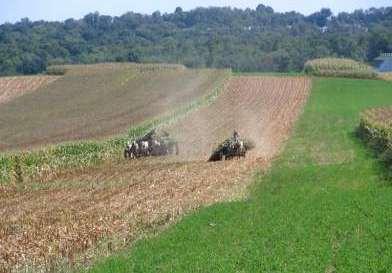
3 RURAL CONSERVATION ZONING Introduction What does this tool address? Loss of farms and forests Loss of rural character Suburban sprawl What does this tool accomplish? Protects prime resource lands Protects rural character while providing landowners with land use options

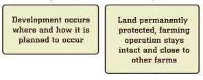
4 Still the picture for a few?

5 More likely for most?


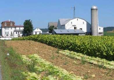
6 RURAL CONSERVATION ZONING Implementation How is this tool implemented? Zoning Ordinance s Agricultural Preservation or Rural Conservation Districts. Permits the following: Farms, forestry and other open space uses Single-family residential Large lot sizes for ag./open space uses Very low- to low-density (1/10 to 1/5) for residential Options: TDR, Conservation Design


7 RURAL CONSERVATION ZONING Applicability Where has this tool been used successfully? Used in various forms within the upper reaches of the Greenway, including Honey Brook, West Caln, West Nantmeal and West Brandywine Townships

8 RURAL CONSERVATION ZONING Applicability How can this tool be used in the Brandywine Creek Greenway? Apply to remaining areas of farms and forests Limit public infrastructure encroachment Combine with natural/cultural resource protection regulations Discourage cookie-cutter subdivisions Promote use of conservation design/open space developments
9 RURAL CONSERVATION ZONING More Information Where can someone learn more about this tool? Greenscapes Element of the Lancaster County Comprehensive Plan Balance. The Center for Rural Pennsylvania, Zoning for Farming, A Guidebook for Pennsylvania Municipalities on How to Protect Valuable Agricultural Lands, 1995
10

11 TRANSFERABLE DEVELOPMENT RIGHTS (TDR) Introduction What does this tool address? Loss of farms and forests Development impacts to watersheds Suburban sprawl What does this tool accomplish? Saves land and manages growth Landowners paid for development rights

12 Implementation: How is this tool implemented? WEST HEMPFIELD TOWNSHIP, LANCASTER COUNTY Created Through Zoning; Must Be Voluntary SENDING AREAS RECEIVING AREAS
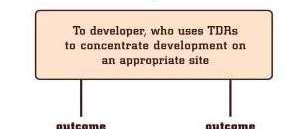

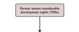
13 Implementation: How is this tool implemented? Basic TDR Steps

14 Applicability: Where has this tool been used successfully? Warwick Township, Lancaster County Program Highlights to date 708 TDRs severed/sold 278 TDRs transferred to receiving development Warwick cooperates with County Ag. Preserve Board & Lancaster Farmland Trust. Preserved Farms since ,334 total acres have been preserved 1,450 acres preserved through TDRs


15 Warwick Township Development Receiving TDRs Campus Industrial development 141 TDRs 40 TDRs Additional Annual School Tax Revenues = $544,000.00


16 The end result TDRs have preserved TDRs 75 TDRs 45 TDRs 47 TDRs
17
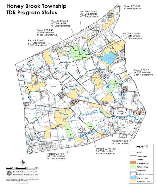
18 TRANSFERABLE DEVELOPMENT RIGHTS (TDR) Applicability How can this tool be used in the greenway? Honey Brook Township example Upper Uwchlan and West Brandywine examples Multi-municipal hypothetical example: Downingtown Borough receives TDRs Upstream municipalities send TDRs Benefits: Borough economic development Open lands minimize downstream flooding
19 TRANSFERABLE DEVELOPMENT RIGHTS (TDR) More Information Where can someone learn more about this tool? Brandywine Conservancy publication Transfer of Development Rights, A Flexible Option for Redirecting Growth in Pennsylvania. Rights (An up-to-date TDR website)
20


21 CONSERVATION DESIGN Introduction What does the Conservation Design tool accomplish? Offers multiple benefits over conventional lot-out Avoids many of the negative aspects of sprawl Fits new development into the character and landscape of the community Enhances resource protection initiatives Implements specific planning objectives


22 CONSERVATION DESIGN Implementation How is Conservation Design implemented? Through local land use regulation Usually offered as a zoning option to conventional lot-out development Permitted by right or via conditional approval Zoning provisions provide for overall density, use types & lot sizes, and open space Design standards may be provided in Zoning or in the SALDO


23 CONSERVATION DESIGN Implementation How is this tool implemented? Keys to Ultimate Effectiveness of Conservation Design: Adoption of flexible regulatory provisions Careful plan review Deliberate crafting of conditions of approval Education regarding landowner options


24 CONSERVATION DESIGN Success Where has this tool been used successfully and what were the outcomes? Conservation Design has been used with varying degrees of success throughout the Greenway and the region... Preserving Scenic Landscapes Providing for Traditional Neighborhood Design Treating Stormwater as a Resource Providing for Resource Enhancement


25 CONSERVATION DESIGN Applicability How can this tool be used in the BCG? In which municipalities might this tool be suitable? The Conservation Design tool is already used broadly and variably in the Brandywine Creek Greenway region. The tool is applicable in every Township, less so in the Boroughs due simply to lack of larger-scale developable land. Successful use of Conservation Design, whether termed Open Space Design or Flexible Development or Cluster Development, depends on both the design standards for development and open space AND the degree to which more conventional development options are more or less favorable for developers.

26 CONSERVATION DESIGN More Information Where can someone learn more about this tool? Contact: Chester County Planning Commission Brandywine Conservancy Natural Lands Trust
27


28 RESOURCE PROTECTION REGULATIONS Introduction What issues does this tool address? What does this tool accomplish? Promoting the conservation of a broad array of resources while providing for on-going community development Flood Plains, Wetlands, and Steep Slopes Riparian Buffers Woodlands Unique Natural Areas Greenway Corridors Scenic Landscapes Historic Resources

29 RESOURCE PROTECTION REGULATIONS Implementation How is this tool implemented? Most resource protection regulation is accomplished via the Zoning Ordinance, which applies all the time and not just to development scenarios. Some municipalities regulate certain resources within the SALDO only, so as not to apply rigorous resource protection standards to the average homeowner. Resource protection regulations may stipulate use limitations or outright prohibitions or may more liberally apply disturbance limitations and/or performance standards. Historic resource protection requires provision for viable economic re-use or adaptation.

30 RESOURCE PROTECTION REGULATIONS Implementation How is this tool implemented? An import qualifier to resource protection regulation is to already have, or develop over time as permit applications are submitted, a clear and accurate Inventory of all subject resources! All resource regulation should take into account the unique character of individual properties and the need for landowners to undertake lawful land use.


31 RESOURCE PROTECTION REGULATIONS Success Where has this tool been used successfully and what were the outcomes? Every municipality is subject to Flood Plain regulation and Wetland regulation which have minimized disturbance of these resources in recent decades. Most municipalities regulate disturbance of Steep Slopes with relative success. Few municipalities regulate Unique Natural Areas or Riparian Buffers beyond regulation imposed by the state. Limited regulation has successfully been imposed at the municipal level for Woodlands, Greenways, Scenic Landscapes and Historic Resources, although we enjoy some excellent examples in the Brandywine Creek Greenway region.


32 RESOURCE PROTECTION REGULATIONS Applicability How can this tool be used in the BCG and in which municipalities might it be suitable? Local regulation of natural and cultural resources can be enacted or enhanced in every municipality within the Brandywine Creek Greenway region. Suitability of specific forms and applicability of regulations are dependent upon both the unique characteristics of each municipality (e.g., what resources are present?) and the community conservation and development objectives.

33 RESOURCE PROTECTION REGULATIONS More Information Where can someone learn more about this tool? Chester County Planning Commission Brandywine Conservancy
34
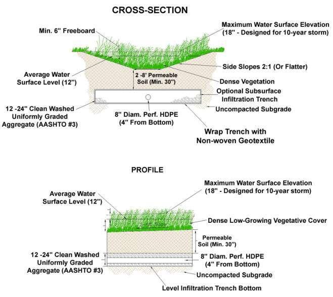
35 STORMWATER MANAGEMENT WITH BMPS Introduction (aka Low Impact Development or LID and Green Infrastructure) What issues does this tool address? Localized and downstream flooding Groundwater recharge Stream baseflow Water quality Streambank erosion Nonpoint source pollutant loadings in runoff Temperature impacts Source water protection What does this tool accomplish? Balances land development with water resource needs/values Quantitatively, minimizes runoff volumes and slows peak rates to minimize local and downstream flooding, protect recharge and baseflow, and mimic pre-development hydrology Qualitatively, minimizes addition of sediment, nutrients, toxics, other runoff-borne pollutants in order to protect aquatic biota/macroinvertebrates and to protect water supplies and minimize treatment costs and protect recreational values and overall quality of life in the watershed Satisfy increasing legal/regulatory/permitting requirements from State and Federal
36 STORMWATER MANAGEMENT WITH BMPS Implementation How is this tool implemented? Municipal Prominence with County Role and State Role and Federal Role For Existing Sources of Stormwater MS4/TMDL Most, not all are MS4s All have TMDLs though varies with Urbanized Areas, Regulated Outfalls, etc. For New Sources of Stormwater New Act 167 Model Ordinance Minimum Relatively New Chapter 102 and other Regs -PADEP BMP Manual, other sources for LID, Green Infrastructure, Smart Growth, etc. See our GreenTreks/StormwaterPA Site Design Process.
37 STORMWATER MANAGEMENT WITH BMPS Success Where has this tool been used successfully? In many Chester County municipalities and beyond What were the outcomes of using the tool? When BMPs are properly matched to site and development being proposed, then installed and maintained correctly, there is proven quantitative/qualitative success.
38 STORMWATER MANAGEMENT WITH BMPS Applicability How can this tool be used in the BCG? MS4/TMDL requirements must be satisfied. Act 167 model ordinance requirements must be satisfied. Integrate BCG extras to provide added benefits and achieve Greenway goals and objectives. In which municipalities might this tool be suitable? Virtually all municipalities can/should use this tool to the maximum, given that it s basically a requirement, and provides maximum environmental and quality of life/community enhancement bang for the buck. Perhaps a BCG overlay that sorts out special MS4/TMDL and 167/New Source provisions for LID/Green Infrastructure/Smart Growth varying by municipal density context?
39 STORMWATER MANAGEMENT WITH BMPS More Information Where can someone learn more about this tool? Call me at or CCWRA website. PADEP and EPA websites. Center for Watershed Protection website. Many many more.
40 SOME EXAMPLES: Keeping in mind: -Prevention (Non-Structural) and Mitigation (Structural) -Blurred line with Low Impact Development -Blurred line with Green Infrastructure
41 NON-STRUCTURAL BMP CATEGORIES WITH SPECIFIC NON-STRUCTURAL BMPS 1.0 PROTECT SENSITIVE AND SPECIAL VALUE RESOURCES BMP 1.1 PROTECT SENSITIVE/SPECIAL VALUE FEATURES BMP 1.2 PROTECT/CONSERVE/ENHANCE UTILIZE RIPARIAN AREAS BMP 1.3 PROTECT/UTILIZE NATURAL FLOW PATHWAYS IN OVERALL STORMWATER PLANNING AND DESIGN 2.0 CLUSTER AND CONCENTRATE BMP 2.1 CLUSTER USES AT EACH SITE; BUILD ON THE SMALLEST AREA POSSIBLE BMP 2.2 CONCENTRATE USES AREAWIDE THROUGH SMART GROWTH PRACTICES 3.0 MINIMIZE DISTURBANCE AND MINIMIZE MAINTENANCE BMP 3.1 MINIMIZE TOTAL DISTURBED AREA GRADING BMP 3.2 MINIMIZE SOIL COMPACTION IN DISTURBED AREAS BMP 3.3 RE-VEGETATE AND RE-FOREST DISTURBED AREAS, USING NATIVE SPECIES 4.0 REDUCE IMPERVIOUS COVER BMP 4.1 REDUCE STREET IMPERVIOUSNESS BMP 4.2 REDUCE PARKING IMPERVIOUSNESS 5.0 DISCONNECT/DISTRIBUTE/DECENTRALIZE BMP 5.1 ROOFTOP DISCONNECTION BMP 5.2 DISCONNECTION FROM STORM SEWERS


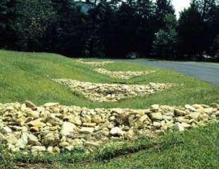
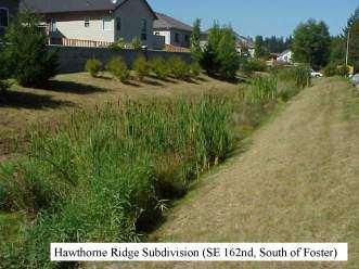
42 RAIN GARDENS / BIORETENTION Rainwater can support the landscape and soils, reducing pipes and basins.

43 VEGETATED SWALE (ENHANCED)

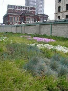
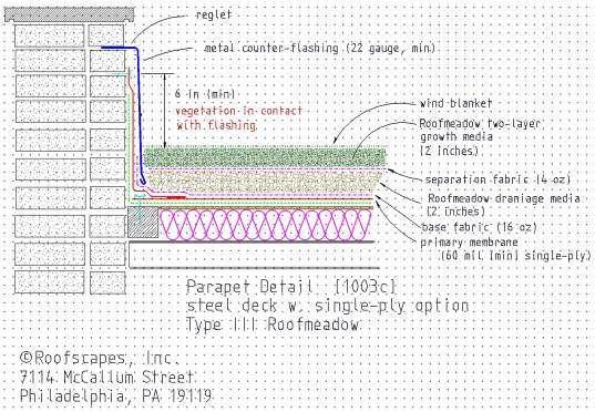
44 VEGETATED ROOF
45 POLLUTANT REMOVAL EFFECTIVENESS POLLUTANT INFILTRATION PRACTICES Stormwater Wetlands Stormwater Ponds Wet Filtering Practices Water Quality Swales Stormwater Dry Ponds Total Phosphorus Soluble Phosphorus Total Nitrogen Nitrate Copper N/A Zinc TSS Water quality benefits of porous pavement with infiltration from National Pollutant Removal Performance Database for Stormwater Treatment Practices Center for Watershed Protection, June 2000
46
47 FLOODPLAIN REGULATIONS (ENHANCED) Introduction What issues does this tool address? Defined here as minimum FEMA program requirements. Reduces property loss and human health impacts from flooding, as currently defined, mapped, regulated Modest environmental benefits; current FEMA allows for substantial impacts on floodplain vegetation and soils What does this tool accomplish? Reduces property loss impacts and human health impacts This tool does not reduce flooding itself; existing regulations allows for worsening of flooding,, even without considering climate change issues such as worsening storm events, changes in upstream watershed hydrology, etc. Upgraded floodplain regulations could further reduce
48 FLOODPLAIN REGULATIONS (ENHANCED) Implementation How is this tool implemented? Through minimum FEMA program requirements, adopted by each municipality (subsidized flood insurance as carrot) What are the problems here? Fails to protect the floodplain on site Can obliterate natural floodplain functions Fails to acknowledge changing upstream watershed hydrology More volume, faster peaks Fails to acknowledge changing climate and precip patterns Increased storm intensity and frequency Fails to integrate need for buffer and therefore does not guarantee protection for property/human health risks
49 FLOODPLAIN REGULATIONS (ENHANCED) Success Where has this tool been used successfully? Used for years throughout County, State, Nation What were the outcomes of using the tool? Reduced human health impacts, though still substantial property losses, though paid for through insurance

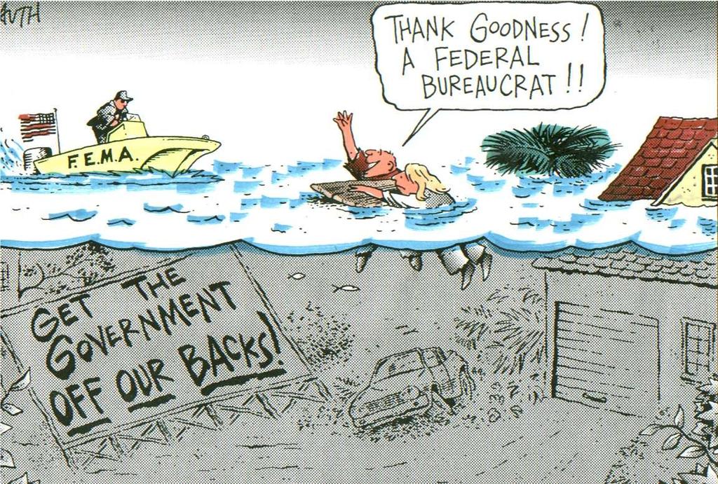
50 The Philadelphia Inquirer, Tony Auth
51 FLOODPLAIN REGULATIONS (ENHANCED) Applicability How can this tool be used in the BCG? We are urge municipalities to adopt more stringent floodplain regulations which work, in tandem, with riparian zone regulations, which work to protect and preserve naturally vegetated (ideally forested) floodplains and riparian zones. Furthermore, these floodplain zones/lines need to be increased/expanded so that impacts from worsened flooding in the future is anticipated and managed/reduced (i.e., functionally increase the 100-year flood elevation). In which municipalities might this tool be suitable? Virtually all municipalities, although the farther down in the watershed system you go, the greater the seriousness of this issue. This issue can be dealt with aggressively/proactively better in less developed municipalities than highly developed ones. Ounce of prevention tons of cure.
52 FLOODPLAIN REGULATIONS (ENHANCED) More Information Where can someone learn more about this tool? FEMA is changing! Learn more about FEMA though their website for FEMA and the Flood Insurance Administration (FIA). There are Pennsylvania sources as well. We hope to host a Subscribers Meeting on this soon.
53
54 PUBLIC LAND DEDICATION & FEE-IN-LIEU Introduction What issues does this tool address? What does it accomplish? Communities need open space for passive and active recreation, and natural areas where wildlife can flourish Municipalities can require developers to provide land for this purpose, while also permitting several voluntary alternatives, include a fee-in-lieu Sometimes called mandatory dedication by land-use planners
55 PUBLIC LAND DEDICATION & FEE-IN-LIEU Implementation How is this tool implemented? First adopt a parks and recreation plan Then amend an existing, or adopt a new, subdivision and land development plan that provides for public dedication Ordinance must contain definite standards Voluntary alternatives to public dedication can be offered but not mandated Developers may pay a fee-in-lieu to be used for parks and rec facilities accessible to the new development Developers may construct recreational facilities Developers may reserve private land within the development for parks and rec use Fees-in-Lieu Must be used within 3 years of being collected unless the muni successfully negotiated with the developer Can be used to buy parkland, provide infrastructure, buy new equipment, or improve existing parkland that is accessible to the new development Cannot be used to maintain existing parkland or buy maintenance equipment

56 PUBLIC LAND DEDICATION & FEE-IN-LIEU Success Where has this tool been used successfully? Up to hundreds of municipalities statewide, concentrated in high-growth areas such as Chester County Local examples include Pocopson, East Brandywine, East Bradford, and Upper Uwchlan Townships
57 PUBLIC LAND DEDICATION & FEE-IN-LIEU Applicability How can this tool be used in the BCG? To preserve open space To provide recreational trails To provide recreational facilities In which municipalities might this tool be suitable? Any municipality experiencing growth
58 PUBLIC LAND DEDICATION & FEE-IN-LIEU More Information The Brandywine Conservancy s Environmental Management Center Where can someone learn more about this tool? Public Dedication of Land and Fees-in-Lieu for Parks and Recreation. 1) 2)
59


60 Introduction OFFICIAL MAP What issues does this tool address? What does it accomplish? The Official Map Provides the right of first refusal to municipalities Helps focus limited financial resources on projects to meet community goals Helps municipalities make improvements such as improving the local street network; protecting important natural areas; and providing more green space, recreation facilities, trails, and sidewalks Saves time and money by informing property owners and developers of municipal goals and intentions ahead of development plans Helps to ensure that development is compatible with and supportive of public goals Supports zoning and subdivision/land development ordinances by helping provide infrastructure and acquire public spaces Helps secure grants O f f i c i a l M a p E a s t B r a d f o r d T o w n s h i p
61 OFFICIAL MAP Implementation How is this tool implemented? Based on a current, adopted Comprehensive Plan And possibly other plans and studies, such as traffic studies, open space & recreation plans, etc. Public education The map is the ordinance The Zoning and Subdivision ordinances should be amended to reference the Official Map
62 OFFICIAL MAP Success Where has this tool been used successfully? 64 municipalities in the state have an Official Map (as of 6/2011) 16 in Chester County 6 in the Brandywine Creek Greenway (Birmingham, East Bradford, East Caln, Honey Brook, Uwchlan, and West Bradford Townships) What were the outcomes of using the tool? Open space preservation and multi-use trails in East Bradford Township Development of an extensive, interconnected trail network in Uwchlan Township Preservation of important natural areas in Bushkill Township, Northampton County
63 OFFICIAL MAP Applicability How can this tool be used in the BCG? The top four goals for the entire Greenway have been identified as 1. Recreation: The Official Map can be used to prioritize land for acquisition and use as public parks and trails. 2. Conservation: It can also be used to identify land as a conservation priority. 3. Water quality: If that land includes riparian areas, conserving it can protect and improve water quality. 4. Transportation: The Official Map can be used to identify multi-use trail corridors, as well as to improve the street network. In which municipalities might this tool be suitable? Any municipality!

 U W C H L A N T O W N S H I P T R A I L")
64 OFFICIAL MAP IMPLEMENTATION EXAMPLES H O L L O W C R E E K G R E E N W A Y S P R I N G F I E L D T O W N S H I P ( Y O R K C O U N T Y ) U W C H L A N T O W N S H I P T R A I L S
65 OFFICIAL MAP More Information Where can someone learn more about this tool? The Official Map: A Handbook for Preserving and Providing Public Lands & Facilities. The Brandywine Conservancy s Environmental Management Center
66
67 SITE ANALYSIS Introduction What issues does this tool address? Typical Land Development Application Problem - no requirement to identify important natural features: sensitive habitat; specimen trees; high quality woodlands; woodland interior; hydric soils; site hydrology; prime agricultural soils. Problem - no requirement to consider site context: regional complex of natural areas; connections among habitat areas; habitat corridors; woodland complexes; existing or planned greenways or trails. Problem no analysis of impact required
68 SITE ANALYSIS Introduction What does this tool accomplish? Fits the development to the site Fits with stormwater management and conservation of natural features A Site Analysis Plan provision in the SALDO would help municipal officials to understand which areas on a proposed land development site have the least sensitive natural features and are most suitable for development A Site Analysis Plan would empower municipal officials to require that the most sensitive natural features are left undisturbed
69 SITE ANALYSIS Implementation How is this tool implemented? Botanical Survey, Exceptional Natural Areas Inventory, Historic Resource Inventory (optional) Draft a Natural Resource Protection Ordinance update to the SALDO Bundle with Conservation Design Option, Stormwater Ordinance, and/or Sketch Plan Review, EAC, Conditional Use (optional) Maximize use of publicly-available information (GIS)

70 SITE ANALYSIS
71 SITE ANALYSIS Applicability How can this tool be used in the BCG? In which municipalities might this tool be suitable? Relevant for municipalities that are in the path of new development or potentially subject to future development pressures Effective in municipalities with woodland interior habitat, wetlands, Pennsylvania Natural Diversity Inventory sites, Important Bird Areas, confirmed populations of state-endangered or threatened plants or animals Suitable in municipalities with sensitive natural features that are not protected by state and/or federal regulation (such as floodplains, surface waters, wetlands) or conservation easements
72 SITE ANALYSIS More Information Where can someone learn more about this tool? Pocopson Township SALDO Subsection Upper Uwchlan Township SALDO Subsection D Brandywine Conservancy Environmental Management Center
73
74 SKETCH PLAN Introduction What issues does this tool address? What does this tool accomplish? Preliminary land development application after engineering is substantially complete Applicant has a considerable investment in the preliminary plan, he/she is often reluctant to make dramatic (or even modest) changes in the final plan. Provide an incentive for the developer to meet with municipal officials in order that both may discuss the land development project at the conceptual level before preliminary engineering begins. This allows the municipality and the developer to articulate their goals for the project and to discuss site layout and design alternatives. Facilitate the approval process for the developer (= less $) Municipality is better able to achieve its community development objectives.
75 SKETCH PLAN Implementation How is this tool implemented? Update Comprehensive Plan, OSRER, Official Map, and gather other relevant municipal planning documents Amend the Plan Process and Content provisions in the SALDO Procedure: Sketch Plan and Site Visit; Preliminary Plan; Final Plan Bundle with ERSAP, Conservation Design Option, Natural Features Protection Ordinance, Historic Resource Protection Ordinance, EAC (optional)


76 SKETCH PLAN Implementation Ponds of Woodward Kennett Township Speakman Property Kennett Township
77 SKETCH PLAN Applicability How can this tool be used in the BCG? In which municipalities might this tool be suitable? Balance new development with resource protection Relevant for municipalities that are in the path of new development or potentially subject to future development pressures Effective in municipalities with scenic roads or byways, scenic rivers, historic resources, prime agricultural soils, community trail plans, transportation improvement plans, open space preservation plans, greenway plans Requires municipal representatives to be willing to accommodate an additional step in the land development application process Developers should not expect to achieve maximum density under the zoning
78 SKETCH PLAN More Information Where can someone learn more about this tool? Kennett Township SALDO Subsection Thornbury Township, Delaware County SALDO Subsection Brandywine Conservancy Environmental Management Center
79
Riparian Buffer on the Bushkill Creek. Policies
 Riparian Buffer on the Bushkill Creek Riparian buffers provide numerous benefits to landowners and the community by protecting groundwater recharge areas, providing flood control, providing stormwater
Chapter 3 Site Planning and Low Impact Development
 CHAPTER 3 Site Planning and Low Impact Development Chapter 3 Site Planning and Low Impact Development 3.0 Introduction The City of Charleston requires that major residential, large commercial (>1 acre),
Chapter 13: Implementation Plan
 Implementation A. Introduction The Implementation Plan, in table form on the following pages, provides a summary of all the Action Items recommended in Chapters 2 through 12. The table also indicates which
Pennsylvania Stormwater Best Management Practices Manual
 Pennsylvania Stormwater Best Management Practices Manual DRAFT - JANUARY 2005 Section 4 Comprehensive Stormwater Management: Integrating Site Design, Non-Structural, and Structural BMP's This page intentionally
STORMWATER GREEN INFRASTRUCTURE AND PLANNING/ZONING BOARDS
 STORMWATER GREEN INFRASTRUCTURE AND PLANNING/ZONING BOARDS Source: Center for Watershed Protection, 2007 Southern Tier Central Regional Planning & Development Board Chemung County Stormwater Team OUTLINE
Pennsylvania Stormwater Best Management Practices Manual. Chapter 4. Integrating Site Design and Stormwater Management
 Pennsylvania Stormwater Best Management Practices Manual Chapter 4 Integrating Site Design and Stormwater Management 363-0300-002 / December 30, 2006 Chapter 4 Integrating Site Design and Stormwater Management
Green Infrastructure Policies and Ordinances
 Green Infrastructure Policies and Ordinances October 23, 2013 By Karen Firehock, Green Infrastructure Center 2013 Georgia Urban Forest Council s 23 rd Annual Conference The mission of the nonprofit Green
Minnesota Department of Natural Resource - Natural Resource Guidance Checklist Conserving Natural Resources through Density Bonuses
 Minnesota Department of Natural Resource - Natural Resource Guidance Checklist Conserving Natural Resources through Density Bonuses NRDB Why Use Density Bonuses & This Checklist Local units of government
Town of Peru Comprehensive Plan Executive Summary
 Town of Peru Comprehensive Plan Executive Communities that plan grow by choice, not by chance. A plan makes growth thoughtful, understandable, and predictable. A plan shows that a community is managing
Environmental Protection Ordinances (Performance Zoning) Bedminster Township, Bucks County
 Bedminster Township, Bucks County") Environmental Protection Ordinances (Performance Zoning) Bedminster Township, Bucks County ARTICLE VI. PERFORMANCE STANDARDS Section 600 Compliance All uses, activities, subdivisions and/or land developments
Environmental Protection Ordinances (Performance Zoning) Bedminster Township, Bucks County ARTICLE VI. PERFORMANCE STANDARDS Section 600 Compliance All uses, activities, subdivisions and/or land developments
TOWN OF SPRINGFIELD, NEW HAMPSHIRE
 TOWN OF SPRINGFIELD, NEW HAMPSHIRE NATURAL RESOURCES INVENTORY EXECUTIVE SUMMARY March 2008 Prepared by: Watershed to Wildlife, Inc. Natural Resource Consultants 42 Mill Street, Suite 3 Littleton, NH 03561
Whitemarsh Township Greenway Plan
 Whitemarsh Township Greenway Plan Prepared for: Whitemarsh Township August 16, 2007 Table of Contents Table of Contents... i Introduction... 1 Study Area Setting... 2 Regional Setting... 2 Township Character...
Planning for and Managing Open Space and Natural Areas
 Planning for and Managing Open Space and Natural Areas Increasingly, development proposals in Delaware include large amounts of open space and natural areas. While open space is important as a community
Pennsylvania Stormwater Best Management Practices Manual. Chapter 1. Introduction and Purpose
 Pennsylvania Stormwater Best Management Practices Manual Chapter 1 Introduction and Purpose Chapter 1 Introduction and Purpose 1.1 Purpose of this Manual 1 1.2 How to Use this Manual...1 1.3 Overview
PUBLIC REVIEW DRAFT. June 15, 2018
 Chester County Comprehensive Plan Update Draft Landscapes Map and Landscapes Descriptions PUBLIC REVIEW DRAFT June 15, 2018 For more detail about Landscapes3 see: www.chescoplanning.org/compplan.cfm 1
CHAPTER 4 FUTURE LAND USE AND URBAN SERVICES DISTRICTS
 CHAPTER 4 FUTURE LAND USE AND URBAN SERVICES DISTRICTS Introduction This chapter discusses how Benzie County should grow and change in the future. A community can grow and change in many different ways.
LOW IMPACT DEVELOPMENT TOOLS FOR VERMONT TOWNS
 LOW IMPACT DEVELOPMENT TOOLS FOR VERMONT TOWNS Low Impact Development (LID) is an approach to managing stormwater runoff based on strategies that mimic natural hydrologic processes. LID provides an alternative
APPENDIX A. Proposed Guidance and LID checklists for UConn and Town of Mansfield
 APPENDIX A. Proposed Guidance and LID checklists for UConn and Town of Mansfield 22 Guidance Document for Low Impact Development Best Management Practices for UConn June, 2011 In 2007, the Connecticut
Zoning Ordinance Article 3
 Article 3 Natural Resources Protection Section 301 Natural Resources Protection 301.1. Purpose - The following natural resources protection standards are established to protect the public health, safety
Chapter 9 Community Facilities & Services Plan. Introduction. Cooperative Efforts. Monitoring of Needs
 Chapter 9 Community Facilities & Services Plan Introduction The location of key community facilities such as water, sewer, schools, parks, and roads is important to the provision of the necessary services
Importance of Master Planning Marcy Colclough
 Importance of Master Planning Marcy Colclough Senior Planner Southwest Michigan Planning Commission WHERE and HOW we develop Land affects Water Quality! 43.2 Acres total 20 Homes 35.8 Acres of open space
Prepared for: Central Coast Low Impact Development Initiative centralcoastlidi.org
 Page 1 of 37 USER GUIDE & TEMPLATE: Municipal Landscape Gap Analysis Tool for Planning & Development Review Standards and Procedures Prepared for: Central Coast Low Impact Development Initiative centralcoastlidi.org
When planning stormwater management facilities, the following principles shall be applied where possible.
 2.0 Principles When planning stormwater management facilities, the following principles shall be applied where possible. 2.0.1 Drainage is a regional phenomenon that does not respect the boundaries between
CROWN POINT SUBDIVISION
 CROWN POINT SUBDIVISION A COMPARISON OF CONVENTIONAL VERSUS CONSERVATION SUBDIVISION DESIGN DEVELOPER: PAUL LUCIANO BUILDERS LAND PLANNING & DESIGN: DAVID LAIRD ASSOCIATES FUNDING PROVIDED BY: PA SEA GRANT
Major Subdivision Sketch Plan Checklist
 This checklist provides specific requirements that are apart of the Sketch process. The entire process is described by the Huntersville Subdivision Review Process which details all the submittal and resubmittal
ST. MARY S SOIL CONSERVATION DISTRICT (SMSCD) AND DPW&T CONCEPT EROSION AND SEDIMENT CONTROL AND STORMWATER MANAGEMENT GUIDELINES AND CHECKLIST
 AND DPW&T CONCEPT EROSION AND SEDIMENT CONTROL AND STORMWATER MANAGEMENT GUIDELINES AND CHECKLIST") St. Mary s Soil Conservation District 26737 Radio Station Way, Suite B Leonardtown, MD 20650 Phone: 301-475-8402 ext. 3 Fax: 301-475-8391 www.stmarysscd.com St. Mary s County Government Department of Public
St. Mary s Soil Conservation District 26737 Radio Station Way, Suite B Leonardtown, MD 20650 Phone: 301-475-8402 ext. 3 Fax: 301-475-8391 www.stmarysscd.com St. Mary s County Government Department of Public
Cahill Associates Inc. West Chester, PA
 PROPOSAL The Development of a Stormwater Best Management Practices Manual to Support the Implementation of EPA Phase II Stormwater Management Requirements and Statewide Stormwater Management Program Submitted
Working Group Meeting
 April 4,, 2017 Parks Operations Bldg Working Group Meeting Arts Districts Overview Stormwater/RPA/Stream Considerations First Principles Agenda 7:00pm 7:05pm 7:10pm 7:40pm 8:30pm 9:40pm 9:45pm Welcome
THREE-STEP DESIGN PROCESS FOR OPEN SPACE SUBDIVISIONS
 00216106.DOC NMA/RRK 1/30/14 THREE-STEP DESIGN PROCESS FOR OPEN SPACE SUBDIVISIONS Open space subdivisions, sometimes called cluster developments, maintain a significant portion of a development site in
Green Infrastructure
 Statutory Authorization: 24 V.S.A. 4402, 4410, 4414, 4416-4418, 4424 Type: NONREGULATORY & REGULATORY Related Topic Areas: Land Use & Development Regulations; Open Space & Resource Protection Programs
BE WATER WISE. Managing Your Onlot Stormwater. Sept. 23, 2006 Watershed Weekend
 BE WATER WISE Managing Your Onlot Stormwater Sept. 23, 2006 Watershed Weekend 2006 1 All water resources are interrelated through the Hydrologic Cycle Sept. 23, 2006 Watershed Weekend 2006 2 What is Storm
Climate Smart Communities Green Infrastructure Case Studies
 New York State Water Resources Institute Climate Smart Communities Green Infrastructure Case Studies Emily Vail Hudson River Estuary Program NYS Department of Environmental Conservation Cornell University
IV. Development in the Rural Overlay District
 Intracoastal Waterway Route 17 Route 168 Great Dismal Swamp VIRGINIA NORTH CAROLINA IV. Development in the Rural Overlay District IV-1 Route 17 in Chesapeake s Rural Overlay District affords distant views
Scorecard. WaterQuality. Appendix B USEPA WATER QUALITY SCORECARD APPENDIX B
 Appendix B USEPA WATER QUALITY SCORECARD EPA 231B09001 October 2009 http://www.epa.gov WaterQuality Scorecard Incorporating Green Infrastructure Practices at the Municipal, Neighborhood, and Site Scales
CHAPTER 2 GOALS, OBJECTIVES AND POLICIES
 CHAPTER 2 GOALS, OBJECTIVES AND POLICIES The goals, objectives and policies of this Comprehensive Plan Update serve as guidelines for directing future growth, revitalization, development, adaptive reuse
Stormwater Regulations & Considerations Morse Study Area. Pam Fortun, P.E. CFM Senior Stormwater Treatment Engineer Engineering Services Division
 Stormwater Regulations & Considerations Morse Study Area Pam Fortun, P.E. CFM Senior Stormwater Treatment Engineer Engineering Services Division Stormwater Regulations Development Considerations Floodplain
5. LOW IMPACT DEVELOPMENT DESIGN STANDARDS
 5. LOW IMPACT DEVELOPMENT DESIGN STANDARDS Low Impact Development (LID) requires a shift in stormwater management away from conveying runoff to a small number of downstream points through hydraulically
3/7/2013. Compliance & Sustainability
 Overview www.kieser associates.com Celebrating 20 Years of Excellence in Environmental Science & Engineering WMU Arcadia Creek Stormwater Treatment and Floodplain Enhancement Project DEQ #2008 0018 and
Improve Neighborhood Design and Reduce Non Point Source Water Pollution
 HOW TO Planning Guide Improve Neighborhood Design and Reduce Non Point Source Water Pollution This document was funded by a grant from the New Hampshire Coastal Program with funding from the National Oceanic
COMMUNITY ENVIRONMENTAL MANAGEMENT
 COMMUNITY ENVIRONMENTAL MANAGEMENT CEM HANDBOOK FOR COMMUNITY CONSERVATION PLANNING ----- Draft ----- Prepared by the CENTER FOR COMMUNITY ENVIRONMENTAL MANAGEMENT in association with the NEW YORK STATE
Executive Summary Purpose of the Plan Defining Open Space and Greenways
 Executive Summary Bucks County possesses a vast array of open space resources including natural areas, parks, farmland and historic and cultural resources that contribute to a high quality of life valued
Chapter 131 GENERAL REFERENCES
 Chapter 131 STREAM CORRIDOR PROTECTION ZONE 131-1. Objectives. 131-2. Definitions. 131-3. Establishment of the Stream Corridor Protection Zone. 131-4. Uses permitted. 131-5. Uses expressly prohibited.
Conservation Development
 Acknowledgements RIDEM: Scott Millar Anthony Lachowicz-Planning and Zoning Consultant Director of Planning 1 : a creative land use technique that allows a community to guide growth to the most appropriate
APPENDIX A SIMPLIFIED APPROACH TO STORMWATER MANAGEMENT FOR SMALL PROJECTS. In West Sadsbury Township, Chester County, Pennsylvania
 APPENDIX A SIMPLIFIED APPROACH TO STORMWATER MANAGEMENT FOR SMALL PROJECTS In West Sadsbury Township, Chester County, Pennsylvania TABLE OF CONTENTS I. Introduction 3 II. Importance of Stormwater Management
STREAM BUFFERS
 88-415 STREAM BUFFERS 88-415-01 PURPOSE In the Kansas City region and throughout the nation, vegetated stream buffers have been clearly shown to protect stream stability and related infrastructure, improve
STORMWATER MANAGEMENT CODES ANALYSIS RICHLAND COUNTY, SC SITE PLANNING ROUNDTABLE
 STORMWATER MANAGEMENT CODES ANALYSIS RICHLAND COUNTY, SC SITE PLANNING ROUNDTABLE Codes analyses for each subcommittee were completed to assist participants of the Richland County Site Planning Roundtable.
Conservation Corridor Planning and Green Infrastructure Themes
 Conservation Corridor Planning and Green Infrastructure Themes Prepared by the Green Infrastructure Center Inc. and the Northern Virginia Regional Commission February 22, 2011 Brief Overview Project Background
DRAFT MAP AMENDMENT FLU 04-4
 DRAFT MAP AMENDMENT FLU 04-4 SW 24 TH AVENUE ROADWAY CORRIDOR The University of Florida participates with the Metropolitan Transportation Planning Organization (MTPO) in its responsibilities for the continuing,
Problem Understanding
 Introduction...2-1 Previous Data and Mapping...2-2 Known Problem Areas...2-3 Resident Survey.2-3 Introduction The Village of Downers Grove stormwater system includes storm sewers, streams, wetlands, roadway
Introducing Green Infrastructure for Coastal Resilience
 Introducing Green Infrastructure for Coastal Resilience National Oceanic and Atmospheric Administration (NOAA) Office for Coastal Management Gloucester, MA Office of Travel Courtesy, Tim Grafft What Is
2.1 Principles & Objectives
 Designing With The Landform 2.1 Principles & Objectives Land planning which integrates the natural features of a site (i.e., designing with the landform ) into the site design is a major component of the
Green Infrastructure. NYS Department of Environmental Conservation
 Green Infrastructure Green infrastructure is an interconnected network of natural areas and open spaces that sustains ecosystems. Benedict, M.A. and E.T. McMahon. 2006. Green Infrastructure Linking Landscapes
Stormwater Low Impact Development - A Natural Solution
 Stormwater Low Impact Development - A Natural Solution Sarah U Ren Program Director The Watershed Center of Grand Traverse Bay 231-935-1514, suren@gtbay.org Our Mission: The Watershed Center advocates
Municipal Plan*Assessment
 Municipal Plan*Assessment This tool was developed to assist in reviewing municipal master plans and in determining if these plans are consistent with smart growth principles, neighboring municipal plans,
One County s Success in Linking Watershed Protection and Land Use Planning
 One County s Success in Linking Watershed Protection and Land Use Planning Bob Thompson Porter County Plan Commission March 28, 2012 Indiana Watershed Leadership Academy Population 160,000 Approximately
Woodland Conservation and the Master Plan
 1 WHAT IS A MASTER PLAN? A Vision for the Future of Your Community Woodland Conservation and the Master Plan Goals Objectives Strategies 2 How Will Your Community Look? TREE PRESERVATION AND THE MASTER
7.0 SOCIAL, ECONOMIC, AND ENVIRONMENTAL ISSUES
 7.0 SOCIAL, ECONOMIC, AND ENVIRONMENTAL ISSUES The following list of social, economic, and environmental issues have been identified based on a preliminary inventory of resources in the project area, an
2016 Comprehensive Plan Amendments C OMPREHENSIVE P LAN T EXT AND M AP A MENDMENT
 2016 Comprehensive Plan Amendments T EXT A MENDMENTS D ISTILLERIES IN R URAL P OLICIES #844110 LID POLICIES #844112 M AP A MENDMENTS B ETHEL S CHOOL D ISTRICT #844237 P ARKS AND R ECREATION #844305 C OMPREHENSIVE
Town of Washington Master Plan & Regulatory Audit: Interim Results
 Town of Washington Master Plan & Regulatory Audit: Interim Results May 20, 2008 Presented by: 30 Bank Street Lebanon, NH 03766 www.uvlsrpc.org Introduction & Purpose Compare the Master Plan to the regulations
WASHINGTON COUNTY OREGON
 WASHINGTON COUNTY OREGON LONG RANGE PLANNING DIVISION North Bethany Subarea Stream Corridors: Existing Regulations In Oregon, there is a distinct difference between the land use rules that apply in rural
Tennessee Stormwater Management Program. Stormwater Management Site Assessment and Inventory Checklist. Quick Check o Vicinity Map within Watershed
 Tennessee Stormwater Management Program Project Name: Location: File Number: Reviewer: Date of Submittal: Review Date: Project Meeting Chronology: Type of Meeting: Date: Stormwater Management Site Assessment
Appendix I. Checklists
 Appendix I Checklists Town of Greenwich Drainage Manual Department of Public Works - Engineering Division Town Hall - 101 Field Point Road, Greenwich, CT 06836-2540 Phone 203-622-7767 - Fax 203-622-7747
Stormwater Management Techniques WMPF LAND USE TRAINING INSTITUTE MARCH 14, 2018
 Stormwater Management Techniques WMPF LAND USE TRAINING INSTITUTE MARCH 14, 2018 Potential Impacts of New Development Urban development can significantly increase stormwater runoff Water quality considerations
Leduc Industrial Outline Plan SE W4
 Leduc Industrial Outline Plan SE 1-50-25-W4 Within the North Leduc Industrial ASP Prepared for: Leduc Energy Park Ltd. Prepared by: Stantec Consulting Ltd. File No. 1161 104655 V5 Table of Contents 1.0
Cost Effective Low Impact Development
 Cost Effective Low Impact Development An Introductory Guide to Conserve Land, Restore Resources, Protect Water, and Save Money in Massachusetts Stefanie Covino Shaping the Future of Your Community Program
Green Infrastructure and Coastal Community Resilience
 Florida Waterfronts Program Managers Meeting May 24, 2012 - Crystal River, FL Green Infrastructure and Coastal Community Resilience Rosalyn Kilcollins Coastal Training Program Coordinator Apalachicola
The Art and Science of Stormwater Retrofitting
 The Art and Science of Stormwater Retrofitting April 9, 2008 Michael Novotney, Center for Watershed Protection Deb Caraco, Center for Watershed Protection Dan Frisbee, City of Charlottesville, Virginia
Recommendations for Municipalities
 Protecting the Kayaderosseras Creek through Better Buffers Recommendations for Municipalities Conservation Committee October 2005 Introduction The Kayaderosseras Creek is a superb natural resource that
CHAPTER 11 SITE DESIGN AND LOW IMPACT DEVELOPMENT
 CHAPTER 11 SITE DESIGN AND LOW IMPACT DEVELOPMENT Source: City of Bend Chapter Organization 11.1 Purpose... 11-1 11.2 Applicability... 11-1 11.3 Low Impact Development Overview... 11-2 11.3.1 Key Strategies...
Green Infrastructure & Low Impact Development
 Green Infrastructure & Low Impact Development CITY OF COVINGTON STORMWATER MANAGEMENT WHAT IS GREEN INFRASTRUCTURE? Green infrastructure uses vegetation, soils and natural processes to manage water and
RECREATION AND OPEN SPACE ELEMENT GOALS, OBJECTIVES, AND POLICIES
 RECREATION AND OPEN SPACE ELEMENT GOALS, OBJECTIVES, AND POLICIES Goal 7 To provide park facilities, recreation programs, and open space resources that are safe, adequate, and accessible to all City residents,
INTRODUCTION Key Issues and Findings Goals, Objectives, and Policies - Natural Resources - Map M18 - Environmental Resources
 Natural, Environmental, Cu INTRODUCTION This Element provides policies related to the preservation and protection of the Centre Region s natural, environmental, cultural, and historic resources. This Element
The Benefits and Challenges Associated with Green Infrastructure Practices
 The Benefits and Challenges Associated with Green Infrastructure Practices Thomas M. Evans ASLA, LEED AP Regional Green Infrastructure Design Services Director OWEA Technical Conference, June 20, 2013
The Restoration of Reading Creek & Model Stream Buffer Ordinances/ Zoning Regulations for Alabama Streams
 The Restoration of Reading Creek & Model Stream Buffer Ordinances/ Zoning Regulations for Alabama Streams Charlene LeBleu, AICP, ASLA, Associate Professor of Landscape Architecture Auburn University Auburn,
Sorted citizen input comments in review of Blount County plans July, August, and September 2007
 Sorted citizen input comments in review of Blount County plans July, August, and September 2007 The following presents sorted citizen input comments from three sessions held in July, August and September
Chapter 5: Natural Resources and Environment
 NATURAL RESOURCES AND ENVIRONMENT 5-1 5 Chapter 5: Natural Resources and Environment BACKGROUND AND INTENT Urban expansion represents the greatest risk for the future degradation of existing natural areas,
Stormwater Retrofitting: The Art of Opportunity. Presented by the Center for Watershed Protection
 Stormwater Retrofitting: The Art of Opportunity Presented by the Center for Watershed Protection What Are Stormwater Retrofits? Retrofits are stormwater management measures inserted in an urban or ultra-urban
Arlington County Watershed Retrofits. Greg Hoffmann Center for Watershed Protection
 Arlington County Watershed Retrofits Greg Hoffmann Center for Watershed Protection March 18, 2010 About the Center for Watershed Protection Non-profit 501(c)3, non-advocacy organization Work with watershed
KISHWAUKEE MUNICIPALITIES PLAN FOR SUSTAINABLE DEVELOPMENT
 KISHWAUKEE MUNICIPALITIES PLAN FOR SUSTAINABLE DEVELOPMENT 4 "Natural areas, parks and open space create a high quality of life that attracts tax-paying businesses and residents to communities." Trust
Recreation, Open Space, Greenway Plan & Smart Agriculture Initiative
 Recreation, Open Space, Greenway Plan & Smart Agriculture Initiative This portion of the Plan represents a follow-up to Section 2, which addressed the natural environment of the two townships. This portion
The Flow. Green Infrastructure Taking Root in Cities 3/23/2015. Green Infrastructure Evolution City Plans/Projects Measureable and Holistic Benefits
 Green Infrastructure Taking Root in Cities Robert Hopper, P.E. CDM Smith The Flow Green Infrastructure Evolution City Plans/Projects Measureable and Holistic Benefits 2 1 Parts, Systems, Whole The first
Going Green with the NYS Stormwater Design Standards
 Going Green with the NYS Stormwater Design Standards Shohreh Karimipour, P.E. NYSDEC History of Stormwater Management Ancient Greek Cisterns Water Cistern Systems in Greece from Minoan to Hellenistic Period,
DEALING WITH STORM WATER MANAGEMENT
 December 2012 DEALING WITH STORM WATER MANAGEMENT This fact sheet provides information on the guiding principles of storm water management practices, explains the difference between structural and non-structural
National Fish & Wildlife Foundation Delaware River Restoration Fund 2014 Award Descriptions
 National Fish & Wildlife Foundation Delaware River Restoration Fund 2014 Award Descriptions Restoring Paulins Kill Floodplain Forests and Functions ( Highlands) $99,759 Barrett s Run Afforestation and
The following principles guide the development of goals and strategies to protect and promote these amenities:
 OPEN SPACE/PARKS/TRAILS/RECREATION GOALS/STRATEGIES Cherry Hills Village is a living environment that offers low density development, open areas, public scenic vistas, public trails and public parks. This
Introduction to Low Impact Development. Fred Milch. East Central Florida Regional Planning Council
 Introduction to Low Impact Development Fred Milch East Central Florida Regional Planning Council Low Impact Development (LID) Low impact development (LID) is a term used to describe a land planning and
Non-Residential&Multi-Family PropertyCreditManual
 CityofRichmond DepartmentofPublicUtilities StormwaterManagementProgram Non-Residential&Multi-Family PropertyCreditManual ApprovedFebruary2011 City of Richmond Stormwater Non-Residential & Multi-Family
COMMUNITY DESIGN. GOAL: Create livable and attractive communities. Intent
 COMMUNITY DESIGN Intent An attractive, well-designed County will attract quality development, instill civic pride, improve the visual character of the community, and create a strong, positive image for
Technical guidance to meet stormwater management design requirements; and,
 Chapter 1. INTRODUCTION 1.1 Purpose of the Manual The purpose of this Stormwater Management Design Manual is to provide engineers, developers, plan reviewers, inspectors, contractors, property owners,
Swatara Township Stormwater Program. 1. There are no storm sewers on or near my property. Why should I pay a fee?
 1. There are no storm sewers on or near my property. Why should I pay a fee? All properties produce stormwater runoff that must be managed by the Township. Even if your property has never flooded and there
What does LEED characterize?
 LEED Certification What does LEED characterize? Leadership in Energy and Environmental Development How was it created? Created by United States Green Building Council (USGBC) in 1998 Developed by architects
Hibbing. Land Use. Hibbing Comprehensive Plan 8.1. Land Use
 Hibbing 8.1 Introduction 8.3 Information and Assessment 8.5-8.14 Recommendations 8.15-8.17 Implementation 8.18-8.19 8.2 Introduction Although land use was not identified as a discrete goal during the community
Staff will be providing an overview of the project need, purpose and intent for consideration as part of the Amendment cycle.
 Agenda Item D-2 City of Tacoma Planning and Development Services To: Planning Commission From: Stephen Atkinson, Planning Services Division Subject: Open Space Corridors Project Meeting Date: March 1,
Section 3 Non-Structural BMPs
 3.1 Stream Buffers A stream buffer or stream setback is a designated area around a stream, lake, or wetland left in a natural, densely vegetated state so as to protect the receiving water quality and provide
Draft Rhode Island Stormwater Design and Installation Standards Manual
 Draft Rhode Island Stormwater Design and Installation Standards Manual Summary The May 2009 Public Review Draft version of the RI Stormwater Design and Installation Standards Manual consists of approximately
Green Infrastructure. by Karen Engel, NYS DEC. NYS Department of Environmental Conservation
 Green Infrastructure by Karen Engel, NYS DEC What is Green Infrastructure? For some it s all about water Green Infrastructure techniques use soils and vegetation to infiltrate, evapotranspirate, and/or
Open Space and Farmland Preservation
 Vibrant. Green. Connected. Competitive. Open Space and Farmland Preservation Statement of Purpose The purpose of this section of the Plan is to encourage and support the preservation of open space areas
Storm Water Quality and Shoreline Restoration Improvements - Grant Funding Request City of Mound Carlson Park Bolton & Menk Project No.
 September 15, 2016 Brett Eidem Cost Share Grant Administrator Minnehaha Creek Watershed District 15320 Minnetonka Boulevard Minnetonka, MN 55345 RE: Storm Water Quality and Shoreline Restoration Improvements
Municipal Comprehensive and Open Space Plans
 Appendix 13-A Local Historic Policy Municipal Comprehensive and Open Space Plans Oxford Regional Comprehensive Plan (1969) The Oxford Regional Comprehensive Plan serves as the Comprehensive Plan for Oxford
SANTA CRUZ COUNTY REGULATORY IMPEDIMENT GAP ANALYSIS TOOL
 SANTA CRUZ COUNTY REGULATORY IMPEDIMENT GAP ANALYSIS TOOL BENCHMARK/OBJECTIVE Street Width Is the minimum pavement width allowed for streets in low density residential developments that have less than