DRAFT Town of Olds Municipal Development Plan JUNE 2018
|
|
|
- Bathsheba Williams
- 5 years ago
- Views:
Transcription


1 DRAFT Town of Olds Municipal Development Plan JUNE 2018
2 Table of Contents 1.0 Introduction and Purpose... 1 Structure of the Plan... 1 Relationship to Other Town Plans Community Context and Trends... 2 Regional Setting and Connections... 2 Future Opportunities... 2 Population Growth... 2 Development Trends... 2 Development Influences Vision and Principles... 6 Our Vision of Olds in Plan Principles Future Land Use Concept Growth Management Urban Form and Design Economic Development and Tourism Heritage Conservation Environmental Management Housing and Neighbourhood Design Commercial Development Uptowne Olds Industrial Development Parks, Recreation, and Culture Future Tree Reserves Community and Protective Services Transportation Utilities Intermunicipal Planning and Regional Cooperation Implementation Glossary of Terms Map 1: Significant Features Map 2: Future Land Use Concept
3 1.0 Introduction and Purpose The Municipal Government Act, RSA, 2000 (as amended) requires all municipalities to prepare and adopt a municipal development plan (MDP). The Act states that an MDP must address such issues as future land use and development in the municipality, the provision of municipal services and facilities, and intermunicipal issues such as future growth areas and the co-ordination of transportation systems and infrastructure. The overall purpose of the Town of Olds Municipal Development Plan (MDP) is to guide future growth and development to ensure that it is sustainable, orderly, appropriate, complementary, and efficient, and ensure that it enhances the quality of life for the citizens of Olds. The MDP is a policy document. It is used as a framework guiding the physical development of the community. It creates context within which both public and private sector decision making can occur. As a policy document the MDP is, for the most part, general in nature and long range in its outlook. The MDP helps Council evaluate immediate situations or proposals in the context of a long range plan. Structure of the Plan Sections 1.0 and 2.0 of the MDP provide introductory and background information about the role of the Plan, recent growth and development trends in Olds and significant features influencing the future development of the community. These parts are presented for the information of the reader only and are not to be interpreted as policy statements. Section 3.0 of the MDP provides a vision of the type of community that Olds aspires to be in the future. It also contains principles that will be used to guide the writing of this Plan. Section 4.0 provides an overview of the major elements shown in the Future Land Use Concept (Map 2) and the general direction of urban growth. The Future Land Use Concept is a key part of the overall policy framework of this Plan and it meant to be interpreted as policy alongside the text of this Plan. Section 5.0 through and including Section 20.0 contain a mix of background and descriptive information, goals, objectives and policies organized by major topic. Each section contains specific statements that are intended as policy to guide decision making on planning and development issues. The goals and objectives contained in each section are not to be interpreted as policy but as context to guide policy interpretation. The specific policy statements are listed and assigned individual identification numbers and quick reference description. Finally, a glossary of terms used throughout the Plan is provided for the convenience of the reader. Relationship to Other Town Plans The MDP is intended to direct future land use and development at a high level. More specific plans for the development of the community are undertaken as part of the area structure plan (ASP) and area redevelopment plan (ARP) processes. ASPs and ARPs provide more detailed guidance for the development of specific properties and are expected to be consistent with the general policy guidance provided in this MDP. 1
4 2.0 Community Context and Trends Regional Setting and Connections The Town of Olds is located in Mountain View County 5 kilometres west of the Queen Elizabeth 2 Highway in the heart of the Edmonton-Calgary corridor. Olds is 90 kilometres north of Calgary and about 60 kilometres south of Red Deer and 210 kilometres south of Edmonton. Two other highways provide direct access to Olds. Highway 27 bisects the town west to east and is a major gateway to numerous recreational opportunities in the West Country and Rocky Mountains. This highway serves the town as well as agricultural, forestry, and oil and gas interests in the area. Highway 2A is a north-south route that runs along the east side of Olds past Olds College. This highway provides an alternate route to get to Bowden and Red Deer (north), and Didsbury, Carstairs and Calgary (south). Olds has access to rail by virtue of its location on the main Canadian Pacific Railway line that connects Edmonton and Calgary. Access by air is available at the Olds-Didsbury Airport, a small airport located 6 kilometres south of town. Scheduled air service is available at the Calgary International Airport. Future Opportunities Olds is a community with potential. The Town is the economic centre of Mountain View County and is in the heart of a region with a diverse economy. The Town is also an important part of the Edmonton to Calgary corridor. Statistics Canada and the Alberta Treasury Board and Finance forecasts that an additional 1.5 million people will live in central Alberta by Olds is well positioned to capture a share of this population growth and the related economic opportunities when the following factors are considered: Olds offers affordable residential, commercial, and industrial real estate when compared with larger communities in the Edmonton-Calgary corridor; Some people, both baby boomers and millennials alike, prefer small town living; Employment opportunities are become more numerous and more diverse, especially considering work from home options; and A range of quality recreation, education, and community services are available. Population Growth Olds strategic location and diverse economic base have made it the economic centre of Mountain View County and have contributed to the community s growth. The Town s 2016 population, according to the Federal Census was 9,184, and has grown by an average of 2.36% per year since In addition to the permanent resident population, Olds College has a student resident capacity of approximately 634, for those who choose to live on campus during the school year. 2
5 In 1952, Olds was home to 1,617 people and the Town s population has grown steadily as shown on the following table. Year Population Year Population Year Population , , , , , , , , ,184 The Town of Olds anticipates further population growth throughout the planning period. The planning period encompasses the next 20 to 30 years. Population projections through to the year 2046 are provided in the table below. Year Low Projection 2.04% per year Medium Projection 2.31% per year High Projection 2.40% per year ,184 9,184 9, ,160 10,295 10, ,239 11,540 11, ,433 12,936 13, ,754 14,501 14, ,216 16,255 16, ,832 18,221 18,708 Average annual population growth of 2.31% during the planning period is considered a reasonable expectation for the Town of Olds. Using this growth rate, the population of Olds is expected to move beyond 12,000 around the year By 2046, the population of Olds would be over 18,000 if this rate of population growth is realized for the duration of the planning period. Development Trends Olds has a diverse housing stock with a range of different types of housing constructed over the Town s history. The 2006 Federal Census reported that 1,869 of the dwellings in Olds were single detached homes, but that there were also 275 semi-detached dwelling, 83 row houses, a combined total of 600 apartment dwelling units and 164 other types of dwellings. As of the 2016 Census, there were 2,255 single detached dwellings, 370 semi-detached dwellings, 160 row houses, a combined total of 680 apartment dwelling units, and 230 other single-attached and movable dwellings. The Census data indicates that approximately 48% of Olds housing was constructed prior to 1986, 32% was built between 1986 and 2006 and 19% was built over the last 10 years. This is supported by data from the Town indicating that new residential construction activity has been strong in the 3
6 community over the past 10 years. Town records indicate that 609 housing starts of al types have occurred in the Town between 2006 and The demand for housing is expected to remain strong over the planning period (next 20 to 30 years). Assuming a medium growth scenario with 2.31% population growth per year, and assuming average household size remains at or close to 2.8 persons per household, an additional 3,200 dwelling units will need to be constructed. At an average residential density of units per hectare, it is anticipated 261 hectares (4 quarter sections) of land will be required to accommodate residential growth anticipated between 2016 and Future housing development in Olds will likely assume the form of housing of most other communities in Canada. Residential areas are expected to become denser and the mix of housing is expected to change with a move toward smaller houses and more townhouses, condominiums, and apartment units. Olds is expected to continue to attract new commercial and industrial development. Olds emergence as the major service centre in Mountain View County combined with its population growth will result in more retail and service sector development in the Town. The Town s location in the Edmonton-Calgary corridor will make it attractive for industrial development in future years. The diversification of the area s agricultural economic base through renewed interest in international export markets and the developing cannabis market are expected to fuel additional interest in industrial development. The following table identifies the total future land and dwelling unit requirements to accommodate the Town s needs at a future population of 18,200 assuming the current ratios of commercial land and industrial land developed to the size of the population remain. Land Use Residential Land Residential Units Commercial Industrial Land/Unit Requirement hectares 6,507 dwelling units hectares hectares The current undeveloped land base within the limits of the Town of Olds may not be able to accommodate the anticipated growth over the planning period for all major land uses classes. Commercial and industrial lands are expected to be consumed before the supply of available residential land. It is expected that additional land, beyond the Town s 2007 boundaries, will be required to accommodate long term future growth. 4
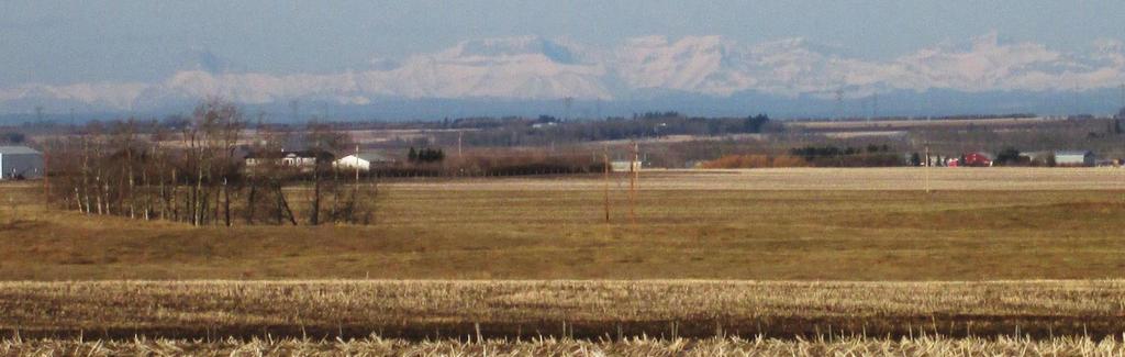
7 Development Influences Map 1: Significant Features (see back of document) identifies the study area for this planning process and it illustrates the location of natural and man-made features that will influence the future growth pattern of the Town of Olds. Some of these features represent constraints to urban development while others are opportunities that can be used by the Town to help create an attractive and interesting urban environment. The presence of two provincial highways that bisect the Town as well as the CP rail line are constraints to residential development as they move a large volume of vehicular and rail traffic with the attendant noise that comes from these forms of transportation. These same pieces of transportation infrastructure, however, also should be viewed by the Town as opportunities as they provide the access that is critical for thriving commercial and industrial uses. Careful planning is required to ensure that the appropriate land uses are targeted for lands adjacent to these key transportation links. In the northwest part of Olds, the presence of the former wastewater treatment plant and solid waste transfer station are constraints to residential development in this part of the community. The Province of Alberta mandates setback distances from wastewater facilities and this Plan must account for this setback by identifying appropriate land uses for property in this part of the community. The former wastewater lagoon is currently being decommissioned and remediated; a 300 m setback from the edge of the wastewater treatment plant applies to all residential uses until the site has been fully remediated. These facilities may be relocated during the planning period and if this occurs, further opportunities for residential development may emerge in the northwest part of Olds. The presence of Olds College in the community presents a significant opportunity for the Town. The College is home to talented staff and students that have the potential to generate ideas that will lead to economic development opportunities. The College does own much of the land to the east and the southeast of Olds and this limits the Town s growth in these directions. There are no significant streams or rivers that exist as constraints to development in the plan area but there are low areas, ponds, and wetlands that will affect development, particularly as Olds grows to the south. More detailed planning for these areas will need to study ways to transform these potential natural constraints into opportunities that make for an attractive urban setting. Significant pipeline right-of-ways are located throughout the plan area. This infrastructure represents a constraint to development because the corridors are undevelopable and the need to cross these corridors with municipal services adds costs. In the future, however, these corridors can be viewed as an opportunity for the Town as they can easily accommodate trails for pedestrian and bicycle use. Many of the pipelines and wells to the south and west of Olds contain sour oil/gas. Based on the operating level and concentration of sour gas present, the setback from these facilities can be as much as 1,500m for any urban centre, residential development and public facility where a large number of people may gather. The exact setback distance can vary over time in response to how the well or pipeline is operated. A firm setback distance will only be available when urban expansion and/or development is proposed. As in all communities, the availability of water and sewer servicing is an important determinant of the pattern of future growth. The terrain in the Olds area is relatively flat which in some cases makes development easier but which can also make development more difficult when seeking appropriate grade for wastewater and storm sewer lines. 5
8 3.0 Vision and Principles Our Vision of Olds in 2046 It is 2046 and the Town of Olds has surpassed a population of 18,000 residents and is now the City of Olds. Olds is known as the Connected City and is the gateway to the connected world. Residents appreciate Olds and regard it as a desirable community to call home offering a good balance between economic opportunities and high quality of life. Community facilities, amenities and social opportunities are part of the attraction along with Olds commitment to environmentally responsible growth and the creation of a sustainable community. Through its internationally recognized engagement policy, the City of Olds has worked alongside the community to accomplish a multitude of shared goals and achievements. Olds success as a safe, healthy community in which to live and raise a family is built on inclusiveness and caring. Housing options are abundant and diverse to meet the needs of young families, older families, single person households, students, seniors and renters. Specialized housing assistance is available for those in need along with a broad range of family support services such as child care and access to health care professionals. Amenities are available for youth and the physically active in the form of soccer fields, ball diamonds, community gyms and more. Younger and older residents interact at Olds library, schools and cultural centre to recreate and enjoy the performing arts. Olds neighbourhoods meet the needs of many types of households and families and provide many facilities and services near people s homes. Uptowne Olds is a vibrant focal point and identifying feature of the community. Its mixture of uses provides commercial, professional and community services to all residents. A rich stock of historically significant architecture and a welcoming pedestrian environment draw residents and tourists to Uptowne Olds and distinguish it from other commercial areas serving the town and surrounding area. Commercial activities and services available in Olds have expanded to feature small scale locally owned businesses and larger national chain outlets in response to residents needs. There is a broad range of employment opportunities in Olds as new and existing businesses build on the strategic advantages a location in Olds offers within the growing Calgary-Edmonton Corridor. High paying, skilled job opportunities, aided by the mutually beneficial relationship between business and Olds College, enable workers of all ages to find local employment in diverse fields. Value added production, building on the rich agricultural possibilities of the region, and increased availability of a skilled, local workforce supports many businesses and provides both stability and growth in the community. The thriving agricultural presence of the Olds Regional Exhibition (ORE) in their southern location adds to the employment prospects for Olds. Education and community based learning facilities enable lifelong learning, foster creativity and knowledge amongst Olds residents. While growth has been encouraged, it has been managed to maintain Olds small town atmosphere, charm and quality of life. Olds has developed in an environmentally responsible manner. Efficient use of land and mixing of compatible land uses supports pedestrians and cyclists. Natural features are preserved for their function and beauty. Parks and green spaces extend throughout the town and are a well-used and treasured part of the urban landscape. Environmental stewardship is a source of pride for the community as water conservation, composting, recycling and energy conservation have become common practices in everyday life. Olds has developed a celebrated waste management system featuring the early adopter Waste to Energy Policy, and has worked to ensure that Olds is a brownfield free city. 6
9 Offering local and regional transit systems, a well-connected pathway system, leading edge roadways for driverless cars, and a multitude of electric car recharging modules, Olds offers a variety of transportation options to residents and visitors. The major open space and integrated trail system and proximity of housing, jobs and services encourage walking and bicycling. A good roadway system provides connections within and through Olds and links to other communities. Public transportation, walking and bicycling are widely used in addition to private automobiles. Residents and businesses have access to high quality, broadband telecommunication connections to the broader Central Alberta community and the world. Olds residents are proud of the community they live in and have helped build. Well-kept and landscaped boulevards and private yards add to the sense of open space and greenery within the community. Streets are multi-functional and used for sidewalks, benches and landscaping to create attractive streetscapes throughout Olds. The community is well served with municipal infrastructure (roads, water, sanitary sewer, and storm sewer) and protective services (fire, police, ambulance) to meet residents needs. The energy-efficient multi-purpose City Hall in the heart of Olds is a gathering place for the community and acts as an example for sustainable building practices. Olds is an inclusive community that is accessible to all and encourages members of the community to come together for recreation and social activities. Residents and neighbours look out for one another to foster a safe and secure environment. Future residents are attracted by the qualities of small town living with city amenities available in Olds. Plan Principles In striving towards our future vision, the Town of Olds is committed to the principles of sustainable community development. The following principles guide these efforts: 1. Social sustainability where needs such as housing and supportive services are identified and addressed in an inclusive manner and opportunities are created to bring people together as a community, as friends, and as an extended family; 2. Environmental sustainability based on our understanding and accountability for the impact that our choices have on the natural environment that we all share and the need for a healthy environment and natural processes to sustain our community; 3. Economic sustainability where diverse and stable businesses create and maintain employment opportunities and contribute to a community catering to a broad range of lifestyle options; 4. Cultural sustainability where we embrace our collective heritage and culture and share them with each other, newcomers, visitors and neighbouring communities; and 5. Sustainable governance based on our broad, inclusive and participative decision making and leadership practices as a community that is committed to growing together to reach our sustainable future. 7
10 4.0 Future Land Use Concept Goal To plan and manage growth and development in an environmentally, socially and fiscally sustainable manner that benefits the community s existing and future residents and businesses. The Future Land Use Concept (Map 2) identifies the preferred long range growth and land use pattern as envisioned by the Town. This includes the type and location of different land uses, the general location of major roads, and possible growth areas. The Future Land Use Concept may be further defined through the preparation and adoption of statutory and non-statutory plans for smaller geographic areas of the Town. Key concepts shown in the Future Land Use Concept include: Residential growth to the west, south and north recognizing that residential expansion to the west and southwest is limited by the presence of constraints and that the north direction poses fewer limitations; Sufficient land is assigned for residential use to accommodate long term growth up to and beyond 2046 with the ability to add 23,000 to 27,500 residents to the current population of approximately 9,200 (based on 2.31% per year growth rate Olds population is projected to reach 18,221 by 2046); Future school sites to meet the needs of the projected 6,250 students across all grade levels; Major open spaces within new residential areas, some in combination with school sites, and preservation of major wetlands and similar natural features; Commercial land in locations accessible to future residential areas and visible along the major thoroughfares (Highway 27 and Highway 2A) to meet the needs of an expanding population, create employment areas and contribute towards a balanced assessment base; Balancing of future highway commercial concentrations on the west and east sides of the Highway 27/46 Street corridor with the Uptowne area as the central hub of the town s main commercial areas; Industrial areas for long-term expansion located to avoid or minimize conflict with non-industrial uses, provide choice between three major industrial areas in the southeast, northeast and the west, and provide some employment opportunities relatively close to residential areas; Recognition that the more urban components of Olds College (e.g. main academic buildings) are part of the town while the more rural components of Olds College (e.g. crop research fields) will remain part of the county; and Major road network comprised of highways, arterial roads and collectors roads to manage the future increased volume of vehicle traffic with a focus on establishing a grid of highway/arterial roads to move traffic around rather than through major residential areas. 8
11 In reading the Future Land Use Concept, it is important to remember that it is a conceptual, high level view of the town s future physical form and distribution of major areas of activity. Some important elements, such as the intent to build an integrated trail and pathway system as part of the Town s recreation and transportation infrastructure, are not clearly shown on the map. These concepts are instead discussed in the text of the plan and will become more evident as more detailed area structure plans and local plans are prepared. The Future Land Use Concept is not to be viewed or interpreted in isolation from the goals, objectives and policies expressed throughout the text of the Municipal Development Plan. Also, identified future land uses, goals, objectives or policies related to lands outside the Town s current boundaries are statements of future intent or preference and are not binding on the owners of these properties. The Land Use Bylaw shall be utilized to implement the MDP policies through the designation of land use districts and the application of development standards for each district. In this regard, the boundaries between the land uses shown on Map 2 are not to be rigidly interpreted and the specific boundaries shall be determined through the designation of the Land Use Bylaw districts and subsequent creation of new property lines through the subdivision process. Policies 4.1 Location of Major Land Uses The Town shall direct future residential, commercial, industrial and open space uses to the areas conceptually show for each of these major land uses on the Future Land Use Concept (Map 2). 4.2 Boundaries and Size of Areas for Major Land Uses The boundaries between each major land use category and the relative size of each area shown on the Future Land Use Concept (Map 2) shall not be rigidly interpreted. Where a more detailed plan in the form of an area structure plan or area redevelopment plan is available, the boundaries and areas of specific land uses in these adopted plans shall prevail. Where different Land Use Bylaw Districts have been applied, the boundaries and areas of specific uses of the Districts shall prevail. 9
12 5.0 Growth Management Growth management is the process of accommodating changes and growth in the community, while directing the location and pattern of development. It seeks to ensure that the quality of life in Olds is maintained as the size of the community increases. Growth management is also a tool to ensure that development contributes to, and works towards, making the community s future vision as a sustainable community a reality. A lack of coordinated growth management can lead to land use conflicts and inefficient servicing patterns. This, in turn, can affect the ability of the Town to provide municipal services in a cost effective manner and achieve the optimal use of limited funds for capital improvements and upgrades. Goals To use land and infrastructure efficiently while encouraging a greater mix of land use and socio economic activities in both new and established areas. To identify and secure the land and infrastructure capacity that is required to meet future growth needs. Objectives (a) (b) (c) Ensure an appropriate supply of land and infrastructure is available to accommodate future growth. Encourage growth in locations that can utilize existing or planned infrastructure capacity and reduce overall travel demands Work with Mountain View County to identify and protect future growth areas for both municipalities. Policies 5.1 Growth Strategy The Town shall monitor the growth of the town and should update its short-term (up to 5 years) growth strategy on an annual basis and its long-term (5 to 30 years) growth strategy at least every five years. 5.2 Relationship with Mountain View County The Town shall work with Mountain View County to have an up-to-date Intermunicipal Development Plan that identifies and protects the Town s future growth areas as identified in the Future Land Use Concept (Map 2) while respecting the County s proposed growth areas and land use planning aspirations. 5.3 Efficient Utilization of Infrastructure The Town shall give priority to the efficient utilization of existing and planned capacity in utility and transportation infrastructure in determining appropriate short-term growth directions. 10
13 5.4 Contiguous Growth The Town should encourage development that is contiguous to the existing built-up area and takes advantage of proximity to existing infrastructure. This aim for contiguous development may not always be possible based on the timing for development desired by individual landowners/developers. The desire to encourage contiguous development shall not be applied in a manner that establishes a monopoly over the supply of available serviceable land. A landowner/developer wishing to proceed with development of an area that is not contiguous shall be required to bear the full cost of any infrastructure improvements needed to support their proposed development. 5.5 Balancing Residential and Non- Residential Assessment The Town shall seek to manage the amount of residential land and non-residential land in its long range land use plan to be able to achieve a 70:30 split between residential and non-residential assessment upon full build out of the available land. 5.6 Annexation The Town shall propose periodic annexations of land from Mountain View County for residential purposes and shall seek to maintain at least a 20-year supply of land for residential uses within the Town boundaries at all times. 5.7 Joint Growth - Commercial and Industrial Uses The Town shall work with Mountain View County through the Growing Together framework and the Intermunicipal Development Plan to meet the combined needs of the Town and County for commercial and industrial lands. 5.8 Protection of Agricultural Lands The Town shall ensure an orderly progression of development to minimize land use conflicts with and protect existing agricultural operations and land until it is required for urban development. The Town shall seek to develop at an intensity of development that minimizes the rate at which agricultural lands are converted to nonagricultural use. 5.9 Location of Employment Opportunities The Town shall seek to reduce travel demands by assessing the potential for locating appropriate employment opportunities in or adjacent to residential areas through more detailed area structure plans and area redevelopment plans. 11
14 5.10 Redevelopment and Intensification The Town shall undertake reviews of potential redevelopment and intensification opportunities in the established areas. This may take the form of an area redevelopment plan and/or regulations set out in the Land Use Bylaw Allocation of Costs of Growth The costs of servicing newly developing areas shall be borne by the Developer in accordance with policies approved by Council Municipal Investment in Infrastructure and Services Any public expenditure for improvements or services proposed within this plan shall be subject to the Town s annual operating and capital budgeting process and shall be evaluated in relation to the overall needs of the community and town-wide priorities Existing Sour Gas Facilities The Town shall consult with the Alberta Energy Regulator (AER) regarding the potential for new development in the vicinity of existing sour gas facilities and shall refer to the AER, applications for subdivision and development of land, in accordance with the Subdivision and Development Regulation as approved under the Municipal Government Act New Sour Gas Facilities The Town shall monitor proposals for new sour gas and related facilities within or adjacent to the Town s existing and future growth areas and determine on a case by case basis its position regarding such facilities New Oil and Gas Facilities The Town shall encourage oil and gas facilities and pipelines to be located beyond the identified future growth areas. Where it is not possible to avoid these areas, the Town shall encourage the use of alignments and locations that are conducive to future urban development Setback from Waste Transfer Site, Wastewater and Related Facilities Subdivision and development within the area identified as development setback from the waste transfer site and wastewater treatment facilities shall only be permitted in accordance with the Subdivision and Development Regulation. The Town may request a waiver of this setback from Alberta Environment. 12
15 5.17 Relocation of Waste Transfer Site The Town shall encourage the Mountain View Regional Waste Authority to relocate the existing waste transfer site on 70 Avenue to remove the impact of the associated development setback from existing and future growth areas of the town Development Adjacent to CPR Right-of- Way Subdivision and development of land adjacent to the CPR railway tracks shall be undertaken in a manner that mitigates the impact of rail operations on adjacent uses. The Town may require a noise study or other type of study (e.g. visual impact study, vibration study) that may, in the opinion of the Approving Authority, be considered necessary to properly evaluate subdivision and development proposals along the railway tracks Brownfield and Greyfield Redevelopment The Town shall promote the environmental remediation and repurposing of brownfield and greyfield sites within the town. The intent is to make good use of lands that are already serviced and typically occupy a prominent location along a major travel route. As part of this effort, consideration may be given to the proposed tax incentives outlined in the Municipal Government Act. 13
16 6.0 Urban Form and Design Urban form refers to the physical layout and design of Olds urban environment. It includes issues such as location of growth, density, street patterns, major transportation routes and systems, major open space areas and employment nodes. Urban design deals with the visual quality of the built environment. High quality urban design can enhance the distinctiveness of parts of the community and promote social objectives such as creating a strong sense of place and belonging and interaction amongst community members. It creates character and interest through such elements as the design of public parks, attractive streetscapes, and the contribution of individual buildings towards creating attractive outdoor spaces. Urban design can also influence the safety of the urban environment through the establishment of highly visible and lively spaces. Goal To create an attractive, safe, functional and stimulating physical environment where residents and visitors experience a strong sense of place and community pride. Objectives (a) (b) (c) Promote high quality architecture and design in commercial, industrial, institutional and residential development. Support and encourage innovative neighbourhood and building designs. Ensure public spaces are designed with community safety as a priority. Policies 6.1 Architectural Appearance and Visual Aesthetics The Town shall require a high quality of architectural appearance and visually attractive development along all major travel corridors into and through the town. Where necessary, specific requirements shall be added to the Land Use Bylaw. The Town shall work with Mountain View County to achieve a similar level of architecture and visually attractive development along the QE2 Highway, Highway 2A, Highway 46 and Range Roads 10, 15 and 20 leading into the town. The Town shall actively manage unsightly premises, which may have suffered vandalism or neglect of upkeep, and shall encourage Mountain View County to apply the same approach within their jurisdiction. 14
17 6.2 Infill Development The Town shall support infill residential and commercial development on vacant or underutilized parcels of land in established neighbourhoods, provided consideration is given to: compatibility in height, scale and design of adjacent buildings in the area; continuity with nearby streetscape and lot patterns; compatibility with surrounding land uses; appropriate landscaping, provision of parking / loading, and preservation of existing vegetation; integration and preservation of buildings considered to have historical and / or architectural significance; and capacity of municipal utilities and infrastructure unless otherwise directed in an area redevelopment plan. 6.3 Promoting a Compact Urban Form The Town should promote a compact and efficient urban form by facilitating infill development in existing residential, commercial and industrial areas, and gradually increasing the overall density of the Town. 6.4 Promoting Appropriate Mixed Use The Town should encourage the development of appropriately designed mixed use areas with retail and office uses, higher density housing, schools, institutional uses and other community facilities to minimize the need for new transportation infrastructure and encourage less reliance on the private automobile. 6.5 Promote Urban Design That Encourages Walkability The Town should promote urban design that encourages walkability by providing functional and attractive pedestrian linkages between adjacent neighbourhoods and the existing trails system, designing for universal accessibility, encouraging the development of active residential and commercial streetscapes, ensuring pedestrian crossings are clearly marked and by avoiding adverse microclimatic effects when designing streets, park spaces and pedestrian linkages. 6.6 Innovative Neighbourhood Designs The Town should encourage and be receptive to consideration of innovative neighbourhood designs that respond to economic, demographic and market conditions; that are in Olds interest and align with the goals, objectives and policies in this Plan. 6.7 Crime Prevention Through Environmental Design (CPTED) The Town encourages the use of Crime Prevention Through Environmental Design (CPTED) in the design of new developments to avoid the creation of areas hidden from view and isolated spaces, as well as provide clear sightlines, sufficient lighting and promote natural surveillance throughout the Town. 15
18 6.8 Fire Smart Principles The Town encourages consideration and incorporation of Fire Smart principles in the management of natural areas and lands on the perimeter of the built up area. This includes such concepts as purposefully removing or limiting materials that may fuel fires (e.g. grass fires) and put properties at risk. 16
19 7.0 Economic Development and Tourism In order to make Olds more economically sustainable, and an attractive place to reside, it is important to attract and retain business investment, create employment opportunities, and expand the local tax base. Economic development entails attracting new businesses seeking to enter the regional and provincial market, as well as providing an environment where existing businesses can thrive and expand. Creating an attractive community with high quality amenities and services is a vital component in attracting and keeping the skilled labour force that local businesses, including the tourism sector, require for success. Goal To foster local business retention and to attract diverse, long term economic growth, including tourism, through a partnered approach to marketing Olds and Central Alberta. Objectives (a) (b) (c) (d) (e) (f) Develop and maintain partnerships for economic development including a strong relationship with Olds College. Create a positive and competitive business climate. Ensure an adequate supply of commercial and industrial land. Evaluate regional market opportunities for innovation and diversification in Olds economy. Advocate investment into education and training programs to promote a skilled labour force. Promote and enhance Olds assets to increase the attractiveness of Olds as a tourism destination. Policies 7.1 Regional Cooperation in Promoting Economic Development and Tourism The Town should continue to be an active partner in promoting regional economic development opportunities in Central Alberta and, working with Mountain View County and other municipal area partners, promote development in the particularly in Mountain View area. 7.2 Adequate Supply of Serviced Land The Town should ensure an adequate supply of serviced industrial, commercial and residential land. This may be accomplished by annexing additional lands to the Town of Olds and/or working with Mountain View County on joint growth areas and preparing more detailed area structure plans and servicing concepts. 17
20 7.3 Creating a Positive Business Environment The Town should foster a competitive business climate through policies and actions that help maintain reasonable operating costs and streamline approval processes and timelines. 7.4 Economic Diversification The Town should pursue opportunities to diversify the local and regional economic base by promoting and attracting value-added industries and by working with Olds College to develop industries related to the College s areas of educational focus and expertise. 7.5 Attracting and Maintaining a Skilled Labour Force The Town should encourage the efforts of businesses, employers, community agencies, Olds College and other educational institutions and senior levels of government to attract and maintain a local skilled labour force to meet the expanding needs of industry and commerce. 7.6 Marketing and Image-Building The Town should continue to work co-operatively with public, not-forprofit and private sector organizations in promoting business and tourism development in and around Olds. 18
21 8.0 Heritage Conservation Heritage conservation has many cultural, social and economic benefits. Conserving heritage enables a community to retain and convey a sense of its history, and provides aesthetic enrichment as well as educational opportunities. Heritage resources help us understand where we have come from so that we can appreciate the link in our built environment from past, to present, to future. Historic buildings become landmarks and touchstones for the community, and the retention of historic elements serves to moderate the impact of rapid change. Key landmark buildings, monuments, historic homes and period streetscapes all add to the vibrancy and character of Olds. Goal To conserve and interpret heritage resources as an expression of community identity and pride and to encourage the preservation of significant sites and buildings. Objectives (a) (b) (c) Encourage the conservation and retention of buildings of historic or architectural significance. Recognize the importance of Olds heritage in creating a unique sense of place and fostering community identity. Ensure compatible development with heritage properties. Policies 8.1 List of Historically Significant Properties The Town shall maintain an inventory of historically, architecturally and culturally significant properties and, where appropriate, shall consider the protection of properties with municipal or provincial historic designation. 8.2 Partnerships for Heritage Conservation The Town shall cooperate with other orders of government, private agencies and individuals in the preservation of historic sites. 8.3 Community Awareness The Town shall promote community awareness about the importance and value to the community of heritage conservation and shall also promote heritage preservation awareness programs such as historic walking tours. 19
22 8.4 Compatible Development Through provision in the Land Use Bylaw, the Town should require development and signage proposals complement the design, character, or appearance of historic buildings. 8.5 Facilitate Adaptive Reuse Wherever possible, the Town should facilitate the adaptive reuse of historic buildings in order to preserve the identity and history of Olds built environment, and demonstrate a commitment to sustainable building techniques. To meet provincial and municipal building codes, the Town shall also consider building code equivalencies where necessary and appropriate. 8.6 Use of Heritage Buildings for Civic Purposes The Town should consider the adaptive reuse of historical buildings for civic functions and facilities and make them a priority in order to demonstrate civic leadership. 8.7 Heritage Management Plan The Town shall maintain the Heritage Management Plan as a strategy for ensuring Olds heritage resources and sites are protected well into the future. 20
23 9.0 Environmental Management Environmental management and the development of Olds as an environmentally sustainable and responsible community is a priority. Preservation of significant natural features is an important contributor to the high quality of life enjoyed by residents. Integrating these features into the open space system helps create an attractive and desirable community. It reinforces the interrelationships and linkages between urban dwellers, their surroundings and the natural systems that residents depend upon. Environmental management also entails consideration of how urban development can impact environmental systems. Efficient use of land, reduction of air pollution, protecting water quality, management and enhancement of open space natural features (natural capital), and efficient use of resources are important elements in Olds efforts to be environmentally sustainable. Goal To preserve significant natural areas and create and maintain attractive, clean and ecologically responsible natural and built environments. Objectives (a) (b) (c) (d) Promote environmental sustainability principles in land use planning decisions and development practices. Recognize the value and contribution natural areas and functions make towards quality of life in an urban setting. Conserve and sensitively incorporate natural features as an integral part of the open space system and utility system. Support programs and initiatives that increase awareness and public involvement in environmental management and conservation. Policies 9.1 Regional Approach to Conservation The Town shall work with Mountain View County and other local and regional organizations to create and implement a regional approach to the conservation of key natural areas and functions. This process should begin with an inventory of existing natural spaces within and surrounding the town. 9.2 Timing of Conservation Planning and Efforts The Town shall recognize that planning and efforts to conserve natural features in and around Olds must be initiated well in advance of urban expansion or development of the surrounding lands. This will require conversations with the owners of features that are identified for conservation well before lands are annexed or planned in detail for urban expansion or non-agricultural use. 21
24 9.3 Environmental Reserve - Lands Unsuitable for Development Through the subdivision process, the Town shall require that lands considered unsuitable for development (e.g. due to steep slopes or being subject to flooding or consisting of a natural drainage course) are dedicated as environmental reserve in accordance with the provisions of the Municipal Government Act. 9.4 Environmental Reserve - Lands Adjacent Water Bodies and Water Courses When lands adjacent to water bodies or water courses are subdivided, a strip of land shall be dedicated as environmental reserve to provide a buffer and provide public access. The width of the required dedication shall be established by the applicable area structure plan or the Subdivision Authority where there is no approved area structure plan. The minimum width of the strip of land to be required shall be 6m. 9.5 Use of Environmental Reserve Lands dedicated as environmental reserve shall remain in their natural state and/or be used as part of the public trail system where necessary to ensure a continuous, integrated trail system. 9.6 Environmental Reserve Easements Despite Policy 9.3 and Policy 9.4, the Town may use an environmental reserve easement in place of the dedication of an environmental reserve parcel where public access to the lands in question is not desirable. 9.7 Crown Ownership of Wetlands Where the Crown (Province) claims ownership of a wetland classified as permanent or semi-permanent under the Alberta Wetland Policy, the wetland shall be treated as a water body and environmental reserve dedication shall be provided in accordance with Policy 9.4 and Policy Environmental Reserve Wetland Value A The Town shall require all wetlands that are given a wetland value of A under the Alberta Wetland Policy to be dedicated as environmental reserve at the time of subdivision. Where subdivision is not proposed these wetlands shall be protected through wetlands regulations set out in the Land Use Bylaw. 9.9 Environmental Reserve Wetland Value B The Town shall require all wetlands that are given a wetland value of B under the Alberta Wetland Policy to be dedicated as environmental reserve at the time of subdivision. Where subdivision is not proposed these wetlands shall be protected through wetlands regulations set out in the Land Use Bylaw. The boundaries of a wetland with a wetland value of B may be modified to accommodate logical roadway, utility alignment and lot patterns. 22
25 9.10 Environmental Reserve Wetland Value C and D The Town shall not seek dedication as environmental reserve or preservation of wetlands that are given a wetland value of C or D under the Alberta Wetland Policy Compensation for Wetland Loss The Town may consider proposals for replacement of an impacted wetland within the same quarter section in which the impacted wetland is located on a case by case basis. When replacement of an impacted wetland does not occur within the same quarter section as the wetland that is being impacted, the Town s preference is that any compensation to be provided to offset the displacement of wetland area or loss of wetland value is provided within a 3 to 5 mile distance of the Town of Olds. The compensation area shall not be located in an area identified for future urban expansion under this plan or the Intermunicipal Development Plan with Mountain View County unless provision for the creation of the replacement wetland has been made in an approved area structure plan Conservation Reserve Upland Features The Town may designate lands that cannot be obtained as environmental reserve as conservation reserve where the lands contain an environmentally significant feature that the Town wishes to conserve. Candidate sites may include existing sizeable (more than 1 acre) stands of trees or areas covered in native prairie grasses or similar features. The details for each candidate site for designation as conservation reserve shall be contained in the area structure plan that applies to the site Conservation Tools In addition to environmental reserve dedication and possible conservation reserve designation, the Town shall investigate the possible use of such tools as land purchases, land swaps, tax incentives, leasing and conservation agreements or easements and other similar mechanisms as a means of conserving natural features both within and in the areas surrounding Olds Environmental Education and Awareness Initiatives The Town should investigate the establishment of a stewardship program or similar initiative to, among other things, provide education, promote awareness and encourage residents to value biodiversity, plant native vegetation, naturalize their property and assist in monitoring the health of the Town s natural areas. 23
26 9.15 Urban Forestry The Town shall implement an urban forestry initiative that includes an annual investment in new tree planting on public lands that are under the control of the Town. This may include landscaping and revegetation of existing open spaces and boulevards and the inclusion of trees in new open space developments Green Infrastructure The Town shall incorporate existing natural features as part of the overall infrastructure systems. This may include using existing wetlands as storm water management facilities wherever possible and planting shrubs and trees to improve air quality along major roads and within industrial areas Air Quality The Town shall promote efforts to improve air quality and may work with other stakeholders to monitor air quality and establish outreach and awareness programs that promote improved air quality Green Buildings The Town shall encourage developers and builders to follow the voluntary LEED TM green building rating system administered by the Canadian Green Building Council or follow sustainable building practices compatible with LEED TM standards. Sustainable building practices include: Minimizing storm water volumes through the installation of roof top gardens or on-site cisterns; Installing water saving plumbing fixtures; Using water efficient landscaping; Increasing energy performance through reduction in demand, harvesting site energy and efficient building design; Reducing waste by extending the life of existing buildings and using local and recycled building materials; Improving indoor environmental quality through efficient heating and ventilation; and Reducing light pollution and energy costs by installing outdoor lights that are designed to minimize escape of light to the sky or beyond the site Town Owned Buildings The Town shall explore and, where feasible, implement programs and policies intended to increase sustainable building practices throughout Olds. As part of this effort, the Town shall be a civic leader by requiring sustainable building practices in the design and construction of new Town-owned facilities Light Pollution The Town shall encourage the use of Dark Sky principles in the design and implementation of outdoor lighting for new development and redeveloped sites. The intent is to avoid casting unwanted and unnecessary lighting towards the sky and adjacent properties. 24
27 9.21 Renewable Energy The Town shall encourage the use of renewable energy technologies, such as photovoltaic cells and small scale wind turbines, where the use of such technologies does not cause incompatibilities with nearby residential uses. 25
28 10.0 Housing and Neighbourhood Design Neighbourhoods are living entities which undergo demographic, social, economic and physical change over time. These changes include such things as altering preferences and needs in housing and changing views on the types of uses that should be within or close to the neighbourhood. Neighbourhoods experience life cycle effects such as population gain, peak and loss. More sustainable neighbourhoods are those that are able to adapt over time, due in large part, to the variety of housing types that are available. Well designed and sustainable neighbourhoods are a critical building block in making Olds more sustainable overall. Goal To create inclusive neighbourhoods containing a range of housing opportunities and related compatible uses supporting the needs and preferences of a variety of household types and income levels. Objectives (a) (b) (c) (d) Promote the establishment of neighbourhoods that are designed based on the principles of social, environmental and economic sustainability. Provide for a mix of housing types and forms to meet a variety of lifestyles, special needs, life cycle demands and market preferences. Encourage re-investment and infill in older neighbourhoods. Promote the creation of affordable and special needs housing. Policies 10.1 Location of Major Residential Areas The Town shall direct future residential development to the areas conceptually shown for residential uses on the Future Land Use Concept Map. 26
29 10.2 Residential Density for New Neighbourhoods The target residential density for new neighbourhoods shall be an average that falls between 11 to 13 dwelling units per gross developable hectare. For the purposes of this policy, gross developable hectare is all lands in title less lands to be dedicated as environmental reserve and lands within a pipeline right of way. This target shall be calculated over large tracts of land (e.g. larger than 40 acres) to enable lower density areas to be offset by higher density areas within the same neighbourhood or planning area. It applies to new proposed neighbourhoods only. Undevelopable lands and lands for commercial and industrial uses shall not be included in the calculation. Residential densities that are higher than the above target shall be encouraged where there is sufficient capacity in the major municipal utility infrastructure Housing Mix The Town shall require a mix of housing types and forms in all residential neighbourhoods and shall avoid excessive concentration of any single type of housing. Duplex and multi-family residential units shall make up at least 30% of the total housing units in a residential neighbourhood unless otherwise approved in an area structure plan Housing Types and Forms The Town shall encourage the creation of a wide variety of housing types and forms including dwelling units in combination with compatible non-residential uses, live-work units and secondary suites Transition Between Housing Types The Town shall encourage transitions from one housing type to another to occur on a street block by block basis. Housing types that front one another across a street shall be similar. Transitions between types shall occur across side yards and rear yards or lanes and open space areas Higher Density Residential Development The Town may consider the development of higher density residential uses (4 or more units) in accordance with the following guidelines: The development is adjacent to or in close proximity to collector and/or arterial roads. The use is located at the periphery of low density residential neighbourhoods. The use is compatible with surrounding land uses. If located in an existing neighbourhood, the site is suitable for the proposed form of infill development. The development is in a location where all necessary services and amenities can readily be provided. 27
30 10.7 Affordable and Special Needs Housing The Town of Olds encourages the provision of affordable and special needs housing in the community. Specifically: The Town will encourage the Government of Alberta and the Government of Canada to fulfill their mandates with respect to the provision of affordable housing. The Town intends to partner with private, public and non-profit organizations in the creation of affordable housing and special needs housing. For this purpose, affordable housing shall be defined as appropriately designed dwelling units that are accessible to households below Olds median income Innovative Housing The Town of Olds should encourage innovative or alternative forms of housing which broaden the range of housing choice as well as address the issues of affordability consistent with policies of this Plan Design and Architecture of Residential Structures The Town of Olds shall encourage high quality design and architectural appearance for all new and renovated residential structures. This may be put into effect through criteria and guidelines established in the Town s Land Use Bylaw, area structure plans or area redevelopment plans Inclusion of Nonresidential Land Uses The design of new neighbourhoods shall be encouraged, but not required, to include compatible non-residential uses, such as local commercial services and public uses that serve the needs of area residents in an effort to create neighbourhood identity and bring basic services closer to residents Home Occupations and Bed and Breakfast Establishments The Town shall support the development of home occupations and bed and breakfast establishments in residential neighbourhoods as a secondary use of a dwelling unit and where compatible with residential uses. 28
31 10.12 Infill and Intensification in Older Neighbourhoods Residential and mixed use infill projects that make a positive contribution to the image, overall architectural appeal, and quality of older neighbourhoods shall be encouraged where there is adequate capacity in the major municipal infrastructure to accommodate the impacts of the project. The following should be taken into account: Similar placement on the lot to other buildings on adjacent properties in relation to front and side parcel boundaries; Sensitive increases in building mass with landscaping and architectural treatment used to achieve transition between larger and smaller buildings; Preservation of existing mature vegetation to the greatest extent possible; and Positive contribution to the streetscape in terms of building appearance, landscaping and parking areas. Where necessary, as determined by Council, the Town may establish infill guidelines for older neighbourhoods through the Land Use Bylaw Student Housing Student housing needs and issues shall be reviewed as part of any area redevelopment plan prepared by the Town. The need for student housing shall be considered when designing new neighbourhoods or reviewing higher density or mixed use infill projects Secondary Suites The Town shall consider development of secondary suites in low density residential areas to broaden the range of available, affordable housing options Small Lot Residential Development The Town may consider creating one or more districts in the Land Use Bylaw to facilitate the development of single detached dwellings on small or narrow lots (e.g. less than 50 ft traditional frontage and less than 120 ft traditional lot depth). 29
32 11.0 Commercial Development Commercial development serves many purposes and is a vital component of a community. It provides local and regional goods and services, acts as employment areas and contributes to the health and vitality of the local economy. Concepts for commercial development evolve and there are a variety of forms that may occur. Local convenience stores, plazas, malls, large format retailers and power centres are among the types of commercial development possible. Goal To support a vibrant commercial sector that services both local residents and the regional market. Objectives (a) (b) (c) (d) Identify locations and policies for long term commercial development. Improve the quality and aesthetics of development along major commercial corridors. Recognize emerging trends in retailing and commercial land use where appropriate. Promote commercial development that generates opportunities for local employment. Policies 11.1 Location of Commercial Development The Town shall direct future commercial development to the areas conceptually shown for commercial uses on the Future Land Use Concept Map Highway 27/46 Street Commercial Corridor The Highway 27/46 Street commercial corridor shall be the primary highway commercial area within the Town. Opportunities for intensification of land use, mixed use development and improvements to make the corridor more pedestrian friendly shall be explored. Mixed use development in this corridor shall consist of commercial development at ground level, with residential development only being considered behind a commercial use at ground level, or above a commercial use. 30
33 11.3 Quality of Commercial Development The Town shall ensure, through performance standards contained in the Land Use Bylaw, that landscaping, building placement, building form and architectural treatment of commercial development provides a high quality visual appearance. Commercial developments shall provide for safe and convenient onsite vehicular, bicycle and pedestrian movement. Where necessary, adequate buffering between commercial and nearby existing or future residential areas shall be provided to minimize noise, traffic, light and visual impacts Location of Local Commercial Sites The Town shall support the development of local neighbourhood convenience commercial sites in select locations on major arterial and collector streets and shall prohibit such uses from locating adjacent to school sites. Care shall be taken to choose sites which minimize land use conflicts with nearby residential properties but at the same time, provide convenient access to neighbourhood patrons Revitalization of Older Commercial Properties The Town will encourage the revitalization and adaptive reuse of existing underutilized or vacant commercial properties Mixed Use Nodes The Town may consider the creation of mixed use nodes incorporating commercial and residential uses and other compatible uses at the highway and local commercial areas shown on the Future Land Use Concept map located along an arterial road. Mixed use development in these locations shall consist of commercial development at ground level, with residential development only being considered behind a commercial use at ground level, or above a commercial use. 31
34 12.0 Uptowne Olds Uptowne Olds (our name for our Downtown) functions as the business, administrative and cultural centre of the community. It is a mixed use area that includes commercial, industrial and residential uses and the place where Olds began. It is an important element of Olds image in the eyes of residents, investors and visitors. Its vitality and health is a reflection on the community as a whole. Diversity, intense development and linkages to other parts of the community are key elements in revitalizing and maintaining a strong and vibrant town core. Goal Encourage the continued growth and intensification of Uptowne Olds as a vibrant mixed use centre that is a focal point for the community and is an attractive place to shop, work, live and play. Objectives (a) (b) (c) Reinforce the Uptowne area as a business, administrative, government and cultural centre. Promote and encourage higher-density residential development in or near Uptowne. Maintain an active Uptowne area by promoting diversity, intensity and linked development. Policies 12.1 Role of Uptowne The Town shall support the on-going redevelopment of the Uptowne as the centre and heart of the town and as the primary area for the highest level of administrative, retail, office, institutional, and cultural and entertainment facilities. As part of this effort, the Town shall implement the recommendations of the Uptowne Olds Area Redevelopment Plan Infill and Intensification Opportunities The Town shall promote opportunities for infill and intensification within Uptowne in order to facilitate a mixed use and compact urban form, utilize existing infrastructure efficiently and increase the range of services and amenities available to residents and visitors. 32
35 12.3 Uptowne Housing Strategy Wherever possible, the Town shall support the development of higher density housing in or near Uptowne including the conversion of commercial and industrial uses to residential uses where appropriate. In acting on this policy, the Town shall recognize that residential uses in Uptowne will be subjected to more noise and traffic than is typically considered acceptable in a predominantly residential area and shall accept this as one of the trade-offs associated with creating residential opportunities in the town core Pedestrian Oriented Design Standards New development and major redevelopments in Uptowne will be encouraged to use pedestrian oriented building and site design (building entrance close to or directly accessible to the public sidewalk) rather than vehicle oriented designs (parking lot separating building from public sidewalk) wherever possible Parking Standards The Town shall ensure through the Land Use Bylaw that provision is made for sufficient on-street and off-street parking in the Uptowne area. 33
36 13.0 Industrial Development Land for industrial development opportunities, in locations that meet the needs of a broad range of industrial activities, is a vital part of overall community planning. Industrial uses and locations serve as major employment areas, contribute to the standard of living enjoyed by residents and supplement the residential tax base to fund services provided to residents. Successful industrial areas rely on ready access to regional and provincial transportation infrastructure, support services, and skilled labour. Locations for a range of industrial activities should be free of potential constraints so as to not hinder future industrial expansion. The ability to expand Olds industrial land base is key to the community s long-term economic success and sustainability. Goal To ensure that there is sufficient serviced industrial land available to attract and accommodate a wide range of industrial development in the future. Objectives (a) (b) (c) (d) Maintain an adequate supply of serviced industrial lots. Encourage existing industries to maintain and expand their operations. Attract a broad range of new industrial development to the town. Avoid conflict between industrial uses and other land uses. Policies 13.1 Location of Industrial Land Uses The Town shall direct future industrial development to the areas conceptually shown for industrial uses on the Future Land Use Concept Map Maintaining an Adequate Supply of Industrial Land The Town shall seek to ensure that an adequate inventory of serviced industrial sites of various lot sizes and type (light and general) to meet the needs of business and industry Development Standards The Town s Land Use Bylaw shall contain development standards for industrial sites including building placement and design, landscaping and screening of storage and parking areas, signage and intensity of development, while recognizing the industrial nature of these areas. 34
37 13.4 Land Use Compatibility with Industrial Development The Town, through provisions in detailed plans and the Land Use Bylaw, shall ensure that adequate separation distances and transition between industrial and non-industrial uses are maintained in locating any industry that may create land use conflicts with regard to noise, dust, vibration, smoke, and odour or pose safety and risk management issues Truck and Dangerous Goods Routes to Industrial Areas The Town shall ensure that industrial areas are planned so as to have direct access to truck routes, highways, and railways to the greatest extent possible Promoting Environmentally Friendly and Innovative Industrial Uses The Town shall encourage the development of more innovative and environmentally friendly industrial employment centre concepts such as business parks, high tech campuses, research parks, and ecoindustrial parks. 35
38 14.0 Parks, Recreation, and Culture The parks and open space system is a highly valued aspect of the community. The recreational and cultural opportunities provided contribute greatly to the satisfaction of residents. Individuals and groups are able to pursue a wide range of activities based on their differing interests and abilities. Major open space, recreation and cultural facilities foster and encourage interaction among community members, as well as providing venues for individual development. Health and wellness in an urban setting can be significantly influenced through the provision of easily accessible recreation and cultural experiences in both indoor and outdoor settings. Planning for, and expanding, these necessities and amenities is part of ensuring that Olds remains a community offering a high quality of life. Goal To create an integrated, accessible and well-planned open space and parks system that supports a broad range of recreation and cultural opportunities catering to diverse age groups, income levels and skill levels. Objectives (a) (b) (c) (d) (e) (f) Provide open spaces and park areas that are functional and effective in satisfying the needs of residents and visitors to Olds. Develop a continuous system of pathways with linkages to parks and natural areas as Olds grows. Encourage sharing and multiple-use of parks and open space areas among a variety of user groups and activities. Provide a range of recreation and culture facilities that reflects the variety of recreational and cultural pursuits and interests in Olds. To work with Mountain View County to ensure that recreation and cultural facilities are provided for everyone in the region. To work with the Olds Regional Exhibition to relocate the livestock component of the Exhibition s operations to its property south of 54 th Street. Policies 14.1 Trails and Pathways Trails and pathways shall be designed and constructed to be universally accessible and in accordance with the direction provided through the Open Space and Trails Master Plan and the Olds Wayfinding Signage Master Plan, as amended from time to time. 36
39 14.2 Open Space Connections As new areas are planned and developed, the Town shall ensure the design of the parks and open space system provides linkages between major open spaces, connections between neighbourhoods and linear corridors Types of Parks The Town recognizes the benefits of providing a combination of active and passive parks in the community with a range of amenities for residents. The planning and design of parks will include consideration of the need for a variety of types of parks and the need to match park infrastructure and amenities with the needs of residents. This shall include creating shaded areas in each park. The types of parks to be provided and their respective functions, characteristics, and amenities shall be based on the Open Space and Trails Master Plan School Sites and Joint Use Sites The Town shall work with School Boards in the planning and location of school sites and joint use sites. Joint use of these sites between the Town, School Boards and community organizations shall be encouraged and pursued wherever practical. The Town shall seek a formal reserve agreement and joint use agreement with each of the School Boards having jurisdiction within the town Arts and Culture When planning parks and outdoor public spaces, the Town shall investigate opportunities to create and include performance/display space or activity space for arts and culture events Gathering Spaces In conjunction with streetscapes and other public realm areas, parks and open space shall be designed to create opportunities for area residents to gather and interact wherever possible Amount of Reserve Dedication The Town shall require that at least 10 percent of the gross developable land being subdivided be dedicated as Reserve (municipal reserve, school reserve and/or municipal and school reserve) in accordance with the provisions of the Municipal Government Act. Gross developable land excludes all lands that have been or will be dedicated as environmental reserve Form of Reserve Dedication In residential areas, the Town shall generally seek reserve dedication in the form of land. In non-residential areas, reserve dedication may be provided in the form of land, cash-in-lieu or a combination of land and cash as determined by the Subdivision Authority. 37
40 14.9 Use of Reserve Reserve lands, or cash-in-lieu, may be used for school sites, parks or recreational facilities Allocation of Reserve Reserve lands, excluding environmental reserve and conservation reserve, shall be allocated between Town and School Board purposes in conformance with the Reserve Agreement between the Town and the School Boards Reserve Dedication Priorities In recognition that the Town has a limited amount of Reserve dedication and there are several competing demands on Reserve land, the following order of priority shall be used in determining which parcels of land may receive credit as part of the ten percent dedication: First, elementary and junior high school sites and major neighbourhood open spaces identified in adopted area structure plans; Second, local parks, linear corridors and trail linkages identified in adopted area structure plans; Third, natural areas identified for conservation and not already dedicated as environmental reserve or secured through a conservation easement; Fourth, high school sites and community open spaces; and Fifth, buffer strips to separate potentially conflicting land uses. Lands used for storm water management purposes shall not be accepted as part of the required minimum reserve dedication Sites for Future Major Recreation Facilities Following an update of the Mountain View Region Parks, Recreation and Culture Facility Master Plan, the Town shall identify and secure the required site(s) for the priority facilities that are identified for location within Olds in the updated Master Plan. The process to plan for future arena upgrades and multi-plex development and sites for future major facilities shall be part of a future update of the Open Space and Trails Master Plan. 38

41 15.0 Future Tree Reserves For the past 25+ years, residents and visitors have been able to enjoy the existing tree reserve in the southwest part of town. This area is a unique part of the Town s open space system and has become a much cherished place of peaceful relaxation, contemplation and passive recreation. It is the intent of the Town to create more sites like the existing tree reserve. For each site, this means having a ten acre (or more) parcel of land that can be heavily reforested to establish an overhead tree canopy and a sense of enclosed space. A series of trails and pathways winding through the site and visitor amenities, like benches and parking facilities would be added. This initiative is recognized as taking a long term view of, and long term commitment to, the quality of the future urban environment and amenities in Olds. Land acquisition and funding of the desired park space will need to be addressed. Land acquisition is likely needed due to the equally important demands on the Town s ability to obtain municipal reserve land dedication for schools, parks, playgrounds, and trail networks. Funding for the initiative must be weighed with other capital priorities and resources available. Figure 1: General Locations for Future Tree Reserves 39
42 The locations shown in Figure 1 were selected based on the opportunity to: balance the long term provision of major open space areas between the parts of the town north and south of Highway 27; create connections between other major open space areas that exist or are planned such as the dog park, sports fields and future school sites; and access planned and existing municipal roads and water infrastructure. Reforestation of an area with significant tree canopy takes a number of years to become established. To be able to enjoy the desired benefits of these new park areas, the start of the project must take place in the short term (next 3-5 years) so that the amenity (i.e. mature tree canopy) is available to be enjoyed in the medium to longer term (next years). Goal To create two new park areas consisting of reforested areas interspersed with small meadows and a series of intertwining pathway loops that enables peaceful relaxation and recreation in a forest like setting. Policies 15.1 Land Acquisition Process The Town shall start a process to discuss the acquisition of Location A and Location B shown in Figure 1 with the affected landowners with the objective of acquiring one or both locations within two years of the date that this Plan is adopted. The Town shall consult Mountain View County where required regarding the acquisition of land within the County s jurisdiction Location, Size and Configuration of Future Sites The precise location, size and configuration of Location A and Location B shall be determined in consultation with the affected landowners. This process shall take into consideration future development of the affected parcels of land for other planned uses. Alternative locations compared to those shown in Figure 1, but still within the same general vicinity, may be considered. The intention is to complement the existing tree reserve with similar areas in other residential quadrants of the community Detailed Planning and Design Once each location is acquired, the Town shall undertake a detailed design and implementation plan for each location. This plan is expected to layout the amenities of the site and provide a more detailed capital plan for Council consideration. 40
43 16.0 Community and Protective Services Community and protective services encompass a broad range of services provided to the whole community, neighbourhoods and individuals. These services help make Olds a safe community in which to live and work and create an environment where all residents have the opportunity to enjoy a high quality of life. A key focus is to ensure that individuals, families and communities in need are able to access a range of support services and that all community members are able to participate in and feel part of the larger community. Related to this is the physical environment s ability to encourage interaction through formal and informal contact with neighbours and with other community members. Goal To build a safe, healthy and inclusive community through the provision of a variety of protective and community services. Objectives (a) (b) (c) (d) Ensure opportunities are available for all residents to enjoy a high quality of life and participate in the community. Support the ability to develop an adequate range of social gathering spaces and social service facilities to meet the needs of the community in appropriate and accessible locations. Facilitate the planning and delivery of social programs that support and enhance individuals, families, neighbourhoods and the community. Provide residents with a safe living environment through the effective provision of protective and emergency services. Policies 16.1 Emergency Services The Town shall continue to provide emergency services either directly or in cooperation with service providers and shall prepare a Regional Emergency Services Strategy to guide the provision of these services. Further, the Town shall continue to participate in the Mountain View Regional Emergency Response Plan Protective Services The Town shall continue to provide protective services either directly or in cooperation with service providers, in accordance with provincial regulations and Council standards. 41
44 16.3 Location of Social Service Facilities The Town shall ensure that its land use plans accommodate the development of facilities that house social services and programs within the community in locations that are compatible with existing and future surrounding land uses. Facilities accommodating social services should be: located in areas convenient for users to access using major roads and the pedestrian system; dispersed throughout the broader community rather than clustered in a single area; able to accommodate multiple uses and physically accessible to seniors and persons with disabilities Olds Hospital and Care Centre Uses and development near and adjacent the Hospital and Care Centre shall be managed to avoid the creation of any conflicts with the hospital or place any limitations on future operations and expansion of the existing hospital site Inclusive Community Social Interaction The Town shall promote and favour building forms, site layouts and neighbourhood designs that are physically accessible and facilitate a high degree of social interaction possibilities among residents. This includes such concepts as pedestrian friendly streetscapes and establishing formal and informal gathering spaces Inclusive Community Programs and Initiatives The Town shall continue to work with community agencies in the provision of social and support services to Olds residents. This includes coordinating and facilitating the provision of preventative social services to meet the community s needs with specific consideration given to children, youth, seniors, persons with disabilities, low income individuals, immigrants and single parent families. 42
45 17.0 Transportation Facilities related to travel within, and through, Olds occupy a considerable amount of land and represent a significant investment of public resources. Ensuring the efficient movement of people and goods to and between various parts of the community is a key planning consideration. It is important to recognize and seek balance between the implications that land use patterns have on transportation needs and vice versa. Equally important is the fact that personal mobility takes many forms and a diverse range of transportation modes needs to be considered. This includes use of private vehicles, cycling, walking and, eventually, public transit. In planning for growth and change in Olds for the long term, appropriate attention must be paid to the provision of facilities for all these modes of transportation. Goal To provide for the safe and efficient movement of people and goods within and through Olds by coordinating the planning of land use and transportation systems and encouraging the use of nonmotorized modes of transportation. Objectives (a) (b) (c) (d) Ensure the coordination and construction of safe and efficient roads, bicycling and pedestrian facilities. Seek opportunities to reduce travel demands and promote alternatives to the private automobile. Coordinate the planning and construction of transportation facilities within the Town with the Provincial and County authorities responsible for connecting routes outside of and through the town. Promote the development and enhancement of regional transportation facilities. Policies 17.1 Coordination of Land Use and Transportation The Town shall coordinate transportation and land use plans with the objective of reducing the demand for travel particularly by private automobile. 43
46 17.2 Transportation Master Plan The Town shall implement the recommendations of the Transportation Master Plan and shall periodically update the Plan s policies, standards and proposals related to the movement of private and commercial vehicles, future public transit, wheelchairs and scooters, bicycling and walking. Where there is a conflict between the recommendations of the Transportation Master Plan and an approved statutory plan, or a decision is made to accept an alternative solution through the adoption of a statutory plan, the policy and direction of the statutory plan prevails Utilization of Available Infrastructure Capacity The Town shall coordinate the planning and construction of transportation infrastructure and development, so as to maximize the utilization of available and planned transportation capacity Coordination of Community Connections The Town shall coordinate the provision of road, transit and pathway connections between and through existing and future communities in the area structure planning process. This includes such items as: collector road connections and patterns that facilitate movement within neighbourhoods without reliance on the arterial road system (e.g. school drop offs); collector road patterns that facilitate the future provision of a public transit system as the community grows (e.g. routing that reaches as many houses as possible); and trails and paths that link to facilities within and beyond the community (e.g. able to bicycle to the dog park) Transportation Needs in Industrial and Commercial Areas The Town shall ensure the provision of appropriate transportation facilities in commercial and industrial areas, to accommodate both the movement of truck traffic and the travel needs of employees and customers Mitigation of Undesirable Impacts The Town shall endeavour to mitigate undesirable community, social, environmental and noise impacts in the planning, construction and operation of transportation facilities. Efforts to achieve this may include: distance separation through increased lot depth and/or buffer spaces; physical barriers such as berms, fences, or sound walls; locating more noise resilient uses and building forms such as commercial along major roadways; or use of traffic calming techniques. 44
47 17.7 Bicycle and Pedestrian Facilities The Town intends to provide bicycle and pedestrian facilities throughout the town through the joint efforts of the municipality and private developers. The Town shall view bicycle and pedestrian facilities as integral parts of the transportation system serving both recreation and transportation needs Right of Way Protection The Town shall protect the appropriate rights-of-way to allow for the implementation of proposals contained in the Transportation Master Plan as amended from time to time Transportation Systems Management The Town shall address local transportation issues including the impact of traffic on residential areas, (e.g. traffic calming) and maximizing the efficiency of the major road network (e.g. traffic signal phasing) through the use of appropriate management techniques Coordination with Provincial and County Transportation Facilities The Town shall work with the Province of Alberta and Mountain View County to ensure coordination in the planning and construction of connections with the Provincial and County road and trail systems Regional Transportation Systems The Town shall actively support the development of effective intermodal regional transportation systems including bus, rail and air service. This includes a regional trail system providing connections to the other urban communities within Mountain View County Highway 27 and Highway 2A The Town acknowledges that there is a need to improve the function of Highway 27 and Highway 2A to serve the existing needs of the community and the traffic passing through the town. The Town shall: seek the cooperation of the Province of Alberta to secure appropriate investments in Highway 27 and Highway 2A as a priority item; work with the developers of property adjacent to Highway 27 and Highway 2A to ensure that adequate highway right-of-way is available to undertake future improvements; work with the Province and developers to upgrade intersections that are impacted by development of lands in the town; and seek cooperation from the Province in improving pedestrian and bicyclist safety, user experience and ease of use of pedestrian crossings along Highway 27 and Highway 2A. 45
48 17.13 Truck and Dangerous Goods Traffic The Town shall seek the co-operation of the Province of Alberta and Mountain View County to study the optimum way of moving east/west truck and dangerous goods traffic in the Olds area and to jointly work towards identifying and protecting an appropriate corridor for this road South Arterial The future east/west arterial in the southern part of Olds is not intended to function as a through truck route. 46
49 18.0 Utilities The utility systems that support our day to day activities include the municipal water system, wastewater system, storm water management system, solid waste management system, and franchise utilities (electricity, gas, cable, and telecommunications). These services are essential for the day-today health, safety and convenience of Olds residents. Environmental protection, health, safety and convenience are all safeguarded through quality management and maintenance of these systems. Goal To provide environmentally responsible, safe, efficient and reliable utility systems to serve the Town. Objectives (a) (b) Ensure that utility infrastructure and capacity is available when required to accommodate growth in Olds. Ensure utilities are maintained and operated in an efficient manner that minimizes their impact on the environment. Policies 18.1 Quality of Utility Services The Town shall provide high quality utility services to residents and businesses in Olds. To this end, the Town shall establish and maintain standards and specifications for the construction of infrastructure based on: Accepted engineering practice and local experience; Compliance with relevant Federal and Provincial requirements; Compatibility with current industry materials and construction methods; and Adaptability to future upgrades and maintenance requirements Timing of Utility Provision The Town shall provide or facilitate the provision of utility services as development of growth areas occurs and in advance of anticipated development and population increases Utility Master Plan and Infrastructure Funding The Town shall maintain, fund and implement a comprehensive longterm master plan for utility infrastructure and establish budget priorities based on the premise that investment in infrastructure maintenance is a necessary annual investment rather than a discretionary cost. 47
50 18.4 Utility Improvements The Town shall investigate opportunities and technologies that provide cost effective improvements in the efficiency and/or environmental impacts of the provision of utility services Solid Waste Reduction, Recycling and Energy Efficiency The Town shall promote the principles of reduce, reuse and recycle materials and the efficient use of energy by Town departments, businesses and residents Former Wastewater Treatment Facilities The Town shall work to obtain formal de-commissioning of the former wastewater treatment plant facilities in the NW 6 to remove the impact of the setback requirement on adjacent lands and repurpose the site Broadband Network 18.8 Storm Water Management The Town shall require the installation of infrastructure and facilities related to broadband telecommunication services in all new developing areas and major redevelopment areas. The Town shall make provisions for storm water management throughout all new development areas. Best management practices, such as the integration of existing water bodies and natural areas into storm water management ponds, shall be pursued. The release of storm water downstream to a recognized receiving water body or water course shall be protected through utility right(s) of way in the name of the Town Water Conservation The Town shall encourage water conservation by managing demand by users where possible and through public awareness campaigns. 48
51 19.0 Intermunicipal Planning and Regional Cooperation It is important to recognize that Olds is part of a region and that many issues and factors that can impact the community, its economic vibrancy and the quality of life of its citizens occur beyond and transcend the town boundaries. It is for this reason that the Province encourages and expects cooperation between municipalities, provincial departments and other agencies to address planning issues. For many years, Olds and its partners have worked through the Municipal Area Partnership to provide services to the area in a coordinated manner. Further, the Growing Together framework, the intermunicipal collaboration framework, and the intermunicipal development plan will result in more direct involvement and sharing of growth management goals and responsibilities between the Town of Olds and Mountain View County. Goal To cooperate with municipalities and other government agencies to achieve mutual objectives that benefits residents and businesses in Olds and help to secure the Town s long-term growth. Objectives (a) (b) (c) Work with Mountain View County to ensure orderly development practices, issue resolution and appropriate management and control of future growth areas in the areas adjacent to the Town/County boundary. Work with the Government of Alberta, its agencies and other municipalities, in the provision of programs and services that benefit residents and businesses in the region. Consolidate Olds position as an urban service centre in Central Alberta and a growth centre in the Calgary/Edmonton corridor. Policies 19.1 Edmonton/ Calgary Corridor The Town shall work with the Provincial Government, other municipalities and interested community organizations in the Edmonton/Calgary corridor to: ensure a coordinated approach to growth in the corridor; ensure the provision of adequate infrastructure to support growth in the corridor; and implement the recommendations of the Central Alberta Highways 2/2A Corridor Design Study dealing with the appearance of development along major highways. 49
52 19.2 Watershed Protection The Town shall cooperate with all municipalities within the watershed of the Red Deer River in the establishment of a regional watershed committee. One purpose of the committee should be to provide comment and input on any actions and decisions of the Provincial and Federal Governments which may impact on the region s watershed and water supply Intermunicipal Development Plan The Town shall maintain an Intermunicipal Development Plan with Mountain View County and the Plan shall address: future land use within the area that the Plan covers; the manner in which proposals for future development in the area will be addressed including the process to refer planning matters, plans and applications between the two municipalities; co-ordination of transportation systems and municipal utilities and proposals for the financing and programming of intermunicipal infrastructure; co-ordination of intermunicipal programs relating to the physical, social and economic development of the area and provision of intermunicipal services and facilities consistent with the agreed upon intermunicipal collaboration framework; co-ordination of environmental matters within the area; processes to consider annexation proposals needed to facilitate Town growth; processes for ongoing consultation and discussion of planning issues and issues of mutual concern, including a process to resolve points of interpretation and disagreement; and processes relating to the administration of the Plan including the process to consider amendments or repeal Regional Service Provision The Town shall work at an elected official and administrative level with surrounding municipalities, communities and agencies to ensure the coordinated delivery of services that benefit residents and ratepayers. 50
53 20.0 Implementation The success of any plan depends on the degree to which efforts are made to implement and integrate the plan s directions into decision making. The MDP provides the means whereby Council, the Municipal Planning Commission, Town staff and members of the community can evaluate situations or proposals in the context of a long range plan for Olds. Goal To promote the implementation and use of the Municipal Development Plan. Objectives (a) (b) (c) (d) Implement the MDP through other statutory and non-statutory plans and ensure consistency between these plans and the MDP. Provide guidance on interpreting and applying the MDP policies and directions. Foster awareness of land use planning policies and participation in planning processes by stakeholders and the general public. Provide for periodic review and amendment of the MDP and monitoring of effort to achieve the MDP goals. Policies 20.1 Interpretation of Key Words The MDP contains shall, should and may policies which are interpreted as follows: Shall policies must be complied with, Should policies mean compliance in principle but subject to the discretion of the applicable authority on a case by case basis, and May policies indicate that the applicable authority determines the level of compliance that is required Plan Amendments The Town or a landowner may initiate an amendment to this Plan. The Town shall require the submission of such background information as is considered necessary to support the amendment prior to the start of the bylaw amendment process. Amendment of the MDP shall follow the appropriate procedures as outlined in the Municipal Government Act. 51
54 20.3 Relation to Other Statutory Plans All statutory plans adopted by the Town shall be consistent with one another. The Municipal Development Plan shall be consistent with the direction of the Intermunicipal Development Plan. All area structure plans and area redevelopment plans shall be consistent with the MDP Preparation of More Detailed Land Use Plans The policies of the MDP shall be further refined and implemented through the preparation, adoption and day-to-day application of area structure plans, area redevelopment plans and the Land Use Bylaw. The Town shall continue to ensure that stakeholders (e.g. School Authorities) and the general public are consulted and have input into all detailed plans as these plans are being prepared Area Structure Plan Required Before approval of any Land Use Bylaw amendment that would allow for subdivision or development of a large block of land that has not been previously developed or used for any use other than agriculture, an area structure plan shall be required. For the purposes of this policy, a large block of land refers to a parcel of land having an area of 40 acres or more. For blocks of land having an area less than 40 acres, an area structure plan may be required if, in the opinion of the Town, such a plan is needed. All area structure plans shall be prepared in accordance with the requirements of the Municipal Government Act and any policies established by the Town relating to process and content requirements of an area structure plan Preparation of Area Redevelopment Plans The Town may identify areas that could benefit from the preparation and adoption of an area redevelopment plan. In preparing such plans, the following considerations should be taken into account: area residents should be as active in the planning process as possible; access should be provided to key resource personnel and professional expertise related to land use planning; sufficient time and information should be provided to allow a full understanding of the implications of the proposed plan; and recognize and plan for the role the area plays or could play within the greater community Public Participation The Town shall utilize its Public Participation Policy when advising residents of existing plans and planning policies and the outcome of key planning decisions. 52
55 20.8 Plan Review In order to ensure that the MDP is current, the plan should be reviewed every five to ten years Plan Monitoring To allow tracking of the impact and effectiveness of the MDP policies a bi-annual (every 2 years) report should be prepared and submitted to Town Council Relation to Town Funding and Budgeting Process Various policies in this Plan suggest spending by the Town in order to achieve its successful implementation. Pursuant to the Municipal Government Act, it is not the intention of this Plan to commit Town Council to funding decisions. The funding of any proposals of this Plan shall be considered on an annual basis during the Town s budget process along with all other funding requests and priorities. 53
56 Glossary of Terms The definitions provided below are for use in understanding the concepts and ideas discussed in the context of the Municipal Development Plan. Where a definition listed below is different than the one provided in the Land Use Bylaw, the Land Use Bylaw definition shall be used in processing a development or subdivision application. Adaptive Reuse is a process whereby buildings are adapted for new uses, while retaining their original architectural features. Affordable Housing refers to dwelling units that are designed to be both adequate in meeting the size and safety needs of individuals and families, and affordable to households with income at or below the community s median income, without spending more than 30% of their income on housing. Area Redevelopment Plan (ARP) is a plan adopted as an area redevelopment plan pursuant to the Municipal Government Act, which provides a framework for future development in an already developed area. Area Structure Plan (ASP) is a plan adopted as an area structure plan pursuant to the Municipal Government Act, which provides a framework for future subdivision and development in an area. Biodiversity is the variety of life and its processes; and it includes the variety of living organisms, the genetic differences among them, and the communities and ecosystems in which they occur. Diversity is the key to ensuring the continuance of life on Earth. It is also a fundamental requirement for adaptation and survival and continued evolution of species. Brownfield Site is a site that is the result of industrial activities such as railroads, gas stations, oil refineries, truck terminals, wood treatment facilities, dry cleaners, liquid/chemical storage facilities, steel and heavy manufacturing plants, etc. Often these sites are contaminated and require remediation before redevelopment can occur. Community Economic Development refers to a community-based and community-directed process that explicitly combines social and economic development to foster the economic, social, ecological and cultural well-being of communities on a sustainable and inclusive basis. Conservation Agreement or Easement is an agreement registered against title whereby a landowner grants to another person or organization rights related to the protection, conservation and enhancement of the environment, including the protection, conversation and enhancement of biological diversity and items of natural scenic or aesthetic value. A conservation agreement may provide for recreational use, open space use, environmental education use, and research and scientific studies of natural ecosystems. Eco-industrial Park refers to a type of industrial park in which businesses cooperate with one another and the local community in an attempt to reduce waste, efficiently share resources (such as information, materials, water, energy, infrastructure and natural resources), and produce sustainable development, with the intention of increasing economic gains and improving environmental quality. 54
57 Ecological Footprint is a measure of the "load" imposed by a given population on nature. It represents the land area necessary to sustain current levels of resource consumption and waste discharge by that population. Economic Development refers to creating a positive environment from which local businesses can succeed and grow, and attracting new enterprises to the community. Emergency Services public organizations that respond to emergencies when they occur, specifically ambulance and fire services. Environmental Reserve is land that is dedicated (given) to a municipality, during the subdivision process, because it is considered undevelopable for environmental reasons in accordance with Section 664 of the Municipal Government Act. This may include areas such as wetlands, ravines, drainage courses, steep slopes, etc. Environmental Reserve Easement is a legal agreement registered with Land Titles in favour of the municipality for lands that would be normally taken as environmental reserve in accordance to Section 664 of the Municipal Government Act. It requires the land to remain in its natural state but continues to be owned by a private landowner. Environmentally Sensitive Area means an undisturbed or relatively undisturbed site, which because of its natural features, has value to society and ecosystems worth preserving. Geographic Information System (GIS) is a system allowing for the visualization, analysis, use and presentation of location related data and geographic information. Goal refers to an idealized end towards which planned action is directed and which provides an indication of what is to be achieved. Greenfield is undeveloped land used for agriculture or left in a natural state. Green Infrastructure refers to a strategic approach to conservation that addresses the ecological, social and economic impacts of sprawl and the accelerated consumption and fragmentation of open land. It is the network of natural lands, open space, waterways, and smart growth design measures that form the framework for healthy and sustainable communities. With a green infrastructure in place, communities can protect native species and ecological processes, maintain clean air and water, reduce habitat fragmentation, pollution, and other threats to biodiversity, and improve the health and quality of life for people. Greyfield Sites are older, economically obsolete commercial areas, often characterized by a large expanse dedicated to surface parking. Growth Management is the process of directing or guiding development in a manner that is consistent with the vision, guiding principles, goals, objectives and policies contained in this MDP. Growth Strategy refers to a document that establishes high level policy direction for the long term (50+ years) growth of the community. 55
58 Growth Study refers to a document that evaluates the supply of developable land relative to demand in the 5-30 year time frame and establishes approaches to issues such as annexation of land, timing of major utility extensions etc. Heritage Conservation refers to actions or processes that are aimed at safeguarding the characterdefining elements of a cultural resource so as to retain its heritage value and extend its physical life. This may involve preservation, rehabilitation, restoration or a combination of these actions or processes. Highway Commercial refers to commercial areas intended for trade and service(s) related to automotive transportation and the automobile traveler, and other commercial land uses which are built at low densities, in planned centres, generally to serve the host community and the region as a whole. Inclusive Communities refers to both a process and a goal; inclusion is the ability to participate effectively in economic, social, political and cultural life of society. It is about having what is needed materially and socially to live comfortably. An inclusive community is one that creates and celebrates the opportunity for full participation for all citizens. Infill Development occurs in mature or built up areas on vacant or underutilized lands, behind or between existing development, and which is comparable with the characteristics of surrounding development. Infrastructure refers to systems and facilities (e.g. roads, sanitary sewers, water treatment and distribution networks, power lines, and telephone and cable TV systems) that service urban development. Intermunicipal Collaboration Framework is a document describing how two or more municipalities work together to provide desired services to residents, ratepayer and properties. Intermunicipal Development Plan (IDP) is a plan adopted by two or more councils, pursuant to the Municipal Government Act, which is an overall policy guide for the coordination of land use planning matters between the municipalities. Joint Use Site means a site that houses multiple, but complimentary facilities such as a school, library and recreation centre. Parking and other associated uses can be shared in order to use land efficiently. Facilities may be housed under one roof or in separate buildings. Land Use Bylaw (LUB) refers to the bylaw that divides the town into land use districts and establishes procedures for processing and deciding upon development applications. It sets out rules that affect how each parcel of land can be used and developed and includes a zoning or district map. Mixed Use refers to a combination of different land uses, such as, but not limited to, residential, office commercial, retail commercial, public or entertainment, which are horizontally integrated (i.e. uses located on the same site beside one another) and/or vertically integrated (i.e. uses located on different floors in the same building) within a single compact form of urban development. The mixes of uses are to be compatible, mutually beneficial, and integrated into the community, for example, live/work in the same complex. The term mixed use can also relate to a range of dwelling types that could provide residences to a diversity of living arrangements and incomes within a neighbourhood and the inclusion of non- 56
59 residential uses like places of worship and local commercial in a neighbourhood. Municipal Development Plan (MDP) is a plan adopted by Council, pursuant to the Municipal Government Act, which is an overall policy guide to a municipality s future growth and development. Municipal Government Act (MGA) is Provincial legislation which outlines the power and obligations of a municipality. Part 17 of the MGA provides the means by which plans and bylaws may be adopted to guide development and the use of land and buildings. Natural Capital is an extension of the economic notion of capital (manufactured means of production) to environmental 'goods and services'. It refers to a stock (e.g., a forest) which produces a flow of goods (e.g., new trees) and services (e.g., carbon removal, erosion control, and habitat). Neighbourhood means a mainly residential area designed as a comprehensively planned unit containing a variety of housing types, community services, recreation and culture amenities and parks necessary to meet the needs of the neighbourhood population. Objective refers to directional statements that are usually phrased in measurable terms for given time frames. Oil or Gas Development refers to active, suspended, and abandoned wells, pipelines, and processing facilities. It may also include rail and road use for oil or gas development. Policy means a statement identifying a specific course of action for achieving objectives. Protective Services provision of services to ensure the security of persons and property. Reserve means land provided, as part of a subdivision, by the developer without compensation for park and school purposes in accordance with the provisions of the Municipal Government Act. This includes lands dedicated as municipal reserve (MR), school reserve (SR) and municipal and school reserve (MSR). Smart Growth refers to a collection of land use and development principles that aim to enhance our quality of life, preserve the natural environment, and save resources over time. These principles ensure that growth is fiscally, environmentally and socially responsible and recognize the connections between development and quality of life. Smart growth enhances and completes communities by placing priority on infill, redevelopment, and densification strategies. Special Needs Housing refers to a range of housing options meant to response to the diverse housing and care needs of a population at various stages of life. This may include such options as live-in care, accessible housing designs, supervised living arrangements, Alzheimer cottages, assisted living, hospices, palliative care, and transitional housing. Sustainable Development means development that meets the needs of today without compromising the ability of future generations to meet their own needs. This means the community needs to sustain its quality of life and accommodate growth and change by harmonizing long-term economic, environmental and social needs. It also requires that development respects and enhances the cultural capital of the community in terms of its traditions, values, heritage, sense of place, arts, diversity and social history. 57
60 Traffic Demand Management (TDM) refers to strategies aimed at reducing the number of vehicle trips, shortening trip lengths, and changing the timing of trips so that they occur outside of peak hours. These strategies include use of public transit, car pools, bicycling and walking and typically focus on home-to-work trips. Urban Design refers to planning and architecture that contributes to the creation of attractive spaces by having regard to design elements such as building form and style, views and vistas, open space, and streetscape treatments, which provide an urban context that is both functional and aesthetically pleasing. Urban Forestry is the practice of maintaining a viable and healthy urban forest for the health, environmental and economic benefits of the community. These benefits include better air quality, cooling and shade, aesthetics, noise buffering and wildlife habitat. Urban Form refers to the design and layout of our urban built environment and includes considerations such as density, street layout, transportation, centres of employment, and urban design. 58
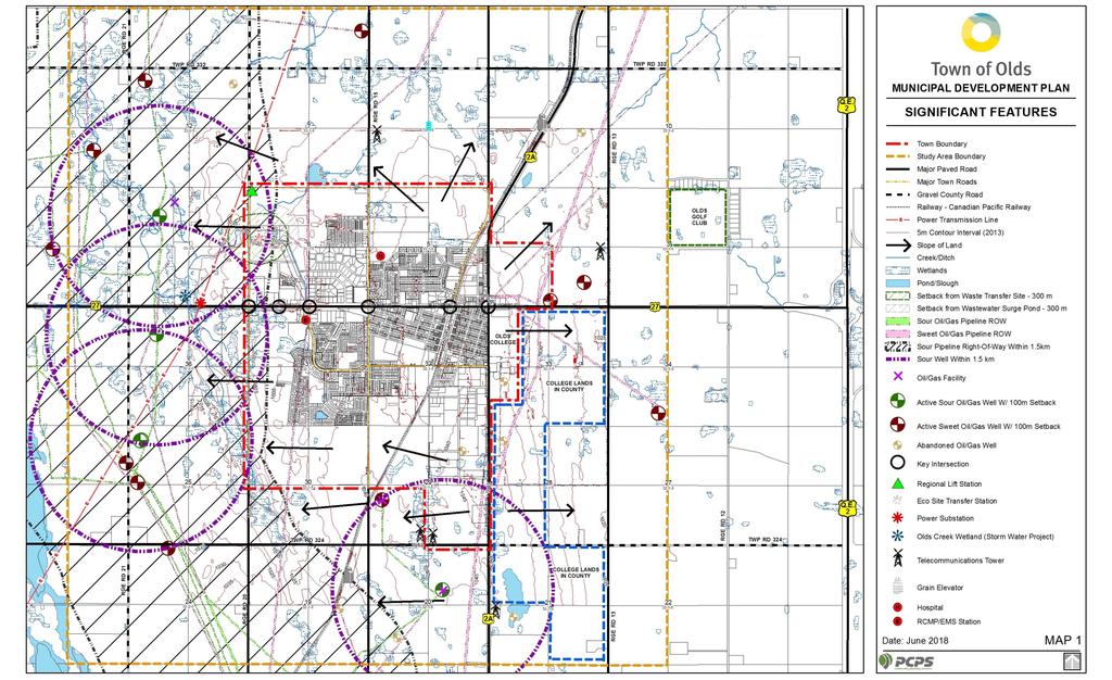
61
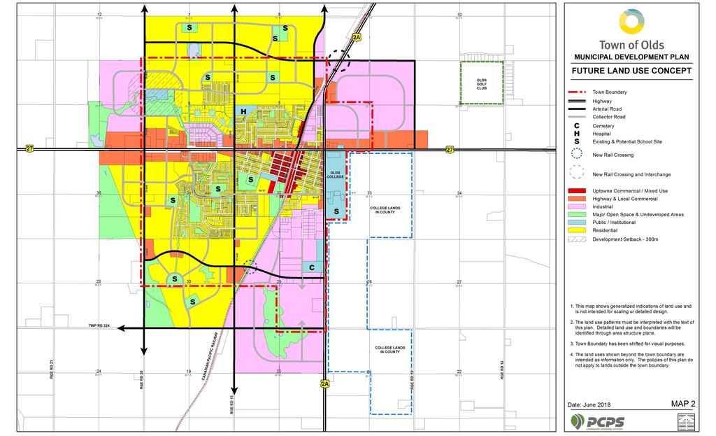
62
MUNICIPAL DEVELOPMENT PLAN
 MUNICIPAL DEVELOPMENT PLAN Bylaw 2007-22 Prepared by: Office Consolidation - April 2017 Table of Contents 1.0 Introduction and Purpose... 1 2.0 Community Context and Trends... 2 3.0 Vision Statement...
Visioning Statement and Guiding Principles
 Visioning Statement and Guiding Principles Planning for the Future The General Plan The General Plan represents Woodland's shared vision of the future and defines a path to lead the community toward its
Municipal Development Plan. Summer Village of ROCHON SANDS. Bylaw #241-18
 Municipal Development Plan Summer Village of ROCHON SANDS Bylaw #241-18 TABLE OF CONTENTS PART ONE: BACKGROUND AND PURPOSE 3 SECTION 1: BACKGROUND 3 SECTION 2: GOALS AND POLICIES 3 PART TWO: PHYSICAL ENVIRONMENT
Town of Bowden Municipal Development Plan. Table of Contents
 Town of Bowden Municipal Development Plan Table of Contents 1.0 Introduction and Purpose 4 2.0 Community Context and Trends 5 3.0 Vision Statement 10 4.0 Land Use Concept and General Development 12 5.0
Land Use Amendment in Southwood (Ward 11) at and Elbow Drive SW, LOC
 at and Elbow Drive SW, LOC") 2018 November 15 Page 1 of 10 EXECUTIVE SUMMARY This land use amendment application was submitted by Rick Balbi Architect on 2017 August 31 on behalf of Sable Developments Ltd, and with authorization from
2018 November 15 Page 1 of 10 EXECUTIVE SUMMARY This land use amendment application was submitted by Rick Balbi Architect on 2017 August 31 on behalf of Sable Developments Ltd, and with authorization from
Municipal Development Plan 2013
 UNIQUELY STONY PLAIN: Municipal Development Plan 2013 Quick Reference Guide What is a Municipal Development Plan (MDP)? The Town s highest-level planning document Sets the long-term vision and key themes
Official Plan Review
 Official Plan Review Summary Report - The Built Environment August 2014 Part 1: Introduction Planning for a healthy, prosperous and sustainable community is an important goal for our municipality. From
Westwind Developments Ltd. PIONEER LANDS AREA STRUCTURE PLAN - PROPOSED AMENDMENT
 FEBRUARY 2013 TABLE OF CONTENTS 1.0 BACKGROUND... 1 1.1 Amendment... 1 2.0 LOCATION & CONTEXT... 2 2.1 Land Ownership... 2 3.0 POLICY CONTEXT... 3 3.1 Municipal Development Plan... 3 3.2 Capital Region
A Growing Community Rural Settlement Areas
 Town of Huntsville Official Plan Review - POLICY BACKGROUND PAPER A Growing Community Rural Settlement Areas BACKGROUND: In addition to the fully municipally-serviced Urban Settlement Area and the Hidden
FORMER CANADIAN FORCES BASE (CFB) ROCKCLIFFE SECONDARY PLAN. Official Plan Amendment XX to the Official Plan for the City of Ottawa
 ROCKCLIFFE SECONDARY PLAN. Official Plan Amendment XX to the Official Plan for the City of Ottawa") FORMER CANADIAN FORCES BASE (CFB) ROCKCLIFFE SECONDARY PLAN Official Plan Amendment XX to the Official Plan for the City of Ottawa 1 INDEX THE STATEMENT OF COMPONENTS PART A THE PREAMBLE PAGE Purpose...
FORMER CANADIAN FORCES BASE (CFB) ROCKCLIFFE SECONDARY PLAN Official Plan Amendment XX to the Official Plan for the City of Ottawa 1 INDEX THE STATEMENT OF COMPONENTS PART A THE PREAMBLE PAGE Purpose...
This page has been intentionally left blank.
 This page has been intentionally left blank. Chapter 3 3-2 3. Employment 3.A Niagara Economic Gateway 3.A.1 General The Niagara Economic Gateway comprises: a) The Gateway Economic Zone which includes all
CHAPTER 3 VISION, GOALS, & PLANNING PRINCIPLES. City of Greensburg Comprehensive Plan. Introduction. Vision Statement. Growth Management Goals.
 CHAPTER 3 VISION, GOALS, & PLANNING PRINCIPLES Introduction The Greensburg Comprehensive Plan is intended as a working community document. A combination of long and short-term goals, this document is intended
SECTION ONE: INTRODUCTION. introduction
 introduction 1 INTRODUCTION Since it was first established in 1843 as a trading post for the Hudson s Bay Company, Victoria has evolved into a Provincial capital city that is recognized across Canada and
Preliminary Plan Framework: Vision and Goals
 Preliminary Plan Framework: Vision and Goals Draft: May 2015 Introduction Since the Town of Milliken s comprehensive plan was last updated in 2010, the community was heavily impacted by the 2013 flood,
Plano Tomorrow Vision and Policies
 Plano Tomorrow Vision and Policies PLANO TOMORROW PILLARS The Built Environment The Social Environment The Natural Environment The Economic Environment Land Use and Urban Design Transportation Housing
HAMLET OF KINGMAN AREA STRUCTURE PLAN
 HAMLET OF KINGMAN AREA STRUCTURE PLAN Prepared by: Austrom Consulting Ltd. Page 1 of 19 Table of Contents TABLE OF CONTENTS... 2 1. BACKGROUND... 3 1.1 PLAN AREA... 3 1.2 PLAN PURPOSE... 3 1.3 LEGISLATIVE
V. Vision and Guiding Principles
 V. Vision and Guiding Principles The Master Plan for the Powers Ferry Corridor seeks a foundation in the desires of the community. At times, various elements of the community offered opposing viewpoints,
Municipal Development Plan Update Urban Service Area and Hamlets
 ENCLOSURE 1 Municipal Development Plan Update Urban Service Area and Hamlets Priorities Committee January 24, 2017 MUNICIPAL DEVELOPMENT PLAN UPDATE SHAPING OUR FUTURE MDP Update - Agenda MDP Update Public
2040 LUP is a part of the Comprehensive Plan and carries the same legal authority. Economic Challenges
 1.1. Guiding Anchorage s Growth Where will new residents settle over the next two decades? Where will people work, shop, and play? Will there be enough room to grow? How will Anchorage look? Will growth
PORT WHITBY COMMUNITY
 PORT WHITBY COMMUNITY SECONDARY PLAN UPDATE COMMUNITY IMPROVEMENT PLAN URBAN DESIGN GUIDELINES September 2015 DRAFT PROPOSED AMENDMENT NUMBER # to the Whitby Official Plan PURPOSE: The intent of this Amendment
1 Introduction. Chapter. In this chapter:
 Chapter 1 Introduction In this chapter: 1.1 A Snapshot of the Region 1.2 Towards a Sustainable Region 1.3 The Provincial Context 1.4 Purpose and Organization The Regional Municipality of York Official
3. VISION AND GOALS. Vision Statement. Goals, Objectives and Policies
 Vision Statement Queen Creek s interconnected network of parks, trails, open spaces and recreation opportunities provide safe and diverse activities and programs that sustain its unique, small town, equestrian
TOWN OF BRUDERHEIM Report to the capital region board
 TOWN OF BRUDERHEIM Report to the capital region board Introduction to the Town of Bruderheim Municipal Development Plan amendment and Relation to the CRB Evaluation Criteria 02 march 2017 1 Introduction
Town of Devon. Municipal Development Plan
 Municipal Development Plan September 2017 ISL Engineering and Land Services Ltd. is an award-winning full-service consulting firm dedicated to working with all levels of government and the private sector
Concord Community Reuse Project Goals and Guiding Principles. Overarching Goals (OG)
") Concord Community Reuse Project Goals and Guiding Principles Overarching Goals (OG) No priority is implied by the order of presentation of the goals and guiding principles. Overarching goals for the Concord
Concord Community Reuse Project Goals and Guiding Principles Overarching Goals (OG) No priority is implied by the order of presentation of the goals and guiding principles. Overarching goals for the Concord
The Five Components of the McLoughlin Area Plan
 The Five Components of the McLoughlin Area Plan This documents contains the complete language of the five components of the McLoughlin Area Plan: The Vision Statement The Values The Guiding Principles
Section 1 Introduction
 Section 1 Section 1,, describes the role of the Official Plan. The Official Plan is one of five growth management plans that was completed under the umbrella of Ottawa 20/20. 1.1 The Role of the Official
Red Fox Commercial Outline Plan
 Red Fox Commercial Outline Plan City of Cold Lake, Alberta Prepared by Durrance Projects Ltd and Ross W. Sharp & Associates Ltd October 2014 Rupert 1 Table of Contents 1. PURPOSE...3 1.1. Location...4
Implementation Guide Comprehensive Plan City of Allen
 Implementation Guide 2030 Comprehensive Plan City of Allen DRAFT 2015 Implementation Guide Allen 2030 Comprehensive Plan INTRODUCTION The Comprehensive Plan serves as a guide for the growth and development
CHAPTER 12 IMPLEMENTATION
 CHAPTER 12 IMPLEMENTATION The 2010 Town of Denton Comprehensive Plan is intended to capture a vision of the future of Denton. As such, it provides a basis for a wide variety of public and private actions
EXISTING COMPREHENSIVE PLAN
 EXISTING COMPREHENSIVE PLAN Town Center Land Use Element: V. LAND USE POLICIES Town Center Mercer Island's business district vision as described in "Your Mercer Island Citizen-Designed Downtown" was an
Port Lavaca Future Land Use
 Port Lavaca Future Land Use Introduction The City of Port Lavaca is beginning to see sustained growth, after many years of relative stable population. New single family homes, apartments, and businesses
Complete Neighbourhood Guidelines Review Tool
 Complete Neighbourhood Guidelines Review Tool Prepared By: City of Regina Planning Department October 2014 Page 1 of 14 Community Development Review Checklist for Secondary Plans and Concept Plans The
[PLANNING RATIONALE] For Site Plan Control and Lifting of Holding Zone By-Law 101 Champagne Avenue. May 23, 2014
![[PLANNING RATIONALE] For Site Plan Control and Lifting of Holding Zone By-Law 101 Champagne Avenue. May 23, 2014](/thumbs/75/71599615.jpg "[PLANNING RATIONALE] For Site Plan Control and Lifting of Holding Zone By-Law 101 Champagne Avenue. May 23, 2014") [PLANNING RATIONALE] For Site Plan Control and Lifting of Holding Zone By-Law 101 Champagne Avenue May 23, 2014 Contents 1.0 Introduction... 2 2.0 Site Context... 2 2.1 Adjacent Uses... 2 Figure 1: Site
[PLANNING RATIONALE] For Site Plan Control and Lifting of Holding Zone By-Law 101 Champagne Avenue May 23, 2014 Contents 1.0 Introduction... 2 2.0 Site Context... 2 2.1 Adjacent Uses... 2 Figure 1: Site
URBAN DESIGN BRIEF URBAN DESIGN BRIEF 721 FRANKLIN BLVD, CAMBRIDGE August 2018
 URBAN DESIGN BRIEF URBAN DESIGN BRIEF 721 FRANKLIN BLVD, CAMBRIDGE August 2018 DESIGN BRIEF CONTENTS PART A 1.0 INTRODUCTION 2.0 DESCRIPTION & ANALYSIS OF SITE CONTEXT 3.0 DESIGN CONSTRAINTS AND OPPORTUNITIES
Economy Vision Statements: Social Wellbeing Vision Statements: Natural Environment Vision Statements:
 Economy Vision Statements: 1. Our business environment makes us a region of choice for new employers as we encourage entrepreneurship and have a vibrant, diversified and resilient regional economy. 2.
Outline Plan in Belvedere (Ward 9) at Street SE, LOC (OP)
 at Street SE, LOC (OP)") 2018 October 04 Page 1 of 12 EXECUTIVE SUMMARY This outline plan application was submitted by B&A Planning Group on 2016 July 15, on behalf of Tristar Communities Inc. for 50.14 hectares (123.89 acres)
2018 October 04 Page 1 of 12 EXECUTIVE SUMMARY This outline plan application was submitted by B&A Planning Group on 2016 July 15, on behalf of Tristar Communities Inc. for 50.14 hectares (123.89 acres)
ELK GROVE GENERAL PLAN VISION
 2-1 CHAPTER 2: 2-2 CREATING OUR The Community Vision for Elk Grove, expressed through a Vision Statement and a series of Supporting Principles, is a declaration of the kind of community that Elk Grove
CONTENTS 8.0 LAND USE 8.1 GENERAL LAND USE 8.2 RESIDENTIAL 8.3 MIXED USE 8.4 COMMERCIAL 8.5 EMPLOYMENT LANDS
 8-2 Land Use 8.0 LAND USE CONTENTS 8.1 GENERAL LAND USE 8.1.1 Uses provided for in all Land Use Designations 8.1.2 Uses prohibited in Hazardous Lands, Hazardous Sites and Special Policy Areas 8.1.3 Uses
The West Vaughan Employment Area Secondary Plan Policies
 Part 2: The West Vaughan Employment Area Secondary Plan Policies 2.1 General Policies It is the policy of Council: 2.1.1. That the West Vaughan Employment Area (the WVEA), identified on Schedule 1, will
6 Growth Management Challenges and Opportunities
 6 Growth Management Challenges and Opportunities The Town has established a goal of attaining a 50% participation rate with respect to employment opportunities versus residential population. The Town s
URBAN DESIGN BRIEF. 2136&2148 Trafalgar Road. Town of Oakville
 URBAN DESIGN BRIEF 2136&2148 Trafalgar Road Town of Oakville Prepared By: METROPOLITAN CONSULTING INC For 2500674 Ontario Inc November 2016 TABLE OF CONTENTS Page No. 1.0 Introduction/Description of Subject
QUEEN-RIVER SECONDARY PLAN
 34 QUEEN-RIVER SECONDARY PLAN 34. QUEEN RIVER SECONDARY PLAN 1. INTRODUCTION The Queen-River area is approximately 6.4 hectares and is located at the eastern edge of the Downtown as shown on Map 34-1.
Tāhuhu whakaruruhau ā-taone The sheltering ridge pole
 B2. Tāhuhu whakaruruhau ā-taone - Urban growth and form B2.1. Issues Tāhuhu whakaruruhau ā-taone The sheltering ridge pole Auckland s growing population increases demand for housing, employment, business,
4 Sustainability and Growth Management
 4 Sustainability and Growth Management Introduction Traditionally, has assumed growth and development with limited consideration for the long-term negative social, environmental or economic impacts on
GATEWAY AREA STRUCTURE PLAN
 CHESTERMERE GATEWAY AREA STRUCTURE PLAN COMMUNITY OPEN HOUSE SEPTEMBER 22 nd, 2015 PLAN AREA ± 512 hectares (± 1,265 acres) GATEWAY LOCATION UNDEVELOPED LANDS PRESENT AGRICULTURAL USE REGIONAL LAND USE
COMMUNITY DESIGN. GOAL: Create livable and attractive communities. Intent
 COMMUNITY DESIGN Intent An attractive, well-designed County will attract quality development, instill civic pride, improve the visual character of the community, and create a strong, positive image for
The transportation system in a community is an
 7 TRANSPORTATION The transportation system in a community is an important factor contributing to the quality of life of the residents. Without a sound transportation system to bring both goods and patrons
SECTION E. Realizing the Plan
 SECTION E Realizing the Plan 60 DESIGN REGINA - OFFICIAL COMMUNITY PLAN SECTION E Realizing the Plan Design Regina has been an ambitious plan-making exercise, with a high level of community, stakeholder,
38 Queen s University Campus Master Plan Part 1
 38 Queen s University Campus Master Plan Part 1 46 The Campus at the City Scale Chapter 4 The Campus at the City Scale 39 Queen s is an urban University centrally located in Kingston. Decisions made by
Growing Community Urban Settlement Area and Hidden Valley Settlement Area
 Town of Huntsville Official Plan Review - POLICY BACKGROUND PAPER Growing Community Urban Settlement Area and Hidden Valley Settlement Area BACKGROUND: Through the Provincial Policy Statement (PPS), the
K. SMART ASSOCIATES LIMITED
 Planning Justification Report Zoning By-Law Amendment 185 King Street North Waterloo, Ontario April 7th, 2017 Project Reference Number 16-245 K. SMART ASSOCIATES LIMITED CONSULTING ENGINEERS AND PLANNERS
LAND USE AMENDMENT CORNERSTONE (WARD 3) 60 STREET NE AND COUNTRY HILLS BOULEVARD NE MAP 26NE BYLAW 22D2017
 60 STREET NE AND COUNTRY HILLS BOULEVARD NE MAP 26NE BYLAW 22D2017") Page 1 of 14 EXECUTIVE SUMMARY This Land Use Amendment application covers an area of 43.76 hectares ± (108.14 acres ±) located in northeast Calgary, bound by Country Hills Boulevard NE to the south and
Page 1 of 14 EXECUTIVE SUMMARY This Land Use Amendment application covers an area of 43.76 hectares ± (108.14 acres ±) located in northeast Calgary, bound by Country Hills Boulevard NE to the south and
LAND USE ELEMENT. Purpose. General Goals & Policies
 LAND USE ELEMENT Purpose This Land Use Element contains the goals and policies necessary to support the City s responsibility for managing land resources and guiding development through implementing regulations,
Town of Peru Comprehensive Plan Executive Summary
 Town of Peru Comprehensive Plan Executive Communities that plan grow by choice, not by chance. A plan makes growth thoughtful, understandable, and predictable. A plan shows that a community is managing
178 Carruthers Properties Inc.
 178 Carruthers Properties Inc. Planning Rationale for 178 Carruthers Avenue Site Plan Control Application June 2014 Table of Contents 1.0 Introduction 2.0 Overview of Subject Property 3.0 Current Zoning
Table of Contents PART 1 FRAMEWORK... 1
 Table of Contents PART 1 FRAMEWORK... 1 1.0 PURPOSE... 1 1.1 MUNICIPAL GOVERNMENT ACT... 1 1.2 REGIONAL & MUNICIPAL POLICIES... 2 1.3 COMMUNITY CONTEXT... 6 PART 2 VISION... 8 2.1 SUSTAINABILITY... 8 2.2
Urban Design Manual PLANNING AROUND RAPID TRANSIT STATIONS (PARTS) Introduction. Station Study Areas
 Introduction. Station Study Areas") 111111 PLANNING AROUND RAPID TRANSIT STATIONS (PARTS) Introduction The ION rapid transit system will link Waterloo, Kitchener and Cambridge through a central transit corridor (CTC). There are a number
111111 PLANNING AROUND RAPID TRANSIT STATIONS (PARTS) Introduction The ION rapid transit system will link Waterloo, Kitchener and Cambridge through a central transit corridor (CTC). There are a number
SECTION II SECTION II STATEMENT OF GOALS, OBJECTIVES, PRINCIPLES, ASSUMPTIONS, POLICIES AND STANDARDS
 STATEMENT OF GOALS, OBJECTIVES, PRINCIPLES, ASSUMPTIONS, POLICIES AND STANDARDS 1 2 STATEMENT OF GOALS, OBJECTIVES, PRINCIPLES, ASSUMPTIONS, POLICIES AND STANDARDS INTRODUCTION The New Jersey Municipal
SAN RAFAEL GENERAL PLAN 2040 INTRODUCTION AND OVERVIEW
 SAN RAFAEL GENERAL PLAN 2040 INTRODUCTION AND OVERVIEW Steering Committee Presentation February 14, 2018 Purpose of General Plan Guide land use and development decisions Coordinate transportation, infrastructure,
Planning Districts INTRODUCTION
 INTRODUCTION To facilitate detailed examination of development prospects for all areas of the community, Delano has been divided into 14 planning districts. The location of these planning districts is
Chapter 2: Vision, Goals and Strategies
 Chapter 2: Vision, Goals and Lake Elmo Today & Tomorrow Comprehensive Plan 2040 2 VISION, GOALS & STRATEGIES - DRAFT 4-6-2018 INTRODUCTION Comprehensive Plan Purpose Perhapse the most important objective
THE GARDEN CITY PLAN. City of St. Catharines Official Plan. City of St. Catharines
 THE GARDEN CITY PLAN City of St. Catharines Official Plan City of St. Catharines August 2010 APPROVAL INFORMATION This Official Plan of the City of St. Catharines Planning Area, known as the Garden City
LAND USE AMENDMENT DOWNTOWN COMMERCIAL CORE (WARD 7) MACLEOD TRAIL SE AND 5 AVENUE SE BYLAW 254D2017
 MACLEOD TRAIL SE AND 5 AVENUE SE BYLAW 254D2017") Page 1 of 10 EXECUTIVE SUMMARY This Land Use Amendment application seeks to redesignate a full downtown block (currently the YWCA site) from a Direct Control based on the CM-2 District (Land Use Bylaw
Page 1 of 10 EXECUTIVE SUMMARY This Land Use Amendment application seeks to redesignate a full downtown block (currently the YWCA site) from a Direct Control based on the CM-2 District (Land Use Bylaw
Transforming Saint John s Urban Heart -
 Transforming Saint John s Urban Heart - How Innovative Community Engagement Inspires a Bold Municipal Plan for a More Sustainable and Compact Saint John 2012 NNECAPA Conference - Brunswick, ME October
Woodburn Comprehensive Plan Growth Management Goals and Policies
 Goal Woodburn Comprehensive Plan Growth Management Goals and Policies G-1. The City's goal is to manage growth in a balanced, orderly and efficient manner, consistent with the City s coordinated population
Town of Cobourg Heritage Master Plan. Statutory Public Meeting
 Town of Cobourg Heritage Master Plan Statutory Public Meeting April 25 th 2016 Presentation Overview 1. Introduction 2. Project background and schedule overview 3. Review of strategic direction content
DAVENPORT VILLAGE SECONDARY PLAN
 27 DAVENPORT VILLAGE SECONDARY PLAN 27. DAVENPORT VILLAGE SECONDARY PLAN 1. VISION FOR THE DAVENPORT VILLAGE SECONDARY PLAN Davenport Village, municipally known as 830, 940, 980 and 1100 Lansdowne Avenue,
Gold Line Bus Rapid Transit Transit Oriented Development (BRTOD) Helmo Station Area Plan
 Helmo Station Area Plan") Appendix F Gold Line Bus Rapid Transit Transit Oriented Development (BRTOD) Helmo Station Area Plan Introduction and Purpose of the Plan The Gold Line Bus Rapid Transit facility is an eleven-mile dedicated
Appendix F Gold Line Bus Rapid Transit Transit Oriented Development (BRTOD) Helmo Station Area Plan Introduction and Purpose of the Plan The Gold Line Bus Rapid Transit facility is an eleven-mile dedicated
Urban Design Brief. Watson Parkway North & Watson Road North Guelph, Ontario. Prepared by Coletara Development
 Urban Design Brief Watson Parkway North & Watson Road North Guelph, Ontario Prepared by Coletara Development December, 2013 Urban Design Brief, Coletara Development 1 Introduction This Urban Design Brief
Derry Green Corporate Business Park
 Town of Milton Derry Green Corporate Business Park Urban Design Guidelines BMI/Pace - June 2010 Draft 3 Prepared by: Brook McIlroy Planning + Urban Design / Pace Architects Suite 300-51 Camden Street Toronto,
Living in Albemarle County s Urban Places
 Living in Albemarle County s Urban Places ALBEMARLE COUNTY, VIRGINIA A Closer Look at Albemarle s Approach to Managing Growth and Creating Quality Urban Environments www.albemarle.org Page 2 Living in
MUNICIPAL DEVELOPMENT PLAN
 MUNICIPAL DEVELOPMENT PLAN Prepared by: RKP Consulting Red Deer City Bylaw 3404/2008 Approved May 5, 2008 Amendments: Bylaw 3404/A-2011 Bylaw 3404/A-2013 Bylaw 3404/A-2015 Office Consolidation Effective
Ten Mile Creek Planning Area
 PLANNING AREA POLICIES TEN MILE CREEK Ten Mile Creek Planning Area Location and Context The Ten Mile Creek Planning Area ( Ten Mile Creek area ) is located south of the current Boise AOCI, generally south
CHAPTER 7: Transportation, Mobility and Circulation
 AGLE AREA COMMUNITY Plan CHAPTER 7 CHAPTER 7: Transportation, Mobility and Circulation Transportation, Mobility and Circulation The purpose of the Transportation, Mobility and Circulation Chapter is to
and services The protection and conservation of environmentally significant and sensitive natural heritage features and functions.
 6. Land Use 6.0 Preamble A healthy and livable city is one in which people can enjoy a vibrant economy and a sustainable healthy environment in safe, caring and diverse neighbourhoods. In order to ensure
MAYFIELD WEST SECONDARY PLAN PHASE 2
 MAYFIELD WEST SECONDARY PLAN PHASE 2 Public Open House #3 February 25, 2010 Draft Preferred Land Use Scenario TOWN OF CALEDON PLANNING & DEVELOPMENT DEPARTMENT Open House Agenda TOWN OF CALEDON 1. Welcome
CHAPTER 2: PLANNING PRINCIPLES
 CHAPTER 2: PLANNING PRINCIPLES 2 Comprehensive Principles The following overarching Principles provide the basis for the goals and policies included in the Mendocino County General Plan. These Principles
Welcome. Walk Around. Talk to Us. Write Down Your Comments
 Welcome This is an information meeting introducing the applications for proposed redevelopment of the Yorkdale Shopping Centre site at 3401 Dufferin Street and 1 Yorkdale Road over the next 20+ years,
ADMINISTRATION RECOMMENDATION(S) 2018 January 25. That Calgary Planning Commission recommend APPROVAL of the proposed Land Use Amendment.
 2018 January 25. That Calgary Planning Commission recommend APPROVAL of the proposed Land Use Amendment.") Page 1 of 9 EXECUTIVE SUMMARY This land use amendment proposes to redesignate a parcel from DC Direct Control District to Multi-Residential Contextual Grade-Oriented (M-CG) District to allow for multi-residential
Page 1 of 9 EXECUTIVE SUMMARY This land use amendment proposes to redesignate a parcel from DC Direct Control District to Multi-Residential Contextual Grade-Oriented (M-CG) District to allow for multi-residential
Comprehensive Plan. Faribault, Minnesota. Hoisington Koegler Group Inc. Claybaugh Preservation Architecture Inc. Howard R. Green Company Bonz/REA
 Comprehensive Plan Faribault, Minnesota Adopted by the Faribault City Council July 8, 2003 prepared for: prepared by: Hoisington Koegler Group Inc. Claybaugh Preservation Architecture Inc. Howard R. Green
Hockessin Community Redevelopment Plan
 Hockessin Community Redevelopment Plan 3.1 Introduction The Community Redevelopment Plan for the Village of Hockessin is the result of the people s vision for a distinct village center that serves as the
ADMINISTRATION RECOMMENDATION 2016 November 03. That Calgary Planning Commission recommends APPROVAL of the proposed Land Use Amendment.
 Page 1 of 12 EXECUTIVE SUMMARY This Land Use Amendment application covers an area of 75.76 hectares ± (187.20 acres ±) located in northeast Calgary, bound by Stoney Trail NE to the north, 128 Avenue NE
Guiding Principles, Objectives, Strategies and Policies
 Guiding Principles, Objectives, Strategies and Policies Section 1 Introduction These Guiding Principles were adopted as part of the 1999 Athens-Clarke County Comprehensive Plan and are carried over, in
A BLUEPRINT FOR BROCKTON A CITY-WIDE COMPREHENSIVE PLAN
 A BLUEPRINT FOR BROCKTON A CITY-WIDE COMPREHENSIVE PLAN Public Meeting October 2016 1 Plan Summary and Discussion Public Meeting May 4 2017 City of Brockton Bill Carpenter, Mayor Department of Planning
Community Design Guidelines. Port Wallace DRAFT
 Community Design Guidelines Port Wallace DRAFT Energy 1 2 3 Nature Movement Connections Built Form DRAFT Layout Energy 1 Nature Community Design Guidelines GREAT COMMUNITIES PROTECT, CELEBRATE, AND CONSERVE
implementation10 Village of Greendale Comprehensive Plan: Greendale, Wisconsin. Revisiting a Greenbelt Community
 implementation10 Village of Greendale Comprehensive Plan: 2010 - Village of Greendale Comprehensive Plan: 2010 - Implementation The recommendations of this Plan must be implemented by the Village of Greendale,
Plan Modification to Chapter B2 of the Auckland Unitary Plan(AUP) Operative in part (15 November 2016)
 Operative in part (15 November 2016)") UNITARY PLAN UPDATE REQUEST MEMORANDUM TO FROM Phill Reid Linley Wilkinson DATE 25 September 2018 SUBJECT Plan Modification to Chapter B2 of the Auckland Unitary Plan(AUP) Operative in part (15 November
UNITARY PLAN UPDATE REQUEST MEMORANDUM TO FROM Phill Reid Linley Wilkinson DATE 25 September 2018 SUBJECT Plan Modification to Chapter B2 of the Auckland Unitary Plan(AUP) Operative in part (15 November
S A C R A M E N T O C O U N T Y JACKSON HIGHWAY & GRANT LINE EAST VISIONING STUDY
 JACKSON HIGHWAY & GRANT LINE EAST S A C R A M E N T O C O U N T Y P L A N N I N G D E P A R T M E N T SUMMARY AND WORKBOOK November 19, 2008 History of the Visioning Study Sacramento County has two growth
Staff Report and Recommendation
 Community Planning and Development Planning Services 201 W. Colfax Ave., Dept. 205 Denver, CO 80202 p: 720.865.2915 f: 720.865.3052 www.denvergov.org/cpd TO: City Council Neighborhoods and Planning Committee
section 3: Vision, Values and Goals
 Vision, Values and Goals 3 2041 Vision: Victoria is an urban sustainability leader inspiring innovation, pride and progress towards greater ecological integrity, livability, economic vitality, and community
PUBLIC OPEN HOUSE SEPTEMBER 8 TH, 2010 CITY OF LETHBRIDGE DEVELOPMENT SERVICES
 PUBLIC OPEN HOUSE SEPTEMBER 8 TH, 2010 CITY OF LETHBRIDGE DEVELOPMENT SERVICES INTRODUCTION Why is the City creating the West Lethbridge Employment Centre Area Structure Plan? West Lethbridge Urbanization
C. Westerly Creek Village & The Montview Corridor
 C. Westerly Creek Village & The VISION Community Vision When the goals of the city are achieved Westerly Creek Village, a distinctive community defined by Montview Boulevard and Westerly Creek, is a strong
1.0 PLANNING MARKHAM S FUTURE CONTENTS
 1-1 Planning Markham s Future 1.0 PLANNING MARKHAM S FUTURE CONTENTS 1.1 THE PURPOSE OF THE OFFICIAL PLAN 1.2 THE MARKHAM CONTEXT 1.3 THE REGULATORY CONTEXT 1.3.1 Province of Ontario 1.3.2 York Region
OP Council Resolution June 16, Planning and Development Services
 OP-08-01 Council Resolution June 16, 2008 Planning and Development Services Kingsgate Landing Outline Plan Table of Contents 1.0 Introduction 1 1.1 Purpose of Plan 1 1.2 Plan Area Location 1 1.3 Ownership
CITY CLERK. Parkland Acquisition Strategic Directions Report (All Wards)
") CITY CLERK Clause embodied in Report No. 10 of the, as adopted by the Council of the City of Toronto at its meeting held on November 6, 7 and 8, 2001. 10 Parkland Acquisition Strategic Directions Report
CITY CLERK Clause embodied in Report No. 10 of the, as adopted by the Council of the City of Toronto at its meeting held on November 6, 7 and 8, 2001. 10 Parkland Acquisition Strategic Directions Report
Regency Developments. Urban Design Brief. Holyrood DC2 Rezoning
 Regency Developments Urban Design Brief Holyrood DC2 Rezoning Stantec Consulting Ltd. 7-31-2017 1. Overview Regency Developments intends to rezone the lands located at 8510 and 8511 93 Avenue, within the
10.0 Open Space and Public Realm
 10.0 Open Space and Public Realm 10.0 Open Space and Public Realm The Public Open Space System is comprised of: outdoor spaces available for public use that are either publicly owned (e.g., parks and
Public Open House #1
 Public Open House #1 TONIGHT S AGENDA Welcome Project Overview The Big Picture The Station Area The Analysis Thoughts about Future Change Breakout Group Discussions Summation / Next Steps Project Overview
City of Grande Prairie Development Services Department KENNEDY DEVELOPMENTS LTD. OUTLINE PLAN OP-09-01
 City of Grande Prairie Development Services Department KENNEDY DEVELOPMENTS LTD. OUTLINE PLAN OP-09-01 July 27, 2009 TABLE OF CONTENTS 1.0 Introduction... 1 1.1 Plan Area Location & Context... 1 1.2 Ownership