Appendix C Draft Cultural Heritage Self-Assessment DRAFT
|
|
|
- Elwin Pitts
- 5 years ago
- Views:
Transcription
1 Appendix C Draft Cultural Heritage Self-Assessment
2 Whitesand First Nation Cogeneration and Pellet Mill Project Draft Cultural Heritage Self-Assessment Prepared By: Neegan Burnside Ltd. 292 Speedvale Avenue West Unit 20 Guelph ON N1H 1C4 Prepared for: Sagatay Cogeneration LP, with its General Partner, Sagatay Cogeneration Ltd., and Whitesand First Nation as agent December 2013 File No: The material in this report reflects best judgement in light of the information available at the time of preparation. Any use which a third party makes of this report, or any reliance on or decisions made based on it, are the responsibilities of such third parties. <#CompanyName#> accepts no responsibility for damages, if any, suffered by any third party as a result of decisions made or actions based on this report.
3 Whitesand First Nation i Draft Cultural Heritage Self-Assessment December 2013 Record of Revisions Revision Date Description 0 December 18, Draft REA Submission for Consultation 2013 Neegan Burnside Ltd _ Cultural Heritage Self-Assessment Report
4 Whitesand First Nation ii Draft Cultural Heritage Self-Assessment December 2013 Table of Contents Record of Revisions... i 1.0 Introduction Answers to Screening Criteria Questions in REA Checklist:... 2 Question 1 (Protected Properties)... 2 Question 2 (Provincial Heritage Properties)... 4 Question 3 (Municipal Inventory)... 4 Question 4 (Plaques)... 5 Question 5 (National Historic Site)... 5 Question 6 (Burial Site/Cemetery)... 6 Question 7 (Structures Over 40 Years Old)... 7 Question 8 (Cultural Heritage Landscape)... 7 Question 9 (Landmarks)... 9 Question 10 (Historical Association) Conclusions Appendices A B C D REA Checklist: Consideration of Potential for Heritage Resources Online Search Query Results Correspondence Project Location Figure Neegan Burnside Ltd _ Cultural Heritage Self-Assessment Report
5 Whitesand First Nation 1 Draft Cultural Heritage Self-Assessment December Introduction Whitesand First Nation has retained Neegan Burnside Ltd. (Neegan Burnside) to assist with environmental permitting for the development of a Class 1 Thermal Facility and Pellet Plant in an unorganized territory near Armstrong Ontario. A map of the Project Location is provided in Appendix D. Part of the project is defined as a Renewable Energy Generation Facility, and thus requires an application for Renewable Energy Approval (REA) under O. Reg. 359/09 under the Environmental Protection Act. As part of this application, proponents are required to assess heritage resources that may be impacted by the project. Pursuant to subsection 23(2) of O. Reg. 359/09, proponents may perform a self-assessment according to the document entitled REA Checklist: Consideration of Potential for Heritage Resources (REA Checklist). If it is determined through this self-assessment that there is low potential for the presence of a heritage resource at the Project Location, no further heritage investigations are required. This report provides a summary of the above noted self-assessment undertaken for the project. It should be noted that responses to inquiries are pending from the Armstrong Local Service Board and Whitesand First Nation. Therefore this draft report presents the findings of investigations and consultation received to date. Neegan Burnside Ltd _ Cultural Heritage Self-Assessment Report
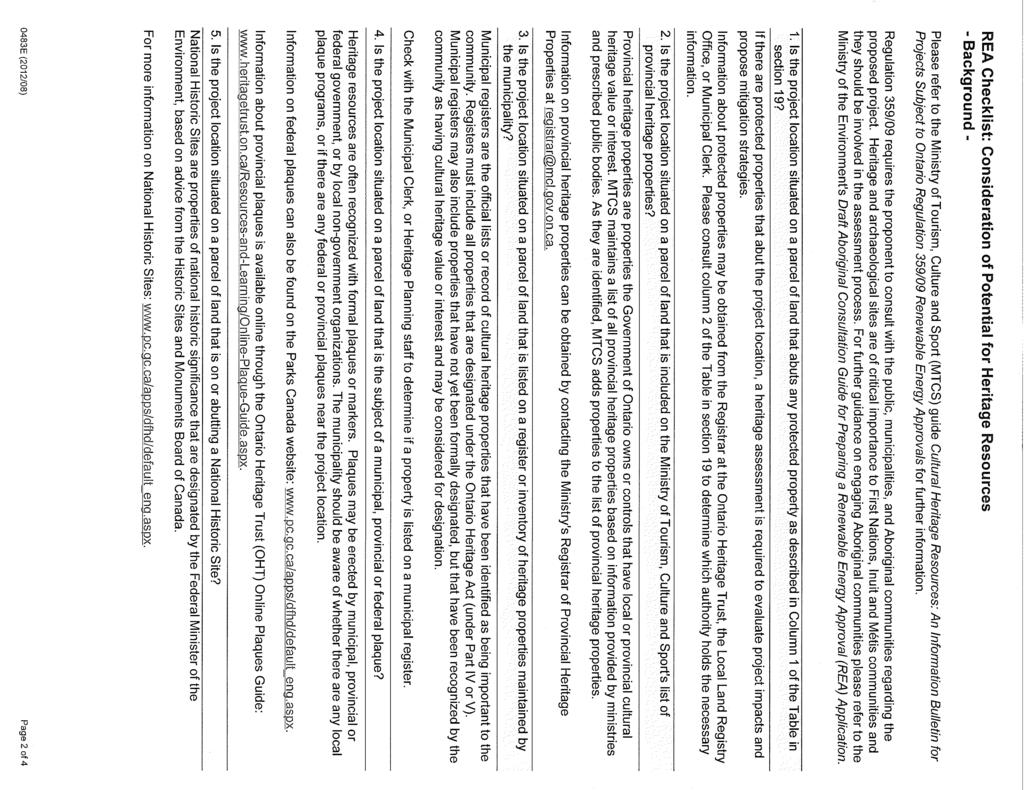
6 Whitesand First Nation 2 Draft Cultural Heritage Self-Assessment December Answers to Screening Criteria Questions in REA Checklist: The following responses correspond to each question in the REA Checklist: Question 1 (Protected Properties) Is the Project Location situated on a parcel of land that abuts any protected property as described in Column 1 of the Table in section 19? These properties can be defined as: a. A property that is the subject of an agreement, covenant or easement entered into under clause 10 (1) (b) of the Ontario Heritage Act. Registrar of the Ontario Heritage Trust: Through an online search for easement properties in Northern Ontario on the Ontario Heritage Trust website, it was determined that there are no properties meeting the above criteria within or abutting the Project Location. The closest easement property is located in Thunder Bay, over 200 km from Armstrong, as determined by distance measurements from Google Earth. Screenshots of these results query results and map are found in Appendix B. Consultation with Municipal Clerk/Local Services Board: This project is located in northern Ontario with no Municipality having jurisdiction over the Project Location. The Armstrong Local Service Board provides select services to Armstrong and the surrounding community. Although correspondence with this board was initiated, response is necessary to confirm that there are no lands within or abutting the Project Location that match the above criteria. Correspondence with the Armstrong Local Service Board can be found in Appendix C. Consultation with the Ministry of Tourism, Culture and Sport (MTCS): MTCS was contacted by Neegan Burnside to inquire whether any lands on or adjacent to the Project Location met the above criteria. Correspondence from MTCS confirmed that the Project Location is not located on a protected property as stipulated in Section 19 of O. Reg. 359/09. Correspondence with MTCS is available in Appendix C. b. A property in respect of which a notice of intention to designate the property to be of cultural heritage value or interest has been given in accordance with section 29 of the Ontario Heritage Act. Consultation with the Local Service Board: The Armstrong Local Service Board was contacted by Neegan Burnside to inquire whether any lands on or adjacent to the Project Location met the above criteria. Response is required to confirm that there are no properties within or abutting the Project Location meeting the criteria above. Correspondence with the Armstrong Local Service Board is available in Appendix C. Neegan Burnside Ltd _ Cultural Heritage Self-Assessment Report
7 Whitesand First Nation 3 Draft Cultural Heritage Self-Assessment December 2013 c. A project designated by a municipal by-law made under section 29 of the Ontario Heritage Act as a property of cultural heritage value or interest. Consultation with the Local Service Board: The Armstrong Local Service Board was contacted by Neegan Burnside to inquire whether any lands on or adjacent to the Project Location met the above criteria. Response is required to confirm that there are no properties within or abutting the Project Location meeting the criteria above. Correspondence with the Armstrong Local Service Board is available in Appendix C. d. A property designated by order of the Minister of Tourism, Culture and Sport made under Section 34.5 of the Ontario Heritage Act as a property of cultural heritage value or interest of provincial significance. Consultation with MTCS: MTCS was contacted by Neegan Burnside to inquire whether any lands on or adjacent to the Project Location met the above criteria. Correspondence from MTCS confirmed that the Project Location is not located on a protected property as stipulated in Section 19 of O. Reg. 359/09. Correspondence with MTCS is available in Appendix C. e. A property in respect of which a notice of intention to designate the property as property of cultural heritage value or interest of provincial significance has been given in accordance with Section 34.6 of the Ontario Heritage Act. Consultation with MTCS: MTCS was contacted by Neegan Burnside to inquire whether any lands on or adjacent to the Project Location met the above criteria. Correspondence from MTCS confirmed that the Project Location is not located on a protected property as stipulated in Section 19 of O. Reg. 359/09. Correspondence with MTCS is available in Appendix C. f. A property that is the subject of an easement or a covenant entered into under Section 37 of the Ontario Heritage Act. Consultation with the Local Service Board: The Armstrong Local Service Board was contacted by Neegan Burnside to inquire whether any lands on or adjacent to the Project Location met the above criteria. Response is required to confirm that there are no properties within or abutting the Project Location meeting the criteria above. Correspondence with the Armstrong Local Service Board is available in Appendix C. g. A property that is part of an area designated by a municipal by-law made under Section 41 of the Ontario Heritage Act as a heritage conservation district. Neegan Burnside Ltd _ Cultural Heritage Self-Assessment Report
8 Whitesand First Nation 4 Draft Cultural Heritage Self-Assessment December 2013 Consultation with the Local Service Board: The Armstrong Local Service Board was contacted by Neegan Burnside to inquire whether any lands on or adjacent to the Project Location met the above criteria. Response is required to confirm there are no properties within or abutting the Project Location meeting the criteria above. Correspondence with the Armstrong Local Service Board is available in Appendix C. h. A property designated as a historic site under Regulation 880 of the Revised Regulations of Ontario, 1990 (Historic Sites) made under the Ontario Heritage Act. Consultation with MTCS: MTCS was contacted by Neegan Burnside to inquire whether any lands on or adjacent to the Project Location met the above criteria. Correspondence from MTCS confirmed that the Project Location is not located on a protected property as stipulated in Section 19 of O. Reg. 359/09. Correspondence with MTCS is available in Appendix C. Question 2 (Provincial Heritage Properties) Is the Project Location situated on a parcel of land that is included on the Ministry of Tourism, Cultural and Sport s list of provincial heritage properties? Consultation with MTCS Registrar of Provincial Heritage Properties The MTCS Registrar was contacted by Neegan Burnside to inquire whether any lands on or adjacent to the Project Location are on the MTCS list of provincial heritage properties. Response is required from the Registrar to confirm that there are no properties within or abutting the Project Location are on the MTCS list of provincial heritage properties. Correspondence with MTCS is available in Appendix C. Question 3 (Municipal Inventory) Is the Project Location situated on a parcel of land that is listed on a register or inventory of heritage properties maintained by the municipality? Consultation with the Local Service Board: The Armstrong Local Service Board was contacted by Neegan Burnside to inquire whether any lands on or adjacent to the Project Location were listed on a register or inventory of heritage properties maintained by the Local Service Board. Response is required to confirm there are no such properties within or abutting the Project Location. Correspondence with the Armstrong Local Service Board is available in Appendix C. Neegan Burnside Ltd _ Cultural Heritage Self-Assessment Report
9 Whitesand First Nation 5 Draft Cultural Heritage Self-Assessment December 2013 Question 4 (Plaques) Is the Project Location situated on a parcel of land that is the subject of a municipal, provincial or federal plaque? Federal Plaques (Parks Canada website): The Parks Canada Directory of Federal Heritage Designations was reviewed to determine if lands within or adjacent to the Project Location contained a federal plaque. The search yielded zero results in Armstrong, Ontario. The search yielded 15 results in Thunder Bay, Ontario, but all plaques were located in the City of Thunder Bay, over 200 km away from the Project Location as determined by Google Earth. The results of these queries can be found in Appendix B. Provincial Plaques (Ontario Heritage Trust Online Plaques Guide): The Ontario Heritage Trust Online Plaques Guide was reviewed to determine if lands within or adjacent to the Project Location contained a provincial plaque. Within the Thunder Bay District, there were 34 results for Provincial Plaques. A distance measurement from each plaque location and the Project Location using Google Earth determined that all 34 Provincial Plaques listed were over 200 km from the Project Location. The query results from this search can be found in Appendix B. Consultation with Local Service Board and MTCS: Although the online research above determined that provincial and federal plaques were over 200 km away from the Project Location, Neegan Burnside contacted the Armstrong Local Service Board and MTCS to confirm if they had records of Provincial or Federal Plaques within or abutting the Project Location. The MTCS confirmed that the project is not located on a protected property as stipulated in Section 19 of O. Reg. 359/09. Response from the Armstrong Local Services Board is required to confirm whether these records exist. Correspondence with the Local Service Board and MTCS can be found in Appendix C. Site Visit: During Site investigations for the natural heritage assessment of the project between August 20-21, 2013, no provincial or federal plaques were observed within the Study Area. Question 5 (National Historic Site) Is the Project Location situated on a parcel of land that is on or abutting a National Historic site? Neegan Burnside Ltd _ Cultural Heritage Self-Assessment Report
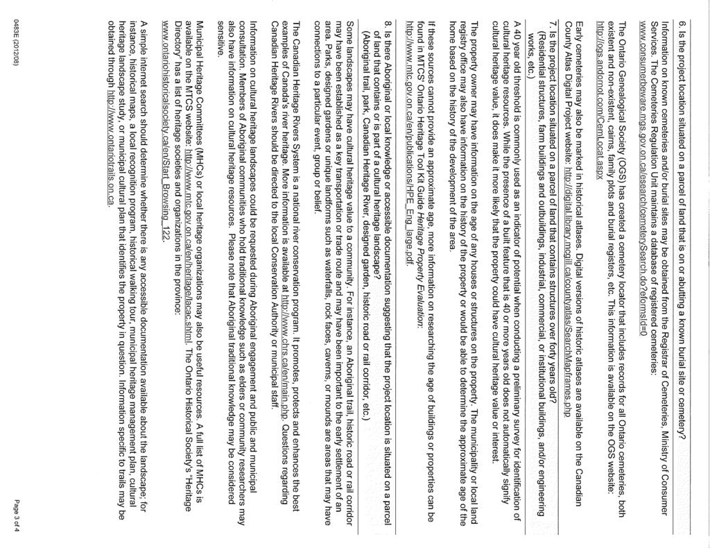
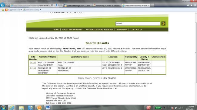
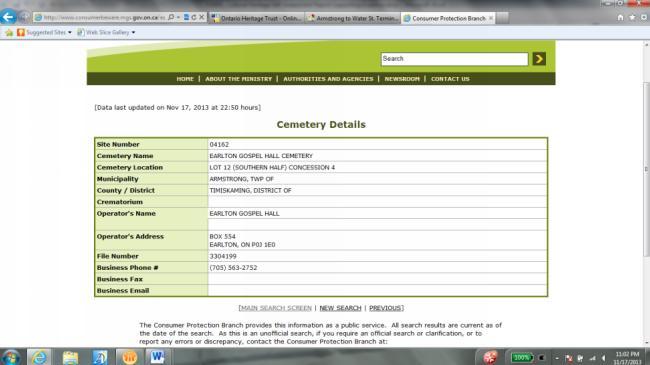
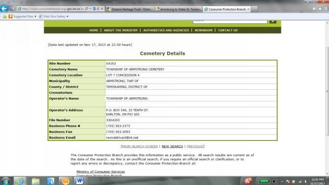
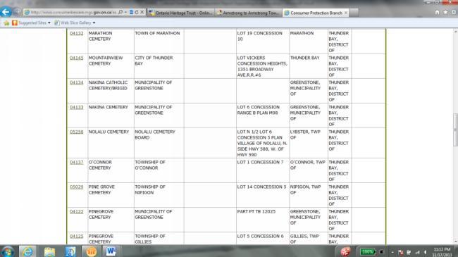
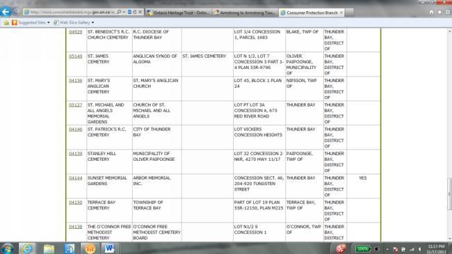
10 Whitesand First Nation 6 Draft Cultural Heritage Self-Assessment December 2013 National Historic Sites Website: In order to determine if properties within or abutting the Project Location were part of a National Historic Site, the National Historic Sites website was reviewed. A query for Armstrong, Ontario, yielded zero results. A query for Thunder Bay, Ontario yielded five results, but all National Historic Sites were located in the City of Thunder Bay, over 200 km away from the Project Location, as determined via Google Earth. Screen shots of these query results can be found in Appendix B. Consultation with the Local Services Board, MTCS and Whitesand First Nation: Although no records of National Historic Sites were found through desktop research or within the Stage 1 Archaeological Assessment, further consultation was undertaken to confirm these search results. Consultation with MTCS confirmed that the project is not located on a protected property as stipulated in Section 19 of O. Reg. 359/09. Consultation with the Local Service Board and Whitesand First Nation was initiated by Neegan Burnside, but response is required to confirm that there are no National Historic Sites within or abutting the Project Location. Copies of this consultation can be found in Appendix C. Question 6 (Burial Site/Cemetery) Is the Project Location situated on a parcel of land that is on or abutting a known burial site or cemetery? Cemeteries Regulation Unit database of registered cemeteries: Two results were obtained through an online search for Armstrong, Ontario and fortytwo results were found for Thunder Bay District. Aerial map analysis of these areas through Google Earth determined that those in Armstrong, Ontario, were actually for Armstrong Township, which is in Earlton Ontario. Review of the locations of the 42 results within the Thunder Bay District determined that none were located within the town of Armstrong, or within any unorganized territory of the Thunder Bay District. As there is no municipality in the vicinity of the Project Location (including Armstrong, Ontario), cemetery locations would have to be listed in an unorganized territory to be within or abutting the Project Location. The results of these searches can be found in Appendix B. Ontario Genealogical Society cemetery locator (OGS website): Through an online search on the OGS website, no results were yielded for an unorganized territory in Thunder Bay District. When a search was conducted for Armstrong Historical Municipality in Thunder Bay District, one result, the Armstrong Hillside Community Cemetery was returned. Aerial photography (Google Earth) was used to further confirm that this cemetery is located within Armstrong, but not within the Project Location or abutting lands. Neegan Burnside Ltd _ Cultural Heritage Self-Assessment Report
11 Whitesand First Nation 7 Draft Cultural Heritage Self-Assessment December 2013 Consultation with Local Service Board, MTCS and Whitesand First Nation: Consultation with Armstrong Local Service Board and Whitesand First Nation was initiated by Neegan Burnside, but responses are required to confirm these results. Consultation with the MTCS confirmed that the project is not located on a protected property as stipulated in Section 19 of O. Reg. 359/09. Copies of correspondence can be found in Appendix C. Site Visits and Stage 1 Archaeological Assessment: Site visits by Neegan Burnside staff Between May 1 and September 25, 2013, and results of the Stage 1 Archaeological Assessment, also concluded there are no known cemeteries within or abutting the Project Location. Question 7 (Structures Over 40 Years Old) Is the Project Location situated on a parcel of land that contains structures over forty years old? This includes residential structures, farm buildings and outbuildings, industrial, commercial, or institutional buildings and/or engineering works, etc. Stage 1-Archaeological Assessment, consultation with Local Service Board, MTCS and Whitesand First Nation: Pictures and descriptions of several abandoned trailers and associated infrastructure can be found in the Stage 1 Archaeological Assessment under a separate cover. Consultation with a Local Service Board representative during a public meeting on September 25, 2013 confirmed that these trailers are remnants of the abandoned logging camp that was once in operation within the Project Location. The Local Service Board representative confirmed that this logging camp was in operation during the 1990s, making the structures well under 40 years old. Response from the MTCS confirmed that the Project Location is not located on a property as stipulated in Section 19 of O. Reg. 359/09. Consultation with Whitesand First Nation (holder of a land use permit for this Crown Land property, issued by the MNR) was initiated, but response is required to confirm if there are structures over 40 years old within the Project Location. Written correspondence from Whitesand First Nation and the Armstrong Local Service Board is required to further confirm this conclusion. Consultation to date can be found in Appendix C. Question 8 (Cultural Heritage Landscape) Is there Aboriginal or local knowledge or accessible documentation suggesting that the Project Location is situated on a parcel of land that contains or is part of a cultural heritage landscape? This includes Aboriginal trails, parks, Canadian Heritage Rivers, designated gardens, historic roads or rail corridors etc.). Neegan Burnside Ltd _ Cultural Heritage Self-Assessment Report
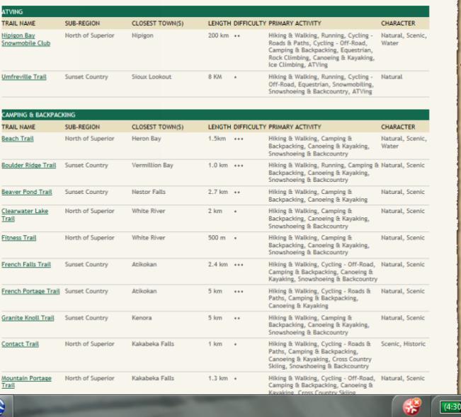
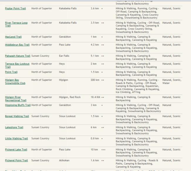
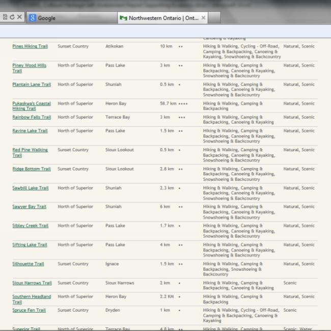
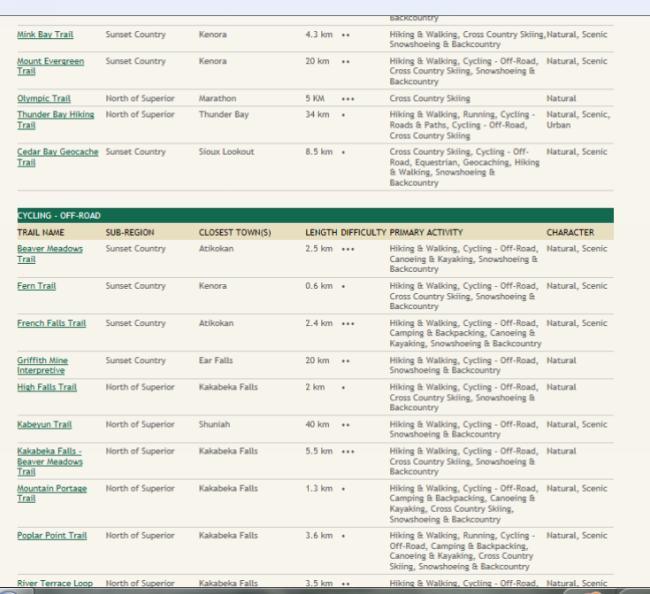
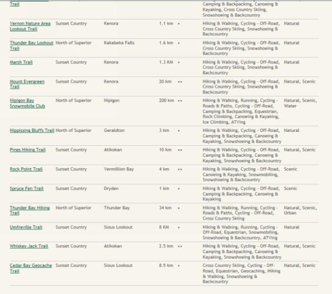
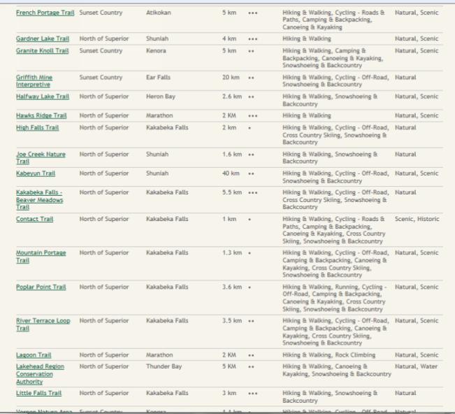
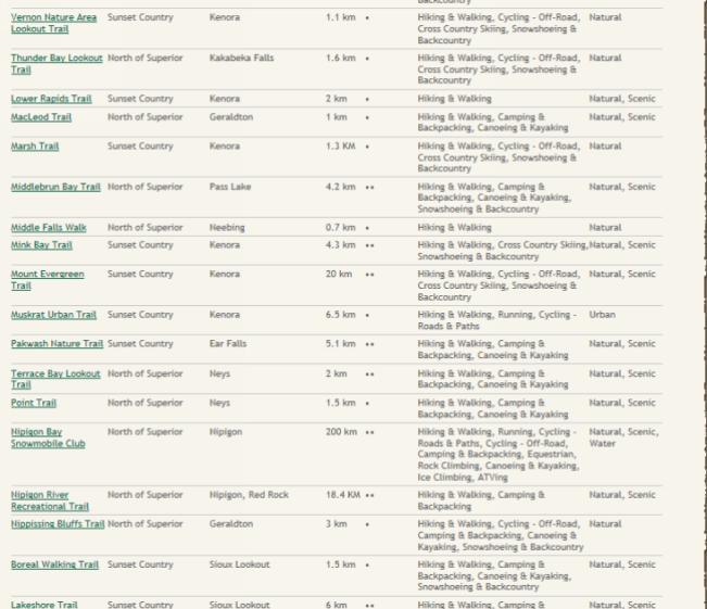
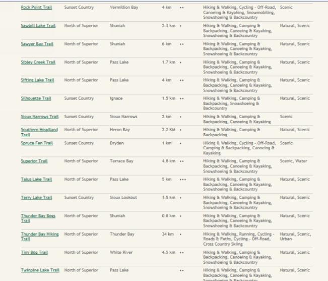
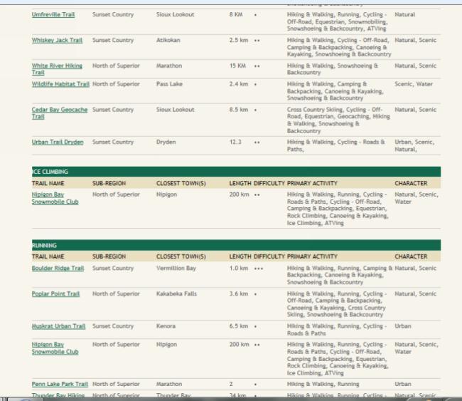
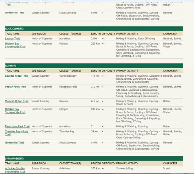
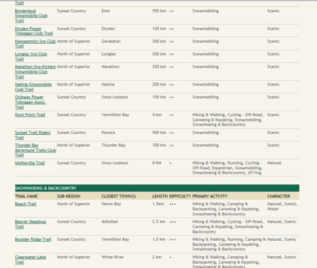
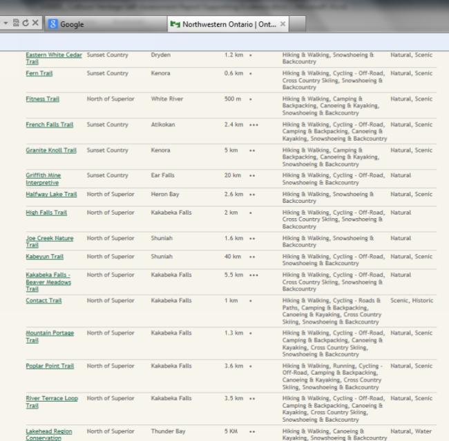
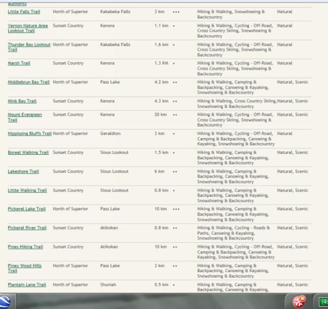
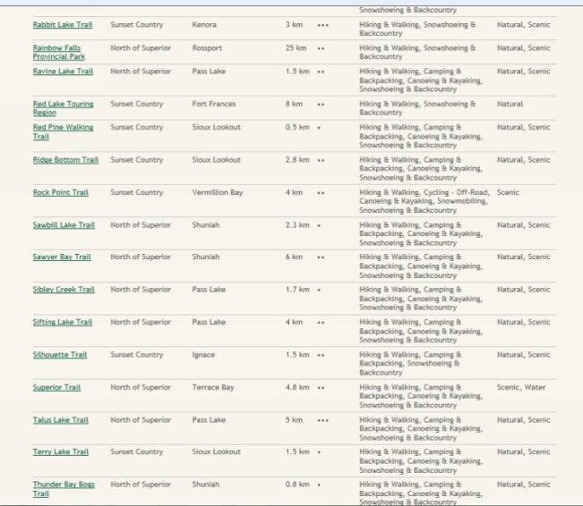
12 Whitesand First Nation 8 Draft Cultural Heritage Self-Assessment December 2013 Archaeological Assessment and Site Visit: Observations in the Stage 1 Archaeological Assessment report under a separate cover indicate no signs of any of the above described features within or abutting the Project Location. The assessment concluded that extensive modification of the ground surface has severely degraded archaeological and cultural heritage potential. Observations from Site visits conducted between May 1 and September 25, 2013 by Neegan Burnside staff noted the same conclusions. Further consultation with Whitesand First Nation and the Local Service Board was initiated, but response is required to confirm that there were no known parcels of land on-site or abutting properties which included cultural heritage landscapes. Copies of this consultation can be found in Appendix C. Canadian Heritage Rivers System: Through visual analysis of the Canadian Heritage Rivers System s map of Rivers in Ontario, it was determined that there were no Heritage Rivers within the Project Site that would be impacted by the Project. Screen shots of these maps can be found in Appendix B, and a map of the Project Location can be found in Appendix D. Consultation with Whitesand First Nation: Consultation was initiated with Whitesand First Nation to determine if there is Aboriginal or local knowledge or accessible documentation suggesting that the Project Location is situated on a parcel of land that contains or is part of a cultural heritage landscape. Response is required to confirm if lands with any of the above criteria are found on project lands. Copies of consultation can be found in Appendix C. Municipal Heritage Committees (MHCs) as listed on MTCS website: Armstrong Ontario has no municipal jurisdiction and is instead serviced through the Armstrong Local Services Board. Armstrong therefore has no MHC, as search results on the MTCS websites confirmed. Results of this search can be found in Appendix B. Further telephone correspondence with the Armstrong Local Service Board confirmed that there is no local Heritage Committee in Armstrong. Copies of this correspondence can be found in Appendix B. Ontario Historical Society s Heritage Directory (OHSHD): While a search for heritage features in the OHSHD determined that Thunder Bay has several Heritage features (49), none are located in Armstrong, Ontario and are therefore not likely to be present within the Project Location or on abutting lands. Results of this query are found in Appendix B. Ontario Trails website search: Through the Ontario Trails website Find a Trail search tool, no options for a search in Armstrong were available (as documented in Appendix B). A search for Thunder Bay retrieved several results, though these features are not located in close proximity to Neegan Burnside Ltd _ Cultural Heritage Self-Assessment Report
13 Whitesand First Nation 9 Draft Cultural Heritage Self-Assessment December 2013 Armstrong, or the Project Location, as determined through Google Earth These results are shown in screen shots in Appendix B. Question 9 (Landmarks) Is there Aboriginal or local knowledge or accessible documentation suggesting that the Project Location is situated on a parcel of land that is considered a landmark in the local community or contains any structure or sites that are important to defining the character of the area? Consultation with Local Service Board, MTCS and Whitesand First Nation: Neegan Burnside contacted the Armstrong Local Service Board, MTCS and Whitesand First Nation to determine if lands within or abutting the Project Location contained landmarks of cultural heritage significance. Correspondence from the MTCS concluded that the Project Location is not located on a property as stipulated in Section 19 of O. Reg. 359/09. Response is required from the Local Service Board and Whitesand First Nation to confirm that there are no such features. Results of this correspondence can be found in Appendix B. Stage 1 Archaeological Assessment: Observations made in the Stage 1 Archaeological Assessment indicate no landmarks within or abutting the Project Location. The assessment also indicates that recent land use has disturbed the land to an extent that cultural heritage potential has been degraded, and evidence of past heritage significance is not likely intact. The Stage 1 Archaeological Assessment report is available for review under a separate cover. Municipal Heritage Committees (MHCs) or local heritage organizations (search for MHCs online on MTCS website): Armstrong Ontario has no municipal jurisdiction and is instead serviced through the Armstrong Local Services Board. Armstrong therefore has no MHC, as search results on the MTCS websites confirmed. Results of this search can be found in Appendix B. Thunder Bay has a MHC, but their jurisdiction is in respect of cultural heritage resources within the City of Thunder Bay, not the Thunder Bay District. Further correspondence with the Armstrong Local Service Board confirmed that there is no local Heritage Committee in Armstrong. Copies of this correspondence can be found in Appendix C. Ontario Historical Society s Heritage Directory Search for Heritage Societies and Organizations in the province: A search for Armstrong Ontario in the Ontario Historical Society s Heritage Directory yielded zero results. A search in the same directory for Thunder Bay Ontario then Thunder Bay District (by clicking on Thunder Bay in results), yielded 49 results, 15 of which related to Heritage Societies and Organizations: 13 Historical Societies, 1 Local Heritage Group and 1 Municipal Heritage Committee. All of these listings are located in Neegan Burnside Ltd _ Cultural Heritage Self-Assessment Report
14 Whitesand First Nation 10 Draft Cultural Heritage Self-Assessment December 2013 the City of Thunder Bay or other surrounding communities. None are listed as being in Armstrong. Screen shots of these results can be found in Appendix B. Question 10 (Historical Association) Is there Aboriginal or local knowledge or accessible documentation suggesting that the Project Location is situated on a parcel of land that has special association with a community, person or historical event (Aboriginal sacred site, traditional-use areas, battlefield, birthplace of an individual of importance to the community etc.)? Consultation with the MTCS confirmed that the Project Location is not located on a property as stipulated in Section 19 of O. Reg. 359/09. Consultation with the Armstrong Local Service Board (in place of local MHC), and Whitesand First Nation was initiated, though response is required to confirm that there is no special association of the Project Location with a historically significant community, person or historic event. Copies of this correspondence can be found in Appendix B. Stage 1 Archaeological Assessment: The Stage 1 Archaeological Assessment report did not indicate special association of the Project Location with a historically significant community, person or historic event. The Stage 1 Archaeological Assessment report is available for review under a separate cover. Ontario Historical Society s Heritage Directory : A search for Armstrong Ontario in the Ontario Historical Society s Heritage Directory yielded zero results. A search in the same directory for Thunder Bay Ontario then Thunder Bay District (by clicking on Thunder Bay in results), yielded 49 results, 15 of which related to Heritage Societies and Organizations: 13 Historical Societies, 1 Local Heritage Group and 1 Municipal Heritage Committee. All of these listings are located in the City of Thunder Bay or other surrounding communities. None are listed as being in Armstrong. Screen shots of these results can be found in Appendix B. Further correspondence with the Armstrong Local Services Board confirmed that there was no local heritage group. This correspondence can be found in Appendix C. Neegan Burnside Ltd _ Cultural Heritage Self-Assessment Report
15 Whitesand First Nation 11 Draft Cultural Heritage Self-Assessment December Conclusions This report provides a written summary of the investigations that have taken place to satisfy the requirements of the REA Checklist and Section 23 of O. Reg. 359/09. Based on online research, consultation to date, site investigations, and background information from a Stage 1 Archeological Assessment report, it is believed that there is low potential for the presence of a heritage resource at the Project Location. Correspondence from the Armstrong Local Service Board and Whitesand First Nation is pending for confirmation of this assessment. Neegan Burnside Ltd. has prepared this Cultural Heritage Self-Assessment for Whitesand First Nation in support of an Application for Renewable Energy Approval of the Whitesand First Nation Cogeneration and Pellet Mill Project. This report has been prepared by Burnside for the sole benefit of Whitesand First Nation, and may not be reproduced by any third party without the express written consent of Whitesand First Nation. Respectfully submitted, Neegan Burnside Ltd. Signature Date December, 2013 Ashley Gallaugher, H.B.A., EPt. Environmental Scientist Neegan Burnside Ltd. Reviewed by: Signature Date December, 2013 Chris Shilton, P.Eng., LEED AP Project Manager Neegan Burnside Ltd. Approved By: Signature Date December, 2013 Craig Toset Project Manager Whitesand First Nation Neegan Burnside Ltd _ Cultural Heritage Self-Assessment Report.docx
16 Appendix A REA Checklist: Consideration of Potential for Heritage Resources
17
18
19
20
21 Appendix B Online Search Query Results
 (b) of the Ontario Heritage Act.")
22 1. Is the project location situated on a parcel of land that abuts any protected property as described in Column 1 of the Table in section 19? These properties can be defined as: a. A property that is the subject of an agreement, covenant or easement entered under clause 10 (1) (b) of the Ontario Heritage Act. Online review of easements in Northern Ontario determined that there were no properties meeting the above criteria on Project Lands or abutting lands. Found online at: Date of Query: November 17, 2013
 As determined in Google Earth using ruler tool on November 27, 2013")
23 Distance from Project Site in Armstrong, ON to Tourist Pagoda in Thunder Bay (208 km) As determined in Google Earth using ruler tool on November 27, 2013


24 4. Is the project location situated on a parcel of land that is listed on a register or inventory of heritage properties maintained by the municipality? Federal Plaques? (Parks Canada website) Armstrong Ontario

25 Thunder Bay, Ontario

26 Page 1 of 2

27 Page 2 of 2 Found online at: 24Main%24PageSearch1%24txtKeyword=&desCheck=NHS&desCheck=EVENT&desCheck=P ERSON&desCheck=HRS&desCheck=FHBRO&c=Thunder+Bay&ctl00%24Main%24PageSearc h1%24ddlprovince=100058&dey=&ctl00%24main%24pagesearch1%24ddlcustodian= Query Date: November 20, 2013

28 Provincial Plaques? Ontario Heritage Trust online Plaques Guide: Northern Ontario, District of Thunder Bay

29 Page 1 of 4

30 Page 2 of 4

31 Page 3 of 4

32 Page 4 of 4 Found online at: Date of query: November 17, 2013

33 5. Is the project location situated on a parcel of land that is on or abutting a National Historic site? Parks Canada Armstrong, Ontario

34 Found online at: Search1%24txtKeyword=&desCheck=NHS&c=Armstrong&ctl00%24Main%24PageSearch1%24 ddlprovince=100058&dey=&ctl00%24main%24pagesearch1%24ddlcustodian= Query Date: November 28, 2013

35 Thunder Bay, Ontario

36 Found online at: NHS&c=Thunder+Bay&ctl00%24Main%24PageSearch1%24ddlProvince=100058&dey=&ctl00 %24Main%24PageSearch1%24ddlCustodian= Query Date: November 28, 2013


37 6. Is the project location situated on a parcel of land that is on or abutting a known burial site or cemetery? Cemeteries Regulation Unit database of registered cemeteries: Thunder Bay District, Armstrong

38 Armstrong
39


40 Thunder Bay District : Page 1 of 6

41 Page 2 of 6 Page 3 of 6

42 Page 4 of 6 Page 5 of 6

43 Page 6 of 6 Found online at: Query Date: November 17, 2013
44 Thunder Bay District, 28, UNORG. TWP OF, 0 Results
45 Found Online at: Query Date: November 25, 2013

46 Thunder Bay District, 30, UNORG. TWP OF, 0 Results Found online at: Query Date: November 25, 2013


47 Thunder Bay District, 46, UNORG. TWP OF, 0 Results Found online at: Query Date: November 25, 2013
: Thunder Bay District, Unorganized")
48 Ontario Genealogical Society cemetery locator (OGS website): Thunder Bay District, Unorganized Territory

49 Found online at: Date of Query: November 18, 2013

50 Thunder Bay District, Armstrong Historic Municipality
51

52 Found online at: Date of Query: November 18, 2013

53 8. Is there Aboriginal or local knowledge or accessible documentation suggesting that the project location is situated on a parcel of land that contains or is part of a cultural heritage landscape? This includes Aboriginal trails, parks, Canadian Heritage Rivers, designated gardens, historic roads or rail corridors etc.) Canadian Heritage Rivers System: Ontario Rivers

54 Boundary Waters River Found online at: Query Date: November 18, 2013

55 Missinaibi River Found online at: Query Date: November 18, 2013

56 Mattawa River Found online at: Query Date: November 18, 2013

57 Municipal Heritage Committees (MHCs) as listed on MTCS website: Ontario Municipal Heritage Committee Directory Results. Armstrong not listed. Found online at: Query Date: November 18, 2013

58 Ontario Historical Society s Heritage Directory: Thunder Bay District Search Results
59
60
61
62
63
64
65
66
67
68
69
70 Found online at: ults.php&county=thunder Bay# Query Date: November 18, 2013

71 Ontario Trails website search: Armstrong Search; no search option for Armstrong as city Found online at: Query Date: November 18, 2013

72 Northeastern Ontario, Thunder Bay Search
73
74
75
76
77
78
79

80
81
82

83

84
85
86

87
88
89
90
91
92
93
94

95 Found online at: Query Date: November 18, 2013
.")
96 9. Is there Aboriginal or local knowledge or accessible documentation suggesting that the project location is situated on a parcel of land that is considered a landmark in the local community or contains any structures of sites that are important to defining the character of the area? (Municipal Heritage Committees on the MTCS website already reached for question 8). Ontario Historical Society s Heritage Directory for Heritage Societies and Organizations Search for Armstrong Ontario
97 Found online at: Browsing_122?page=heritage_connections_SearchDB.php&search=Armstrong+Ontario&SearchDB=Submit Query Date: November 18, 2013
98 Thunder Bay Ontario

99 Thunder Bay Click on Thunder Bay District 49 Results Total

100 13 Historical Societies

101 1 Local Heritage Group, 1 Municipal Heritage Committee: Found online at: er Bay Query Date: November 26, 2013
102 Appendix C Consultation
103 Ministry of Tourism, Culture and Sport Culture Services Unit Programs and Services Branch 401 Bay Street, Suite 1700 Toronto ON M7A 0A7 Tel: Fax: Ministère du Tourisme, de la Culture et du Sport Unité des services culturels Direction des programmes et des services 401, rue Bay, Bureau 1700 Toronto ON M7A 0A7 Tél: Téléc: November 27, 2013 ( ONLY) Chris Shilton Neegan Burnside Ltd 292 Speedvale Avenue West, Unit 20 Guelph, ON N1H 1C4 E: Project : Whitesand First Nation Cogeneration and Pellet Plant Project Location : Unorganized Territory (Armstrong Station area), Thunder Bay District MTC File No. : Dear Chris Shilton: The Ministry of Tourism, Culture and Sport (MTCS) has received your request, as per the Renewable Energy Approvals process of Ontario Regulation 359/09 under the Environmental Protection Act, to determine whether the above-noted renewable energy project affects cultural heritage resources. MTC understands that this project is classified as a Class 1 Thermal Facility. Section 19 of O.Reg. 359/09 requires proponents to contact the Ministry to determine if a renewable energy project location is: Designated as a property of cultural heritage value or interest of provincial significance (under section 34.5 of the Ontario Heritage Act); The subject of a notice of intention to designated as a property of cultural heritage value or interest of provincial significance (under section 34.6 of the Ontario Heritage Act); or, Designated as a historic site (under Regulation 880 of the Ontario Heritage Act) As a result of this review, the Ministry notes that this project location is not located on a protected property as stipulated in section 19 of O. Reg. 359/09. The Armstrong Local Service Board (Armstrong Resource Development Corporation) and the Ontario Heritage Trust should be contacted regarding the remaining types of protected properties listed in the Table under section 19. Please contact the Ministry s Archaeology Database Coordinator, Robert von Bitter, regarding the consideration of archaeological resources under Section 21(2)(a) of O.Reg. 359/09. My brief review of our data does not indicate that any archaeological sites have been registered on the subject property, but it may have archaeological potential due to the proximity of the project to water. Joseph.Muller@ontario.ca Please contact me if you have any questions or would like to discuss the file. Thank-you for your assistance, Joseph Muller Heritage Planner
104 Neegan Burnside Ltd. 292 Speedvale Avenue West Unit 20 Guelph ON N1H 1C4 Canada telephone (519) fax (519) web October 21, 2013 Via: Mail Ms. Diane Laybourne Armstrong Local Services Board 111 Queen Street Armstrong, ON P0T 1A0 Dear Ms. Diane Laybourne: Re: Request for Cultural Heritage Information Whitesand First Nation Cogeneration and Pellet Plant Project File No.: As you are aware, Neegan Burnside Ltd. ( Neegan Burnside ) is preparing an Application for Renewable Energy Approval ( REA ) on behalf of Whitesand First Nation for the above-referenced biomass fueled electric power and heat cogeneration plant, and wood pellet facility, located on crown land in an unorganized territory of the Thunder Bay District near Whitesand First Nation and Armstrong, Ontario. A contextual map of the site location can be found below, and a more detailed site plan of the project location is enclosed. Project Location Further details about the proposed project can be found in the Draft Project Description Report, available online at or in print for viewing at the locations: following
105 Ms. Diane Laybourne Page 2 of 4 October 21, 2013 Whitesand First Nation Reserve Band Office Lot 4A, Whitesand Road, Whitesand First Nation PO Box 68, Armstrong ON P0T 1A0 Standard Office Hours: Mon-Fri, 8:30 a.m. 5:00 p.m. Armstrong Local Service Board 111 Queen St. Armstrong Station ON P0T 1A0 Standard Office Hours: Mon-Fri, 10:00 a.m.-4:30 p.m. The project is subject to the provisions of the REA process as prescribed in Ontario Regulation 359/09. It is also subject to the provisions of the Ministry of Natural Resources Class Environmental Assessment for Resource Stewardship and Facility Development Projects. These processes include consideration of environmental aspects, natural heritage features and water bodies as well as heritage and archaeological resources. In addition, they include public, agency and aboriginal consultations. A brief outline of the processes is outlined below. Notice of Proposal / Release of Draft Project Description Report Public Meeting #1 We are here Completion of Environmental and Technical Studies Notice of Public Meeting #2 Release of draft REA Reports / Notice of EA Public Meeting #2 Project Layout and Reports Finalized Submit REA / Permit Applications / Notice of EA Completion/ Release Draft EA Report Notice of Filing posted on Env. Registry by MOE MOE REA Review / 30-day Public Review/ Issue EA Statement of Completion REA Decision Applicants for REA under the Environmental Protection Act, who opt to consider the potential for heritage resources under subsection 23 (2) of Ontario Regulation 359/09, must complete a self-assessment to determine if the site is located on or abutting a parcel of land which contains cultural heritage potential. This includes consultation with local municipalities, cultural heritage associations and First Nation communities to obtain information on cultural heritage resources in the area. Please note that other requests for information have been sent to the appropriate representatives of other groups or agencies to gather necessary information for the self-assessment. In order to thoroughly research the potential for cultural heritage resources on site, Neegan Burnside is sending this letter to request your input. In particular, please identify if this site is located on or abutting a property that: Permits Issued 1. Is defined as a protected property as per Section 19 of Ontario Regulation 359/09. Within the Local Authority s purview of this clause, Protected properties include those which: a. Have been given a notice of intention to designate them to be of cultural heritage value or interest in accordance with section 29 of the Ontario Heritage Act;
106 Ms. Diane Laybourne Page 3 of 4 October 21, 2013 b. Have been designated by a municipal by-law made under section 29 of the Ontario Heritage Act as properties of cultural heritage value or interest; c. Are the subject of an easement or a covenant entered into under section 10(1) (b) or section 37 of the Ontario Heritage Act; d. Are part of an area designated by a municipal by-law made under section 41 of the Ontario Heritage Act as a heritage conservation district. 2. Is a parcel of land listed on a register or inventory of heritage properties maintained by the municipality, local services board, local Heritage Committee or Society; 3. Contains a federal, provincial or municipal plaque; 4. Contains a National Historic Site (as designated by the Federal Minister of the Environment); 5. Contains a burial site or cemetery; 6. Contains structures over forty years old including: residential structures, farm buildings and outbuildings, industrial, commercial, or institutional buildings and/or engineering works etc; 7. Contains or is part of a cultural heritage landscape (ie. Aboriginal trail, park, Canadian Heritage River, designated garden, historic road or rail corridor, etc.); 8. Is considered a landmark in the local community or contains any structures or sites that are important to defining the character of the area (ie. prominent buildings or landscape features, complexes of buildings, monuments etc.); 9. Has a special association with a community, person or historical event (ie. Aboriginal sacred site, traditional-use areas, battlefield, birthplace of an individual of importance to the community etc.); 10. Contains extractive areas for food or scarce resources; 11. Contains Aboriginal or non-aboriginal settlements (ie. places of early military or pioneer settlement, older core of a community, early wharf or dock, pioneer churches, early cemeteries etc.); 12. Contains a significant or historical transportation route (ie. trail, pass, road, rail, portage route, canal, heritage river, shipping route, etc.); and 13. Contains a heritage trail, buildings or ruins that cannot be found through site visits or other means (ie. flooded area). Your participation in this study is much appreciated. Please submit your comments to the following mailing or address: whitesandbiomass@neeganburnside.com Mail: Chris Shilton Neegan Burnside Ltd. 292 Speedvale Avenue West, Unit 20 Guelph, ON N1H 1C4 Phone/Fax:
107 Ms. Diane Laybourne Page 4 of 4 October 21, 2013 Thank you for your attention to this matter. Yours truly, Neegan Burnside Ltd. Chris Shilton, P.Eng., LEED AP Project Manager CS:sd Enc. Cc Project Location Figure Craig Toset, Business Development, Whitesand First Nation David Mackett, Community Development, Whitesand First Nation Chris Walton, Arbora Management Services _Local Services Board Cultural Heritage Information Request Letter 21/10/ :34 AM
108 350 N FIGURE A1 PROJECT LOCATION KEY MAP N.T.S TW-3-13 TW TW-1-13 TW WHITESAND FIRST NATION PELLET MILL & BIOMASS PROJECT LEGEND 350 STUDY AREA PROJECT LOCATION :7,500 July 2013 Project Number: 120m SETBACK 300m SETBACK Air Photo Source: Background 2008 forest resource inventory air photo reproduced with the permission of Ministry of Natural Resources, Queen's Printer for Ontario Prepared by: C. Sheppard MONITORING WELL LOCATION By Others, 1990 MONITORING WELL LOCATION By Neegan Burnside, 2013 WASTEWATER MANAGEMENT SYSTEM AREA WITHDRAWN PER SECTION 35 OF THE MINING ACT (ORDER No. W-TB-122/11) EXISTING ELECTRICITY DISTRIBUTION LINE CONNECTION POINT EXISTING 10m CONTOURS INTERVAL (m asl) Metres Projection: UTM Zone 16 Datum: NAD83 Verified by: C. Shilton PELLET MILL DRAWING SET.DWG LAYOUT: PROJECT DESCRIPTION SA PRINTED: June 17, 2013, 3:53 PM

109 Neegan Burnside Ltd. 292 Speedvale Avenue West Unit 20 Guelph ON N1H 1C4 Canada telephone (519) fax (519) web October 21, 2013 Via: Mail Chief Allan Gustafson P.O. Box 68 Armstrong, ON P0T 1A0 Dear Chief Gustafson: Re: Request for Cultural Heritage Information Whitesand First Nation Cogeneration and Pellet Plant Project File No.: As you are aware, Neegan Burnside Ltd. ( Neegan Burnside ) is preparing an Application for Renewable Energy Approval ( REA ) on behalf of Whitesand First Nation for the above-referenced biomass fueled electric power and heat cogeneration plant, and wood pellet facility, located on crown land in an unorganized territory of the Thunder Bay District near Whitesand First Nation and Armstrong, Ontario. A contextual map of the site location can be found below, and a more detailed site plan of the project location is enclosed. Project Location Further details about the proposed project can be found in the Draft Project Description Report, available online at or in print for viewing at the locations: following
110 Chief Allan Gustafson Page 2 of 3 October 21, 2013 Whitesand First Nation Reserve Band Office Lot 4A, Whitesand Road, Whitesand First Nation PO Box 68, Armstrong ON P0T 1A0 Standard Office Hours: Mon-Fri, 8:30 a.m. 5:00 p.m. Armstrong Local Service Board 111 Queen St. Armstrong Station ON P0T 1A0 Standard Office Hours: Mon-Fri, 10:00 a.m.-4:30 p.m. The project is subject to the provisions of the REA process as prescribed in Ontario Regulation 359/09. It is also subject to the provisions of the Ministry of Natural Resources Class Environmental Assessment for Resource Stewardship and Facility Development Projects. These processes include consideration of environmental aspects, natural heritage features and water bodies as well as heritage and archaeological resources. In addition, they include public, agency and aboriginal consultations. A brief outline of the processes is outlined below. Notice of Proposal / Release of Draft Project Description Report Public Meeting #1 We are here Completion of Environmental and Technical Studies Notice of Public Meeting #2 / Release of draft REA Reports / Notice of EA Public Meeting #2 Project Layout and Reports Finalized Submit REA / Permit Applications / Notice of EA Completion/ Release Draft EA Report Notice of Filing posted on Env. Registry by MOE MOE REA Review / 30-day Public Review/ Issue EA Statement of Completion REA Decision Applicants for REA under the Environmental Protection Act, who opt to consider the potential for heritage resources under subsection 23 (2) of Ontario Regulation 359/09, must complete a self-assessment to determine if the site is located on or abutting a parcel of land which contains cultural heritage potential. This includes consultation with local municipalities, cultural heritage associations and First Nation communities to obtain information on cultural heritage resources in the area. Please note that other requests for information have been sent to the appropriate representatives of other groups or agencies to gather necessary information for the self-assessment. In order to thoroughly research the potential for cultural heritage resources on site, Neegan Burnside is sending this letter to request your input. In particular, please identify if you have any Aboriginal or local knowledge, or documentation suggesting that the project is located on, or abuts a parcel of land that: 1. Contains a National Historic Site (as designated by the Federal Minister of the Environment); 2. Contains a burial site or cemetery; 3. Contains structures over forty years old including: residential structures, farm buildings and outbuildings, industrial, commercial, or institutional buildings and/or engineering works etc.; Permits Issued
111 Chief Allan Gustafson Page 3 of 3 October 21, Contains or is part of a cultural heritage landscape (ie. Aboriginal trail, park, Canadian Heritage River, designated garden, historic road or rail corridor, etc.); 5. Is considered a landmark in the local community or contains any structures or sites that are important to defining the character of the area (ie. prominent buildings or landscape features, complexes of buildings, monuments etc.); 6. Has a special association with a community, person or historical event (ie. Aboriginal sacred site, traditional-use areas, battlefield, birthplace of an individual of importance to the community etc.); 7. Contains extractive areas for food or scarce resources; 8. Contains Aboriginal or non-aboriginal settlements (ie. places of early military or pioneer settlement, older core of a community, early wharf or dock, pioneer churches, early cemeteries etc.); 9. Contains a significant or historical transportation route (ie. trail, pass, road, rail, portage route, canal, heritage river, shipping route, etc.); and 10. Contains a heritage trail, buildings or ruins that cannot be found through site visits or other means (ie. flooded area). Your participation in this study is much appreciated. Please submit your comments to the following mailing or address: Mail: whitesandbiomass@neeganburnside.com Chris Shilton Neegan Burnside Ltd. 292 Speedvale Avenue West, Unit 20 Guelph, ON N1H 1C4 Phone/Fax: Thank you for your attention to this matter. Yours truly, Neegan Burnside Ltd. Chris Shilton, P.Eng., LEED AP Project Manager CS:sd Enc. Cc Project Location Figure Craig Toset, Business Development, Whitesand First Nation David Mackett, Community Development, Whitesand First Nation Chris Walton, Arbora Management Services _Whitesand Cultural Heritage Information Request Letter 21/10/ :03 PM


112 350 N FIGURE A1 PROJECT LOCATION KEY MAP N.T.S TW-3-13 TW TW-1-13 TW WHITESAND FIRST NATION PELLET MILL & BIOMASS PROJECT LEGEND 350 STUDY AREA PROJECT LOCATION :7,500 July 2013 Project Number: 120m SETBACK 300m SETBACK Air Photo Source: Background 2008 forest resource inventory air photo reproduced with the permission of Ministry of Natural Resources, Queen's Printer for Ontario Prepared by: C. Sheppard MONITORING WELL LOCATION By Others, 1990 MONITORING WELL LOCATION By Neegan Burnside, 2013 WASTEWATER MANAGEMENT SYSTEM AREA WITHDRAWN PER SECTION 35 OF THE MINING ACT (ORDER No. W-TB-122/11) EXISTING ELECTRICITY DISTRIBUTION LINE CONNECTION POINT EXISTING 10m CONTOURS INTERVAL (m asl) Metres Projection: UTM Zone 16 Datum: NAD83 Verified by: C. Shilton PELLET MILL DRAWING SET.DWG LAYOUT: PROJECT DESCRIPTION SA PRINTED: June 17, 2013, 3:53 PM
113 Neegan Burnside Ltd. 292 Speedvale Avenue West Unit 20 Guelph ON N1H 1C4 Canada telephone (519) fax (519) web Recorded By: Telephone Conversation Summary Date: August 19, :56 AM File No.: Project: Name: Message/Conversation Whitesand First Nation Cogeneration and Pellet Mill Project Chris Shilton I contacted the Armstrong Local Services Board (ph: ) and spoke to Secretary Diane Laybourne. Ms. Laybourne confirmed that Armstrong has no local police, fire, school board, heritage group/committee, or rate payers association. She also noted that fire protection services are provided by Whitesand First Nation _phone call summary - Armstrong local sevices board.docx 12/16/2013 4:00 PM
114 Appendix D Project Location Figure


115 350 N FIGURE A1 PROJECT LOCATION KEY MAP N.T.S. RAILWAY HIGHWAY MAINTENANCE YARD WELL MTO HIGHWAY MAINTENANCE YARD HYDRO ONE REMOTE COMMUNITIES DIESEL GENERATING STATION TRANSFORMER SUBSTATION HIGHWAY HYDRO ONE WELL MAINTENANCE GARAGE BIOMASS BELT DRYER PELLET MILL COGENERATION PLANT LOG DEBARKER / CHIPPER FIRE PUMP BUILDING WATER SUPPLY POND FOR FIRE PROTECTION TW TW TW-1-13 TW WASTEWATER MANAGEMENT SYSTEM GRAVEL QUARRY 350 WASTE OIL BUILDING DIESEL FUEL STORAGE & FILLING STATION LAND USE PERMIT #LUP HELD BY SAGATAY ECONOMIC DEVELOPMENT FOR A SAWMILL/COGENERATION PLANT INFILTRATION BIO-SWALE TRUCK SCALE ROUND WOOD (LOG) BIOMASS STORAGE PROCESSED (CHIPPED / HOGGED) BIOMASS STORAGE TRUCK DUMPER WHITESAND FIRST NATION COGENERATION & PELLET MILL PROJECT LEGEND 350 STUDY AREA PROJECT LOCATION :10,000 December 2013 Project Number: Prepared by: C. Sheppard STUDY AREA 50m BUFFER STUDY AREA 120m BUFFER MONITORING WELL LOCATION By Others, 1990 MONITORING WELL LOCATION By Neegan Burnside, 2013 PRIVATE WELL LOCATION By Others AREA WITHDRAWN PER SECTION 35 OF THE MINING ACT (ORDER No. W-TB-122/11) CROWN LAND DISPOSITION CL10395 PART 1, REFERENCE PLAN No. P ON HIGHWAY No. 527 EXISTING ELECTRICITY DISTRIBUTION LINE CONNECTION POINT EXISTING 10m CONTOURS INTERVAL (m asl) Air Photo Source: Background 2008 forest resource inventory air photo reproduced with the permission of Ministry of Natural Resources, Printer for Ontario Metres Projection: UTM Zone 16 Datum: NAD83 Verified by: C. Shilton PELLET MILL DRAWING SET.DWG LAYOUT: PROJECT DESCRIPTION SA PRINTED: December 16, 2013, 11:24 AM
Cultural Heritage Resources
 Cultural Heritage Resources An Information Bulletin for Projects Subject to Ontario Regulation 359/09 - Renewable Energy Approvals Ministry of Tourism, Culture and Sport 2011 (updated August 2013) Disclaimer:
Municipal Heritage Bridges Cultural, Heritage and Archaeological Resources Assessment Checklist Revised April 11, 2014
 Municipal Heritage Bridges Cultural, Heritage and Archaeological Assessment Checklist Revised April 11, 2014 This checklist was prepared in March 2013 by the Municipal Engineers Association to assist with
Cultural Heritage Resources
 Cultural Heritage Resources An Information Bulletin for Projects Subject to Ontario Regulation 359/09 - Renewable Energy Approvals DRAFT Ministry of Tourism, Culture and Sport 2011 (updated September 2012)
A Guide to Open Space Design Development in Halifax Regional Municipality
 A uide to Open Space Design Development in Halifax Regional Municipality May 2007 1 Introduction Pursuant to Section 3.5 of the Regional Municipal Planning Strategy (RMPS), subdivision of land may proceed
TOWN OF AURORA HERITAGE IMPACT ASSESSMENTS AND CONSERVATION PLANS GUIDE
 PLANNING AND DEVELOPMENT SERVICES Development Planning Division Heritage Planning Section Phone: 905-727-3123 ext. 4226 Fax: 905-726-4736 Email: planning@aurora.ca Town of Aurora 100 John West Way, Box
Provincial Heritage Places Recognition Program
 Prince Edward Island Provincial Heritage Places Recognition Program A guide for heritage property owners Contents 1 1) Contents 2) The Island s Heritage 3) Historic Places Initiative 4) Heritage Recognition
Purpose of Report...1. Planning Framework Provincial Policy Statement Draft PPS...2. Ontario Heritage Act...3
 Cultural Heritage Policy Discussion Paper November 4 th, 2013 Table of Contents Purpose of Report...1 Planning Framework...1 2005 Provincial Policy Statement...1 2012 Draft PPS...2 Ontario Heritage Act...3
MUNICIPALITY OF NORTH GRENVILLE. PROPOSED WATERFRONT TRAILS AND PEDESTRIAN BRIDGE ON THE SOUTH BRANCH OF THE RIDEAU RIVER Kemptville, Ontario
 MUNICIPALITY OF NORTH GRENVILLE PROPOSED WATERFRONT TRAILS AND PEDESTRIAN BRIDGE ON THE SOUTH BRANCH OF THE RIDEAU RIVER Kemptville, Ontario MUNICIPAL CLASS ENVIRONMENTAL ASSESSMENT, SCHEDULE B Project
Intention to Designate under Part IV, Section 29 of the Ontario Heritage Act 844 Don Mills Road and 1150 Eglinton Avenue East
 STAFF REPORT ACTION REQUIRED Intention to Designate under Part IV, Section 29 of the Ontario Heritage Act 844 Don Mills Road and 1150 Eglinton Avenue East Date: September 7, 2016 To: From: Toronto Preservation
Telecommunication Facility Policy
 Telecommunication Facility Policy September 26, 2016 Table of Contents SECTION 1 Purpose of the Policy SECTION 2 Principles SECTION 3 Designated Municipal Official SECTION 4 Design and Landscaping SECTION
Figure 1- Site Plan Concept
 Figure 1- Site Plan Concept Parking will be provided underground on three levels at rate of 1.0 space/ unit; this rate includes all visitors parking. MMM Group has prepared a parking assessment (April,
ONTARIO MUNICIPAL BOARD
 PL 120483 ONTARIO MUNICIPAL BOARD Applicant/Appellant: 2124123 Ontario Limited Subject: OPA, Rezoning and Draft Plan of Subdivision Municipal Address: 3940 Highway 7 East Municipality: City of Markham
South of Eastern Strategic Direction Status Update
 STAFF REPORT ACTION REQUIRED South of Eastern Strategic Direction Status Update Date: July 10, 2014 To: From: Planning and Growth Management Committee Chief Planner and Executive Director, City Planning
The Evolution of Cultural Heritage Landscapes as a Means of Protecting Heritage Resources
 The Evolution of Cultural Heritage Landscapes as a Means of Protecting Heritage Resources Heritage conservation itself is not a new planning issue. This issue has traditionally been framed primarily as
9 CITY OF VAUGHAN OFFICIAL PLAN AMENDMENT NO BOCA EAST INVESTMENTS LIMITED
 9 CITY OF VAUGHAN OFFICIAL PLAN AMENDMENT NO. 631 - BOCA EAST INVESTMENTS LIMITED The Planning and Economic Development Committee recommends the adoption of the recommendations contained in the following
Garden District Heritage Conservation District Study
 Garden District Heritage Conservation District Study Community Consultation Meeting September 24 th, 2013 What is a Heritage Conservation District? A defined area of heritage significance and character
APPENDIX F: EXTERNAL APPROVALS
 1.0 RESPONSIBILITIES When the City is constructing the Park or Open Space Development lands (OPTION I), after the subdivision construction process is completed by the Developer, Open Space Development
CHAIR AND MEMBERS PLANNING & ENVIRONMENT COMMITTEE MEETING ON MONDAY AUGUST 28, 2017 JOHN M. FLEMING MANAGING DIRECTOR, PLANNING AND CITY PLANNER
 TO: FROM: SUBJECT: CHAIR AND MEMBERS PLANNING & ENVIRONMENT COMMITTEE MEETING ON MONDAY AUGUST 28, 2017 JOHN M. FLEMING MANAGING DIRECTOR, PLANNING AND CITY PLANNER REQUEST FOR DEMOLITION OF HERITAGE LISTED
Garden District Heritage Conservation District Study
 Garden District Heritage Conservation District Study Community Consultation Meeting Ryerson International Living & Learning Centre 7:30 9:00 pm April 29 th, 2014 Presentation Overview Presentation of project
KLEINBURG-NASHVILLE AREA HERITAGE CONSERVATION DISTRICT STUDY AND PLAN PURSUANT TO PART V OF THE ONTARIO HERITAGE ACT
 COUNCIL JUNE 23, 2003 KLEINBURG-NASHVILLE AREA HERITAGE CONSERVATION DISTRICT STUDY AND PLAN PURSUANT TO PART V OF THE ONTARIO HERITAGE ACT Recommendation The Commissioner of Planning in consultation with
PHASE 1 ARCHAEOLOGICAL IMPACT ASSESSMENT PROPOSED DEVELOPMENT ERF 3 ROBERTSON WESTERN CAPE PROVINCE
 PHASE 1 ARCHAEOLOGICAL IMPACT ASSESSMENT PROPOSED DEVELOPMENT ERF 3 ROBERTSON WESTERN CAPE PROVINCE Prepared for BOLAND ENVIRO Att: Mr Nik Wullschleger PO Box 250 Worcester 6849 Fax: (023) 347 0336 By
Variance from Chapter 297, Signs, of the Former City of Toronto Municipal Code Bloor Street West (High Park)
") Variance from Chapter 297, Signs, of the Former City of Toronto Municipal Code - 2595 Bloor Street West (High Park) (City Council on August 1, 2, 3 and 4, 2000, adopted this Clause, without amendment.)
Variance from Chapter 297, Signs, of the Former City of Toronto Municipal Code - 2595 Bloor Street West (High Park) (City Council on August 1, 2, 3 and 4, 2000, adopted this Clause, without amendment.)
The Rideau Canal Corridor: Planning for a Proud Future. Heather Thomson Heritage Planner Parks Canada
 The Rideau Canal Corridor: Planning for a Proud Future Heather Thomson Heritage Planner Parks Canada Overview What is the Rideau Canal? Planning in the Rideau and Trent-Severn Corridors: Challenges and
CULTURAL HERITAGE ASSESSMENT REPORT CULTURAL HERITAGE LANDSCAPE & BUILT HERITAGE FEATURES
 CULTURAL HERITAGE ASSESSMENT REPORT CULTURAL HERITAGE LANDSCAPE & BUILT HERITAGE FEATURES DUNTROON QUARRY EXPANSION LOT 25 AND PART LOT 26, CONCESSION 12 & PART LOT 25, CONCESSION 12 CLEARVIEW TOWNSHIP
Town of Cobourg Heritage Master Plan. Statutory Public Meeting
 Town of Cobourg Heritage Master Plan Statutory Public Meeting April 25 th 2016 Presentation Overview 1. Introduction 2. Project background and schedule overview 3. Review of strategic direction content
52: 2182 Lakeshore Road East, Horizons
 1. Description of Property Municipal Address Name (if applicable) Legal Description Location of Property Ownership Access Current Use Existing Designation General Description Priority Level 52: 2182 Lakeshore
VILLAGE OF BOLTON HERITAGE CONSERVATION DISTRICT PLAN
 Page 1 1. INTRODUCTION AND BACKGROUND 1.1 THE PROJECT VILLAGE OF BOLTON HERITAGE CONSERVATION DISTRICT PLAN TERMS OF REFERENCE The Town of Caledon (Town) is a large, predominantly rural municipality with
West London Dyke, April 1947 Flood. Forks of the Thames, July 2000 Flood. Source: UTRCA
 This Public Information Centre is the 1 st of 2. Its purpose is to inform the public and to receive input with regards to the West London Dyke Master Repair Plan. The following panels describe the history,
COUNTY OF LAMBTON OFFICIAL PLAN UPDATE BACKGROUND REPORT NO.
 COUNTY OF LAMBTON OFFICIAL PLAN UPDATE BACKGROUND REPORT NO. 7 TELECOMMUNICATIONS Image Source: (Word Clip Art Stock Photos, 2011) Date: May, 2015 PLANNING AND DEVELOPMENT SERVICES DEPARTMENT 789 Broadway
Chapter 6 cultural heritage
 6 Cultural Heritage 6.1 Protecting Vaughan s Cultural Heritage 165 6.1.1 Protecting Vaughan s Cultural Heritage 165 6.1.2 Maintaining a Heritage Inventory 166 6.1.3 Promoting Vaughan s Cultural Heritage
F2. Draft Archaeological and Cultural Heritage Net Effects Analysis & Comparative Evaluation Report
 F2. Draft Archaeological and Cultural Heritage Net Effects Analysis & Comparative Evaluation Report Clean Harbors Canada Inc. Lambton Landfill Expansion Environmental Assessment Draft Archaeological and
2: Bond Street, I.O.F Orphanage
 1. Description of Property 2: 37-53 Bond Street, I.O.F Orphanage Municipal Address 37-53 Bond Street ame (if applicable) Independent Order of Foresters (I.O.F.) Orphanage Legal Description PT LTS 15 &
Subject: Identification and Confirmation Procedure for Areas of Natural and Scientific Interest Compiled by Branch Ontario Parks
 Subject: Identification and Confirmation for Areas of Natural and Scientific Interest Compiled by Branch Ontario Parks Replaces Directive Title ANSI 2000 Section Planning & Research Number No. Date Issued
GUIDELINES FOR CULTURAL HERITAGE IMPACT ASSESSMENTS
 GUIDELINES FOR CULTURAL HERITAGE IMPACT ASSESSMENTS Purpose A Cultural Heritage Impact Assessment (CHIA) is a study to identify and evaluate built heritage resources and cultural landscapes in a given
Demolition of a Designated Heritage Property Roncesvalles Avenue
 REPORT FOR ACTION Demolition of a Designated Heritage Property - 421 Roncesvalles Avenue Date: March 8, 2018 To: Toronto Preservation Board Toronto and East York Community Council From: Acting Chief Planner
CITY OF VAUGHAN EXTRACT FROM COUNCIL MEETING MINUTES OF MAY 6, 2014
 CITY OF VAUGHAN EXTRACT FROM COUNCIL MEETING MINUTES OF MAY 6, 2014 Item 35, Report No. 18, of the Committee of the Whole, which was adopted, as amended, by the Council of the City of Vaughan on May 6,
STAGE 1 ARCHAEOLOGICAL ASSESSMENT OF RATHBURN ROAD, FROM DUKE OF YORK BOULEVARD TO SHIPP DRIVE, CITY OF MISSISSAUGA. Submitted to:
 STAGE 1 ARCHAEOLOGICAL ASSESSMENT OF RATHBURN ROAD, FROM DUKE OF YORK BOULEVARD TO SHIPP DRIVE, CITY OF MISSISSAUGA Submitted to: McCormick Rankin Corporation 2655 North Sheridan Way, Suite 280 Mississauga,
Cultural Heritage Landscape Heritage Impact Statement Terms of Reference
 Community Services Department City of Mississauga 201City Centre Dr, Suite 900 MISSISSAUGA ON L5B 2T4 www.mississauga.ca Leading today for tomorrow Cultural Heritage Landscape Heritage Impact Statement
Cultural Heritage Landscapes Strategy
 Cultural Heritage Landscapes Strategy TABLE OF CONTENTS Executive Summary 1.0 Introduction 1.1 Objectives of the Strategy 2.0 Definition and Identification of Cultural Heritage Landscapes 2.1 Definitions
THE CORPORATION OF THE CITY OF WINDSOR Office of the City Solicitor Planning Department
 THE CORPORATION OF THE CITY OF WINDSOR Office of the City Solicitor Planning Department REPORT TO THE CITY OF WINDSOR PLANNING ADVISORY COMMITTEE DATE OF REPORT: August 19, 2010 SUBJECT: Official Plan
13 Extending the Esri Enterprise Licence Agreement
 Clause 13 in Report No. 10 of Committee of the Whole was adopted, without amendment, by the Council of The Regional Municipality of York at its meeting held on May 21, 2015. 13 Extending the Esri Enterprise
An Introduction to the Far North Land Use Strategy
 An Introduction to the Far North Land Use Strategy December, 2013 Ministry of Natural Resources Table of Contents PREFACE... 3 About the Far North... 3 Evolution of Land Use Planning in the Far North...
a) buildings, structures and artifacts of historical significance;
 buildings, structures and artifacts of historical significance;") 12.3.2. Definition Heritage Resources: There are two classes of heritage resources: monumental or landmark heritage that is considered to reflect exemplary architecture and style of a particular area or
12.3.2. Definition Heritage Resources: There are two classes of heritage resources: monumental or landmark heritage that is considered to reflect exemplary architecture and style of a particular area or
Summary of Other State Archeological Guidelines
 Summary of Other State Archeological Guidelines This is a summary all guidelines for archeology from 17 other states. This information was gathered in order to see what type of guidelines other states
APPENDIX 1: SCOPED ENVIRONMENTAL IMPACT STATEMENT (EIS) FORM
 FORM") APPENDIX 1: SCOPED ENVIRONMENTAL IMPACT STATEMENT (EIS) FORM This form is intended for use by applicants (primarily private landowners) who need to conduct a Scoped EIS in support of minor development
APPENDIX 1: SCOPED ENVIRONMENTAL IMPACT STATEMENT (EIS) FORM This form is intended for use by applicants (primarily private landowners) who need to conduct a Scoped EIS in support of minor development
The Director of Development Planning and Manager of Urban Design and Cultural Heritage recommends:
 HERITAGE VAUGHAN COMMITTEE APRIL 26, 2017 LOT LINE ADJUSTMENT AND DEMOLITION OF GARAGE 376 STEGMAN S MILL ROAD - KLEINBURG-NASHVILLE HERITAGE CONSERVATION DISTRICT, DESIGNATED UNDER PART V, ONTARIO HERITAGE
20 & 30 Frank Nighbor Place
 Engineering Land / Site Development Municipal Infrastructure Environmental / Water Resources Traffic / Transportation Structural Recreational Planning Land / Site Development Planning Application Management
43: 2165 Dundas St. West, Smith-Carrique Barn and Shed
 1. Description of Property Municipal Address Name (if applicable) Legal Description Location of Property Ownership Access Current Use Existing Designation General Description Priority Level 43: 2165 Dundas
Request for Decision. Recommendation. Presented: Monday, Jul 07, Report Date Friday, Jun 20, Type: Public Hearings
 Presented To: Planning Committee Request for Decision Application for rezoning in order to permit a place of worship on a vacant lot zoned for C1, Local Commercial uses, Cam Street, Sudbury Sitiri Investments
SUBJECT: Proposed Downtown Mobility Hub Precinct Plan and Proposed Official Plan Policies
 Page 1 of Report PB-81-17 SUBJECT: Proposed Downtown Mobility Hub Precinct Plan and Proposed Official Plan Policies TO: FROM: Committee of the Whole Planning and Building Department Report Number: PB-81-17
Rowntree Mill Road Zoning and Plan of Subdivision Applications Final Report
 STAFF REPORT ACTION REQUIRED 148-156 Rowntree Mill Road Zoning and Plan of Subdivision Applications Final Report Date: March 13, 2007 To: From: Wards: Reference Number: Etobicoke York Community Council
CULTURAL HERITAGE RESOURCES POLICIES
 New Official Plan CULTURAL HERITAGE RESOURCES POLICIES Date March 6, 2009 Distributed at: Livable Oakville Committee, March 9, 2009 Planning Services Department March 2009 1 1 Policy Discussion Paper:
Baby Point Wastewater Pumping Station Forcemain Class Environmental Assessment Study
 Baby Point Wastewater Pumping Station Forcemain Class Environmental Assessment Study Public Drop-in Event 1 Thursday, October 12, 2017 6:00 p.m. to 8:00 p.m. Humbercrest United Church Welcome Welcome to
Development Permit Application Form. Property Owner Information as Registered on Legal Title Property Owner Name: Phone:
 Development Application Requirements 1 1926 Tsawwassen Drive Tel: 604-943-2112 Tsawwassen, BC V4M 4G2 www.tsawwassenfirstnation.com Canada Development Permit Application Form Name of Applicant: Address:
Cultural Landscape Heritage Impact Statement Terms of Reference
 Culture Division Community Services Department City of Mississauga 201City Centre Dr, Suite 202 MISSISSAUGA ON L5B 2T4 www.mississauga.ca Leading today for tomorrow Cultural Landscape Heritage Impact Statement
June 22, 2018 Project No /2100
 June 22, 2018 Project No. /2100 Riotrin Properties (Gloucester 3) Inc. c/o Riocan Management Inc. Riocan Yonge Eglinton Centre 2300 Yonge Street, Suite 500 Toronto, Ontario M4P 1E3 PHASE I ENVIRONMENTAL
Director, Community Planning, Etobicoke York District
 STAFF REPORT April 25, 2006 To: From: Subject: Etobicoke York Community Council Director, Community Planning, Etobicoke York District Refusal Report Rezoning Application 04 203855 WET 07 OZ Plan of Subdivision
LSRA Solar Project Site Considerations Information. Page 1. Table 1: LSRA Solar Project Site Considerations Information
 Table 1: LSRA Solar Project Requirements from LRP I RFP Section 3.2.6 (b) (i) The Registered Proponent must have provided detailed scale maps of the Large Renewable Project and the proposed Connection
PDS June 1, 2016 Page 1. Planning and Development Committee. MEETING DATE: Wednesday, June 01, 2016
 Page 1 REPORT TO: Planning and Development Committee MEETING DATE: Wednesday, June 01, 2016 SUBJECT: ROPA 12: Project Initiation Report Regional Official Plan Amendment (ROPA # 12) Watercourse Policies
Heritage Impact Assessment York Road Environmental Design Study City of Guelph, Ontario APPENDIX A FIGURES. Project Number TP115100
 Heritage Impact Assessment York Road Environmental Design Study City of Guelph, Ontario APPENDIX A FIGURES Project Number Appendix A 200 400 600 800 0 1000m C:\Users\cara.howell\Desktop\York.dwg(fig1)*cara.howell*
Transportation Master Plan Schedule B Projects Road Name From To Description of Works Southcote Road Garner Road Twenty Road Extension
 NOTICE OF STUDY COMPLETION CLASS ENVIRONMENTAL ASSESSMENT STUDY Municipal Class Environmental Assessment for Hamilton Airport Employment Growth District Background The Airport Employment Growth District
HERITAGE ASSESSMENT REPORT
 HERITAGE ASSESSMENT REPORT Cultural Heritage Evaluation for Woolwich Bio-en Inc. Part Lot 89, G.C.T., Settlement Area of Elmira Township of Woolwich Region of Waterloo Required under: Environmental Protection
INTACH AWARD FOR BEST PRACTICES IN CONSERVATION
 INTACH AWARD FOR BEST PRACTICES IN CONSERVATION ENTRY FORM (Please FILL OUT in English, PRINT, SIGN and SEND together with required materials). The form should be submitted together with the Project Description
ONTARIO MUNICIPAL BOARD
 PL141318 ONTARIO MUNICIPAL BOARD Bronte Green Corporation has appealed to the Ontario Municipal Board under subsection 51(34) of the Planning Act, R.S.O. 1990, c. P.13, from the failure of the Town of
Cc~tporate Sers~ic:es
 tg * Cc~tporate Sers~ic:es Csrmcil and Adnrirristrativs Services April 26,201 1 ". RE(;lr?N (1;. 1q.1 i Town of Caledon Region of Peel ci E~iliS DEP? Attn: Karen Landry, Director of Attn: Carol Reig, Regional
ADMINISTRATIVE REPORT
 ADMINISTRATIVE REPORT TO: FROM: Board of Directors B. Newell, Chief Administrative Officer DATE: July 6, 2017 RE: Official Community Plan (OCP) Bylaw Amendment Electoral Area C Administrative Recommendation:
TOWN OF BRUDERHEIM Report to the capital region board
 TOWN OF BRUDERHEIM Report to the capital region board Introduction to the Town of Bruderheim Municipal Development Plan amendment and Relation to the CRB Evaluation Criteria 02 march 2017 1 Introduction
7437, 7439 and 7441 Kingston Road - Zoning By-law Amendment and Site Plan Control Applications - Preliminary Report
 STAFF REPORT ACTION REQUIRED 7437, 7439 and 7441 Kingston Road - Zoning By-law Amendment and Site Plan Control Applications - Preliminary Report Date: August 13, 2015 To: From: Wards: Reference Number:
and Richmond Street West - Official Plan Amendment Application - Preliminary Report
 STAFF REPORT ACTION REQUIRED 822-838 and 860-862 Richmond Street West - Official Plan Amendment Application - Preliminary Report Date: August 14, 2017 To: From: Wards: Reference Number: Toronto and East
Planning and Building Department APPLICATION FOR CEMETERY EXPANSION BAYVIEW CEMETERY, 720, 726 AND 740 SPRING GARDENS ROAD
 Page 1 of Report Planning and Building Department TO: Community Development Committee SUBJECT: APPLICATION FOR CEMETERY EXPANSION BAYVIEW CEMETERY, 720, 726 AND 740 SPRING GARDENS ROAD Report Number: Report
Alternative Routes. St. Vital to La Verendrye Station - Southern Loop Transmission Corridor. 20 different segments 4 segments common to all routes
 Alternative Routes St. Vital to La Verendrye Station - Southern Loop Transmission Corridor In a fixed right-of-way St. Vital to Letellier Station 20 different segments 4 segments common to all routes Goal
GUIDELINES FOR CULTURAL HERITAGE IMPACT ASSESSMENTS
 GUIDELINES FOR CULTURAL HERITAGE IMPACT ASSESSMENTS Purpose The purpose of undertaking a Cultural Heritage Impact Assessment, which is provided by the applicant, is to identify and evaluate cultural heritage
Bressa Developments Limited. Planning Justification Report. Revised Draft Plan of Subdivision and Zoning By-Law Amendment
 Bressa Developments Limited Revised Draft Plan of Subdivision and Zoning By-Law Amendment Planning Justification Report Part of Lots 7 & 8 Concession 1, North of Dundas Street Town of Oakville September,
MINISTRY OF TRANSPORTATION. Environmental Guide for Built Heritage and Cultural Heritage Landscapes
 MINISTRY OF TRANSPORTATION Environmental Guide for Built Heritage and Cultural Heritage Landscapes Version: February 2007 MINISTRY OF TRANSPORTATION Environmental Guide for Built Heritage and Cultural
City of Toronto. Emery Village Transportation Master Plan
 City of Toronto Emery Village Transportation Master Plan May 2009 Emery Village Transportation Master Plan Toronto, ON May 2009 Consulting Inc. 100 York Blvd., Suite 300 Richmond Hill, ON L4B 1J8 Tel:
MONITORING STRATEGY. CRM Lab Archaeological Services
 CRM Lab Archaeological Services MONITORING STRATEGY Archaeological Monitoring and Mitigation Strategy submitted to City Planning - for project 587-599 Yonge Street, 7 & 9 Gloucester Street, 4 Dundonald
; Office of the Regional Clerk
 Iagafa Mtg; ; Office of the Regional Clerk R gioi I 2201 St. David s Road, P.O. Box 1042, Thorold ON LNW Tel: 905-685-1571 Toll-free: 1-800-263-7215 Fax: 905-687-4977 cierk@niagararegion.ca vwwv.niagararegion.ca
City of Kingston Heritage Commemoration Program Guidelines: 7 May 2010
 MHC-13-010 Exhibit B City of Kingston Heritage Commemoration Program Guidelines: 7 May 2010 These guidelines cover three separate types of city heritage commemoration: small markers on designated property.
8 Oak Street - Official Plan and Zoning By-law Amendment Application - Preliminary Report
 STAFF REPORT ACTION REQUIRED 8 Oak Street - Official Plan and Zoning By-law Amendment Application - Preliminary Report Date: March 17, 2014 To: From: Wards: Reference Number: Planning and Growth Management
Preliminary Sediment & Stormwater Management Plan Review Checklist DATE RECEIVED: PROJECT NUMBER: PROJECT NAME:
 Preliminary Sediment & Stormwater Management Plan Review Checklist DATE RECEIVED: PROJECT NUMBER: PROJECT NAME: General Information: 1. Completed application signed by the owner, review fee, one set of
Feasibility Analysis for Expansion of the Provincial Greenbelt Plan Area into Mississauga
 Feasibility Analysis for Expansion of the Provincial Greenbelt Plan Area into Mississauga November 8, 2013 Natural Heritage and Urban Forest Strategy: Draft Discussion Paper #3: Table of Contents 1.0 Introduction...
Planning and Growth Management Committee. Chief Planner and Executive Director, City Planning Division. Pg12013 (File No NNY 34 OZ)
") 865 York Mills Road Official Plan Amendment Application Preliminary Report STAFF REPORT ACTION REQUIRED Date: February 28, 2012 To: From: Wards: Reference Number: Planning and Growth Management Committee
865 York Mills Road Official Plan Amendment Application Preliminary Report STAFF REPORT ACTION REQUIRED Date: February 28, 2012 To: From: Wards: Reference Number: Planning and Growth Management Committee
PHASE 1 ARCHAEOLOGICAL IMPACT ASSESSMENT THE PROPOSED SWARTLAND SHOPPING MALL
 10 ( PHASE 1 ARCHAEOLOGICAL IMPACT ASSESSMENT THE PROPOSED SWARTLAND SHOPPING MALL Remainder Farm Tweefontein No. 696, Erf 2654 (Portion of Erf 327), Erf 9215 (Portion of Erf 2654) & Portion of Erf 327
Paul D. Ralph, BES, RPP, MCIP, Commissioner, Development Services Department. Proposed Storm Water Pond Maintenance Fee
 Public Report To: From: Report Number: Development Services Committee Paul D. Ralph, BES, RPP, MCIP, Commissioner, Development Services Department DS-16-211 Date of Report: December 1, 2016 Date of Meeting:
CONSULTING SERVICES FOR THE WHITEBELT VISIONING EXERCISE ADDENDUM TO THE GTA WEST LAND USE STUDY WORK PROGRAM
 CONSULTING SERVICES FOR THE WHITEBELT VISIONING EXERCISE ADDENDUM TO THE GTA WEST LAND USE STUDY 1. Introduction WORK PROGRAM The Town of Caledon is a large, local municipality located in the Greater Toronto
The MSII reports for the bridge indicate that the Annual Average Daily Traffic at the bridge is 100. The road can be considered a low volume road.
 Page 1 1 INTRODUCTION 1.1 Background The Bronk Road Bridge is located on Bronk Road about 0.2 km north of Thrasher Road and spans Parks Creek, a tributary of the Moira River. Bronk Road is the road allowance
REQUEST FOR PROPOSAL RFP PRESERVATION MASTER PLAN FOR THE ELAM MARTIN FARMSTEAD CITY OF WATERLOO RIM PARK TERMS OF REFERENCE
 REQUEST FOR PROPOSAL RFP-01-28 PRESERVATION MASTER PLAN FOR THE ELAM MARTIN FARMSTEAD CITY OF WATERLOO RIM PARK TERMS OF REFERENCE The City of Waterloo is requesting proposals for the development of a
Newcombe House & Kensington Church Street
 Newcombe House & Kensington Church Street Archaeological Evaluation September 2017 Summary Site name: Newcombe House, Kensington Church Street, Notting Hill, London Grid reference: TQ 25318 80372 Site
AMENDMENT NO. 30 TO THE OFFICIAL PLAN OF THE TOWN OF MILTON
 AMENDMENT NO. 30 TO THE OFFICIAL PLAN OF THE TOWN OF MILTON Subject: Boyne Survey Secondary Plan and Related Official Plan Amendments The following text and schedules constitute Amendment No. 30 to the
STAGE 1 2 ARCHAEOLOGICAL ASSESSMENT OF YONGE STREET SUBWAY EXTENSION, LOTS 37-41, CONCESSION EYS, TOWNSHIP OF MARKHAM, CITY OF TORONTO, YORK COUNTY
 STAGE 1 2 ARCHAEOLOGICAL ASSESSMENT OF YONGE STREET SUBWAY EXTENSION, LOTS 37-41, CONCESSION EYS, TOWNSHIP OF MARKHAM, CITY OF TORONTO, YORK COUNTY Original License Report Submitted to: Ecoplans Limited
APPENDIX F CULTURAL HERITAGE RESOURCE ASSESSMENT
 APPENDIX F CULTURAL HERITAGE RESOURCE ASSESSMENT TO Katherine Jim, MRC DATE February 28, 2013 (Revised March 6 2013, May 27 2013, June 24 2013) FROM Lindsay Popert, ASI ASI FILE 12EA-084 RE Dundas Street
Ontario Municipal Board Commission des affaires municipales de l'ontario
 PL150128 Ontario Municipal Board Commission des affaires municipales de l'ontario PROCEEDING COMMENCED UNDER subsection 34(11) of the Planning Act, R.S.O. 1990, c. P. 13, as amended Applicant and Appellant:
COMMUNITY SERVICES DIVISION Parks and Recreation Department. Chair and Members of the Community and Corporate Services Committee
 Pg 1 of Report PR 33-09 COMMUNITY SERVICES DIVISION Parks and Recreation Department TO: SUBJECT: Chair and Members of the Community and Corporate Services Committee Naval Memorial Monument Report Number:
20 & 50 Ashtonbee Road, 1920 & 1940 Eglinton Avenue East, and 880, 890 & 900 Warden Avenue Zoning Amendment Application Final Report
 STAFF REPORT ACTION REQUIRED 20 & 50 Ashtonbee Road, 1920 & 1940 Eglinton Avenue East, and 880, 890 & 900 Warden Avenue Zoning Amendment Application Final Report Date: August 16, 2012 To: From: Wards:
Proposed St. Vital Transmission Complex
 Proposed St. Vital Transmission Complex Round 2 Preferred Route for the St. Vital to Letellier Line What is it? Manitoba Hydro is proposing construction of two 230-kilovolt (kv) transmission lines to improve
TERRESTRIAL NATURAL HERITAGE SYSTEM STRATEGY APPENDIX F: MODEL POLICIES FOR THE IMPLEMENTATION OF THE TARGET TERRESTRIAL NATURAL HERITAGE SYSTEM
 TERRESTRIAL NATURAL HERITAGE SYSTEM STRATEGY APPENDIX F: MODEL POLICIES FOR THE IMPLEMENTATION OF THE TARGET TERRESTRIAL NATURAL HERITAGE SYSTEM C H A P T E R 1 M O D E L P O L I C I E S F O R I M P L
London s Bus Rapid Transit System
 London s Bus Rapid Transit System HERITAGE WORKSHOP November 7, 2017 1 Agenda 1. Introductions 2. Overview of Transit Project Assessment Process 3. Archaeology and Heritage Approval Process 4. Role of
STAFF REPORT. December 20, North York Community Council. Director, Community Planning, North York District
 STAFF REPORT December 20, 2005 To: From: Subject: North York Community Council Director, Community Planning, North York District Preliminary Report Application to Amend the Official Plan and Zoning By-law
AND STATEMENT OF EVIDENCE OF JOHN LONINK ON BEHALF OF CHRISTCHURCH CITY COUNCIL SPECIFIC PURPOSE (GOLF RESORT) ZONE
 ZONE") Page 1 of 13 BEFORE THE CHRISTCHURCH REPLACEMENT DISTRICT PLAN INDEPENDENT HEARINGS PANEL IN THE MATTER of the Resource Management Act 1991 and the Canterbury Earthquake (Christchurch Replacement District
Page 1 of 13 BEFORE THE CHRISTCHURCH REPLACEMENT DISTRICT PLAN INDEPENDENT HEARINGS PANEL IN THE MATTER of the Resource Management Act 1991 and the Canterbury Earthquake (Christchurch Replacement District
STIKEMAN ELLIOTT. Stikeman Elliott LLP Barristers & Solicitors
 STIKEMAN ELLIOTT Stikeman Elliott LLP Barristers & Solicitors 5300 Commerce Court West, 199 Bay Street, Toronto, Canada M5L 1B9 Tel: (416) 869-5500 Fax: (416) 947-0866 www.stikeman.com Calvin Lantz Direct: