AGENDA CITY OF DAYTON, MINNESOTA
|
|
|
- Russell Davis
- 5 years ago
- Views:
Transcription
1 AGENDA CITY OF DAYTON, MINNESOTA So. Diamond Lake Road, Dayton, MN Wednesday, September 26, 2018 REGULAR MEETING OF THE CITY COUNCIL - 6:30P.M. 6:30 I 6:30 II 6:30 III 6:35 IV CALL TO ORDER PLEDGE OF ALLEGIANCE APPROVAL OF AGENDA CONSENT AGENDA These routine or previously discussed items are enacted with one motion A. B. C. Approval of Council Meeting Minutes of September 11, 2018 Payment of Claims for September 26, 2018 Yard Waste Site Contract Extension with Lynde & McCloud, Inc 6:40 V OPEN FORUM 6:45 VI STAFF, CONSULTANT AND COUNCIL UPDATES is limited to 3 minutes for non-agenda items; state your name and address; No Council Action will be taken and items will be referred back to staff VII. PUBLIC HEARING 6:55 D. Interim Ordinance ; Moratorium on subdivisions of land within Dayton VIII COUNCIL BUSINESS New Business 7:15 E. Discussion on Construction Hours Action Items 7:25 F. Approval of Preparation of Pineview/Oakview Feasibility Study 7:40 G. Resolution Granting Preliminary Plat for Cloquet Island Estates 7:50 H. Ordinance Rezoning; Cloquet Island Estates from A-1 to R-3, PUD 8:00 I. Concept Plan Review - LT Properties, LLC 8:20 IX ADJOURNMENT The City of Dayton's mission is to promote a thriving community and to provide residents with a safe and pleasant place to live while preserving our rural character, creating connections to our natural resources, and providing customer service that is efficient, fiscally responsible, and responsive.
2 COUNCIL MEETING CITY OF DAYTON, MINNESOTA September 11, SO. DIAMOND LAKE ROAD 6:30 P.M. HENNEPIN/WRIGHT COUNTIES PAGE 1 OF 5 Mayor McNeil called the public meeting to order at 6:30 p.m. PRESENT: Mayor Tim McNeil, Councilmembers Anne Ziebell, Rick Shermer, Bob O Brien and Jon Mellberg ABSENT: ALSO PRESENT: Police Chief Paul Enga, Public Works Supervisor Marty Farrell, City Clerk Amy Benting, Engineer Jason Quisberg, Attorney John Edison and City Administrator/Development Director Tina Goodroad APPROVAL OF AGENDA: Mayor McNeil took a moment of silence for the anniversary of the September 11 attacks. McNeil added a proclamation for the Altenweg Family. Would also like to take item D. Rental Ordinance off consent agenda for discussion MOTION: Motion was made by Councilmember O Brien, seconded by Councilmember Mellberg to approve the agenda items as amended. Motion carried unanimously. CONSENT ITEMS: A. Approval of Council Meeting Minutes of August 29, 2018 B. Payment of Claims for September 11, 2018 C. Resolution To Select the Preferred Alternative Design for the Dayton Parkway Interchange at I-94 D. Ordinance Rental Dwellings MOTION: Motion was made by Councilmember O Brien seconded by Councilmember Mellberg, to approve Consent Agenda Items B and D.5 (Proclamation for Altenweg family) Motion carried unanimously. MOTION: Motion was made by Councilmember Mellberg seconded by Councilmember O Brien, to approve Consent Agenda Items A Abstention from Ziebell and Shermer Ziebell would like to discuss item C (the interchange) and wanted clarification on the preferred design. She also wanted to know why McNeil was not in favor of the designed being the diverging diamond. McNeil explained that he wanted to vote for the folded diamond his opinion is the ultimate design for future needs.
3 COUNCIL MEETING CITY OF DAYTON, MINNESOTA September 11, SO. DIAMOND LAKE ROAD 6:30 P.M. HENNEPIN/WRIGHT COUNTIES PAGE 2 OF 5 MOTION: Motion to approve Consent Agenda Item C. Ayes: Ziebell, Shermer, O Brien and Mellberg Nays: McNeil McNeil discussed item D. Rental Ordinance; McNeil spoke regarding the rental Ordinance. He would like the definition for an apartment building to be 5 dwellings or more. There are a couple definitions that seems to be missing like owner occupied, dormitories, board of appeals. McNeil would like to see owner occupied dwellings are exempt expanded on in the definitions. Section 113.5: he would like it to read that you get a rental license, however did not want it required to display. Should have documentation on how many people are occupying the building. Would like language added to read that the building code would be enforced at the time the building was built. Would like to see some changes on what you are allowed to have in the garage. Would like the car to be able to be stored in garage. This will be brought back with fixes on a future agenda. Mayor McNeil opened the Open Forum at 6:35 p.m. no one came forward. Staff Updates: Goodroad Read an submitted by one of the election judges and commended Benting and Brown on their performance of the elections. Informed Council that this is the third week we have had the new financial software and training on that has been going well. Utility billing is being converted and there may be a slight delay in the bills going out. Ann Rexine from Three Rivers Park district will be at the next Council meeting, Council requested some information that they would like Goodroad to get from her prior to the next meeting. Goodroad informed the Council that she has had a few requests over the last couple months of people inquiring if it would be possible to build a wedding venue on agricultural lots. Goodroad asked the Council if this is something that would be a good fit for Dayton and if staff time should go into working on a text amendment. Council discussed and agreed that this may be a good fit but would like to have a more in-depth conversation and questions answered. Brayburn Trails asked for a review of a revised plan for the entry way. The big difference would be not having a decorative pond and replacing that with a similar feel as River Hills development. They will be putting in a tiered landscaping entry, they felt that the pond was not the right look for the development. Council agreed and was fine
4 COUNCIL MEETING CITY OF DAYTON, MINNESOTA September 11, SO. DIAMOND LAKE ROAD 6:30 P.M. HENNEPIN/WRIGHT COUNTIES PAGE 3 OF 5 with the change. Mellberg requested that no decorative lights be added in the landscaping like River Hills has. At the last Park Commission meeting they reviewed a proposed picnic shelter that the Dayton Lions would like to donate. This would be located at the Susan McLean park. The Council was in favor of this. The Lions will bring in plans to be reviewed by the Park Commission and then the City Council. Had a meeting with SRF about the corridor study for the transportation plan. Working with Loucks to create a scope for us on street scape designs when we have a parkway. The Mayor and Goodroad met with Kristin Robins who is the candidate for Joyce Peppin s seat. We were able to share some important issues within Dayton. Farrell Has been working with the contractor on Sundance Woods, the grading will be complete tomorrow and hope that concrete will get poured next week. We will have a ribbon cutting event on September 26 at 5:30 pm for the new disc golf course located at Wildwoods Springs Park. Working on getting revised quotes for the Activity Center upgrades. The well house chemical feed upgrade quotes are being looked at as a few quotes came in higher than anticipated. At the open house we launch a survey and since October 16 there has been no responses and no complaints received. The salt shed is now complete at the new Public Works site. Would like to recognize Kelsey Montgomery for the remarkable job she did on the new layout of the Dayton communicator. Enga Officer Anderley completed the reinspection with MN Department of Health down at Dayton Park properties. When we get the final results back we will let you know. Officer Standridge is back at full duty; his first night back was last night and everything seems to be going good. Mellberg- Would like to thank Jason, Rowdy, Alec and Marty for taking the time and letting me do a ride along to learn more about all the development and what they look at daily. Ziebell- Noted that she recently took a drive and noticed other Cities monuments and would like to see the City of Dayton come up with a simple design and implement it. Gateway signs should be in the budget.
5 COUNCIL MEETING CITY OF DAYTON, MINNESOTA September 11, SO. DIAMOND LAKE ROAD 6:30 P.M. HENNEPIN/WRIGHT COUNTIES PAGE 4 OF 5 McNeil- Recently has been contacted about what the City s plan is for the hockey rink. Would like this topic discussed at a future meeting and have Farrell come up with cost and what that looks like. McNeil also mentioned that this would be a good topic for the Parks Commission and then be brought to the Council. McNeil asked to be able to go to the Mississippi Towns initiatives meeting in Iowa, as he normally goes to the annual meeting in DC, however the organization would be contributing to this trip. COUNCIL BUSINESS: Action Items E. Resolution Adopting 2018 Levy and Resolution Approving EDA Levy Goodroad introduced this is to set the preliminary levy some adjustments were made; Hannah Lynch with AEM will walk through those changes. Hannah Lynch and Steve McDonald came forward from AEM and focused on the changes made to the budget walked the Council through the budget document. Shermer requested to see individual wages. Ziebell mentioned that she was not comfortable with the staff positions within the Police Department and having that large of an increase. Enga explained the two positions and why they are needed. Lynch also explained that the EDA passed a Levy that was different than originally anticipated. MOTION: Motion was made by Councilmember Ziebell seconded by Councilmember Mellberg, to approve Resolution and Resolution adopting the 2018 Levies. Motion carries unanimously F. Resolution Granting Final Plat Approval of Pineview Meadows Goodroad introduced this is two separate items as two separate developers are working on this project. She explained the 1 st and 2 nd addition. Goodroad explained that there was a delay in the developer s agreement as staff has been working with the attorney on the transportation fee. Mellberg asked if we could add language in the DA about limiting construction hours on Saturday and Sundays.
6 COUNCIL MEETING CITY OF DAYTON, MINNESOTA September 11, SO. DIAMOND LAKE ROAD 6:30 P.M. HENNEPIN/WRIGHT COUNTIES PAGE 5 OF 5 MOTION: Motion was made by Councilmember O Brien seconded by Councilmember Shermer, to approval Resolution Granting Final plat approval of Pineview Meadows. Motion carries unanimously G. Resolution Granting Final Plat Plat Approval of Pineview Meadows 2 nd Addition MOTION: Motion was made by Councilmember O Brien seconded by Councilmember Shermer, to approve Resolution Granting Final plat approval of Pineview Meadows 2 nd Addition. Motion carries unanimously H. Large Assembly License for Sundance Event Center Bryan Skochenski came forward and asked the Council if they would be able to hold a large event as the surrounding houses requested it. MOTION: Motion was made by Councilmember Shermer, seconded by Councilmember Mellberg to approve the large assembly license for Sundance Event Center. Motion carried unanimously. Public Hearing I. Resolution Vacating Easements for Pineview Meadows Goodroad introduced that this is simply to remove some preexisting draining and utility easements. McNeil opened the public hearing and no one came forward. MOTION: Motion was made by Councilmember O Brien, seconded by Councilmember Shermer to Approve Resolution Vacating Easements for Pineview Meadows. Motion carried unanimously. ADJOURNMENT: MOTION: Motion was made by Councilmember Mellberg, seconded by Councilmember O Brien to adjourn at 8:19 p.m. Motion carried unanimously. Approved: Attest: Amy Benting
7
8
9
10
11
12
13
14
15
16
17
18
19
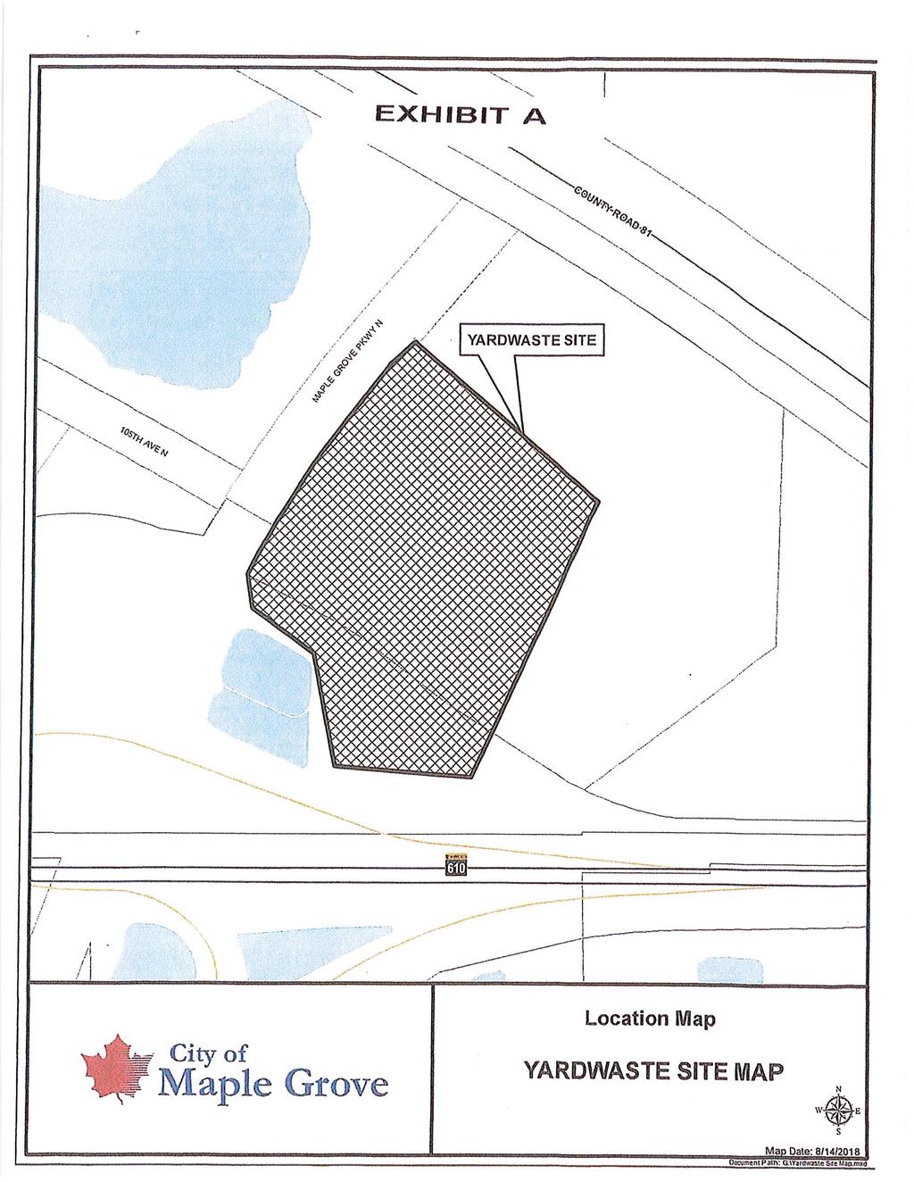
20 Meeting Date: Item Number: C ITEM: Yard Waste Site Contract Extension with Lynde and McCloud, Inc PREPARED BY: Tina Goodroad, City Administrator /Development Director POLICY DECISION / ACTION TO BE CONSIDERED: Approval of contract BACKGROUND: The City of Dayton has participated in a multi-city agreement with Lynde & McCloud for yard waste drop off and disposal at the Maple Grove site off Hwy 81 and Maple Grove Parkway. We have had an agreement for this service for our residents since 1999 and both residents and the City benefit from the service for disposal of yard waste disposal. It is time for contract renewal through December 31, The attached track change draft includes minor changes to the existing agreement including the extension of the contract to 2023; hours of operation expansion to increase customer service and incremental increase in price for the contract extension to CRITICAL ISSUES: There are no outstanding issues. BUDGET IMPACT: The City includes this cost along with recycling into the annual general fund budget. RECOMMENDATION: Staff recommends approval of the contract ATTACHMENT(S): Redline version of Contract Maple Grove yard waste site history and background
21
22
23
24
25
26
27
28
29
30
31
32
33 Meeting Date: Item Number: D ITEM: Interim Ordinance No (Public Hearing) PREPARED BY: Tina Goodroad, City Administrator/Development Director POLICY DECISION / ACTION TO BE CONSIDERED: Adoption of Ordinance BACKGROUND: At the August 29 th City Council meeting the council directed staff to prepare an Interim Ordinance placing a moratorium on the subdivision of land. This is a result of discussions the council had regarding the court decision on the Woodbury case involving fees. The moratorium will allow the city opportunity to study and respond to the impacts of the case and make any necessary changes to the official controls, fees and processes for development review and construction of new developments. This moratorium will not impact any project that has preliminary plat approval. Those projects will be able to file for final plat application during the moratorium period. This item requires a public hearing. COMMISSION REVIEW / ACTION (IF APPLICABLE): The Planning Commission briefly discussed councils suggested moratorium and supported the request with desire that any required research, amendments to official, etc., necessary to respond to concerns be completed as quickly as possible. ACTION: Consider approval of Ordinance ATTACHMENTS: Ordinance Letter from Housing First
34 Interim Ordinance No WHEREAS, pursuant to Minn. Stat , the City has the authority to regulate the use of land through the adoption and enforcement of official controls; and WHEREAS, pursuant to Minn. Stat , the City has the authority to regulate the subdivision of land through the adoption and enforcement of a subdivision ordinance; and WHEREAS, pursuant to Minn. Stat the City Council also has the authority to adopt an interim zoning ordinance for the purpose of classifying and regulating land uses and related matters; and WHEREAS, Dayton staff has initiated a study of the City s official controls insofar as they relate to subdivisions of land and City fees related to the subdivision of land; and WHEREAS, the Dayton City Council desires to protect the public health, safety and welfare by its study of its official controls in these areas; and WHEREAS, The Dayton City Council deems it necessary to adopt an Interim Ordinance placing a moratorium on any subdivision of land that creates more than two new parcels of record, for a period of one year from the effect date of this Interim Ordinance to permit the planning process to take place and to allow City staff, the Planning Commission and the City Council sufficient time to proceed in an orderly fashion to make any necessary changes, modifications and updates to the City s Official Controls and Comprehensive Plan. NOW, THEREFORE, the Dayton City Council Hereby Ordains: Section 1: Temporary Restrictions on Subdivisions of Land that Create more than Two New Parcels of Record. For a period of one year from the effective date of this Interim Ordinance, or until such earlier time as the City Council determines by resolution that the reasons for the interim ordinance no longer exist, no application for a subdivision of land that proposes to create more
35 than two new parcels of record shall be accepted, processed or approved by the City. Section 2: Section 3: Section 4: Section 5: Application to Subdivisions with Preliminary Plat Approval as of the Effective Date of this Moratorium. This Interim Ordinance shall not apply to subdivisions that have received preliminary plat approvals from the City prior to the effective date hereof. It shall apply to all other subdivision requests that have not received approval as of the date hereof. Enforcement. The City of Dayton may enforce any provision of this Ordinance by any and all means authorized by Dayton Ordinances and State Statutes. Effective Date. The Ordinance shall take effect on the date of its adoption and shall be in effect for a period of one year, unless earlier terminated by the Dayton City Council. Severability. Every section, provision, or part of this Interim Ordinance is declared severable from every other section, provision, or party thereof to the extent that if any section, provision, or part of this ordinance shall be held invalid by a court of competent jurisdiction, it shall not invalidate any other section, provision, or part thereof. Moved by, second by and adopted this 26th day of September, 2018 Attest: City Clerk Mayor
36 September 6, 2018 City of Dayton Planning Commission S Diamond Lake Road Dayton, MN To Members of the City of Dayton Planning Commission, I am writing on behalf of Housing First Minnesota, the state s leading voice for the housing industry. By way of background, Housing First Minnesota represents more than 1,200 member firms involved in all aspects of housing, including new home construction, remodeling and land development. On behalf of our member firms and Minnesota s housing industry, I am writing to urge the City of Dayton to halt its march toward a development moratorium in response to the recently decided Harstad v. City of Woodbury decision. A development moratorium will have a swift and certain negative impact on existing home and property owners as well as those wishing to move into Dayton. As you are aware, development relies on an orderly process, predictable timeline, and transparent cost structure. A development moratorium threatens each of those necessary elements and places Dayton s housing market into a period of uncertainty. Furthermore, recovery from a moratorium can take months, if not years, depending on its length. This is not the approach our market needs when the demand for new construction across our region is not being met adequately and the ability to produce market-rate affordable housing is in serious jeopardy. The City of Dayton s consideration of a moratorium is not a planning or growth study exercise, but rather to consider financing for future, undefined improvements for the city, stemming from the recent ruling by the Minnesota Supreme Court. The court merely affirmed the decades-long precedent that these charges have never been authorized under Minnesota law and any attempt to impose them violates the law. Since the City of Dayton lacked the ability to enact its Transportation Fee in the first place, a development moratorium while the city studies its financing options is misguided. Of the 25 cities Housing First Minnesota reached out to following the Harstad v. Woodbury decision, the City of Dayton stands alone in responding to the unanimous Supreme Court decision by proposing to suspend development within its borders. A number of these high-growth cities responded to the Harstad decision by stopping their use of this inappropriate financing mechanism, and have not required a moratorium to do so. A development moratorium is an unnecessary overcorrection to the city s reliance on unlawful fees. We ask that the Planning Commission recommend against enacting a moratorium. Housing First Minnesota looks forward to a partnership on this important housing affordability matter. Best Regards, David Siegel Executive Director Housing First Minnesota: Construction Stormwater General Permit MNR May 3, 2018
37 Meeting Date: Item Number:F PRESENTER: Jason Quisberg ITEM: Pineview Lane & Oakview Lane Infrastructure Improvements project PREPARED BY: Engineering POLICY DECISION / ACTION TO BE CONSIDERED: Authorize Feasibility Study for Infrastructure Improvements on Pineview Lane North and Oakview Lane North BACKGROUND: Street improvements to Pineview Lane and Oakview Lane/130 th Avenue have been warranted and considered for some time. Improvements have been delayed primarily due to the, now significantly completed, Granstrom Orchards development on Pineview Lane. Project Scope: Improvements currently considered within these corridors, slated for 2020 construction, include: Pineview Lane (CR-121 to South Diamond Lake Road): o Full reconstruction of street anticipated 2-lane configuration, with considerations for future expansion o Intersection improvements at CR-121 (including work on CR-121) o Construction of regional trail (Three River Park District) o Utility improvements (minor) Oakview Lane/130 th Avenue: o Full reconstruction of street o Potential utility extensions (to be evaluated) o Ravine improvements Feasibility Study Activities: Activities to be completed as part of the feasibility study include: Preliminary survey of existing conditions Neighborhood meetings (to determine desire for utilities on Oakview/130 th o Preparation of preliminary assessment roll, if required o Coordinate property valuations/appraisals, if necessary Identify ROW acquisition requirements o Coordinate property/row valuations, if necessary Three Rivers Park District coordination (Pineview trail) Hennepin County coordination (CR-121 intersection improvements, traffic control, etc.) Small utility coordination (primarily utility pole conflicts) Determine/finalize funding sources Concept/preliminary design
38 2 Preliminary Cost Estimates [Revenue Source]: Preliminary estimates (based on unit prices and current CIP amounts): Pineview Lane: o Street improvements = $1,400,000 [485 Trunk Trans, MSA] o Trail improvements = $350,000 [TRPD/408 Park Trail Development] o CR-121 intersection imps = $250,000 [County/485 Trunk Trans, MSA] o Pineview subtotal = $2,000,000 Oakview Ln/130 th Ave: o Street Improvements = $845,000 [414 Pavement Mgmt] o Utility extensions = $425,000 [Special Assessments] o Ravine improvements = $75,000 [603 Stormwater Enterprise] o Oakview Ln/130 th Ave subtotal = $1,345,000 Total Project Cost = $3,345,000 *Note: Utility extensions were previously removed from the CIP, with instruction to staff being to re-introduce costs if found desired at the time of the project. Anticipated Schedule: Feasibility Study Winter 2018/2019 Present Feasibility Report Spring 2019 Prepare Plans & Specifications Summer 2019 Bid Project Fall/Winter 2019 Start Construction (early) Spring 2020 Substantial Completion Fall 2020 Final Completion Spring 2021 This project includes multiple complex design components, involving several stakeholders and jurisdictions. An early start on a feasibility study is recommended such that scope and improvements can be coordinated while mitigating risk of rushing for a spring construction start. A short presentation will be given at the Council meeting with an opportunity for questions. RELATIONSHIP TO COUNCIL GOALS: Maintain and Enhance Infrastructure BUDGET IMPACT: $25,000-$35,000 anticipated RECOMMENDATION: Authorize preparation of feasibility study and related activities.

39 Meeting Date: Item Number:G. & H. ITEM: Resolution Granting Preliminary Plat, Rezoning to R-3 and Planned Unit Development Approval of Cloquet Island Estates; AND Ordinance Rezoning Cloquet Island Estates from A-1 to R-3, PUD PREPARED BY: Tina Goodroad, City Administrator/Development Director POLICY DECISION / ACTION TO BE CONSIDERED: Consider Resolution BACKGROUND: The applicant, North Diamond Investment, LLC ( applicant/developer ) has submitted an application for a Preliminary Plat to be known as Cloquet Island Estates. The Preliminary Plat includes 193 single family lots and five outlots. The applicant is also requesting approval of a rezoning from A-1, Agriculture District to R-3, Attached and Detached Single Family Residential and Planned Unit Development (PUD). This zoning district allows for a variety of smaller lot sizes and developments that are all single family. The site is located north of North Diamond Lake Rd, south and southwest of Dayton River Road and immediately east of the River Hills development. The site consists of gross acres and net acres. A portion of the property contains mapped Greenway Corridor consisting of a band of native trees through the middle of the property (contained in Outlots B and D). These trees will be preserved based on the proposed development plan with the exception of some minor tree loss due to the proposed east/west parkway that will continue from the River Hills and extend east to Dayton River Road and further west in the future. This east/west parkway is part of the City s planned transportation network. This item was on the August 9 th Planning Commission meeting (public hearing) and the September 6, Please see attached staff reports for detailed analysis of the request of the plat.
40 2 COMMISSION REVIEW / ACTION (IF APPLICABLE): The Planning Commission reviewed this application over two meetings. During the course of the preliminary plat review staff requested that the applicant work with the neighboring Demars property for a shared access at Berkshire Lane. The Planning Commission reports expand on the reasons for this request. The applicant did provide a revised site plan which was presented at the September 6 th agenda. The site is attached. Staff did not request all the plans to be revised until after Planning Commission and City Council review. The applicant provided a revised site plan that considers the DeMars concept plan layout (also on the agenda) and the request for a shared access at Berkshire Lane. The revised site plan proposes a roundabout just north of the wetland on the DeMars site that would serve as the main entry for both sites. This will require shared costs for the turn lanes at Co. Rd 144 (as required by the County) and cost of the roundabout. The DeMars property owner has already provided a letter indicating support for the shared access and willingness to provide an easement. The proposed site plan changes lot mix: East 65 wide lots: 85 West 65 wide lots: 70 North 55 villas Due to reduction in villas the applicant no longer needs a deviation to the limit of 30% villas. The proposed site plan is only 19% villa. The proposed site plan provides for a cul-de-sac at the southwest corner with single family lots (75 wide). The entire southeast and southwest portion of the site are now proposed for single family. All villa lots are located north of the parkway. The proposed site plan also provides for street connections to the east into the DeMars site in alignment with the proposed concept plan (next on agenda). This change impacts the layout of streets and lots just south of the parkway in the northeast corner. The applicant is proposing the open space and HOA park in this location versus the southwest corner. A trail from the main north/south road to the HOA Park is provide for neighborhood access. During the August review the Planning Commission requested that the street layout in the west central portion of the plat be revised to provide improved street layout versus the straight alignment resulting in rows of homes at the same setback. The applicant did not address this concern stating that impact to trees may result. The commission discussed and continues to believe some slight modification can be made to reduce the row of garage fronts on these streets. See attached sketch of how this area could be designed with a cul-de-sac. The applicant is proposing a HOA park in the northeast portion of the site. Staff has recommended that this park be an HOA built and maintained park as the local neighborhood park will be provided in River Hills. The Commission recommended that additional park land be dedicated on the Demars site to provide for additional park land and either the park be a city park or shared HOA park. City Council should discuss this and review the condition proposed in the resolution and determine if the City wants this dedicated as a public park. The applicant s development plan includes preservation of the trees within the greenway corridor with the exception of the crossing of the parkway. Staff has requested that the
41 3 applicant provide a trail within the corridor to provide public access to this preserved natural resource. Due to this the Planning Commission discussed this being credited as the required park dedication. Staff supports this recommendation and also recommends that the City Council count the preserved greenway corridor as satisfying the required park dedication. The applicant has agreed to the transportation fee with a credit for the upsizing of the Parkway. The total fee with the credit (listed in resolution) will be $489,295. This will be paid for on a per lot cost of $2, (based on preliminary plat of 193 lots) with each final plat as incorporated into the developer agreement. The applicant requests consideration of the Preliminary Plat prior to consideration of the Moratorium. An alternate resolution for denial has been prepared in the event the council does not consider this request. 60/120-DAY RULE (IF APPLICABLE): 120 day review expires BUDGET IMPACT: No impact to the City budget. Future development agreement will include all require development fees. ACTION: The City Council has the following options for action: Consider Resolution No approving the Preliminary Plat and Rezoning AND Ordinance amending the zoning to R-3, Residential, Planned Unit Development (PUD). OR Consider Resolution No denying the Preliminary Plat, Rezoning and PUD. ATTACHMENT(S): Resolution (in support) Resolution (denial) from Peter Coyle ( ) confirming agreement to fee Ordinance Planning Commission Report Planning Commission Report Letter from Leo Dehn/DeMars Family Revised Site Plan Revised site plan sketch with possible cul-de-sac design Preliminary Site Plan Preliminary Plat Tree Preservation Plan (7) Landscaping plan (5)
42 RESOLUTION NO RESOLUTION GRANTING PRELIMINARY PLAT, REZONING TO R-3 RESIDENTIAL AND PLANNED UNIT DEVELOPMENT APPROVAL OF CLOQUET ISLAND ESTATES WHEREAS, North Diamond, LLC (hereinafter referred to as the Applicant/Developer ) has made an application for preliminary plat approval for Cloquet Island Estates as well as Rezoning to R-3 and Planned Unit Development Approval of the project to be located on the legally described as: The West Half of the Southwest Quarter of Section 10, Township 120, Range 22, Hennepin County, MN (hereinafter referred to as the Property ); and WHEREAS, the City staff studied the matter, reports were issued, and information was provided to the Planning Commission and City Council regarding the Application; and WHEREAS, the City Planning Commission at its August 9, 2018 meeting held a public hearing regarding the Application; and WHEREAS, the City Planning Commission at its September 9, 2018 meeting reviewed revised plans; and WHEREAS, the City Council at its September 26, 2018 meeting has considered the matter. NOW, THEREFORE, the City Council of the City of Dayton makes the following: FINDINGS A. The Applicant proposes to develop the Property pursuant to the Preliminary Plat into multiple phases. B. The Applicant has submitted, for the City s review and approval, the Preliminary Plat of Cloquet Island Estates (193 lot) and preliminary plans for the property drafted by Sathre-Berquist, dated May 2018 and revised site plan submitted on August 24, 2018 (hereinafter referred to as the Preliminary Plans ). C. The applicant is requesting rezoning of the property from A-1, Agriculture to R- 3, Single Family Attached and Detached Residential and approval of a Planned Unit Development. D. The property is guided Low Density Residential on the Comprehensive Plan. The rezoning is consistent with the land use. 1
43 E. The Preliminary Plat also contains net acres, 193 single family detached lots, five Outlots and public right-of way. The Outlots will be used as preserved open space, park and open space and ponding. Many site amenities are being planned including trails, sidewalks and an HOA (or possible City park). F. Minn. Stat grants the City, for the purpose of protecting and promoting the public health, safety and general welfare, the authority to adopt subdivision regulations providing for the orderly, economic and safe development of land within the City. G. The City Council has adopted Subdivision Regulations for the orderly, economic and safe development of land within the City. H. Dayton City Code states that no land shall be subdivided without complying with the provisions of [Chapter 1002]. I. The proposed subdivision of the Property is governed by Dayton City Code Chapter J. Dayton City Code requires review of final planned unit development plans to be reviewed with the final plat. K. The Final Plans are governed by Dayton City Code L. The Applicant has submitted the Preliminary Plat and Rezoning to R-3 for the City s review and approval. M. The Preliminary Plat meet the City Code requirements and the Preliminary Plans meet the City Code requirements, provided they are subject to and satisfy the conditions set forth in this Resolution. DECISION NOW, THEREFORE, and based upon the information received and the above Findings it is resolved by the City Council of the City of Dayton as follows: 1. Applicant/Developer shall meet all engineering and fire department conditions and make all plan changes as noted in the attached memo prior to approval of the final plat. All plans shall be adjusted for the combined entrance via the roundabout plan prior to submittal of the Final Plat. Additional engineering comments are expected with the revised plans based on the updated site plan and with that additional engineer conditions are to be expected. 2. The Preliminary Plat Plans shall be revised to include the shared access at Berkshire 2
44 Lane. 3. Applicant/Developer shall obtain easement for access at Berkshire Lane prior to Final Plat approval. 4. The Applicant/Developer, per its agreement to pay the same, shall pay a transportation fee of $489,295, which sum constitutes the City s normal fee of $3,550 per proposed lot less a credit being provided to the Developer for the oversizing of the parkway proposed as part of the development. A per lot fee of $2,535.21, which accounts for the credit, shall be paid by Developer in conjunction with each phase s receipt of final plat approval. 5. The Applicant/Developer will be responsible for construction of a combined access at Berkshire Lane as recommended by the City Engineer. The Applicant/Developer is responsible for entering necessary agreements with the adjacent property owner needed to allow for construction of the combined access. Construction timing and coordination of costs will need to be determined prior to Final Plat approval. 6. Dead end streets shall be modified to accommodate temporary turn arounds with enough room for maintenance and emergency vehicle maneuvering. Staff will restrict, as necessary, future home construction in these areas. 7. The preliminary and final plat shall be revised to create a cul-de-sac or alternative street layout in the west-central portion of the plat to eliminate the straight street design. 8. The Applicant/Developer shall comply with all Hennepin County requirements, permits and/or other, involving work within the right-of-way and impacts to County Road 144 for the access. 9. The Applicant/Developer shall work with the neighboring property owner on joint HOA constructed and maintained park in the northeast portion of the plat. 10. The Applicant/Developer shall be provided full credit of the park dedication fee with the preservation of the 11 acres in the greenway corridor with public trail construction by the Applicant/Developer. 11. All future builders shall provide an anti-monotony plan tracker that can be followed as permits are submitted. 12. Applicant shall provide HOA documents for staff review. 13. Screening/buffering plans, and cross section plan from abutting roads, shall be revised to meet all ordinance requirements prior to Final Plat approval. 14. All required screening/buffering areas shall be irrigated and maintained by the HOA. 15. Native trees shall be planted in the rear yards of homes adjacent to existing greenway corridor to further enhance the corridor and provide a buffer. Tree planting plan shall be reviewed by City Staff prior to Final Plat approval. 16. Final trail alignment in the southern portion of the plat, along Co. Rd. 144, shall be approved by staff prior to approval of the final plat. All trails shall be constructed to be 10 feet in width. 17. The Applicant/Developer shall provide plans for the HOA park amenities (including proposed equipment); and proposed entry monument signage prior to approval of the final plat. All open space, tot lot and all other development amenities shall be maintained by the HOA unless otherwise determined by the City Council. 18. All maintained HOA areas including the villa lots shall be irrigated. 19. Final approval of the parkway landscaping (ground cover, irrigation, trees, shrubs and lighting) including within the medians and areas adjacent to the parkway shall be approved by staff prior to the final plat approval. 3
45 20. The applicant/developer shall provide the city an easement for all trails upon construction. 21. All HOA documents shall be recorded with all final plats. 22. All Greenway Corridor areas (Outlots A, B, D) shall be in a conservation easement and maintained by the HOA. 23. Elm Creek Watershed approvals shall be secured prior to grading. 24. All lighting plan shall be submitted for review and approval prior to installation. 25. All street lighting shall be downcast or shielded light fixtures. 26. The applicant/developer shall work with the City to determine requirements for contractors including, but not limited to, the hours of operation, off-street parking, hauling and loading/unloading. Specific language will be included in the Developers Agreement Adopted this 26th day of September, 2018 by the City of Dayton. Mayor - Tim McNeil City Clerk - Amy Benting Motion by Councilmember, Second by Councilmember Opposed by and the motion passes. 4
46 RESOLUTION NO RESOLUTION DENYING PRELIMINARY PLAT, REZONING TO R-3 RESIDENTIAL AND PLANNED UNIT DEVELOPMENT APPROVAL OF CLOQUET ISLAND ESTATES WHEREAS, North Diamond, LLC (hereinafter referred to as the Applicant/Developer ) has made an application for preliminary plat approval for Cloquet Island Estates as well as Rezoning to R-3 and Planned Unit Development Approval of the project to be located on the legally described as: The West Half of the Southwest Quarter of Section 10, Township 120, Range 22, Hennepin County, MN (hereinafter referred to as the Property ); and WHEREAS, the City staff studied the matter, reports were issued, and information was provided to the Planning Commission and City Council regarding the Application; and WHEREAS, the City Planning Commission at its August 9, 2018 meeting held a public hearing regarding the Application; and WHEREAS, the City Planning Commission at its September 9, 2018 meeting reviewed revised plans; and WHEREAS, the City Council at its September 26, 2018 meeting adopted a moratorium on subdivision approvals. NOW, THEREFORE, the City Council of the City of Dayton makes the following: FINDINGS A. The Applicant proposes to develop the Property pursuant to the Preliminary Plat into multiple phases. B. The Applicant has submitted, for the City s review and approval, the Preliminary Plat of Cloquet Island Estates (193 lot) and preliminary plans for the property drafted by Sathre-Berquist, dated May 2018 and revised site plan submitted on August 24, 2018 (hereinafter referred to as the Preliminary Plans ). C. The applicant is requesting rezoning of the property from A-1, Agriculture to R- 3, Single Family Attached and Detached Residential and approval of a Planned Unit Development. D. The property is guided Low Density Residential on the Comprehensive Plan. 1
47 E. The Preliminary Plat also contains net acres, 193 single family detached lots, five Outlots and public right-of way. The Outlots will be used as preserved open space, park and open space and ponding. Many site amenities are being planned including trails, sidewalks and an HOA (or possible City park). F. Minn. Stat grants the City, for the purpose of protecting and promoting the public health, safety and general welfare, the authority to adopt subdivision regulations providing for the orderly, economic and safe development of land within the City. G. The City Council has adopted Subdivision Regulations for the orderly, economic and safe development of land within the City. H. Dayton City Code states that no land shall be subdivided without complying with the provisions of [Chapter 1002]. I. The proposed subdivision of the Property is governed by Dayton City Code Chapter J. Dayton City Code requires review of final planned unit development plans to be reviewed with the final plat. K. The Final Plans are governed by Dayton City Code L. The Applicant has submitted the Preliminary Plat and Rezoning to R-3 for the City s review and approval. M. The City Council, by Ordinance No , adopted a moratorium on subdivisions in the City to allow it more time to evaluate its transportation fee structure in the subdivision process. N. Approval of the PUD and Rezoning to accommodate the Cloquet Island Estates subdivision plan would also be improper during the pendency of the moratorium. DECISION NOW, THEREFORE, and based upon the information received and the above Findings it is resolved by the City Council of the City of Dayton as follows: 1. The applications of the Applicant/Developer for Rezoning, Planned Unit Development Approval, and Preliminary Plat approval of Cloquet Island Estates is hereby denied due to the Council s adoption of a moratorium on subdivision approvals. 2
48 Adopted this 26th day of September, 2018 by the City of Dayton. Mayor - Tim McNeil City Clerk - Amy Benting Motion by Councilmember, Second by Councilmember Opposed by and the motion passes. 3
49 ORDINANCE NO CITY OF DAYTON COUNTIES OF HENNEPIN AND WRIGHT AN ORDINANCE TO AMEND THE DAYTON ZONING ORDINANCE BY AMENDING ZONING DISTRICTS THEREIN FOR CLOQUET ISLAND ESTATES DEVELOPMENT THE CITY COUNCIL OF THE CITY OF DAYTON DOES ORDAIN: SECTION 1. AMENDMENT. The zoning classification of the property described in Section 2, as shown on the zoning map referred to in Section , subd. 2, of the Dayton Ordinance Code, is hereby amended from A-1, Agriculture District to R- 3 Single Family Attached and Detached Residential, Planned Unit Development (PUD). SECTION 2. PROPERTY DESCRIPTION. The West Half of the Southwest Quarter of Section 10, Township 120, Range 22, Hennepin County, MN SECTION 3. EFFECTIVE DATE. This Ordinance shall be in full force and effect from and after its passage and publication as required by law and the recording the final plat of Cloquet Island Estates Adopted by the City Council of the City of Dayton this 26th day of September, Mayor Tim McNeil ATTEST: City Clerk Amy Benting Published in the Champlin Dayton Press on
50
51 CITY OF DAYTON Meeting Date: PLANNING COMMISSION Item: C. ITEM: Application by North Diamond Investment, LLC. for a Rezoning from A-1, Agriculture District to R-3, (Attached and Detached Single Family Residential); Approval of a Planned Unit Development and Preliminary plat for the proposed Cloquet Island Estates. APPLICANTS/PRESENTERS: North Diamond Investment, LLC. (NDI) 60-DAY RULE SUMMARY: Application Accepted: Day Review Deadline: N/A Extension Granted To: BACKGROUND/OVERVIEW: The applicant, North Diamond Investment, LLC ( applicant/developer ) has submitted an application for a Preliminary Plat to be known as Cloquet Island Estates. The Preliminary Plat includes 193 single family lots and five outlots. The applicant is also requesting approval of a rezoning from A-1, Agriculture District to R-3, Attached and Detached Single Family Residential and Planned Unit Development (PUD). This zoning district allows for a variety of smaller lot sizes and developments that are all single family. The site is located north of North Diamond Lake Rd, south and southwest of Dayton River Road and immediately east of the River Hills development. The site consists of gross acres and net acres. A portion of the property contains mapped Greenway Corridor consisting of a band of native trees through the middle of the property (contained in Outlots B and D). These trees will be preserved based on the proposed development plan with the exception of some minor tree loss due to the proposed east/west parkway that will continue from the River Hills and extend east to Dayton River Road and further west in the future. This east/west parkway is part of the City s planned transportation network. LEVEL OF CITY DISCRETION IN DECISION-MAKING Action taken on the proposed rezoning is legislative in nature; the City has broad discretion in making rezoning decisions land use decisions based on the comprehensive plan and advancing the health, safety, and general welfare of the community. The basic question of the
52 PLANNING COMMISSION REPORT Cloquet Island Estates July 9, 2018 Page 2 rezoning is whether it is consistent with the land use plan. In this case the property is all guided Low Density Residential and the rezoning to R-3 is consistent with that land use. The subdivision (preliminary plat) plat is a quasi-judicial; the City s role is to determine the facts associated with the request and weigh those facts against the legal standards contained in the City Code and State Statute. In general, if the facts indicate the applicant meets the relevant legal standards of the code and will not compromise the general welfare, the applicant is likely entitled to approval. The City is, however, able to add conditions to the plat approval to ensure that any impacts to parks, roads, utilities or other public infrastructure on and around the subject property are adequately addressed. Subdivisions may also be modified to promote the public health, safety, and general welfare, and to provide for the orderly, economic, and safe development of land, and to promote housing affordability for all levels. ZONING AND LAND USE The property is guided Low Density Residential in the 2030 Future Land Use Plan and is within the current staging area. The proposed density is approximately 2.49 units per acre Low Density Residential land use category requires a density of units/acre. The property is zoned A-1, Agriculture District and guided for Low Density Residential and will connect to services. The proposed R-3 rezoning falls within the Low Density land use density. Adjacent land use: Direction Land Use Plan Zoning Map Existing Use North Low Density Residential R-1(PUD) and P-R River Hills and Cloquet Overlook park. West Low Density Residential R-1(PUD) River Hills South LDR and Urban Reserve A-1 Single Family East Low Density Residential A-1 Single Family and AG PLAT ANALYSIS The proposed preliminary plat includes a variety of lot sizes and widths. All lots are single family. There are 83 Villa units with 55-foot lot widths (38 villas in the north portion and 45 in the south portion of the plat). The density is approximately 2.49 units/acre (below the maximum allowed in R- 3) and meets the requirement for Low Density Residential according to the comprehensive plan. The R-3 ordinance limits Villa lots to 30% of the overall development. The proposed lot breakdown includes 43% villas therefore the applicant is requesting a deviation to exceed the minimum threshold. The Planning Commission may want to discuss this proposed deviation. The Greenway Corridor extends through the middle of the development. The plat has been designed to conserve and protect the majority of trees within the greenway corridor. City Code requires developments adjacent or a part of the Greenway corridor go through PUD and are to follow the Conservation guidelines within the Conservation Subdivision chapter and develop as a PUD. The Greenway Corridor will be an amenity to the development and public. A trail system is proposed through the corridor. Links to this system are also planned from River Hills as well as interior so all
53 PLANNING COMMISSION REPORT Cloquet Island Estates July 9, 2018 Page 3 areas of the development can access this trail. A trail will also be provided along the southern portion of the plat. A trail will extend from the from River Hills through this development along the southern portion to serve as a trail link on the north side of North Diamond Lake Road but will not be adjacent to the road due to the wetland. Two main access points and roads will serve this development. An east/west parkway is proposed that will extend from the west (in Riverhills) to the eastern edge of the plat boundary. This parkway is identified in the City s comprehensive Plan. This parkway will be extended through the DeMars site and connect to Dayton River Road in the future. The City has coordinated this location with the County and the adjacent property owner. This parkway will also continue west as development occurs west of River Hills. This parkway is the only road crossing of the Greenway Corridor. This east/west roadway is designed as a parkway with trees planted in the median and along the roadway in the ROW. As its part of the City s roadway system the city will be responsible for the maintenance. This area will be required to be irrigated and a final plan will be required that includes as much maintenance free landscaping as possible. The more roadways designed as parkways the more additional PW staff will be required for maintenance of these areas. Proposed Road 4, on the preliminary plat, serves as the main north/south road with access at North Diamond Lake Road/Co. Rd The City has requested the developer to relocate this access to the east at Berkshire Lane to consolidate this entry with the development of the vacant DeMars property. This would be a cooperative effort with the adjacent property owner and an easement would be required to meet the applicant s timeline (the adjacent property owner and future owner provide a letter supporting a future easement, as attached). Some wetland mitigation will be required for this consolidated entry. A temporary access could be provided for while these approvals are being sought. The reason for the recommended consolidation is to improve intersection safety, improve overall traffic safety, limit access density on the county road and provide for adequate access spacing. The applicant is requesting rezoning to R-3, Attached and Detached Residential District. The proposed lot widths consist of 55 wide villas; 65 wide single family and 70 + single family. The smallest villa lot is 7,101 sq. ft; the smallest single family is 9,727 and the average single family lot is 11,300 sq. ft. The R-3 district allows for developments that contain a mix of attached (such as a townhome) and detached single family in a range of lot sizes. The district also allows a development with all single family; which is the case with the proposed Cloquet Island Estates. The proposed lots meets the R-3 zoning district for lot sizes (6,000 10,000; avg 10,000 sq. ft.) and setbacks: The required setbacks per code are shown below: Front- Living Area 20 feet Front- Garage 25 Side to Dwelling 7.5 feet Side to Garage (with minimum of 15 feet between structures 7.5 feet Rear 20 feet
54 PLANNING COMMISSION REPORT Cloquet Island Estates July 9, 2018 Page 4 The applicant is requesting a deviation to lot width for the villa lots which are proposed at 55 feet. This request would be similar to other developments of villa lots that have been approved with 55 foot wide lots with the 7.5 side yard setbacks. The Villas will be maintained by an HOA. PLANNED UNIT DEVELOPMENT The subject property has a portion of the property within the Greenway Corridor and as such is required (under the Subdivision code) to develop under the PUD standards to ensure protection of natural resources in the Greenway Corridor. The subdivision ordinance includes the standards for development in the Greenway Corridor and how the PUD approval can allow for flexibility in design standards such as setbacks, lot size, etc. in exchange for preservation of the resources in the greenway. The subdivision standards for property containing Greenway Corridor is as follows: 1. Keep the undeveloped Greenway Overly area large enough to maximize sustainability. The proposed development preserves and protects the Greenway Corridor as one contiguous parcel (with the exception of the road crossing) which meets the intent of the development guidelines. 2. Maintain a buffer adequate to the health and viability of the greenway. The proposed plat contains single family lots abutting the corridor so open space is provided between the preserved woods and any impervious surface. Staff has added discussion in the landscaping portion of the report that native trees be added adjacent to existing trees to create a more native buffer. 3. Minimize adverse construction impacts on the Greenway Overlay Corridor. The proposed development will not impact the greenway corridor with the exception of the east/west parkway. 4. Cluster homes to protect large areas of open space and avoid fragmented habitat. The reason of requiring a PUD is too allow for flexibility to off-set the preservation of greenway overlay areas. In this case the trees are protected and the development plan provides a layout of clustered lot sizes utilizing the R-3 standards and flexibility of the PUD. 5. The ordinance also allows for the opportunity for equitable economic return for the development. The proposed development maintains adequate density to make it economically viable with all other development costs while preserving the greenway overlay area. 6. Consideration should be given in the layout of the subdivision to provide each dwelling unit with access and or views onto the preserved natural areas. The proposed development provides views from several homes and access to the natural areas through proposed trails. In accordance with Section , Subd. 4-6 of the Zoning Ordinance, the application for a Planned Unit Development shall be evaluated by the Planning Commission and City Council and the Planning Commission shall make a recommendation to the City Council based on and including, but not limited to the following findings: 1. The Planned Unit Development is consistent with the Comprehensive Plan. 2. The Planned Unit Development is an effective and unified treatment of the development possibilities on the project site and the development plan provides for the preservation or creation of unique amenities such as natural streams, stream banks, wooded cover, rough terrain, manmade landforms or landscaping and similar areas. 3. The Planned Unit Development can be planned and developed to harmonize with any existing or proposed development in the areas surrounding the project site. The
55 PLANNING COMMISSION REPORT Cloquet Island Estates July 9, 2018 Page 5 development plan will not have a detrimental effect upon the neighborhood or area in which it is proposed to be located. 4. The proposal better adapts itself to the physical and aesthetic setting of the site and with the surrounding land use than could be developed using strict standards within the underlying zoning district. 5. The proposal would provide mixed land use and/or site design flexibilities while enhancing site or building aesthetics to achieve an overall higher quality of development than would otherwise occurring in the underlying zoning district. 6. The proposal would ensure the concentration of open space into more workable or usable areas and would preserve the natural resources of the site than would otherwise occur in the underlying zoning district. 7. The development plan is in compliance with the provisions of the City Code, except as specifically modified through the use of the PUD provisions. 8. Public benefits shall be included in each development and considered as part of the review of the overall Planned Unit Development and as an opportunity to support any deviations from the primary zoning ordinance provisions and performance standards. 9. The development plan and plat conform to the requirements of the shoreland and floodplain regulations of the City Code. PUD Deviations Deviations to the underlying zoning requirements may be considered as part of the PUD review and ultimate approval. The City must judge whether the deviations can be supported by other additional improvements and enhancements the applicant is proposing. The following have been identified as deviations. Planning Commission may want to discuss the proposed deviations in more detail at the meeting. Increase in villa lots to 43% (30% allowed) 55 wide villa lots Increased cul-de-sac lengths (exceeding by 90 feet in one section) PUD Benefits Benefits provided in the development as identified by staff: Trails planned within the plat boundary including through Greenway Corridor providing for public access to this amenity East/west roadway upgraded to landscaped parkway design Curvilinear street design Enhanced entry features Variety of housing styles The preservation of the greenway is expected as part of the conservation design therefore not called out as a public benefit. Within the corridor a total of acres will be preserved. Planning Commission will want to review and discuss the proposed PUD benefits.
56 BUILDING MATERIALS AND ARCHITECTURE: PLANNING COMMISSION REPORT Cloquet Island Estates July 9, 2018 Page 6 No additional information has been provided on elevations. TREE PRESERVATION: The development seeks to save the majority of the trees in the Greenway Corridor. Two exception areas include around the wetland in the south portion of the site and where the east/west parking is planned. The amount of tree removal does not required reforestation. LANDSCAPING: The applicant has submitted an extensive landscaping plan. The proposed plan meets requirements for trees for each lot. The plan includes a landscaped parkway with trees within the median and with the north and south sides of the parkway to create tree lined street. A landscaped buffer is required in the far northeast corner abutting Dayton River Road. Some trees are planned around the pond. Due to grades it may be challenge to add more in this area. Trees have been added to the rear yards of homes abutting River Hills. Staff has also requested trees be added where a trail abuts a side or rear yard which has been accomplished in most areas. As mentioned previously the applicant is preserving trees within the greenway. Staff has requested that additional buffer of new native trees be added in rear yards abutting the greenway to further widen the greenway corridor. The applicant has added a tree to these rear yards but not an expanded buffer. The Planning Commission will want to discuss this suggested addition to the landscaping. In the southern portion of the plat the applicant has planned a cul-de-sac that is positioned to run behind existing River Hills lots to serve three lots in the proposed development. To help screen this new culde-sac the applicant is proposing a 6 privacy fence and row of trees. In the southwest portion of the site the trees in the greenway corridor will be preserved and a trail provided with connection to an existing trail in River Hills. Open space, landscaped entry and park/playground area will be provided by the developer. No plans for the monument signage have been provided at this time. A 35 foot wide buffer is required at the southern property line abutting N. Diamond Lake Road that will screen up to 6 feet in eight. The buffer must include a minimum of 6 trees per 100 feet in staggered rows with shrubs to enhance yearlong vegetation. Staff has added a condition that the buffer be increased with additional trees (with any evergreens at 8 feet at install and shrubs to fully meet ordinance requirements along the length of the plat (with the exception of the wetland area). A cross section plan will also be required demonstrating the buffer meets the intent of the ordinance. All required buffer areas shall be irrigated.
57 PLANNING COMMISSION REPORT Cloquet Island Estates July 9, 2018 Page 7 PARK DEDICATION The applicant is proposing an HOA tot lot area in the southwest portion of the plat. The park will not count towards park dedication. All required park dedication will be based on cash in lieu at time of final plat. ENGINEERING CONSIDERATIONS: There are outstanding engineering comments provided to the applicant however it is believed that plan revisions due to the comments provided are achievable within the development layout submitted outside of the revised entrance location. See the engineering memo for specifics. The consolidated entrance across from Berkshire Lane in the SE corner of the development has been requested by the city as it is the preferred access location for the long-term operation of North Diamond Lake Road. The spacing of entrances along heavily traveled roadways is important as the proper location, spacing and reduction of access locations along the roadways will increases its safety. For these reasons, staff prefers the access location across from Berkshire lane as it properly aligns with an existing access location, is adequately spaced from existing access locations and limits the access points within this area. It is expected that the access location preferred by the city in the SE corner of the development will be shared with any adjacent development within the DeMars Property. It is anticipated that if the application is tabled to accommodate the shared development access across from Berkshire Lane, additional engineering comments may be provided on the revised layout. PLANNING CONSIDERATIONS: The preliminary plat provides for a single-family development in a range of lot sizes with more diversity in lot sizes and product types to serve future residents and broader housing needs in Dayton. The proposed net density falls within the Low Density Residential density range. The PUD allows for a master planned development approach and phased development plan. The development plan provides for protection of the majority of the trees in the Greenway Corridor while providing for public enjoyment of this amenity through the trail system. ROLE OF PLANNING COMMISSION: The role of the Planning Commission is to review the technical aspects of the rezoning and plat as it relates to the City s Zoning and Subdivision Ordinance and its consistency with these standards. RECOMMEDATION: Because of the importance of the location of the access at Berkshire Lane, that will serve this development and the future development to the east, staff recommends that this application be tabled to allow time for the applicant to revise plans with this shared access. Plans should be revised and brought back to Planning Commission for further review. The 120 day review expires and the Planning Commission may want to request the applicant provide a letter to waive the 120 review requirement to provide ample time to work with the city on revised plans.
58 PLANNING COMMISSION REPORT Cloquet Island Estates July 9, 2018 Page 8 Other conditions for consideration: 1. The applicant/developer shall meet all engineering conditions and make all plan changes as noted in the attached memo prior to approval of the final plat. 2. Applicant shall address all county comments for required ROW and turn lane improvements. 3. All future builders shall provide an anti-monotony plan tracker that can be followed as permits are submitted. 4. Applicant shall provide HOA documents for staff review. 5. Screening/buffering plans shall be revised and cross section plan submitted to meet all ordinance requirements. All required buffering areas shall be irrigated and maintained by the HOA. 6. Native trees shall be planted adjacent to existing greenway corridor to further enhance the corridor and provide a buffer. 7. Final trail alignment in the southern portion of the plat along Co. Rd. 144 shall be approved by staff prior to approval of the final plat. 8. Plans shall be submitted for the southwest corner including details on park amenities and monument signage prior to approval of the final plat. All open space, tot lot and all other amenities in the southwest corner shall be maintained by the HOA. All maintained HOA areas including the villa lots shall be irrigated. 9. All monument signage shall require a permit prior to installation. 10. Final approval of the parkway landscaping (ground cover, irrigation, trees, shrubs and lighting) including within the median and adjacent to the parkway shall be approved by staff prior to the final plat approval. 11. The applicant/developer shall provide the city an easement for all trails upon construction. 12. The applicant/developer shall pay required park dedication as calculated on a per lot bases with each final plat. 13. All HOA documents shall be recorded with all final plats. 14. All Greenway Corridor areas (Outlots A, B, D) shall be in a conservation easement) and maintained by the HOA. ATTACHMENTS: City Engineer Memo Location Map Applicants Narrative Letter from Leo Dehn/DeMars Family Preliminary Site Plan Survey (2) Preliminary Plat Preliminary Grading Plan (4) Preliminary Erosion Control Preliminary Utility Plan (7) Tree Preservation Plan (7) Landscaping plan (5)
; Approval of a Planned Unit Development and Preliminary plat for the proposed Cloquet Island")
59 CITY OF DAYTON Meeting Date: PLANNING COMMISSION Item: B. ITEM: Application by North Diamond Investment, LLC. for a Rezoning from A-1, Agriculture District to R-3, (Attached and Detached Single Family Residential); Approval of a Planned Unit Development and Preliminary plat for the proposed Cloquet Island Estates. APPLICANTS/PRESENTERS: North Diamond Investment, LLC. (NDI) 60-DAY RULE SUMMARY: Application Accepted: Day Review Deadline: N/A Extension Granted To: BACKGROUND/OVERVIEW: The applicant, North Diamond Investment, LLC ( applicant/developer ) has submitted an application for a Preliminary Plat to be known as Cloquet Island Estates. The Preliminary Plat includes 193 single family lots and five outlots. The applicant is also requesting approval of a rezoning from A-1, Agriculture District to R-3, Attached and Detached Single Family Residential and Planned Unit Development (PUD). This zoning district allows for a variety of smaller lot sizes and developments that are all single family. The site is located north of North Diamond Lake Rd, south and southwest of Dayton River Road and immediately east of the River Hills development. The site consists of gross acres and net acres. A portion of the property contains mapped Greenway Corridor consisting of a band of native trees through the middle of the property (contained in Outlots B and D). These trees will be preserved based on the proposed development plan with the exception of some minor tree loss due to the proposed east/west parkway that will continue from the River Hills and extend east to Dayton River Road and further west in the future. This east/west parkway is part of the City s planned transportation network. This item was tabled at the August Planning Commission to provide opportunity for the applicant to revise the plat in the west-central portion to redesign and provide improvements to street layout. The Commission also requested the applicant revise plans to provide for the consolidation of access with the neighboring property at Berkshire Lane.
60 PLANNING COMMISSION REPORT Cloquet Island Estates September 6, 2018 Page 2 Please refer to the August Planning Commission report for other details on the site plan, plat, etc. This report will serve only as an update. Revised Site Plan The applicant provided a revised site plan that considers the DeMars concept plan layout (also on the agenda) and the request for a shared access at Berkshire Lane. The revised site plan proposes a roundabout just north of the wetland on the DeMars site that would serve as the main entry for both sites. This will require shared costs for the turn lanes at Co. Rd 144 (as required by the County) and cost of the roundabout. The DeMars property owner has already provided a letter indicating support for the shared access and willingness to provide an easement. The proposed site plan changes lot mix: East 65 wide lots: 85 West 65 wide lots: 70 North 55 villas Due to reduction in villas the applicant no longer needs a deviation to the limit of 30% villas. The proposed site plan is only 19% villa. The proposed site plan provides for a cul-de-sac at the southwest corner with single family lots (75 wide). The entire southeast and southwest portion of the site are now proposed for single family. All villa lots are located north of the parkway. The proposed site plan also provides for street connections to the east into the DeMars site in alignment with the proposed concept plan (next on agenda). This change impacts the layout of streets and lots just south of the parkway in the northeast corner.. The applicant is proposing the open space and HOA park in this location versus the southwest corner. A trail from the main north/south road to the HOA Park is provide for neighborhood access. The revised site plan did not address any changes to the west portion of the plat as requested by the Planning Commission. The street alignment remains straight. Staff recommends that this area be revised to address the commissions concerns. Some details that will have to be worked out between the two projects at Final Plat review include: cost sharing for the required turn lanes at Co. Rd. 144 and Co. Rd. 12; cost sharing for the roundabout and coordination for a permanent easement; final wetland mitigation for this shared access (DeMars site). PARK DEDICATION The applicant is proposing an HOA tot lot area south of parkway in the northeast corner. At the August Planning Commission meeting there was discussion on whether the tot lot should be an HOA park or dedicated to the public. The local neighborhood park (that can serve this development) will be provided for in the River Hills Development where the City received a donation of land. The City is working on funding for development of the park which will include variety of park amenities including a playground.
61 PLANNING COMMISSION REPORT Cloquet Island Estates September 6, 2018 Page 3 Staff views the proposed HOA Park as a small park area serving primarily the development. Staff is recommending this not be dedicated to the public. If the Planning Commission wishes to recommend it be considered as a public park staff suggests discussion that the applicant construct the park and provide all equipment as part of their project before it is deeded to the City. The applicant s development plan includes preservation of the trees within the greenway corridor with the exception of the crossing of the parkway. Staff has requested that the applicant provide a trail within the corridor to provide public access to this preserved natural resource. Due to this the Planning Commission discussed this being credited as the required park dedication. Staff supports this recommendation and will forward this as a recommendation to the City Council. Ultimately, the City Council will make the final decision park dedication; but all of the Planning Commission input will be provided when the council reviews the preliminary plat on September 26 th. TRAILS During the July Planning Commission meeting we discussed the trail alignment along N. Diamond Lake Road. The proposed plan includes trail connections from River Hills into the proposed development in the southwest corner. The revised site plan proposes connecting this trail to a sidewalk along the south side of the street that runs east/west just north of the wetland. This sidewalk would continue east along the south side of the proposed roundabout. In the DeMars plan this sidewalk could then connect to a trail that extends south to the north side of N. Diamond Lake Road and then extend along the road to the east edge of the plat. Staff is supportive of this alignment. This may be an interim solution until N. Diamond Lake Road is upgraded and a trail could then be added to the north site of N. Diamond Lake Road. Another option for consideration is requiring the sidewalk portion on the east/west road to be designed as a trail (8 feet) so that the trail continues without sidewalk interruptions. This trail could be improved either as concrete (more typical of a sidewalk) as it will site in the front yards or as bituminous. Staff would like input from the Planning Commission on preferred trail connection to serve the site. TREE PRESERVATION: The development seeks to save the majority of the trees in the Greenway Corridor. Two exception areas include around the wetland in the south portion of the site and where the east/west parking is planned. The amount of tree removal does not require reforestation based on the current ordinance. PUD Deviations Deviations to the underlying zoning requirements may be considered as part of the PUD review and ultimate approval. The City must judge whether the deviations can be supported by other additional improvements and enhancements the applicant is proposing. The following have been identified as deviations. Based on the revised plan the deviations are limited to only two minor items. Increase in villa lots to 43% (30% allowed) 55 wide villa lots Increased cul-de-sac lengths (exceeding by 90 feet in one section)
62 PLANNING COMMISSION REPORT Cloquet Island Estates September 6, 2018 Page 4 PUD Benefits Benefits provided in the development as identified by staff: Trails planned within the plat boundary including through Greenway Corridor providing for public access to this amenity East/west roadway upgraded to landscaped parkway design Curvilinear street design Enhanced entry features Variety of housing styles The preservation of the greenway is expected as part of the conservation design therefore not called out as a public benefit. Within the corridor a total of acres will be preserved. ENGINEERING CONSIDERATIONS: The applicant addressed the major outstanding engineering item related to the consolidated access. City Engineer Jason Quisberg did prepare a summary (before we received the revised plan) of the request for shared access based on Planning Commission feedback. The letter is attached. PLANNING CONSIDERATIONS: The preliminary plat provides for a single-family development in a range of lot sizes with more diversity in lot sizes and product types to serve future residents and broader housing needs in Dayton. The proposed net density falls within the Low Density Residential density range. The PUD allows for a master planned development approach and phased development plan. The development plan provides for protection of the majority of the trees in the Greenway Corridor while providing for public enjoyment of this amenity through the trail system. The revised site plan provides for the desired consolidation of access at County Rd 144 plus internal road coordination of access with the DeMars Property. ROLE OF PLANNING COMMISSION: The role of the Planning Commission is to review the technical aspects of the rezoning and plat as it relates to the City s Zoning and Subdivision Ordinance and its consistency with these standards. RECOMMEDATION: The Planning Commission has the following options for recommendation to the City Council: Recommend to council approval of the Rezoning, PUD and Preliminary Plat. 1. Applicant/Developer shall meet all engineering conditions and make all plan changes as noted in the attached memo prior to approval of the final plat. 2. The Preliminary Plat Plans shall be revised to include the shared access at Berkshire Lane. 3. Applicant/Developer shall obtain easement for access at Berkshire Lane prior to Final Plat
63 PLANNING COMMISSION REPORT Cloquet Island Estates September 6, 2018 Page 5 approval. 4. The city engineer shall undertake a feasibility study to determine what improvements may be necessary as a result of the development application. Applicant/Developer shall install all improvements outlined in the City s feasibility study as included in the Developers Agreement approved at Final Plat. 5. All future builders shall provide an anti-monotony plan tracker that can be followed as permits are submitted. 6. Applicant shall provide HOA documents for staff review. 7. Screening/buffering plans, and cross section plan from abutting roads, shall be revised to meet all ordinance requirements prior to Final Plat approval. 8. All required screening/buffering areas shall be irrigated and maintained by the HOA. 9. Native trees shall be planted in the rear yards of homes adjacent to existing greenway corridor to further enhance the corridor and provide a buffer. Tree planting plan shall be reviewed by City Staff prior to Final Plat approval. 10. Final trail alignment in the southern portion of the plat, along Co. Rd. 144, shall be approved by staff prior to approval of the final plat. 11. The Applicant/Developer shall provide plans for the HOA park amenities (including proposed equipment); and proposed entry monument signage prior to approval of the final plat. All open space, tot lot and all other development amenities shall be maintained by the HOA. 12. All maintained HOA areas including the villa lots shall be irrigated. 13. Final approval of the parkway landscaping (ground cover, irrigation, trees, shrubs and lighting) including within the medians and areas adjacent to the parkway shall be approved by staff prior to the final plat approval. 14. The applicant/developer shall provide the city an easement for all trails upon construction. 15. All HOA documents shall be recorded with all final plats. 16. All Greenway Corridor areas (Outlots A, B, D) shall be in a conservation easement and maintained by the HOA. 17. Elm Creek Watershed approvals shall be secured prior to grading. 18. All lighting plan shall be submitted for review and approval prior to installation. All street lighting shall be downcast or shielded light fixtures. 19. The applicant/developer shall work with the City to determine requirements for contractors including, but not limited to, the hours of operation, off-street parking, hauling and loading/unloading. Specific language will be included in the Developers Agreement. OR Recommend the request be tabled with specific items the Commission would like to see addressed prior to consideration. Please keep in mind that the 120-day review expires on OR Recommend to the City Council denial however, specific findings related specifically to the land use request would be required.
64 ATTACHMENTS: PLANNING COMMISSION REPORT Cloquet Island Estates September 6, 2018 Page 6 City Engineer Memo-general requirements City Engineer Memo Co. Rd. 144 Access Letter from Leo Dehn/DeMars Family Revised Site Plan Preliminary Site Plan (from July packet) Preliminary Plat (from July packet) Preliminary Grading Plan (4) (from July packet) Tree Preservation Plan (7) (from July packet) Landscaping plan (5) (from July packet)
65
66
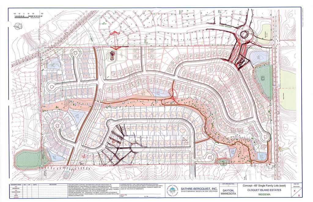
67
68
.1 Greenway Corridor (north) 61,093 sf (1.40 acres) 1 15 5 14 Pond#3N NWL-855.0 HWL- 858.")
69 OVERALL PLANT SCHEDULE SYMBOL Y DA POND 400 NWL = YR HWL = TO N POND 300 NWL = YR HWL = Wetland #3 (Kjolhaug Sept 16) Pond#1N NWL HWL A RO D. (H C. 13 NO 10 AY.H PA RK W S.A EA ST R VE RI 5 Pond#4N NWL HWL ).1 Greenway Corridor (north) 61,093 sf (1.40 acres) Pond#3N NWL HWL SHEET LP RIVE ILLS R H PARKWAY Pond #5N Infiltration Area NWL HWL SHEET LP3 Pond#5N NWL HWL RIVER HILLS PARKWAY PLANTING NOTES VALLEY VIEW Wetland #2 (Kjolhaug Sept 16) Pond#7N NWL HWL SHEET LP4 24 Park Area - 9,396 sf (Tot Lot) 5 POND 100 NWL = YR HWL = Greenway Corridor (south) 351,752 sf (8.08 acres) Pond#6N NWL HWL Open Space (Playfield 100'x150') Wetland #1 Pond#1SE NWL HWL (Kjolhaug Sept 16) Approx Wetland City Data - MH 2 TC " INV ' Landscaped Buffer 35' Landscaped Buffer/Berming 10' Bit Trail WETLAND #1 IMPACT +/-1,020 SF 12 DIAMOND LAKE ROAD NORTH Approx Wetland BERKSHIRE LANE N. (H.C.S.A.H. NO. 144) NORTH PER SITE PLAN & CITY COMMENTS S S UR CITY PROJECT NO. --- V YO RS DAREN M. LABEREE, RLA Date: Lic. No. N R EE E I HEREBY CERTIFY THAT THIS PLAN OR SPECIFICATION WAS PREPARED BY ME OR UNDER MY DIRECT SUPERVISION AND THAT I AM A DULY REGISTERED LANDSCAPE ARCHITECT UNDER THE LAWS OF THE STATE OF MINNESOTA. G I USE (INCLUDING COPYING, DISTRIBUTION, AND/OR CONVEYANCE OF INFORMATION) OF THIS PRODUCT IS STRICTLY PROHIBITED WITHOUT SATHRE-BERGQUIST, INC.'s EXPRESS WRITTEN AUTHORIZATION. USE WITHOUT SAID AUTHORIZATION CONSTITUTES AN ILLEGITIMATE USE AND SHALL THEREBY INDEMNIFY SATHRE-BERGQUIST, INC. OF ALL RESPONSIBILITY. SATHRE-BERGQUIST, INC. RESERVES THE RIGHT TO HOLD ANY ILLEGITIMATE USER OR PARTY LEGALLY RESPONSIBLE FOR DAMAGES OR LOSSES RESULTING FROM ILLEGITMATE USE. S REVISIONS ER DATE DML N N BY 01 E NG NO. DE S DRAWING NAME CIE PRELIM DRAWN BY DML CHECKED BY DML DATE 06/01/18 I 0' ER S A PL N SATHRE-BERGQUIST, INC. 150 SOUTH BROADWAY WAYZATA, MN (952) DAYTON, MINNESOTA 100' 200' 400' FILE NO. PRELIMINARY LANSCAPE PLAN CLOQUET ISLAND ESTATES NDI DEVELOPMENT LP1 LP5
70 YR HWL = Wetland #3 (Kjolhaug Sept 16) R VE RI 5.C (H AD Pond#4N NWL HWL RO Pond#1N NWL HWL S. A. 2).1 NO 10 H 13 Greenway Corridor (north) 61,093 sf (1.40 acres) Pond#3N NWL HWL ILLS R H RIVE NORTH S S UR CITY PROJECT NO. --- V YO RS DAREN M. LABEREE, RLA Date: Lic. No. N R EE E I HEREBY CERTIFY THAT THIS PLAN OR SPECIFICATION WAS PREPARED BY ME OR UNDER MY DIRECT SUPERVISION AND THAT I AM A DULY REGISTERED LANDSCAPE ARCHITECT UNDER THE LAWS OF THE STATE OF MINNESOTA. G I USE (INCLUDING COPYING, DISTRIBUTION, AND/OR CONVEYANCE OF INFORMATION) OF THIS PRODUCT IS STRICTLY PROHIBITED WITHOUT SATHRE-BERGQUIST, INC.'s EXPRESS WRITTEN AUTHORIZATION. USE WITHOUT SAID AUTHORIZATION CONSTITUTES AN ILLEGITIMATE USE AND SHALL THEREBY INDEMNIFY SATHRE-BERGQUIST, INC. OF ALL RESPONSIBILITY. SATHRE-BERGQUIST, INC. RESERVES THE RIGHT TO HOLD ANY ILLEGITIMATE USER OR PARTY LEGALLY RESPONSIBLE FOR DAMAGES OR LOSSES RESULTING FROM ILLEGITMATE USE. S REVISIONS PER SITE PLAN & CITY COMMENTS ER DATE N N BY DML E NG NO. 01 DE S DRAWING NAME CIE PRELIM DRAWN BY DML CHECKED BY DML DATE 06/01/18 I 0' ER S A PL N SATHRE-BERGQUIST, INC. 150 SOUTH BROADWAY WAYZATA, MN (952) DAYTON, MINNESOTA 25' 50' 100' FILE NO. PRELIMINARY LANSCAPE PLAN CLOQUET ISLAND ESTATES NDI DEVELOPMENT LP2 LP5
71 ILLS R H RIVE PARKWAY Pond #5N Infiltration Area NWL HWL Pond#5N NWL HWL VALLEY NORTH S S UR CITY PROJECT NO. --- V YO RS DAREN M. LABEREE, RLA Date: Lic. No. N R EE E I HEREBY CERTIFY THAT THIS PLAN OR SPECIFICATION WAS PREPARED BY ME OR UNDER MY DIRECT SUPERVISION AND THAT I AM A DULY REGISTERED LANDSCAPE ARCHITECT UNDER THE LAWS OF THE STATE OF MINNESOTA. G I USE (INCLUDING COPYING, DISTRIBUTION, AND/OR CONVEYANCE OF INFORMATION) OF THIS PRODUCT IS STRICTLY PROHIBITED WITHOUT SATHRE-BERGQUIST, INC.'s EXPRESS WRITTEN AUTHORIZATION. USE WITHOUT SAID AUTHORIZATION CONSTITUTES AN ILLEGITIMATE USE AND SHALL THEREBY INDEMNIFY SATHRE-BERGQUIST, INC. OF ALL RESPONSIBILITY. SATHRE-BERGQUIST, INC. RESERVES THE RIGHT TO HOLD ANY ILLEGITIMATE USER OR PARTY LEGALLY RESPONSIBLE FOR DAMAGES OR LOSSES RESULTING FROM ILLEGITMATE USE. S REVISIONS PER SITE PLAN & CITY COMMENTS ER DATE N N BY DML E NG NO. 01 DE S DRAWING NAME CIE PRELIM DRAWN BY DML CHECKED BY DML DATE 06/01/18 I 0' ER S A PL N SATHRE-BERGQUIST, INC. 150 SOUTH BROADWAY WAYZATA, MN (952) DAYTON, MINNESOTA 25' 50' 100' FILE NO. PRELIMINARY LANSCAPE PLAN CLOQUET ISLAND ESTATES NDI DEVELOPMENT LP3 LP5
72 Wetland #2 (Kjolhaug Sept 16) Pond#7N NWL HWL Park Area - 9,396 sf (Tot Lot) Greenway Corridor (south) 351,752 sf (8.08 acres) Pond#6N NWL HWL Open Space (Playfield 100'x150') Wetland #1 Pond#1SE NWL HWL (Kjolhaug Sept 16) 35' Landscaped Buffer 35' Landscaped Buffer/Berming 10' Bit Trail WETLAND #1 IMPACT +/-1,020 SF NORTH 12 DIAMOND LAKE ROAD NORTH (H.C.S.A.H. NO. 144) S S UR CITY PROJECT NO. --- V YO RS DAREN M. LABEREE, RLA Date: Lic. No. N R EE E S I HEREBY CERTIFY THAT THIS PLAN OR SPECIFICATION WAS PREPARED BY ME OR UNDER MY DIRECT SUPERVISION AND THAT I AM A DULY REGISTERED LANDSCAPE ARCHITECT UNDER THE LAWS OF THE STATE OF MINNESOTA. G I USE (INCLUDING COPYING, DISTRIBUTION, AND/OR CONVEYANCE OF INFORMATION) OF THIS PRODUCT IS STRICTLY PROHIBITED WITHOUT SATHRE-BERGQUIST, INC.'s EXPRESS WRITTEN AUTHORIZATION. USE WITHOUT SAID AUTHORIZATION CONSTITUTES AN ILLEGITIMATE USE AND SHALL THEREBY INDEMNIFY SATHRE-BERGQUIST, INC. OF ALL RESPONSIBILITY. SATHRE-BERGQUIST, INC. RESERVES THE RIGHT TO HOLD ANY ILLEGITIMATE USER OR PARTY LEGALLY RESPONSIBLE FOR DAMAGES OR LOSSES RESULTING FROM ILLEGITMATE USE. ER REVISIONS PER SITE PLAN & CITY COMMENTS N N DATE I BY DML E NG NO. 01 DE S DRAWING NAME CIE PRELIM DRAWN BY DML CHECKED BY DML DATE 06/01/18 0' ER S A PL N SATHRE-BERGQUIST, INC. 150 SOUTH BROADWAY WAYZATA, MN (952) DAYTON, MINNESOTA 25' 50' 100' FILE NO. PRELIMINARY LANSCAPE PLAN CLOQUET ISLAND ESTATES NDI DEVELOPMENT LP4 LP5
73 OVERSTORY TREE PLANTING DETAIL NOT TO SCALE Approved tree wrap to be applied prior to winter season. Do not allow backfill or mulch material to come into contact with root collar. Wood mulch or other specified material. (3" Depth) Backfill with indigenous soil. Add 3 1 compost to poor soils in first 12". *NOTE: Tree to be staked & guyed only on an as needed basis. 12" MIN. SHRUB PLANTING DETAIL NOT TO SCALE 4" Commercial grade black poly edger where specified.. Wood mulch or other specified material to be placed at 3" depth. Backfill with loosened soil indigenous to site. DRAWING NAME CIE PRELIM DRAWN BY DML CHECKED BY DML DATE 06/01/18 NO. 01 BY DML DATE REVISIONS PER SITE PLAN & CITY COMMENTS USE (INCLUDING COPYING, DISTRIBUTION, AND/OR CONVEYANCE OF INFORMATION) OF THIS PRODUCT IS STRICTLY PROHIBITED WITHOUT SATHRE-BERGQUIST, INC.'s EXPRESS WRITTEN AUTHORIZATION. USE WITHOUT SAID AUTHORIZATION CONSTITUTES AN ILLEGITIMATE USE AND SHALL THEREBY INDEMNIFY SATHRE-BERGQUIST, INC. OF ALL RESPONSIBILITY. SATHRE-BERGQUIST, INC. RESERVES THE RIGHT TO HOLD ANY ILLEGITIMATE USER OR PARTY LEGALLY RESPONSIBLE FOR DAMAGES OR LOSSES RESULTING FROM ILLEGITMATE USE. I HEREBY CERTIFY THAT THIS PLAN OR SPECIFICATION WAS PREPARED BY ME OR UNDER MY DIRECT SUPERVISION AND THAT I AM A DULY REGISTERED LANDSCAPE ARCHITECT UNDER THE LAWS OF THE STATE OF MINNESOTA. DAREN M. LABEREE, RLA Date: Lic. No G I EN D E S I GN E NE E R S R S SU P RVE L A Y O NN R E R S S SATHRE-BERGQUIST, INC. 150 SOUTH BROADWAY WAYZATA, MN (952) CITY PROJECT NO. --- DAYTON, MINNESOTA PRELIMINARY LANSCAPE PLAN CLOQUET ISLAND ESTATES NDI DEVELOPMENT FILE NO LP5 LP5
74 Meeting Date: Item: I. PRESENTER: LT Properties, LLC ITEM: Application by LT Properties, LLC, for Concept Plan Review Demars, Brodin, Dehn Development PREPARED BY: Alec Henderson, Associate Planner BACKGROUND: LT Properties, LLC is requesting comments and review of a Concept Development Plan for three properties on Diamond Lake Road North (Co. Rd 144) that lie east of the proposed Cloquet Island Estates preliminary plat. Concept Plan review is designed to illicit early input from the public, Planning Commission, and City Council. Most concept plans are limited to lot layout as engineering dollars has yet to be spent on obtaining grading, utility and tree data. Any comments provided by staff, Planning Commission, or Council are non-binding. Additional comments will be made when more information is submitted for preliminary plat. The site totals at acres. The concept plan includes 113 single family lots with a proposed density of 2.3 units an acre. Lots range from 8,209 to 23,430 square feet and average to 11,513 square feet. The property is guided for Low Density Residential in the 2030 Future Land Use Plan and is within the current staging area. The proposed density is within the range for Low Density Residential development at units an acre. The property is zoned A-1, Agriculture District. It is expected that zoning will be R-3 Single Family to match the underlying zoning for the Cloquet Island development. This would allow for consistent R-3 zoning to extend east to Dayton River Road. Additional amenities shall be included in subsequent submissions from the newly revised R-3 ordinance. See the attached report drafted for the Planning Commission meeting on 9/6/18 for more in depth details. CRITICAL ISSUES: The development will require rezoning at the time of preliminary plat. Berming and landscaping shall be required along the parkway, Dayton River Road, and North Diamond Lake road to meet the screening requirements. The County discussed the possibility of including trail along both sides of Dayton River Road (Co Rd 12). The Council should discuss whether trail on both sides of the Dayton River Road is necessary and whether access to the north side of the road (on the future Three Rivers trail) is sufficient through the River Hills underpass and a future crossing east at an undetermined intersection (possibly Balsam Lane). PLANNING COMMISSION REVIEW / ACTION (IF APPLICABLE): Planning Commission discussed screening, landscaping and tree preservation, sidewalks/trails and park amenities. Planning Commission highlighted the importance of the parkway as a major future road in Dayton. The landscaped screening berm is suggested to wrap south of Parkway,
75 CITY COUNCIL REGULAR MEETING Page 2 of 2 around the parcel south of Dayton River Road. Additional screening is required on the south side of the parcels abutting North Diamond Lake Road. Planning Commission also discussed additional tree preservation on site. Planning Commission recommended that the sidewalks be looped to limit points where walkers need to cross. In the case of this plat, the sidewalk may switch sides (ie loop the sidewalk around the parcels which surround outlot A). The Planning commission recommended additional interior trails and facilitate connections between Cloquet Island and this development. Planning Commission discussed at length the possibility of matching the amount of park the Cloquet Island Estates plan is proposing on the north side of the plat (south of the Parkway). They hoped the two Developers could create a shared private HOA park and discussed the possibility of the City accepting the park area as park dedication. The Council may wish to discuss the pros and cons of either accepting a pocket park as park dedication or the risk of hoping the developers will work together to create a shared HOA agreement for both neighborhoods to use pocket parks on either side the two developments. In any case, matching the park area to Cloquet Island Estate development could better facilitate a grand entrance into the Parkway. Planning Commission also recommends providing future access to the lot east (and outside of) the development through the development through an outlot or easement. The lot on the corner of Co Rd 144 and Co Rd 12 could benefit from gaining safer access through the development. Additionally, Planning Commission discussed reducing the number of existing accesses to the homes which are staying and a part of the Plat. The Developer should consider turning the driveways back through the development to internal streets. RECOMMENDATION: Staff agrees with much of Planning Commissions analysis of the Concept Plan. One aspect of the plat to explore further is whether the City should accept Park dedication of two small pocket parks. There are several parks on the North side of Dayton which will require improvements (River Hills, Stephens Farm). Accepting the pocket parks as park dedication would require the City to add additional park improvements to the CIP. The City has limited amount of park dedication. However, Council should discuss the merits of accepting small parks as dedication versus requiring the developers build and maintain the park via an HOA. ATTACHMENT(S): Location Map Planning Commission Report City Engineer Memo Hennepin County Comments Concept Plan
76 way Park Brodin, Demars, Dehn - Concept Development 13560, 13740, & North Diamond Lake Rd Clo que t Ri ve r Hi lls et River Hills Stre Ros ew oo Lane Nor d th Berkshire Lane North Concept Development Parcels Vinewood Lane North ca Itas Legend e North Lan Diamond Lake Road North Avenue nd 2 14 North ood s ew Ro r Rive ourt C Valley View Road Cedarwood Court North e Road ridg e n St o d oa rr ve Ri y Ba on w Ox bo Lane Cloquet Island Estates Preliminary Plat under review Hi lls Over look Pineview Trail Pineview Lane North way yt Da East Park
77 Meeting Date: Item: C ITEM: Application by LT Properties, LLC, for Concept Plan Review Demars, Brodin, Dehn Development PRESENTER/PRESENTERS: Leo and Diane Dehn Diamond Lake Road North Buck and Judy Brodin Diamond Lake Road North Kyle and Amber Dehn Diamond Lake Road North 60-DAY RULE SUMMARY: Application Accepted: 60-Day Review Deadline: Extension Granted to: N/A N/A N/A BACKGROUND/OVERVIEW: LT Properties is requesting review and comments on a Concept Plan for a future residential development consisting of three parcels east of the proposed Cloquet Island Estates at 13780, 13740, and Diamond Lake Road North. The concept plan is designed to receive early input from the public, Planning Commission and Council. It does not require the level of engineering detail that a site plan or preliminary plat submittal will require. Comments are not binding, nor are they expected to be the only comments on this project. Once the preliminary plat is submitted the review process begins and additional formal review comments will be provided. Many projects may have multiple concepts. As such, it does not require a public hearing or notification at this stage. However, staff did notice this meeting to residents who live near the concept development. The site totals at acres. The concept plan includes 113 single family lots with a proposed density of 2.3 units an acre. The property is guided for Low Density Residential in the 2030 Future Land Use Plan and is within the current staging area. The proposed density is within the range for Low Density Residential development at units an acre. The property is zoned A-1, Agriculture District. It is expected that zoning will be R-3 Single Family to match the underlying zoning for the Cloquet Island development. This would allow for consistent R-3 zoning to extend east to Dayton River Road. This means additional amenities shall be included in subsequent submissions from the newly revised R-3 ordinance. ZONING AND LAND USE: Direction Land Use Plan Zoning Map Existing Use North Low Density Residential R-E Single Family West Low Density Residential R-3 (PUD) Proposed Agriculture, proposed preliminary plat South Existing Sewered and Urban Reserve A-1 and R-1 Single Family
78 Page 2 of 5 East LDR and Existing Unsewered A-1 and R-E Single Family CONCEPT PLAN ANALYSIS Gross Site Area: Acres Probable Wetlands: 1.05 Acres The proposed concept plan includes some variety of lot sizes. The proposal includes 113 singlefamily lots and 4 outlots. R-3 Zoning allows a variety of lots sizes including lot sizes below 10,000 and not less than 6,000 square feet as long as the plat has an average lot size of at least 10,000 square feet. R-3 allows a lot frontage at street to be 50 feet however the width at setback must be 65 feet in width. It appears that most of the lots meet the width requirements. However, multiple lots may be under the minimum widths requirement and should be adjusted (May include block 1, lot 21,22, 24, 30; Block 4 lots 3-5; Block 6, lot 20,21, 24 Lot widths may be easier to determine on fully development preliminary plat plans rather than concept). Lot sizes in Square Feet: Average 11,513 Range 8,209-23,430 Median 10,705 Additional lot variety should be included to allow for multiple housing types. A variety of lots/housing types could be marketable to multiple types of buyers. Additional information for plans for existing homes is needed. Staff recommends reducing driveway accesses on North Diamond Lake Rd and turning back existing homes drives into the development. Staff also requests that the applicant work with exception parcel with the possibility to plat the lot and include two stubs for future redevelopment. Allow the possibility for the eastern lot (at the corner) to gain access through the development (through outlot, or otherwise). It should be noted that Staff has concerns over the northern most cul-de-sac near the Parkway. Additional space may be needed to incorporate a grand entrance at this parkway as this will become a substantial east/west route in Dayton. The Planning Commission may wish to discuss whether additional spacing between the homes and the Parkway is recommended. SITE AMENITIES: R-3 Zoning requires the inclusion of amenities similar to amenities which could be included in a PUD. Elements. All R-3 developments shall incorporate four (4) of the following elements into the development plan at time of Preliminary Plat. 1. Public or private open space accessible and useable by the neighborhood. 2. Increased park land dedication of 2% beyond the required park dedication amount when land is required by the ordinance; 3. Expansion of existing open space or open space corridors and/or linking open space corridors beyond borders of the site;
79 Page 3 of 5 4. Preservation of existing natural resources, woodlands and unique topographical features if they exist 5. Increased landscape buffer along roadways beyond minimum requirements of the ordinance. 6. Increased internal landscaping throughout the site beyond minimum requirements of the ordinance. 7. Private parks furnished with commercial grade playground equipment approved by City Staff, 8. Enhanced pedestrian scale and decorative street lighting, 9. Construction of trails (above what is required by ordinance), 10. Sidewalks are provided on both sides of the street. 11. Recreational facilities, pool or other on-site amenities which serve the entire development. 12. Monument signage with decorative lighting, and enhanced entry landscaping surrounding the monument; 13. Water feature at entry or used in storm water ponds 14. Innovative street designs that encourages a variety of building orientation along roads 15. Architectural detail beyond minimum requirements of the ordinance; 16. Unique environmentally friendly development characteristics or building techniques; BUILDING MATERIALS AND ARCHITECTURE: No building materials or architectural information at this time. Architecture of homes would have to meet the letter of the Residential district standards (mixture of materials, architectural elements, no vinyl on front, window trim, etc.). TREE PRESERVATION: There are some significant tree stands on the site. At this time, we have no information about conserving existing trees. Staff highly encourages the preservation of existing trees where feasible. Should tree removal exceed the threshold of 50%, replacement of.25 inches for every 1 inch removed beyond threshold is required per section A tree preservation and replacement plan shall be submitted showing significant trees inches on site, significant trees inches proposed to be removed (with amount of inches beyond threshold), and replacement inches required and location. LANDSCAPING/SCREENING: Lot landscaping is required. Additional information shall be submitted with preliminary plat. Submit landscape plan showing how landscaping meets the requirements of section caliper inches are to be planted on each lot, 2 trees (of the overall 8-inch requirement) must be planted in the front yard. Extensive landscaped buffer with berm shall be constructed along Dayton River Road, and along the portion of the parkway entering the site where rear of homes faces the parkway. The point of this berm is to facilitate a view shed along Dayton River Road, reduce impacts of the road on future residents. The intent of screening berms is to reduce the view of homes from major roads. Similar screening berm shall be required along North Diamond lake Road and at
80 Page 4 of 5 the parkway entrance. The applicant shall submit a cross section of the berm to illustrate how it meets the requirements of section TRANSPORTATION: Staff recommends a shared access for this development and Cloquet Island Estates at Berkshire Lane. The revised site plan for Cloquet Island Estates provides for a shared access which utilizes a roundabout at Co. Rd Turn lanes will be required at Co Rd 144 and County Road 12. Cost of roundabout and turn lanes would be shared. As plans are revised, the applicant shall work closely with Cloquet Islands Estates engineering/plat team to ensure consistency of accesses between developments. The Parkway design shall match the design of Cloquet Island Estates. After concept review the City will require an infrastructure feasibility study (prepared by the City) to determine infrastructure impacts of the development and required mitigation. This will be required (at the applicants cost) prior to submittal of a Preliminary Plat. PARK AND TRAILS: Park dedication will be required as part of this development. Trails and sidewalks shall connect to the proposed trails/sidewalks in Cloquet Island Estates. Our comprehensive trails plan shows a trail along the north side of North Diamond Lake Road (Co. Rd. 144). A trail which coordinates with Cloquet Island Estates portion of the Co. Rd. 144 shall be required as part of the future submission. An interim trail/sidewalk connection to trails through Cloquet Island Estate may be considered until such a time as Co. Rd. 144 is improved as recommended by staff, Planning Commission or as Approved by Council. The County believes a trail crossing near this area and a trail on the West/South side of Dayton River Road would be beneficial. Planning Commission may wish to discuss the feasibility and/or need for a trail on both sides of Dayton River Road in this area. The Three Rivers Trail will be built on the North side of Dayton River Road. A trail crossing (underpass) will be constructed at the north end of River Hills in All internal trails between this site, Cloquet Island Estates should be planned to connect to River Hills and be able to access this underpass. ROLE OF PLANNING COMMISSION: The role of the Planning Commission is to review the concept plan and offer input and any desired changes or improvements. The commission s comments will be forwarded to the City Council and used by the applicant as plans are revised and a preliminary plat is designed. As this is a concept plan, comments are not binding nor are final decisions approved. Note that the Engineering Memo and County memos are attached to this report. Things to keep in mind and comment on the concept plan: Overall layout of the proposed development Access points and street and cul-de-sac design Screening/buffering and other transition to existing neighborhood Requirements for trails, connection to park and other existing trails Tree preservation needs Overall landscaping; entrances Expected R-3 amenities
81 Page 5 of 5 Building Elevation expectations ATTACHMENT(S): Location Map City Engineer Memo Hennepin County Comments Concept Plan
82
83

84 N N CAMPION ENGINEERING SERVICES, INC. Civil Engineering Land Planning DEMARS PROPERTY CONCEPT PLAN LT PROPERTIES, LLC DAYTON, MN /10/2018
CITY OF DAYTON Meeting Date: PLANNING COMMISSION
 CITY OF DAYTON Meeting Date: 3-8-18 PLANNING COMMISSION Item: B ITEM: Application by North Diamond Investment, LLC. for Concept Plan Review - Cloquet Island Estates APPLICANTS/PRESENTERS: North Diamond
REQUEST FOR COUNCIL ACTION 6A AGENDA ITEM ORIGINATING DEPT. AGENDA ITEM CITY ADMINISTRATOR APPROVAL
 DATE REQUEST FOR COUNCIL ACTION 6A AGENDA ITEM ORIGINATING DEPT. AGENDA ITEM CITY ADMINISTRATOR APPROVAL Community Development Territorial Greens PUD Concept Plan Development Stage Plan Subdivision (Preliminary
REQUEST FOR COUNCIL ACTION 6A AGENDA ITEM
 DATE REQUEST FOR COUNCIL ACTION 6A AGENDA ITEM ORIGINATING DEPT. AGENDA ITEM CITY ADMINISTRATOR APPROVAL Community Development PUD Concept & Development Stage Plan Preliminary Plat & Final Plat PREVIOUS
Approved: CITY OF ARDEN HILLS, MINNESOTA PLANNING COMMISSION WEDNESDAY, AUGUST 5, :30 P.M. - ARDEN HILLS CITY HALL
 Approved: CITY OF ARDEN HILLS, MINNESOTA PLANNING COMMISSION WEDNESDAY, AUGUST 5, 2015 6:30 P.M. - ARDEN HILLS CITY HALL PLANNING CASES A. Planning Case 15-016; Final Planned Unit Development Arden Plaza;
PLANNING COMMISSION Work Session Meeting Agenda
 PLANNING COMMISSION Work Session Meeting Agenda 5200 85TH AVENUE NORTH BROOKLYN PARK MN 55443 PHONE (763) 424-8000 FAX (763) 493-8391 Wednesday, September 27, 2017-7:00 P.M. Brooklyn Township Room If due
CITY OF MAPLE GROVE PLANNING COMMISSION AGENDA SEPTEMBER 12, :00 P.M.
 CITY OF MAPLE GROVE PLANNING COMMISSION AGENDA SEPTEMBER 12, 2016 7:00 P.M. 1. OPENING BUSINESS A. Call to Order B. Pledge of Allegiance C. Roll Call 2. ADDITIONS OR DELETIONS TO AGENDA Any Commissioner
Planning Commission Staff Report June 5, 2008
 Owner/Applicant Taylor Village Sacramento Investments Partners, LP c/o Kim Whitney 1792 Tribute Road #270 Sacramento, CA 95815 Staff Recommendation Planning Commission Staff Report Project: File: Request:
Watertown City Council
 City of Watertown Watertown City Council April 14 th, 2015 Agenda Item: City Comment on Sun Share CUP Application Request for Action: Motion to Approve City Comments regarding CUP Application Department:
Glenborough at Easton Land Use Master Plan
 Implementation 114 9.0 IMPLEMENTATION 9.1 OVERVIEW This chapter summarizes the administrative procedures necessary to implement the proposed land use plan, infrastructure improvements, development standards,
Proposed Walkability Ordinance for City of Knoxville (6/16/17)
") Proposed Walkability Ordinance for City of Knoxville (6/16/17) New or revised text is highlighted Section 1: Purpose The purpose of this ordinance is to set requirements for walkability and pedestrian
Proposed Walkability Ordinance for City of Knoxville (6/16/17) New or revised text is highlighted Section 1: Purpose The purpose of this ordinance is to set requirements for walkability and pedestrian
PLANNED UNIT DEVELOPMENT & SUBDIVISION STAFF REPORT Date: May 18, 2017
 & PUD-0000102-2017 PLANNED UNIT DEVELOPMENT & SUBDIVISION STAFF REPORT Date: May 18, 2017 NAME SUBDIVISION NAME Dauphin Creek Estates Subdivision Dauphin Creek Estates Subdivision LOCATION CITY COUNCIL
A BILL FOR AN ORDINANCE TO AMEND CHAPTER 9, KAUAI COUNTY CODE 1987, RELATING TO STREET REQUIRE:MENTS FOR SUBDIVISIONS
 ORDINANCE NO. BILL NO. { vy"yj1j A BILL FOR AN ORDINANCE TO AMEND CHAPTER 9, KAUAI COUNTY CODE 1987, RELATING TO STREET REQUIRE:MENTS FOR SUBDIVISIONS BE IT ORDAINED BY THE COUNCIL OF THE COUNTY OF KAUA'I,
AGENDA ITEM: IOWA. west] that were not FISCAL IMPACT. the City of Clive. STAFF REVIEW. Resolution II. Amendment PREPARED BY: REVIEWED BY:
![AGENDA ITEM: IOWA. west] that were not FISCAL IMPACT. the City of Clive. STAFF REVIEW. Resolution II. Amendment PREPARED BY: REVIEWED BY:](/thumbs/93/112428810.jpg "AGENDA ITEM: IOWA. west] that were not FISCAL IMPACT. the City of Clive. STAFF REVIEW. Resolution II. Amendment PREPARED BY: REVIEWED BY:") AGENDA ITEM: CITY OF WAUKEE, IOWA CITY COUNCIL MEETING COMMUNICATION MEETING DATE: March 7, 2016 AGENDA ITEM: Consideration of approval of a resolution approving Engineering Services Amendment No. 1 with
AGENDA ITEM: CITY OF WAUKEE, IOWA CITY COUNCIL MEETING COMMUNICATION MEETING DATE: March 7, 2016 AGENDA ITEM: Consideration of approval of a resolution approving Engineering Services Amendment No. 1 with
City of Lake Elmo Planning Commission Meeting Minutes of August 10, 2015
 City of Lake Elmo Planning Commission Meeting Minutes of August 10, 2015 Chairman Dodson called to order the meeting of the Lake Elmo Planning Commission at 7:00 p.m. COMMISSIONERS PRESENT: Dodson, Dorschner,
STAFF REPORT TO THE CITY COUNCIL. Conduct Public Hearing to vacate certain public right of way adjacent to Sycamore Avenue and San Pablo Avenue
 STAFF REPORT TO THE CITY COUNCIL DATE: Adjourned Regular Meeting of December 16, 2014 TO: SUBMITTED BY: SUBJECT: Mayor and Members of the City Council Holly Smyth, Planning Director Conduct Public Hearing
CITY PLANNING COMMISSION AGENDA. ITEM NO: 6.a 6.b STAFF: LONNA THELEN
 Page 156 CITY PLANNING COMMISSION AGENDA ITEM NO: 6.a 6.b STAFF: LONNA THELEN FILE NO(S): A. - CPC ZC 08-00069 QUASI-JUDICIAL B. - CPC CU 08-00070 QUASI-JUDICIAL PROJECT: APPLICANT: OWNER: PHIL LONG VALUCAR
R E S O L U T I O N. Single-Family Residence/ Church. 2,488 sq. ft. 2,488 sq. ft. Area Parking Required: Church
 R E S O L U T I O N WHEREAS, the Prince George s County Planning Board is charged with the approval of Detailed Site Plans pursuant to Part 3, Division 9 of the Zoning Ordinance of the Prince George s
Gold Line Bus Rapid Transit Transit Oriented Development (BRTOD) Helmo Station Area Plan
 Helmo Station Area Plan") Appendix F Gold Line Bus Rapid Transit Transit Oriented Development (BRTOD) Helmo Station Area Plan Introduction and Purpose of the Plan The Gold Line Bus Rapid Transit facility is an eleven-mile dedicated
Appendix F Gold Line Bus Rapid Transit Transit Oriented Development (BRTOD) Helmo Station Area Plan Introduction and Purpose of the Plan The Gold Line Bus Rapid Transit facility is an eleven-mile dedicated
DISCUSSION ON VACAVILLE S2 INVESTORS PROPERTY IN URBAN RESERVE
 Agenda Item No. 9C April 25, 2017 TO: FROM: SUBJECT: Honorable Mayor and City Council Attention: Jeremy Craig, Interim City Manager Barton Brierley, AICP, Community Development Director (Staff Contact:
MINUTES OF TOWN BOARD MEETING HELD ON OCTOBER 18, 2017 AT 7:00 PM AT TOWN HALL, ONE OVEROCKER ROAD POUGHKEEPSIE, NEW YORK
 CALL TO ORDER SALUTE TO THE FLAG ROLL CALL OF TOWN BOARD: MINUTES OF TOWN BOARD MEETING HELD ON OCTOBER 18, 2017 AT 7:00 PM AT TOWN HALL, ONE OVEROCKER ROAD POUGHKEEPSIE, NEW YORK PRESENT: Supervisor Baisley
COUNTY COUNCIL OF PRINCE GEORGE'S COUNTY, MARYLAND SITTING AS THE DISTRICT COUNCIL 2010 Legislative Session. Council Members Dernoga and Olson
 DR- COUNTY COUNCIL OF PRINCE GEORGE'S COUNTY, MARYLAND SITTING AS THE DISTRICT COUNCIL 00 Legislative Session Bill No. CB--00 Chapter No. Proposed and Presented by Introduced by Co-Sponsors The Chairman
The maximum amounts shown in the Engineer s Report for each of those categories for FY 2008/09 are as follows (per house/per year):
:") Agenda Item No. August 28, 2007 TO: FROM: SUBJECT: Honorable Mayor and City Council Attention: David J. Van Kirk, City Manager Dale I. Pfeiffer, Director of Public Works RESOLUTION INITIATING PROCEEDINGS,
Agenda Item No. August 28, 2007 TO: FROM: SUBJECT: Honorable Mayor and City Council Attention: David J. Van Kirk, City Manager Dale I. Pfeiffer, Director of Public Works RESOLUTION INITIATING PROCEEDINGS,
Subject: City of Richfield Cedar Avenue Corridor Plan Comprehensive Plan Amendment, Review File No
 Committee Report Business Item No. 2017-21 Community Development Committee For the Metropolitan Council meeting of January 25, 2017 Subject: City of Richfield Cedar Avenue Corridor Plan Comprehensive Plan
Drexel, Barrell & Co.
 Drexel, Barrell & Co. June 18, 2018 Engineers/Surveyors Boulder Colorado Springs Greeley 3 South 7 th Street Colorado Springs, Colorado 80905-1501 719 260-0887 719 260-8352 Fax El Paso County Planning
Drexel, Barrell & Co.
 Drexel, Barrell & Co. December 21, 2018 Engineers/Surveyors Boulder Colorado Springs Greeley 3 South 7 th Street Colorado Springs, Colorado 80905-1501 719 260-0887 719 260-8352 Fax El Paso County Planning
CITY COUNCIL STUDY SESSION MEMORANDUM
 City and County of Broomfield, Colorado CITY COUNCIL STUDY SESSION MEMORANDUM To: From: Prepared by: Mayor and City Council Charles Ozaki, City and County Manager Kevin Standbridge, Deputy City and County
Asbury Chapel Subdivision Sketch Plan
 Asbury Chapel Subdivision Sketch Plan PART 1: PROJECT SUMMARY Applicant: NVR Inc. Project Size: +/- 76.13 acres Parcel Numbers: 02101112,02116101,02116112, 02116113 Current Zoning: Transitional Residential
CITY OF DEERFIELD BEACH Request for City Commission Agenda
 Item: CITY OF DEERFIELD BEACH Request for City Commission Agenda Agenda Date Requested: February 7, 2012 Contact Person: Gerald R. Ferguson - Director of Planning & Development Services Description: 3901
ROLL CALL Member Anthony, Member Avdoulos, Member Greco, Member Lynch, Member Maday, Chair Pehrson
 CALL TO ORDER The meeting was called to order at 7:00 PM. PLANNING COMMISSION ACTION SUMMARY CITY OF NOVI Regular Meeting July 11, 2018 7:00 PM Council Chambers Novi Civic Center 45175 W. Ten Mile (248)
VILLAGE OF CLEMMONS PLANNING BOARD DRAFT STAFF REPORT. Single Family Residential, Townhomes
 VILLAGE OF CLEMMONS PLANNING BOARD DRAFT STAFF REPORT PETITION INFORMATION Docket # C-212 Staff Megan Ledbetter Petitioner(s) Peacehaven Development LLC Owner(s) Larry Jarvis, William Alexander and Peacehaven
Folly Beach Planning Commission
 Folly Beach Planning Commission June 4, 2018 6:00 PM WORK SESSION 7:00 PM REGULAR MEETING ---------------------------------------------------------------------------------------------------- Commission
VILLAGE BOARD MEETING STAFF REPORT
 Meeting: Village Board Meeting Date: 05/09/2016 Agenda Item: 6b Mission Statement To provide our residents with a safe, friendly, attractive and active community by aggressively pursuing innovative ways
O l so n M e morial Highway, S t e , G o l d e n V a l l e y, MN Delano Laketown Homes Concept Plan
 N O R T H W E S T A S S O C I A T E D C O N S U L T A N T S, I N C. 4 1 5 0 O l so n M e morial Highway, S t e. 3 2 0, G o l d e n V a l l e y, MN 5 5 4 2 2 T e l e p h o n e : 7 6 3. 9 5 7. 1 1 0 0 W
AWH REPORT OF THE PLANNING AND DEVELOPMENT DEPARTMENT FOR APPLICATION FOR REZONING ORDINANCE TO PLANNED UNIT DEVELOPMENT
 AWH REPORT OF THE PLANNING AND DEVELOPMENT DEPARTMENT FOR APPLICATION FOR REZONING ORDINANCE TO PLANNED UNIT DEVELOPMENT MAY 8, 2014 The Planning and Development Department hereby forwards to the Planning
PLANNING AND ZONING COMMISSION AGENDA MEMORANDUM
 PLANNING AND ZONING COMMISSION AGENDA MEMORANDUM City and County of Broomfield, Colorado To: Planning and Zoning Commission From: John Hilgers, Planning Director Anna Bertanzetti, Principal Planner Meeting
14 October 10, 2012 Public Hearing APPLICANT: MPB, INC
 14 October 10, 2012 Public Hearing APPLICANT: MPB, INC PROPERTY OWNER: MUNDEN & ASSOCIATES, LP STAFF PLANNER: Karen Prochilo REQUEST: Conditional Change of Zoning (AG-1 & AG-2 to Conditional O-2) ADDRESS
CHESAPEAKE LANDSCAPE ORDINANCE
 CHESAPEAKE LANDSCAPE ORDINANCE CONSERVATION PRESERVATION CZO 19-600 Effective October 16, 2008 BUFFER YARD C PARKING LOT REFORESTATION YEAR 1 REFORESTATION YEAR 4 BUFFER YARD F CBPA REFORESTATION Page
The transportation system in a community is an
 7 TRANSPORTATION The transportation system in a community is an important factor contributing to the quality of life of the residents. Without a sound transportation system to bring both goods and patrons
SPECIFIC PLAN Requirements
 CITY OF LANCASTER PLANNING DEPARTMENT 44933 Fern Avenue, Lancaster, California 93534 (661) 723-6100 SPECIFIC PLAN Requirements Purpose The purpose of a specific plan is to provide for the logical development
CITY OF VACAVILLE PLANNING COMMISSION Agenda Item No. G. 1 STAFF REPORT August 4, Staff Contact: Tricia Shortridge (707)
") CITY OF VACAVILLE PLANNING COMMISSION Agenda Item No. G. 1 STAFF REPORT August 4, 2009 Staff Contact: Tricia Shortridge (707) 449-5140 TITLE: REQUEST: LONGS / CVS DRIVE-THRU PHARMACY & REMODEL TIME EXTENSION
CITY OF VACAVILLE PLANNING COMMISSION Agenda Item No. G. 1 STAFF REPORT August 4, 2009 Staff Contact: Tricia Shortridge (707) 449-5140 TITLE: REQUEST: LONGS / CVS DRIVE-THRU PHARMACY & REMODEL TIME EXTENSION
CHAPTER 12 IMPLEMENTATION
 CHAPTER 12 IMPLEMENTATION The 2010 Town of Denton Comprehensive Plan is intended to capture a vision of the future of Denton. As such, it provides a basis for a wide variety of public and private actions
REPORT TO MAYOR AND COUNCIL
 AGENDA ITEM NO..e REPORT TO MAYOR AND COUNCIL TO THE HONORABLE MAYOR AND COUNCIL: DATE: March 1, 1 SUBJECT: ADOPTING RESOLUTION NOS. 1-, 1-, 1-, and 1- ORDERING THE PREPARATION OF THE ENGINEER S REPORT
The Town Board of the Town of Vienna, County of Dane, State of Wisconsin, does ordain and adopt as follows.
 ORDINANCE DRIVEWAYS AND CULVERTS NO. 6-5-06 ORDINANCE CONCERNING DRIVEWAY AND CULVERT REQUIREMENTS 1-1-1 Driveway Permits; Culvert Requirements 1-1-2 Driveway and Culvert Location, Design and Construction
EXHIBIT B PROJECT NARRATIVE POULSBO MEADOWS
 EXHIBIT B PROJECT NARRATIVE POULSBO MEADOWS Name of Project: Poulsbo Meadows; A Planned Residential Development (PRD)/Plat Applicants Name: PBH Group LLC/Byron Harris PO Box 1010 Silverdale, WA 98038 Description
Chapter Master Planned Communities (MPC) District
 District") Sections 14.53.010 Purpose and Intent 14.53.020 Applicability 14.53.030 Procedure 14.53.040 MPC Standards 14.53.050 Required Findings 14.53.010 Purpose and Intent Chapter 14.53 Master Planned Communities
Sections 14.53.010 Purpose and Intent 14.53.020 Applicability 14.53.030 Procedure 14.53.040 MPC Standards 14.53.050 Required Findings 14.53.010 Purpose and Intent Chapter 14.53 Master Planned Communities
D3 January 14, 2015 Public Hearing
 D3 January 14, 2015 Public Hearing APPLICANT: DONALD J. BOUCHER, JR. PROPERTY OWNER: D.J.B. SERVICE CENTER, LLC STAFF PLANNER: Kristine Gay REQUEST: A. Conditional Change of Zoning (I-1 to B-2) B. Conditional
ORDINANCE NO. WHEREAS, the Comprehensive Plan directs that master plans be developed for each proposed urban village (FLU-18), and
, and") ATTACHEMENT 1 ORDINANCE NO. AN ORDINANCE RELATED TO LAND USE PLANNING AND ZONING ESTABLISHING THE FOUNTAIN DISTRICT URBAN VILLAGE SUBAREA PLAN, AMENDING PORTIONS OF LAND USE AREAS 3 AND 8, AND ALL OF AREAS
ATTACHEMENT 1 ORDINANCE NO. AN ORDINANCE RELATED TO LAND USE PLANNING AND ZONING ESTABLISHING THE FOUNTAIN DISTRICT URBAN VILLAGE SUBAREA PLAN, AMENDING PORTIONS OF LAND USE AREAS 3 AND 8, AND ALL OF AREAS
THE CITY OF VAUGHAN BY-LAW BY-LAW NUMBER
 THE CITY OF VAUGHAN BY-LAW BY-LAW NUMBER 123-2013 A By-law to designate the whole of the City of Vaughan as a Site Plan Control Area, and to adopt site development guidelines and rules of procedure for
13. PRELIMINARY PLAT NO MILLS FARM - Vicinity of the southeast corner of 159 th Street and Quivira Road
 13. corner of 159 th Street and Quivira Road 1. APPLICANT: HNTB Corporation is the applicant for this request. 2. REQUESTED ACTION: The applicant is requesting approval of a preliminary plat for a 383-lot
Baumgarten MPUD. Exhibit 3 Evaluation Criteria
 Pursuant to LDC subsections 10.02.13 B, 10.02.08 F and Chapter 3 G. of the Administrative Code, staff s analysis and recommendation to the Planning Commission, and the Planning Commission s recommendation
RESOLUTION NO. WHEREAS, the proposed Master Plan for Villa Esperanza (VE), located at 2116
, located at 2116") RESOLUTION NO. A RESOLUTION OF THE CITY COUNCIL OF THE CITY OF PASADENA APPROVING A MASTER PLAN FOR VILLA ESPERANZA WHEREAS, the proposed Master Plan for Villa Esperanza (VE), located at 2116 Villa Street
RESOLUTION NO. A RESOLUTION OF THE CITY COUNCIL OF THE CITY OF PASADENA APPROVING A MASTER PLAN FOR VILLA ESPERANZA WHEREAS, the proposed Master Plan for Villa Esperanza (VE), located at 2116 Villa Street
Town of Florence Florence County, WI DRIVEWAY ORDINANCE
 Town of Florence Florence County, WI 08-10-09 DRIVEWAY ORDINANCE 1.01 PURPOSE The purpose of this Ordinance is to regulate the establishment, construction, improvement, modification or reworking of a driveway
ARLINGTON COUNTY, VIRGINIA
 ARLINGTON COUNTY, VIRGINIA County Board Agenda Item Meeting of July 21, 2012 DATE: July 12, 2012 SUBJECT: SP #416 SITE PLAN AMENDMENT to modify condition #6 to eliminate requirement to provide a pedestrian
SAN RAFAEL CITY COUNCIL AGENDA REPORT
 Agenda Item No: 7.b Meeting Date: December 4, 2017 SAN RAFAEL CITY COUNCIL AGENDA REPORT Department: Public Works/City Attorney Prepared by: Kevin McGowan, Asst. Director of Public Works Lisa Goldfien,
CONSENT CALENDAR CITY PLANNING COMMISSION AGENDA ITEM NO: A.1, A.2 STAFF: LARRY LARSEN
 Page 8 CONSENT CALENDAR CITY PLANNING COMMISSION AGENDA ITEM NO: A.1, A.2 STAFF: LARRY LARSEN FILE NO: CPC PUZ 14-00013 - QUASI-JUDICIAL FILE NO: CPC PUD 14-00014 QUASI-JUDICIAL PROJECT: APPLICANT: OWNER:
ANN ARBOR CITY NOTICE ORDINANCE NO. ORD ALARM SYSTEMS
 ANN ARBOR CITY NOTICE ORDINANCE NO. ORD-16-14 ALARM SYSTEMS AN ORDINANCE TO AMEND SECTIONS 7:402, 7:405, 7:406, AND 7:407 OF CHAPTER 93, ALARM SYSTEMS, OF TITLE VII OF THE CODE OF THE CITY OF ANN ARBOR
Urban Planning and Land Use
 Urban Planning and Land Use 701 North 7 th Street, Room 423 Phone: (913) 573-5750 Kansas City, Kansas 66101 Fax: (913) 573-5796 Email: planninginfo@wycokck.org www.wycokck.org/planning To: From: City Planning
Request for Decision. Recommendation. Presented: Monday, Jul 07, Report Date Friday, Jun 20, Type: Public Hearings
 Presented To: Planning Committee Request for Decision Application for rezoning in order to permit a place of worship on a vacant lot zoned for C1, Local Commercial uses, Cam Street, Sudbury Sitiri Investments
RESIDENTIAL PLANNED UNIT DEVELOPMENT / SUBDIVISION AND REZONING CONCEPT AND DEVELOPMENT STAGE PLAN SUBMITTAL NARRATIVE
 RESIDENTIAL PLANNED UNIT DEVELOPMENT / SUBDIVISION AND REZONING CONCEPT AND DEVELOPMENT STAGE PLAN SUBMITTAL NARRATIVE DEVELOPMENT TEAM DONEGAL SOUTH Maple Grove, Minnesota March 27, 2017 Applicant/Developer/Builder:
Request Modification of Proffers Approved by City Council on May 8, 2012 Modification of Conditions (Mini- Warehouse) Staff Recommendation Approval
 Staff Recommendation Approval") Applicant & Property Owner Salem Lakes Storage, LLC, a VA Limited Liability Company Public Hearing February 8, 2017 City Council Election District Centerville Agenda Item 4 Request Modification of Proffers
Applicant & Property Owner Salem Lakes Storage, LLC, a VA Limited Liability Company Public Hearing February 8, 2017 City Council Election District Centerville Agenda Item 4 Request Modification of Proffers
BOARD OF EXAMINERS OF LANDSCAPE ARCHITECTS
 STATE OF RHODE ISLAND AND PROVIDENCE PLANTATIONS BOARD OF EXAMINERS OF LANDSCAPE ARCHITECTS RULES AND REGULATIONS Revised RHODE ISLAND STATE BOARD OF EXAMINERS OF LANDSCAPE ARCHITECTS RULES OF THE BOARD
ARLINGTON COUNTY, VIRGINIA
 ARLINGTON COUNTY, VIRGINIA County Board Agenda Item Meeting of April 23, 2019 DATE: April 12, 2019 SUBJECT: SP #413 SITE PLAN AMENDMENT to permit a fixed bar in a private outdoor café space with associated
Note: Staff reports can be accessed at Zone: I-3. Tier:
 The Maryland-National Capital Park and Planning Commission Prince George s County Planning Department Development Review Division 301-952-3530 Note: Staff reports can be accessed at www.mncppc.org/pgco/planning/plan.htm.
ORDINANCE NO. 430 REGARDING WATER CONSERVATION
 ORDINANCE NO. XXXX AN ORDINANCE OF THE TOWN COUNCIL OF THE TOWN OF TIBURON AMENDING TITLE IV, CHAPTER 13E (WATER EFFICIENT LANDSCAPE) OF THE MUNICIPAL CODE AND ADOPTING BY REFERENCE MARIN MUNICIPAL WATER
PLANNED UNIT DEVELOPMENT Date: April 5, 2018
 PLANNED UNIT DEVELOPMENT Date: April 5, 2018 DEVELOPMENT NAME SUBDIVISION NAME LOCATION Robert Myers Robert Myers 2955 and 2989 Dauphin Street (Southeast corner of Dauphin Street and Sage Avenue) CITY
12 January 12, 2011 Public Hearing APPLICANT: TAILWIND DEVELOPMENT GROUP,LLC PROPERTY OWNER: CITY OF VIRGINIA BEACH
 12 January 12, 2011 Public Hearing APPLICANT: TAILWIND DEVELOPMENT GROUP,LLC PROPERTY OWNER: CITY OF VIRGINIA BEACH STAFF PLANNER: Faith Christie REQUEST: Conditional Change of Zoning (from PD-H1 Planned
STAFF REPORT TO THE PLANNING COMMISSION April 30, Copper Creek of Nottingham 13 th Addition PUD Development Stage Plan and Final Plat
 STAFF REPORT TO THE PLANNING COMMISSION Copper Creek of Nottingham 13 th Addition PUD Development Stage Plan and Final Plat Applicant: Owner: Requested Action: Location: Zoning: Adjacent Land Use and Zoning:
Request Conditional Use Permit (Car Wash Facility) Staff Recommendation Approval. Staff Planner Jonathan Sanders
 Staff Recommendation Approval. Staff Planner Jonathan Sanders") Applicant Property Owner SunTrust Bank Public Hearing October 10, 2018 City Council Election District Princess Anne Agenda Item 2 Request Conditional Use Permit (Car Wash Facility) Staff Recommendation
Applicant Property Owner SunTrust Bank Public Hearing October 10, 2018 City Council Election District Princess Anne Agenda Item 2 Request Conditional Use Permit (Car Wash Facility) Staff Recommendation
ORDINANCE 2009-_15_ WATER CONSERVATION POLICY
 ORDINANCE 2009-_15_ WATER CONSERVATION POLICY AN ORDINANCE OF THE CITY COUNCIL OF THE CITY OF PALM COAST, FLORIDA RELATING TO AMENDING CHAPTER 24 WATER CONSERVATION POLICY OF THE CODE OF ORDINANCES OF
REPORT TO MAYOR AND COUNCIL
 REPORT TO MAYOR AND COUNCIL AGENDA ITEM NO. 5.a TO THE HONORABLE MAYOR AND COUNCIL: DATE: May 26, 2015 SUBJECT: ADOPT RESOLUTION NOS. 15-33, 15-34, 15-35, AND 15-36, CONFIRMING THE ASSESSMENT DIAGRAMS
CITY OF PALM BEACH GARDENS ORDINANCE NO. 12, 2002
 CITY OF PALM BEACH GARDENS ORDINANCE NO. 12, 2002 AN ORDINANCE OF THE CITY COUNCIL OF THE CITY OF PALM BEACH GARDENS, FLORIDA, ADOPTING THE FLORIDA FIRE PREVENTION CODE; REPEALING ARTICLE III, "STANDARDS,"
CITY OF APPLE VALLEY PLANNING COMMISSION MINUTES SEPTEMBER 18, 2013
 PLANNING COMMISSION MINUTES SEPTEMBER 18, 2013 1. CALL TO ORDER The City of Apple Valley Planning Commission meeting was called to order by Chair Melander at 7:00 p.m. Members Present: Tom Melander, Ken
MINUTES OF THE TOWN COUNCIL MEETING SEPTEMBER 1, 2016
 MINUTES OF THE TOWN COUNCIL MEETING SEPTEMBER 1, 2016 Town Council Meeting 09/20/16 Item #1 The Town Council of the Town of Los Gatos conducted a Special Meeting on Thursday, September 1, 2016, at 6:00
ORDINANCE NO WHEREAS, the City of Kalama has many areas of timberland and open areas inside its City limits adjacent to residential areas;
 ORDINANCE NO. 1342 AN ORDINANCE OF THE CITY OF KALAMA, WASHINGTON ADOPTING A NEW KALAMA MUNICIPAL CODE CHAPTER 17.20 ESTATE LOT FLOATING ZONE TO PROVIDE TRANSITIONAL ZONING OPTIONS FOR RESIDENTIAL DEVELOPMENT
CITY OF KEIZER MASTER PLAN APPLICATION & INFORMATION SHEET
 CITY OF KEIZER MASTER PLAN APPLICATION & INFORMATION SHEET PRE-APPLICATION CONFERENCE Prior to the actual filing of a Master Plan application, it is strongly recommended that the applicant contact Planning
BYLAW NO. 3549/2015. Being a Bylaw of The City of Red Deer to provide a uniform levy of off-site costs in respect of previously undeveloped land.
 BYLAW NO. 3549/2015 Being a Bylaw of The City of Red Deer to provide a uniform levy of off-site costs in respect of previously undeveloped land. 1 WHEREAS pursuant to provisions of Section 648 of the Municipal
ORDINANCE WHEREAS, this Ordinance is consistent with the City of Winter Garden Comprehensive Plan; and
 ORDINANCE 17-06 AN ORDINANCE OF THE CITY COMMISSION OF THE CITY OF WINTER GARDEN, FLORIDA, CREATING ARTICLE XIV OF CHAPTER 118 OF THE CITY OF WINTER GARDEN CODE OF ORDINANCES PROVIDING FOR THE EAST PLANT
CONSENT CALENDAR CITY PLANNING COMMISSION AGENDA ITEM: A.1-A.3 STAFF: STEVE TUCK
 Page 8 CONSENT CALENDAR CITY PLANNING COMMISSION AGENDA ITEM: A.1-A.3 STAFF: STEVE TUCK FILE NOS: 1. - CPC MPA 07-00308-A4MJ09 LEGISLATIVE 2. - CPC PUZ 09-00057 QUASI-JUDICIAL 3. - CPC PUD 09-00058 QUASI-JUDICIAL
PLANNING REPORT CITY OF EAGAN. APPLICANT: Cedar Grove Hospitality, LLC HEARING DATE: December 18, 2014
 PLANNING REPORT CITY OF EAGAN REPORT DATE: December 8, 2014 CASE: 19-PA-11-11-14 APPLICANT: Cedar Grove Hospitality, LLC HEARING DATE: PROPERTY OWNER: The Flats at Cedar APPLICATION DATE: Nov. 21, 2014
CITY OF ROHNERT PARK CITY COUNCIL AGENDA REPORT
 Mission Statement We Care for Our Residents by Working Together to Build a Better Community for Today and Tomorrow. CITY OF ROHNERT PARK CITY COUNCIL AGENDA REPORT ITEM NO. 5 Meeting Date: July 23, 2013
ARLINGTON COUNTY, VIRGINIA. County Board Agenda Item Meeting of June 16, 2018
 ARLINGTON COUNTY, VIRGINIA County Board Agenda Item Meeting of June 16, 2018 DATE: June 7, 2018 SUBJECT: Z-2604-18-1 Rezoning from R-6 and R-5 Single Family Residential Districts to S-3A Special District
TO: CITY COUNCIL DATE: MARCH 23,2009
 Report TO: CITY COUNCIL DATE: MARCH 23,2009 FROM: CITY MANAGER SUBJECT: MASTER DEVELOPMENT PLAN AMENDMENT FOR PASADENA CHRISTIAN SCHOOL AT 1515 NORTH LOS ROBLES AVENUE AND GENERAL PLAN AMENDMENT AND ZONE
CITY PLANNING COMMISSION AGENDA. ITEM NO(s): C.1 C.3 STAFF: STEVE TUCK
: C.1 C.3 STAFF: STEVE TUCK") Page 34 CITY PLANNING COMMISSION AGENDA ITEM NO(s): C.1 C.3 STAFF: STEVE TUCK FILE NOS: CPC ZC 12-00035 QUASI-JUDICIAL CPC NV 12-00036 QUASI-JUDICIAL AR DP 12-00039 QUASI-JUDICIAL PROJECT: APPLICANT: OWNER:
Page 34 CITY PLANNING COMMISSION AGENDA ITEM NO(s): C.1 C.3 STAFF: STEVE TUCK FILE NOS: CPC ZC 12-00035 QUASI-JUDICIAL CPC NV 12-00036 QUASI-JUDICIAL AR DP 12-00039 QUASI-JUDICIAL PROJECT: APPLICANT: OWNER:
MONTGOMERY COUNTY PLANNING DEPARTMENT THE MARYLAND-NATIONAL CAPITAL PARK AND PLANNING COMMISSION
 MONTGOMERY COUNTY PLANNING DEPARTMENT THE MARYLAND-NATIONAL CAPITAL PARK AND PLANNING COMMISSION MCPB Item No. Date: 12-10-15 Leisure World Clubhouse II Addition Fitness Center, Limited Site Plan Amendment
COLERAIN TOWNSHIP ZONING COMMISSION Regular Meeting Tuesday, October 18, :00 p.m.
 COLERAIN TOWNSHIP ZONING COMMISSION Regular Meeting Tuesday, October 18, 2016-6:00 p.m. Colerain Township Government Complex 4200 Springdale Road - Cincinnati, OH 45251 1. Meeting called to order. Pledge
Section 1. Executive Summary
 Executive Summary (This page left blank intentionally) Executive Summary Background Economic growth in southern Leavenworth County over the past decade has been strong. As both the number of business and
PART 1: PROJECT SUMMARY. Proposed Land Use: 120 single-family lots. The application is Attachment A. The site plan is Attachment B.
 PART 1: PROJECT SUMMARY Applicant: JBH Development, LLC and Hopper Communities, INC Project Size: +/- 80.48 acres Parcel Number: 01513107, 01513108, 01513109, 01513113, 01513120, 01513121, 01513122, 01513124,
ORDINANCE NO
 ATTACHMENT CC-1 ORDINANCE NO. 13-2113 AN ORDINANCE OF THE CUPERTINO CITY COUNCIL APPROVING THE REZONING OF AN APPROXIMATELY 1.1 ACRE AREA FROM PARK AND RECREATION (PR) TO PLANNED INDUSTRIAL PARK (P(MP))
SUBMITTAL REQUIREMENTS
 WHEN PROCESS TYPE III IS USED References to Process Type III applications are found in several places in the Milton Municipal Code (MMC), indicating that the development, activity, or use, is permitted
MONTGOMERY COUNTY PLANNING DEPARTMENT THE MARYLAND-NATIONAL CAPITAL PARK AND PLANNING COMMISSION
 MONTGOMERY COUNTY PLANNING DEPARTMENT THE MARYLAND-NATIONAL CAPITAL PARK AND PLANNING COMMISSION MCPB Item No. Date: 05-22-14 Consent Item - Park Potomac: Site Plan Amendment No. 82004015K MCS. Molline
CITY PLANNING COMMISSION AGENDA ITEM: C STAFF: ROBERT TEGLER FILE NO: CPC PUD QUASI-JUDICIAL
 CPC AGENDA June 8, 2006 Page 37 CITY PLANNING COMMISSION AGENDA ITEM: C STAFF: ROBERT TEGLER FILE NO: CPC PUD 05-294 - QUASI-JUDICIAL PROJECT: APPLICANT: OWNER: PARKWOOD AT WOLF RANCH NASS DESIGN ASSOCIATES
4 January 11, 2012 Public Hearing APPLICANT:
 . 4 January 11, 2012 Public Hearing APPLICANT: MID-ATLANTIC AUTO PROPERTY OWNER: DZR, LLC STAFF PLANNER: Leslie Bonilla REQUEST: Conditional Use Permit (truck rental, automobile service, and automotive/bulk
NOTICE OF SPECIAL MEETING
 NOTICE OF SPECIAL MEETING Pursuant to Section 54956 of the Government Code of the State of California, a Special meeting of the Tracy City Council is hereby called for: Date/Time: Location: Tuesday, April
Rezoning. Rezone from C-4 and RA to RF-9C and RF-12C to allow subdivision into approximately 47 small single family lots in East Clayton.
 City of Surrey PLANNING & DEVELOPMENT REPORT File: 7903-0275-00 Rezoning Proposal: Rezone from C-4 and RA to RF-9C and RF-12C to allow subdivision into approximately 47 small single family lots in East
Town of Portola Valley General Plan. Nathhorst Triangle Area Plan
 Town of Portola Valley General Plan Amended December 10, 1997 Table of Contents Introduction... 1 Planning Area... 1 Objectives... 2 Principles... 2 Standards... 4 Description... 4 Community Commercial...
YORK COUNTY GOVERNMENT
 YORK COUNTY GOVERNMENT Planning & Development Services MEMORANDUM TO: FROM: RE: DATE: May 9, 2016 York County Council York County Planning Commission Eddie Moore, Development Services Manager PROPOSED
Local Growth Planning in North Central Green Line Communities
 2018 April 30 Page 1 of 6 EXECUTIVE SUMMARY This report outlines a high-level scope for local growth planning for north central Green Line communities. The catalyst for this review is the significant investments
Narcoossee Roadway Corridor
 Community Meeting Narcoossee Roadway Corridor April 5, 2012 Meeting Agenda Purpose of Meeting Continuation of Study Update Process (Previous Meetings Oct. & Nov., 2011) Tonight s Objective Review Proposals
OFFICIAL CONTROLS IMPLEMENTATION LEGAL REQUIREMENTS
 IMPLEMENTATION The objective of the Implementation component of the Comprehensive Plan is to identify the changes that need to be made to the official controls in order to be consistent with the Comprehensive
MINUTES TOWN OF HORSEHEADS PLANNING BOARD MEETING August 2, 2017
 MINUTES TOWN OF HORSEHEADS PLANNING BOARD MEETING August 2, 2017 A regular meeting of the Planning Board of the Town of Horseheads, County of Chemung, and the State of New York was held at the Town Hall,